network analyst wp
TRANSCRIPT

8/10/2019 Network Analyst WP
http://slidepdf.com/reader/full/network-analyst-wp 1/12
ArcView ®
Network AnalystAn ESRI White Paper • April 1998

8/10/2019 Network Analyst WP
http://slidepdf.com/reader/full/network-analyst-wp 2/12
Copyright © 1997, 1998 Environmental Systems Research Institute, Inc.All rights reserved.Printed in the United States of America.
The information contained in this document is the exclusive property of Environmental Systems Research Institute, Inc.This work is protected under United States copyright law and other international copyright treaties and conventions. Nopart of this work may be reproduced or transmitted in any form or by any means, electronic or mechanical, including
photocopying and recording, or by any information storage or retrieval system, except as expressly permitted in writingby Environmental Systems Research Institute, Inc. All requests should be sent to Attention: Contracts Manager,Environmental Systems Research Institute, Inc., 380 New York Street, Redlands, CA 92373-8100 USA.
The information contained in this document is subject to change without notice.
U.S. GOVERNMENT RESTRICTED/LIMITED RIGHTS
Any software, documentation, and/or data delivered hereunder is subject to the terms of the License Agreement. In noevent shall the Government acquire greater than RESTRICTED/LIMITED RIGHTS. At a minimum, use, duplication, ordisclosure by the Government is subject to restrictions as set forth in FAR §52.227-14 Alternates I, II, and III (JUN1987); FAR §52.227-19 (JUN 1987) and/or FAR §12.211/12.212 (Commercial Technical Data/Computer Software);and DFARS §252.227-7015 (NOV 1995) (Technical Data) and/or DFARS §227.7202 (Computer Software), asapplicable. Contractor/Manufacturer is Environmental Systems Research Institute, Inc., 380 New York Street, Redlands,
CA 92373-8100 USA.
In the United States and in some countries, ARC/INFO, ArcCAD, ArcView, ESRI, and PC ARC/INFO are registeredtrademarks; 3D Analyst, ADF, AML, ARC COGO, ARC GRID, ARC NETWORK, ARC News, ARC TIN, ARC/INFO,ARC/INFO LIBRARIAN, ARC/INFO—Professional GIS, ARC/INFO—The World's GIS, ArcAtlas, ArcBrowser,ArcCAD, ArcCensus, ArcCity, ArcDoc, ARCEDIT, ArcExplorer, ArcExpress, ARCPLOT, ArcPress, ArcScan,ArcScene, ArcSchool, ArcSdl, ARCSHELL, ArcStorm, ArcTools, ArcUSA, ArcUser, ArcView, ArcWorld, Atlas GIS,AtlasWare, Avenue, BusinessMAP, DAK, DATABASE INTEGRATOR, DBI Kit, ESRI, ESRI—Team GIS, ESRI—TheGIS People, FormEdit, Geographic Design System, GIS by ESRI, GIS for Everyone, GISData Server, IMAGEINTEGRATOR, InsiteMAP, MapCafé, MapObjects, NetEngine, PC ARC/INFO, PC ARCEDIT, PC ARCPLOT,PC ARCSHELL, PC DATA CONVERSION, PC NETWORK, PC OVERLAY, PC STARTER KIT, PC TABLES, SDE,SML, Spatial Database Engine, StreetMap, TABLES, the ARC COGO logo, the ARC GRID logo, the ARC NETWORKlogo, the ARC TIN logo, the ARC/INFO logo, the ArcCAD logo, the ArcCAD WorkBench logo, the ArcData emblem,the ArcData logo, the ArcData Online logo, the ARCEDIT logo, the ArcExplorer logo, the ArcExpress logo, the
ARCPLOT logo, the ArcPress logo, the ArcPress for ArcView logo, the ArcScan logo, the ArcStorm logo, the ArcToolslogo, the ArcView 3D Analyst logo, the ArcView Data Publisher logo, the ArcView GIS logo, the ArcView InternetMap Server logo, the ArcView Network Analyst logo, the ArcView Spatial Analyst logo, the ArcView StreetMap logo,the Atlas GIS logo, the Avenue logo, the BusinessMAP logo, the BusinessMAP PRO logo, the Common Design Mark,the DAK logo, the ESRI corporate logo, the ESRI globe logo, the MapCafé logo, the MapObjects logo, the MapObjectsInternet Map Server logo, the NetEngine logo, the PC ARC/INFO logo, the SDE logo, the SDE CAD Client logo, TheWorld's Leading Desktop GIS, ViewMaker, Water Writes, and Your Personal Geographic Information System aretrademarks; and ArcData, ARCMAIL, ArcOpen, ArcQuest, ArcWatch, ArcWeb, Rent-a-Tech, www.esri.com, [email protected] are service marks of Environmental Systems Research Institute, Inc.
The names of other companies and products herein are trademarks or registered trademarks of their respective trademark owners.

8/10/2019 Network Analyst WP
http://slidepdf.com/reader/full/network-analyst-wp 3/12
J-7871
ESRI White Paper i
ArcView Network Analyst
An ESRI White Paper
Contents Page
ArcView GIS Extensions: Easy-to-Add Capabilities 1
ArcView Network Analyst Extension 3
Using ArcView Network Analyst 3
Life and Style Furniture 3
Cool Boy Restaurant Supply 4
Key Features 5
Gives You the Power to Solve Your Network
Analysis Problems 5
Find the Best Routes 5Locate the Closest Facilities 5
Build Service Areas 5
Give Clear Directions 5
Answer Your Questions Based on Different Criteria 6
Use Your Data to Answer Your Questions 6
Build Custom Solutions 6
Technical Specifications 6
Designed for Power 6
Integrate Data 6
Solve Your Problems 6Find the Shortest Path 6
Determine the Closest Facility 6
Generate Service Areas 6
Give Clear Directions 6
Build Complete Solutions 7
ArcView Network Analyst and ARC NETWORK 7

8/10/2019 Network Analyst WP
http://slidepdf.com/reader/full/network-analyst-wp 4/12

8/10/2019 Network Analyst WP
http://slidepdf.com/reader/full/network-analyst-wp 5/12
J-7871
ESRI White Paper
ArcView Network Analyst
ArcView GISExtensions:
Easy-to-AddCapabilities
ArcView® GIS software lets users see, explore, and analyze spatial data on
their desktop. Its basic mapping functionality and advanced geographic
information system (GIS) capabilities allow you to create maps showing
your data and integrate and see data in powerful new ways.
ArcView GIS enables you to present your work attractively. You'll find that
communicating geographically is a powerful way to inform and motivate others.
Working geographically enables you to understand relationships between the forces that
drive your business, so you'll make better decisions and get the power you need to solve
problems faster.
ArcView GIS software's extensible design makes it easy to add new capabilities when
you need them. These extensions are plug-ins to ArcView GIS that you can load and
unload at any time as you work. In addition to the set of extensions that come with
ArcView GIS, numerous optional extensions are available.
The diagram below shows the numerous extensions for ArcView GIS. Note that some
extensions are not available for all platforms.

8/10/2019 Network Analyst WP
http://slidepdf.com/reader/full/network-analyst-wp 6/12
ArcView Network Analyst
J-7871
April 1998 2
ArcView GIS gives you tools for visualizing, analyzing, and presenting your data. The
optionally available ArcView Network Analyst extension to ArcView GIS provides
additional analytic capabilities. These new capabilities can solve problems you
encounter every day, helping you make more informed decisions, saving time and
money.
To tap into this level of geographic analysis technology, users previously had to purchase
high-end, professional GIS software. Now you can integrate it into the already proven
capabilities of ArcView GIS. You can perform complex analysis of geographic data
from your desktop all within the intuitive, easy-to-use ArcView GIS graphic userinterface.
Let's take a closer look at ArcView Network Analyst.
8/10/2019 Network Analyst WP
http://slidepdf.com/reader/full/network-analyst-wp 7/12
ArcView Network Analyst
J-7871
ESRI White Paper 3
ArcView NetworkAnalyst Extension
ArcView Network Analyst solves problems associated with any network. Users can
Access geographic network data based on ARC/INFO
®
coverages, ESRI shapefiles,or computer-aided design (CAD) drawings.
Find the most direct route between two locations, or find the best way to visit several
locations.
Find the nearest facility.
Perform drive-time analyses.
Use Avenue™ software, ArcView GIS software's object-oriented scripting language,
to automate tasks, add new capabilities, and build applications.
Using ArcViewNetwork Analyst
Life and StyleFurniture
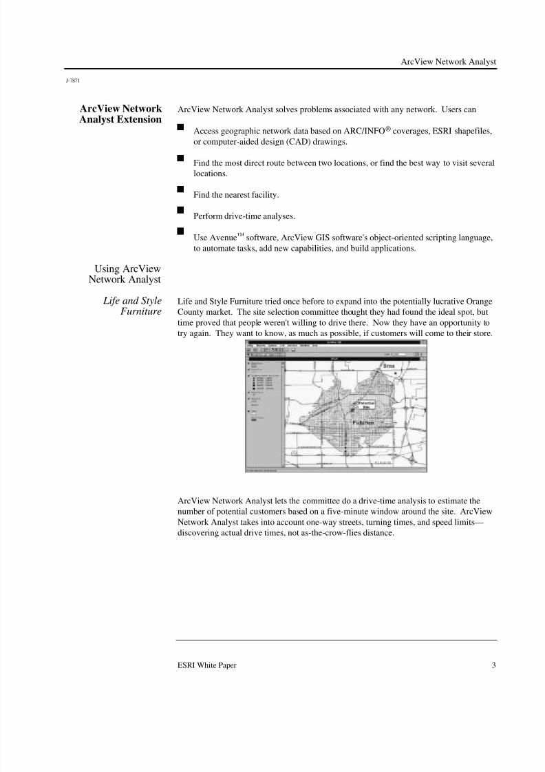
Life and Style Furniture tried once before to expand into the potentially lucrative Orange
County market. The site selection committee thought they had found the ideal spot, but
time proved that people weren't willing to drive there. Now they have an opportunity to
try again. They want to know, as much as possible, if customers will come to their store.
ArcView Network Analyst lets the committee do a drive-time analysis to estimate the
number of potential customers based on a five-minute window around the site. ArcView
Network Analyst takes into account one-way streets, turning times, and speed limits—
discovering actual drive times, not as-the-crow-flies distance.

8/10/2019 Network Analyst WP
http://slidepdf.com/reader/full/network-analyst-wp 8/12
ArcView Network Analyst
J-7871
April 1998 4
Shopping Centers Drive Time ReportDate: 8/26/96
Center Name Address City State Square
Footage
Stores Parking Drive Time
(min)
LA MANCHA SHOPPING CENTER HARBOR BLVD. & VALLEY VIEW AVE. FULLERTON CA 103,904 14 375 1
SUNRISE VILLAGE EUCLID & ROSECRANS FULLERTON CA 113,000 30 530 4
FULLERTON TOWN CENTER NE HARBOR BLVD. & ORANGETHORPE FULLERTON CA 420,491 40 0 4
ORANGEFAIR MALL HARBOR BLVD. & ORANGETHORPE FULLERTON CA 525,000 50 2,500 4
GATEWAY SHOPPING CENTER NWC IMPERIAL HWY & BREA BLVD. BREA CA 180,000 0 800 5
FULLERTON METRO CENTER 1361 HARBOR BLVD. FULLERTON CA 444,794 48 0 5
BREA MALL NWC 57 FWY & IMPERIAL HWY. BREA CA 1,250,000 160 6,115 6
Life and Style can also look at the demographics of the area and at other stores and
attractions that could bring potential customers into the area.
Site Demographic ReportDate: 8/26/96
Population1990 84,957 Married 51.3%
Current 90,320 Female Divorced 12.3%5 Yr Projected 96,065 Male Divorced 5.7%
Single Female 13.0%Single Male 17.8%
Households1990 30,011 Persons Per Household 3
Current 32,160 Households with Child(ren) 1175 Yr Projected 33,927
IncomeAvg Household Income 68,528 Per Capita Income 25,657
Med Household Income 57,102
Cool Boy Restaurant Supply
Cool Boy has recently gained so many clients that it will have to either hire a lot of new
couriers and buy a lot of new trucks or get much more efficient with the ones it now has.
With ArcView Network Analyst to help plan routes, Cool Boy will be able to maintain its
current level of service without breaking the bank. Cool Boy's dispatchers need only call
up an area map on their desktops and designate destinations.

8/10/2019 Network Analyst WP
http://slidepdf.com/reader/full/network-analyst-wp 9/12
ArcView Network Analyst
J-7871
ESRI White Paper 5
ArcView Network Analyst can be used to route deliveries. Dispatchers can then give
couriers detailed directions and instructions and send them on their way.
If a rush order crops up, the dispatcher can use ArcView Network Analyst to determine
which of the couriers is closest and provide directions immediately.
Key Features
Gives You the Power to Solve Your
Network AnalysisProblems
ArcView Network Analyst enables you to solve a variety of problems based on
geographic networks (i.e., streets, highways, rivers, pipelines, utility lines). Solve
problems such as finding the most efficient travel route across town, generating travel
directions, finding the closest emergency vehicle or service facility to an incident, or
defining service areas or sales territories based on travel time.
Find the Best Routes Improve the efficiency of your operations by finding the best routes around town or
across the country. Delivery locations can be added by interactively pointing at
locations, using mapped locations, or even geocoding an address or street intersection onthe fly. ArcView Network Analyst can even reorder your deliveries optimizing their
order as needed.
You can find the best routes based on the shortest distance or shortest time between
destinations. You can even find the best routes during rush hour and at midnight by
changing weighting factors for route calculations.
To solve your problem you need clear directions. ArcView Network Analyst allows you
to generate detailed directions across your route, providing as-you-need-it solutions for
common problems.
Locate the Closest
Facilities
Eliminate guesswork—locate the closest available resource instantly. Dispatch the
closest vehicle to a location, or find the nearest valve in critical situations. Weight yourdecisions on the information that matters most to you—cost, time, and distance.
Locate the closest facility(s) by time or distance. You can even have ArcView Network
Analyst report the closest five facilities within a ten-minute drive. ArcView Network
Analyst will help you avoid construction and other obstacles, provide the best route for
you, and give you clear, accurate directions.
Build Service Areas Create a service area around your facility, defined by distance or time. Plan for the
future by examining where the "holes" are in existing services. Analyze customer
profiles by overlaying planned service areas and census information, showing the areas
of potential growth. Build travel areas that can be served by your facilities in five, ten, or
fifteen minutes.
Give Clear Directions ArcView Network Analyst lets you create clear directions customized to suit your needs.You can also specify what data are used to generate and the distance units used in the
directions.
ArcView Network Analyst also lets you use additional landmark points within your
directions. The directions will include these additional data, giving clear easier-to-
understand information (e.g., "go one mile past Jefferson School on your left").

8/10/2019 Network Analyst WP
http://slidepdf.com/reader/full/network-analyst-wp 10/12
ArcView Network Analyst
J-7871
April 1998 6
Answer Your Questions Based on
Different
Criteria
ArcView Network Analyst can use any cost field for its calculations. You can solve your
questions based on drive time, street length, traffic conditions, or any of a number of
criteria. You can move beyond simple distance-based routing and make use of the
additional information available today.
Use Your Data to Answer Your
Questions
ArcView Network Analyst supports all of ArcView GIS software's line data. This means
you can transparently create routes across your CAD data, ESRI® shapefiles, or
ARC/INFO coverages.
Build CustomSolutions
ArcView Network Analyst adds extra functionality to ArcView GIS and to Avenue. You
can build complete customized solutions from simple tools to complete applications
using the power of Avenue and ArcView Network Analyst.
TechnicalSpecifications
Designed for Power True 32-bit architecture.
Multiplatform portable design (Windows [NT and 95] and UNIX).
No limits to size of the network problem.
Networks are persistent with the data, reducing solve time.
Integrate Data Use existing ArcView GIS features directly.
Use your existing ARC/INFO networks, CAD drawings, and ESRI shapefiles.
Build data-driven networks.
Solve Your Problems Find the shortest path between any number of points.
Determine the closest facility for any location.
Generate service areas around any location.
Build clear directions using points as landmarks for your directions.
Find the Shortest Path
Enter your "stops" using their addresses or by pointing.
Reorder the "stops" automatically to find the best order.
Return to your starting location for a round-trip route.
Solve based on distance, time, or other variables.
Determine theClosest Facility
Determine the closest facility(s) from any given point.
Enter your "stops" using their addresses or by pointing.
Use cut-off distances/times as criteria.
Change the travel direction.
Solve based on distance, time, or other variables.
Generate Service
Areas
Evaluate multiple service centers.
Set multiple service areas based on time, distance, or other variables. Change the service areas based on travel direction.
Enter your service center using their addresses or by pointing.
Generate results as polygons and/or lines.
Give Clear Directions Specify which attributes to form directions from.
Use existing landmark information within the directions.
Save directions to an ASCII file.
Set the measurement units to use in the directions.

8/10/2019 Network Analyst WP
http://slidepdf.com/reader/full/network-analyst-wp 11/12
ArcView Network Analyst
J-7871
ESRI White Paper 7
Build CompleteSolutions
Develop complete applications based on ArcView Network Analyst.
Build custom tools and solutions solving your problems.
ArcView Network Analyst and
ARC NETWORK
ARC NETWORK™ software is a network package that works with ARC/INFO, ESRI's
professional GIS software. ArcView Network Analyst is a subset of the ARC NETWORK
package, integrated with ArcView GIS and packaged as an optional extension with an easy-
to-use graphic user interface.
ArcView Network Analyst runs on UNIX, Windows NT, and Windows 95, while
ARC NETWORK runs on UNIX and Windows NT.
ArcView Network Analyst provides an intuitive, interactive, easy-to-use, stand-alone
interface for calculating travel routes, finding the closest facility, reporting the results as
directions and finding service areas. ArcView Network Analyst is easy to use because
the majority of the functionality people typically use is provided in a graphical interface
as part of the ArcView GIS interface with which most users are already familiar.
On the other hand, ARC NETWORK contains tools to do additional complex analyses
including resource allocation, tracing analysis, spatial clustering for vehicle routing,
gravity modeling and interaction, and location–allocation. ARC NETWORK also
contains ARC/INFO software's geocoding capabilities.

8/10/2019 Network Analyst WP
http://slidepdf.com/reader/full/network-analyst-wp 12/12
ESR I–M inneap olis
612-454-0600
ESRI–Alaska
907-344-6613
ESR I–O lym pia
360-754-4727
ESR I–Boston
978-777-4543
ESR I–C alifornia
909-793-2853
ext. 1-1906
ESR I–D enver
303-449-7779ESRI–San A ntonio210-499-1044
ESRI–C harlotte
704-541-9810
ESRI–W ashington,
703-506-9515
Regional
For m ore than 25 years ESR I has been helping peop le m anage and analyze g eograp hic inform ation. ESR I offers a fram ew ork
for im plem enting G IS in any organization w ith a seam less link from personal G IS on the desktop to enterprisew ide G IS client/server
and data m anagem ent system s. ESR I G IS solutions are flexible and can b e custom ized to m eet the need s of our users.
ESR I is a full-service G IS com pany, ready to help you b eg in, grow , and build success w ith G IS.
ESRI
380 N ew York Street
R edlands, C alifornia
92373-8100 U SA
Telep hone: 909-793-2853
Fax: 909-793-5953
For m ore inform ation on
ESR I softw are call ESR I at
(1-800-G IS-XPRT)
Send E-m ail inquiries to
Visit ESR I’s W eb pag e at
www.esri.com
Corporate
1-800-447-9778
A ustralia
61-9-242-1005
Canada
416-441-6035
France
33-1-46-23-6060
G erm any
49-8166-677-0
H ong Kong
852-2-730-6883
International
India
91-11-620-3801
Italy
39-6-406-96-1
Poland
48-22-256-482
South A sia
65-735-8755
Spain
34-1-559-4345
Sweden
46-23-84090
Thailand
66-2-678-0707
U nited K ingdom
44-1-923-210450
Venezuela
58-2-285-1134
O utside the U nited States,contact your local ESR I distributor.For the num ber of your distributor,
call ESR I at909-793-2853, ext.1-1235
ESR I–St. Louis
314-949-6620
N o. G S-35F-5D