new design guidelines for the crp master plan
DESCRIPTION
ÂTRANSCRIPT

CUMMINGSRESEARCHPARK
Design GuidelinesDRAFT 05.23.2016FINAL 11.22.16
Design Guidelines

BEYOND ARESEARCH PARK.
11 CHAPTER 1 INTRODUCTION.15 CHAPTER 2 PARK ORGANIZATION.21 CHAPTER 3 PUBLIC REALM DESIGN & TRANSPORTATION.31 CHAPTER 4 SITE LAYOUT & DESIGN.41 CHAPTER 5 BUILDING DESIGN.65 CHAPTER 6 ADMINISTRATION.
ABOUT THIS DOCUMENT
This master plan, the first comprehensive plan for CRP in nearly 40 years, carries forward a vision established by Milton Cummings, the park’s namesake, to reserve land for scientific industry adjacent to higher education and linked to the Redstone Arsenal and NASA’s Marshall Spaceflight Center. The Design Guidelines document describes the organizational strategy of the plan, design standards for public spaces and elements, and recommendations for modifying the park’s zoning regulations to enable development consistent with the master plan’s ambitious vision.
CREDITS
CITY OF HUNTSVILLE
The Honorable Thomas “Tommy” Battle, Jr, MayorJohn Hamilton, City AdministratorShane Davis, Director of Urban DevelopmentDennis Madsen, Manager of Urban & Long Range PlanningJim McGuffey, Manager of Planning Services
CHAMBER OF COMMERCE OF HUNTSVILLE/MADISON COUNTY
Chip Cherry, President & CEOLucia Cape, Senior Vice President, Economic Development, Industry Relations & WorkforceErin Koshut, Cummings Research Park DirectorPammie Jimmar, Small Business & Events DirectorEmma Williams, Small Business & Events SpecialistMike Gillespie, Special Advisor
CUMMINGS RESEARCH PARK BOARD
Charles Grainger (Chairman), CG TechnologiesNancy Archuleta, Retired, Mevatec (BAE Systems)Sheila Brown, Quantitech, Inc., CEORon Gray, Thompson Gray, Inc., PresidentKim Lewis, PROJECTXYZ, Inc, CEOGripp Luther, Samples Properties, PrincipalMike Stanfield, Retired, Ducommun MiltecCouncilman Mark Russell, City of Huntsville,
City Council District 2 John Hamilton, City of Huntsville, Office of the Mayor,
City AdministratorJanet Watson, City of Huntsville, Huntsville Planning
Commission, Chairman

The Cummings Research Park, its base of knowledge, capabilities, high-tech businesses, and ongoing research and development activities is a strategic global asset for handling complex scientific and technological challenges. CRP is the proving ground for the most ambitious goals of our society, from yesterday’s lunar landings to tomorrow’s Mars settlement.
The history and legend of the Cummings Research Park began in the first golden age of space exploration following World War II, spurred by President Kennedy’s vision for human footsteps on the moon and Werner von Braun’s team of elite scientists. However, the long-term success of CRP could not have been possible without the sustained investment of grit and knowhow for 60 years by this small community to make things possible in Huntsville that seem impossible elsewhere. While CRP is driven by science, it is truly powered by the people of Huntsville.
This master plan, the first for CRP in nearly 40 years, carries forward a vision established by Milton Cummings, the park’s namesake, to reserve land for scientific industry adjacent to higher education and linked to the Redstone Arsenal and NASA’s Marshall Spaceflight Center. This plan extends this vision to further curate an ecosystem of creativity and entrepreneurship in any advanced scientific or technological endeavor, from the simple imaginative spark in the mind of a graduate student to the complex workings of a Fortune 500 company and everything in between.
IntroductionCHAPTER 1
BUILDING THE FUTURE BIT BY BIT.
02 03

1
Our Master Plan
MAKER-HACKER VILLAGE
BRADFORD CROSSING
MADISON SQUARE MALL REDEVELOPMENT INTERFACE
UNIVERSITY CORNER
WATERFRONT CENTER
LANDMARK SITES
DISTRICT PARKS
INDIAN CREEK GREENWAY LINK
DISCOVERY HUB
EXPLORER HUB
BOULEVARD BRIDGE
SPARKMAN CROSSING
HUDSONALPHA CAMPUS
2
3
1
1
6
7
8
9
10
4
5
11
12
13
The Master Plan cultivates interaction and collaboration while simultaneously creating an experientially unique and satisfying place to work and visit.
TELEDYNE BROWN ENGINEERING
LOCKHEED MARTIN
SWIRLL
UNIVERSITY OF ALABAMA IN HUNTSVILLE
CALHOUN COMMUNITY COLLEGE
SHERWOOD PARK
US SPACE & ROCKET CENTER
BRIDGE STREET TOWN CENTRE
THORTON RESEARCH PARK
ADTRAN
ADTRANCOLUMBIA HIGH SCHOOL HUDSON ALPHA
DYNETICS
DIGIUM
LOGICORE
MADISON SQUARE MALL REDEVELOPMENT
INDIAN CREEK GREENWAY
1
2
34
5
6
13
6
6
6
6
7
7
7
7
7
7
7
7
89
10
11
11
12
12
12
6
6
REDSTONE FEDERAL CREDIT UNION
CRP APPLICATIONS
REDSTONE ARSENAL
I-565
UNIVERSITY DRIVE
MADISON PIKE
BRADFORD DRIVE
HOLMES AVE
HOLMES AVE
WYNN DRIVE
TECHNOLOGY DRIVE
SANDERSON ROADEXPLORER BLVD
EXPLORER BLVD
EAGLE DRIVE
ENTERPRISE WAY
FARROW ROAD
SPARKMAN DRIVE
RESEARCH PARK BLVD
VOYAGER WAY
JAN DAVIS DRIVE
DISCOVERY DRIVE
MIDTOWNE
RAYTHEON
AEGIS
04 05

1
Our Master Plan
MAKER-HACKER VILLAGE
BRADFORD CROSSING
MADISON SQUARE MALL REDEVELOPMENT INTERFACE
UNIVERSITY CORNER
WATERFRONT CENTER
LANDMARK SITES
DISTRICT PARKS
INDIAN CREEK GREENWAY LINK
DISCOVERY HUB
EXPLORER HUB
BOULEVARD BRIDGE
SPARKMAN CROSSING
HUDSONALPHA CAMPUS
2
3
1
1
6
7
8
9
10
4
5
11
12
13
The Master Plan cultivates interaction and collaboration while simultaneously creating an experientially unique and satisfying place to work and visit.
TELEDYNE BROWN ENGINEERING
LOCKHEED MARTIN
SWIRLL
UNIVERSITY OF ALABAMA IN HUNTSVILLE
CALHOUN COMMUNITY COLLEGE
SHERWOOD PARK
US SPACE & ROCKET CENTER
BRIDGE STREET TOWN CENTRE
THORTON RESEARCH PARK
ADTRAN
ADTRANCOLUMBIA HIGH SCHOOL HUDSON ALPHA
DYNETICS
DIGIUM
LOGICORE
MADISON SQUARE MALL REDEVELOPMENT
INDIAN CREEK GREENWAY
1
2
34
5
6
13
6
6
6
6
7
7
7
7
7
7
7
7
89
10
11
11
12
12
12
6
6
REDSTONE FEDERAL CREDIT UNION
CRP APPLICATIONS
REDSTONE ARSENAL
I-565
UNIVERSITY DRIVE
MADISON PIKE
BRADFORD DRIVE
HOLMES AVE
HOLMES AVE
WYNN DRIVE
TECHNOLOGY DRIVE
SANDERSON ROADEXPLORER BLVD
EXPLORER BLVD
EAGLE DRIVE
ENTERPRISE WAY
FARROW ROAD
SPARKMAN DRIVE
RESEARCH PARK BLVD
VOYAGER WAY
JAN DAVIS DRIVE
DISCOVERY DRIVE
MIDTOWNE
RAYTHEON
AEGIS
04 05

PARK LEVEL DESIGN GUIDANCE
SITE & BUILDING LEVEL DESIGN GUIDANCE
RESEARCH PARKDESIGN GUIDELINES
Organization of the Park into District & Sub-Districts
Site Types & Design to Accommodate a Variety of Research Businesses
Comprehensive Guidance for Modifying Existing Zoning Regulations and Creating a Vibrant, Active Research Park
Design of the Public Realm and its Elements to Bring Continuity & Identity to the Park
Design of Buildings for a Variety of Users and to reinforce the Public Realm
+ =PUBLIC REALM
DESIGNBUILDING
DESIGN
SITE LAYOUT &DESIGN
PARK ORGANIZATION
DESIGNGUIDELINES
CUMMINGSRESEARCH PARK
PUBLIC REALMDESIGN
BUILDING DESIGN
SITE LAYOUT &DESIGN
PARK ORGANIZATION
DESIGNGUIDELINES
CUMMINGSRESEARCH PARK
PUBLIC REALMDESIGN
BUILDING DESIGN
SITE LAYOUT &DESIGN
PARK ORGANIZATION
DESIGNGUIDELINES
CUMMINGSRESEARCH PARK
PUBLIC REALMDESIGN
BUILDING DESIGN
SITE LAYOUT &DESIGN
PARK ORGANIZATION
DESIGNGUIDELINES
CUMMINGSRESEARCH PARK
PUBLIC REALMDESIGN
BUILDING DESIGN
SITE LAYOUT &DESIGN
PARK ORGANIZATION
DESIGNGUIDELINES
CUMMINGSRESEARCH PARK
The Cummings Research Park Design Guidelines document is an extension of the Cummings Research Park Master Plan that details the nature of the underlying organization of the park and design for projects within it to ensure that future development and redevelopment are consistent with the vision for the park. These guidelines are also the vehicle by which potential changes to the park’s existing applicable zoning districts should be considered.
It is imperative that the needs of research and innovation are of utmost consideration in all design decisions. These decisions should be guided by knowledge of global trends and initiatives in research, general issues pertaining to the development of research communities, and specific research considerations for Cummings Research Park. The ultimate goal is to ensure the creation of a world-class, high-performing research park that facilitates the creation of research and high-technology businesses in an active, high-quality design environment that guarantees long-term value for owners, occupants, and the entire community.
GUIDELINES INTENT
The organization of the design guidelines reflects the master plan’s strategy of reorganizing the park into a series of districts to flexibly accommodate the lifecycle of business while also providing continuity and identity to the park as a whole. The chapters of the guidelines move from the most general elements of the research park’s fundamental organizing strategy and public realm design to more detailed recommendations for site layout and building design that respond to the characteristics of each district. The guidelines address the following sections:
Park Organization (PO) – this section focuses on the organization of the park into a series of districts and sub-districts to create opportunities for the park to support the lifecycle of business from start-up to success. This section also provides clarity on acceptable land uses within the park.
Public Realm (PR) – this section focuses on elements that are common to the entire park and reinforce the park’s organization and identity such as street types, parks and open spaces, and site furnishings.
Site Layout (SL) – this section focuses on the nature of sites within each district, how these sites are to be organized, development intensity parameters, acceptable uses, and parking.
Building Design (BD) – this section focuses on those elements of building design that have the most substantial impact on the overall district and park such as street relationship, articulation and expression, materials, and sustainability.
Administration (AD) – this section addresses the issue of administering both the master plan and design guidelines and provides recommendations for how the park might strategically operate to become a more proactive partner in the development process.
GUIDELINES ORGANIZATION The guidelines move from the most general elements of the research park’s fundamental organizing strategy and public realm design to more detailed recommendations for site layout and building design.
06 07

The master plan builds on the existing characteristics of CRP, particularly its form, structure and land use. If properly planned and managed, with efficient use of space, Cummings Research Park can yield unlimited development potential over the next 60 years. The question isn’t when will the CRP reach its capacity; it is how will the park optimize the use of undeveloped parcels, underutilized and vacant buildings, and the vast parking lots and deep buffers that exist between buildings. This plan anticipates healthy quantities of both new development, principally in the west, and urban redevelopment, in the east.
Through development and infrastructural investment, CRP will strengthen its connections to the City of Huntsville and its neighbors, linking to the Indian Creek and regional greenway network, surrounding street corridors, neighboring commercial centers, and importantly to CRP’s anchors at Redstone, NASA and the University of Alabama Huntsville. Connections outward will be facilitated by transforming the open spaces of Cummings Research Park into healthy, active landscape. This transformation will convert public and private lawns, buffers and driveways into trail networks, parks, plazas and walkable streets. CRP’s connected, human-oriented landscape will be further animated in each district by a dense development node with signature public spaces and mixed uses. The nodes will provide critical business and lifestyle services that support the diverse needs of the research park residents and visitors.
Park OrganizationCHAPTER 2
ORGANIZING FOR BUSINESS AT
DIFFERENT SCALES
08 09

The Cummings Research Park Master Plan leverages the phased organization and development of the park over the previous 50 years to shape and transform the park for the next 60 years and beyond. Through the master plan, the park is organized into four overarching districts. Each district is focused on accommodating research and high-technology businesses at different points in their lifecycles of growth and development. This organizational strategy is aimed at accomplishing the master plan’s main goal: to unify the research park - which currently exists as CRP East and CRP West with different rules, standards, and quality of development – into a single, cohesive research park where businesses grow from inception to maturity and success.
CUMMINGS START-UP
The Start-up District is a dense, active R&D center designed to promote the growth of new high-technology businesses during their earliest stages and cultivate a culture of grassroots experimentation and entrepreneurship in Cummings Research Park.
The district leverages proximity and access to existing intuitional assets such as the University of Alabama-Huntsville (UAH) and Calhoun Community College. Redevelopment and new development within this district that are driven by opportunities for adaptive reuse of existing structures and facilities. Central among the redevelopment opportunities in this District is the transformation of the former Chrysler plant into a catalytic Maker-Hacker Village with facilities, equipment, and programs to incubate creativity around cyber-physical endeavors, fabrication, and prototyping.
The Start-up District is the most flexible, nimble, and experimental area of Cummings Research Park. It should also remain the most affordable, with a predominance of warehouse conversion to office and fabrication space. Simple, affordable space will allow the Start-up District to continually respond to the changing needs of the dynamic companies in their infancy.
DISTRICTS
CUMMINGS SCALE-UP
The Scale-up District is a dense, active and urban district designed to promote the growth of small, medium and large scientific and high-tech companies in single or multi-tenant buildings. Although limited new development opportunities exist, the long-term development of this district relies on the redevelopment of aging, outmoded and/or underutilized parcels and buildings along Bradford Drive, Wynn Drive, and Research Drive. The Scale-up District benefits from its proximity to UAH and the anchors of Teledyne Brown Engineering, Lockheed Martin and the Severe Weather Institute and Radar & Lightning Laboratories (SWIRLL).
Two mixed-use nodes are planned within the district, one at the corner of Bradford and Wynn and the other in the far northwest corner of Technology Drive, adjacent to Madison Square Mall and its eventual redevelopment. In these nodes, business and lifestyle services, cafes and restaurants, and limited housing will be located to support the primary science and technology focus of business in CRP. The Scale-up District will follow an urban framework of streets and blocks which are given preliminary layout by this plan and parcel by parcel redevelopment will occur incrementally at the pace of the market.
CUMMINGS CORPORATE
The Corporate District carries on the successful legacy of CRP West as a low-density, park-like environment for the orderly growth of medium to large stable high-tech industries. The distinct and managed environment of the Corporate District has made it a premier address, synonymous with success, in Huntsville. This District counts among its residents some of the most important high-tech businesses from around the world.
For the most part over the coming years, new development will be on previously undeveloped parcels that dot the District but are also in high concentration on the western edge of CRP. Multi-tenancy of buildings is allowable but restricted with the District and a network of parks, trails activate the landscape and a small mixed-use node is proposed near Bridge Street Town Centre.
RESEARCH PARK BOUNDARYCUMMINGS START-UP DISTRICTCUMMINGS SCALE-UP DISTRICTCUMMINGS CORPORATE DISTRICTCUMMINGS LANDMARK DISTRICT(S)
DISTRICT LOCATIONS DIAGRAM
BRADFORD DR
HOLMES AVE
HOLMES AVE
UNIVERSITY DR
WYNN DR
RESEARCH DR
CORPORATE DR
SANDERSON RD
TECHNOLOGY DR
SPAR
KMAN
DR
I-565
MADISON PIKE
VOYA
GER
WAY
JAN
DAVI
S DR
FARROW RD
DISCOVERY DR
MOQUIN DR
MARK C SM
ITH DR
ENTE
RPRI
SE W
AY
EXPLORER BLVD
CUMMINGS LANDMARK
The Landmarks are existing buildings and parcels that are reserved for apex high-tech businesses – large corporate campuses – in the most prominent locations of Cummings Research Park. Landmark campuses, such as those for Adtran, Teledyne Brown, and Lockheed Martin, already anchor CRP’s landscape. New Landmarks are positioned at each entry point into the Cummings Corporate District.
Flexibility within zoning regulations will be granted to these sites to allow each company to design a bespoke campus for their needs; each Landmark site, however, will be required to provide a new publicly accessible and signature open space. Landmark companies are expected to raise the quality of their architectural and landscape design comparable to their stature in industry.
10 11

The goal of Cummings Research Park is to create a place that is first and foremost focused on development of uses that further its core research and businesses creation mission. The development of such a place will require supporting uses that are not directly related to research, innovation, and entrepreneurship mission of the district but buoy it nonetheless. Such uses may include retail and business support services for new companies, housing for researchers and their families, and even restaurants and coffee shops that provide valuable, informal meeting spaces. Mixing support functions with core research uses is vital to the success of the master plan’s vision. These uses are more specifically defined in the next section.
While supporting uses are essential to realizing the master plan vision for the research park, it is crucial that development of these uses in relationship to the primary function of the park be organized and controlled. In order to control the location, quantity, and character of supporting uses, several nodes, or mixed-use sub-districts, have been designated. Clustering supporting uses in this manner creates identifiable places within the research park and can contribute to the success of the businesses that are located in these areas by ensuring a critical mass of activity. Five mixed-use sub-districts have been identified by the master plan, although any number of additional sub-districts may be designated later.
MADISON SQUARE REDEVELOPMENT INTERFACE
Located in a northern corner of the park formed by the intersection of Research Park Boulevard and Madison Square Mall, the goal of this sub-district is to establish connections with the anticipated redevelopment of the Madison Square Mall area and leverage the broad diversity of uses and amenities offered by this development as assets to the employees and users of the research park.
UNIVERSITY CORNER
Located in the northeast corner of the research park adjacent to the campus of the University of Alabama-Huntsville (UAH), the goal of this sub-district is to create gateway development at
the highly visible corner of University Drive and Sparkman Drive, as well as to create development opportunities that are done in partnership with UAH.
BRADFORD CROSSING
Located at the intersection of Bradford Drive and Wynn Drive, the goal of this sub-district is to create a node of supporting uses and high-intensity development at the core and most accessible point of the east side of the research park.
MAKER-HACKER VILLAGE
Located at the southeastern portion of Cummings Research Park around the intersection of Wynn Drive and Technology Drive, this sub-district is intended to leverage the adaptive re-use potential of existing building assets (such as the former Chrysler plant) as well as the proximity to the University of Alabama-Huntsville academic programs (such as those related to cyber security) and Calhoun Community College) to create a node that has a great deal of flexibility to accommodate to numerous new start-up companies in various stages of growth.
WATERFRONT CENTER
Located between Lake 4 and Bridge Street Town Centre along Eagle Drive, this sub-district is a focused opportunity to bring supporting uses and services to the employees and visitors of the research park on the west side. Given its location at the edge of the park, Bridge Street has evolved to serve outside users as much as or more so than employees of the research park. While it is important to maintain Bridge Street’s status as a valuable community asset, the master plan proposes the creation of a core and new connections from within the park in order to increase access and value of this entire area to park users.
SUB-DISTRICTS
RESEARCH PARK BOUNDARYMIXED-USE SUB-DISTRICT(S)
SUB-DISTRICT LOCATIONS DIAGRAM
BRADFORD DR HOLMES AVE
HOLMES AVE
UNIVERSITY DR
WYNN DR
RESEARCH DR
CORPORATE DR
SANDERSON RD
TECHNOLOGY DR
SPAR
KMAN
DR
I-565
MADISON PIKE
VOYA
GER
WAY
JAN
DAVI
S DR
FARROW RD
DISCOVERY DR
MOQUIN DR
MARK C SM
ITH DR
ENTE
RPRI
SE W
AY
EXPLORER BLVD
MADISON SQUARE REDEVELOPMENT INTERFACEUNIVERSITY CORNERBRADFORD CROSSINGMAKER-HACKER VILLAGEWATERFRONT CENTERBRIDGE STREET TOWN CENTRE
ABCDEF
AB
C
DE
F
12 13

Cummings Research Park should integrate varying land uses and building programs that serve the larger goals of the research and business community. While the primary focus of the research park is on business creation and growth, other uses such as commercial, retail, and residential are necessary to support this mission. The following sections illustrate the range of those uses that should be permitted in the park and how they might be controlled.
RECOMMENDED PRIMARY USES
Primary uses are those that directly further the research, innovation, and entrepreneurship mission of the research park. These uses span the spectrum to include the corporate headquarters, high-performance multi-tenant office buildings, and research and development facilities already found within the park but also include incubator, accelerator, and coworking facilities that accommodate companies during the start-up and scale-up period of growth. These uses receive the highest priority for new development opportunities and should be permitted by right. Additional examples include:
• Research & Development Facilities• Laboratories• Testing Facilities• Engineering / Prototyping Facilities• Icubators / Accelerator / Coworking Facilities• Business / Professional Offices• Meeting & Conference Facilities• Educational Facilities: K-12, colleges/universities,
community colleges, etc• Prototyping / Light Manufacturing Facilities• Government Facilities: federal, state, county, city, or public
utility• Agricultural – as a temporary, transitional use only
RECOMMENDED SUPPORTING USES
Supporting uses are those that indirectly further the research, innovation, and entrepreneurship mission of the research park but buoy it nonetheless. These uses exist to serve and support
the research and business community of the entire research park. Examples of supporting uses may include printing and copying services, accounting and legal services, and even restaurants and coffee shops that provide valuable, informal meeting spaces.
Maintaining the correct balance between supporting uses and primary uses is critical to ensure the park remains first and foremost a place for cutting-edge research and high-technology business development. Supporting uses are limited to designated mixed-use sub-districts within Cummings Research Park. Within these sub-districts, uses are permitted by right with limitations described in this section. Additional examples include:
• Medical / Dental Offices• Financial Services / Banks• Food Services / Restaurants • Commercial Retail Space• Childcare Facilities• Multi-family Housing (by Special Use Permit)• Hotels• Museums• Recreational Facilities
LIMITATIONS ON COMMERCIAL RETAIL
Allowing commercial retail space creates the opportunity to bring valuable businesses and services to the research and business community in Cummings Research Park. Businesses and services allowed in designated mixed-use sub-districts should have a demonstrable direct benefit to district users.
Commercial retail space should be limited to the ground floor / street level of buildings, publicly accessible at the street level to generate the greatest amount of street activity possible, and otherwise integrated into research and other primary use buildings. These spaces should account for no more than 25% of the overall building program by gross floor area. For purpose of these recommendations, restaurants, cafes, and other dining facilities are assumed included in these limitations.
USES
LIMITATIONS ON RESIDENTIAL & HOSPITALITY
The residential program of buildings in mixed-use sub-districts should address research-focused residents and the needs of their families. The goal is to allow researchers and entrepreneurs to be located in close proximity to work, encouraging walking to work as well as to supporting locations of goods and services throughout the district.
Where possible any new residential buildings should be integrated into research and other primary-use buildings but may be allowed to develop separately as needed to support park employees and users.
Residential development should be considered a special use and allowable by Special Use Permit only. Regulating residential development in this manner can provide greater control over the target market, quality of construction, and overall amount of residential development within a mixed-use sub-district. While strict limitations on the amount of residential development within a sub-district should be avoided, generally this type of development should not exceed more than 20-30% of the gross development program within each sub-district.
LIMITATIONS ON MULTI-TENANT BUILDINGS
Multi-tenant buildings in the Start-up & Scale-up DistrictsIn order to facilitate creation of incubators, accelerators, coworking spaces, and other facilities design to accommodate companies in the startup or early stages of growth where flexible space accommodations are a necessity, restrictions on multi-tenant organization or occupancy should be avoided.
Multi-tenant Buildings in the Corporate DistrictIn limited capacity, multi-tenant office buildings are advantageous in the Corporate District because they provide space for medium to large companies whose space needs cannot be accommodated in the other districts but do not necessarily warrant a standalone facility. These mid-growth companies may desire to construct standalone facilities where multi-tenant space is a gateway to establish a presence in the research park.
In order to accommodate these instances, multi-tenant facilities should be allowed in the Corporate District provided that the companies, as potential tenants, are in line with the park’s vision as a place for research and high-technology businesses.
Additional limitations could be placed on the number of tenants allowed within a building such as limiting the number to the total gross floor area divided by 25,000. In this example, 25,000 square feet is assumed to be a typical office floor plate. In this way, tenants are virtually limited to one per floor although specific arrangement and configuration within the building would be left to the discretion of the end user. There should be no requirement or limitation on the maximum/minimum floor area per tenant, provided that the maximum tenant amount is not exceeded.
If a standard of conformance with the park’s vision and multi-tenant structures is required, the construction of speculative office buildings for multi-tenant use may be considered where pre-leasing commitments for a proposed speculative office building have been obtained at the time of permitting. For example, a percentage of pre-leased gross floor area may be required.
SPECIAL PROGRAMS & TEMPORARY USES
Special programs and temporary uses are those that activate the park and are amenities to park users. These programs and uses are not necessarily developed as part of a building project but rather are hosted at regular intervals in the public / common spaces of the park’s districts and sub-districts. Examples of encouraged uses include:
• Mobile Food Vending & Sites (Food Trucks)• Outdoor Performance / Concert Spaces• Pop-up Cafes, Beer & Wine Gardens• Temporary Farmers Markets• Festival / Special Event Spaces• Other Recreational Programs
14 15

RECOMMENDED PROHIBITED USES
The following uses are examples of those that are incompatible with the mission of Cummings Research Park and should be prohibited:
• Single-family Housing (except where grandfathered such as on Holmes Ave)
• Warehouses (other than structures accessory to a primary research and development use)
• Logistics / Distribution Facilities• Outdoor Storage & Operations• Vehicle & Equipment Maintenance Facilities• Heavy Manufacturing & Assembly Facilities• Loading• Lay Down Yards• Gas Stations• Adult Entertainment Establishments
While the primary focus of the research park is on business creation and growth, other uses such as commercial, retail, and residential are necessary to support this mission.
CO-WORKING SPACES HOUSING FOR RESEARCHERS
WET & DRY LABS LIGHT INDUSTRIAL & PROTOTYPING
SERVICES & RETAIL SPECIAL EVENTS & ACTIVITIES
MAKERSPACES
INCUBATORS & ACCELERATORS
CORPORATE FACILITIES
16 17

Connectivity of people and ideas is at the heart of innovation. An emphasis in planning needs to be placed on improving connectivity within Cummings Research Park and to the surrounding community, particularly Redstone, Bridge Street, UAB, Downtown and the amenities along University Drive.
The design of the public realm is critical in creating a powerful first impression to users in Cummings Research Park. The public realm binds the public space to the private development. Through the meticulous design of parks, plazas, pedestrian spaces, and other open spaces as well as a comprehensive approach to streetscape design, Cummings Research Park can provide a public realm that balances the daily requirements of vehicular traffic and an enhanced pedestrian setting.
This section of the guidelines identifies smart transportation alternatives, public amenities and street types within Cummings Research Park and the minimum elements that should be required of private development to enhance the public realm and contribute to the landscape network within the park.
Public Realm Design & Transportation
CHAPTER 3
ACTIVATING THE RESEARCH PARK’S
LANDSCAPE
18 19

The street framework plan, based on the Cummings Research Park Master Plan, indicates the preferred locations and layouts of new streets in the research park. The locations of new streets are based on an existing street network, driveway locations, and property lines, and are optimized to create site flexibility and maximize connectivity throughout the park.
Additionally, the goal is to provide a hierarchy of street types that will provide circulation alternatives and disperse traffic effectively and balance the need to accommodate pedestrians and bicycles to create a street environment appropriate for all users. The street master framework plan establishedss the proposed locations of all street types within the district. New streets will be constructed gradually and strategically over time as properties redevelop.
STREET FRAMEWORK & TYPES
RESEARCH PARK BOUNDARYENTRY STREET, URBAN TYPEENTRY STREET, NON-URBAN TYPEPRIMARY STREETS, URBAN TYPEPRIMARY STREETS, NON-URBAN TYPESECONDARY STREETSEXISTING STREETS
BRADFORD DR HOLMES AVE
HOLMES AVE
UNIVERSITY DR
WYNN DR
RESEARCH DR
CORPORATE DR
SANDERSON RD
TECHNOLOGY DR
SPAR
KMAN
DR
I-565
MADISON PIKE
VOYA
GER
WAY
JAN
DAVI
S DR
FARROW RD
DISCOVERY DR
MOQUIN DR
MARK C SM
ITH DR
ENTE
RPRI
SE W
AY
EXPLORER BLVD
STREET FRAMEWORK DIAGRAM
STREET DESIGN FOR ALL USERS
In addition to automobile transportation, this plan recommends enhancing the ability for people to walk, bike and use public transit in Cummings Research Park.
Although pedestrian movement across the long distances within CRP are challenging, pedestrian connectivity within proposed mixed use nodes and around UAH are critical. Additionally, long-term planning should consider comprehensive pedestrian space planning around the university, which may include measures such as skybridges and/or tunnels as traffic and pedestrian volumes increase.
A bike share program should be considered to complement this plan’s trail network proposal. Bike share locations may be placed across the park in kiosks and at mixed use nodes, such as near Bridge Street, Bradford Crossing and the Maker/Hacker Village. This form of on-demand transportation can also be supplemented with car share programs, such as zip car, to allow employees who commute via alternate modes of transportation to make convenient business trips during the day to Redstone or Downtown.
Public transit is essential to the long-term vitality of Cummings Research, making a hardwired connection between the park and Downtown. However, in the near-term, mobility within the park and the surrounding community can be improved with a hop-on/hop-off shuttle system. The shuttle system could run on a loop and serve the heart of Cummings Research Park, UAH and amenities in Bridge Street and along University Drive.
STREET FRAMEWORK & TYPES
20 21

Entry streets facilitate movement, provide places for activity to occur, define edges and open spaces, and connect major destinations in the research park to the surrounding area.
The urban type entry street is urban in character, with wide sidewalks for pedestrian activity, such as providing appropriate space to move park traffic while enhancing the experience of the pedestrian and bicyclist.
Main entrances should front on these streets and open directly onto sidewalks. Pedestrians on the street should be able to see the activities inside the buildings through transparent windows and doors. The sidewalks should provide a variety of seating options.
Street trees should be spaced no further than 30 feet on-center (in a 6-foot tree planting zone). Streetscape furnishings should include pedestrian-scaled light fixtures, signage, seating, bicycle parking, waste receptacles, and public art.
These streets are also an opportunity to incorporate signage and wayfinding elements that are common to the entire research park. Additional information is included in the Site Furnishings section. Special paving at a major intersection of two entry streets should be used.
ENTRY STREET, URBAN TYPE
The non-urban entry street is suburban in character. Existing vehicular roadways are maintained for anticipated future traffic flow and to provide access to specialized/large vehicles. Shared-use paths are proposed to be located in existing medians to provide safe access for pedestrian, bicyclists, and other non-vehicular users. Shared-use paths in medians should follow existing topography but be graded down for smooth, gradual transitions at street crossings.
Main entrances of buildings should front the street. Direct access to the shared-use path system should be provided.Site furnishings should include pedestrian-scaled light fixtures, signage, seating, bicycle parking, waste receptacles, and public art.
These streets are also an opportunity to incorporate signage and wayfinding elements that are common to the entire research park. Additional information is included in the Site Furnishings section. Special paving at a major intersection of two entry streets should be used.
ENTRY STREET, NON-URBAN TYPE
22 23

Urban type primary streets are defined by the buildings that line them. Main entrances should front on these streets and open directly onto sidewalks. Pedestrians on the street should be able to see the activities inside the buildings through transparent windows and doors. The sidewalks should provide a variety of seating options.
Street trees should be spaced no further than 30 feet on-center (in a 6-foot tree planting zone). Streetscape furnishings should include pedestrian-scaled light fixtures, signage, seating, bicycle parking, waste receptacles, and public art. Primary streets are also an opportunity to incorporate signage and wayfinding elements that are common to the entire research park.
PRIMARY STREET, URBAN TYPE
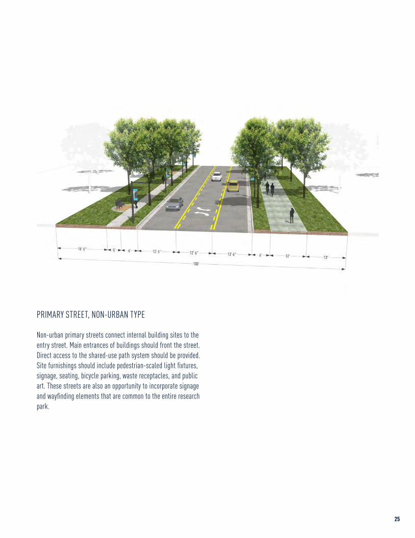
Non-urban primary streets connect internal building sites to the entry street. Main entrances of buildings should front the street. Direct access to the shared-use path system should be provided.Site furnishings should include pedestrian-scaled light fixtures, signage, seating, bicycle parking, waste receptacles, and public art. These streets are also an opportunity to incorporate signage and wayfinding elements that are common to the entire research park.
PRIMARY STREET, NON-URBAN TYPE
24 25
Urban type primary streets are defined by the buildings that line them. Main entrances should front on these streets and open directly onto sidewalks. Pedestrians on the street should be able to see the activities inside the buildings through transparent windows and doors. The sidewalks should provide a variety of seating options.
Street trees should be spaced no further than 30 feet on-center (in a 6-foot tree planting zone). Streetscape furnishings should include pedestrian-scaled light fixtures, signage, seating, bicycle parking, waste receptacles, and public art. Primary streets are also an opportunity to incorporate signage and wayfinding elements that are common to the entire research park.
PRIMARY STREET, URBAN TYPE
Non-urban primary streets connect internal building sites to the entry street. Main entrances of buildings should front the street. Direct access to the shared-use path system should be provided.Site furnishings should include pedestrian-scaled light fixtures, signage, seating, bicycle parking, waste receptacles, and public art. These streets are also an opportunity to incorporate signage and wayfinding elements that are common to the entire research park.
PRIMARY STREET, NON-URBAN TYPE
24 25

Secondary streets should encourage low-speed traffic. Off-street parking and loading throughout the district should be accessed from these streets only. The number of parking and service points are intentionally minimal to limit impact to the public realm.
Street trees should be spaced no further than 30 feet on-center (in a 6-foot tree planting zone). Streetscape furnishings should include pedestrian-scaled light fixtures, signage, seating, bicycle parking, waste receptacles, and public art.
SECONDARY STREET
Design streets to balance the needs of pedestrians and bicycles to create environment appropriate for all users.
PEDESTRIAN SEATING AREAS WIDE SIDEWALKS
INTERFACE WITH DEVELOPMENT SEPARATED CYCLE TRACKS
PLANTING & LANDSCAPE AREAS BICYCLE SHARE FACILITIES
26 27

Trails and paths provide safe and convenient access to parks and open spaces within the research park as well as destinations and other trail systems external to it. Employees, visitors, and residents of the district would benefit from the complete and connected system of sidewalks, trails, and bikeways envisioned for the park.
TRAILS / SHARED-USE PATHS
A shared-use path is a dedicated pedestrian and bicycle way located outside the traveled way and physically separated from motorized vehicular traffic by an open space buffer in a street right-of-way or in an independent alignment in an easement or dedicated right-of-way. Shared-use paths may be used by pedestrians, joggers/runners, bicyclists, skaters, manual or motorized wheelchairs, and other non-motorized or authorized motorized users.
Users have differing needs depending on skill levels and purpose for using the path and path system. Paths should be designed for recreation, service, and emergency access as well as alternative routes for a combination of pedestrians and cyclists to move through the park with minimal street crossings.
Additional recommendations for paths include:
• Provide holistic, safe, and integrated path systems accessible for a variety of uses and users
• Design and place paths to reduce trail/human visibility in sensitive areas
• Manage use and vegetation to minimize impact on natural systems
• Design to accommodate occasional maintenance and emergency vehicles
• Connect with existing and proposed future neighboring trails and paths
• Provide adequate and conveniently located bicycle parking to encourage bicycle use
• Design and implement in conformance with American with Disabilities Act Accessibility Guidelines
• Refer to the most current version of AASHTO’s Guide for the Development of Bicycle Facilities for detailed design standards
ON-STREET BICYCLE LANES
Designated exclusively for bicycle travel, bicycle lanes are separated from vehicle travel lanes with striping and are indicated by pavement treatment (material or color), stencils, and signage. The lanes are intended to increase the comfort of bicyclists and remind motorists that bicyclist also have a right to use the street.
TRAIL & PATH SYSTEM
BRADFORD DR HOLMES AVE
HOLMES AVE
UNIVERSITY DR
WYNN DR
RESEARCH DR
CORPORATE DR
SANDERSON RD
TECHNOLOGY DR
SPAR
KMAN
DR
I-565
MADISON PIKE
VOYA
GER
WAY
JAN
DAVI
S DR
FARROW RD
DISCOVERY DR
MOQUIN DR
MARK C SM
ITH DR
ENTE
RPRI
SE W
AY
EXPLORER BLVD
RESEARCH PARK BOUNDARYTRAILSON-STREET BICYCLE LANES
TRAIL SYSTEM DIAGRAM
TRAIL CROSS SECTION
28 29

Cummings Research Park aims to create dynamic parks and open spaces that allow for collaboration and engagement of various users while also developing a system that unifies the districts and connects the larger research park.
Parks and open spaces are publicly accessible spaces that are intended to remain undeveloped except as a park, plaza, promenade, or other similar common amenity that is not tied directly to a developable property. Locations of potential parks and open spaces are illustrated on the master plan and are described in this section.
DISTRICT PARKS
District parks would be designated common areas within the research park that create public, programmed open spaces within the fabric of the park’s built environment. These parks are envisioned as focal points for activities and programs within the districts and would receive primary consideration as the location of any major indoor/outdoor event venues. District parks should be fully integrated with and connected to the park’s circulation system, particularly the trail system, to ensure wide access to all park users.
LANDMARK DISTRICT PARKS
Landmark parks are designed to the same level and programmatic function of district parks but are constructed concurrently with the development of a Landmark District site. The location of Landmark District sites at highly visible and accessible entry points into the park make them the ideal candidates for the location of signature public spaces. These spaces should provide amenities and access for all park users. Provision and maintenance of a landmark park grants the owner/occupant/developer of a Landmark District site a greater degree of flexibility of building development on the site. Additionally, landmark parks are an opportunity for showcasing the research, products, and other accomplishments of the businesses that occupy these sites.
NEIGHBORHOOD PARKS
Neighborhood parks would be designated common areas typically found in the mixed-use sub-districts within the park. These parks are smaller scale versions of district parks and serve as open space areas and focal points for activities for development in in the park. Consideration should also be given to integrate these trails with the overall trail and open space system of the park to the greatest degree possible. The master plan currently identifies neighborhood parks in the following locations:
• Central to the Madison Square Mall Redevelopment Interface mixed-use sub-district
• Central to the University Crossing mixed-use sub-district• Integrated with the Bradford Crossing mixed-use sub-
district• Integrated with the Maker/Hacker Village and the Greenway/
Eco-corridor• Integrated with the Central Service Core
COURTYARD PARKS
Courtyard parks are those open spaces integrated with or internal to development, particularly in the east side of the park, that are designed to be publicly accessible. These spaces add variety to the pedestrian experience and can make development more memorable and distinct. Open spaces developed in such a manner should be designed to attract people and create compelling design solutions. Active amenities such as art, water features, seating, and dog walks, where appropriate, can add additional enhancement to experience in these areas.
GREENWAYS
Greenways are recommended open space systems within the park that include natural areas (existing or re-established) that are in contrast to the built environment. The greenway and sur-rounding undeveloped areas provide the structure for a contigu-ous system and connects to major destinations both internal and external to the district. This area creates opportunities for recreation interface with open space.
PARKS & OPEN SPACES
RESEARCH PARK BOUNDARYTRAILSPARKS & OPEN SPACESPLAZASLAKES & PONDS
PARKS & OPEN SPACE SYSTEM DIAGRAM
DISTRICT PARKSLANDMARK PARKSNEIGHBORHOOD PARKSGREENWAYSGREENWAY-CORPORATE PARKS
PARK & OPEN SPACE TYPES
ABCDE
A
A
A
A
A
A
A
B
B
B
B
A CC
C
C
C
C
B
DD
E
E
E
BRADFORD DR HOLMES AVE
HOLMES AVE
UNIVERSITY DR
WYNN DR
RESEARCH DR
CORPORATE DR
SANDERSON RD
TECHNOLOGY DR
SPAR
KMAN
DR
I-565
MADISON PIKE
VOYA
GER
WAY
JAN
DAVI
S DR
FARROW RD
DISCOVERY DR
MOQUIN DR
MARK C SM
ITH DR
ENTE
RPRI
SE W
AY
EXPLORER BLVD
30 31

Additional recommendations for greenways include:
• Restore historical landscape patterns• Re-create the integrity of the ecology• Combine with the trail / shared-use path system to connect
major destinations• Provide human-scaled transitions from the built
environment to the natural environment through paths, plantings, or other landscape features
• Incorporate natural areas to allow people to enjoy and interact with nature
GREENWAY-CORPORATE PARKS
Greenway-corporate parks are open spaces integrated with development projects on Corporate District sites that are located along a major trail easement. These spaces should be publicly accessible and add variety to the pedestrian/bicyclist experience and can make development in the Corporate District more memorable and distinct. Open spaces developed in such a manner should be designed to attract people and create compelling design solutions. Active amenities such as art, water features, seating, and dog walks, where appropriate, can add additional enhancement to experience in these areas. Additionally, greenway-corporate parks are an opportunity for showcasing the research, products, and other accomplishments of the businesses that occupy these sites.
Create opporunities for collaboration and engagement of research park users while creating a system that connects and unifies the research park itself.
DISTRICT PARKS LANDMARK PARKS
NEIGHBORHOOD PARKS COURTYARD PARKS
EVENT & ACTIVITY SPACES GREENWAYS & TRAILS
Planting and hardscape materials located within the public realm should be coordinated to reinforce public accessibility, encourage socialization, and promote the identity of the district and continuity with the larger research park. They provide details within the public realm that help to generate the human scale.
PLANTING & LANDSCAPE
Planting design should utilize materials that are site appropriate and consider the location of adjacent walks and pedestrian spaces. Open lawns should be enhanced with large deciduous trees placed in an architectural manner. Plantings should screen winds from the north and west while more open areas should occur on the south side of buildings.
In selecting plant materials, priority should be given to the use of native or adapted plants to limit maintenance and to emphasize developing a sustainable landscape. Where feasible, native grasses and “no mow” areas should be incorporated to limit the maintenance and water use, filter stormwater, support fauna, and provide an educational / research tool. Parking lots should include large shade trees to reduce heat island effect and provide visual entrance.
HARDSCAPE
Hardscape materials used in the district should be high quality, such as natural stone and concrete, and be common throughout the district and larger park. The design of hardscape materials should maximize the amount of usable sidewalk space by utilizing tree grates or permeable unit pavers, for example, at the base of street trees. Low, raised planting beds are acceptable alternatives but should be designed and located to minimize impact on pedestrian flow. A change in scale and volume of use, however, calls for different textures, tones and applications.
PAVING
Pavement materials should be attractive, durable, and low maintenance. A variety of special paving materials, patterns and colors are encouraged to emphasize significant intersections, plazas, and building entries. Local materials and pervious pavement techniques should be utilized. The use of pervious pavers within surface parking lots is strongly encouraged for parking spaces but not for use within the drive lanes. Unique paving patterns are a good method to help direct pedestrian and vehicular traffic.
MATERIALS
32 33

Custom elements reinforce the brand identity of Cummings Research Park. The research park should establish a unified set of site furnishings that is coordinated with the larger research park. Site furnishings should be selected based on consistency, quality of design, and appropriate character materials for the research park. Consistent use of standard furnishings builds a cohesive style and visual appearance. Contemporary style furnishings are encouraged.
BENCHES
Standard benches should be utilized to promote a unified district identity. Benches should have aesthetic appeal, compatibility with district architecture, quality, and durability of materials. The standard bench should include both backed and backless models that can be chosen to allow the location and use. Specific recommendations include:
• Benches should be placed unobtrusively in exterior spaces and not interrupt traffic flow.
• Benches should be securely anchored to minimize theft and vandalism. All benches should be secured to a pad compatible to the adjacent pavement or anchored to concrete bases if set in a landscape area.
• Benches should be constructed with extruded and cast aluminum with a powder-coated finish to complement wayfinding and signage.
WASTE & RECYCLING RECEPTACLES
Waste and recycling receptacles should be located where needed, but should have minimal visual impact and relate to the placement of site benches, planters, and lighting. Receptacles should be to complement benches, bike racks, and lighting elements. Specific recommendations include:
• Locate at the intersections of major pedestrian corridors, public gathering areas and at building entries.
• The waste receptacles shall integrate recycling for paper, plastic and aluminum unless single-stream recycling is available.
• The unit should be secured to discourage vandalism and to extend its life.
• Specify the cover to keep rainwater from infiltrating the receptacle and to maintain a neater appearance.
• Specify the interior liner to control insects and facilitate waste removal.
BICYCLE RACKS
Bicycle racks should be consistent in their design, material, and color as well as in the detail for their installation and design of their layout. Bicycle racks should have little visual impact. The same make and model of unit should be used throughout the research park. The standard model should allow for simultaneous front and rear wheel locking. Specific recommendations include:
• Locate on paved surfaces.• Locate under cover where possible.• Incorporate bike parking into the building entrance site
design and consider winter maintenance requirements with placement.
• Incorporate bike stations into the outdoor areas and/or path site design where possible.
• Locate bike stations in highly visible locations.
LIGHTING
Lighting function and aesthetics should be designed to enhance the parks’s image; it should also foster an enhanced nighttime experience for the parks’s users. The lighting must be designed to effectively light pathways, walkways, and other outdoor active areas.
Light fixtures should be selected and located to develop a park hierarchy. Streets and parking lots should be the first layer with uniform, low-level lighting. Street intersections and crosswalks are a secondary level, providing higher lighting levels that provide appropriate lighting for pedestrians in crosswalks. Tertiary levels include building entrances, exterior stair locations and exterior activity spaces.
SITE FURNISHINGS
Custom elements reinforce the brand identity of Cummings Research Park.
BENCHES & SEATING BICYCLE RACKS
WASTE & RECYCLING RECEPTACLES BOLLARDS
VERTICAL LIGHTING SITE LIGHTING
34 35

Signage and public art can creates focal points, emphasize gathering spaces, and communicate the character, identity and history of the research park.
Research park lighting should be environmentally sensitive to meet DSF and LEED standards including minimizing light trespass and pollution, and using minimal energy through lighting equipment selection and operation. LED lamps shall be selected to address and balance three primary concerns: lighting performance, energy efficiency and maintenance aspects. Ballasts, power generators and power supplies should all be capable of dimming the lamps. Specific recommendations include:
• Limit street and parking lot pole lights to 25 feet.• Limit path pole lights to 12 feet.• Select lighting equipment that has a shielded light source,
minimizes glare and is dark-sky compliant. Strictly limit the use of floodlights.
• Select lighting equipment with high cut-off characteristics and locations that minimize light trespass.
• Select lighting equipment that is dark-sky compliant.• Develop a network of “safe” sidewalks linking perimeter
parking to destinations.
PUBLIC ART
Art in the public realm reinforces a dynamic pedestrian environment and provides additional opportunities to display the research and innovation occurring in Cummings Research Park. The park should consider the inclusion of a public art allocation as a part of all construction projects to fund art installations. Art should be incorporated into the design of the entry and primary streetscapes, greenways, and as focal points with sub-district parks. Specific recommendations include:
• Streetscape elements and screening fence materials are encouraged to incorporate artistic design elements, forms, patterns, colors, lighting and materials that communicate
district character and identity.• Public art is encouraged in public plazas as gateways and
along significant pedestrian streetscapes to create focal points, emphasize a gathering space, or communicate something about the character, identity or history of the place.
SIGNAGE & WAYFINDING
Beyond helping users effortlessly find their way with well-placed, readable messaging, signage can become the connecting fibers of a place, visually weaving together paths of travel and outdoor environments for enhanced user interaction. Cummings Research Park should develop a system of common signage and wayfinding elements that is coordinated with all districts for a unified family of research park signage elements and standards.
Strategically planned wayfinding elements can challenge traditional interpretations of “signage,” blurring the lines between form and function. These elements can drive additional user exposure to place differentiators, including storytelling and public art, substantially adding to the user’s overall experience.
PUBLIC SPACE WIRELESS INTERNET
Proving wireless internet connection in public spaces in the park is not only convinient, but it aligns with the overall vision of Cummings Research Park by providing the platform for a constant and continuous exchange of ideas and information between its occupants — independent of their physical location.
It also fosters creativity by not limiting internet-related work to indoors.
BUILDING SIGNAGE MONUMENTAL / GATEWAY SIGNAGE
EVENT SIGNAGE
STORYTELLING IN PUBLIC ART SCIENCE ON DISPLAY
36 37

Proper site layout and design is the foundation for creating a strong and balanced relationship between individual building projects and Cummings Research Park as a whole. Cummings Research Park supports design strategies that locate critical elements within development boundaries in such a manner that reinforces the creation of a robust public realm. The guidelines in the section focus on providing clear guidance on site types, development interface and intensity, and parking and access.
Site Layout & Design
CHAPTER 4
ESTABLISHING A PATTERN OF DEVELOPMENT
38 39

Cummings Research Park is envisioned as the premier address for a full range of research and business related development from start-up to full corporate facilities. Creating different site types provides flexibility to meet varied needs in site size, and creates opportunities for signature facilities within the park.
START-UP & SCALE-UP DISTRICT SITES
Appropriate block dimensions create the walkable fabric and density of the east side of the research park. Achieving greater density is a pre-requisite for collaborative research environments. Each development should embrace this environment and add to its rich network.
The plan for the start-up and scale-up districts is built on a framework where block dimensions are no more than 600 feet in length (500 feet typical). This re-configuration will take place gradually over the next several decades. As properties redevelop, new streets will be required to subdivide existing properties to create smaller blocks. These blocks former the developable sites for these districts.
CORPORATE DISTRICT SITES
Sites within the Corporate District are the most prevalent site type in Cummings Research Park. The typical size ranges from 4.0–8.0 acres and is more than sufficiently sized to accommodate a standard 20,000–25,000 square foot building footprint in addition to other site requirements such as setbacks, landscape areas, parking, and other accessory structures. Most of the existing development in the Corporate District is representative of this site type.
SITE TYPESLandmark sites are an
opportunity to elevate the potential exposure and design quality of premier locations in
Cummings Research Park.
LANDMARK DISTRICT SITES
Landmark District sites are an opportunity to elevate the potential exposure and design quality of premier locations in Cummings Research Park. These sites are located at or around key intersections / entries into the research park and are typically 35 acres or greater. These sites also play a critical role in the creation of the active landscape network of the park: in exchange for the creation of key public space areas and elements, greater flexibility in terms of site coverage, massing, and height may be achieved. The Adtran facility located near the center of the west side of the research park is the model for future landmark development projects.
40 41

NEW BUILDINGS TYPES
START-UP
SCALE-UP
CORPORATE
LANDMARK
42 43

NEW BUILDINGS TYPES
START-UP
SCALE-UP
CORPORATE
LANDMARK
42 43

CREATE DEVELOPABLE BLOCK SIZES USING A MASTER STREET
FRAMEWORK PLAN MAXIMIZE VIEW OF BUILDING ACTIVITY TO THE STREET
ACTIVATE THE ROOF
LOCATE PARKING AREAS IN THE REAR OF BUILDINGS
MAXIMIZE BUILDING FRONTAGE ALONG THE STREET
PLACE ACTIVE / SUPPORTING USES AT THE STREET LEVEL
CREATE ACTIVE DISTRICT OPEN SPACES
CREATE A CONTINUOUS STREET WALL
MAXIMIZE SITE COVERAGE
MINIMUM BUILDINGS HEIGHTS, NO MAXIMUM
CUMMINGS START-UP & SCALE-UP SITES
44 45

CUMMINGS CORPORATE & LANDMARK SITES
LOCATE PARKING AREAS IN THE REAR OF BUILDINGS
BUILD-TO THE SETBACK LINE TO MAXIMIZE BUILDING VISIBILITY FROM THE STREET
MAINTAIN EXISTING SETBACKS TO REINFORCE IDENTITY OF THE PARK
MAXIMIZE BUILDING FRONTAGE ALONG THE STREET
CONNECT SITES WITH THE PROPOSED TRAIL SYSTEM
CREATE PUBLICLY ACCESSIBLE PARKS ON LANDMARK SITES
ALLOW GREATER HEIGHTS AND COVERAGE ON LANDMARK SITES
CORPORATE SITES ORGANIZED FOR STANDARD DEVELOPMENT
RELAX HEIGHT PLANE RESTRICTIONS TO ACCOMMODATE CRITICAL RESEARCH FUNCTIONS
LANDMARK SITES FOR FLEXIBILITY AND VISIBILITY OF THE MOST PROMINENT COMPANIES
46 47

Proper control of site coverage, setbacks, frontage, and massing are essential to establishing Cummings Research Park as a collaborative research environment. Development should be designed to maximize engagement with the research park and reinforce the plan’s vision for each district.
FOR START-UP & SCALE-UP DISTRICT SITES
CoverageCoverage is defined as building coverage and areas related to parking including surface parking areas, access drives, and service areas. Allowable site coverages of up to 85% are recommended.
SetbacksFront yard setbacks should be eliminated to maximize the buildable area of a site and the potential for building frontage. A build-to line is recommended along major corridors where maximum building frontage and a continuous street wall is desirable.
Rear setbacks of no more than 25 feet and side yard setbacks of no more than 10 feet may be employed where a site is adjacent to a residential district external to the research park except when an intervening street is present. The resulting rear / side yard should be landscaped within the first 5 feet of the yard.
FrontageBuilding frontage along a street reinforces the creation of edges and facilitates building access particularly at the street level. For buildings located along major corridors, frontages of up to 100% but no less than 65% of the site property line are recommended.
Build-to LinesBuild-to lines ensure continuity of building frontage especially at the street level. These continuous lines ensure that all building masses create consistent edges that frame and define the site.
LAYOUT
FOR CORPORATE & LANDMARK DISTRICT SITES
CoverageBuildings should be organized to maintain the districts’ open space character. Buildings should cover no more than 30% of total site area on Corporate District sites. Total site coverage for buildings and parking area should not exceed 50% of total site area. Landmark sites may receive a coverage bonus if publicly accessible landmark park spaces have been provided.
SetbacksAll sites should have at a minimum of one (1) frontage on either an entry or primary street type. All frontage conditions shall require a minimum 100-foot front yard setback. All other setbacks (side and rear) shall be a minimum of 50-feet. All setbacks shall be kept clear of parking areas, loading areas, driveways unless required for access, and landscaped. Exceptions on side and/or rear yard setbacks may be granted for sites in a Landmark District.
Build-to LinesIn order to maximize building visibility and create consistent frontage, all buildings – including buildings on both Corporate and Landmark District sites – shall construct a primary façade to the edge of the 100-foot front yard setback.
FrontageBuilding frontage along major corridors creates consistency and enhances visibility. Building frontage along the front yard build-to line on major corridors in Corporate and Landmark Districts should be no less than 50% of the available site frontage (including side or rear setback requirements).
Heights within Cummings Research Park are set to encourage development to respond to context. It balances the need for greater density in some districts against over development in others. Building heights are restricted by minimum and maximum height allowances.
FOR START-UP & SCALE-UP DISTRICT SITES
Minimum HeightAll buildings constructed on Start-up and Scale-up District sites should be a minimum of two (2) occupied floor levels. Additionally, new buildings constructed in designated mixed-use sub-districts should be a minimum of four (4) occupied floor levels. Mechanical equipment, including penthouses, is not included.
Maximum Building HeightMaximum number of levels and height should be lightly restricted to (15) occupied floors.
Floor LevelsThe floor level at the street level should be no less than 15 feet and no greater than 24 feet.
Typical floor-to-floor levels should be no less than 12 feet and may be as great as 18 feet. This minimum and maximum may be exceeded where needed to accommodate an identified critical research function such as the creation of high-bay space.
HEIGHTS
FOR CORPORATE & LANDMARK DISTRICT SITES
Minimum HeightAll buildings constructed in Corporate and Landmark Districts should be a minimum of two (2) occupied floor levels. Single-story structures may be permitted provided that the single level has a minimum height of 24 feet.
Maximum Building HeightMaximum number of levels and height should be unlimited.
Transitional Height PlanesTransitional height planes have created a demonstrated, reoccurring hardship for the development of facilities particularly where high-bay laboratory space, tall prototyping and assembling spaces, and other specialized high-tech spaces conflict where this requirement. Transitional height planes, if possible, should be eliminated or reduced. If this is not possible, this restriction should be waived on a case-by-case where a specialized research or business is capable of demonstrating undue hardship where this limitation makes development otherwise unfeasible or cost-prohibitive.
48 49

Creating high-quality development requires balancing the costs and supply of parking with the goals of Cummings Research Park including promoting economic development, efficient use of land, and walkability.
PARKING REQUIREMENTS
Adequate off-street parking should be provided for each site to accommodate parking needs for employees, visitors, and company vehicles. Analysis of current off-street parking utilization suggests that the research park may be creating off-street parking at a rate up to 50% greater than what is actually needed to support research and office uses. Given that the predominant use in the research park will be research facility and office development, it is recommended that two (2) spaces per 1,000 square feet for research facilities be established as a new minimum requirement. Implementation of parking utilization monitoring and district sharing may ultimately enable this level to be lowered to one (1) space per 1,000 square feet.
Reducing minimum parking requirements allows greater flexibility in the provision of off-street parking. Projects can elect to provide off-street parking beyond the maximum to ensure the specific needs of each project are met and should be evaluated on a project-by-project basis. Variances to the minimum parking requirements may be approved on a case-by-case basis according to the specific parameters of the project.
SHARED PARKING OPPORTUNITIES
Adjacent properties with different peak hours of parking demand should consider shared parking, reducing the number of parking spaces that each property owner would provide individually. This strategy for parking reduction should be explored, particularly in the mixed-use sub-districts.
UNBUNDLING PARKING
Unbundled parking separates parking spaces from office or residential units, requiring parking spaces to be rented or sold separately rather than automatically including them with
building space. This strategy for parking reduction should be explored if possible. This is not only a more equitable solution, but can also reduce the total amount of parking required for a building.
PARKING REDUCTION OR TRANSFER
Parking reductions or transfers should be granted when one of two requirements is met:
1. The character or use of the building is such that the full provision of parking facilities is unnecessary.
2. The developer has established a valid shared or off-site parking arrangement.
LOCATION
Cummings Research Park aims to create a pedestrian-oriented environment to the greatest extent possible and showcase the buildings of its most successful companies. Off-street parking areas should be located to the rear or side of each building. Off-street parking should not be located between an entry or primary street and a building.
ACCESS
Access to parking areas should be limited to avoid excessive curb cuts and interruption of the public realm. Parking access and other drives should be placed on secondary streets only.
LOADING / SERVICE AREAS
Adequate area shall be provided on-site for all loading and maneuvering of trucks and other service vehicles. Loading and maneuvering should not cause damage to district landscape areas.
Loading and service areas shall be located to the side or rear of the building or structure. Unpaved parking, loading, and maneuvering areas are prohibited. Loading doors should be prohibited from facing an entry or primary street.
PARKING & ACCESSCreating high-quality
development requires balancing the costs and supply of parking
with the goals of Cummings Research Park.
50 51
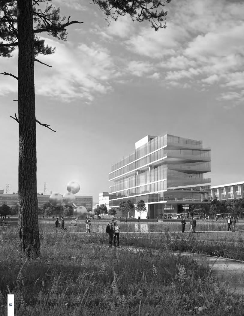
Individual buildings will make some of the most recognizable contributions to the overall character of Cumming Research park through their massing, orientation, architectural expression, and choice of materials. The design of a building often reflects the programmatic requirements of the uses that are housed within, as well as the regulatory requirements that are applicable to those uses. A well-balanced research park is achieved not by restricting variety in uses, or their associated architectural expressions, but by knitting each building into the fabric of a unified public realm.
Building DesignCHAPTER 5
PROMOTING ARCHITECTURAL
DESIGN EXCELLENCE
52 53

The street level is the most important interface between a building and the public realm. Each building should define and animate the street level, exploring active uses, transparency, and engaging design.
FOR START-UP & SCALE-UP DISTRICT SITES
Active UsesActive uses should line each building face at the street level to provide an animated building edge that enhances the pedestrian experience. Entry, primary, and secondary streets should create a continuous street edge with a minimum depth of 20 feet measured from the façade enclosure line. To provide the greatest opportunity for active uses, a depth of 40 feet is strongly recommended.
Traditional active uses include retail, restaurants, lobbies, live/work units, and flexible office spaces. Where depth is constrained, alternative active uses include bike maintenance rooms, recreation centers, light projections, art-based installations, flexible gathering space, and indoor gardens.
Main EntrancesThe articulation, location, and frequency of main entrances of buildings reinforces active uses at the street level.
All buildings should be required to have a main entrance facing the street. Main entrances are indicated by the placement of atriums, lobbies, or other entry areas and may include architectural features such as, but not limited to, awnings, arcades, columns or archways with a level of architectural detailing that exceeds other entrances to the building.
The length of street-fronting façade without an intervening entrance should not exceed 150 feet.
Glazing / FenestrationExterior clear glass (low iron) fenestration allows for the perception of transparency, provides a degree of visibility of interior uses at the building perimeter, and animates the street level, which reinforces the walkability these districts. Colored,
STREET RELATIONSHIP
mirrored or otherwise translucent or semi-translucent glass should be prohibited.
Glazing should be no less than 70% for the first story on entry and primary street frontages and no less than 50% for the first story on all other streets.
Users, spaces, or functions within a building that have established requirements for confidentiality or protection of proprietary resources may be exempt from this requirement though it is highly recommended that these spaces be located to the interior portion of building where possible.
Blank WallsBlank walls should be avoided on entry and primary streets and should be minimized on all other streets. If absolutely necessary for the function of the building, these walls should be treated to enhance the pedestrian experience. Consider green / planted walls and murals.
Temporary UsesBuilding lifecycle should also be considered in regards to the active uses at the street level. Where street level spaces are not fully leased or otherwise unoccupied, some uses could be installed temporarily with a plan for transitioning to a more permanent active use over time.
SignageBuilding signage should be viewed as an opportunity to further activate the streets within these districts. While all signage is important, the critical signage opportunity lies at the street level. Signage for this zone should focus on creative undercanopy signs, blade signs, and window signs. All signage should conform to park signage standards.
FOR CORPORATE & LANDMARK DISTRICT SITES
Main EntrancesThe articulation and location of main entrances of buildings reinforces building prominence toward the street.
All buildings should be required to have a main entrance facing the street. Main entrances are indicated by the placement of atriums, lobbies, or other entry areas and a level of architectural detailing that exceeds other entrances to the building.
Blank WallsBlank walls facing streets should be avoided. If absolutely necessary for the function of the building, these walls should be given special architectural treatment and expression.
SignageAll building signage should be viewed as an opportunity to further provide identity in these districts and continuity with the research park as a whole. A standard signage type for the identification of businesses within these districts can provide further continuity. The signage type should reflect a consistent park branding, have single company and multi-tenant variations, and publicly visible from the street. All signage should conform to park signage standards.
Multi-tenant signs should display the most prominent companies of buildings and be easily updatable.
Signs should be located in the front yard setback of each property and located at a maximum of one (1) sign per building access driveway.
Additionally, companies and businesses that own entire buildings should be permitted to display corporate signage on the building at a maximum of one building sign per property.
START-UP & SCALE UP SITES
CORPORATE & LANDMARK SITES
54 55

FACADE ARTICULATION
The facades and enclosure of a building establish the architectural experience of Cummings Research Park. Each building should consider its architectural stance within the park as well as potential performance measures that could be incorporated.
DELINEATION OF LEVELS
Building articulation is a critical component of the architectural experience, especially for a pedestrian at the street level.
The area between the first and second stories along all street frontages should include architectural detailing such as, but not limited to, variations in materials or horizontal expression line, to visually delineate the first and second stories.
To achieve this articulation, changes in materials and shifts in the vertical plane (like a projection or recession of the upper floors from the ground floor build-to line) should be considered as part of a building’s design.
DETAILING & MATERIALS
Façade details and materials are an opportunity to explore and develop a unique architectural expression for a building. The approach to a building’s façade should be inspiring, as the enclosure of each building helps give the overall district its identity.
Considerations such as performance and environmental impact should be taken into account when choosing materials and design details.
The facades and enclosure of a building establish the architectural experience of Cummings Research Park.
SHIFTS IN MASSING & SCALE
FACADE & MASSING ARTICULATION
VARIATIONS IN MASS & TRANSPARENCY
DELINEATION OF LEVELS DISTINCT GROUND FLOOR EXPERIENCE
DELINEATION IN CHANGES OF PROGRAM MATERIAL CHANGES BETWEEN LEVELS
MAIN ENTRY ARTICULATION ARTICULATION OF CORNERS
56 57

DESIGN & MATERIALS
Cummings Research Park aims to foster creative, contemporary architectural responses to its goals of supporting research and entrepreneurial success. Individual buildings are expected to meet the programmatic needs of users as well as contribute to the creation of a unified public realm in their design and selection of materials. The overall intent is to create an appealing and richly designed environment that is attractive to employees, residents, and visitors.
SUSTAINABLE DEVELOPMENT
Cummings Research Park is envisioned as a sustainable research park with green, energy-efficient buildings that provide state-of-the-art laboratories with ample natural indirect light, thoughtful interior design, inviting work spaces, and support spaces to encourage interaction and promote blue-sky research, or “curiosity-driven science.”
All buildings are encouraged to utilize high-performance sustainability practices to reduce the environmental impact of each project and to create healthy working environments for employees and visitors. The following elements should be considered during the design process:
• Appropriate creation of pedestrian-friendly project elements• Natural daylighting of interiors• Use of on-site generated renewable energy and/or park
provided utilities/services• Use of insulated wall and roof assemblies• Innovative on-site stormwater management solutions• Use of water conserving fixtures• Use of environmentally appropriate interior finishes and
furnishings• Use of innovative solutions to environmentally sustainable
systems, materials, and other elements of project performance
• Use of third-party reference guides in the evaluation of project design
• Certification of buildings by third-party rating systems
ARCHITECTURAL DESIGN
Buildings in Cummings Research Park should be progressive and contemporary in design, reflecting the forward looking ambitions of the park. Historic, neo-classical or other thematic styles are highly discouraged. It is recommended that building design and composition be appropriately related to and coordinated with contiguous or proximate structures to provide consistency throughout the research park.
STRUCTURAL SYSTEMS
Pre-fabricated and pre-engineered buildings should be discouraged unless of high design aesthetic and quality of construction. Temporary buildings, other than for construction trailers during construction or programmed events and activities in park common areas, are prohibited.
MATERIAL & FINISHES
Exterior building materials and finishes should be durable and of high quality. Buildings should include a maximum of four exterior materials. The following materials and elements are recommended:
• Stone, stucco, pre-cast concrete, glass-fiber-reinforced (GFRC), and metal panel wall coverings
• Transparent materials particularly at entrances, courtyards, and community spaces
• Metals used for architectural elements such as sunscreens, trellises, and canopies
• Materials that have proven long-term durability• Materials and finishes that are of low-intensity color• Materials that are resistant to hot, humid environments
The following materials and elements are discouraged:
• Exposed and unpainted concrete masonry units (CMU)• Brick when used as a primary building material• Colored, mirrored or otherwise translucent or semi-
translucent glass• Flat or corrugated translucent panels
Individual buildings are expected to meet the programmatic needs of users as well as contribute to the creation of a unified public realm in their design and selection of materials.
METAL SUN SHADES METAL PANELS
STONE TRANSPARENT MATERIALS
GLASS LIGHT-COLORED CLADDING
58 59

ROOF DESIGN & USE
Roofs are an opportunity to create additional open spaces and capitalize on park views from buildings. Each building should consider these opportunities and seek creative, active solutions.
MATERIALS & ORGANIZATION
Roofs are critical visual elements in creating successful buildings and should be designed as a “fifth façade,” integrated into the building’s overall design. Roofs should be designed from the user and viewer standpoint. These spaces should include volumes and surfaces varying in form, massing and materiality. Design should consider mixing soft and hardscape to create a roofscape that incorporates usable open space and sustainable design strategies.
Roofs should use non-reflective materials and low-intensity color to minimize the heat-island effect. Dark materials should be avoided. Renewable/energy-generating materials are encouraged.
ACTIVE USES
Roofs provide a tremendous opportunity to incorporate active public spaces into a building’s design. Potential active uses include active gardens, recreational activities, passive gardens, productive greenhouses, outdoor seating, rooftop restaurants and beer gardens. Depending on the uses, retractable roofs and other coverings should be considered to facilitate year round activity.
MECHANICAL EQUIPMENT
Any mechanical equipment situated on a rooftop that is visible from the street level of an adjacent street or building should be screened by roofing, parapet walls, landscaping, or other architectural elements. If the equipment cannot adequately be screened, roof-mounted screening may be used provided such equipment and screening is located to the rear of the building. Roof-mounted screening materials should complement and/or blend with the color and design scheme of the overall expression of the building.
PERFORMANCE STANDARDS
Existing performance standards concerning air pollution, odor, vibration, noise, fire hazard, etc are already established in the existing zoning regulations. Given the new level of density and potential for mixed-use buildings in certain districts, the following additional guidance is offered regarding vibration criterion for the development of laboratory facilities in this context. Specific requirements will vary based on the specific building program and contingent upon site factors and building structural systems and detailing.
• Level 1 – 12.5 μ m/s (500 μ in/s) – most stringent; appropriate for optical 1000x and moderate electron microscopes, digital imaging, and high-precision balances.
• Level 2 – 25-50 μ m/s (1,000-2,000 μ in/s) – moderately acceptable; appropriate for microtomes and cryoptomes, tissue/cell culture, optical 400x microscopes, mass spectrometers
• Level 3 or greater – 100-200 μ m/s (4,000-8,000 μ in/s) – least stringent; clean rooms may be located above this level due to barely perceptible vibration
FENCES & GATES
Fences and gates should be avoided and should be prohibited in the Start-up and Scale-up Districts. When necessary due to security requirements, fences should be installed with the finished side facing towards the exterior or adjacent properties and streets. All fences shall be maintained in a sturdy, upright position and in good condition. It is recommended that all fences be screened by planting and other landscape elements.
DESIGN FOR HIGH-PERFORMANCE BUILDINGSROOFTOP RESTAURANTS
MULTI-PURPOSE SPACES
PRIVATE GATHERING SPACES
60 61

PARKING STRUCTURES
As Cummings Research Park reaches critical capacity, parking demands may dictate the construction of vertical, shared parking structures. Parking structures may be privately or publicly developed. Publicly developed parking structures present greater flexibility in park supply, control, and sharing.
These structures should be designed internally to parcels with building program wrapping the structure. If this is not possible, parking structures should be designed and developed as part of the building.
FACADES
Any parking structure façade that is exposed to the public realm should have screening features to conceal visibility and carry the appearance of the building. Creativity is encouraged through the use of architectural screens, vegetative walls, texture and even kinetic elements to animate the screens. Alternatively, the structures themselves can be designed with a sculptural expression.
ACTIVE USES
Parking structures located in the more densely developed Start-up and Scale-up Districts should provide continuous street-fronting active uses on ground levels. Along entry and principal streets active uses should be required to a minimum depth of 20 feet.
As Cummings Research Park reaches critical capacity, parking demands may dictate the construction of vertical, shared parking structures.
GROUND FLOOR USES COLOR & TEXTURE
TRANSLUCENT SCREENING TEXTURED MATERIALS
SCULPTURAL EXPRESSION THREE DIMENSIONALITY
62 63

The realization of the vision for Cummings Research Park will be a product of clear development regulations and design standards that balance the need for flexibility and predictability. Additionally, establishing a clear review and approval process for design and development ensures that new development in the park meets a high standard of quality while helping to create a place that is attractive and unique. The following sections offer guidance as to implementation of the aspirational vision for the park.
AdministrationCHAPTER 6
IMPLEMENTING AN ASPIRATIONAL
VISION
64 65

REGULATORY IMPLEMENTATION
IMPLEMENTATION THROUGH ZONING
Three zoning districts currently guide the development of Cummings Research Park today: the Research Park (RP) district for the east side of the park, the Research Park West (RPW) district for the west side, and the Research Park Commercial (RPC) district for the central service core known as Bridge Street Town Centre.
It is recommended that the City of Huntsville modify the zoning ordinance for these districts based on the respective design guidelines specified herein. Furthermore, modifications to the regulations for these districts should provide reference to the existence and define the applicability of the Cummings Research Master Plan and Design Guidelines to ensure the vision and design principles become formalized standards by which proposed development will be reviewed and assessed. Should future updates to either the master plan or design guidelines be necessary, the updated versions would be automatically become applicable in the zoning by way of this reference.
PROTECTIVE COVENANTS & DEED RESTRICTIONS
Currently, protective covenants are employed in Cummings Research Park West in order to establish the park governance structure and ensure conformance with park zoning regulations and design review process of all development within this area of the park. Additionally, deed restrictions are also enacted on each property transaction to ensure conformance with acceptable land uses. These restrictions remain in effect for a period of twenty (20) years.
Cummings Research Park East also used similar deed restrictions to control the use of land in this area of the park. However, many of these restrictions have since expired with the main exception being the area of single-family residential located along Holmes Ave in the northeast corner of the park.It is recognized that the use of protective covenants and deed restrictions is likely to remain the primary vehicle by which development activity is controlled within the research park. However, regulation of property in this manner has several drawbacks. Primary, inclusion of land use and development
intensity within protective covenants and deed restrictions is redundant to their provision in the governing zoning district. Necessary updates to the zoning over time may present potential conflicts with existing covenants and restrictions. These conflicts are difficult, if not impossible, to remove on a case-by-case basis.
To this point, two recommendations are offered. First, that the practice of controlling land use through deed restriction be terminated henceforth in favor of controlling property use through the applicable zoning district. Regulating use in this manner allows greater flexibility to accommodate future uses that may bring valued benefit to the park but are unforeseen at this time.
Second, protective covenants should avoid including overtly specific language referencing specific design requirements or intensity controls. Instead, covenants should note the existence of a park master plan, design guidelines, and zoning regulations and ensure conformance with these references. For the same reason as the deed restriction recommendation, using these external sources to define specific regulations facilitates implementation of future updates.
With respect to the potential changes to the zoning regulations recommended in these guidelines, care has been taken to avoid potential conflict with existing protective covenants and deed restrictions both in terms of use and design.
RETROACTIVE EFFECT
In regard to anticipated adoption of the Cummings Research Park Master Plan, Design Guidelines, and revised zoning regulations, it is recognized that the adoption of such standards and regulations may immediately create non-conforming properties. Existing buildings, structures, or improvements should remain subject to the regulations and design standards in effect at the time they were constructed, or the adopted guidelines and/or zoning regulations, whichever is less stringent except that if a change is required by building code in which the code requirements will apply.
These non-conforming properties should be required to conform to the new regulations and guidelines at such time a permit
is sought for further improvement or redevelopment of the property. Additional thresholds could be set determining the magnitude of improvement or redevelopment that would trigger conformance. Common thresholds used include total dollar value of improvement or redevelopment, percentage of existing site and/or structure impacted by improvement or redevelopment, or total area of site affected by improvement or redevelopment to name a few.
DESIGN CONTROL / REVIEW PROCESS
ROLE OF THE DESIGN CONTROL COMMITTEE
Currently, all development in Cummings Research Park West and Cummings Research Park Commercial is reviewed and approved by a Design Control Committee. The membership of the Cummings Research Park West Design Control Committee is charged with reviewing the plans for all construction or exterior alteration of facilities and developments within CRP West. The Design Control Committee is an appointed board, and included among its membership are registered professional architects, landscape architects, and engineers. It is recommended that the Design Control Committee be organized under and report to the Cummings Research Park and coordinate all activities with the Planning Division of the City of Huntsville and that the Mayor continue to appoint both the CRP Board and the Design Control Committee, subject to the confirmation of the City Council.
It is recommended that the role of this committee be expanded to included review and approval of proposed new development and redevelopment for Cummings Research Park East. From its years of experience ensuring the design and development integrity of Cummings Research Park West, the Design Control Committee would have the necessary institutional knowledge to ensure high-level of design and consistency throughout the research park. Additionally, limiting design and development oversight to a single committee avoids redundancy and potential confusion to those seeking to develop in the park.
In its expanded role, it is recommended that the Design Control Committee report to and become an integral part of the Cummings Research Park Board while continuing to coordinate with the Planning Division of the City of Huntsville. In this scenario, the Mayor would continue to appoint both the CRP Board and the Design Control Committee, subject to the confirmation of the City Council.
POTENTIAL SUB-COMMITTEES FOR THE DESIGN CONTROL COMMITTEE
Though the recommendation is to consolidate the design review process as much as possible, the size of the research park, the potential volume of projects entering the review process, and the specialized focus of the districts may warrant the creation of separate sub-committees within the overall organization of the Design Control Committee that would be delegated responsibility for each of these districts within the research park.
In this scenario, the Design Control Committee would serve as the gateway for user entry into the design review process by routing projects to the correct sub-committee, provide general oversight over all design reviews, and maintain final authority in making recommendations to approve, approve with conditions, or disapprove projects.
The sub-committees would comprise similarly trained design and development professionals as is currently called for in the Design Control Committee. Members of the Design Control Committee may chair or otherwise serve on the sub-committees and would provide an additional point of continuity in the design review process.
DESIGN REVIEW PROCESS
Currently, the protective covenants established for Cummings Research Park West set the design review process and requirements for this area of the park. The covenants establish that approval of the Design Control Committee must be received prior to the issuance of a building permit.
With the adoption of design guidelines and modification of the applicable zoning districts, this process could be made more generally applicable by use of a Special Administrative Permit (SAP) required by the zoning regulations. An SAP would be triggered by applications for building permits for new construction or major renovations (for example, renovations impacting 50% or more of the gross floor of a building). Building permits would be contingent upon successful completion of this administrative review process as overseen by the Design Control Committee. The Design Control Committee would approve, approve with condition, or disapprove SAPs contingent on their zoning conformity. The SAP process would ideally begin at the
66 67

beginning of a building design process, such as at the end of a concept design phase when conceptual site plans and elevations are available for review. This early review will allow for modification to architectural drawings before such modifications could have a negative impact on the development process.
ADDITIONAL DESIGN REVIEW MILESTONES
The current design review process is a one-stage review process that requires the submission and review of preliminary architectural plans, site plans, grading and platting plans, erosion control plan, utility and easement plan, occupancy projections, and signage plan prior to construction. Additional stages within the process could provide additional insurance that design is in conformance with the guidelines. One or more of the following review stages could be considered as a part of this process:
• Concept Design Review – completed design review application and design documents (architectural, site layout, etc) completed to a conceptual level of design.
• Preliminary Design Review – completed design review application and detailed documents (architectural, site, civil, etc) that reflect revisions made to the design based on comments from the Concept Design Review.
• Final Design Review – completed design application and completed contract documents (all plans and specifications) reflecting preliminary design approval and response to any conditions provided.
Design reviews should be conducted administratively at the staff level of the Department of Planning. The preliminary design review for new construction and major renovations should coincide with a presentation to the Design Control Committee.
COMPLIANCE MEASURES
Additional compliance measures applied to the construction phase of projects can provided even greater assurances that conformance with the regulations and guidelines will be achieved. Implementation of these measures should be carefully
balanced against creating a process that would be unattractive to potential park users and developers. Compliance measures that could be considered include:
• Inspections – of a site for the sole purpose to determine that the work is in compliance with the governing regulations and standards. These inspections would be for the benefit of the Design Control Committee and would not be a substitute for any other inspections required to determine the safety of the development or compliance with any other laws, codes, or regulations.
• Certificate of Compliance/Completion – upon final inspection of a project at completion to certify that the project has been completed in conformance only with respect to the zoning regulations and design guidelines.
• Compliance Deposit – a refundable deposit could be required where some or all of the deposit may be forfeited for, among other reasons, non-compliance with the zoning regulations, design guidelines, or other conditions of approval. The amount of the deposit would be based on the size and/or complexity of the proposed project.
VARIANCES
The business of science, research, and innovation is constantly evolving. The master plan and design guidelines aspire to establish a flexible framework for future development and redevelopment of the park that is capable of responding to a variety of development scenarios and conditions. However, it is impossible to foresee and plan for every potential scenario. When ambiguities or conflicts arise, it is imperative that the needs of research and innovation receive the utmost consideration in all design and development decisions. These decisions should be guided by knowledge of global trends and initiatives in research, general issues pertaining to the development of research communities, and specific consideration with ensuring the realization of Cummings Research Park as a world-class research park.Variances to the zoning regulations and design guidelines should be granted when strict compliance would create an undue hardship by depriving the user of the reasonable use of a site,
or where unusual characteristics are shown that affect the site or use in question, making such compliance unfeasible or where the variance constitutes a design improvement in line with the intent of the regulations and guidelines.
Variances would be at the discretion of the City’s duly recognized Zoning Review Board upon review and recommendation by the Cummings Research Pak Board. Such variances should only be granted as long as the general purpose and intent of the guidelines are maintained in the judgement of the CRP Board and Zoning Review Board.
Any variance granted should only be applicable to the specific site and conditions for which the variance is granted, and should not constitute a change in or affect the terms of conditions set out in the regulations and guidelines as applied to other sites. Where a variance request or condition is recurring, further evaluation and consideration should be given to amending the zoning regulations when determined appropriate.
BUSINESS IMPROVEMENT DISTRICT
The declaration of protective covenants for Cummings Research Park West established an Owners and Occupants Association for this particular area of the park. The stated intent of the association is to provide for the maintenance, improvement, and beautification of common areas and facilities of Cummings Research Park West in the interest of maintaining as a desirable development for members of the association. For various reasons, the Owners and Occupants Association has yet to be formed. Given the vision set forth by the master plan and the potential changes to the park detailed in the design guidelines, consideration should be given, at a minimum, to establishing the Owners and Occupants Association to assist in implementation of plan element. Further, consideration should be given to expanding the concept of the Owners and Occupants Association in geography – to include the entire research park – and in scope and function to more closely resemble a Business Improvement District.
A Business Improvement District (BID) is a defined area in a city, typically with a particular consistency of character and vision, within which businesses contribute by tax or fee in order to
fund improvements within the district’s boundaries. It is also a vehicle through which development can be monitored and guided to ensure that each project reinforces the basic goals and vision of the area. BIDs typically provide services, such as cleaning streets, providing security, making capital improvements, construction of pedestrian and streetscape enhancements, and marketing for the area. The services provided by a BID are supplemental to those already provided by the municipality, but are more focused on the specific needs of the district.
In this system, owners and occupants in the research park pay a consensually determined tax or fee that is used to provide funding for the operation of the BID but also for selected projects that the BID deems critical to the success of the park such as construction and maintenance of common areas. Residences, non-profits, and governmental entities are usually exempt from making any contributions. The universal contribution of the owners and occupants in the park helps avoid the free rider situation that can hamper voluntary organizations. A BID may be operated by a nonprofit organization or by a quasi-governmental entity. The governance of a BID is the responsibility of a board composed of some combination of property owners, businesses, institutions, and government officials. The management of a BID is the job of a paid administrator, usually called an executive director, or of a management company.
In addition, a BID Development Review Committee (made up of various representatives of BID members) can be established to assist in the oversight of the development process. This committee acts as the intermediary between a development team and the larger jurisdictional authorities. In this district, the city’s regulations have been formulated such that there is significant flexibility in the zoning. The Development Review Committee is charged with aligning the goals of the district, specifically, with the broad regulatory requirements of the city.
The combination of the clear and flexible zoning regulations and the efficient and equitable Business Improvement District works in concert to provide the optimum relationship between requirements and opportunities. In this system creativity and originality, along with speed and efficiency, of development are fostered, while the vision and its vital characteristics are exigent and, ultimately, ensured throughout the district.
68 69


DRIVEN BY SCIENCE. POWERED BY PEOPLE.
www.cummingsresearchpark.com