new england - faelixmedia.urbed.coop.ccc.cdn.faelix.net/sites/default/files/pages from... ·...
TRANSCRIPT

Brighton New England Quarter Design Statement A report by URBED with Chetwood Associates, and David Huskisson Associates
BRIGHTON NEW ENGLAND QUARTERDESIGN STATEMENT
Prepared by... URBED
(Urban and Economic Development Group)
with...Chetwood Associates
and David Husskison Associates
For the New England Consortium
July 2001
New England Quarter

New England QuarterBRIGHTON NEW ENGLAND QUARTER
DESIGN STATEMENT
Part 3: Public Realm 25. Introduction 2926. Formal public spaces 3027. Informal public space 3228. Semi-public courtyards 3329. Mainandsecondarytrafficroutes 3430. Pedestrian routes 3531. Links to London Road and Surroundings 36
Part 4: The Core Site 32. Block A 3833. BlockB 4034. BlockC 4235. BlockD 44
Part 5: Site Briefs36. BLOCKA-Urbanhousing 4637. BLOCKB-Urbanhousing 4738. BLOCKC-Foodstore/mixed-useblock 4839. BLOCKD-Housingandtrainingcentre 4940. BLOCKE-Housingandhealth&fitnesscentre 5041. BLOCKF-Communitybuilding 5142. BLOCKG-PlateauHousing 5243. BLOCKJ-FourStarHotel 5344. BLOCKK-3Starhotelandoffices 5445. BLOCKSL-N-InternationalCollege 5546. BLOCKSO-R-Carpark 56
CONTENTS
1. Introduction 1
Part 1: Analysis 2. The development of Brighton 2 33. Brightontoday 44. TheCharacterofBrighton 55. Background to the site 66. The site today 77. The surrounding area 88. Figure ground analysis 99. Townscape analysis 1010. Landscape and ecology analysis 1111. Permeability and street hierarchy 1212. Pedestrian access 13
Part 2: The masterplan 13. The origins of the Masterplan 1514. Masterplanningprinciples 1615. Masterplan development 1716. Masterplan 1817. Proposed uses 2018. Townscape 2119. Views of the site 2220. Open Space 2321. Publicrealm 2422. Public art strategy 2523. Sustainability 2624. Conclusion 27

Brighton New England Quarter Design Statement A report by URBED with Chetwood Associates, and David Huskisson Associates
1.
IntroductionIn which we describe the purpose and structure of the design statement
This design statement has been produced
by URBED (the Urban and Economic
Development Group) with Chetwood
Associates and David Huskisson Associ-
ates. It has been produced to support the
planning application submitted by the
New England Consortium and describes
the masterplan developed for the
consortium over the last 18 months.
The masterplan relates to 8.75 hectares
(21.6 acres) of land to the east of Bright-
on Station, formerly the goods yards and
locomotive works associated with the
station. It is a site with a long history and
which has lain vacant for more than thirty
years. The aim of this masterplan is to de-
velop the site as a mixed-use, dense urban
quarter integrated with and adding to the
diversity and character of the surrounding
areas.
This masterplan has been developed in
parallel with the intensive work under-
taken by Brighton Council over the last
two years. This includes the community
planning weekend held in November
1999, the working group and studies that
The aim is to develop mixed-use, dense urban quarter adding to the diversity of the surrounding areas
took place over the first half of 2000 and
the planning brief approved in October
2000. It has also been informed by the
consultation workshops organised by the
New England Consortium in December
2000 and February 2001.
This Design Statement is in 5 parts:
1. An analysis of the site within the
Brighton context (pages 1-13)
2. A description of the masterplan and
masterplanning principles (pages 14-
27)
3. Details of the public realm design by
Huskisson Associates (pages 28 -36)
4. Details of the core site by Chetwood
Associates (pages 37 - 44)
5. Detailed proposals and design briefs
for each of the elements of the mas-
terplan (pages 45 - 56).
1

Part 1: ANAlysIs
Brighton New England Quarter Design Statement A report by URBED with Chetwood Associates, and Huskisson Associates
The New England Quarter

Brighton New England Quarter Design Statement A report by URBED with Chetwood Associates, and David Huskisson Associates
2.
The development of BrightonIn which we describe the historic growth of Brighton and the way in which this has shaped the character and structure of the city.
Originally known as Brighthelmstone,
Brighton developed as a Saxon fishing vil-
lage. By the 1600s it had a population of
4,000 and was the largest town in Sussex.
At this time the town was confined to the
area now known as The Lanes.
In the 17th century poor demand for fish,
coastal erosion and attacks by the French
caused the town to decline. However the
promotion of the benefits of sea bathing
by Dr. Russell from the 1740s led to a
change in fortunes. Brighton grew into
a fashionable resort reinforced by the
patronage of the Prince of Wales who
first visited in the 1780s. The first Pavilion
was built later that decade and than as
King George IV, he commissioned the
Royal Pavilions from Nash in 1821. The
Nash plans included the creation of a
formal landscaped corridor – now known
as Valley Gardens – indicated on figs. 3B,D
and G that ran from the Steine to the
Level.
Following the completion of the Royal
Pavilion Brighton expanded rapidly. The
1820s saw the development of Kemp
Town to the east and Brunswick Square
and Adelaide Crescent to the West. To the
north the development of Valley Gardens
by Nash led to Regency housing spread-
Following the completion of the Royal Pavilion Brighton expanded rapidly
A. The old town of Brighthelmstone 1779 (now The Lanes)B. An aerial view of the Level today showing the Nash layout with
the Station site in the foregroundC. The Royal Pavilion completed in 1821D. AfiguregroundplanofBrightontodaycolouredtoshowthe
stages of the city’s development.E. Brighton in the 1930s at the height of its success F. Much of Brighton retains its Regency and Victorian characterG. A plan of Brighton from the 1830s
ing along London Road and later to Park
Crescent and Seven Dials. Later in the
19th century came the Victorian develop-
ment of Hove.
Poorer workers housing was also growing
rapidly around the old town. The oldest
of this housing was the North Laine, built
on the former arable fields and extend-
ing as far north as New England Road.
This dates from the 1820s and expanded
greatly with the arrival of the railways in
the 1840s (see Section 5).
The railways turned Brighton into a mass
holiday resort with the growth of hotels
and boarding houses. While it was famous
in 1960s – when as Laurence Oliver said
‘the sweet smell of success is Brighton’
– like other British resorts it was entering
a gradual period of decline. This decline
continued until recently but has been
largely reversed through diversification of
the town’s economy as described in the
next section.
A.
B.C.
D. E.F.
G.
The Old Town predating the 18th century
19thcenturyaffluentdevelopment
19th century worker housing
19th century open space
20th century development
THE LEVEL
3

Brighton New England Quarter Design Statement A report by URBED with Chetwood Associates, and David Huskisson Associates
3.
Brighton todayInwhichwedescribehowBrightonhasdiversifieditseconomic base and developed a diverse and eclectic community to become a regeneration success story.
Brighton has reversed its decline by
becoming a successful resort for day visi-
tors and conferences (which now account
for 40% of tourist income). It has also
diversified its economy, attracting finance
and insurance jobs which now make up
20% of the workforce compared to 11%
in tourism. Creative industries have also
grown with 130 media companies setting
up or moving to Brighton recently. The
universities and language schools have
also grown and Brighton now has 30,000
students.
The city is seen as an attractive place to
live. Easy train links to London mean that
even more people can commute into the
capital.
It has also developed a lively cosmopolitan
culture, known for its bars and nightclubs
and has more restaurants per head of
population than anywhere outside Lon-
don. This has attracted a wide range of
people including strong ‘alternative’ and
gay communities. A participant at a recent
focus group described it as an ‘eclectic
mix, living in harmony.’
However these successes have also
brought pressures. Housing demand, es-
pecially from Londoners, has priced many
local people out of the market. The grow-
ing economy means that unemployment
Brighton and Hove now has the ambience of a successful North European city-by-the-sea
E.
A. A land use plan of BrightonB. Per head of population Brighton has more restaurants than any
other British city. C. The North Laine has developed as a specialist shopping area
catering for Brighton’s alternative communityD. A £1 million investment has transformed Brighton’s sea front. E. More than any other British resort, Brighton has a continental
character.
A.
D.
B.C.
has fallen from 15% to 6.6% but it is still
4 points higher than the rest of the South
East and the city has Assisted Area status.
It also has problems with homelessness
and drugs.
Figure 3A shows how these trends are
reflected in the land use of the city. Hotel
and leisure uses are concentrated along
the sea front and the city centre stretches
from London Road to the sea and along
Western Road into Hove. Churchill Square
has consolidated the retail core, leading to
the decline of London Road. Meanwhile
specialist shopping has developed in the
Lanes and through the North Laine.
A symbol of Brighton’s renaissance is the
£1 million improvement to the board-
walk along the seafront. As the successful
city status bid stated; ‘Our transformed
seafront has brought the art of promena-
ding back to the shores of Britain, and
Brighton and Hove now has the ambience
of a successful North European city-by-
the-sea.’
Housing
Retail
Public/community uses
Office/B1development
Transport uses
Car parking
Leisure/hotel uses
Industry/B2 uses
4

Brighton New England Quarter Design Statement A report by URBED with Chetwood Associates, and David Huskisson Associates
4.
The Character of BrightonIn which we describe the historic growth of Brighton and the way in which this has shaped the character and structure of the town.
Brighton was praised by the Urban Task
Force, which stated; ‘Brighton and Hove
has successfully absorbed new neigh-
bourhoods and communities over time,
creating a seamless continuity between
the old and the new’. In developing plans
for the New England Quarter we have
been concerned to continue this ‘seamless
continuity’ based upon an understanding
of the character of the town. Figure 2D
on page 2 shows four historical stages in
Brighton’s development: The Old Town,
The Regency housing, Victorian workers
housing and the 20th century suburbs. We
have concentrated here on the first three.
The Lanes The old town of Brighton is a small but
distinctive part of the town’s character.
It is characterised by very narrow wind-
ing lanes and buildings of three and four
storeys creating an enclosure ratio of
4:1 (streets 4 times higher than they are
wide). This creates an intense feeling of
enclosure but also creates a very attractive
environment for specialist shops.
The Regency HousingHousing dating from the early 19th cen-
tury dominates Brighton. As well as Kemp
Town and Regency Square it is to be
found around Seven Dials, Queens Park,
Park Crescent and along London Road.
We are concerned to create a ‘seamless continuity’ based upon an understanding of the character of the town
The housing is mostly between three and
six storeys and is made up of white stucco
terraces with occasional villas. The layouts
are often curved and sinuous – partly due
to the fashion for crescents and circuses
but also as a result of the topography of
the town. The streets are urban in charac-
ter with an enclosure ration of around 1:1.
Victorian workers housing Extensive areas of terraced housing
survive in Brighton around Preston Park,
Dyke Road and Albion Hill and, best
known, the North Laine. This housing is
based upon an orthogonal grid with the
housing running along the valley sides and
occasional cross street running down the
hill. The blocks are generally 80m long
and the housing is a combination of 2 and
3 storey terraces. This creates an average
enclosure ratio of 1:2.
These development types are all urban
and combine to give Brighton its unique
character.
The Lanes
Regency Housing
Victorian terraces
A-C. The North Laine is a good example of the Victorian terraced housing that characterises much of inner Brighton
D-E. The Old Town or Lanes retains a medieval character of narrow winding streets
G-F. The Regency housing of Kemp Town (3f) and Adelaide Crescent (3g)issomeofthefinestinthecountry
H. The Station Site is surrounded by conservation areas
A.
B.
D.
C.
E.
H.
G.
F.
5

Brighton New England Quarter Design Statement A report by URBED with Chetwood Associates, and David Huskisson Associates
5.
Background to the site In which we explore the history of the site through its originsasSaxonfieldstothegrowthoftherailwayandworker housing and subsequent decline and dereliction.
The area above the old town of Brighton
has always been known as the Laines.
This is a Saxon word meaning ‘lease’
and referred to communal arable fields.
There were five laines stretching from
North Street to New England Road each,
divided into a series of furlongs. These
field patterns were to influence the street
pattern of the area when it was developed
as shown by fig. 5A. Trafalgar Street, Ann
Street and York Hill are on the line of the
‘leakways’ that served the Laines.
London Road developed in the early 19th
century as a wealthy residential street.
However by 1830 the houses were being
converted to shops and by the 1930s it
had become Brighton’s main shopping
street with a large Coop store and a Marks
and Spencers.
The area to the west of London Road
was developed for workers housing in
the 1820s on the ‘Laines’. The opening
of the railway in 1840 led to the further
expansion of worker housing. The railway
was built on a man-made plateau (reput-
edly the largest in Europe) with the chalk
cut from the hillside creating a series of
terraces for the locomotive works, goods
station and sidings. These expanded
through the 19th century demolishing
much of the surrounding housing. The re-
The area to the west of London Road was developed for workers housing in the 1820s on the ‘Laines’
mainder of the housing was cleared in the
early 1960s. There were plans to demolish
the North Laine, these were rejected in
1973 and it was designated a conservation
area in 1977.
The area north of Trafalgar Street was
clear and has been redeveloped with
schemes such as Theobald House, May-
flower Square and New England House
that are out of character with the former
tight grain of the area. Meanwhile the
locomotive works closed in 1959 and was
demolished in 1969. Since 1972 the upper
level has been the station car park while
the lower level has accommodated tempo-
rary uses such as used car dealerships.
There have been many attempts to de-
velop the former goods yards. The most
recent was a proposal for a 3,530m2 (net)
superstore, offices and homes. This was
refused in 1997, a decision confirmed at
appeal in 1998. The current masterplan
demonstrates a new approach to the site
and has been developed as a comprehen-
sive alternative to the previous scheme.
E.
A. ThestreetpatternandfieldboundariesoftheSaxonLainesovera plan of Brighton today
B. London Road looking south in 1905C. A view down Station Street with the former goods station on the
leftD. The former locomotive works viewed from the station E. The former street pattern of the area over the site planF. An aerial view of the site from the 1950s showing the goods
yard surrounded by tightly packed terraced housing.G. A view over the site today showing the ramp in the centre and
the station car park in the background
A.
D.C.
B.
F. G.
6

Brighton New England Quarter Design Statement A report by URBED with Chetwood Associates, and David Huskisson Associates
6.
The site todayIn which we describe the boundaries of the site, the current uses and its levels and retaining walls.
The site lies to the east of Brighton Sta-
tion and was formerly the goods yards.
Marked on fig. 6F it is bounded to the
north by New England Road, to the east
by New England Street and Boston Street,
to the west by the Station and railway
line and to the south by Cheapside and
Trafalgar Place.
The site is made up of a series of ter-
races on a eastward facing hillside. The
upper terrace is at the same height as the
railway and a large part of it is used for
the station car park. This is accessed by
a concrete ramp in the centre of the site
and officially has 537 places. At the north-
ern end of the plateau are a number of
operational buildings. The car park is also
used for a large car boot sale and market
on Sundays.
To the north of the station car park is a
deep cutting where New England Road
passes under the railway lines. A second
bridge crosses this cutting which formerly
carried the line leading to the goods yards.
This line has regenerated with self-seeded
vegetation and runs parallel to Boston
Street, passing to the rear of the remain-
ing railway buildings.
The lower part of the site is on two levels.
The upper level north of Trafalgar Place
was used for open storage but has been
The site is made up of a series of terraces on a east-ward facing hillside.
A. B.C.D. E.
G. H.
A. View from New England Street with Theobald House and Trafalgar Place in the background
B. The former railway line running parallel to Boston Street, now a Site of Nature Conservation Interest (SNCI)
C. Aviewsouthwardsoverthesitefromthe‘clocking-onoffice’D. The station car park on the upper levelE. The view northwards from the car park rampF. The current site planG. Harvest Forestry at the southern end of New England StreetH. A topography model of the site
vacant for some time. The lower level
accommodates a number of small car
dealerships along with Harvest Forestry
- a wood yard with a shop on the corner
of New England Street and Cheapside.
Further north along New England Street
is a line of low-rise commercial buildings
and a former clocking-on office for rail-
way workers. This building is on a number
of levels and is largely vacant. There is
however a camping shop in the single
storey section fronting the street.
Each of the levels is separated by a series
of banks and retaining walls. The largest
of these next to the station drops some
10m while the retaining wall running
through the centre of the site drops 2.5m
and the drop along New England Street is
between 3 and 4m. There is also a further
retaining wall on the eastern side of New
England Street which drops 4m.
The sloping parts of the site and the
central section have been colonised by
vegetation. Indeed the former railway
line and the edge of the station car park
are now designated as a Site of Nature
Conservation Importance (see Section 10).
F.
Site boundary
Planning application Site edged red
7

Brighton New England Quarter Design Statement A report by URBED with Chetwood Associates, and David Huskisson Associates
7.
The surrounding areaIn which we describe the buildings that form the context for the site. With two exceptions these have little intrinsic character.
The area between London Road and
Brighton Station was first developed as
workers housing. Part of this was redeve-
loped to create the goods yard and the
remainder was part of a slum clearance
programme. The context for the site is
created by the developments that followed
this clearance.
London Road retains its original func-
tion and form. There is housing directly
behind the shops to the east as was once
the case to the west. However Providence
Place is now little more than a service
route. The land between Providence Place
and New England Street slopes steeply
and apart from St. Bartholomews Church
(see Section 9) all the buildings that once
stood here have been replaced by six
large blocks. The largest is New England
House, a seven storey flatted factory
block. Next to this is Mayflower Square
– three storey of flats over a multi storey
car park – and St. Bartholemews School.
At the southern end of New England
Street is a recently completed two and
three storey housing association scheme.
The Western side of New England Street
retains some original railway buildings
along with two more recent blocks (one
of which is an evangelical church).
The area around the site does not respect the scale and character of London Road or the North Laine
A. The area between the station and Trafalgar Place
B. View from Cheapside towards Trafalgar Place
C. Providence PlaceD. The London Road Car Park
from New England StreetE. St. Bartholomews Church from
Providence PlaceF. London Road looking South
A.
B.C.D.
E.
F. G.
H. I.
To the south of the site, the grain of
development is equally coarse. This area
is dominated by Theobald House, a 17
storey council tower block and the tower
of Brighton Technical College. There
remain two vacant sites in this area with
some small scale industrial uses. There
are also two new office developments, the
largest being Trafalgar Place on the site of
the former goods station. Trafalgar Street
retains much of its original character with
residential property over ground floor
retail uses. South of this are the streets of
the North Laine.
The railway lines and curving station
sheds dominate the western side of the
site with the housing of West Hill beyond.
To the north New England Road runs
through a deep cutting beyond which is
operational railway land.
The area around the site therefore has lit-
tle intrinsic character and does not respect
the scale and character of either London
Road or the North Laine.
Housing
Retail
Public/community uses
Office/B1development
Transport uses
Car parking
Leisure/hotel uses
Industry/other commercial uses
J.
G. New England HouseH. View from the disused bridge
over New England RoadI. Looking along New England
Street towards Providence Place
J. Existing land uses
8

Brighton New England Quarter Design Statement A report by URBED with Chetwood Associates, and David Huskisson Associates
8.
Figure ground analysisInwhichweusethefiguregroundplantoanalysethedensity, form and grain of development as well as the impact of the slope and buildings heights.
An important element of our urban
design analysis is the figure ground plan
(fig. 8A) This is a plan that shows only the
buildings and no other detail. It is a useful
tool to analyse three characteristics of an
area:
Its density: The amount of white space on
the plan shows a very low intensity of
development around the site compared
to the North Laine and indeed the rest of
Brighton (see fig. 2D).
The integrity of public spaces: Streets that are
well defined by buildings show up clearly
on a figure ground plan. This is true of
London Road that stands out clearly on
the plan as does the five-way junction at
Preston Circus. The North Laine is also
well defined as are the lower sections of
Cheapside, Ann Street and York Hill.
However beyond this there is little defini-
tion of urban space.
The grain of development: The amount of detail
on the plan also shows the grain of devel-
opment. Traditional urban areas generally
have a fine grain in that they are made
up of a large number of small buildings.
This again shows clearly in the North
Laine and around London Road. The
areas surrounding the site are, by contrast,
The areas surrounding the site are characterised by a large buildings lacking urban diversity and grain
A.B.
C.
D.
A. Figure ground plan of the site and its surroundingsB. The view down Ann Street showing the steep change in levelsC. London Road retains much of its urban enclosure and formD. The upper part of Trafalgar Street likewise retains much of its
form, Trafalgar Place reduces in scale here to match the height of the street.
E. A plan showing the heights of buildings and retaining walls
characterised by a small number of large
buildings lacking urban diversity and grain.
Figure 8E provides more detail by show-
ing building heights and retaining walls.
The slope of the site plays an important
role in the townscape of the area. So, for
example, the London Road car park is
four storeys high on Cheapside but barely
one storey high on New England Street.
The steep fall to the east of New England
Street means that the car park, school and
to an extent the housing are at a lower
level and do not provide a great deal of
urban enclosure.
The plan also shows the high buildings in
the area. New England House, The Col-
lege, Theobald House and Trafalgar Place
all dominate through their height without
contributing to the townscape of the area.
St Bartholomews Church and the sta-
tion, by contrast use their height to create
important landmarks as
described overleaf.
E.
Eight storeys plus
Five to seven storeys
Three and four storeys
Two storeys
One storey
Retaining walls
NB. Because of the steeply sloping nature of parts of the site buildings that are four storey on one elevation can be only one storey on another. This is indicated by the graduatedfills
9

Brighton New England Quarter Design Statement A report by URBED with Chetwood Associates, and David Huskisson Associates
9.
Townscape analysisIn which we describe the two important listed buildings that affect the site as well as the townscape character of the wider area.
Figure 9A provides more detail to the
townscape analysis of the area. It shows
first of all the extent of the adjacent
conservation areas. While the station is
part of the West Hill Conservation area,
in general the site impinges hardly at all on
the character of the conservation areas.
There are however two important listed
buildings that affect the site; St. Bar-
tholomews Church and the station.
St. Bartholomews Church: The Church dates
from 1874 and is listed Grade I. It was
designed by Edmund Scott to the dimen-
sions of Noah’s Ark 180 feet long by 58
feet wide and 140 feet high and has the
tallest nave of any church in England. It
seats 1500 and was built to dominate its
surroundings. Its is particularly impres-
sive when viewed from Albion Hill to
the east. The site provides a backdrop to
these views something that was an issue in
rejecting the previous scheme.
Brighton Station: The station dates originally
from 1841 and much of the original build-
ing exists under the later additions. Of
most important to the site is the curv-
ing station shed completed in 1883 by
H.E. Wallis. The glory of these sheds is
however the interior and they were not re-
ally designed to be seen from the outside.
They can be seen in the background of
There are two important listed buildings; the sta-tion and St. Bartholomews Church
A.
B. C.
D.
E.
A. Townscape analysis planB. Cheapside forms an important urban entrance to the siteC. St. Bartholomews Church seen from the siteD. The station sheds are seen at their best from the insideE. A 1950s view showing how St. Bartholomews dominated Brighton F. The view up Ann Street towards the site and the station.
views of the site (fig. 9F) but are best
seen from close up (fig. 7A). Platform 10
adjacent to the site was closed in 1971.
There are however plans to reopen it with
associated improvements to the station.
There is only one other listed build-
ing in the area - the former vicarage on
London Road. There are however many
buildings on London Road which are
either locally important or make a posi-
tive townscape contribution. Away from
London Road buildings with a negative
townscape contribution tend to dominate.
This is particularly true due to their height
and the curve in New England Street
that means that they tend to dominate
views up and down the street. East/west
views are more limited. Vistas exist over
to Albion Hill from the station car park.
However the views from the east are
foreshortened by the Hill. The best of
these is up Ann Street (fig. 9E) although
the only other view up York Hill ends in a
concrete wall.
F.
Listed buildings
Conservation area
Buildings of historical interest
Prominent buildings withnegative visual impact
Focal points
Quality frontages
Vistas
Good views
Negative views
Site boundary
10

Brighton New England Quarter Design Statement A report by URBED with Chetwood Associates, and David Huskisson Associates
10.
landscape and ecology analysisThe Greenway divides within the site, the more westerly Greenway leaves the site along the western boundary and the more easterly Greenway continues northwards.
Brighton is a compact city set on undulat-
ing topography and located between the
high ground of the South Downs to the
north and the sea to the south.
The city is fringed to the north by the Sus-
sex Downs Area of Outstanding Natural
Beauty (AONB), part of which is identi-
fied in the north east corner of fig. 2B,
just over a mile from the site. The Sussex
Downs AONB forms part of the wider
South Downs landscape, typified by a
chalk landscape of rolling hills, steep scarp
slopes and sculpted dry valleys.
Within the city, at a more local level, there
is a well established network of urban
parks, notably The Level and Preston Park
both of which are less than half a mile
from the site (fig. 2D). These open spaces
are poorly connected at present, although
the Local Plan identifies, indicatively, a
series of proposed ‘Greenways’ intended
to improve the links between them.
Greenways are defined by the Countryside
Agency as ‘off road routes connecting
people to facilities and the open spaces
in and around towns, cities and to the
countryside’.
The Deposit Local Plan indicates a
proposed Greenway within the site. The
Greenway follows a line to the southern
boundary of the site before turning north-
wards and running within the vicinity of
the western boundary.
In addition to the proposed Greenways
the Local Plan identifies the disused
railway line within the site as part of the
Brighton Station Site of Nature Conserva-
tion Importance (SNCI). This is an area
of vegetation which has become estab-
lished on this brownfield site over the 30
years that the site has remained vacant.
This strip of land which was designated as
an SNCI in 1992 runs from the south-
ern boundary to the northern boundary
of the site. In addition the SNCI is also
identified as part of a designated wildlife
corridor and Nature Conservation Priority
Zone and is protected in the 1992 Bright-
on Wildlife Strategy.
A. The dissused railway line coming into the site from the north has been colonised by nature
B. Analysis of ecological features prepared by the consortium’s ecological consultants, CPM
C. The northern section of the disused railway line D. Viewfromtheclocking-onofficesouthwardstowardstheSNCIon
the embankment of the station car park. E. The embankments on New England Road are the most dramatic
landscape features on the site.
The site has been vacant for thirty years in which time nature has colonised the un-disturbed parts of the site
In which we describe the landscape and ecological character of the site and it’swiderlandscapecontextincludinglandscapedesignationsidentifiedwithinthe Brighton and Hove Deposit Local Plan
A.
B
C. D. E.
SNCI boundary
Site boundary
Regenerating native woodland
Continuous scrub
Scattered scrub
Tall ruderal community
Semi-improved grassland
Improved grassland
Hard standing
Fly tipping/waste dumping
Fence
Existing landscape features
11
Figure 10B shows the proposed boundary
of the SNCI in the Brighton and Hove
Local Plan 2000. The SNCI is divided
into two distinct sections. The southern
section is located on the steeply sloping
embankment along the southern edge of
the station car park and comprises broad-
leaf woodland and individual trees. The
northern section continues along the line
of the disused railway and comprises con-
tinuous scrub, tall ruderal vegetation and
broadleaf woodland. The SNCI boundary
extends beyond the site to the north on
land currently under railway operation.
The other main areas of vegetation out-
side the SNCI, but within the site include
the scrub and broadleaf woodland to the
steep embankments which slope down to
New England Road to the north of the
site, and to the south, an area of scrub
and ruderal vegetation associated with the
central area. Whilst these areas of vegeta-
tion may have some ecological, value they
have little landscape amenity value apart
from the mature broadleaf trees to the
New England Road embankments.

Brighton New England Quarter Design Statement A report by URBED with Chetwood Associates, and David Huskisson Associates
11.
Permeability and street hierarchyIn which we describe the street network of the area and the hierarchy of routes including the proposals by the Counciltoaltertrafficcirculation
The plans on this page show the perme-
ability analysis undertaken as part of the
masterplan. Figure 11A shows the position
of the site within Brighton’s transport
network. It is clearly excellently positioned
for rail access and is well served by roads
being at the junction of the A23 to Lon-
don and the east/west A270.
Figure 11D is a simple plan showing the
public realm associated with the site today.
It illustrates that, while the railway is an
advantage in one respect it also creates a
major permeability problem to the west of
the site.
Figure 11D explores the public realm
further by looking at the hierarchy of
route that make up the public realm. The
dark blue routes are the primary traffic
routes and reflect the Council’s traffic
measures for London Road as described
in the Transport Assessment. These meas-
ures have diverted incoming traffic off
London Road – supposedly by diverting it
to the east. However the effect has been
to increase southbound traffic on New
England Street which then has nowhere to
go other than the North Laine. The final
stage of the plan is yet to be implemented
and proposes to divert north-bound traffic
off London Road and along New England
While the railway is an advantage in one respect it also creates a permeability problem
A.
A. Main circulation routes in Brighton by road, bus, train and cycle.B. A Public Realm plan showing just the areas where the public has
access. This shows the lack of permeability in the area.C. Theroadsystemtendstochannelmuchofthearea’straffic
through York Place.D. A street hierarchy plan showing the importance of different
routes.E. Congestion has always been an issue on London Road. The
questionremainsastowhethersuchlevelsoftrafficarenecessary to support the shops.
Street. This is opposed by the London
Road Traders and creates problems at
the junctions of Cheapside/York Place
and New England Street/New England
Road. The future of the final stage road
proposals is in some doubt. While the
consortium does not support this third
phase, the scheme has been designed to
accommodate the diversion if required.
Figure 11D also shows secondary routes
that provide access within the area. The
key routes here are Providence Place and
Ann Street because of the role they play
as service access to the London Road
shops, the car park and school. Because
of this there is no scope for completely
closing these streets to traffic.
The tertiary streets provide access to
individual buildings and unadopted vehicle
surfaces complete the hierarchy. The
brown area on Figure 11D illustrates just
how little of the public realm is devoted
to pedestrians.
D. E.
C.
B.
A Roads
Railways
Railway station
Bus routes
Main bus station
Cycle route
Cycle route ‘missing link’
Site boundary
Primary roads for throughtraffic
Secondary roads for access within the area
Tertiary roads not for throughtraffic
Yards and access routes not public highway
Main car parks
Pedestrian access
12

Brighton New England Quarter Design Statement A report by URBED with Chetwood Associates, and David Huskisson Associates
12.
Pedestrian accessIn which we describe the pattern of pedestrian movement in the area and the extent to which the site is served by bus routes
Traffic access is important for the good
functioning of the area but it does little
for its vitality. This requires pedestrian
activity and is dependent on access by
other means.
Figure 12D explores pedestrian and bus
access in more detail. It is based on the
public realm plan (fig. 11B) and analyses
pedestrian movements in the area. The
purple arrows show roughly the level
of pedestrian movement in the area.
This shows strong pedestrian flow along
much of the length of London Road as
the retail flows of the southern end of
the street are supplanted by the activity
around Preston Circus. Pedestrian activity
extends down Oxford Street but there is
a much weaker flow through the Open
Market. Lower pedestrian flows are shown
on Trafalgar Street, Whitecross Street and
the lower end of New England Street and
Ann Street based upon the college and
peripheral North Laine activity. Beyond this
pedestrian flows are very low and great care
will be needed to draw pedestrian activity
into the site.
An important asset in this respect is the
proposal to develop the eastern entrance
to the station. This currently serves only
the car park. It is proposed that it should
Pedestrianflowsarelowaway from London Road and care is needed to draw pe-destrian activity into the site
A.
A. The potential to create a new eastern entrance to the station couldgeneratesubstantialpedestrianflowsintothesite
B. A photograph of London Road from the late 1970s showing pedestrian vitality on London Road (Brighton Local Studies Library)
C. The Open Market suffers due to the limited amount of pedestrian activitythatflowsintothesite
D. Pedestriancrossings,pedestrianflows,busroutesand200mwalking distances from bus stops
be developed for pedestrians, taxis and
possibly some buses. This would create
activity as well as providing a destination
for people crossing the site.
Figure 12D also shows bus routes and bus
stops. PPG13 suggests that all new devel-
opment should be within 400m of a bus
stop – something that the site achieves
comfortably. Figure 12D has used a more
stringent test to draw the yellow areas that
are within 200m of a bus stop. This shows
a gap in the central part of the site.
However this takes no account of the
quality of the bus service. Brighton has
a very good and well-used bus service.
There are 15 bus services on London
Road and 25 that serve London Road via
Oxford Street. New England Street carries
three irregular northbound services the
21, 35 and 59. One option to improve
access by bus to the site would be to im-
prove these services.
D.
B. C.
Mainpedestrianflows
Trafficlightcontrolledcrossings
Other pedestrian crossings
Bus routes
Bus stops
Areas within 200m of a bus stop
13

Brighton New England Quarter Design Statement A report by URBED with Chetwood Associates, and David Huskisson Associates
Part 2: ThE mAsTErPlAN
INDICATIVE ILLUSTRATION OF THE SCHEME

Brighton New England Quarter Design Statement A report by URBED with Chetwood Associates, and David Huskisson Associates
13.
The origins of the masterplanIn which we describe the development processes that have shaped the scheme including the Council’s planning brief and the views of local people
The masterplan for the site has been
developed over the course of 18 months.
On the following pages we describe the
concepts underlying the plan. However it
has not been developed in a vacuum but
as a response to URBED’s analysis and
the views of a range of players:
The Developer: As described in Section 5 the
site was previously subject to a
proposal to develop a superstore which
was refused by the Council and upheld on
appeal. Following this the development
consortium organised a limited com-
petition for architects to reconsider the
scheme. This led to the principle of hous-
ing being developed over the supermarket
as well as the idea of diverting New Eng-
land Street. However these schemes still
did not create a mixed-use urban area and
URBED was approached to look at how
a smaller supermarket could be developed
as part of a wider urban neighbourhood.
The Council: Following the refusal of the
previous planning application Brighton
Council started work on a planning brief
for the site. An important part of this
was a Community Planning Weekend in
November 1999 and a subsequent work-
ing group which met over the first half
of 2000 to develop a planning brief. The
The brief’s aim is to develop a vibrant mixed-use urban quarter that acts as an exemplar of 21st century sustainable urban development
A.
A. A sketch of an early scheme by Roy Worsket showing the view up an extension of Ann Street through the site
B. ThefirstschemebyURBEDshowingtheproposaltodivertNewEngland Street and the initial problems with getting access to the station level.
C. The aims of the Brighton Council planning brief D. A view of new a pedestrianised New England Street by Roy
WorsketE. A view of the Community Planning Weekend in November 1999F. Views expressed at the community workshops organised by the
consortium on 22nd November 2000 and 15th February 2001.
brief was approved in October 2000 as
Supplementary Planning Guidance with
the objective of developing; ‘a vibrant
mixed-use urban quarter that meets both
its strategic and local role whilst acting as
an exemplar of 21st century sustainable
urban development’. The brief calls for
270-400 housing units (30% affordable)
and half of 3 bedrooms of more. It sug-
gests that the site is suitable for office use
and for a large hotel. It requires 20,000 sq.
ft. of workspace and a 20,000 sq.ft. train-
ing centre. Crucially the brief provides for
a supermarket of not more than 25,000sq.
ft. (net) provided tests on need, retail im-
pact and traffic generation are met.
The Community: Sections of the local com-
munity have been campaigning against
the development of a superstore on the
site for some years. Initially called the
‘Stop the Store’ group this became BUDD
(Brighton Urban Design and Develop-
ment) reflecting a desire to promote a
more mixed-use urban scheme. The com-
munity opinion of the scheme has gone
through three stages.
The first was the widespread opposition
to the original superstore as part of which
BUDD produced an alternative brief for
the site. This alternative brief influenced
the development of URBED’s initial
schemes.
The second stage was based around the
community planning weekend and the
subsequent working group. During this
stage, groups such as the London Road
Traders and the North Laine Community
Association, accepted the idea of a smaller
supermarket as part of a mixed-use
scheme while BUDD continued their op-
position to a foodstore of any kind.
The third stage relates to the current
scheme and has been articulated through
two community design workshops or-
ganised by the consortium, a newsletter
and a series of surveys. While BUDD has
continued to oppose a foodstore there has
been a degree of support for the scheme.
However it has also raised additional is-
sues of community concern as detailed in
fig. 13F. Where possible these have been
taken on board as part of the masterplan.
The aims of the Planning Brief are to...
be mixed-use to promote diversity and vitality
improve accessibility throughout the area, new access and improved facilities east of the station.
contributesignificantlytomodalshiftintransport
promote the highest standards of design
encourage innovative, exciting design and a high density that respects the historic and adjoining patterns of development
meet housing, employment and community needs
be a centre for artistic excellence and stimulus for creative design
meet the needs of local people, the new community and the wider city
be compatible with other regeneration strategies and proposals
Summary of community concerns...
Theamountoftrafficgeneratedby the foodstore and other uses and associated problems of noise, pollution and safety.
The scale and design of the scheme and a concern that it is out of character with Brighton and particularly the North Laine.
The need for a community focus or facilities for local people and businesses
The importance of sustainable design in terms of energy-use, water, transport and recycling.
The impact of the scheme on the vitality of London Road
The need for open space and landscape
That housing should be affordable for local people
The loss of the Sunday market on the station car park
B.
C. D.
E. F.
15

Brighton New England Quarter Design Statement A report by URBED with Chetwood Associates, and David Huskisson Associates
14.
masterplanning principlesIn which we set out the principles of sustainable urban development that have been used to shape the masterplan as well as outlining a series of objectives for the scheme.
A common thread running through the
views of the consortium, council and
community is that the area should become
a mixed-use urban neighbourhood. This is
reinforced by URBED’s work through the
Sustainable Urban Neighbourhood Initia-
tive. From this a set of 6 principles have
guided the masterplan:
A network of streets and squares: Unlike housing
estates or retail parks an urban neighbour-
hood is based upon a network of streets
and squares (fig. 14D). These can be pedes-
trianised or traffic routes and provide both
a route from A to B and a focus for the
people who live and work in the adjacent
buildings. This calls for a very different
approach to the design of uses such as
hotels, housing and supermarkets.
Quality public spaces: These streets and squares
should combine to create a high quality
public realm which is built with quality
materials, enclosed by well proportioned
buildings and linked to a network of other
streets and spaces.
A rich mix of uses: Living places contain more
than one use to ensure that streets remain
active throughout the day, that there is
sufficient activity to sustain a range of
commercial uses and to encourage walking
rather than the use of the car.
A common thread running through the views of all play-ers is that the area should be developed as a mixed-use urban neighbourhood
A critical mass of development: Vitality will not
be achieved if development is spread out
at low densities. It should be a compact
walkable neighbourhood based upon aver-
age net residential densities of at least 100
units per hectare.
A feeling of stewardship: Successful places
depend on people looking after them
and this is best done by the people who
live and work locally. It is important to
promote a sense of stewardship similar to
that which exists in the North Laine. To
this end it is important to accommodate
a range of different groups and organisa-
tions in the development.
Minimal environmental harm: It is incumbent
on all developers to minimise the envi-
ronmental impact of their deve-lopment.
As set out in the Planning Brief it is
the consortium’s intention to make the
scheme an exemplar for sustainable urban
development.
Specifically the masterplan has been de-
veloped to meet the following objectives
based partly on the brief and partly on
our analysis of the site:
To create a scheme that draws on the
character and urban form of Brighton.
To help meet Brighton’s housing
requirement and to support a resident
population of at least 1,000.
To attract significant employment uses
to create around 1,000 jobs.
To add to Brighton’s visitor attractions
by including at least one good quality
hotel and conference centre.
To create strong links to and beyond
London Road and North Laine.
To create a fitting gateway to Brighton
for travellers by road and rail.
To contribute to the revitalisation of
London Road
To encourage people to use
alternatives to the car.
To achieve the highest standards of
sustainable development
A.
A. Stroget in Copenhagen - A classic curving urban street similar in proportion to the new street proposed as part of the masterplan
B. Brighton has some excellent urban streets such as Lansdowne Place
C. In Kolding, Denmark environmental housing has been developed in an urban context.
D. An illustration from URBED’s book showing the contrast between suburban and urban layouts.
E. Edinburgh New Town showing that high density development need not feel overcrowded
D.
B. C.
E.
16

Brighton New England Quarter Design Statement A report by URBED with Chetwood Associates, and David Huskisson Associates
15.
masterplan developmentIn which we describe a sequence of plans that show the way in which the masterplan was developed
A key decision at the start of the masterp-
lan was to divert New England Street (fig.
15A). This has the advantage of bringing
activity into the heart of the site, taking
traffic away from the school and remov-
ing a barrier between the supermarket and
Ann Street. The line of this new road is
echoed by a green corridor along the line
of the SNCI and railway line (fig. 15B).
Gaining access to the station car park was
a problem because of the 10m change
in levels. Early schemes included a long
curving road which made it difficult to
establish an urban framework on the up-
per level. This was overcome by creating a
route parallel to the railway line (fig. 15C).
This plan also shows the decked station
car park to reduce its footprint and screen
the railway line.
The next step was the links to London
Road and the Station. Cheapside, Ann
Street, the London Road car park and
York Hill (the latter linking through the
clocking-on office) are each developed
as pedestrian routes (fig. 15D). The street
grid is completed with links to Station
Street, Blackman Street and Whitecross
Street (fig. 15E). The picture is completed
by the creation of two public spaces (fig.
15F).
In giving character and form to the buildings we have developed a series of gentle curves
Figures 13G-I show how these principles
have been applied to the masterplan. This
is based on the Access and Figure Ground
plans (Fig. 8A and 11D).
In giving character and form to the build-
ings we have developed a series of gentle
curves. This contrasts with the grid struc-
ture of the North Laine but is based upon
three factors:
1. The curving forms of the circuses and
crescents that characterise much of
the Regency housing in Brighton (see
Section 4).
2. The former field boundaries of the
Laines and the fact that this site was
known as the Crooked Laine because
of the steeply sloping hillside. The
routes down to London Road are also
based on the Leekways that once ran
between the Laines (See Section 5).
3. The gentle curves of the railway lines
and sidings and the shape of the
embankments remaining on the site.
A.
A-F A sequence of plans showing how the principles of the masterplan were developed
G-I The way in which these principles have been translated into the plan.
I.
D. B. E.
C. F. F.
H.
PrimaryRoadsforthroughtraffic(arrow indicates if one way)
Secondary roads providing access within the area
Tertiary Roads not for through traffic
Yards and access routes that are not public highway
Main car parks
Pedestrian areas
17

Brighton New England Quarter Design Statement A report by URBED with Chetwood Associates, and David Huskisson Associates
16.
masterplan
Themasterplaninitsfinalformbringstogethertheuses,elements and principles described on the previous pages. This page shows the plan in its wider context while the plan overleaf is at 1:1250 scale
18

Brighton New England Quarter Design Statement A report by URBED with Chetwood Associates, and David Huskisson Associates
16.
masterplan 1:1250

Brighton New England Quarter Design Statement A report by URBED with Chetwood Associates, and David Huskisson Associates
17.
Proposed usesIn which we describe the proposed use for each of the blocks and the scale of accommodation envisaged.
The proposed uses for the masterplan
are described on figure 17D. These are
described in more details in Part 5.
Blocks A and B: Residential blocks containing
26 three storey townhouses and 59 flats
rising to six storeys. The northern end of
the blocks face onto the new square and
have ground floor retail and café bar uses.
Block C: The supermarket fronts onto New
England Street and is dug into the hillside
so that on its western side it is at base-
ment level. Below the supermarket is a
194-space car park. Above it are 94 apart-
ments grouped around a pedestrian route
and courtyard.
Block D: A landmark residential block of
54 apartments over a 1,858m2 Training
Centre. The servicing for the supermarket
also takes place under this block.
Block E: A second landmark block (a twin
to Block D). This includes a ground floor
health and fitness centre beneath 5,697m2
of key worker housing. This block would
also be appropriate for offices.
Block F: This is reserved for community
use, either through refurbishment or new
build. It is likely to include a cafe,
accommodation for local organisations
The scheme includes at least 261 residential units, 2 hotels, over 17,000m2 of offices,andotheruses
and is intended to be managed by a local
community trust.
Block G: A terrace of 26 three storey town
houses on top of the retaining wall with
views over Brighton. At the southern
end of this terrace is a 900m2 workspace
building.
Block J: A 250 bed 4 Star Hotel fronting
onto the new square. This will include
restaurants, cafes and conference facili-
ties. The site includes a triangular site at
its northern end which may be required
for the hotel but which could otherwise be
residential.
Block K: The southern part of the site is a
160 bed Three Star Hotel. The northern
section is a 2,465m2 office building.
Blocks L, M and N: These blocks are either a
mixture of offices and housing or edu-
cational uses. The most likely use is an
International College (reflected in the
plan) with offices, teaching facilities and
student accommodation.
A B C
D
E
F G
The pictures on this page are examples of the sort of development proposed for the different elements of the masterplan. They have provided models for the design of each element:
A. B. C.
F. G.
D.
E.
H.
I.
A. Travel Inn BristolB. Language school SpainC. Terraced housing AmsterdamD. Innovativeflats,HollandE. Mixed-use housing and shops,
Gloucester Green OxfordF. Housing over a supermarket,
Tesco HammersmithG. High density mixed-use
Horsleydown Square, LondonH. Proposed uses and yieldsI. Proposed land-use plan
Site area m2 Uses Units GEA m2 Parking spaces Units/ha
BLOCK A 4,484 2B Flats 21 0 85 4B Town houses 17 17 Retail 2 245 0 BLOCK B 3,953 2B Flats 25 0 119 3B Flats 13 0 4B Town houses 9 0 Retail/café 1 124 0 BLOCK C 6,432 1B Flats 4 0 146 2B Flats 54 0 3B Flats 36 0 Supermarket 1 4,180 194 BLOCK D 3,953 1B Flats 10 0 142 2B Flats 34 0 3B Flats 12 0 Training Centre 1 1,858 0 BLOCK E 2,710 Key worker hsg. 369 bed spaces 10,117 0 Health&fitness 1 2,323 26 BLOCK F 975 Community uses 1 742 0 BLOCK G 2,092 3/4B Town Hs. 26 0 124 Workspace 1 883 0 BLOCK J 3,707 Four Star Hotel 250 bed 21,367 0 BLOCK K 3,531 3 Star hotel 165 7,099 0 B1offices 3,159 29 BLOCKS 5,509 Offices 1,965 0 L-N Teaching blocks 4,336 60 Student housing 400 7,046 0 Catering centre 1 701 0
A
B
CD
E
J k l m-N
G
F
O-r
hA
B
CD
E FG
Housing
Retail
Public/community uses
Office/B1development
Transport related uses
Car parking
Leisure/hotel uses
Industry/other commercial uses
20

Brighton New England Quarter Design Statement A report by URBED with Chetwood Associates, and David Huskisson Associates
18.
TownscapeIn which we describe the form and massing of the scheme and the character and enclosure of the urban spaces.
In the preceding sections we have
described how the townscape elements of
the masterplan have been assembled. This
is based on an organic street grid based
around a series of gentle curves. However
Masterplanning must also work in the
third dimension by including the height
and massing of buildings.
The proposed building heights are set out
on fig. 18B. These range from 3 storeys
opposite the Providence Place housing
to 8 storeys on Blocks D and J. In de-
termining building heights we have been
influenced by the following factors:-
The character area studies (Section
4) and particularly the heights and
massing of Regency Brighton.
The heights of surrounding buildings,
particularly the need to avoid being
overwhelmed by Trafalgar Place and
New England House.
The setting of St Bartholomew’s
Church and the Station.
The enclosure ratio of each street.
The need to prevent over shadowing
and overlooking within the scheme
and in relation to surrounding uses.
The need to accommodate the scale
of development required by the brief.
The masterplan employs height and massing to create a dense urban character with a distinct sense of place
A-B. Views of the computer model produced to assess the building heights
C. Building heights expressed in residential storeysD. Section through supermarket showing land usesE. Elevation/section looking northwards from Ann Street
Bearing in mind these points the masterp-
lan employs height and massing to create
a dense urban character with a distinct
sense of place made up of the following
elements:
The town houses in Blocks A and B
are scaled to match the North Laine.
Building heights rise to create greater
enclosure on the extended Ann Street/
Square and the hotel square.
A vista is created up Ann Street to a
landmark lift tower and the station
beyond.
Blocks D and E create twin landmark
terminating vistas in either direction
on the New Road.
The bulk of the hotel (Block J) is
set back from the road so as not to
overlook the housing in Block C.
The street sections have been created
to create a strong sense of enclosure
and to reflect the character of the
urban parts of Brighton.
A.
Eight storeys or over
Five to seven storeys
Three to four storeys
Two storey
Single storey
C.
B.
D.
E.
SECTION
FIG.18
D
SECTION
FIG.18
E
21

Brighton New England Quarter Design Statement A report by URBED with Chetwood Associates, and David Huskisson Associates
19.
Views of the siteIn which we describe the impact of the scheme on views of the site from across the valley, from the nearby conservation areas and in relation to the settings of listed buildings.
The preceding sections have described the
urban character of the scheme. However
it will also be seen from the surround-
ing areas and from further afield. This is
important for three reasons:
The topography of Brighton: The long views of the site across the val-
ley are illustrated by figs. 19C,D,F and H.
These show the dominance of the station
on the skyline over the vacant station site.
The proposed scheme does not exceed
the height of Trafalgar Place so that the
scale of this building is a useful yardstick.
The hotel will partially conceal views of
the station from The Level but will not
break the skyline from higher view points.
The new square will also retain important
views of the station from both The Level
and Ann Street. In general the scheme
will replace views of a vacant site with
high quality buildings so improving the
situation.
Conservation areas As described in Section 4, the site is
adjacent to 3 conservation areas. However
there are few points in these conserva-
tion areas from which the scheme will
be visible. Figure 21A shows the view
from West Hill. The North Laine area is
separa-ted from the site by a strip of poor
quality development and by the fact that
the street grid does not line up. There are
In general the scheme will replace views of a vacant site with high quality buildings so improving the situation
Site views - see location plan in the Environmental StatementA. The dramatic view down Buckingham Place towards the station
- from this view the development would not be visibleB. One of the most important views up Ann Street C. A view across the valley showing the station on the skylineD. Trafalgar Place dominates views across the valleyE. The curving station shed was traditionally seen only from close
upF. A view from the south east with the site in the middle ground G. St. Bartholemews Church dominates the siteH. View from the level with the station on the skyline
A. B. C. D. E.
F. H.
G.
views from Level in the Valley Gardens
conservation area as described above.
Listed buildings The long views of the station as a skyline
feature are described above. The promi-
nent views from nearby streets are a result
of the site being vacant. These views
will inevitably be reduced by the scheme.
However important views will be cre-
ated up Ann Street and along the green
corridor that will draw attention to the
station. The character of St. Bartholom-
ew’s Church is based on its dominant
height. Most views of the church are
from the north, east and south and will
not be blocked by the scheme. The main
impact will be on the backdrop to views
of the church. The previous scheme was
criticised because of the dominance of
the supermarket roof. The greater height
of the current proposals and the hous-
ing over the supermarket will overcome
this problem. The scheme has also taken
care not to exceed the ridge height of the
church.
22
Brighton New England Quarter Design Statement A report by URBED with Chetwood Associates, and David Huskisson Associates
20.
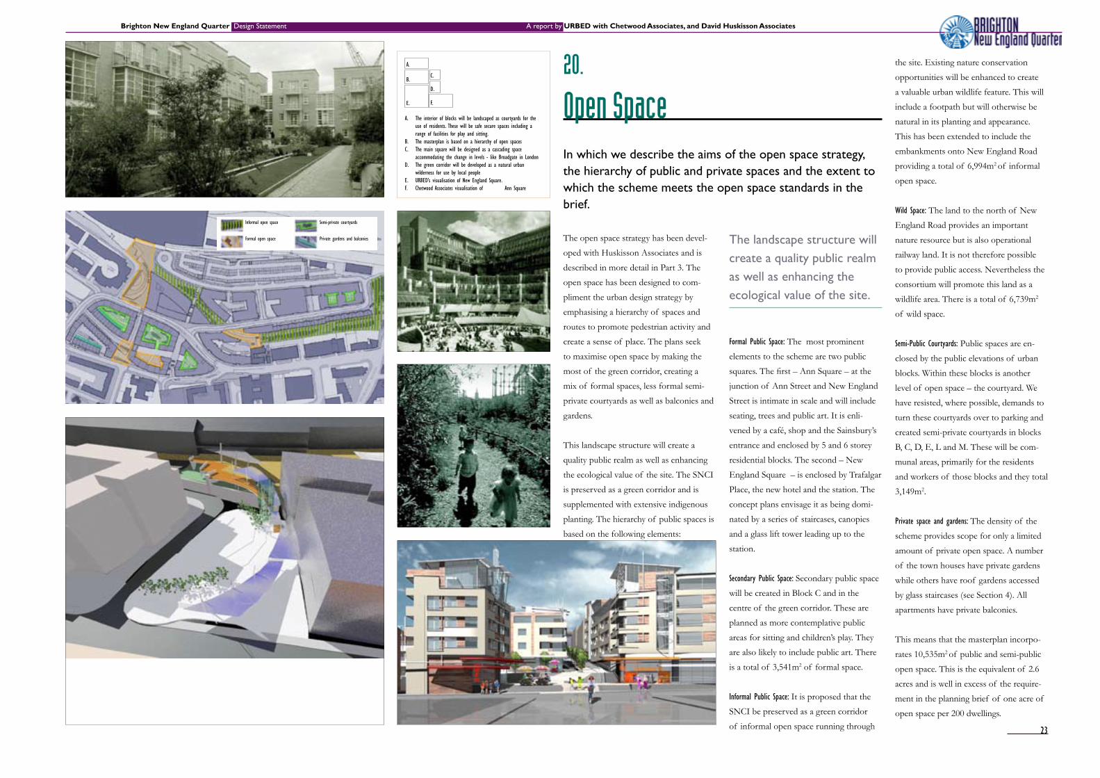
Open spaceIn which we describe the aims of the open space strategy, the hierarchy of public and private spaces and the extent to which the scheme meets the open space standards in the brief.
The open space strategy has been devel-
oped with Huskisson Associates and is
described in more detail in Part 3. The
open space has been designed to com-
pliment the urban design strategy by
emphasising a hierarchy of spaces and
routes to promote pedestrian activity and
create a sense of place. The plans seek
to maximise open space by making the
most of the green corridor, creating a
mix of formal spaces, less formal semi-
private courtyards as well as balconies and
gardens.
This landscape structure will create a
quality public realm as well as enhancing
the ecological value of the site. The SNCI
is preserved as a green corridor and is
supplemented with extensive indigenous
planting. The hierarchy of public spaces is
based on the following elements:
The landscape structure will create a quality public realm as well as enhancing the ecological value of the site.
Formal Public Space: The most prominent
elements to the scheme are two public
squares. The first – Ann Square – at the
junction of Ann Street and New England
Street is intimate in scale and will include
seating, trees and public art. It is enli-
vened by a café, shop and the Sainsbury’s
entrance and enclosed by 5 and 6 storey
residential blocks. The second – New
England Square – is enclosed by Trafalgar
Place, the new hotel and the station. The
concept plans envisage it as being domi-
nated by a series of staircases, canopies
and a glass lift tower leading up to the
station.
Secondary Public Space: Secondary public space
will be created in Block C and in the
centre of the green corridor. These are
planned as more contemplative public
areas for sitting and children’s play. They
are also likely to include public art. There
is a total of 3,541m2 of formal space.
Informal Public Space: It is proposed that the
SNCI be preserved as a green corridor
of informal open space running through
A. The interior of blocks will be landscaped as courtyards for the use of residents. These will be safe secure spaces including a range of facilities for play and sitting.
B. The masterplan is based on a hierarchy of open spacesC. The main square will be designed as a cascading space
accommodating the change in levels - like Broadgate in LondonD. The green corridor will be developed as a natural urban
wilderness for use by local people E. URBED’s visualisation of New England Square. F. Chetwood Associates visualisation of Ann Square
A. the site. Existing nature conservation
opportunities will be enhanced to create
a valuable urban wildlife feature. This will
include a footpath but will otherwise be
natural in its planting and appearance.
This has been extended to include the
embankments onto New England Road
providing a total of 6,994m2 of informal
open space.
Wild Space: The land to the north of New
England Road provides an important
nature resource but is also operational
railway land. It is not therefore possible
to provide public access. Nevertheless the
consortium will promote this land as a
wildlife area. There is a total of 6,739m2
of wild space.
Semi-Public Courtyards: Public spaces are en-
closed by the public elevations of urban
blocks. Within these blocks is another
level of open space – the courtyard. We
have resisted, where possible, demands to
turn these courtyards over to parking and
created semi-private courtyards in blocks
B, C, D, E, L and M. These will be com-
munal areas, primarily for the residents
and workers of those blocks and they total
3,149m2.
Private space and gardens: The density of the
scheme provides scope for only a limited
amount of private open space. A number
of the town houses have private gardens
while others have roof gardens accessed
by glass staircases (see Section 4). All
apartments have private balconies.
This means that the masterplan incorpo-
rates 10,535m2 of public and semi-public
open space. This is the equivalent of 2.6
acres and is well in excess of the require-
ment in the planning brief of one acre of
open space per 200 dwellings.
B.
E.
C.
D.
F.
Semi-private courtyards
Private gardens and balconies
Informal open space
Formal open space
23

Brighton New England Quarter Design Statement A report by URBED with Chetwood Associates, and David Huskisson Associates
21.
Public realmIn which we describe the principles that underlie the public realm strategy and the treatment of the hierarchy of streets
Figure 21D illustrates three types of street
in the scheme based on the analysis in
Section 15. These streets are central to
the masterplan. They provide the routes
for traffic and pedestrians but will also
function as places where people meet and
which as a focus for community life. To
do this it is important that a number of
simple rules apply to all streets:
All buildings should address the street
and take their primary access from it.
Buildings should respect the building
line established by the masterplan.
Buildings should provide a street wall
on at least 75% of their frontage.
Building windows should provide eyes
onto the street.
The street should be enlivened with
active ground floor uses.
These rules apply to all streets. In addition
each of the street types have their own
particular character:
1. Maintrafficroutes:While every effort will
be made to reduce traffic levels, traffic is
inevitable on these streets. Particular care
Street provide routes for trafficandpedestriansbutwill also function as a focus for community life
A. Streetsnotcarryingthroughtrafficwillbedesignedwithpedestrian priority like this Dutch Woonerf in Delph
B. Pedestrianised streets will be landscaped with high quality materials such as this street in Hamburg
C. Streetscarryingthroughtrafficwillbenarrowedtoonecarriagewayandtreatedtopreventtrafficfromdominatingashas been done in Wind Street in Swansea
D. The distribution of the three types of public realm E. The legibility of the area will be strengthened with clear signage
as is being implemented by the Legible City Initiative in Bristol
A.
is required to ensure that these street are
not dominated by traffic by providing just
one carriageway in each direction along
with generous pavements, street trees and
regular crossings (see fig. 21C).
2. Secondary routes: These are routes where
vehicle access is required but pedestri-
ans should dominate. These will include
shared surfacing, cobbles and traffic
calming along with street trees and short
term parking. The aim is to create a Home
Zone environment (fig. 21A).
3. Pedestrian routes: Within the core site
routes will be traffic free pleasant pedes-
trian environments (Fig. 21B).
Links to London Road: The consortium has
sought to maximise links to London
Road. This includes improvements to
Ann Street and York Hill as well as a third
route through the car park. This is being
explored further.
B. C.
D. E.
Mainstreetsdesignedtoaccommodatetrafficwithout it being intrusive
Secondarystreetswhichtaketrafficbutwhere pedestrians dominate
Pedestrianstreetswherenotrafficispermitted
Yellow arrows indicate main pedestrian linkages
24

Brighton New England Quarter Design Statement A report by URBED with Chetwood Associates, and David Huskisson Associates
22.
Public art strategyIn which we describe the aim of the consortium to exploit opportunities for public art by appointing an artist in residence
The consortium is committed to the
incorporation of public art within the
scheme. To this end a budget has been set
aside for public art and a further £2mil-
lion of work has been identified where
artists can be involved.
At this stage the Masterplanning team has
identified the following opportunities for
public art within the scheme:
Free standing pieces in the main
squares
A trail of public art along the green
corridor
Engraving and light sculptures on the
glass lift to the station
Steps and bridges at the top of York
Hill and around Block F
Paving within the main squares
Mosaics/murals on the retaining walls
Street furniture, benches, bins, lights
etc. throughout the scheme
In order to progress this an ‘artist-in-resi-
dence’ will be appointed to work with the
masterplanning team, responsible for:
It is proposed to appoint the artists in residence on the basis of a limited competition
Firming up on the public art
opportunities listed above and
identifying others as appropriate
Undertaking some of the public art
directly
Curating the involvement of other
artists
Working with local people and schools
Organising competitions to promote
the involvement of local artists
Curating exhibitions of the ideas and
artwork assembled
Documenting and writing up the
process
It is proposed to appoint the artist-
in-residence on the basis of a limited
competition organised in association with
Southern Arts.
A. Murals and mosaics such as in Hulme could be used to enliven retaining walls
B. A sculpture in Bristol providing delight and surpriseC. Similarly understated sculptures in a public space in Barcelona.D. Opportunities for public art in the masterplan E. Public sculpture on London’s South BankF. Artists can become involved in the creation of play areas and
street furniture G. Surfacing and mosaics can be designed by artists
A. B. C.
D.
E. F. G. H.
25

Brighton New England Quarter Design Statement A report by URBED with Chetwood Associates, and David Huskisson Associates
23.
sustainability
The aim of the consortium is to deliver solutions which bring real environmental benefits
Environmental sustainability is increas-
ingly moving up the commercial and
political agenda. It is therefore the New
England Consortium’s aim to incorporate
best practice in sustainable design and
to address the local and national policy
context.
The aspiration of the consortium is
to deliver solutions which bring real
environmental benefits throughout the de-
velopment’s life cycle which are deliverable
within practical commercial constraints,
as well as creating a place in which people
will want to live and work.
The sustainability team has worked on a
number of high profile projects including
the Greenwich Sainsbury’s, Homes for
Change housing co-operative and ICIAN’s
Smithfield Development in Manchester.
Extensive consultation within the design
team has resulted in plans which through
design and the provision of innovative
services will address the environmental
criteria described in the Building Research
Establishment Environmental Assessment
Method (BREEAM) – with the aim being
to achieve at least a ‘Very Good’ rating
across the development.
The design team also recognises the need
to be open and accountable about the way
in which these issues are addressed. At
this early stage of the design process, the
commitments will cover:
Energy An integrated strategy has been developed
including measures to reduce demand
through design, specification and con-
trol systems; develop a highly efficient
Combined Heat and Power (CHP) supply
system; and explore the potential for using
renewable energy sources.
Mobility A range of measures have been devel-
oped to reduce car-dependency through
integrating and promoting travel by rail,
bus travel, cycling and walking. The public
realm and road space will be designed and
prioritised accordingly and new services
such as car share, cycle hire, tele-work-
ing and home delivery will be introduced.
Commercial occupiers will be encouraged
to develop green travel plans. The poten-
tial for demonstration of zero emission
vehicles will be explored.
Water An integrated strategy will include meas-
ures to reduce demand through design,
specification and control systems; develop
new supply systems including rainwater
harvesting and grey water recycling; and to
reduce storm-water run-off.
Waste Measures will be taken to reduce the
amount of waste produced during
construction and explore the potential
to specify re-used or recycled products.
Domestic and commercial recyclable
collection services will be established
including organic waste collection.
Construction Materials Minimising life-cycle impacts through
development of a green procurement
procedure will be developed to review
products against the following criteria:
embodied energy, recycled content, dura-
bility, ecological impact, recyclability and
toxicity.
In which we summarise the sustainability appraisal undertaken by Chetwood Associates and URBED. We outline the commitments to follow a sustainable development agenda in the redevelopment of the site
A. High level aqueducts could be used to collect rain water
B. There may be potential for solar PV arrays.
C. Electric car charge points at Greenwich Sainsburys
D. Cycle hire will be explored such as Copenhagen ‘city bike’
E/J A CHP system housed in a distinctive building will
supply heat, power and cooling demand.
F. Multi materials household recycling including organic waste.
G/H Berlin’s Stattauto car share. Novel city cars could also be provided.
I Greenwich Millennium Village uses prefabrication and distinctive building materials to reduce waste and embodied energy
K This Dutch apartment block demonstrates high density low energy housing and requires <10 KWh/m2 for heating
A. C. B.
D. E. F.
G. H. I. J. K.
26

Brighton New England Quarter Design Statement A report by URBED with Chetwood Associates, and David Huskisson Associates
24.
ConclusionIn which we summarise the masterplan contents in relation to the requirements of the Council’s planning brief.
In which we summarise the masterplan
and its components in relation to the
Council’s planning brief.
Brighton’s planning brief for the site sets
out a vision to ‘develop a vibrant mixed-
use urban quarter that meets both its
strategic and local role whilst acting as an
exemplar of 21st century sustainable ur-
ban development’. The brief develops this
We believe that the master-plan responds to both the spirit of the brief and to the detail of uses and develop-ment requirements.
context. The uses proposed have been
integrated into an urban street network,
something that has not been easy given
the topography of the site and the lack
of permeability created by the railway
lines. This street network ensures that the
scheme is permeable and maximises links
to the surrounding streets. Particularly
important are the links that it creates to
London Road.
In doing this we have paid particular attention
to the following aspects of the brief:
Housing: The brief seeks 270-400 residential
units and the masterplan provides for 261
self-contained residential units plus 369
bedspaces of key worker housing and 400
bedspaces of student housing. 109 of
these units are 3 bedroom and over, and
52 are town houses. As required by the
brief 30% of the self-contained units will
be social housing.
The amount of housing on the site ex-
ceeds the brief ’s requirements when the
key worker housing is included. Efforts
have been made to maximise the number
and size of units and while the number of
3 bedroom units is lower than required it
is the maximum achievable without fur-
ther reducing the number of units. There
were originally plans to accommodate
more housing on the plateau although the
college and student accommodation are
considered a better use. There is however
potential for additional housing at the
northern end of Block J depending on the
space requirements of the hotel.
Offices: The brief encourages B1 develop-
ment without setting any targets other
than for 1,858m2 of workshops and a
similar area of training centre. The train-
ing centre is accommodated on the
ground floor of Block D. Workshop space
is available at the southern end of Block
G (883m2). In addition to this Block K
includes 3,160m2 of B1 office space and
Block M has 1,965m2 of office space for
the International College.
Retail development: The brief encourages small
scale A1 and A3 uses. The masterplan
accommodates these around Ann Square.
There is also likely to be an element of
uses. This means that the consortium has
not assigned a value to this site and has
initiated discussions with the Council and
local groups about how it should be used.
The building could be reused or redevel-
oped and could accommodate a range
of uses including workshops, premises
for community organisations, a cafe and
facilities for meeting and other community
activities.
Open space: As we described in Section 20,
the brief requires that the SNCI to be
incorporated into the scheme, that at least
1 acre of open space be created for every
200 homes, that 6 acres of playing field
be available for every 1,000 residents and
that play space be provided. The master-
plan responds to this by incorporating
the SNCI as a major landscape feature
running through the site. This is part of a
total of 2.6 acres of public and semi-pub-
lic open space - far exceeding the brief ’s
requirements. It is not however possible
to include the playing field requirement in
a scheme of this nature. The scheme also
includes a play area within Block C. The
scheme also includes a commitment to
include public art within the scheme and
to appoint an artist in residence to work
with the masterplanning team.
We therefore believe that the masterplan
responds to both the spirit of the brief
– namely to create a distinctive mixed-use
urban quarter – and to the detail of uses
and development requirements.
vision into a series of eleven objectives as
summarised in fig. 13C.
We believe that the masterplan described
in this design statement is an imaginative
response to this vision. We have described
proposals for a mixed-use urban quarter
with a robust urban public realm that
responds to the character of the sur-
rounding area and the wider Brighton
A3 use in the ground floor of the 4 Star
Hotel and in Block F.
The justification for the supermarket is
covered in other documentation support-
ing this application. In urban design terms
the masterplan seeks to implement the
brief ’s aims to locate the supermarket as
close as possible to London Road, to re-
move barriers between the two and ensure
that there are a number of clear links to
London Road. By locating the supermar-
ket in the ground floor and basement of a
residential block the masterplan also seeks
to minimise its visual impact.
Hotel uses: The brief indicates that hotel
uses are acceptable provided that they
are well related to the station and have
minimal car parking. This the brief does
by locating the two hotels adjacent to the
public space created outside the station.
Community uses: Block F has been set aside
within the masterplan for community
New England square
Ann square
A
B
C
J
0-R
K
E
L-N
G
F D
27