new gis and rs in support of adaptive collaborative management · 2007. 4. 18. · gis and rs in...
TRANSCRIPT

GIS and RS in Support of Adaptive Collaborative Management
A Case Study in Labanan Forest Concession Area, Indonesia
Dian Novarina ��������

GIS and RS in Support of Adaptive Collaborative Management
A Case Study in Labanan Forest Concession Area, Indonesia
by
Dian Novarina
Thesis submitted to the International Institute for Geo-information Science and Earth Observation in partial fulfilment of the requirements for the degree of Master of Science in Geo-information Science and Earth Observation, Planning and Coordination in Natural Resources Management
Degree Assessment Board: Prof. Dr. Ir. W. vd. Toorn (Chairman), PGM Department, ITC Dr. A. de Fraiture (External Examiner), University of Wageningen Dr. Y. Hussin (Internal Examiner), NRS Department, ITC Dr. Ali Sharifi (Supervisor), PGM Department, ITC Dr. Ing. W. H. de Man (Supervisor), PGM Department, ITC
INTERNATIONAL INSTITUTE FOR GEO-INFORMATION SCIENCE AND EARTH OBSERVATION ENSCHEDE, THE NETHERLANDS

Disclaimer This document describes work undertaken as part of a programme of study at the International Institute for Geo-information Science and Earth Observation. All views and opinions expressed therein remain the sole responsibility of the author, and do not necessarily represent those of the institute.

I
Abstract Escalating deforestation rate as an impact of Indonesia’s decentralization process since late-���������raised the necessity to find appropriate concept to manage the forest at local level, which could accommodate and adapt to the rapid changes while at the same time providing the opportunity for different stakeholders to collaborate. Adaptive collaborative management, a concept proposed by among others, CIFOR (Centre for International Forestry Research), is a promising solution, because it based on participatory approach and collaborative learning to improve these stakeholders’ capabilities to deal with the complexity and dynamism of interaction between human and natural components in forest management. The potential advantages of geographic information system (GIS) and remote sensing (RS) to improve the quantity and quality of spatial information and the analytical capabilities of their users could not only contribute to a better understanding in collaboration among stakeholders, but could also facilitate their thinking, communicating, and negotiating in solving spatial problem like a boundary dispute. This study evaluates the application of adaptive collaborative management in settling a boundary dispute between the Labanan forest concession holder and the community of Siduung Baru, and the role of GIS and RS to support the application. Findings from this evaluation are then used to discuss possibilities of wider applications of adaptive collaborative management in resource management in Labanan. This case study was carried out in Labanan forest area, in East Kalimantan, Indonesia. Participatory action research approaches has been employed in this study; whereby the researcher is not outside the system, but an actor within it, who works together with the people as a co-learner. Notebook computer with ArcView software, GPS and Landsat TM images were prepared to bring geographic information technology to the people. The research approach follows the three main phases of adaptive collaborative management: the preparation phase, the negotiation phase and the consensus phase. The preparation for the negotiation process between both parties was intended to lessen power disparity and build trust between them, to enable collaboration, sharing and negotiation in solving the problem. This study found that adaptive collaborative management technique indeed has enabled a collaboration and somehow equal negotiation process between both parties, which resulted in a more secure decision in a long-term perspective. A more collaborative way has made the concessionaire win the community’s commitment to protect the forest. On the other hand, the community has been able to gain the concessionaire’s concern upon their livelihood in the area. Better understanding upon each other concerns and trust has made both parties able to adopt some flexibilities to accomodate adjustments in their resource management practices as consequences of agreeing upon the boundary. The dispute settlement process has also brought the idea to acknowledge this boundary arrangement as temporary, which they need to revisit upon a discovery of inappropriateness in the future. The application of adaptive collaborative management has enabled both parties to learn not only about their current situation, but also for the future (feed-forward). GIS and RS have been able to empower the community by giving them a bargaining power for the negotiation process. GIS and RS also contributed to build trust between both parties by keeping the negotiation process open, and facilitated sharing and learning during the consensus seeking process. Given some hindrances for its implementation, adaptive collaborative management is still something to be aimed at for resource management in Labanan area.

II
Acknowledgement I first want to convey a very special thanks to Dr. Ali Sharifi, my supervisor, who provided guidance without which the value of this work could not have been achieved. I am deeply indebted to my other supervisor, Dr. Erik de Man. His patient and support have sustained and inspired me throughout my difficult days writing this thesis. I will never forget fruitful discussions with him, and also his words telling me not to be panicked. A sincere thanks goes to Dr. Michael Weir, my program director, whose support encouraged me to finish my thesis in a better shape. I would wish to express my appreciation to Dr. Dick van der Zee, my study adviser, who always very thorough in reading my thesis drafts. I would extend my appreciation to Mr. Muhandis, the President Director of PT. Inhutani I, who gave me a permission to carry out my study in Labanan and to have a full access to their spatial database. I would also extend my appreciation to PT Inhutani I Labanan officials in Berau, particularly to Mr. Doddy Hendrika and Mr. Boorliant Satryana, for their kindly support during my fieldwork. My special thanks goes to Arif, who was tirelessly taking me with his off-road motorbike along the bumpy and dusty roads of Labanan forest. I owe a handful of thanks to Mr. Jiu Usat, the leader of Siduung Baru community. His spirit and cooperativeness has made my fieldwork enjoyable. He always there when I need his assistance. I am greatly indebted to Mr. Yohannes Hardian, the former President Director of Barito Pacific Timber Group. Without his support, I would not able to come and study in ITC while I am still working with the company. I also would thank my colleagues in PT. Binareka Alamlestari, my consultants gang, who take over my duties during I am away in the Netherland. Terima kasih, Kawan! Special thanks are due to my friends in ITC, with whom I share laughs and pressures during my study period in ITC. I could not mention their name one by one, but for sure I will not forget all of them - along with a thousand of memories. I am grateful to my classmates in Planning and Coordination ���������� �������������� �������������� ������ ��������������� ���� I wish to express my sincere gratitute to Mr. and Mrs. Remeijn, who made me feel at home in Enschede. I am thankful to my father, who inspired me to follow his step studying in ITC. And for you, Mother, your couraging voice in my tough times in ITC always give me strength to keep going on. Also my mother-in-law, Mama, your blessing and understanding have giving me courage to finish my study on time. To my sisters, Dewi and Dini, and my sisters-in-law, Teh Ida and Iis, who help taking care of my two daughters during I am away in the Netherland, thank you very much. My deepest debt is to my loving husband, Aa Ruhul, and to my two angels, Namira and Hanna. I thank them for letting me away from them for one and a half years. It is really not easy for them nor for me. Without their love, courage and sacrifice, I would never able to achieve my study goal in ITC. The words of thanks I can offer to them can never do justice to what I truly owe them.
III
Table of Content
Abstract ……………………………………………………………………… i Acknowledgements ……………………………………………………………………… ii Table of Contents ……………………………………………………………………… iii List of Tables ……………………………………………………………………… vi List of Figures ……………………………………………………………………… vii List of Acronyms ……………………………………………………………………… viii
�� ����������.........................................................................................................................�
���� ����������� �������� ������������������� ������ ����������� � ...........................� ���� ��������� �������������������������������� � ��������������............ ���� �������������� ����������������������� � ������������������������
���� ��� ����������� .................................................................................................................� ���� ������������� ���� �������������......................................................................................� ���� ��������� ����������� .................................................................................................................� ������ ������� ������...................................................................................................................� ������ ���������� �������................................................................................................................�
���� �������� ����� �� ......................................................................................................................� ������ ��������������������� ���������� ...........................................................................� ������ ��������������������� ����������...........................................................................� ������ ��������������������� ����������...........................................................................� ������ ��������� �������............................................................................................................�
��!� ���������� �� ����������� .......................................................................................................... ��!��� �������������.......................................................................................................................� ��!��� �������"�������������������"�������������"�������������������
#�����#��������������$%�������������������...................................� ��"� ����������� ��........................................................................................................................! ��#� ������� �� ������������ ........................................................................................................!
�� �� ��������.......................................................................................................................�
���� �������� � ��������������........................................................................................� ������ &�#����'�������������� ����#�������������������������
#�����#���..........................................................................................................................� ������ (���������������������������������#�����#���.......................................�� ���� � ���������� ���� .................................................................................................................� ������ (������������������������##����"�����������������������"......�� ������ )������"���*��������##����"+�������������������������������...��
���� �� ���������� ���� ���������$���%������� �����������$��%...............................�� ������ $���������%����#������"���#,$%�-.......................................................................�� ������ ��#����������,��-........................................................................................................��
���� �������� ������ ���������................................................................................................� ������ (��������������������������"��������������........................................................��
IV
������ .�������������������������������������"��������������.........................�� ������ /���������������������....................................................................................................��
�� �������� ������............................................................................................................�
���� ���� ���� ������ ���� � ..................................................................................................� ���� ���&����� �'���������� ...........................................................................................................� ������ ����"��������������������...........................................................................................�� ������ %�����������*��0..............................................................................................................��
���� ����� �'���������� ................................................................................................................... ������ 1��������������������#���������..........................................................................�� ������ $�������������������"�����������........................................................................�� ������ /�������*�������������.............................................................................................� ������ ���������'��##��#������������������".............................................................
���� � ��&����� �'����������.........................................................................................................��
�� �����������������������������..................................................................�
���� ����� ������ ������ ���� ............................................................................................� ������ 2������������������������........................................................................................� ������ 2������������������������........................................................................................�
���� ��������������������� ..........................................................................................................�� ������ 3�����".....................................................................................................................................� ������ )��4��"����������.............................................................................................................� ������ �����4�����#���������..................................................................................................�
�� ����������������������� ...................................................................................
���� ��'�� ��������� .................................................................................................................�� ������ ���0���������������������.............................................................................................. ������ .��"��������0�������+������������#��������............................................. ������ 5�������*�#������0�������6�����##����"���������)���������
7��������������������...................................................................................................�� ���� � ������������������� .......................................................................................................�� ������ ���������������................................................................................................................�� ������ 8�������������������������...................................................................................��
���� ������ ��� ������������������ �� ���� ������������� ......................................�� ������ .����������������������������������������������..................................� ������ 7���������#��������������%��������..................................................................�
�� �������������������������������................................................................��
���� ������ ����� ��� ���������������������� �.............................................................� ������ )������"���������������������*��������##����"���������)���......�� ������ )������"����������������7��������������������..........................................�
�� ���������������������...................................................................................��
!��� ���������� ��������� ���� � ................................................................................................ ! !����� )������"��������������������.................................................................................�� !����� .��"��������������*�������������"......................................................................�� !����� (����##����"+���������').(8.�����#���#����������.............................� !����� (����������������+������������).(8..................................................................��
V
!��� ��� ���� ���� ���� ...................................................................................................................���!����� �����"���������+������������������������##��������������������
�����........................................................................................................................................�� !����� 8����������............................................................................................................................�
!��� � �������(�� ���������������� ���������������........................................................�! !����� ���������.............................................................................................................................�� !����� ��##��#������������������"....................................................................................��
�� ����������������������������������������������������
����� ����������������������������������������.....................�
"��� � ������������������ ��� �������� ���������������� ������ ���������......��� "��� ����� �� ������������ �� ���������� � ������������������������ �����
��� ������������������������������������� ��� ����������� .............................��� 9����� $�������������������"�����������4���:� ��4�������+�������������
��##����"..........................................................................................................................��� 9����� 5�����������������������������������������������������������������
................................................................................................................................................��� 9����� ���������'��##��#������������������"...........................................................��
"��� ��������� �� ��� ������������ ��� ���������� � ��������������������
�������� ���)���������� ������ ������ ������������� �� ���������������
������ ���� ��� ..........................................................................................................................��� 9����� 2����������������"�������������������#�����#������*���������;�
��7��������������������������............................................................................��� 9����� 3�*$%�����������������������������*���������;�<....................��� 9����� .�����'������������������������������������#�����#�����7������
��������#������������#����<............................................................................��
� � ���!����������������� ���������....................................��
#��� ������ ........................................................................................................................................�� #��� � ����� �� ................................................................................................................................�� =����� (������������������������������������������"�������.....................��� =����� (�����������������$%������............................................................................��� =����� .*�����������������������������������#�����#�����7���������
������������������$%������.............................................................................��� #��� ��� ������� �.........................................................................................................................� =����� ����##������������#�����������������������������������������
#�����#���......................................................................................................................��� =����� ����##��������������������������......................................................................���
REFERENCES …………………………………………………...…………………………………. ���

VI
List of Tables "�#������$���������%����������������������� �� ����#������������� �� �������&�'����������� ( ��� ���
of potential impacts of the dispute settlement activity to them ...........................................�� "�#��!���)((������#��(������������� ����(�$ ������*���.................................................................!� "�#��!��+����� ��,���� �� � ��������� ��� ���� ���� .......................................................................! "�#��!���-������ ���#�������������(�������$ ������*���������� ��..............................................!� "�#��!���)((������#��(�������.�#������������ ��� ��........................................................................!� "�#��!���.�#������������ ��� ��,���� �� � ��������� ��� ���� ���� ....................................................!� "�#��!� �-������ ���#�������������(�������.�#������������ ��� ��................................................�� "�#��!�!�/����� ���������� ��$ ������*���������������������������� �������������������������������������������
(����� ((������������ �� .......................................................................................................�! "�#������$�����%elements in the ‘equal-footing’ process, the outcomes, GIS/RS contributions, and
relevant ACM requirements...............................................................................................��� "�#�����$������ ��0��� ��������������������,����������������������12$%3$������ #�tions, and
ACM requirements ............................................................................................................��� "�#������4 ((�������������(����� � ��� ������ ��������������(�0��� ��������������������,���������
participants involved..........................................................................................................��� "�#������$������ ��������� ����(���������� �� ��������������������������12$%3$������ #�� ���������
relevant ACM requirements...............................................................................................���

VII
List of Figures
5 ���������3���������������� ................................................................................................................� 5 ��������+���������������(������ ������#���� �������������.................................................�� 5 �������/��� � ��� ���������&��������(����4����������$���������� ��$����������!'...................� 5 ��������6 ���������(������� �(����� �������������&��������(����"��� ������'.........................�� 5 ��������$�7�������(������� ������� ��������������&��8������(����9�#���������� ��5��������'.�� 5 ���������:�� ��� ��� �������� �������� 7���(��������� ���#��������������� ����&adapted from
;������� ������� ��$��� ( ���������6��� 8�������'......................................................� 5 ��������3����������������� ������ �����(����� ( ������������#8��� ��� ..........................................�� 5 ���������$�����������.�#�����(������������� ���������*�����4 ��� ����)����<� �������/��� ���...�! 5 ��������"������� ����(�$ ������*������������������������ ������������� ���.abanan forest
concession area ..................................................................................................................�� 5 ���������&�'�$ ������*����� ��� ����� ��-harvest ceremony; (b) Totem-pole and wood carving for
house decoration made by Dayak people around Labanan area ........................................�� 5 ���������2�����������lamin or long house in Siduung Baru ...........................................................�� 5 ���������Planting rice among trunks − the community’s agricultural practice.................................�� 5 ���������$��������������� ( ��� ������� =�#����������� �� �������������� �(������ ���������������
boundary dispute between the Siduung Baru community and the Labanan concessionaire�� 5 ��������A structure of local government in Indonesia.....................................................................�� 5 ����� ���&�'�*��������������� �������>�����&#' Boundary alternative���� ..................................... � 5 ����� ��&�'�*��������������� ��������>�����&#'�:������� ���������(�������� ������-timber forest
products .............................................................................................................................. 5 �����!���?���������(��������� ���#��������������� ����(�������$ ������*���������� ��........... � 5 �����!��&�'�+���� #�� �����(�������� ��� ������������������� ����(���#��������������� ���������������
(b) Contributions of each criteria group using separate bar chart......................................!� 5 �����!���?���������(��������� ���#��������������� ����(�������.�#������������ ��� ��..............!� 5 �����!���&�'�+���� #�� �����(�������� ��� ������������������� ����(���#��������������� ���������������
(b) Contributions of each criteria group using separate bar chart......................................�� 5 �����!���?�������������� ��(�������$ ������*���������� �����������.�#������������ ��� ��....�� 5 �����!� �.���� ����(���� ������������� �� �������#��������������� ��..........................................� 5 �����!�!�1�����������(��������� ���������� ������������������� ��$ ������*�������� .............�! 5 �����!���"������� ����(����������������-timber forest products can be found within each boundary
alternative...........................................................................................................................�� 5 �����!���/��� #������ ����(������(�������,���������� ������(������������ �� ��#��������������������������������
������� �������� ..................................................................................................................�� 5 �����!����/��� #������ ���(������������� ����(�$ ������*���,����� ����������� ........................�� 5 �����!����&�'�? ����� �������������.�#anan concession area and their categorized buffer areas for
collecting non-timber forest products; (b) The categorized buffer areas and the location of non-timber forest products .................................................................................................�
5 ���������$haring data, information and knowledge ........................................................................���

VIII
List of Acronyms
ACM Adaptive Collaborative Management GIS Geographic Information System RS Remote Sensing BFMP Berau Forest Management Project MCE Multi Criteria Evaluation CIFOR Centre for International Forestry Research LEI Lembaga Ekolabel Indonesia (Indonesian Ecolabel Institute) ITTO International Tropical Timber Organization BATNA Best Alternative To a Negotiated Agreement
GIS and RS in Support of Adaptive Collaborative Management
�
�� Introduction Escalating deforestation rate as an impact of Indonesia’s decentralization process since late-����������raised the necessity to find appropriate concept to manage the forest at local level, and look at the possible tools that can help putting that concept into practice. The present forest management system is seen as not heading to forest sustainability, nor enhancing the well being of the community who live in and around the forest. It also does not work well with rapid changes in the relations among the forest stakeholders and between them and the forest. Adaptive collaborative management seems to be a promising solution to overcome the problem, because it gives emphasis to a collaboration among stakeholders (necessarily involving the local community) to learn from their shared knowledge and experience, and to improve their capability to deal with the complexity and dynamism of interaction between human and natural components in forest management. It based on learning process to adapt forest management strategies overtime. Conflict is inevitable when different interests toward the forest exist. Conflicting stakeholders’ interests over the use and control of forest resource turn out to amplify during the decentralization era. One recurrent problem is boundary dispute between the local community and the forest concession holder. To settle conflict under the current situation, multi-stakeholders processes need to be employed. The negotiation among stakeholders should be grounded in an ample space for stakeholders’ interaction and communication, sharing and learning together, and seeking to achieve consensus. Adaptive collaborative management approach may well provide those structures. The potential advantages of geographic information system (GIS) and remote sensing (RS) to improve the quantity and quality of spatial information and the analytical capabilities of their users could not only contribute to a better understanding in collaboration among stakeholders, but could also facilitate thinking, communicating, and negotiating in solving spatial problem like a boundary dispute, which eventually could build trust among them to work together in managing the forest resource. This is important because trust is the ‘heart’ of adaptive collaborative management. ���� Decentralization in Indonesia an its effect to the forestry sector Decentralization is regarded as an important approach towards deepening democracy in developing ������ ���&@�������'����A ����� ��������������� ����#�����������(���� � ����� �����������������
authority have been transferred from the national government to the country’s provincial and district governments. In forestry, decentralized administration often allows for greater participation on the part of forest communities in policy decision-making processes, and more direct accountability of policymakers to ������������� �� ����������������(�������&*�����������A�������'���4������� B�� �������
frequently implies a more equitable distribution of benefits from forest resources, as local communities and local governments in forested regions are able to secure a greater portion of ���������(���������=����� ����(�� �#�������������(���������������&@�����������'� However, decentralization also carries significant risks. For example, national government in many countries have decentralized without first creating the necessary institutional capacity at the provincial or district levels and without giving them adequate resources to administer forests effectively.
GIS and RS in Support of Adaptive Collaborative Management
�
In Indonesia, in an increasingly open political system, the policy community has widened and included more than a single policy ideology. Local governments, which have long been powerless, increasingly become significant players, and societal interest groups in the form of NGOs are more organized and have more capacity to bring their aspirations. Local people are still in the policymaking periphery, although their political participation is formally enhanced. However, there is noticeable drive towards a more bottom-up approach, coordination based more on dialogue, self-organization, transparency, conflict management, and public participation which were formerly not so common. But failure to tackle those complexities properly could lead to unwanted direction into which policies may develop. In Indonesia for example, the decentralization process has created a high risk of rapid deforestation. The Indonesia’s national governments have delegated authority without creating necessary legal and institutional frameworks to ensure that people at the lower level capable of taking advantage of increased opportunities for participation in managing the forest properly. Most provincial and district governments lack essential technical skills and must look to other entities for advice, training, support, and technical information. There are also many cases where these local governments have little interest in sustainable forest management, because they face a necessity to generate instant cash to replace the income, which previously was provided by the national government, while forest is one of the most reachable source for it. For the situation in Indonesia’s forestry sector nowadays, decentralization should be addressed with a �������������(�������������������� � ��&:��� �����)((��� �����'��2�� ������ntial to find suitable collaboration patterns between local government, local communities, NGOs, existing timber companies and other stakeholders, that can deal with horizontal and vertical complications by adapting the management strategies overtime. One concept that can be appropriate for forest management in Indonesia under current political circumstance is adaptive collaborative management. ���� Present forest management system and adaptive collaborative management
“Our forest and our land are not without an owner Our forest and our land are not without a boundary Our forest and our land are not without a customary right” &:����������-#�������'
� To date, the forest management in Indonesia is based on a commercial forestry concessions (Hak Pengusahaan Hutan=HPH) system, which is a timber-based management. In that system, the concession holder with a rigid cost and benefit target develops plan mostly by using a top-down approach, while the government supervises the forest management activities and develops regulations and laws to penalize unconformities. The condition makes the forest management system not flexible; it has a fixed ‘management menu’, with a single goal: income from the forest. That system does not have enough room for the local community or for other stakeholders to take part in managing the forest or to benefit more than what has been defined by the government and subsequently by the concession holder. As a consequence, the forest concession holder often sees the local community as a part of the forest which should be managed like other forest components, rather than as a partner to work with. The present forest management system − even though it is never intended for that, has positioned the local community as a party who benefited the least from the forest. Only after the decentralization process began, when many parties claimed more rights over the use and control of the forest, the concession holders and other forest users realized that there are
� Taken from a speech of Dayak Punan ethnic group representatives in a seminar: “Empower local community initiative in natural resource management decentralization in East Kalimantan”, held in Samarinda – Indonesia, 5�#�����������
GIS and RS in Support of Adaptive Collaborative Management
�
numerous forest stakeholders with different interests toward the forest that has to be acknowledged. Not only that, the relationship among those stakeholders and with the forest ecosystem is also changing very rapidly in many different directions. The current forest management system could not respond more effectively to manage the complex and dynamic situation like that. That situation has raised thought to find a new approach in managing the forest, which could accommodate and adapt to the rapid changes while providing the opportunity for stakeholders to collaborate. Adaptive collaborative management seems to be the answer. It based on participatory approach and collaborative learning. Different interests are balanced through negotiation with joint concerns about the consequences of the decision being made. It is a resource-based management, which has multiple goals in managing the forest − not only timber, to satisfy different stakeholders’ interests. Adaptive collaborative management is process-oriented, since the management approaches is treated as a series of experiment that are observed and evaluated for the basis of adjustments and improvements to the forest management system. ��� Settling spatial conflict by using adaptive collaborative management with the
support of GIS and RS Conflicts can be expected when different interests towards the forest resource exist. In forest area in Indonesia, conflict might take place between neighbouring villages, between local community and forest concession holder, between forest concession holder and other private companies like mining, and between different forest concession holders. Most conflicts between local community and forest concessionaire are spatial or spatial-related. In East Kalimantan, a lot of conflicts between local community and forest concession holder are caused by community’s claim over compensation (payment) for customary land or non-timber forest products #� ������������0� ����#��,�#������������� ��� ���&C��� ����'���2��/������Asmat tribal group found themselves depend on the forest concession holder for employment (while they do not have sufficient skill for that) because the company were ‘encroached’ their customary lands and forcefully prohibited the Asmat from entering and using their traditional hunting and areas for gathering non-timber forest products. When they started to claim back their customary lands, the conflict began (Kirana and 3�� ��� 8���������'�� Multi-stakeholder processes to tackle conflicts and greater community participation are necessities to guarantee better outcomes in the current decentralization course and nerves. Underlying principles of multi-stakeholders process suggest that negotiation that involves relevant stakeholders has to ensure an effective dialogue where their concerns are identified and can be channelled out. In that process, stakeholders can gradually build collective understanding upon the problem and collective awareness upon the decision to be made, as they move forward to achieve consensus. Adaptive collaborative management as an approach proffers that construction. Adaptive collaborative management approach has been used in dealing with several spatial conflicts and decision-making processes in forestry. In Malinau − Indonesia, CIFOR has used adaptive collaborative management to deal with conflict, power disparities and agreement building in the demarcation of village boundary (Anau, et al����'���2��<��� �−�9�����4�����&��'�����(����������adaptive collaborative management is a good approach to increase participation of disadvantaged group in the decision-making process. Without adequate prior preparation efforts, disadvantaged group often loose more rather than gain something from a negotiation process with a more powerful party. When power disparity exists among stakeholders, collaboration is difficult to be expected. Some methods such as scenario development and value tree analysis could be used within the context of adaptive collaborative

GIS and RS in Support of Adaptive Collaborative Management
�
management to empower the disadvantaged group by raising their awareness, as well as tools like GIS and RS. Particular to GIS and RS, they could contribute more in the application of adaptive collaborative management in spatial problem. While RS could provide reliable data, GIS spatial analysis capability could support effective negotiation process and allow interactive, more open, and recursive problem solving. 2����� � ������������1��B��B�&��'���������������12$���������� �����������(�� ������� �� ������� ���
social construction of natural resources, and concerted decision making about the ‘world’ we manage with others; or in other words, it can facilitate joint learning or collaborative learning. GIS capability to incorporate local community’s information (local knowledge) and views is very important when the local community is a part of the collaboration. Through that ability, GIS could help bring their concerns out, and enable them to communicate better with others. These capabilities of GIS and RS have stimulated thought about their potentialities to support a wider application of adaptive collaborative management later. �� � Relating the story to the study area The Labanan forest concession area is located in Berau District, East Kalimantan Province, Indonesia. This area is one of the forest concession areas managed by PT. Inhutani I - a central government-owned tim#������������ ������! ���"��������.�#���������� ��������������$ ���������.�#�����(������
concession area was given a special status by the government as an area for research and the implementation of sustainable forest management practices. Currently, many activities that are not related to sustainable-forestry such as shifting cultivation, mining, illegal logging, animal husbandry and settlement take place in Labanan area. Those activities emerge during the decentralization, possibly because of the unclear and inconsistent local government regulations, weak law enforcement, weak control from the Labanan management, and also because of the availability of good access to and through the Labanan area. 2������������(��������������������������.�#�����(������������ ((������������ ��)����<� �������
province. They are all from the same tribe: Dayak Kenyah. They came to find area to cultivate and ������������2������#�� �� ����(����������������������������������������������������8� ��������
previous group. The second group is also from the same tribe, but they came from a village located �������!������������������������(�.�#���������������9�����2�������9�������������� ����(�����
settleme����������� ��� �������$ ������*����������������������������������������������
households. The Labanan concessionaire is facing a dilemma. On one side, based on the decree of the Ministry of Forestry, the area is allocated to production forest, so the only legitimate activity in the area is supposedly forestry-related. But on the other side, the people who came to the area are ‘local people’ who traditionally depend on the forest for their livelihood. To make things more complicated, the local government, who allegedly helps the Labanan management to find a solution, does not have single opinion towards the problem, but varies. One local government’s constituent supports the community to live in the area; while other considers that they are intruders, so they have to be resettled to other area outside Labanan. The existence of the Siduung Baru settlement in Labanan area can not be solved by merely sending them out from there, because it can be dangerous due to the fragile social, economical and political situation nowadays. But to what extent they could and should be accommodated in Labanan forest area without being harmful to the ultimate goal of ‘sustainable forest management’ still remains
GIS and RS in Support of Adaptive Collaborative Management
�
unclear. The dispute between the Labanan concessionaire and the community of Siduung Baru arouse when the community started to reveal their intention to have a permanent settlement area there, with a clear boundary, which is admitted by the Labanan concessionaire, as well as the government and other parties. A boundary dispute in a forest area like this necessitates a cautious handling because it is not only threatening the forest sustainability, but could also escalate social unrest in the area. The settlement process of the dispute needs a collaborative approach to allow the concerned parties have enough chance to communicate, share, and learn in consensus seeking process; and also needs an adaptiveness to comply with the changing of relationship among them and to the consequences of the decision being made. Adaptive collaborative management approach would be used to deal with the dispute, which might lead to a better situation for the Siduung Baru community and for the Labanan concessionaire. During the process of settling the boundary dispute, the role of GIS and RS would also be studied to understand how they could help putting adaptive collaborative management into practice. The outcome would give a reflection on the possibility of a wider application of adaptive collaborative management in Labanan, together with the supporting role of GIS and RS to it. ���� Objective of the study ������ Overall objective The objective of this study is to obtain a better understanding in the possible application of adaptive collaborative management in resource management in Labanan forest concession area − Indonesia, and the role of GIS and RS as support to it. ������ Specific objectives �� To evaluate the application of adaptive collaborative management in the process of settling
boundary dispute between the community of Siduung Baru and the Labanan concessionare; � To study the role of GIS and RS to support the application of adaptive collaborative management
in the process of settling the boundary dispute; �� To study the possible wider application of adaptive collaborative management in Labanan
concession area and the role of GIS and RS as support to it. ���� Research questions To accomplish the objectives mentioned above, the following research questions are formulated. ������ ���������������������������������� ��� �� How to see the process of setling the boundary dispute as an instance of adaptive collaborative
management? � What criteria need to be used to evaluate the application of adaptive collaborative management? ������ ���������������������������������� ��� �� What support GIS and RS could provide for adaptive collaborative management on each stage of
boundary dispute settlement process?
GIS and RS in Support of Adaptive Collaborative Management
�
����� ���������������������������������� �� �� Is adaptive collaborative management applicable to a wider resource management in Labanan
area? �� How GIS and RS could support a wider application of adaptive collaborative management in
Labanan area? ���� � Concluding question Is the application of adaptive collaborative management in Labanan area still something to be aimed at? ���� Justification of the study ������ Research focus There are a lot of spatial problems in Labanan forest concession area. These include conflicts between the Labanan concessionaire with some other villages in the area, with illegal loggers, with an animal husbandry company and with a mining company. Given limited time and resources to conduct this study while maintaining the need to ensure that the objective of the study can be fulfilled, this research is focused on one spatial problem: boundary dispute between the Labanan concessionaire and the community of Siduung Baru. This study will not solve the boundary dispute completely, since this is only the first attempt to bring both disputing parties together to the negotiation table; follow up actions upon the agreement being made still need to be carried out to see how both parties could proceed further to settle the dispute ‘on the ground’. Nevertheless, this study could give information on the use adaptive collaborative as an alternative approach to improve the situation. ������ Relevancy of settling the boundary dispute to study adaptive collaborative
management and the role of GIS and RS as support to it The process of settling the boundary dispute is considered relevant to study the applicability of adaptive collaborative management because settling a boundary dispute needs a multi-stakeholder process, which necessarily involves communicating, collaborating, negotiating, learning, and sharing among parties engaged. At the same time, spatial dimension of the boundary dispute gives room for GIS and RS to provide support. Defining the boundary also has a tremendous impact on the possibility to carry out resource management, for example the necessity to adjust the community’s agricultural practice to make it more suitable for the area within the agreed boundary. The possibility to choose different types of boundary (including the rigid and the fuzzy ones) and the need to adapt to the chosen boundary, will allow further analysis on the adaptiveness of stakeholders with respect to the decision being taken. This is important because adaptive collaborative management implies something that is iterative and evolving. Regarding the scope of case study, the process of settling the boundary dispute is considered adequate as an initial effort to study adaptive collaborative management in Labanan area, because if the problem is too complex, points to be observed could be blurred; while if it is too simple, it will not representative enough.
GIS and RS in Support of Adaptive Collaborative Management
�
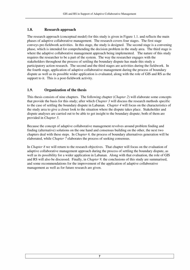
���� Research approach
The research approach (conceptual model) for this study is given ��5 ����������������(����������� ��
phases of adaptive collaborative management. The research covers four stages. The first stage conveys pre-fieldwork activities. In this stage, the study is designed. The second stage is a convening phase, which is intended for comprehending the decision problem in the study area. The third stage is where the adaptive collaborative management approach being implemented. The nature of this study requires the researcher to be a part of the system. The way the researcher engages with the stakeholders throughout the process of settling the boundary dispute has made this study a participatory action research. The second and the third stages are activities during the fieldwork. In the fourth stage, application of adaptive collaborative management during the process of boundary dispute as well as its possible wider application is evaluated, along with the role of GIS and RS as the support to it. This is a post-fieldwork activity.
���� Organization of the thesis
This thesis consists of nine chapters. The following chapter (�� ������) will elaborate some concepts that provide the basis for this study; after which Chap���� will discuss the research methods specific to the case of settling the boundary dispute in Labanan. Cha����� will focus on the characteristics of the study area to give a closer look to the situation where the dispute takes place. Stakeholder and dispute analyses are carried out to be able to get insight to the boundary dispute; both of them are provided in Chap�����. Because the concept of adaptive collaborative management revolves around problem finding and finding (alternative) solutions on the one hand and consensus building on the other, the next two chapters deal with these steps. In �� ������� the process of boundary alternatives generation will be elaborated, while �� ������ elaborates the process of seeking consensus. In �� ������ we will return to the research objectives. That chapter will focus on the evaluation of adaptive collaborative management approach during the process of settling the boundary dispute, as well as its possibility for a wider application in Labanan. Along with that evaluation, the role of GIS and RS will also be discussed. Finally, in �� ������� the conclusions of this study are summarised, and some recommendations for the improvement of the application of adaptive collaborative management as well as for future research are given.
GIS and RS in Support of Adaptive Collaborative Management
�
Application of adaptive collaborative management – participatory action research
Convening phase
Problem formulation
Stakeholder analysis: - Assessment of
interests - Analysis of
influence & importance
Boundary dispute analysis: - Source of
dispute - Nature & stage
of the dispute - Other relevant
issues
Generating boundary alternatives Moving towards consensus
Figure �.� Research approach
Research design
Preparation for the negotiation
Research proposal development: - Research topic,
objectives, research questions formulation
- Propositions development
Study area selection
Reflection on the foregoing process for possible wider application of adaptive collaborative management in Labanan with supporting role of GIS & RS
Discussion on adaptive collaborative management application in settling the boundary dispute & supporting role of GIS & RS
Recommendation & conclusions
A set of boundary alternatives
Participatory boundary alternative generation with the community (‘equal-footing’ process): - Objective
formulation - Scenario
development - Participatory
satellite image interpretation
- Boundary alternative generation
- Spatial data requirement
- GPS surveying - GIS operation - Feedback
session
Boundary alternative generation with the concessionaire
Negotiation process
Commitment &
responsibility
Figuring out other party’s objectives & concerns: Value tree analysis
Boundary alternative evaluation with the community: Multi-criteria evaluation
Boundary alternative evaluation with the conces-sionaire: Multi-criteria evaluation
$"-1)� $"-1)�� $"-1)�� $"-1)��
Pre-fieldwork Post-fieldwork Fieldwork
Analysis on some relevant issues to solve boundary
dispute
GIS and RS in Support of Adaptive Collaborative Management
�� Some Concepts
This chapter elaborates some concepts, which provide the basis for this study. This chapter ������������������ ��������������
st part, the concept of adaptive collaborative management, its ���������� ����������������� ��������� ��!����"����� ��!�� ������ ���#�������$����
nd part reveals some boundary issues in forest area in Indonesia. GIS and RS capabilities in the light of their potentiality to support the implementation of adaptive collaborative � � #������ ����! %�� �����������
rd�� �����&�� !!'������
th part provides a review of ‘participatory action research’, which is used in this study.
���� Adaptive collaborative management
The definition of adaptive collaborative management from the Centre for International Forestry Re�������&+25@3����'� �����(����D��“Adaptive Collaborative Management involves improving the shared, institutional learning that takes place among stakeholders (necessarily including communities) involved in forest management. This will include continuous and collaborative improvements in management, based on improvements in the breadth and depth of forest-related knowledge shared, and the speed at which that knowledge is transformed into effective action. Adaptive collaborative management is built on recognition of the dynamism and complexity of human and natural systems touching on management.” 3� ���#��������+��� ���&���'������������������� ������#���� �������������������������������#��
too rigorously defined to avoid too many reductions of what it is actually meant. By referring to the different interpretations of adaptive collaborative management from different literatures, they found that most definitions seems to include that adaptive collaborative management involves two elements: • the collaboration element of the definition, which refers to means for the rights and
responsibilities of stakeholders to be defined and shared, and • the adaptive element of the definition, which refers to means for stakeholders to learn through
actions in one period, so that they may modify actions in future periods.
������ Elements, processes and requirements of adaptive collaborative management
The distinction between adaptive and collaborative elements of adaptive collaborative management is useful to understand the whole concept better. The collaborative element of adaptive collaborative management entails two things: ‘collaboration’ and ‘collaborative management’. Collaboration implies that there are two or more separate parties involved, while collaborative management refers to the arrangement and the process of the collaboration. The elaboration of the collaborative element of adaptive collaborative management in (�%��� ������������ refers to the collaborative management. However, it is necessarily kept in mind that to undertake a collaborative management, there are several conditions to make collaboration among different parties possible. According to Marshall &����'������������ � �������D���������� ����� ��� clarity of rights and rules, consensus, relation based on �������������� # ������������������A � �������� ������"��8�� ��&���'�����#���� ���������#��#� ��
based on equity, equality, respect and openness among parties involved. In the light of the literatures and the context of the present research in adaptive collaborative management, those conditions for collaboration can be summarised into two salient conditions, namely equity and trust. This study takes those two conditions for enabling collaboration.

GIS and RS in Support of Adaptive Collaborative Management
�
The adaptive element of adaptive collaborative management also entails two things: ‘adaptation’ and ‘adaptive management’. Adaptation within this context refers to the attempts of the parties involved to adapt to changing circumstances. While ad��� �������������������� ������"�����&���!'� ��5����
&���'���(���������(�������������(������� ����� ����� ���������������� � ������������ ����#��
learning from their outcomes. In a context of decision-making, they can be defined clearer as follows: • Adaptation: adapting to decision (adaptation within the stakeholder domain) • Adaptive management: adapting the decision (adaptation within the management domain) The elaboration of adaptive element of adaptive collaborative management in (�%��� ������������ and (�%��� ����������� refer to the adaptive management. 5 �������������� ������������������������(������ ������#���� ����������������"��������������(�
adaptive collaborative management and requirements of each process in the figure are suggested by +25@3�&��'���+��#���� ���������#�(��������� ��� ������� ����� ���������������� ���������#�������
adaptive collaborative management implies a connotation of ‘collaborative management which is adaptive’. ���������������������!����������� ��"� #������$eholders in learning and action This Sub Chapter elaborates the collaborative element of adaptive collaborative management. - All stakeholders have an opportunity to participate in the process in a manner satisfactory to them
Collaboration means participation. Before proceed further, it is worthwhile to be aware of different types of participation to understand at what level or what type of participation is required in adaptive collaborative management. One categorization of participation provides b��4����������$����&����'�in Se�����&���!'� �������� ��5 �������� According to this categorization, in participation as domestication, power and control over a given activity are in the hands of outsiders like planners, local elites or scientists. Domestication is manipulating people by using pseudo-participatory techniques to do what these outsiders perceive as important for their own benefit (or for those they represent) rather than to empower the participants. In participation as assistencialism, the power and control upon the process remain in the hands of outsiders, while the participants receive information, and are consulted, assisted, or conciliated; but they do not have influence to the decision being made or control over benefit. In participation as cooperation, the outsiders and the participants take the decision upon what and how activities would and should be done through dialogue. In the implementation of activities, both parties are also working together. So, power and control are shared throughout the process, which is ideally an inductive and bottom-up approach. In participation as empowerment, the people/the participants hold complete power over and are fully in control of a program or an institution, including decision-making and administrative activities. In adaptive collaborative management, the level of participation is expectedly at “cooperation”.

GIS and RS in Support of Adaptive Collaborative Management
��
Note: = ‘label’ of each requirement which is used in analysis
Figure .� Conceptual model of adaptive collaborative management
Collaborative Adaptive
Conditions for collaboration: power equity
& trust
Adaptation within the stakeholder domain (i.e. the community,
the concessionaire, & the forest ecosystem)
Management interventions
are consciously designed for
learning
Learning is effectively
translated into adjustment in
understanding & in management improvements
Collaboration amongst
stakeholders in learning &
action
���-�
stakeholders have an
opportunity to participate in
the process in a manner
satisfactory to them
���"����� �����
effective information
flow amongst stakeholders
���9���
understanding/knowledge is produced and
shared amongst stakeholders
���"���������
management actions
undertaken collaboratively
��� There is innovation in
management based on conscious
learning, including both intentional &
unintentional (new) findings
���"��������������
process is not linear, but has some sorts
of feedback mechanism, which allows management to be a continuous process of discover
& learning
���-��������
perspective is taken in management
planning
��:����������
interventions are designed & treated as
experiments, where the goal is improvement not
solution
���"���������
information feedback
mechanisms linked to the management interventions
ACM elements
ACM processes
ACM requirements
Adaptive Collaborative Management
Sharing information
Collaborative action
Participation
Collaborative learning /sharing
knowledge
Taking a system perspective in
thinking/planning
Experimenting Feedback
mechanism
Adjustment
Iterative process for improvements

GIS and RS in Support of Adaptive Collaborative Management
��
Figure .�/��� � ��� ���������&��������(����4����������$���������� ��$����������!'
- There is an effective information flow amongst stakeholders Collaboration means sharing information. Effective information flow is a transfer of relevant information in a timely, accurate and concise ways (Sayer et al.,����!'���)((��� ��� �(����� ���(���
enables sharing of information among stakeholders, which can build confidence in the collaboration �����������������������������&4�� �������A ���������'������ ������������feeling of partnership (Ritchie, B. et al.,����'���.���&����'��������������� ����(� �(����� ��� ����������� ����������� # ���
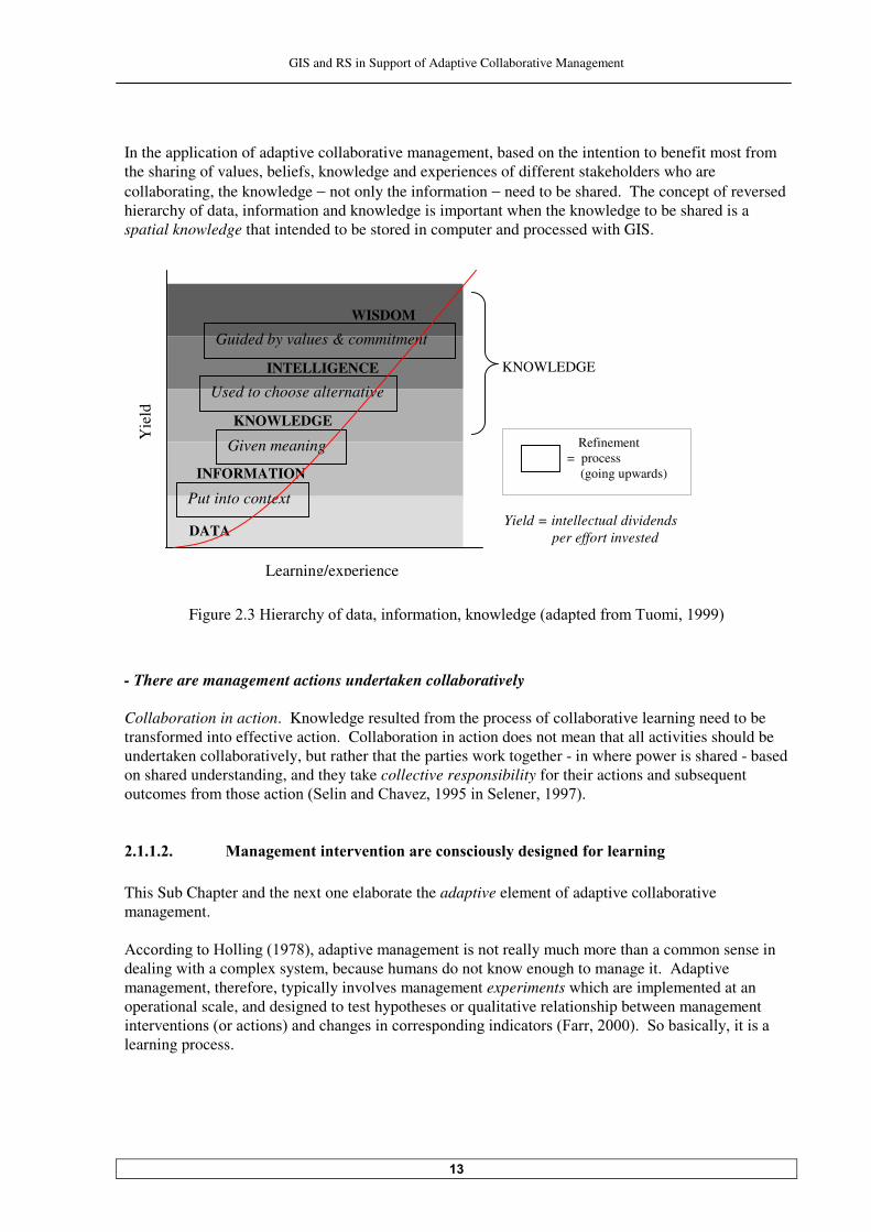
for finding common ground. - New understanding/knowledge is produced and shared amongst stakeholders Collaboration in learning. Collaborative learning recognized that through the process of sharing knowledge and experience, knowledge is held in many forms and by many different stakeholders &+25@3����'���$��� ������������ ������� ��� �������������� ��� �(����� ����#���������owledge is resided in people’s mind. Knowledge has to be elicitated if it will be shared, and trust is needed to ���������#���� ��� ������������� �%�������������&"��� ������'� Knowledge is based on data and information, but unlike these, it is always bound to persons. It is structured by individuals, and represents their beliefs about causal relationship (Probst et al.,����'�� A clear differentiation among data, information and knowledge is needed for the discussion related to GIS and RS in the coming chapters. Data, information and knowledge can be structured in a hierarchi�����������5 �������������������� ���������(������� �(����� ������������������ ���
intelligence and wisdom being added to it. But for the sake of this study, everything above knowledge is lumped into knowledge. The symbolic curve on the figure is meant to emphasis that the value of the various forms of data-information-knowledge increase through learning. In this process, data is ������ ������( ����&"��� ������'� The same author, also contends about the reversed hierarchy of data, information and knowledge, because: there are no ‘isolated pieces of simple facts’ unless someone has created them using his or her knowledge. Data can emerge only if a meaning structure, or semantics, is first fixed and then used to represent information. Data exist only as a solution to a practical problem.
• Manipulation • Therapy • Informing
• Consultation • Placation
• Partnership • Delegated
power
Domestication
Assistencialism
Cooperation
Empowerment
Pseudo-participation
Genuine participation
• Citizen control
GIS and RS in Support of Adaptive Collaborative Management
��
In the application of adaptive collaborative management, based on the intention to benefit most from the sharing of values, beliefs, knowledge and experiences of different stakeholders who are collaborating, the knowledge − not only the information − need to be shared. The concept of reversed hierarchy of data, information and knowledge is important when the knowledge to be shared is a spatial knowledge that intended to be stored in computer and processed with GIS.
Figure .� 6 ���������(������� �(����� �������������&��������(����"��� ������'
- There are management actions undertaken collaboratively Collaboration in action. Knowledge resulted from the process of collaborative learning need to be transformed into effective action. Collaboration in action does not mean that all activities should be undertaken collaboratively, but rather that the parties work together - in where power is shared - based on shared understanding, and they take collective responsibility for their actions and subsequent ���������(������������� ���&$� ������+����B������� ��$����������!'� ����������������������� �#�"� ��� ����� ��� ������� ����%��&�����# ����������� � # This Sub Chapter and the next one elaborate the adaptive element of adaptive collaborative management. -����� ������6� ���&��!�'������� �������������� ������really much more than a common sense in dealing with a complex system, because humans do not know enough to manage it. Adaptive management, therefore, typically involves management experiments which are implemented at an operational scale, and designed to test hypotheses or qualitative relationship between management �������� ����&������ ���'������������� ������������ ��� �� �������&5��������'���$��#�� ����� �� ����
learning process.
WISDOM
INTELLIGENCE
KNOWLEDGE
INFORMATION
DATA
Learning/experience
Yie
ld
KNOWLEDGE
Put into context
Given meaning
Used to choose alternative
Guided by values & commitment
Refinement = process (going upwards)
Yield = intellectual dividends per effort invested
GIS and RS in Support of Adaptive Collaborative Management
��
- A system perspective is taken in management planning Taking a system perspective in thinking/planning. System thinking is a way of understanding the world, by seeing networks of relationship rather than linear cause-effect chains among its ����������������#����� ��������������(������������������������������&$����������'���In managing a complex system like forest, nothing can be understood in isolation; awareness of biophysical, social, and political aspects, together with their interrelationship, connectedness and also wholeness, need to be taken into account in planning and actions (in a form of management interventions). - Management interventions are designed and treated as ‘experiments’, where the goal is
improvement not solution Experimenting. Adaptive management is grounded in the admission that humans do not know enough to manage a complex system. Surprise should be expected when we make perturbation to the systems and they give unexpected responds. Those surprises need to be accepted as chances to learn more about the system rather than as policy failures�&4�� �������A ���������'� Adaptive management, from this perspective, formulates management interventions (or actions) as experiments that probe the responses of ecosystems as people's behaviour in them changes. In conducting these experiments we aim to learn something about the ecosystem's processes and ������������������������#���������� ���#�������� � ��������������� ���#�������=��� ������&.��������'��
So, the goal is to learn something not solution. - There are information feedback mechanisms linked to the management interventions Feedback mechanism. The linkage of the earlier discussion about ‘management intervention treated as experiments’ and ‘information feedback mechanism’, can be explained as follows (after Miller et al., ���� in Dovers and :�##������!'D • Management interventions are made in an experimental manner so the outcome of the
intervention can be used to reduce uncertainty about the system. • Sufficient monitoring prior to and during the intervention enables detection of the results of the
management intervention and thereby allows managers to learn from past experience. • Management interventions are then refined. @������&����'������������ �����������(��� �#��(���#���������� ���(����=��� ������ ��� ������� ���
management. She contends that experimentations, which based on erroneous data about one key structural variable or one false assumption about how actors will react, can lead to a disaster. Monitoring activities is a source of information for feedback mechanism. Though the role of monitoring activities is important, in adaptive management monitoring is carried out in a less detailed − in term of detailed understanding of parts of the system, because the focus is on understanding the response of the system as a whole (Taylor et al������!� ��5��������'���"� �� �������������������� ����discussion about a system perspective in planning and action. -����� ������$������&���!'����� ��� �������(���#��������������������( �����������������#������#��
tackled and analysed is not just an idea, but arisen from practical experience; and second, the process guarantees that actions will not be implemented without prior, and on-going, reflection. This is sustained the sentence that adaptive collaborative management is not a risky trial and error approach, #������������������� ����#���������=��� �����&.��������'��

GIS and RS in Support of Adaptive Collaborative Management
��
��������������������'��� � #��������������&���� �������� ������%��"� ��� �% ������ �� #�� ��� �
management interventions In adaptive management, lesson that has been learned from previous actions is translated into adjustment of actions for future period. The process is supported by feedback mechanism, which made it an iterative process of improvement. - There is innovation in management based on conscious learning, including both ‘intentional’
and ‘unintentional’ (new) findings
Adjustment. The process of knowing through learning does not by itself change reality. Change ������������������ �������� �(������������ ����#����(��� ���&$����������!'���2���������������
knowledge must be applied when implementing action. In adaptive collaborative management, the process of reflection and action is continuously took place through the translation of learning into adjustment in understanding and action in the form of management interventions which are intended for improvements. Adjustment can take form as an innovation. - The management process in not linear, but has some sort of feedback mechanism, which allows
management to be a continuous process of discovery and learning Iterative process for improvements���9�#����&����'� ��5����&���'������������7������ ������� ����������������������� ��5 ������������2������������������ ������#���� �������������� ���=� � ���
iterative. The iterative nature of this serves one purpose: to allow for adaptation of management strategies overtime for improvements.
Figure .� $�7�������(������� ������� ��������������&��8������(����9�#���������� ��5��������'
Some people add a word ‘active’ in front of adaptive management. From some references, it can be concluded that active adaptive management put emphasis on the experimentation part by including modelling �������5����&���'���( ���� ����D����������� ��������s of modelling, experimentation, and ��� ��� ����������������������������(�������� ����������������� ������-����� ������A �����&���!'�
��5����&���'���������� ����������������� ���� �� ������������������������������� ���#���� ��
and error with learning by careful test (a process of directed selection). The discussion about
Assess Problem
Monitor
Design
Evaluate
Adjust
Implement
GIS and RS in Support of Adaptive Collaborative Management
��
modelling is highlighted here, because this is one ‘space’ where GIS could contribute through its spatial analysis capability. ������ The application of adaptive collaborative management Most of the applications of adaptive collaborative management so far are under CIFOR’s research scheme, undertaken in some countries like Philippines, Indonesia, Nepal, Cameroon, and Bolivia. Though the applications are still within forestry sector (CIFOR’s domain), they cover broad aspects because they study adaptive collaborative management by looking at different processes or requirements within it separately. Those applications of adaptive collaborative management give special emphasis on innovations that will help the poor and politically marginal in the forestry sector. Some examples of the application of adaptive collaborative management approach are given below. .����B��&��'� ��/������− Philippines, has used adaptive collaborative management approach to explore alternative and sustainable livelihood options for the community-based forest management program with women. She found that the approach has been able to encourage women participation. In Congo Basin, adaptive collaborative management approach has been used to address the increasing imbalance at the agricultural frontier and the need to address and integrate them as institutional and political concerns for co-management perspective in the forest-agriculture interface (Mala et al., ��'��� The use of adaptive collaborative management approach to empower local communities, strengthening their capacity and enhancing their negotiating power was carried out in Malawi, to work out overlapping claims on land right (Kamoto and Milner, ��'����A � �� ��+����������� �����������
has been used to seek solutions upon two asymmetrical positions between official forestry �������������������������������� ��,�����������&@��������'���In Pasir − Indonesia, adaptive collaborative management approach has been used to develop a model with the community to explore qualitative future scenarios to improve their well being and the forest quality. The process was found to be very effective in developing collective action (Purnomo et al�����'� �
Adaptive collaborative management as a management approach is still in its infancy to judge with any degree of fairness. However, it is importance to keep in mind that if adaptive collaborative management does not work so well in practice, it might be that the practical efforts have not paid ������ ������������(���������������� #�����&3� ���#��������+��� �������'���� .���&����'��#��������� ������� ����(������ ��������������− not with adaptive collaborative management, but might have very close similarities − gives some points to be considered for the application: • By taking an experimentation approach in management, there is no reason to think that adaptive
management will work smoothly, nor that it will be easy to coordinate. • Information is expensive, while it plays an important role in adaptive management. However, the
value of information needs to be balanced against the human and environmental values one is seeking to protect.
���� Boundary in forest ������ The changing perception of community upon forest land and boundary A boundary refers to a ‘line’, which is used to divide two or more areas, either artificially, or based on natural features. In the past, in a community who is practicing shifting cultivation like Dayak people, the shifting/swidden cultivation took place within boundaries recognized between adjacent
GIS and RS in Support of Adaptive Collaborative Management
��
communities. These had been set by elders in earlier period and were marked by streams, trees and paths. Members of a village might cultivate anywhere within their own village boundaries, but would not cross into the territory of a neighboring village. Membership in the community is the primary pre-requisite for rights to cultivate land within the communal boundary. According to Anau et al.�&���'��#�����������( �������#��������� ����������������munities who ��� ��(����������� ��2������ �������������������������������������2��������������-mining companies introduced a payment system to the community to compensate forest area being utilized by them. Since that time, the community’s perception �������������(�����#�����������������2�����!��� �#���
companies were also employed similar compensation scheme. The effect of this scheme to spatial conflicts is more severe because the timber companies’ compensation fee involves bigger amount of money. �2�������(��� ��������������� B�� ����������������#�����������#���������� ���� ����
territory became even more complex when the local government introduced a chance for the community to manage the forest within their village territory through partnership scheme with private companies. As an impact, having an administrative (or legalized) village boundary becomes a necessity for the communities. If in the past the forest communities depended on natural features such as rivers, ridges and peaks to mark their territory, as their valuation system on land changed; at present they also often use straight line between two points or follow company’s road, to mark their territory. ������ Boundary between the community’s area and the forest concession area Accor� ������2""@�&2������� ����"��� ���" �#���@���� B�� ��'�&����'�������#������������rcation of forest management unit/forest concession area and local community’s land on the map and in the field, has to be in place to assure sustainable management of forest. Within this point of view, the term ‘local community’s land’ is not necessarily refers to a village administrative area, but can also refer to areas which have special values for the community (apart from the ‘commercial’ value as discussed in previous section). These areas for example are: the community’s sacred places, hunting grounds, or areas for collecting non-timber forest products. Fixed boundaries such as village administrative boundary and forest concession area boundary are important for area management. This boundary defines in versus out, included versus excluded, as something to be established and defended. In many cases, the community’s areas are not correspond to their administrative village boundary (if it is exist), and this is particularly true for areas where the community usually collects non-timber forest products. A lot of communities, who are highly depended on the forest for their livelihood, perceive a borderless forest for collecting non-timber forest product. That condition makes joint-claim upon the same area from some adjacent communities to the forest concessionaire frequent. A fuzzy boundary concept could be applied to deal with that kind of problem. Fuzzy boundary is not a precise line, but rather itself an area of transition. It is a boundary that is treated as band of ������� ����&���*������<� �B�����'���"� ��������(�#�������� ������������������( ����������
characteristics of an area such as gradient between two soil types. Related to the areas for collecting non-timber forest product, this concept can be used to define gradual change of the community’s right upon a forest area from where they can collect non-timber forest product as the distance from their village changes; the farther the location from their village, the weaker the right they posses.
GIS and RS in Support of Adaptive Collaborative Management
��
��� Geographic Information System (GIS) and Remote Sensing (RS) GIS and RS support the implementation of adaptive collaborative management when it is implemented in a spatial or spatial-related problem. They provide support through their capability to improve the quality and quantity of spatial information and to analyse that spatial information. ����� Geographic Information System (GIS) ���������������������()*�"�� ��% ���� � The ability of GIS to support the application of adaptive collaborative management, comes from its three main functions: database management technology, spatial analysis technology, and visualization technology. ��Database management technology is important when a large amount of data is included and need
to be processed in a complex spatial problem. The database management technology can manage the geographic database and support cartographic display, spatial query and analytical modeling by integrating three types of data: locational (spatial primitives such as coordinates and chains); topological (attribute-bearing objects, e.g. points, nodes and lines, and relationship between them); and thematic (attributes of the topological objects, including area size, related cost aspects, the distance to important objects, etc.). In spatial decision problem, database management technology provides those three types of data of each decision alternatives, so the decision maker can store and examine information about where things are and what they are like.
�� Spatial analysis technology in GIS can flexibly combine analytical models with data, explore the solution space by building alternatives, support a variety of decision-making styles and allow interactive and iterative problem-solving (Berry, ����'���2��includes the analytical techniques of spatial and geographical analysis, and provides output in a variety of spatial forms, including maps. In spatial decision-making process, for example, a link between sensitivity analysis techniques with map displays to visualize the spatial manifestations of alternative rankings of options will help a decision maker to analyze the spatial decision problem more thoroughly. Spatial analysis technology in spatial decision support system uses GIS modeling to simulate the reality and explore the solution for the spatial problem. Modeling is based on decision maker’s preference: value structure, hierarchical structure of goals, evaluation criteria, objectives and attributes, multi-attribute value/utility, and consensus modeling. -� ����(������������� ������*�����&����'� ��6��� ������*�����&���'�������������(����������������
(which transforming data into information) through the spatial decision support system is not one way, the information which is produced and generated during the spatial decision process alters the process itself and thus must be stored, retrieved and communicated back to the data systems responsible for their generation in the first place. In this sense then, information is continually created, destroyed and transformed as the process proceeds and as the decision maker cycles purposively and intelligently through its various stages, generating the knowledge necessary for informative spatial decision making. With the help of an information technology, the outcomes can be made available not only to an individual but also to a group of decision makers. This aspect shows how database management technology and spatial analysis technology together could help the decision maker(s) manage the complexity of a complex spatial decision problem.
• Visualization technology manages the interface between the user and the rest of the system. Its
advantages include user friendliness (such as a consistent, novice and expert mode), variety of dialog styles (such as command lines, pull-down menus, graphical user interfaces) and graphical
GIS and RS in Support of Adaptive Collaborative Management
�
and tabular display, which can be used as visualization in the decision space and decision outcome space. It helps in spatial decision-making process because in general people can use graphics more easily than tables for problem understanding.
���������������������()*����� ������%����������������������� ���������������������������"� �#�"� � The following part elaborates some possible supports provided by GIS to the application of adaptive collaborative management. The differentiation of those supports is made in light of adaptive collaborative management elements/processes/requirements, so it is realized that there are possible overlapped between one and another. - Enhances collaboration Maps and GIS both encode spatial relationships in structured formal representations. These representations enable shared understanding of geographic phenomena and their interdependencies. This formal encoding makes maps and GIS well suited inherently to facilitate collaboration among � ((���������� ��� ���� �� ���������� � ������ ����#�������� �����#���&:���)�����������'����@���
main contribution of GIS for enhancing collaboration is WYSIWIS (what you see is what I see) techniques (Armstrong,�����>�-��������������� ��:���)�����������'� - Empowers the community There is a dichotomy that GIS can act to both empower and marginalize communities simultaneously &6��� ������A� ���������'���5���������� ������������� ���� �� ����7� ���������12$� ���aken out of a conventional top-down development context, which necessitates ‘demand-driven’ and not ‘technology-�� ���,���� ��� ����&6���� ���������"������������'��2���������������12$������#������
an appropriate technology for the community. For empowerment, emphasis needs to be firmly on participatory while producing GIS data and doing spatial decision-��� ���� ������������� �������������������� ��� �����&;�����������'���12$���������
the community by providing them with greater access to data about their own areas, also simultaneously increases the capability for greater surveillance over neighbours (Harris and Weiner, ����'>�����#���� � ������ ���������(�������� ���(������������������������ ������ � ��� ���&;�������
����'���12$�� ����������� � �����������oach also empowers the community by providing access to �=���� ���&5-@������'��� - Facilitates learning process
GIS can be very supportive in learning process because it is not only described what is, but can also display what pattern and what could be (Kainz et al.,����'���2��0����� �,��12$�� ��������������������
reports and tables, which is supported by its storage and query functions. In ‘what pattern’, GIS ��������������� ������������(����=�������������� ���#������ ������������ B������������������������
which is supported by query functions with constraints. In ‘what if’, GIS provides a prediction about the data at a certain time or at a certain location, which is carried out with modelling functions. However, it has to be taken care that GIS can only describe, not explain; or they examine, but don’t understand. There may be answers to question: where, what, when and who, but not the why (McCall, ��b). - Incorporates local knowledge In its fuction as a supporting technology for knowledge sharing, a primary strength of GIS with respect to local/traditional knowledge is its layering capabilities. Local knowledge, concerns, desires,
GIS and RS in Support of Adaptive Collaborative Management
�
and wishes can actually be incorporated and embedded as layers or objects in the GIS (Harris and A� ���������'���nd multiple perspectives can be represented in multi-mappings. The use of layering has a synergistic result in that the combinations of themed information, could range from different social perspectives, eras and sources, and both qualitative and quantitative, could create a whole �� ��� ������������������������(� ���������&:�+�����a). - Drives negotiation process more transparent By incorporating each party’s knowledge and concerns (including the community’s) as layers or objects in GIS, in a negotiation process, GIS has a potential to raise all kinds of concerns regarding individual rights and confidentialities. In this form, GIS provides an arena in which politics and ���( �����(����� �����#�����������������������&6��� ������A� ���������'� - Improves problem understanding and facilitate communication The power of GIS maps in enhancing problem understanding is profound. “The old maxim of ‘a �����������)����������)����*����% %!'�� ���)��+�(-��! ��������!! ����,�������)����������)������"�������computer-#���� ���� ��������)������"������������!���-�&4�� ������A ���������'���An image, a drawing, a map convey information more succinctly, if no better, than a table of numbers, or a textual description. Visualization technology in GIS allows representation of the spatial relations and structures, so the decision maker(s) can understand easier and better the spatial problem to be solved. GIS could also enhance understanding of complex spatial problem by provide a technique to break an apparently ill-structured spatial problem into a series of structural components which makes the ��������������#��&:���)�����������'� If more than one decision maker involved, GIS can help them to understand the array of alternatives involved, the evaluation criteria and the decision consequences quicker; which are complicated where different interests engaged. Here GIS could facilitate a group of decision makers to ‘communicate’ better to each other to be able to come to an agreement. - Facilitates knowledge-sharing GIS could facilitate knowledge-sharing by ‘visualizing’ knowledge from different sources and or different parties, and offers the possibility of discovering relations or combining different understanding. To enhance the process of sharing knowledge, GIS also allows integration of the structure for knowledge sharing with data source and information (database). ����� Remote Sensing (RS) Remote sensing images (and information extracted from these images), along with Global Positioning System (GPS) data, have become primary data sources for GIS. Indeed, the boundaries between RS, GIS and GPS technology have become blurred, and these combined fields will continue to revolutionize the way inventory, monitoring and management of natural resources are carried out (. ����������< �(�������'���3���������� ��� �� ���������������������(��#������� �����#��������
detection of many phenomena, allowing glimpses from the ‘side windows’ (Sayer et al.,����!'��� Some possible supports of RS to the application of adaptive collaborative management, either together with GIS or not, are given below.
GIS and RS in Support of Adaptive Collaborative Management
��
- Helps thinking in a system basis By its ability to cover a wide area, RS allows the users to literally see the invisible, where they can begin to see components of the natural����������������0����������#�� �,�&. ����������< �(�������'�� The ‘global’ vision, which transcends social, biological and physical boundaries, would help the users develop his/her thinking in a system basis. - Enables collaborative learning In collaborative learning, where different parties with different disciplinary and backgrounds learn together, RS could provide support because it provides data which transcend disciplinary boundaries. It is so broad in its applications, that nobody owns the field. Whether the party interested in using the data for ‘hard knowledge’ like for biophysical application, or using the data for ‘soft knowledge’ like social application; RS data can contribute. - Supports management experimentation and provide feedback Forward-looking or adaptive management requires prediction systems (computer models as well as field trials) to give adequate information for efficient decision-making; RS together with GIS allow the development and communication of cause and effect ‘what if’ scenarios in a spatial context. -����� ���������*������<� �B�&���'���������� �-temporal analysis or change-detection activity could be done for scrutinizing decision to be made by answering questions such as: • Where and when the impact of decision being made would take place? • What kind of impact occurs? • At what speed the impact occurs? • What else can be understood about the pattern of the impact? - Provides feedback For monitoring purpose, RS can provide serial data, which can serve as feedback mechanism to analyse undertaken management experimentations. However, there is a technical challenge lies in perfecting methods to provide consistent output; that the resulting information may be compared for change with confidence that differences represent real change and not ‘noise’ or variability in the ���������� ����������&A������������!�'��� �� � Participatory action research �� ��� The definition of participatory action research In the process of settling the boundary dispute, there is a necessity to create shift in balance of power in favour of the community to make collaboration and negotiation possible. That condition requires the researcher to have a role as a catalyst for the change, as well as a co-learner with the people; which means that the researcher is not outside the system, but actor within it. This kind of research approach is known as a participatory action research. In participatory action research, the role of researcher is not as an objective external researcher but as a committed co-investigator; and also the role usually assigned to the target population, that is, not as objects to be studied but as active participants� �����������������������&$����������!'���A ��������
objects of research become subjects and partners, they benefit not only from the opportunity to learn about and understand their own reality, but also from sharing directly in subsequent policy and program decision-��� ��������������&:��� �������!� ��$����������!'���"���������� ���������� ������
GIS and RS in Support of Adaptive Collaborative Management
��
control over tools and techniques, but, rather, control over the process of knowledge generation and use. $������&���!'�������������������������� ����(����������������� ���������������������� ����(�
participatory action research. Its basic assumption is that common people already have a rich popular (indigenous) knowledge necessary to guide actions for their own benefit. On the other hand, the researcher could contribute, among others, to the formulation of theories that explain social realities, and assist in the design and implementation of actions to solve the problem identified. So the existence of reciprocal relationship between the researcher and members of the groups is not necessarily an obstacle to the creation of knowledge and the promotion of social change; though the researcher needs to be aware of his or her involvement in the social reality of the member of the group. This approach assumes that social science is not value-free or neutral. All research is political in nature, and has the potential to affect the distribution of power in society. Research can serve either ����� ��� ������������������� ���,���= �� ������������� ����&$����������!'���C������� ��������������
are relatively separated from the researched groups and are less shaped by their social position because they try to learn the viewpoints of others people and empathize with all parts of society. They can and should adopt a relational position – a position apart from any other specific social ����������� ��������� ������������&9����������'��"����articipatory researchers are clear about their role as agents of social change that will benefit powerless groups.
�� ��� Advantage and disadvantage of participatory action research -����� ������+����������;������&����'���� ���� ��� ( �%������� �����esearch put emphasize on the outcome and participatory approach put emphasize on the process; participatory action research put emphasize on the combination of both: the outcome and the process. So, it is more comprehensive in nature. However, participatory action research is not without problems. Researchers of action research projects of relatively short period are often not conceptually clear and well equipped for conducting participatory action research, while he or she has to have multi-functions in it. Consequently, initial idea, concept, design, research process, selection of data, analysis and interpretation, ownership of result, access to various knowledge systems, are often unequally controlled by the researchers and the participants in the research; which could lead to a modest outcome. �� �� Methods for verification A main question to any form of research is determining if the findings are right, or correctly represent what is going on. Triangulation technique could be used to strengthen the analysis by observing data (����� ((���������������� ���� ������� ���� ������� ����������� ������� ��&/����������!'� -����� ������9������&���'��������������������������(��� ������ �����"���( ��������� ���� ����ation of means where the researcher takes multiple measures of the same phenomena. This technique makes the researcher more likely to see all aspects of it. Another type is triangulation of observers. Multiple observers add alternative perspectives, backgrounds and social characteristics and will reduce the limitations. Triangulation of theory takes place when the researcher uses multiple theoretical perspectives at the beginning phase of the study or when interpreting the data at the later
“We both know some things, neither of us knows everything. Working together, we will know more, and we will both learn more about how to know”�&:��� �������!� ��$����������!'�

GIS and RS in Support of Adaptive Collaborative Management
��
phase. The last one is a triangulation of method, which means mixing qualitative and quantitative approaches of research and data.
In additional to it, in special cases where trust among groups in the study area is low, it might be unwise to assume that they would communicate their interests honestly, Bavi�����&���'� ��-����&��'������������� ���� ��������������������������#���� �(��� ���������(���������,����� �������������
from what they say.
GIS and RS in Support of Adaptive Collaborative Management
��
� Research Methods
This chapter elaborates the research methods specific to the case of settling the boundary dispute in Labanan. This chapter begins with detail of data collection methods, which are used for the study. Afterwards, the explanation is divided into three parts, which follows consecutive phases in carrying out this study: pre-fieldwork, fieldwork and post-fieldwork phases. Most of this chapter details methods being utilized during fieldwork, on how the boundary dispute was settled by using adaptive collaborative management. This study applies participatory action research approach. Therefore, the way the fieldwork activities progressing were also influenced by or defined together with the research participants (i.e. the community of Sidung baru and the Labanan concessionaire).
��� Methods for data collection Two types of data for this study are needed: primary and secondary data. Secondary data such as relevant documentation (written reports of events, formal studies or evaluations of the same area under study, etc.), the regional land-use plan, forest inventory data, and satellite images of the area, were sought from the district forest services, statistical bureau, PT. Inhutani I (the management of Labanan area), Berau district government and from previous research findings related to the topic. Primary data are assembled using different kinds of techniques, such as interview, direct/field observation, and participant-observation. A semi-structured interview method is used because it gives more flexibility in asking questions and probing, topics can be dug deeper, and it allows responding to new data presented by respondents. In addition to the semi-structured interviews, in-depth interviews are being utilized as well. Southwold-.������&����'��������������� �� �� ��������������������������������������������������
what they really do. Most frequently people being interviewed answer in the form of an ideal situation, however, their actual behaviours may not necessarily be in line with such ideal things. Therefore, to ensure that the information gathered from the interview is accurate, field observation is ���� ���������5����� ����������#���� ����#������ ��� ����������&*������������'���2���#���� ���
observation people know about the presence of the researcher. This technique also has negative side. For instance, because people know that a researcher is observing them, they may change their #���� ����������������#������ ��������������������������=����������������6�����������*�������&����'�
argues, after a while people will behave in their normal ways, especially once the relationship between researcher and people has been established. For field observation, the forest concession area and the settlement area under dispute were visited. The way the concessionaire manages their forest concession area and the way they deal with other parties in the area were observed. The way they deal with the community of Siduung Baru is the researcher’s particular interest. To be able to observe the community’s behaviour and absorb information from them, involvements in their daily activities such as when they opened the forest for planting rice and when they had a village meeting were also pursued. Conducting field observation to verify ‘ground truth’ of spatial data from satellite images is equally important for this study. To make sure that informatio�� �����������������C ��&����'�������������������(��#������ ����
protocol. It is intended to guide the researcher with the list of data to be collected and occasions/behaviours to be observed, procedural reminders in collecting the data, ’tally sheet’ to record the data, etc.
GIS and RS in Support of Adaptive Collaborative Management
��
As meant by participatory action research approach, participant-observation is a special mode of observation being used in this study in which the researcher is not merely a passive observer. The researcher took a variety of roles within the research situation and actually participated in the events being studied. Finally, experts in related fields were consulted, including those who have experience doing research in the field related to adaptive collaborative management like CIFOR. The important reason for this consultation is that it will make clarification possible and also stimulate some thinking. Different point of views towards the problem was also sought from the community member and from the concessionaire. To strengthen the analysis, some comparisons were done between observational data with interview data, and what people say in public with what they say in private. In additional to it, information obtained through interviews was validated by checking relevant documents or written evidences. ��� Pre-fieldwork activities -�������� ��5 �������������-( ���������������������� ��������������������������2���� ����������� ��study was designed. This stage mostly dealt with problem structuring and formulation of the research topic, objectives and propositions for the study. A research proposal was developed as the outcome of this stage. Literature review about the selected research topic was done for an insight on other experiences about related issues. Criteria for selecting the appropriate study area were then set as explained under ���� �������� ����� Study area selection criteria The concern of this study is the possible application of adaptive collaborative management as an alternative approach for addressing the problem in the forest management system in Indonesia following the decentralization process. A selection of appropriate study area for achieving the research objective is an important aspect. The following criteria were developed as the basis for the selection: - The study area has to be a forest concession area, which is still suitable to be managed as a
production forest area. - The condition in the study area has to show a necessity for a change or an adaptation in forest
management system, due to problems related to the decentralization process that are threatening the sustainability of the forest.
- The study area has to have spatial problems as a result of diversity of interests (including the local community’s interest) towards the forest area.
The research was conducted in the Labanan forest concession area, which fulfils all the criteria mentioned. ����� Input for fieldwork A number of secondary data for the study area could be collected, because some researches had been conducted in the area. In ��� � ����.�������":� ������(������� ���� ������������ ����������������
regional news media articles, reports, and the management plan of the Labanan concession area.
GIS and RS in Support of Adaptive Collaborative Management
��
For primary data acquisition, checklists/tally sheets and questionnaires were prepared. A Global Positioning System (GPS) receiver, compass, and laptop with ArcView software were all set to bring the geographic information technology to the community in the study area. �� Fieldwork activities 5 ���������������������������������� �� ������������������������&5 ���������'���"���
nd stage is a convening phase, which is intended to give the researcher a good understanding on the problem � ���� ��>��� �������� ����#������� ��$�#�+��������������� 2�������
rd stage adaptive collaborative manageme��� ������������"� ���������� ������� ����(����� ��
phases, they are: • 1������ �������#��������������� ����&$�#�+�����������'���� ��� ���������0�7��-footing’ process
for the community; • :�� ���������������������&$�#�+������������'���� ������� ����(���� preparation for the
negotiation process, where both parties learn from each other, and the negotiation process; and • "�������������&$�#�+������������'� Total period for fieldwork activities was six weeks. ���� Understanding the problem situation Stakeholder and dispute analyses are essential to give insight on the problem situation. This stage was carried out independently from the actors in the dispute, though most information for these analyses came from them. The reason behind this is because the researcher’s necessity for having sufficient understanding before being involved in the dispute. These analyses were also useful to guide the researcher on how to use adaptive collaborative management approach appropriately in the problem situation. However, a����� ������*��������&����'� ��+���� ���&���'�� (�0����������,� ��
one of the agenda, ideally the actors’ participation should begin from the beginning, including in the activity to analysis the stakeholders and the dispute. ��������������������*��$��older analysis Stakeholder analysis had been conducted by following some steps as follows: - Identify current stakeholders and those potentially affected by future decisions on boundary
dispute A number of stakeholders were identified before fieldwork and during fieldwork period, including those who are potentially affected by the settlement of the dispute. Stakeholders in the study area can be grouped into users (several subgroups based on differing interests, power and location), government (policy makers and politicians, senior government officials, and field personnel), development agents (international donors, consultants, and NGOs), and other private (private enterprises/companies and other individuals) (after Ingles et al.,�����'� - Determine stakeholders’ interests, characteristics and circumstances Along with stakeholders’ identification, their interests, characteristics, and circumstances were also studied. A table was assembled to summarizing the information from this step and the previous one.
GIS and RS in Support of Adaptive Collaborative Management
��
This table contains listing of stakeholders, their interests, and also positive/negative impacts of the ��� � ���& ��������#��������� ���������������'������� �� ���������&4524������� ��?������������'� - Assess the influence and importance of stakeholders -����� ������?��������&���'� influence refers to how powerful a stakeholder is to determine the direction and outcomes of the activity in relation to their own objectives. This could be assessed through the power that stakeholders have over the activity, such as: • to control what decision are made • to facilitate its implementation; and • to exert influence. Power may come from the nature of a stakeholder’s organization, or their position in relation to other stakeholders. Importance refers to those stakeholders whose problems, needs and interests are priority of the activity. Importance is likely to be most obvious when stakeholder’s interests in the activity meet closely with the activity’s objectives. Importance is different from influence. For example, there is often situations that stakeholders which the activity puts big priority, do not have capacity to participate in the activity and have limited power to influence the decisions. -���� ����� �������������� �(�������������# ���� �����#������� =������������������������(������
stakeholder’s importance and influence, ranging from low to high. According to Ingles et al. &����'��a benefit of doing this analysis is in predicting supports that can be expected and resistances that may be met in the participatory process. It can be used to avoid the pitfall of bypassing powerful stakeholders who can derail the process if they so desire, and other stakeholders who depend on and affect the resource in substantial ways. ��������������������Dispute analysis In this study, the term ‘conflict’ and ‘dispute’ are used interchangeably. By definition, conflict is a long-term, underlying disagreement that divided two or more parties, while dispute is an individual episode within a conflict (Verpla��������'���4 ����������� ���������� �������#�� ���� (� �������source of dispute and analysing the nature and stage of the dispute. In this stage, the analyses focus on the attributes of key stakeholders, which are derived from the stakeholder analysis. Some other important issues such as the governmental system were also clarified to understand the dispute more comprehensive. The source of conflict/dispute can be identified whether it has origin in data or facts (factual disagreement), in divergent needs or interests, in conflicting values or beliefs, or in incompatible ���� ���� ��&���� �������������������� ����������������� � ��'�&3 8�#�����������'����"����= �������
of each of them was identified in the study area, by using the information obtained from interviews and discussion with stakeholders, policy reviewing, reading project documents and reports, and the outcome of stakeholder analysis. "�������� �����������������������������(������ ��������#�������&5-@������'D • interaction between key stakeholders in term of scope and level at which the dispute occurred • relative level or status of the disputants • power disparities among them • resource in dispute • stake that key stakeholders’ posses, and • stage of the dispute (the time dimension).
GIS and RS in Support of Adaptive Collaborative Management
��
Some other issues, which are relevant in the settlement of this boundary dispute, were also sought from the information obtained from interviews. ���� Generating the boundary alternatives The process of boundary alternative generation was done separately and differently between the community and the concessionaire. For the community of Siduung Baru, it meant to be a learning process to prepare them to negotiate with the concessionaire. For the concessionaire, it meant a clarification of their plan to dealing with this dispute. ��������������������+�% ���&������ ������#� ������ �,����������""% ��& Power disparity exists between the community of Siduung Baru and the concessionaire. Since equity is one main condition for collaboration, this stage is intended to give the community an equal-footing with regard to the concessionaire to ascertain the collaboration between them. Several steps with the community during the process of boundary alternative generation are detailed as follows: - Objective formulation and discussion on key issues Focus group discussion technique was used with the community to discuss and formulate their objective in settling the boundary dispute, priorities and key issues. According to Morgan and <�������&����'� ��1 ##��&���!'�������� �������se of focus group discussion is to draw upon participants’ attitudes, views, needs, desires, experiences and reactions in a way in which would not be feasible using other methods such as one-to-one interviewing, because focus group could bring out a multiplicity of views and emotional processes within a group context. Aside of that, a focus group enables the researcher to gain a larger amount of information in a shorter period of time. Focus groups are particularly useful when there are some positional differences between the participants and the researcher, and when one wants to explore the degree of consensus on a given topic. With the community, focus group discussions designed to be done three times, firstly among persons who are considered leaders/key persons in the community, secondly among the more ordinary ones including young people, and thirdly among the women. These were arranged to avoid reluctantly for powerless party among the community members for expressing his/her views. - Scenario development and satellite image interpretation Scenario development process was an important part of focus group discussion sessions. The participants were encouraged to think about the future before being asked to generate boundary alternatives. The method of scenario development employed is pathway scenario, because the learning in it focuses on open-ended problem solving and creating strategies for dealing with the constraints and opportunities for achieving future goal, rather than on trying to internalise the possibility of a particular future (Wollenberg et al.,����'� "��(���������������������� ��� �������(�.�#������������ ���������(���� ������������������������
visualization aid. Those satellite images were chosen because they are the best images among
In this study, the definition of power for the Labanan concessionaire with regards to the Siduung Baru community is reduced into a power which comes from ownership of spatial information and knowledge mastery related to spatial technology.
GIS and RS in Support of Adaptive Collaborative Management
�
available images in term of ‘free from cloud cover’, and also the time difference between the two is considered sufficient to reveal changes that had happened in the area. Simple participatory image interpretation was carried out to begin the process of scenario development. Some features on the images were introduced to stimulate discussion. To make it clearer to the participants, some thematic maps were also provided to identify name of rivers, villages, administrative boundary, or Labanan‘s cutting blocks plan. Participants were asked to identify the differences between the two images. By reflecting to some changes on both images such as a clear reduction of the forest area, participants were asked to articulate their hopes (vision) in the future, by asking questions: “How do you want the forest looks like?” Then participants were asked to reveal their current situation (the current resources, actors, events and relations among them with the forest) and the kind of problems that they face. The group discussed the main constraint and opportunities to achieve their hopes. This was followed by brainstorming about what strategy could be used to be able to cope with factors such as: the existing capacities and weaknesses among actors in achieving their vision, and the external factors possibly affecting their capacity to achieve their vision. - Boundary alternatives generation and spatial data determination The previous processes gave the community foundation to generate boundary alternatives, which was done by a group who represents the previous three groups when conducting focus group discussion. Those boundary alternatives then used to determine spatial data necessarily to be collected to generate maps of the boundary alternatives. For the researcher, the examination of each stakeholder specific requirements of the boundary were where the basic spatial information and management information were combined, where quantitative, objective information and qualitative, subjective information����������&;�����������'���A ������
understanding the community’s requirements and their resource usage patterns, it is impossible to offer useful management advice to determine the possible boundary. - Spatial data collection Spatial data collection was basically GPS surveying to collect locational information by using GPS. Satellite images, maps provided by the Labanan concessionaire, compass and GPS receiver were used during this process. Some points for mapping each boundary alternative were recorded by using GPS and marked on the map. The same procedure was also done for some sites that are important for the community, which mainly the places where they collect non-timber forest products. In addition to the intention of making boundary alternatives maps, this activity was also intended to show the community how to relate information on the satellite image with the available maps and with the reality, and how to verify maps provided by other party. - GIS operation and feedback sessions ArcView was used for GIS operation in this study. GPS coordinates were used to make point layer indicating borders of areas of interest and other survey sites. Then polygon maps for boundary alternatives were derived. Other survey data as pointed out by the community were also incorporated into GIS. Map compilations were prepared as an ArcView project. Not all maps had to be developed from scratch since the concessionaire has provided some maps which can be used, but the community witnesses that their spatial knowledge, i.e. their information about certain places, location of objects, etc., together with GPS coordinates which they collected, were used to enrich and to validate those maps from the concessionaire. This stage is partly done independently from the community due to the technicality reason

GIS and RS in Support of Adaptive Collaborative Management
�
Feed the results back to the community was equally important with other stages; this was aimed to determine the usefulness of the information to them and can be regarded as a component of the participatory approach being employed. The value of these maps is that they respond to the needs and wants of the community. ��������������������+�% ���&������ ������#� ������ �,���������� ������ ���� Boundary alternatives generation with the concessionaire is a straightforward process. It was discussion sessions with people from different management levels, followed by map making based on concept formulated from those discussions. Discussions with the top management level for Labanan area in Tanjung Redeb office (regional office of PT. Inhutani I) were carried out with: the administrator of Labanan area, head of Berau region ���� ���� � � ���&*�������� ���������/"��2������ �2����� �����(�.�#����������������������(������
concession areas), and vice head of Berau region. While with a group of technical people (i.e. personnel from production section, from community development section, from forest tending section, from GIS section, from planning section, and from financial section), the discussions were held in the site office in Labanan. Based on these discussions, a boundary alternative map for Siduung Baru settlement was generated with personnel from Labanan’s GIS section. ��� Moving towards consensus The process of coming to the agreed boundary consists of two phases, they are a preparation for the negotiation, and the negotiation process between the disputing parties. �������������������-������ #��������� �#������� This phase is intended to give both parties a chance to learn from each other before entering the negotiation process. The activities within this phase are: evaluating the boundary alternatives, analysing ‘position’ towards other party, and setting up the BATNA (Best Alternative To a Negotiated Agreement). In this phase, a path was built for both stakeholders to be able to have a rewarding negotiation and eventually come to a consensus. When each party analyses their position towards other party, they start to recognize other party’s concerns. For the community, this phase can be seen as a further preparation prior to the negotiation process, while for the concessionaire, this phase is intended to develop their trust to the community to ascertain a meaningful collaboration between them. - Boundary alternatives evaluation Boundary alternatives were analysed by using Multi-Criteria Evaluation (MCE) technique with the support of Definite software for each party. A same set of boundary alternatives, which is the outcome of previous stage, was used for both parties. Each boundary was analysed on how well it can achieve objectives of each of them. MCE was done partly independent from both parties. Their involvement was limited particularly in the technicality part when using Definite software. However, criteria for evaluation, structuring those criteria into a value tree and weighting process to reveal their priorities upon those criteria, were conducted together with them. This is important because the set of criteria should represent all value and aspects of the problem at hand according to the decision team (i.e. each party and the researcher).
GIS and RS in Support of Adaptive Collaborative Management
��
Value tree or criteria tree was produced to enable more thorough evaluation. A criteria tree is built by structuring the criteria hierarchically according to their relevancy and level of magnitude. In this case, the hierarchy consists of: objective – decision factors/aspects – criteria – sub-criteria. Each stakeholder group has their own value tree. :+)�(������������� ������������������� ��5 �����������"������������������������� ���������� concessionaire were participating, is marked by given the box in the figure grey colour. Definite software also operates by following those steps. Each step is elaborated as follows: • A set of evaluation criteria: This is the value tree as explained earlier. • Criterion score: This is the estimated impact of each alternative on every criterion; it is acquired
based on the description of alternative effects in the study area. Some criteria were measured in quantitative scales (either internal or ratio scale), and some others in qualitative scales (binary or ordinal scale). The qualitative measurement scales are necessary because the decision problem in this study has an involvement of ‘value’, which made it difficult to be measured accurately.
• Effect table: Criteria scores are organized in an effect table or also known as an
impact/evaluation/decision matrix. This table is an N*P table, where ‘N’ alternatives are evaluated on ‘P’ criteria, each cell of table being the evaluations. Each evaluation normally is a real number, representing the appreciation of the option.
An effect table is not only useful to get an overview of the problem, but also used to recover how the data are measured. Because the evaluation scores were almost always measured in different units, they cannot be compared across the criteria directly but have to be made comparable using standardization method.
• Decision team’s priority: In this study, the nature of teamwork between the researcher and the
stakeholders made it more appropriate to use a term ‘decision team’ rather than ‘the decision maker’. Decision team’s priority was reflected in different weight they assigned to the criteria. In this study the pairwise comparison method was used to assess weights of the criteria’s relative importance.
• Aggregation method: Aggregation method build an aggregation of the evaluations, or preferences
associated with each attribute, so that a unique preference structure of the alternatives can be derived. In this study, weighted summation method was used for this. This method is simple and often used. The method requires all effect scores (on effect table) are standardized to make different criteria comparable. The aggregation of criteria is performed by using the following equation:
W = E�W�+EW+……….EnWn Where W is the overall aggregated weight, E is the score of effect n, and W is the weight assigned to criteria n (taken the decision team’s prioritization).
• Sensitivity and uncertainty analysis: Sensitivity analysis is applied to examine the robustness of
the ranking of alternatives. This is necessary because most problems including the one in this study have some uncertainness due to incomplete information, which would affect the MCE (for example when assigning criteria scores or defining priorities). In this study, sensitivity of the ranking of alternatives was examined by looking at the influence on the ranking when changing one criterion weight and score.
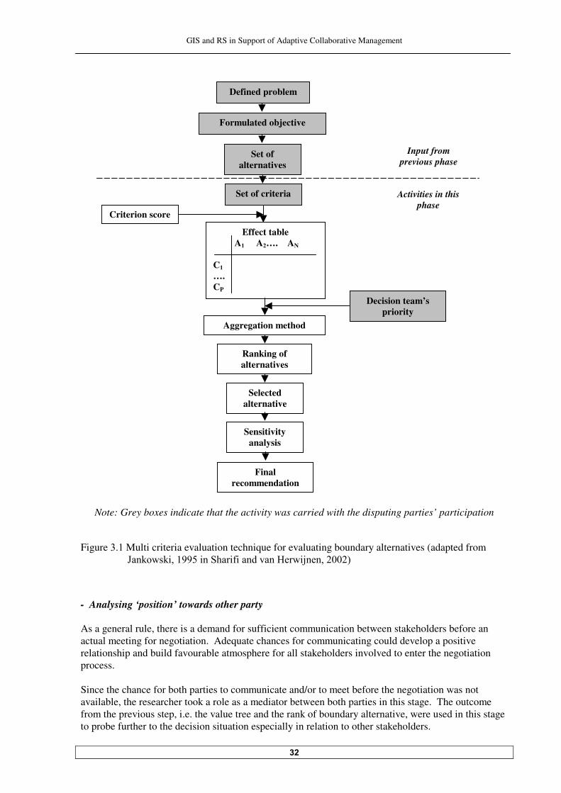
GIS and RS in Support of Adaptive Collaborative Management
��
Note: Grey boxes indicate that the activity was carried with the disputing parties’ participation
Figure �.� Multi criteria evaluation technique for evaluating boundary alternatives (adapted from ;������� ������� ��$��� ( ���������6��� 8�������'
- Analysing ‘position’ towards other party As a general rule, there is a demand for sufficient communication between stakeholders before an actual meeting for negotiation. Adequate chances for communicating could develop a positive relationship and build favourable atmosphere for all stakeholders involved to enter the negotiation process. Since the chance for both parties to communicate and/or to meet before the negotiation was not available, the researcher took a role as a mediator between both parties in this stage. The outcome from the previous step, i.e. the value tree and the rank of boundary alternative, were used in this stage to probe further to the decision situation especially in relation to other stakeholders.
Formulated objective
Set of alternatives
Criterion score
Set of criteria
Final recommendation
Sensitivity analysis
Selected alternative
Input from previous phase
Defined problem
Ranking of alternatives
Decision team’s priority
Aggregation method
Effect table A� A�…. AN
C� …. CP
Activities in this phase
GIS and RS in Support of Adaptive Collaborative Management
��
Value tree analyses were conducted by showing and discussing value tree of both parties to each of them. This was done only after the researcher got permission from both parties. The researcher committed to assure what information each party is not objected to share, particularly the one regarding the concessionaire. Value tree provides a legitimate structure for discussions and defined agendas for the negotiation process. Each stakeholder compared their own value tree with other party’s and analysed them. By doing that, they can define the scope of the discourse about a controversial problem in a broader sense including the other party’s, and identify areas of agreement and disagreement. Missing elements in a value tree can be just as interesting as����� ����������&����A ����(��������!'���A � ���� ���������
reasoning for the outcome of boundary alternative ranking can also be sought. Being aware of the existence of imbalance knowledge and thus power between two parties, additional attempts was arranged to assist the community in analysing their position towards other parties, in this case not only the Labanan concessionaire but also the local government concerns. This was done by discussing what they could do or would possibly do regarding the boundary dispute, with the capacities in their possession. - Setting up the BATNA BATNA is the acronym for the Best Alternative To a Negotiated Agreement. Having a well-developed and attractive BATNA is a source of great power in any negotiation. One party’s BATNA is the choice they can make if they conclude that negotiating with other party is not likely to yield a favourable result. They can walk away from a negotiation if their BATNA is better than the likely outcome of that negotiation. BATNA is a dynamic element, changing as one derives information about the interests of other parties and their constituencies and as s/he compares the resources between each party (including her/himself) has available to bring about and fulfil an agreement. In this study, BATNA was identified in a simple way, i.e. by asking the question, “What will we do if this negotiation is not successful?” This question is particularly important for the community. �������������������.�#������ # The negotiation process was held in Labanan base camp, because it was not possible to have the meeting in a ‘more neutral’ place because of the availability of sufficient electricity power in the area for using supporting meeting equipments such as laptop and beamer (LCD) to project the presentation to the wall. Other party aside of the researcher was not attending the negotiation process between the community and the concessionaire, though ideally local government also in the meeting. In the negotiation process, both clarified each other’s interests, established a common understanding of the issues, negotiated/discussed on choice/decision to be made, while acknowledged and respected the interest and concerns of other party. In negotiation process, each party tried to convince other party based on their BATNA to achieve their objectives. Displaying spatial facts of boundary alternatives by using GIS was very important in this phase; so all stakeholders could evaluate their choice with respect to the overall objective of both parties to have an agreed boundary. Satellite image was also used from time to time to clarify or to emphasis several things during the negotiation process. Facilitations or sometimes mediation by the researcher was needed during the negotiation process to keep the negotiation process going on well and to ensure the objective of the negotiation could be achieved.
GIS and RS in Support of Adaptive Collaborative Management
��
�� � Consensus, commitment and responsibility The purpose of this phase is to achieve consensus for the problem, define commitment and responsibility of both parties towards the decision, and develop constituent awareness and supports to the decision being made. In this phase, both parties made effort to invent options to accommodate all interests. In the negotiation process, when these parties came to the agreement, they need to explain the choice and communicated/visualized the results through appropriate method (visualization) among them. This was meant to increase the acceptability and desirability of the choice, and also to raise commitment and responsibility towards the decision among them. The next step after building consensus is the arrangement of an action plan to implement the result. Finally, a context for renegotiations over unforeseen issues and implications also need to be created as a ‘follow-up’ program (iterative nature of decision making process and adaptive management). � � Post-fieldwork activities Post-( ����������������������������� �� ������������������������ ��5 �����������"� �� ����� ����� ���on workability of adaptive collaborative management approach when it was used for settling the boundary dispute between the community of Siduung Baru and the Labanan concessionaire, and how GIS and RS contributed to the accomplishment of the application. The discussion would be based on how each requirement/underlying element of adaptive ���#���� ��������������������� ��� ��$�#�+���������������������� ��� ((������������������������
the process of settling the dispute. And at which requirements/elements of adaptive collaborative management GIS and RS could contribute and how. The subsequent part of the discussion is on the applicability of adaptive collaborative management to wider resource management in Labanan area. This goes beyond the case study. The discussion is based on observations and findings during the process of settling the boundary dispute. The discussion would also situate where GIS and RS could support. A concluding remark of this study is regarding the answer to the question whether after all the application of adaptive collaborative management in Labanan area is still something to be aimed at. 5 ��������������� B����������������������������=�� ���� ���� �������������# ����� ���������������
�(������ ������#���� ��������������(����+�������� ������ �����(��he specific research objectives.
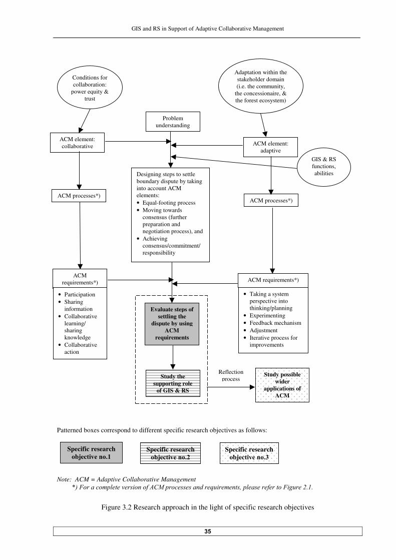
GIS and RS in Support of Adaptive Collaborative Management
��
Patterned boxes correspond to different specific research objectives as follows:
Note: ACM = Adaptive Collaborative Management �������./�&��� �����!�������������"�0�1����������� ������������������!� �����"������&�#��������
Figure �. Research approach in the light of specific research objectives
Problem understanding
Designing steps to settle boundary dispute by taking into account ACM elements: • Equal-footing process • Moving towards
consensus (further preparation and negotiation process), and
• Achieving consensus/commitment/ responsibility
ACM element: adaptive
ACM processes*)
ACM element: collaborative
ACM processes*)
ACM requirements*) ACM requirements*)
Evaluate steps of settling the
dispute by using ACM
requirements
Study the supporting role
of GIS & RS
Study possible wider
applications of ACM
Reflection process
Specific research objec����� ���
Specific research objec����� ��
Specific research objec����� ���
GIS & RS functions, abilities
Conditions for collaboration:
power equity & trust
Adaptation within the stakeholder domain (i.e. the community,
the concessionaire, & the forest ecosystem)
• Participation • Sharing
information • Collaborative
learning/ sharing knowledge
• Collaborative action
• Taking a system perspective into thinking/planning
• Experimenting • Feedback mechanism • Adjustment • Iterative process for
improvements

GIS and RS in Support of Adaptive Collaborative Management
��
� Characteristics of the Study Area
This chapter is intended to give insight of the situation in the study area where the dispute takes place. The first part of this chapter details information on the Labanan forest concession area, while in the second part; the settlement area of Siduung Baru is described.
��� Labanan forest concession area ����� Profile of the concession area Labanan forest concession area is located in Berau District, East Kalimantan Province, Indonesia &5 ���������'���"��������������(�.�#����� �������������������#���������itu�����E���,�9������°���,�9�������� ������� E��!,�)�������!E�!,�)���-����� ������������� ��������������������� ������(�
.�#���������� ����������(���(������������� �����(��� ������� !����������( =���(������������� �������
���������� ���!���������� � ����(������������� �����"������� � ����� ! ����������������(������-forest production (such as for transmigration area, etc.). Labanan forest area is considered as one of the last remaining tropical rain forest in Kalimantan with a good condition, in term of biodiversity, logs that can be harvested, and other environmental and scenic values. "���(�������������(�.�#�����(������������������;�������(�����������":�#�������� ��
������ ��5 �����������PT. Inhutani I has managed the Labanan concession as an international showcase of forest management, with the support of the ministry of forestry. They already possess 2$@����������� ( �����(�������������� ������������������������������� ���5������$�������� ��
Council (FSC) certification. Some research projects, international and national ones, had been carried out in this area since more ��������������������@����(����������(���������� ����$"3)<�&$ � �������"����������(���
Regeneration of logged over forest in East Kalimantan) plots project commenced by CIRAD (Centre de cooperation Internationale en Recherche Agronomique pour de Development = Center of international co-operation in agronomic research for the development'��(����5�������� �����������"���
data collection for this research is still continued till now. This research will provide information on rates of tropical forest recovery after logging to determine sustainable harvest. Other project with European Union called BFMP (Berau Forest Management Project) is also commenced in this area (������� ���� ������"�����=���������(��� �����8����� � ��������#� �� �����������(������������
extensive forest management project in East Kalimantan province. ����� Profile of surrounding villages 5 (������ ������������������������� ���� ����������� ���� �����ttlement units surround Labanan (������������� �����������"������(����������������� �������.�#������������� �����(�������������
�� �������.�#������������5������� ��������������������� �� �������.�#�������������(����������
transmigration settlement units, which mistakenly located by the government, and one of them is Siduung Baru settle������������5 ��������������� ������������������������� �������������.�#�����
area. This map only shows the position of those villages and settlement areas, but does not show their administrative boundary.
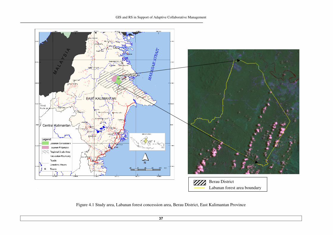
GIS and RS in Support of Adaptive Collaborative Management
��
Figure �.� Study area, Labanan forest concession area, Berau District, East Kalimantan Province
��������-� Location of Labanan concession area
Berau District Labanan forest area boundary

GIS and RS in Support of Adaptive Collaborative Management
��
Figure �. The location of Siduung Baru settlement area and villages surrounding Labanan forest concession area
Segah River
Siduung River
Siduung Baru
Gunung Sari
Tepian Buah
Nyapa Indah
Tanjung Redeb
LEGEND
Labanan forest area Villages/settlement areas/transmigration units Rivers
Roads

GIS and RS in Support of Adaptive Collaborative Management
�
��������������������*����-economical condition "�����8�� ����(����������� ���&����������!��F'����� ���� �����������������.�#��������a lives as farmers, while the remaining work as labors in some projects in the area or as employees with government or private businesses. There are two types of community in the area; the first type is a community that is originated from Java, brought #��������������������������������������������������� ���� �������������"���� ��� ��
transmigration settlement units. This people mainly practice permanent lowland agriculture as they did previously in Java. They are majority Moslems. The second type is a Dayak community. In this area, they live in some villages which are relatively �������������������������"��������+�� �� �������G���������������������� ����� (� ������ ��� �������
collect non-timber forest product such as gaharu (eagle wood), rattan, and honey. Not so many of them work as an employee. The highest school in those villages is primary high school. To continue studying to the higher level, they have to send their children to Tanjung Redeb (Berau district capital city). There are some community health facilities in the area, with permanent nurses and doctors who regularly visit each of them. ���������������������/�����������&����� The base camp of Labanan area can be reached through Segah River from Tanjung Redeb in approximate����� ���������������#�������#�������#���������������������-provincial road for about ������������������!����������������� �����������"��������� # ����(��� ��(������������� �������� ��
very good, which is not so common in Kalimantan. Part of the road between Labanan and Tanjung Redeb is a segment of a main road in the region, which called trans-Kalimantan. 2�� ��������������� ����(����������� ���������������������������#� ��#��������������������� ���
through. They are the extension road from Tanjung Redeb to Samarinda (the capital city of East Kalimantan province) and the road from Tanjung Redeb to some villages in the north of Labanan area. The roads are compacted-dirt road with a good condition because they maintained regularly. Bridges on that road are permanently built; this is an indication that in the future they will be made permanent (paved). ��� Siduung Baru settlement ����� History Siduung Baru is a new settlement area inside Labanan concession area; it is not yet an official village in a sense that the local government is not admitted it legally as a village. It is a new settlement area, which ‘appeared’ inside the Labanan area after and as one of the impacts of decentralization process in Indonesia. 2������ ������������(�������������������(�������������(�4�����<������&������� ��������(����)����
Kalimantan region) from some different places in the region came and inhabited the area near the $ ������3 �������"���� ���������������������������������8� ������������������������(��������
s�������� ���������(��������� ���������������������!�����������������-east of Labanan area called 9�����2��������2��$�����#����������������� ��� ����������� �������������� ����������������
������������������= ��������������������
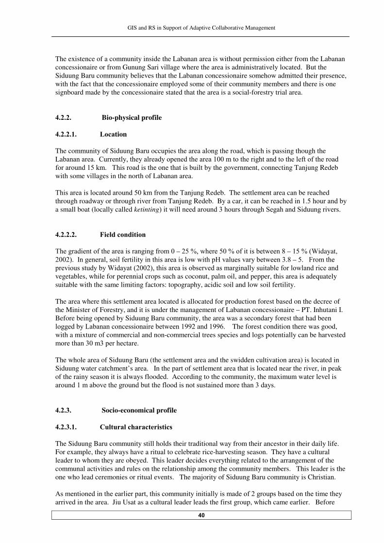
GIS and RS in Support of Adaptive Collaborative Management
�
The existence of a community inside the Labanan area is without permission either from the Labanan concessionaire or from Gunung Sari village where the area is administratively located. But the Siduung Baru community believes that the Labanan concessionaire somehow admitted their presence, with the fact that the concessionaire employed some of their community members and there is one signboard made by the concessionaire stated that the area is a social-forestry trial area. ����� Bio-physical profile ��������������������'���tion The community of Siduung Baru occupies the area along the road, which is passing though the La#������������+��������������������������������������������������� ����������������(���(����������
(�������������������"� ������� ��������������� ��#� ��#y the government, connecting Tanjung Redeb with some villages in the north of Labanan area. "� ������� ����������������������(��������"��8����3edeb. The settlement area can be reached through roadway or through river from Tanjung Redeb. By a car, it�����#���������� ���������������#��a small boat (locally called ketinting'� ��� �����������������������������$���������$ ������� ������� ��������������������0������� ����� "������� �����(���������� ������ ���(������–���F�����������F��(� �� ��#���������–����F�&A idayat, ��'���2������������ �(��� ��� ���� ������� ������ ����6������������#�����������–������5��������
���� ����������#��A ������&��'���� ������� ���#�������������� ������ ��#��(���������� �������
vegetables, while for perennial crops such as coconut, palm oil, and pepper, this area is adequately suitable with the same limiting factors: topography, acidic soil and low soil fertility. The area where this settlement area located is allocated for production forest based on the decree of the Minister of Forestry, and it is under the management of Labanan concessionaire – PT. Inhutani I. Before being opened by Siduung Baru community, the area was a secondary forest that had been ������#��.�#������������ ��� ���#������������������ � The forest condition there was good, with a mixture of commercial and non-commercial trees species and logs potentially can be harvested ������������������������������� The whole area of Siduung Baru (the settlement area and the swidden cultivation area) is located in Siduung water catchment’s area. In the part of settlement area that is located near the river, in peak of the rainy season it is always flooded. According to the community, the maximum water level is ������������#���������������#�������(���� ����������� ���������������������� ���� Socio-economical profile �������������������!%��%������������������� The Siduung Baru community still holds their traditional way from their ancestor in their daily life. For example, they always have a ritual to celebrate rice-harvesting season. They have a cultural leader to whom they are obeyed. This leader decides everything related to the arrangement of the communal activities and rules on the relationship among the community members. This leader is the one who lead ceremonies or ritual events. The majority of Siduung Baru community is Christian. -������ ����� ��������� ����������� �������� ��� � � ��� ��������(���������#������������� ��������
arrived in the area. Jiu Usat as a cultural leader leads the first group, which came earlier. Before
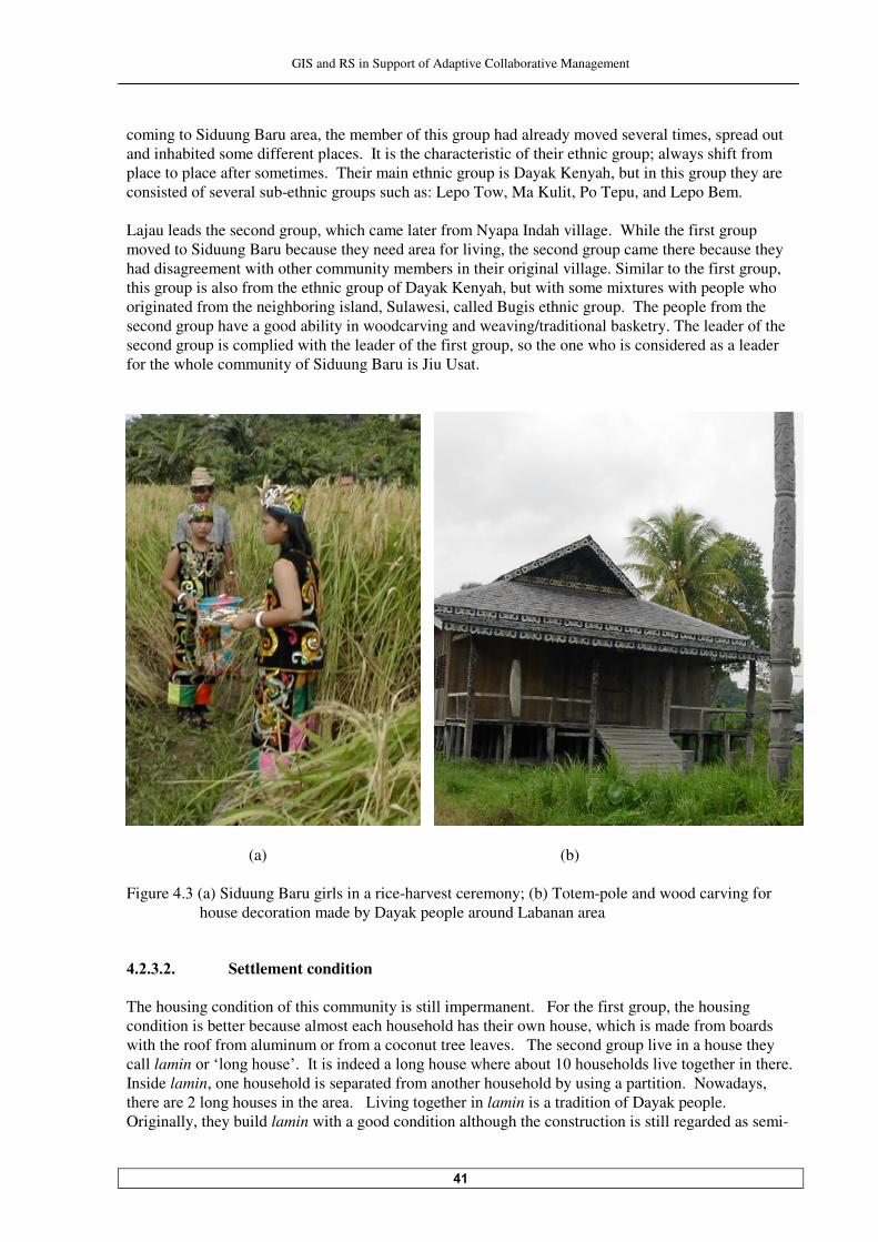
GIS and RS in Support of Adaptive Collaborative Management
��
coming to Siduung Baru area, the member of this group had already moved several times, spread out and inhabited some different places. It is the characteristic of their ethnic group; always shift from place to place after sometimes. Their main ethnic group is Dayak Kenyah, but in this group they are consisted of several sub-ethnic groups such as: Lepo Tow, Ma Kulit, Po Tepu, and Lepo Bem. Lajau leads the second group, which came later from Nyapa Indah village. While the first group moved to Siduung Baru because they need area for living, the second group came there because they had disagreement with other community members in their original village. Similar to the first group, this group is also from the ethnic group of Dayak Kenyah, but with some mixtures with people who originated from the neighboring island, Sulawesi, called Bugis ethnic group. The people from the second group have a good ability in woodcarving and weaving/traditional basketry. The leader of the second group is complied with the leader of the first group, so the one who is considered as a leader for the whole community of Siduung Baru is Jiu Usat.
(a) (b) Figure �.� (a) Siduung Baru girls in a rice-harvest ceremony; (b) Totem-pole and wood carving for
house decoration made by Dayak people around Labanan area
�������������������*ettlement condition The housing condition of this community is still impermanent. For the first group, the housing condition is better because almost each household has their own house, which is made from boards with the roof from aluminum or from a coconut tree leaves. The second group live in a house they call lamin����0���������,���2�� �� �������������������������#����������������� ������������ �����������Inside lamin, one household is separated from another household by using a partition. Nowadays, ���������������������� ��������������. � ������������ ��lamin is a tradition of Dayak people. Originally, they build lamin with a good condition although the construction is still regarded as semi-
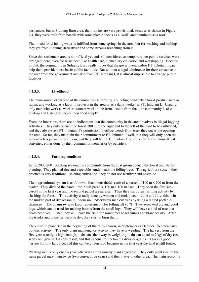
GIS and RS in Support of Adaptive Collaborative Management
��
permanent, but in Siduung Baru area, their lamins are very provisional, because as shown in Figure ���������������#� ��(����#������� ������������ ��������������0��,�������� ������������(� Their need for drinking water is fulfilled from some springs in the area, but for washing and bathing they get from Siduung Baru River and some streams branching from it. Since this settlement area is not official yet and still considered as temporary, no public services were arranged there, even for basic need like health care, elementary education and worshipping. Because of that, the community in Siduung Baru really hopes that the government and/or PT. Inhutani I can help them provide those basic public facilities. But without a legal admittance for their existence in the area from the government and also from PT. Inhutani I, it is almost impossible to arrange public facilities. ������������������'��������� The main source of income of the community is farming, collecting non-timber forest product such as rattan, and working as a labor in projects in the area or as a daily worker in PT. Inhutani I. Usually, only men who work as worker, women work in the farm. Aside from that, the community is also hunting and fishing to secure their food supply. From the interview, there are no indications that the community in the area involves in illegal logging ��� � � �����"�������������������(������������������� ����������������(���(�������������#����� �������
and they always ask PT. Inhutani I’s permission to utilize woods from trees they cut while opening the area. So far, they maintain their commitment to PT. Inhutani I well, that they will only open the area which is permitted for them, and they will help PT. Inhutani I to protect the forest from illegal activities, either done by their community member or by outsiders. ���� ��������������0��"� #��� ����� 2���������%�������� ��������������������� ���(��������( ���������������������(������������������
planting. They planted rice and vegetables underneath the felling trees. The agriculture system they practice is very traditional, shifting cultivation; they do not use fertilizer and pesticide. "�� ����� �������������� �����(�������)����������������� �������������(�������=������(��������
��������"����� � �������������� �������#-��������������=��������������"�������������( ������#-parcel in the first year and the second parcel a year after. Then they start their farming activity by slashing the forest. This activity usually done by women and took place in June and July, this is in the middle part of dry season in Indonesia. Afterwards men cut trees by using a rented portable-chainsaw. The chain����������#�����7� ��������(���(� ���� ����F���"��������������# �����������
logs, which can be used for making boards from the small logs. They will leave a kind of tree that bears beehives. Then they will leave the field for sometimes to let trunks and branches dry. After the trunks and branches become dry, they start to burn them. They start to plant rice in the beginning of the rainy season, in September or October. Women carry out this activity. The only plant maintenance activity they have is weeding. The harvest from the ( ��������������� ��� �������������� ������&��� ������ ���� ��� ������� �������7������!���'��(������ �e ������� �� ���!��� �������������������� �� ���7�������������%������-rice-grains. This is a good harvest for low land rice, and this can be understood because in the first year the land is still fertile. Planting rice is only once a year; afterwards they usually plant vegetable. They only plant rice on the same parcel maximum twice (two consecutive years) and then move to other area. The main reason is
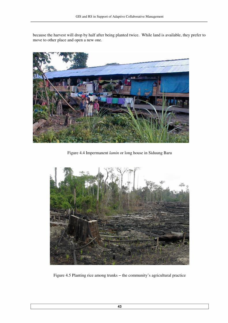
GIS and RS in Support of Adaptive Collaborative Management
��
because the harvest will drop by half after being planted twice. While land is available, they prefer to move to other place and open a new one.
Figure �.� Impermanent lamin or long house in Siduung Baru
Figure �.� Planting rice among trunks − the community’s agricultural practice
GIS and RS in Support of Adaptive Collaborative Management
��
�� Understanding the Problem
Stakeholder and dispute analyses are conversed in this chapter. Both analyses are intended to equip the researcher with understanding of the problem situation before working together with the disputants to settle the problem. In addition to that, some relevant issues toward the boundary dispute are also discussed.
���� Stakeholder analysis
������ Stakeholders identification A number of relevant stakeholders/stakeholder groups were identified before fieldwork and during fieldwork period. Later, those stakeholders were verified and streamlined by excluding those who are considered not essential to the analysis. The stakeholders are grouped into users, government, development agents, and other private. "�#����������� ���� �� ����(������������������������� �� ����#����������������� �� �����������"���
interests of stakeholders presented here might not reflect all of their interests but just the major ones relevant to the topic. In the table, a notification of possible positive/negative impacts of this activity (i.e. settling the boundary dispute) to each of them is also given ������ Analysis on stakeholders’ influence and importance Since not all identified stakeholders should be involved directly in settling the boundary dispute, key stakeholders should be chosen. Key stakeholders were defined from the list of stakeholder/stakeholder group by determining their influence and importance toward the success of settling this problem. Influence refers to the power which stakeholders possess to affecting the problem, while importance indicates to whom the boundary dispute settlement places a priority on meeting their needs, interests and expectations. By combining influence and importance of each stakeholder in a two by two matrix diagram as shown ��5 ��������������� ���� ����������#������ ( ������������������������( �� ��� �����������������
potential coalition of support for the activity can be identified. Analysis of stakeholder’s influence and importance and their classification is mainly based on the researcher’s judgment based on the information obtained from interview and observation, literature review and to the extent of researcher’s knowledge and experience.
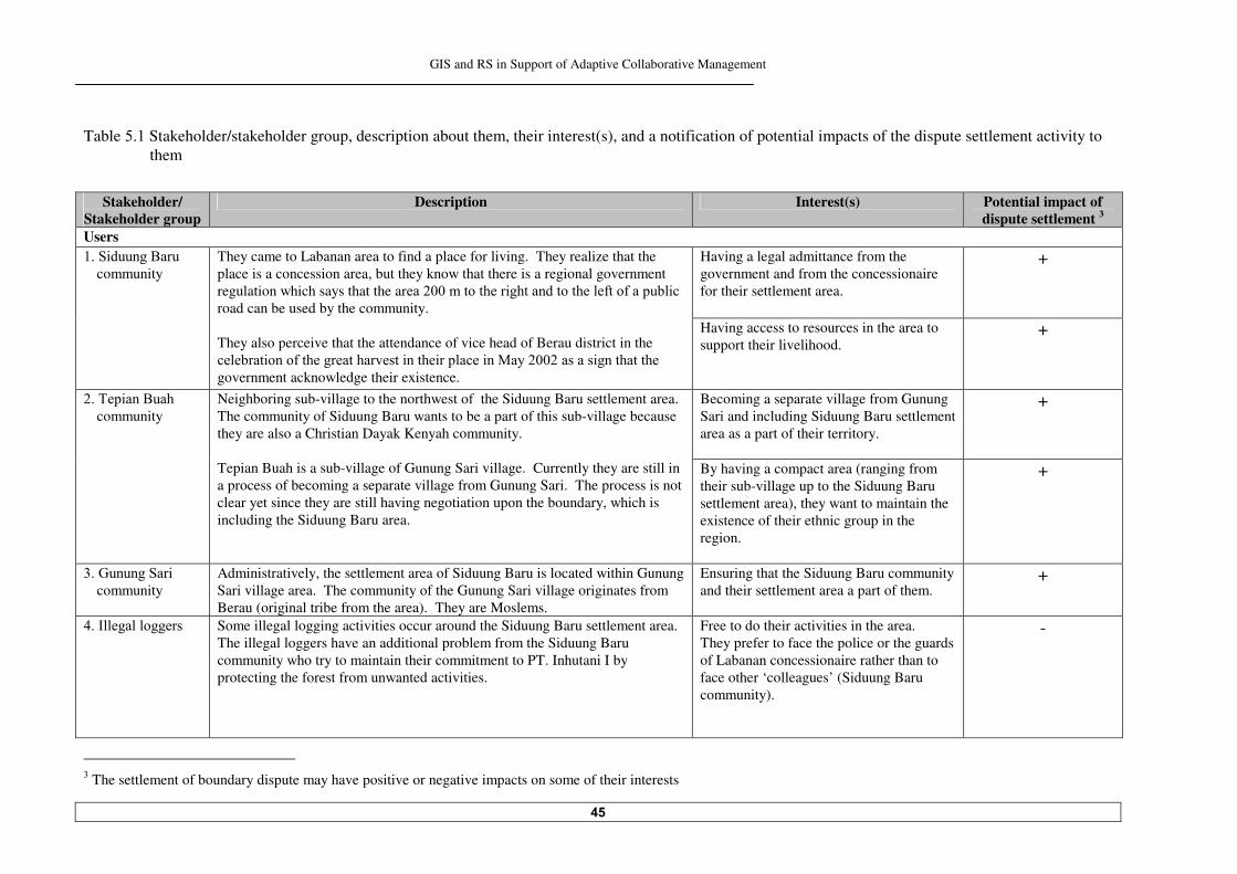
GIS and RS in Support of Adaptive Collaborative Management
��
Table �.� Stakeholder/stakeholder group, description about them, their interest(s), and a notification of potential impacts of the dispute settlement activity to them
Stakeholder/
Stakeholder group Description Interest(s) Potential impact of
dispute settlement Users
Having a legal admittance from the government and from the concessionaire for their settlement area.
+ ���$ ������*������������
community They came to Labanan area to find a place for living. They realize that the place is a concession area, but they know that there is a regional government regulation which says that the ar���������������� ����������������(���(�����# ��
road can be used by the community. They also perceive that the attendance of vice head of Berau district in the ���#��� ����(������������������� ����� ������� ��:������������ ������������
government acknowledge their existence.
Having access to resources in the area to support their livelihood.
+
Becoming a separate village from Gunung Sari and including Siduung Baru settlement area as a part of their territory.
+ ��"�� ���*����
community Neighboring sub-village to the northwest of the Siduung Baru settlement area. The community of Siduung Baru wants to be a part of this sub-village because they are also a Christian Dayak Kenyah community. Tepian Buah is a sub-village of Gunung Sari village. Currently they are still in a process of becoming a separate village from Gunung Sari. The process is not clear yet since they are still having negotiation upon the boundary, which is including the Siduung Baru area.
By having a compact area (ranging from their sub-village up to the Siduung Baru settlement area), they want to maintain the existence of their ethnic group in the region.
+
���1������$�� community
Administratively, the settlement area of Siduung Baru is located within Gunung Sari village area. The community of the Gunung Sari village originates from Berau (original tribe from the area). They are Moslems.
Ensuring that the Siduung Baru community and their settlement area a part of them.
+
���2���������� Some illegal logging activities occur around the Siduung Baru settlement area. The illegal loggers have an additional problem from the Siduung Baru community who try to maintain their commitment to PT. Inhutani I by protecting the forest from unwanted activities.
Free to do their activities in the area. They prefer to face the police or the guards of Labanan concessionaire rather than to face other ‘colleagues’ (Siduung Baru community).
-
� The settlement of boundary dispute may have positive or negative impacts on some of their interests
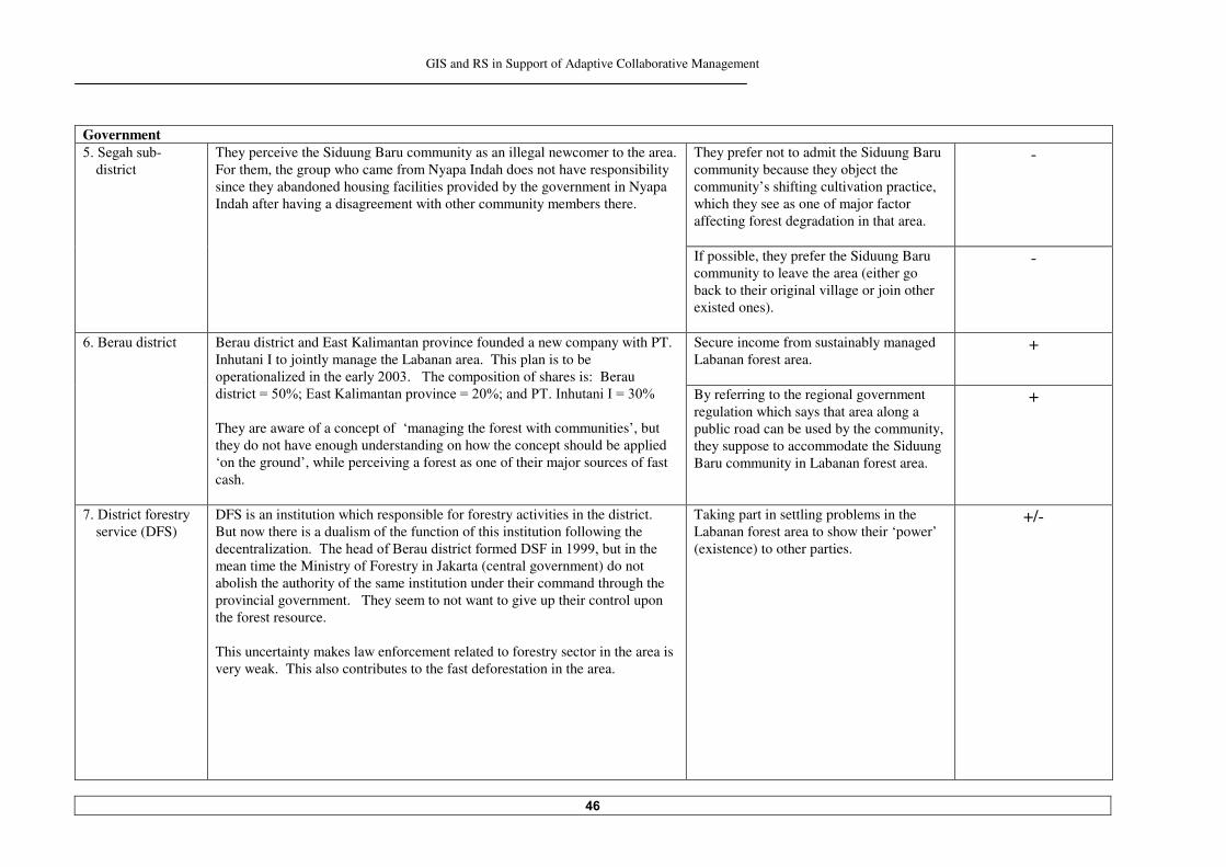
GIS and RS in Support of Adaptive Collaborative Management
��
Government They prefer not to admit the Siduung Baru community because they object the community’s shifting cultivation practice, which they see as one of major factor affecting forest degradation in that area.
- ���$�������#-district
They perceive the Siduung Baru community as an illegal newcomer to the area. For them, the group who came from Nyapa Indah does not have responsibility since they abandoned housing facilities provided by the government in Nyapa Indah after having a disagreement with other community members there.
If possible, they prefer the Siduung Baru community to leave the area (either go back to their original village or join other existed ones).
-
Secure income from sustainably managed Labanan forest area.
+ ��*������ ��� �� Berau district and East Kalimantan province founded a new company with PT. Inhutani I to jointly manage the Labanan area. This plan is to be ������ ��� B��� ������������������"�������osition of shares is: Berau � ��� ���H���F>�)����<� ����������v ����H��F>�����/"��2������ �2�H���F
They are aware of a concept of ‘managing the forest with communities’, but they do not have enough understanding on how the concept should be applied ‘on the ground’, while perceiving a forest as one of their major sources of fast cash.
By referring to the regional government regulation which says that area along a public road can be used by the community, they suppose to accommodate the Siduung Baru community in Labanan forest area.
+
!��4 ��� ���(��������
service (DFS) DFS is an institution which responsible for forestry activities in the district. But now there is a dualism of the function of this institution following the �������� B�� �����"���������(�*������ ��� ���(������4$5� ��������#��� ������
mean time the Ministry of Forestry in Jakarta (central government) do not abolish the authority of the same institution under their command through the provincial government. They seem to not want to give up their control upon the forest resource. This uncertainty makes law enforcement related to forestry sector in the area is very weak. This also contributes to the fast deforestation in the area.
Taking part in settling problems in the Labanan forest area to show their ‘power’ (existence) to other parties.
+/-
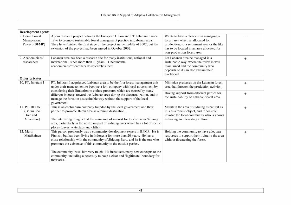
GIS and RS in Support of Adaptive Collaborative Management
��
Development agents ���*�����5������
Management Project (BFMP)
A join research project between the European Union and PT. Inhutani I since ��� ����������������� ��#��(��������������������ctice in Labanan area. They have finished the first stage �(��������8���� ������� �����(�����#�������
�=���� ����(��������8��������#����������� ��@���#������
Wants to have a clear cut in managing a forest area which is allocated for production, so a settlement area or the like has to be located in an area allocated for non-production forest area.
-
���-����� � ���%�
researchers Labanan area has been a research site for many institutions, national and ������� ������ ��������������������������G�����table academicians/researchers do researches there.
Let Labanan area be managed in a sustainable way, where the forest is well maintained and the community who depends on it can also sustain their livelihood.
+
Other privates Minimize pressures on the Labanan forest area that threaten the production activity.
+ ����/"��2������ �2 PT. Inhutani I acquiesced Labanan area to be the first forest management unit under their management to become a join company with local government by considering their limitation to endure pressures which are caused by many different interests toward the Labanan area during the decentralization, and to manage the forest in a sustainable way without the support of the local government.
Having support from different parties for the sustainability of Labanan forest area.
+
����/"��*)4-�
(Berau Eco Dive and Adventure)
This is an ecotourism company founded by the local government and their partner to promote Berau area as a tourist destination. The interesting thing is that the main area of interest for tourism is in Siduung area, particularly in the upstream part of Siduung river which has a lot of scenic places (caves, waterfalls and cliffs).
Maintain the area of Siduung as natural as it is as a tourist object, and if possible involve the local community who is known as having an interesting culture.
+
���:��� �
Mattikainen This person previously was a community development expert in BFMP. He is 5 �� ����#�������#���� � ��� ��2������ ��(�����������������������6��������
close relationship with the community of Siduung Baru, and he is the one who promotes the existence of this community to the outside parties. The community trusts him very much. He introduces many new concepts to the community, including a necessity to have a clear and ‘legitimate’ boundary for their area.
Helping the community to have adequate resources to support their living in the area without threatening the forest.
+
GIS and RS in Support of Adaptive Collaborative Management
��
Legend: ��H�$ ������*���������� �� !�H�4 ��� ���(������������ �� �H�"�� ���*���������� �� ��H�*�����5������:anagement Project ��H�1������$�� ������� �� ��H�-����� � ���%������������ ��H�2���������� ���H�/"��2������ �2 ��H�$�����$�#-district ���H�/"��*�����)���4 �������-�������� �H�*�����4 ��� �� ��H�:��� �:��� �� ���
Note: The numbering sys����"����� 2���!�������������"�#������������������������������$ %!������
Figure �.� Stakeholders classification matrix based on their importance and influence in the boundary dispute between the Siduung Baru community and the Labanan concessionaire
Boxes A, B, C and D (marked by bold lines) represent the major categories of stakeholders classification based on their influence and importance. While the dashed lines within each box reflect a further grouping of stakeholders whereby the stakeholders falling in the same major category, for example in box A, are also analysed to their relative degree of influence and importance. Boxes A, B and C are the key stakeholders of this dispute; they are those who can significantly influence the result of this activity, or are the most important ones if objectives of the activity are to be met. The implications of each of the major boxes (A, B, C and D) and analysis strategies for each stakeholder are summarized as follows:
High
Importance
Low
Low Influence High
� �
�������������������������������������
��� � ��
�������
������������������������ ����������������������������������
Box A
Stakeholders in this box need special initiatives if their interests are to be protected. In this problem situation, no stakeholder falls into this category.
Box B Good working relationship with stakeholders from this box is necessarily built to ensure an effective support for the success of the activity. The Siduung Baru community, the Labanan concessionaire, and Berau District are together in this box. The Siduung Baru community and the concessionaire are at the same level of importance because they are the main stakeholders in this problem situation, but in term of influence (i.e. power), they are in equal.
GIS and RS in Support of Adaptive Collaborative Management
�
Box C The interests of stakeholders in this box are not the targets of this activity but they could influence the outcome, so they might be a source of risks. They need careful monitoring and management attempts. Stakeholders in this box are the Tepian Buah community, the Gunung Sari community, the academicians/researchers, Segah Sub-district and Marti Mattikainen. The Tepian Buah community has a significant influence to the Siduung Baru community through their traditional and cultural links. Both parties have a potential to make a coalition. The Gunung Sari community can affect the outcome of the attempt to settle the boundary dispute negatively if it is not acceptable to them. Their ‘power’ comes from the fact that Siduung Baru area administratively is within their territory. Based on the total area under their administration, they have a right to receive a compensation-logging fee from PT. Inhutani I or other timber companies who have activities in their territory. So the idea of joining Siduung Baru settlement area with Tepian Buah sub-village would possibly get a strong rejection from them. The academicians/researchers’ importance comes from a fact that they can influence government or public opinion through their recommendation on resource management in the area. But at the same time, being a researcher, they do not have direct stake in the outcome of management decisions, so on this ground, it would seem appropriate to weight their preference modest in this activity. Segah Sub-district has a position between the people in village level and in district level. Though Segah Sub-district interests are not in accordance with other people’ interests in village level and in district level, they can easily influence to both directions; to the village with their authority and to the district with persuasive approach. A close relationship between Marti Mattikainen and the community of Siduung Baru makes his opinion always heard by the community. But his effort to promote the existence of this community to outside parties made him less respected by the Labanan concessionaire.
Box D Stakeholders in this box may require little monitoring and evaluation, but are of low priority. Stakeholders in this category are the illegal loggers, the District Forestry Service, Berau Forest Management Project (BFMP), the academicians/researchers, and PT. Berau Eco Dive and Adventure. The illegal loggers do not have any influence and importance to the activity of settling the boundary dispute but they will be affected by the outcome. In a normal situation, the District Forestry Service could play a significant role in a problem like this, but because at the moment they have their internal conflict, they become powerless.
The importance of the Berau District comes from the fact that their interests are basically a combination of the parties in dispute’ interests (the community of Siduung Baru and the concessionaire). But because the nature of Berau District participation in this dispute is not � ���������(��� ������>�������������������������(�����������������������
GIS and RS in Support of Adaptive Collaborative Management
�
����� Focus on two main stakeholders: the community of Siduung Baru and the
Labanan concessionaire In line with the objective of this study, the main stakeholders from the stakeholder analysis (stakeholders in box B) are the Siduung Baru community, the Labanan concessionaire and the local government (this is referred to the Berau District). But due to the circumstances when this research was carried out, it was not possible to involve Berau District actively in the process of settling the boundary dispute. That was a transition period for Berau District to take part in managing the Labanan forest concession area through a new company that jointly founded with PT. Inhutani I and East Kalimantan Province. As a majority shareholder, Berau District was on a stage of selecting a president director and a management team who will operate on behalf of them in Labanan. This study is intended as an initial analysis for the implementation of adaptive collaborative management in Labanan area through the resolution of the boundary dispute between the community of Siduung Baru and the Labanan concessionaire. Therefore focus on the community of Siduung Baru and the Labanan concessionaire as the main stakeholders is considered sufficient to represent the objective of this study. A focus on these two main stakeholders does not mean overlooking other stakeholders in this problem. By referring to the result of the stakeholder analysis, other stakeholders’ existence, views ���� ������������������������ �������������������� ��������� B�� ��� ���������� =� ��5 ��������������
used as a frame for analysis. ���� Boundary dispute analysis Before proceeding further in resolving the boundary dispute, it is necessary to examine the nature of dispute and the situation in which it arises.
A similar situation also happened to the BFMP. During this research, BFMP was in an idle condition because the extension of their research project in Labanan area came a bit later. But regard ����� ��� �������*5:/������ ���������������� ������������(����������������������� #��
solu� ������"��������������������������� �������*5:/D�&�'�3����������������� ���(����
$ ������*�������������&'�.��������������here with a full support from PT. Inhutani I. The BFMP project was already terminated before the decision being taken, but this problem is still on the agenda for the continuing program. PT. Berau Eco Dive and Adventure has a full support from the local government to work on the other potential aspect of Labanan area, eco-tourism. They can have influence indirectly through their partner, the local government. But since basically their objective is aligned with parties’ concerned (stakeholders in box B) and their direct participation in the process of settling the boundary dispute is not relevant, they are not considered important. Whatever the outcome is, they also will be affected by the result.
GIS and RS in Support of Adaptive Collaborative Management
��
������ Source of dispute ���������������������1������ ��� ������� The main source of dispute in the study area is different needs or interest to the piece of forest in the Labanan area where the settlement area is located. The community wants to live and open the area for agriculture, while the concessionaire wants to keep it fully a forest production area to produce logs. �������������� Factual disagreement A factual disagreement is also recognized. This is related to the interpretation of one regional ����������������� ���������������������������� ��������������������������������� ����������������
the left of a public road. The Labanan concessionaire said that they have heard about the regulation but never seen it. They are trying to find a copy of it but have not succeeded yet. They argued that if the regulation exists, it cannot be implemented in general term, it is supposedly accompanied with some conditions, to avoid uncontrollable interpretation. Different interpretations upon the regulation could be dangerous, especially in the during decentralization era, where many different interests come to the surface, while law enforcement is weak and uncertain. The definition of ‘a public road’ or ‘can be used’ (while some said it also means: ‘can be owned’) is not clear. If it is possible, they really like to have a copy of the regulation (if it exists). The researcher tried to trace the regulation to some relevant institution such as the Regional Development Planning Agency (BAPPEDA), National Land Agency (BPN) and Berau District office, but surprisingly they said that they have heard about the regulation but never seen it. When it was reminded that the head of the district and his subordinates always mention in front of their constituent ����D�I��������������������� ����������������(���(�����# �����������#�������#������������ ��J����
person from the Regional Development Planning Agency said that it was an outcome of one seminar ��*�����4 ��� �������������������� �������������������������#���������� � ����������� ���������
time it becomes ‘a favourite political statement’ of the people in executive and legislative bodies there. This is also the case for the community of Siduung Baru. When they had a celebration of a big rice- harvest, the vice district head (vice bupati) stated the same sentence in his speech. Based on that, the community perceives that their existence in the area is allowed and admitted by the government. The tracking of the ‘disputed’ regional government regulation by the researcher later gave a different result. One Sub-district head showed the researcher a copy of a regional regulation issued by the Gov�������(�)����<� �������/��� ���� ����!��������� ������������ �������0������� ���������������
regulation’ is referred to that one. It says that: “An area along new public roads built by the government or special roads built by a company, stret��������������������#��� ����������������!�"���"�the roads, the usage of them is decided by the provincial government”. So this is in fact something different. It is also doubtful whether the regulation is still valid or there is a revision on it or a newer version. Till the fieldwork finished, the issue about this is remained unclear. This is a proof for the factual disagreement that occurred: uncertainty because of imperfect knowledge which leads to misinterpretation and misunderstanding. �������. Relational aspect: mistrust Another source of dispute that is also identified, is one of the relational aspects; the Labanan concessionaire distrusts the community of Siduung Baru. They suspect that the community came to
GIS and RS in Support of Adaptive Collaborative Management
��
the area not only for having a piece of land for their living but also to later claim the ‘logging compensation fee’ (if so, the community will tend to open and have control to the area as much as they could). The concessionaire thought that in the beginning the community tried to please the concessionaire by giving a commitment to participate in protecting the forest area from illegal logging activity, but if later after they have what they want (a legal permission to settle in the area): ”Who can guarantee that they will not ask for more and more?” From the three sources of dispute identified in the study area, ‘conflicting interests’ and ‘distrust’ between the community of Siduung Baru and the concessionaire are which adaptive collaborative management approach would deal with. Conflicting interest would be addressed by collaboration and negotiation between them; while building trust is one of major goals of series of activities in the implementation of adaptive collaborative management approach here. Adaptive collaborative management will not directly solve ‘the factual disagreement’, but as collaboration between the disputants is achieved, they will be able to have a good dialogue to solve this problem. ������ Nature and stage of the dispute For analytical purposes it is also useful to identify the interaction between the disputing parties; the resource in dispute; the stake that each party has upon the resource; and the stage that the dispute has reached (i.e. the time dimension). ���������������������) �������� ���tween the disputants Interaction between the disputants is frequently crucial in determining the terms on which the dispute will be settled. In this boundary dispute, some factors influencing the community of Siduung Baru and the Labanan concessionaire’s interaction are: • The scope or the level at which the dispute occurred, which is local. • The relative level or status of the disputants, which is ‘vertically’ different. • The relative power of the community of Siduung Baru and the Labanan concessionaire is
significantly different. Addressing large discrepancies in the relative power of disputants may present formidable obstacles in the process of settling the dispute, so this is necessarily noticed.
The last point above about power disparity, underlined another importance of using approach like adaptive collaborative management. It reveals the necessity to arrange some efforts to lessen the discrepancies between the disputant before they could collaborate. �������������������������%����� �����%�� The competitive and antagonistic characteristics of the activities of the community and the concessionaire in the area have giving rise to the dispute. They compete and conflict claims over the allocation of the forest area around Siduung River. ������������ The stake The stake here is the value, use or interest that the stakeholder has upon the resource. The stake of the Labanan concessionaire comes from a legal recognition from the Ministry of Forestry. During the previous era (before the decentralization era), formal legal recognition like this can have a dramatic effect on their bargaining power in relation to other stakeholders, but since the decentralization era, it is reduced a lot by the local government and the local people.
GIS and RS in Support of Adaptive Collaborative Management
��
The stake of the Siduung Baru community comes from the fact that they are ‘local people’ and one of the forest-dependent communities, which are strongly supported since the decentralization era in Indonesia and succeeded in getting a lot of sympathies from many different parties. It is important to appreciate that a stake can be conceived of as having both subjective and objective elements. It can be seen as representing the stakeholder's subjective evaluation of their relationship with the resource. The more highly the stakeholder values this relationship, the more intensely they will assert their interests in the resource. In the case of the Siduung Baru community, their ability to assert their rights to use the resource will possibly compromised if their ‘traditional’ interests in the resource are not legally recognized. Aside of that, the fact that they are newcomers in the area or even worse – basically they are intruders, is very much weakens their stake. That is why they strive to get the legal admittance. ���������������������*��#�������������%���2������"����"� ��� 3 It is important to establish what stage the dispute has reached. As a dispute continues, it is likely that it will increase in intensity and the relationship between the disputants will become more confrontational. The state of the resource(s) at issue may also deteriorate over time, thus reducing the total potential benefits available to be shared between the parties through resolution of the dispute. Early intervention in most disputes/conflicts is therefore advisable to facilitate the satisfactory resolution and to minimize undesirable consequences. This approach is also in line with the principle of preventive action, which advocates early action to prevent environmental harm on the basis that it is cheaper, safer and more desirable to prevent such harm occurring than to rectify it later. The boundary dispute between the Labanan concessionaire and the community of Siduung Baru should have been solved earlier if the Labanan concessionaire willing to do so, but since some other conflicts in the area and some ‘political’ considerations on their side had higher priority at that moment. They delayed the attempt to settle this boundary dispute, until at a certain point they could not delay it any longer, i.e. when the forest is continuously opened by the community at a threatening speed and the certification body� would only issue the certificate of sustainable forest management for them after the Labanan concessionaire settles all spatial conflicts in the area including this one. It is around three years now that the dispute in the area occurred. But related to the relationship between the two parties, there is no indication yet that it becomes more confrontational or the like. This is because the Labanan concessionaire always tries to maintain their interaction with the Siduung Baru community as minimal as possible (avoidance behaviour), while the community as the ‘weaker’ party always tries to prevent themselves for being firm/insisting to the concessionaire. ��� Analysis on some relevant issues to solve boundary dispute Some issues related to the government regulations need to be considered before proceeding further with the process of settling boundary dispute. First is about the government regulation for changing a status of ‘forest production area’ into ‘non-forest production area’. And the other one is about a local governance structure in Indonesia.
� Currently the Labanan concessionaire is seeking an international sustainable forest management certificate from the Forest Stewardship Council (FSC) and Indonesian Ecolabel Institute/Lembaga Ekolabel Indonesia (LEI)
GIS and RS in Support of Adaptive Collaborative Management
��
����� A procedure to change a status of forest production area The whole Labanan area by law is allocated for forest production. If a settlement area to be developed and legalized within the Labanan area, that part of forest has to be altered into non-forest production area. Changing the status of the area that has been allocated for forest production area to other allocation outside forest related purposes has to be with permission from the Minister of Forestry. It is because by changing the status, the forest area will be reduced, and this is contradicted the principle to maintain or if possible to expand a forest area in Indonesia. The process to change the status is not simple and usually lengthy. It has to begin with a request from the authorized party for the particular area (in this case is the Labanan concessionaire) to the Ministry of Forestry. Local government has to support the request, which is only possible after they have some technical considerations from relevant institutions. The Ministry of Forestry then will study the request through their team. And if things go smooth, the request could be approved. The area for forest production is ‘a productive’ area for the government because the concession holder in the area has to pay a certain tax for having production activities there. If it is allocated for public purpose, tax treatment for the area will be very different. ����� Local government structure in Indonesia -������������(���������������� ��2������ �� �������� ��5 �����������"����������������������� �� ��
a Rukun Tetangga/RT (neighbourhood unit). Some RT can become a sub-village (dusun), and the process usually is not complicated. The next phase to become a village is not very easy; some ���� � ������������#��(�( ���( ������-����� ������*�����4 ��� ��������� ���9�����%�����������(�
those conditions are: • Th��� � ���������� ����������#������������������������������������ (� �� ��������(( � ����� ��
has to fulfil the district government certain considerations; • The area has to have a good accessibility; • The area has to have a potential to be developed economically. A village can be formed by promoting one eligible sub-village, or by joining some sub-villages. In the case of the Siduung Baru settlement area, their intention to directly become ‘a village’ will not be easy due to the situation mentioned before. A reasonable way is starting from the beginning as a ‘neighbourhood unit’ either with the Gunung Sari village or with the Tepian Buah (sub) village; then after sometimes they can develop into sub-village. The next phase to become a village will depend on the circumstances in the future.
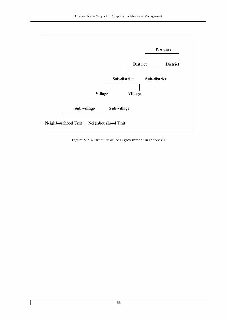
GIS and RS in Support of Adaptive Collaborative Management
��
Province District District
Sub-district Sub-district
Village Village
Sub-village Sub-village Neighbourhood Unit Neighbourhood Unit
Figure �. A structure of local government in Indonesia
GIS and RS in Support of Adaptive Collaborative Management
��
�� Generating Boundary Alternatives
This chapter elaborates the process of boundary alternatives generation. The discussion on the process is done separately for the community and for the concessionaire. The one for the community includes several stages/elements which are intended to give the community ‘equal-footing’ with regards to the concessionaire before entering the negotiation process. While the one for the concessionaire is a straight forward process of generating the boundary. This chapter is completed with a set of boundary alternatives, which serves as an input for the next process in settling the dispute.
���� The process of boundary alternative generation
The process of generating boundary alternatives was conducted separately between the community of Siduung Baru and the Labanan concessionaire. Both processes had different approaches. With the community, the process was including some stages/elements, which are intended to give the community ‘equal-footing’ with regards to the concessionaire prior to the negotiation process. With the Labanan concessionaire, the process of generating boundary alternatives was straight forward since they already had a concept to deal with this boundary dispute. ������ Boundary alternatives generation with the community of Siduung Baru The process of boundary alternative generation with the community includes: objective formulation, discussion on priorities and key issues, and scenario development. Those steps were intended to bring the community gradually to understand the problem situation more thorough to help them in generating boundary alternatives, which are appropriate for them, and to prepare them for the negotiation process. ���������������������4������������"%����� �� ������%���� �� �$�&����%�� Through focus group discussion sessions and dialogues with the community’s leader, it was clear that the objective of the community Siduung Baru is to have a clear boundary for their settlement area which is acknowledged by their neighbouring villages, by the concessionaire and particularly by the local government. They would use the boundary to further process their existence as a sub-village (or if possible a village) in the area, to become eligible for receiving support from the government in the form of public facilities, funding, and other rights. This is in fact intended as their initial step to have an administrative village boundary. Some key issues came out from these sessions with the community are: • They would like to have an area, which is sufficient for their living, not only for them but also for
their descendants; to have access for benefiting from the forest surrounding their settlement area; and also to be able to manage their ‘village’ in a way their ancestors managed theirs, so they want to have tana’ ulen.

GIS and RS in Support of Adaptive Collaborative Management
��
Tana’ ulen is a piece of forest which is protected because it serves as a ‘saving’ for the community’s communal needs. This piece of forest is usually the best part of the area. Nobody can take anything from tana’ ulen for their personal needs. Something can be taken from tana’ ulen only with a permission from the leader/accountable persons, for important communal activities like a cultural celebration, or if the community has important guests.
• They prefer to become a part of Tepian Buah village area if they could not directly become a full-
fledged village because the community in Tepian Buah is also Dayak Kenyah. They are aware that this is a sensitive issue since the village of Gunung Sari (where administratively the Siduung Baru area located) would not easily agree with the idea.
���������������������-�����������&��"�#��� ����������� � To stimulate thinking for the scenario development process, two satellite images of the Labanan area �(���� ����������������������� ��� B�� ���� ����������������� ����� �����"���������
representations of those images were intentionally chosen, so the forested area appeared green, the opened area appeared light brown, and the newly opened area appeared pinkish; to make it easier for the participants to interpret it. To begin with, the researcher explained what satellite images are, how they are produced, for what purpose, and how maps were derived from it. There was an interesting comment from one participant with a group of young people. He said: “So if the images are pictures which were taken by satellite from the outer space without people in it, it means that they can not be manipulated, it shows figures as they are”. When he was asked why he thought about ‘manipulation’, he said that he knew somebody can change and adjust maps to fit their purpose though the information is not correct, and used the map for getting IPK (Izin Pemanfaatan Kayu = Timber Extraction Permits�). Then suddenly the discussion about maps and possible manipulation on it started. The researcher took the chance to get the participants support that the maps for them will be generated with their participation, so they can have control on the results. That idea seemed to appeal to them. Then simple participatory image interpretation was conducted. It was included: recognizing some landmarks such as roads and rivers, locating the Siduung Baru area, differentiating step areas from (�������������������� ��������������������������#�������� ��� �������(���� ���������&�� �����
change from forested areas to the open areas). Some thematic maps were also used to help participants identify name of rivers, villages, locate administrative boundaries and examine Labanan concessionaire’s logging activities. The researcher had a hard time to do the same process with the women group. They tend to be passively listening and directly agreed to whatever was said by the researcher. They seemed not too interested in spatial information such as maps and satellite images. This is maybe because in their daily life, they depend on their husband/father/brother for spatial related things; they are not the ones who have to decide where they will go, where they will live or where they will open area for agriculture. In the group of leaders/key persons in the community, the leader dominated the session. But indeed he is a very bright person. He easily located their area on the image and was able to point out rivers and roads in the area, and also some neighbouring villages. He identified neighbouring villages and
�During the decentralization era, IPK is issued by the local government without appropriate and sufficient control. This permit often misused for illegal logging activities.
GIS and RS in Support of Adaptive Collaborative Management
��
rivers name by referring to the thematic maps. Then he explained things to his colleagues. It was very interesting to listen to their discussion on how the forest disappeared along the rivers and roads and from those points went deeper to the forest, by comparing the two images. Most of all participants were surprised that their activities in opening the forest along the road in the Siduung Baru area are ‘monitored’ by a satellite in the outer space. To the researcher, the ability of the leader and some of his key persons to understand maps was not very unexpected because of their prior interaction with the Labanan concessionaire, with people from the BFMP (Berau Forest Management Project), and also with Marti Mattikainen. But inspecting satellite images was something new for them, and this is also understandable because the Labanan concessionaire and BFMP who have those satellite images in the area, limited the usage only for them with some considerations, one of them is worryness that it will be misused. By relating and comparing similarities between maps and satellite images, it was understandable and also acceptable for the community on how maps were generated by using satellite images as a source. From the literature review, communication with resource person, and witnessing the discussion process among participants, it is recognized that naturally Dayak people is good in their spatial related instinct and knowledge because of their close relationship with forest as their place for living. They can walk inside the forest for several days without getting lost. -����� ������:������&���!'����� ���������e develops in humans through three progressive stages, they are: landmark knowledge, route knowledge, and survey knowledge. The first one refers to the capacity of memorizing places in relation to an event, the second to developing the sense of ordered sequences of landmarks, and the latest is the one where the knowledge embraces simultaneously more locations, their interrelations and allows for detouring, shortcutting and creative navigation. In the case of the Siduung Baru community, their newness in that area more or less would affect their familiarity with the area. That familiarity considerably differs from person to person. In average they were able to describe the route to reach their place from Tanjung Redeb, either through the river or through two different alternative roads. That can be perceived as the stage two in spatial knowledge development as explained earlier. But some participants including the leader undoubtedly already have been in the stage three. ��������������������*�� ���� development The scenario development process in this research also intended to give the community learning experience to think in term of what if about the future. This is an important aspect in adaptive management. The learning in pathway scenario - the type of scenario that was used here, focuses on open-ended problem solving and creating strategies for dealing with constraints and opportunities for achieving future goal. The scenario was developed gradually through some stages as follows: - Contrasting current and future conditions
The participants were asked to contrast the current situation with the future situation that they desired. In the future they would like to have a well-arranged settlement area, which has complete facilities like school, health service, church, electricity, and public transportation service. About the forest, they were asked: “How do you want the forest to look like?” One of them answered that he wants the forest like the one they see in the Labanan area, and the others agreed. When he was asked why, the answer was because compared to other places they know, the forest in Labanan is still good, the trees are dense, the soil is fertile, the bearded-pigs (their favourite hunting target) still
GIS and RS in Support of Adaptive Collaborative Management
�
abundant, the rivers in the area are still clear and have a lot of fishes, the nature is beautiful (some waterfalls, karsts caves and cliffs), and they can easily collect rattan and honey from the forest. Then the participants were asked questions to reveal their current situation. They said that they realize they are now opening and burning the forest along the road, but they are committed to open ����������������� �������������� �����������������(������������������� �����(������������@���������
participant said that he saw people did the same with what they are doing along the road in Muara Wahau area (in neighbouring district located at the north of Berau District). More and more people came there because the access to that place is good, and when all areas along the road had been opened, they went deeper and deeper to the forest, till now almost no forest left there. He said he does not want the same condition to happen in Labanan area. The others supported his opinion. When it was stated that their existence in the area also possibly attracts other people to come and open the area, they responded that they would not allow more and more people to join them there because there is not enough land available. They would need help from the Labanan concessionaire to deal with this matter. Another interesting thing was their opinion that for the Labanan concessionaire, their existence in that place cannot be seen as a total disadvantage because sooner or later people will come to open the area because the road is there. And who could guarantee that the other group will be better than them (in term of cooperativeness, etc.). While in the decentralization era, the Labanan concessionaire would have a hard time to refuse them or even maybe it will be impossible. About the illegal logging activities, they said that is the reason why they offered the Labanan concessionaire to participate in protecting the forest in that area. They will do that as much as they could. - Constraints and opportunities to achieve their hopes The participants realized that there would not be enough land available if the population grows at this speed and even more insufficient land if they still practice shifting cultivation. It also would not be easy for them to move to other areas as they traditionally always do, because the forest areas in the region is not as plenty as before, and it would be even more difficult to find another area with a good condition like the Labanan area. They also are aware that if they continue to open the forest, floods in the area will possibly become worse, without additional efforts soil fertility will decrease and they will not have enough rice production. If they want to stay and settle in the Labanan area, they would need to change their way of farming to a more permanent way, though they know it will not be easy because they already practice shifting cultivation over a long period. They have to have a mechanism to control the number of their community members if they want to have the forest in the area maintained, but they do not have capacity to do all of those things without the support of the local government and the Labanan concessionaire. They need technical assistance as well as funds. Their main constraint is that they do not have a legal status in the area. The opportunity is there if they could show their good will to the local government and cooperate well with the Labanan concessionaire. There is also a plan that the area would be developed into a tourism area, supported by a good access to the area. It could be another possibility for the community to have benefits from that activity because they can get income from the visitors by providing some services like renting boats,

GIS and RS in Support of Adaptive Collaborative Management
�
providing accommodation, selling souvenirs, becoming a porter/a guide in fishing activities, or giving performance on Dayak Kenyah culture since they have a good capability in art and culture. - Existing capacities and weaknesses among actors in achieving their vision The Labanan concessionaire is the only one who has a capacity to propose the status change of the area there from the production forest into non-production forest to the Minister of Forestry. The status of the area as non-forest production area has to be clear before the local government can further process the legal status of the settlement area. Before the concessionaire agrees to release some areas and propose the status change to the ministry, of course they have to agree first with the community of Siduung Baru about the boundary of the settlement area. The district government will only process the legal status of the settlement area of Siduung Baru community if the village of Gunung Sari and the sub-district of Segah support them. It means the Siduung Baru community has to be accepted by the Gunung Sari village as a part of their village. The Segah sub-district could support the attempt of the Siduung Baru community to have a legal status by giving a recommendation to the district government. It will be easier for the community of Siduung Baru to develop the status of their settlement area step by step before becoming a ‘full-fledged’ village. They could start from RT (Rukun Tetangga = a neighbourhood unit), then dusun (a sub-village), and finally desa (a village). The vice district head indirectly gave his admittance to the Siduung Baru community by attending the community’s big harvest celebration. The local government cannot deny their statement that the ������������������������������������ ���������������������(���(�����# ������� The Tepian Buah village cannot do anything in terms of action to support the willingness of the Siduung Baru community to become a part of them. Also in term of location, their area and the Siduung Baru area are not connected. International research project in Labanan area like BFMP has a capacity to suggest a relocation of the Siduung Baru community for the sake of defending ‘the last remaining precious tropical rain forest in Kalimantan Island’. - External factors possibly affecting their capacity to achieve their vision In changing the status of that particular forest area from the forest production area to non-forest production area, the ministry of forestry will consider that the location of the Siduung Baru settlement area is within the very important production forest, and will have a possible impact in destroying the forest production environment. The Gunung Sari village can refuse to release their area if the Siduung Baru community prefers to become a part of Tepian Buah village. This is related to their total area and a possible reduction of compensation fee which is usually received by them. The settlement area of Siduung Baru will be developed slower or will be put in a low priority if the road from Tanjung Redeb to the villages in the northern part is finished, because people would rather use that road, which is shorter, to go there than go through the Siduung Baru area. From the view of forest management, this will be better because it means fewer disturbances to the forest area but for the community of Siduung Baru it could be a disadvantage since the public transportation will not available for them. The Labanan forest area will soon become a joint company with the local government. So if the vision and the mission of the new company is not aligned with the ones of the Labanan

GIS and RS in Support of Adaptive Collaborative Management
��
concessionaires, the status and the existence of the community of Siduung Baru in the area is questionable and uncertain. - Strategies to cope with factors threatening success to achieve their vision • To prevent negative impact to the forest:
(i) Control the community’s population growth by limiting people who want to join them in the
area (ii) With the support of the local government, practice permanent agricultural practice in the area. (iii) Have other secure sources of income such as working as an employee of the Labanan
concessionaire. • To attain support from Gunung Sari village and Segah sub-district Perhaps choose to be a part of Gunung sari village, not Tepian Buah, and practicing more permanent agricultural system. ������ ��� Boundary alternative generation As a result of the preceding stages, three boundary alternatives were generated. In defining those boundary alternatives, it was considered very important for the community that the each of them has to have area for them to live, which means at least for settlement area and for agriculture. Those minimum requirements decided upon a consideration that they also need support from other parties to be able to exist in Labanan area. However, they realized that they still need more forest area to support their livelihood; the area where they could collect non-timber forest products and support their communal needs (tana’ ulen). This area has to be a good forest, so they call this area as an area for protection. These boundary alternatives have a variation only for area for protection, which the community can somehow be flexible. These boundary alternatives are marked on maps which prepared by the researcher based on maps belongs to the concessionaire. Later, the community would prepare their own maps. The three boundary alternatives are as follows: -���������������� ���������������������� � ������������������ �� This boundary comprises the area for the community’s settlement area, the area for agriculture, and the forest area from where they could have tana’ ulen and could collect non-timber forest products. After a discussion, the boundary for living and for protection was decided to cover the area along the Siduung River to the south till the boundary of Segah sub-district and Kelay sub-district, while in the �������������������(��������$ ������3 ������"��������� ���������������������������������������
area for tana’ ulen in the middle part of the area. The community of Siduung Baru prefers this boundary since the area is considered sufficient to support their livelihood.

GIS and RS in Support of Adaptive Collaborative Management
��
-���������������� ���������������������� � �� This boundary comprises the area for the community’s settlement area and for agriculture area. The location of those areas is the same with the previous one but without the area for protection. This boundary is likely the most acceptable one to many other stakeholders, but for the community of Siduung Baru, having this boundary consequently will cause some necessary changes in their ‘resource management’ like farming. -���������������� ���������������������� � �������������� �������������� ����������
protection This boundary is similar to the first alternative in a sense that it has area for the community’s settlement area, for agriculture, and for protection, but the location of the area for protection is restricted to the upper part of the area for living and for agriculture, closer to the area of Tepian Buah (sub) village. The community planned to have tana’ ulen������������������ �� �����������(���������� ����#�����������decided yet exactly where. ���������������������*�����������������"� ���� �� ����������� The maps generation process for the Siduung Baru settlement area boundary alternatives was not necessarily started from the beginning since some maps can be obtained from the Labanan concessionaire. The important thing is that in making the boundary maps, after more or less understanding the process of generating maps from some sources like satellite images and ground survey, the community would be involved in verifying those maps through GPS surveying and ground checking, in modifying the maps, and finally would come up with their own maps. Spatial data collection was done in two stages. The first stage was done in the settlement area and in the area where the community has their agricultural activities, and the second stage was done in the much larger area for mapping the boundary alternatives and locating some sites that are important to the community (mainly in the relation with non-timber forest products and scenic values). A thorough preparation was needed to conduct this activity. Ideally every corner of each boundary alternative is visited, but some of them are located very far if not inaccessible. There are some places that can only be reached through river and then by foot. Due to the limited time and resources available for conducting this activity, finally only places that can be reached by car plus some reasonable walking distance were visited. The remaining places were marked on the map based on the community’s knowledge and familiarity with the characteristics of the area. So they are the ones who mainly decide ’what places have to be visited and why’. The leader decided who should go with the researcher to do that (including him) because there was only one car available. The leader was very enthusiastic in doing the survey. Some points along each boundary alternative which is accessible and obvious on the ground like bridges, road junctions and object like cliff/huge stone, were recorded by GPS and marked on the map. The same procedure was also applied to collect locational information for the community’s important sites, such as their hunting areas, place where they collect rattan and honey, and some parts of rivers that according to them very good for fishing. This activity can also be seen as a counter-mapping activity from the community to maps provided by the concessionaire, especially the one that showing area for collecting non-timber forest products.
GIS and RS in Support of Adaptive Collaborative Management
��
���������������������()*��������� After the spatial data needed were collected, they were integrated, organized, and evaluated by using GIS (ArcView). This stage is partly done independently from the community due to the technicality reason. However, in the process of generating maps, a very simple concept of geo-referencing was introduced to them. By combining it with their involvement in GPS surveying, the community can be assured on how GIS maps are made. Once those maps had been digitised and printed, they were taken back to the community for feed back sessions. Based on the feed back from the community, those maps were modified and corrected. Previously, those maps were intended to be printed and given to the community for their preparation in discussion and negotiation with the Labanan concessionaire. But the researcher was strongly requested by the Labanan concessionaire not to leave any single printed map with the community, because it was worried that the community would misuse those maps. In order not to jeopardize the cooperation of those parties, the researcher had to comply with that. So without telling the community the real reason why they were not given printed versions of those maps, after each session of discussion, all printed maps were taken back again. Because of the GIS operation and analysis, it seemed not really annoying to the community on the way the researcher used the maps with them by using a laptop together with the print version of those maps; and then took all printed maps afterwards. At the end of the day, the community seemed quite satisfied with the result, i.e. the boundary alternatives maps and the map showing areas for collecting non-timber forest products, which are show�� ��5 ����������� ��� � Some additional information about each boundary alternative after they were mapped and analysed by using GIS are as follows: -���������������� ���������������������� � ������������������ �� The Siduung Baru community’s bou������(��� � �������(���������� ��� �������� ��5 ������������"��������� ��,������������������������������������������������������������������������������"� �������
is located within the area for agriculture. "������ ����������������������� ��������long the road from the bridge of Siduung River to the road 8���� ��� �������������" �$�����#����������������� ����������������������������������������(��
������������������ �����(������������� ��� ���7������� �������-����� ��������������� ��������ey will ������������� � ��������&� � �������������� � ���(�������������� ���������������������(���(�����
����'����������������� ������ ����� "�������������(���������� ��� ��K����������������#����������������(� ������(���#��#����������������
and Siduung river, would be allocated for tana’ ulen. In the area for protection, the community will have forest areas which are rich in rattan, gaharu/eaglewood, cave with bird-nest (swallow) and honey. Along the Siduung River to the upper part there are lots of cliffs, and according to the community, further upstream there also a waterfall. This place can potentially be developed for eco-tourism (nice views) and can be combined with fishing activities. -���������������� ���������������������� � �� This is basically the same boundary with the previous one but without the area for protection, so this is only consisted of area for the community’s settlement area and for agriculture along the road for �������"� ��#�������� �������� ��5 �����������
GIS and RS in Support of Adaptive Collaborative Management
��
-���������������� ���������������������� � �������������� �������������� ����������protection
"� ��������� ���#��������(�������$ ������*���������� ��� �������� ��5 ������������-� ����(�����
settlement area and area for agriculture along the road fo�� ������������ ����������(���������� ����"�������������(���������� ��� �����������������������2�����������(���������� �������������� ���� ������
forest areas that are rich in rattan (along the Siduung River) and good for hunting. ������ Boundary alternative for the Labanan concessionaire
The Labanan concessionaire only has one boundary option for the settlement area of Siduung Baru, because they decided to stick to the regulation while at the same time they wanted to minimize possible negative impacts by allowing the Siduung Baru lives inside the forest concession area. The ������� ��� ��,��#�������� ������������ ������������� ��,��#��������������� ������#����� ��������
boundary for living. This boundary only comprises of the agricultural area for the community along �����������������������(������������������� ����������������� �� ���������,��#�((���B���>��������������
settlement area for the community within that ‘buffer zone’. The settlement area is located at the east end of that buffer zone. For the settlement area and the agricultural area of the Siduung Baru community, the Labanan concessionaire allocates a total area of ±� ��������"���������������������� �������(�������������� ���
of their ‘effective production area’.

GIS and RS in Support of Adaptive Collaborative Management
��
Figure .� &�'�*��������������� �������>�����&#' *��������������� ������
Legend Labanan concession
boundary Boundary alternative
����� Roads Rivers
Legend Labanan concession
boundary Boundary alternative
���� Roads Rivers
a b
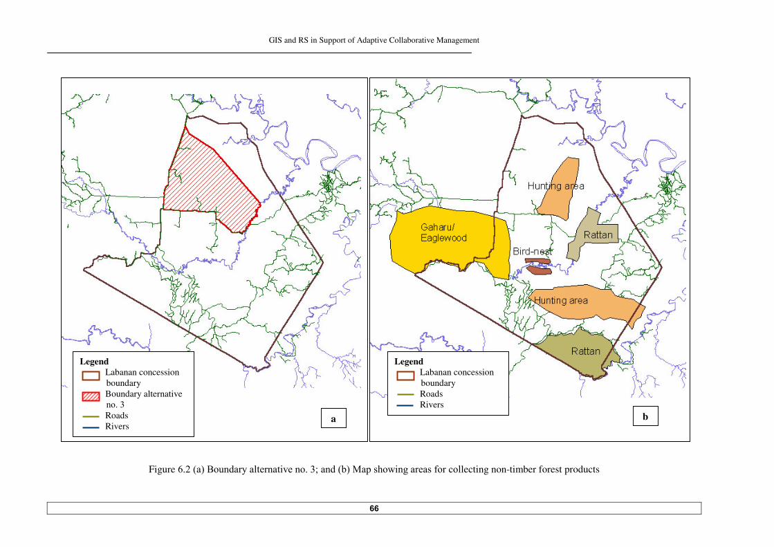
GIS and RS in Support of Adaptive Collaborative Management
��
Figure .�&�'�*��������������� ��������>�����&#'�:������� ���������(�����lecting non-timber forest products
Legend Labanan concession
boundary Boundary alternative
����� Roads Rivers
Legend Labanan concession
boundary Roads Rivers
a b
GIS and RS in Support of Adaptive Collaborative Management
��
�� Moving Towards Consensus
This chapter elaborates consensus-seeking process to settle the dispute. The process of coming to the consensus consists of two phases, they are: the preparation for the negotiation process, and the negotiation process itself. The preparation for the negotiation process encompasses boundary alternatives evaluation, which employs multi-criteria evaluation technique, analysing position towards other party by figuring out their objective and concerns, and finally set up the BATNA (Best Alternative To a Negotiated Agreement). Negotiation and the process to come to the agreement are discussed afterwards. This chapter is wrapped up with both parties’ commitment and responsibility sharing to settle the boundary dispute between them.
���� Preparing for the negotiation For the community, this phase can be seen as a further preparation prior to the negotiation process; while for the concessionaire, this phase is intended to develop their trust to the community to ascertain a meaningful collaboration between them ������ Boundary alternatives evaluation Boundary alternatives evaluation was carried out to give each party (the community of Siduung Baru and the concessionaire) understanding on how well each alternative can meet their objectives in this decision problem. A same set of boundary alternatives was used for this process for the community and for the concessionaire. While for the community the intention is clear that they have three boundary alternatives to evaluate, for the concessionaire the intention is different. For the concessionaire, this analysis is intended to give reasoning that the only appropriate boundary option for them is the one that they have. Multi-Criteria evaluation (MCE) technique with the support of Definite software was used to evaluate those boundary alternatives. MCE was carried out partly independent from both parties, particularly for the technical part of the MCE process using the Definite software. Only with the Labanan concessionaire, the steps of MCE process were discussed and explained. The boundary alternatives evaluation processes for the community of Siduung Baru and the Labanan concessionaire are elaborated respectively in the following sub-chapters. ������������ Boundary alternatives evaluation for the community of Siduung Baru - Evaluation criteria, criterion scores and effect table Criteria to evaluate the boundary alternatives were generated together between the community and researcher, and also when those criteria were grouped and then structured into a criteria tree/a value tree. However, the subsequent process of giving scores to each criterion and arranging them into an effect table was done by the researcher, because the community’s leader
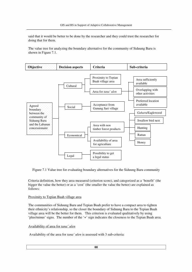
GIS and RS in Support of Adaptive Collaborative Management
��
said that it would be better to be done by the researcher and they could trust the researcher for doing that for them. The value tree for analyzing the boundary alternative for the community of Siduung Baru is ������ ��5 �����!�����
Figure !.� Value tree for evaluating boundary alternatives for the Siduung Baru community
Criteria definition, how they area measured (criterion score), and categorized as a ‘benefit’ (the bigger the value the better) or as a ‘cost’ (the smaller the value the better) are explained as follows: Proximity to Tepian Buah village area The communities of Siduung Baru and Tepian Buah prefer to have a compact area to tighten their ethnicity’s relationship, so the closer the boundary of Siduung Baru to the Tepian Buah village area will be the better for them. This criterion is evaluated qualitatively by using ‘plus/minus’ signs. The number of the ‘+’ sign indicates the closeness to the Tepian Buah area. Availability of area for tana’ ulen Availability of the area for tana’ ulen� ������������ �������#-criteria:
Objective Decision aspects Criteria Sub-criteria
Possibility to get a legal status
Rattan
Availability of area for agriculture
Hunting
Swallow bird nest
Gaharu/Eaglewood
Honey
Area with non timber forest products
Acceptance from Gunung Sari village
Preferred location available
Overlapping with other activities
Area sufficiently available
Area for tana’ ulen
Proximity to Tepian Buah village area
Agreed boundary between the community of Siduung Baru and the Labanan concessionaire
Legal
Economical
Cultural
Social
GIS and RS in Support of Adaptive Collaborative Management
�
- Area sufficiently available The area which would be used for tana’ ulen is supposedly large enough to support the commu� ��,����7� �����������������������������������������������"� ����#-criteria is measured qualitatively with binary scale which comprise the values ‘yes’ and ‘no’ to indicate the fulfilment and non-fulfilment of the demand. - Overlapping with other activities As a protected area, this area has to be free from other activities, especially from illegal logging activity. This sub-criterion is measured quantitatively with the size of overlapped areas, and considered as a ‘cost’. - Preferred location available Tana’ ulen is necessarily located in an appropriate forest area based on the community’s values, such as proximity to rivers, good forest area in term of forest cover and non-timber forest product. It is also desirably located not too far from the where the community live, accessible but naturally well protected to lessen the risks of being encroached by unwanted parties. This sub-criterion is also measured qualitatively by using ‘yes’ and ‘no’ to indicate the fulfilment and non-fulfilment of the demand. Acceptance from Gunung Sari village The whole area proposed for the Siduung Baru community administratively located in Gunung Sari village area. As an intermediate step in gaining the settlement area’s legal admittance from the government, approval from the Gunung Sari village is important. Logically, Gunung Sari village will only accept as small area as possible for the community of Siduung Baru because they do not like their area being taken by ‘the newcomer’. Actually this criteria can be measured quantitatively in hectare and being treated as a ‘cost’, but since the 1������$�� �� ��������#������������������������#��������������� �������� �������table to them, this criterion is measured qualitatively with binary scale: ‘yes/no’, to indicate whether it is ‘acceptable’ or ‘not acceptable’ to the Gunung Sari village. Area with non-timber forest products For their livelihood, the community prefers to have the parts of forest areas, which are rich in non-timber forest products. This criterion is subdivided into sub-criteria based on the main non-timber forest products available in the area: gaharu (eaglewood), swallow bird nest, hunting ground, rattan and honey. Each non-timber forest product is one sub-criterion, which is measured by the size of the forest area where they can be found/the activity can be done (hunting). All sub-criteria are considered as ‘benefit’. Availability of area for agriculture The whole Labanan area is allocated for production forest, so by law it is not available for other activities including for agriculture. But due to the regional government regulation, which says ��������������������������� ����������������(���(�����# �����������#�������#������������ ���&(���
agriculture), while the Labanan area passed by some public roads, some areas can be considered implicitly as ‘available’ for agriculture. This is a ‘benefit’ criterion, which is measured in hectare.
GIS and RS in Support of Adaptive Collaborative Management
�
Possibility to get a legal status The underlying aim to have an agreed boundary is to get a legal status for the settlement area of Siduung Baru in the Labanan area from the government. So somehow the boundary should be aligned with the vision and mission of the government (both local and central) toward this problem situation, by also considering the existing status of the area. This criterion is judged qualitatively by using plus/minus. The increasing number of ‘+’ sign indicate more possibility to get a legal status of the area. All criterion scores were added to the criteria set and����������� ��"�#��!������"� ����#�����������������((������#���(������ ������������������������ �������������#���� ������� ��� ��
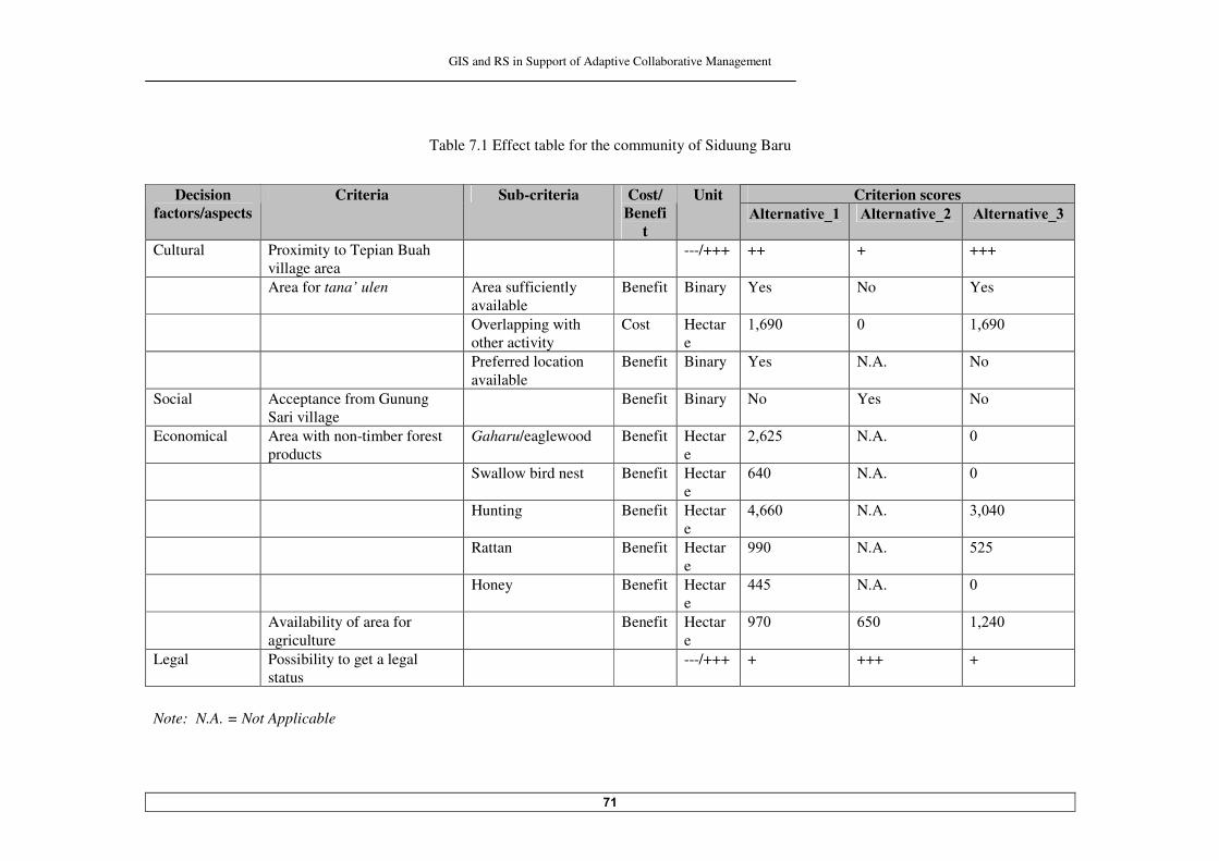
GIS and RS in Support of Adaptive Collaborative Management
��
Table !.� Effect table for the community of Siduung Baru
Criterion scores Decision
factors/aspects Criteria Sub-criteria Cost/
Benefit
Unit /���� �����5� /���� �����5� /���� �����5
Cultural Proximity to Tepian Buah village area
---/+++ ++ + +++
Area for tana’ ulen Area sufficiently available
Benefit Binary Yes No Yes
Overlapping with other activity
Cost Hectare
�� ��� �� �� ���
Preferred location available
Benefit Binary Yes N.A. No
Social Acceptance from Gunung Sari village
Benefit Binary No Yes No
Economical
Area with non-timber forest products
Gaharu/eaglewood Benefit Hectare
� �� N.A. ��
Swallow bird nest Benefit Hectare
��� N.A. ��
Hunting Benefit Hectare
�� �� N.A. ������
Rattan Benefit Hectare
���� N.A. ���
Honey Benefit Hectare
���� N.A. ��
Availability of area for agriculture
Benefit Hectare
�!�� ��� �����
Legal Possibility to get a legal status
---/+++ + +++ +
Note: N.A. = Not Applicable
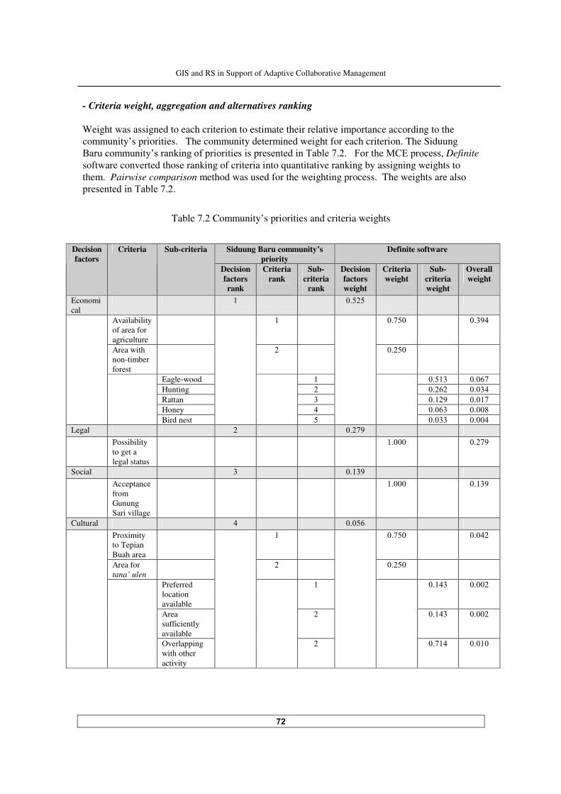
GIS and RS in Support of Adaptive Collaborative Management
��
- Criteria weight, aggregation and alternatives ranking Weight was assigned to each criterion to estimate their relative importance according to the community’s priorities. The community determined weight for each criterion. The Siduung *���������� ��,������ ����(��� �� � ��� ������������ ��"�#��!�����5�������:+)����������Definite software converted those ranking of criteria into quantitative ranking by assigning weights to them. Pairwise comparison method was used for the weighting process. The weights are also ���������� ��"�#��!��
Table !. Community’s priorities and criteria weights
Siduung Baru community’s
priority Definite software Decision
factors Criteria Sub-criteria
Decision factors rank
Criteria rank
Sub-criteria
rank
Decision factors weight
Criteria weight
Sub-criteria weight
Overall weight
Economical
� ����
Availability of area for agriculture
� ��!�� �����
Area with non-timber forest
����
Eagle-wood � ����� ��� ! Hunting �� ����� Rattan � ���� ����! Honey � ��� � �����
Bird nest
�
����� ����� Legal ��!� Possibility
to get a legal status
����� ��!�
Social � ����� Acceptance
from Gunung Sari village
����� �����
Cultural � ���� Proximity to Tepian Buah area
� ��!�� ����
Area for tana’ ulen
����
Preferred location available
� ����� ����
Area sufficiently available
����� ����
Overlapping with other activity
��!�� �����
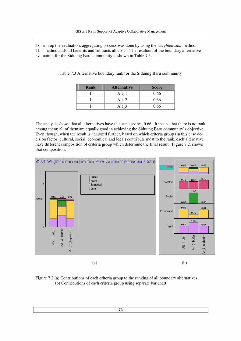
GIS and RS in Support of Adaptive Collaborative Management
��
To sum up the evaluation, aggregating process was done by using the weighted sum method. This method adds all benefits and subtracts all costs. The resultant of the boundary alternative ������ ���(�������$ ������*���������� ��� �������� ��"�#��!�����
Table !.� Alternative boundary rank for the Siduung Baru community
Rank Alternative Score � -�L� �� � -�L �� � -�L� ��
"�������� ���������������������� ���������������������������� ���2������������������� ����������
among them; all of them are equally good in achieving the Siduung Baru community’s objective. Even though, when the result is analyzed further, based on which criteria group (in this case de-cision factor: cultural, social, economical and legal) contribute most to the rank, each alternative have different composition of criteria group which determine the final result. Fig����!���������that composition.
(a) (b)
Figure !. (a) Contributions of each criteria group to the ranking of all boundary alternatives (b) Contributions of each criteria group using separate bar chart
GIS and RS in Support of Adaptive Collaborative Management
��
"��������� � ����(��� ��� ������������� #�� ������������� ��������������������������������������
�������(����5 ����� �&#'�� ������#��������������� ���� ��� �������,�������������� ((erent. Economical aspect contrib��������������(���������� ��������������������(������#����������
�����������������5���������� ��������������� ��� ��������,������� � ��� ��� ((��������6���������
aspect contributes the most. The contributions of economical and social aspects to alternative �������������������7������ ��������������������� #�������������� To the community, the above analysis can be understood as they were reminded that they put high priorities for economical and legal aspects in evaluating the boundary alternatives. A ����������7�������� #�� ����(������� ������������������������ ������������������� ���������#��
different reasons. For alterna� ���������#������� ������������(������(�������� ������-timber forest product, wh ��(���������� ���������#������� ������������(������(������ ���������$�� �������������� �� ( ����������� #������������������� ��������(������ �� ������������������� �������
other alternatives. This is the only alternative that is most likely acceptable to different stakeholders in Labanan area. - Sensitivity and uncertainty analyses Sensitivity and uncertainty analyses could be done to scrutinize the robustness of the ranking. But since there is no ranking in the MCE result for the community of Siduung Baru, these analyses are not necessary. ���������������������+�% ���&������ �����������%���� ���������'��� � ��� ������ ������� - Evaluation criteria, criterion scores and effect table The value tree for analysing the boundary alternative for the Labanan concessionaire is shown in 5 �����!��� Definition of each criterion is explained as follows: Social acceptability Social acceptability is describing communities’ acceptability in the area towards the concession holder’s decision to accommodate the community of Siduung Baru inside the Labanan forest area. Some of them might get jealous and some of them might not object. There will be some subsequent impacts from that decision inside and outside the Labanan area sooner or later, either negative or positive. During the decentralization era, community or public opinion towards a company can give surprising effect. This criterion is evaluated qualitatively by using ‘plus/minus’ signs. The number of the ‘+’ sign indicates the acceptability level. It will range from low acceptability to moderate acceptability. High acceptability is unlikely to happen in this circumstance.

GIS and RS in Support of Adaptive Collaborative Management
��
Figure !.� Value tree for evaluating boundary alternatives for the Labanan concessionaire
Environmental influence of the alternative to the forest at the local and regional levels Forest at the local level in this criterion defined as the forest in the Labanan area and its surroundings. The environmental influences of the alternative to the forest include: forest encroachment (forest opened for shifting cultivation and illegal logging) and other succeeding impacts from that activity such as erosion, sedimentation, and disturbances to wildlife. At the regional level, the influence is considered extended to the forest area in Berau District. The impact is related to the overall objective of the government to prevent the forest area in Labanan since it is a very important forest production area in the district (in fact also in the province and in the country); and also related to the district’s plan to develop the area for tourism.
Agreed boundary between the community of Siduung Baru and the Labanan concessionaire
Objective Decision aspects Criteria Sub-criteria
Political effect on choosing a particular boundary
To the local government
To the central government
To the research society
Possibility to get a legal status
Legal
Capacity to manage /to control
Total forest area which need to be re-allocated
Management
Social Social acceptability
Environmental Environmental influence to the forest at the local and regional levels
Economical
Effect on company’s revenue
Effect on productivity of non-timber forest product
Direct effect
Indirect effect
Political
GIS and RS in Support of Adaptive Collaborative Management
��
This criterion is measured qualitatively by using ‘plus/minus’ signs. It is ‘positive’ if the alternative could provide adequate support to the community’s livelihood, so the chance that they will situate additional pressures to the forest is less; while in the opposite condition it is valued as ‘negative’. The number of pluses or minuses indicates the level of the impacts. Effect on company’s revenue from the forest Effects of the boundary alternative to the company’s revenue can be direct and indirect. Direct effect from the changing of forest production area and logs that can be harvested by the company; and indirect effect from having additional obligation to support a new community in Labanan area and other costs incurred as a consequence of choosing a particular boundary alternative (such as cost for area demarcation, cost for re-arranging logging plan, etc.). Aside of that, the effects could also be positive and negative to the company’s revenue. This criterion is valued by plus and minus to indicate the positive and negative effects; the number of the plus and minus to indicate the ‘level’ of the effect (from weak to strong). Effect on productivity of non-timber forest product So far the company only uses non-timber forest products as a ‘media’ to cooperate with the communities who live in and around the Labanan area. For example the company will help to find a market for rattan, which is collected by the community. This pattern will not be changed. The effect of the boundary on non-timber forest product is seen from how the boundary can maintain the productivity of non-timber forest products in the forest area and gives an economical benefit to the community, which in turn could positively affect the relationship between the company and the communities. The effect is valued qualitatively by plus/minus. The number of the ‘+’ sign indicates the ‘positiveness’ of the boundary alternative for the productivity of non-timber forest product. Political effect on choosing a particular boundary Political effect can be viewed from the performance of the Labanan concessionaire in the eyes of the local government, central government and the research society. Local or district level government would be pleased if the ‘local and forest-dependent’ community can be accommodated in Labanan area with a minimal possible negative impacts to the forest since they - as the company’s future shareholder - concern about sustainable forest production in the area. Central government’s concern mainly related to the national and international communities’ opinion toward sustainable forest management practice in Labanan area - in relation with forest certification and special status of the Labanan area as a showcase and research site for sustainable forest management. They also concern about the total forest area within the national context, because a rate of deforestation is an important indicator of their performance. While the research society’s concern primarily due to the wholeness of the Labanan area as one of the last remaining tropical forest in Kalimantan. This criterion is valued qualitatively by using pluses and minuses. The number of plus and minus signs indicate the ‘strength’ of the effect.

GIS and RS in Support of Adaptive Collaborative Management
��
Possibility to get the legal status The explanation of this criterion is the same with the one for the community of Siduung Baru. The underlying aim to have an agreed boundary is to get a legal status for the settlement area of Siduung Baru in the Labanan area from the government. So somehow the choice of the boundary should be in line with the government’s vision and mission (both local and central) toward this problem, by also considering the existing status of the area. This criterion is judged qualitatively by using plus/minus. The increasing number of ‘+’ sign indicate more possibility to get a legal status of the area. Capacity to manage/to control the boundary As a consequence to accommodate the settlement area inside the concession area, some management plans and actions need to be adjusted so the forest can still be managed in a sustainable way. In relation to that, the concessionaire has to put efforts, among others, to ensure that the community would not give negative impacts to the forest. Normally, the bigger the area ‘given’ to the community, the bigger efforts necessarily being put to control it as complexity also increase. So the concessionaire really has to assess their capability in making a decision upon it. This criterion is measured quantitatively based on the size of area within the boundary. This is a ‘cost’ criterion for the concessionaire (because the bigger the area would be the worse for them), though in general it is not always like that because sometimes smaller area can be more complex to manage compare to a bigger one. Total forest area which need to be re-allocated The status of ‘production forest area’ has to be changed into ‘non-production forest area’ if the area is to be allocated for the settlement area. This criterion is measured quantitatively. This criterion is also a ‘cost’ for the concessionaire, because it means lessen the total area for forest production. - Criteria weight, aggregation and alternatives ranking "���.�#������������ ��� ��,������ ����(��� �� � ��� ������������ ��"�#��!����������������
quantitative ranking produced by Definite by using pairwise comparison for the weighting process.
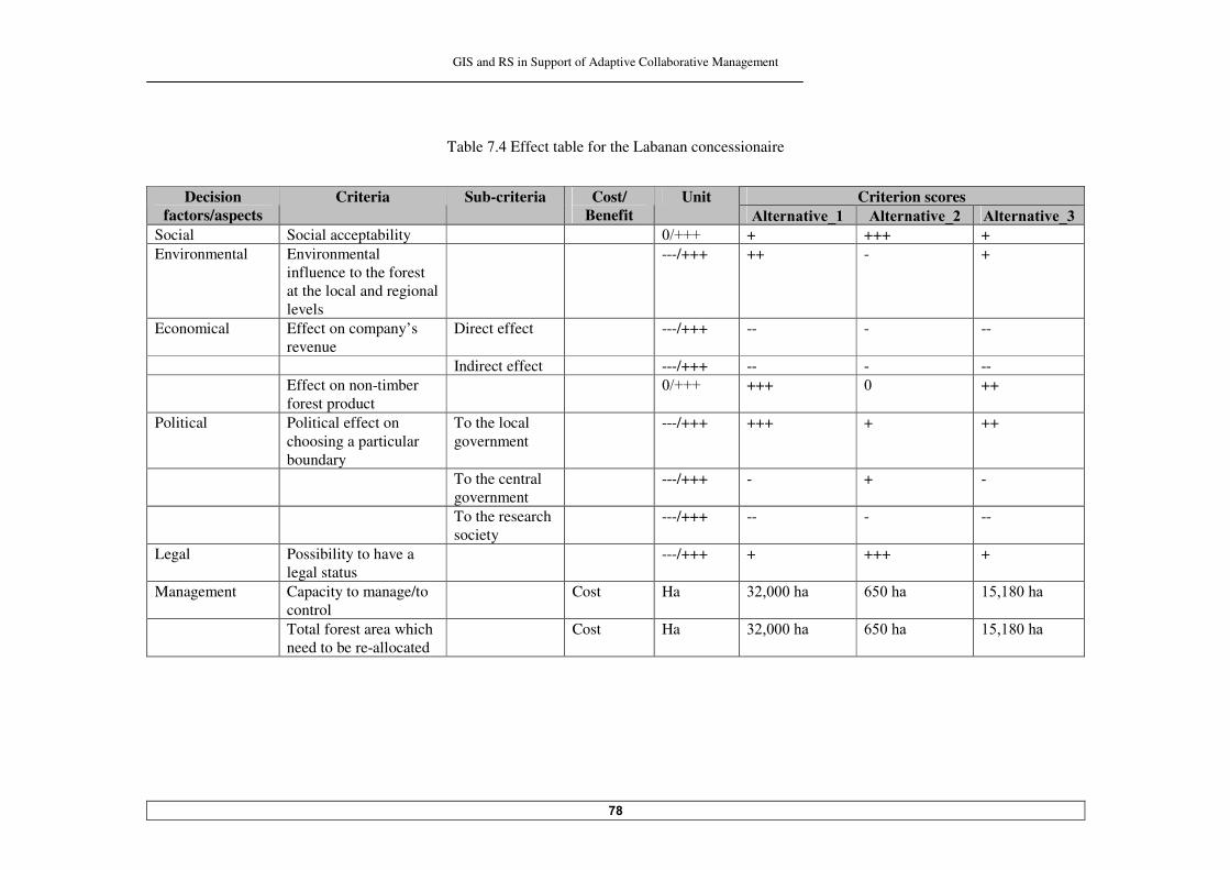
GIS and RS in Support of Adaptive Collaborative Management
��
Table !.� Effect table for the Labanan concessionaire
Criterion scores Decision
factors/aspects Criteria Sub-criteria Cost/
Benefit Unit
/���� �����5� /���� �����5� /���� �����5 Social Social acceptability �%MMM + +++ + Environmental Environmental
influence to the forest at the local and regional levels
---/+++ ++ - +
Economical Effect on company’s revenue
Direct effect ---/+++ -- - --
Indirect effect ---/+++ -- - -- Effect on non-timber
forest product �%MMM +++ � ++
Political Political effect on choosing a particular boundary
To the local government
---/+++ +++ + ++
To the central government
---/+++ - + -
To the research society
---/+++ -- - --
Legal Possibility to have a legal status
---/+++ + +++ +
Management Capacity to manage/to control
Cost Ha �������� ����� ���������
Total forest area which need to be re-allocated
Cost Ha �������� ����� ���������
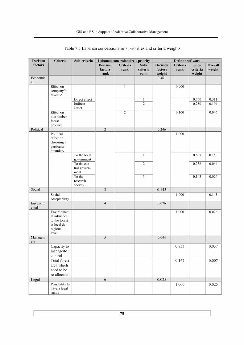
GIS and RS in Support of Adaptive Collaborative Management
�
Table !.� Labanan concessionaire’s priorities and criteria weights
Labanan concessionaire’s priority Definite software Decision
factors Criteria Sub-criteria
Decision factors rank
Criteria rank
Sub-criteria
rank
Decision factors weight
Criteria rank
Sub-criteria weight
Overall weight
Economical
� ��� �
Effect on company’s revenue
� �����
Direct effect � ��!�� ����� Indirect effect
���� �����
Effect on non-timber forest product
����� ����
Political ��� Political effect on choosing a particular boundary
�����
To the local government
� �� �! �����
To the cen-tral govern-ment
���� ��� �
To the research society
�
����� ���
Social � ����� Social
acceptability ����� �����
Environmental
� ���!
Environmental influence to the forest at local & regional level
����� ���!
Management
� �����
Capacity to manage/to control
����� ����!
Total forest area which need to be re-allocated
��� ! ����!
Legal ���� Possibility to
have a legal status
����� ����
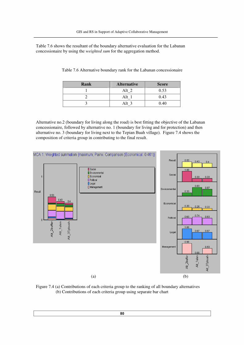
GIS and RS in Support of Adaptive Collaborative Management
�
"�#��!� ���������������������(�����#��������������� ��������� ���(�������.�#�����
concessionaire by using the weighted sum for the aggregation method.
Table !. Alternative boundary rank for the Labanan concessionaire
Rank Alternative Score � -�L ���� -�L� ���� � -�L� ����
-������ �������&#��������(���iving along the road) is best fitting the objective of the Labanan ������� ��� ����(������#��������� ���������&#��������(��� � �������(���������� ��'����������
������� ���������&#��������(��� � �����=���������"e� ���*����� ���'���5 �����!�����������e composition of criteria group in contributing to the final result.
(a) (b)
Figure !.� (a) Contributions of each criteria group to the ranking of all boundary alternatives
(b) Contributions of each criteria group using separate bar chart
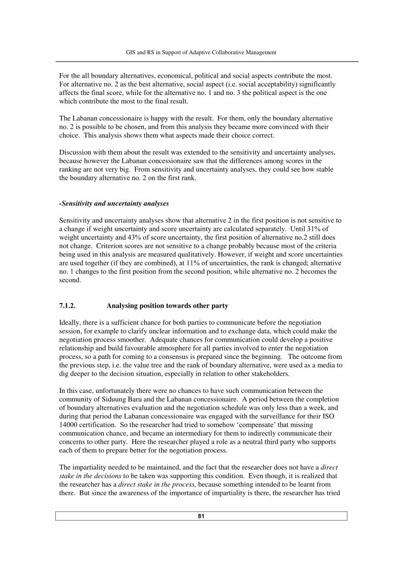
GIS and RS in Support of Adaptive Collaborative Management
��
For the all boundary alternatives, economical, political and social aspects contribute the most. 5���������� ���������������#����������� ������� ���������& ������� ���������# ��'�� �� ( ������
�((���������( ������������ ��(�������������� ������������������������� � ���������� ����������
which contribute the most to the final result. The Labanan concessionaire is happy with the result. For them, only the boundary alternative ����� ������ #�����#��������������(������ ������� �������#��������������� ������ ������ ��
choice. This analysis shows them what aspects made their choice correct. Discussion with them about the result was extended to the sensitivity and uncertainty analyses, because however the Labanan concessionaire saw that the differences among scores in the ranking are not very big. From sensitivity and uncertainty analyses, they could see how stable ����#��������������� ���������������( ��������� -Sensitivity and uncertainty analyses Sensitivity and uncertainty analyses show that alter��� ���� ������( ������� � ��� ���������� � ������a change if weight un����� ��������������������� �����������������������������G�� ���F��(�
�� ����������� ����������F��(�������������� ���������( ������� � ����(�������� ��������� ������
not change. Criterion scores are not sensitive to a change probably because most of the criteria being used in this analysis are measured qualitatively. However, if weight and score uncertainties ������������������& (�������������# ���'�������F��(�������� �� ������������� ���������>�������� ���
���������������������( ������� � ���(������������������ � ������ ��������� ��������#�����������
second. ������ Analysing position towards other party Ideally, there is a sufficient chance for both parties to communicate before the negotiation session, for example to clarify unclear information and to exchange data, which could make the negotiation process smoother. Adequate chances for communication could develop a positive relationship and build favourable atmosphere for all parties involved to enter the negotiation process, so a path for coming to a consensus is prepared since the beginning. The outcome from the previous step, i.e. the value tree and the rank of boundary alternative, were used as a media to dig deeper to the decision situation, especially in relation to other stakeholders. In this case, unfortunately there were no chances to have such communication between the community of Siduung Baru and the Labanan concessionaire. A period between the completion of boundary alternatives evaluation and the negotiation schedule was only less than a week, and during that period the Labanan concessionaire was engaged with the surveillance for their ISO ���������� ( ��� �����$����������������������� ��������������0����������,������� �� ���
communication chance, and became an intermediary for them to indirectly communicate their concerns to other party. Here the researcher played a role as a neutral third party who supports each of them to prepare better for the negotiation process. The impartiality needed to be maintained, and the fact that the researcher does not have a direct stake in the decisions to be taken was supporting this condition. Even though, it is realized that the researcher has a direct stake in the process, because something intended to be learnt from there. But since the awareness of the importance of impartiality is there, the researcher has tried

GIS and RS in Support of Adaptive Collaborative Management
��
to be as neutral as possible throughout the process. Aside of that, as a consequence of being a �� ���������#������������� ������� �������������������������������������( ���� � �� for each stakeholder has to be protected. So, only results that are accepted to them and information that allowed to be shared were made public, in the sense that only those things could be shared and discussed. For the community of Siduung Baru, more sessions were conducted compared to the Labanan concessionaire. It was intentionally arranged like that to provide sufficient supports and resources for them, to reduce as much as possible lack-of-balance negotiation process later. The value tree analysis was used to probe to the problem situation by bringing the other party to ‘the picture’. By showing their own value tree and other party’s value tree, the areas of agreement and disagreement between the parties involved can be pinpointed (von Winterfeldt, ���!'���-�������������� �������������������������������������(����������� ����(�$ ������
*������������.�#������������ ��� ���������=��������(������� ���������������5 ����� ����������
the value tree analysis for the Siduung Baru community and the Labanan concessionaire. The figure shows some areas of disagreement between the two of them, which are marked by cycles. The remaining values/concerns without mark are perceived as somehow agree with other match up value/concern on the other value tree. ���������������������/���������#���"� ��� ���"�����%��6�� ��� � - Social aspect Social acceptability concern of the Labanan concessionaire can be seen as a wider view of the acceptance from Gunung Sari village’s concern towards the Siduung Baru community. So both concerns can be understood as aligned: the boundary should be acceptable to outside parties (wider audience). - Economical aspect Concern towards areas with non-timber forest products and their productivity are also common for both stakeholders. Although the community sees it from the perspective of ‘direct user’ and the concession holder sees it from the perspective of ‘indirect user’, for both of them those areas are important to be preserved. - Legal aspect The concerns of both parties in this aspect are the same. They consider the possibility of the chosen boundary to get admittance and a legal status from the government. - Environmental aspect At the local and regional levels, the environmental considerations of the concessionaire for choosing a particular boundary is aligned with the interest of the community that they prefer to have a boundary which can guarantee their livelihood, so it will not necessary for them to find other sources of income which at a certain point could be harmful to the forest and to the environment (such as continue practicing shifting cultivation or forced to engage in illegal logging activity).
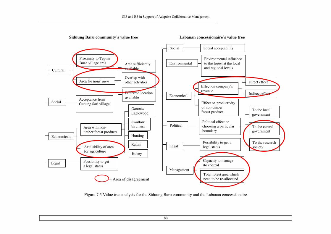
GIS and RS in Support of Adaptive Collaborative Management
��
Siduung Baru community’s value tree Labanan concessionaire’s value tree
= Area of disagreement
Figure !.� Value tree analysis for the Siduung Baru community and the Labanan concessionaire
Cultural
Proximity to Tepian Buah village area
Acceptance from Gunung Sari village Social
Possibility to get a legal status
Capacity to manage /to control
Total forest area which need to be re-allocated
Preferred location available
Overlap with other activities
Area sufficiently available
Area for tana’ ulen
Economicala
Possibility to get a legal status
Legal
Area with non- timber forest products
Availability of area for agriculture
Rattan
Hunting
Swallow bird nest
Gaharu/ Eaglewood
Honey
Management
Legal
Social Social acceptability
Environmental Environmental influence to the forest at the local and regional levels
Economical
Effect on productivity of non-timber forest product
Effect on company’s revenue
Direct effect
Indirect effect
Political effect on choosing a particular boundary
To the local government
To the central government
To the research society
Political
GIS and RS in Support of Adaptive Collaborative Management
��
- Political aspect In the eyes of the local government, as long as the Labanan concession holder could accommodate the community with the minimum negative effect to the forest, they will be satisfied. This is become common with the community’s concerns, because it means a guarantee to live inside the Labanan area and have rights to the forest to support their livelihood. ���������������������/������������#���"� ��� ���"�����%��6�� ��� � - Cultural aspect for the community The values and concerns of the community of Siduung Baru to live close to their relatives and have suitable tana’ ulen are not considered by the Labanan concessionaire. - Economical aspect for the community For the community, availability of the area for agriculture is important, bear in mind that they think about practicing the same agricultural techniques (extensive pattern). So they tend to have as vast area as possible to guarantee that. While for the Labanan concessionaire, the agricultural area in their concession has to be limited as minimum as possible, if there is a situation that force them to have an agricultural area inside the concession, they already think about more permanent agricultural practice with more intensive pattern. - Economical aspect for the concessionaire The community does not consider effects of the chosen boundary to the company’s revenue, both direct and indirect. They think in a simple way that the company is rich and strong, incomparable to them, so whatever the decision made regarding the boundary for their settlement area, would not affect significantly to the company’s financial condition. - Political aspect for the concessionaire Being an important forest concession area, the concern of the Labanan concessionaire related to the opinion of ‘the wider audience’ such as the central government and the research society are also important. But for the community, things like these are too far to be considered, something beyond their concerns. - Management aspect The management aspect is also something that goes beyond the community’s concern. ����� The community’s position, BATNA and compromise options The disagreement areas from value tree analysis gave some additional facts to each stakeholder, which opened and broadens their thinking. It was interesting to witness how the Siduung Baru community gradually can see the reasons why it is not very easy for the Labanan concessionaire to settle this problem. They said, now more or less they understand the reasons behind that, which they never thought about before. Then the discussion was extended to the topic on what the Labanan concessionaire could do or would possibly do with the capacity they have. It was identified that:
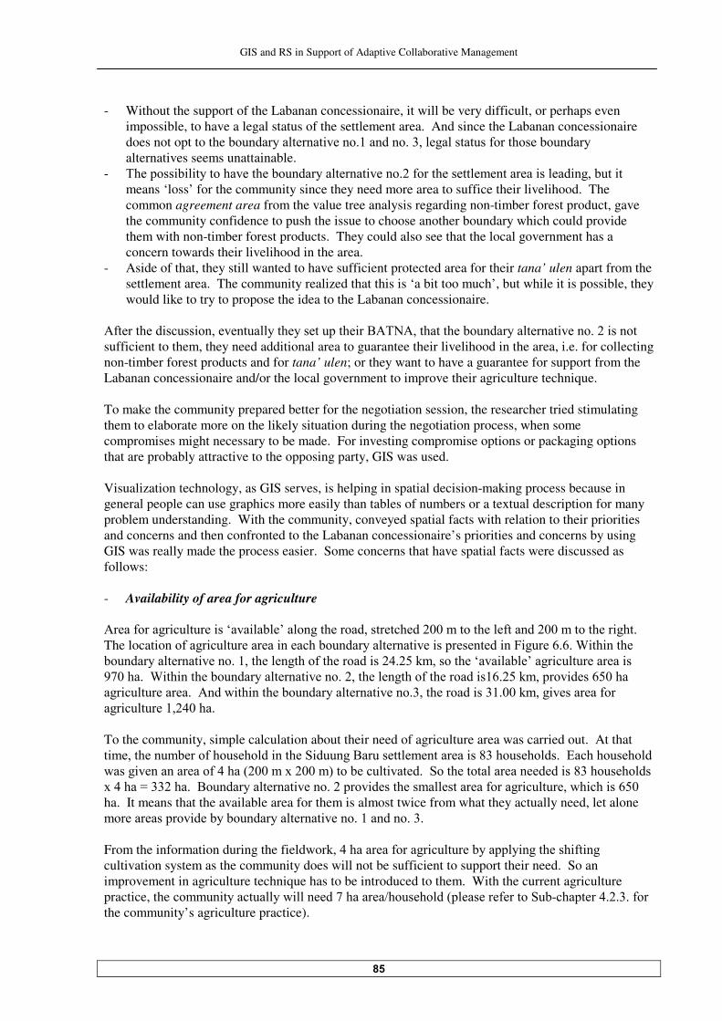
GIS and RS in Support of Adaptive Collaborative Management
��
- Without the support of the Labanan concessionaire, it will be very difficult, or perhaps even impossible, to have a legal status of the settlement area. And since the Labanan concessionaire does not opt to the #��������������� ������������������������������(���������#��������alternatives seems unattainable.
- "������� # ���������������#��������������� �������(���������������������� ����� ����#��� ��
means ‘loss’ for the community since they need more area to suffice their livelihood. The common agreement area from the value tree analysis regarding non-timber forest product, gave the community confidence to push the issue to choose another boundary which could provide them with non-timber forest products. They could also see that the local government has a concern towards their livelihood in the area.
- Aside of that, they still wanted to have sufficient protected area for their tana’ ulen apart from the settlement area. The community realized that this is ‘a bit too much’, but while it is possible, they would like to try to propose the idea to the Labanan concessionaire.
-(��������� ����� ���������������������������� ��*-"9-�����������#��������������� �������� ������
sufficient to them, they need additional area to guarantee their livelihood in the area, i.e. for collecting non-timber forest products and for tana’ ulen; or they want to have a guarantee for support from the Labanan concessionaire and/or the local government to improve their agriculture technique. To make the community prepared better for the negotiation session, the researcher tried stimulating them to elaborate more on the likely situation during the negotiation process, when some compromises might necessary to be made. For investing compromise options or packaging options that are probably attractive to the opposing party, GIS was used. Visualization technology, as GIS serves, is helping in spatial decision-making process because in general people can use graphics more easily than tables of numbers or a textual description for many problem understanding. With the community, conveyed spatial facts with relation to their priorities and concerns and then confronted to the Labanan concessionaire’s priorities and concerns by using GIS was really made the process easier. Some concerns that have spatial facts were discussed as follows: - Availability of area for agriculture -����(������ ������� ��0��� �#�,���������������������������������������(������������������� �������
The location �(���� ������������ �������#��������������� ��� ������������ ��5 ����� � ��A �� ������
#��������������� ���������������������(���������� �����������������0��� �#�,���� ������������ ��
�!�������A �� ������#��������������� ��������������������(���������� �� ����������� ���� ������
��� ��������������-���� �� ������#��������������� ������������������ ������������� ���������(���
��� ��������������� To the community, simple calculation about their need of agriculture area was carried out. At that t �����������#����(���������� ������$ ������*������������������� �����������������)�������������
����� �������������(������&�����=�����'����#����� ��������$����������������������� ���������������
=������H���������*��������������� ������������ ��������������������(������ ���������� ��� �� ���
ha. It means that the available area for them is almost twice from what they actually need, let alone ��������������� ���#��#��������������� ��������������������� From the information during the fieldwork,�����������(������ �������#������ ��������� (� ���cultivation system as the community does will not be sufficient to support their need. So an improvement in agriculture technique has to be introduced to them. With the current agriculture practice, the������� ����������� ������!��������%���������&��������(������$�#-��������������(���the community’s agriculture practice).
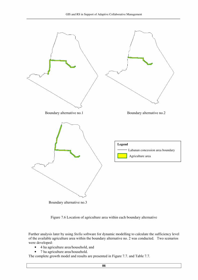
GIS and RS in Support of Adaptive Collaborative Management
��
������������������*��������������� ������� ���*��������������� ������
B��������������� �������
Figure !. Location of agriculture area within each boundary alternative
Further analysis later by using Stella software for dynamic modelling to calculate the sufficiency level o(�������� �#����� ������������� �� ������#��������������� �������������������������"��������� ���were developed:
• �������� �����������%������������� • !������� �����������%���������
"������������������������������������������������ ��5 �����!�!������"�#��!�!���
Legend
Labanan concession area boundary
Agriculture area

GIS and RS in Support of Adaptive Collaborative Management
��
Assumption: •��+��)���� ��3���4�5%����-dead & migration) •��6������!����7�3���������8�������!�
•��(��� �����,� #����!����� �� ���7�3��� 8�������!� ���(��� �����,� #����!����� �� ���7�3���� 8�������!�
Figure !.! Growth model for population and agriculture area needed in Siduung Baru area
Table !.! Population growth in Siduung Baru area and corresponds agriculture area needed (����� ((������������ ��
Agriculture area
���6��%������ ����6��%������ No. Year Population
(people) Area needed (ha) Area needed (ha)
� �� ������ ����� � ���� � ��� ������ ����� � ��� ��� ������ ��!�� !!� � � ��� ����� ���� !���� � �� ���� � � ���� ������ � ��! ���� ����� ������ ��� !��� � ��� ����! ! ��� !!���� ���� ������� � ��� ��!��� ����� ������� � ��� ������ !����� ������� �� �� ����!��� ������ �������
Note: The threshol���������� � � �! %!�� #����!����� ��

GIS and RS in Support of Adaptive Collaborative Management
��
+����� ���(�������������������������������� �����F������� ����������&���� ����(�# ���-dead and � ���� ��������'� ��$ ������*������������������������ ��������� �#�������� �#����(( � ����(�������
period of !���������&� ������ ���(����'� (������������������� �������������n������������ ���������������*��� (����������!���������(������������������ �����������������������&� ������ ���(����'������
whole area will already under farming, so at that time possibly they will need to open more forest to suffice their need. When the calculation of agriculture area was disclosed to the community, they said that actually they ����� (����������� �� ������#������������� �����������(( � �������������#������������want to secure more land for their descendants. The discussion about this topic was closed with an understanding ����������������#��������������� ��������������(( ������ �������(������ ������������ .������(����( ��������(�������� ��� ������(���, it was revealed that the community already ����������������������������������� �� ������#��������������� ����������#���(��������( �����������
��������������������������� ���������������������������(�������������������� �����(����������
(because the���������������������� � ����������=������'���2�����������������������(�������&�����
��� �#��������(� ������� � ����#��'�������������������#���������"���� ����� �� ��� ��������some of them do open the area more than they suppose to open as suspected by the Labanan concessionaire. - Area with non-timber forest products The location of different kind of non-timber forest products within each boundary alternative is ������ ��5 �����!��� "��������� �� ��#��������������� ��������� �����������������it is not very surprisingly that this one is also the richest in term of non-timber forest products. All kind of non-timber forest products that can be found in this region is obtainable within this boundary, they are: gaharu/eaglewood, rattan, swallows bird nest, honey and area for hunting. *��������������� ���������������������������������������=��������������(������ ����������������
road; so this one does not provide the community with non-timber forest products. Boundary ������� ��������� �����ering areas, which are good for hunting and rich in rattan. The community aware of those facts. In the area, related to the non-timber forest products, they know where to find what. For collecting gaharu/eaglewood and swallow bird nest, they have to consider territory/right of other villages, which is defined based on agreement among them. Since they are newcomers in the area, in their case, they do not really have priority to collect those products. For gaharu/eaglewood, the rule is not very strict; but for swallow bird nest, to get into the caves where the nests could be found they have to get permission first from ‘the caves owner’, which is not very easy. Area for collecting honey is considerably far from the settlement area. So eventually, for the community of Siduung Baru, areas for hunting and collecting rattan become very important. Then it was agreed that if it is needed to compromise during the negotiation session, as long as they could have areas for hunting and collecting rattan, they could agree. - Proximity to Tepian Buah village After some thorough analyses and through broader outlook in seeing correlation among one concern and the others, in the end the community decided that living next to their relatives in Tepian Buah is not really an important issue anymore to be pushed in the negotiation process. They put this aspect on the lower priority.
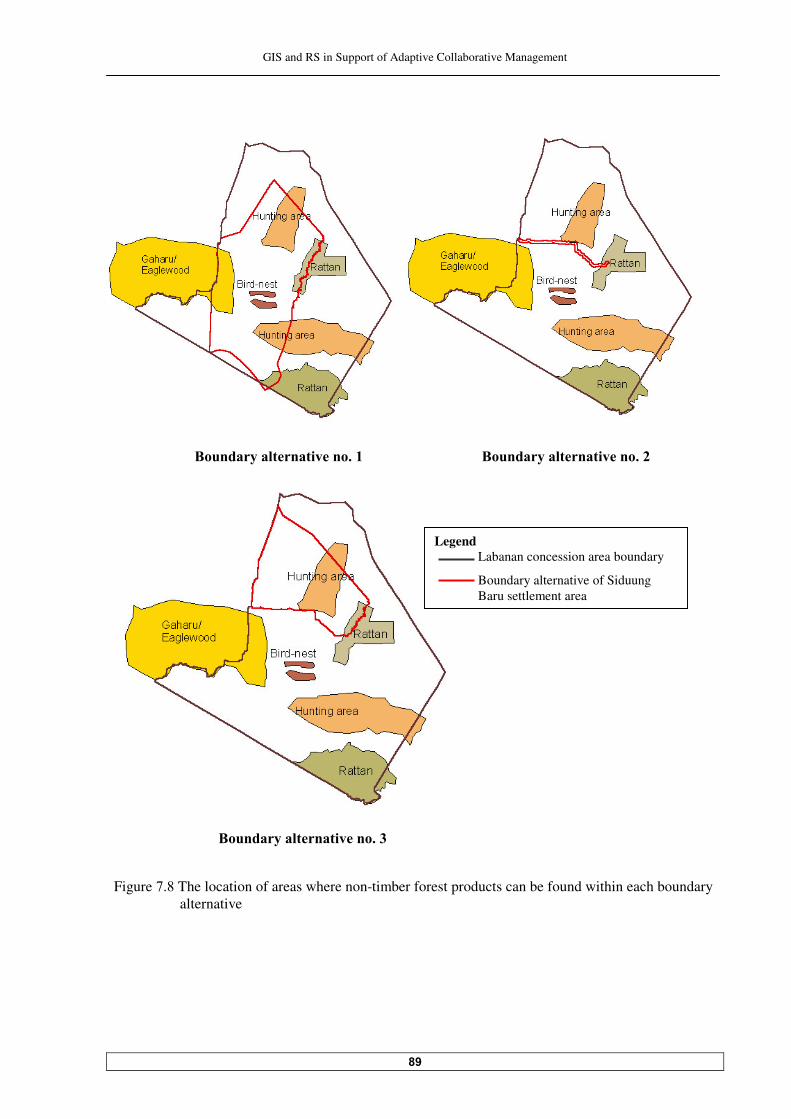
GIS and RS in Support of Adaptive Collaborative Management
�
Figure !.� The location of areas where non-timber forest products can be found within each boundary alternative
+�% ���&������ ������ ����
Legend Labanan concession area boundary
Boundary alternative of Siduung Baru settlement area
+�% ���&������ ������ ����
+�% ���&������ ������ ���
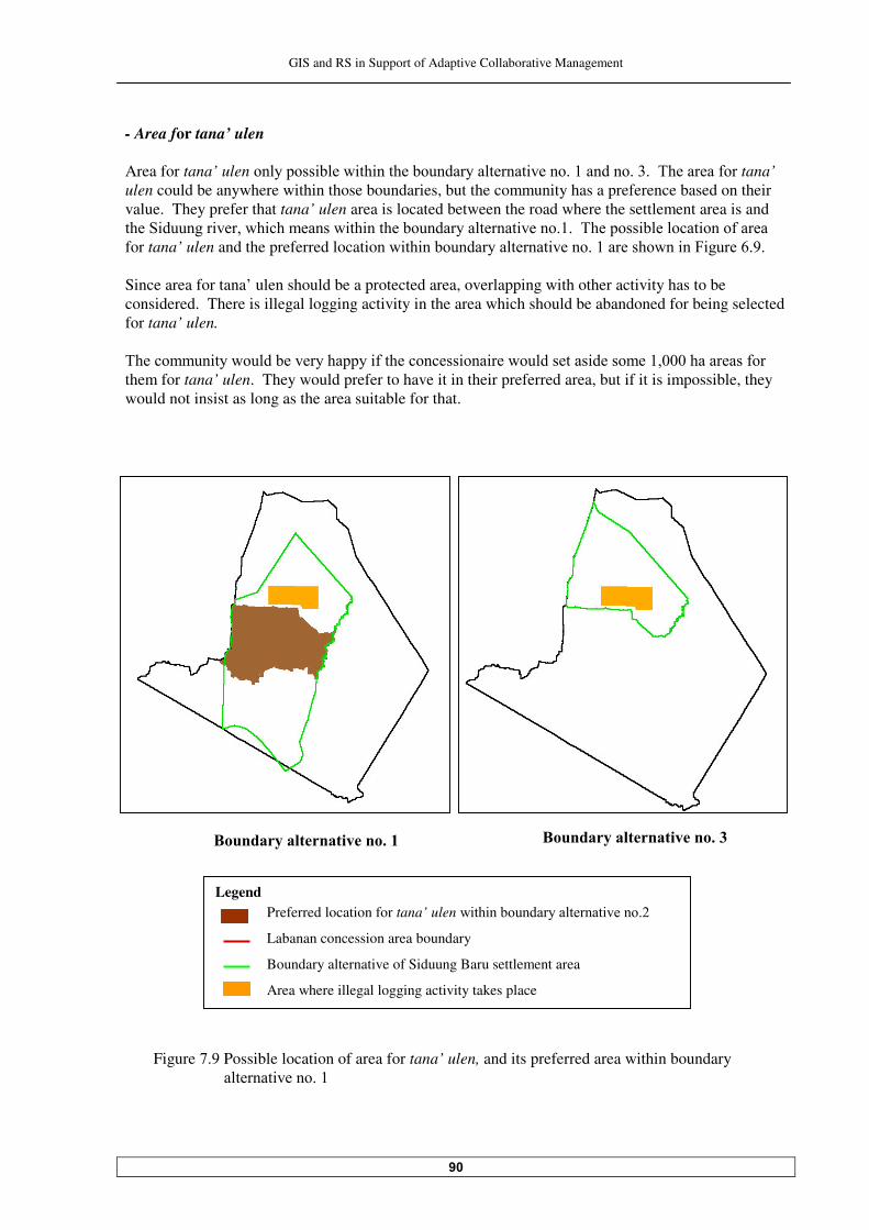
GIS and RS in Support of Adaptive Collaborative Management
- Area for tana’ ulen Area for tana’ ulen��������� #��� �� ������#��������������� ���������������������"��������(���tana’ ulen could be anywhere within those boundaries, but the community has a preference based on their value. They prefer that tana’ ulen area is located between the road where the settlement area is and ����$ ������� ������� ���������� �� ������#��������������� ����������"������� #������ ����(������
for tana’ ulen and the preferred locatio��� �� ��#��������������� ������������������� ��5 ����� ��� Since area for tana’ ulen should be a protected area, overlapping with other activity has to be considered. There is illegal logging activity in the area which should be abandoned for being selected for tana’ ulen. "��������� ��������#������������� (������������ ��� �������������� �����������������������(���
them for tana’ ulen. They would prefer to have it in their preferred area, but if it is impossible, they would not insist as long as the area suitable for that.
Figure !.� Possible location of area for tana’ ulen, and its preferred area within boundary
������� ��������
+�% ���&������ ������ ���� +�% ���&������ ������ ���
Legend Preferred location for tana’ ulen�� �� ��#��������������� ������
Labanan concession area boundary
Boundary alternative of Siduung Baru settlement area
Area where illegal logging activity takes place
GIS and RS in Support of Adaptive Collaborative Management
�
���� � The concessionaire’s position and BATNA For the Labanan concessionaire, the story was similar. By carrying out value tree analysis, they were able to understand the community’s concerns better, especially the ones related to the cultural aspect. Additional to their case, surprisingly the concessionaire also stated that the analysis has improved their understanding and clarity of some values and concerns not only related to the community, but also for their own company. The Labanan concessionaire knows that their position is strong in the coming negotiation process. 5���������#��������������� �������� ������������� ������� �� ����� ��*-"9-���������*��������
������� ������� ��������������� #��������� ������#��� �������������������*��� ��������������� �������
boundary is proposed by the community, for processing the legal status, it has to go through the Labanan concessionaire. One of the main reasons for entering a negotiation is to achieve better results than would be possible without negotiating. The stronger the BATNA, the greater the ability to walk away from an unsatisfactory negotiation. But the Labanan concessionaire realizes that time may well be appropriate for a more collaborative approach to negotiate, to solve the problem that has been long neglected. Their other reason to participate in a negotiation is to promote social stability in the concession area, which can be achieved through avoidance of undesirable consequences of abandoning the dispute and by promoting a sense of fairness for the community. The willingness to participate in the negotiation came into view after the concession holder had a discussion with the researcher. They are aware that they need to settle the dispute due to the necessity to fulfil the forest certification requirement and ever-increasing rate of forest opening by the community. However, they are indecisive since they are still in a transition phase to become a join company with the local government. But eventually they saw that the result of the negotiation could give them experience and direction to deal with the community in a more collaborative way. Where conflicts are resolved using collaborative technique by involving the interested parties in the search for solutions, the outcome is usually more satisfactory to the parties and therefore the prospects for successful implementation of the decisions/solutions produced by the interested parties ��������������������������������#�� ������� ���&5-@������'� For the negotiation process, the Labanan concessionaire was not carrying out further spatial analysis for the decision problem since they know that they have good understanding related to the spatial facts of their concession area. Besides, the areas of disagreements that were identified from the value tree analysis are non-spatial-related concerns. At the end of the day, both the Siduung Baru community and the Labanan concessionaire expressed appreciation of the process in which their values were brought out and they felt that they had learned something. ���� Negotiation process For the negotiation process, it was agreed that in the decision-making process, consensus is the preferred method to be used. Actually this was a suggestion of the researcher because seeking consensus will urge participants to find an agreement that incorporates all points of view. -����� ������6����� �&��'���������������������� ((��������������(����=����D • Unanimity, i.e. total agreement; and

GIS and RS in Support of Adaptive Collaborative Management
�
• A willingness to step aside and live with the ‘whole package’, not blocking an agreement because of disagreement with one or another point. This is the willingness to compromise and support the compromise and agree with it as the group consensus.
Learning from the situation, it seems that for this boundary dispute, the second shape of consensus is more attainable. In the negotiation process, the researcher had a role as a facilitator and from time to time when it was necessary, became a mediator. Both disputants agreed on these roles. A facilitator lets participants to design and drive the forum, and is not expected to volunteer his/her own ideas or participate actively in moving the parties towards agreement. But a facilitator has to ensure that everyone is able to speak and be heard. A mediator on the other hand, can intervene to ensure the objective of the negotiation could be achieved, and to promote reconciliation, settlement, compromise or understanding in the negotiation process. In general, the negotiation process comprised of three main stages: the initial stage where both parties clarified their interests till they establish a common understanding of the issue; the discussion/negotiation stage where the ‘real’ negotiation took place; and the agreement phase where the consensus reached. ������ Clarify each other’s interests and establish a common understanding of the issue This negotiation process is the first chance for the Labanan concessionaire and the community of Siduung Baru to sit together and discussed the boundary issue. The avoidance behaviour of the Labanan concessionaire towards the community of Siduung Baru before made it difficult for the community to propose a meeting with the Labanan concessionaire to talk about the issue. The representatives from the Siduung Baru community were the community’s leader and two other key persons: the leader’s advisor and the representative of Siduung Baru young generation. While from the Labanan concessionaire, the meeting was attended by the head of planning section and the head of community development section. It was planned that the administrator of Labanan area and the head of Berau region planning division would attend the meeting, but they could not make it. The researcher had an impression that actually the concessionaire still somehow hesitate to have a negotiation with the community of Siduung Baru. The negotiation process was held in Labanan base camp, because sufficient electricity for this meeting is only available there. Clarifying each other’s interest was carried out by showing each other value tree. Here values/objectives/interests of each party were communicated to others. Then by showing boundary alternatives, the preferred boundary and explaining why it is preferred, the discussion proceeded to the spatial aspects. Displaying the spatial aspects of boundary alternatives by using GIS was very helpful at this stage. It was used to explain the array of alternatives involved, made it quicker to understand. It assists to build an open atmosphere in the meeting, and because of that, promote more respectful listening and possibly learning to understand each other better. It was remarkable to see how the three representatives of the Siduung Baru community took turn to talk; especially the community leader who was very convincing in talking about their preferred boundary with the help of GIS as a visualization aid. He seems wanted to give an impression that he is already familiar with the technology. An in fact he is. In the researcher’s opinion, the community’s confidence comes from the fact that they use their own data. Data that they can rely on, because those data come from
GIS and RS in Support of Adaptive Collaborative Management
�
sources which they can trust, and they were involved in the process of generating maps from those data. During this stage, the researcher had a function as a facilitator while helping operate GIS to display different spatial representation. This opening stage was summed up with a common understanding between both parties, that they would like to come up with an agreed boundary between the Siduung Baru area and the Labanan concession area, which will be processed further to have admittance from the government and then a legal status. ������ Negotiating Entering the ‘real’ negotiation, each party tried to convince other party about their preferred boundary. In this stage, despite of previous lengthy efforts to reduce it, the power imbalance between both parties is still apparent. Due to the changing situation, the researcher turned the role to a mediator. GIS was used in more elaborate way through out this stage, while satellite image was also used from time to time to clarify things or to provide additional information. The Labanan concessionaire showed their power through their information mastery concerning the Labanan forest concession area. They used GIS to show the decision consequences, and they tried to drive the community to accept their preferred boundary, i.e. boundary al������ �������� But something could be observed, that during the whole process, the Labanan concessionaire acknowledged and respected interests and concerns of the community, which was not very common before. In the past, the relationship between the concession holder and the community always: the superior versus the inferior. This could be because the concessionaire wanted to give good impression to the researcher or more logically because of some stages undertaken prior to the negotiation process which somehow affected the relationship between both parties (to a more positive direction), and equally important was the atmosphere during the negotiation process. It was observed, with GIS and RS as aids, the negotiation playing field was ‘forced’ to become transparent because while the Siduung Baru community and the Labanan concessionaire talked about the same area of concern, both parties have the data for it, which made it difficult to hide or to say something untrue. Each of them could always compare and notice if there are differences or inappropriateness. In other word, during the negotiation process, GIS had not only facilitating them to speak in the same language but also to speak honesty. Regarding the community’s concerns, the Labanan concessionaire gave additional explanations as follows: - Availability of area for agriculture Available agriculture area for the community of Siduung Baru is only possible along the road where ����������������� ���(�������� ���#� ������ ���������� �� ������#��������������� ����������"���
extension to another road in the west, branching to two opposite directions (to the north and to the south) is not possible because it would surely fuel a ‘social jealousness’ from the communities who live in the up north villages like Gunung Sari and also possibly Tepian Buah, which could lead to social unrest in the area. This is dangerous and has to be avoided. There is also a Transmigration
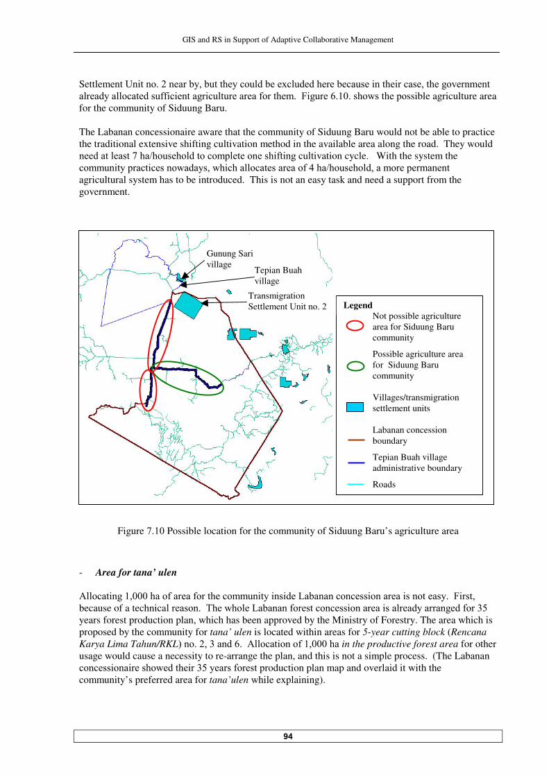
GIS and RS in Support of Adaptive Collaborative Management
�
Settle�����G� ������������#���#�������������#���=�����������#������� ����� �����������������������
�����������������(( � ������� ������������(����������5 ����� �����������������ssible agriculture area for the community of Siduung Baru. The Labanan concessionaire aware that the community of Siduung Baru would not be able to practice the traditional extensive shifting cultivation method in the available area along the road. They would �������������!���%�������������������������� (� ������ivation cycle. With the system the ������ �������� ���������������� �����������������(�����%���������������������������
agricultural system has to be introduced. This is not an easy task and need a support from the government.
Figure !.�� Possible location for the community of Siduung Baru’s agriculture area
- Area for tana’ ulen -���� �������������(������(������������� ��� �� ���.�#������������ �������� �������������5 �����
because of a technica����������"��������.�#�����(������������� �������� ������������������(������years forest production plan, which has been approved by the Ministry of Forestry. The area which is proposed by the community for tana’ ulen is located within areas for �-year cutting block (Rencana Karya Lima Tahun/RKL'������������� ���-���� ����(����������in the productive forest area for other usage would cause a necessity to re-arrange the plan, and this is not a simple process. (The Labanan ������� ��� ������������� �����������(��������oduction plan map and overlaid it with the community’s preferred area for tana’ulen while explaining).
Legend Not possible agriculture area for Siduung Baru community
Possible agriculture area for Siduung Baru community Villages/transmigration settlement units Labanan concession boundary
Tepian Buah village administrative boundary
Roads
Gunung Sari village
Tepian Buah village
Transmigration Set�������G� ������
GIS and RS in Support of Adaptive Collaborative Management
�
The second reason is again related to the possible jealousy from other communities in the area, especially that the Siduung Baru community is a newcomer. Privilege like this could trigger unwanted effects, which is very risky in the decentralization era. - Area for collecting non-timber forest products In giving access to the community for collecting non-timber forest products in Labanan area, the concessionaire could not define a fixed boundary to determine ‘who can collect what and where’, because they also has to consider communities from other surrounding villages, who also have the same right. The concessionaire aware that the access for non-timber forest products in their area can create conflict among the communities if it is not well arranged. After a previous discussion with the researcher (prior to the negotiation process), they considered a spatial arrangement concept on how the communities who live in and around the Labanan area could benefit from Labanan area’s non-timber forest products. The fuzzy boundary concept will be applied here, because this is related to a spatial vagueness, where there are gradual transitions occurs between ������� ���&*����������'�����������������(���������������������������� ������ ����� �����1������
transition here refers to a gradual change of right to access non-timber forest products. The concept is still need to be studied thoroughly by the Labanan concessionaire before coming into implementation because it will cause some changes in their non-timber forest management, which tightly related to their interaction with communities who live in and around the concession area. And it will also need some preceding collaborative stages with the concerned communities. The concept is as follows: The Labanan concessionaire will divide the area for collecting non-timber (��������������� ������������� ��D • Priority area, where a particular village has a priority to collect non-timber forest products within
the area • -����(������� ���#���( �%������������������������������8������� �����������7���� ��������
benefit from non-timber forest products within the area • Public area, where everybody can get benefit from non-timber forest products within the area. Those categories will be defined as a set of buffer of each village. The buffer area size will be different from village to village, and the Labanan concessionaire would propose a population of each village as a determining factor for that. The bigger the population, the bigger the buffer of the area. The buffer will be developed from each village’s boundary, and here the Labanan cocessionaire has identified another potential problem, because not all villages in the area already have fixed administrative boundary. Many of them even do not have agreed boundaries among neighboring villages. And in applying this concept, most likely an administrative boundary cannot be used. For example, if the administrative boundary of Gunung Sari village is used, almost the whole Labanan concession area will fall into their territory. The alternative is to use ‘agreed boundary’ among those villages. And to come to the ‘agreed boundary’, consequently participatory mapping activity with the concerned communities will be needed. To the representatives of Siduung Baru community, the Labanan concessionaire was willing to introduce the general concept because it was relevant to the topic being negotiated. The concept was explained to the community by using simple terminologies, sketches on the white board, and finally the conceptual fuzzy boundary map with GIS. When the fuzzy boundary map was overlaid with non-timber forest areas map, they were able to get clearer understanding about the concept. A sharing and learning between the two stakeholders could be seen from this process.
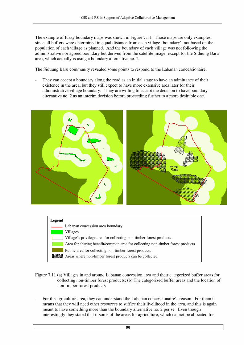
GIS and RS in Support of Adaptive Collaborative Management
�
"����=������(�(�BB��#����������������������� ��5 �����!������"�������������������=�������
since all buffers were determined in equal distance from each village ‘boundary’, not based on the population of each village as planned. And the boundary of each village was not following the administrative nor agreed boundary but derived from the satellite image, except for the Siduung Baru �������� ���������� ���� �����#��������������� �������� The Siduung Baru community revealed some points to respond to the Labanan concessionaire: - They can accept a boundary along the road as an initial stage to have an admittance of their
existence in the area, but they still expect to have more extensive area later for their administrative village boundary. They are willing to accept the decision to have boundary ������� �������������� ���� ����� � ���#�(����������� ���(�������������������� ��#� one.
Figure !.�� (a) Villages in and around Labanan concession area and their categorized buffer areas for collecting non-timber forest products; (b) The categorized buffer areas and the location of non-timber forest products
- For the agriculture area, they can understand the Labanan concessionaire’s reason. For them it
means that they will need other resources to suffice their livelihood in the area, and this is again meant to have so���� �����������������#��������������� �����������������)�����������
interestingly they stated that if some of the areas for agriculture, which cannot be allocated for
Legend Labanan concession area boundary Villages Village’s privilege area for collecting non-timber forest products
Area for sharing benefit/common area for collecting non-timber forest products
Public area for collecting non-timber forest products Areas where non-timber forest products can be collected
GIS and RS in Support of Adaptive Collaborative Management
�
them, were allocated for the community of Tepian Buah, they can accept that because they do not want to compete with their relatives.
- Regarding non-timber forest products, they appreciate that the Labanan concessionaire has tried
to develop a concept to avoid conflict among communities in the area regarding non-timber forest products. But they think that the concept cannot fully apply because for gaharu/eaglewood and bird-nest, some people already considered themselves as the owners.
The community of Siduung Baru also wanted the Labanan concessionaire to consider them more compared to the other surrounding villages, since the other villages are already settled. The other villages have already had adequate facilities to support their livelihood. So the Siduung Baru community thought that they still need some kind of privilege regarding the right for collecting non-timber forest products in the area. At least they want to have a privilege for hunting and rattan areas, which located relatively close to their settlement area.
��� Consensus, commitment and responsibility sharing The progress in the negotiation process showed that the participants already refined their understanding of the decision problem. Multiple issues arisen simultaneously, which benefited the negotiation, process since both parties can prioritise trade off positions. That was the moment that they could make an effort to invent options to accommodate all interests and reach consensus. The important thing there was that they had to have a capacity for accommodating changes, avoid closure on single-issue agreement and focus on the need for agreement on ‘total package’. ����� Consensus In due course, after more bargaining and negotiating, the consensus was finally reached. Points of the consensus are: - "���#��������������� �������� ������������������ ����(������������������nge the Siduung Baru
settlement area status with the government. - The Labanan concessionaire would provide support to the community of Siduung Baru to
improve their agricultural technique towards the more intensive pattern. The support will be in a form of both technical and material, which will be arranged further as a part of their community development program for Siduung Baru community.
- While the Labanan concessionaire works with the arrangement on how the communities who live
in and around their area could benefit fairly from non-timber forest products, the Labanan concessionaire could give full access for the community of Siduung Baru to their forest area to collect non-timber forest products as long as it is not conflicting with other nearby community’s interests. Particularly for hunting and rattan areas, the priority is given to the community of Siduung Baru.
- The Labanan concessionaire in the mean time can not accommodate the community’s request to
have area for tana’ ulen. If later they need to revise their long term forest management plan, they will consider the necessity to allocate an appropriate area for tana’ ulen.

GIS and RS in Support of Adaptive Collaborative Management
�
����� Commitment and responsibility When parties come to an agreement, they need to explain the choice and communicate the result through appropriate method. For an agreement concerning spatial problem, GIS could provide excellent representation for visualization purpose, as it can communicate spatial information succinctly. Presentation and explanation of the decision is one of the most important phases of a decision-making process, as it can increase the acceptability and desirability of the choice, and also can build commitment and responsibility towards the decision among all stakeholders involved. Before the negotiation process brought to the end, points as the outcome of this negotiation process were stated one by one by the researcher in a position as a mediator, while showing the maps to point out ‘what and where’ the consensus points referred to. It was also agreed that: • Labanan concessionaire would prepare draft of the minutes and then it would be sent to the
representative of the community of Siduung Baru to be reviewed before both parties could sign it together.
• Each party would then confirm and explain the outcome of the negotiation process to their
constituent. • The Labanan concessionaire would report the negotiation result to their regional and central
offices. With their permission, the action could be taken by arranging formal request to the local and central government (the Ministry of Forestry). While in the mean time the community committed to apply agreed points in their daily live.
Those points are: (i) "�������� �����������������������������������������������������(������� �����(����������
for � ��������"�������������������� �������� ��,�����#���(���������#�� �������
agreement. (ii) With a support from the concessionaire and the government, they would try some practices in
agriculture, which are more intensive. (iii) They would participate in protecting the forest around their area from illegal logging activity. (iv) They would prevent their community’s member to involve in illegal logging activity. (v) They would maintain a good relationship with other communities in Labanan area.
• Both parties would jointly monitor the implementation of the outcome of the negotiation. • Based on the monitoring and evaluation of the implementation, both parties would learn how the
consensus could work, any inappropriateness (like unforeseen issues and implications) would lead to a necessity for them make a revisit, where they would arrange another negotiation session for that.
At the end of the negotiation process, the researcher could see that both parties were happy with the result and they felt committed to the decision. It was obvious that the relationship between them certainly changed to the positive direction compare to the condition before, where they acknowledged and respected each other more.

GIS and RS in Support of Adaptive Collaborative Management
This negotiation process could be seen as a ‘success’ to the extent that the parties concerned feel that they made progress. Especially for the Siduung Baru community, they were confident that they had gained power, confidence, and respect from the Labanan concessionaire. This agreement could not be seen as final. Rather it is more appropriate to say that the negotiation between both parties has just begun. But anyway this was a good start for a more collaborative way in the relationship among different stakeholders in Labanan area. One lesson could be learned from the whole process that when multi-stakeholder process went well, it would lead to more trust and better relation among participating stakeholder groups. It could also improve communication and networks, which may in turn lead to further collaboration among them.

GIS and RS in Support of Adaptive Collaborative Management
�
�� Discussion on the Application of Adaptive Collaborative Management
and the Supporting Role of GIS and RS
In this chapter the process of settling the boundary dispute, as detailed in the previous chapters –�� �����! �!'��� ������� ����� ������������� !� ���� ��an instance of adaptive collaborative management. The discussion is preceded by some considerations about possible impacts of using participatory action research approach in this study. The evaluation of the process of settling the boundary dispute is carried out based on how each phase during the process of settling the dispute is seen in the light of adaptive collaborative management reequirements. The areas where GIS and/or RS could contribute to enhance the process are also discussed. The last part of this chapter discusses the applicability of adaptive collaborative management to a wider resource management in Labanan area, whilst also looks at possible supports of GIS and RS to that implementation. This chapter is concluded with an opinion whether after all, the application of adaptive collaborative management in Labanan area is still something to be aimed at.
���� Possible effects and consequencies of using participatory action research In this study, the application of adaptive collaborative management technique in the process of settling the boundary dispute between the community of Siduung Baru and the Labanan concessionaire had been carried out by using a participatory action research approach. The discussion about participatory action research here is intended to elucidate that the researcher is aware about the involvement throughout the process of settling the boundary dispute, and about the interference which by some means might affect the way the process progressing and/or the outcome of the process coming up. As a consequence of employing the participatory action research approach, the researcher’s role during this study was changed from time to time according to the stages of the process of settling the dispute and the circumstances. As a partner with the participants in participatory sessions, the researcher avoided distancing from the participants to be able to taking advantage of personal insight and feeling to understand what is going on more fully. Consequently, in doing role as a partner, it was difficult for the researcher to be objective and value free. But during the negotiation session, as a facilitator and a mediator, a distance to both parties involved was taken since the neutrality as a third party is very important. Indeed, it was not always easy to play different roles with sufficient level of acceptability. The researcher’s involvement and interference in the process is unavoidable, because to study the implementation of adaptive collaborative management and the supporting role of GIS and RS in the study area, the approach has to be introduced and taught, and the process of the implementation has to be initiated. It is realized that the intervention is not without a consequence. The outcome could be modest if it is valued from the ‘level of objectivity’, and also could introduce bias. To cope with those issues, in determining and analysing whether the findings are ‘right’, or correctly represent what is going on, a triangulation or the use of multiple perspectives in data collection and analysis were conducted. Multiple perspectives were sought from the observations and reflections of the participants and also from outside parties, which in this case are the BFMP researchers. That technique helps to see things more objective.
GIS and RS in Support of Adaptive Collaborative Management
��
���� Evaluation of the application of adaptive collaborative management in the process of boundary dispute settlement with the support of GIS and RS
The first two specific objectives of this research deal with the application of adaptive collaborative management in settling boundary dispute and the role of GIS and RS in that, respectively. Because GIS and RS have been used throughout the research, the two specific objectives are dealt with together in this Sub Chapter. As learned from the previous chapters, some factors in Labanan area have given a reason to apply adaptive collaborative management approach in settling the boundary dispute. Those factors are: • A power disparity between the community of Siduung Baru and the Labanan concessionaire; • Lack of the concessionaire’s trust to the community; and • A changing of relationship characteristics between both parties and with the forest ecosystem as an
impact of the decentralization process. The first two factors (power disparity and lack of trust) deterred collaboration between both parties. These two factors are related to the collaborative element of adaptive collaborative maangement. The third condition is about dynamism and complexity of relationship between the forest stakeholders and with the forest ecosystem, this is where adaptive element of adaptive collaborative management could play a role. The separation of collaborative and adaptive elements is only analytical and is meant to make the evaluation of adaptive collaborative management in this chapter clearer. Those factors has been narrated the phases for settling the boundary dispute. In this study, the process of settling the boundary dispute comprises of several phases as follows: • Generating boundary alternatives, which for the community is an ‘equal-footing’ process with
respect to the concessionaire; • Moving towards the consensus, which consists of:
- Further preparation for the negotiation process, where both parties learned from each other; and - The negotiation process itself;
• Achieving consensus, giving commitment and stating responsibility. The evaluation of the process of settling the boundary dispute as an instance of adaptive collaborative management is carried out by seeing each phase during the process of settling the boundary dispute in �����(������ ������#���� ����������������7� ��������������� ����� ��5 �����������"�����
requirements are: • Collaborative:
- Participation - Sharing information - Collaborative learning/sharing knowledge - Collaborative action
• Adaptive - Taking a system perspective into thinking/planning - Experimenting - Feedback mechanism - Adjustment - Iterative process for improvements
The evaluation is intended to give an idea how the process of settling the boundary dispute can be seen as adaptive collaborative management. Within that scheme, the areas where GIS and RS have contributed are also identified and analysed.
GIS and RS in Support of Adaptive Collaborative Management
��
The outcomes of each phase and the final outcome of the dispute settlement process can reflect whether by using adaptive collaborative management approach, the condition in Labanan related to this boundary dispute could be improved. This evaluation is divided into three sections according to those phases during the process of settling the boudary dispute as mentioned earlier. ������ Generating the boundary alternatives - the ‘equal-footing’ process for the
community A certain degree of power equity between the community and the concessionaire is needed for a rewarding collaboration and negotiation between them. This situation has necessitates some preliminary stages prior to the negotiation process to bring the community to have ‘equal-footing’ with respect to the concessionaire. As explained earlier, in this study, the definition of power is reduced into a power which comes from spatial information ownership and knowledge related to the spatial technology. The ‘equal-footing’ process then was designed and carried out within that context. In adaptive collaborative management framework, the activities during this ‘equal-footing’ process involve the community’s participation, sharing of information and knowledge, and collaborative ���� ���������� ������ ����� ������������������ ��� �������� ���������� � ������"�#������������ ����
the stages in this process together with the outcome of each stage, the contributions of GIS/RS, and the corresponding adaptive collaborative management requirements. The following discussion tries to see each stages of the ‘equal-footing’ process from adaptive collaborative management perspective by taking the adaptive collaborative management’s requirements as evaluation factors. Each stage in the ‘equal-footing’ process can also be seen as an element of a ‘package’ for empowering the community. ����������������������-����������� 7�������""% ��&������ �������% ��&���������cipate in the process in
a manner satisfactory to them - The community’s participation The participation during the ‘equal-footing’ process was between the community and the researcher. During this process, the participation was varied between assistencialism and cooperation (please ��(������5 ����������� ((�������������(����� � ��� ��'���/��� � ��� ������assistencialism took place when the researcher mainly administered the activities, while the community received information, was consulted, but they almost did not have control over decision to direct the process. This was happened during the GIS operation stage when maps were developed. Aside of that activity, the participation between the community and the researcher was a cooperation. In participation as cooperation, the decision upon what and how activities would and should be done was taken through dialogue between the researcher and the community. In the implementation of the activities, both parties were also working together. So, power and control were shared throughout the process. The community’s satisfaction upon their participation in this process could be deducted from their admittance that they gained something from the stages they were participating. Among others, they were able to understand/appreciate the use of satellite images as a trustworthy source for maps, to understand/appreciate on how maps are developed, and to have some ideas of thinking in ‘what-if’, which made them aware of a threatening deforestation rate in the area. From the process, they were
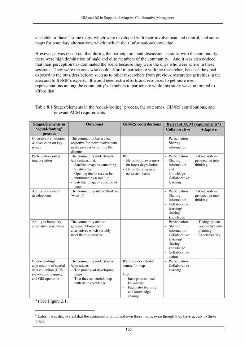
GIS and RS in Support of Adaptive Collaborative Management
��
also able to ‘have’ some maps, which were developed with their involvement and control, and some maps for boundary alternatives, which include their information/knowledge. However, it was observed, that during the participation and discussion sessions with the community, there were high domination of male and elite members of the community. And it was also noticed that their perception has dominated the scene because they were the ones who were active in these sessions. They were the ones who could afford to participate with the researcher, because they had exposed to the outsiders before; such as to other researchers from previous researches activities in the area and to BFMP’s experts. It would need extra efforts and resources to get more even representations among the community’s members to participate while this study was too limited to afford that. Table �.� Stages/elements in the ‘equal-footing’ process, the outcomes, GIS/RS contributions, and
relevant ACM requirements
Relevant ACM requirements*) Stages/elements in ‘equal-footing’
process
Outcomes GIS/RS contributions Collaborative Adaptive
Objective formulation & discussion on key issues
The community has a clear objective for their involvement in the process of settling the dispute
- Participation - Sharing
information
Participatory image interpretation
The community understands /appreciates that: - Satellite image is something
trustworthy - Opening the forest can be
monitored by a satellite - Satellite image is a source of
maps
RS: - Helps build awareness
on forest degradation - Helps thinking in an
ecosystem basis
- Participation - Sharing
information and knowledge
- Collaborative learning
Taking system perspective into thinking
Ability in scenario development
The community able to think in ‘what-if’
- Participation - Sharing
information - Collaborative
learning/ sharing knowledge
Taking system perspective into thinking
Ability in boundary alternative generation
The community able to �����������#��������
alternatives which variably meet their objectives
- Participation - Sharing
information - Collaborative
learning/ sharing knowledge
- Collaborative action
- Taking system perspective into planning
- Experimenting
Understanding/ appreciation of spatial data collection (GPS surveying), mapping, and GIS operation
The community understands /appreciates: - The process of developing
maps - That they can enrich map
with their knowledge
RS: Provides reliable source for map GIS: - Incorporates local
knowledge - Facilitates learning
and knowledge sharing
- Participation - Collaborative
learning
N'�$���5 ���������
Later it was discovered that the community could not own these maps, even though they have access to these maps.

GIS and RS in Support of Adaptive Collaborative Management
��
- The support of GIS and RS The community’s participation when producing GIS data has been able to raise their power in spatial context by: • Giving them access to spatial data of their area • Giving them confidence that their maps were produced from reliable sources: (i) RS data which
they perceive as trustworthy; and (ii) data which were collected with their involvement; • Giving them chance to learn to work with geographic information technology. This cannot be
seen as a technology-driven process, though it is also cannot be seen as a fully demand-driven process. The reason is because the technology was brought to the community (by the researcher), but however the community realised that it is beneficial for them to know something about spatial data and geographic information technology because the know that the concessionaire has that kind of data and uses that technology to process their spatial data.
���������������������*���� #�� ���"���� 7����������� ���"���� ����,����,�� ����$��������� - Information sharing between the community and the researcher Information and knowledge sharing took place between the community and the researcher through out this phase. This was possible after the researcher could be ‘accepted’ by the community. Trust between the researcher and the community and a similar desire to learn something from the process has made communications, interactions and dialogues very favourable for sharing information, understanding/knowledge, and experience. - Information sharing between the community and the concessionaire Though it was not directly affecting the process of ‘equal-footing’, the concessionaire’s lack of trust to the community has prevented an information flow between them and the community. During this study, the researcher mostly used maps or spatial information from the concessionaire for carrying out this study; but the concessionaire did not allow the researcher to leave any single map with the community, including the ones resulted from the community’s counter mapping activity after the ‘equal-footing’ sessions with the community finished. ��������������������!����������������� � #6����� #�$ �,���#�7�new understanding/knowledge is
produced and shared between the community and the researcher The main intention of the collaboration among actors is that new understanding/new knowledge is produced through the sharing of the their knowledge and experience. This can be seen as a collaborative learning process, whereby different understandings are integrated to develop a new way of perceiving things. During the ‘equal-footing’ process, the interaction between the community and the researcher has provided abundance chances for learning together from sharing knowledge/understanding or experience. To mention some of them: while doing the participatory satellite image interpretation, the community learned that their activity in opening the forest along the road can be monitored by a satellite in the outer space; while at the same time the researcher also learned from the community that they trust the satellite image because it can not be manipulated. Another example, during the mapping session, the researcher learned from the community how they could locate boundary of areas for collecting non-timber forest products only by recognizing some simple natural features, while the community learned from the researcher how to ‘put’ their knowledge on the map by first ‘recording the place’ by using GPS.
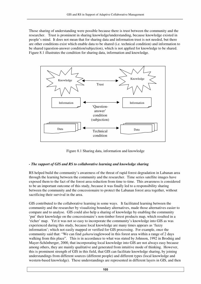
GIS and RS in Support of Adaptive Collaborative Management
��
Those sharing of understanding were possible because there is trust between the community and the researcher. Trust is prominent in sharing knowledge/understanding, because knowledge existed in people’s mind. It does not mean that for sharing data and information trust is not needed, but there are other conditions exist which enable data to be shared (i.e. technical condition) and information to be shared (question-answer condition/subjection), which is not applied for knowledge to be shared. 5 ��������� ����������������� � ���(������� ��������� �(����� ����������������
Figure �.� Sharing data, information and knowledge - The support of GIS and RS to collaborative learning and knowledge sharing RS helped build the community’s awareness of the threat of rapid forest degradation in Labanan area through the learning between the community and the researcher. Time series satellite images have exposed them to the fact of the forest area reduction from time to time. This awareness is considered to be an important outcome of this study, because it was finally led to a responsibility sharing between the community and the concessionaire to protect the Labanan forest area together, without sacrificing their survival in the area. GIS contributed to the collaborative learning in some ways. It facilitated learning between the community and the researcher by visualizing boundary alternatives, made those alternatives easier to compare and to analyse. GIS could also help a sharing of knowledge by enabling the community ‘put’ their knowledge on the concessionaire’s non-timber forest products map, which resulted in a ‘richer’ map. Yet it was not so easy to incorporate the community’s knowledge into GIS as was experienced during this study, because local knowledge are many times appears as ‘fuzzy information’; which not easily mapped or verified for GIS processing. For example, once the community said that: “We can find gaharu%��������� ���� ��(������������ �� �����������(���������� ���(������ ������J����"� �� �� ��������������������������������#��;������������ ��Brodnig and Mayer-$��O�#�����������������incorporating local knowledge into GIS are not always easy because among others, they are mainly qualitative and generated from intuitive mode of thinking. However, this is prominent strength of GIS in this field, that GIS can facilitate knowledge sharing, by joining understandings from different sources (different people) and different types (local knowledge and western-based knowledge). These understandings are represented in different layers in GIS, and then
Information
Data Technical condition
‘Question-answer’
condition (subjection)
Knowledge Trust
Knowledge
Information
Data
GIS and RS in Support of Adaptive Collaborative Management
��
GIS can create a whole ‘picture’ (which can be seen as a new understanding), which is ‘greater than the sum of its parts’ &:�+�����a). ������ ��������������!������������������ 7���������������� ��% �����$� ���������������&� Collaborative actions between the community and the researcher occurred when a set of boundary alternatives was determined. That determination is considered as an action, as a result of a lengthy process of learning together. Other collaborative action between the community and the researcher took place during the spatial data collection activity. The nature of this collaborative action is quite different from the previous one since this one refers to a more ‘physical’ collaborative action. By doing this activity together, the community and the researcher shared responsibility for this activity and for the outcomes, which in this case are maps. ���������������������/��&���"������������������$� �� ���� � # - The community’s system perspective A system perspective is a foundation of thinking in adaptive management. System perspective needs to be taken in planning, as it is the beginning step for an action. For the community of Siduung Baru, instinctively system perspective has been used as a basis of their planning and decision-making activities. Their system perspective is in fact simple because it is basically reflecting their main concerns: economical and social concerns. For them to be able to construct and incorporate a more comprehensive ‘system perspective’ for guiding their planning and decision-making activities is a part of the process to empower them. The activities, like participatory image interpretation and scenario development, have been able to help the community to ‘add’ other elements to their consideration in planning and making decision (in this case defining the boundary alternatives as the alternatives solutions for the dispute), which is reflected in their value tree. - The support of RS for thinking in a system perspective Remote sensing data can support thinking in a system basis because of their capability to show a wide area under their coverage. During the satellite image interpretation session, the images were able to enhance the community’s familiarity with Labanan area. Satellite image showed them a global vision of the area and components of the environment on an ‘ecosystem basis’, which they never experienced before. They could see that their settlement area is located on a flat area and surrounded by a huge forest. The image also helped them to see a link between one element of the ecosystem with others, for example they could see road and river networks in the area, and see how the location of villages in the area related to those networks. In this study, satellite image has enabled the community to look at the boundary dispute in a broader perspective, which eventually affected their consideration in evaluating boundary for their settlement area.
GIS and RS in Support of Adaptive Collaborative Management
��
����������������������89����"� �� #7������ ����������# ���� ��������������9����ments, where the goal is improvement not solution
In this study, the researcher and the community treated different boundary alternatives as an experiment, which is a part of the community’s learning process. The community was experimenting with different boundary alternatives, which could variably meet their objectives. The process of evaluating those boundary alternatives in the subsequent phase would give them a feedback for this ‘experiment’. ������ Further preparation for the negotiation process and the negotiation process This phase basically is intended to give both parties chances to learn from each other. This phase consists of two stages: further preparation for the negotiation process, and the negotiation process. Prior to the negotiation process, further preparation was carried out with the community as well as with the concessionaire. For the community of Siduung Baru, this phase was planned to prepare them more for the negotiation process following the previous ‘equal-footing’ phase. There is an assumption hold by the researcher, that when the community entered this phase, they were already somehow having an ‘equal-footing’ (within spatial context) to collaborate with the concessionaire. For the Labanan concessionaire, this phase is intended as a trust-building process. As mentioned earlier, the Labanan concessionaire does not trust the community. This is the second important factor, which deterred the collaboration between both parties. This phase is to ascertain satisfying collaboration between the concessionaire and the community. Entering the negotiation process, the researcher also had another assumption that the concessionaire has been able to develop a certain level of trust towards the community after the attempt to understand their views and concerns better. The trust building process would be continued as the process of settling the boundary dispute progressing. In adaptive collaborative management framework, the activities during this phase involved both parties participation, sharing of information, and collaborative learning. In these activities, system perspective was also taken in making the decision, a sort of feedback mechanism was also exist, and some kind of experiments were carried out by the community and the co����� ��� ������"�#������summarises the stages in this process together with the outcome of each stage, the contributions of GIS/RS, and relevant adaptive collaborative management requirements. ����������������������-����������� 7�������""% ��&�� ���he concessionaire have opportunities to
participate in the process in a manner satisfactory to them The participation in this phase involved three different combinations, they are: between the researcher and the community, between the researcher and the concessionaire, and between the researcher and both of them. The combination of participants involved during this phase depends on the intention of the participation session. In addition to that, as the consequence of different intentions of the participation session, there ���������� ((�������������(����� � ��� ������"�#����������� ����� ((������types of participation and the participants involved during this phase. In adaptive collaborative management, stakeholder participation is not optional or peripheral; it is essential. The opportunity for participating has to be given to the relevant stakeholders, while their actual participation has to come from their willingness to participate. The participation should be satisfactory to them, which means they could participate to the extent they wanted to and they are able to fulfil the reason of their participation.
GIS and RS in Support of Adaptive Collaborative Management
��
Table �. Stages in ‘moving towards consensus’ phase, the outcomes, GIS/RS contributions, and ACM requirements
Relevant ACM requirements*) Stages in
moving towards
consensus
Outcomes GIS/RS contributions Collaborative Adaptive
Further preparation
Boundary alternative evaluation
- The community found out that each boundary alternative can equally meet their objectives (analytical purpose)
- The concessionaire found out that boundary alternative ������������������
their objectives (reasoning purpose)
GIS: Facilitates learning and experimenting, improves the analysis
- Participation - Sharing
information
A feedback for the ‘experimentation’
Analysing position towards other party
- The concessionaire could better understand their own company’s values and concerns towards this dispute
- Both parties able to understand better other party’s concerns
- Both parties able to understand the boundary dispute in a wider perspective
- Participation - Sharing
information - Collaborative
learning
Taking system perspective into thinking
Defining BATNA**) and compromise solutions
The community able to define their BATNA and possible compromise solutions
GIS: Improves the analysis
- Participation - Collaborative
learning
Taking system perspective into thinking
Negotiating Clarify each other’s interests & establish common understanding on the issues
- The community able to communicate well with the concessionaire
- The concessionaire respects the community and acknowledges their views/concerns
GIS: Facilitates both parties to communicate (speaking in the ‘same language’)
- Participation - Sharing
information
N'�$���5 ������� **) BATNA=Best Alternative To a Negotiated Agreement
GIS and RS in Support of Adaptive Collaborative Management
�
"�#�������+��� ����P
Relevant ACM requirements*) Stages in moving towards
consensus
Outcomes GIS/RS contributions Collaborative Adaptive
Negotiation process
- The community has power to influence the negotiation process and the results (better bargaining position)
- Both parties could work together to achieve the consensus
RS: - Verifies data/information - Helps keep the negotiation
process transparent GIS: - Empowers the community - Keeps the negotiation process
open, which helps to maintain trust between both parties
- Facilitates collaborative learning
- Visualises facts to improve group understanding
- Facilitates sharing of information and knowledge
- Stimulates taking system perspective in making a decision
- Participation - Sharing
information - Collaborative
learning/ sharing knowledge
- Taking system perspective in making a decision
- The community’s experimentation to know their ability in the negotiation process
- The concessionaire’s experimentation to apply more collaborative approach with the community
N'�$���5 ������� Table �.� Different types of participation during the phase of ‘moving towards consensus’ and the
participants involved
Activities Participants Types of participation
Further preparation - The community and the researcher - The concessionaire and the
researcher
Assistencialism and cooperation
Negotiation process The community, the concessionaire, and the researcher
Cooperation
The preparation phase consists of several activities, they are: evaluating the boundary alternatives, analyzing position towards other party, and defining BATNA and compromise solution. During this process, participation between the community and the researcher and between the concessionaire and the researcher were varied between assistencialism and cooperation. Participations as assistencialism happened with both parties during the evaluation of boundary alternative, particularly during the process of multi-criteria evaluation, which used Definite software. The researcher’s portion while participating in this activity with the concessionaire was less compared to the session with the community. Cooperation type of participation took place in the remaining sessions between the researcher and the concessionaire, and also between the researcher and the community. During the negotiation process, participation as cooperation is ideal since this one revealed the collaboration between parties involved, which is in this case involved the community, the concessionaire and the researcher.
GIS and RS in Support of Adaptive Collaborative Management
��
According to the concessionaire, the participation sessions were able to raise their understanding upon concerns and views of the community regarding the boundary dispute. While for the community, their satisfaction upon their participation in the process could be deducted from their admittance upon fulfillment of their objective for participating. They were able to improve their capability to negotiate their settlement boundary with the Labanan concessionaire, and to establish better relationship with them. The attainment of their objective to participate would affect their motivation to involve in other participatory activities in the future. ���������������������*���ing information: there is information flow amongst stakeholders Effective information flow within collaboration context will give ‘power’ to all stakeholders involved, since it enhances stakeholders’ understanding upon relevant issues. It could also enhance the ‘feeling of partnership’ through sharing, and could serve as ‘a trust building mechanism’ trough openness about pertinent issues. As mentioned earlier, there was no information sharing between the community and the concessionaire before the negotiation process. Only during the negotiation session the information sharing between the Labanan concessionaire and the community took place and it was unexpectedly open information sharing. The reasons for that can be threefold: (i) The Labanan concessionaire was forced to do that because the community understood what they
were talking about. Because the community also has their own spatial information to verify the Labanan concessionaire spatial information. So the Labanan concessionaire did not have other choice than to talk openly.
(ii) The Labanan concessionaire felt, after the session with the researcher, that they could trust the community better than before, so they just wanted to be opened with the community.
(iii) The Labanan concessionaire was pretentious to do that because of the presence of the researcher. They tried to give the researcher a good impression in dealing with the community.
Nevertheless, after the negotiation session between the community of Siduung Baru and the Labanan concessionaire for the boundary dispute, the relationship between both parties has been changed in one way or another. They acknowledge and respect each other more than before. This could be a very subjective opinion, because this is judged based on what was observed and what was uttered by those parties from the process that the researcher was involved in it. But however, as a multi-stakeholder process, the process of settling the boundary dispute went well, which lead to a more trust between both parties, which in turn could improve communication and enables information sharing between them. It would be ideal to give the community their maps (maps generated from the process they were involved) and other relevant spatial data. But since it is currently not possible, at least the community of Siduung Baru knows that the information is now available in the concessionaire’s GIS database. Whether they could access those data later, it will depend on the progress of their relationship with the Labanan concessionaire, and also on the social and political situations in the area. - The support of GIS and RS for sharing information Related to the sharing of information, GIS and RS supports were observed during the negotiation process. By visualizing spatial information with the help of GIS, both stakeholders could explain each other concerns better. By using the ‘same language’, the GIS language, the chance for misinterpreting the information could also be minimized, so the communication between the community and the concessionaire was also better. Here GIS also helps to maintain trust between both parties.
GIS and RS in Support of Adaptive Collaborative Management
���
In the negotiation process, GIS was helped to keep the discussion focus and open, so both parties were able to probe sufficiently to the problem. This was helped because it is common that in the meeting like that, the discussion became lengthy without really touching the main issue. This is particularly important also because it was observed that in the beginning the Labanan concessionaire somehow still has a reluctant feeling to negotiate openly with the community upon the boundary issue. Without the help of GIS, the Labanan concessionaire could speak about this issue only ‘at the surface’. However, the fact that the community also ‘has’ data from their mapping activity could also contribute to drive the Labanan concessionaire speak more openly. This openness made the information sharing between them better, and eventually developed a sense of partnership between them. In this process, GIS has also empowered the community. The fact that the community also has a reliable spatial data and an appreciation on how GIS can be used to show their maps with different combination of information; has raised their bargaining position in the negotiation process RS also contribute to make the ‘playing field’ transparent. In sharing the information and carrying out joint fact-finding process, both parties could always refer back to the information on the satellite images to clarify or to verify information provided on the maps. ���������������������!����������������� � #6����� #�$ �,���#�7� �,�% ������ �� #6$ �,���#�����
produced and shared amongst stakeholders It is necessarily noticed that during this study, the process of sharing knowledge/understanding could possibly took place between: the community and the researcher; the concessionaire and the researcher, and the community and the concessionaire. Learning between the community and the researcher took place through out the process of preparing the community before the negotiation process, particularly during the process of value tree analysis and developing some possible compromise solutions. Out of the process, the researcher could learn how important it is for the community to secure agriculture area as much as possible for their descendant; while on the other hand the community also learned that the situation is not possible to support this desire, which seems to imply their greediness upon land ownership in the eye of other forest stakeholders in the area. Learning together between the concessionaire and the researcher took place for example when analysing their position towards the community’s position. The concessionaire learned how to use the technique (value tree analysis) while the researcher was also learned how the concessionaire can see the relationship among different concerns of their own company (the management) towards this boundary dispute clearer when these concerns are structured into the value tree. Sharing knowledge between the community and the concessionaire took place during the negotiation session. It was observable that what has happened was not merely a sharing of information, but also a sharing of knowledge/understanding, because both parties had to go through a joint-fact finding and a thorough discussion process before coming to a common understanding about boundary alternative ������������������������ ������� ������4�� �����������������������#����������������� �����������
concessionaire (and the researcher) was there. - The support of GIS and RS to collaborative learning and knowledge sharing Learning between the concessionaire and the researcher to analyse how strong boundary alternative �������������������������� ��� ��,���#8��� ����������������������#��12$���2��������� ��� B���
‘what is happened where’.
GIS and RS in Support of Adaptive Collaborative Management
���
GIS has improved the analysis when the community and the researcher tried to define the community’s BATNA and possible compromise solutions. With GIS visualization ability, it was easier for the community to understand the problem, which is actually become more complicated with the inclusion of other party’s concerns. During the negotiation process, GIS contributed by improving group understanding and deepening the analysis. In general, the supporting role of GIS during the negotiation process comes from its ability to coordinate different boundary alternatives situation by integrating and exploring data and information from different sources. Then GIS effectively presented that information in a comprehensive form to the community and the concessionaire. Spatial analysis and data visualization abilities are the most useful aspects of GIS during the negotiation session, while its other ability, database management, was not apparent since this boundary dispute is not a complex spatial problem which involved a wide range of data. Even though those aforementioned capabilities of GIS are very helpful because they could encourage full participation, mutual understanding, inclusive solutions and shared responsibility in solving the boundary dispute; during the negotiation process, it was not needed to sophisticate the analysis because anyway this is not a complex spatial problem. Besides, it was realized that using GIS in a ‘too sophisticated’ way in a situation like this will not be beneficial, because it could be confusing to the community and could give fur���������#���D����� �� B����������4�� �������A �����&���'�
were also given another caution. According to them, the advantage of GIS can be captured only if the parties realize that it must aid the learning of all of the parties involved and not merely support the views of a particular interest. The researcher was aware of this when ‘playing’ a role as a mediator/facilitator during the negotiation process. ������ ���������� A system perspective is taken in planning and decision-making Taking a system perspective in planning is important, because in managing a complex system like forest; nothing can be understood in isolation. Awareness of biophysical, social, and political aspects, together with their interrelationship, connectedness and also wholeness, need to be taken into account. In this study, it was observed that the Labanan concessionaire has already used system perspective in their management planning; this can be seen from their value tree, which is used in analysing the boundary alternatives. They considered different elements and the interrelationship among those elements for their planning and decision making activities. This is not something surprising for a company with a ‘modern’ management system like the Labanan concessionaire; even though as observed during the value tree analysis process, structuring these elements into the value tree was able to make them understand their company’s values/concerns better. - The support of GIS to help the parties thinking in a system basis As a result of the previous stages prior to the negotiation process, during the negotiation process, with the help of GIS, both parties could ‘recall’ and eventually involved different elements, which need to be considered in making a decision. During the negotiation process, the ability of maps and GIS to encode spatial relationships in structured formal representations, have revealed geographic phenomena and their interdependencies to the parties involved. Aside of contributing to a shared understanding and to an improvement of analysis, it can also be seen as helping the parties to think in a system basis. By changing the combination of different layers intentionally during the negotiation process, for example to clarify how one phenomenon related to others, GIS has stimulated the negotiators to take a system perspective in making decision.

GIS and RS in Support of Adaptive Collaborative Management
���
����������������������89����"� �� #7�"� �#�"� ��� ����� ��� ��2����� �3���������# �� and treated as ‘experiments’, where the goal is improvements not solutions
The community perceived the negotiation session with the Labanan concessionaire partly as an experiment. The reason is because they are aware that they has already undergone some preparation sessions for the negotiation session with the researcher, therefore they also wanted to know how it would work in the negotiation. So in fact the community’s curiosity and the researcher’s curiosity in this case are the same. The Labanan concessionaire was also perceived the negotiation process with the community as an experiment, because at that time they were using a different way in dealing with the community from what they usually did before: a more collaborative way. If it worked well, the Labanan concessionaire wanted to improve and to consistently use it to interact with the communities in the area. Eventually, after the negotiation process, the Labanan concessionaire discovered that a more collaborative way has granted them some advantages, such as the community’s cooperativeness and commitment to support the agreement. In a wider perspective, this case study as a whole can also be seen as a management intervention to the condition in Labanan area; which is designed and treated as an experiment to seek improvement. "� ������#������������������������� ����#��6� ���&��!�'������������ ������������������������������
active form by using the project itself (in this case is this study) as an experimental probe, to improve a situation. ���������������������0������$�"���� ��"7����������� ���"���� ��������$�"���� ��"��� $������
management interventions (actions) The process of boundary alternative evaluation was also a part of the experiment for the community, because that activity provided a feedback for their experiment with different boundary alternatives. It was recognizable that the community has a capacity to learn and has an adequate curiosity to understand something that is interesting to them. - The support of GIS for the community’s experimentations When experimenting with different boundary alternatives, GIS support the process by visualising those alternatives. The maps visualization, with different layers, different shape of areas, different colours, was able to keep the community’s curiosity to learn high. ����� Consensus, commitment and responsibility This is a closing stage of the negotiation process. This is when both parties stepped aside to support the consensus, and declared their commitment to it. In adaptive collaborative management framework, the activities during this phase involved: both parties participation, collaborative action, experimentation, adjustment in action based on learning, (���#���������� ����������� ��������������(� ��������������"�#������������rises the process of achieving the consensus and giving the commitment/responsibility, together with the outcomes, the contributions of GIS/RS, and relevant adaptive collaborative management requirements.
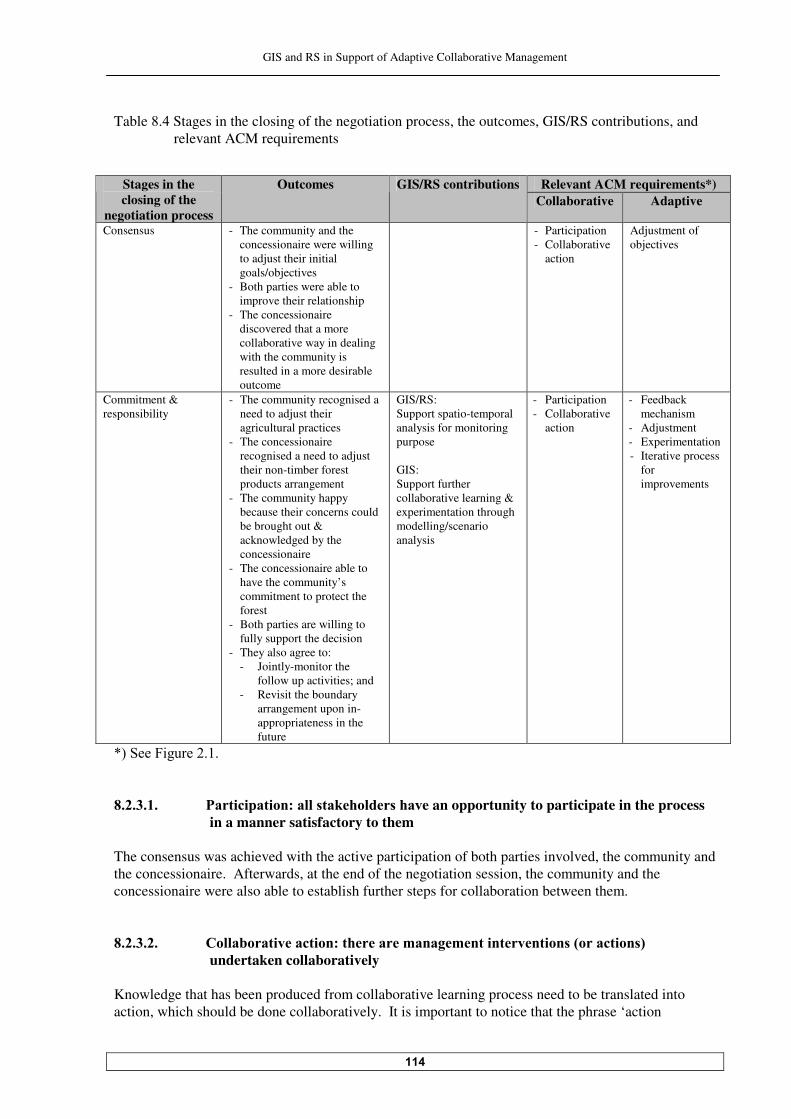
GIS and RS in Support of Adaptive Collaborative Management
���
Table �.� Stages in the closing of the negotiation process, the outcomes, GIS/RS contributions, and relevant ACM requirements
Relevant ACM requirements*) Stages in the
closing of the negotiation process
Outcomes GIS/RS contributions Collaborative Adaptive
Consensus - The community and the concessionaire were willing to adjust their initial goals/objectives
- Both parties were able to improve their relationship
- The concessionaire discovered that a more collaborative way in dealing with the community is resulted in a more desirable outcome
- Participation - Collaborative
action
Adjustment of objectives
Commitment & responsibility
- The community recognised a need to adjust their agricultural practices
- The concessionaire recognised a need to adjust their non-timber forest products arrangement
- The community happy because their concerns could be brought out & acknowledged by the concessionaire
- The concessionaire able to have the community’s commitment to protect the forest
- Both parties are willing to fully support the decision
- They also agree to: - Jointly-monitor the
follow up activities; and - Revisit the boundary
arrangement upon in-appropriateness in the future
GIS/RS: Support spatio-temporal analysis for monitoring purpose GIS: Support further collaborative learning & experimentation through modelling/scenario analysis
- Participation - Collaborative
action
- Feedback mechanism
- Adjustment - Experimentation - Iterative process
for improvements
N'�$���5 �������� ��������������������-����������� 7��������$������������e an opportunity to participate in the process
in a manner satisfactory to them The consensus was achieved with the active participation of both parties involved, the community and the concessionaire. Afterwards, at the end of the negotiation session, the community and the concessionaire were also able to establish further steps for collaboration between them. ��������������������!������������������ 7�����������"� �#�"� ��� ����� ��� ��2�������� �3�
undertaken collaboratively Knowledge that has been produced from collaborative learning process need to be translated into action, which should be done collaboratively. It is important to notice that the phrase ‘action

GIS and RS in Support of Adaptive Collaborative Management
���
undertaken collaboratively’ does not mean that all activities should be undertaken collaboratively, but rather that the parties work together and share responsibility among them. In this study, collaborative action between the community of Siduung Baru and the Labanan concessionaire took placed when both parties achieved consensus for settling the boundary dispute. The consensus was taken after they worked together to analyse the problem thoroughly. Both parties also took collective responsibility upon the consensus being taken and succeeding consequences from the consensus, and also the follow up actions, such as joint-monitoring activity. This is a good start for possible further implementation of adaptive collaborative management in the area. ���������������������89����"� �� #7�"� �#�"� ��� ����� ��� ��2����� �3���������# ���� ����eated as
‘experiments’, where the goal is improvement not solution - Both parties’ experiment The experimental emphasis in adaptive collaborative management does not mean that the ‘experiments’ are undertaken like the ones in research. In adaptive collaborative management, management responds to problems and opportunities (by intervening them), and that is different from an experimental scientist's desire to explore a phenomenon systematically "������ � �����������������#��������������� ������������#e seen as both parties’ experiment; because within this decision, there is a consequence to apply the decision by making some adjustments of their resource management practices, to adapt to it and then to learn from the outcome. This is true that both parties planned to seek improvements through this experiment. - The support of GIS to the experiment GIS ability to show ‘what is’ and ‘what pattern’ has facilitated the community and the concessionaire’s learning and experimenting during the process of settling the boundary dispute. Actually, the experiment with the help of GIS could be extended to ‘what could be’ or ‘what if’. This modelling capability of GIS could guide and enrich the parties’ experimentation with different scenarios and analyse the effect through time and space. In this context, as a forward-looking scheme, adaptive collaborative management with its experimenting and collaborative learning activities could be well supported by GIS. ����� ��������������0������$�"���� ��"7�����������information feedback mechanisms linked to the
management interventions (actions) Monitoring activities provide information as a feedback for action being taken. In concert with RS data, GIS could provide reliable information for monitoring activities. In this case study, the length of the fieldwork period was not sufficient to experience the process of management intervention refinement based on a feedback mechanism. But the intention to apply the feedback mechanism had been arranged by the community and the concessionaire during the closing of the negotiation process, when both parties agreed to jointly monitor the implementation of the outcome of the negotiation, and afterwards based on the monitoring and evaluation of the implementation, both parties agreed to learn on how the consensus could work. Any inappropriateness (like unforeseen issues and implications) would necessitate them to make a revisit, when they would arrange another negotiation session to improve the current decision.

GIS and RS in Support of Adaptive Collaborative Management
���
Both parties’ willingness to think and act in an ‘adaptive management’ way is a good sign for the application of this concept in a more developed shape later on. However, it still has to be proved that what was agreed would really be followed up. Because it is not uncommon practice in Indonesia that an agreement will end without the real follow up action. This has given a reason to think that adaptive collaborative management will likely to work with a strong leadership. - The support of RS and GIS for monitoring activities Time series data provided by RS is particularly important for a monitoring purpose. During the fieldwork, almost automatically the community could recognize the depletion of the forest area by comparing satellite images from different years. That is only an example of a basic monitoring activity. Together with GIS, RS data can be used for a more thorough and comprehensive monitoring activities, which could supply rich information for the feedback mechanism in adaptive collaborative management. ���������������������/��%��"� �7����������� ������ �� �"� �#�"� ��������� ��� ����%������ � #��
included both ‘intentional’ and ‘unintentional’ (new) findings Innovation needs sufficient capacity to design and to carry it out. It needs ability to integrate knowledge from different sources, willingness to respond to learning/to change views, and capacity to change/to adjust actions (flexibility). Both parties were able to step aside adjust their initial objectives to achieve the consensus. This was possible after they listened to each other and learned how the boundary of the settlement area would possibly be arranged, and what consequences would go behind. - The community’s innovation In this case study, the innovation is still in a form of the community’s goodwill. During the closing of the negotiation session, they expressed their willingness to adjust their agricultural system to a more intensive way with the support of the Labanan concessionaire and the government, as a consequence of ac���� �������#��������������� ��������(������ �������������������"� �� ����# �� �����(�������������
like them, because Dayak community is famous for their extensive agricultural system (shifting cultivation) since the very beginning. Their willingness to adjust their resource management practice could be seen as a result of their learning that the situation has already changed where their agricultural practice is not appropriate anymore. From their learning during the sessions with the researcher, the increase of their awareness towards forest degradation problem in Labanan area is also contributed to their willingness to change. - The concessionaire’s innovation The Labanan’s innovation, though it is still in a form of a plan, from the process of learning with the community and with the researcher during the process of boundary dispute settlement, is to adjust the arrangements to collect non-timber forest products in Labanan forest area for the surrounding communities (not only for the Siduung Baru community). It will still need several stages till it can come into practice, but at least they already have a willingness to adjust their old way in giving free access to collect non-timber forest products, which might create conflict since there are more and more people want to get benefit from the Labanan forest area. Aside of that, with a careful observation, the Labanan concessionaire’s decision to participate in the process of settling the boundary dispute, apart from the possibility of the researcher’ influence to the decision being made, can be seen also as an innovation. It is resulted from their learning to deal with
GIS and RS in Support of Adaptive Collaborative Management
���
the community, that they need to employ a more collaborative and participative ways in dealing with the community in the on-going decentralization process. They learnt from their previous experience that ignorance to the community’s demand or unpleasant treatments would only make the situation worse, their existence in the area becomes uneasy and the Labanan forest becomes more threatened. A possible way out is to have a collective awareness between them and the community to improve the situation through the process, which emphasizes collaboration. Their ‘learning’ to use a more collaborative way to deal with the community of Siduung Baru can be regarded as their conscious learning, because from there they could draw a certain way or a policy for dealing with the communities in the area. The experience with the community of Siduung Baru showed that a more collaborative way could be used to win the community’s support. But whether that could also work with other communities in the area who have different characteristics that will be a part of the concessionaire’s further learning. ����������������������)������������cess for improvements: the management process is not linear, but
has some sort of feedback mechanism, which allows management to be a continuous process of discovery and learning
- Learn-adapt-adjust Adaptive management is an iterative process of learning and discovery; this is necessary to deal with the dynamism and complexity of the situation. The boundary dispute between the community of Siduung Baru and the Labanan concessionaire emerged when the relationship between them and with the forest ecosystem changed as an impact of the decentralization process. Among others, those changes are: more intense bottom-up movements, and emergence of different (conflicting) interests toward the forest. This is a condition where adaptive management is meant to contribute. However, it is important to realize that the process of settling the boundary dispute during this study is too instant to analyse adaptive collaborative management in Labanan completely, because the fieldwork activity was ended slightly after the closing of the negotiation process. It will be ideal to see the subsequent process after the negotiation process, such as: how both parties implement the agreement afterwards, how they carry out joint-monitoring activities, how they deal with inappropriateness, and also whether they could adapt to the decision they made, etc.; which could give an idea on the iterative nature of adaptive collaborative management. Resource boundary arrangement has a direct impact to the livelihood of the concerned parties and to the resource itself. Boundary arrangement dictates what parties can or cannot do in the area. When the circumstances change very quickly as has happened during the decentralization era, it is important to see the process of arranging the boundary as an adaptive collaborative management process. There is always a possibility to necessarily revisit the boundary arrangement upon a discovery of inappropriateness in the future. The parties should therefore build in flexibility to accommodate adjustment and acknowledge this as temporary measures. So, this is not a linear process; this is an iterative process of ‘learn-adjust-adapt’. From and beyond this case study, the boundary arrangement from the perspective of adaptive collaborative management can be illustrated as follows: • The community and the concessionaire have agreed on the boundary arrangement; • Both parties are willing to adjust their resource management practices based on the boundary
arrangement; • Then they adjust their resource management practices and try to live with it;
GIS and RS in Support of Adaptive Collaborative Management
���
• Both parties later on will discover whether they can adapt to the new resource management practices or not. If one of them discovered that they cannot live with it, or that has caused them a lot of sacrifices to adapt, it will be not fair for them to continue with the current boundary arrangement;
• So, both parties will revisit the boundary arrangement, and negotiate another one. The above sequence can be seen as an iterative process of adaptive collaborative management in this case study. The application of adaptive collaborative management has enabled both parties to learn not only about their current situation, but also for the future (feed-forward activity). In the iterative process of boundary arrangement, trust between the community and the concessionaire is also important, because there is always possibility to misuse the chance to re-negotiate/revisit the current boundary arrangement for having benefit at the expense of other party. - Other consideration for adjustment aspect Related to the adjustments in this case study, there are two things to consider: • The ability of both parties to adjust to the boundary arrangement, and • The possibility to adjust the boundary arrangement. The first one, an adjustment within the parties’ domain is likely to occur with the commitment of both parties to the agreement. But for the second one, an adjustment within the management domain, given the situation in the area and also by referring to the principle of sustainable forest management system which is widely adopted, it is likely to be difficult to be applied. Moving or changing boundary arrangement between the forest concession area and the community’s area in practice is not a simple issue. The principle of sustainable forest management such as from ITTO and LEI required a fixed boundary between the forest management unit and the community’s area. Therefore in the meantime, it can be assumed that only the first type of adjustment (the parties’ adjustment to the boundary arrangement), which is possible, while for the second type of adjustment, is still not clear. Nevertheless, it is good for, the concessionaire and other stakeholders like the local government and academicians/researchers consider the second type of adjustment in the arrangement of boundary between a forest management unit and the community’s area for a long-term perspective of sustainable forest management. ��� The evaluation of possible applications of adaptive collaborative management
in a wider context in Labanan forest concession area and the role of GIS and RS as support to it
This Sub Chapter deals with the third specific objective of this study. Here, possibilities of the application of adaptive collaborative management in a wider context in Labanan is dicussed, along with possible support of GIS and RS to the application. The discussion is based on the observations and findings during the process of settling the boundary dispute. However it is realised that the application of adaptive collaborative management in the process of settling the boundary dispute was too instant and somehow limited to give a complete figure about possible application of this concept in a wider context, especially related to the adaptive element of it. Therefore, additional information was also sought from other sources such as literatures and interviews. The application of adaptive collaborative management in a wider context in Labanan refers to the application of it which certainly involved the Labanan concessionaire; in any cases related to the forest management activities, in a more complex situation compare to the one for the case study. It is more complex because possibly it involves many more parties; takes longer time; has an effect on a bigger area; involves more resources; or merely just because the situation is more difficult.
GIS and RS in Support of Adaptive Collaborative Management
��
The guiding questions to carry out this evaluation are: • Is it possible to apply adaptive collaborative management in a wider context in Labanan? • How GIS and RS could help the application in a wider context? • After all, is the application of adaptive collaborative management in Labanan area still something
to be aimed at? ����� Possibilities to apply adaptive collaborative management in a wider context in
Labanan forest concession area As previously done in the earlier Sub Chapters, the discussion on the possibilities to apply adaptive collaborative management in a wider context in this Sub Chapter will also follow the two elements of it, collaborative and adaptive element, and their requ ��������&��������(������5 ��������(���������
elements and requirements). ����������������������!����������� 6��������������"� �#�"� � From what has learned during the stakeholder analysis process, there are many stakeholders in Labanan area. These stakeholders’ interests toward the Labanan forest are not always synergistic or complementary, but also competitive. Given that situation, collaborative management approach would be appropriate to be applied in Labanan area. - Condition for collaboration From what had been experienced during the process of settling the boundary dispute, it is understood that collaboration is only possible if some factors, which could discourage the parties to collaborate, are first amended. The most important factor for collaborating is the existence of trust among parties who want to collaborate. If trust were not there, it has to be built. In a chaotic, uncertain situation during the decentralization process, it has to be realized that a trust-building process will possibly need more time. Other common hindrance for collaboration is in-equity condition among parties. The in-equity condition in Labanan area can be caused by the discrepancies in the information ownership, possession of knowledge, technology mastery, right/control of a resource, wealthy-ness (or budget control), and formal or informal (or social) authority. In–equity among stakeholders needs to be cured if different stakeholders want to have a meaningful collaboration. Then some questions arise: Who will do that (conducting trust-building process or empowerment effort)? Is it the party who initiate the collaboration who should do that? If it is not the Labanan concessionaire, do they have the capacity to do that? From the perspective of the Labanan concessionaire, at least they have two reasons for having collaboration with other stakeholders in the area. Those reasons are: • They saw that it worked well during the process of settling the boundary dispute; and • They do not have other better option if they want to be able to manage the Labanan forest area
sustainably. But if they need the collaboration, does it mean that they are the one who has to eliminate the hindrances to enable collaboration to take place? Here actually other ‘strong’ party like the local government and/or a project like BFMP could play a role to support the Labanan’s intention to collaborate in managing the resource in the Labanan forest area.
GIS and RS in Support of Adaptive Collaborative Management
��
- Requirements for collaborative management Requirements of collaborative element are used as a checklist to discuss a possible wider application of adaptive collaborative management in this section. • Participation For a wider application of adaptive collaborative management, the participation of different stakeholders in Labanan can always be expected if the activity is corresponded to their interests. However it needs to be carefully arrange, what kind of participation is expected from them. It has to be ensured as well that their actual participation comes from their willingness to participate. In addition that, an activity that involved a community’s participation, needs to be carefully scheduled. During the busiest agricultural periods and major festivals, it will be difficult to expect their participation in the activity. The process of settling the boundary dispute was relatively short, so this kind of problem was not experienced, but for a wider (or longer) application of adaptive collaborative management in the area, this consideration is important. • Sharing information In Labanan, information, particularly related to the forest, is a sensitive issue. The Labanan concessionaire is the party who owned a comprehensive data and information concerning the Labanan area. Sharing information needs a proper arrangement to avoid unwanted case such as a misuse of it; and also to reduce a chance for the Labanan concessionaire to have reluctantly to collaborate. The arrangement on what kind of information should and could be shared and with whom should be in place. The arrangement also has to ensure an equal access among collaborating parties to relevant information. This arrangement is meant to maintain trust among them, to sustain the collaboration. • Collaborative learning For a successful wider application of adaptive collaborative management in Labanan area, the local government need to be involved in the collaboration. There will always be a reason to involve them. Under decentralization circumstances, they are one actor who has to collaborate and has to be involved not only in action but also in a learning process. The application of adaptive collaborative management in the process of settling the boundary dispute has noted some necessities for supporting collaborative learning, they are: mechanism to build trust and then maintain it; and to develop a climate that support the idea of understanding other’s points of views/concerns and sharing more freely. This is something that possibly not very easy to be done, especially if many parties involved, and also because usually not all parties has a habit (or perhaps a culture) of sharing openly, or ready to share. • Collaborative action Collaborative action in the sense of sharing responsibility is more crucial in a wider application of adaptive collaborative management. It needs a clear arrangement among concerned parties, as well as a capacity to undertake the responsibility. This suggests a good leadership or a good facilitation to allow a successful implementation.
GIS and RS in Support of Adaptive Collaborative Management
���
����������������������/��������"� �#�"� � - Adaptation within the management domain As a central government owned timber company, the Labanan concessionaire has a strict bureaucratic system, which goes from the local level (Labanan area), unit level (Berau District), regional level, and finally the head office. The Labanan concessionaire’s does not have much flexibility for, let says, changing management approach from time to time, experimenting with it, applying some innovations, etc. without permission from their superior (unit/regional/head offices – depend on the extent of the matter). For changing simple and local things, sure the Labanan concessionaire could decide themselves. But for a wider application of adaptive collaborative management, it needs a full support from their superiors. Adaptive management from the local government standpoint is also not so promising, since as commonly happened in Indonesia, government offices are also very bureaucratic and not flexible. -������������� ����� ������������������ ��&����$�#�+����������.), there is a plan to form a joint-company between the Labanan concessionaire and the local government to manage the Labanan forest concession area. They will operate more locally, because the local government is the main shareholder. More local level operation implicates shorter bureaucratic system. Possibly because of that, the new form of the Labanan concessionaire management could be more flexible to adapt and to adjust their management system as suggested by adaptive management. But this also still needs to be seen. - Requirements for adaptive management Requirements of adaptive element are used as a checklist to discuss a possible wider application of adaptive collaborative management in this section. • Taking a system perspective in planning Taking a system perspective in planning for a wider application of adaptive collaborative management will not be a problem. This aspect could be taught or learned together among the parties involved. • Experimenting and feedback mechanism The experimental approach in management is not cheap; not only the cost for carrying out the ‘experiment’ but also the cost for monitoring it. For a company like the Labanan concessionaire, the balance between benefits from an action undertaken with the cost incurred for doing it always needs to be calculated. For a wider application of adaptive collaborative management, the financial aspect could make it not so easy to materialize. • Adjustment Innovation in management as a result of learning process is advanced, but there is also a caution for adaptive collaborative management that result from learning may not be readily applied by all or even any of the parties involved. The reason could be a necessity of some preconditions to exist before the result of learning can be implemented.

GIS and RS in Support of Adaptive Collaborative Management
���
If innovations are to be accepted, the concerned party/parties should understand them. This suggests that change as a result of learning need to be seen as an incremental process. So, a wider application of adaptive collaborative management needs a proper arrangement. • Iterative process for improvements Related to the difficulties of applying adaptive management approach, i.e. the cycle of learn-adapt-adjust, maybe it will be more affordable to start applying it in a situation/matter, which is not too broad or too complex in the beginning. As ‘the management’ sees that it works or able to improve the situation, their support can be expected. In fact, being flexible is also something that has to be learned. ���������������������4�erall evaluation The earlier discussion suggests that the wider application of adaptive collaborative management needs a proper planning and sufficient resources. A preliminary study prior to the application might be beneficial to understand the situation and to identify potential hindrances. It also needs a strong leadership or a good facilitation for a successful application. The wider application of adaptive collaborative management needs to be initiated by a capable party (in this case perhaps the Labanan concessionaire themselves, the local government or a project like BFMP). Those considerations have raised thought that applications of adaptive collaborative management in a wider context will be better if it is institutionalised. ����� How GIS and RS could help the application in a wider context? GIS and RS can support a wider application of adaptive collaborative management, which related to spatial matters. All contributions of GIS and RS as pointed out during the process of boundary dispute settlement can also be their contributions for a wider application of adaptive collaborative management. When the number of parties involved increases, the usefulness of GIS in collaborative activities like collaborative learning, collaborative problem understanding, etc. is more prominent. Within adaptive collaborative management context, further advantage of ‘what if’ analysis with GIS can assist the parties involved to define responsibility sharing among them. Those parties could collaboratively analyse the impact on one spatial related decision by scrutinising questions such as: what the problem really is; how will be the impact of the decision being made; how the impact will affect them or other stakeholders and to what extent; and finally how they could collaborate to cope with the decision being made and the consequences by sharing the responsibility. The process of collaborative learning and sharing could build the feeling of partnership among them and eventually could improve the commitment to carry out the subsequent responsibility. As happened with the Siduung Baru community when they realized that their activity in opening the forest along the road is monitored by a satellite; in a wider application of adaptive collaborative management with more parties involved, RS in concert with GIS can increase awareness of each party in a similar way. Each of them will prevent themselves to do something towards the forest, which is not acceptable in the eyes of other parties, because they know that their activity is monitored. So as a result, they will be more careful in taking their action towards the forest. In a longer-term and wider application of adaptive collaborative management, GIS could provide base spatial data for the collaborating parties, which can support the requirement of effective information
GIS and RS in Support of Adaptive Collaborative Management
���
flow among them. Here GIS is preferably institutionalised because it incurred a high cost and time for collecting data, maintaining and updating database, and processing data into information for the collaborating parties. ���� After all, is the application of adaptive collaborative management in Labanan
area is something to be aimed at? The answer is yes. In spite of all difficulties as mentioned earlier, the application of adaptive collaborative management in Labanan area is still promising to overcome problem which threatening the forest there.

GIS and RS in Support of Adaptive Collaborative Management
���
�� Summary, Conclusions and Recommendations
This chapter begins by presenting a summary of the principal aspects of the preceding chapters of this study. The conclusions of this study come next. The recommendations for the improvements of the application of adaptive collaborative management as well as for further research then wrapped this writing up.
���� Summary The specific objective of this study is to obtain a better understanding in the application of adaptive collaborative management in resource management in Labanan forest concession area in Indonesia, and the role of GIS and RS as support to it. This was done by: �����)����� ���������� ��� ����(�adaptive collaborative management in the process of settling
boundary dispute between the community of Siduung Baru and the Labanan concessionaire; ����$���� ������������(�12$�����3$������������������� ��� ����(������ ������#���� ��������������
in the process of settling the boundary dispute; and �����$���� ��������� #��� ������� ��� ����(������ ������#���� �������������� ��.�#�����
concession area and the role of GIS and RS as support to it. The introductory chapter of this study justifies the process of settling the boundary dispute as an appropriate case to study adaptive collaborative management. The justification has been given based on the fact that settling a boundary dispute is a multi-stakeholder process which necessitates collaboration, negotiation, sharing and learning among the parties involved. Defining a resource boundary also implies an iterative process because it has possibilities to revisit the boundary arrangement upon unforeseen issues. The spatial dimension of the boundary dispute gives room for GIS and RS to provide supports. Chapter two presents some concepts that provide bases for this study. Adaptive collaborative management concept is detailed in this chapter, along with its elements, processes and requirements, which were used to evaluate the process of settling the boundary dispute as an instance of it. The distinction between collaborative and adaptive elements of adaptive collaborative management is used to enable thorough evaluation of this concept. The concept of participatory action research is also provided in this chapter. Participatory action research approach had been used in this study to enable the researcher as well as the participants to learn and to develop together through the process of settling the boundary dispute. Concept of boundary in forest, and also potentialities of GIS and RS to support adaptive collaborative management are also provided in this chapter. The research methodology specific to the case of settling the boundary dispute in Labanan is explained in Chapter three. The closer look at the study area where the boundary dispute took place is given in Chapter four. Chapter five provides stakeholder and dispute analyses. This chapter is intended to give the researcher insight of the problem situation before working together with the community and the concessionaire to settle the dispute. Because the concept of adaptive collaborative management revolves around problem solving and finding (alternatives) solutions on the one hand and consensus building on the other, Chapter six and Chapter seven deals with these stages. In Chapter six, the process of generating boundary alternatives is explained. For the community, this process is intended to give them an ‘equal-footing’ with regards
GIS and RS in Support of Adaptive Collaborative Management
���
to the concessionaire before entering the negotiation process. Adaptive collaborative management approach was implemented since this process took place. Consensus seeking process comes next. This process includes the process of preparing both parties for the negotiation. For the community, this stage provided them with further preparation before the negotiation, while for the concessionaire this stage is attempted to build their trust to the community. Afterwards, the negotiation process is discussed, and finalised by the consensus and the commitment out of it. Those processes are elaborated in Chapter seven. In Chapter eight, we will return to the research objectives. This chapter provides the evaluation of the process of settling the boundary dispute as an instance of adaptive collaborative management, as well as the supporting role of GIS and RS. By reflecting to this process, a possible wider application of adaptive collaborative management is also discussed. The discussion would also situate where GIS and RS could support. The answer to the question whether after all the application of adaptive collaborative management for resource management in Labanan area is still something to be aimed at closes this chapter. ���� Conclusions ������ The evaluation of the process of settling the boundary dispute This case study shows that it is really make sense to use adaptive collaborative management for settling a boundary dispute, because boundary dispute exemplifies the two elements of adaptive collaborative management: the collaborative and the adaptive elements. The evaluation of the process of settling the boundary dispute as an instance of adaptive collaborative management has come up with the following conclusions: • The application of adaptive collaborative management has been able to give the community a
meaningful power to collaborate and to negotiate with the concessionaire. • The application has also enabled the concessionaire to build trust towards the community. • Adaptive collaborative management technique indeed has enabled collaboration between both
parties, and eventually developed a feeling of partnership between them. • The process of settling the boundary dispute by using adaptive collaborative management has
given a more secure outcome in a long-term perspective, because both parties feel committed to it.
• A more collaborative way has made the concessionaire win the community’s commitment to protect the forest; whilst on the other hand; the community has been able to gain the concessionaire’s concern upon their livelihood in the area.
• The learning and sharing process between both parties has brought them an idea to acknowledge that agreements are not the end of the process, so much as a set of principles providing guidelines and legitimacy for follow up actions.
• Better understanding upon each other concerns and trust has made both of them able to adopt some flexibility to accommodate adjustment in their resource management practices as consequences of agreeing upon the boundary.
• The application of adaptive collaborative management has enabled both parties to learn not only about their current situation, but also for the future (feed-forward).
GIS and RS in Support of Adaptive Collaborative Management
���
������ The supporting role of GIS and RS • Access to RS data has increased the community’s confidence because they trust the satellite
image as a reliable source for maps they used. • GIS and RS has been able to empower the community by giving them a bargaining power for the
negotiation process. • GIS and RS also contributed to build and maintain trust between both parties by keeping the
negotiation process open. • GIS has enabled both parties to communicate better during the negotiation process. It has also
facilitated sharing and learning during the consensus seeking process, which was able to improve their analytical thinking upon the problem.
����� A wider application of adaptive collaborative management in Labanan and the
supporting role of GIS and RS • A wider application of adaptive collaborative management in Labanan area is possible, even
though it will not be very easy. The possible major obstacle is the limited flexibility of the Labanan concessionaire to treat their management interventions as experiments.
• A wider application of adaptive collaborative management needs a proper arrangement and adequate resources, as well as a strong leadership and/or a good facilitation to allow successfull application.
• When the number of parties involved increases, the usefulness of GIS in collaborative activities like collaborative learning, collaborative problem understanding, etc. is more prominent.
• The main contribution of GIS and RS in the application of adaptive collaborative management in wider spatial matters is in assisting responsibility sharing among the concerned parties.
• As a forward-looking scheme, adaptive collaborative management is supported by GIS by enabling the concerned parties to learn and to have experiments through its capability to deal with ‘what if’ or ‘what could be’ questions.
• In spite of some difficulties in its application, adaptive collaborative management is still something to be aimed at to improve the situation in Labanan area.
��� Recommendation ����� Recommendation for improving the application of adaptive collaborative
management • An involvement of the local government in the applications of adaptive collaborative management
is necessary, since they are an important actor in a resource management. • A study prior to the application of adaptive collaborative management could be necessarily
carried out to allow appropriate design of the application. ����� Recommendation for further research • As a case study for the application of adaptive collaborative management, the process of
boundary dispute settlement undertake during the fieldwork could not provide a complete figure of adaptive collaborative management. More time is needed to reveal adaptiveness of stakeholders towards decision being made during the negotiation process, and to see how the relationship between both parties develop after the negotiation process. That suggests a further research on this subject.
GIS and RS in Support of Adaptive Collaborative Management
���
• Another case study on the application of adaptive collaborative management in Labanan area on different aspect/problem can be carried out to validate the result of this study. In addition to it, if the aspect/problem is not-spatial related, it could also complement the result of this study to give more comprehensive picture on how possible a wider application of adaptive collaborative management is applied in Labanan.
• A correlation between an application of adaptive collaborative management and a change of the community’s well-being will be an interesting topic for a further research in adaptive collaborative management.
GIS and RS in Support of Adaptive Collaborative Management
���
References
-�����-���:������6� ����3��2�����1��. �#�����:��$����������)��A���#�����������
Pemetaan Desa Partisipatif dan Penyelesaian Konflik Batas (Participatory Village Mapping and Settling Boundary Conflict). Case Study Report. CIFOR. Bogor, Indonesia.
Anau, A., M. van Heist, R. Iwan, G. Limberg, M. Sudana and E. Wollenberg,������
Negotiating More Than Boundaries: Conflict, Power, and Agreement Building in the Demarcation of Village Borders in Malinau. Technical Report for ITTO. CIFOR. Bogor, Indonesia.
*������;��<����������$��� ��3����� ���(���)((��� ���12$���12$�A�����2�����5����+� ���
Colorado, the USA. Bernard��6�3��������3��������:������� ��+������-�������������$����/�# ��� �����
London. *��������<�)������:��A����������/��� ���(���/���������/����D�4�� ���� �������World
Development���&�'D��!-!�� Brodnig, G. and V. Mayer-$��O�#�������������*� �� �������1��D�"���3����(�$��� ��
Information Technologies in the Integration of Traditional Environmental Knowledge and Western Science. The Electronic Journal on Information Systems in Developing Countries��?�����– January ����
+���� ����;���������$����������-���� ������9������3��������:������������
����D%%��������������%Q8����� %$"-<)6�����&���� ����D�;���������������' +�������-������3���;��������������A ���� ��/��� � �������3������R��;�������(�$����$� ��
:����?�������9���������� !-� ! � +25@3�������-���� ���+��#���� ���:����������– Research Projects. Center for
International Forestry Research (CIFOR) home page. Bogor, Indonesia. http://www.cifor.cgiar.org (re�� ����D�;������������'
4�� ����$��)������1��*��A ������������A��� ���"�������)�� ���������+��( �����"���
Collaborative Learning Approach. Praeger Publisher, London. 4������$��������Participation of Disadvantaged Groups in the Decision-making Process in
Community Forestry, Nepal (A case study of ACM research site). ACM News, Vol. ��9������+25@3��*������2������ ��
���*���3��-������A��<� �B���������1������� ��2�(����� �������$��� ��Data Types.
Principles of Geographic Information System. R. A. de By, ed. ITC, Enschede, the Netherland.
4�������$��3������+��4��:�##������!���-��-�� ���/��������R��)���������������
Requirements of Adaptive Management. Paper. Centre for Resource and Environmental Studies. Australian National University, Australia.
GIS and RS in Support of Adaptive Collaborative Management
��
5-@���������2����������+������-����:��������������-�� ��������5������������5 ���� �����
FAO Guidelines. Food and Agriculture Organization of the United Nations, Rome. 5�����4�������� Defining Active Adaptive Management.
����D%%��������������%-#���F�5���%--:��( � � ���/45��&���� �����;�������
��' 1 ##���-������!���5�����1��������$�� ��3��������G�������2�����9 ���������
����D%%��������������������%���%$3G��������&���� ����D�9����#���!�����' 1��B�����3��:���������/��(���������"����������*� �� ���/��� � ��� �������12$� ��;� ��-
learning for Watershed Management with the Ifugaos of the Philippines. Dissertation. International Institute for Aerospace Survey and Earth Sciences (ITC), Enschede, the Netherlands.
6��� ���*������:��*������������.���� ����:������1������� ��2�(����� ��������/��� ���
$�������$���������"���� ���/������-���9�� ����+������(���1������� ��2nformation and Analysis.
6��� ���"������4��A� ������������+����� ��-integrated GIS for Land Reform in
Mpumalanga Province, South Africa. http://www.ncgia.ucsb.edu/varenius/ppgis/papers/harris.html�&���� ����D�;���������'�
6����� ��:��������:�� -stakeholder Processes for Governance and Sustainability.
Beyond Deadlock and Conflict. Earthscan Publications Ltd., London 6� ����+��$�����!����-���� ���)�� ���������-�������nt and Management. John Wiley &
Sons, New York. 6���� �����+��5������;��"���������������1� �� ����(���4��������� ���1������� ���
Information Systems Based on Participatory Development. Int. J. Geographical 2�(����� ���$�������?���!�9����������–�� ��
Ingles, A. W., A. Musch and H. Qwist-6�((�������������"���/��� � �������/�������(���
Supporting Collaborative Management of Natural Resources: An Overview. Food and Agriculture Organization on the United Nations, Rome.
International Tropical Timber Organ B�� ���&2""@'���������:�����(�������-�� ��� ����(�
Criteria and Indicators for Sustainable Management of Natural Tropical Forests – Part B/Forest Management Unit Indicators, Yokohama.
;�������1����������-�/�#lic Participation GIS for Community Forestry User Groups in Nepal:
Putting People before the Technology. University of Central Lancashire, Carlisle. http:///www.iapad.org/publications/ppgis/ppgis_for_community_forestry_jordan.pdf &���� ����D�;��������'
Kainz, W.��3��-�����*�������:��+��) ���������4����/������ ���$������ Principles of
Geographic Information System R. A. de By, ed. ITC, Enschede, the Netherland.
GIS and RS in Support of Adaptive Collaborative Management
��
<�������;������;��: ����������Negotiating Multiple and Overlapping Claims on Land Right: Experiences from Malawi. -+:�9�����?�����9������+25@3��*������
Indonesia. < ������+������-��3�� ��� 8�����������2������ �,���4 ������� ���5��������Article.
93:�9����?���22%9������9������3���urces Management Program, Indonesia. .����<��9����������-���� � ���-���� ���:������������Conservation Ecology �&'D����
����D%%���������������%���% ��%���� (���� ����D�;���������' Lillesand, T.�:������3��A��< �(�����������3������$��� �������2����� ���������� �����;����
Wiley & Sons, Inc. New York. .����B���:��+��*��������1������ ��-�� ��D�+����� ��-Based Forest Management (CBFM)
.�� ������@�� ���� ��/�������/� �� ������-+:�9�����?�����9������+25@3��
Bogor, Indonesia. :�������)��:����������"����(��� �������A ���A��A���D�"���/������(�����+��#���� ���
Workplace. American Management Association. New York. :��)��������-��:���������+���������������12$D�5�� ��� ���+��#���� �����/���ress in
6�����1����������?�����&�'��������-�� �������D%%�������� �����������%��# ��� ���%���%���������( (retrieved: January �������'
Mala, W., P. R. Oyono, C. Diaw and V. Robl � ��������-�+�������-���� ���(�����2����(����
*�������5����������-�� ������� ������+�����*�� ����-+:�9�����?�����9������
CIFOR, Bogor, Indonesia. :�+���:��<�����a. Seeking Good Governance in Participatory-GIS. A Review of
Indigenous Spatial Knowledge, Participatory Processes, and Governance Dimensions in Local-level GIS for Development. /��������������� ��12$4)+@����(���������-���:��������)�������������9����������
:�+���:��<�����b. Seeking Good Governance in Participatory-GIS. A Review of
Processes and Governance Dimensions in Applying GIS to Participatory Spatial Planning. Adapted from paper from GISDECO Conference���-���:��������
Enschede, the Netherlands. :��� ��3������)��)((��� ��������5������4������� B�� ��D�*� � ���+�������s on Sustainable
5������:������������-�� �����93:�9����?���22%9������9������3���������
Management Program, Indonesia. :�������4��3������!���"���/������ �������+��� � ����(�)�� ���������4 ������D�4 �����
Sources of Information. Conference on Spatial 2�(����� ���"������&+@$2"'D��!-����
9�������A��.���������$�� ��3��������:���������S�� ��� �������S���� ��� ���-pproaches.
Allyn and Bacon, Boston. @�����4��������1���������� ��4����� ���+����� ��D�"���+��������(�:�� -level
Governance. Paper ���������� ��12$4)+@���-���:��������)�������������
Netherlands.
GIS and RS in Support of Adaptive Collaborative Management
���
@�������)�������. Governing the Commons: The Evolution of Institutions for Collective
Action. Cambridge: Cambridge University Press. @�������)���������+�� ���� ���"����� ����(�����+������� Annual Reviews Political
$� �����D���-����������D%%�� ��� ��������� �������%�� %�������%(�%%�%��� &���� ����D�;�����������'�
@������/��3��������? � � ���+������ ����e Management of Tropical Forests: Systemic
3�� ���������"������ ����(�2�� �������4 ����������-+:�9�����?�����9������
CIFOR, Bogor, Indonesia. /�������:��S������!���6������G���S�� ��� ���:������� ��)����� �����$����/�# ��� ������
Newbury, California. Probst, G., S. Raub and K. Romhardt,�������:���� ���<����������*� � ���*�����(���
Success. John Wiley & Sond, Ltd. New York. /��������6���C��C��� ��3��/��#����$��6�� ���-��;�(�������$��� ��� ��������4����� �����
Collaborative Model for the Management of the Areas Surrounding Lumut Mountain: A Qualitative Systems Analysis Approach. CIFOR, Bogor, Indonesia.
3 8�#�������5����������+��( ���:��������������+���������*� � ���(���2����������+������
Management in Latin America and the Caribbean. Resource Analysis. Delft, the Netherland. http://www.iadb.org/sds/doc/ENV-��)���(��&���� ����D�4����#��������
���' Ritchie, B., C. McDougall, M. Haggith and N. B. de Oliveira,������+� ��� ������2�� ����rs of
Sustainability in Community Managed Forest Landscapes: An introductory Guide. CIFOR. Bogor, Indonesia.
Ruitenbeek, J. and C. Cartier. The Invisible Wand: Adaptive Co-management as an
Emergent Strategy in Complex Bio-economic Systems. Occasional /�����9�������Center for International Forestry Research (CIFOR), Bogor, Indonesia.
$������;��-���;��<��?����������*��*���������!���"������� ���(���$���� ��#��5������
:���������D�+�������(�����������+���������+25@3�@���� ����/�����9�������
Bogor, Indonesia $�������4������!���/��� � �������-�� ���3������������$�� ��+��������+�����G� ���� ����
Ithaca, New York. $������/��:����������"���5 (���4 �� � ����4��#������9���C���� $��� ( ��-������6������6��� 8����������$��� ��4�� � ���$�������$������ ITC, Enschede,
the Netherland. Southwold-.�������$���������$����������S���� ���� ���D�3�������(�������G��� �bility of
Survey Data. Methods and Techniques of Field Research. Wageningen Agricultural Uni���� ���������–�!�
"��8�� ���4���������Manajemen Kolaborasi (Collaborative Management). LATIN, Bogor,
Indonesia.

GIS and RS in Support of Adaptive Collaborative Management
���
"��� ��2����������4���� ��:���������<�������D�2�� ��� �����(�����3��������<��������
Hierarchy for Knowledge Management and Organizational Memory. Proceedings of ��������6��� �2���rnational Conference on System Sciences.
?���������;��;���������-���� ������:�����������(�$��� ��+��( ������-�3�������������
Principles of Conflict. ITC, Enschede, the Netherlands. ����A ����(�����4�������!���?����"����-���� �D��-��2�������� ����nd an Application to
Offshore Oil Drilling. Insuring and Managing Hazardous Risks From Seveso to Bhopal and Beyond. P. R. Kleindorvers and H. C. Kunreuther, eds. Berlin: Springer-Verlag, ���-����
A����������5��?������!����.����G���-���� �� ��G�#�� B�� Areas. Remote Sensing for
Planners. K. Ford, ed. Center for Urban Policy Research Rutgers, The State University of New Jersey, the USA.
A �������4��������Penanganan Masyarakat Pendatang di Areal Status Khusus Labanan
(Handling New Settlers in Labanan Area). Report. Berau Forest Management Project (BFMP), Berau, Indonesia.
Wollenberg, E., D. Edmunds and L. Buck.,�������-�� � ��� ���+�����D�$����� ��������"���
for Adaptive Forest Management. CIFOR. Bogor, Indonesia. C��� ��C��������+��( ��� ��5�rest Management: A Study for Collaborative Forest
Management in Indonesia. MSc thesis, Wageningen Agricultural University, the Netherlands.
C ���3��<����������+����$�����3��������- Design and Methods. Applied Social Research
:�������$�� ���?�������$��� Publications, London.

GIS and RS in Support of Adaptive Collaborative Management
���
Appendix: Questionnaire for field data collection Questionnaire/checklist for guiding data collection from the community 9�������� ��������:�!! #�������������8�������������"�! ������8� � #����� A. Village description ����$ nce when has this village exists? Does it formally acknowledge by the government? ���A ���� ������������(������ ���R Area: What does it border on? - North: - East: - South: - West: ����A ���� ������������(�(������������ ����������������tlement, and others? - Forest area: - Swidden area: - Settlement: - Others: ����A ���� ������������ ����(������ ���R - ……. people - ……. households ����A �������� ������������� � ��� ������� ���R��. ���(���������������������������������� B. Land use ����A ������������� ���������������(����� �������� ��� ��>���������� ������-timber
forest products/hunting/fishing? - Swidden cultivation: - Collecting non-timber forest products:
- Hunting: - Fishing:
���-��������������������� ��� ����rules concerning forest utilisation? - No change, for ……? - Getting stricter, for ……? - More flexible, for …….? ����2�� �������� (( ��������� B�%�#�� ��������(����������R - More difficult: - Easier: - No change: C. Land management According to you, is the management of your land easy or difficult? If difficult, how do you overcome the problems? 9�������� ����������!��� !�% �2#�������"�! ������ A. General description of traditional community ����4���� #��#� �(������� �������(��������� � �nal community of this village.
GIS and RS in Support of Adaptive Collaborative Management
���
���-����������� � ������������� ��� ��� ������ �(���� �� ���� �� ( ����������R - No, reasons: - Yes, examples: ����"������������������ � ��������������������������������� ��� ���R - Insiders: - Outsiders: B. Traditional rules and regulations �����-����������������������� � ���������������(����� ����#�����&���������������������
traditional land/forest)? If yes, please name them. ����A ����������������������������R �����-����������������� � ��������������for protecting the forest? �����A �������� � ��������� �������� �������������������������������(������R �����-��������������������� ������������(�����(������#� ����� ���R
- Increase (What for?) - Decrease (What for?) - No changes (What for?) ����-���there any changes in the traditional rules concerning forest land-uses? - No change (What for?) - Becomes stricter (What for?) - Becomes more flexible (What for?) 9�������� �������(��������"�������� �����A ��������������� �����������(���R�4���������� other income aside of from forest and
agriculture? ����6���# �� ������� �����R��2(��������������������������������(� ����������������� �����
percentage of each of them? �����-�������������������������������#����������������������������R�2(��������������t
job, how much do they earn? 9�������� �������;��-timber forest product collection and sale �����A ����(���������������������������%���������R ����A �������������������������#����(��������������R �����A ��������������������������#����(����������ucts? �����-��������������������� ������ �������7���� ����(����-timber forest products that you
usually collect? - Changing location, previously in….., now in …… - Permanent place/location: - Increased quantity: - Decreased quantity: - Not change: �����A �������������� ����� �����(�����(��� ������������(����������%(�����R - Rattan: - Eaglewood/gaharu: - Honey: - Others (please name) Which one is easily sold? Please prioritise.
GIS and RS in Support of Adaptive Collaborative Management
���
9�������� ��������0���� ������"�!�� !���������'�5�������ring focus group discussions) �����2������� (��#�����������( ��%�������������R ����A ����(������������������(���������� ����%������������� ��R �����A ������������=����%���� ���� �������� �������� ���� ��������=��(���������%�����R �����2�����������(��est is degraded or disappear, what are you going to do? Questionnaire/checklist for guiding data collection from all respondents 9�������� ��������<�������������� �#���8���� ����������"����� �����-����� ������������� ������������ � � �������� ����#�the sustainability of forest
functions and benefits to human? ����+�������������� ��������#����������� ����������(�������R �����*�� ����������������������������������������������������%#���( ���(����������������
activities? �����A ����������������������nt or to reduce those dangers/threats? 9�������� ������������"!����8���������������� �� � �����-����������������( ���%� ((���������(� ����������������������������#����������������� ���
and the forest concession holder in the area? ����6��������������those conflicts? Please elaborate. Questionnaire/checklist for guiding data collection from respondents (except the Siduung Baru community) Questionnaire: Perception regarding the Siduung Baru settlement area �����6�������������������= ��������(������ommunity of Siduung Baru in the Labanan forest
concession area? ����2��������� � ���������������������� ��������� ���� ��R