new systems for geological modelling–black box or … · code for reporting of exploration...
TRANSCRIPT
IntroductionThis paper examines geological modelling fromthe perspective of a lecturer from the School ofMining Engineering with a background inResource Geology as well as Mineral ResourceManagement. The questions that are raisedlook primarily at how geological modelling haschanged recently and whether the newmethods are acceptable for creating resourcestatements that comply with the South AfricanCode for Reporting of Exploration Results,Mineral Resources and Mineral Reserves
(SAMREC Code) or other internationalreporting codes.
The ease with which a student can betaught to do geological modelling isconsidered, as well as how the models that arecreated using implicit geological modellingsoftware compare to those created intraditional ways. This is to answer the broadquestion whether the new modelling methodsare just ‘black boxes’ or if they should beconsidered to be the best practice.
The paper then continues to look at minedesigns and their production schedule-baseddiscounted cash flows with the resultant netpresent value (NPV) and internal rate ofreturns (IRR). These two figures are often thenumbers on which the investment decision isbased, or by which projects are ranked intimes of limited capital. This portion of thestudy was also conducted in the academicenvironment but was based on a real-worldmine. The question was to consider howimportant the geological model is in the minedesign, because so many other factors can alsoinfluence the final investment decision.
The School of Mining Engineering, at theUniversity of the Witwatersrand inJohannesburg, South Africa is recognized asone of the top mining engineering schools anddepartments throughout the world. Miningengineers play a key role in the planning andexploitation of mineral resources. The School’sprogramme is designed to provide the graduatewith the engineering expertise that he or shewill require as a mining engineer. The 4-yearBSc Mining Engineering programme is theschool’s flagship programme and includes
New systems for geological modelling–blackbox or best practice?by C. Birch*
SynopsisA ‘geologically constrained’ orebody model has long been hailed as vital fora Mineral Resource statement that is compliant with the South AfricanCode for Reporting of Exploration Results, Mineral Resources and MineralReserves (SAMREC Code). In this paper, the requirements for geologicalmodelling as contained in the outline for the SAMREC Code are considered,and whether the new modelling software available on the market is a‘black box’ or is better for modelling than traditional methods of wireframecreation.
Implicit geological modelling is a technique that uses a radial basisfunction to establish and update geological models relatively quickly andefficiently from borehole data, outcrop data, manually interpreted verticalor horizontal sections, and structural data. Assays and any coded drill-holedata, such as lithology and alteration, can be interpolated.
Leapfrog Geo software is an example of this new approach togeological modelling. A case study of a short training course in geologicalmodelling for non-geologists at the University of Witwatersrand, as part ofthe Higher Certificate in Mineral Resource Management, is presented. Thebenefits of this type of geological modelling software are considered forthis type of assignment as well as for mining industry applications.
The use of geological models in mine planning is reviewed and a casestudy is presented comparing the variations in mine plan design andfinancial output of 13 final-year Mine Design projects from the Universityof the Witwatersrand School of Mining Engineering. These designs were allbased on the same geological model created in the traditional way, and yetthe resultant mine designs were significantly different, with very differentresulting financial outlooks for the project. This raises questions as to howsignificant a very detailed model in the pre-feasibility and feasibilityphases of projects really is, considering the huge costs involved ingathering the required data to build a SAMREC-compliant geological model.
Keywordsimplicit geological modelling, mine design, software.
* School of Mining Engineering, University of theWitwatersrand.
© The Southern African Institute of Mining andMetallurgy, 2014. ISSN 2225-6253. This paperwas first presented at, A Southern African SilverAnniversary, 2014 SOMP Annual Meeting, 26–30June 2014, The Maslow Hotel, Sandton, Gauteng.
993The Journal of The Southern African Institute of Mining and Metallurgy VOLUME 114 DECEMBER 2014 ▲
New systems for geological modelling–black box or best practice?
findividual and group project work. The final project is a minedesign project completed during the final months of thestudents’ undergraduate year (University of theWWitwatersrand, 2013). The School also has postgraduateprogrammes (MSc and PhD), as well as certificateprogrammes in Mine Planning and Mineral ResourceManagement for people currently in the mining industry. Thisstudy has been conducted considering students in both theirfinal year of the BSc Mining Engineering programme as wellas students on the Mineral Resource Management Certificateprogramme.
Geological modelling
Geological modelling is a computerized representation oflithological, structural, geochemical, geophysical, anddiamond drill-hole data on and below the Earth’s surface(Fallara, et al., 2006).
Geological models are based on limited data for sub-surface interpretation. They simplify the complexity found innature. Traditionally, accuracy of the resultant modelsdepended on the experience and training of the modeller. Inmining, geological models are used to predict the presence ofeconomic quantities of minerals, and then quantify theamount of material available. Models are nowadays afundamental part of mine planning. Prediction has an extrap-olative rather than interpolative character, and thus involvesrisk and leads to decision-making (Hodkiewicz, 2013).
Resource geologists traditionally favoured the use ofsectionally hand-digitized wireframe models for resourceestimation (e.g. those created with Datamine, Gemcom, orggother mining software packages). Automated methods weregenerally not considered appropriate by those traditionallydoing modelling for estimation purposes. They were lookedon as ‘black boxes’ that allowed the computer to do theinterpretation, rather than the geologist. Advances in thesoftware available for the automatic creation of geologicalmodels (implicit geological modelling) have led to thechallenging of the traditional methods. This paper considersthe advantages of these new methods, and asks if they arenot actually the best practice.
The modelling challengeTraditionally, 3D models are built from isolated boreholeintersections as well as other sources of information(sections, surface mapping etc.). Interpretation is required tofill in the gaps between the areas of certainty. The modelsoften simplify real-world complexity due to the lack ofinformation. Owing to the degree of interpretation required,the model builder’s skill, training, as well as personality allaffect the resultant model, making verification of the modelvvery difficult. Auditing the results presented in a resourcestatement could thus be exceedingly difficult as the modelcan never be replicated exactly. The production of thesemodels is very time-consuming, as well as costly, consideringthe labour costs of a skilled geologist required for this task.
The challenges in geological modelling are thus to reducethe time it takes to build these models, to represent real-wworld complexity, and have models that anyone can replicate
f ffor auditing purposes. As new information becomesavailable, the models should be easily updated to reflect thenew data accurately.
The benefits to the individual scientist of improving themethod of building geological models are that the hours spentdoing the boring wireframing are reduced. Due to therepetitive nature of this task it is often left to junior staff.There is then more time to verify the models and interpretspecific aspects which the model has not representedadequately. The throughput of models increases and thusthere is more job satisfaction for staff, more publications, andincreased promotional opportunities. Updating models withnew information can be done as soon as it becomes available,as the model can be linked to the database and thus automat-ically updated as the database is amended.
The benefits to the ‘client’ organizations are that themodels are more consistent. There is less variation betweentheir own in-house models and those created by independentconsultants. This will allow models to be easily audited forinconsistencies and errors and thus give credibility to theresource statements published. The models are createdefficiently and thus are easily updated as the new data isloaded without requiring expensive and time-consumingediting of the current model. This will aid decision-making asall the data available is utilized and the model uses the latestdata.
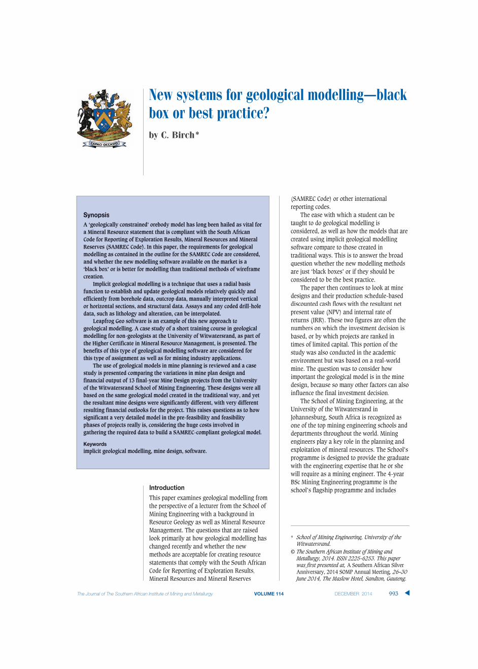
Traditional wireframingTraditional models are created using wireframes based ongeological logging of boreholes. This type of modelling istime-consuming and a good understanding of the geology isneeded to make it effective. To create this type of model, theorebody is sliced into sections and the orebody intersectionsof the boreholes are linked by strings (Figure 1).
The method is time-consuming, and very repetitive, andrelies on a fair amount of interpretation by the modeller whilelinking the strings. After the entire orebody has beeninterpreted, the strings are linked together to form thewireframes. This process must then be carefully checked toensure there are no cross-over strings or openings as this willprevent the modelling software (e.g. Datamine) from fillingggthe wireframe volumes with blocks that are needed for theevaluation, as shown in Figure 2.
▲
994 DECEMBER 2014 VOLUME 114 The Journal of The Southern African Institute of Mining and Metallurgy
Figure 1—Section showing drill-holes with strings linking the orebodies(hand wireframing) (Birch, 2011)

If the initial borehole logging was done by inexperiencedgeologists who interpret the geology incorrectly, the computermodelling and orebody evaluation will not be effective.
IImplicit geological modelling
Implicit geological modelling is a technique that uses a radialbasis function to establish and update geological modelsrelatively quickly and efficiently from borehole data, outcropdata, manually interpreted vertical or horizontal sections, andstructural data.
The radial basis function allows scattered 3D data pointsto be described by a single mathematical function. Modelscan be isotropic, meaning without any trends or directionalbias, or anisotropic, based on planar, linear, or more complexstructural trends. Assays and any coded drill-hole data, suchas lithology and alteration, can be interpolated (Hodkiewicz,2013).
A commonly used software package for implicit geologicalmodelling is Leapfrog Geo (Leapfrog, 2010).
BBenefits of implicit geological modelling overtraditional wireframingAA comparison of implicit geological modelling and thetraditional method of hand digitization is shown in Table I.
fThis simple comparison of the two methods illustratesthat there is no basis to the claim that traditional digitizationis superior to implicit geological modelling for the generationof geological models. Table II shows that implicit geologicalmodelling methods are in fact superior to hand digitization.
In modelling of true 3D objects, such as orebodies,interpolation methods in implicit geological modelling do notrely on sectional information to produce a 3D model. This isone of the major weaknesses of traditional modelling wherethe 3D model is built up from a series of sectional interpre-tations (Cowan, 2010).
International reporting codesInvestors have become far more circumspect in investing inmineral projects following scandals like Bre-X (Cawood,2004). This has led to the introduction of various reportingcodes, which are essentially aimed at protecting investors andholding professionals responsible for the figures that theyrelease in the public domain. Compliance with these codes isconsidered a prerequisite for public listing on variousinternational stock markets like Toronto (TSX), Australia(ASX), and the Johannesburg Securities Exchange (JSE).Codes, as opposed to laws, allow for professional judgment,and a good guide as to what is acceptable is doing what areasonable person would do. To ensure compliance with thisprinciple, mineral resource practitioners try to follow best-practice principles as far as practically possible, because thismakes it easier to justify the decisions to professional peers ifcalled upon to do so.
There are several classification schemes worldwide,including:
➤ Canadian CIM classification (NI 43-101)➤ Australasian Joint Ore Reserves Committee Code (JORC
Code)➤ South African Code for the Reporting of Mineral
Resources and Mineral Reserves (SAMREC Code).
In this paper, the SAMREC Code has been used forillustration purposes, but the other codes share the samedefinitions and broadly follow the same requirements forcompliance. Figure 3 shows the relationship between mineraloccurrences, Inferred, Indicated, and Measured resources, aswell as the modifying factors required to convert Resourcesinto Reserves.
New systems for geological modelling–black box or best practice?
995The Journal of The Southern African Institute of Mining and Metallurgy VOLUME 114 DECEMBER 2014 ▲
Figure 2—Datamine wireframes manually created from boreholeintersections (Birch, 2011)
Table I
Traditional wireframing compared with implicit geological modelling
Aspect Hand wireframing Implicit modelling
DH contact honouring Yes (manual) Yes (automated)
Minimum curvature fit between points No. Only straight lines. Curvatures are manually digitized Yes
Modelling speed Slow Very fast
True 3D modelling, i.e. drill-hole sectional No. Limited to sectional digitization Yes. Not limited to sectional interpretation
fences are not needed
Models can be replicated No. Manual digitization cannot be replicated Yes, given the same variables
Can multiple models be generated from Yes, but not very practical as it is very time-consuming Yes
the same data?
No. Manual digitization cannot be replicated
Yes, but not very practical as it is very time-consuming
New systems for geological modelling–black box or best practice?
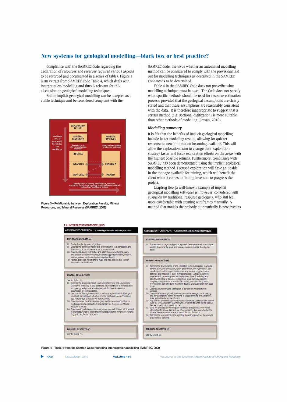
Compliance with the SAMREC Code regarding thedeclaration of resources and reserves requires various aspectsto be recorded and documented in a series of tables. Figure 4is an extract from SAMREC Code Table 4, which deals withinterpretation/modelling and thus is relevant for thisdiscussion on geological modelling techniques.
Before implicit geological modelling can be accepted as avviable technique and be considered compliant with the
SAMREC Code, the issue whether an automated modellingmethod can be considered to comply with the provisions laidout for modelling techniques as described in the SAMRECCode needs to be determined.
Table 4 in the SAMREC Code does not prescribe whatmodelling technique must be used. The Code does not specifywhat specific methods should be used for resource estimationprocess, provided that the geological assumptions are clearlystated and that these assumptions are reasonably consistentwith the data. It is therefore inappropriate to suggest that acertain method (e.g. sectional digitization) is more suitablethan other methods of modelling (Cowan, 2010).
Modelling summaryIt is felt that the benefits of implicit geological modellinginclude faster modelling results, allowing for quickerresponse to new information becoming available. This willallow the exploration team to change their explorationstrategy faster and focus exploration efforts on the areas withthe highest possible returns. Furthermore, compliance withSAMREC has been demonstrated using the implicit geologicalmodelling method. Focused exploration will have an upsidein the tonnage available for mining, which will benefit theclient when it comes to finding investors to progress theproject.
Leapfrog Geo (a well-known example of implicitgeological modelling software) is, however, considered withsuspicion by traditional resource geologists, who still feelmore comfortable with creating wireframes manually. Amethod that models the orebody automatically is perceived as
▲
996 DECEMBER 2014 VOLUME 114 The Journal of The Southern African Institute of Mining and Metallurgy
Figure 4—Table 4 from the Samrec Code regarding interpretation/modelling (SAMREC, 2009)
Figure 3—Relationship between Exploration Results, MineralResources, and Mineral Reserves (SAMREC, 2009)

a ‘black box’, and errors in data capturing and input will notbe picked up. It is felt, however, that similar input errors cancompromise the current method also, especially where theperson doing the initial core logging is not skilled. Ultimately,any method must be checked, double-checked, and thenindependently verified.
Case study – can a non-geologist produce a validgeological model?
The School of Mining Engineering at the University of theWWitwatersrand offers a Certificate in Mineral ResourceManagement (MRM). The MRM programme is a 2-yearmodular programme that was developed in close collabo-ration with industry and is aimed at filling a competency gapin the field of MRM. Delegates who successfully complete theprogramme obtain a certificate of competency in MineralResource Management. The programme is also a steppingstone to a postgraduate qualification at the School of MiningEngineering. Delegates may also register for specificindividual modules and receive a certificate of competence inthe module (University of the Witwatersrand, 2013). Not allthe delegates on the programme are from a mining technicalbackground.
Geological modelling moduleThe MRM 5 module is an introduction to geological modellingand students are evaluated via examination and a practicalassignment using Leapfrog Geo software. The practicalassignment was based on a borehole data-set from theMerensky Reef supplied by Leapfrog South Africa. LeapfrogSouth Africa personnel modified the data-set to include someobvious and not-so-obvious errors. The students had tovalidate the data and produce a geological model. They weregiven strict instructions regarding the colour coding and howthe output was to be presented. This module was presentedin September 2013 by the author.
The focus of the assessment was ascertaining that thedata errors were all identified and rectified. A detailed reporton these errors was required. The model also had to becompliant to the ‘client’ requirements regarding colours andthe format of the final output files. The models created by thestudents were furthermore compared to the model created bythe author for accuracy. Figure 5 shows the author’s model.
Figure 6 shows one of the models created by a student onthe MRM 5 programme. This student had no previousgeological modelling experience prior to attending MRM 5,and is an employee in the legal department one of the largemining companies.
New systems for geological modelling–black box or best practice?
The Journal of The Southern African Institute of Mining and Metallurgy VOLUME 114 DECEMBER 2014 997 ▲
Figure 6—Answer for MRM 5 assignment by a student with no technical experience (University of the Witwatersrand, 2013)
Figure 5—Model answer for MRM 5 assignment exercise (University of the Witwatersrand, 2013)

New systems for geological modelling–black box or best practice?
As can be observed, all the major data errors wereidentified and rectified and the resultant model is visuallysimilar to the model created by the module presenter. Thistype of deposit is traditionally difficult to model usingtraditional wireframe methods due to the very thin nature ofthe economic horizon. Leapfrog Geo allows the modeller toidentify the age relationships between the various lithologies,and then creates the stratigraphic sequence automaticallyfrom the borehole intersections. The fault is digitized fromthe surface mapping and when activated, the displacement isautomatically determined.
For an experienced modeller, this assignment could becompleted in a very short period of time. The processfollowed for an entire deposit, would be the same as for thisassignment, but just on a larger scale. As new data is loadedinto the database, the model would be updated automatically.The most important component of the modelling process isdata verification and ensuring the database is accurate. Mosterrors are easily identified in the model and thus the ability toquickly create a model goes a long way towards ensuring thatthe final model is accurate.
How important is the geological model in the minedesign?
The international reporting codes require extensive documen-tation and compliance regarding the quality of the sampledata and how it is collected, stored, and processed. This leadsinto the modelling and evaluation techniques used until theoutput of the classified resource statement is obtained. TheSAMREC Code in South Africa is the guide to what is anacceptable level of detail for this statement (SAMREC, 2009).For the conversion of Mineral Resources to Mineral Reserves,the modifying factors must be stated and justified. Theseinclude the following:
➤ Mining methods➤ Minimum mining dimensions➤ Mining dilution mining method➤ Mine design criteria➤ Infrastructure➤ Capacities➤ Production schedule➤ Mining efficiencies➤ Grade control➤ Geotechnical and hydrological considerations➤ Closure plans➤ Personnel requirements.
The whole scheduling aspect of a mine design is critical inconverting the Mineral Resource into a monetary value due tothe considerations of the time value of money (and resultantnet present value, NPV, and internal rate of return, IRR).
This paper considers how assumptions made during themine design and scheduling process can affect the financialoutlook of a project at the pre-feasibility study (PFS) stage,using the School of Mining Engineering Final Mine DesignProject as a case study. Thirteen groups of students weregiven the same geological model as a starting point for theirmine designs. This model can be considered a perfect
f f frepresentation of the orebody for the purposes of this project,as they were not required to recreate or verify this model aspart of their project. In reality, when a group of consultantsdo pre-feasibility studies on an orebody, each consultantwould create their own geological model, which adds a wholelayer of variation when comparing the results. The minedesign exercise presents a fairly unique opportunity tocompare 13 interpretations of the same geological modeltaken to PFS level. In the corporate world, due to the costsinvolved, a company would never commission 13 differentmine designs.
Final Mine Design ProjectSeventy final-year students were split into 13 groups with 5or 6 members in each group. According to the brief given atthe start of the project, the students had to carry out a minedesign exercise to the level of a PFS based on the mineraldeposit block model supplied to them. They were to utilize theknowledge gained over their previous coursework, as well asexperience gained during vacation work, to complete theproject. They then had to make a substantiated recommen-dation regarding the viability of mining the deposit. Thefinancial aspects of the project were thus critical, as well asthe technical aspects. For 2013, the final mine design projectwas the Lily Gold Mine, close to Barberton in the eastern partof South Africa.
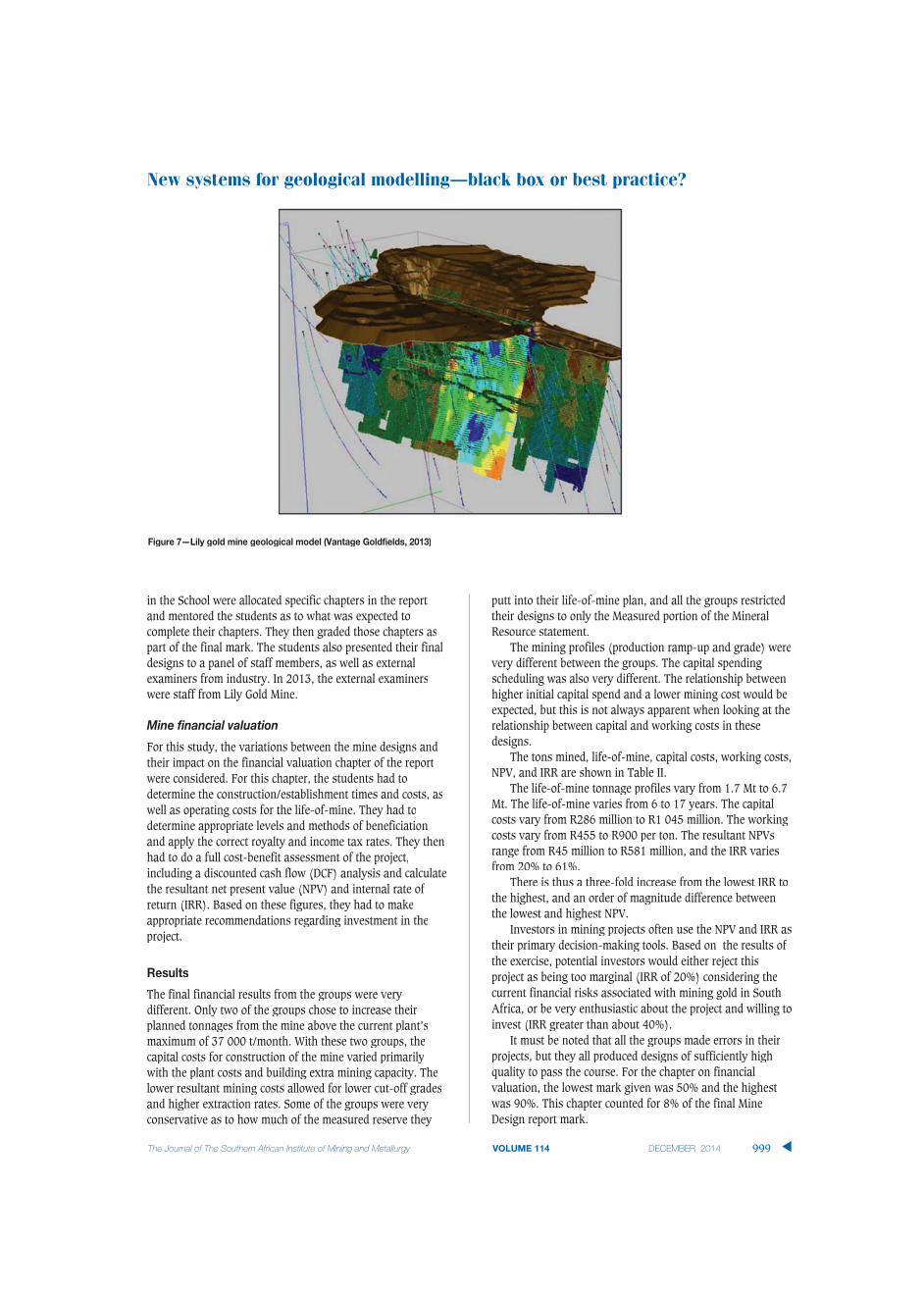
The students were supplied with a high-quality geologicalblock model of the deposit created by the mine geologicalteam (Figure 7). For purposes of this study, this block modelcan be considered to be perfect, as they all were given thesame model and accepted it as a true representation of thedeposit.
Lily Gold Mine
The Lily Mine began as an open pit operation in 2000. Theopen pit closed down in 2008 after producing more than 100000 ounces of gold. The orebody extends for at least 2000 malong strike and has been drilled to a depth of approximately700 m. A detailed geological model was created by the mineand was presented to the students for their mine plan(Figure 7). The current underground mine design has beenconstrained due to available capital, and the students wereexpected to take this into account and thus come up withdesigns significantly different due to the removal of thisconstraint.
Mine Design report
The students were instructed to start their designs at thestage where the mine began underground operations and theplant had a maximum capacity of 37 000 t/month. If theywished to increase the plant capacity, they would have tobudget for this increase in their mine design. The studentswere given the geological model as generated prior to theunderground development; based on the sampling in the pitas well as the surface diamond drill-holes (Figure 7). Thefinal report presented to the School of Mining was to cover allthe aspects of a mine design and was expected to be at a levelof detail that would be acceptable as a PFS. Most of the staff
▲
998 DECEMBER 2014 VOLUME 114 The Journal of The Southern African Institute of Mining and Metallurgy
fin the School were allocated specific chapters in the reportand mentored the students as to what was expected tocomplete their chapters. They then graded those chapters aspart of the final mark. The students also presented their finaldesigns to a panel of staff members, as well as externalexaminers from industry. In 2013, the external examinerswwere staff from Lily Gold Mine.
MMine financial valuation
For this study, the variations between the mine designs andtheir impact on the financial valuation chapter of the reportwwere considered. For this chapter, the students had todetermine the construction/establishment times and costs, aswwell as operating costs for the life-of-mine. They had todetermine appropriate levels and methods of beneficiationand apply the correct royalty and income tax rates. They thenhad to do a full cost-benefit assessment of the project,including a discounted cash flow (DCF) analysis and calculatethe resultant net present value (NPV) and internal rate ofreturn (IRR). Based on these figures, they had to makeappropriate recommendations regarding investment in theproject.
Results
The final financial results from the groups were verydifferent. Only two of the groups chose to increase theirplanned tonnages from the mine above the current plant’smaximum of 37 000 t/month. With these two groups, thecapital costs for construction of the mine varied primarilywwith the plant costs and building extra mining capacity. Thelower resultant mining costs allowed for lower cut-off gradesand higher extraction rates. Some of the groups were veryconservative as to how much of the measured reserve they
f fputt into their life-of-mine plan, and all the groups restrictedtheir designs to only the Measured portion of the MineralResource statement.
The mining profiles (production ramp-up and grade) werevery different between the groups. The capital spendingscheduling was also very different. The relationship betweenhigher initial capital spend and a lower mining cost would beexpected, but this is not always apparent when looking at therelationship between capital and working costs in thesedesigns.
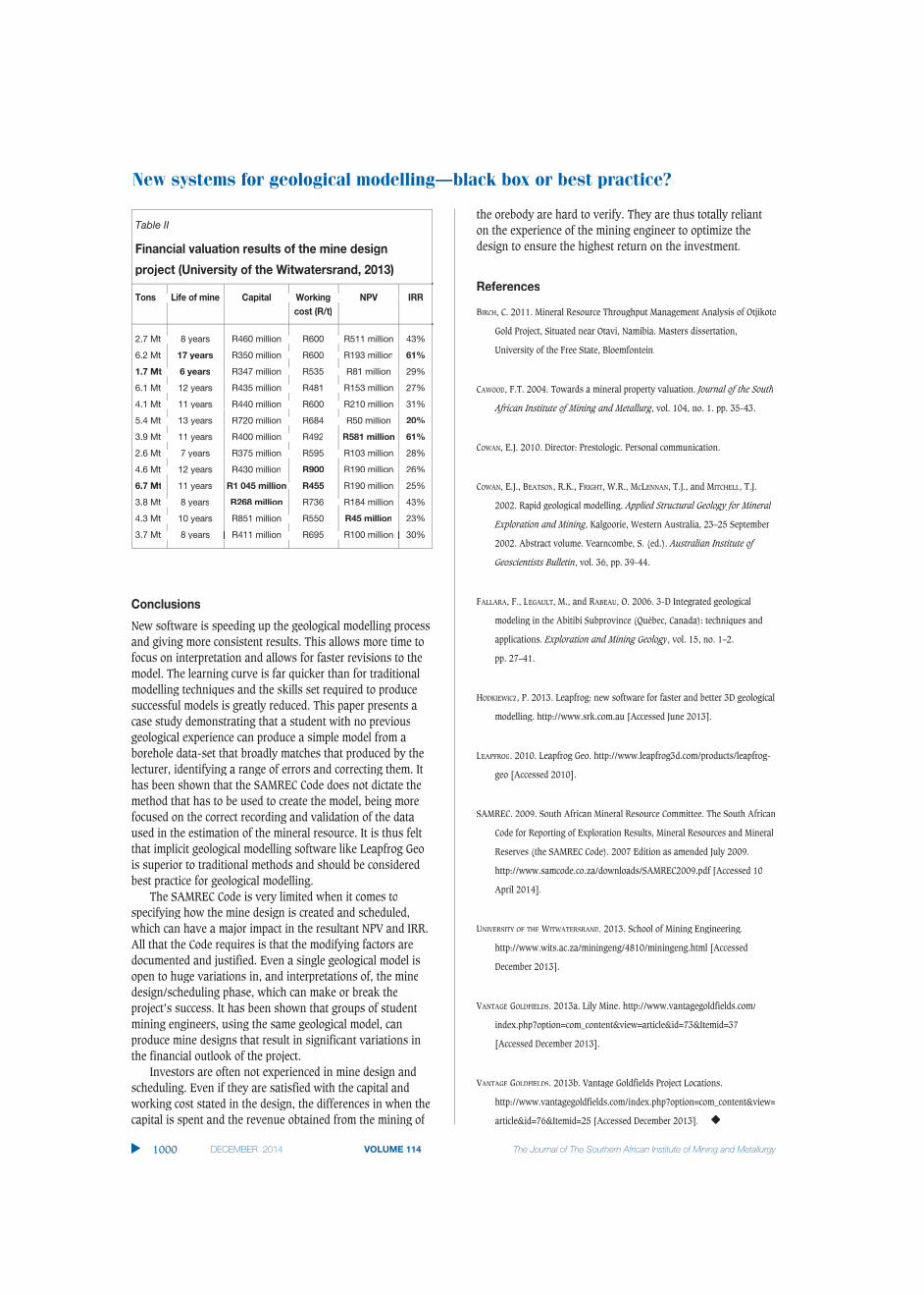
The tons mined, life-of-mine, capital costs, working costs,NPV, and IRR are shown in Table II.
The life-of-mine tonnage profiles vary from 1.7 Mt to 6.7Mt. The life-of-mine varies from 6 to 17 years. The capitalcosts vary from R286 million to R1 045 million. The workingcosts vary from R455 to R900 per ton. The resultant NPVsrange from R45 million to R581 million, and the IRR variesfrom 20% to 61%.
There is thus a three-fold increase from the lowest IRR tothe highest, and an order of magnitude difference betweenthe lowest and highest NPV.
Investors in mining projects often use the NPV and IRR astheir primary decision-making tools. Based on the results ofthe exercise, potential investors would either reject thisproject as being too marginal (IRR of 20%) considering thecurrent financial risks associated with mining gold in SouthAfrica, or be very enthusiastic about the project and willing toinvest (IRR greater than about 40%).
It must be noted that all the groups made errors in theirprojects, but they all produced designs of sufficiently highquality to pass the course. For the chapter on financialvaluation, the lowest mark given was 50% and the highestwas 90%. This chapter counted for 8% of the final MineDesign report mark.
New systems for geological modelling–black box or best practice?
The Journal of The Southern African Institute of Mining and Metallurgy VOLUME 114 DECEMBER 2014 999 ▲
Figure 7—Lily gold mine geological model (Vantage Goldfields, 2013)
New systems for geological modelling–black box or best practice?
Conclusions
New software is speeding up the geological modelling processand giving more consistent results. This allows more time tofocus on interpretation and allows for faster revisions to themodel. The learning curve is far quicker than for traditionalmodelling techniques and the skills set required to producesuccessful models is greatly reduced. This paper presents acase study demonstrating that a student with no previousgeological experience can produce a simple model from aborehole data-set that broadly matches that produced by thelecturer, identifying a range of errors and correcting them. Ithas been shown that the SAMREC Code does not dictate themethod that has to be used to create the model, being morefocused on the correct recording and validation of the dataused in the estimation of the mineral resource. It is thus feltthat implicit geological modelling software like Leapfrog Geois superior to traditional methods and should be consideredbest practice for geological modelling.
The SAMREC Code is very limited when it comes tospecifying how the mine design is created and scheduled,wwhich can have a major impact in the resultant NPV and IRR.All that the Code requires is that the modifying factors aredocumented and justified. Even a single geological model isopen to huge variations in, and interpretations of, the minedesign/scheduling phase, which can make or break theproject’s success. It has been shown that groups of studentmining engineers, using the same geological model, canproduce mine designs that result in significant variations inthe financial outlook of the project.
Investors are often not experienced in mine design andscheduling. Even if they are satisfied with the capital andwworking cost stated in the design, the differences in when thecapital is spent and the revenue obtained from the mining of
fthe orebody are hard to verify. They are thus totally relianton the experience of the mining engineer to optimize thedesign to ensure the highest return on the investment.
References
BIRCH, C. 2011. Mineral Resource Throughput Management Analysis of Otjikoto
Gold Project, Situated near Otavi, Namibia. Masters dissertation,
University of the Free State, Bloemfontein.
CAWOOD, F.T. 2004. Towards a mineral property valuation. Journal of the South
African Institute of Mining and Metallurg, vol. 104, no. 1. pp. 35-43.gg
COWAN, E.J. 2010. Director: Prestologic. Personal communication.
COWAN, E.J., BEATSON, R.K., FRIGHT, W.R., MCLENNAN, T.J., and MITCHELL, T.J.
2002. Rapid geological modelling. Applied Structural Geology for Mineral
Exploration and Mining, Kalgoorie, Western Australia, 23–25 Septembergg
2002. Abstract volume. Vearncombe, S. (ed.). Australian Institute of
Geoscientists Bulletin, vol. 36, pp. 39-44.
FALLARA, F., LEGAULT, M., and RABEAURR , O. 2006. 3-D Integrated geological
modeling in the Abitibi Subprovince (Québec, Canada): techniques and
applications. Exploration and Mining Geology, vol. 15, no. 1–2.
pp. 27–41.
HODKIEWICZ, P. 2013. Leapfrog: new software for faster and better 3D geological
modelling. http://www.srk.com.au [Accessed June 2013].
LEAPFROG. 2010. Leapfrog Geo. http://www.leapfrog3d.com/products/leapfrog-
geo [Accessed 2010].
SAMREC. 2009. South African Mineral Resource Committee. The South African
Code for Reporting of Exploration Results, Mineral Resources and Mineral
Reserves (the SAMREC Code). 2007 Edition as amended July 2009.
http://www.samcode.co.za/downloads/SAMREC2009.pdf [Accessed 10
April 2014].
UNIVERSITY OF THE WITWATERSRANDWW . 2013. School of Mining Engineering.
http://www.wits.ac.za/miningeng/4810/miningeng.html [Accessed
December 2013].
VANTAGEVV GOLDFIELDS. 2013a. Lily Mine. http://www.vantagegoldfields.com/
index.php?option=com_content&view=article&id=73&Itemid=37
[Accessed December 2013].
VANTAGEVV GOLDFIELDS. 2013b. Vantage Goldfields Project Locations.
http://www.vantagegoldfields.com/index.php?option=com_content&view=
article&id=76&Itemid=25 [Accessed December 2013]. ◆
▲
1000 DECEMBER 2014 VOLUME 114 The Journal of The Southern African Institute of Mining and Metallurgy
Table II
Financial valuation results of the mine design
project (University of the Witwatersrand, 2013)
Tons Life of mine Capital Working NPV IRRcost (R/t)
2.7 Mt 8 years R460 million R600 R511 million 43%
6.2 Mt 17 years R350 million R600 R193 million 61%
1.7 Mt 6 years R347 million R535 R81 million 29%
6.1 Mt 12 years R435 million R481 R153 million 27%
4.1 Mt 11 years R440 million R600 R210 million 31%
5.4 Mt 13 years R720 million R684 R50 million 20%
3.9 Mt 11 years R400 million R492 R581 million 61%
2.6 Mt 7 years R375 million R595 R103 million 28%
4.6 Mt 12 years R430 million R900 R190 million 26%
6.7 Mt 11 years R1 045 million R455 R190 million 25%
3.8 Mt 8 years R268 million R736 R184 million 43%
4.3 Mt 10 years R851 million R550 R45 million 23%
3.7 Mt 8 years R411 million R695 R100 million 30%8 years R411 million R695 R100 million