new washington school
TRANSCRIPT

New Washington School Historic District Plan

Section 2: Individual Historic District PlansNew Washington School Historic District Plan 247
Sacramento Historic District Plans Final
Physical Description & Boundaries
The New Washington School Historic District (formerly Washington School Historic District) is located within Sacramento’s original 1848 street grid and is roughly bounded to west by commercial development along 16th Street, to the north by the Blue Diamond Growers industrial facilities, to the east by the railroad tracks between 19th and 20th streets, to the south by mixed commercial and institutional development along H Street.
Figure 188. Modestly-sized houses, such as these Neoclassical Row Houses on 19th and D streets, are common on the northern border of the district.
Figure 189. The current Washington School building occupies the block between E, F, 17th, and 18th streets.
Figure 190. The largest houses in the district, such as these on F and 17th streets, are often located on street corners.
Figure 191. A few two-story apartment buildings sit side-by-side on G Street.
Section 2: Individual Historic District PlansNew Washington School Historic District Plan 248
Sacramento Historic District Plans Final
Brief Historic Context
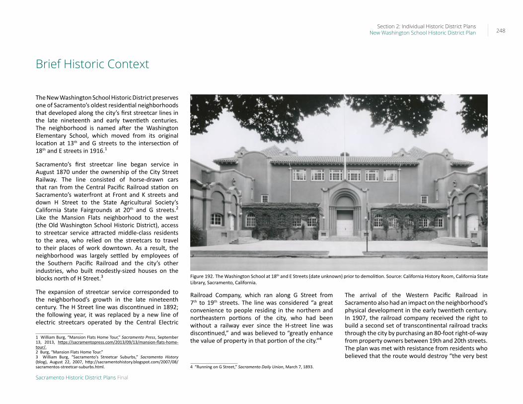
The New Washington School Historic District preserves one of Sacramento’s oldest residential neighborhoods that developed along the city’s first streetcar lines in the late nineteenth and early twentieth centuries. The neighborhood is named after the Washington Elementary School, which moved from its original location at 13th and G streets to the intersection of 18th and E streets in 1916.1
Sacramento’s first streetcar line began service in August 1870 under the ownership of the City Street Railway. The line consisted of horse-drawn cars that ran from the Central Pacific Railroad station on Sacramento’s waterfront at Front and K streets and down H Street to the State Agricultural Society’s California State Fairgrounds at 20th and G streets.2 Like the Mansion Flats neighborhood to the west (the Old Washington School Historic District), access to streetcar service attracted middle-class residents to the area, who relied on the streetcars to travel to their places of work downtown. As a result, the neighborhood was largely settled by employees of the Southern Pacific Railroad and the city’s other industries, who built modestly-sized houses on the blocks north of H Street.3
The expansion of streetcar service corresponded to the neighborhood’s growth in the late nineteenth century. The H Street line was discontinued in 1892; the following year, it was replaced by a new line of electric streetcars operated by the Central Electric
1 William Burg, “Mansion Flats Home Tour,” Sacramento Press, September 13, 2013, https://sacramentopress.com/2013/09/13/mansion-flats-home-tour/.2 Burg, “Mansion Flats Home Tour.”3 William Burg, “Sacramento’s Streetcar Suburbs,” Sacramento History (blog), August 22, 2007, http://sacramentohistory.blogspot.com/2007/08/sacramentos-streetcar-suburbs.html.
Railroad Company, which ran along G Street from 7th to 19th streets. The line was considered “a great convenience to people residing in the northern and northeastern portions of the city, who had been without a railway ever since the H-street line was discontinued,” and was believed to “greatly enhance the value of property in that portion of the city.”4
4 “Running on G Street,” Sacramento Daily Union, March 7, 1893.
The arrival of the Western Pacific Railroad in Sacramento also had an impact on the neighborhood’s physical development in the early twentieth century. In 1907, the railroad company received the right to build a second set of transcontinental railroad tracks through the city by purchasing an 80-foot right-of-way from property owners between 19th and 20th streets. The plan was met with resistance from residents who believed that the route would destroy “the very best
Figure 192. The Washington School at 18th and E Streets (date unknown) prior to demolition. Source: California History Room, California State Library, Sacramento, California.

Section 2: Individual Historic District PlansNew Washington School Historic District Plan 249
Sacramento Historic District Plans Final
residence district” in the city.5 The Western Pacific proposed mitigating the effects of a rail line running through the center of the city by landscaping the right-of-way into a parkway and building elevated pedestrian crossings, but the landscaping proposals were never realized. Freight service began on the new rail line in 1909, and passenger service followed a year later.6
In 1916, Washington Elementary School relocated from the corner of 13th and G streets to the block bounded by E, F, 17th, and 18th streets, giving its name to the surrounding neighborhood. A new Mission
5 “Southside People Now Protest Against Western Pacific,” Sacramento Union, September 16, 1907.6 William Burg, Sacramento’s K Street: Where Our City Was Born (Charleston, SC: The History Press, 2012, 62-64.
Revival style building was completed on the site shortly after. The school’s relocation was an indication of the area’s growing population and the need to provide public services to the local community.
By the 1920s, major transportation corridors had developed that roughly correspond to the present-day historic district’s boundaries. In 1923, streetcar lines ran down G Street to 19th Street and along D Street between 15th and 19th streets, then north along 19th Street to C Street. Sixteenth Street, which formed the neighborhood’s western boundary, and a portion of D Street had also been incorporated into the state highway system by this period. The Western Pacific rail tracks marked the neighborhood’s eastern boundary.7
7 Cyrus G. Brown Maps and Aero Views Commercial Artists, “Map of the City of Sacramento [map], 1923.
Residents continued to consist primarily of middle-class workers, such as clerks, printers, stenographers, electricians, and carpenters, who lived in modest single-family houses or multi-unit flats.8
Residential development slowed during the Great Depression. The economic downswing, combined with the rising popularity of the automobile, led to the decline of streetcar lines across the city. In 1936, streetcar service along G Street ended and was replaced by bus service.9 After World War II, many residents migrated out of the city’s central grid to newer residential suburbs outside the city limits and were replaced by lower-income residents. Multi-unit apartment buildings were constructed in greater numbers over the following decades in response to the demographic shift.
In 1975, Washington Elementary School building was demolished; the following year, it was replaced by a new building at the same location. In 2013, the City closed the school in an effort to save money in the face of budget cuts after years of declining enrollment. Local residents responded to the decision with grassroots opposition efforts and lawsuits, and, in 2016, the school reopened with a new STEAM (science, technology, engineering, arts, and math) curriculum. City leaders viewed the school’s reopening as “a vital step” in its efforts to attract families back into the central city.10
8 Sacramento City Directory, Sacramento Directory Co., 1921.9 Burg, Sacramento’s Streetcars, 34.10 Loretta Kalb and Ryan Lillis, “Washington Elementary School set to reopen in 2016 in midtown Sacramento,” Sacramento Bee, June 15, 2015, https://www.sacbee.com/news/local/education/article24520912.html.
Figure 193. View looking north along the Western Pacific Railroad tracks between 19th and 20th streets with the railroad’s depot on the left (1910). Source: Library & Archives, California State Railroad Museum Library, Sacramento, CA.
Section 2: Individual Historic District PlansNew Washington School Historic District Plan 250
Sacramento Historic District Plans Final
Significance
The New Washington School Historic District was designated for listing on the Sacramento Register of Historic and Cultural Resources by the City Preservation Commission in 1985 in Ordinance #85-076 as the Washington School Historic District.
The following table provides a current evaluation of significance under the requirements and considers the factors based on the above historic district context and the 2018 historic district survey. Additionally, this historic district relates to the Railroad Context Statement of the city’s General Plan Technical Background Report.
(B) Listing on the Sacramento Register – Historic districts
(1) Requirements (a) The New Washington School Historic District meets requirement (a) for listing on the Sacramento Register, because
it is a geographically definable area.
(b)(i) The New Washington School Historic District meets requirement (b)(i) for listing on the Sacramento Register as an area that possesses “a significant concentration or continuity of buildings unified by: (A) past events or (B) aesthetically by plan or physical development.”
The district is significant for its collection of late nineteenth- and early twentieth-century houses that were built as part of a middle-class neighborhood that emerged directly to the east of Sacramento’s older residential neighborhoods as streetcar lines expanded outward from the city center. While the establishment of a streetcar line on H Street in the 1870s and on G Street in the 1890s initially attracted the larger houses of the city’s affluent residents, areas further to the north of the streetcar lines were filled with the smaller houses of employees of the city’s railyards and other industries. The relocation of the Washington School from G and 13th streets to the block between E, F, 17th, and 18th streets in 1916 indicates the neighborhood’s burgeoning population in the early twentieth century. Meanwhile, the construction of the Western Pacific Railroad’s tracks on a right-of-way between 19th and 20th streets in 1907 created a physical barrier that continues to define the neighborhood’s eastern boundary. The range of architectural styles present in the district, ranging from Victorian-era Italianate and Queen Anne style houses to 1930s Minimal Traditional cottages, reflects the area’s peak period of development prior to the departure of the streetcars in 1936 and the exodus of residents to newer automobile-oriented suburbs further from the city center.
Section 2: Individual Historic District PlansNew Washington School Historic District Plan 251
Sacramento Historic District Plans Final
(B) Listing on the Sacramento Register – Historic districts
(1) Requirements (b)(ii) The New Washington School Historic District meets requirement (b)(ii) for listing on the Sacramento Register as an
area “associated with an event, person, or period significant or important to city history.”
The district is associated with the development of new residential neighborhoods along the city’s streetcar lines from the late nineteenth to mid-twentieth century. The neighborhood grew alongside Sacramento’s first streetcar line, which began operation in 1870 and initially ran down H Street before shifting to G Street in 1893. Prior residential development in Sacramento had been primarily concentrated in the central business district downtown, where the commercial waterfront, railyards, industries, and state government offices were located. The availability of employment opportunities attracted large numbers of people to the downtown area who not only worked in the businesses downtown but often lived in the immediate area. As these areas became increasingly overcrowded and polluted, neighborhoods to the east, such as the Washington neighborhood, became attractive alternatives. Streetcars enabled workers who were employed by businesses downtown to live further from the city center, resulting in the establishment of new residential areas further to the east and the beginning of an exodus of residents from the downtown area. The relocation of the Washington School in 1916, approximately five blocks east of its former location to a one-block site within the present New Washington School Historic District, reflects the movement of Sacramento’s population further to the east in the early twentieth century.
(c) The New Washington School Historic District meets requirement (c) for listing on the Sacramento Register as it aligns with the goals and purposes of historic preservation in Sacramento, as well as the city’s other goals and policies. Per the Sacramento City Code, the preservation of the district enhances the “city’s economic, cultural and aesthetic standing, its identity and its livability, marketability, and urban character.”
(B) Listing on the Sacramento Register – Historic districts
(2) Factors to be considered(a) Factor (2)(a) states that “a historic district should have integrity of design, setting, materials, workmanship and
association.” The New Washington School Historic District retains sufficient integrity to meet this factor for consideration as a historic district.
(b) Factor (2)(b) states that “the collective historic value of the buildings and structures in a historic district taken together may be greater than the historic value of each individual building or structure.” The New Washington School Historic District meets this factor because its buildings and structures represent a significant and distinguishable entity whose collective historic value is greater when taken as a whole.
Period of Significance: 1870-1936The period of significance for the New Washington School Historic District begins with the start of streetcar service to the area in 1870, which attracted residential development to the area, and concludes in 1936, when streetcar service ended along G Street.
Property Types from the Period of Significance
• Residential
Architectural Styles from the Period of Significance
• Italianate
• Stick/Eastlake
• Queen Anne
• Shingle
• Folk Victorian
• Colonial Revival
• Classical Revival
• Classic Box
• Beaux Arts
• French Eclectic
• Spanish Revival
• Prairie
• Craftsman
• Minimal Traditional
• Vernacular
• Landscape

Section 2: Individual Historic District PlansNew Washington School Historic District Plan 252
Sacramento Historic District Plans Final
Character-Defining Features
Element Character of Historic DistrictUse • Historically single-family residences, some converted into
multi-family units, interspersed with a few multi-unit apartments and commercial businesses
• Parking, infill development, and auxiliary uses located along alleys
Mass & Form • Typically, one-to-two stories tall over a raised basement• Some larger, three-story multi-unit apartment buildings • Predominately houses with Delta-style high basement and
raised first story• Largest, most elaborate houses situated on corner lots
Cladding • Predominately wood siding, typically wide and narrow width channel rustic siding, three- or four-lap siding, or shingles, especially on upper stories and gabled ends
Roofs • Front-facing gabled, hipped, or jerkinhead roofs, often with a low, centrally placed dormer
• Brick or clinker brick chimneysEntries & Doors • Delta-style configuration with staircases leading to primary
entrances above a high basement• Paneled wood doors, often with a transom above, or
integrated glazing• Wood, terrazzo, or brick stairs
Windows • Wood-frame double-hung windows• Bay windows, both front- and side-facing• Stained glass and spiderweb windows as occasional
decorative accentPorches • Prominent full or half-width porches accessed by a
staircase• Brick or clinker brick chimneys, foundations, and column
bases
Element Character of Historic District
Ornamentation • Italianate, Queen Anne, Stick/Eastlake details, including incised brackets; spindlework; turned columns; patterned shingles at gabled ends; and rounded windows
• Classical Revival details, including Tuscan columns• Craftsman details, including exposed rafter and purlin
tails, wood braces, tapered square columns, and low shed dormers
Property Landscape
• Gardens, lawns, or patios in front of houses • Low fences in front of many houses, mostly wood picket or
wrought iron and some with brick piers • Some brick paved front patios• Few surviving iron letterboxes
Streetscape • Varying setbacks ranging from 25 feet or less in front of apartment buildings to 40 feet in front of some older Italianate houses; in general setbacks are smaller on numbered streets (approximately 30 feet) and larger on lettered streets (more than 30 feet)
• Rows of deciduous street trees of varying types and sizes—most often sycamore, elm, and palm trees—planted in a parking strip along the street curb; some blocks with surviving, cohesive rows of mature elm or sycamore trees
• Some brick-paved parking strips• Horse-head hitching posts and evidence of removed
hitching posts in the form of L-shaped cement strips next to the street curb, especially on F and G streets
Section 2: Individual Historic District PlansNew Washington School Historic District Plan 253
Sacramento Historic District Plans Final
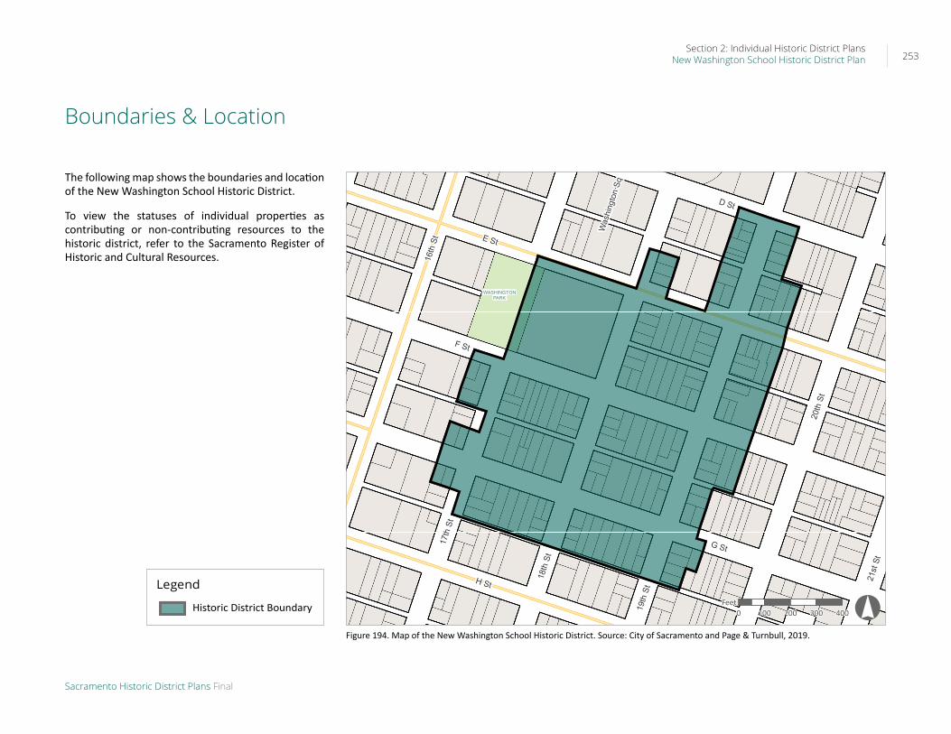
Boundaries & Location
The following map shows the boundaries and location of the New Washington School Historic District.
To view the statuses of individual properties as contributing or non-contributing resources to the historic district, refer to the Sacramento Register of Historic and Cultural Resources.
WASHINGTONPARK
16th
St E St
H St
17th
St
20th
St
18th
St
21st
St
D St
G St
F St
Was
hing
ton
Sq
19th
St
Historic District Boundary
0 100 200 300 400Feet !°
Figure 194. Map of the New Washington School Historic District. Source: City of Sacramento and Page & Turnbull, 2019.
Legend
Historic District Boundary

Section 2: Individual Historic District PlansNew Washington School Historic District Plan 254
Sacramento Historic District Plans Final
District-Specific Standards & Criteria
Design Principle
Preserve and maintain the contributing resources and features that define the district while encouraging new development that enhances its historic residential character and livability.
Rationale
The New Washington School Historic District contains a collection of single- and multi-family residential buildings that are part of a historic neighborhood that dates back to the late nineteenth century. It also includes Washington Park and the Washington School. While the contributing buildings exhibit a mix of architectural styles, the similar use of materials, scale, setback, landscaping, and siting unite the grouping as a whole. The district’s location between two major transportation corridors, 16th Street and the railroad tracks between 19th and 20th streets, introduce potential development pressures to the east and west.
1. Rehabilitation of Contributing Resources
1.1 Maintain, preserve, and, where necessary, repair and restore historic elements associated with the predominate Delta style of residential architecture, especially historic staircases, porches, and doors.
2. Additions & Accessory Structures for Contributing Resources
2.1 Avoid additions that cause a contributing building’s height to exceed 150% of its historic height.
• Use step backs to maintain the existing street façade height.
In addition to the Standards & Criteria Common to Sacramento's Historic Districts in Section 1, the following district-specific standards and criteria apply when planning a project in the New Washington School Historic District.
Figure 195. Additions should not cause a building's height to exceed 150% of its historic height.

Section 2: Individual Historic District PlansNew Washington School Historic District Plan 255
Sacramento Historic District Plans Final
Figure 196. The height of new buildings should be no more than 150% of the height of surrounding contributing buildings.
3. New (Infill) Construction & Alterations to Non-Contributing Resources
3.1 Design the scale, massing, and proportions of new construction to be compatible with those of adjacent contributing buildings, which are predominately narrow and vertically massed or wide and horizontally massed.
• Where additional height is considered, the height of new buildings should be no more than 150% of the height of surrounding contributing buildings.
• Consider using step backs for taller buildings to maintain the existing street façade height of adjacent contributing buildings.
• Broader, more robust buildings may be appropriate at street corners where there is a historic precedent for siting larger buildings.
3.2 Preserve the historic pattern and articulation of long, narrow 40’ x 160’ parcels, wherever possible.
• Consider breaking down the massing of large infill developments into smaller masses that reflect the historic lot pattern.
3.3 Consider providing covered front porches or entries at new infill development to preserve the historic district’s visual pattern of porches.
Figure 197. Larger buildings have historically been located at street corners in the district.
Figure 198. The apartment building on the right does not align with the setback of the historic house on the left.

Section 2: Individual Historic District PlansNew Washington School Historic District Plan 256
Sacramento Historic District Plans Final
Figure 199. Rows of evenly spaced, mature elm trees are a distinctive feature along some streets.
Figure 200. Low wood picket fences are consistent with historic character of the district
4. Site Features, Streetscape, & Landscaping
4.1 Where street trees consist of a row of trees of the same species, such as elm trees, replace removed or diseased trees in kind with the same species or a compatible species at regular intervals in order to maintain the historic tree planting pattern.
4.2 Preserve and maintain, and, where necessary, repair and restore, historic brick patios in front of properties.
4.3 Preserve and maintain historic hitching posts and carriage barns in their original locations.
4.4 Avoid creating new curb cuts on lettered streets in the historic district.
• Locate parking and service access along alleys, and use landscaping features to screen it from the public right-of-way, wherever possible.
• Where shared courtyard approach is used for subdivision of properties into multi-family use, utilize a single curb cut at the courtyard entrance if parking is included at the courtyard.
4.5 Remove chain link fences where possible.
• Replace chain link fences with fences that are of a compatible material and height to historic or compatible new fences at contributing properties in the historic district.
5. Alley Infill5.1 On a typical unsplit parcel, set back alley infill
buildings a minimum of 30 feet from the primary building on the parcel. If a parcel is split, set back alley infill buildings a minimum of 15 feet from the lot split.
5.2 The height of alley infill should be no more than 150% of the height of surrounding contributing buildings.