newfoundland orphan basin exploration drilling program
TRANSCRIPT

Confidential
Newfoundland Orphan Basin Exploration Drilling Program Environmental Impact Statement Summary
Submitted by: BP Canada Energy Group ULC 1701 Hollis Street, 10th floor Halifax, NS B3J 3M8 Prepared by: Stantec Consulting 141 Kelsey Drive St. John’s, NL A1B 0L2 September 2018

NEWFOUNDLAND ORPHAN BASIN EXPLORATION DRILLING PROGRAM
i
Table of Contents
1.0 INTRODUCTION ............................................................................................................ 1
2.0 PROJECT OVERVIEW .................................................................................................. 3 2.1 Project Location .............................................................................................................. 3 2.2 Project Components ....................................................................................................... 4
2.2.1 Drilling Vessel ................................................................................................ 4 2.2.2 Offshore Exploration Wells ............................................................................. 4 2.2.3 Supply and Servicing Components ................................................................ 4
2.3 Routine Project Activities ................................................................................................ 5 2.3.1 MODU Mobilization and Drilling ...................................................................... 5
2.3.1.1 MODU Mobilization ....................................................................... 5 2.3.1.2 Drilling........................................................................................... 5 2.3.1.3 Well Control .................................................................................. 7 2.3.1.4 Waste Management ...................................................................... 7
2.3.2 Vertical Seismic Profiling ................................................................................ 8 2.3.3 Well Evaluation and Testing ........................................................................... 8 2.3.4 Well Abandonment and Decommissioning ..................................................... 9 2.3.5 Supply and Servicing ..................................................................................... 9
2.3.5.1 Platform Supply Vessel Operations ............................................... 9 2.3.5.2 Helicopter Operations ................................................................... 9
2.4 Accidental Events ..........................................................................................................10 2.4.1 Risk Management ........................................................................................ 10 2.4.2 Potential Accidental Event Scenarios ........................................................... 11 2.4.3 Contingency Planning and Emergency Response ........................................ 12 2.4.4 Fate and Behaviour of Potential Spills .......................................................... 14
2.4.4.1 Well Blowout Scenario ................................................................ 15 2.4.4.2 Diesel Spill Scenario ................................................................... 16 2.4.4.3 SBM Spill Scenario ..................................................................... 17
2.5 Project Schedule ...........................................................................................................17
3.0 ALTERNATIVE MEANS OF CARRYING OUT THE PROJECT ....................................18
4.0 INDIGENOUS AND STAKEHOLDER ENGAGEMENT .................................................22 4.1 Indigenous Engagement Activities .................................................................................22 4.2 Stakeholder Engagement Activities ...............................................................................25 4.3 Indigenous and Stakeholder Issues and Concerns ........................................................25
5.0 ENVIRONMENTAL ASSESSMENT APPROACH .........................................................27 5.1 Scope of the Assessment ..............................................................................................27 5.2 Overview of Approach ...................................................................................................27 5.3 Selection of Valued Components ...................................................................................28 5.4 Spatial and Temporal Boundaries ..................................................................................29
6.0 SUMMARY OF ENVIRONMENTAL EFFECTS ASSESSMENT ....................................31 6.1 Marine Fish and Fish Habitat .........................................................................................31
NEWFOUNDLAND ORPHAN BASIN EXPLORATION DRILLING PROGRAM
ii
6.1.1 Baseline Conditions ..................................................................................... 31 6.1.2 Anticipated Changes to the Environment ..................................................... 36 6.1.3 Potential Effects from Routine Operations .................................................... 36
6.1.3.1 Change in Risk of Mortality or Physical Injury ............................. 36 6.1.3.2 Change in Habitat Quality and Use ............................................. 37
6.1.4 Potential Effects from Accidental Events ...................................................... 38 6.2 Marine and Migratory Birds ............................................................................................40
6.2.1 Baseline Conditions ..................................................................................... 40 6.2.2 Anticipated Changes to the Environment ..................................................... 42 6.2.3 Potential Effects from Routine Operations .................................................... 43
6.2.3.1 Change in Risk of Mortality or Physical Injury ............................. 43 6.2.3.2 Change in Habitat Quality and Use ............................................. 43
6.2.4 Potential Effects from Accidental Events ...................................................... 44 6.3 Marine Mammals and Sea Turtles .................................................................................46
6.3.1 Baseline Conditions ..................................................................................... 46 6.3.2 Anticipated Changes to the Environment ..................................................... 47 6.3.3 Potential Effects from Routine Operations .................................................... 48
6.3.3.1 Change in Risk of Mortality or Physical Injury ............................. 48 6.3.3.2 Change in Habitat Quality and Use ............................................. 48
6.3.4 Potential Effects from Accidental Events ...................................................... 49 6.4 Special Areas ................................................................................................................51
6.4.1 Baseline Conditions ..................................................................................... 51 6.4.2 Anticipated Changes to the Environment ..................................................... 53 6.4.3 Potential Effects from Routine Operations .................................................... 53
6.4.3.1 Change in Habitat Quality ........................................................... 53 6.4.4 Potential Effects from Accidental Events ...................................................... 54
6.5 Indigenous Peoples and Community Values..................................................................56 6.5.1 Baseline Conditions ..................................................................................... 56 6.5.2 Anticipated Changes to the Environment ..................................................... 57 6.5.3 Potential Effects from Routine Operations .................................................... 58
6.5.3.1 Change in Commercial Communal Fisheries .............................. 58 6.5.3.2 Change in Current Use of Lands and Resources for
Traditional Purposes ................................................................... 59 6.5.4 Potential Effects from Accidental Events ...................................................... 60
6.6 Commercial Fisheries and Other Ocean Users ..............................................................61 6.6.1 Baseline Conditions ..................................................................................... 62 6.6.2 Anticipated Changes to the Environment ..................................................... 63 6.6.3 Potential Effects from Routine Operations .................................................... 63
6.6.3.1 Change in Availability of Resources ............................................ 63 6.6.4 Potential Effects from Accidental Events ...................................................... 65
6.7 Cumulative Effects.........................................................................................................66 6.8 Effects of the Environment on the Project ......................................................................68
7.0 MITIGATION MEASURES AND COMMITMENTS ........................................................70
8.0 SIGNIFICANCE OF RESIDUAL EFFECTS ...................................................................76
NEWFOUNDLAND ORPHAN BASIN EXPLORATION DRILLING PROGRAM
iii
9.0 FOLLOW-UP AND MONITORING PROGRAMS ..........................................................83
10.0 REFERENCES ..............................................................................................................84
LIST OF TABLES Table 3.1 Summary of Alternative Analysis ........................................................................19 Table 4.1 Stakeholders Engaged for the Project (as of August 2018) ................................25 Table 4.2 Summary of Key Issues and Concerns Raised to Date (as of August
2018) .................................................................................................................26 Table 6.1 Fish Species of Conservation Interest with Potential to Occur in the
Project Area and/or in the RAA ..........................................................................33 Table 6.2 Marine and Migratory Bird Species of Conservation Interest Likely to
Occur in the RAA ...............................................................................................41 Table 6.3 Important Bird Areas on Marine Waters of Eastern Newfoundland .....................41 Table 6.4 Marine Mammals of Conservation Interest with Reasonable Likelihood of
Occurrence in the Regional Assessment Area and Project Area ........................47 Table 7.1 Summary of Standard and Project-Specific Mitigation ........................................70 Table 8.1 Summary of Residual Effects for Routine Operations ........................................77 Table 8.2 Summary of Residual Effects for Accidental Events ...........................................80 Table 8.3 Summary of Residual Environmental Effects for Routine Operations,
Accidental Events and Cumulative Effects .........................................................81
LIST OF FIGURES Figure 1.1 Project Location .................................................................................................. 2 Figure 2.1 Drilling Sequence (Not to Scale) ......................................................................... 6 Figure 2.2 Risk Barrier Philosophy ......................................................................................11 Figure 2.3 Exploration Drilling Accidental Risks ..................................................................12 Figure 2.4 Planned Project Schedule (for Initial Well Drilling Campaign).............................17 Figure 5.1 Project Spatial Boundaries .................................................................................30 Figure 6.1 Special Marine Areas Within the Project Area and RAA .....................................52

NEWFOUNDLAND ORPHAN BASIN EXPLORATION DRILLING PROGRAM
iv
Abbreviations
The Accord Acts Canada-Newfoundland and Labrador Atlantic Accord Implementation Act and the Canada-Newfoundland and Labrador Atlantic Accord Implementation Newfoundland and Labrador Act
ADW Approval to Drill a Well Agency Canadian Environmental Assessment Agency API American Petroleum Institute BAOAC Bonn Agreement Oil Appearance Code bbl barrel BOP blowout preventer BP BP Canada Energy Group ULC CEAA 2012 Canadian Environmental Assessment Act, 2012 C-NLOPB Canada-Newfoundland and Labrador Offshore Petroleum Board COSEWIC Committee on the Status of Endangered Wildlife in Canada CRA commercial, recreational, or Aboriginal CWS Canadian Wildlife Service dB decibel DFO Fisheries and Oceans Canada DND Department of National Defense EA environmental assessment EBSA Ecologically and Biologically Significant Area
ECCC Environment and Climate Change Canada EEZ Economic Exclusion Zone EIS Environmental Impact Statement EL Exploration Licence EPP Environmental Protection Plan ERP Emergency Response Plan FSC food, social and ceremonial IACG International Association of Geophysical Contractors IBA Important Bird Area IMP Incident Management Plan IUCN International Union for the Conservation of Nature LAA Local Assessment Area LMRP lower marine riser package MARPOL International Convention for the Prevention of Pollution from Ships

NEWFOUNDLAND ORPHAN BASIN EXPLORATION DRILLING PROGRAM
v
MBCA Migratory Birds Convention Act, 1994 MBS Migratory Bird Sanctuary MODU mobile offshore drilling unit MPA Marine Protected Area NAFO Northwest Atlantic Fisheries Organization NB New Brunswick NEB National Energy Board NEBA Net Environmental Benefit Analysis NL Newfoundland and Labrador NL ESA Newfoundland and Labrador Endangered Species Act nm nautical mile NOAA National Oceanic and Atmospheric Administration NOIA Newfoundland and Labrador Oil & Gas Industries Association NS Nova Scotia OA Operations Authorization OCNS Offshore Chemical Notification Scheme OCSG Offshore Chemical Selection Guidelines for Drilling and Production
Activities on Frontier Lands OWTG Offshore Waste Treatment Guidelines PAM passive acoustic monitoring PEI Prince Edward Island The Project Newfoundland Orphan Basin Exploration Drilling Program PSV platform supply vessel PTS Permanent Threshold Shift RAA Regional Assessment Area ROV remotely operated vehicle SAR species at risk SARA Species at Risk Act SBA Significant Benthic Area
SBM synthetic-based [drilling] mud SCAT Shoreline Clean-up Assessment Technique SEA Strategic Environmental Assessment SER Seabird Ecological Reserve SIMA Spill Impact Mitigation Assessment SOCC species of conservation concern SOCP Statement of Canadian Practice with respect to the Mitigation of
Seismic Sound in the Marine Environment

NEWFOUNDLAND ORPHAN BASIN EXPLORATION DRILLING PROGRAM
vi
SRP Spill Response Plan Technical Guidance Document Technical Guidance for Assessing Cumulative Environmental Effects
under the Canadian Environmental Assessment Act, 2012
THC total hydrocarbons TTS Temporary Threshold Shift UNESCO United Nations Educational, Scientific and Cultural Organization VC Valued Component VME Vulnerable Marine Ecosystem VSP vertical seismic profiling WBM water-based [drilling] mud WMP Waste Management Plan

NEWFOUNDLAND ORPHAN BASIN EXPLORATION DRILLING PROGRAM
INTRODUCTION September 2018
1
1.0 INTRODUCTION
BP Canada Energy Group ULC (BP Canada Energy Group ULC and/or its affiliates are hereafter generally referred to as “BP”) proposes to conduct exploration drilling activities within the areas of its existing offshore exploration licences (ELs) in the Orphan Basin, approximately 343 and 496 kilometres (km) northeast of St. John’s, Newfoundland and Labrador, in the Northwest Atlantic Ocean (Figure 1.1). The Newfoundland Orphan Basin Exploration Drilling Program (the Project) may involve drilling up to 20 exploration wells, with an initial well proposed to be drilled in 2020 pending regulatory approval.
BP was awarded exploration rights to ELs 1145, 1146, 1148, with its co-venturers Noble Energy Canada ULC and Hess Canada Oil and Gas ULC, and EL 1149 with co-venturer Noble Energy Canada ULC (Figure 1.1) by the Canada-Newfoundland and Labrador Offshore Petroleum Board (C-NLOPB) in 2016. The term of these ELs extends from January 15, 2017 to January 15, 2026, with the first term ending January 15, 2023. BP will serve as the operator for the exploration drilling program.
Offshore exploration drilling, under certain circumstances, is a designated activity under the Canadian Environmental Assessment Act, 2012 (CEAA 2012). On March 5, 2018, the Canadian Environmental Assessment Agency (the Agency) determined that a federal environmental assessment (EA) is required for the Project pursuant to CEAA 2012 and published project-specific guidelines for the preparation of an Environmental Impact Statement (EIS) (Agency 2018).
An EIS document has been prepared to satisfy project-specific EIS Guidelines (Agency 2018) and is also intended to fulfill environmental assessment requirements of the C-NLOPB pursuant to the Canada-Newfoundland and Labrador Atlantic Accord Implementation Act and the Canada-Newfoundland and Labrador Atlantic Accord Implementation Newfoundland and Labrador Act (collectively referred to as the “Accord Acts”). This document is a summary of the EIS, and has been prepared to facilitate public, stakeholder, and Indigenous review and engagement on the Project.

NEWFOUNDLAND ORPHAN BASIN EXPLORATION DRILLING PROGRAM
INTRODUCTION September 2018
2
Figure 1.1 Project Location

NEWFOUNDLAND ORPHAN BASIN EXPLORATION DRILLING PROGRAM
PROJECT OVERVIEW September 2018
3
2.0 PROJECT OVERVIEW
On November 9, 2016, the C-NLOPB announced BP and co-venturers had been awarded exploration rights to ELs 1145, 1146, 1148, and 1149 with an aggregate work expenditure bid of $425,805,000. The overall term of these ELs extends from January 15, 2017 to January 15, 2026, with the first period (period within which the work expenditure bid is committed for spending) ending January 15, 2023. The issuance of an EL confers the exclusive right to drill and test for petroleum within the EL. The interest owner is required to drill one exploratory well on or before the expiry date of the first period of the EL as a condition to maintaining tenure of the EL for the second term. The temporal scope of the Project extends to and includes 2026.
The ELs in the Orphan Basin present potentially important geological formations and hydrocarbon reserves. Exploration drilling is required to determine the presence, nature, and quantities of the potential hydrocarbon resources within the ELs further to previous geophysical data that have been collected in the region. The exploration drilling program also presents an opportunity for the interest holders, including BP as operator, to fulfill their work expenditure commitments that must be met over the term of the EL period.
BP proposes to drill up to 20 exploration wells on ELs 1145, 1146, 1148, and 1149 during the term of the ELs. The ELs are located in the Grand Banks Region, with ELs 1145, 1146, and 1148 located in the West Orphan Basin within Canada’s 200 nautical mile (nm) Exclusive Economic Zone (EEZ), and EL 1149 located in the East Orphan Basin, beyond the EEZ.
Wells will be drilled using either a semi-submersible rig or a drillship, referred to generically as a mobile offshore drilling unit (MODU). It is possible that the same MODU may not be used for drilling all wells in the drilling program. At this time, it is anticipated that exploration drilling will be carried out in multiple phases so that initial well results can be analyzed to inform the execution strategy for subsequent wells.
Logistics support will be provided through a fleet of platform supply vessels (PSVs) and helicopters. Existing shore-based facilities in Eastern Newfoundland will be used for supply, support, and logistical functions. Onshore activities at existing shore-based facilities (e.g., supply base) are not included in the scope of the environmental assessment.
2.1 Project Location
BP proposes to drill up to 20 wells on ELs 1145, 1146, 1148, and 1149. These ELs cover 9,432 km2 and, at their shortest distance, are located approximately 343 km east of Newfoundland (refer to Figure 1.1). Water depths in the ELs range from 970 m to nearly 3,000 m. Specific drill sites have not yet been finalized but will be located within the ELs delineated in Figure 1.1. Prospective well locations within the ELs are being identified based on data obtained through two-dimensional (2D) and three-dimensional (3D) seismic data collected between 2012 and 2015 within the Orphan / Flemish Pass basins.
NEWFOUNDLAND ORPHAN BASIN EXPLORATION DRILLING PROGRAM
PROJECT OVERVIEW September 2018
4
2.2 Project Components
The Project includes two main physical components: the drilling vessel; and the offshore exploration wells. The Project also includes components for logistics support for servicing and supplying offshore activity (PSVs and helicopters). An existing supply base facility in the St. John’s region will be used to support logistical requirements for offshore operations. Supply base activities will be conducted by a third-party contractor and are outside the scope of this environmental assessment process.
The offshore exploration wells are the only new pieces of infrastructure that need to be constructed as part of the Project. Other Project components, including the drilling vessel, PSVs, helicopters, and supply base are pre-existing and will be used by the Project on a temporary basis through contractual arrangements.
2.2.1 Drilling Vessel
Within eastern Canadian waters, three main types of exploration drilling vessels are typically used. The selection of the drilling vessel generally depends on physical characteristics of the wellsite, including water depth and oceanographic conditions, and logistical considerations (e.g., rig availability). In shallow waters (less than 100 m), a jack-up rig is typically used; in deeper waters a semi-submersible rig or drillship is used. These drilling vessels (i.e., semi-submersible rigs, drillships, and jack ups) are often referred to as MODUs. BP has not yet selected the MODU that will be used to drill the wells for the Project. In consideration of the water depths in the ELs (up to approximately 3,000 m), it is expected that either a semi-submersible rig or a drillship will be used. Additional detail on the types of MODUs currently under consideration for use by BP is presented in Section 2.3.1 of the EIS.
2.2.2 Offshore Exploration Wells
BP will drill up to 20 exploration wells within ELs 1145, 1146, 1148, and 1149 in phases over the term of the licences. The well design and location for the proposed wells have not yet been finalized. Once confirmed, the details for the wells will be provided for review and approval to the C-NLOPB as part of the Operations Authorization (OA) and Approval to Drill a Well (ADW) submitted for each well associated with the Project.
2.2.3 Supply and Servicing Components
Offshore drilling operations will be supported by logistics arrangements for supply and servicing activity. Such arrangements will facilitate the transportation and movement of equipment and personnel between the MODU and land to allow sufficient stocks of equipment and supplies to be maintained for reliable, ongoing drilling operations. The Project will require support from PSVs for equipment and supplies, and from helicopters for crew changes. Both PSV and helicopter operations will be based out of the St. John’s region.
NEWFOUNDLAND ORPHAN BASIN EXPLORATION DRILLING PROGRAM
PROJECT OVERVIEW September 2018
5
2.3 Routine Project Activities
2.3.1 MODU Mobilization and Drilling
2.3.1.1 MODU Mobilization
The MODU will be subject to the BP rig intake process as well as regulatory review and inspections that are required to deliver a Certificate of Fitness prior to approval for use. After permits, regulatory approvals, and authorizations have been obtained, the MODU will be mobilized to the drilling location.
The MODU used to support the Project will be stationed in the Project Area during drilling, testing, and abandonment activities. The MODU will be either towed or will move self-propelled to the drilling location. Once the MODU is in place, positioning and stability operations will occur. This will include ballasting to increase the stability of the MODU and implementing the dynamic positioning system to maintain position.
In accordance with the Newfoundland Offshore Petroleum Drilling and Production Regulations, a safety zone (approximately a 500-m radius from the drilling location) will be established around the MODU to prevent collisions between the MODU and other vessels (e.g., fishing, research, or cargo vessels) operating in the area. This safety zone will be established around the MODU during initial mobilization activities and remain in place throughout drilling operations, including well evaluation and abandonment processes. The safety zone will be monitored by a standby vessel at the MODU. BP will provide details of the safety zone to the Marine Communication and Traffic Services for broadcasting and publishing in the Notice to Shipping and Notice to Mariners. Details of the safety zone will also be communicated during ongoing engagement with Indigenous groups and fisheries stakeholders.
2.3.1.2 Drilling
It is estimated that each well will take approximately 60 days to drill. The drilling of each well can be broken down into two phases: riserless drilling and riser drilling. During riserless drilling, the well is drilled using an open system with no direct drill fluid return connection to the MODU. Riserless drilling is typically only carried out in the shallow sections of the well before the equipment that allows the riser to be connected to the well is installed. During riserless drilling, water-based mud (WBM) is typically used as the drilling fluid and cuttings are discharged directly to the marine environment in accordance with regulatory guidelines. Once a wellhead has been installed, a blowout preventer (BOP) and a riser can be connected to the well. The BOP is a critical piece of safety equipment and is put in place to protect the crew and the environment against unplanned fluid releases from the well. The riser is a conduit that allows drilling fluid and solids from the wellbore to be returned from the well to the surface. Drilling with a riser is therefore a closed loop system that allows drill fluids and cuttings to be returned to the MODU for treatment; therefore, either WBM or an alternative drilling fluid such as synthetic-based mud (SBM) can be used.
Figure 2.1 illustrates the drilling sequence described above. Further information about drilling is described in Section 2.4.1 of the EIS.

NEWFOUNDLAND ORPHAN BASIN EXPLORATION DRILLING PROGRAM
PROJECT OVERVIEW September 2018
6
Source: Modified from Petroleum Club of Western Australia, Drilling for Oil and Gas
Figure 2.1 Drilling Sequence (Not to Scale)

NEWFOUNDLAND ORPHAN BASIN EXPLORATION DRILLING PROGRAM
PROJECT OVERVIEW September 2018
7
The selection of drilling chemicals will be in accordance with the Offshore Chemical Selection Guidelines (OCSG) (National Energy Board [NEB] et al. 2009) that provides a framework for chemical selection to reduce potential for environmental effects. During drilling activities, where technically feasible, lower toxicity drilling muds and biodegradable and environmentally friendly additives within muds and cements will be preferentially used.
2.3.1.3 Well Control
A number of barriers are used in drilling operations to control formation pressure, including the drilling fluid and casing, and dedicated pressure control equipment. Formation pressures are managed to prevent a blowout, which is an uncontrolled flow of formation fluids. A blowout can occur when the specific well control barriers have failed.
Blowouts are prevented, in the first instance, by using primary well control measures and procedures. This includes the design of the well and installation of casing strings to isolate different sections of the formation, predicting and monitoring the formation pressure, and controlling the density of the drilling fluid accordingly. The density, or weight, of the drilling fluid is adjusted to maintain an overbalance of pressure against the formation, which keeps the wellbore stable. If a primary barrier fails, the next line of defense is a BOP system, which is a secondary well control barrier. A BOP is a mechanical device, which is designed to seal off the wellbore at the wellhead when required. The system is made up of a series of closing mechanisms.
The BOPs that will be used as part of the Project will comply with American Petroleum Institute (API) standards, specifically Standard 53 (Blowout Prevention Equipment Systems for Drilling Wells). For each well drilled as part of the Project, a BOP rated to 15,000 psi working pressure (which will be able to accommodate the anticipated formation pressures) will be installed and pressure tested. Prior to installation on the well, the BOP stack will be pressure tested on the MODU deck, and then again following installation on the well to test the wellhead connection with the BOP and operability on the seafloor. The BOP will be pressure tested periodically throughout the drilling program in line with the Drilling and Production Guidelines (C-NLOPB and Canada-Nova Scotia Offshore Petroleum Board [CNSOPB] 2017a). When the BOP is initially installed, the remotely operated vehicle (ROV) intervention capability for operating the BOP, if necessary, will also be tested. This is done by physically engaging the ROV control panel to function the BOP. The BOP will only be removed once the well has been secured (for BOP repairs or weather events) or plugged and abandoned and the casing pressure tested above the abandonment plugs to confirm plug integrity.
2.3.1.4 Waste Management
Project activities will generate various waste streams. The key emission and waste streams from the Project have been classified into the following groups:
• atmospheric emissions • drilling waste • liquid discharges • hazardous and non-hazardous waste • heat, light, and sound

NEWFOUNDLAND ORPHAN BASIN EXPLORATION DRILLING PROGRAM
PROJECT OVERVIEW September 2018
8
Some wastes will be managed and disposed of directly offshore from the MODU and the PSVs, and some wastes will be brought to shore for disposal. Offshore waste discharges and emissions associated with the Project (i.e., operational discharges and emissions from the MODU and PSVs) will be managed in accordance with relevant regulations and municipal bylaws as applicable, including the Offshore Waste Treatment Guidelines (OWTG) (NEB et al. 2010) and the International Convention for the Prevention of Pollution from Ships (MARPOL), of which Canada has incorporated provisions under various sections of the Canada Shipping Act. Waste not meeting legal requirements will not be discharged to the ocean and will be brought to shore for disposal.
Waste management plans and procedures will be developed as part of the Environmental Protection Plan (EPP) for the Project and implemented to define waste storage, transfer, and transportation measures.
Information on the releases, wastes, and discharges will be reported as part of a regular environmental reporting program in accordance with regulatory requirements.
2.3.2 Vertical Seismic Profiling
Vertical seismic profiling (VSP) may be conducted as part of well evaluation activities. There are various types of VSP, including zero offset and walkaway (also referred to an “offset VSP”). A zero offset VSP deploys the acoustic source from the MODU. A walkaway VSP deploys the acoustic source from a marine vessel at a distance of up to 8 km from the well. For the BP exploration wells it is likely that a zero offset VSP would be conducted. A stationary acoustic sound source will be deployed from the MODU while a number of receivers, positioned at different levels within the wellbore, will measure the travel time of the sound generated at the source as it arrives at those receivers. VSP operations are typically short duration, normally taking no more than a day to complete the profiling.
VSP activity will be planned and conducted in consideration of the Statement of Canadian Practice with respect to the Mitigation of Seismic Sound in the Marine Environment (SOCP; Fisheries and Oceans Canada [DFO] 2007). Specific details of the VSP program (e.g., frequency, source array design) will depend on the geological target and the objectives of the VSP.
2.3.3 Well Evaluation and Testing
Well testing may be required for the Project. Well testing can be used to gather information about subsurface characteristics such as potential productivity, connected volumes, fluid properties, composition, flow, pressure, and temperature. Well evaluation is an important component of exploration drilling as it helps to determine the viability of a prospect and commercial potential of the reservoirs.
It is not currently anticipated that well testing will be carried out on the wells drilled in the initial phase of the Project (i.e., one to two wells). In the event of well success in the initial wells, and if the need for well testing is identified, a well test program will be developed and executed on subsequent wells drilled.
Where it is carried out, it is likely that the well testing operational process would occur over a one-month window after drilling is complete; however, it is possible that it could extend up to three months. Flaring, if required as part of well testing, would likely last approximately a few days for any one period, depending on the testing objectives.

NEWFOUNDLAND ORPHAN BASIN EXPLORATION DRILLING PROGRAM
PROJECT OVERVIEW September 2018
9
2.3.4 Well Abandonment and Decommissioning
Once well(s) have been drilled to total depth and well evaluation programs completed (if applicable), the well(s) will be plugged and abandoned in accordance with applicable BP practices and C-NLOPB requirements. Cement plugs will be placed above and between hydrocarbon bearing intervals at appropriate depths in the well, as well as at the surface.
The abandonment program has not yet been defined, however BP’s wellhead removal strategy for wellheads considers water depth and the likelihood of potential interactions with fishing activities. In water depths greater than 900 m, BP may seek approval from the C-NLOPB to leave the wellhead in place.
If approval is sought to leave the wellhead in place, the only infrastructure that will be left on the seafloor is a wellhead, which would be approximately 1.5 to 3.7 m in height and take up a permanent footprint of less than 1 m². Other subsea infrastructure, including the BOP will be removed. The BOP will only be removed once the well has been plugged and abandoned and the casing pressure tested above the abandonment plugs to confirm plug integrity.
Final details about the well abandonment program will be confirmed to the C-NLOPB as planning continues.
2.3.5 Supply and Servicing
Existing supply base facilities in the St. John’s region will be used to support logistical requirements for offshore operations. Supply base activities will be conducted by a third-party contractor and are outside the scope of this environmental assessment process.
2.3.5.1 Platform Supply Vessel Operations
The MODU will be supported by a fleet of PSVs to re-supply the drilling vessel with fuel, equipment, drilling mud, and other supplies during the drilling program, as well as removing waste. It is likely that two to three PSVs will be required, with one vessel on stand-by at the drilling vessel, at all times. It is estimated that the PSVs will make a total of two to three round trips per week between the MODU and the supply base.
Typical PSVs travel at approximately 12 knots at service speed. Common shipping routes will be used as practicable to reduce incremental marine disturbance, although where these do not exist, PSVs will follow a straight-line approach to and from the Project Area. Once in the Project Area, the PSVs will select the most appropriate route for reaching the destination.
2.3.5.2 Helicopter Operations
Helicopters will be used for crew changes on a routine basis and to support medical evacuation from the MODU and search and rescue activities in the area, if required. It is anticipated that one to two helicopter trips per day would be required to transfer crew and supplies not carried by the PSV to the MODU. The MODU will be equipped with a helideck for safe landings. Helicopter operations will be operated from St. John’s International Airport. Routes to the well locations from shore have not yet been finalized, as the well locations have not yet been confirmed.
NEWFOUNDLAND ORPHAN BASIN EXPLORATION DRILLING PROGRAM
PROJECT OVERVIEW September 2018
10
2.4 Accidental Events
BP uses a systematic, risk-based approach to identify and manage potential accidental events that could occur during its project activities. This section presents potential accidental events that could arise during Project operations, with a focus on those that could result in a release of hydrocarbons to the marine environment. An assessment of potential environmental effects of accidental spills is presented, which has been informed, in part, by oil spill fate and behaviour modelling that has been undertaken for the Project (refer to Appendix D of the EIS). The assessment is also undertaken in consideration of BP’s approach to crisis and continuity management (including spill response and planning) and lessons learned following the 2010 Deepwater Horizon incident and other industry incidents.
2.4.1 Risk Management
A risk is the measure of the likelihood of occurrence of an undesirable event (i.e., an incident) and of the potentially adverse consequences that this event may have upon people, the environment, or economic resources (IAGC-OGP 1999). BP manages, monitors, and reports on the principal risks and uncertainties that could potentially arise during their global activities, to promote safe, compliant, and reliable operations. BP uses management systems, organizational structures, processes, standards, behaviours, and its code of conduct to form a system of internal controls to govern the way in which BP operates and manages its risks. One of the key tools that BP uses to manage risk is the risk barrier philosophy. Multiple preventative and response barriers are put in place to manage the risk of an incident arising, as well as mitigation and response to incidents should they occur. This barrier philosophy is illustrated in Figure 2.2.
BP has assessed the risks associated with the Project and has identified effective and robust barriers that will be in place to manage and mitigate the identified risks. The performance of the barriers will be monitored and tested through self-verification, assurance, and audit.
BP has worked, along with industry partners, to improve the strength of the barriers used in deep-water drilling risk prevention and management. Standardized global requirements for well design and construction are used by BP to further reduce the risk of a major incident.

NEWFOUNDLAND ORPHAN BASIN EXPLORATION DRILLING PROGRAM
PROJECT OVERVIEW September 2018
11
Figure 2.2 Risk Barrier Philosophy
2.4.2 Potential Accidental Event Scenarios
Accidental risk events with potential environmental consequences that could occur during Project operations are illustrated in Figure 2.3.
The environmental assessment for accidental events considers the following accidental spill scenarios:
• subsea well blowout − continuous 30-day (capping stack scenario) and 120-day (relief well scenario) well blowouts at
representative wellsites in the West Orphan Basin and East Orphan Basin • marine diesel spill
− instantaneous spill of marine diesel from the MODU including 10 bbl (e.g., hose failure) and 100 bbl (e.g., tank failure) scenarios
− spill from a PSV in transit to or from the MODU • SBM spill from the MODU and the marine riser
Although not illustrated on Figure 2.3 because it is considered first and foremost an accidental risk event with safety consequences, an aviation accident could potentially result in environmental consequences in the event it results in a spill of hydrocarbons from the MODU or the helicopter itself. The consequences of such an incident are captured by assessing the scenarios identified above.

NEWFOUNDLAND ORPHAN BASIN EXPLORATION DRILLING PROGRAM
PROJECT OVERVIEW September 2018
12
Note: BOP = blowout preventer; LMRP = lower marine riser package
Figure 2.3 Exploration Drilling Accidental Risks
2.4.3 Contingency Planning and Emergency Response
BP prioritizes activities and takes measures to reduce the probability of incidents, including oil spills, from occurring through the use of prevention barriers. As a precaution, BP prepares response barriers to mitigate adverse consequences should an incident occur.
Response barriers used by BP include standardized practices for the preparation and response to crises and emergency events that have the potential to cause harm to BP employees, contractors or the public, the environment, company assets. or interruption to business operations. These practices form the foundation of the response management strategy for the Project, which will be based upon the principles of preparedness, response, and recovery. Response management strategies will incorporate lessons learned from within BP and the wider industry.
A Project-specific Incident Management Plan (IMP) will be developed that outlines the emergency response processes to be implemented during actual or potential emergency incidents, regardless of size, complexity, or type. It will describe the facilities, notification and reporting procedures, response organization, and specific roles and responsibilities to provide a comprehensive, efficient, and timely response. It will also contain checklists and guidance for initial actions for specific response scenarios, including potential spill or well control events.

NEWFOUNDLAND ORPHAN BASIN EXPLORATION DRILLING PROGRAM
PROJECT OVERVIEW September 2018
13
The IMP is designed to serve as a high-level, over-arching umbrella plan under which the functional and tactical-level Emergency Response Plans can bridge, including the Spill Response Plan (SRP) and source control contingencies. The IMP and associated plans will be aligned with applicable regulations, industry practice and BP standards. These plans will be submitted to C-NLOPB prior to the start of drilling activity as part of the OA process. The SRP will be finalized in consultation with applicable regulatory authorities.
The SRP and source control contingencies will include information about well control strategies to stop the flow of oil and spill response tactics to manage any released oil. A suite of response measures will be activated in response to any uncontrolled well control event as soon as practicable and when safe to do so. Many of these measures will be deployed simultaneously to provide a comprehensive response. This approach also provides a level of contingency so that if initial response measures are unsuccessful, additional measures will be available to be deployed as back up.
The source control contingencies will comprise various well intervention strategies (i.e., source control approaches) including direct BOP intervention, mobilization and installation of a capping stack, and drilling of a relief well, if required. If a blowout incident were to occur, it is estimated the well could be capped between 9 and 17 days after an incident (based on median value of timing estimates). If a relief well is required to stop the flow of hydrocarbons, for the purpose of this environmental assessment and associated spill modelling, it is conservatively estimated that the mobilization and drilling of a relief well could take approximately 120 days. However, the actual time to plan and execute a relief well would be considerably less. Section 15.3.3 of the EIS provides more information on well control and well intervention response strategies.
The SRP will contain specific details of response methods that can be used in the event of an oil spill. A toolkit of different tactical response methods will be available to be used depending on the specific conditions of a spill event. Tactical response methods that will be considered following a spill incident include but are not limited to: offshore containment and recovery; surveillance and tracking; dispersant application (surface and subsea injection); in-situ burning; shoreline protection; shoreline clean-up; and oiled wildlife response.
BP will undertake a Spill Impact Mitigation Assessment (SIMA), also commonly referred to as a Net Environmental Benefit Analysis (NEBA), which will qualitatively evaluate the risks and trade-offs of all feasible and effective response options when compared to no action. The SIMA process will inform the selection of an overall spill response strategy for the Project.
The selection of appropriate response methods and equipment will be determined by the specific nature of the incident and the environmental conditions at the time of the incident. If identified as a preferred response option, use of chemical dispersants would not occur without first obtaining regulatory approval. BP will work with applicable local and federal government bodies in the event of a spill event. Agencies that would be notified of a spill event, engaged to support response efforts, and provide regulatory oversight, as required, include the C-NLOPB, the Canadian Coast Guard, the Joint Rescue Coordination Centre, Transport Canada, DFO, Environment and Climate Change Canada (ECCC) (Environmental Emergencies), and the Government of Newfoundland and Labrador.

NEWFOUNDLAND ORPHAN BASIN EXPLORATION DRILLING PROGRAM
PROJECT OVERVIEW September 2018
14
2.4.4 Fate and Behaviour of Potential Spills
Spill fate modelling has been undertaken to evaluate the effects of potential spill scenarios that could arise as part of the Project (refer to Section 15.4 and Appendix D of the EIS). The fate and behaviour of spilled oil depends on a number of factors at the point of release, and the effects on any Valued Component (VC) are contingent on how the VC and oil interact.
Stochastic and deterministic modelling were conducted for subsea well blowout and marine diesel spill scenarios at the MODU. Scenarios were modelled to represent both a low probability, large-scale event (i.e., a well blowout incident) and an instantaneous, small-scale spill scenario (i.e., a surface release of diesel). The scenarios were modelled at two possible drilling locations in the Project Area to evaluate the potential impact of water depth and proximity to sensitive receptors in and around the Project Area. Other than applying relief well or capping stack response scenarios to set an assumed duration for the release of hydrocarbons, the modelling assumes no oil spill tactical response methods were applied as mitigation measures. The implementation of mitigation (including emergency response measures such as containment and recovery operations) would likely reduce the magnitude, duration, and geographic extent of the spill and associated residual environmental effects. The probability of interaction and estimated arrival and exposure times are therefore conservative in the environmental assessment; these values would be considerably improved with mitigation applied in the event of an actual spill incident. Flow rates used for the blowout scenarios were based on the worst credible case discharges at each of the two modelled locations.
Stochastic modelling is used to predict the probability of sea surface, shoreline or water column oiling that may occur following an oil spill event. It accounts for the variability of meteorological and oceanographic conditions in the study area over the anticipated operational period to provide insight into the probable behaviour of the potential spills. It can also be used to predict associated arrival times for threshold exceedances. The stochastic model output does not represent the extent of any one oil spill event (which would be substantially smaller) but rather provides a summary of the total individual simulations for a given scenario or oil type. Stochastic models are used for emergency response planning purposes. To assess the probability or likelihood of potential effects of a spill, specific thresholds for surface oil thickness (0.04 µm), shoreline oiling (1.0 g/m2), and in water concentration (58 ppb total hydrocarbon concentration [THC]) have been used. Separate stochastic simulations were carried out to represent weather during summer (May to October) and winter (November to April) seasonal weather conditions.
Deterministic modelling (or single spill trajectory analysis) is used to predict the fate (transport and weathering behaviour) of spilled oil over time under predefined hydrodynamic and meteorological conditions. Individual or “deterministic” trajectories were identified and selected from the stochastic results that represented the maximum shoreline oiling for each wellsite and season. These representative worst credible case scenarios were then rerun deterministically to establish near-field and far-field fate and transport. The deterministic simulations provide insight to the individual trajectories, oil weathering behaviour, the mass of oil in each environmental compartment (air, water, surface, land, and sediment) and other information (area of oil slick, length of shoreline oiled) related to each single spill at a given location and time which cannot be assessed using stochastic models.

NEWFOUNDLAND ORPHAN BASIN EXPLORATION DRILLING PROGRAM
PROJECT OVERVIEW September 2018
15
2.4.4.1 Well Blowout Scenario
Stochastic trajectories for the West Orphan blowout scenarios were predicted to drift in all directions but extended out much more towards the east from the release location. The west to northwesterly winds and higher frequency and strength of surface currents towards the south and south southeast during the winter months transports the oil further south during the winter season, whereas the predominant southwesterly winds transport the oil away from the Avalon coastline in the summer months. Stochastic modelling for a relief well scenario (120-day unmitigated blowout) predicted the probability of a sheen (0.04 µm threshold) occurring in near-coastal waters as 0% during the summer season, increasing to 5% in the winter months. In the event that surface oil was to enter the nearshore area of Newfoundland during the winter season due to an unmitigated blowout, it would take a minimum of 50 days to arrive.
The smaller volume release at the East Orphan Basin modelling site and the more south-easterly release location resulted in predicted oil trajectories to the north and east, attributable to the easterly bias in surface currents at the East Orphan location. In addition, as a result of the deeper well location, oil travels further in the water column and is dispersed more widely before surfacing. For the relief well scenario (120-day unmitigated blowout), there was a 1% probability of surface oil being present in the near-coastal waters of the Avalon Peninsula during the winter months and it would take a minimum of 70 days to arrive.
Shoreline contact is unlikely from releases at either the West Orphan or East Orphan sites. The highest shoreline contact probabilities (using a threshold of 1 g/m2) of 5% to 7% occurred for the West Orphan relief well scenario during the winter months, with 31 km of coastline potentially at risk from contact. No shore contacts were predicted for the West Orphan and East Orphan capping stack scenarios (30-day unmitigated blowout) during the summer seasons. Maximum probabilities of <5% were predicted for the East Orphan relief well scenarios, and 1% to 2% probabilities were indicated for the capping stack winter scenarios and the West Orphan relief well summer scenario. The earliest arrival times for shoreline oiling ranged from 27 to 145 days for the scenarios where beaching of oil occurred.
The stochastic results also demonstrated the potential locations for spill effects exceeding threshold levels beyond the RAA boundary, and in some cases, beyond Canadian jurisdiction (Saint-Pierre and Miquelon - France, Greenland and the Azores). However, average probabilities are low (<10%) and arrival times are greater than 50 days.
Far-field deterministic modelling results for the West Orphan “worst” shoreline oiling simulation for the winter season, indicated that at the end of the simulation (after 160 days, assuming a 120 day relief well scenario), 36% of the oil released is biodegraded, 27% evaporated, 0.19% is reported on the surface, and 34% in the water column; with that remaining in the water column dispersed to negligible concentrations (<58 ppb THC dispersed oil). Shoreline oiling exceeding the 1.0 g/m2 threshold level is expected to be limited to the Avalon Peninsula with occurrences of moderate, light, and stain oiling. The maximum length of shoreline impacted would occur after 119 days with 20 km of coastline being affected. The maximum mass of oil on the shoreline occurs slightly earlier (after 107 days) and is associated with 403 tonnes of oil accumulated on the shoreline.
Far-field deterministic modelling results for the East Orphan “worst” shoreline oiling simulation for the winter season, indicated that at the end of the simulation (after 160 days), 46% of the oil released is biodegraded,
NEWFOUNDLAND ORPHAN BASIN EXPLORATION DRILLING PROGRAM
PROJECT OVERVIEW September 2018
16
37% evaporated, 0.65% is reported on the surface, and 25% in the water column; with that remaining in the water column dispersed to negligible concentrations (<58 ppb THC dispersed oil). Shoreline oiling exceeding the 0.04 µm threshold level is also expected to be limited to the Avalon Peninsula with occurrences of light and stain oiling. The maximum length of shoreline impacted would occur after 132 days with 27 km of coastline being affected. The maximum mass of oil on the shoreline occurs slightly earlier (after 98 days) and is associated with 271 tonnes of oil accumulated on the shoreline.
2.4.4.2 Diesel Spill Scenario
To simulate an accidental surface release of diesel within the Project Area, two batch spills of diesel were modelled as a surface release using stochastic and deterministic methods. Modelling for the batch release of diesel was undertaken for unmitigated incidents involving a hose failure (a 10-bbl surface release over 1 hour) and a tank failure (a 100-bbl surface batch release over 6 hours).
The results show that the location of threshold exceedances for surface effects are expected to occur over a greater area if a spill occurs during the summer season compared to the winter months. For a 100-bbl spill, there is a less than 1% probability of surface oiling in excess of 0.04 µm thickness (Bonn Agreement Oil Appearance Code sheen) extending greater than 25 km from either release location in the summer season and greater than 15 km in the winter months.
Deterministic modelling was conducted for a 100-bbl and 10-bbl spill during the summer season, at the time of lowest ambient surface currents to capture a scenario of maximum surface oiling. Modelling showed that surface oil would rapidly evaporate and disperse into the water column following a release. In the 100-bbl batch spill scenario, approximately 60% of the spill evaporates from the surface within three days following the release, with remaining proportions dispersing or biodegrading within the same period. Results were similar for both West and East Orphan Basin modelling sites.
The results of deterministic modelling conducted by RPS (2017) in support of Nexen Energy’s Flemish Pass Exploration Drilling Project (2018-2028) (Nexen Energy 2018) for a hypothetical release of 750,000 L (6,391 bbl) of diesel from a PSV over 30 days at a location between St. John’s and Nexen Energy’s project area were used to qualitatively assess a diesel spill scenario from a PSV within the RAA for the Orphan Basin Exploration Drilling Program. RPS (2017) indicates that the release would be predicted to result in patchy and discontinuous surface sheens, although the large release volume would likely result in a rainbow sheen for approximately 40 km before transitioning to a colourless and silver sheen. The predicted exposure area for surface oil from the vessel collision (using a threshold of 0.04 μm) was 925 km2. At the end of the 30-day simulation, only <0.1% of the released volume was predicted to remain floating on the water surface and 0% was predicted to contact the shore (RPS 2017). A 750,000-L spill is predicted to result in more extensive surface oiling and a smaller percentage of oil evaporation in comparison with the smaller batch spills that were modelled for this Project (refer to Appendix D of the EIS).
In the unlikely event of a diesel spill occurring, either as a surface spill from the MODU or as a result of a collision involving a Project PSV, response measures (e.g., containment and/or recovery operations) would be implemented, reducing the spatial extent of the spill and associated environmental effects.

NEWFOUNDLAND ORPHAN BASIN EXPLORATION DRILLING PROGRAM
PROJECT OVERVIEW September 2018
17
2.4.4.3 SBM Spill Scenario
Project-specific modelling was not conducted for SBM spill scenarios. Modelling conducted by Amec Foster Wheeler (2017) for Nexen Energy’s Flemish Pass Exploration Drilling Project (2018-2028) (Nexen Energy 2018) was used to generally inform this effects assessment to allow for a qualitative assessment of environmental effects from these spill scenarios. Nexen Energy’s project is located within the Newfoundland Orphan Basin Exploration Drilling Program RAA. Their SBM spill modelling considered a wellsite location at a water depth similar to BP’s representative West Orphan Basin wellsite (1,360 m, compared to 1,137 m at the Nexen Energy wellsite) and is therefore generally assumed to provide a reasonable approximation of the potential properties and behaviour of an SBM spill from the Project.
Based on the SBM modelling conducted for the Nexen Energy project (Amec Foster Wheeler 2017), an SBM surface release volume of 64 m3 from the MODU is predicted to result in a maximum spatial extent (footprint) of SBM deposition on the seafloor ranging from 7,200 m2 to 9,000 m2. The average modelled deposition thicknesses ranged from 1.7 to 2.2 cm (maximum modelled deposition thickness was 7.1 cm). An SBM water column release volume of 255 m3 from a potential BOP disconnect scenario would result in a smaller initial footprint but would have a potentially larger initial SBM layer thicknesses of approximately 23 to 28 cm (Amec Foster Wheeler 2017).
2.5 Project Schedule
BP proposes to commence exploration drilling with an initial well in 2020 pending regulatory approval to proceed. Up to 20 exploration wells could be drilled between 2020 and 2026 contingent on the drilling results of the initial well(s). Drilling activities will not be continuous and will be in part determined by rig availability and previous wells’ results. It is anticipated that each well will take approximately 60 days to drill.
This EIS assumes year-round drilling, although BP’s preference is to conduct drilling between May and October. VSP operations will take approximately one day per well and well testing, where required, would occur over a one to three-month period. Well abandonment will be conducted following drilling and/or well testing.
Figure 2.4 shows key elements of the proposed Project schedule for the initial well drilling campaign.
Figure 2.4 Planned Project Schedule (for Initial Well Drilling Campaign)
Q1 Q2 Q3 Q4 Q1 Q2 Q3 Q4 Q1 Q2 Q3 Q4 Q1 Q2 Q3 Q4Well Selection, Design and Planning
Stakeholder and Indigenous Engagement
Regulatory Permitting
Logistics Preparation
Exploration Drilling
Well Abandonment and Reporting
2017 2018 2019 2020Task

NEWFOUNDLAND ORPHAN BASIN EXPLORATION DRILLING PROGRAM
ALTERNATIVE MEANS OF CARRYING OUT THE PROJECT September 2018
18
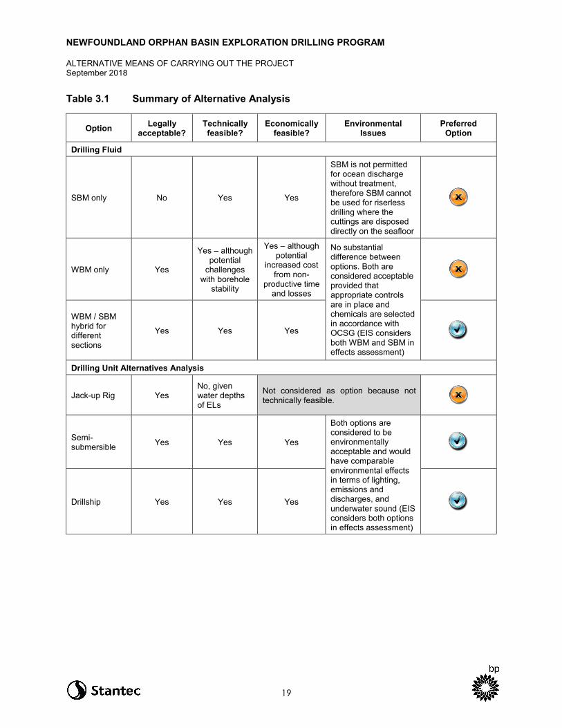
3.0 ALTERNATIVE MEANS OF CARRYING OUT THE PROJECT
As required under section 19(1)(g) of CEAA 2012, every environmental assessment of a designated project must take into account alternative means of carrying out the project that are considered technically and economically feasible and considers the environmental effects of any such alternative means.
Consistent with the Operational Policy Statement: Addressing “Purpose of” and “Alternative Means” under the Canadian Environmental Assessment Act, 2012 (Agency 2015), the process for consideration of alternative means of carrying out the Project includes the following steps:
• consideration of legal compliance, technical feasibility, and economic feasibility of alternative means of carrying out the Project
• description of each identified alternative to the extent needed to identify and compare potential environmental effects
• consideration of the environmental (including socio-economic) effects of the identified technically and economically feasible alternatives of carrying out the Project; this includes potential adverse effects on potential or established Aboriginal and Treaty rights and related interests (where this information has been provided)
• selection of the preferred alternative means of carrying out the Project, based on the relative consideration of effects
There are several components of the Project that remain to be finalized. Some options under review will be confirmed to C-NLOPB as part of the OA and ADW process (e.g., wellsite location).
As per the EIS Guidelines, the analysis of alternative means considers the following alternative means of carrying out the Project:
• drilling fluid selection • drilling unit selection • drilling waste management • water management and effluent discharge • alternative platform lighting options (including flaring) to reduce attraction and associated mortality of
birds
A summary of the alternative means of carrying out the Project is provided in Table 3.1 and includes a consideration of legal compliance, technical feasibility, and economic feasibility, as well as the environmental effects (where applicable) of each alternative means.
NEWFOUNDLAND ORPHAN BASIN EXPLORATION DRILLING PROGRAM
ALTERNATIVE MEANS OF CARRYING OUT THE PROJECT September 2018
19
Table 3.1 Summary of Alternative Analysis
Option Legally acceptable?
Technically feasible?
Economically feasible?
Environmental Issues
Preferred Option
Drilling Fluid
SBM only No Yes Yes
SBM is not permitted for ocean discharge without treatment, therefore SBM cannot be used for riserless drilling where the cuttings are disposed directly on the seafloor
WBM only Yes
Yes – although potential
challenges with borehole
stability
Yes – although potential
increased cost from non-
productive time and losses
No substantial difference between options. Both are considered acceptable provided that appropriate controls are in place and chemicals are selected in accordance with OCSG (EIS considers both WBM and SBM in effects assessment)
WBM / SBM hybrid for different sections
Yes Yes Yes
Drilling Unit Alternatives Analysis
Jack-up Rig Yes No, given water depths of ELs
Not considered as option because not technically feasible.
Semi-submersible Yes Yes Yes
Both options are considered to be environmentally acceptable and would have comparable environmental effects in terms of lighting, emissions and discharges, and underwater sound (EIS considers both options in effects assessment)
Drillship Yes Yes Yes

NEWFOUNDLAND ORPHAN BASIN EXPLORATION DRILLING PROGRAM
ALTERNATIVE MEANS OF CARRYING OUT THE PROJECT September 2018
20
Option Legally acceptable?
Technically feasible?
Economically feasible?
Environmental Issues
Preferred Option
Drilling Waste Management
Discharge to water column (following treatment of SBM on cuttings)
Yes Yes Yes
Some localized effects are expected on the seafloor from discharge of cuttings (assessed in Section 8 of the EIS)
Offshore Reinjection Yes No Not considered as option because not
technically feasible
Ship-to-shore (SBM-associated cuttings)
Yes Yes
Yes – but increased costs from increased transportation and operational delays
Some limited offshore effects are expected from increased transportation, and some onshore effects from transportation and onshore disposal of waste including increased health, safety and environment risks associated with truck and vessel traffic and exposure and handling of waste material
Lighting Alternatives
Standard MODU lighting Yes Yes Yes
Some localized visual effect is expected which could affect migratory birds (assessed in Section 9 of the EIS)
Spectral modified lighting
Yes
No – limited capabilities in extreme weather; safety concerns with helicopter approach and landing
No – not considered as commercially viable yet
Not considered as option because not feasible

NEWFOUNDLAND ORPHAN BASIN EXPLORATION DRILLING PROGRAM
ALTERNATIVE MEANS OF CARRYING OUT THE PROJECT September 2018
21
Option Legally acceptable?
Technically feasible?
Economically feasible?
Environmental Issues
Preferred Option
Flaring Alternative Analysis
No flaring No
Not considered as option due to regulatory and safety requirements; current regulatory practice requires formation flow test with flaring to secure Significant Discovery Licence. Industry continues to advocate for alternative methods.
Formation testing while tripping
Yes
Yes – although may not fulfill C-NLOPB data requirements in all cases
Yes
No flaring therefore reduced light and atmospheric emissions and reduced risk of bird attraction and mortality
Reduced flaring (i.e., no flaring during night time or inclement weather)
Yes
Yes – although activity could give result to compromised data
Yes – but increased MODU costs and risk of delays
Reduced flaring would still result in some measure of light and atmospheric emissions
Flaring as required with flare shield (water curtain)
Yes Yes Yes
Some limited offshore effects are expected from the light and atmospheric emissions generated during flaring. These are expected to be intermittent and brief in duration over a temporary period at the end of drilling (assessed in Section 9 of the EIS)
Where preferred options are noted, these alternatives were carried forward as the basis for the environmental assessment for the Project.
In addition to the alternatives listed above, BP will consider potential options for chemical selection and management. The details of chemicals to be used in the Project have not yet been confirmed and potential alternatives have not yet been identified. A drilling fluid and cementing contractor for the Project has not yet been selected, and the drilling fluid basis of design for the wells is under development. As planning for the Project continues, BP will follow chemical management and selection processes to define the ways in which chemicals will be chosen and used.
At a minimum, selection of drilling chemicals will be in accordance with the Offshore Chemical Selection Guidelines (NEB et al. 2009). The Offshore Chemical Selection Guidelines establish a procedure and criteria for offshore chemical selection. The objective of the guidelines is to promote the selection of lower toxicity chemicals to reduce the potential environmental impact of a discharge where technically feasible. Furthermore, BP will document the process used to evaluate prospective chemicals.

NEWFOUNDLAND ORPHAN BASIN EXPLORATION DRILLING PROGRAM
INDIGENOUS AND STAKEHOLDER ENGAGEMENT September 2018
22
4.0 INDIGENOUS AND STAKEHOLDER ENGAGEMENT
BP recognizes the importance of early and ongoing engagement with Indigenous groups and stakeholders that continues over the life of the Project. BP believes it is important to build positive relationships with Indigenous groups and key stakeholders to facilitate the exchange of information and understand concerns and priorities so that these can be mitigated and incorporated as appropriate in the planning and operation of the Project.
BP’s key objectives for stakeholder and Indigenous engagement are to:
• provide appropriate information in a timely manner to relevant, interested and affected parties based on the nature, location, and duration of the Project
• create an understanding of BP’s proposed drilling operations and address questions and concerns that arise
• obtain information and feedback from interested and affected parties including but not limited to local, traditional, and Indigenous knowledge that can improve BP’s understanding of the local environment and potential interactions
• provide feedback to interested and affected parties so they understand how BP has represented and responded to their input.
4.1 Indigenous Engagement Activities
BP recognizes the potential for Project activities (including potential accidental events) to affect Indigenous peoples and acknowledges the importance of engaging Indigenous groups to communicate Project details and obtain their views on potential effects of changes to the environment on Indigenous peoples and potential adverse impacts of the Project on asserted or established Aboriginal and/or Treaty rights.
The EIS Guidelines specify that BP engage the following Indigenous groups:
Newfoundland and Labrador
• Labrador Inuit (Nunatsiavut Government) • Labrador Innu (Innu Nation) • NunatuKavut Community Council • Qalipu Mi’kmaq First Nation Band • Miawpukek Mi'kmamawey Mawi'omi (Miawpukek First Nation) (MFN)
Nova Scotia
• 11 Mi’kmaq First Nation groups represented by Kwilmu’kw Maw-klusuaqn Negotiation Office (KMKNO): − Acadia First Nation − Annapolis Valley First Nation − Bear River First Nation − Eskasoni First Nation

NEWFOUNDLAND ORPHAN BASIN EXPLORATION DRILLING PROGRAM
INDIGENOUS AND STAKEHOLDER ENGAGEMENT September 2018
23
− Glooscap First Nation − Membertou First Nation − Paq’tnkek Mi’kmaw Nation − Pictou Landing First Nation − Potlotek First Nation − Wagmatcook First Nation − We’koqma’q First Nation
• Millbrook First Nation • Sipekne’katik First Nation
New Brunswick
• Eight Mi’gmaq First Nations represented by Mi’gmawe’l Tplu’taqnn Inc. (MTI): − Fort Folly First Nation − Eel Ground First Nation − Pabineau First Nation − Esgenoôpetitj First Nation − Buctouche First Nation − Indian Island First Nation − Eel River Bar First Nation − Metepnagiag Mi’kmaq First Nation
• Elsipogtog First Nation • Five Maliseet First Nation groups represented by Wolastoqey Nation in New Brunswick (WNNB):
− Kingsclear First Nation − Madawaska Maliseet First Nation − Oromocto First Nation − St. Mary’s First Nation − Tobique First Nation
• Woodstock First Nation • Peskotomuhkati Nation at Skutik (Passamaquoddy)
Prince Edward Island
• Two Mi’kmaq First Nation groups represented in consultation by Mi’kmaq Confederacy of PEI (MCPEI): − Abegweit First Nation − Lennox Island First Nation
Quebec
• Three Mi’gmaq First Nation groups represented by Mi’gmawei Mawiomi Secretariat (MMS): − Micmas of Gesgapegiag − La Nation Micmac de Gespeg − Listuguj Mi’gmaq Government
• Les Innus de Ekuanitshit • Première Nation des Innus de Nutashkuan
NEWFOUNDLAND ORPHAN BASIN EXPLORATION DRILLING PROGRAM
INDIGENOUS AND STAKEHOLDER ENGAGEMENT September 2018
24
BP initiated engagement with the above groups in November 2017, prior to filing the Project Description, with the objective of providing early notification and introducing the Project, obtaining early feedback on potential interests and concerns, and understanding individual groups’ preferred method of communication and engagement.
BP is committed to ongoing engagement with Indigenous groups not only during the EA process but throughout the life of the Project. BP also recognizes that Indigenous groups are involved in engagement with other oil and gas companies (“operators”) proposing similar exploration work in the eastern Newfoundland offshore area. Therefore, early in the planning process, it was determined that collaboration of operators on engagement to the extent possible, would help to reduce multiple engagement requests on Indigenous groups. BP has sought opportunities to coordinate Indigenous engagement efforts for this Project with ExxonMobil Canada Ltd., Equinor (formerly Statoil Canada Ltd.), Husky Oil Operations, and Nexen Energy (referred to hereafter as the “other NL operators” unless otherwise stated) who are proposing exploratory drilling programs in the Flemish Pass and Jeanne d’Arc Basins. One example of this coordinated engagement effort was the delivery of workshops organized with the Agency and held in Moncton, NB (April 12, 2018), Quebec City, QC (April 18, 2018), and St. Johns, NL (April 20, 2018) to which the 41 Indigenous groups and government agencies identified above were invited. These workshops were intended to introduce BP and the other NL operators and their proposed exploration drilling programs, improve an understanding of exploration drilling, and identify and discuss concerns of Indigenous groups. BP and the other NL operators are planning similar workshop format meetings in Fall 2018 which would follow up on the April workshops and focus on spill modelling, spill prevention and response, and follow-up and monitoring plans. BP and the other operators also meet with interested Indigenous groups and communities, as requested.
BP has notified, and will continue to notify, each of the identified Indigenous groups about key steps in the EIS development process and of opportunities to provide comments on key documents. BP has also contacted each of the Indigenous groups to request any existing Indigenous knowledge they wish to share with BP that may be helpful to the Project and understanding its potential effects including: information to help improve BP’s understanding of each community’s social, cultural and economic conditions; information related to current use of lands and resources for traditional purposes; and/or concerns regarding potential impacts of the Project on potential or established Aboriginal and/or Treaty rights. At the time of EIS preparation, BP, in collaboration with other NL operators, have initiated discussions with some Indigenous communities about the completion of an Indigenous Knowledge Study that would focus on marine species of Indigenous interest within the eastern Newfoundland offshore area.
BP will also develop, with input from Indigenous groups, an Indigenous Fisheries Communication Plan to be implemented during the drilling program. This Plan will provide a framework for regular operational updates to Indigenous groups as well as emergency notifications if needed.
A description of key engagement activities with each Indigenous group, along with a summary of key issues and concerns raised by each group are presented in Section 3.2 of the EIS.

NEWFOUNDLAND ORPHAN BASIN EXPLORATION DRILLING PROGRAM
INDIGENOUS AND STAKEHOLDER ENGAGEMENT September 2018
25
4.2 Stakeholder Engagement Activities
BP’s stakeholder consultation and engagement activities on the Project have been ongoing since November 2017. BP will continue with its consultation and engagement activities over the life of the Project. Engagement activities to date include face-to-face meetings with identified stakeholders, emails, and telephone calls. BP will continue to provide information and opportunities for dialogue to stakeholders as Project planning or activity milestones are nearing or achieved. Engagement will continue throughout the CEAA 2012 and drilling program authorization processes, through to Project completion. Table 4.1 lists the stakeholders engaged to date for the Project.
Table 4.1 Stakeholders Engaged for the Project (as of August 2018)
Stakeholder Group Organization
Government Agencies/Departments • Canadian Environmental Assessment Agency • C-NLOPB • DFO • ECCC • Natural Resources Canada
Fisheries • One Ocean • Fish, Food and Allied Workers-Unifor (FFAW-Unifor) • Association of Seafood Producers (ASP) • Ocean Choice International (OCI) • Groundfish Enterprise Allocation Council (GEAC) • Canadian Association of Prawn Producers (CAPP)
Other Interest Groups • Newfoundland and Labrador Oil & Gas Industries Association (NOIA)
Note: See Tables 3.1, 3.16, and 3.18 of the EIS for a description of engagement activities.
Stakeholder engagement will continue beyond the environmental assessment, throughout the full project life-cycle. BP will continue to notify fisheries stakeholders about key steps in the environmental assessment process including opportunities to provide comment on key documents. Upon completion of the EIS, BP is planning to share a summary of EIS results, including an overview of spill modelling results with interested fisheries stakeholders.
During the drilling program, BP will implement a Fisheries Communication Plan which will provide a framework for regular operational updates to fisheries stakeholders as well as emergency notifications if needed. Input will be sought from fisheries stakeholders during the development of the Fisheries Communication Plan.
4.3 Indigenous and Stakeholder Issues and Concerns
Issues and concerns raised by stakeholders and Indigenous groups during the environmental assessment process are being considered during the preparation of the EIS and Project planning. Table 4.2 summarizes issues and concerns raised to date (as of August 2018). For a more detailed account of issues and concerns raised, including attribution to specific stakeholders or Indigenous groups, and BP’s response, refer to Section 3 of the EIS.

NEWFOUNDLAND ORPHAN BASIN EXPLORATION DRILLING PROGRAM
INDIGENOUS AND STAKEHOLDER ENGAGEMENT September 2018
26
Table 4.2 Summary of Key Issues and Concerns Raised to Date (as of August 2018)
Stakeholder/Indigenous Group
Key Issues and Concerns
Indigenous Groups • Effects on species that are of importance to commercial and subsistence/traditional fisheries, most notably migratory species
• Consideration of climate change during Project planning • Potential impacts on Aboriginal rights and interests, such as:
− food, social, and ceremonial (FSC) fishing − commercial fishing − Atlantic salmon, Atlantic eel, cold water corals, species at risk, marine
mammals, marine birds − community wellbeing, and socio-economic conditions
• Effects from vessel traffic, seismic testing, spills, drilling mud, and well blowouts • Effects of dispersants on fish and dispersant approval process • Compensation for adverse effects on fishing activities and compensation for
socio-cultural impacts • Data gaps on Atlantic salmon and their migratory patterns and opportunities for
funding to undertake studies to address data gaps • Design and implementation of follow-up and monitoring programs for exploration
drilling • Incorporation of Indigenous knowledge in all phases of Project planning • Capping stack availability and BP’s emergency response capabilities • Adequate funding for meaningful engagement during the EIS and throughout
Project operations
Fisheries Stakeholders • Successful co-existence with oil and gas industry and need for cooperation and communication
• Cumulative effects between fisheries closures and offshore oil programs infringing on area to be fished
• Interested in reviewing Fisheries Communication Plan and Oil Spill Response Plan
Newfoundland and Labrador Oil & Gas Industries Association (NOIA)
• Using previous data from existing studies will eliminate duplication and delays, which is critical to the future development of NL’s offshore resources
The EIS considers potential interactions with biophysical and socio-economic components, with a focus on aspects raised by Indigenous groups and stakeholders, including consideration of impacts which could potentially affect Aboriginal rights and interests. BP acknowledges data gaps on Atlantic salmon migration routes and is discussing, in collaboration with other NL operators and Indigenous groups, opportunities for Indigenous knowledge studies and research related to Atlantic salmon. These studies would be conducted outside of the EIS but could be factored into environmental management planning and future environmental assessments.
Upcoming workshops with Indigenous groups and fisheries stakeholders will help address issues and questions related to spill prevention and response. The development and implementation of fisheries communication plans for Indigenous groups and fisheries stakeholders will help provide a framework for ongoing engagement through the life of the Project.
NEWFOUNDLAND ORPHAN BASIN EXPLORATION DRILLING PROGRAM
ENVIRONMENTAL ASSESSMENT APPROACH September 2018
27
5.0 ENVIRONMENTAL ASSESSMENT APPROACH
5.1 Scope of the Assessment
The Project includes the drilling, testing, and abandonment of up to 20 exploration wells within a Project Area encompassing BP’s offshore licences in the Orphan Basin (ELs 1145, 1146, 1148, and 1149) between 2020 and 2026. The Project Area is located approximately 343 km east of the Island of Newfoundland, in the Northwest Atlantic Ocean.
The scope of the Project to be assessed under CEAA 2012 and pursuant to the Accord Acts includes the following Project activities and components (refer to Chapter 2 for details):
• MODU mobilization and drilling − mobilization, operation (i.e., drilling), and demobilization of the MODU − establishment of a safety zone − light and sound (atmospheric and underwater) emissions associated with MODU presence and
operation − waste and water management, including discharge of drill muds and cuttings and other discharges
and emissions • VSP operations • well evaluation and testing • well abandonment and decommissioning • supply and servicing operations
− loading, refueling and operation of PSVs (for re-supply and transfer of materials, fuel, and equipment; on-site safety during drilling activities; and transit between the onshore supply base and the MODU)
− helicopter support (for crew transport and delivery of supplies and equipment)
Potential environmental effects that could occur in the event of an accidental spill are also assessed.
5.2 Overview of Approach
The method used to conduct the environmental assessment for the Project is based on a structured approach consistent with international best practices and with the method used by Stantec for EAs of projects assessed by the Agency, including Shell’s Shelburne Basin Venture Exploration Drilling Project (Shell 2014), BP’s Scotian Basin Exploration Drilling Project (BP 2016), and Husky Energy Exploration Drilling Project (2018 [in progress]). The environmental assessment method is structured to:
• identify the issues and potential effects that are likely to be important • consider key issues raised by Indigenous groups, stakeholders, and the public • incorporate engineering design and programs for mitigation and follow-up into a comprehensive
environmental planning process.
NEWFOUNDLAND ORPHAN BASIN EXPLORATION DRILLING PROGRAM
ENVIRONMENTAL ASSESSMENT APPROACH September 2018
28
This method is focused on the identification and assessment of potential adverse environmental effects of the Project on Valued Components (VCs). VCs are environmental attributes associated with the Project that are of value or interest because they have been identified to be of concern to Indigenous peoples, regulatory agencies, BP, resource managers, scientists, key stakeholders, and/or the public.
The potential environmental effects of Project activities and components are assessed in the EIS using a standard framework to facilitate assessment of each VC. Evaluation tables are used to document the environmental effects assessment. Residual Project-related environmental effects (i.e., those environmental effects that remain after application of mitigation measures) are characterized for each individual VC using specific analysis criteria (i.e., magnitude, geographic extent, duration, frequency, reversibility, and context). The significance of residual Project-related environmental effects is then determined based on pre-defined standards or thresholds (i.e., significance rating criteria). A precautionary approach has been applied to assessing and reducing environmental effects in planning and designing the Project and throughout the EIS. This includes using standard equipment, methods, and technologies in Project design for which potential environmental interactions are well understood and managed through the use of proven mitigation. Using the precautionary approach, effects predictions and implementation of recommended mitigation were conservative in nature assuming that each VC is present in the Project Area when a Project activity (or accidental spill) is occurring and therefore there is potential for Project-VC interaction. The characterization of range of magnitude (range of natural variability) considers the reasonable worst-case scenario and is therefore considered to provide a conservative indication of effects.
5.3 Selection of Valued Components
The selection of VCs was determined in consideration of: regulatory guidance and requirements including CEAA 2012 and the Project-specific EIS Guidelines; technical aspects of the Project; issues raised by Indigenous peoples, regulatory agencies, and key stakeholders; existing physical, biological, and socio-economic conditions; experience and lessons learned from environmental assessments for similar offshore projects; and the professional judgement of the environmental assessment Study Team.
The following VCs were selected to facilitate a focused and effective environmental effects assessment:
• Marine Fish and Fish Habitat • Marine and Migratory Birds • Marine Mammals and Sea Turtles • Special Areas • Indigenous Peoples and Community Values • Commercial Fisheries and Other Ocean Users
Table 4.1 in Section 4.2.2 of the EIS provides detailed rationale for VC selection.
NEWFOUNDLAND ORPHAN BASIN EXPLORATION DRILLING PROGRAM
ENVIRONMENTAL ASSESSMENT APPROACH September 2018
29
5.4 Spatial and Temporal Boundaries Environmental effects are evaluated within spatial and temporal boundaries. The spatial boundaries reflect the geographic range over which the Project’s potential environmental effects may occur, recognizing that some environmental effects will extend beyond the Project Area. The temporal boundaries identify when an environmental effect may occur. The temporal boundaries are based on the timing and duration of Project activities and the nature of the interactions with each individual VC. Spatial and temporal boundaries are developed in consideration of:
• timing / scheduling of Project activities for all Project phases • known natural variations of each VC • information gathered on land and resource use • recovery time from an environmental effect • potential for cumulative environmental effects • oil spill modelling conducted for the Project.
The spatial boundaries for the Project to be assessed are shown on Figure 5.1 and defined below with respect to Project activities and components.
• Project Area: The Project Area encompasses the immediate area within which Project activities and components may occur. Well locations have not been identified but will occur within the ELs in the Project Area. As a subset of the Project Area, the wellsite is referenced in the assessment discussion, where relevant, to more appropriately characterize the associated effects. The Project Area is consistent for all VCs and includes ELs 1145, 1146, 1148, and 1149, as well as a 20 km buffer to help join non-contiguous ELs into a single Project Area.
• Local Assessment Area (LAA): The LAA is the maximum area within which environmental effects from routine Project activities and components can be predicted or measured with a reasonable degree of accuracy and confidence. It consists of the Project Area and adjacent areas where Project-related environmental effects are reasonably expected to occur based on available information including effects thresholds, predictive modelling, and professional judgement. The LAA is defined for each VC.
• Regional Assessment Area (RAA): The RAA is the area within which residual environmental effects from Project activities and components may interact cumulatively with the residual environmental effects of other past, present, and future (i.e., certain or reasonably foreseeable) physical activities. Although the RAA is intended to be much broader than the LAA, which focuses on the extent of potential effects associated with routine Project activities for each VC, it is possible that effects from larger scale unplanned events (e.g., blowout) could extend beyond the RAA. The RAA is consistent for all VCs, except for the Indigenous People and Community Values VC, which has a larger RAA to encompass the various Indigenous communities that have the potential to be affected by Project-related activities.
The temporal boundaries for the Project to be assessed encompass all Project phases, including well drilling, testing, and abandonment. BP is currently planning a one-well program with an initial well proposed for 2020 but could potentially drill up to 20 wells between 2020 and 2026. Each well is anticipated to take approximately 60 days to drill. Although BP’s preference is to conduct drilling between May and October for the purpose of the environmental effects assessment it is assumed that Project activities could occur year-round.

NEWFOUNDLAND ORPHAN BASIN EXPLORATION DRILLING PROGRAM
ENVIRONMENTAL ASSESSMENT APPROACH September 2018
30
Figure 5.1 Project Spatial Boundaries

NEWFOUNDLAND ORPHAN BASIN EXPLORATION DRILLING PROGRAM
SUMMARY OF ENVIRONMENTAL EFFECTS ASSESSMENT September 2018
31
6.0 SUMMARY OF ENVIRONMENTAL EFFECTS ASSESSMENT
The following sections provide a summary of the key results of the environmental effects assessment. For a more detailed account, refer to Chapters 8 to 13 of the EIS for the assessment of effects from routine Project activities, Chapter 14 of the EIS for the cumulative effects assessment, and Chapter 16 of the EIS for an assessment of effects of the environment on the Project. Section 15.5 of the EIS presents the effects assessment of accidental events. The environmental effects assessment is informed by Project-specific drill waste dispersion modelling (Appendix B of the EIS), an underwater sound assessment (Appendix C of the EIS) and oil spill trajectory modelling (Appendix D of the EIS).
6.1 Marine Fish and Fish Habitat
Marine fish and fish habitat was selected as a VC in consideration of the ecological value provided to marine ecosystems, the socio-economic importance of fisheries resources (i.e., target fish species), the potential for interactions with Project activities and components, and requirements in the EIS Guidelines. The Project Area, LAA, and RAA are known to be used by many fish and invertebrate species, including those fishery species of commercial, recreational, or Aboriginal (CRA) importance or species that support them.
The presence and abundance of marine fish species and associated abiotic and biotic habitat characteristics vary considerably across the eastern Newfoundland offshore area, which transitions from relatively shallow shelf areas to the continental slope and deeper waters. This VC considers relevant fish species (including Species at Risk [SAR] and Species of Conservation Concern [SOCC]), plankton, algae, benthos, and relative components of their habitat, such as water and sediment quality. Marine plants are not present in the Project Area given the water depths in the Orphan Basin, and routine Project activities are not expected to interact with marine plants in nearshore environments.
6.1.1 Baseline Conditions
The eastern Newfoundland offshore area is a highly-productive ecosystem, and many marine fish species are known to occur in Newfoundland and Labrador waters (Templeman 2010; Amec 2014). The occurrence of these species is based on their physiological and life history requirements; their presence may vary according to habitat, environmental conditions, and life history stage (Amec 2014). Within the Project Area, habitats transition from Newfoundland slope to abyssal. These Newfoundland slope areas support regionally important areas of biodiversity and marine productivity and are used by fish and invertebrate species of commercial, cultural, and/or ecological value including CRA fishery species. The abundance and distribution of these fish and invertebrate species depend on their linkages with other species across fish habitats and interactions with the physical parameters of the marine environment.
Within the Orphan Basin, concentrations of bacteria are generally highest in water depths less than 500 m and decrease with depth. Bacterial abundance also increases in areas overlying seamounts or knolls, with bacterial concentrations on the seamount summit higher than those in surrounding waters. This suggests downwelling of bacteria normally limited to the sea surface (Greenan et al. 2010).

NEWFOUNDLAND ORPHAN BASIN EXPLORATION DRILLING PROGRAM
SUMMARY OF ENVIRONMENTAL EFFECTS ASSESSMENT September 2018
32
Phytoplankton are single-celled photosynthetic organisms that are adapted to living in the upper water column of coastal and offshore regions (Archambault et al. 2010). At least 60 species of phytoplankton, 160 species of zooplankton, and 30 species of icthyoplankton may occur in the Orphan Basin based on historical studies (Movchan 1963; Buchanan and Foy 1980a, 1980b; Buchanon and Browne 1981; Tremblay and Anderson 1984, in LGL Limited 2003). Phytoplankton in the Orphan Basin is likely dominated by microflagellates and diatoms, at least during the summer months (LGL Limited 2003).
The distribution of macroalgae and marine plants is predominantly limited to areas reached by sunlight, as they are reliant on photosynthesis to produce energy; however, some types of marine algae (e.g., coralline algae) occur at greater depths (Amec 2014). There is limited published information regarding macroalgae and marine plants in the Project Area, likely because this area contains oceanic habitat that is generally not conducive for the growth of seaweeds and macroalgae (Amec 2014). The entire Project Area is too deep for these species, and most areas of the Grand Banks do not contain the hard substrates required to establish holdfasts (Dayton 1985, in Amec 2014).
Benthic invertebrates form an important link to higher trophic level organisms such as fish, birds, and marine mammals (LGL Limited 2003), and certain taxa (e.g., cold-water corals) provide habitat for other species of invertebrates and fishes (Buhl-Mortensen and Mortensen 2005; Buhl-Mortensen et al. 2010). There is a high abundance and diversity of structure-forming benthic invertebrate species that occur in the Orphan Basin and in surrounding areas, including corals, sponges, and sea pens (Amec 2014). Within the RAA, corals and sponges are present on the Labrador Shelf and slope, the Northeast Newfoundland Shelf and Slope, the Flemish Pass and Flemish Cap, and are widespread on slopes and submarine canyons on the eastern and southern Grand Banks. The Orphan Knoll, located approximately 100 to 150 km to the northeast of the Project Area, is a biologically rich and complex area, and corals (including stony corals) and sponges have been observed on the flanks of the knoll and surrounding seamounts using a ROV (NAFO 2017).
DFO has defined a large Significant Benthic Area (SBA) for sea pens that encompasses the edge of the Northeast Newfoundland Shelf, including the far western portion of the Project Area and EL 1145, and small portions of ELs 1146 and 1148. There are additional SBAs for small and large gorgonian corals surrounding the Project Area along the Northeast Newfoundland Slope. The Northeast Newfoundland Slope Closure is a marine refuge designated by DFO which is closed to bottom contact fishing to protect corals and sponges in this area and encompasses all of ELs 1145, 1146 and 1148.
Within the RAA, there are NAFO coral and sponge closures to the southeast, south, and southwest of the Project Area. These closures are concentrated on the slope of the Grand Banks, the Flemish Pass and Cap, and other seamounts further offshore.
The benthic or demersal species which inhabit the continental slope and abyssal habitats in the vicinity of the Project Area are not yet well studied. Emerging continental slope fisheries for grenadiers, Greenland halibut and redfish are resulting in additional pressures for other continental slope species found within the Project Area such as blue hake, roughhead grenadier, roundnose grenadier, skate species and synaphobranchid eels (Devine et al. 2006). Pelagic species include resident pelagic species (capelin and lanternfish) and migratory pelagic species (tunas, swordfish, and several shark species). The most abundant fish species found the Project Area (based on 2015-2016 DFO research vessel survey data)

NEWFOUNDLAND ORPHAN BASIN EXPLORATION DRILLING PROGRAM
SUMMARY OF ENVIRONMENTAL EFFECTS ASSESSMENT September 2018
33
include: redfish; Greenland halibut; roughhead grenadier; roundnose grenadier; witch flounder; and northern wolfish. These species would be expected to be present in the Project Area year-round. For more information on key fish species present in the RAA and Project Area, refer to Section 6.1.7 of the EIS.
There are five fish SAR and 20 SOCC that may be present in the Project Area (refer to Table 6.1). SAR include species listed under Schedule 1 of the federal Species at Risk Act (SARA) that are endangered, threatened, or of special concern, or under the Newfoundland and Labrador Endangered Species Act (NL ESA) as endangered, threatened, or vulnerable.
Table 6.1 Fish Species of Conservation Interest with Potential to Occur in the Project Area and/or in the RAA
Common Name
Scientific Name
SARA Schedule 1
Status COSEWIC
Designation NL ESA
Designation
IUCN Red List
Designation
Potential for
Occurrence in the
Project Area*
Acadian redfish
Sebastes fasciatus No Status Threatened Not Listed Not Assessed Moderate
American eel Anguilla rostrata Not Listed Threatened Vulnerable Endangered Migratory/ Transient
American plaice (Newfoundland and Labrador population)
Hippoglossoides platessoides Not Listed Threatened Not Listed Not Assessed Low
Atlantic bluefin tuna
Thunnus thynnus Not Listed Endangered Not Listed Endangered Low
Atlantic cod (Newfoundland and Labrador population)
Gadus morhua Not Listed Endangered Not Listed Vulnerable Moderate
Atlantic halibut Hippoglossus hippoglossus Not Listed Not at Risk Not Listed Endangered Moderate
Atlantic salmon (South Newfoundland population)
Salmo salar Not Listed Threatened Not Listed Least Concern
Migratory/ Transient
Atlantic salmon (Gaspe-Southern Gulf of St. Lawrence)
Salmo salar No Status Special Concern Not Listed Least
Concern Low
Atlantic salmon (Outer Bay of Fundy)
Salmo salar No Status Endangered Not Listed Least Concern
Migratory/ Transient
Atlantic salmon (Eastern Cape Breton)
Salmo salar No Status Endangered Not Listed Least Concern
Migratory/ Transient

NEWFOUNDLAND ORPHAN BASIN EXPLORATION DRILLING PROGRAM
SUMMARY OF ENVIRONMENTAL EFFECTS ASSESSMENT September 2018
34
Common Name
Scientific Name
SARA Schedule 1
Status COSEWIC
Designation NL ESA
Designation
IUCN Red List
Designation
Potential for
Occurrence in the
Project Area*
Atlantic salmon (Nova Scotia Southern Upland)
Salmo salar No Status Endangered Not Listed Least Concern
Migratory/ Transient
Atlantic salmon (Quebec Eastern North Shore population)
Salmo salar No Status Special Concern Not Listed Least
Concern Low
Atlantic salmon (Quebec Western North Shore population)
Salmo salar No Status Special Concern Not Listed Least
Concern Low
Atlantic salmon (Anticosti Island population)
Salmo salar No Status Endangered Not Listed Least Concern Low
Atlantic wolffish
Anarhichas lupus
Special Concern
Special Concern Not Listed Not Assessed Low
Basking shark (Atlantic population)
Cetorhinus maximus Not Listed Special
Concern Not Listed Vulnerable Moderate
Bigeye tuna Thunnus thynnus Not Listed Not Listed Not Listed Vulnerable Low
Blue shark (Atlantic population)
Prionace glauce Not Listed Not at Risk Not Listed Near Threatened Low
Bowhead Whale
Balaena mysticetus No Status Special
Concern Not Listed Least Concern Low
Common lumpfish
Cyclopterus lumpus No Status Threatened Not Listed Not Assessed Low
Cusk Brosme brosme No Status Endangered Not Listed Not Assessed Low
Deepwater redfish (Northern population)
Sebastes mentella Not Listed Threatened Not Listed Least
Concern High
Northern wolffish
Anarhichas denticulatus Threatened Threatened Not Listed Not Assessed High
Porbeagle shark Lamna nasus Not Listed Endangered Not Listed Vulnerable Moderate
Roughhead grenadier
Macrourus berglax Not Listed Special
Concern Not Listed Not Assessed High

NEWFOUNDLAND ORPHAN BASIN EXPLORATION DRILLING PROGRAM
SUMMARY OF ENVIRONMENTAL EFFECTS ASSESSMENT September 2018
35
Common Name
Scientific Name
SARA Schedule 1
Status COSEWIC
Designation NL ESA
Designation
IUCN Red List
Designation
Potential for
Occurrence in the
Project Area*
Roundnose grenadier
Coryphaenoides rupestris Not Listed Endangered Not Listed Endangered High
Shortfin mako shark (Atlantic population)
Isurus oxyrinchus Not Listed Special
Concern Not Listed Vulnerable Low
Smooth skate (Funk Island Deep Population)
Malacoraja senta No Status Endangered Not Listed Endangered Low
Spotted wolffish
Anarhichas minor Threatened Threatened Not Listed Not Assessed Moderate
Thorny skate Amblyraja radiata Not Listed Special
Concern Not Listed Vulnerable Moderate
White shark (Atlantic population)
Carcharodon carcharias Endangered Endangered Not Listed Vulnerable Low
Winter skate (Eastern Scotian Shelf – Newfoundland population)
Leucoraja oscellata No Status Endangered Not Listed Endangered Low
Notes: Data from the SARA Registry (http://www.sararegistry.gc.ca/sar/index/default_e.cfm) as of April 10, 2018 * This qualitative characterization is based on expert opinion, and an analysis of understood habitat preferences across life-history stages, available distribution mapping, and catch data for each species within the Project Area.
The Northern Grand Banks encompasses an area designated as proposed critical habitat for northern and spotted wolfish; both species are listed under SARA Schedule 1 as threatened. The proposed northern wolffish critical habitat overlaps the Project Area along a portion of the Northeast Newfoundland Slope.
Within the waters offshore Newfoundland and Labrador, including waters within the Project Area and the RAA, commercial fishing activity for several different species occurs, including species that Indigenous groups may hold commercial communal licenses to harvest. Species harvested for commercial communal purposes within the RAA include capelin, groundfish, herring, mackerel, seal, shrimp, snow crab, tuna, and whelk. Species harvested by Indigenous groups for food, social, and ceremonial (FSC) purposes include, but are not limited to, gaspereau, trout, Atlantic salmon, bass, mackerel, eel, shad, groundfish (e.g., flounder, halibut, pollock), Arctic char, smelt, blue shark, herring, mussel, clams, periwinkle, soft-shell clams, squid, tomcod, quahaug, razor clams, lobster, crab, and scallops. Many FSC species are harvested in the inshore and/or freshwater systems. However, some species are anadromous and can potentially migrate through the RAA and/or Project Area. Two migratory fish species in particular have been highlighted during Indigenous engagement as being of concern due to potential interaction with Project activities: American eel and Atlantic salmon. The American eel has been identified as important to Aboriginal rights-
NEWFOUNDLAND ORPHAN BASIN EXPLORATION DRILLING PROGRAM
SUMMARY OF ENVIRONMENTAL EFFECTS ASSESSMENT September 2018
36
based, Treaty rights-based, and commercial fisheries, particularly to the Mi’kmaq peoples (Denny and Kavanagh 2018). Atlantic salmon have traditionally been a staple food for Indigenous peoples, although today, due to a lack of abundance and concern for local populations, it is often reserved for special occasions (Denny and Fanning 2016).
6.1.2 Anticipated Changes to the Environment
Potential interactions between planned offshore oil and gas activities and pathways of potential effects on marine fish and fish habitat include (adapted from Amec 2014):
• destruction, contamination, or alteration of marine habitats and benthic organisms due to discharge and deposition of drill cuttings and/or fluids, the deployment and use of other Project equipment and wellhead abandonment / decommissioning
• contamination of fish / invertebrates and their habitats due to other discharges in the environment during planned oil and gas exploration drilling and other associated survey and support activities
• the attraction of marine fish to MODUs and vessels, with increased potential for injury, mortality, contamination, and other interactions
• temporary avoidance of areas by marine fish due to underwater sound or other disturbances, which may alter their presence and abundance as well as disturbing movements / migrations, feeding, or other activities
• changes in the availability, distribution, or quality of food sources and/or habitats for fish and invertebrates as a result of planned activities and their associated environmental emissions
• injury, mortality, or other disturbances to marine fish as a result of exposure to sound within the water column during VSP survey activity (with impact relative to distance to VSP sound source and exposure period)
As a result of these considerations, the assessment of Project-related effects on marine fish and fish habitat is focused on the following potential effects:
• change in risk of mortality or physical injury • change in habitat quality and use
6.1.3 Potential Effects from Routine Operations
6.1.3.1 Change in Risk of Mortality or Physical Injury
A change in risk of mortality or physical injury for individual marine fish may result from the presence and operation of a MODU, VSP surveys, and Project-related discharges. The presence and operation of a MODU will generate underwater sound that may affect the quality of the underwater acoustic environment for fish species, and VSP operations will also temporarily and intermittently generate increased sound levels. In consideration of the acoustic modelling conducted for similar exploration drilling projects in the eastern Newfoundland offshore area, physical injury effects on fish that may result associated with MODU operations would be localized and transient as it is expected that mobile fish would respond and move away thereby reducing risk of injury due to sound level in close proximity to a sound source. The VSP sound source is expected to generate the highest level of underwater sound associated with the Project. Received

NEWFOUNDLAND ORPHAN BASIN EXPLORATION DRILLING PROGRAM
SUMMARY OF ENVIRONMENTAL EFFECTS ASSESSMENT September 2018
37
sound levels are unlikely to result in physical effects to the majority of mobile fish species due to the expectation that they would avoid underwater sound at lower levels than those at which injury or mortality may occur.
Benthic species (e.g., fish, shellfish, sponges, and corals) may also experience mortality or physical injury from crushing or smothering from waste management activities, particularly the discharge of drill muds and cuttings. It is predicted that sediment thicknesses greater than 6.5 mm could extend up to 128 m from the discharge point or cover an area of approximately 0.69 ha in the West Orphan Basin, and 55 m from the discharge point or approximately 0.64 ha per well in the East Orphan Basin under low ambient surface current conditions. Marine water column organisms (e.g., phytoplankton, zooplankton, ichthyoplankton, pelagic invertebrates, and fish) are generally at low risk of harm from drill cuttings due to rapid dilution and dispersal of drill cuttings; mobile water column organisms usually avoid or move away from plumes of suspended drill cuttings, thereby also reducing risk of harm (IOGP 2016). However, zooplankton, larvae, and pelagic invertebrates unable to avoid exposure can experience temporary physical effects (interference with respiration and feeding) associated with elevated concentrations of total suspended solids and an associated increase in turbidity in the water column.
In the West Orphan Basin, particularly in EL 1145 and the southwest portion of EL 1148, corals and sponges are present and there are Significant Benthic Areas designated for sea pens. There is potential for the smothering or disturbance of corals and sponges in these ELs in the immediate area of wellsites. Benthic mortality rates as a result of these discharges are not predicted to result in irreversible changes to local populations, although it is acknowledged that there are fewer data on effects of drilling waste on corals and sponges, and recovery rates for these communities are expected to be longer (Gates and Jones 2012; Cordes et al. 2016; Henry et al. 2017).
Other routine discharges (e.g., bilge and deck drainage water, grey and black water, ballast water), will be managed in accordance with the Offshore Waste Treatment Guidelines (NEB et al. 2010), Transport Canada’s Ballast Water Control Management Regulations and/or MARPOL, and are not expected to cause mortality or physical injury to marine fish.
6.1.3.2 Change in Habitat Quality and Use
The operation of the MODU will result in light and sound (atmospheric and underwater) emissions. Avoidance and short duration startle responses to underwater sound by some marine fish species may occur in close proximity to the sound source during the start-up of the initial period of drilling (Müeller-Blenkle et al. 2008; Fewtrell and McCauley 2012). However, given the localized and temporary nature of the drilling and VSP activity, displacement of fish from habitats and population level disturbances are unlikely. Habitat quality and use may also be affected from the lights of the MODU, as marine fish may experience physiological stress from the artificial lighting introduced into the water column. Groups of fish often react to the presence of artificial lighting by schooling and moving towards the light source. The feeding, schooling, predator avoidance, and migratory behaviours of marine fish can be altered by sharp light contrasts created by over-water structures due to shading during the day and artificial lighting at night (Nightingale and Simenstad 2002; Hanson et al. 2003).
NEWFOUNDLAND ORPHAN BASIN EXPLORATION DRILLING PROGRAM
SUMMARY OF ENVIRONMENTAL EFFECTS ASSESSMENT September 2018
38
VSP surveys will temporarily generate underwater sound. As noted above (change in risk of mortality or physical injury), received sound levels are unlikely to result in physical effects to the majority of mobile fish species due to the expectation that whey would avoid underwater sound at lower levels than those at which injury or mortality may occur. Nevertheless, surveys may cause a temporary change in habitat quality and use for marine fish near VSP operations.
Project-related discharges will include waste management and the deposition of drill cuttings and muds. A temporary increase in suspended particulate matter and turbidity in the water column will occur as drilling mud and cuttings disperse and settle rapidly through the water column to accumulate on the seafloor. Deposition of drill cuttings can change sediment grain size and physical or chemical properties of sediments, causing a change in the abundance, composition, and diversity of the benthic community (IOGP 2016) within a localized area.
Cold-water corals provide habitat for other species, so Project-related effects on corals could result in a change in habitat quality and use. Different species of cold-water corals provide habitats of varying physical size and life spans (Roberts et al. 2009); as a result, the fauna associated with some corals is more diverse than others (De Clippele et al. 2015). However, both sea pens and larger structure-forming corals (i.e., gorgonians) play an important role as habitat (De Clippele et al. 2015).
Wellhead abandonment could result in localized temporary disturbance depending on the wellhead abandonment program, which has not yet been defined. In water depths greater than 900 m, BP may seek approval from the C-NLOPB to leave the wellhead in place. It is anticipated that the wellhead, if left in place, would provide hard substrate that may be suitable for colonization by benthic communities and provide fish habitat. If the wellhead is removed, the process may involve temporary and localized increases in underwater sound levels.
During supply and servicing operations, underwater sound associated with vessel movement will be generated and may therefore locally affect fish habitat quality and use around PSVs due to increased vessel sound. Although underwater sound generated by PSV traffic will introduce additional sound to the acoustic environment, this increase will be low given the relatively small increment in vessel traffic as a result of Project activities.
6.1.4 Potential Effects from Accidental Events
Accidental spill scenarios have potential to result in a change in risk of mortality or physical injury and/or a change in habitat quality and use for marine fish and fish habitat. Potential effects pathways for a change in risk of mortality or physical injury and/or change in habitat quality and use for marine fish and fish habitat due to an oil spill include: reduction of water and/or sediment quality; reduced primary productivity due to a reduction in air-water gas exchange and light penetration; and lethal and sub-lethal effects from acute or chronic exposure to water-soluble fractions of hydrocarbons.
The risk of exposure of fish and invertebrates to an oil spill is dependent on the type of oil and the extent of the spill, but also on the habitat these species occupy, their behaviour, the time of year, their life history, and the general health of the stock at the time of the spill. Fish kills are typically brief and localized following a discrete spill event due to the rapid loss of the acutely lethal low-molecular weight components of oil due

NEWFOUNDLAND ORPHAN BASIN EXPLORATION DRILLING PROGRAM
SUMMARY OF ENVIRONMENTAL EFFECTS ASSESSMENT September 2018
39
to dilution and weathering (Lee et al. 2015), the ability of mobile species to detect and avoid impacted areas, and the ability of phytoplankton, zooplankton, and adult fish to metabolize hydrocarbons (Wolfe et al. 1996; Graham et al. 2010).
In general, adult pelagic and benthic fish occurring in relatively deep waters have lower exposure risk because they are highly mobile and able to avoid oiled areas (Irwin 1997; Law et al. 1997). Larval and juvenile pelagic and benthic fish species are at a greater risk of exposure as they are often less mobile than adults (Yender et al. 2002) and have shown higher sensitivity to lower concentrations of hydrocarbons, since they may not have yet developed detoxification systems allowing them to metabolize hydrocarbons (Rice 1985; Carls et al. 1999; Incardona et al. 2013; Lee et al. 2015). Fish that spawn or occur in nearshore intertidal and subtidal zones and in shallow reef zones are at higher risk of exposure where there is shoreline oiling or contamination of sediments, thereby potentially increasing the risk for chronic exposure (Yender et al. 2002; Lee et al. 2015). Benthic invertebrates have a moderate to high risk of exposure, depending on their mobility and use of contaminated sediments (Yender et al. 2002; Lee et al. 2015).
A well blowout scenario has the greatest potential for environmental effects. The actual effects of a blowout incident would depend in large part upon the duration and volume of the spill, as well as the environmental conditions at the time of the spill. Although the areas of potential effects delineated by the modelling results are relatively large, substantial portions of these areas would have low probabilities of occurrence if the release is allowed to continue unmitigated for 120 days. The implementation of mitigation measures would further reduce the already relatively low probabilities of oil reaching nearshore areas. In the unlikely event of an actual well blowout, mitigation (including emergency response measures such as containment and recovery operations) would be implemented well before 120 days elapse, thereby likely reducing the magnitude, duration, and geographic extent of the spill, and associated residual environmental effects.
Diesel spills from the MODU or a PSV are not likely to result in biological effects on fish over a large area. With respect to a change in habitat quality and use, it is expected that the majority of diesel from a spill from either the MODU or PSV would evaporate and disperse within days following the release. This will create a temporary and reversible degradation in habitat quality. Depending on the location and extent of the spill, nearshore spawning and nursery areas could potentially be affected. However, given the small-scale and short-term nature of the spill, effects on nearshore areas are expected to be limited to a scenario in which marine diesel is spilled from a PSV transiting close to the shore. Oil spill containment and recovery operations will further reduce residual effects on fish and fish habitat associated with total dissolved hydrocarbons.
With respect to a change in habitat quality and use following an SBM spill, it is conservatively predicted that there would likely be a temporarily and reversible degradation in habitat quality within approximately a 1 km-radius from the spill site. The acute toxicity of SBM is considered relatively low and would not result in adverse effects from contamination of marine biota or habitats.

NEWFOUNDLAND ORPHAN BASIN EXPLORATION DRILLING PROGRAM
SUMMARY OF ENVIRONMENTAL EFFECTS ASSESSMENT September 2018
40
6.2 Marine and Migratory Birds
Marine and migratory birds was selected as a VC due to their ecological value to marine and coastal ecosystems, the economic and cultural importance of recreational and subsistence hunts, vulnerability to artificial light attraction, vulnerability to oil on water, regulatory considerations, and requirements in the EIS Guidelines. The marine and migratory birds VC includes oceanic (i.e., beyond the continental shelf), neritic (continental shelf), and littoral zone (intertidal, splash, and spray zones) seabirds, waterfowl, loons, grebes, and shorebirds that are protected under the Migratory Birds Convention Act, 1994 (MBCA) and additional marine-associated birds not protected under the MBCA (i.e., cormorants). The term “migratory” is defined here as: protected under the MBCA whether or not a listed species under consideration undertakes seasonal or moult migrations. This VC also considers marine and migratory birds listed under Schedule 1 of SARA, Committee on the Status of Endangered Wildlife in Canada (COSEWIC), the NL ESA or the Newfoundland and Labrador Wild Life Act.
6.2.1 Baseline Conditions
The highly productive Grand Banks and adjacent waters are known to support large numbers of seabirds in all seasons (Lock et al. 1994; Fifield et al. 2009). Several million seabirds nest along the coasts of the eastern and northeastern Newfoundland, and forage on the Grand Banks and adjacent areas during and following the nesting season. There are also many non-breeding seabirds in the RAA during the summer months. During this time most of the world’s population of great shearwater and large numbers of sooty shearwater nesting in the South Atlantic are thought to migrate to Newfoundland waters. Leach’s storm-petrels traverse the continental shelf to forage for nestlings in deep waters off the shelf in areas such as the Orphan Basin, which is the nearest deep-water area to the largest nesting colony in the world of this species at Baccalieu Island. During the winter months, seabirds from the Arctic and subarctic of eastern Canada, and from Greenland, gather in the RAA. Of those seabirds, the non-breeding, sub-adults, especially northern fulmar and black-legged kittiwake, are present In the RAA year-round. Waterfowl nest in coastal Newfoundland in relatively small numbers but winter in coastal waters in large numbers (Lock et al. 1994). However, they occur away from the coast generally only as vagrants in small numbers. Some species of Arctic-nesting shorebirds (plovers and sandpipers) undertake trans-oceanic flights during fall migration from eastern North America to South America (Williams and Williams 1978; Richardson 1979), so some passage offshore through the RAA may be expected. During summer, the Grand Banks also host species that migrate from nesting areas in the South Atlantic, including globally important numbers of great shearwater, large numbers of sooty shearwater, and smaller numbers of Wilson’s storm-petrel, and south polar skua.
There are eight species designated at risk provincially or federally that have the potential to occur in the RAA or the Project Area (Table 6.2); an additional species is considered a SOCC as assessed by COSEWIC. These species consist of two coastal waterfowl species, three shorebird species, one phalarope species, two gull species, and one raptor species. Other shorebird and landbird species at risk in Newfoundland are not likely to occur in the RAA or Project Area.

NEWFOUNDLAND ORPHAN BASIN EXPLORATION DRILLING PROGRAM
SUMMARY OF ENVIRONMENTAL EFFECTS ASSESSMENT September 2018
41
Table 6.2 Marine and Migratory Bird Species of Conservation Interest Likely to Occur in the RAA
Species NL ESA Status Federal Status
SARA Listing COSEWIC Assessment
Harlequin duck (eastern pop.) Vulnerable Special Concern (Schedule 1) Special Concern
Barrow’s goldeneye (eastern pop.) Vulnerable Special Concern (Schedule 1) Special Concern
Piping plover (melodus ssp.) Endangered Endangered (Schedule 1) Endangered
Red knot (rufa ssp.) Endangered Endangered (Schedule 1) Endangered
Buff-breasted sandpiper None Special Concern (Schedule 1) Special Concern
Red-necked phalarope None None Special Concern
Ivory gull Endangered Endangered (Schedule 1) Endangered
Ross’s gull None Threatened (Schedule 1) Threatened
Peregrine falcon Vulnerable Special Concern (Schedule 1) Special Concern
Several coastal areas have been designated as Important Bird Areas (IBAs) which have been designated internationally to recognize sites of national and international importance to birds and generally include areas where large concentrations of seabirds nest, stage, or overwinter. There are 21 IBAs in eastern Newfoundland and 10 of these include marine waters of the RAA (Table 6.3). Some of these IBAs are also designated federal Migratory Bird Sanctuaries or provincial Seabird Ecological Reserves. Seabird Ecological Reserves are protected from industrial development and other activities that can cause disturbance to breeding seabirds pursuant to the Seabird Ecological Reserve Regulations, 2015.
Table 6.3 Important Bird Areas on Marine Waters of Eastern Newfoundland
IBA Name Importance to Marine and Migratory Birds
Funk Island (NF004) NestingG common murre, nestingG northern gannet; provincially protected SARE; overlaps Fogo Shelf EBSAE
Wadham Islands and adjacent Marine Area (NF013)
WinteringC common eider; nestingC Atlantic puffin, nesting Leach’s storm-petrel and razorbill; overlaps Fogo Shelf EBSA
Cape Freels Coastline and Cabot Island (NF025)
WinteringG common eider; nestingC black-headed gull; nesting common murre, razorbill, Atlantic puffin, and common / Arctic tern; overlaps Fogo Shelf EBSA
Terra Nova National Park (NF017) WinteringC black-headed gull; winteringC dovekie; shorebirds, gulls and waterfowl on tidal flats at Big Brook and Newman Sound; large nos. nesting common / Arctic terns; federal Migratory Bird Sanctuaries
Grates Point (NF019) WinteringC common eiders; wintering black-legged kittiwake, thick-billed murre, dovekie; summer use Atlantic puffin, northern Gannet
Baccalieu Island (NF003) NestingG Leach’s storm-petrel and Atlantic puffin; nestingC black-legged kittiwake, large nos. nesting northern gannet; other nesting species; SER
Cape St. Francis (NF021) Fall migrationC dovekie; fall migrationC Manx shearwater; large nos. wintering common eider; wintering purple sandpiper

NEWFOUNDLAND ORPHAN BASIN EXPLORATION DRILLING PROGRAM
SUMMARY OF ENVIRONMENTAL EFFECTS ASSESSMENT September 2018
42
IBA Name Importance to Marine and Migratory Birds
Witless Bay Islands (NF002) NestingG Atlantic puffin, common murre, razorbill, and Leach’s storm-petrel; nestingC black-legged kittiwake and herring gull; staging waterfowl; SER; overlaps Eastern Avalon Coast EBSA
Mistaken Point (NF024)
Wintering common eider; winteringG purple sandpiper; nesting black-legged kittiwake, common murre and razorbill; springC, summer and fall Manx shearwater; Provincial Ecological Reserve and UNESCO World Heritage Site (fossil deposits)
Cape Pine and St. Shotts Barren (NF015)
NestingG razorbill; large nos. fall staging American golden-plover and whimbrel; overlaps Placentia Bay EBSA
Cape St. Mary’s (NF001)
NestingG northern gannet; nestingC black-legged kittiwake, winteringN and moulting harlequin duckS; nesting common and thick-billed murre, razorbill, black guillemot, herring and great black-backed gull, great and double-crested cormorant, wintering waterfowl; overlaps Placentia Bay EBSA
Notes: C Continentally Significant concentration of birds (IBA criteria), E Ecologically or Biologically Significant Area, G Globally Significant concentration, N Nationally Significant concentration, P Provincial Seabird Ecological Reserve, S SOCC
6.2.2 Anticipated Changes to the Environment
Routine Project activities and components have potential to interact with migratory birds and their associated habitat due to attraction to artificial lighting and atmospheric sound of the MODU and PSVs, operational discharges during well drilling and testing operations, underwater sound emissions from VSP operations, and interactions with PSV and helicopter activities during supply and servicing. Direct and indirect adverse effects on migratory birds could be caused by the following effects pathways:
• physical displacement because of vessel presence (e.g., disruption of foraging activities) • nocturnal disturbance (e.g., increased opportunities for predators, attraction to the MODU or PSVs and
subsequent collision) associated with illumination levels from artificial lighting during different weather conditions and seasons and during different Project activities (e.g., drilling, formation flow testing with flaring)
• atmospheric sound associated with the presence and operation of the MODU, PSVs and helicopter traffic
• exposure to spilled contaminants (e.g., fuel, oils) and operational discharges (e.g., drilling waste, deck drainage, gray water, black water)
• attraction of predator species near the MODU or PSVs • collision risk with Project infrastructure (e.g., MODU, PSVs, or helicopters) • physical or behavioural effects due to increased underwater sound from VSP surveys
As a result of these considerations, the assessment of Project-related effects on marine and migratory birds is focused on the following potential effects:
• change in risk of mortality or physical injury • change in habitat quality and use

NEWFOUNDLAND ORPHAN BASIN EXPLORATION DRILLING PROGRAM
SUMMARY OF ENVIRONMENTAL EFFECTS ASSESSMENT September 2018
43
6.2.3 Potential Effects from Routine Operations
6.2.3.1 Change in Risk of Mortality or Physical Injury
The presence and operation of the MODU and PSVs has the greatest potential to result in changes to risk of mortality or physical injury for marine and migratory birds because they are known to congregate around drilling and production platforms as a result of night lighting, food, and other visual cues, potentially making them subject to increased risk of mortality due to physical strikes of structures, predation by other marine bird species, and incineration from flares (Wiese et al. 2001; Ronconi et al. 2015). There may be a slight increase in mortality / injury levels due to collisions, disorientation, and potential predation, although, based on previous monitoring, the mortality rate is anticipated to be low as most stranded birds encountered on platforms and vessels are released successfully in accordance with the Procedures for Handling and Documenting Stranded Birds Encountered on Infrastructure Offshore Atlantic Canada (ECCC 2016).
The Project has potential to result in a change in risk of mortality or physical injury of marine and migratory birds through exposure to residual hydrocarbons associated with drill muds and cuttings, and other discharges. Cement, WBM and cuttings released at the seafloor will be far below the maximum diving range of most seabirds, and therefore will not interact with marine-associated birds (or their habitats). Other potential liquid discharges from offshore vessels and equipment relate to the possible release of oily water and other substances through produced water (if applicable), deck drainage, bilge water, ballast water and other liquid wastes. The treated discharge of some operational wastes may cause surface sheening, typically under calm conditions; however, the potential for sheen formation is very unlikely with proper treatment and management of operational discharges in accordance with the Offshore Waste Treatment Guidelines.
Atmospheric emissions associated with the Project include exhaust from power and heat generation from the drilling installation(s), and from PSVs and aircraft traffic. It is unlikely that such emissions will have a measurable effect on marine and migratory birds, as the emissions will be within regulatory standards, transient in nature, and short-term at one location.
Formation flow testing may occur during drilling of the well, or it may be carried out at a later date upon re-entering a suspended well, and in certain situations, flaring may be required. In Atlantic Canada, nocturnal migrants, and nocturnally-active seabirds such as Leach’s storm-petrel are the marine and migratory birds most at risk of attraction to flares, although the potential mortality resulting from such interactions is poorly understood.
6.2.3.2 Change in Habitat Quality and Use
Changes in habitat quality and use due to the presence and operation of a MODU are generally associated with artificial lighting and atmospheric and underwater sound emissions from the MODU which can result in behavioural changes in marine and migratory birds. Some marine bird species, especially alcids, may be displaced from the area around the active MODU during drilling operations and along PSV supply routes through general avoidance responses. However, the effect of habitat displacement on marine-associated birds is likely to be minor due to its small footprint (Hedd et al. 2011; Ronconi et al. 2015). Because the

NEWFOUNDLAND ORPHAN BASIN EXPLORATION DRILLING PROGRAM
SUMMARY OF ENVIRONMENTAL EFFECTS ASSESSMENT September 2018
44
MODU will not be situated in one location for extended periods of time, disturbance will be short-term and transient in nature.
Discharge of organic wastes (sewage and food scraps) may result in enhancement of the local food supply and attraction of birds to vessels and platforms. However, this effect will only occur during the drilling program (approximately 60 days per well) and be localized in nature. The production of sheens from routine discharges will be unusual given adherence to the Offshore Waste Treatment Guidelines and MARPOL requirements for waste management. However, if they do occur, this could result in avoidance and / or attraction of marine birds.
Formation flow testing may occur during the drilling program, and in certain situations, flaring may be required. Nocturnal flaring introduces artificial lighting to the marine environment and has the potential to attract marine and migratory birds (particularly storm-petrels), diverting them from their movements between foraging areas and nesting colonies.
The Project will involve PSV and helicopter transit to and from the MODU in the Project Area, potentially any time of year over the life of the Project. Bird species will not likely be affected by PSV activity or associated aircraft use, due to its transitory nature and thus, its short-term presence at any one location, PSV and helicopter avoidance of migratory bird nesting colonies, and because it is generally consistent with the overall marine traffic that has occurred throughout the region for years.
6.2.4 Potential Effects from Accidental Events
Accidental spill scenarios have potential to result in a change in risk of mortality or physical injury and/or a change in habitat quality and use for marine and migratory birds. The extent of the potential effects will depend on how the spill trajectory and the VC overlap in space and time. The assessment is conservative (i.e., geographic and temporal overlap are assumed to occur, and modelling results assume no implementation of mitigation measures). Birds are among the most vulnerable and visible species to be affected by oil spills. A change in risk of mortality or physical injury for marine and migratory birds exposed to hydrocarbons can occur through three main pathways: external exposure to oil (resulting in coating of oil on feathers); inhalation of particulate oil and volatile hydrocarbons; and ingestion of oil. External exposure to oil occurs when flying birds land in oil slicks, diving birds surface from beneath oil slicks, and swimming birds swim into slicks. Reported effects vary with species, type of oil, weather conditions, time of year, volume of the spill, and duration of the spill (Gorsline et al. 1981).
A well blowout incident has potential to result in a change in risk of mortality or physical injury and change in habitat quality and use for marine and migratory birds. Although potential for direct effects on nesting habitat is possible, there is greater potential for direct effects on foraging habitat at sea. With respect to a change in risk of mortality or physical injury, exposure to hydrocarbons frequently leads to hypothermia and deaths of affected marine birds. Although some may survive these immediate effects, long-term physiological changes may eventually result in lower reproductive rates or premature death.
With respect to a change in habitat quality and use for migratory birds, hydrocarbon spills are not likely to permanently alter the quality of marine bird habitat. Prey availability may be reduced or migratory birds may avoid affected habitat. However, spill cleanup and natural weathering processes are likely to result in the
NEWFOUNDLAND ORPHAN BASIN EXPLORATION DRILLING PROGRAM
SUMMARY OF ENVIRONMENTAL EFFECTS ASSESSMENT September 2018
45
eventual recovery of such habitat. Seabird colonies, IBAs, Migratory Bird Sanctuaries, Ecologically or Biologically Significant Areas (EBSAs), and ecological reserves of importance to marine and migratory birds along the coast (including small coastal islands) could potentially be affected by nearshore surface oiling and/or shoreline stranding of oil from an unmitigated well blowout.
The implementation of mitigation measures would reduce the probabilities of oil extending beyond the RAA or reaching nearshore areas, shorelines, or special areas. In the unlikely event of an actual well blowout, mitigation (including emergency response measures such as containment and recovery operations) would be implemented, thereby likely reducing the magnitude, duration, and geographic extent of the spill and associated residual environmental effects.
A batch diesel spill or vessel spill has the potential to result in a change in risk of mortality or physical injury and change in habitat quality and use for marine and migratory birds. With respect to a change in habitat quality and use, the majority of diesel from a spill from either the MODU or PSV will evaporate and disperse within days following the release (refer to Appendix D of the EIS and RPS 2017). For a 100-L batch spill of diesel in the Project Area, the maximum exposure time for oil on the surface with a thickness greater than 0.04 μm (visible sheen) is less than one day. As a result, this will create a temporary and reversible degradation in habitat quality. Depending on the location and extent of the spill, it could directly and indirectly reduce the amount of habitat available to marine and migratory birds at sea. In the event of a vessel spill in the nearshore area, there is the potential for shoreline to be affected by a diesel spill. When diesel interact with a shoreline, it tends to penetrate porous sediments quickly and washes off quickly by waves and tidal flushing (NOAA 2016). These effects would be short-term in duration until the slick disperses and the diesel content in the area reaches background levels. A batch spill of diesel is not expected to create permanent or irreversible changes to habitat quality and use.
With respect to change in risk of mortality or physical injury for marine and migratory birds, the accidental release of diesel fuel has the potential to affect migratory birds through direct contact, although it is predicted that the number of birds affected would be limited due to the short time and small area where the diesel would be on the water’s surface. Mortality can be caused by ingestion during preening as well as through hypothermia due to matted feathers (NOAA 2016). Some birds may survive the immediate effects of contact with diesel, although there is the potential for long-term physiological changes resulting in lower reproductive rates or premature death. Migratory birds foraging at sea have the potential to become oiled and bring hydrocarbons back to their nest, contaminating their eggs or nestlings, thereby causing embryo or nesting mortality.
There is potential for a surface release of SBM to result in a surface sheen, which in turn could potentially cause a change in risk of mortality or physical injury and change in habitat quality and use for seabirds present in the immediate area. If the wind and wave conditions were such that a sheen formed, it would be temporary and limited in size, such that only birds in the immediate area at the time of the spill would likely be affected.

NEWFOUNDLAND ORPHAN BASIN EXPLORATION DRILLING PROGRAM
SUMMARY OF ENVIRONMENTAL EFFECTS ASSESSMENT September 2018
46
6.3 Marine Mammals and Sea Turtles
The Marine Mammal and Sea Turtle VC includes baleen whales, toothed whales, dolphins, porpoises, seals, and sea turtles, including species listed under Schedule 1 of SARA and considered at risk by COSEWIC. Marine mammals and sea turtles were selected as a VC in recognition of:
• important habitat for these species in the offshore waters of Newfoundland and Labrador • the cultural and recreational value placed on these species by Indigenous peoples and the general
public • the potential vulnerability of marine mammals to underwater sound • regulatory considerations, including consideration of SAR and SOCC • the EIS Guidelines which require assessment of effects of the Project on marine mammals and sea
turtles.
6.3.1 Baseline Conditions
Twenty-four marine mammal species are known to occur within or near the Project Area, including 19 species of cetaceans (whales, dolphins, and porpoises) and five species of pinnipeds (seals). Most marine mammals use the area seasonally. The region likely represents important foraging habitat for many marine mammals. Three species of sea turtles may also potentially occur within or near the Project Area, although their presence would be rare.
Based on the DFO sightings database, the southern portion of the Project Area appears to host a more concentrated proportion of the marine mammals recorded within the whole Project Area. While marine mammal sightings appear to occur year-round in the RAA, they are more common during the months of June-September within the Project Area. However, the appearance of concentrations in certain areas and during certain times may be a monitoring bias artifact of the survey effort in these areas compared to elsewhere. Conversely, low sighting numbers in other areas and during other times may, at least in part, be attributable to a lack or absence of survey effort. Overall, the summer is an important period for cetaceans and sea turtles in waters offshore Newfoundland, where many migratory species come to feed before returning to more southern latitudes for the winter. Pinnipeds may be more common during winter and spring.
There are five marine mammal SAR that may occur in the Project Area and an additional two SOCC, which are not legally protected under SARA (refer to Table 6.4). There are two sea turtle SAR species that may occur in the Project Area, although the occurrence of sea turtles in the Project Area, based on the DFO sightings database, would be considered rare.

NEWFOUNDLAND ORPHAN BASIN EXPLORATION DRILLING PROGRAM
SUMMARY OF ENVIRONMENTAL EFFECTS ASSESSMENT September 2018
47
Table 6.4 Marine Mammals of Conservation Interest with Reasonable Likelihood of Occurrence in the Regional Assessment Area and Project Area
Species RAA and Project Area
Habitat SARA Statusa
COSEWIC Statusa Occurrence Season
Baleen Whales (Mysticetes) North Atlantic Right Whale Rare Summer Coastal, shelf &
pelagic Schedule 1: Endangered Endangered
Fin Whale Common Year-round, but mostly summer
Shelf breaks, banks & pelagic
Schedule 1: Special Concern Special Concern
Blue Whale Uncommon Year-round Coastal & pelagic Schedule 1: Endangered Endangered
Toothed Whales (Odontocetes)
Northern Bottlenose Whale Uncommon Year-round Slope, canyons &
pelagic
Schedule 1: Endangered b / No
Status c
Endangered b / Special Concern c
Sowerby’s Beaked Whale Rare Year-round Slope, canyons &
pelagic Schedule 1:
Special Concern Special Concern
Killer Whale Uncommon Year-round Coastal & pelagic No Status Special Concern
Harbour Porpoise Uncommon Year-round, but mostly spring-fall
Coastal, shelf & pelagic
Schedule 2: Threatened Special Concern
Sea Turtles Leatherback Sea Turtle Rare April to December Shelf & pelagic Schedule 1:
Endangered Endangered
Loggerhead Sea Turtle Rare Summer and fall Pelagic Schedule 1:
Endangered Endangered
Notes: a Species designation under the Species at Risk Act (SARA website; Government of Canada 2018). b Scotian Shelf population. c Davis Strait-Baffin Bay-Labrador Sea population.
6.3.2 Anticipated Changes to the Environment Routine Project activities and components have potential to interact with marine mammals and sea turtles primarily due to underwater sound associated with the presence and operation of a MODU, VSP survey, PSV operations, and to a lesser extent, helicopter overflights. These potential disturbance sources, as well as operational discharges, could result in direct and indirect (e.g., changes to habitat quality) effects on marine mammals and sea turtles. There is also risk of morality or physical injury as a result of collisions with PSVs. The Project could also result in changes in the availability, distribution or quality of prey (refer to Section 6.1 for an assessment of effects on prey species).
As a result of these considerations, the assessment of Project-related effects on marine mammals and sea turtles is focused on the following potential effects:
• change in risk of mortality or physical injury • change in habitat quality and use

NEWFOUNDLAND ORPHAN BASIN EXPLORATION DRILLING PROGRAM
SUMMARY OF ENVIRONMENTAL EFFECTS ASSESSMENT September 2018
48
6.3.3 Potential Effects from Routine Operations
6.3.3.1 Change in Risk of Mortality or Physical Injury
There are two primary pathways from Project activities that may result in change in the risk of mortality or physical injury for marine mammals and sea turtles: ship strikes; and underwater sound generated during VSP operations. PSVs in transit to and from the Project Area have the potential to collide with a large marine mammal species or sea turtle, resulting in injury or mortality. Baleen whales are known to be more vulnerable to vessel strikes than toothed whales or seals (Laist et al. 2001; Jensen and Silber 2003; Vanderlaan and Taggart 2007). Baleen whale species that may occur in the Project Area include species that are documented to have been struck by ships (Jensen and Silber 2003), with fin whales being the most frequently struck followed by humpback and right whales (Laist et al. 2001; Jensen and Silber 2003; Panigada et al. 2006; Douglas et al. 2008). The Project will involve PSV transit to, from, and within the Project Area potentially at all times of year over the course of Project activities. With the implementation of mitigation measures, it is highly unlikely that PSVs transiting to and from the Project Area and within the Project Area will strike a marine mammal or a sea turtle. PSVs will travel at speeds lower than those typically associated with lethal ship strikes to marine mammals. Also, vessel crew will keep a watch for marine mammals and sea turtles and reduce speed to avoid collision. Overall, the risk of marine mammals and sea turtles incurring injury or experiencing mortality is considered low.
Exposure to underwater sound produced by an air gun source array during VSP operations has the potential to cause temporary changes in marine mammal or sea turtle hearing sensitivity (temporary threshold shifts, or TTS) as well as the possibility of permanent auditory injury (permanent threshold shift, or PTS), depending on the proximity of the animal to the sound source and period of exposure (refer to Section 10.3.3 of the EIS for more information on injury thresholds). Similarly, exposure to sound from the MODU could in theory result in auditory injury, although this is highly unlikely. The associated size and total volume of the air gun source array used during VSP are typically much smaller than in a traditional offshore seismic survey, and thus VSP operations tend to produce lower sound levels. Furthermore, VSP operations occur over much shorter time frames (e.g., days instead of months) and are conducted over a much smaller spatial scale (i.e., focused on the wellsite). While these factors greatly reduce the likelihood that marine mammals and sea turtles will incur hearing impairment effects from VSP, the potential does exist. There are; however, no documented cases of marine mammal and sea turtle mortalities causally-linked to sound generated during oil and gas exploration activities. Adherence to the Statement of Canadian Practice with respect to the Mitigation of Seismic Sound in the Marine Environment (SOCP) (DFO 2007) will reduce potential for adverse environmental effects on marine mammals and sea turtles due to underwater sound produced during VSP operations.
6.3.3.2 Change in Habitat Quality and Use
A change in habitat quality and use for marine mammals and sea turtles may occur from Project activities, particularly due to the influence of underwater sound associated with the MODU, VSP, and PSVs. Marine mammals use the underwater acoustic environment, as they use and produce sounds both passively and actively to communicate, navigate, locate prey and predators, and gather information about their surroundings (Richardson et al. 1995; Nowacek et al. 2007; Tyack 2008; Shannon et al.2016). As described

NEWFOUNDLAND ORPHAN BASIN EXPLORATION DRILLING PROGRAM
SUMMARY OF ENVIRONMENTAL EFFECTS ASSESSMENT September 2018
49
in Section 5.2.10.3 and Appendix C (Matthews et al. 2018) of the EIS, acoustic recordings in and around the Project Area revealed fin whale vocalizations as one of the dominant sound sources in the existing underwater soundscape. The importance of underwater sound to sea turtles is not well known but is thought to be less important than for marine mammals. The introduction of anthropogenic sound, including that from offshore exploration activities and vessel traffic, has the potential to result in adverse effects on marine mammals and sea turtles. Some localized and short-term behavioural effects (change in presence and abundance) are likely to occur, with some species displaced from the immediate area around the MODU. The localized, transient, and short-term nature of these disturbances at one location and time during the Project considerably reduces the potential for adverse effects upon marine mammals and sea turtles (individuals or populations). It is therefore unlikely that individuals will be displaced over extended areas or timeframes. Given that the likely zone of influence of the Project at one time or location will represent a small proportion of the feeding, breeding or migration area of species, marine mammals and sea turtles will not be displaced from key habitats or during important activities or be otherwise affected in a manner that causes detectable adverse effects to overall populations in the region.
Discharges from Project PSVs and the MODU will be in accordance with the Offshore Waste Treatment Guidelines and MARPOL as applicable. Discharges are expected to be temporary, localized, non-toxic, and subject to dilution in the open ocean. Drilling wastes such as cement, WBM and cuttings released at the seafloor are unlikely to affect marine mammals and sea turtles. With screening and selection of chemicals (including use of non-toxic drilling fluids) in accordance with the Offshore Chemical Selection Guidelines (NEB et al. 2009), and proper disposal of drill muds and cuttings in accordance with the Offshore Waste Treatment Guidelines, effects on marine mammals and sea turtles due to disposal of drill muds and cuttings and associated waste materials are considered unlikely.
Well abandonment and decommissioning have low potential for interaction with marine mammals and sea turtles. The potential exists for elevated underwater sound levels in the immediate vicinity of the wellhead during mechanical separation of the wellhead from the seabed. However, if applicable, this will be short-term and localized, and is not expected to result in adverse effects on marine mammals or sea turtles, Marine mammals and sea turtles will likely avoid the area during the abandonment process.
6.3.4 Potential Effects from Accidental Events
Accidental spill scenarios have potential to result in a change in risk of mortality or physical injury and/or a change in habitat quality and use for marine mammals and sea turtles. The effects of oil on marine mammals and sea turtles depend on the extent of exposure to toxic components of oil. Exposure may be derived from external coatings of oil (e.g., interaction with surface slicks when animals surface for air, clogging of baleen plates), inhalation of aerosols of particulate oil and hydrocarbons, and ingestion of contaminated prey (Lee et al. 2015). Several studies have demonstrated varying results on the ability of marine mammals to detect and/or avoid oil-contaminated waters (Engelhardt 1983; St. Aubin et al. 1985; Smultea and Würsig 1995; Ackleh et al. 2012).
It is unknown if sea turtles are able to detect oil spills, but evidence suggests that they do not avoid oil at sea (Milton et al. 2010). Gramentz (1988) reported that sea turtles did not avoid oil at sea, and sea turtles experimentally exposed to oil showed a limited ability to avoid oil (Vargo et al. 1986) or petroleum fumes

NEWFOUNDLAND ORPHAN BASIN EXPLORATION DRILLING PROGRAM
SUMMARY OF ENVIRONMENTAL EFFECTS ASSESSMENT September 2018
50
(Milton et al. 2010). Exposure pathways for effects on sea turtles are similar to those of marine mammals: external coatings of oil (e.g., interaction with surface slicks when animals surface for air); inhalation of aerosols of particulate oil and hydrocarbons; and ingestion of contaminated prey.
A well blowout has the potential to result in a change in risk of mortality or physical injury and change in habitat quality and use for marine mammals and sea turtles. Monitoring studies of marine mammals following oil spill events in different parts of the world have demonstrated evidence implicating oil spills with the mortality of marine mammals, although it has historically been challenging to link oil exposure to acute and chronic effects in marine mammals (Lee et al. 2015). For the EIS, it was assumed that any marine mammal or sea turtle occurring within the zone of influence of an accidental event scenario has the potential to be exposed to oil and experience related health effects (refer to Section 15.5.3 of the EIS). Several EBSAs in the RAA provide important habitat for ecological functions (e.g., overwintering, refuge, feeding) for marine mammals and sea turtles, including the Northeast Shelf and Slope, Notre Dame Channel, Fogo Shelf, Labrador Marginal Trough, Eastern Avalon, Placentia Bay Extension, Lilly Canyon-Carson Canyon, Southeast Shoal and Tail of the Banks, Southwest Shelf Edge and Slope. Stochastic modelling results for a 120-day unmitigated release of hydrocarbons from a well blowout predict that many of these special areas could be subject to surface and in-water column oiling in the event of a well blowout, although the anticipated time for hydrocarbons to reach these areas and average maximum exposure times to effects thresholds within these areas vary depending on the spill scenario and location of the special area.
With respect to shoreline oiling, stochastic modelling for a 120-day unmitigated release indicates that the highest average probability that emulsified oil with thicknesses exceeding 1 g/m2 could intersect the boundary of a special area of importance for marine mammals and sea turtles from either hypothetical wellsite is 2.6% (from the West Orphan Basin during the winter). This 2.6% probability is applicable for Placentia Bay Extension EBSA, which supports high aggregation of cetaceans and leatherback sea turtles in the spring and summer. Otters and harbour seals use the area year-round and it is an important feeding area from spring to fall for many cetaceans (especially humpbacks and porpoises), as well as an important area for reproduction of harbour seals and otters.
Modelling results indicate that diesel spills from the MODU or PSV are not likely to result in biological effects on marine mammals over a large area. With respect to a change in habitat quality and use for marine mammals and sea turtles, the majority of diesel from a spill from either the MODU or PSV will evaporate and disperse within the first three days following the release, based on deterministic modelling results (refer to Appendix D of the EIS). This will create a temporary and reversible degradation in habitat quality. Depending on the location and extent of the spill, it could directly and indirectly reduce the amount of habitat available to marine mammals and sea turtles for foraging and other life history activities. These effects would be short-term in duration until the slick disperses and hydrocarbon content in the area reaches background levels. A batch spill of diesel is not expected to create permanent or irreversible changes to habitat quality and use.
With respect to change in risk of mortality or physical injury, the accidental release of diesel fuel has the potential to affect various physical and internal functions of marine mammals and sea turtles. As noted above, the behaviour of species influences the likelihood of their being oiled with probabilities of lethal effects on exposure varied among species groups. Fur-bearing marine mammals are the most susceptible
NEWFOUNDLAND ORPHAN BASIN EXPLORATION DRILLING PROGRAM
SUMMARY OF ENVIRONMENTAL EFFECTS ASSESSMENT September 2018
51
to contact with hydrocarbons. Direct contact with hydrocarbons can cause fouling in fur-bearing marine mammals such as seals, reducing thermoregulation abilities. Hydrocarbons can be inhaled or ingested, leading to behavioural changes, inflammation of mucous membranes, pneumonia, and neurological damage (Geraci and St. Aubin 1990). Diesel fuel would disperse faster than crude oil, limiting the potential for surface exposure, although there would be increased toxicity associated with this spill and risk of inhalation of toxic fumes is present for either type of spill (crude oil or diesel).
There is some potential for a SBM spill to result in a surface sheen which in turn could potentially cause a change in risk of mortality or physical injury for marine mammals and sea turtles present in the immediate area. If the wind and wave conditions were such that a sheen formed, it would be temporary and limited in size, such that only marine mammals and sea turtles in the immediate area of the spill would likely be affected. Furthermore, given the low surface oil thickness required to result in a sheen, it is expected that effects would be minor and unlikely to result in marine mammal or sea turtle mortality.
6.4 Special Areas
The Special Areas VC considers areas that have been noted for their biological and ecological importance. These areas have been designated, and in some cases protected, under international, federal, and / or other applicable legislation due to this importance. This VC includes designated EBSA, Vulnerable Marine Ecosystems (VMEs), NAFO coral and sponge closure areas, and marine refuge areas. Special areas have been selected as a VC due to the presence of these areas within and near the Project Area, and concerns regarding Project activities occurring within or near these areas.
6.4.1 Baseline Conditions
Newfoundland and Labrador has several areas that are protected under federal, provincial, or international legislation or programs because they are considered to be important for ecological, historical, or socio-economic reasons (see Figure 6.1).
Part of DFO’s mandate under the Oceans Act is the establishment of a national network of Marine Protected Areas (MPAs). The Eastport MPA, which is also designated as the Eastport Peninsula Lobster Management Area and protected under the jurisdiction of the Fisheries Act, is the only Oceans Act MPA in the RAA.
Fisheries closure areas are identified under the Fisheries Act to conserve and protect fish and fish habitat and to manage inland fisheries. There are four marine refuges that are located within the RAA: Hopedale Saddle; Hawke Channel; Northeast Newfoundland Slope; Funk Island Deep; and Division 3O Coral. The Northeast Newfoundland Slope Closure marine refuge is the only one that occurs within the Project Area (24,460 km² of co-occurrence, or 44% of the total area of the marine refuge).
There are seven Lobster Area closures along the coast of the Island of Newfoundland that are also designated as marine refuges. They protect approximately 94 km² of important lobster spawning habitat in rocky coastal areas. Lobster fishing is prohibited in these areas, along with other activities that are unsuited for conservation of the habitat (DFO 2017). The Gander Bay and Gooseberry Island lobster area closures are within the RAA.

NEWFOUNDLAND ORPHAN BASIN EXPLORATION DRILLING PROGRAM
SUMMARY OF ENVIRONMENTAL EFFECTS ASSESSMENT September 2018
52
Figure 6.1 Special Marine Areas Within the Project Area and RAA
NEWFOUNDLAND ORPHAN BASIN EXPLORATION DRILLING PROGRAM
SUMMARY OF ENVIRONMENTAL EFFECTS ASSESSMENT September 2018
53
Under the Migratory Birds Convention Act,1994, the Canadian Wildlife Service manages migratory bird sanctuaries, which are established for the protection and conservation of migratory birds. There are three migratory bird sanctuaries in Newfoundland and Labrador, only one of which is located in the RAA. The Terra Nova sanctuary is in the estuarian waters of Terra Nova National Park in Bonavista Bay and is within the RAA.
EBSAs are identified by DFO to emphasize marine areas with high ecological or biological activity relative to their surrounding environment (DFO 2005). The Project Area overlaps with only one EBSA – the Orphan Spur EBSA (4,688 km² co-occurrence, or 22% of the total area of the Orphan Spur EBSA). Potential vessel transit routes intersect the Northeast Shelf and Slope EBSA. The RAA contains portions of 14 EBSAs, six of which are completely contained within the boundary of the RAA (refer to Figure 6.1).
6.4.2 Anticipated Changes to the Environment
Routine Project activities and/or accidental events have the potential to affect the ability of special areas to provide and maintain important ecological and biological functions for the species that use these areas. As a result of these considerations, the assessment of Project-related effects on special areas is focused on the following potential effect:
• change in habitat quality
6.4.3 Potential Effects from Routine Operations
6.4.3.1 Change in Habitat Quality
A change in habitat quality for special areas could potentially occur because of Project activities affecting the marine environment. The primary pathway for Project-related activities to affect the physical quality of special areas is the presence and operation of a MODU (light and sound [atmospheric and underwater] emissions), the discharge of drill muds and cuttings and other emissions (localized effects on water and sediment quality), VSP surveys (underwater sound emissions), PSV operations (light and atmospheric and underwater sound emissions associated with vessel movement), and well abandonment (change in benthic habitat).
Underwater sound would be generated by the MODU through drilling operations and the use of dynamic positioning to keep the MODU on station. This underwater sound has potential to affect habitat quality of special areas within the Local Assessment Area, which may in turn affect the species that use these special areas. The Orphan Spur EBSA is in close proximity to ELs 1145, 1146, and 1148 and is known to support aggregations of fish species, including species at risk. However, a change in underwater sound in the area would be temporary, with highest sound levels being localized close to the wellsite and is not predicted to result in permanent or irreversible loss of habitat for fish, or marine mammals and sea turtles. Underwater sound emissions would occur continuously while drilling is conducted, and the presence of such sound would be reversible once the MODU has completed drilling operations and sound levels return to pre-Project levels. The short-term nature and irregular occurrence of drilling activity would promote a short duration interaction with special areas.

NEWFOUNDLAND ORPHAN BASIN EXPLORATION DRILLING PROGRAM
SUMMARY OF ENVIRONMENTAL EFFECTS ASSESSMENT September 2018
54
The potential effect of Project-related VSP surveys on special areas within the Project Area, include those effects of underwater sound on fish, marine mammals, and sea turtles that may inhabit these special areas during the time of a survey. There is potential for VSP surveys to occur within the special areas that overlap with the Project Area, primarily the Northeast Newfoundland Slope Closure marine refuge, which could temporarily affect the habitat quality of that area to support fish and mammal species using it. VSP survey activities will adhere to the SOCP, as appended to the Geophysical, Geological, Environmental and Geotechnical Program Guidelines (C-NLOPB 2017).
Discharges that result from offshore exploration drilling operations, including drill muds and cuttings, have the potential to adversely alter sediment and water quality in special areas that overlap with BP’s Project Area. A change in habitat quality of special areas could therefore occur in the Northeast Newfoundland Slope Closure marine refuge primarily related to drilling discharges. This area contains cold water corals and sponges, which provide ecological importance in the form of benthic habitat for marine species, and a productive marine environment. Corals and sponges have the potential to be smothered by drilling wastes if they are located close to the wellsite. Sediment quality also has the potential to be altered in terms of oxygen depletion and nutrient enrichment, which may reduce species diversity and abundance (Neff et al. 2000, 2004). Recovery time for benthic macrofauna communities from effects associated with offshore drilling activities has been found to be relatively quick in most cases (IAOGP 2016). In areas such as deep water (greater than 600 m) where drilling muds and cuttings are more widely dispersed, ecological recovery begins soon after drilling and can be well advanced within a year (IAOGP 2016). However, it is acknowledged that there are fewer data on effects and recovery from deposition on drilling wastes on deep-water corals and sponges, with recovery rates for these communities expected to be longer than in other environments.
Similar to the discussion on Fish and Fish Habitat (Section 6.1.3.2), depending on the wellhead decommissioning strategy developed by BP and approved by the C-NLOPB for the Project, in water depths greater than 900 m BP may seek approval to leave the wellhead infrastructure in place. If left in place, the wellhead may provide new hard substrate that is suitable for colonization by benthic communities. In special areas that lack hard substrates, this may result in an overall increase of total fish habitat in the area.
The potential effects of supply and servicing operations on special areas within the Project Area, include those effects of underwater sound on fish, marine mammals, and sea turtles that may use these special areas. Potential vessel transit routes intersect the Northeast Shelf and Slope EBSA, which is known to support aggregations of groundfish marine mammals, and corals. The transient nature of PSVs and aircraft would promote a short-term interaction at any one location, not lasting for more than a few hours as they pass through and over areas along transit routes between the MODU and the shore base. The number of PSVs and aircraft required for the Project will represent a small increase above existing traffic in the area. Supply and servicing operations are expected to have a short-term and localized effect on special areas, and the species that use them.
6.4.4 Potential Effects from Accidental Events
Accidental spill scenarios have potential to result in a change in habitat quality for special areas. The extent of the potential effects will depend on how the spill trajectory and the VC overlap in space and time. The
NEWFOUNDLAND ORPHAN BASIN EXPLORATION DRILLING PROGRAM
SUMMARY OF ENVIRONMENTAL EFFECTS ASSESSMENT September 2018
55
assessment is conservative (i.e., geographic and temporal overlap are assumed to occur, and modelling results assume no implementation of mitigation measures).
Special areas provide important habitat and may be comparatively more vulnerable to environmental effects, including effects from accidental events, than other areas. Adverse effects on special areas could degrade the ecological integrity of the special area such that it is not capable of providing the same ecological function for which it was designated (e.g., protection of sensitive or commercially important species). The assessment of special areas is therefore closely linked to the other VCs considered in this assessment. This consideration is particularly true for accidental events where the physical effects on the biological resources found in these areas represent the potential effects of greatest concern.
A well blowout represents the accidental event with the potential for the most widespread effects. Based on stochastic modelling for a 120-day unmitigated release, a blowout occurring in the West Orphan Basin in the winter has the greatest potential to interact with the most designated special areas. The Sackville Spur, Northwest Flemish Cap, Northern Flemish Cap, Northeast Flemish Cap, Orphan Knoll, and Northeast Newfoundland Slope Closure have the highest probabilities of reaching the surface oil or in-water THC thresholds. However, these special areas are primarily designated to protect corals and sponges and the potential for sponges and corals on the seafloor to be exposed to surface or in-water oil, particularly at these water depths is considered low. There are lower probabilities (generally less than 2%) for surface oiling exceeding 0.04 µm in coastal special areas.
The Cape Pine and St. Shotts Barren IBA has the highest probability (3.4%) of being subject to stranded oil exceeding the threshold (due to a 120-day unmitigated blowout in the West Orphan Basin in winter); other probabilities of stranded oil shoreline contact with special areas in winter are 2.6% or less. Stochastic modelling results for unmitigated blowouts originating in the West Orphan Basin and East Orphan Basin during the winter indicate 0.9-2% average probabilities of heavy oiling (>10 mm thickness [or 10,000 µm] of emulsified oil) for the Fogo Shelf EBSA, Grates Point IBA, and Cape St. Francis IBA. These probabilities are quite low; however, in the unlikely event of such a blowout, the minimum arrival time to reach 1 µm thickness threshold at these special areas ranges from 34 to 80 days, which would allow time for BP to implement mitigation (including emergency response measures such as containment and recovery operations) to reduce potential residual effects.
Based on modelling of 100-bbl and 10-bbl batch spills (Appendix D of the EIS), it is expected that in-water THCs and surface oil thicknesses would be highest in the immediate vicinity of the spill and that the spill would be limited in terms of its overall magnitude, extent, and duration, and thus its potential adverse environmental effects on habitat quality in special areas. Given that such a spill could conceivably occur at any location within the Project Area or along the associated vessel and aircraft traffic routes, it is possible that it could overlap with, and to a degree affect, the special areas that are located within these boundaries. The Project Area and PSV transit routes overlap directly with the Northeast Newfoundland Slope Closure marine refuge, the Orphan Spur EBSA, the Bonavista Cod Box experimental closure area, the Orphan Knoll Seamount Closure, and the Northeast Shelf and Slope EBSA. Dissolved hydrocarbons from spilled diesel are expected limited to the surface and mixed layer of the water column. The potential for exposure of deep-water sponges and corals in special areas is therefore considered low.

NEWFOUNDLAND ORPHAN BASIN EXPLORATION DRILLING PROGRAM
SUMMARY OF ENVIRONMENTAL EFFECTS ASSESSMENT September 2018
56
In the event of a SBM drilling fluid spill, the potential changes in habitat quality described for marine fish and fish habitat, marine and migratory birds, and marine mammals and sea turtles could also affect habitat quality within the following special areas that are located within 1 km of BP ELs in the Project Area: the Northeast Newfoundland Slope Closure marine refuge and the Orphan Spur EBSA.
6.5 Indigenous Peoples and Community Values
Indigenous peoples and community values is included as a VC in recognition of the cultural, social, and economic importance of marine life and fishing to Indigenous peoples and in recognition of potential or established Aboriginal and Treaty rights. As prescribed in the EIS Guidelines and in CEAA 2012, the following factors are required to be addressed, as applicable to the Project:
5 (1) For the purposes of this Act, the environmental effects that are to be taken into account in relation to an act or thing, a physical activity, a designated project or a project are…
(c) with respect to aboriginal peoples, an effect occurring in Canada of any change that may be caused to the environment on
(i) health and socio-economic conditions,
(ii) physical and cultural heritage,
(iii) the current use of lands and resources for traditional purposes, or
(iv) any structure, site or thing that is of historical, archaeological, paleontological or architectural significance.
6.5.1 Baseline Conditions
Indigenous peoples have traditionally relied on fishing both for sustenance and for trade for centuries – it is a way of life for many Indigenous communities. Important Supreme Court of Canada decisions recognize the right of many Indigenous groups to fish traditionally (R. v. Sparrow, 1992) and for a moderate livelihood (R. v. Marshall, 1999). These rights are protected under Section 35 of the Constitution Act, 1982. The Minister of Fisheries and Oceans issues two types of communal fishing licences to Indigenous groups, which allow fishing for either FSC or commercial purposes. Through ongoing engagement and consultation with Indigenous communities on this Project and other offshore exploration drilling programs, it has been communicated that Indigenous interests and concerns extend beyond potential interactions and effects on commercial communal and FSC fishing practices (the act or ability to fish). Several species that could occur in the eastern Newfoundland offshore area (and potentially interact with Project activities) are culturally or spiritually significant to Indigenous peoples. These include species that hold cultural value and have been traditionally used for food, medicinal, social or ceremonial purposes, as well as species that ecological value as biological components contributing to overall ecosystem sustainability. Indigenous groups maintain that those species of interest, if adversely impacted, could potentially indirectly affect asserted or established Aboriginal and/or Treaty rights.

NEWFOUNDLAND ORPHAN BASIN EXPLORATION DRILLING PROGRAM
SUMMARY OF ENVIRONMENTAL EFFECTS ASSESSMENT September 2018
57
The EIS Guidelines identified five Indigenous groups in Newfoundland and Labrador, thirteen groups in Nova Scotia, sixteen groups in New Brunswick, two groups in Prince Edward Island and five groups in Quebec that have the potential to be affected by Project activities. These communities hold commercial communal and/or FSC licenses in the RAA or for species that may migrate through the RAA. Given that the Project is located 343 km offshore, and approximately 346 km from the nearest Indigenous community, potential interactions with Indigenous peoples are most likely to occur through Project interactions with species of cultural or commercial importance that have the potential to occur or migrate through the RAA and/or coastal species that could potentially be impacted in the unlikely event of a major spill.
Within the waters of offshore Newfoundland and Labrador, including waters within the Project Area and the RAA, commercial fishing activity for several different species occurs, including species that Indigenous groups may hold commercial communal licences to harvest. Species harvested for commercial communal purposes in the RAA include capelin, groundfish, herring, mackerel, seal, shrimp, snow crab, swordfish, tuna, and whelk. Shrimp, snow crab, and groundfish are the key species harvested in and near the Project Area. Species such as capelin, herring, and mackerel are generally harvested in coastal areas.
There are various species harvested by Indigenous groups for FSC purposes, including, but not limited to gaspereau, trout, Atlantic salmon, bass, mackerel, eel, shad, groundfish (e.g., flounder, halibut, pollock), Arctic char, smelt, blue shark, herring, mussel, clams, periwinkle, soft-shell clams, squid, tomcod, quahaug, razor clams, lobster, crab and scallops. There is no known FSC harvesting occurring in the RAA; however, some species are anadromous and can potentially migrate through the area. Two migratory fish species that are harvested in geographic proximity to Indigenous communities have been highlighted during Indigenous engagement as being of specific concern due to potential interaction with Project activities: American eel and Atlantic salmon.
6.5.2 Anticipated Changes to the Environment
The Project could affect commercial communal fisheries resources by direct or indirect effects on fished species and/or effects on fishing activity from displacement from fishing areas, gear loss or damage, and availability of fisheries resources. Although there is no known FSC fishing occurring in the Project Area, routine Project activities may interact with migratory species, including marine fish, marine mammals, and marine birds, traditionally and currently harvested by Indigenous communities at their traditional harvesting sites. The consideration of effects for this VC also reflects: the variations in fishing locations by Indigenous groups, which include nearshore areas and offshore areas; the multiple purposes for the use of marine resources, which include commercial communal and FSC species; and the cultural, social, and economic aspects of each of these fisheries.
Given routine Project-related activities will occur in the marine environment, over 340 km from the nearest Indigenous community on the Island of Newfoundland, and even further from such communities in Labrador, the Maritime provinces, and Quebec, effects from routine activities are unlikely to directly affect the physical or social health and well-being of Indigenous persons or communities except potentially indirectly as a result of effects on commercial communal or FSC fishing. There are no known physical and cultural sites, including structures, sites, or things of historical, archaeological, paleontological, or architectural significance within the Project Area or LAA. Therefore, there are no pathways of effects from routine Project activities to changes in structures, sites or things of historical, archaeological,

NEWFOUNDLAND ORPHAN BASIN EXPLORATION DRILLING PROGRAM
SUMMARY OF ENVIRONMENTAL EFFECTS ASSESSMENT September 2018
58
paleontological or architectural significance due to the offshore location of the Project and localized extent of routine Project interactions.
As a result of these considerations, the assessment of Project-related effects on Indigenous peoples and community values is focused on the following potential effects:
• change in commercial communal fisheries • change in current use of lands and resources for traditional purposes
Either of these changes could potentially indirectly lead to changes in health and socio-economic conditions or cultural heritage of affected Indigenous communities.
6.5.3 Potential Effects from Routine Operations
6.5.3.1 Change in Commercial Communal Fisheries
Commercial communal fishing activity includes deploying, setting, retrieving / hauling, and/or accessing gear in designated fishing grounds, and travel to and from those fishing grounds. Project interactions that might interrupt or prevent that process, such as having grounds closed to fishing, impediments to or from fishing grounds, lost or damaged fishing gear, or lost or reduced catch, are the focus of this assessment. Revenue generated from commercial communal fishing activity is also a main source of revenue for many Indigenous communities; therefore, indirect socio-economic impacts are also qualitatively considered. A change in commercial communal fisheries could occur from Project activities affecting the marine environment, including from:
• the presence and operation of a MODU (fisheries exclusions and underwater sound potential effects on fisheries species)
• VSP operations (underwater sound potential effects on fisheries species) • discharge of drill muds and cuttings (effects on water and sediment quality on fisheries species) and
other discharges and emissions (effects on water quality) • well abandonment (potential underwater sound associated with removal of wellhead infrastructure
and/or a change in benthic habitat associated with leaving the wellhead in place) • supply and servicing operations (PSV operations resulting in underwater sound associated with vessel
movement causing fisheries species to avoid the area)
Indigenous communities hold commercial communal licenses for several species, including groundfish, halibut, mackerel, herring, capelin, seal, lobster, scallop, snow crab, shrimp, swordfish, tuna, and Arctic char. Swordfish and tuna, are two species known to occur in the RAA that were noted through Indigenous engagement activities as being of primary commercial communal importance and are two species most likely to migrate across larger geographic areas and therefore potentially be targeted for fishing outside the Project Area. Given the overall migration range for swordfish and tuna, it is unlikely that large numbers of these species would interact or be adversely affected by routine-Project activities. Therefore, this activity is not predicted to decrease the availability of swordfish or tuna as a resource for commercial communal fishing and result in associated adverse socio-economic impacts to the Indigenous communities.

NEWFOUNDLAND ORPHAN BASIN EXPLORATION DRILLING PROGRAM
SUMMARY OF ENVIRONMENTAL EFFECTS ASSESSMENT September 2018
59
Routine Project activities are not predicted to result in changes to the socio-economic conditions in the Indigenous communities. Given the offshore location of Project activities, routine activities are not predicted to interact with on-land or near-shore Indigenous activities that contribute to the socio-economic conditions, including with services and infrastructure within or used by Indigenous people and their communities. Residual effects on marine fish and fish habitat, including species harvested for commercial communal purposes, are determined likely to be temporary and of low magnitude. Residual effects on Indigenous fisheries resources would also then be comparable to effects on marine fish and fish habitat. Additionally, access to fishing ground is anticipated to be localized and temporary in nature. Given the low likelihood of residual effects on Indigenous fisheries from routine activities, associated potential effects to socio-economic conditions such as employment and business activity and income, community revenue, and availability of culturally important species in the Indigenous communities are anticipated to be low.
6.5.3.2 Change in Current Use of Lands and Resources for Traditional Purposes
Current use of lands and resources for traditional purposes includes those harvesting activities to collect resources that provide nourishment, or for use in traditional ceremonies and social events. Although there are no known FSC fisheries in the Project Area, species that are traditionally harvested elsewhere have the potential to migrate through the Project Area. A change in current use of lands and resources for traditional purposes could occur as a result of Project activities affecting the marine environment including the presence and operation of a MODU (underwater sound potential effects on FSC fisheries species), VSP operations (underwater sound potential effects on FSC fisheries species), discharge of drill muds and cuttings (effects on water and sediment quality for FSC fisheries species), other discharges and emissions (effects on water quality), PSV operations (underwater sound associated with vessel movement causing FSC fisheries species to avoid the area), well abandonment (potential underwater sound associated with removal of wellhead infrastructure and/or a change in benthic habitat associated with leaving the wellhead in place), and supply and servicing operations (including helicopter transportation and Project supply vessel operations).
Indigenous communities hold FSC licenses for several species. Two fish species were noted through Indigenous engagement activities to be of importance from a cultural or spiritual perspective: the Atlantic salmon and American eel. Salmon have the potential to be affected by underwater sound emissions; however, like most mobile fish species, salmon are generally expected to avoid underwater sound at lower levels than those at which injury may occur. Behavioural effects would be of limited duration due to the short-term nature of the activities (i.e., approximately 60 days) and the migratory nature of the salmon. If American eel are present in the Project Area, it is not expected that a localized potential area of avoidance would substantially affect their behaviour during migration through a relatively wide corridor (e.g., kilometres). It is possible that eels migrating from southern waters would attempt to avoid the MODU, although it is not expected this small area will interfere with migration, such that the species at a population level distributed over a much wider geographic area would be affected.
Seals are harvested by Indigenous communities for FSC purposes, including five seal species occurring in the Project Area: harp; hooded; grey; ringed; and bearded seals. Residual effects on marine mammals were predicted to be low in magnitude; therefore, potential impacts to harvested seal species are similarly predicted to be low in magnitude.
NEWFOUNDLAND ORPHAN BASIN EXPLORATION DRILLING PROGRAM
SUMMARY OF ENVIRONMENTAL EFFECTS ASSESSMENT September 2018
60
Project-related activities could interact with traditional bird harvesting activities through nocturnal attraction of birds due to artificial lighting on the MODU and PSVs. Species commonly harvested by Indigenous communities include goose, ducks, loons, seagulls, murres, mergansers, and scoters. Within the RAA, murres are common in the Project Area, including thick-billed murre and common murre. The magnitude of the effect of routine Project activities on marine and migratory birds is anticipated to be low in consideration of the implementation of mitigation such as following the Procedures for Handling and Documenting Stranded Birds Encountered on Infrastructure Offshore Atlantic Canada (ECCC 2016).
Routine Project activities are predicted to result in no significant adverse environmental effects on marine fish, marine mammals and sea turtles, or marine and migratory birds (see Chapters 8-10 in the EIS), including the overall presence, distribution, and quality of these species. Routine Project activities are therefore not anticipated to result in changes to the environment that would influence human health and well-being of Indigenous peoples.
The assessment of current use of lands and resources for traditional purposes also considers the social, spiritual, and cultural value of the FSC fishery to the Indigenous communities; however, it is difficult, if not impossible, to express the importance of this fishery as a monetary value, because it reflects the very nature of Indigenous culture. A change in current use of lands and resources for traditional purposes could occur from routine Project activities affecting the marine environment. However, with the implementation of mitigation, effects were predicted, in general, to be negligible to low in magnitude. Therefore, associated affected to social, spiritual, and cultural value are also considered to be negligible to low in magnitude.
6.5.4 Potential Effects from Accidental Events
Accidental spill scenarios have potential to affect fisheries resources (direct or indirect effects on fished species affecting fisheries success) and/or fishing activity (displacement from fishing areas, gear loss or damage) in such a way that results in a change in commercial communal fisheries and/or a change in current use of lands and resources for traditional purposes, as well as associated socio-economic impacts to the Indigenous communities. The extent of the potential effects will depend on how the spill trajectory and the VC overlap in both space and in time. The assessment is conservative (i.e., geographic and temporal overlap are assumed to occur, and modelling results assume no implementation of mitigation measures).
In the event of a well blowout, there is potential for adverse effects to a change in commercial communal and FSC fisheries. A blowout incident could result in effects on availability of fisheries resources (e.g., effects on fisheries species), access to fisheries resources (e.g., fisheries closure, interruption of fishing rights), and/or fouling of fishing or cultivation gear. In the event of a blowout there may also be effects to socio-economic aspects in the Indigenous communities.
While the modelling demonstrates a potentially large affected area, it is important to note that many of the areas delineated through the modelling have low probabilities of occurrence and that results are based on an unmitigated release. In an actual incident, emergency response measures are likely to have some effect on limiting the magnitude and duration of the spill thereby limiting the geographic extent and potential environmental effects. In the event of a spill, surface oiling would have a short-term effect on commercial communal fisheries due to the exclusion of fishing in areas where oil exceeds a thickness of 0.04 μm (a

NEWFOUNDLAND ORPHAN BASIN EXPLORATION DRILLING PROGRAM
SUMMARY OF ENVIRONMENTAL EFFECTS ASSESSMENT September 2018
61
visible sheen). Affected areas would be closed to commercial and Indigenous fishing to prevent human contact with spilled oil and consumption of potentially contaminated food sources. Closures typically remain in place until: an area is free of oil and oil sheen on the surface; there is low risk of future exposure based on predicted trajectory modelling; and seafood has passed sensory sampling (smell and taste) for oil exposure (taint) and chemical analysis for oil concentration (toxicity). Because of the widespread nature of the worst-case, unmitigated blowout incident, a significant effect is conservatively predicted for Indigenous peoples and community values for this scenario. The likelihood of this significant effect occurring is considered low, given the potential for a blowout incident to occur and given the response measures that would be in place to mitigate potential effects.
The importance of the FSC fishery has been emphasized by the communities as being culturally important. For example, although traditional food may currently be a small portion of the community’s diet, given some community members face food insecurity, it is considered to be highly important to their diet. It is the perception from the communities, that in the event of a spill, there would be a negative effect to the FSC fishery with impacts to the quality of life within the communities.
In the event of a marine diesel spill, significant adverse effects are not predicted for marine fish or marine mammals, including species known to be harvested for traditional purposes. Significant effects could occur to marine and migratory birds in the unlikely event of a 100-bbl diesel spill or PSV diesel spill however, it is predicted that the number of birds affected would be limited due to the short time and small area where the diesel would be on the water’s surface. Mitigation measures will be implemented to reduce associated environmental effects on the harvested species. There is limited potential for the biophysical effects of the Project to have an adverse effect on the presence, abundance, distribution or quality the overall availability for harvesting activities by Indigenous groups within their traditional harvesting areas which would therefore have limited effects on quality or cultural value of these traditional activities by any Indigenous group. Similarly, such effects are unlikely to extend to or affect the physical (through, for example, ingestion of toxic materials) or social health and well-being of any Indigenous persons or communities.
The Project Area and LAA are not known to contain resources of historical, archaeological, paleontological, or architectural significance, therefore given the localized nature of a spill, it is predicted that a marine diesel spill would not adversely affect the physical and cultural heritage of any Indigenous group.
With respect to a SBM spill scenario, the predicted affected area would be limited to occurring within the LAA, any measurable effect on water quality would be temporary, and the product is considered to be of low toxicity. A fisheries closure would not likely be necessary, and fouling of gear would be unlikely given the relatively small spatial and temporal footprint of the spill event and limited harvested activity within the Project Area. Associated social, cultural, and economic effects would also therefore be limited. Adverse effects of a SBM spill on Indigenous peoples are therefore anticipated to be negligible to low in magnitude.
6.6 Commercial Fisheries and Other Ocean Users
Commercial fisheries and other ocean users is considered a VC because of the commercial and cultural importance that commercial fishing has for the province of Newfoundland and Labrador, and the importance of other ocean activities such as offshore research, subsea communications, military training, and shipping

NEWFOUNDLAND ORPHAN BASIN EXPLORATION DRILLING PROGRAM
SUMMARY OF ENVIRONMENTAL EFFECTS ASSESSMENT September 2018
62
activities that occur in offshore waters. Project activities have potential to interact with commercial fishing and other ocean users.
6.6.1 Baseline Conditions
Commercial fishing activity occurs in the waters of offshore Newfoundland and Labrador, including areas that overlap the Project Area and larger RAA. The large portion of commercial fishing activity occurs on the Grand Banks, and along the continental shelf break. This includes areas of the shelf break that overlap with the Project Area.
The Project Area overlaps NAFO Divisions 3KLM and the larger RAA overlaps NAFO Divisions 2J+3KLMNO. DFO maintains jurisdiction over commercial fish species within Canada’s 200 nm EEZ and all sedentary species that occur across the extent of Canada’s continental shelf. Outside of the EEZ, NAFO holds jurisdiction over commercial fishing activity for several species and manages the conservation of other environmental features like corals and sponges.
Based on DFO commercial fish landings data for 2016, total domestic landings within the RAA were 112,206 tonnes with a total landed value of $411,915,331. In the Project Area, the total landings in 2016 were 1,114 tonnes with a total value of $4,169,574 (refer to Section 7.2 of the EIS for more information on landings data including historical trends).
Snow crab and northern shrimp constitute most landings, in offshore Newfoundland and Labrador, and internationally. Other prominent species harvested include groundfish such as Greenland halibut, Atlantic halibut, deepwater redfish, and flounder. Within the Project Area, domestic commercial fishing activity appears to be focused primarily on groundfish species, along with northern shrimp and snow crab. There were ten species fished commercially within the Project Area between 2012 and 2016: Greenland halibut; redfish; greysole / witch flounder; Atlantic halibut; American plaice; roughhead grenadier; Atlantic cod; skate; snow crab; and norther shrimp. Greenland halibut accounts for approximately 67% of the landed weight and 76% of the landed value of commercial fish catch within the Project Area between 2012 and 2016. Northern shrimp and snow crab are the next most valuable fisheries, followed by the remaining groundfish species, which account for less than 1% of the total landed weight and landed value.
Most of these species are fished using bottom trawls for groundfish, and modified trawls designed for shrimp harvesting. Snow crab are harvested using fixed crab pots that are laid on the seabed and marked at the surface by a buoy. Snow crab fishing occurs during late spring and into the summer months, usually from April to August. Other fisheries are typically year-round, with most fishing taking place in the summer months due to relatively higher productivity.
A large portion of the Project Area, including ELs 1145,1146, and 1148, overlaps with a newly designated marine refuge area, the Northeast Newfoundland Slope Closure. Within this area, bottom contact fishing activity has been prohibited. EL 1149 is outside the marine refuge area and beyond Canada’s EEZ.
In addition to commercial fisheries, other ocean uses in the RAA include aquaculture and recreational fisheries; marine research; marine transportation (e.g., shipping, marine tourism small craft harbours); other offshore oil and gas operations; military operations; and existing subsea infrastructure (e.g., subsea cables).

NEWFOUNDLAND ORPHAN BASIN EXPLORATION DRILLING PROGRAM
SUMMARY OF ENVIRONMENTAL EFFECTS ASSESSMENT September 2018
63
There are no registered aquaculture operations in or near the Project Area or within St. John’s Harbour. Marine research activities taking place in the waters offshore Newfoundland relate primarily to biophysical research being carried out by DFO and fishing industry partners. St. John’s Harbour is one of the busiest ports on the east coast of Newfoundland, with the oil and gas industry historically accounting for the largest number of vessels entering the harbour. Oil and gas is a well-established industry in the province, with exploration activities beginning in the 1960s and production activities occurring since 1997. There are currently four producing oil fields on the Grand Banks of Newfoundland: Hibernia, Terra Nova, White Rose, and Hebron. Exploration drilling and geophysical surveys (e.g., seismic) continue to be a large component of offshore oil and gas related activity for the province.
6.6.2 Anticipated Changes to the Environment
Routine Project activities can interact with commercial fisheries resources either directly through effects on fishing activity itself (e.g., through displacement from fishing areas, gear loss or damage), and/or indirectly from physical or behavioural effects on species (e.g., changes in fish health or quality, fish potentially avoiding popular areas due to underwater sound or changes in water quality). These direct and/or indirect effects have potential to result in a demonstrated economic loss to commercial fishing interests. Likewise, physical, or behavioural effects on fish could indirectly affect research activities. Oil and gas activities may also restrict certain areas for research or military exercises, which may result in changes in schedules, or moving to different areas.
As a result of these considerations, the assessment of Project-related effects on commercial fisheries and other ocean users is focused on the following potential effect:
• change in availability of resources
6.6.3 Potential Effects from Routine Operations
6.6.3.1 Change in Availability of Resources
Commercial fishing activity includes deploying, setting, retrieving / hauling, and/or accessing gear in designated fishing grounds, and travel to and from those fishing grounds. Ocean research activities can also include similar processes, and other ocean uses can include shipping and planned military activities. Project interactions that might interrupt or prevent these processes, such as having grounds closed to fishing, impediments to or from fishing grounds, lost or damaged gear and equipment, or lost or reduced catch, are the focus of this assessment. Adverse effects to marine fish, including targeted fishery species, are discussed in Section 6.1 (Marine Fish and Fish Habitat).
The presence and operation of a MODU can affect the availability of resources for both commercial fishing activities and other ocean users. This can be through direct interference through the establishment of safety zones associated with the MODU when it is present, restricting access to certain areas for commercial fisheries and other ocean activities. The potential also exists for the MODU to damage fishing gear, vessels, and equipment in the unlikely event of a direct interaction. When a MODU is set on location at the wellsite, a 500-m radius safety zone will be established prior to the commencement of drilling, and throughout the operation of the MODU. This will result in localized fisheries exclusion within an area of approximately 0.8

NEWFOUNDLAND ORPHAN BASIN EXPLORATION DRILLING PROGRAM
SUMMARY OF ENVIRONMENTAL EFFECTS ASSESSMENT September 2018
64
km² (80 ha) for approximately 60 days for each well drilled. The establishment of this safety zone can result in a change of availability of resources if commercial fishers are displaced from an area where they historically fish, particularly if in place during times of the year when commercial fishing activity is highest (e.g., the summer months), and in fisheries where the season is shorter (e.g., the snow crab fishery). The presence of the MODU, due to its safety zone, can have similar interactions and outcomes with other ocean activities such as research programs and planned military exercises. While there is potential for safety zones to affect the availability of resource to commercial fishers and other ocean users, the Project Area, which includes BP’s ELs, is in an area where there are relatively low levels of commercial fishing and other activity.
Underwater sound associated with a VSP survey could startle fish, causing them to temporarily avoid the affected area and thereby reduce catchability. VSP surveys use equipment similar to that used in seismic operations (i.e., an air gun source array); however, the associated size and volume of the array are much smaller than a traditional seismic survey. With the small amount of commercial harvesting activity occurring within the Project Area, and the further reduction in commercial fishing activity in ELs 1145, 1146, and 1148 due to the Northeast Newfoundland Slope Closure, it is unlikely that effects on fish species from VSP surveys would affect distribution in a way that would create a substantial change in availability of resources for commercial fishers and or other ocean users such as researchers, as there is a low amount of research activity occurring within the Project Area.
The discharge of drill muds and cuttings, and other discharges from the MODU and PSVs, can result in a change in sediment and water quality of the surrounding area. These changes can, in turn, potentially affect the quality of commercial fish species, and potential conditions for research activities. There were no predicted significant adverse environmental effects on fish and fish habitat from discharges associated with routine Project activities. Furthermore, the presence of three Project ELs within a marine refuge area that prohibits bottom fishing activity, combined with the low levels of commercial fishing and offshore research activities within the Project Area, reduces the potential interaction with commercial fisheries.
Wells drilled during the life of the Project will be plugged and abandoned upon completion of well evaluation programs (if applicable). The depth of waters within BP’s ELs, the prohibition of bottom fishing activities within the Northeast Newfoundland Slope Closure, including within the boundaries of EL 1145, EL 1146, and EL 1148 and the relatively reduced amount of fishing activity occurring within the boundaries of BPs ELs, indicates that it is unlikely that wellhead abandonment will result in an interaction with commercial fishing and offshore research activity in a way that would result in a substantial change to availability of resource.
Supply and servicing operations can interact with commercial fishing activity and other ocean use through potential direct interference with fishing gear or offshore research equipment or if PSVs are moving through areas where military activities are planned to take place. The addition of PSV traffic to and from the area will provide a small increase to existing marine traffic levels. Commercial fishers are aware of supply vessels moving throughout offshore Newfoundland and Labrador and have become accustomed to operating around PSVs. Helicopter transportation is predicted to have negligible effect on fisheries given the limited frequency of trips associated with the exploration program and lack of interaction with the marine environment (including fish).

NEWFOUNDLAND ORPHAN BASIN EXPLORATION DRILLING PROGRAM
SUMMARY OF ENVIRONMENTAL EFFECTS ASSESSMENT September 2018
65
6.6.4 Potential Effects from Accidental Events
Accidental spill scenarios have potential to result in a change in availability of resources for commercial fisheries and other ocean users. The extent of the potential effects will depend on how the spill trajectory and the VC overlap in both space and in time. The assessment is conservative (i.e., geographic and temporal overlap are assumed to occur, and modelling results assume no implementation of mitigation measures).
An accidental well blowout or marine diesel spill could interact with commercial fisheries and other ocean users by potentially impeding the ability of fishers to harvest fish, affecting the biological health of commercial fish species, reducing the marketability of commercial fish products, and interfering with marine research activities or offshore military exercises.
An accidental event could result in effects on availability of resources, access to fisheries resources, and/or fouling of fishing or cultivation gear. Although the Project is not located within an area of high harvesting activity, hydrocarbons could reach nearby areas on the continental shelf, including the slopes along the Orphan Basin, or the Grand Banks, where harvesting activity is more concentrated. Under some circumstances (e.g., nearshore PSV spill, well blowout incident), oil could reach coastal locations, potentially interacting with nearshore fisheries and aquaculture operations. Adult free-swimming fish rarely suffer long-term damage from oil spills, primarily due to rapid dispersion and dissolution. Sedentary species, such as edible seaweeds and shellfish, are particularly sensitive to oiling (ITOPF 2011).
A well blowout has the potential to result in a change in availability of resources for commercial fisheries and other ocean users. The extent of the potential effects will depend on how the spill trajectory and the activities and resources of commercial fisheries and other ocean users overlap in both space and in time. Potential effects of accidental events on marine fish and fish habitat concluded that associated residual effects are predicted to be not significant. However, adverse effects could still be realized by fishers in the event of an offshore or nearshore spill, as a result of reduced access to fishing grounds (e.g., fisheries exclusion), reduced catches, and/or reduced marketability of fish products. In addition, fishing gear or aquaculture cultivation gear may be lost or damaged as a result of an accidental event. The significance of the potential adverse effects depends on the nature, magnitude, location, and timing of a spill. Because of the widespread nature of the worst-case, unmitigated blowout incident, a significant effect is conservatively predicted for commercial fisheries and other ocean users for this scenario. The likelihood of this significant effect occurring is considered low, given the potential for a blowout incident to occur and given the response measures that would be in place to mitigate potential effects.
Diesel fuel is considered to result in a moderate to high risk of seafood contamination because of the relatively high content of water-soluble aromatic hydrocarbons, which are semi-volatile and evaporate slowly (Yender et al. 2002). The risk of interference with marine research activities or offshore military exercises would be low.
In the event of a SBM spill, the predicted affected area would be limited to within the LAA, any measurable effect on water quality would be temporary, and the product is considered to be of low toxicity. A fisheries closure would not likely be necessary, and fouling of gear would be unlikely given the relatively small spatial and temporal footprint of the spill event and limited harvested activity within the LAA.

NEWFOUNDLAND ORPHAN BASIN EXPLORATION DRILLING PROGRAM
SUMMARY OF ENVIRONMENTAL EFFECTS ASSESSMENT September 2018
66
6.7 Cumulative Effects
In addition to assessing Project-specific environmental effects, section 19(1)(a) of CEAA 2012 requires that the environmental assessment of a designated project consider “any cumulative environmental effects that are likely to result from the designated project in combination with other physical activities that have been or will be carried out”. This includes past, present and certain or reasonably foreseeable future physical activities (i.e., projects or activities) with residual environmental effects that could interact cumulatively with the residual environmental effects of the Project and assesses the significance of the associated potential cumulative environmental effects on the affected VCs.
Past, present, and future physical activities that are considered in the cumulative effects analysis because they have potential to result in residual environmental effects that may interact cumulatively (i.e., overlap spatially and temporally) with the residual environmental effects of the Project within the RAA include:
• offshore gas development projects (Hibernia Oilfield, Terra Nova Oilfield, White Rose Oilfield, and Hebron Oilfield)
• offshore petroleum exploration –geophysical survey programs (seismic surveys, magnetic surveys, electromagnetic surveys)
• offshore petroleum exploration – exploration and delineation drilling programs (Husky Oil Operations, Nexen Energy ULC, Equinor Canada Ltd., ExxonMobil)
• commercial fishing activity • hunting activity • other ocean uses (e.g., marine research, shipping, military training)
The assessment of cumulative effects on each VC considers:
• the context for cumulative environmental effects • potential Project-related contributions to cumulative effects • other projects and activities and their effects • potential cumulative environmental effects (including special consideration of potential cumulative
environmental effects on species at risk)
Life cycles of several species of fish, marine mammals, sea turtles, and migratory birds include long-distance movement within the RAA (refer to Section 6 of the EIS), and there is potential for individuals of these species to be affected by the combined residual environmental effects of the Project and other physical activities (i.e., the same individuals may be exposed to the residual environmental effects of multiple physical activities during the course of their migrations within the RAA). Likewise, some physical activities (e.g., commercial fishing, shipping) may encompass a broad area or multiple areas within the RAA and have potential for a broader spatial and temporal overlap with residual effects of the Project given their regular occurrence (past, present and future) and far-reaching geographic extent of activity in the RAA.
Other projects and activities have the potential for residual effects, including: a change in risk or mortality or physical injury, and/or a change in habitat quality and use for marine fish, marine and migratory birds, and/or marine mammals and sea turtles; a change in habitat quality of special areas; a change in commercial communal fisheries or change in current use of lands and resources for traditional purposes

NEWFOUNDLAND ORPHAN BASIN EXPLORATION DRILLING PROGRAM
SUMMARY OF ENVIRONMENTAL EFFECTS ASSESSMENT September 2018
67
for Indigenous peoples; and a change in resource availability for commercial fisheries and other ocean users. These residual effects can interact with residual environmental effects of the Project to result in cumulative environmental effects on the VCs assessed within the EIS.
As reported in Matthews et al. (2018) (Appendix C of the EIS), the Environmental Studies Research Fund (ESRF) funded a two-year program aimed recording the underwater soundscape and the occurrence of marine mammals on Canada’s East Coast. As part of the ESRF study, JASCO deployed 20 acoustic recorders along Canada’s east coast, including one station which was located within BP’s Project Area. Based on measurements at the ESRF stations, Matthews et al. (2018) found there were several identifiable sources in the Project Area that are dominant in the soundscape and these sources are expected to be present in the foreseeable future: fin whales, shipping and oil and gas extraction platforms, and seismic surveys (Matthews et al. 2018). Shipping, including supply vessels like PSVs that are proposed to be used for the Project, are generally transient sources that are detectable at any one location over a period of several hours. Closer to the exploration drilling areas and existing oil and gas extraction platforms in the Newfoundland offshore area, the sounds from vessels and dynamic positioning systems are continuously present (Matthews et al. 2018). Underwater sound from seismic source arrays was a dominant sound source in the soundscape. Although the underwater sound emissions from the Project will be relatively short-term and reversible, they will contribute to an already disturbed soundscape in the marine environment.
Residual effects from the Project as well as from other physical activities could combine to result in cumulative adverse effects including changes in risk of mortality or physical injury and/or a change in habitat quality and use for marine fish, marine and migratory birds, marine mammals, and sea turtles. Given the generally low magnitude and temporary nature of Project residual effects, the Project’s contribution to cumulative adverse effects is low. It is concluded therefore that no additional mitigation measures beyond those in place to mitigate the Project’s direct effects are needed to address potential cumulative effects on marine fish, migratory birds, marine mammals, and sea turtles.
The only special areas that are overlapped spatially by the Project Area are the Northeast Newfoundland Slope Closure marine refuge, Orphan Spur EBSA, Bonavista Cod Box experimental closure area, and Orphan Knoll Seamount Closure. A total of up to 20 Project exploration wells have potential to be drilled within the Northeast Newfoundland Slope Closure marine refuge (which is overlapped by Project ELs 1134, 1146, and 1148) and/or the Orphan Spur EBSA (which is overlapped by Project EL 1134); however, no Project ELs overlap with the Bonavista Cod Box experimental closure area or the Orphan Knoll Seamount Closure, so no Project wells will be drilled within those special areas. Cumulative environmental effects on special areas are predicted to be adverse, low to moderate in magnitude, occurring within the VC-specific LAA, sporadic to regular in frequency, short to medium-term in duration, and reversible. With the application of proposed Project-related mitigation and environmental protection measures, the residual cumulative environmental effects on special areas are predicted to be not significant. Therefore, no additional mitigation measures beyond those in place to mitigate the Project’s direct effects are needed to address potential cumulative effects, assuming other ocean users also respect industry standard protection measures in place for special areas (e.g., fishing restrictions and closures).

NEWFOUNDLAND ORPHAN BASIN EXPLORATION DRILLING PROGRAM
SUMMARY OF ENVIRONMENTAL EFFECTS ASSESSMENT September 2018
68
No substantial change in commercial communal fisheries or change in land and resource use for traditional purposes is anticipated to result from the cumulative interaction of the various safety zones associated with the Project, Hibernia, Terra Nova, White Rose, Hebron, or exploration drilling projects. Alternative fishing and harvesting locations are anticipated to be available nearby as these safety zones are relatively small and occupy a negligible amount of the total harvestable grounds in the RAA. Standard practices for communication among marine users, including the issuance of Notices to Mariners and Notices to Shipping (as appropriate), is expected to mitigate potential conflicts with Indigenous and commercial fisheries as well as other ocean users. Similarly, there is potential for temporary displacement of commercial fishers from their customary fishing grounds due to establishment of a 500-m radius safety zone around the Project MODU, as well as the various safety zones associated with other exploration drilling projects, Hibernia, Terra Nova, White Rose, and Hebron. However, it is noted that the implementation of these safety zones, in combination with DFO and NAFO-designated fisheries closures, does result in a cumulative adverse environmental effect on the availability of resources for commercial and commercial communal fisheries.
With the application of proposed Project-related mitigation and environmental protection measures, the residual cumulative environmental effects on Indigenous peoples and community values, and commercial fisheries and other ocean users are predicted to be not significant. With the application of standard practices for communication with Indigenous groups and among marine users, including Notices to Shipping, Notices to Mariners, and fisheries communication plans implemented by other offshore petroleum operators in the Newfoundland offshore area, it is concluded that no additional mitigation measures beyond those in place to mitigate the Project’s direct effects are needed to address potential cumulative effects.
6.8 Effects of the Environment on the Project
Offshore oil and gas activities, and other marine activities taking place in the eastern Newfoundland offshore area, are often influenced by environmental factors, including: climatological and meteorological conditions (wind, precipitation, fog, visibility); oceanographic conditions (waves, currents); seasonally-present sea ice and icebergs; and geology and seismicity. These environmental factors are considered in the design and operation of offshore exploration activities, including measures to avoid or reduce the potential for incidents and accidents that may occur from unplanned interactions between Project activities and physical environmental conditions.
The primary means of mitigating adverse effects of the environment on the Project is through detailed engineering and use of environmental design criteria, compliance with industry codes of practice, and avoidance of environmental hazards where possible.
The following factors will reduce the potential of occurrence, and magnitude of effects of the environment on the Project:
• short-term duration of potential offshore activities between 2020 and 2026 (i.e., approximately 60 days drilling per well for up to 20 wells)
• absence of fixed offshore infrastructure • deep-water harsh-weather design criteria for the MODU • capability of the MODU to disconnect the riser from the well in a short period of time, to reduce the risk
of damage to the well, riser, and MODU in the event of extreme weather
NEWFOUNDLAND ORPHAN BASIN EXPLORATION DRILLING PROGRAM
SUMMARY OF ENVIRONMENTAL EFFECTS ASSESSMENT September 2018
69
• adherence to the requirements of C-NLOPB’s Operations Authorization for drilling an exploration well including the requirements of the Newfoundland Offshore Certificate of Fitness Regulations and the Offshore Physical Environment Guidelines (NEB et al. 2008)
• continuous monitoring of meteorological and oceanographic conditions • operating limits and stop-work procedures in the event of unsafe conditions
BP will prepare an Ice Management Plan as part of its Safety Plan for the Project which will include details on sea ice/ iceberg monitoring and detection, and risk assessment, mitigation, and contingency procedures. More information on potential environmental considerations and measures to mitigate potential adverse effects of the environment can be found in Chapter 16 of the EIS.
With the implementation of mitigation measures, it is predicted that there will be no significant adverse residual effects of the environment on the Project.

NEWFOUNDLAND ORPHAN BASIN EXPLORATION DRILLING PROGRAM
MITIGATION MEASURES AND COMMITMENTS September 2018
70
7.0 MITIGATION MEASURES AND COMMITMENTS
Most potential environmental effects can be managed effectively with general design mitigation and standard operating procedures, many of which are captured in BP’s own policies and procedures, regulations, and/or guidelines. In some cases, Project-specific mitigative commitments are proposed to reduce or eliminate potential adverse effects on VCs. A summary of standard mitigation and Project-specific commitments to be implemented is provided in Table 7.1.
Table 7.1 Summary of Standard and Project-Specific Mitigation
No. Proponent Commitments EIS Reference General
1 Contractors and subcontractors will be required to demonstrate conformance with the requirements that have been established, including HSSE standards and performance requirements.
Section 2.10
2 A Certificate of Fitness will be obtained for the MODU from an independent third-party Certifying Authority prior to the commencement of drilling operations in accordance with the Newfoundland Offshore Certificate of Fitness Regulations.
Sections 2.4.1, 16.2
3 The observation, forecasting and reporting of physical environment data will be conducted in accordance with the Offshore Physical Environment Guidelines (NEB et al. 2008).
Sections 16.2
4 BP and contractors working on the Project will regularly monitor weather forecasts to forewarn PSVs, helicopters and the MODU of inclement weather or heavy fog before it poses a risk to their activities and operations. Extreme weather conditions that are outside the operating limits of PSVs or helicopters will be avoided, if possible. Captains / Pilots will have the authority and obligation to suspend or modify operations in case of adverse weather or poor visibility that compromises the safety of PSV, helicopter, or MODU operations.
Section 16.2
5 BP will prepare and submit an Ice Management Plan as part of the application for Drilling Program Authorization as per the Offshore Physical Environment Guidelines (NEB et al. 2008). This Plan, which will form part of the Safety Plan submission, will include details on sea ice/ iceberg monitoring and detection, and risk assessment, mitigation, and contingency procedures.
Section 16.2
6 Safe work practices will be implemented to reduce exposure of personnel to lightning risk (e.g., restriction of access to external areas on the MODU or PSV during thunder and lightning events).
Section 16.2
7 Prior to any drilling activity, BP will conduct a comprehensive regional geohazard baseline review, followed by detailed geohazard assessments for each proposed wellsite.
Section 2.2
Presence and Operations of the MODU
8 A safety zone will be established around the MODU in accordance with the Newfoundland Offshore Petroleum Drilling and Production Regulations.
Sections 2.4, 12.3, 13.3

NEWFOUNDLAND ORPHAN BASIN EXPLORATION DRILLING PROGRAM
MITIGATION MEASURES AND COMMITMENTS September 2018
71
No. Proponent Commitments EIS Reference 9 BP will provide details of the safety zone to the Marine Communication
and Traffic Services for broadcasting and publishing in the Notices to Shipping and Notices to Mariners. Details of the safety zone will also be communicated during ongoing engagement with commercial and Indigenous fishers.
Sections 12.3, 13.3
10 To maintain navigational safety at all times during the Project, obstruction lights, navigation lights and foghorns will be kept in working condition on board the MODU. Radio communication systems will be in place and in working order for contacting other marine vessels as necessary.
Sections 12.3, 13.3,16.2
11 The MODU will be equipped with local communication equipment to enable radio communication between the PSVs and the MODU’s bridge. Communication channels will also be put in place for internet access and enable communication between the MODU and shore.
12 BP will conduct an imagery-based seabed survey at the proposed wellsite(s) to confirm the absence of shipwrecks, debris on the seafloor, unexploded ordnance, and sensitive environmental features, such as habitat-forming corals or species at risk. The survey will be carried out prior to drilling and will encompass an area within a 500-m radius from the wellsite. If any environmental or anthropogenic sensitivities are identified during the survey, BP will notify the C-NLOPB immediately to discuss an appropriate course of action. This may involve further investigation and/or moving the wellsite if it is feasible to do so. This survey will also serve to provide baseline data for coral and sensitive benthic habitat that may be present and be used to inform discussions on potential follow-up and monitoring with respect to drill waste discharges.
Sections 8.3, 13.3
13 Artificial lighting will be reduced to the extent that worker safety and safe operations are not compromised.
Sections 8.3, 9.3
14 Stranded birds on the MODU and PSVs will be recovered using the methods from Procedures for Handling and Documenting Stranded Birds Encountered on Infrastructure Offshore Atlantic Canada (ECCC 2016).
Section 9.3
VSP
15 As required in the Geophysical, Geological, Environmental and Geotechnical Program Guidelines (C-NLOPB 2017), mitigation measures applied during geophysical surveys (VSP) will be consistent with those outlined in the Statement of Canadian Practice with respect to the Mitigation of Seismic Sound in the Marine Environment (SOCP) (DFO 2007). The following are key mitigation measures that will be employed during VSP surveys: • Marine Mammal Observers (MMOs) will be used to monitor and
report on marine mammal and sea turtle sightings during VSP surveys to advise shutdown and ramp-up procedures
• A ramp-up procedure (i.e., gradually increasing seismic source elements over a period of approximately 30 minutes until the operating level is achieved) will be implemented before any VSP activity beings. This measure is aimed at reducing the potential for auditory injury to marine animals in close proximity to the source at the onset of activity. It is based on the assumption that the gradual increase in emitted sound levels will provide an opportunity for marine animals to move away from the sound source before potentially injurious sound levels are achieved close to the source. This procedure will include a pre-ramp up observation period. Ramp-up will be delayed if any marine mammal or sea turtle is detected within the 500 m safety zone.
Sections 8.3, 9.3, 10.3, 11.3

NEWFOUNDLAND ORPHAN BASIN EXPLORATION DRILLING PROGRAM
MITIGATION MEASURES AND COMMITMENTS September 2018
72
No. Proponent Commitments EIS Reference • Shut down procedures (i.e., shutdown of source array) will be
implemented if a marine mammal or sea turtle listed on Schedule 1 of SARA as well as all baleen whales and sea turtles are observed within 500 m of the wellsite.
• Passive acoustic monitoring (PAM) will be used to detect vocalizing marine mammals during conditions of low visibility (e.g., fog and darkness). The technical specifications and operational deployment configuration of the PAM system will be optimized within the bounds of operational and safety constraints in order to maximize the likelihood of detecting cetacean species anticipated being in the area.
Discharges 16 Air emissions from the Project will adhere to applicable regulations and
standards including the Newfoundland and Labrador Air Pollution Control Regulations, National Ambient Air Quality Objectives, Canadian Ambient Air Quality Standards, regulations under MARPOL and the intent of the Global Gas Flaring Reduction Partnership.
Section 2.8.1
17 Selection and screening of chemicals to be discharged, including drill fluids, will be in accordance with the Offshore Chemical Selection Guidelines (NEB et al. 2009). Where feasible, lower toxicity drilling muds and biodegradable and environmentally friendly properties activities within muds and cements will be used. The chemical components of drilling fluids, where feasible, will be those that have been rated as being least hazardous under the Offshore Chemical Notification Scheme (OCNS) and Pose Little or No Risk to the Environment by the Convention for the Protection of the Marine Environment of the North-East Atlantic (refer to Section 2.9 for more information on chemical selection).
Sections 2.9, 8.3, 9.3, 10.3, 11.3
18 Offshore waste discharges and emissions associated with the Project (i.e., operational discharges and emissions from the MODU and PSVs) will be managed in accordance with relevant regulations and municipal bylaws as applicable, such as the OWTG and MARPOL, of which Canada has incorporated provisions under various sections of the Canada Shipping Act. Waste discharges not meeting legal requirements will not be discharged to the ocean and will be brought to shore for disposal.
Section 2.8, 8.3
19 SBM drill cuttings will be returned to the MODU and treated in accordance with the OWTG before being discharged into the marine environment. The concentration of SBM on cuttings will be monitored onboard the MODU, and in accordance with OWTG, no excess or spent SBM will be discharged, and any of this excess or spent SBM that cannot be reused will be brought back to shore for disposal. WBM drill cuttings will be discharged without treatment.
Section 2.8, 8.3
20 Excess cement may be discharged to the seabed during the initial phases of the well, which will be drilled without a riser. Unused cement bulks and additives will be transported to shore for future re-use or disposed at an approved facility.
Section 2.8
21 Small amounts of produced water may be flared. If volumes of produced water are large, some produced water may be brought onto the MODU for treatment so that it can be discharged in line with the OWTG.
Section 2.8
22 Deck drainage and bilge water will be discharged according to the OWTG which state that deck drainage and bilge water can only be discharged if the residual oil concentration of the water does not exceed 15 mg/L.
Section 2.8
NEWFOUNDLAND ORPHAN BASIN EXPLORATION DRILLING PROGRAM
MITIGATION MEASURES AND COMMITMENTS September 2018
73
No. Proponent Commitments EIS Reference 23 Ballast water will be discharged according to IMO Ballast Water
Management Regulations and Transport Canada’s Ballast Water Control and Management Regulations. The MODU will carry out ballast tank flushing prior to arriving in Canadian waters.
Section 2.8
24 Putrescible solid waste, specifically food waste generated offshore on the MODU and PSVs, will be disposed according to OWTG and MARPOL requirements. In particular, maceration of kitchen waste will be conducted in accordance with MARPOL and OWTG. There will be no discharge of macerated food waste within 3 nm from land.
Section 2.8
25 Sewage will be macerated in accordance with MARPOL and in line with the OWTG prior to discharge.
Section 2.8
26 Cooling water will be discharged in line with the OWTG which states that any biocides used in cooling water are selected in line with a chemical management system developed in line with the OCSG.
Section 2.8
27 BOP fluids and any other discharges from the subsea control equipment will be discharged according to OWTG and OCSG.
Section 2.8
28 Liquid wastes, not approved for discharge in OWTG such as waste chemicals, cooking oils or lubricating oils, will be transported onshore for transfer to an approved disposal facility.
Section 2.8
29 The transfer of hazardous wastes will be conducted in accordance with the Transportation of Dangerous Goods Act, and any applicable approvals for the transportation, handling, and temporary storage of hazardous waste will be obtained, as required.
Section 2.8
Well Testing and Flaring 30 If flaring is required, BP will discuss flaring plans with the C-NLOPB
including steps to reduce adverse effects on migratory birds. This may involve restricting flaring to the minimum required to characterize the wells’ hydrocarbon potential and as necessary for the safety of the operation, minimizing flaring during periods of migratory bird vulnerability, and the use of a water curtain to deter birds from the general vicinity of the flare.
Section 9.3
Well Abandonment 31 Once wells have been drilled and evaluation programs completed (if
applicable), the wells will be plugged and abandoned in line with applicable BP practices and C-NLOPB requirements. The final well abandonment program has not yet been finalized; however, these details will be confirmed to the C-NLOPB as planning for the Project continues.
Sections 8.3, 11.3
32 A seabed survey will be conducted at the end of the drilling program using an ROV to survey the seabed for debris.
Section 2.10
33 BP will communicate locations of suspended and/or abandoned wellsite locations to the appropriate authorities for inclusion on nautical charts for use by commercial fishers and other mariners.
Section 13.3
Supply and Servicing 34 PSVs will undergo BP’s internal assurance process as well as external
inspections / audits inclusive of the C-NLOPB’s pre-authorization inspection process in preparation for the Project.
Section 2.4.5

NEWFOUNDLAND ORPHAN BASIN EXPLORATION DRILLING PROGRAM
MITIGATION MEASURES AND COMMITMENTS September 2018
74
No. Proponent Commitments EIS Reference 35 Routes of helicopters transiting to and from the MODU will avoid
transiting near migratory bird nesting colonies and will comply with provincial Seabird Ecological Reserve Regulations, 2015, and, ECCC’s Avoidance Guidelines for seabird and waterbird colonies. Appropriate flight altitudes and horizontal buffer zones will be established to minimize disturbance to colonies in accordance with the Seabird Ecological Reserve Regulations, 2015 and the ECCC’s Avoidance Guidelines. Specific details will be provided in the EPP.
Section 9.3
36 PSV routes transiting to and from the MODU will be planned to avoid passing within 300 m of migratory bird nesting colonies during the nesting period and will comply with provincial Seabird Ecological Reserve Regulations, 2015 and federal guidelines to minimize disturbance to colonies (ECCC 2017). Specific details will be provided in the EPP.
Section 9.3
37 PSVs travelling between the Project Area and shorebase will follow established shipping lanes in proximity to shore.
Sections 10.3, 12.3, 13.3
38 During transit to/from the Project Area, PSVs will travel at vessel speeds not exceeding 22 km/hour (12 knots), except as needed in the case of an emergency. In the event that a marine mammal or sea turtle is detected in proximity to the vessel, vessel speed will be reduced. Marine mammal and sea turtle sightings will be recorded opportunistically during PSV transit. In the unlikely event of a vessel collision with a marine mammal or sea turtle, BP will contact the Canadian Coast Guard within 24 hours following the collision.
Sections 10.3, 13.3
39 Lighting on PSVs will be reduced to the extent that safety of operations is not compromised.
Section 9.3
40 To maintain navigational safety at all times during the Project, obstruction lights, navigation lights and foghorns will be kept in working condition on board the PSVs. Radio communication systems will be in place and in working order for contacting other marine vessels as necessary.
Sections 12.3, 13.3
Accidental Events 41 BP will implement multiple preventative and response barriers to manage
risk of incidents occurring and mitigate potential consequences. As noted in Section 15.3, the Project will operate under an Incident Management Plan (IMP) which will include contingency plans for responding to specific emergency events, including potential spill or well control events. The IMP and supporting specific contingency plans, such as a Spill Response Plan (SRP) and source control contingencies, will be submitted to the C-NLOPB prior to the start of any drilling activity as part of the Operations Authorizations (OA) process. The SRP will specify tactical response methods, procedures and strategies for safely responding to different spill scenarios. Tactical response methods that will be considered following a spill incident include but are not limited to: offshore containment and recovery; surveillance and tracking; dispersant application; in-situ burning; shoreline protection; shoreline clean up; and oiled wildlife response.
Sections 15.5.1, 15.5.2, 15.5.3, 15.5.4, 15.5.5, 12.5.6
42 BP will undertake a Spill Impact Mitigation Assessment (SIMA) / Net Environmental Benefit Analysis (NEBA) as part of the OA process with the C-NLOPB. The SIMA is a structured process that will qualitatively evaluate the risks and trade-offs of all feasible and effective response options, when compared to no action. The SIMA process will inform the selection of an overall spill response strategy for the Project.
Sections 15.3.3, 15.5.1, 15.5.2, 15.5.3, 15.5.4, 15.5.5, 15.5.6
NEWFOUNDLAND ORPHAN BASIN EXPLORATION DRILLING PROGRAM
MITIGATION MEASURES AND COMMITMENTS September 2018
75
No. Proponent Commitments EIS Reference 43 If identified as a preferred response option, use of chemical dispersants
would not occur without first obtaining regulatory approval. Sections 15.3.3, 15.5.1, 15.5.2, 15.5.3, 15.5.4, 15.5.5, 15.5.6
44 In the unlikely event of a spill, specific monitoring (e.g., environmental effects monitoring) and follow-up programs may be required and will be developed in consultation with regulatory agencies, Indigenous groups, and fisheries stakeholders as applicable.
Sections 15.5.1, 15.5.2, 15.5.3, 15.5.4, 15.5.5, 15.5.6
45 In the event that oil threatens or reaches the shoreline, shoreline protection measures, including deflection from sensitive areas, will be implemented as practical. Shoreline Clean-up Assessment Technique (SCAT) teams will be mobilized to the affected areas to conduct shoreline surveys to document the type and degree of any shoreline oiling and inform shoreline clean-up and remediation as applicable. SCAT teams will also be used to monitor and evaluate the effectiveness of the clean-up operations
Section 15.5.2
46 BP will develop a Wildlife Response Plan and, for incidents where wildlife is threatened, engage specialized expertise to implement the Plan, including the recovery and rehabilitation of wildlife species as needed (refer to Section 15.3 for BP’s oiled wildlife response approach).
Sections 15.3.3,15.5.2, 15.5.3
Indigenous and Stakeholder Engagement 47 BP will continue to engage Indigenous communities to share Project
details as applicable and facilitate coordination of information sharing. An Indigenous Fisheries Communication Plan (IFCP) will be used to facilitate coordinated communication with Indigenous fishers. The IFCP will include procedures for informing fishers of an accidental event and appropriate response.
Section 12.3
48 BP will continue to engage commercial fishers to share Project details, as applicable and determine the need for a fisheries liaison officer during mobilization and demobilization of the MODU. This engagement will be coordinated through One Ocean, Fish, Food and Allied Workers-Unifor, Ocean Choice International, Association of Seafood Producers, and Groundfish Enterprise Allocation Council. A Fisheries Communication Plan will be used to facilitate coordinated communication with fishers (FCP). The FCP will include procedures for informing fishers of an accidental event and appropriate response.
Section 13.3
49 BP will maintain ongoing communications with the NAFO Secretariat, through DFO as the Canadian representative, regarding planned Project activities, including timely communication of drilling locations, safety zone, and decommissioned wellsites.
Section 13.3
50 BP will develop and implement a compensation program for damages resulting from Project activities. This compensation program will be developed in consideration of C-NLOPB guidelines, including the Compensation Guidelines Respecting Damages Relating to Offshore Petroleum Activities (C-NLOPB and CNSOPB 2017).
Sections 12.3, 13.3
51 BP will contact DFO regarding timing and locations of planned DFO research surveys.
Section 13.3
52 BP will contact DND regarding timing of planned offshore military exercises.
Section 13.3
NEWFOUNDLAND ORPHAN BASIN EXPLORATION DRILLING PROGRAM
SIGNIFICANCE OF RESIDUAL EFFECTS September 2018
76
8.0 SIGNIFICANCE OF RESIDUAL EFFECTS
Table 8.1 summarizes the residual effect findings for each VC from routine activities and indicates the significance of these effects. Table 8.2 summarizes the residual effect findings for each VC from an accidental event and indicates the significance of these effects. Where an effect is predicted to be significant (refer to Chapters 8-13 in the EIS for significance criteria for each VC), the likelihood of that effect occurring is also presented.

NEWFOUNDLAND ORPHAN BASIN EXPLORATION DRILLING PROGRAM
SIGNIFICANCE OF RESIDUAL EFFECTS September 2018
77
Table 8.1 Summary of Residual Effects for Routine Operations
Valued Components
Area of Federal Jurisdiction
(CEAA, 2012 s.5 “environmental
effect”)
Potential Effect Project Activity Mitigation Reference (refer to
Table 7.1)
Residual Effect Characterization Other Criteria Used to
Determine Significance
Significance of Residual Effect
Likelihood of Significant
Effect Magnitude Extent Duration Frequency Reversibility
Marine Fish and Fish Habitat
s. 5(1)(a)(i) Change in Risk of Mortality or Physical Injury
Presence and Operation of a MODU
See Section 7 L PA MT IR R D N N/A
VSP Operations L PA ST IR R D N N/A Discharges L PA MT-LT IR R D N N/A
Change in Habitat Quality and Use
Presence and Operation of a MODU L PA-LAA MT IR R D N N/A
VSP Operations L PA-LAA ST IR R D N N/A Discharges L PA MT-LT IR R D N N/A Well Abandonment and Decommissioning L PA ST-LT IR R D N N/A
Supply and Servicing Operations L LAA MT IR R D N N/A
Marine and Migratory Birds
s. 5(1)(a)(iii) Change in Risk of Mortality or Physical Injury
Presence and Operation of a MODU
See Section 7 L RAA ST-MT IR R D N N/A
VSP N-L PA ST IR R D N N/A Discharges L PA ST IR R D N N/A Well Evaluation and Testing L PA ST IR R D N N/A Supply and Servicing Operations L LAA ST IR R D N N/A
Change in Habitat Quality and Use
Presence and Operation of a MODU L RAA ST-MT IR R D N N/A
VSP Operations N PA ST UL R D N N/A Discharges L PA ST UL R D N N/A Well Evaluation and Testing L PA ST IR R D N N/A Supply and Servicing Operations L LAA ST IR R D N N/A

NEWFOUNDLAND ORPHAN BASIN EXPLORATION DRILLING PROGRAM
SIGNIFICANCE OF RESIDUAL EFFECTS September 2018
78
Valued Components
Area of Federal Jurisdiction
(CEAA, 2012 s.5 “environmental
effect”)
Potential Effect Project Activity Mitigation Reference (refer to
Table 7.1)
Residual Effect Characterization Other Criteria Used to
Determine Significance
Significance of Residual Effect
Likelihood of Significant
Effect Magnitude Extent Duration Frequency Reversibility
Marine Mammals and Sea Turtles
s. 5(1)(a)(ii) Change in Risk of Mortality or Injury
Presence and Operation of a MODU
See Section78 N PA ST-MT UR R D N N/A
VSP Operations N-L PA ST-MT UL R D N N/A Supply and Servicing Operations N-L LAA ST-MT UL R D N N/A
Change in Habitat Quality and Use
Presence and Operation of a MODU L PA-LAA ST-MT IR R D N N/A
VSP Operations L PA ST-MT IR R D N N/A Discharges N PA ST UL R D N N/A Well Abandonment and Decommissioning N PA ST UL R D N N/A
Supply and Servicing Operations L PA ST IR R D N N/A
Special Areas s. 5(1)(b)(i) Change in Habitat Quality
Presence and Operation of a MODU
See Section 7 L-M PA ST IR R U N N/A
VSP L PA ST IR R D N N/A Discharges L-M PA ST-MT IR R D N N/A Well Abandonment and Decommissioning L PA ST-LT IR R D N N/A
Supply and Servicing Operations L LAA ST IR R D N N/A
Indigenous People and Community Values
s.5(1)(c)(i) s.5(1)(c)(iii)
Change in Commercial Communal Fisheries
Presence and Operation of a MODU
See Section 7 L PA ST IR R D N N/A
VSP Operations N-L PA ST IR R D N N/A Discharges L PA MT IR R D N N/A Well Abandonment and Decommissioning N-L PA LT IR R D N N/A
Supply and Servicing Operations N-L LAA ST IR R D N N/A
Indigenous Peoples and Community Values
s.5(1)(c)(i) s.5(1)(c)(iii)
Change in Current Use of Lands and Resources for Traditional Purposes
Presence and Operation of a MODU
See Section 7 L PA ST IR R D N N/A
VSP Operations L PA ST IR R D N N/A
Discharges L PA MT IR R D N N/A
Well Evaluation and Testing L PA ST IR R D N N/A
Well Abandonment and Decommissioning N-L PA ST-LT IR R D N N/A
Supply and Servicing Operations L LAA ST IR R D N N/A

NEWFOUNDLAND ORPHAN BASIN EXPLORATION DRILLING PROGRAM
SIGNIFICANCE OF RESIDUAL EFFECTS September 2018
79
Valued Components
Area of Federal Jurisdiction
(CEAA, 2012 s.5 “environmental
effect”)
Potential Effect Project Activity Mitigation Reference (refer to
Table 7.1)
Residual Effect Characterization Other Criteria Used to
Determine Significance
Significance of Residual Effect
Likelihood of Significant
Effect Magnitude Extent Duration Frequency Reversibility
Commercial Fisheries and Other Ocean Users
s. 5(2)(b)(i) Change in Availability of Resources
Presence and Operation of a MODU
See Section 7 L PA ST IR R D N N/A
VSP Operations L PA ST IR R D N N/A
Discharges L PA ST IR R D N N/A
Well Abandonment and Decommissioning L PA ST-LT IR R D N N/A
Supply and Servicing Operations L LAA ST IR R D N N/A
Magnitude: N: Negligible L: Low M: Moderate H: High
Geographic Extent: PA: Project Area LAA: Local Assessment Area RAA: Regional Assessment Area
Duration: ST: Short-term MT: Medium-term LT: Long-term
Frequency: UL: Unlikely S: Single event IR: Irregular event R: Regular event C: Continuous
Reversibility: R: Reversible I: Irreversible
Ecological/Socio-Economic Context: D: Disturbed U: Undisturbed
Significance: S: Significant N: Not Significant
Likelihood: U: Unlikely L: Likely N/A: Not applicable
Key/Notes: VC specific definitions included for each VC in Chapters 8-13 on the EIS. Environmental Effects under CEAA, 2012: 5(1) (a) a change that may be caused to the following components of the environment that are within the legislative authority of Parliament:
(i) fish as defined in section 2 of the Fisheries Act and fish habitat as defined in subsection 34(1) of that Act, (ii) aquatic species as defined in subsection 2(1) of the Species at Risk Act, (iii) migratory birds as defined in subsection 2(1) of the Migratory Birds Convention Act, 1994, and (iv) any other component of the environment that is set out in Schedule 2 of [CEAA, 2012];
(b) a change that may be caused to the environment that would occur (i) on federal lands, (ii) in a province other than the one in which the act or thing is done or where the physical activity, the designated project or the project is being carried out, or (iii) outside Canada; and
(c) with respect to Aboriginal peoples, an effect occurring in Canada of any change that may be caused to the environment on (i) health and socio-economic conditions, (ii) physical and cultural heritage, (iii) the current use of lands and resources for traditional purposes, or (iv) any structure, site or thing that is of historical, archaeological, paleontological or architectural significance.
Certain additional environmental effects must be considered under section 5(2) of CEAA, 2012 where the carrying out of the physical activity, the designated project, or the project requires a federal authority to exercise a power or perform a duty or function conferred on it under any Act of Parliament other than CEAA, 2012. 5(2) (a) a change, other than those referred to in paragraphs (1)(a) and (b), that may be caused to the environment and that is directly linked or necessarily incidental to a federal authority’s exercise of a power or performance of a duty or function that would permit the carrying out, in whole or in part, of the physical activity, the designated project or the project; and (b) an effect, other than those referred to in paragraph (1)(c), of any change referred to in paragraph (a) on
(i) health and socio-economic conditions, (ii) physical and cultural heritage, or (iii) any structure, site or thing that is of historical, archaeological, paleontological or architectural significance.

NEWFOUNDLAND ORPHAN BASIN EXPLORATION DRILLING PROGRAM
SIGNIFICANCE OF RESIDUAL EFFECTS September 2018
80
Table 8.2 Summary of Residual Effects for Accidental Events
Valued Components
Area of Federal Jurisdiction
(CEAA, 2012 s.5 “environmental
effect”)
Potential Effect Accidental Event Scenario
Mitigation Reference (refer
to Table 7.1)
Residual Effect Characterization Other Criteria Used to
Determine Significance
Significance of Residual
Effect
Likelihood of Significant
Effect Magnitude Extent Duration Frequency Reversibility
Marine Fish and Fish Habitat
s. 5(1)(a)(i) Change in Risk of Mortality or Physical Injury / Change in Habitat Quality and Use
Well Blowout Incident See Section 7 M-H RAA* ST-MT S R D N N/A 10 bbl Diesel Spill L LAA ST S R D N N/A 100 bbl Diesel Spill M RAA ST S R D N N/A PSV Diesel Spill M RAA ST-MT S R D N N/A SBM Spill L LAA ST-LT S R D N N/A
Marine and Migratory Birds
s. 5(1)(a)(iii) Change in Risk of Mortality or Physical Injury / Change in Habitat Quality and Use
Well Blowout Incident See Section 7 H RAA MT S R D S U 10 bbl Diesel Spill L LAA ST S R D N U 100 bbl Diesel Spill M RAA ST S R D S U PSV Diesel Spill M RAA ST-MT S R D S N/A SBM Spill L LAA ST S R D N N/A
Marine Mammals and Sea Turtles
s. 5(1)(a)(ii) Change in Risk of Mortality or Physical Injury / Change in Habitat Quality and Use
Well Blowout Incident See Section 7 H RAA* ST-MT S R D N N/A 10 bbl Diesel Spill L LAA ST S R D N N/A 100 bbl Diesel Spill M LAA ST S R D N N/A PSV Diesel Spill M LAA ST-MT S R D N N/A SBM Spill L LAA ST S R D N N/A
Special Areas s. 5(1)(b)(i) Change in Habitat Quality
Well Blowout Incident See Section 7 H RAA* MT S R D N N/A 10 bbl Diesel Spill L LAA ST S R D N N/A 100 bbl Diesel Spill M LAA ST S R D N N/A PSV Diesel Spill L-M LAA ST-MT S R D N N/A SBM Spill L LAA ST-LT S R D N N/A
Indigenous Peoples and Community Values
s.5(1)(c)(i) s.5(1)(c)(iii)
Change in Commercial Communal Fisheries / Change in Current Use of Lands and Resources for Traditional Purposes
Well Blowout Incident See Section 7 H RAA LT S R D S U 10 bbl Diesel Spill N-L LAA ST S R D N N/A
100 bbl Diesel Spill M RAA MT S R D S U
PSV Diesel Spill M RAA MT S R D S U
SBM Spill N-L LAA ST S R D N N/A Commercial Fisheries and Other Ocean Users
s. 5(2)(b)(i) Change in Availability of Resources
Well Blowout Incident See Section 7 H RAA* LT S R D S U
10 bbl Diesel Spill L LAA ST S R D N N/A
100 bbl Diesel Spill M RAA MT S R D S U
PSV Diesel Spill M RAA MT S R D S U
SBM Spill L LAA ST S R D N N/A Note: * In certain scenarios, effects may extend beyond the RAA. See Table 8.1 for key.
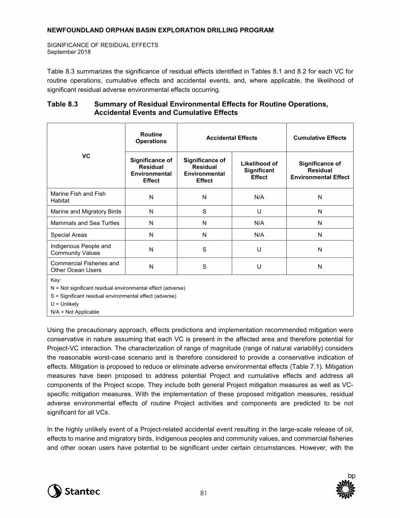
NEWFOUNDLAND ORPHAN BASIN EXPLORATION DRILLING PROGRAM
SIGNIFICANCE OF RESIDUAL EFFECTS September 2018
81
Table 8.3 summarizes the significance of residual effects identified in Tables 8.1 and 8.2 for each VC for routine operations, cumulative effects and accidental events, and, where applicable, the likelihood of significant residual adverse environmental effects occurring.
Table 8.3 Summary of Residual Environmental Effects for Routine Operations, Accidental Events and Cumulative Effects
VC
Routine Operations Accidental Effects Cumulative Effects
Significance of Residual
Environmental Effect
Significance of Residual
Environmental Effect
Likelihood of Significant
Effect
Significance of Residual
Environmental Effect
Marine Fish and Fish Habitat N N N/A N
Marine and Migratory Birds N S U N
Mammals and Sea Turtles N N N/A N
Special Areas N N N/A N
Indigenous People and Community Values N S U N
Commercial Fisheries and Other Ocean Users N S U N
Key: N = Not significant residual environmental effect (adverse) S = Significant residual environmental effect (adverse) U = Unlikely N/A = Not Applicable
Using the precautionary approach, effects predictions and implementation recommended mitigation were conservative in nature assuming that each VC is present in the affected area and therefore potential for Project-VC interaction. The characterization of range of magnitude (range of natural variability) considers the reasonable worst-case scenario and is therefore considered to provide a conservative indication of effects. Mitigation is proposed to reduce or eliminate adverse environmental effects (Table 7.1). Mitigation measures have been proposed to address potential Project and cumulative effects and address all components of the Project scope. They include both general Project mitigation measures as well as VC-specific mitigation measures. With the implementation of these proposed mitigation measures, residual adverse environmental effects of routine Project activities and components are predicted to be not significant for all VCs.
In the highly unlikely event of a Project-related accidental event resulting in the large-scale release of oil, effects to marine and migratory birds, Indigenous peoples and community values, and commercial fisheries and other ocean users have potential to be significant under certain circumstances. However, with the
NEWFOUNDLAND ORPHAN BASIN EXPLORATION DRILLING PROGRAM
SIGNIFICANCE OF RESIDUAL EFFECTS September 2018
82
implementation of proposed well control, spill response, contingency, and emergency response plans, significant residual adverse environmental effects are unlikely to occur.
In summary, the Project is not likely to result in significant residual adverse environmental effects, including cumulative environmental effects, provided that the proposed mitigation is implemented.
BP recognizes the challenge of managing and meeting growing worldwide demand for energy while addressing climate change and other environmental and social issues. The proposed Project will contribute to energy diversification and is expected to generate industrial, employment, and social benefits. The Project is also expected to contribute to technological and scientific knowledge sharing in Canada and Newfoundland and Labrador, advancing the understanding of deep-water drilling operations offshore Newfoundland and Labrador.
NEWFOUNDLAND ORPHAN BASIN EXPLORATION DRILLING PROGRAM
FOLLOW-UP AND MONITORING PROGRAMS September 2018
83
9.0 FOLLOW-UP AND MONITORING PROGRAMS
Under CEAA, 2012, a follow-up program is defined as a program for “verifying the accuracy of the environmental assessment of a designated project” and “determining the effectiveness of any mitigation measures.” In most cases, the effects of routine exploration drilling activities and effectiveness of mitigation measures are well-understood (refer to Chapters 8-13 of the EIS). Where the level of confidence in effects prediction is low or an interest has been expressed by regulatory, public or Indigenous stakeholders for additional information, follow-up has been proposed.
BP is proposing to implement a follow-up program to address uncertainty regarding residual effects of drill waste discharges on the marine benthic environment in consideration of the proximity of Significant Benthic Areas to BP’s Project Area and concerns raised by Indigenous groups about potential effects on cold-water corals. As noted in Table 7.1, BP will conduct an imagery-based seabed survey at the proposed wellsite(s) to confirm the absence of sensitive environmental features, such as habitat-forming corals or species at risk prior to drilling. If any environmental sensitivities are identified during the survey, BP will notify the C-NLOPB immediately to discuss an appropriate course of action. This may involve further investigation and/or moving the wellsite if it is feasible to do so. This survey will also serve to provide baseline data for coral and sensitive benthic habitat that may be present and be used to inform discussions on potential follow-up with respect to drill waste discharges. BP plans to conduct a visual survey of the seafloor using an ROV after drilling activities to assess the visual extent of sediment dispersion and validate drill waste modelling predictions. The specific details of the follow-up program will be determined in consultation with the C-NLOPB and DFO in consideration of the pre-drill survey results.
In addition, the following monitoring programs are proposed to gather data and reduce potential interactions with marine and migratory birds (refer to EIS Chapter 9), marine mammals and sea turtles (refer to EIS Chapter 10), and special areas (refer to EIS Chapter 11).
• For the duration of the drilling program for each well, routine systematic checks will be conducted for stranded birds on the MODU and PSVs by trained personnel in accordance with Procedures for Handling and Documenting Stranded Birds Encountered on Infrastructure Offshore Atlantic Canada (ECCC 2016) and associated permit conditions under the MBCA authorizing the capture and handling of migratory birds. Results of the monitoring program will be shared publicly to help further improve the understanding of bird strandings and mortality in the Newfoundland and Labrador offshore area.
• BP will develop a marine mammal and sea turtle monitoring plan to be implemented during VSP surveys as outlined in Section 10.3.2. The Plan will include Marine Mammal Observer requirements, shutdown and ramp-up procedures and reporting requirements.
BP will submit a report to the C-NLOPB documenting the implementation schedule of commitments and additional conditions of approval, as applicable (prior to drilling) and will also report on the outcome of follow-up and monitoring programs (post-abandonment) of each well, along with any additional conditions of approval, as applicable. The implementation schedule and results will be shared with Indigenous groups and made available online for public information.
NEWFOUNDLAND ORPHAN BASIN EXPLORATION DRILLING PROGRAM
REFERENCES September 2018
84
10.0 REFERENCES
Ackleh, A.S., G.E. Ioup, J.W. Ioup, B.Ma, J.J. Newcomb, N. Pal, N.A. Sidorovskaia and C. Tiemann. 2012. Assessing the Deepwater Horizon oil spill impact on marine mammal population through acoustics: Endangered sperm whales. J. Acoust. Soc. Am., 131: 2306-2314.
Agency (Canadian Environmental Assessment Agency). 2015. The Operational Policy Statement, Addressing “Purpose of” and “Alternative Means” under the Canadian Environmental Assessment Act, 2012.
Agency (Canadian Environmental Assessment Agency). 2018. Guidelines for the Preparation of an Environmental Impact Statement pursuant to the Canadian Environmental Assessment Act, 2012. Newfoundland Orphan Basin Exploration Drilling Project.
Amec (Amec Environment and Infrastructure). 2014. Eastern Newfoundland and Labrador Offshore Area Strategic Environmental Assessment. Final Report. Submitted to Canada-Newfoundland and Labrador Offshore Petroleum Board, St. John's, NL. 527 pp. + appendices. Available at: http://www.cnlopb.ca/sea/eastern.php.p
Amec Foster Wheeler. 2017. Flemish Pass Exploration Drilling Program Drill Cuttings Dispersion Modelling. Prepared for Nexen Energy ULC.
Archambault, P., P.V.R. Snelgrove, J.A.D. Fisher, J.-M. Gagnon, D.J. Garbary, M. Harvey, E.L. Kenchington, V. Lesage, M. Levesque, C. Lovejoy, D.L. Mackas, C.W. McKindsey, J.R. Nelson, P. Pepin, L. Piché and M. Poulin. 2010. From sea to sea: Canada’s three oceans of biodiversity. PLOS One. 5(3): e12182. 26 pp.
Buchanan, R.A. and S.M. Browne. 1981. Zooplankton of the Labrador coast and shelf during summer, 1979. Report by LGL Ltd., to Petro-Canada Exploration Inc. 78 pp.
Buchanan, R.A. and M.G. Foy. 1980a. Ichthyoplankton of the Labrador Shelf and inshore region during summer 1979. Pp. 100-122. In: Proceedings 1980 Workshop on Research in the Labrador Coastal and Offshore Region. Sept. 4-6, 1980. Goose Bay Labrador. Sponsored by Memorial University, Newfoundland Dept. Mines and Energy and Petro-Canada.
Buchanan, R.A. and M.G. Foy. 1980b. Offshore Labrador Biological Studies, 1979: Plankton. Nutrients, chlorophyll, phytoplankton and ichthyoplankton. ABS Ltd. (LGL-Northland) Report to Total Eastcan Explorations Ltd. 293 pp.
Buhl-Mortensen, L. and P.B. Mortensen. 2005. Distribution and diversity of species associated with deep-sea sea gorgonian corals off Atlantic Canada. Pp. 849-879. In: A. Freiwald and J.M. Roberts (eds.). Cold-water corals and ecosystems. Springer-Verlag, Berlin Heidelberg.

NEWFOUNDLAND ORPHAN BASIN EXPLORATION DRILLING PROGRAM
REFERENCES September 2018
85
Buhl-Mortensen, L., A. Vanreusel, A.J. Gooday, L.A. Levin, I.G. Priede, P. Buhl‐Mortensen, H. Gheerardyn, N.J. King and M. Raes. 2010. Biological structures as a source of habitat heterogeneity and biodiversity on the deep ocean margins. Marine Ecology Progress Series, 31: 21-50.
BP Canada Energy Group ULC. 2016. Scotian Basin Exploration Drilling Project Environmental Impact Statement. Volume 1: Environmental Impact Statement. Prepared by Stantec Consulting Ltd., Halifax, NS.
Carls, M.G., L. Holland, M. Larsen, T.K. Collier, N.L. Scholz and J.P. Incardona. 2008. Fish embryos are damaged by dissolved PAHs, not oil particles. Aquat. Toxicol., 88(2): 121-127.
Carls, M.G., Rice, S.D., and Hose, J.E. 1999. Sensitivity of fish embryos to weathered crude oil: Part 1. Low-level exposure during incubation causes malformations, genetic damage, and mortality in larval Pacific herring (Clupea pallasi). Environ. Toxicol. Chem. 18: 481-493.
C-NLOPB (Canada-Newfoundland and Labrador Offshore Petroleum Board). 2017. Geophysical, Geological, Environmental and Geotechnical Program Guidelines. vii + 56 pp.
C-NLOPB (Canadian-Newfoundland and Labrador Offshore Petroleum Board) and CNSOPB (Canada-Nova Scotia Offshore Petroleum Board). 2017a. Drilling and Production Guidelines. Available at: http://www.cnlopb.ca/pdfs/guidelines/drill_prod_guide.pdf?lbisphpreq=1
C-NLOPB (Canadian-Newfoundland and Labrador Offshore Petroleum Board] and CNSOPB [Canada-Nova Scotia Offshore Petroleum Board)]. 2017b. Compensation Guidelines Respecting Damages Relating to Offshore Petroleum Activity. 20 pp.
Cordes, E.E, D.O.B. Jones, T.A Schlacher, D.J. Amon, A.F. Bernardino, A. Brooke, R. Carney, D.M. DeLeo, K.M. Dunlop, E.G. Escobar-Briones, A.R. Gates, L. Génio, J. Gobin, L.A. Henry, S. Hererra, S. Hoyt, M. Joye, S. Kark, N.C. Mestre, A. Metaxas, S. Pfeifer, K. Sink, A.K. Sweetman and U. Witte. 2016. Environmental impacts of the deep-water oil and gas industry: a review to guide management strategies. Frontiers in Environmental Science, 4(58):1-26.
Dayton, P.K. 1985. Ecology of kelp communities. Annual Reviews of Ecology and Systematics, 16: 215-245.
De Clippele, L.F., P. Buhl-Mortensen and L. Buhl-Mortensen. 2015. Fauna associated with cold water gorgonians and sea pens. Continental Shelf Research, 105:67-78.
Denny, S. and S. Kavanagh. 2018. Review of the Timing of the American Eel Migratory Journey off Nova Scotia. Window of Sensitivity Defined for the American Eel.
Denny, S., and L. Fanning. 2016. A Mi’kmaw perspective on advancing salmon governance in Nova Scotia, Canada: Setting the stage for collaborative co-existence. The International Indigenous Policy Journal, 7(3).
NEWFOUNDLAND ORPHAN BASIN EXPLORATION DRILLING PROGRAM
REFERENCES September 2018
86
Devine, J.A., K.D. Baker, and R. L. Haedrich. 2006. Deep-sea fishes qualify as endangered. Nature 439: 29.
DFO (Fisheries and Oceans Canada). 2005. Identification of Ecologically and Biologically Significant Areas. DFO Can. Sci. Advis. Sec. Ecosystem Status Rep., 2004/006: 15 pp.
DFO (Fisheries and Oceans Canada). 2007. Statement of Canadian Practice with respect to the Mitigation of Seismic Sound in the Marine Environment. Available from: http://www.dfo-mpo.gc.ca/oceans/publications/seismic-sismique/index-eng.html
DFO (Fisheries and Oceans Canada). 2017. Lobster Area closures (Trout River, Shoal Point, Penguin Islands, Gooseberry Island, Glovers Harbour, Mouse Island, Gander Bay). Available at: http://www.dfo-mpo.gc.ca/oceans/oeabcm-amcepz/refuges/lobster-homard-eng.html.
Douglas, A.B., J. Calambokidis, S. Raverty, S.J. Jeffries, D.M. Lambourn and S.A.Norman. 2008. Incidence of ship strikes of large whales in Washington State. Journal of the Marine Biological Association of the United Kingdom, 88: 1-12.
ECCC (Environment and Climate Change Canada). 2016. Procedures for Handling and Documenting Stranded Birds Encountered on Infrastructure Offshore Atlantic Canada. 17 pp. + Appendices
ECCC (Environment and Climate Change Canada). 2017. Seabird and waterbird colonies: Avoiding disturbance. Available at: https://www.canada.ca/en/environment-climate-change/services/avoiding-harm-migratory-birds/seabird-waterbird-colonies-disturbance.html Accessed: 26 April 2018.
Engelhardt, R.F. 1983. Petroleum effects on marine mammals. Aquat. Toxicol., 4: 199-217.
Fewtrell, J.L. and R.D. McCauley. 2012. Impact of air gun noise on the behaviour of marine fish and squid. Mar. Pollut. Bull., 64(5): 984-993.
Fifield, D.A., K.P. Lewis, C. Gjerdrum, G.J. Robertson and R. Wells. 2009. Offshore Seabird Monitoring Program. Environmental Studies Research Funds ESRF Report 183. 68 pp.
French-McCay, D.P. 2009. State-of-the-art and research needs for oil spill impact assessment modeling. PP. 601-653. In: Proceedings of the 32nd AMOP Technical Seminar on Environmental Contamination and Response, Emergencies Science Division, Environment Canada, Ottawa, ON. Available from: http://www.asascience.com/about/publications/pdf/2009/FrenchMcCay_AMOP09-biomodel-with-cite.pdf.
Gates, A.R. and D.O.B. Jones. 2012. Recovery of benthic megafauna from anthropogenic disturbance at a hydrocarbon drilling well (380 m depth in the Norwegian Sea). PLOS One, 7(10):1-14.
Geraci, J.R. and D.J. St. Aubin. 1990. Sea Mammals and Oil: Confronting the Risks. Academic Press, New York, NY.
NEWFOUNDLAND ORPHAN BASIN EXPLORATION DRILLING PROGRAM
REFERENCES September 2018
87
Gorsline, J., W.N. Holmes and J. Cronshaw. 1981. The effects of ingested petroleum on the naphthalene-metabolizing properties of liver tissue in seawater-adapted mallard ducks (Anas platyrhynchos). Environ. Res., 24: 377-390.
Government of Canada. 2018. Species at Risk Public Registry. Available at: http://www.sararegistry.gc.ca/default.asp?lang=En&n=24F7211B-1.
Graham, W.M., R.H. Condon, R.H. Carmichael, I. D’Ambra, H.K. Patterson, L.J. Linn and F.J. Hernandez, Jr. 2010. Oil carbon entered the coastal planktonic food web during the Deepwater Horizon oil spill. Environ. Res. Lett., 5(4): 045301, doi:10.1088/1748-9326/5/4/045301.
Gramentz, D. 1988. Involvement of loggerhead turtle with the plastic, metal and hydrocarbon pollution in the central Mediterranean. Mar. Poll. Bull., 19: 11-13.
Greenan, B.J.W, I. Yashayaev, E. J. H. Head, W. G. Harrison, K. Azetsu-Scott, W. K. W. Li, J. W. Loder and Y. Geshelin. 2010. Interdisciplinary oceanographic observations of Orphan Knoll. NAFO SCR Doc. 10/19.
Hanson, J., M. Helvey and R. Strach (Editors). 2003. Non-fishing impacts to essential fish habitat and recommended conservation measures. Long Beach (CA): National Marine Fisheries Service (NOAA Fisheries) Southwest Region. Version 1. 75 p.
Hedd, A., W.A. Montevecchi, L. McFarlane Tranquilla, C.M. Burke, D.A. Fifield, G.J. Robertson, R.A. Phillips, C. Gjerdrum and P.M. Regular. 2011. Reducing uncertainty on the Grand Bank: tracking and vessel surveys indicate mortality risks for common murres in the North-West Atlantic. Animal Conservation, 14: 630-641.
Henry, L.A., D. Harries, P. Kingston and J.M. Roberts. 2017. Historic scale and persistence of drill cuttings impacts on North Sea benthos. Marine Environmental Research, 129: 219-228.
IAGC-OGP (International Association of Geophysical Contractors and International Association of Oil and Gas Producers). 1999. Glossary of HSE Terms. Report No. 6.52/244. Available from: http://www.ogp.org.uk/pubs/244.pdf
IAOGP (International Association of Oil & Gas Producers). 2016. Environmental fates and effects of ocean discharge of drill cuttings and associated drilling fluids from offshore oil and gas operations. Report 543, Version 1, March 2016. 145 pp.
Incardona J.P., T.L. Swarts, R.C. Edmunds, T.L. Linbo, A. Aquilina-Beck, C.A. Sloan and N.L. Scholz. 2013. Exxon Valdez to Deepwater Horizon: Comparable toxicity of both crude oils to fish early life stages. Aquat. Toxicol., 142: 303-316.
Irwin, R.J. 1997. Environmental Contaminants Encyclopedia Crude Oil Entry. National Park Service, Water Resources Divisions, Water Operations Branch, CO.
NEWFOUNDLAND ORPHAN BASIN EXPLORATION DRILLING PROGRAM
REFERENCES September 2018
88
ITOPF (International Tanker Owners Pollution Federation Limited). 2011. Recognition of oil on shorelines. Technical Information Paper No. 6. Available at: http://www.itopf.com/knowledge-resources/documents-guides/document/tip-6-recognition-of-oil-on-shorelines/.
Jensen, A.S. and G.K. Silber. 2003. Large Whale Ship Strike Database. US Department of Commerce, NOAA Technical Memorandum. NMFS-OPR. 37 pp.
Laist, D.W., A.R. Knowlton, J.G. Mead, A.S. Collet and M. Podesta. 2001. Collisions between ships and whales. Marine Mammal Science, 17: 35-75.
Law, R., C. Kelly, K. Graham, R. Woodhead, P. Dyrynda and E. Dyrynda. 1997. Hydrocarbons and PAH in Fish and Shellfish from Southwest Wales following the Sea Empress Oil Spill in 1996. Available at: http://ioscproceedings.org/doi/pdf/10.7901/2169-3358-1997-1-205.
Lee, K., M. Boufadel, B. Chen, J. Foght, P. Hodson, S. Swanson, A. Venos. 2015. Expert Panel Report on the Behavior and Environmental Impacts of Crude Oil Released into Aqueous Environments. Royal Society of Canada, Ottawa, ON.
LGL Limited. 2003. Orphan Basin Strategic Environmental Assessment. LGL Rep. SA767. Prepared by LGL Limited, St. John’s, NL for Canada-Newfoundland and Labrador Offshore Petroleum Board. 229 pp.
Lock, A.R., R.G.B. Brown and S.H. Gerriets. 1994. Gazetteer of Marine Birds in Atlantic Canada: An Aatlas of Seabird Vulnerability to Oil Pollution. Canadian Wildlife Service Atlantic Region. 137 pp.
Matthews, M.-N., T.J. Deveau, C. Whitt and B. Martin. 2018. Underwater sound assessment for Newfoundland Orphan Basin exploration drilling program. Rep. by JASCO Applied Sciences, Dartmouth, NS for Stantec, St. John’s, NL. 48 pp. + appendices.
Milton, S., P. Lutz and G. Shigenaka. 2010. Oil toxicity and impacts on sea turtles In: G. Shigenaka (ed.). Oil and Sea Turtles: Biology, Planning, and Response. National Oceanic and Atmospheric Administration, 112 pp.
Movchan, O.A. 1963. Quantitative development of the phytoplankton in the areas of the Newfoundland and Flemish Cap banks and in adjacent waters. Pp. 205-213. In: Soviet Fisheries Investigations in the Northwest Atlantic.
Müeller-Blenkle, C., E. Jones, D. Reid, K. Lüdemann, R. Kafemann and A. Elepfandt. 2008. Reactions of cod (Gadus morhua) to low frequency sound resembling offshore wind turbine noise emissions. Bioacoustics, 17: 207-209.
NAFO Conservation and Enforcement Measures. 2017 (FC Doc. 17-01, Serial No. N6638, 188 pp.). Available at: https://www.nafo.int/Portals/0/PDFs/fc/2017/CEM-2017-web.pdf 2017

NEWFOUNDLAND ORPHAN BASIN EXPLORATION DRILLING PROGRAM
REFERENCES September 2018
89
NEB (National Energy Board), C-NLOPB (Canadian Newfoundland and Labrador Offshore Petroleum Board), and CNSOPB (Canada-Nova Scotia Offshore Petroleum Board). 2008. Offshore Physical Environment Guidelines. vii + 28 pp. + Appendices. Available at: https://www.cnlopb.ca/wp-content/uploads/guidelines/peg_guidelines.pdf
NEB (National Energy Board), C-NLOPB (Canadian Newfoundland and Labrador Offshore Petroleum Board), and CNSOPB (Canada-Nova Scotia Offshore Petroleum Board). 2009. Offshore Chemical Selection Guidelines for Drilling and Production Activities on Frontier Lands. iii + 13 pp. Available at: http://www.C-NLOPB.nl.ca/pdfs/guidelines/ocsg.pdf
NEB (National Energy Board), C-NLOPB (Canadian Newfoundland and Labrador Offshore Petroleum Board), and CNSOPB (Canada-Nova Scotia Offshore Petroleum Board). 2010. Offshore Waste Treatment Guidelines. vi + 28 pp. Available at: https://www.cnlopb.ca/wp-content/uploads/guidelines/owtg1012e.pdf
Neff, J.M., G. Kjeilen-Eilersten, H. Trannum, R. Jak, M. Smit and G. Durell. 2004. Literature Report on Burial: Derivation of PNEC as Component in the MEMW Model Tool. ERMS Report No. 9B. AM 2004/024. 25 pp.
Neff, J.M., S. McKelvie and R.C. Ayers, Jr. 2000. Environmental Impacts of Synthetic Based Drilling Fluids. OCS Study MMS 2000-64. US Department of the Interior, Minerals Management Service, Gulf of Mexico OCS Program, New Orleans, LA. 118 pp.
Nexen Energy ULC. 2018. Nexen Energy ULC Flemish Pass Exploration Drilling Project Environmental Impact Statement.
Nightingale, B. and C. Simenstad. 2002. Artificial night-lighting effects on salmon and other fishes in the Northwest. Ecological Consequences of Artificial Night Lighting conference, February 23-24, 2002, sponsored by the Urban Wildlands Group and the UCLA Institute of the Environment.
NOAA (National Oceanic and Atmospheric Administration). 2016. What Happens to Dispersed Oil? Available from: http://response.restoration.noaa.gov/oil-and-chemical-spills/oil-spills/resources/9-what-happens-dispersed-oil.html.
Nowacek, D.P., L.H. Thorne, D.W Johnston and P.L. Tyack. 2007. Responses of cetaceans to anthropogenic noise. Mammal Rev., 37: 81-115.
Panigada, S., G. Pesante, M. Zanardelli, F., F. Capoulade, A. Gannier and M.T. Weinrich. 2006. Mediterranean fin whales at risk from fatal ship strikes. Mar. Poll. Bull., 52(10): 1287-1298.
Rice, S.D. 1985. Effects of oil on fish. Pp: 157-182. In: F.R. Engelhardt (ed.). Petroleum Effects in the Arctic Environment, Elsevier Science Publishing Co., NY. xxiv + 282 pp.
Richardson, W.J. 1979. Southeastward shorebird migration over Nova Scotia and New Brunswick in autumn: a radar study. Canadian Journal of Zoology, 57: 107-124.

NEWFOUNDLAND ORPHAN BASIN EXPLORATION DRILLING PROGRAM
REFERENCES September 2018
90
Richardson, W.J., C.R. Greene, Jr., C.I. Malme and D.H. Thomson. 1995. Marine Mammals and Noise. Academic Press, San Diego, CA. 576 pp.
Roberts, J.M., A.J. Wheeler, A. Freiwald and S. Cairns. 2009. Cold-water Corals: The Biology and Geology of Deep-sea Coral Habitats. Cambridge University Press, New York, USA. 334 pp.
Ronconi, R.A., K.A. Allard and P.D. Taylor. 2015. Bird interactions with offshore oil and gas platforms: Review of impacts and monitoring techniques. Journal of Environmental Management, 147: 34-45.
RPS. 2017. Trajectory Modelling in Support of the Nexen Energy ULC Flemish Pass Exploration Drilling Project (2018-2028).
Shannon, G., M.F. McKenna, L.M. Angeloni, K.R. Crooks, K.M. Fristrup, E. Brown, K.A. Warner, M.D. Nelson, C. White, J. Briggs., S. McFarland and G. Wittemyer. 2016. A synthesis of two decades of research documenting the effects of noise on wildlife. Biol. Rev. Camb. Philos. Soc., 91(4): 982-1005.
Shell Canada Limited. 2014. Shelburne Basin Venture Exploration Drilling Project. Volume 1: Environmental Impact Statement. Prepared by Stantec Consulting Ltd. for Shell Canada Limited, Halifax, NS.
Smultea, M.A. and B. Würsig. 1995. Behavioral reactions of bottlenose dolphins to the Mega Borg oil spill, Gulf of Mexico 1990. Aquatic Mammals, 21: 171-181.
St. Aubin, D.J., J.R. Geraci, T.G. Smith and T.G. Friesen. 1985. How do bottlenose dolphins, Tursiops truncatus, react to oil films under different light conditions? Canadian Journal of Fisheries and Aquatic Sciences, 42: 430-436.
Statoil Canada Ltd. 2017. Flemish Pass Exploration Drilling Program- Environmental Impact Statement. Prepared by Amec Foster Wheeler and Stantec Consulting Ltd. St. John’s, NL Canada, November 2017. 1484 pp.
Templeman, N. 2010. Ecosystem status and trends report for the Newfoundland and Labrador Shelf. Can. Sci. Advis. Sec. Res. Doc., 2010/026: vi + 72 pp.
Tremblay, M.J. and J.T. Anderson. 1984. Annotated species list of marine planktonic copepods occurring on the shelf and upper slope of the Northwest Atlantic (Gulf of Maine to Ungava Bay). Canadian Spec. Publ. Fish. Aquat. Sci., 69. 12 pp.
Tyack, P.L. 2008. Implications for marine mammals of large-scale changes in the marine acoustic environment. Journal of Mammalogy, 89(3): 549-558.
Vanderlaan, A.S.M. and C.T. Taggart. 2007. Vessel collisions with whales: The probability of lethal injury based on vessel speed. Mar. Mammal Sci., 23(1):144-156.
NEWFOUNDLAND ORPHAN BASIN EXPLORATION DRILLING PROGRAM
REFERENCES September 2018
91
Vargo, S., Lutz, P., Odell, D., Van Vleet E., and Bossart, G. 1986. Study of the Effects of Oil on Marine Turtles. Final report to Minerals Management Service MMS Contract No. 14-12-0001-30063. 181 pp.
Wiese, F.K., W.A. Montevecchi, G.K. Davoren, F. Huettmann, A. W. Diamond and J. Linke. 2001. Seabirds at risk around offshore oil platforms in the North-west Atlantic. Mar. Poll. Bull., 42: 1285-1290.
Williams, T.C. and J.M. Williams. 1978. An oceanic mass migration of land birds. Scientific American, 239: 166-176.
Wolfe, D.A., M.M. Krahn, E. Casillas, S. Sol, T.A. Thomas, J. Lunz and K.J. Scott. 1996. Toxicity of intertidal and subtidal sediments in contaminated by the Exxon Valdez oil spill. Pp. 121-139. In: S.D. Rice, R.B. Spies, D.A. Wolfe and B.A. Wright (eds.). Proceedings of the Exxon Valdez Oil Spill Symposium, American Fisheries Society Symposium 18.
Yender, R.J., Michel, J., and Lord, C. 2002. Managing Seafood Safety after an Oil Spill. Seattle Hazardous Materials Response Division, Office of Response and Restoration, National Oceanic and Atmospheric Administration. 72 pp.