newmont exploration of canada ltd. · drilling and sampling methods the reverse circulation method...
TRANSCRIPT
32E12SEa045 2.5848 BRADETTE 010
NEWMONT EXPLORATION
OF CANADA LTD.
1983 Overburden Drilling
Mikwam Property - Project 260
Bradette Township, Ontario
OCT 3 l
MINING LAND;, ;**.v.,
l
July, 1983 R.A. Archer
32E12SE0045 2.5840 BRADETTE 010C
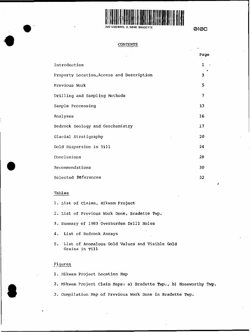
CONTENTS
Page
Introduction lt
Property Location,Access and Description 3
Previous Work 5
Drilling and Sampling Methods 7
Sample Processing 13
Analyses 16
Bedrock Geology and Geochemistry 17
Glacial Stratigraphy 20
Gold Dispersion in Till 24
Conclusions 28
Recommendations 30
Selected References 32
Tables
1. List of Claims, Mikwam Project
2. List of Previous Work Done, Bradette Twp.
3. Summary of 1983 Overburden Drill Holes
4. List of Bedrock Assays
5. List of Anomalous Gold Values and Visible Gold Grains in Till
Figures
1. Mikwam Project Location Map
2. Mikwam Project Claim Maps: a) Bradette Twp., b) Noseworthy Twp.
3. Compilation Map of Previous Work Done in Bradette Twp.
t
4. Sample Processing Flow Sheet
5. Jensen Cation Plot for Selected Bedrock Samples
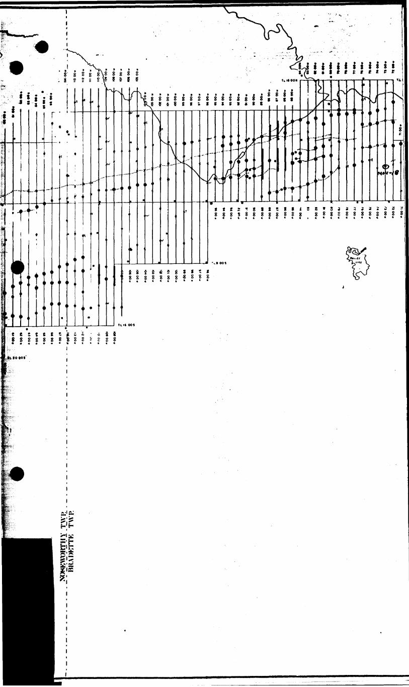
6. Drill Hole Location Map with Section Lines and Geophysical* Compilation,
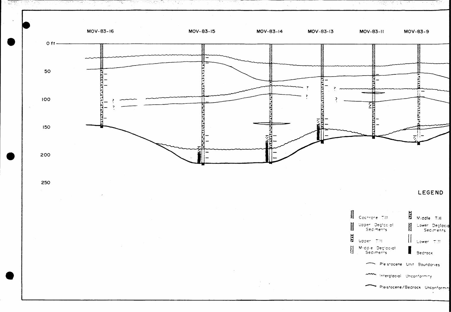
7.' Glacial Stratigraphy and Gold Distribution along Section A-A 1
8. Glacial Stratigraphy and Gold Distribution along Section B-B 1
9. Glacial Stratigraphy and Gold Distribution along Section C-C 1
Appendix
Overburden Drilling Management Ltd. Laboratory Sample Logs
Bedrock Assays and Selected Whole Rock Analyses
Non-magnetic Heavy Mineral Concentrate Assays
Volume II
Overburden Drill Logs

t
t
-1-
Introduction
Magnetic and Max Min II EM surveys carried out over
the Mikwam property in 1982 outlined an iron formation flanked
by graphitic horizons in the eastern part of the property. ,
Since little else was known about this area and due to an
estimated overburden depth (calculated from horizontal loop
data) which locally exceeded 200 feet, it was felt that over
burden drilling was the best way to evaluate the gold potential
of these horizons.
Fifteen overburden holes were drilled in January and
February of 1983 at 400 to 600 m intervals along the strike
length of the iron formation. The majority of these were
drilled down-ice from the magnetic high, often testing areas
of apparent structural complexity, or conductive horizons
outlined, by the EM survey. A single hole, MOV-83-18, was
drilled to the northwest of the others, down-ice from an
area of geochemically anomalous gold-bearing rocks previously
identified in drill core.
Hole MOV-83-8, drilled into the magnetic high, confirmed
the presence of a laminated oxide-facies iron formation.
Other bedrock intersections outlined a package of predominantly
mafic, calc-alkaline volcanic rocks'with intercalated pelitic
sediments and graphitic argillites. One of these pelitic
units, in hole MOV-83-9, yielded an anomalous gold content-
of 290 ppb.
-2-
The glacial stratigraphy of the study area proved to be
quite uniform and consists of three units of Wisconsin-age
till and associated deglacial sediments unconformably overlain
by a layer of the more locally derived Cochrane Till.
Gold in till occurs predominantly as free, visible grains
and shows a very good correlation with anomalous arsenic values.
This, along with a tendency for the gold-arsenic to occur in
till close to bedrock suggests that the source of the gold is
probably a quartz-gold-arsenopyrite system that is within a
few hundred metres of the overburden holes. This makes the
iron formation and adjacent rocks the primary target for a
proposed diamond drill program designed to obtain a geological
cross-section while testing for mineralization and possible
structural controls. *

-3-
Property Location, Access and Description
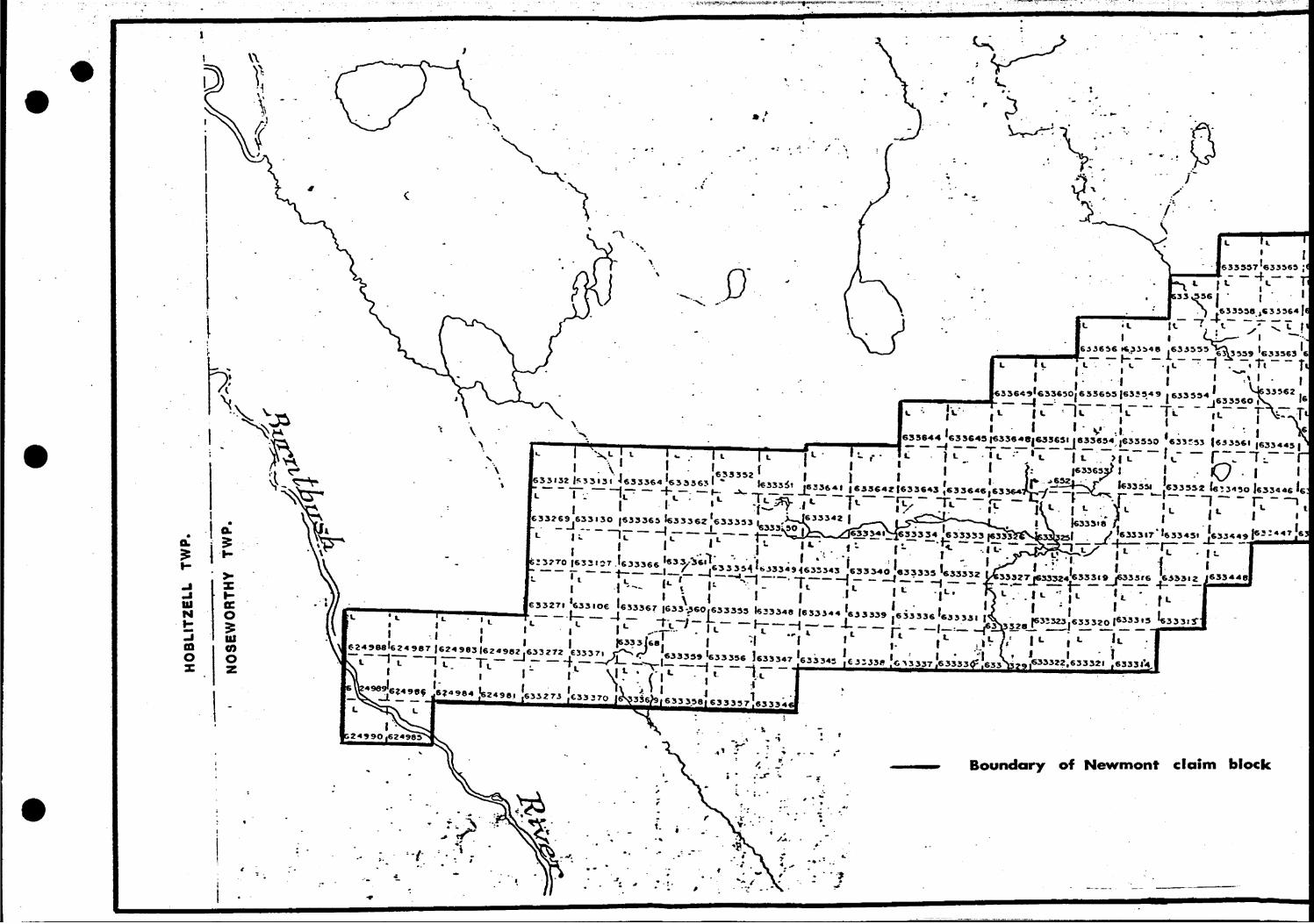
The Mikwam project is a Newmont C5(H)-Dupont (50%) joint
venture consisting of 323 contiguous claims in Ontario and
12 in Quebec staked by Newmont in December, 1981 and February,
1982. A list of claim numbers (Table 1) and a claim map
(Fig. 2} are appended to the report.
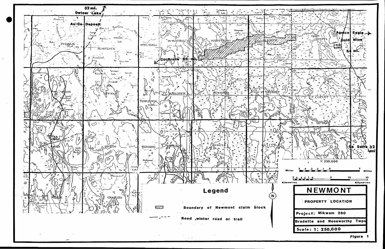
The property straddles the townships of Noseworthy and
Bradette in northeastern Ontario and extends into Dieppe Township
in northwestern Quebec. The western property boundary lies in
the southwestern corner of Noseworthy Twp., in the Burntbush
River area, about 65 miles northeast of Cochrane, Ontario
(Figure 1). In the summer the property is accessible only by
helicopter or by boat along the Turgeon, Burntbush and Turcotte
Rivers. In the winter of 1983, however, access was provided
from the Quebec side by the winter road to Detour Lake, as far
as the ice bridge across the Turgeon River, and then by logging
roads and bush roads.
There is less than J.% outcrop exposure on the property and
most of this is found in the southwest corner near the Burntbush
River. The overburden varies considerably in thickness across the
property and depths of over 200 feet (maximum 255 feet) were not
uncommon in the overburden drilling program. The overburden
consists of till and glacio-lacustrine and glacio-fluvial sediments.
Surficial vegetation ranges from string bog, alder and spruce
swamp to drier ridge areas covered by spruce, poplar and jackpine.
-4-
Air photographs of the area show a strong northwest-southeast
lineation in the surface topography related to underlying
glacial features and/or bedrock topography.

-5-
Previous Work
The earliest geological report on the property (western
part only) was written by R. Thompson (1936) in which he noted
that some stripping and trenching had been done on the east *
side of the Burntbush River by the Cyril Knight Prospecting
Company. This work was carried out over an area of quartz
veining in a shear zone and yielded a highest assay of $2.00
per ton (0.057 oz Au/ton at $35.00 per ounce). These claims
were allowed to lapse and the area is currently held by Newmont
as part of the Mikwam Property.
The earliest interpreted geology of the area was done by
G. Bennett et.al. in 1966 and is presented in MAP 2161 ( l inch
to 4 miles scale) published by the Ontario Geological survey.
The most recent geological mapping of Bradette and Noseworthy
Townships, done by G.W. Johns, also of the Ontario Geological
Survey, is presented in MAP 2453 and is current to December,
1978. Prior to this publication Johns also published, through
the OGS, preliminary map P2243 (1:50,000 scale) which covers the
southern part of the Burntbush-Detour Lakes area with an accompany
ing text referring to the geology of the area published as an
open file report (OFR 5279) .
Prior to the above-mentioned geology maps a Data Series
Preliminary map, P902, was published in 1975 which compiled all
the work done by various companies, in Bradette Twp., as filed
for assessment up to 1973. A similar map for Noseworthy Twp.,
map P2172, was issued in 1981.
-6-
Certain parts of the project area have been surveyed by
various companies in the past and information from assessment
files in Toronto and Kirkland Lake has been compiled and studiedt
by Newmont personnel. Many of these companies refer to airborne
geophysical surveys which have never been filed with the Ontario
Ministry of Natural Resources. The main exploration target for
these companies was base metals, hence much of the data was not
considered from the point of view of gold exploration. Table 2
summarizes the previous work done on the property in Bradette
Township and the limit of each respective survey area is illustrated
in Figure 3.
Previous work done on the property in Noseworthy Township has
been omitted from this report since it does not pertain to the
present study.
The earliest government-released geophysical survey was an
airborne magnetic survey done by Spartan Air Services Ltd.
between 1963 and 1964 and was published by the Geological Survey
of Canada as Map 2367G and Map 2368G (covering NTS areas 32E/5
and 32E/12 respectively; l inch to l mile scale).
Prior to overburden drilling, Newmont conducted an extensive
geophysical program over the Mikwam Property including magnetic,
Max Min II EM and selective IP surveys. It was
this information, together with previously compiled geological
and geochemical data, which outlined several gold exploration
targets in areas of deep overburden and prompted Newmont to
carry out the present study.
-7-
Drilling and Sampling Methods
The reverse circulation method of drilling was used, with the
work contracted to Dominik Drilling Ltd. of Val D'Or, Quebec.
The drill, an 'Inspiration 33 l model, was fully enclosed and
jnounted on skids to facilitate towing by a Timberjack. The
drill shack was extended to allow for the enclosure of a sample
collection area. This unitized system was advantageous over
previous, two-shack systems in that it allowed for faster moving
times and better.communication between the drillers-and the
geologists while the drill was in operation.
Reverse circulation rods have a dual tube construc
tion. They are 10 feet long with an outer tube 2.75 inches
in diameter which acts as a casing. The inner tube has a
diameter of one inch and serves only to deliver the sample to
the surface. Water is used to reduce abrasion on the bit and
to act as the transporting medium for the sample. It is pumped
down to the bit through the space between the two tubes. A
one-foot long adaptor is used to connect the bottom rod to
the tricone bit. The latter is faced with a series of beveled
tungsten carbide buttons and has a diameter of 2.94 inches.
A high pressure water pump is used to ensure that the
sample is instantly and continuously returned to surface. In
this way it is possible to accurately log the levels of
stratigraphic contacts and important textural and mineralogical
features inherent in the glacial debris.
l

-8-
r
When the sample slurry reaches the surface it is channeled
through an enclosed funnel called a 'cyclone 1 , passed through
two wire mesh screens and into a fifteen gallon plastic bucket.
The first of the screens has a mesh spacing of about 1.7 mm1 (+10
mesh) and catches virtually everything except fine sand and silt.
This gives the geologist logging the hole a brief opportunity to
record the relative abundances of grain size fractions and
predominant rock types. Since the sample delivery is a continuous
process, this screen has to be frequently dumped. Removal of
the +10 mesh material at this point decreases the size of the
sample shipped to the processing laboratory, where it would be
removed anyway, and therefore decreases the shipping and handling
costs. The larger screen, with a mesh spacing of about l cm, is'
used mainly as support for the 10 mesh screen and also to collect
heavy clay material which would clog up the finer screen. Excess
water is allowed to overflow the sample bucket into a settling
tank from which the clean water is recirculated. Fresh water is
obtained from nearby sources via a 1000 gal. tank mounted on skids.
An additional 200 gal. reservoir tank in the drill shack is kept
full in order to keep up the water supply until fresh water is
obtained.
At the end of each 10-foot run the sample bucket is
replaced and left to settle for a few minutes. Excess water
is then decanted off the top and the entire sample is scooped
into plastic bags which have been labeled with the sample
number, hole number and sample footage. The sairple is once
-9-
again left to settle and, after a final Recantation, the bag
is sealed and placed in a five gallon can for shipment to the
processing laboratory. A ticketing system is used to keep
* track of samples, whereby a ticket with the sample number and
project number is attached to the sample bag. "Three other
tickets are each filled out with the project, hole and sample
numbers, date, sample footage and description. These tickets
are then distributed for field and office records. Sample
number and footage are further recorded on the drill log
sheets .
For the sampling operation to run smoothly and
efficiently, two persons are required - one to log the sample
as it passes through the screens and one to handle the sample
preparation. In this way the sample is constantly monitored
and the geologist may advise the driller of any formational
changes requiring an adjustment in drill or water pressure.
It is only fair to acknowledge that an experienced driller
may well notice' these changes on his own and advise the
geologist before the new sample actually reaches the surface.
This foreknowledge of an upcoming change is especially
appreciated upon the intersection of bedrock. It is at this
point, where the sample becomes homogeneous and it is apparent
to the geologist that bedrock has indeed been intersected, that
the sample bucket is immediately exchanged for a fresh one,
thereby reducing the amount of bedrock chips mixing with till
-10-
and vice-versa. The bedrock is then drilled for approximately
five feet in order to obtain a sufficient sample for assay
and geological/geochemical evaluation. During this 5-foot
section, the larger, cleaner chips caught in the screens are
examined and a suitable sample is taken for whole rock analysis.
Anything else of interest, such as quartz veins or sulphide
mineralization may also be sampled at this point.
The drill logs for each hole contain all the
information recorded for that hole, except whole rock analyses,
and are appended to the report. Whole rock analyses for
bedrock samples are given in the Appendix.
The uppermost clay horizons were not sampled since
they have been too highly transported to be of any use in
exploration. Clay horizons interlayered with till were sampled,
however, as they may have been more locally derived and may
contain remobilized gold from above or below. Special care was
also taken to sample the contact between the top of the till
horizon and the overlying clay since free gold has a tendency
to collect on this interface. It has not yet been established
whether these occurrences yield real or false anomalies.
Due to the inhomogenous distribution of gold in
clastic horizons (till, sand and gravel), the entire sample
collected from each 10-foot run was kept and processed, in
the hope of increasing the chances of detecting gold mineral
ization. A small test was conducted with the samples from hole

-11-
MOV-83-4 to see if the sample size does have any bearing on
the amount of gold detected. To do this, eleven till samples,
each from a 10-foot section, were split, as evenly as possible,t
into two parts, one being at least twice the size of the other.
The two parts of each sample were then given separate numbers
and were processed and assayed as completely independent samples.
The results of this test were suprising in tha't the smaller
samples consistently yielded equal or higher assays than their
larger counter parts. While the reason for this consistency may
be partially analytical it appears that larger samples do not
increase the chances of finding gold. It is therefore recommended
that future sampling of overburden material be limited to a bulk
weight of approximately 6 kg per sample. This should yield about
15 grams of non-magnetic heavy mineral concentrate (based on anj
average yield of about D.25% from the present study) which is
sufficient for reliable gold, arsenic, copper and zinc analyses
to be carried out.
It was found that the amounts of sample returning to surface
was very dependent on the type of material being drilled. For
example, porous horizons such as sand and silt generally absorbed
the water pumped to the bit and hence, little material was flushed
up the rods. Horizons containing a higher proportion of clay,
however, tended to be less porous and a larger sample was typically
obtained. Therefore, the size of individual samples varied
considerably and the bulk weights ranged from 4.2 kilograms to
-12-
as much as 46.9 kg. The average bulk weight for the 197 samples
taken (counting sample pairs from MOV-83-4 as single samples)
was 17.9 kg.
-13-
Sample Processing
All till, sand and gravel samples were processed by Overburden
Drilling Management Ltd. at their specially equipped laboratory
in Ottawa. The flow sheet illustrated in Fig. 4 outlines the
procedure followed for each sample.
Initially, two splits of approximately 250 grams (dry weight)
are taken from the original bulk sample. One of these splits is
kept for future reference, while the other is sieved at 120 mesh
(63 microns) and the minus 63^ fraction is retained for geochemical
analysis.
The remainder of the bulk sample is then weighed (wet) and
passed through a 1700^ (10 mesh) sieve. The plus 10 fraction is
stored and the minus 10 fraction is fed onto a Wilfrey shaking
table through a special gravity concentrator. This feeding
device puts the coarse material onto the table first followed
by the finer material, giving the operator a chance to classify
the sample as till, sand or gravel based on the proportion of
fine to coarse material and on the degree of sorting.
The separation of heavy minerals begins on the shaking
table. Coloured trails of hornblende, epidote, garnet, pyritei
and magnetite can be seen with any free gold present riding on
the outside of these bands. With the help of a large magnifyingt
glass, visible gold grains are counted, measured with a micro
meter and classified according to the degree of rounding they
have undergone.
-14-
Rounded grains are classified as 'transported' (T), grains
showing little or no rounding as 'delicate 1 (D), and grains
that are quite delicate but with some rounded edges are classedc t
as 'abraided 1 (A). The degree of re-working of the grains
presumably indicates the relative distance from the source,
hence this classification is proving quite useful in the
interpretation of till anomalies.
Over 9(H of the heavy minerals are collected by the table
process and these are further refined by a heavy liquid
separation. For this, a Methylene Iodide solution with a
specific gravity of 3.32 as used. The light mineral fraction
from this process (M.I. Lights) is saved while the heavy
mineral x concentrate is subjected to a magnetic separation.
This is accomplished with a hand-held, mechanical release type
of magnet which is held at such a level as to remove all the
drill steel and magnetite, while leaving behind the lesser
and non-magnetic substances such as pyrrhotite, hematite,
pyrite and ilmenite.
The non-magnetic heavy mineral concentrate is the final
product of the sample processing system. The last step is to
separate this concentrate into 1/4 and 3/4 portions with a
microsplitter. The 3/4 fraction is then submitted for analysis
while the 1/4 fraction is retained for binocular examination
and for possible future check analysis.
-15-
Coarse, clean and non-mineralized bedrock chip samples
which had been designated for whole rock analysis were sent
directly to X-Ray Assay Laboratories Ltd. (XRAL) in Toronto.
Samples for geochemical analysis only were also sent to XRAL.
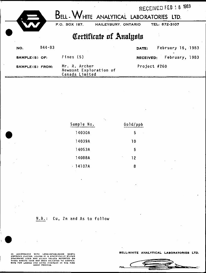
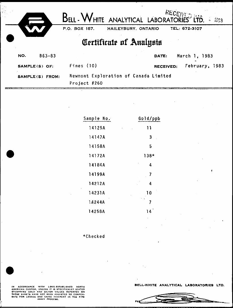
The remaining bedrock samples (fines that passed through the
screen) were shipped directly to Bell-White Analytical
Laboratories Ltd. in Haileybury as a check on Au, As, Cu, and
Zn. Bedrock assays are given in Table 4 with the fines
designated by an "A 1 suffixed to.the sample number and the
coarse chips by a 'B' or 'C'.
-16-
Analyses
From previous overburden drilling experience it has been
found that, of the various fractions obtained from the processing
laboratory {-6^u, magnetic heavy mineral concentrate, etc.)/
only the non-magnetic heavy mineral concentrate (HMC) contains
an appreciable amount of gold and other metals. Therefore,
this was the only sample fraction submitted for assay in the
present study. All 3/4 splits of the non-magnetic HMC were
sent to X-Ray Assay Laboratories Ltd. and assayed for Au, As,
Cu, and Zn. Since the gold assays were carried out using the
Neutron Activation method the samples did not need to be crushed
or pre-treated and it was possible to irradiate the whole sample.
{Larger samples were split up into smaller fractions and irradiated
individually, after which a weighted average was obtained'.)
After a "cooling" period, a one-gram sample was removed for the
analyses of As by Neutron Activation (one-half gram) and Cu
and Zn by Direct Current Plasma Spectrometry (DCP-one-quarter
gram).
All bedrock fines sent to Bell-White Analytical Laboratories
Ltd. were assayed for gold only. This was done by Atomic Absorption
after a pre-treatment by Fire Assay.
Bedrock chips were sent to the X-Ray Assay Laboratoriest
Ltd. and assayed for Au, As, Cu and Zn by the same methods as
the heavy mineral concentrates . Samples designated for whole rock,
analyses were also sent to XRAL, with major and minor elements
being detected by X-Ray Fluorescence and the % CO by a "wet"
method.

-17-
Bedrock Geology and Geochemistry
Geological mapping of the limited outcrop on the Mikwam
Property along with the review of previous diamond drill logs
indicated that the area is underlain by mafic to felsic volcanic
rocks with interbedded sediments and volcaniclastic tuff-breccias.
The present study was conducted in an area of deeper over
burden where little was known about the underlying geology
other than what was interpreted from previous geophysical surveys.
This included a strong, ENE-WSW trending magnetic anomaly
interpreted to be an iron formation and several electromagnetic
conductors thought to be graphitic Of sulphide) horizons. These
interpretations proved to be correct as six overburden holes,
drilled into the conductors, revealed graphitic argillites, some
of which were pyritic, and a single hole, MOV-83-8, drilled into
a magnetic low between two peaks,intersected an oxide-facies iron
formation. Most other holes were drilled down-ice from, and
along the strike length of the magnetic trend and showed a
consistent presence of iron formation chips in the till.
Of the eight remaining holes, two intersected pelitic
sediments adjacent to conductors and six intersected volcanic
rocks. Whole rock analyses of the latter showed that they
belong to a predominantly calc-alkaline suite of rocks (Fig. 5).
Two of these plot as calc-alkaline dacites and appear to be
tuffaceous while the others plot as basalts (mainly Mg-tholeiitic).
Most of the volcanic rocks are moderately to highly carbonatized

-18-
predominantly calcitic but with some ankeritic alteration.
A predominance of greywacke chips in the upper till units
of most of the overburden holes is indicative of a large sediment-t
ary package to the north of the survey area. Volcanic rocks in
the till are almost exclusively intermediate to mafic in composition
tmainly the latter) and are most abundant in the middle and lower
till units suggesting that they lie between the survey area and
the sedimentary package mentioned above. There was a notable lack
of felsic volcanic chips in most of the till suggesting that the
survey area lies down-ice from a more distal volcanic environment.
Twenty-six samples of bedrock chips were taken from the 15
holes drilled and of these only three contained more than 10 ppb
gold. These were: sample no. 14041 from MOV-83-2 - 31 ppb,
sample no. 14089 from MOV-83-4 - 38 ppb and sample no. 14172B from
MOV-83-9 - 290 ppb. Of these, the latter is obviously the most
significant, especially when combined with a single grain of gold
found in the till immediately above bedrock in this hole. These
three samples also show anomalous copper, zinc and arsenic values
(see Appendix).
All rocks on the Mikwam Property have undergone low-grade
regional metamorphism (Greenschist Facies) and subsequent retrograde
alteration. Geophysical data indicate-.that the rocks in the survey *
area dip steeply to the south and previous diamond drilling suggests
that tops are also to the south. As previously mentioned the
rocks have locally been subjected to carbonate alteration and whole

-19-
rock analyses indicate that alkali metasomatism has also occurred
in places.
-20-
Glacial Stratigraphy
The quaternary geology of the northern Abitibi region is
not well documented, however, studies by Hughes (1965), Prest-(1976),*
Chauvin (1977) and Chauvin and La Salle (1978) agree that there
have been two periods of glaciation in this area.
The first and major period occurred during the last Wisconsin
glaciation and subsequent deglaciation. It appears that several
till sheets were deposited during different phases of advance
and retreat of this glaciation. The final retreat is marked by
the formation of glacial lake Barlow-0jibway which deposited a
thick blanket of varied clay on top of the till.
A second, more localized glaciation occurred in the north
west part of Quebec and northeast Ontario and is termed the
Cochrane readvance (Hughes, 1965). Apparently the till laid
^ down by this later glaciation was partially contemporaneous with
Lake Barlow-0jibway. Because of this it incorporated a high
percentage of clay into its matrix and retains a strong similarity
to the underlying lacustrine clays.
Within the glacial deposits of Wisconsin age, three till
sheets and their associated deglacial sediments can be distinguished
in the Mikwam overburden holes. The earliest phase, having
direct contact with large areas of bedrock, deposited a "Lower (
Till" that is comprised mainly of local material. It is typically
a sandy till with abundant cobbles and boulders. Volcanic rock
chips, predominantly mafic, comprise 60 to 98% and any sedimentary

-21-
material present is almost exclusively argillite.
The retreat of this early phase of glaciation is marked by
a thin unit of deglacial sediments which lies on top of the -t '
Lower Till in the mid-eastern holes. To the west it has been
eroded by the subsequent phase of glaciation and incorporated
into the overlying till and to the east it is pinched out by
shallower overburden (Fig. 7). This unit of "lower Sediments"
is comprised of a hard, grey, varved clay in the middle holes
and coarsens eastward into silt, sand and fine gravel.
A "Middle Till" is found in all of the Mikwam holes. It
ranges in thickness from 2 feet to over 80 feet and overlies
the Lower Sediments, Lower Till or, in the absense of the latter
two, the bedrock itself. Clay till and sandy till layers are
often interbedded within the Middle Till and there is a tendencyt
for the till to become increasingly clay-rich with depth due to the
incorporation of "Lower Sediments". Greywacke decreases in
abundance down-section in the Middle Till and is locally replaced
by argillite near the base of the unit. Volcanic material is
usually in the 45-6C^ range with mafic rocks still predominant
and with about 5% grey, sericitic, felsic volcanics.
The "Middle Deglacial Sediments" proved to be the major
marker horizon within the glacial stratigraphy of the drill t
area. From hole MOV-83-6 west to hole MOV-83-14 (with the exception
of MOV-83-12 and including hole MOV-83-18 to the northwest) this
unit is comprised of hard, grey to dark greenish-grey clay. West

-22-
and east of this area it grades into silty clay, silt and fine
sand. These sediments are usually 10-20 feet in thickness but
locally attain a thickness of 65 feet.*
The last phase of Wisconsin glaciation deposited the "Upper
Till" which, like the Middle Till, is composed of an upper sandy
layer grading into a lower clay-rich layer, the latter being
derived from over-riding of the Middle Sediments. In two of
the holes (MOV-83-12 and 16) there is no distinct division
between the Upper and Middle Tills. This may be due to the fact
that both of these holes are close to bodies of water and have
probably been subjected to a large degree of ground water move
ment and reworking of the fine material in the till. Greywacke
is the most abundant rock type in the Upper Till (up to 50)fe of
rock chips) and the volcanic content ranges from 25-50%, with
mafic types still predominant.
The "Upper Deglacial Sediments" are better known as the
glaciolacustrine clays of Lake Barlow-0jibway and mark the last
retreat of the Wisconsin glaciation. These are typically soft,
smooth, grey clays and were intersected in all holes except
MOV-83-4 and 18. In the other holes this unit varied from 12-45
feet in thickness.
The Barlow-0jibway clays are unconformably overlain by the
aforementioned Cochrane Till. This unit varies from 22-45 feet
in thickness and is typically a sandy, brown to grey, clay-rich
till.
-23-
There does not seem to have been a great deal of mixing
and/or reworking of till units in the Mikwam drill area and most
of these were fairly consistent in their physical and compositional9
characteristics. This allowed for a reasonably good correlation
to be made between drill holes as shown on Fig's 7,8 and 9, and
helped a great deal in the interpretation of till anomalies.

-24-
Gold Dispersion in Till
The ideal way to find a gold dispersion trail in overburden
is to drill a section of holes perpendicular to the direction.*
of glacial advancement. Once a trail has been detected, however,
only a section parallel to the ice direction will show the down-
ice dispersion pattern of the gold and allow a back-projection
to the source to be made.
The 1983 overburden drilling program on the Mikwam project
was only a "first pass" designed to detect any dispersion trails
originating in or near the iron formation.
During the 'tabling' step of sample processing a total of
21 free grains of gold were detected in 9 of the 15 holes drilled.
When the heavy mineral concentrates were assayed, however, gold
abundances tended to be quite low, with the exception of thoset
samples containing visible gold. This suggests that the gold
occurs free, probably in quartz veins, and that very little, if
any, is associated with pyrite mineralization. Figure 7,8, and
9 show cross-sections of the glacial stratigraphy of the study
area with higher gold and arsenic values plotted where they
occur in each hole. Presumably, the lower the gold occurs in
the section, the closer we are to the source, since gold
!imbricates 1 upwards in the till during transport in a down-
ice direction. From Figure 7 we can see that gold occurs in
the Lower Till, a few feet above bedrock, in several holes.
Similarly, gold is found just above the base of the Middle
Till and, locally, in the Upper Till. This suggests that the

-25-
source of the gold was either exposed to both the Lower and
Middle phases of Wisconsin glaciation, or that the gold in the
Middle Till was derived from reworking of an anomalous Lower
Till. Either way, the fact that gold is concentrated this 'low
in the section suggests that the source is not far away,
probably within a few hundred metres.
Gold anomalies in the Upper Till have either been derived
from a ridge of "source -rocks" left uncovered by the middle
glaciation or from a source farther away in an up-ice direction.
If the first case is true then these occurrences may be import
ant as the source is approached and the Upper Till unit may be
the only one remaining. If these anomalies have a more distant
origin then they are of little immediate significance. Either
way it is obviously more important to follow the Lower Till
anomalies to their source. (Note: if there was a lack of
anomalies close to bedrock, the Upper Till gold occurrences
would be much more significant, therefore, it is still important
to sample all horizons.)
Gold and base metal anomalies within the glaciofluvial
and glacio-lacustrine layers of overburden are of little
significance here since they have undergone a much higher degree
of reworking and transportation than those within the till
layers.
From Figure 7 it can also be seen that there is a good
correlation between gold and arsenic in the till. Copper and

-26-
zinc abundances are more erratic and do not correlate well with
gold occurrences. It is significant to note that arsenic occurs
predominantly lower down in the overburden stratigraphy and that
values increase towards bedrock also. This suggests that the
source of the arsenic is also close by and supports the idea
that gold and arsenic occur together in bedrock.
Since it appears that we are not far from our source,
it may not be necessary to drill another row of overburden
holes up-ice from these ones. It may well be more advantageous
at this point to know more about the underlying geology and
structure rather than blindly chase a gold zone which, from
overburden results alone, could be interpreted to "be" discontinuous
"for almost 5 kilometres along strike. Hopefully, a diamond drill
program would provide us with a better understanding of the
geological stratigraphy and possibly of how the'gold mineraliz
ation occurs. If it appears that the latter is associated with
arsenopyrite and/or pyrite mineralization, an IP survey may
be warranted in specific areas in order to outline target
areas.
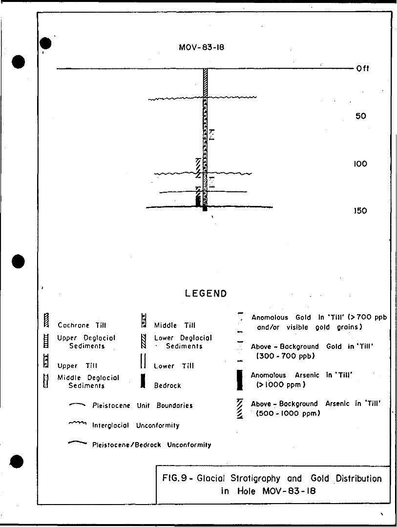
While gold values in hole MOV-83-18 (Fig. 9) were only
slightly above background, the anomalous arsenic values
obtained near bedrock are enough to warrant further investigation
in this area north of Mollet Lake.
Hole MOV-83-7 was drilled to test a conductor south of the
iron formation and to give a cross-section roughly parallel to
the ice-direction. Not only did this hole not detect any
-27-
mineralization associated with the conductor, but there is very
little evidence of the gold dispersion trail detected by hole
MOV-83-6 to the north (Fig. 8). Since these two holes are only
350 metres apart, it appears that the gold and arsenic are
dissipated rapidly in a down-ice direction or that the ice directi
t ion was such that hole #7 is actually not down-ice from hole #6.
Whatever the case, if hole #7 can be taken to be representative
of a regional background with respect to metal content of the
tills, then this brightens the outlook on the area adjacent
to the iron formation.

-28-
Conclusions
The study area is underlain by a package of volcanic and
sedimentary rocks which appear to strike in a northeasterly
direction and have a steep southerly dip. The volcanic rock's
belong to a predominantly calc-alkaline suite of basalts and
dacites and show moderate carbonatization. The sedimentary
rocks include graphitic argillite, pelitic sediments and a
laminated oxide-facies iron formation. The latter was initially
identified by magnetic surveys and then confirmed in hole MOV-
83-8 of the present study.
A total of seven layers of till and deglacial sediments
were identified in the overburden. The lower six units are
representative of three phases of Wisconsin glaciation and
include a Lower, Middle and Upper Till, each with a capping
of deglacial sediments. The uppermost of these, the Upper
Deglacial Sediments/ are more commonly known as the glaciol
acustrine clays of Lake Barlow-Ojibway. This sequence is over
lain by a more localized unit of clay-rich till deposited
during the Cochrane readvance. There does not appear to have
been much intermixing between units and a reasonably good
correlation of glacial stratigraphy was possible across the
study area.
The major gold anomaly with respect to bedrock mineraliz
ation accurs in hole MOV-83-9 where a 290 ppb value was obtained
from a pelitic sediment with 2% crystalline pyrite. Two minor
-29-
values of 31 and 38 ppb were detected in holes MOV-83+2 and
l, respectively. All of these occurences have above background
abundances of arsenic, zinc and copper associated with them/ .#
of which zinc seems to be the jnost prevalent.
Analysis of heavy mineral concentrates from till samples
has outlined a fairly strong correlation between gold and
arsenic values, however, there is no apparent correlation
between gold and copper or zinc. Most of the major gold
anomalies in the till occur as free grains, while gold assays
rarely exceed 700 ppb. These observations suggest that the
gold in bedrock probably occurs in a quartz-gold-arsenopyrite
0+ sphalerite) system with little, if any, pyrite association.
The consistent occurence of gold-arsenic anomalies in the Lower
Till and the lower Middle Till suggests that the source of
the gold is probably within about 400m and the anomalous bed
rock in hole MOV-83-9 backs this up.

-30-
Re cprnme n da t ion s
Since the source of the gold in the till appears to occur
in quartz veins with arsenopyrite and is probably within a few
hundred metres, it is recommended that the next step should'be
a diamond drill program designed to give a better understanding
of the geological stratigraphy, the structure, and hopefully the
type and style of mineralization present. If the latter is
successful then it may not be necessary to do more overburden
drilling, however if no mineralization is intersected after the
first phase of diamond drilling then a follow-up overburden
program should be outlined in an attempt to trace the gold in
the till to its source. Therefore, the following recommendations
are made for the 1984 exploration program-:
1) A diamond drill program consisting of 6 holes and a
* total of about 6000' to 6500' should be carried out
as follows:
.AzimuthCollar Anflle
14+OOW/5+25N -50
24+OOW/1+25N. -50C
33+OOW/l-fOOS -50C
45+OOW/0+50S -50C
46+OOW/3+50S -50C
43+OOW/2+OON -50C
330"
340
Depth
1000 1
Purpose
Cross-section mag, high N of MOV-83-4
1000-1200' Cross-section of fold nose N of MOV-83-6
1000-1200' Cross-section through anomalous bedrock of MOV-83-9
180
135-
1200'
1000'
1000'
Scissor holes to cross- section mag. high and adjacent rocks N of MOV-83-14
Test rocks adjacent to conductor N of MOV-83-12 .and test fold nose of IF.
-31-
2) If sufficient sulphide mineralization is identified in
core, a selective IP survey may generate further drill
targets and aid in geological interpretation.9
3) If no favourable mineralization is intersected in the
diamond drill holes, a tightly-spaced overburden drill
program may be the only way to find the source of the
gold in the till.
4) Due to the success of the 1983 overburden drill program
in detecting gold dispersion trails, it is felt that
this is the best method available for an evaluation of
the central and western Mikwam areas. Since this area
contains little outcrop and would obviously benefit from
a large overburden program, the number of holes to be
drilled and their optimum locations would depend totally
on the size of the budget allotted for such a program.
Respectfully submitted,
R. A. Archer Project Geologist
-32-
Refe fences
Bennett, G., etalv1968 Coral Rapids-Cochrane Sheet, Cochrane District, Ontario,
Geological Compilation Series, ODM Color Map 2161. Toronto 1968, 1IN-4NI, 28X26IN, Related Maps P-370 to
Chauvin, L.,1977 Geologic des Depots .Meubles de la Region de Joutel -
Matagami; Ministere des Richesses Naturelles, Quebec,DPV-539, 106 p.
Chauvin, L. and Lasalle, P.,3-978 Forage des Sediments Meubles de la Region de Joutel-
Matagami; Ministere des Richesses Naturelles, Quebec,DPV-560, 38 p.
Geological Survey of Canada,1963, 1964 Airborne Magnetic Survey, Payntouk Lake Xre'a, Ontario.,
Sheet 32^. NTS, Geophysics Paper 2367, Spartan Air ServicesLtd., May 1963 to April 1964.
Geological Survey of Canada,1963, 1964 Airborne Magnetic Survey, Chabbie Lake Area, Ontario,
Sheet 32!^ NTS, Geophysics Paper 2368, Spartan Air ServicesLtd., May 1963 to April 1964.
iGrabowski, G., and Waldron, D. 1981: Noseworthy Township, Cochrane District; Ontario Geological
Survey, Preliminary Map P.2172, Kirkland Lake Data Series.Scale 1:15840 or l inch to ^r mile. Data complied 1981.
Hughes, O.L.,1965 Surficial Geology of Part of the Cochrane District,
Ontario, Canada; Geological Society of America, SpecialPaper 84, p. 535-565. .
Jensen, L.S.,1976 A New Cation Plot for Classifying Subalkalic Volcanic
Rocks; Ontario Division of Mines, MP 66, 22p.
tJohns, G. .W.1979: Geology of the Burntbush - Detour Lake Area, District of
Cochrane; Ontario Geological Survey, Open File Report 5279, 122p. Accompanied by 3 maps, scale 1:50 000
-33-
Johns, G. W.1979 Burntbush Lake. - Detour Lake Area (Southern Part). District
of Cochrane, Ontario Geological Survey Prelim. Map P2243, Geological Ser., Scale 1"50 000 Geology 1978
t
Johns, G. W.1981: Burntbush - Detour Lakes; Ontario Geological Survey
Map 2453, .Precambrian Geology Series, Scale 1:100 000.Geology 1978.
Lovell, H.L., and de Grijs, J.1975: Bradette Township, District of Cochrane; Ontario Div. Mines,
Prelim. Map P.902, Kirkland Lake Data Series, scale l inch to h mile or 1:15,840. Data Compiled 1972, 1973.
Newmont Exploration of Canada Ltd.1983 Interpretation of Max Min and Magnetics survey conducted
on Project 260 Mikwam, Bradette and Noseworthy Townships, Larder Lake Mining Division, Ontario. Assessment Report, 9 volumes.
Prest, VIK.,1976 Quaternary Geology of Canada; in Geology and Economic
Minerals of Canada, Part B, ed. R.J.W. Douglas;Geological Survey of Canada, Economic Geology ReportNo. l, p. 676-764.
Thomson, Robert1938: Geology of the Burntbush River Area; Ontario Dept.
Mines Vol. 45, Part 6, p. 49-63.
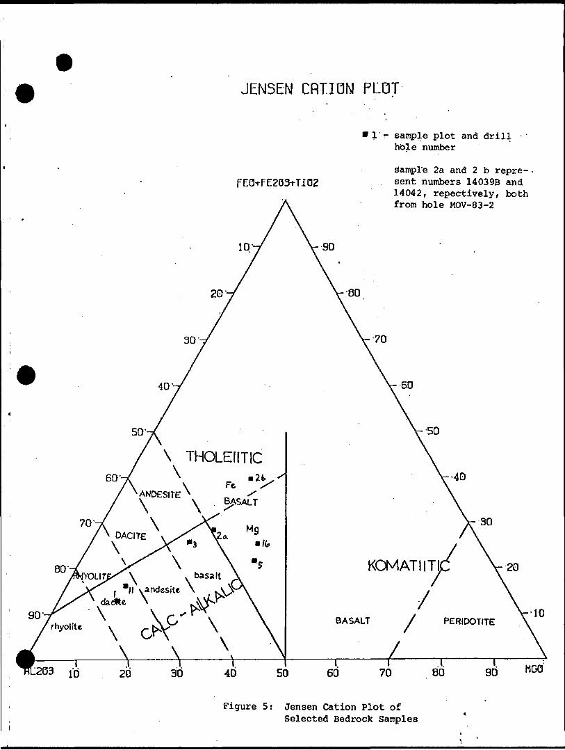
JENSEN CRTION PLOT
FEOTFE2031-T.I02
l'r sample plot and drill - - hole number
sample 2a and 2 b repre sent numbers 14039B and 14042, repectively, both from hole MOV-83-2
ID-
20'- 80
30'- 70
40'- 60
/\
7 \ THOLEIITICGO'-/ \ • 2b, x
X\ \ Fc 'f x ANDESITE N -^
i \ \ BASALT
/\ DACITE \s^ Va ^
80̂ YOLIjX\ v basalt \^/^daie"\andeSlte ^^ \
x y0"" x\ G^x X\ \k \ \ \ ^1 —— 1 1 1 1 1
V 40
V 30
KOMATIITJC V-20
^ \,ny V'lO
BASALT 7 PERIDOTITE \
x \11.1. ..-- .-
-203 10 20 30 40 50 60 70 80 3d *w
Figure 5: Jensen Cation Plot ofSelected Bedrock Samples
Bulk Sample Ave. wt. 24 kg.
- 250 g STORE
1700^ STORE
Light Fraction STORE
Heavy Liquid Separation (Methylene Iodide SG 3.3)
+63/A STORE
Geochem analysis
Magnetic Separation
Light Fraction STORE
Magnetic Fraction Geochem Analysis
-* 1/4 STORE - Microscope Examination
3/4 Geochem Analysis
Figure 4 - Sample .Processing Flow Sheet
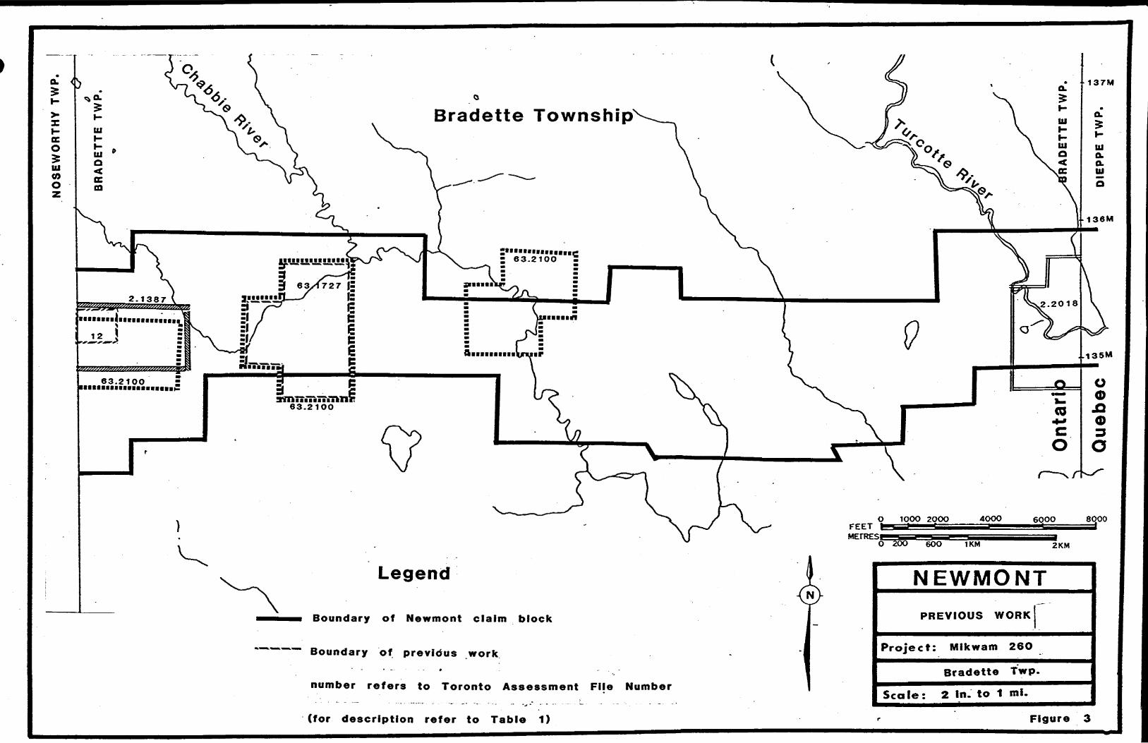
Bradette Township
a iniiin i iTTiTkTI r63.2100
Legend NEWMONT
PREVIOUS WORKBoundary of Newmont claim block
Boundary of previous work' ~ , . # -
number refers to Toronto Assessment Fije Number
(for description refer to Table 1)
Project: Mikwam 26O
Bradette Twp.
Scale: 2 In. to 1 mi.
Figure 3
HO
BL
ITZ
EL
L
TW
P.
NO
SE
WO
RT
HY
T
WP
..^
.x*
~~ - -
^ —
-. L
1*-, -l ~
— ~
—T"*1"
" ""J
"'"?*
* TT
*"~"
i~r l
u
r u
! n
i' w
l W
l
W
'W
i W
i? is
,o
'w
\z'
y-Z
&
-i.1
-1:_
_l.
_L
Ld
-"Q
I ri
2
;-7s
rIS
rI
S '*
•(o!
s
'' is
is i s
-J ^
-s-\
* , **
' *
* '*l
- -'1
. J\4
'N--L
*.-
1W
x*-
-.S
ri 2
r;.
S
n S
n 5
ry
s r
l ig
a.^
--|^
. s
..lg
. ,*.
1s-J S
L?
J S
1-1
"is
rfl~
~is
' "rs
"""'-T
.a~~
^s
T y l l"
s i l
-
- i'
'oT
~-fm
——
-^--
tit
l *
*
* *
*
l W
"^""
~^
hw
- -."
f m—
—' -
1
*.T
'J__J,o
^^
y
/.
r^
4 JJ
15
^4
?
rig
"S
-"
•i--
-i- --
:JW
-* l
. rf?
-ir^-
s ^-.
a r
Is?
\i
^ ^.
i0
i*
K.**
' '
S ^1
*8:"
"^"^
""!*
^
jr.-u
-
*-rb
-—l
0i ..
Ot
' ,
Uw
-
l f
^
|3'-
l 5
.,5
^*v
',*..
j S
-
ISr~:r
7'T"'!r"'
Ti"r*
IK
'
* i
*-J
.—
.J
* -
r" J
* r~
7 *~
r ~
""
~r
*~*
~1 u
'
u '
l **
l
wlw
^
w
'
o.IS
. i
; . w
i w
1 w
-lw
V
'O'
j*
li"
"
(2 ""
"1
?* ~
^fl
T ~
^O''

L-
\ 1 I L | L t l
62JP97 1624806 .67*6851 - — — — —t — —1.— — -4 t- ? L l L
________1634378^6343831634386 J634389 *634396 j" -~~~ a.i*. p-~~ ?t~ ~ y.~ ~TL~ ~ [r~ ~n.~ ~ ~|:i ! /! ' i -l
1634370*63*377 J63437* '6343P4 (634387 J6343B8 J63439I '624899 '67*89* *C2498ru ir ~! L~~ .^~|T ~~p"~~I-~"|v '~^~ \- l*- —
|6336*9l65363Oi633655|6355*9 1633554 ' 6335 ——— ——— -- ———— l- - -l - ' - ~ -, - - l - - ^L3^0^
C ' | L l L l ^ ' J { l 1- j ^-
^ 568 '' '
31 16236*1 | 633647 (6336*3 ,633646 j6336*~~"~~"~~ ~f J '633317 '633*^1 .*633*49 l^ 3 -
-
j6^333S4; 1*3334946323*3
i 'i I. 63332 ' .8333^4,1IJ633356 1633347 J633345 JCJI
|63S537 1 633363 J653366 634369 ( 63*37I r^D ::vv.'jf'r^j'"!!- 1-'!*"'
j633558 63336463436* 63*368 *34372 -------——-
~
633*371633434 - '"-
/^ "lif
NEWMONT
Boundary of Newmont claim block. CLAIM LOCATION
Project: Mikwam 26O
Noseworthy Twp.
Scale: 2 In. to 1 mi.
Figure 2b

a. 5
vtll
l L l L
l
J t. l t
I.
l t
I
* . jr
"548886(348883 J34BB79 |348878|
36*32 1633633 1*33634 J" 6958 ^36957 .636936 ^636935 1*334^— t "T ~ — p- — — — — —, — — -j- r^ZJ\ ~ ~ ~* ~
S" : J t. j . p ,/LJ L IL
,L i
l 348893 548692-5488871548884 J5488801^4887 3 j34B8f3 f
~ C f ~*-~~l C ~* ~ ~^~V" t~ ~ H. : . . . J i l ! i i-
3488941940*91 348884.348883
L L , L L - , , - . - - . . L ..
! ' X ' i f ! '''' '- .1 .-'wsssrT/J l .,59I39. 591389 ^iSSsV'S'l 383 I3.-9I38O 159 ' 3T1 ,*S34IO |63340 7 I 6 33404 ,6334OI |e3S5, e | 1^3339016333.9 .633382 83337* 6 r — — J- — — -4- -"~ —— -K— —— -j-* — — r— —— ' —— — ~r~ — ——— - i — — —— l — —— — — — J— — (-J *— — — -i- — — Li-' — -M — — —i:L .r r T^-?,- r-- ; L J- L J L ;*- ! L 'i^Uj 1 JL . ! L -Ti L ^-591392 J59I390 J39I383 591384 ̂ 91378 J39I37JP [633411 ,6334O6 j6334O3 .6334001633399 633396 \(6333gl (633388 |633383J633378 16- ' ""~~~ "624883-591392
•T T." J548868 948887 3488625488*— --— --*- - - -
642OOI I63I869 ,'647OO3 I6420O4
'647010 |64?OII JC420-? 642OI3
i - ' i642O17 J642OI6 J642OIS
l i-L , L . , L 1633468 l
1633463 '633462_ m_ , l ^^ ^_ .
1633436 1633433^
933381 (6333aOK4202O 642019
. '' l 1 : I ' ' ' IM90|6333*9 |633382J63337*!6333TZ (633491 |6rS484(|63348^ 16^347^(6334^
BS .633383 "633378: 1633373 Ie33490 1633483 1*633482 633477 .633474 ^63346^ ^33464^ 1633^63
" ' - l i ';-54183 U34I84 {634I83..I634I86 '634167 J634I88 .634189 '^3*190
633478 J633473 J63347I '63347O•62488ZI 59I393 1633630 6??63t
tl li l L ll l
624881 '391394 U33637
VJ*?JW^ |**^w**- - i^^^-M' V^ |W*^*^
633480 '633479 6N33472
K "— •—h--— l —— -f~ -
1334O 94988.B||4S BBZ JB43B7-7 I&48B98InLVA-Trrt.Tt-'r-r-. ,L
634228 I634JJ7 1634226 l 634223 (634224 634223
JBO .6 34I77
634234)634233 1634236
l. f - ' L
63424O 634 24 l S34242 634243 . . . u ,,,r r * - i * v t--r s i \ . .l "' f - '34811*13403401843880 134387* |348900|
!!?L.--J, __ L^;^JL^;ii __ ll-- — \- ——- L- — I---J — -J —
l 1 634246|634247|634248 J634249r — Bradette Townsip454233 '634234 {63*233~ "~634239 (R3426O I634288
Boundary of Newmont claim block
NEWMONTCLAIM LOCATION
Mlkwam 26OProject:
Bradette Twp.
Scale: 2 In. to 1 ml.
Figure 2a
32 mi. Detour La k
: - 1... x Eagle-X
tetyjy.tfw^' . wzzz/^^^ ,*v r~
^rT ̂ ~ - ''-"d- -A ^ " ' ) J3sfe~r^—J,- ^-\__\k-:
f 1:250.000
543210
NEWMONTLegend/^ff -O
PROPERTY LOCATION
Boundary of Newmont claim block
Road .winter road or trail
Project: Mikwam 26O
Bradette and Noseworthy Twps
Scale: l: 25O,OOO
Figure 1
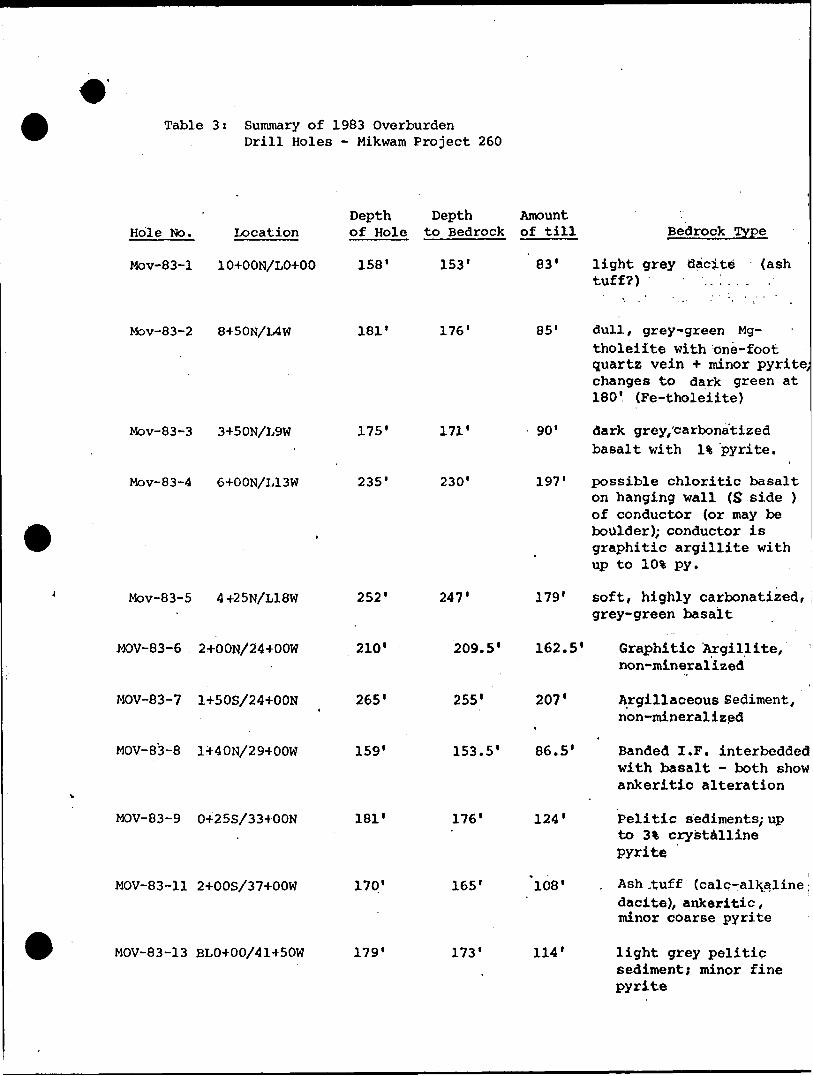
Table 3: Summary of 1983 OverburdenDrill Holes - Mikwam Project 260
Hole No. LocationDepth Depth Amount of Hole to Bedrock of till Bedrock Type
Mov-83-1 10+OON/LO+OO 158' 153' 83' light grey dacite (ash tuff?) .. : . . .
Mov-83-2 8+50N/L4W 181' 176'
Mov-83-3 3+50N/L9W
Mov-83-4 6+OON/L13W
Mov-83-5 4+25N/L18W
MOV-83-6 2-4-OON/24+OOW
MOV-83-7 1+50S/24+OON
MOV-83-8 1440N/29+OOW
MOV-83-9 0+25S/33+OON
MOV-83-11 2+OOS/37+OOW
MOV-83-13 BLO+00/41+50W
175'
235'
252'
210"
265'
159'
181'
170'
179'
171'
230'
247'
209.5'
255'
153.5'
179'
162.5'
207'
86.5'
176'
165'
173'
85' dull, grey-green Mg-tholeiite with one-foot quartz vein * minor pyrite;] changes to dark green at 180' (Fe-tholeiite)
90* dark grey/carbona'tized basalt with l "k pyrite.
197' possible chloritic basalt on hanging wall (S side ) of conductor (or may be boulder); conductor is graphitic argillite with up to 10% py.
soft, highly carbonatized, grey-green basalt
Graphitic Argillite, non-mineralized
Argillaceous Sediment, non-mineralized
Banded I.F. interbeddedj with basalt - both showj ankeritic alteration
124' Pelitic sediments/ up to 3% crystalline pyrite
'l08* , Ash ,tuff (calc-alkjaline ; dacite), ankeritic, minor coarse pyrite
114' light grey peliticsediment; minor fine pyrite
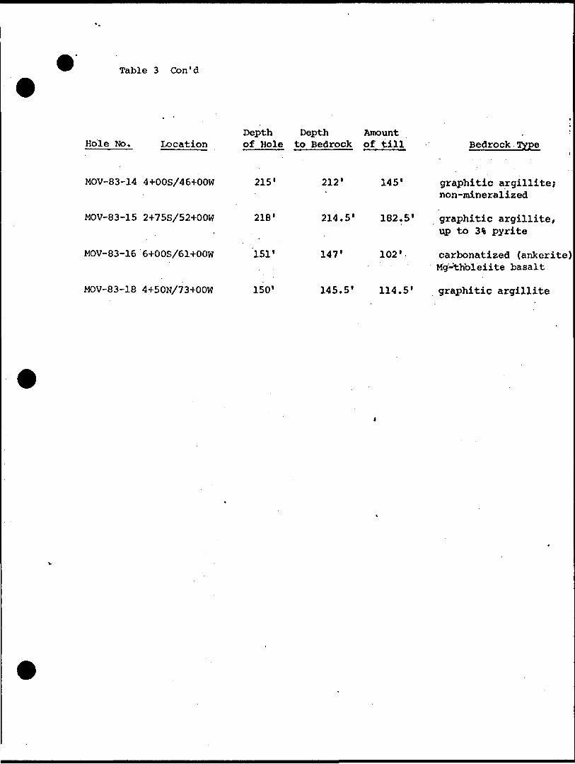
Table 3 Con'd
Hole No. Location
MOV-83-14 4+OOS/46+OOW
MOV-83-15 2+75S/52+OOW
MOV-83-16 64-OOS/61+OOW
MOV-83-18 4+50N/73+OOW
Depth Depth Amount of Hole to Bedrock of till
215'
218'
151'
150'
212'
214.5*
147'
145.5'
145'
182.5'
102'
114. 5 1
Bedrock Type
graphitic argillite; non-mineralized
graphitic argillite, up to 3% pyrite
carbonatized (ankerite) Mg-thbleiite basalt
graphitic argillite
TABLE 4: LIST OF BEDROCK ASSAYS FOR 1983 OVERBURDEN DRILLING -MIKWAM PROJECT (260)
Hole No.
MOV-83-9
MOV-83-11
MOV-83-13
MOV-83-14
MOV-83-15
MOV-83-16
MOV-83-18
.
Sample No.
14172A
14172B
14184A
14184B
14185'.
14186
14199A
14199B
14212A
14212B
14231A
14231B
14244A
14244B
14245
14258A
14258B
Footage
176-181
176-177
165-170
167-168
165-166
169-170
173-179
176-177
212-215
212-215
215-218
216-217
147-151
148-149
150.5-151
145-150
149-150
Rock Type *
Pelitic Sediment
^
Sericitic, ankeritic ash tuff (Calc-alkaline dacite)
Pelitic sediment
Graphitic argillite
Graphitic argillite
Ankeritic basalt (Mg-Tholeiite)
Graphitic argillite
Au (PPb)
138
290
4
a3
2
7
6
4
2
10
5
7
4
5
14
10
As (ppm)
N.A.
100
N.A.
17
17
12
N.A.
20
Ni.'A.
4
N.A.
79
N.A.
24
23
N.A.
460
Cu (ppm)
N.A.
78
N.A.
34
28
26
N.A.
36
N.A
23
N.A.
48
N.A.
86
52
N.A.
100
Zn Ppm)
N.A.
160
N.A.
63
58
59
N.A.
35
N.A.
33
N.A.
120
N.A.
51
48
N.A.
87
^2 W
2.5
1.5
* Rock types in parentheses are classifications based on Jensen Cation Plots,
N.A. signifies "Not .Assayed".
TABLE 4" LIST OF BEDROCK ASSAYS FOR 1983 OVERBURDEN DRILLING - MIKWAM PROJECT (260)
Hole No.
MOV-83-1
MOV-83-2
MOV-83-3
MpV-83-4
MOV-83-5
MOV-83-6
MOV-83-7
MOV-83-8
Sample No.
14030A
14031B
14039A
14039B
14040
14041
14042
14053A
14053B
14088A
14088B
14089
14107A
14107B
14125A
14125B
14147A
14147B
14158A
14158B
14159
14160
Footage
153-158
153-154
176-181
178.5-179 ' *
176.5-177.5
177,5-178.5
180.5-181.0
171-175
171-172
230-235
r 231-232
234.5-235
247-252
247-248
209.5-210
209.5-210
261-265
261-262
154-159
154-155
155-156
158-159
Rock Type *
Ash tuff (Calc-alkaline dacite)
Dull 'grey^green^basalt (Mg-Tholeiite)
Dark green basalt (Fe-Tholeiite)
Dark grey calcitic basalt (Calc-alkaline basalt)
. *-
Graphitic argillite
* 10% nodular pyrite
Light grey, carbonatized basalt (Mg-Tholeiite)
Graphitic argillite
Argillaceous sediment
laminated Iron Formation
Au (PPb)
5
4
10- 42
4
31
2
5
<2
12
<2
38
8
*2
11
3
3
1
5
1
5
2 '
As (ppm)
N.A.
50
N.A.
53
70
84
43
N.A.
28
N.A.
61
320
N.A.
32
N.A.
12
N.A.
^1
N.A.
8
6
4
Cu *ppm)
N.A.
45
N.A.
110
22
100
120
N.A.
42
N.A.
120
450
N.A.
97
N.A.
9.5
N.A.
12
N.A
19
10
6.5
Zn '(ppm)
N.A.
41
N.A.
84
15
300 .
83
N.A.
81
N.A.
190
2600
N.A.
39
N.A.
47
N.A.
35
N.A.
34
24
28
^2 W 2
4.5
7.2
9.6
4.0
9.1
TABLE 5: LIST OF ANOMALOUS GOLD AND ARSENIC VALUES S VISIBLE GOLD GRAINS - 1983 OVERBURDEN DRILLING - MIKWAM PROJECT 260
Hole No.
MOV-83-2
MOV-83-4
MOV-83-5
MOV-83-6
MOV-83-9
MOV-83-11
MOV-83-13
MOV-83-14
MOV-83-15
SampleNO.
14035
14038
14061
14094 14096 14101
14113 14124
14165 14171
14173
14188 14195 14197
14209 14210
14214 14220 14226 14229
Sample Footage
125-135
175-176
65-75
105-115 125-135 195-205
81.5-95 205-209.5
85-95 165-176
55-65
65-75 135-145 155-165
175-195 195-205
35-45 95-115
165-175 195-205
Depth to Bedrock
176'
176"
230'
247' 247' 247'
209.5'
209.5'
176' 176'
165'
173' 173' 173'
212' 212'
214.5' 214.5' 214.5'
214.5'
Type of Material
3?ill
Sand/Bedrock
Sand
Till Till Till
Till Till
Till Till
Till
Till Till Till
Till Till
Till Till Till Till
Average Au ppb
300
670
1800
1700 980 100
800 1600
360 780
220
80 70
480
110 610
30 5900 360 290
Arsenic Content - ppm
40
380
66
93 660 210
250 670
380 600
140 ;
20 . 780 2100
1200 1400
34 63
150 2200
Visible GoldGrains
2
1
1
1 1 1
11
1
111
1 1
1
1 1
Size (u)
250X450 400X600 250X300
150X200
200X250 300X350 100X150
250X300 250X250
300X300
50X100 150X200 300X300
150X200 200X250
250X350
200X300 250X600
"Class
A D D
A
D D D
A A
A
A A A
A A
A
A/D A
TABLE 5: LIST OF ANOMALOUS GOLD AND ARSENIC VALUES fi VISIBLE GOLD GRAINS - Con't - 1983 OVERBURDEN DRILLING - MIKWAM PROJECT 260 "
Hole , No.
MOV-83-16
' Sample No.
14233
14239
foo.tage No.
45-55
105-115
Depth to Bedrock
147'
1477
Type of Material
Till
Till
Average Auj?pb
250
250
Arsenic Content - ppm
75
390^
Visible GoldGrains
2
l
Size (u)
250X300250X350 '150X200
Class
A/DA/DA

Table 2 Previous Jtork-oJi-Pxoject 26.0 Area in Bradette Township
ASSESSMENT FILE INFORMATION (GEOPHYSICS AMD-DIAMOND DRILLING)
^B A. F. NO.
^^ T. O.:
63.1727
63,2100-
2.1387
2.2018
12
KL
KL
^P KL
KL
KL
*
COMPANY
Rio Tinto
Rio Tinto
Dome
Patino
Dome
Rio Tinto
Rio Tinto
Rio Tinto
Rio Tinto
Rio Tinto
SURVEY DATES
1965
1966-67
Nov. 1973
Julyl975
1974
1965
1965
1965
1966
1966
CONDUCTOR-- DDH ree - . ~
following A. B. EM conductor
1 anomaly
V*
Ground Electromagnetic SurveyInstrument
EM 5
EM 5
Turam -
McPhar VHEM
Mode
Vertical loop
Vertical loop
Coplanar
horizontal loop
FrequendV
-
600 Hz 220 Hz
600 cps 2400 cps
Coil Separation
' '
100 ft
300 ft
t
r
Magnetometer Survey" " -Instrument
Mag
Mag
ScintrexMF-2
McPhar M 700
F or P :- v
fluxgate
fluxgate
Gravity Survey^- Instrument
World Wide gravity meter
World Wide -gravity meter
Base
i

let 26.0 Area in Bradette Township(GEOPHYSICS ANd-DIAMOND DRILLING)
toil Separation
-
00 ft
00 ft "
J
Magnetometer SurveyInstrument
Mag
Mag
ScintrexMF-2
McPhar M 700
F or P : -
f luxgate
fluxgate
Gravity Survey -C Jf- Instrument
World Wide gravity meter
World Wide -gravity meter
Base Valiie
V
*
DDH So".
59-4
65-5
65-6
65-7
66-B-l
66-B-2
:*2
ISO0
ISO0
ISO0
ISO0
0
0
Information
i
casing 152' length 305'KP-I&A:casing 84. 01 ' length 414*' dip-500 AXT-
Casing 73' length 304' dip-470 AX
casing 94' length 304' dip-45*AXT
casing 50* length 314 ' dip-500EXT
casing 55* length 306* dip-5O0 EXT
-
CMaim No.
L^367090
boundary X87153 fi L87154
L87152
L87152
L90489
L90489
Location of Core
at camp Burntbush River
-
f

poo'se s i 'i1*'?
g 8gg8gggg8888g88gg88
g g! t
^
^
. "
v!
*
v
• 4-xi
i
-^
*
N
i*c- 1
x
s*,*'
*
^4
•**
m
-W
^
Hi *f
V
'If
r*
i
AOC
4t
..^i^*
i
1•ni
*r
.w'
^A
/'
m
~
\
\
f
PH^
\
i
fcj
'
isaJS'sstKxiKu'sss: t88888ggi88gg8g88g
*/
>
^
Pi
•AC
4
*^*
Ni
wf
V*t***
•gggggggg^g'lglggggg j t s s a s j sx* s s s s i s s !
•wff
**n
— ".m*1
"
*
^3
t
,*''
*~~ i-*"^
/*
-^*H*
'
*^!
•*f
1
^-^
-
^^
J**-
i
i
2L-^
i
(
i
9/
)s — "
•Ae
r
(^
*~Mf
1
-41
")
^-^"
1^n LI
-*-"
i ii
iI 00 fi"V
g g S 8 g 8S 2 S t 1 8
'
1
1
t—
,--•y(
S S S t t I J 8 ?~A/?! * : S 1 1 3 ^-ggggggggg g^[g-g g g 8 8 g
t f t !i t t S I C

illl ' IKO II* | in.'* OOO'OI l l,nj
1i*w*r~iit-iFiim"HI1 ** nf~iT'f^ iwn'uati-nitn*
HIM
1NOWM3N
^J... T
^.^
tC
\ f 8 8 8 8 g\ S g S g 8 8
MOV-83-16 MOV-83-15 MOV-83-14 MOV-83-13 MOV-83-II MOV-83-9
Oft
50
100
150
200
250
LEGEND
Uope r
g *, Deg'ccial
i M'iddle Til!
Lower
Lower
lP'e s'ocene Unit Boundaries
Interglacial Llncon'o.r"v *y
Pleistocene XBedrocK Uncon'ormt 1
MOV-83-8 MOV-83-6 MOV-83-5 MOV-83-4 MOV-83-3 MOV-83-2 MOV-83-1
Oft
100
150
200
i
25O
Anomalous Gold in 'Till' (>7OO ppb and/or visible gold grains)
Above - Background Gold in 'Till' (300-TOO ppb)
Anomalous Arsenic in 'Til!' O 1000 ppm )
Above - Background Arsenic in ' T iir (500-1000 ppm)
o^zon'a! Scc ! e l : IO,OOO
Vertical Scoie l cm z 20 feet
Oft.
20
40
200m
7*-
F!G. 7- Glacial Stratigraphy and Gold Distribution
Along Section A - A1
MOV-83-7 MOV-83-6
Oft
50
IOO
150
2OO
250
N
l
Cochrane Till
Upper Deglacial Sediments
Upper Till
Middle Deglacial Sediments
III l
Middle Till
Lower DeglacialSediments
Lower Till
Bedrock
Pleistocene Unit Boundaries
Interglacial Unconformity
Pleistocene/Bedrock Unconformity
Anomalous Gold in "Till' ^ TOO ppb and/or visible gold grains)
Above - Background Gold in 'Till' .— (3OO-70Oppb)
E Anomalous Arsenic in 'Till' OIOOO ppm)
f/ Above - Background Arsenic in 'Till* ? (5OO-IOOO ppm)
Horizontal Scale l: 250O
Vertical Scale l cm s 2O feet
50m
FIG.8- Glacial Stratigraphy and Gold Distribution
Along Section B-B1
MOV-83-18
Oft
l!
50
100
150
i l
Cochrane Till
Upper Deglociol Sediments
Upper Till
Middle Deglacial Sediments
H
II l
LEGEND
Middle Till
Lower Deglociol - Sediments
Lower Till
Bedrock
Pleistocene Unit Boundories
Inlerglociol Unconformity
Pleistocene/Bedrock Unconformity
7 Anomalous Gold in 'Till' ^700 ppb ' and/or visible gold grains)
lAbove - Background Gold in'Till*
(300 - 700 ppb)
Anomalous Arsenic In 'Till* OIOOO ppm)
Above - Background Arsenic in 'Till* (500-1000 ppm)
FIG.9- Glacial Stratigraphy and Gold Distribution in Hole MOV-83-18
APPENDIX
RECEIVED FIB UBELL-WHITE ANALYTICAL LABORATORIES LTD.P.O. BOX 187, HA1LEYBURY, ONTARIO TEL: 672-3107
NO. B44-83
SAMPLE (S) OF:
SAMPLE (S) FROM:
(!fc riifirate of Analgate
Fines (5)
Mr. R. ArcherNewmont Exploration ofCanada Limited
DATE: February 16, 1983
RECEIVED: February, 1983
Project #260
Sample No.
14030A
14039A
14053A
14088A
14107A
Gold/ppb
5
10
5
12
8
N.B.: Cu, Zn and As to follow
IN ACCORDANCE WITH LONG-ESTABLISHED NORTH AMERICAN CUSTOM, UNLESS IT IS SPECIFICALLY STATED OTHERWISE GOLD AND SILVER VALUES REPORTED ON THESE SHEETS HAVE NOT BEEN ADJUSTED TO COMPEN SATE FOR LOSSES AND GAINS INHERENT IN THE FIRE
ASSAY PROCESS.
BELL-WHITE ANALYTICAL LABORATORIES LTD.
ft*.
NO. B63-83
\A/ lVr-x ,,,, ELL-WHITE ANALYTICAL LABORATORIES LTD. p p 3
*WV*,J
P.O. BOX 187, HAILEYBURY. ONTARIO TEL: 672-31O7
Qkrttftrate nf
SAMPLE (S) OF:
SAMPLE (S) FROM:
Fines (10)
DATE: March l , 1983
RECEIVED: February, 1983
Newmont Exploration of Canada Limited Project #260
Sample No.
14125A
14147A
14158A
14172A
14184A
14199A
14212A
14231A
1.4244A
14258A
Gold/ppb
11
3
5
138*
4
7
4
10
714'
*Checked
IN ACCORDANCE WITH LONG.ESTABLISHED NORTH AMERICAN CUSTOM. UNLESS IT IS SPECIFICALLY STATED OTHERWISE GOLD AND SILVER VALUES REPORTED ON THESE SHEETS HAVE NOT BEEN ADJUSTED TO COMPEN SATE FOR LOSSES AND GAINS INHERENT IN THE FIRE
ASSAY PROCESS.
BELL-WHITE ANALYTICAL LABORATORIES LTD.
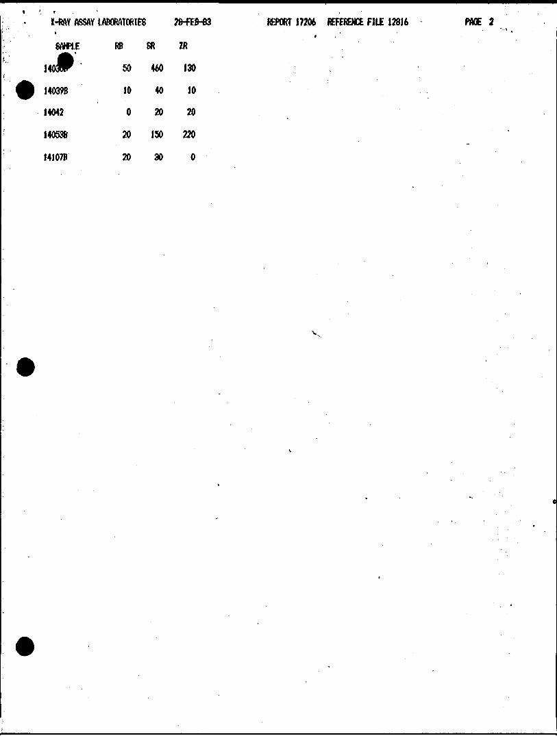
X-RAY ASSAY LABORATORIES 28-FEB-83 REPORT 17206 REF. FILE 12816-U3 PAGE
*PLE AU PPB C02 * CU PPM ZN PPM AS PPM
14030B14039B14040140411404214053B1408714088B1408914107B14108
tt4
312
tttttt38tt
6
4.57.2
——
9.64.0
———
9.1
45.0110.22.0
100.120.42.033.0
120.450.97.084.0
41.084.0 .15.0
300.83.081.052.0
190.2600.
39.044.0
50 - M*V'53 )70 v Mot/-8443 )28 — f^o^i-i14 -)61 }"'**
320 )32 79 } M0^'f
X-RAY ASSAY LABORATORIES 09-MAR-83 REPORT 17261 REF. FILE 12889-05 PAGE
AU PPB C02 X CU PPM ZN PPM AS PPM
14125B141478141588141591416014172B14184B141851418614199B14212B14231B14244B1424514258B
31152
290a3262545
10
•••V
——~—r-2.5—————1.5~—
9.512.019.010.06.5
78.034.028.026.036.023.048.086.052.0100.
47.035.034.024.028.0
160.63.058.059.035.033.0
120.51.048.087.0
120864
100171712204
792423
460
SE
*
eo
oo s
—
g
s- jj!
E
f*
JO
22 ^
td*
s s
8? sg
C
K
8
S
se s
s o*
fn
se
r*
fa
fa
•^^
-^^
—^
——
2
g
I K
So
o
o
2a?s
O
*^
4^
^^
^^
f"*
8 2
S
2 2
g
?3
i p*
PO
!S
pi
c•s
i g
K
) so
tt
2
?
r*
?
?
i*
jc
vJ
Vsl
K/
-s
X-RAY ASSAY LABORATORIES OHWR-63 REPORT 17261 REFERENCE FILE 12889 PAGE l
SAMPLE SI02 N203 CAO HGO NATO K20 FE203 m TI02 P205 CR203 LOI SUN
14lA 69.3 12.7 3.07 1.48 1.A3 2.31 4.02 0.04 0.45 0.14 0.02 4,39 99.7
14244B 49.0 13.9 8.53 R11 1.89 0.14 12.2 0.18. 0.75 0.07 . 0.05 5.00 99.8
\
l
X-RAY ASSAY LABORATORIESl
SAHPLE RB SR ZR
50 460 130
REPORT 17206 REFERENCE FILE 12816
I4039B
14042
140538
I4107B
10
O
20
20
40 10
20 20
150 220
30 O

X-RAY ASSAY LABORATORIES OHtoR-83
RB SR IR
60 110 110
J4244B O 180 40
REPORT 17261 REFERENCE FILE 12889 PAGE 2
SAHPU
lIP
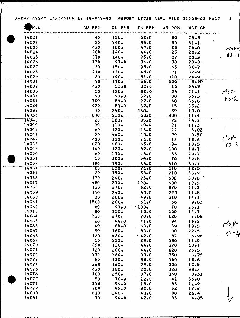
X-RAY ASSAY LABORATORIES 18-MAY-83 REPORT 17715 REF. FILE 13208-C2 PAGE l
AU PPB CU PPM ZN PPM AS PPM WGT GM
t
t
t
140211402214023140241402514026140271402814029140311403214033140341403514036140371403814043140441404514046140471404814049140501405114052140541405514056140571405814059140601406114062140631406414065 14066140671406814069140701407114072140731407414075140761407714078140791406014081
4030
^0180170130
30110
8090
^05090
300^0
70670
20306020
^0^01406050
18080 ""20
170480110110
301800
6080
31020 4050
12050
250120170
80260^0100
50230200^0
70
150.140.100.140.140.91.0
150.120.140.110.53.0
120.99.088.081.0
250.510.100.110.120.460.110.680.120.130.100.190.130.150.240.230.270.240.200.200.99.0
110.270.94.0 88.0
180.420.110.120.200.180.120.160.150.250.70.059.095.0
140.94.0
52.055.047.046.075.036.035.045.051.066.032.052.037.027.037.0
130.68.035.040.046.040.031.065.082.048.034.036.071.653.093.0
120.62.060.049.061.0
100.52.070.041.0 63.050.042.029.044.044.033.033.029.020.037.012.013.030.041.042.0
8050252527306571
110550
162330404589
380232744291834
1005376
3101162106806803702201106670
100120
34 399087
1301708207501602201201604233528085
25.331.126.020.220.323.0 -38.732.924.9
9.9034.921.136.336.035.219.011.424.311.35.029.58
15.618.518.729.735.630.112.533.930.6 *12.521.311.814.19.63
26.114.78.08
16.2 13.522.5
6.9821.510.725.59.75
35.612.533.26.31
36.012.917.826.4
9.85
f4oV~
. zz-\
f/tol/-t/1-05 3"X
rf Qy-g ̂ . "^
rio}/-j? \ ' - LO y
i
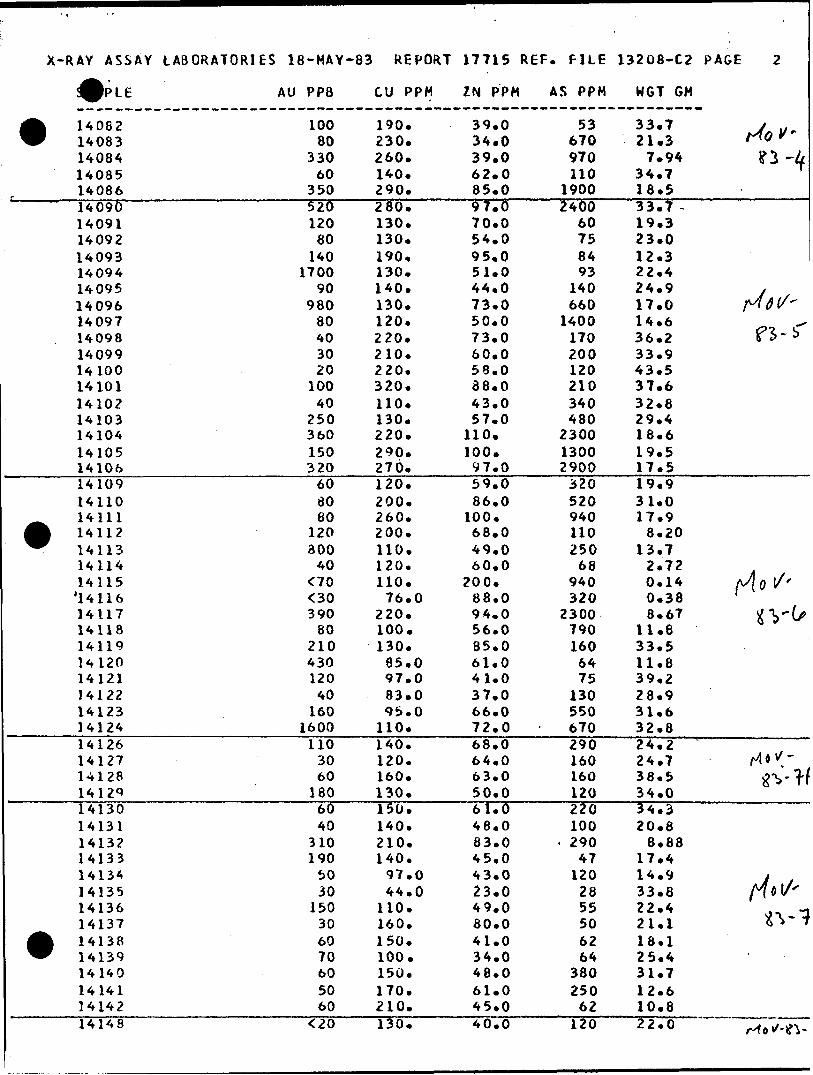
X-RAY ASSAY LABORATORIES 18-MAY-83 REPORT 17715 REF. FILE 13208-C2 PAGE
AU PP8 CU PPM ZN PPM AS PPM WGT CM
• 140821408314084140851408614090140911409214093140941409514096140971409814099141001410114102141031410414105141061410914110
^ 14111A 14112W 14113
1411414115'141161411714118141191412014121141221412314124141261412714128141291413014131141321413314134141351413614137
• 1413814139141401414114142
10080
33060
350520120
80140
170090
98080403020
10040
250360150320
60SO60
120300
400000390
8021043012040
1601600
1103060
1806040
310190
5030
150306070605060
190.230.260.140.290.280.130.130.190.130.140.130.120.220.210.220.320.110.130.220.290.270.120.200.260.200.110.120.110.76.0
220.100.130.85.097.083.095.0
110.140.120.160.130.150.140.210.140.97.044.0
110.160.150.100.150.170.210.
39.034.039.062.085.097.070.054.095.051.044.073.050.073.060.058.038.043.057.0
110.100.97.059.086.0
100.68.049.060.0
200.88.094.056.085.061.041.037.066.072.068.064.063.050.061.048.083.045.043.023.049.060.041.034.048.061.045.0
53670970110
19002400
60758493
140660
1400170200120210340480
230013002900
320520940110250
68940320
23007901606475
130550670290160160120220100
- 29047
1202855506264
380250
62
33.7 y u21.3 f*0 *
7.94 ?3 ~434.7 T16.533.7 ~19.323.012.322.424.917.0 p4dl/'14.6 ^36.2 f3~^33.943.537.632.829.416.619.517.519.931.017.98.20
13.72.720.14 fj[o l/'0.38 '8.67 iCV'k*
11.833.511.839.228.931.632.824.224.7 M'**38.5 gvTf34.034.320.8
8.8817.414.9 t33.8 /^C(A22 ' 4 9\--3-21.1 *^ T"18.125.431.712.610.8
14148 130 40.0 120 22.0

X-RAY ASSA'Y LABORATORIES 18-MAY-83 REPORT 17715 REF. FILE 13208-C2 PAGE
E AU PP3 CU PPM ZN PPM AS PPM HGT GM
141491415014151141521415314154141551415614157141611416214163141641416514166141671416814169141701417114173141741417514176
^ 14177A 14178^ 14179
1418014181141821418314187141881418914190141911419214192? - ——141931419414195141961419714198142001420114202142031420414205
A 14206^ 14207
14208142091421014211
6020608020407020
210^0
303070
36040
1101104030
780220
3050
280290
7015070
32030
1104080503050
100—30-
3019070
170480200
6040
1102060509040
350110610320
150.190.86.0
100.150.140.200.260.160.170.130.150.89.0
150.150.110.160.140.180.190.160.140.210.
83.0160.170.220.170.160.170.160.65.065.0
190.280.170.130.160. ——120.160.160.170.220.200.130.150.160.110.280.170.180.130.180.170.170.320.
39.074.033.047.053.056.057.0
130.68.052.053.061.036.0
100.110.53.065.070.065.089.086.062.070.047.079.094.085.085.0
160.49.096.026.018.083.0
2100.95.065.0
- — 1*3. -58.076.069.0
150.110.120.45.066.089.0
110.110.74.061.056.0
120.100.120.140.
98110150210540200180160
9568
22026066
38022014011068
180600140
61210
604105404901507489
4005320
270400
94577190
180780
140021001200
- 5293
2501006784
120250920
120014001300
18.35.853.38
18.3 . ./,*VK11*. M0v o 11.6 r "-12.6 -31.112.331.623.332.812.723.6 .4.25 M0v
34.121.8 tf'i9.349.05
30.534.733.635.213.424.922.6 nOv'29.2 i!12.4 6^'16.214.323.019.933.922.221.731.229.2 . y.
24.6 fAb v•— — B-.87 S?7)^"
26.024.532.138.637.034.534.2
6.5329.034.8ll.l fj o {/"35.834.1 tfV'V25.833.232.933.736.2

X-RAY ASSAY LABORATORIES 18-MAY-83 REPORT 17715 REF. FILE 13208-C2 PAGE
E AU PPB CU PPM ZN PPM AS PPM WGT GM
• 14213142141421514216142171421814219142201422114222142231422414225142261422714228142291423014232142331423414235142361423714238
A 14239^ 14240
142411424214243142461424714248142491425014251142521425314254142551425614257
8030
17030
14040
2005900
3016060
11040
36017080
290320
20250^0460250170160250250110680320
2020
^060
60030
12040
150550
90210
140.120.110.84.069.0
120.380.270.130.74.0
130.120.150.140.140.270.210.290.170.150.140.500.
95.0140.150.150.110.200.130.300. *210.220.220.220.230.170.220.220.250.130.130.150.
35.042.043.048.035.073.0
220.130.100.41.049.048.047.037.055.047.094.0
180.48.055.047.056.032.020.041.041.046.052.055.065.066.059.059.050.063.066.0
120.95.0
130.65.087.077.0
373442
10010096536365434492
100150130510
22002000
677540
1408366
110390300160140440
6349252940
260320850990260750
1100
17*237.112.725.7
8.9013.9 . y18.5 MOV'26 * 6 .t\~lS17.2 X*16.917.717.219.417.916.034.530.135.46.39
32.833.727.112.0 dtiV'21*4 ^ j/14.6 O-;(x21.321.916.016.4
9.2814.635.536.637.036.133.0 Jlol/''36.6 ^(25.3 #V/^26.315.132.935.2

OVERBURDEN DRILLINC^ANAGEMENT LIMITED LABORATORY SAMPLE LOG
Sample Number
Weight (kg, wet)
Table Split
+ 10 Rock Chips
-10TableFeed
Weight (grams dry)
Table Cone
M.I. Lights Non.mag Mag
Grains
VG.
Description
+ 10 Matrix
Classification
5-7 ^39.7 21.4 d-bs b ' 0
28.0 5.0 5/3-8 3V, O lo'. fS i*
13,0 o- //Z'/ O i u/s '•77̂
11024 77.6 0-4 /70 O 77 *.
rtozs /o,/ 9.7 O Cot
O' M 8 3o, l57.0 h 2 /5S.O SI 'O r o u.
o.s Zo.Z 239.6 /69V , f
0-9 /5",7 1 88.3 32. 8 reti oe-ifte-—^iiA^^^^^^^^^^^^^^—
•fV.T77,,
-2- /Vo3/ 7-3 A3 9?. t tS,'/. is/*. -rr limt oe. i r. r oieu*•2-. 3 /So. O ft-fcft , .
S 'o'/, i)/ Sr'C-** " t* in c
i H S/*? /O J)
O. t, o vi-/.o . z 34.70.2 5*0.5- ^
23.0 O. (o gO'/. IZo.3 o , . /'"
(Jfl-SorTtd
Ho 37 /3.9 O, S /3.V Mo. 3 /oo o •2V- 7 O 5orfed -f,,,, -w.dbtlQt LOI'fl- S "l If1
Jfossr O.C 100.2 J O. 250X300^rib K
m.s . 7 o Qrrcjnu,\t J- f, w
7,9 .2-2. o
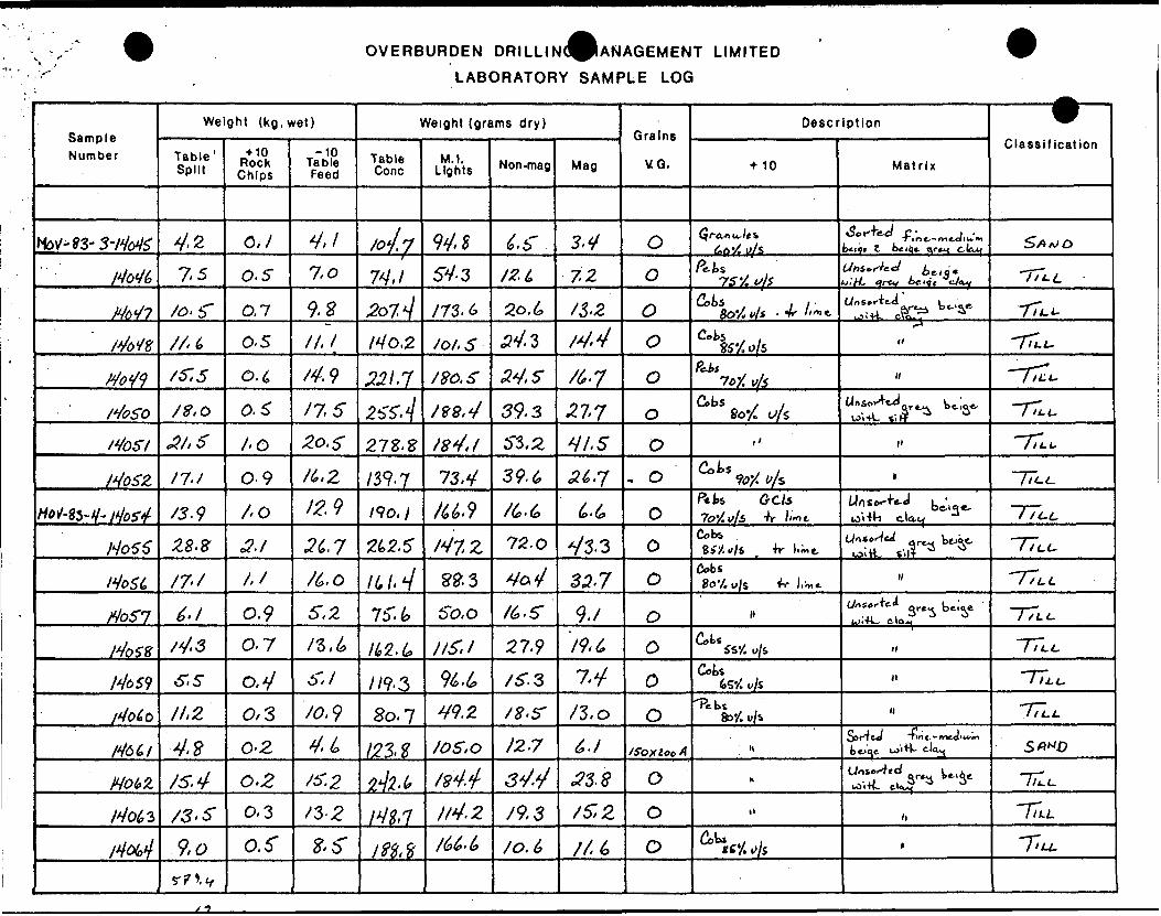
OVERBURDEN DRILLIN(^ANAGEMENT LIMITED
LABORATORY SAMPLE LOG
Sample Number
Weight (kg. wet)
Table' Split
+ 10 Rock Chips
-10TableFeed
Weight (grams dry)
Table Cone
M.I. Lights Non-mag Mag
Grains
VO.
Description
•MO MatrixClassification
4-2 O,/ y,/ 9V. O S fi t* o
7.5 0-5 7V./ 5V. 3 72 O 7 S "A f*
/o. O,7 9- X73.6 O 5 , , j rSo'/, v/s - 4r li* 77 *.0-5 /o/. 5 34. 3 t 4, 4 1.
/575 j 20. . S Pc-bt ILL-
, 4 39.3 27-7 Cobs . ,807, u/s ,.
AO f 84,1 53,2 y A 5J^OSZ /r-/ 0-9 /39-7 73,4 39-6 , 0 ^
/OPets
o'i •m elo-t /i-L
. 8"o?./ , Z 75-0 V 3. 3
Cobi er. Q oitL s'.l? ^ i i. t.
MoSt, 22.3 35-7 o Cobs 8o'/.
0.9 75". So. o0-7 tiZ.I 27-9 *.
7/9-3 oII.Z 0/3- /a 9 80.7 /3.o o 'Pebi
*.
*.
4,2 0-2 /2-7 t f ox loo A bf'qe.
j 5. 4 34.4 o0,3 It4.2 /9,3 /s: 2
.9,0r? *.v
o.r /o. o
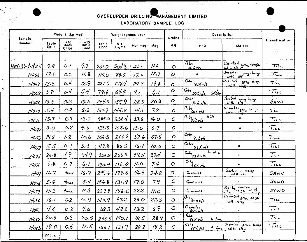
OVERBURDEN DRILLING^MANAGEMENT LIMITED LABORATORY SAMPLE LOG
Sample Number
HoV-ttJ'ifaf
/Sou
Mow
i*htf
Motf
tfo~?o
/Vo7/
j4n-79
Mo73
/Jo74
Holt
Mo7L
Mor?j4o^(>/^79
t too
Hovi/4ot9
/4oz5
Weight (kg, wet)
Table Split
l*12,0
/3'3S.8
/f, 8s,*//3,7S- o
/9.81S- S26.8
t. S
/6*7
5*4
/l. 3
tt./
4*2o.S
/9-0g'l.-L.
+ 10 Rock Chips
o.*o.zo.V0-iO'3
0.2
0-70.2
I,Z
0-2
/•90.7
Ti-Ace
'f(UJt
TfACt
0-2
0.2
0.3
0,6
-10 Table Feed
9.7II,*X2.95,y/S, 6S,2
/3.0
t -S
IV.te
5,3
24. 96.//^7
5. V
//3
/5T9
V^^0.5
/^^
Weight (grams dry)
Table Cone
*370
119.0
33.7.1*
79,6
2o4,S
/M7
zse.o
IZ1.3
3U.3
113.*
&5.Z
/So, V2^9-4
IS L 3
229,2
/W, 762-3
2^/5'. S"
/6ff./
M.I. Lights
Ws28.5
m.4at/5b'9M' 8
23S.4
/03-t,
2U-2.
n.s2U.9
112.0
I7Z.6
/SI, 9
/9t*.o97.2
42.2
170,1
121.1
Non-mag
31.1
17. ^
W/9,/
28,3
14.1
33. t*
13.0
62. t*
l(*'l
S9.f//.oV6-9
n.o22.*
25- O
/3,2
V^.b"28-2
Mag
'
M 6'*'9
/9.B
d,/20.3
7,9
Ito.O
(o.l
37.5
/o, 6
59.4
7424.2
7-9
II, O
22. S
tf23.9
/?.2
Grains
VQ.
O
O
OO
0
0
O
O
0
O
0
oooooooo
Description
•MO
ftuz s y, vi i
nC*k .
9b#Vs
Sfctf w/s SZ#6rtfot-s
So'/ y/5tfot*
foy. y/sCots . , Ws
9o-/ vkH
Coks 9o'/. vk
Cot* u , ?6'X t/A
Coii . Tr unit, 8 S'/. l/A
Cot* 8SX u/S
(Jro-OK-lel
^}r*o uJe i
GjntuxuJes
atsw*/*-/*(fra.ndet
3SV. u/sfat f y'/ v/f Jr /""e.
Oots96-/ u/s ^ //-.t
Matrix
iSrtsi,^- 1*u^.^-1^'UnSfrttd. grey - ttj^*.
io'i4-t. c.Jov.j
;i
Oorteo QP^,, ttio*.u^+i. sr/r 3Uo So ,teJ bt| -
ui'iW- clcSj 3 3
*/
l/
/l
li
yi
H
SorieJ - ^e-ici*to'.Ht tlo^
II
f&ertu Sorted., . 3 rtS Ok"a ft We^
""-^^^ t*y(Olft C-liVy
/l
/l
Unsorted yten - t ft 'J t W if/- C/Oj,
—————— ̂ ———
Classification
TTIc
~77c-L.
TTcc
T7^c
5/9A/P
T7-L^
Ta./-
"hl.L
n^ir^Lr^TT^5/jA/o
S/9A/O
S^A'^
TT*. L
TTic
"Tin,"TlLL
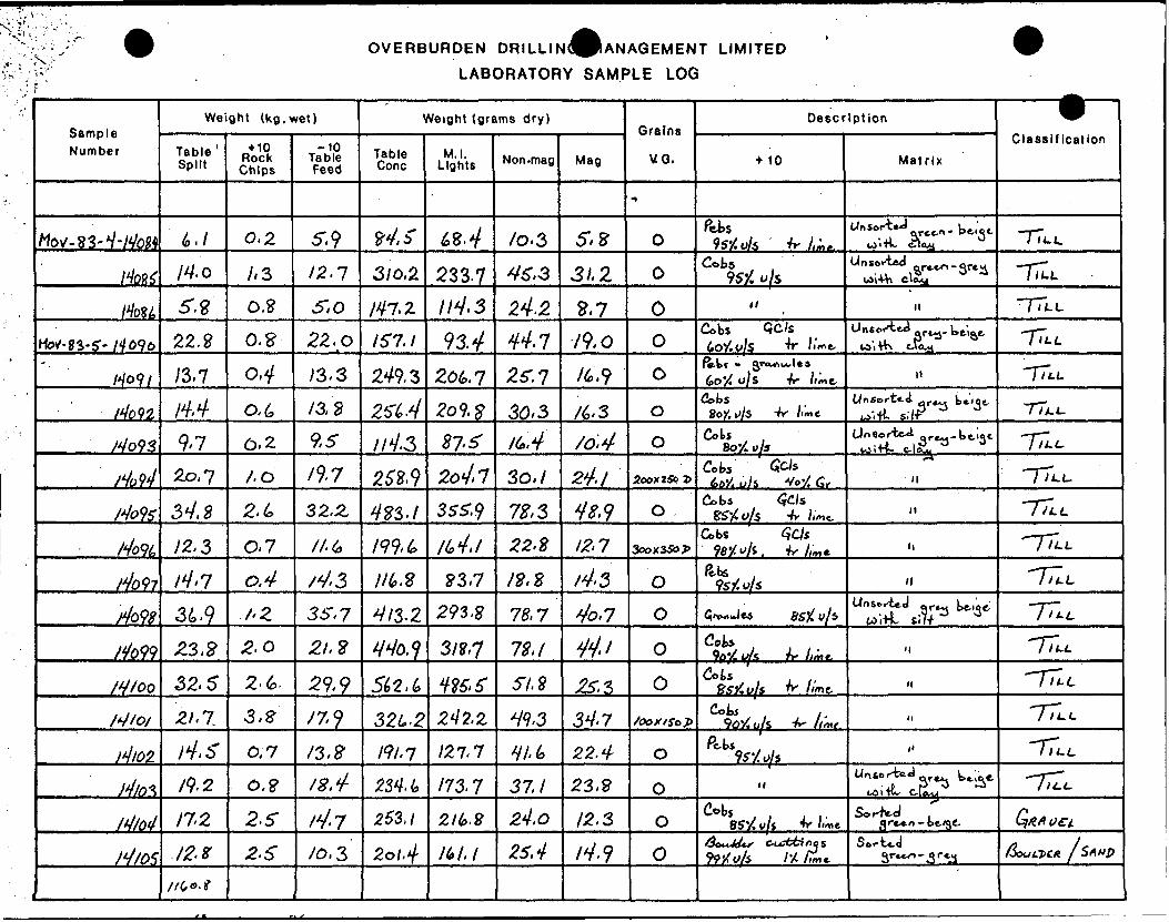
OVERBURDEN DRILLwd^ANAGEMENT LIMITED
LABORATORY SAMPLE LOG
Sample Number
MOV-83-V-/V0M
/VoK
/Vo8i
Ho1-n-S~ MOVo
/Vo9/
/Vo92
/Vo93
rfoti
Mote
HoVL
/4o97
do98
tfo99
/y/oo
/V/o/
)*JI02
)4io^1*1/0*}
ri/os
Weight (kg. wet)
Table' Split
6-/
M. Q
5.V22.8
/3.7I'M
9*7
2o,7
3V. S
y2, 3/V'7
34-9
^3.^
52.5
-8/. 7,
ri. sft. 2
17.2IZ*\
/r(,o-t
+ 10 Rock Chips
0,2
A3
0.?0,9-
04O.I,6,2'
/.O
2,6
0-7
aVA2
2-0
Z' (o.
3,3
0.7
0.9
2^5
2.6
-10 Table Feed
5-. 912.1
S, O
2Z.O
13.3
13,2
9,5/9*7
32.2
//6
/V-3
3S. 7
2/,?
29,9
/7?
/3.8IB,*j-
ri'7
10, 3
Weight (grams dry)
Table Cone
94 f
310,2.
M7.Z
157,1
249-3
2^4
/'ri.3262.9
433.1
m. LIILX
413-2
Wbj
542,6
32U-2191.1m. i*253,1
2ol4
M.I. Lights
te-4
233-7//V.3
93. 4-
Zo^.l2o9,#87'*
2oj.7S55-.9
M,l
P3-7293. S
311,1
MS. f242.2
121,1
173.1
2l(o.2
Ik I.I
Non-mag
/o. 3V5",3
2^.2
^72^.7
30/3/6,V
30, ;
7^3,?2.F
/?.E
78,7
72,1
S/. S
W,3
HI. (o
37,1
24,0
25,4
Mag
S, Z
31,2
9,7
79,0/6,?
/6.3/o,424.1
4 e, 912-7
ri- 34o,7
44.i25.334.7
22.4
23,9
12.3
14.9
Grains
VG.
-*
O
O
00
coo
ZoovlSo f
0
3ooX3So*
O
O
O
0
Soox/SoP
O
O
oo
Description
t 10
Pebs 9S5CU/5 Vr /^,
Cobs95X u/s
t/
C*bs Qc/s io'/.y/S ^ '''•"e-ft.tt * 5ra*4iA.l*s
(oO'/t O/S Vr /((ne-
a,bsSoy. w/s ^ /'•"*
Cots8oX w/5
Cobi ^Cfe 6oX, u/S Ve'/ C,
Cobs (fCIs SS'/^/S -h- limt.
a,bs ^cy*SfcJ?"A. f' //^,e
Pt-k , 9s/. u/s
S*w JC6 ^X W/*
Cola. , . ,9A'/. UK Tf lira e.
Coks , HS^.ulz ir lime.
Cob* ,90^0/s •A' ///M^
r^b* ' 95'Xu/s
H
8?'X y/* -^ '-me/SouJt^f C-ud&nqs
KXo/s It K**
Matrix
UftS^3,——— ^LO 'TV, cHcLy
UnsorUd or*cn- 3rtiiWfMl elc^y
II
Unsor-ttJ ^. te^eU)'l VK C.Vo.54
II
6/n Sorted flr4M tciOt
^-,-tt S.1^ ^ ^
(Jnte^teJ. ^.teljclOtTV- C-tOuu
^t
M
H
li
(1Unsei*J ,9r*3 ^'3fcp i-Hl si7-f
M
M
It
t'
Un6or^ft*J^re^ tev̂ e LOiiC culu
Sor^-d . ^Cteo - bfgC-
S^r-Ud3r**^-.3 r*j
9Classification
TT^
TTuLTTLL
TT,t~~fi~*-L.
TT/.C
"jTic.-rr^TTLL
-TTt-LTTt-L77^TT^-TT.L~77U
-77,c7T^
GI&A oei.
&XJ&CK. /SAVP

OVERBURDEN DRILLIN(^ANAGEMENT LIMITED
LABORATORY SAMPLE LOG
Sample Number
Weight (kg. wet)
Table Split
+ 10 Rock Chips
Table Feed
Weight (grams dry)
Table Cone
M.I. Lights N on- mag Mag
Grains
VO.
Description
10 MatrixClassification
u 5". 2 1 'l #.8 9.9 O "C? C-1
•yvjt fceA-rot-k. *"*v
12.5 0.9 127-2 25.1* /S", g O Tr
3o.2 1,4 35^.5" 5 7. Z obsto s i H" ILL
Hill 0-7 . 6 23.3 OCobS TV ki TiLL
9.9 2-7 10.7 9-3 Ocoas
/3.3 0-3 98,8 17 - 13,2 TILL6 ra'A . c i""\*. TO
G f Q.; M S
o'.H '. M*. 3f*.*.N)
2.0.8 n.s O.H 0.3, 11
H/l? . S 1.2. 61. li. 5" 5.2 Tr GC J. TILLIMMS 1(0. l Tr
IHII1 Al.? -l IMI.O 56.Cobs
LL
TLL
0.2. A i. 113-6 o -TiU
jM/2,2. 2. 5-. 3 ". o ^n.o I3I.S" li LL
IHI2.3 C)- 50! loo. 1?UonSor 4- td *ir**| to i *k S'.l-T. T'.LL
O. l o LLI3C.5 CoWS So '/i
i r Ki nw*- TILL
IHJX} •n./r*?. 3
12. 32. PcbS .
ill-TUL
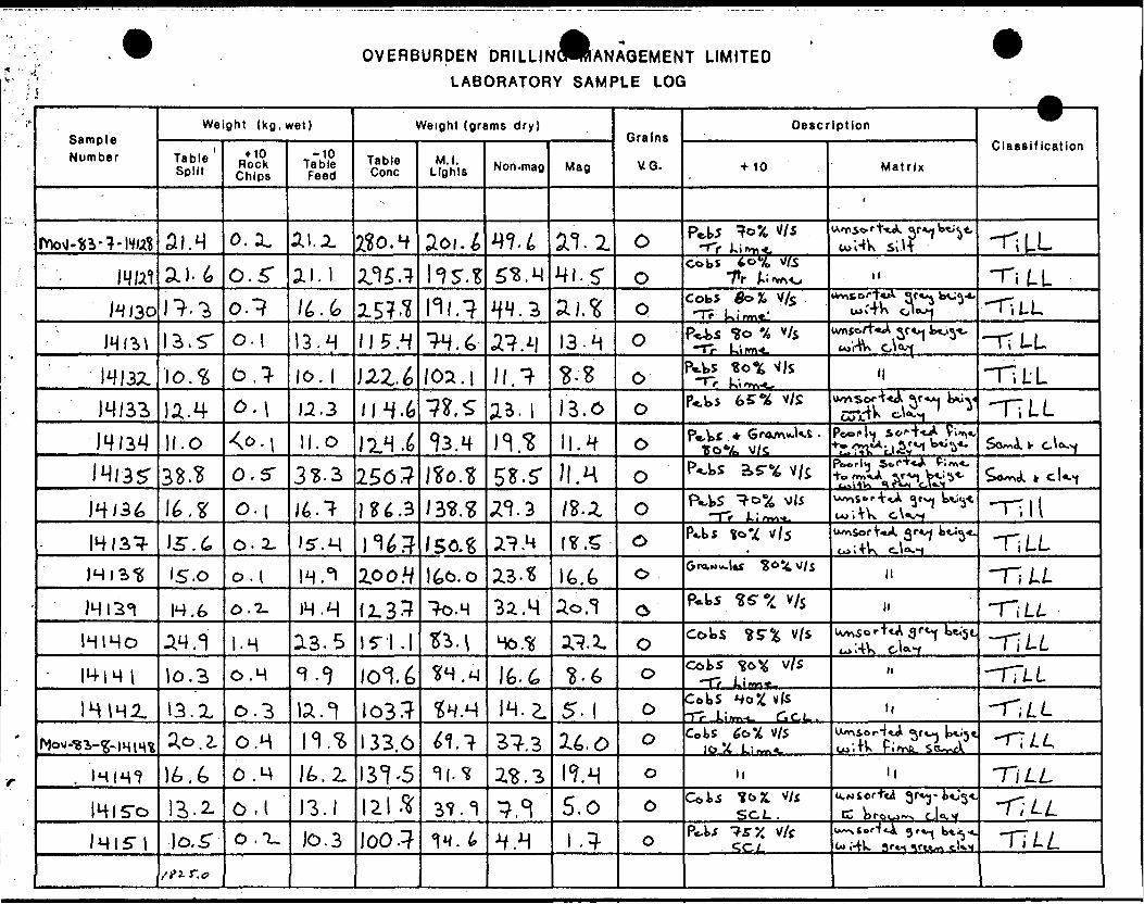
OVERBURDEN DRILLINCWRANAGEMENT LIMITED LABORATORY SAMPLE LOG
Sample Number
Weight (kg. wet)
Table Split
+ 10 Rock Chips
-10TableFeed
Weight (grams dry)
Table Cone
M.I. Lights Non-mag Mag
Grains
VQ.
Description
+ 10 MatrixClassification
o.x '"t;*A or si l f
-r-LLmm o.r 3.1 hsr.s . M
cobsli -ra L
1^130 2.5?.^ a j. Cob* 0o 7- Tr kirm*I
14 . S' o.i 13. . 4 13.414132. 10,3 o.l- lo. 1 loa.i } -ri t LJ4/33 U.3 114-6 TILL
.o . 0 11.4J4I3ST o, 256? /l. H
t**. i , iTK
- li
14133- \S. 6 0-2. 2? .H UmSor ̂ *A TILL15.0 O.I H. 0! Zoo.4 LL
JHI31 H. 6 0,1. IH.-H fz.33 To.H 32.4 P.b5
IHIHO .24 . I.H . S . 2. Cobs
!o,3 O.M cofcs v/s -ra LIHHi 13. X 0.3 H. 5- C, Ci-
2,0,2, O.H 133.0 Cotslo X Li^
V/5 i**-'}*
1^.2. 131-5 I1H l! TILL141 0,1 13. 37. *) 5.0 W*
SCi. . C brcuwv cj -TILL0 .1. JO. 3 loo.} 4. H .} cl TT/./.
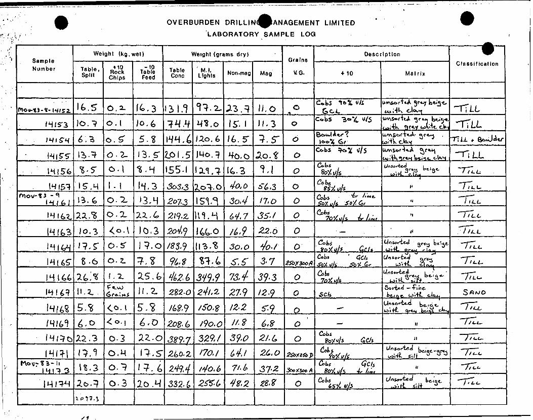
OVERBURDEN DR1LLIN(^ANAGEMENT LIMITED
LABORATORY SAMPLE LOG
Sample Number
Weight (kg, wet)
Table, Split
+ 10 Rock Chips
-10 Table Feed
Weight (grams dry)
Table Cone
' M.I. Lights Non-mag Mag
Grains
UO.
Description
10 MatrixClassification
. S O.CokS 16 X
GCL Hi 1 4k -T7 O,O.I H /S". H. 3 Cobs
6 '. O.S' , 4 Uo.6 TC (Sr T?U
0.2- 13.5- ZPI.5 40-0 Ao.f Cobs
IHI56 I55-I a.1. lt.3 o fcS, M , 3 4o,o , 3
'3.H 17,0 o Cots *.0.2. 2/9-2, 111. M . 7 3 S.I o
Jo. 3 0.3 22.6 77*., S" 0.5-
*- ^8-6 o. z. 3' 7 Cob*
(/s 5b'XJ. l Wn scrCed
.- jj IUJ ' TV. Ci OiAt-
HI64 l. Z 25. 13,4- 39' 3Un sot-ted-
H. i. . i 27.9 123 — Tinsck
IZ2 *L o i K..
l/. Z 6,8 i-L,
22.3 0-3 329, / 39.0 2/.L. 0CoU
O.M . S ^0.2 170.171-1* 37-2
0.3 lo .M 4 Z, 2
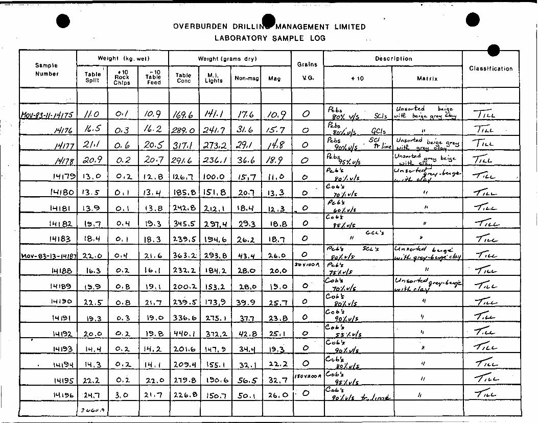
OVERBURDEN DRILLINWMANAGEMENT LIMITED LABORATORY SAMPLE LOG
Sample Number
MW-SMI't4l7S
Hl7(,
rimM/78
H\1^
/MlSO
IHI8I
IHI82
IHI82
MOV-83-I3-N/87
IHIB6
IHI&9
IHI9O
H |9|
mi92.t
14(33
im9q
m 195mist
Weight (kg, wet)
Table Split
//•O
K.. S
21.1
ao,913,0
13.5-
13. ̂
I9.-7
18.4
27.. 0
lb.3
15.5-
2.2.S-
19,3
2.0. o
IM.^
1H.3
22. Z
2HH
2^4.^.")
+ 10 Rock Chips
o./
0*3
O. k
0.2
0,2.
O, 1
O, 1
0,H
0, 1
0,M
0,2
O,8
O. 8
0.3
o.x0.2.
o.z.
O. Z
3.0
-10 Table Feed
lo. 9/4.2
^o.^2o-7
^^.6
/3,A/
(B. 8
i^.s
I8.3
2.1.6
tb.i
\9,l
21, "7
19.0
19.6
IH.Z
IM, 1
2-1.0
21. -7
Weight (grams dry)
Table Cone
/69.L
289-0
317-1
zqt.Llib,!
ies,eani.6
3HS.ST
^^9 ( s•
3fca.ix^.i
200, TL
ZV5.5-
33fo.fe
4^0 J
ZOt.b
Z09.H
219. 8
2ifc.e
M.I. Lights
/W-/
2V/. 7.273,22.3CJ
loo. o
1SI.8
2.12. \
i 31. H
ISH.b
293.6
len.x153.2
H3,S
215. l
EllA
im, 5IS5.I
I5o,fo
ISo.1
Non-mag
/76
3 1. 1,
39* 1
36.6
/S-,7
20.1
i8,M
233
2fc.Z
Hl.H
28,0
28.0
i9.9
3T.-7
yi.%3H.M
32.1
5^,5"
5o, i
Mag
/o. 9/S-.7
f 4. ?S 8. 9
/l,o
13,3
12,3
I&.8
18,1
^fe.O
20.0
\5.o
2S."7
23,8
25", 1
19. ̂
2.1. ^
32, -7
2G.O
Grains
VG.
O
O
ooC)
o0
ooo
5*yYoo4
O
O
oo
oo
1 rov noon
- O
Description
+ 10
Rfe* VoV. v/A SUs
fits , FovSiyi ^/s
P^s , 5C/ 9o'^ f/5 "- ///we
^K x y W.v/SPt-k's.
fo '/. uJsC.ot,'s
7o '/i vi fPt-l 1*
bo'/.vjsdofci-
tf/v/eC-Ct'j
y/
PeJ.** Sc,L's Go/,*/?
f^l't7 f /••'If
Cot,**1O'/, V '1 'f
Col. t?o/ *Y*
C.ot't 90 X t//*
de.^. iys 'X ^ /s
OoU't 9o /, i// t
C^'t to'/ f/s
Zola's If/v/s
Colt's 90/b/s 4r. //^*,
Matrix
i7n sorted tnoe- wi'tf. be-i^t, ^rty cJ'jy
tl
t/oSor^J bt,'wiK, 5r*y iiio-w^T^fl-a k-S-u i HL cJ /i . .
Urtttt'-^ccr /. -j. 9 f~j~***9*' /- x s*/- fi/fiy
^
/i
w
*
LinS0r4ejcf ^^^^1
Lu.'M-, Gf&y^t-V&C' 'cky
ItUr* t*"-/*** g ~y-t*^. ^fU.f/OLy *^
'1
'1
li
A
If
li
h
VClassification
"T7/U.
"7/Ti.T7^TTL^~7^it-.
•/Tlu-
-rr^-T7LM~
-rr^-r;^~7^itr
"TTlc-
~7Tl^--r:^~7Ti-c--rT^T-r^*7?Lir"T^fct.

OVERBURDEN DRILLINVMANAGEMENT LIMITED LABORATORY SAMPLE LOG
Sample Number
Weight (kg, wet)
Table Split
1 10 Rock Chips
-10TableFeed
Weight (grams dry)
Table Cone
M.I. Lights Non-mag Mag
Grains
VC G.
Description
+ 10 MatrixClassification
35M 5L8 32.. lOfe.t 95-7-
CM 831, (? Mil. 95, S
Hzoo as. 1,0 ae.s 58S.5 8H.O , B
1M20I 2S-0 O.b en tt
21-8 1.1 20,1 210, fe IMS 3 29,3dot'*
25, H 0,4 25", 0 80. H 35.0 /i
I420H 4.0,1 22.1, b 201,0 H, 6 6, 0 Ptt's
21.9 O.fc 21,3 2oo. t02.S 36. Sn *
IM 206 18.5 O.H 18,1 H3-8 28.8 X/
H201 W.I 203.1 33/2 2.1,3
o, t IS", S M. e 23,2. fO/.H/S
IM209 23,3 0,H 85.1 21,0
(MHO 2H.6 2M.5" in.e 82.3
IHXM 20, ST 1,0 15.5" 253.1 isi.o
IM2I3 lb.3 120.8 23,4 8,8
IM2N 21,5 0,2 21.3 113, S" 62. 31.2. ^ ^- r
8.1 XO.I 8.0 238, b 213. /b, 8/Ufc c L '
,fr
IS, S (M IS, 4 2821.4 232. S 3H.I ir, s 11 . c.
IS, b 204,0 111,0 53.o 3H.O JV

OVERBURDEN DRILLINCT MANAGEMENT LIMITED LABORATORY SAMPLE LOG
Sample Number
Weight (kg, wet)
Table Split
+ 10 Rock Chips
-10 Table Feed
Weight (grams dry)
Table Cone
M.I. Lights Non-mag Mag
Grains
VG.
Description
10 MatrixClassification
zzr? 2X1,1 • 07. J 63,6 Sfc.o
1,0. , 8 210,1 S-2. 2.Lin forrf-ff 9 r**/
ISM H3.S 8,1
IM2S3 2,1- r I -3. HI, 8 tS.T.2*6*100*1*
li
(•m*/ SHUT •70^
n,8 122., 6 31 18,
M234 13,8 C. 7. ISSM 132,1 IIJT& '.
H 2V? IM.1 0,1 H-S" 'se,-? 110.8 I8J
^i- 18- sg, 8 75-1,3 '111,7. 68,O ?o /, II
Ht.O (03, 87.
IHiSO l.TL H4.Z, Z36.S" 6o,0ir
60? f/S
IH2S-I Zt.l 0.7, ZI.O
IM252 25", b 330,^ 8?. Cot's'/r l/ ft
tfo. 6 0,-i. /ro.7 , "7 20, S" ft
, 8 ir. 3s, 7ftc-i,'*
IHZ53T 3.6Cot,*
IHZSfc Xft. H 0.-7 /fef-7 2.1.7.C* t. 't
3o J Act's
mn 37,3 388,7 2^5". 0 n
HOV-83- fc.fc. 0,1 il.l ,'//-

OVERBURDEN DRILLI(^MANAGEMENT LIMITED
LABORATORY SAMPLE LOG
Sample Number
Weight (kg, wet)
Table' Split
+ 10 Rock Chips
-10TableFeed
Weight (grams dry)
Table Cone
M.I. Lights Non-mag Mag
Grains
VG.
Description
•HO MatrixClassification
e. s 8. S" lUft fJe*jj
14119 . s*. 8 1H.1 18.5
t y-
///1 -f-f^"T//-C-
H11O 18. H IH8J 3S-.I lb.7 H
mil 11,3 li. Z IOb.9 Ifo.S"
mil. 10, . S lb.8
9. S is, 38. r 13,3 ••5.7 /x
I421M is. 87.1 71,8 n.i1-5, 101, O fct.l 19.3
Nllfc 11.7 Ill.O 67.5" 13. "Z- It, 3
IH117 II. 0 10.9 9M.O 11,7. 16.
IH.3 0.3, H. D -7T.9 Hi. 7 8 7o/! v/t
H 139 13.0 0. IX. 101,6 21,7 IO. t &C-L
10,8 0.3 lo. r 10-5,3 . H 30. S li *.*.
H141 It. Z Oil H. 1 81.1 21,1 IS". K
51.3 tt.S" II
1.3 fei. 6 13,1
KVOV- 81-18- lO.G 0.1. lv, Ibt.fc 2.6, "f
ZM./ 50.1 31.9 n
/' ^ /,.
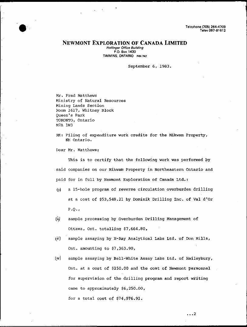
Telephone (705) 264-4709 Telex 067-81612
NEWMONT EXPLORATION OF CANADA LIMITEDHollinger Office Building
P.O. Box 1430 TIMMINS, ONTARIO P4N 7N2
September 6, 1983.
Mr. Fred MatthewsMinistry of Natural ResourcesMining Lands SectionRoom 1617, Whitney BlockQueen's ParkTORONTO, OntarioM7A 1W3
RE: Filing of expenditure work credits for the Mikwam Property, NE Ontario.
Dear Mr. Matthews;
This is to certify that the following work was performed by
said companies on our Mikwam Property in Northeastern Ontario and
paid for in full by Newmont Exploration of Canada Ltd.:
(j) a 15-hole program of reverse circulation overburden drilling
at a cost of $53,548.21 by Dominik Drilling Inc. of Val d'Or
P.Q.,
\\\) sample processing by .Overburden Drilling Management of
Ottawa, Ont. totalling $7,664.80,
(m") sample assaying by X-Ray Analytical Labs Ltd. of Don Mills,
Ont. amounting to $7,363.90,
(jtf) sample assaying by Bell-White Assay Labs Ltd. of Haileybury,
Ont. at a cost of $150.00 and the cost of Newmont personnel
for supervision of the drilling program and report writing
came to approximately $6,250.00,
for a total cost of $74,976.91.
...2

-2-
Invoices showing the breakdown of the aforementioned
costs are appended.
JAC/cm A. Coopece President
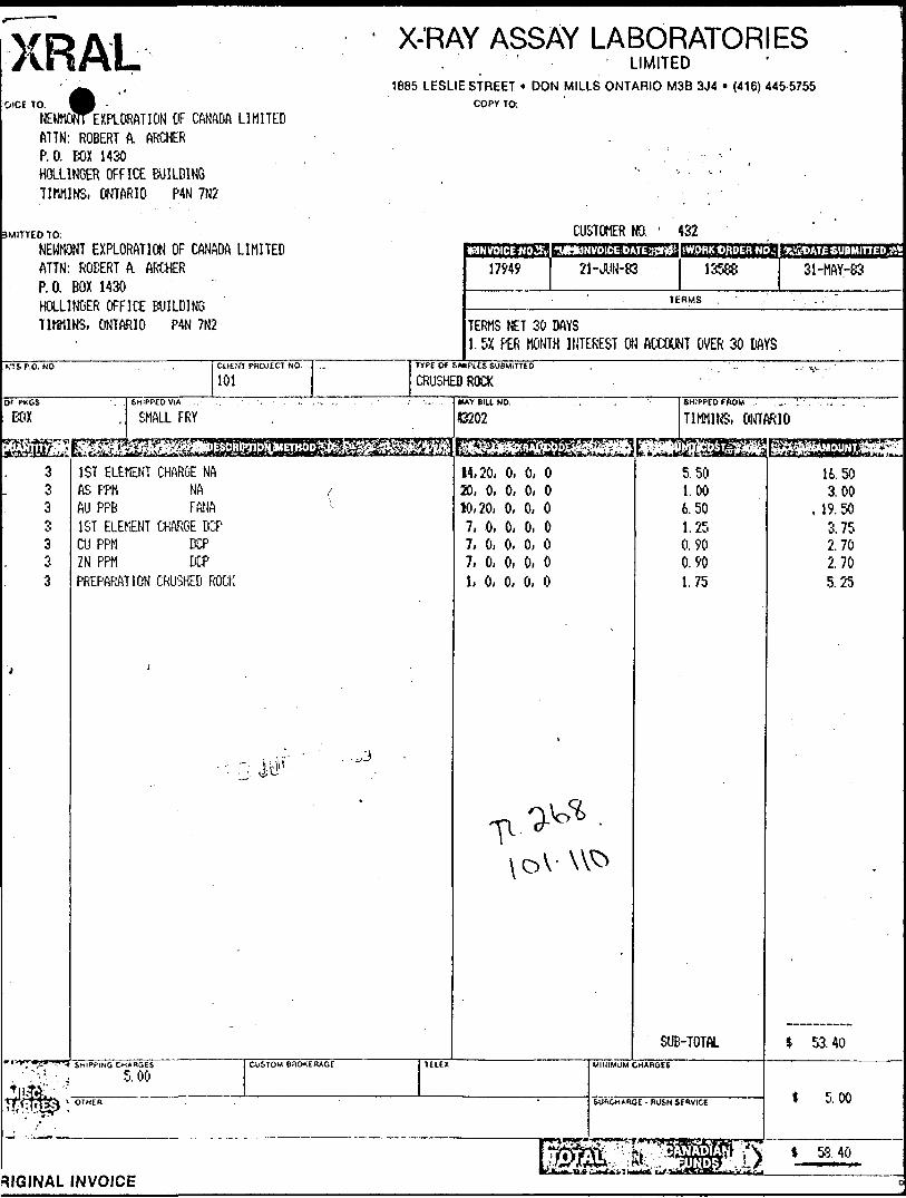
XRALWE
X-'RAY ASSAY LABORATORIES
OlCE TO.lOMCiNTEXPLORATION OF CANADA LIMITEDftTTN: ROBERT A. ARCHERP.O. BOX 1430HOLLINGER OFFICE BUILDINGTJMM1NS, ONTARIO P4N 7N2
. ' ' LIMITED1B85 LESLIE STREET * DON MILLS ONTARIO M3B 3J4
COPY TCh
(416) 445-5755
3MITTEO TO:
NEWMONT EXPLORATION OF CANADA LIMITEDATTN: ROBERT A. ARCHERP.O. BOX 1430HOLLINGER OFFICE BUILDINGTIMMINS, ONTARIO P4N 7N2
CUSTOMER NO. ' 432
17949 21-JUN-83 13588 31-HAY-83
TERMS
TERMS NET 30 DAYS1.5X PER MONTH INTEREST ON ACCOUNT OVER 30 DAYS
CLIENT PROJECT NO.
101TYPE Of SAHPUS SUBMITTED
CRUSHED ROCKSHIPPED FROM . ~
TIMMINS, ONTARIOBOXSHIPPED VIA, .
SMALL FRYIU.YBIU.NO.
53202
^^^8113^^3333333
t
iife
1ST ELEMENT CHARGE NAAS PPM NA /AU PPB FftNA1ST ELEMENT CHARGE DCPCU PPM DCPZN PPM DCPPREPARATION CRUSHED ROCK
j
- . f f " ' - ^
14,20, 0, 0, 020, 0, 0, 0, 010,20, 0, 0, 07, 0, 0, 0, 07, 0, 0, 0, 07, 0, 0, 0, 01, 0, 0, 0, 0
^
5.501.006.501.250. 900.901.75
SUB-TOTALSHIPPING CHARGES CUSTOM BROKERAGE TELEX MINIMUM CHARGES
5.00OTHER ' SURCHARGE - RUSH SERVICE
/" V
^tolSsSZI^^16.503.00
, 19.503. 752.702.705.25
-
* 53.40
* 5.00
RIGINAL INVOICE
XRALINVOICE TO
X-RAY ASSAY LABORATORIESLIMITED
1885 LESLIE STREET * DON MILLS ONTARIO MSB 3J4 * (416) 445-5755COPY TO
i-, u M. si?vKlU.:!.:-:-. Ofr'KE
SUBMITTED TO:
f:^" : i t i:."'.! ;j :.-. i. : - i-.-,:V III :ft;['
r.'i !i. i... l- i ,;:.'i i t ,i'.F. U l'..-, l--; . -
';*:* t'O.
TERMS
TERMS KE1 30 DAYS 1.5Z PEfc HOMTK O1 . fatOiiT f .va: 5.. D',V1.
TVPI OF SAMPLES EUBMITTtO.,,CLIENTS P.O. NO. CUENT PROJECT NO.
2-.0WAY BILL NO. SHIPPED FROM6HIPPEDV1A
Wr'li F?,''
0
^RAL-CODE
6.. O, O, C- O 9, O, C-, O, O
H..i
1*UNIT COST ^:.\ .; ; i ;. :vi(S AMOUNT
12: .
XRALINVOICE TO:
X-RAY ASSAY LABORATORIESLIMITED
1885 LESLIE STREET * DON MILLS ONTARIO MSB 3J4 * (416) 445-5755COPY TO:
P, T-., t *~
r, l ih. K
F'. 0. t' J
SUBMITTED TO:
TERMS
CLIENTS P.O. NO. CLIENT PROJECT NO. TYPE OF SAMPLES SUBMITTEDvr;J;-r;iv tv.U.
NO. OF PKGS1 f..:.
WAVBIUNO.
;.Si;XHAl CODE
f, t 1 : O, 0: f'
l.'. "' O, i 1 .- t-
SHIPPED FROM
SHIPPING CHARGES
TfilPLICATE COPY
CUSTOM BROKERAGE MINIMUM CHARGES
SURCHARGE - RUSH SERVICt
,;3gfiUNDS ;^
LVOICE 10
NEHMOWT EXPLORATION OF CANADA LIMITEDATTN: as. MIDDLETONK 0. BOX 1430HOLLINGER OFFICE BUILDINGT l (WINS, ONTARIO P4N 7N2
X-RAY ASSAY LABORATORIESLIMITED
1885 LESLIE STREET ' DON MILLS ONTARIO MSB 3J4 * (416) 445-5755COPY 10:
JBMITTEDTO: ( j V?
NEWMOjJT EXPLORATION OF CANADA LIMITED ^ AT1N: R S. MIDDLETON P. 0. BOX 1430 HOLLINGER OFFICE BUILDING TIMMINS, ONTARIO P4N 7N2
aaaasBGEzSKtNO 43?\VHV--* *! lS^^MIdSJII^fti732E32]nitr!2Z;
17715 18-MAY-83 13208 j 7-APR-837ERMS
TERMS NET 30 DAYS 1.5K PER MONTH INTEREST ON ACCOUNT OVER 30 DAYS
.itWSP.ONO . CLIENT PKOJEC1 NO TV Pt Of SAMPLES SUBMITTED '1-
260 HEAVY MINERAL COOf ^KGS
1 PACKAGE
1. 326 1 44 3. 209 4. 209 5. . 209
- i i -to \ *:^jfej
1 SHIPPED VIA - .- . . ' - . ,
QUICK MESSENGER SERVICE
AU (LARGE VIAL) NA AU (SMALL VIAL) NA AS PPM CU, 2N PFti DCPPREPARATION HEAVY MINER
WAV BILL NO. .. . ; . . . . SHIPPEDFROM
T-391756 TIMMINS^S^^^^^^S- -v-'"i
14,20, 0, 0, 0 14,20, 0, 0, 020, 0, 0, 0, 0 7, 0, 0, 0, 0 1, 0, 0, 0, 0
j
E.JMSElEi15.00 7.502.00 3.05 1.75
SUB-TOTALii'Sf-f.G CHthGES . . CUSTOM BROKERAGE TEliX MINIMUM CHARGES .
8.50ClnER SUHCMABOI . RUSH SERVICE
I^^/SF?^,l^SikzL1M " "^ 3JLuUu^v 1*^*v " ynrrtog ^A*j.".—-^— ̂ .rji'zlf.^ jLt
4890. 00 330.00
1 418.00 637.45 365. 75
t 6641. 20
* 8.50
J 6649. 70RIQINAL INVOICE
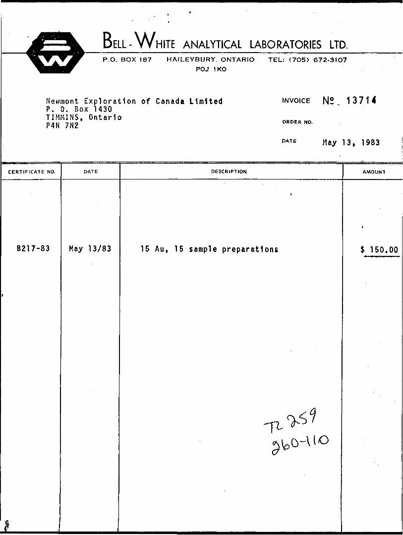
BELL-WHITE ANALYTICAL LABORATORIES LTD.P.O. BOX 187 HAILEYBURY. ONTARIO TEL: (7O5) 672-31O7
POJ 1KO
Newmont Exploration of Canada Limited P. 0. Box 1430 TIMMINS, Ontario P4N 7N2
INVOICE N2 . 13714
ORDER NO.
PATE May 13, 1983
CERTIFICATE NO. DATE DESCRIPTION AMOUNT
B217-83 May 13/83 15 Au, 15 sample preparations $ 150.00
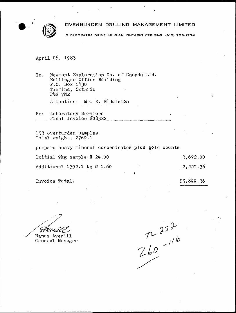
OVERBURDEN DRILLING MANAGEMENT LIMITED
3 CLEOPATRA DRIVE, NEPEAN, ONTARIO K2G 3M9 (613) 226-1774
April 06, 1983
To: Newmont Exploration Co. of Canada Ltd. Hollinger Office Building P.O. Box 1430 Timmins, Ontario P^N ?N2Attention: Mr. R. Middleton
Re: Laboratory Services . Final Invoice #08322_______________,
153 overburden samples Total weight: 2769.!
prepare heavy mineral concentrates plus gold counts
Initial 9kg sample @ 2^.00 3,6?2.00
Additional 1392.1 kg @ 1.60 ' 2,227.3.6j
Invoice Total: $5,899.36
Nancy Averill General Manager
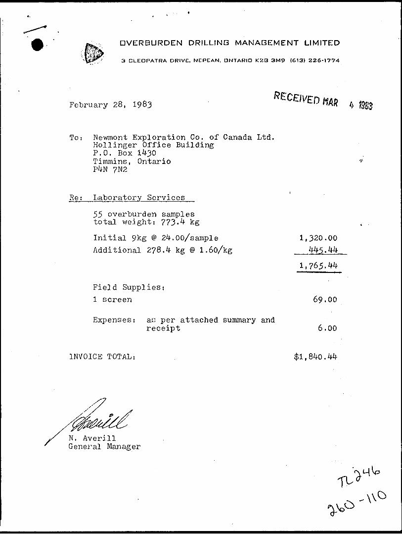
OVERBURDEN DRILLING MANAGEMENT LIMITED
3 CLEOPATRA DRIVE, NEPEAN, ONTARIO K2G 3M9 (613) 226-1774
February 28, 1983
To: Newmont Exploration Co. of Canada Ltd. Hollinger Office Building P.O. Box 1430 Timmins, Ontario P4N ?N2
Re; Laboratory Services
55 overburden samples total weight: 773-4 kg
Initial 9kg @ 24.00/sample 1,320.00 Additional 278.4 kg @ 1.60/kg __445.
Field Supplies:l screen 69-00
Expenses: as per attached summary andreceipt 6.00
INVOICE TOTAL: #1,840.44
N. Averill General Manager

INVOICE-FACTURE
FORAGE DOMINIK (1981) INC. c*. 1^247. v..™. P.O DOMINIK DRILLING (1981) INC. P*.**Telephone: (819) 824-6839 Telex: 057-45523
r Newmont Exploration of Canada Limited, ~* Invoice No. No. defeature: 0332
637 Algonquin Blvd., Date January 15, 1O83
Timmins, Ont.Terms-Net 15 Days Termes-Net 15 Jours
P4N 7N5
l. -J
Reverse Circulation Drilling -Joutel A La Sarre Area, Que1 .- North East Ont. to Jan.15/
January 11 - 10 hours move12'- 10 " "13 - 10 " "14 - 10 " "15-10 " "
50 hours @ 153.00 7,650.00
Other Charges.412 litters of gas for ingineer @ 181.40
Plus 15J5 27.21 208.61j S7.858.61
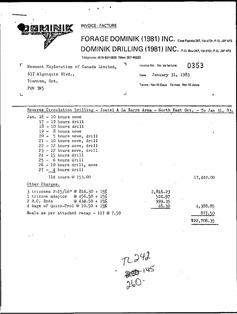
Newmont Exploration of Canada Limited,
637 Algonquin Blvd.,
Timmins, Ont.
P4N 7N5
INVOICE-FACTURE
FORAGE DOMINIK (1981) INC. DOMINIK DRILLING (1981) INC.Teldphone: (819)824-6839 Telex: 057-45523
' Invoice No. No. de lecture:
,.P.O.
0353Dete January 31, 1983
Terms - Net 15 Days Termes - Net 15 Jours
Reverse Circulation Drilling -Joutel A La Sarre Area - North East Ont. - To Jan 31, 83.
Jan. 16 - 10 hours move171819
- 12 hours drill- 10 hours drill- 8 hours move
20-5 hours move, drill21 - 10 hours move, drill22 - 12 hours move, drill23 - 12 hours move, drill24 - 15 hours drill 25-6 hours drill26 - 10 hours drill, move27 - _ 4 hours drill
114 hours
Charges.
153.00
3 tricones 2-15/16" @ 816.30 +1 tricone adaptor @ 456.50 *2 H.C. Rods Q 434.50 + 4 bags of Quick-Trol @ 10.50 +Meals as per attached recap - 117 ® 7*50
2,816.23524.97999-3548.30
17,442.00
4,388.85877.30
S22.708.35

INVOICE-FACTURERECEIVED FEB 2 1 1983
FORAGE DOMINIK (1981) INC.DOMINIK DRILLING (1981) INC. P.O.BOX 247^0,, P.O.
Newmont Exploration of Canada Limited, 63? Algonquin Blvd., Timmins, Ont.
P4N 7N5
Tel6phone: (819)824-6839 Telex: 057-45523
' Invoice No. No. de facture: 0357
D8te February 15, 1983
Terms-Net 15 Days Termes-Net 15 Jours
Reverse
Feb. 01020304050607080910
Circulation- 13- 12- 12- 12- 12- 12- 11- 12- 12— 14
hoursMDM
II
II
tl
II
II
11
Drilling - Joutel & La Sarre Area - North East Ont. - To Feb. 15i 1
drilldrilldrilldrilldrilldrilldrilldrilldrilldrill
&
&
A4bSe,St
move
move
movemovemovemovemove
122 hours @ 153.00, Other Charges.
3 tricones 2-15/16" @ 816.30 4- 3 R.C. Rods @ 434.50 *
2,816.231.499.02
18,666.00
4.315.25522,981.25

NEWMONT EXPLORATION OF CANADA LTD.
DIAMOND DRILL HOLE RECORDPROJECT.
HOLE No.
Mikwam - 260
MOV-83-1
LOCATIONAREA or TWP. Bradette Twp., On t.
CLAIM NO - 633453
NTS 32E/12 u™
DIP TESTFOOTAGE ANGLE
" RECORDING L CORRECTED
LEVEL
ELEVATION
LATITUDE 10+OON
DEPARTURE LO+00 (Ont.^ Quebec
HORIZONTAL COMPONENT
VERTICAL COMPONENTBEARING Vertical
LENGTH 158 feetCORE LOCATION
DATE 1 STARTED
FINISHED January 17, 1983LOGGED BY R. A. Archer
PURPOSE Overburden
TOT. RECOVERY
DIAMOND DRILL HOLE LOCATION SKETCHSCALE:
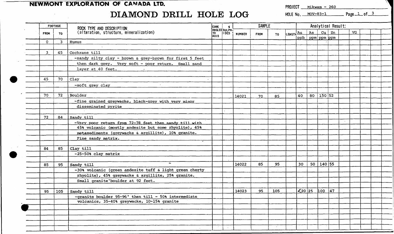
NEWMONT EXPLORATION OF CANADA LTD.
DIAMOND DRILL HOLE LOGPROJECT . HOLE No.
Mikwam - 260Mov-83-1 Page-i-of
* .
FOOTAGE
FROM
0
3
45
70
72
84
85
95
TO
3
45
70
72
84
85
95
105
ROCK TYPE AND DESCRIPTION (alteration, structure, mineralization)
Humus
Cochrane till-sandy silty clay - brown S grey-brown for first 5 feetthen dark grey. Very soft - poor return. Small sandlayer at 40 feet.
Clay-soft grey clay
Boulder-fine grained greywacke, black-grey with very minordisseminated pyrite
Sandy till-Very poor return from 72-78 feet then sandy till wit-h
45!* volcanic (mostly andesite but some rhyolite) , 453;metasediments (greywacke fi argillite) , lO'fc granite.Fine sandy matrix. "
Clay till-25-50^* clay matrix
Sandy till ~-30!* volcanic (green andesite tuff S light green chertyrhyolite) / 45% greywacke S argillite, 25% granite.Small granite 'boulder at 92 feet.
Sandy till-granite boulder 95-96' then till - SO1* intermediatevolcanics, 35-40*1 greywacke, ID-15% granite
CORE ANGLES TO AXIS
* SULPH-
DES
SAMPLENUMBER
14021
14022
14023
FROM
70
85
95
TO
85
95
105
LENGTH
Analytical Result: |Auppb
40
30
^0
Asppm
80
50
25
Cuppm
150
140
100
Znppm
52
55
47
VG 1
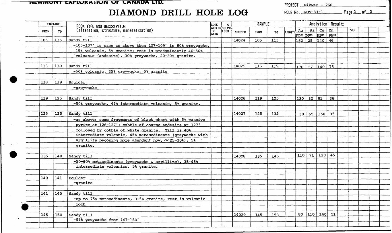
PROJECT Mikwam - 260
DIAMOND DRILL HOLE LOG HOLE No. MOV-83-1 Page-i_of-J.
l——
FOOTAGE
FROM
105
115
118
119
125
135
140
141
145
TO
115
118
119
125
135
140
141
145
150
ROCK TYPE AND DESCRIPTION (alteration, structure, mineralization)
Sandy till-105-107' is same as above then 107-109' is BO'S greywacke,
15 ife volcanic, 5?; granite; rest is predominantly 40-50!?;volcanic (andesite), 303; greywacke, 20-30 !6 granite.
Sandy till-GO'S volcanic, 353; greywacke, 5* granite
Boulder-greywacke
Sandy till-SO1* greywacke, 45!fe intermediate volcanic, 5% granite.
Sandy till-as above; some fragments of black chert with 5% massivepyrite at 126-127'; cobble of coarse andesite at 127'followed by cobble of white granite. Till is 40'fcintermediate volcanic, 45* metasediments (greywacke withargillite becoming more abundant now, f** 25-30%) , 5*granite .
Sandy till-SO-60% metasediments (greywacke S argillite), 35-45**intermediate volcanics, 5% granite.
Boulder-granite
Sandy till-up to 753; metasediments, S-5% granite, rest is volcanicrock
Sandy till-95*6 greywacke from 147-150'
CORE ANGLES TO AXIS
* SULPH IDES
SAMPLENUMBER
14024
14025
14026
14027
14028
14029
FROM
105
115
119
125
135
145
TO
115
119
125
135
145
153
LENGTH
Analytical Result:Au
ppb180
170
130
30
110
80
AsDpm?5
27
30
65
71
110
Cuppm140
140
91
150
120
140
Znppm46
75
36
35
45
51
VG
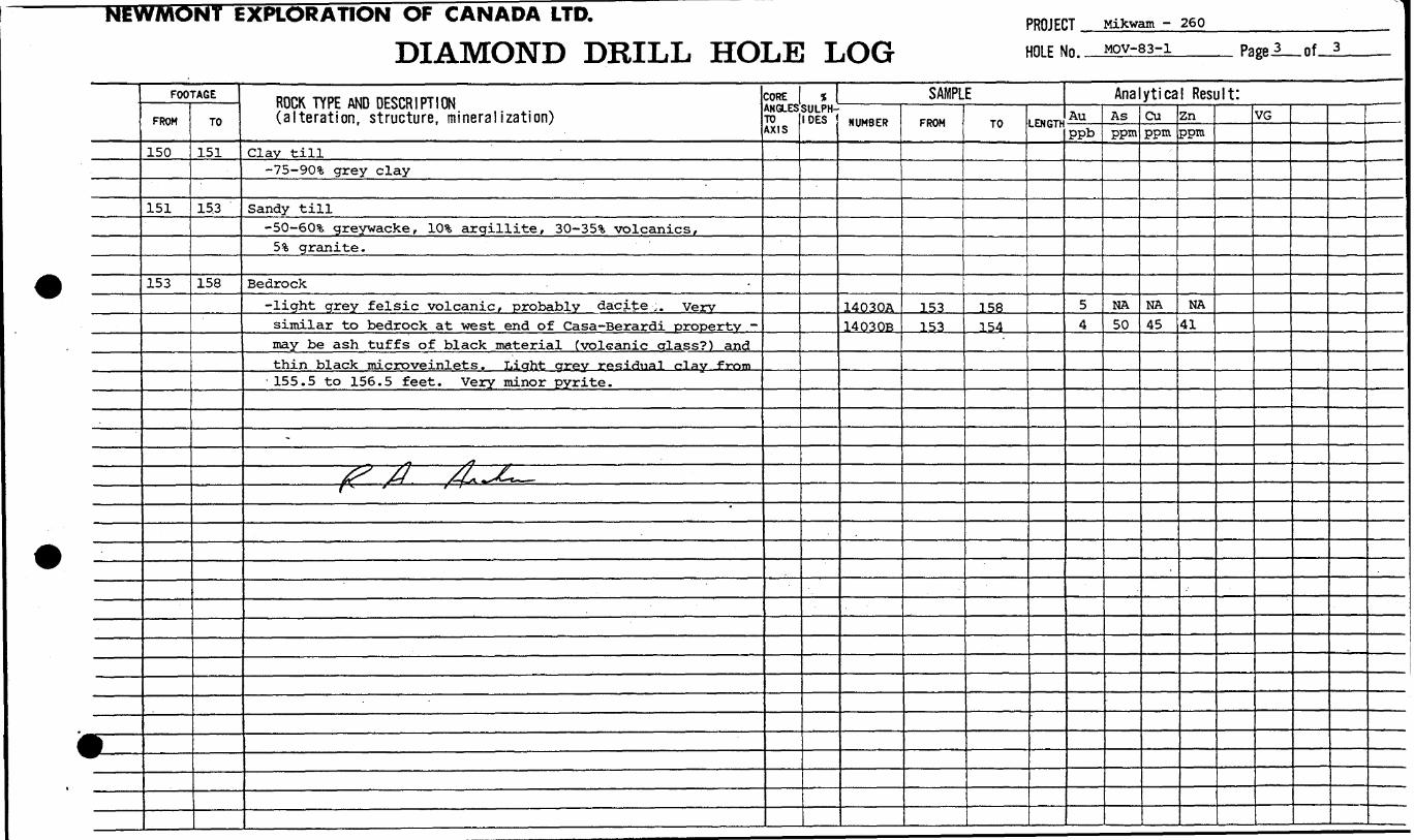
EXPLORATION OF CANADA LTD.
DIAMOND DRILL HOLE LOGPROJECT . HOLE No..
Mikwam -260MOV-83-1 Page.?_of—l.
*
FOOTAGE
FROM
150
151
153
TO
151
15.3
158
ROCK TYPE AND DESCRIPTION (alteration, structure, mineralization)
Clay till-75-90!?; grey clay
Sandy till-SO-60% greywacke, 10** argillite, 30-35!?, volcanics.
5* granite.
Bedrock-light grey felsic volcanic, probably dacite,. Verysimilar to bedrock at west end of Casa-Berardijiroperty -may be ash tuffs of black material (volcanic crlass?) andthin black microveinlets . Liaht arey residual c^lay from155.5 to 156.5 feet. Very minor pyrite.
-
^ /r /L^L——— ̂ — f/ . — ff-j^^v ———— '
CORE ANGLES TO AXIS
1 SULPH-
DES
SAMPLENUMBER
14030A14 03 OB
FROM
153153
TO
158154
LENGTH
Analytical Result:Auppb
54
Asppm
MA50
Cuppm
NA45
Znppm
NA41
VG

NEWMONT EXPLORATION OF CANADA LTD.
DIAMOND DRILL HOLE RECORDPRfllFHT Mikwam - 260
HOLE No, MOV-83-2
LOCATIONAREA or TWP. : Bradette Twp.
CLA.MNo. 633458
NTS 32E/12 U ™
DIP TEST
FOOTAGE ANGLERECORDING CORRECTED
LEVEL
ELEVATION
LATITUDE 8+50N
DEPARTURE 4+OOW
HORIZONTAL COMPONENTVERTICAL COMPONENT
BEARING Vertical
LENGTH 181 feet
CORE LOCATION
DATE STARTED
FLUSHED Jan - 18-21, 1983LOGGED BY R. A. Archer
PURPOSE Overburden
TOT. RECOVERY
DIAMOND DRILL HOLE LOCATION SKETCHSCALE:

NEWMONT EXPLORATION OF CANADA LTD.
DIAMOND DRILL HOLE LOGPROJECT. HOLE No.
Mikwam - 260MOV-83-2 Page-*—of—L
*—
FOOTAGE
FROM
0
3
: 15
25
45
91
95
105
114
115
TO
3
15
25
45
91
95
105
114
115
125
ROCK TYPE AND DESCRIPTION (alteration, structure, mineralization)
Humus
Clay-Cochrane Till - grey sandy silty clay - poor return
-no return
Clay-Cochrane Till but very poor return.
-no return from 45-90' - probably very soft clay then onefoot of sandy silty clay
Sandy till-eO-70% sediments, predominantly greywacke but with 1*iron formation. The latter are dull black magnetite.no jasper observed. 25-35*1, dark green volcanics.2-3% granitic material
Sandy till-90% sand-silt; rock chips are predominantly dark crreenvolcanic and 25% greywacke; only very minor magnetite ,
Sandy till-cobbles of volcanic, greywacke, quartz s granite. Rockchips are predominantly (70-80%) intermediate to maficvolcanic
Boulder-light grey rhyolite ash tuff (fragments up to 2mm long)similar to bedrock of MOV-83-1
Boulder till-boulders of volcanic (intermediate to mafic) predominatebut greywacke and felsic volcanics also common. NOiron formation . .
CORE ANGLES TO AXIS
f \ SULPH- DES
SAMPLENUMBER
14031
14032
14033
14034
FROM
90
95
105
114
TO
95
105
114
125
LENGTK
Analytical Result:Auppb
90
20
50
90
Asppm
550
16
23
30
Cuppm
110
-
53
120
99
Znppm
66
32
52
37
VG
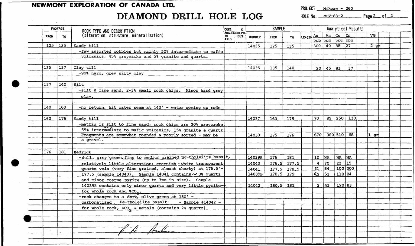
NEWMONT EXPLORATION OF CANADA LTD.
DIAMOND DRILL HOLE LOGPROJECT . Mikwam - 260
HOLE No. MOV-83-2 Page 2_of
^
r-
FOOTAGE
FROM
125
135
137
140
163
176
TO
135
137
140
163
176
181
ROCK TYPE AND DESCRIPTION (alteration, structure, mineralization)
Sandy till-few assorted cobbles but mainly 50* intermediate to maficvolcanics, 45* greywacke and 5* granite and quartz.
Clay till-90* hard, grey silty clay
Silt-silt S fine sand, 2-3*6 small rock chips. Minor hard greyclay.
-no return, hit water seam at 143' - water coming up rods
Sandy till-matrix is silt to fine sand; rock chips are 30% greywacke
SB'S intermediate to mafic volcanics, 151 aranite s quartzFragments are somewhat rounded s poorly sorted - may bea gravel .
Bedrock- dull , grey-green, fine to medium grained -mg-tholeiite basarelatively little alteration: crreenish - white- transparentquartz vein (very fine grained, almost cherty) at 176.5'-177.5 (sample 14040). Sample 14041 contains ^ 3 % quartzand minor coarse pyrite (up to 3mm in size) . Sample14039B contains only minor quartz and very little pyrite-for whoTe" rock and %CO,, .——————— ————— . —— ... f.
-rock changes to a dark, olive green at 180" -carbonatized . Fe-tholeiite basalt - Sample #14042 -for whole rock, %CO0 s metals (contains 2% cruartz)
^*
S? A /? 1
/f /f /^^f - f ( Si
CORE ANGLES TO AXIS
t,
1 SULPH IDES
SAMPLENUMBER
14035
14036
14037
14038
.
14039A140401404114039B
14042
FROM
125
135
163
175
176176.5177.5178.5
180.5
TO
135
140
175
176
181177.5178.5179
181
LENGTH
Analytical Result:Auppb300
20
70
670
104
31O
2
Asppm
40
45
89
380
NA708453
43
Cuppm88
81
250
510
NA22100110
120
Znppm27
37
130
68
NA1530084
83
VG
2 q
i gr
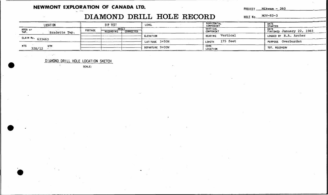
NEWMONT EXPLORATION OF CANADA LTD.
DIAMOND DRILL HOLE RECORDPROJECT-
HOLE No..
Mikwam - 260
MOV-83-3
LOCATIONAREA or . TVP. . -Bradette Twp.
CLAIM No. 633463
NTS UTM 32E/12 -
DIP TEST
FOOTAGE ANGLERECORDING CORRECTED
LEVEL
ELEVATION
LATITUDE 3+50N
DEPARTURE 9+OOW
HORIZONTAL COMPONENT
VERTICAL COMPONENTBEARING Vertical
LENGTH 175 feet
CORE LOCATION
DATE STARTED
FINISHED January 22, 1983LOGGED BY R. A. Archer
PURPOSE Overburden
TOT. RECOVERY
DIAMOND DRILL HOLE LOCATION SKETCHSCALE:

NEWMONT EXPLORATION OF CANADA LTD.
DIAMOND DRILL HOLE LOGPROJECT Mikwam - 260
HniFNn, MOV-83-3 Page
* —
.
0
-
^
FOOTAGE
FROM
0
3
45
60
81
85
96
101
103
117
132
TO
3
45
60
81
85
96
101
103
117
132
134
ROCK TYPE AND DESCRIPTION (alteration, structure, mineralization)
Humus
Clay till-Cochrane Till - soft, crrey, sandy clay
Clay-soft grey clay
'
Silt-fine greenish-beige silt
Sandy till-poor return to 85' - fragments are small, poorly sorted
fi predominantly volcanic.
-no return - probably silt again
Clay till-95% hard, light grey clay. Rock chips are small spredominantly volcanic
Sandy till-50% volcanic, 35ifc greywacke, 15** granite
Clay till-as for 96-101'
Sandy till-dark green mafic volcanic predominates for the most part
(60-703:) but greywacke may also be eo-70% locally.. Granitic material is /^ S-15% throughout. Minor magnetite.
Few small, assorted cobbles 126-130*.
Boulder-coarse grained arevwacke
CORE ANGLES TO AXIS
* SULPH IDES
SAMPLENUMBER
14043
14044
14045
14046
14047
14048
FROM
65
75
•95
105
115
125
TO
75
85
105
115
125
135
LENGTf
Analytical Result:AUPPb
20
30
60
20
GO
C20
Asppm
23
27
44
29
18
34
CuPPm
100
110
120
460
110
680
Znppm
35
40
46
40
31
65
lVG

NbWfVHJIMI tAI iNADA LTD.
DIAMOND DRILL HOLE LOGPROJECT Mikwam - 26.0HOI F Mn MOV-83-3 Page-i_of
f
9—
FOOTAGE
FROM
134
137
145
152
154
161
163
171
TO
137
145
152
154
161
163
171
175
ROCK TYPE AND DESCRIPTION(alteration, structure, mineralization)
Clay till-small return, rock chips predominantly volcanic sgreywacke
Sandy boulder till-small boulders of volcanic, greywacke and granite insandy till. Dark green volcanics predominante in matrix.
Sandy till-601 assorted volcanic rocks, 251 greywacke, 151 granite.Minor magnetite, minor grey chert with pyrite in volcanichost.
Clay till-901 moderately hard grey clay. Rock chips are 751intermediate to mafic volcanics.
Sandy till-few small assorted cobbles but mostly ' 50-601 dark greenvolcanic, 30-401 greywacke^ 101 granite. Minor clayat 160'
Boulder-consists entirely of ouartz (801) and chlorite (201) -may be altered quartz monzonite.
Sandy till-few cobbles of volcanic s greywacke. Fine to mediumgrained, intermediate to mafic volcanics predominate -60-701 - with 20-301 greywacke.
Bedrock-dark grey, carbonatized basalt
Minor crystalline pyrite occurring asdisseminations locally up to li . ^ f S? ^
——————————————————————————— - ————— - ——— - —— — ——— ————————— f f\ —— f f •"i—"! 11*^- i ————
CORE ANGLES TO AXIS
ISULPH- DES
SAMPLENUMBER
14049
14050
14051
14052
-
14053A14053B
FROM
135
145
155
165
171171
TO
145
155
165
171
175172
LENGTH
Analytical Result:Au
140
60
50
180
5C2
AsPpm100
53
76
310
NA28
Cuppm120
130
100
190
NA42
Znppm82
48
34
36
NA
81
VG
-
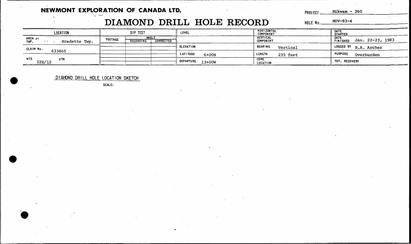
NEWMONT EXPLORATION OF CANADA LTD.
DIAMOND DRILL HOLE RECORDPROJECT.
HOLE No.
Mikwam - 260
MOV-83-4
LOCATIONAREA or TWP. •••- . -Bradette Twp.
CLA.MNo. 633465 '
NTS UTM 32E/12
DIP TEST
FOOTAGE AN CRECORDING
LECORRECTED
LEVEL
ELEVATION
LATITUDE 6+OON
DEPARTURE 13+QOW
HORIZONTAL COMPONENT
VERTICAL COMPONENT
BEARING vertical
LENGTH 235 feetCORE LOCATION
DATE STARTED
nJFsHED Jan. 22-23, 1983 ____
LOGGED BY R. A . Archer
PURPOSE overburden
TOT. RECOVERY
DIAMOND DRILL HOLE LOCATION SKETCHSCALE:
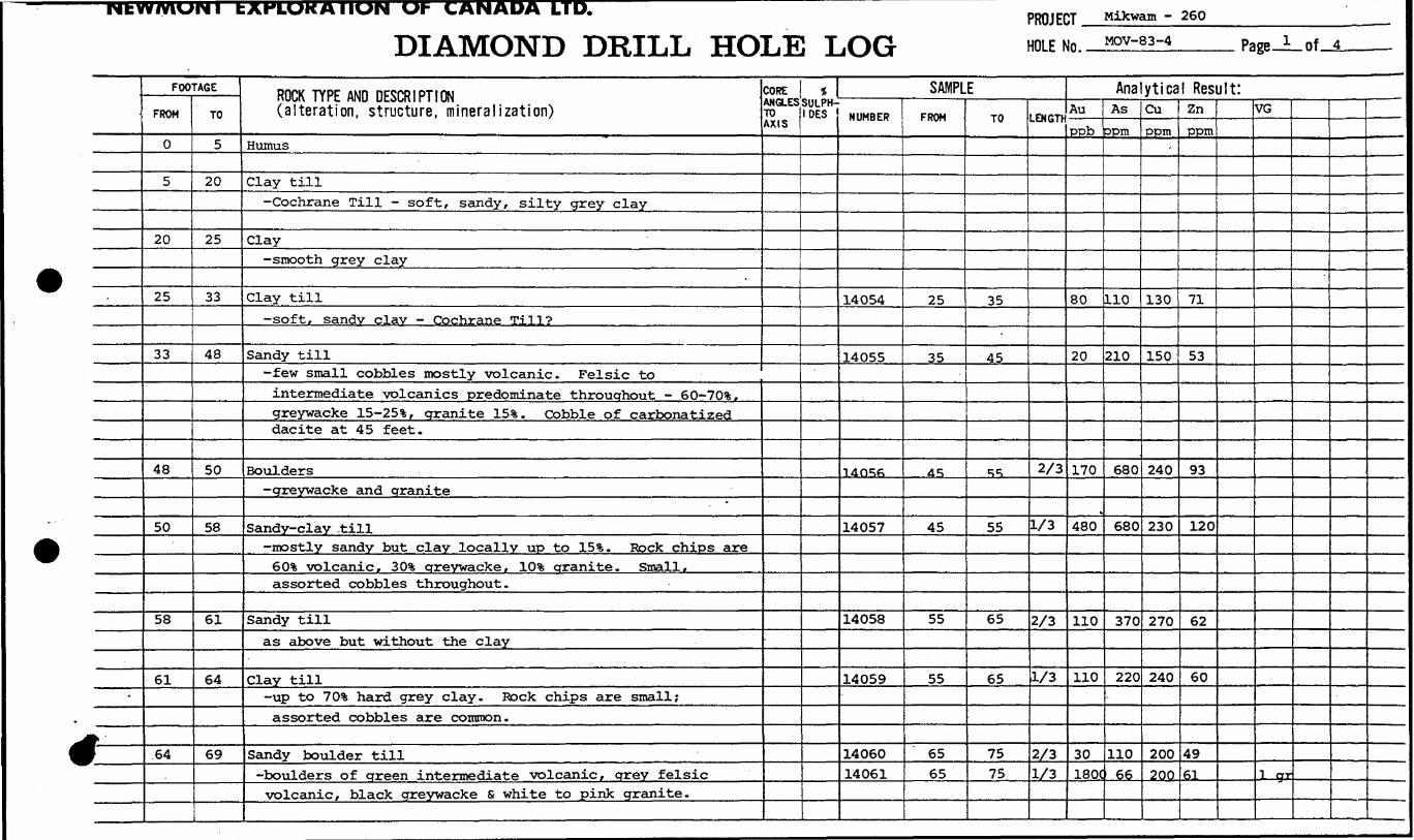
NtWIVVUNI bAHLUHAIIUN Ul- CANADA LTD.
DIAMOND DRILL HOLE LOGPROJECT Mikwam - 260 HOLE No. MQV-83-4 nf 4
-
h-
FOOTAGE
FROM
0
5
20
25
33
48
50
58
61
64
TO
5
20
25
33
48
50
L. 58
61
64
69
ROCK TYPE AND DESCRIPTION (alteration, structure, mineralization)
Humus
Clay till-Cochrane Till - soft, sandy, silty grey clay
Clay-smooth grey clay
Clay till
-soft, sandv clav - Cochrane Till?
Sandy till-few small cobbles mostly volcanic. Felsic tointermediate volcanics predominate throughout - eO-70%.greywacke lS-25%, granite 15%. Cobble of carbonatizeddacite at 45 feet.
Boulders-greywacke and granite
"
Sandy-clay -till-mostly sandy but clay locally up to IS 1*. Rock chips are60% volcanic, 30ifc areywacke, 10% granite. Small,assorted cobbles throughout.
Sandy tillas above but without the clay
Clay till-up to 70*3; hard grey clay. Rock chips are small;assorted cobbles are common.
Sandy boulder till-boulders of green intermediate volcanic, grey felsicvolcanic, black greywacke S white to pink granite.
CORE ANGLES TO AXIS
* SULPH IDES
SAMPLENUMBER
14054
14055
14O56
14057
14058
14059-
1406014061
FROM
25
35
45
45
55
55
6565
TO
35
45
^
55
65
65
7575
LENGTH
2/3
1/3
2/3
1/3
2/31/3
Analytical Result:Au
ppb
80
20
170
480
110
110
30180C
As
ppm
110
210
680
680
370
220
110
66
Cu
PPM-
130
150
240
230
270
240
200
200
ZnPPI"
71
53
93
120
62
60
49
61
VG
j-jsrj
.-. -.
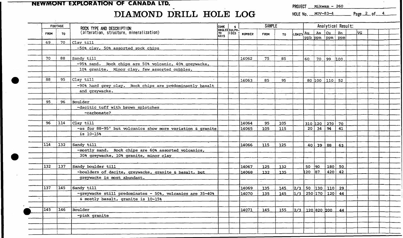
IN OF CANADA LTD.
DIAMOND DRILL HOLE LOGPROJECT Mikwam - 260
HOLE No. MOV-83-4
-
1—
FOOTAGE
FROM
69
70
88
95
96
114
132
137
145
TO
70
88
95
96
114
132
137
145
146
ROCK TYPE AND DESCRIPTION (alteration, structure, mineralization)
Clay till-503; clay, 50*1; assorted rock chips
Sandy till-951 sand. Rock chips are SO5!; volcanic, 401 greywacke,101 granite. Minor clay, few assorted cobbles.
Clay till
-901 hard grey clay. Rock chips are predominantly basaltand greywacke.
Boulder-dacitic tuff with brown splotches
-carbonate?
Clay till-as for 88-95' but volcanics show more variation s graniteis ID-15%
Sandy till-mostly sand. Rock chips are 601 assorted volcanics,301 greywacke, 101 granite, minor clay
Sandy boulder till-boulders of dacite, greywacke, granite fi basalt, butgreywacke is most abundant.
Sandy till-greywacke still predominates - 501, volcanics are 35-401s mostly basalt, granite is 10-151
Boulder-pink granite
COREANGLESTO AXIS
*SULPH- DES
SAMPLENUMBER
14062
14063
1406414065
14066
1406714068
1406914070
14071
FROM
75
85
95105
115
125132
135135
145
TO
85
95
105115
125
132135
145145
155
LENGTH
2/31/3
2/3
Analytical Result:AuPPb
60
80
31020
40
50L20
50250
120
Asppm
70
100
12034
39
9087
130170
820
Cuppm
99
110
27094
88
180420
110120
200
Znppm
100
52
7041
63
5042
2944
44
VG

NEWMONT EXPLOrtAtlON OF CANADA LTD.
DIAMOND DRILL HOLE LOGPROJECT Mikwam - 260
HOLE No. MOV-83-4 Page J_of.
-
1 —
FOOTAGE
FROM
146
156
164
165.5
174
186
193
TO
156
164
165.5
174
186
193
223
ROCK TYPE AND DESCRIPTION (alteration, structure, mineralization)
Clay till-95^?, clay. Rock chips are small. Grazed edcre of boulderbetween 147-149" - hard dull green dacite. Boulders ofgranite s dark .grey rhyolite 153-154 ' . Clay decreases to30* by 155 s crrades into sandy till by 156'.
Sandy till-Cobbles of greywacke are common making it slightly more 'abundant than volcanic rocks, ie. 50!fc greywacke,40 !fe volcanic, 101; granite.
Boulder-pink granite
Sandy till-30-40!* greywacke, ID-25% granite, 451* assorted volcanic.Light green andesite cobble at 169' . Greywackedecreases to 80** (40 1* green intermediate-mafic, 40%dark green felsic) . Minor magnetite with pyrite at 174'
Silt-silt fi fine sand. Minor till at 180'. Minor clay @ 184*
Sand-clay till-sand s clay in about equal proportions, minor rockfragments. Few small, assorted cobbles
Sandy till-predominantly sand. Several assorted cobbles throughoutbut most are volcanic. Greywacke down to 5% now, granitestill 10%, crrev felsic volcanics are 45* r greenintermediate to mafic volcanics are 40**. Magnetitecontent increases a little by 215' but it is still lessthan l*?, of rock chips. Minor jasper at 215'.
COREANGLESTO AXIS
tSULPH IDES
SAMPLENUMBER
14072
14073
14074
1407514076
1407714078
14079
1408014081140821408314084
FROM
145
155
155
165165
175175
185
195195205215215
TO
155
165
165
175175
185185
195
205205215225225
LENGTf
1/3
2/3
1/3
2/31/3
2/31/3
2/31/3
2/31/3
Analytical Result:Au
170
80
260
20100
50230
200
2070
1008033C
As
750
160
220
120,160
4233
52
808553
670970
Cu
180
120
160
15 C250
7059
95
14094190230260
Zn
33
33
29
2037
1213
30
4142393439
VG

' NtW/YIOIMT EXI LNADA LTD.
DIAMOND DRILL HOLE LOGPROJECT. HOLE No..
Mikwam -260MOV-83-4 Page .4_of.
-
*——
FOOTAGE
FROM
223
227
230
230.5
TO
227
230
230.5
235
ROCK TYPE AND DESCRIPTION (alteration, structure, mi neralization)
Sandy qravel-SS-90% volcanic, ID'S Quartz-feldspar sand (coarse) .
S-5% greywacke. Rock chips rancre from sand to crravelsize, are poorly sorted S somewhat rounded. Mostlvfine to coarse sand.
Sandy till-dull green, grey and brown (ie. three types) alteredvolcanic rock makes up 98*, rest is granitic fragments.Minor massive and nodular pyrite in argillite at 230'.25 !fe medium grained gabbro at 230' .
Boulder or bedrock-green basalt with minor pyrite. Only smalLamountobtained - sample 14087 for metals only - mixed withsome till s graphite.or small boulder above
May be hanging wall of conductorbedrock.
Bedrock-graphitic argillite with l-2% disseminated and massivepyrite. Sample 14088A contains fines from 230' (ie.including basalt) . Sample 14088B contains argillitechips only. Sample 14089 is small and was taken at 235'but contains ID'S nodular pyrite.
J?*LS f -S .
~~~ J^J~~ls* — V^-*~***~\ —————— .f -T f~^X. ——————— .
~
CORE ANGLES TO AXIS
t SULPH IDES
SAMPLENUMBER
1408514086
14087
14088A14088B14089
FROM
225225
230
230231234.5
TO
230230
230.5
235232235
LENGTH
2/31/3
Analytical Result:Au
ppb
60350
2
3,22
38
Asopm
110190
14
NA61320
Cuppm
140) 29C
33
NA120
450
Znppm
6285
52
NA190
2600
VG
.
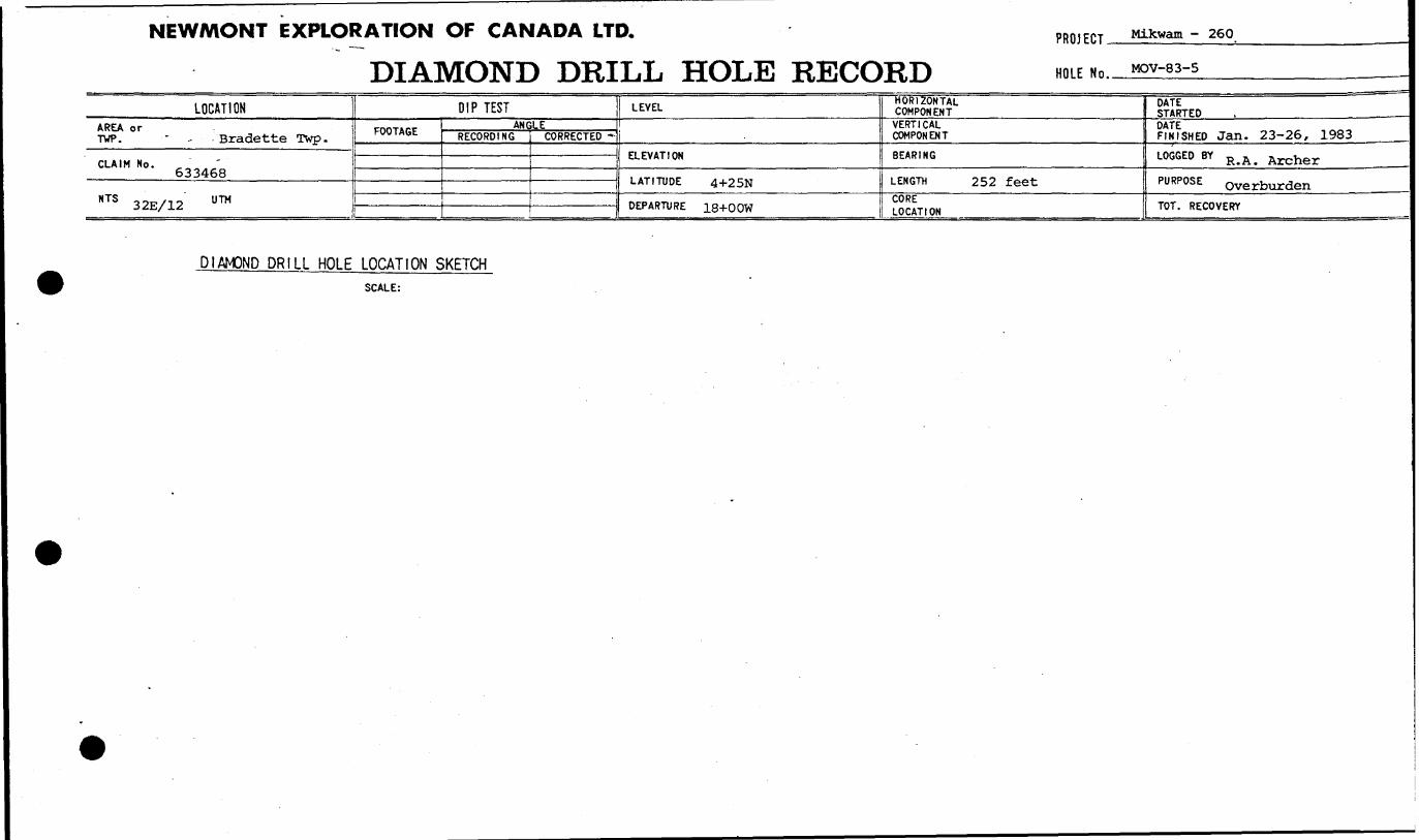
NEWMONT EXPLORATION OF CANADA LTD.
DIAMOND DRILL HOLE RECORDPROJECT.
HOLE No.
Mikwam -260
MOV-83-5
LOCATIONAREA or TWP. - - -Bradette Twp.
CLAIM No. 633468
NTS 32E/12 U ™
DIP TESTFOOTAGE ANGLE
RECORDING CORRECTED -
LEVEL
ELEVATION
LATITUDE 4+25N
DEPARTURE 18+0 OW
HORIZONTAL COMPONENT
VERTICAL COMPONENT
BEARING
LENGTH 252 feetCORE LOCATION
DATE STARTEDDATE FINISHED Jan. 23-26, 1983 —LOGGED BY R^ Archer
PURPOSE overburden
TOT. RECOVERY
DIAMOND DRILL HOLE LOCATION SKETCHSCALE:
.
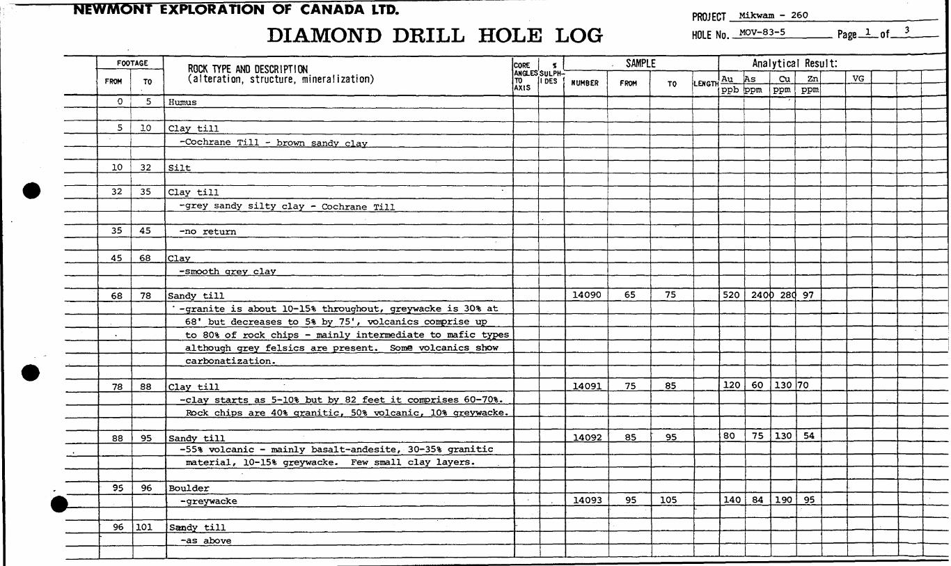
EXPLORATION OF CANADA LTD.
DIAMOND DRILL HOLE LOGPROJECT Mikwam - 260
HOLE NO. MOV-83-5 i of
\ —————
FOOTAGEFROM
0
5
10
32
35
45
68
78
88
95
96-
TO
5
10
32
35
45
68
78
88
95
96
101
ROCK TYPE AND DESCRIPTION (alteration, structure, mineralization)
Humus
Clay till-Cochrane Till - brown sandy clay
Silt
Clay till-grey sandy silty clay - Cochrane Till
-no return
Clay-smooth arey clay
Sandy till' -granite is about ID-15% throughout, greywacke is 30% at
68" but decreases to 5% by 75', volcanics comprise upto 80* of rock chips - mainly intermediate to mafic typesalthough grey felsics are present. Some volcanics showcarbonatization .
Clay till-clay starts as S-10% but by 82 feet it comprises 60-70%.
Rock chips are 40% granitic, 501; volcanic, 10% arevwacke.
Sandy till-SS5* volcanic - mainly basal t-andesite , SO-35% graniticmaterial, lG-15% greywacke. Few small clay layers.
Boulder-greywacke
Sandy till-as above
CORE ANGLES TO AXIS
-
t SULPH IDES
. SAMPLENUMBER
14090
14091
14092
14093
FROM
65
75
85
95
TO
75
85
95
105
LENGTH
"
Analytical Result:Auppb
520
120
80
140
Asppm
240
60
75
84
Cuppm
'
) 28C
130
130
190
Znppm
97
70
54
95
VG
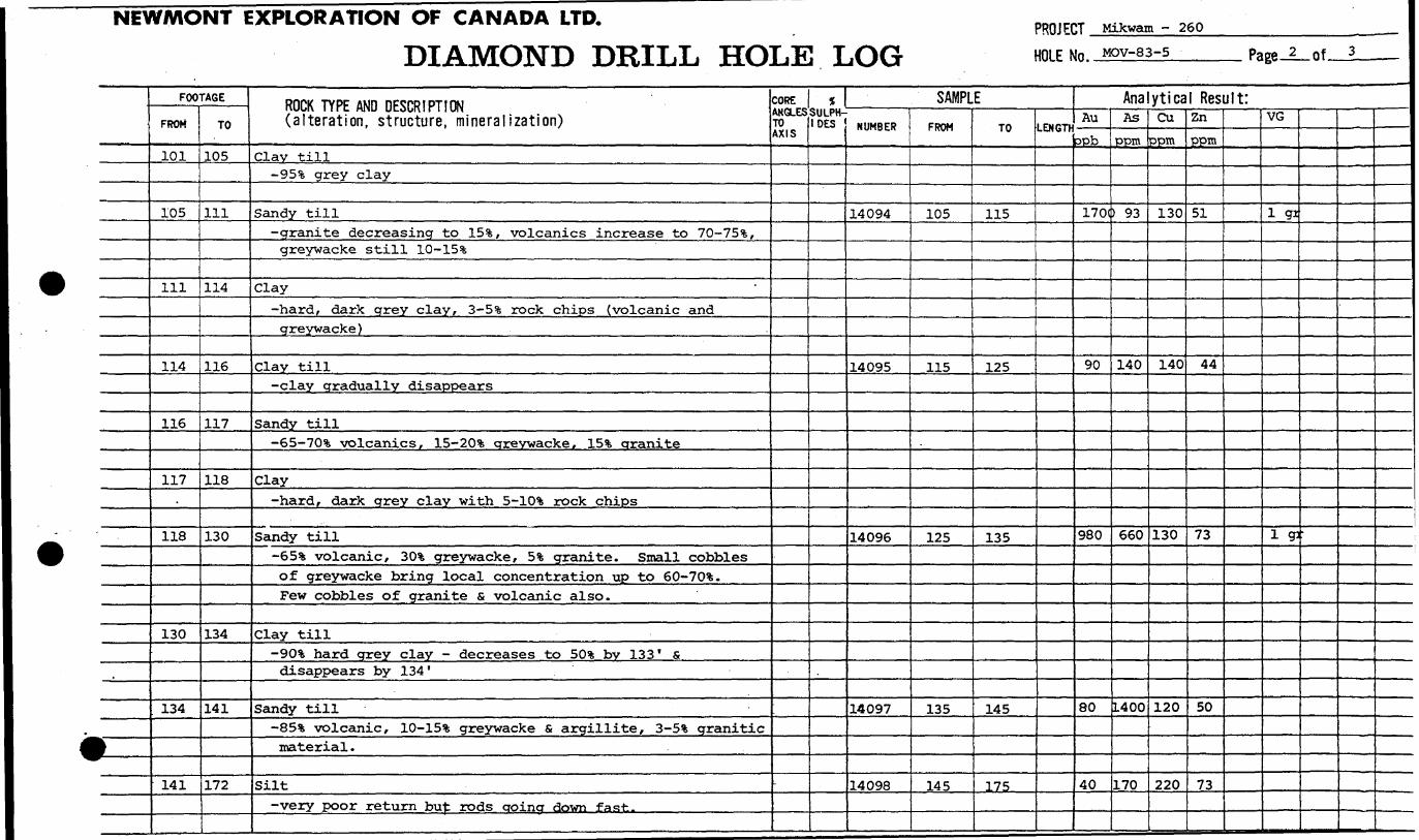
NEWMONT EXPLORATION OF CANADA LTD.
DIAMOND DRILL HOLE LOGPROJECT Mikwam - 260
HOLE NO. MOV-83-5, Page-2—of
*
FOOTAGEFROM
101
105
ill
114
116
117
118
130
134
141
TO
105
111
114
116
117
118
130
134
141
172
ROCK TYPE AND DESCRIPTION (alteration, structure, mineralization)
Clay till-95!?; grey clay
Sandy till-granite decreasing to 15*, volcanics increase to 70-75*fc,
greywacke still ID-15%
Clay-hard, dark grey clay, S-5% rock chips (volcanic andgreywacke)
Clay till-clay gradually disappears
Sandy till-65-70% volcanics, lS-20% areywacke, ISt granite
Clay-hard, dark grey clay with S-10% rock chips
Sandy till-65% volcanic, 30% greywacke, 5% granite. Small cobblesof greywacke bring local concentration up to eO-70%.Few cobbles of granite s volcanic also.
Clay till-90% hard grey clay - decreases to 50** bv 133 ' Sdisappears by 134'
Sandy till-85% volcanic, ID-15% greywacke S argillite, S-5% graniticmaterial .
Silt-very poor return bu^; rods croina down fast.
CORE ANGLES TO AXIS
-
55 SULPH IDES
SAMPLENUMBER
14094
14095
14096
14097
14098
FROM
105
115
125
135
145
TO
115
125
135
145
175
LENGTC
Analytical Result:Au
ppb
170(
90
980
80
40
AsPPm
) 93
140
660
L400
170
Cuppm
130
140
130
120
220
ZnPPM
51
44
73
50
73
VG
1 91
1 g:

NEWMONT EXPLORATION OF CANADA LTD.
DIAMOND DRILL HOLE LOGPROJECT . HOLE No.
Mikwam - 260MOV-83-5 Page 3
t
1
FOOTAGE
FROM
172
179
234
242
244
247
TO
179
234
242
244
247
252
ROCK TYPE AND DESCRIPTION(alteration, structure, mineralization)
Sand and crravel-mostly coarse sand with 25*1; fine gravel^ 35*3; quartz-feldspar, S-10% greywacke and argillite, SS-60% volcanic.Grains are rounded.
Sandy till-ID-15% greywacke, 15*6 granitic material, 70-75 !fc volcanic -mostly intermediate to mafic. Mostly fine to coarse sand.Minor carbonatized volcanic with I.* pyrite. Cobbles areminor s vary in composition. By 215' volcanicscomprise 90* , greywacke and argillite S-10% and graniticmaterial S-5%. Sandy matrix gets finer S less abundantby 195'.
Sandy clay till-mostly 'fine to coarse sand with 2(^ liqht arey clay.Sand is predominantly volcanic chips.
Boulder-basalt with a one-foot thick quartz vein
Sandy till-95!* volcanic, 2!!, granite, 3% argillite. Grazed edge ofanother basalt boulder 145-146'. Magnetite up to J.%now - occurring with quartz and/or iasper and/or pyrite.
Bedrock-light grey, soft, highly carbonatized ba **a i f Veryminor pyrite. Part B of whole rock and %CO,, analyses.
.
s? S /}/(d /-{*.J^ __——————————— /-^v^ — /^
CORE ANGLES TO AXIS
t SULPH IDES
SAMPLENUMBER
14099
14100
14101141021410314104
14105
14108
14106
14107A14107B
FROM
175
185195205215225
235
243
245
247247
TO
185
195205215225235
245
244
247
252248
LENGTH
Analytical Result:AuDob30
2010040250360
150
6
320
8'2
AsPPI"200
120210
3404802300
130(
9
2900
NA
32
CuPPI"210
22032011013022C
)290
84
270
NA
97
Zn.EPm.60
588843
57110
100
44
97
NA
39
VG
fLgr
———————

NEWMONT EXPLORATION OF CANADA LTD.
DIAMOND DRILL HOLE RECORDPROJECT.
HOLE No.
Mikwam - Bradette Twp
MOV-83-6
LOCATIONAREA or TWP. Bradette Twp. On t.
CLAIM No. 633477
NTS 32E/12 U™
DIP TESTFOOTAGE ANGLE
RECORDING CORRECTED
LEVEL
ELEVATION
LATITUDE 2+00 N
DEPARTURE 74+OOW
HORIZONTAL COMPONENT
VERTICAL COMPONENT
BEARING Vertical
LENGTH 210 feet
CORE LOCATION
GIRTED Jan. 27/83DATE - . T ,fl , FINISHED Feb. 1/83.
LOGGED BY RAA
PURPOSE overburden
TOT. RECOVERY
DIAMOND DRILL HOLE LOCATION SKETCHSCALE:
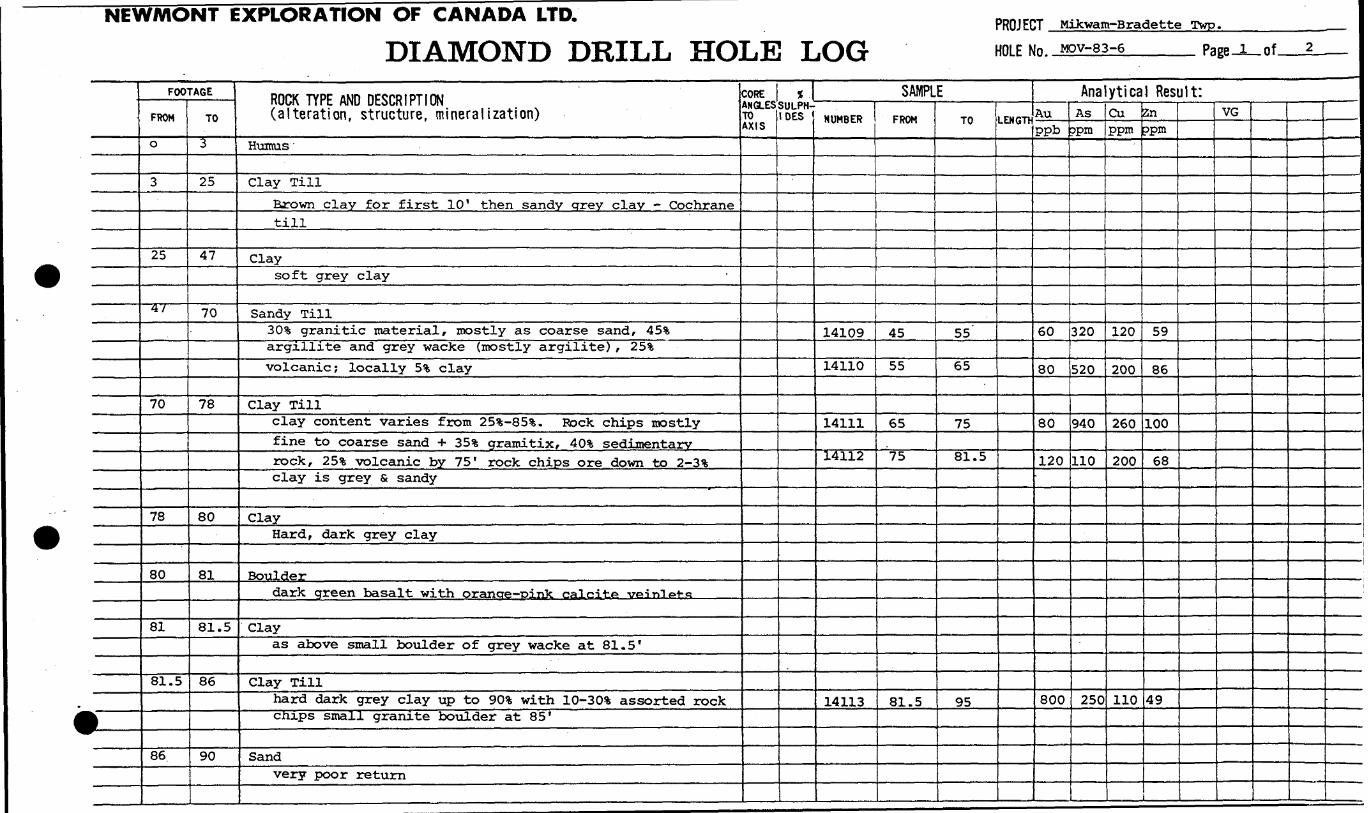
NEWMONT EXPLORATION OF CANADA LTD.
DIAMOND DRILL HOLE LOGPROJECT Mikwatn-Bradette Twp.HOLE No. MOV-83-6 Page. .of.
1 _
FOOTAGEFROM
O
3
25
4 1
70
78
80
81
81.5
86
TO
3
25
47
70
78
80
81
81.5
86
90
ROCK TYPE AND DESCRIPTION (alteration, structure, mineralization)
Humus
Clay TillBrown clay for first 10' then sandy grey clay - Cochranetill
Claysoft grey clay
Sandy Till30 !fe granitic material, mostly as coarse sand, 45%argillite and grey wacke (mostly argilite) , 253;volcanic; locally 5*; clay
Clay Tillclay content varies from 25*^-85!?;. Rock chips mostlyfine to coarse sand + 35*6 gramitix, 40* sedimentaryrock, 25!*, volcanic by 75' rock chips ore down to 2-3*fcclay is grey s sandy
ClayHard, dark grey clay
Boulderdark green basalt with oranae-pink calcite veinlPt-fi
Clayas above small boulder of grey wacke at 81.5'
Clay Tillhard dark grey clay up to 90t with lQ-30% assorted rockcnips small granite boulder at 85*
Sandvery poor return
COREANGLESTO AXIS
*SULPH-
DES
SAMPLENUMBER
14109
14110
14111
14112
14113
FROM
45
55
65
75
81.5
TO
55
65
75
81.5
95
LENGTK
Analytical Result:Auppb
60
80
80
120
800
Asapm
320
520
940
110
250
Cuppm
120
200
260
200
110
Znoprn
59
86
100
68
49
VG
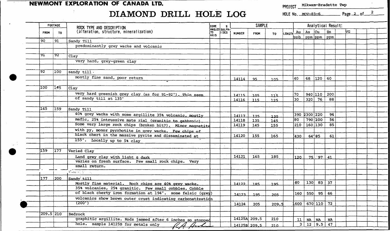
NIWMONT EXPLORATION OF CANADA LTD.
DIAMOND DRILL HOLE LOGPROJECT Mikwam-Bradette Twp
HOLE Nn MOV-83-6 Page 2 of.
t
9
* —-
————
^fc^*
FOOTAGE
FROM
90
•91 ———
92
100
145
159
177
209.5
TO
91
"92 ——
100
145
159
177
200
210
ROCK TYPE AND DESCRIPTION (alteration, structure, mineralization)
Sandy Tillpredominantly grey wacke and volcanic
Clayvery hard, grey-green clay
sandy till -mostly fine sand, poor return
^
Clayvery hard greenish grey clay (as for 91-92 ' ) . Thin seemof sandy till at 135'
Sandy Till40% grey wacke with some argillite 35** volcanic^mostlvmafic, 25% intrussive mate rial (granitic to g*hb™^}Some very large rock chips (broken bit?) . Minor maonetitewith py, monor pyrrhotite in grey wacke. Few chips ofblack chert in the massive pyrite and disseminated at155 ' . Locally up to 5*fc clay
Varied ClayLand grey clay with light s darkvaries on fresh surface. Few small rock chips. Verysmall return.
•*- -ti-i.' - ~ . V
Sandy' tillMostly fine material. Rock chips are 40^* grey wacke,35% volcanies, 25% granitic. Few small cobbles. Cobbleof black cherty iron formation at 194 ' . some felsic (grejvolcanics show brown outer crust indicating carbonatizatic(200 1 )
Bedrockgraphitic argillite. Rods jammed after 6 inches so stoppechole, sample 14125B for metals only /7 S& x^L^L,
CORE ANGLESTO AXIS
)n
1 SULPH IDES
SAMPLENUMBER
14114
1411 S14116
341171411814119
14120
14121
14199
1419^
14124
14125A
14125B
FROM
95
ins115
12^135145
155
165
1RS
iqs
205
209.5
209.5
TO
ins
US125
— 135145155
165
185
iqs
2rm
209.5
21091 Ci
LENGTH
Analytical Result:AU
PPb————
40
7030
39080210
430
120
40
160
.600
111 3
AsPPI"
68
940320
2300790160
64'
75
130
550
670
NA12
CuPPM
120
11076
220100130
85
'97
83
95
110
NA9.5
znPPm
60
20088
945685
61
41
37
66
72
NA47
VG
———— . — . .,... ,, ...., . . j, -^ , t ,
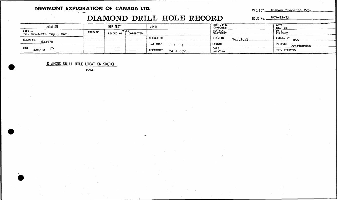
NEWMONT EXPLORATION OF CANADA LTD.
DIAMOND DRILL HOLE RECORDPROJECT-
HOLE No.
Mikwam-Bradette Twp.
MOV-82-7A
LOCATIONAREA or TWP. Bradette Twp., Ont.
CLAIMNO - 633478
NTS 32E/12 U ™
DIP TESTFOOTAGE ANGLE
RECORDING I CORRECTED
LEVEL
ELEVATION
LATITUDE l + 50S
DEPARTURE 24 ± OQW
HORIZONTAL COMPONENT
VERTICAL COMPONENT
BEARING vert . cal
LENGTH
CORE LOCATION
DATE STARTEDDATE FINISHED .—
LOGGED BY ^
PURPOSE . - Overburden
TOT. RECOVERY
DIAMOND DRILL HOLE LOCATION SKETCHSCALE:

NEWMONT EXPLORATION OF CANADA LTD.
DIAMOND DRILL HOLE LOGPROJECT Mikwam-Bradette Twp
HOLE No. MDv-a?-7A Page. .of.
f ——
FOOTAGE
FROM
0
3
35
47
83
84
TO
335
47
83
84
ROCK TYPE AND DESCRIPTION (alteration, structure, mineralization)
Lumus Hu***fClay Till
brown 4 ft. then grey sandy clay-Cochrane Till
Claysoft, smooth grey clay
Sandy Till50*!; granitic, 35* grey wacke and argillite, ISt mixedvolcanics. Minor clay. Volcanics (predominently green .basalt) increase gradually to 40*fc by 75', grey wacke isdown to 15^, argillite up to 20^1; and granite down to 25
Clay till75% sandy clay
BouldergraniteBit broke in boulder, had to re-drill hole one footaway. New hole is MOV-83-7
s ^/c 4^- /LjZ—,f' /-'
CORE ANGLES TO AXIS
1 SULPH IDES
SAMPLENUMBER
14126141271412814129
FROM
45556575
TO
55657585
LENGTK
Analytical Result:Auppb
1103060180
Asppm
290160160120
Cuppm
140120160130
Znppm
68646350
VG

NEWMONT EXPLORATION OF CANADA LTD.
DIAMOND DRILL HOLE RECORDPROJ ECT 260-Mikwaro-Bradette Twp.
HOLE Mn. MOV-83-7____________
LOCATIONAREA or ""^-Bradette Twp. f Oni-.
CLA,MNo. 633478
HTS 32E/12 U ™
DIP TESTFOOTAGE ANGLE
RECORDING CORRECTED
LEVEL
ELEVATION
LATITUDE i+sos
DEPARTURE 24+OOW
HORIZONTAL COMPONENTVERTICAL COMPONENT
BEARING vertical
LENGTH 265 feetCORE LOCATION
DATE STARTEDDATE FINISHED February 3/83LOGGED BY R^ Archer
PURPOSE overburden
TOT. RECOVERY
DIAMOND DRILL HOLE LXATION SKETCHSCALE:

NEWMONT EXPLORATION OF CANADA LTD.
DIAMOND DRILL HOLE LOGPROJECT 260-Mikwam-Bradette Twp
HOLE NO. MOV-83-7 Page i of.
J
FOOTAGE
FROM
0
5
35
48
70
84
88
125
130
132
L33
TO
5
35
48
70
84
88
125
130
132
133
141
ROCK TYPE AND DESCRIPTION (alteration, structure, mineralization)
Humus
Cochrane Tillsandy clay, brown for first five feet then grey
Claysmooth, soft grey clay
Sandy Till30!fc mafic volcanic, 301; argil lite and grey wacke, 40*fegranitic material (including coarse quartz - f^tricpar, 5anPredominently sand from 59 '-fi-? 1 r^rn^tifuous grc** wackpchips a.t 69 'as well as piece of white to g^y ^a-rt-,. M-i th53; cryatalline pyrite. Poor return to 70'
No return
Clay till85*; grey sandy clay; small boulder of grey wacke with.l1* pyrite at 86'
No Return
Clay Till60% sandy clay, SO-35% grey wacke, S-10% oreen basalt
Sandy Till403; grey wacke, 403; basalt, 20*fc granitic
boulderfine grained, pink granite
sandy tillas for 130-132'
CORE ANGLES TO AXIS
1^—
f, SULPH IDES
SAMPLENUMBER
14130
id m14132
14133
14134
FROM
45
"65
95
—i35 ——
TO
55
65 ..-95
nq
1/m
LENGTH
Analytical Result:Anppb
60
40310
190
50
Anppm
220
100290
47
120
Cuppm
150
14 C210
140
97
Znppm
61
4883
45
43
VG

PROJECT 260-Mikwam-Bradette Twp
DIAMOND DRILL HOLE LOG HOLE No. MQV-83-7 Page-2_of.
* —
FOOTAGE
FROM
141
146
155
210
TO
146
155
210
255
ROCK TYPE AND DESCRIPTION (alteration, structure, mineralization)
Clav till20-50!*; clay, basalt and grey wacke an in a 50:50 ratiofor the remainder
Clayvery hard, greenish-grey clay similar to that in holeMOV-83-6. At 151 '-152 clay is grey S sandy with 10%
rock chips s brown organic material - may have beenstuck in rods. Back to greenish grey clay by 152'.
Granite boulder at 154.5'
Clay tillgrey and brown (mottled or layered?) clay with SO-50%rock chips- predominantly mafic volcanic and grey wacke
with some granite. Cobble of drill green basalt at 164 '^By 172" brown clay is gone. Boulder of gobbro on coarsegrained basalt 178-179' then nohM** nf g-roy ^^Q Fr~m190 '-191' clay is mostly replaced by sand then back to50% grey clay at 191'. Another sandy unit from 200-201'.Cobble of brown-grey chert in this latter. Clay till-again at 201'. Minor banded iron formation (jasper andmagnetite) at 204'. By 200' basalt is the dominant rocktype - up to 75!fe, grey wacke second, with S-10% graniticmaterial and l-St argillite. At 208' clay content is90!*. Note: clay is sandy throughout this whole unit ofclay .till.
Clayhard grey clay. This layer of clay till at 213' and at218 ' . Small boulder of grey wacke (may be aarnef ifirons) at 223' and granite at 224'. At 225' flay ^m*light green in colour and is soft and sticky. At 227'colour goes to light greenish brown s fine laverina isevident. Light brown by 228' with dark brown varies.Colour changes again at 233" to light green-brown-crreythen back to light green at 237*. Clay is sandy f-mp
CORE ANGLES TO AXIS
t SULPH- DES
SAMPLENUMBER
14135
14136
14137
14138
141391414014141
1414?
1414314144
14145
14146
FROM
145
155
165
175
185195205
91 R
225235
245
255
TO
155
165
175
185
195205215
.225 ———
235245
2*5
261
LENGTK
Analytical Result:Auppb
30
150
30
60706050
60
--
Asppm
28
55
50
6264380250
62
NA
Cuppm
44
110
160
150100150170
210
NA
Znppm
23
49
80
41344861
45
NA
WG
NEWMONT EXPLORATION OF CANADA LTD.
DIAMOND DRILL HOLE LOGPROJECT HOLE No.
260-Mikwam - Bradette TwpMOV-83-7
Page__of 3..
l ——
FOOTAGEFROM
210
255
TO
255
265
ROCK TYPE AND DESCRIPTION (alteration, structure, mineralization)
Cent 'dabout 227' to 240' where it becomes smooth again. Cobbleof milky white quartz at 253'
Bedrocklight grey, soft, argillaceous sediment. Grey clay priorto 255' may be altered bedrock or just ground up by bit.Quartz at 253' may have been a vein in bedrock.Part B for metals only
S) f J ^K /l~ /Lr^^^————————————————————————— j \^ /'"I ————— r. ^f mrT*~*~^r~-^ ——— . ——————————————
COREANGLESTO AXIS
iSULPH IDES
SAMPLENUMBER
14147A
14147B
FROM
261
261
TO
265
262
LENGTH
Analytical Result:-&U-ppb
3
1
Asopm
NA
41
Ciippm
NA
12
Znppm
NA
35
VG
-
NEWMONT EXPLORATION OF CANADA LTD.
DIAMOND DRILL HOLE RECORDPROJECT. 260-Mikwam-Bradette Twp
HOLE Mn. MOV-83-8
LOCUTIONAREA or TWP. Bradette Twp., Ont.
CLAIM No. 633482
NTS 32 E/12 U™
DIP TESTFOOTAGE ANGLE
RECORDING CORRECTED
LEVEL
ELEVATION
LATITUDE T.+4QN
DEPARTURE 29+OGW
HORIZONTAL COMPONENTVERTICAL COMPONENT
BEARING vertical
LENGTH 159 feetCORE LOCATION
DATE STARTEDDATE FINISHED Feb., 4/83.LOGGED BY R. A. Archer
PURPOSE
TOT. RECOVERY
DIAMOND DRILL HOLE LOCATION SKETCHSCALE:
SBT.TD.
DIAMOND DRILL HOLE LOGPROJECT 260-Mikwam-Bradette Twp
HOLE No.MOV-83-8 Page-_of 2
i—
FOOTAGE
FROM
0
3
35
67
85
88
L14
116
119
121
TO
3
35
67
85
88
114
116
0.19
121
125
ROCK TYPE AND DESCRIPTION (alteration, structure, mineralization)
Humus
Cochrane Tillgrey sandy clay
ClaySoft, smooth grey clay
Sandy TillAssorted cobbles change local percentages, but overallabout 35ifc granitic, 35% volcanic, 30** greywacke. Cobbleof linestone at 74 ' .
Clay till7Cn sandy grey clay, rock chips are 45ifc volcanic (matic) ,
45% greywake, 1C^ granitic.
Clayvery hard, dark greenish-grey clay as in holes MOV-83-6and 7
sandy till45*fc mafic volcanic, 45* argillite and greywacke, 10*granite
n*y +--5-Msoft crrey clay ino-r^acs-inrj i-^ wards 118' rock chiPs 50*volcanic, 50% argillite and grey wacke
Boulderquartz greywacke
Clay tillSO-75% arev sandy clay. PO^V chips ar-e 50* gr-^y w^-fcoand argillite, 40!* basalt, 10% granitic natural
COREANGLESTO AXIS
tSULPH IDES
SAMPLENUMBER
14148
14149
14150
L4153L4152
L4153
14154
FROM
65
75
85
95105
115
120
TO
75
85
95
ins115
120
125
LENGTH
Analytical Result:Auppb
20
60
20
6080
20
40
Asppm
120
98
110
150210
540]
200
Cuppm
130
150
190
86100
150
140
Znppm
40
39
74
3347
53
56
VG
^
p—
NEWMONT EXPLORATION OF CANADA LTD.
DIAMOND DRILL HOLE LOGPROJECT
260-Mikwam-Bradette Twp.
HOLE NO. MOV-83-8 Page?_of.
)—
FOOTAGE
FROM
125
' ' ;
135
137
144
146
L53.5
TO
135
137
144
146
153.5
159.0
ROCK TYPE AND DESCRIPTION (alteration, structure, mineralization)
Sandy boulder tillcobbles of argillite greywacke, granite and assorted
volcanics in sandy matrix with minor clay. Greywackepredominates .
Bouldergreywacke
-
clay tillSO-35% grey sandy clay. Rock chips are predominantly greywacke and cobbles of the latter are common
*
Clayhard grey, smooth clay
Sandy Clayey tillclay is only ID-30%, sand is more abundant. Rock chipsare 45% greywacke. 45% volcanic, 10% granitic. Cobbleof banded iron formation (guartz-magnetite, monor jasper)at 153'
Bedrockbanded iron formation - quartz- magnetite- jasper, Appearto be on contact for first foot as areen^mafir? volcanic ispresent also. Sample 14158B is at contact. Small quartzveinletslrat 155 '-156' (sample 14159) . Very minor pyr-it-^in quartz. Few thin units of dull green basalt from 156*
-158'. 158 '-159' contains a few quartz veinlets and rustybrown ankeritic alteration (sample 14160J
/? /f /IS/W /^Jt~
CORE ANGLES TO AXIS
^
1 SULPH-
DES
-
SAMPLENUMBER
14155
14156
141 "57
14158X14158B1415914160
FROM
.125
135
1,45
154154155158
TO
13b
145
IS-J
159155156159
LENGTH
Analytical Result:Auppb
70
20
210
5152
&S
ppm
180
160V
95
NA864
Cuppm
'
200
260
160
NA191065
Znppm
57
130
68
NA342428
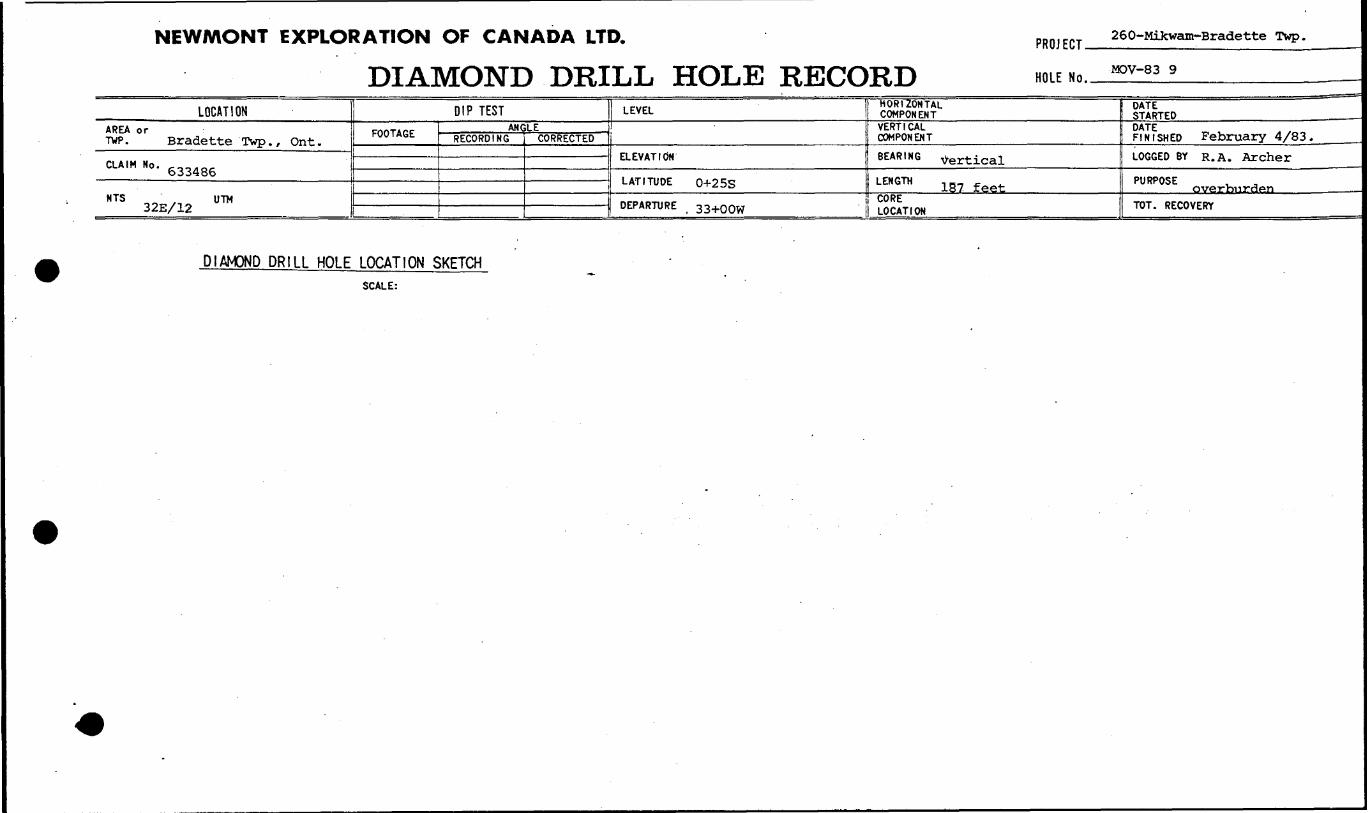
NEWMONT EXPLORATION OF CANADA LTD.
DIAMOND DRILL HOLE RECORDPROJECT-
HOLE No..
260-Mikwam-Bradette Twp.
MOV-83 9
LOCATIONAREA or TWP. Bradette Twp., Ont.
CLAIM Ho - 633486
NTS 32E/12 U™
DIP TEST
FOOTAGE i ANGLERECORDING CORRECTED
LEVEL
ELEVATION
LATITUDE 0+25S
DEPARTURE 33+QQW
HORIZONTAL COMPONENTVERTICAL COMPONENT
BEARING vertical
LENGTH 157 feetCORE LOCATION
DATE STARTEDDATE FINISHED February 4/83.LOGGED BY R. A. Archer
PURPOSE . , overbiii"d**nTOT. RECOVERY
DIAMOND DRILL HOLE LOCATION SKETCHSCALE:
NEW/WONT EXPLORATION OF CANADA LTD.
DIAMOND DRILL HOLE LOGPROJECT 260-Mikwam-Bradette Twp
HOLE Mn MOV-83-9 Page. .of.
9—
FOOTAGEFROM
0
3
34
52
66
30
95
105
TO
3
34
52
66
80
95
LOS
120
ROCK TYPE AND DESCRIPTION(alteration, structure, mineralization)
Humus
Cochrane Tillbrown to grey sandy clay
Claysoft, smooth grey clay
-
Sandy till50% granitic, 25% volcanic, 25** greywacke and argillite.Granitic material locally decreases t-o 20* Hit vo] f^n-i "and sedimentary rocks remain in equal proportion for theother 80%. Limestone chips are common. Minor clay,Cobble of light grey - brown carbonatized basalt at 66'
clay tillup to 95!fc smooth grey clay. Rock chips are predominantlysedimentary. Cobbles of greywacke and grey felsic volcan!at 77'. Clay decreases to 153; by 80' with rock chips45% greywacke, lO8* grantic.
-layhard smooth greenish- grey clay. Cobble of magnetite (I. Fat 83' and granite at 83'. Clay is sandy after 85* andcolour gradually changes to grey
Sandy tilllight brown fossilized limestone cobble at 95 ' . Granticmaterial decreases from 40% at 95' to 10% at 10O' vol^amVincreases to 60% by loo' and greywacke to 30*fc. Small cobl;of pinkish brown rhyolite at 96' with fine stringers anddisseminations (S^fe) of pyrite. Minor clay at 105'.
Silt (?)very poor return. Sample #14167 may be partially f Or most!fines from water tub.
COREANGLESTO AXIS
i
le
ir?)
1 SULPH IDES
SAMPLE
NUMBER
14161
14162
14163
14164
14165
14166
1416714168
FROM
45
55
65
75
85
95
105115
TO
55
65'
75
85
95
105
115125
LENGTT
Analytical Result:Auppb
20
30
30
70
360
40
110110
Asppm
68
220
260
66
380
220
140110
Cuppm
170
130
150
89
150
150
110160
Znppm
52
53
61
36
100
110
5365
VG
i gr .
NEWMONT EXPLORATION OF CANADA LTD.
DIAMOND DRILL HOLE LOGPROJECT 260-Mikwam-Bradette Twp
HOLE No. MOV-83-9 Page.
1-^
FOOTAGE
FROM
120
123
147
153
159
176
TO
123
147
153
159
176
187
ROCK TYPE AND DESCRIPTION (alteration, structure, mineralization)
sandy tillpoor return, mostly fine material
Clay tillup to 80* grey sandy clay, rock chips are predominantlygreywacke. Very poor return
Clayhard, smooth grey clay, minor rock chips
Clay till95^6 grey clay, 5*^ rock chips (mainly greywacke, some,
volcanic) . Clay decreases gradually to 159'
CORE ANGLES TO AXIS
Sandy till .60* basalt 25% greywacke, 15% granitic material. Minorclay again at 161! By 163' granitic material has decreasto 5*;, volcanics 50-75*, grey wacke and argillite 20-45*Sample #14170 comes predominantly from 155-165'. Fewsmall boulders of basalt, greywacke and argillite.
Bedrocklight grey to dark greenish grey to black argillaceoussediment ~- ; 2* crystallinepyrite from 176-177' then tapers off to less than 1*.sample 14172B for metals only.
""^ rf ^ J**
fi ,/h ,^^n
ed
t SULPH IDES
SAMPLENUMBER
14169
14170
14171
14172A
14177T*
FROM
125
145
165
176
17fi
TO
145
165
176
181
1 77 -
LENGTH
Analytical Result:Auppb
40.:
30
780
138
290
Asppm '
68
180
600
NA
100
Gnipm
140
180
190
NA
78
Znppm
70
65
89
NA
168
VG
1 gr

NEW/WONT EXPLORATION OF CANADA LTD.
DIAMOND DRILL HOLE RECORDPRO] ECT 260-Mikwain-Bradette Twp.
HOLE Nn MOV~83-11_____________
LOCATIONAREA or TWP - Bradette Twp. On t.
CUIM NO - 633489
NTS 322/12 U™
DIP TEST
FOOTAGE ANGLERECORDING CORRECTED
LEVEL
ELEVATION
LATITUDE 2+oos
DEPARTURE 37+OOW
HORIZONTAL COMPONENT
VERTICAL COMPONENT
BEARING vertical
LENGTH 170 feet
CORE LOCATION
DATE STARTEDDATE FINISHED February 6/83LOGGED BY R^ ^^
PURPOSE Qverburden
TOT. RECOVERY
DIAMOND DRILL HOLE LOCATION SKETCHSCALE:
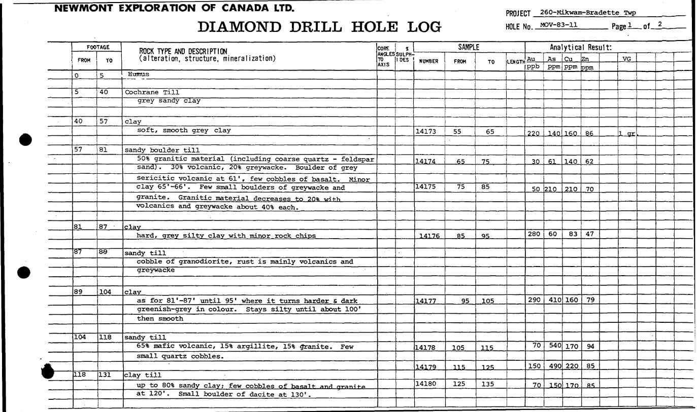
NEWMONT EXPLORATION OF CANADA LTD.
DIAMOND DRILL HOLE LOGPROJECT 260-Mikwam-Bradette Twp———-,
HOLE Mn MOv-83-ii____ Page!— of-A
1-
FOOTAGEFROM
0
5
40
57
81
87
89
104
118
TO
5
40
57
81
87
8-9
104
118
131
ROCK TYPE AND DESCRIPTION (alteration, structure, mineralization)
Humus
Cochrane Tillgrey sandy clay
claysoft/ smooth grey clay
sandy boulder tillSO 5!, granitic material (including coarse quartz - feldsparsand) . SO 5* volcanic, 20% greywacke. Boulder of greysericitic volcanic at 61', few cobbles of basalt. Minorclay 65 ' -66 ' . Few small boulders of greywacke andgranite. Granitic material decreases to 2O* wit-hvolcanics and greywacke about 40!* each.
clayhard, grey silty clay with minor rock chips
sandy tillcobble of granodiorite, rust is mainly volcanics andgreywacke
clavas for 81 ' -87 ' until 95 ' where it turns harder s darkgreenish-grey in colour. Stays silty until about 100'then smooth
sandy till65ifc mafic volcanic, 15* argillite, IS5* granite. Fewsmall quartz cobbles.
clay tillup to 80*6 sandy clav; few cobbles of basalt- anrf m-anit-oat 120'. Small boulder of dacite at 130'.
CORE ANGLES TO AXIS
1 SULPH IDES
SAMPLENUMBER
14173
14174
14175
14176
14177
14178
14179
14180
FROM
55
65
75
85
95
105
115
125
TO
65
75
85
95
105
115
125
135
LENGTf
Analytical Result:Auppb
220
30
50
280
290
70
150
70
Asppm
14ft
61
210
60
410
540
490
150
Cuppm
160
140
210
83
160
170
220
170
Znppm
86
62
70
47
79
94
85
fi*,
VG
JL-SX
LI

NEWMONT EXPLORATION OF CANADA LTD.
DIAMOND DRILL HOLE LOGPROJECT 260-Mikwam-Bradette Twp
HOLE No. MOV-83-11
*—
FOOTAGE
FROM
131
158
L65
TO
158
165
170
-
ROCK TYPE AND DESCRIPTION (alteration, structure, mineralization)
sandy till40!?; greywacke and argillite, SO 1?; basalt 30!?, granitic mateimaterial. Locally up to ~LQ\ clay. By 150' grantic matericis only S-10% and the remainder is predominantly greywackeMafic volcanics range from ID-40%
'Clay Till
up to 80*1, grey sandy clay. Rock chips are mainly greywackand basalt but locally, granitic material reaches 30-40*
Bedrockdark grey sericitic, ankeritic dacite. Minor coarse pyritcubes (up to 3 mm across) for first foot (#14185) . Sample#14184B for whole rock and ifcCo,1 - non-mineralized; sample#14186 contains a small quartz'vein - for metals only
^ s /lf A. X^L^L^.i 'f' f ~*
CORE ANGLES TO AXIS
1
.
A
1SULPH IDES
SAMPLENUMBER
14181
1418214183
14184A14184B14185
14186
FROM
135
145155
165167165
169
TO
14b
155165
170168166
170
LENGtt
Analytical Result:AuJ?**.
320
30110
4132
Asppm
74
89400
NA171712
Cuppm
160
170160
NA343826
Znppm
160
4996
NA635859
VG
•-
v.
NEWMONT EXPLORATION OF CANADA LTD.
DIAMOND DRILL HOLE RECORDPROJECT 260-Mikwam-Bradette Twp.
HOLE Nn MOV-83-13
LOCATIONAREA or TWP. .Bradette Twp. Ont.
CLA.M No. 6333?4
NTS 32E/12 UTM
DIP TESTFOOTAGE ANGLE
RECORDING CORRECTED
LEVEL
ELEVATION
LATITUDE BLO+00
DEPARTURE 41+50W
HORIZONTAL COMPONENTVERTICAL COMPONENT
BEARING vertical
LENGTH
CORE LOCATION
DATE STARTED FP*- fi/^DATE ^ ..^, FINISHED Feb. 7/83.
LOGGED BY R^ Archer
PURPOSE overburden
TOT. RECOVERY
DIAMOND DRILL HOLE LOCATION SKETCHSCALE:
IAT1ON OF CANADA LTD.
DIAMOND DRILL HOLE LOGPROJECT 260-Mikwam-Bradette twp
HOLE Nn Mfw-R-s-T*____ Page i of
t—
FOOTAGE
FROM
0
5
40
59
81
82
126
TO
5
40
59
81
82
126
153
ROCK TYPE AND DESCRIPTION (alteration, structure, mineralization)
Humus
Cochrane Tillsot t, grey sandy clay
Claysoft, smooth grey clay; very poor return
Sandy till303; granitic material, 20-30*6 greywacke with some argilli-40-50 !fe assorted volcanic rocks from dark green basalt togrey and brown ankeriteic dacite. By 75' granitic materi;
is S-15% and volcanics (mostly mafic) and greywacke arein roughly equal proportion for the remainder
Boulderlight grey sericitic volcanic or sedimentary rock, similajto bedrock in hole MOV-83-11
Sandy tillas above. Cobble of coarse grained gabbro (magnetic)at 88 ' . Sand predominates in the metrix but clay is
locally present between 5% and SO^k. Rock chins ay**predominantly mafic volcanics and greywacke. Cobble ofmassive black argillite at 94' then similar rock withlarge fragments (?) of coarse green volcanic (?) - maybe some kind of breccia. Granite boulder at 114*.
Clay frill7 5% grey Sandy Clay. Pock Chips art* proAnmi nanl-1 y ejroy-
wacke and mafic volcanic. Mednim tn r-nar^ grainedbasalt (latter may be a fine grained crabbres) j s rromnv-in .Small granite boulder at 130' . Clay increases to 95*fc by134 '. Small boulder of sericitic volcanic at 135' thenclay content decreases to 5*fc s back up to 30** by l^Q 1KOCK chips here are a good mixture of f^igjr. and mafic
COREANGLESTO AXIS
.
e
1
t SULPH- OES
SAMPLE
NUMBER
14187
14188
14189
141901419114192
1419314194
.
141 OR
14196
FROM
55
65
75
8595
105
115125
T* q
145
TO
65
75
85
QS105115
19S
135
145
155
LENGTH
Analytical Result:AuPPb
40
80
50
3050
10030190
n 70
170
Asppm
53
20
270
400945790
180
'780
L400
Cuppm
65
65
190
280170130100180
160"
170
Znppm
26
18
83
210095655876
69'.,
L50
VG
l gi
1 gr
-
EXPLORATION OF CANADA LTD.
DIAMOND DRILL HOLE LOGPROJECT 260-Mikwam-Bradette Twp
HOLE Nn MOV-83-13______ Page 2_of.
1 —
FOOTAGE
FROM
126
153
155
158
165
173
TO
153
155
158
165
173
179
ROCK TYPE AND DESCRIPTION (alteration, structure, mineralization)
Cont'dvolcanics, argillite, greywacke and minor graniticmaterial. Clay content continues to vary from S-30%.
until 145' where it rises to 85*
sandy tillwell mixed till, cobble of ankeritic felsic, volcanic
Clay tillclay content varies from lQ-15%; rock chips are 50* felsi*volcanic, 20-30*6 mafic volcanic (including a coarse grainbasalt or fine grained gabbro ) ,20* argillite, minorgreywacke and granite. Jasper cobble at 156*
Sandy tillrock chips as for 155-158 but with sandv matrix
sandminor rock chips
"
Bedrocklight grey, sericitic pelitic sediment with thin blackargillite. stringers. Very 'minor fine grained pyrite. .(Part B for, -metals only)
S? * S? ^K A /J^Z^
s f ^ f
CORE ANGLES TO AXIS
-
3d
%SULPH IDES
SAMPLENUMBER
14197
14198
141 99A
14199B
FROM
155
165
173
176
TO
165
173 ^
179
177
LENGTF
Analytical Result:Auppb
480
200
7
6
Asppm
2100
1200
NA
20
Cuppm
220
200
NA
36
Znppm
110
120
NA
35
VG
1 gr
*
NEWAAONT EXPLORATION OF CANADA LTD.
DIAMOND DRILL HOLE RECORDPROJECT-
HOLE No..
260-Mikwam-Bradette Twp.
MOV-83-14
LOCATIONAREA or TVP. Bradette
CLAIM No. 63337?
NTS 32E/12 UTM
DIP TEST
FOOTAGE i ANGLERECORDING CORRECTED
LEVEL
ELEVATION
LATITUDE 4+oos
DEPARTURE 46+OOW
HORIZONTAL COMPONENTVERTICAL COMPONENTBEARING vertical
LENGTH 215 FeetCORE LOCATION
DATE STARTED February 7 r 1993.
FINISHED February 8, 1983.LOGGED BY R^ ^^
PURPOSE overburden
TOT. RECOVERY
DIAMOND DRILL HOLE LOCATION SKETCHSCALE:

NEWMONT EXPLORATION OF CANADA LTD.
DIAMOND DRILL HOLE LOGPROJECT 260-Mikwam-Bradette Twp
HOLE Mn yiny-a^-id______ PageJ_iof
)
FOOTAGE
FROM
0
5
35
67
75
76
90
104
125
130
142
TO
5
35
67
75
76
90
104
125
130
142
145
ROCK TYPE AND DESCRIPTION (alteration, structure, mineralization)
Humus
Cochrane Till
Sandy clay - brown for first five feet then grey
claysoft, smooth grey clay
.sandy till
50* granitic material (including quartz chips, 25* volcan
mostly mafic, 25* greywacke, minor linestone I. F.
clay tillrock chip as above, with clay increasinq in content
clayhard, dark greenish - grey clay
sandy till60!* mafic volcanic, 30* granitic, 20% greywacke, 101 "argillite . Cobble of light brown dolomite at 98 ' , minoriron formation .
NO returnsample #14204 is probably mostly fine material fromrecirculated water
Sandy clayey fill40-50% mafic volcanic, SO-40% grp.y™oVo 5 some arg-5n ****,20% granitic material. Small boulder of creywacke at130'. Lots of fine material.
No return
Claysmall chips of hard, dark greenish grey clay
CORE ANGLES TO AXIS
LG
* SULPH IDES
SAMPLENUMBER
14200
14201
14202
14203
-
14204
14205
14206
FROM
65
75
85
95
105
125
135
TO
75
85
95
105
125
135
155
LENGTH
Analytical Result:AuPPb
60
40
110
20
60
50
90
Asppm
52
93
250
100
67
84
120
Cuppm
130
150
160
110
280
170
180
Znppm
45
66
89
110
110
74
61
VG
**
NEWMONT EXPLORATION OF CANADA LTD.
DIAMOND DRILL HOLE LOGPROJECT 260-Mikwam-Bradette Twp HOLE Mn. MOV-83-14
) —
FOOTAGE
FROM
145
152
155
L75
L88
212
TO
152
155
175
188
212
215
ROCK TYPE AND DESCRIPTION(alteration, structure, mineralization)
Clay Tillclay content about 60*, rock chips have about equalproportions of volcanic and greywacke; 201; granitic rock.Cobbles are common and change local composition of till.Clay locally reaches 951;
Sandy till501; volcanics (mostly mafic), 30* grey wacke with some -argillite, 20* granitic material
Clay Tillas for 145-152'; minor banded rion formation (jasper and :specularite) . Piece of coral at 174 ' .
No return
Sandy Tillmostly sand; rock chips are SO-85% intermediate to maficvolcanics, ID-15% argillite and greywacke, St quartz andgranitic material. By 207* mafic volcanic (basalt tuff?)constitutes 601; and argillite 60* then argillite increasessteadily towards bedrock
Bedrockgraphitic argillite non-mineralized. Part B for metals onl
/J J /) ST
f 4L /U^r^s ' s
CORE ANGLES TO AXIS
Y
*SULPH IDES
SAMPLENUMBER
14207
14208
14209
142JLU
14211
14212A14212B
FROM
155
165
175
±ys
2Ub
212212
TO
165
175
195
•t!U3
212
215215
LENGTh
Analytical Result:Auppb
40
350
110
610
320
42
Asppm
250
920
1200
1400
1300
NA4
Cuppm
130
180
170
170
320
NA23
Znppm
56
120
100
120
140
NA33
VG
1 ar
1 gr
'
NEWMONT EXPLORATION OF CANADA LTD.
DIAMOND DRILL HOLE RECORDPROJECT 260-JMikwam-Bradette Twp.
HOLE No. MOV-83^15____________
LOCATIONAREA or TWP. Bradette Twp.
CLAIM No. 633384
NTS 32E/12 0™
DIP TESTFOOTAGE ANGLE
RECORDING CORRECTED
LEVEL
ELEVATION
LATITUDE 2+75S
DEPARTURE 52+OOW
HORIZONTAL COMPONENT
VERTICAL COMPONENT
BEARING vertical
LENGTH 21 g feet
CORE LOCATION
DATESTARTED February 8, 1983-Fu^SHED February 9, 1983
LOGGED BY R. A. Archer
PURPOSE overburden
TOT. RECOVERY
DIAMOND DRILL HOLE LOCATION SKETCHSCALE:
[ION OF CANADA LTD.
DIAMOND DRILL HOLE LOGPROJECT 260-Mikwam-Bradette Twp
HOLE No. MOV-83-15 Page i of—.2.
i —
FOOTAGE
FROM
0
5
20
32
45
49
56
57
62
95
106
TO
5
20
32
45
49
56
57
62
95
106
189
ROCK TYPE AND DESCRIPTION (alteration, structure, mineral ization)
Humus
Cochrane Tillbrown to grey sandy clay
Claysoft, smooth grey clay
Sandy Till601 granitic material, 20-25* greywacke, lS-20% volcanic
No return
Clay tillup to 90!fe grey sandy clay. Rock chips are predominantlygreywacke and, to a lesser extent, volcanic
Boulderlight grey sericitic volcanic or sediment
-
sandy till401! greywacke, 35-40% granitic material, 20-25!* volcanicpoor return
Clay tillas above, small return
Sandfine sand to silt - poor return; gets coarse at 106'
Clay tillas above but with 40!* mafic volcanic, 35% granitic materia25* greywacke soft, smooth grey clay after 120'. Thinlayer of sandy till at 157' with 45** dark grow K^it40% greywacke, 15*1 granitic material. Small boulders of.gabbro at 188.5'.
COREANGLESTO AXIS
1
iSULPH IDES
SAMPLENUMBER
14213
14214
14215
14216
14217
14218
14219
1422014221142221442314424 '14425 —
FROM
25
35
45
55
65
75
85
95115125135145
—— 155—
TO
35
45
55
65
75
85
95
115125135145155
Hp55 ——
LENGTH
Analytical Result:Auppb
80
30
170
30
140
40200
590030
16060110 ^TTT
Asppm
37
34
42
110
100
9653
6365434492
100
CUppm
140
120
110
84
69
L20380
270130
74L30L20Y^n
Znppm
35
42
43
48
35
73220
130100
414948 f
VG
1 gr
.
NEWMONT EXPLORATION OF CANADA LTD.
DIAMOND DRILL HOLE LOGPROJECT 260-Mikwam-Bradette TwpHOLE No. ^-83-15.
Feb. 8-9 2+75S/52+OOWPage 2 of
1——
FOOTAGE
FROM
189
194.5
195.5
214.5
TO
194.5
195.5
214.5
218
ROCK TYPE AND DESCRIPTION (alteration, structure, mineralization)
Sandy till45-50^6 greywacke, 45% basalt with minor felsic volcanicsS-10% granitic material
Bouldergrey-brown, sericitic rhyolite
sandy tillas above but with felsic volcanics more prevalent now(lOli) . Argillite gradually replaces greywacke. Cobbleof dull green andesite at 203'. Very sanriy st- 207' By205' volcanics are 65-70% including liqht arey sericitictypes, green basalt and dull grwn t-o Hr^wnish-grecncarbonatized, basalt and andesite; araillite is 30* *nrlgranitic material is 2-3*?.
Bedrockgraphitic argillite, up to 3* coarse pyrite Part Bfor metals only ^ pyrite)
*
j/C 4- ^j?~
^
CORE ANGLES TO AXIS
tSULPH IDES
SAMPLENUMBER
149261422714228
149?Q
14230
14231A
14231B
FROM
165175185
19S
205
215
216
TO
175185195
20 e;
215
218217
LENGTH
Analytical Result:Auppb l
360170
Asppm
150130
80 510
290
320
105
2200
2000
NA79
Cuppm
-
140140270
210
290
NA48
Znppm
375547
94
180
NA120
VG
Iqr
1 gr
:
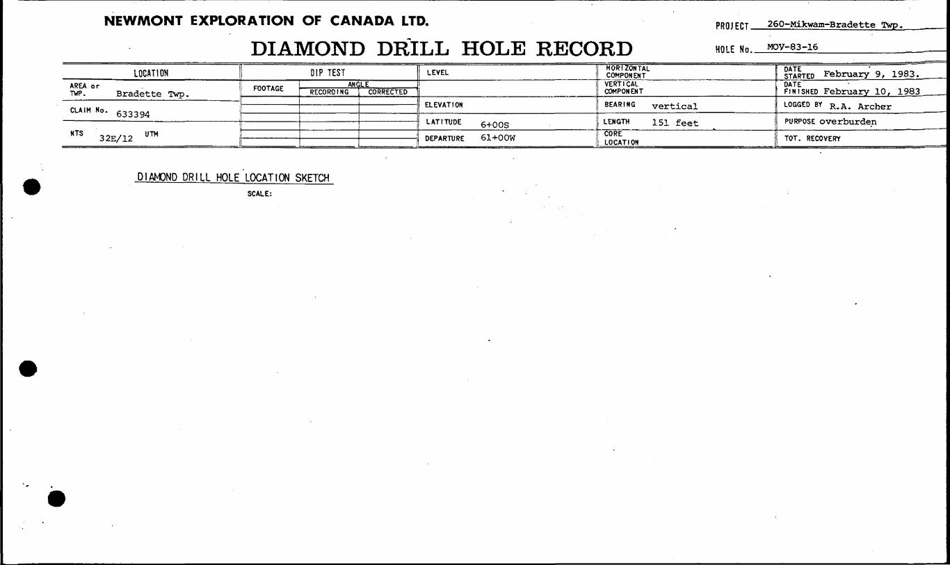
NEWMONT EXPLORATION OF CANADA LTD.
DIAMOND DRILL HOLE RECORDPROJECT.
HOLE No.
260-Mikwam-Bradette Twp.
MOV-83-16
LOCATIONAREA or TWP. Bradette Twp.
CLAIM No. 633394
HTS 32E/12 U ™
DIP TESTFOOTAGE AN C
RECORDINGLE
, CORRECTED
LEVEL
ELEVATION
LATITUDE 6+oos
DEPARTURE 61+OOW
HORIZONTAL COMPONENTVERTICAL COMPONENTBEARING vertical
LENGTH 151 feetCORE LOCATION
STARTED February' 9, 1983.DATEFINISHED February 10, 1983 ——.LOGGED BY R. A . Archer
PURPOSE overburden
TOT. RECOVERY
DIAMOND DRILL HOLE LOCATION SKETCHSCALE:
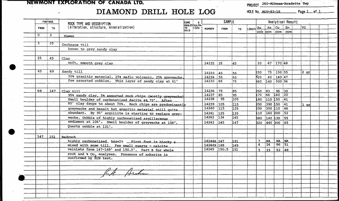
NEW/WONT EXPLORATION OF CANADA LTD. PROJECT 260-MiJcwam-Bradette Twp
DIAMOND DRILL HOLE LOG HOLE NO. MOV-83-16 Page l of J.
f
FOOTAGE
FROM
0
~~3
25
45
69
147
TO
3
25
45
69
147
151
ROCK TYPE AND DESCRIPTION (alteration, structure, mineralization)
Humus
Cochrane Tillbrown to grey sandy clay
Claysoft, smooth grey clay
Sandy till
501 granitic material, 25% mafic volcanic, 25*6 greywacke.Few assorted cobbles. This layer of sandy clay at 61'
Clay till95*6 sandy clay, 51 assorted rock r-hipe: (n^e-t-iy graywacke)Small boulder of carbonatized dacite ati 72'. " After85' clay drops to about 701. Rock chips are predominant!greywacke and basalt but granitic material still qni-t-pabundant. By 95' argillite is starting to replace grey wacke. Cobble of highly carbonatized argillaceoussediment at 104 ' . Small boulder of greywacke at 108 ''.Quartz cobble at 121!.
Bedrockhighly carbonatized basalt Fir^t- font- -i^ KL^cky fimixed with some till . Few small cruartz — calciteveinlets from 147-148' and 150.5'. Part B for wholerock and 1 Co2 analyses. Presence of ankerite isconfirmed by KCN test.
/O J /J r/^j#- /J~t^Z~c—S^ ! f '
CORE ANGLES TO AXIS
y
1 SULPH- IDES
SAMPLENUMBER
14232
142331423414235
142361423714238
1423914240142411424214243
14244A14244B14245
FROM
35
455565
758595
105115125134145
147148150.5
TO
45
556575 -
8595105
115125135145147
151149151
LENGTH
Analytical Result:Auppb
20
250^20160
250L70L80250250L10o80320
74
5
Asppm
67
7540140
8366110390300160140440
NA24
23
Cuppm
170
150140500
95L40150150110200130boo
NA86
52
Znppm
48
554756
3220414146525565
NA51
48
VG
2 gr
1 qr
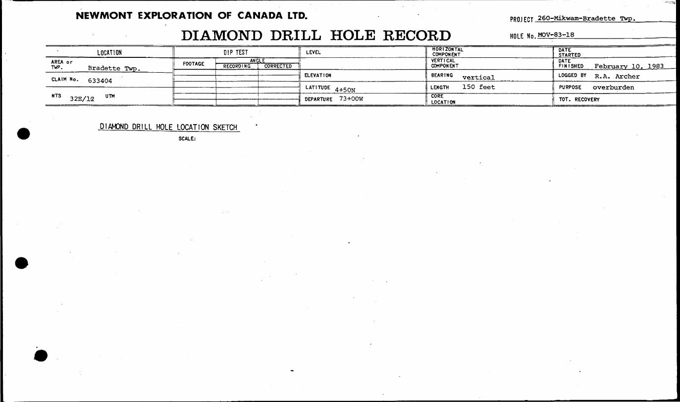
NEWMONT iXPLORATION OF CANADA LTD.
DIAMOND DRILL HOLE RECORDPROJ ECT 260-Mikwam-Bradette Twp.
HOLE Mn,MOV~83~18____________
LOCATIONAREA or TWP. Bradette Twp.
CLAIM No. 633404
NTS 32E/12 U7M
DIP TESTFOOTAGE ANGLE
RECORDING [ CORRECTED
LEVEL
ELEVATION
LATITUDE 4^ON
DEPARTURE 73+OOW
HORIZONTAL COMPONENTVERTICAL COMPONENT
BEARING vertical
LENGTH 150 feet
CORE LOCATION
DATE STARTEDDATE FINISHED February 10. 1983LOGGED BY R. A. Archer
PURPOSE overburden
TOT. RECOVERY
DIAMOND DRILL HOLE LOCATION SKETCHSCALE:

NbWMUNI tXPLOHATION OP CANADA LTD.
DIAMOND DRILL HOLE LOGPROJECT 260-Mikwam-Bradette TwpHOLE NO. MOV-83-18 Page l_of.
j
FOOTAGE
FROM
0
5
31
83.5 .
84.5
93
96
110
125
-
TO
5
31
83.5
84.5
93
96
110
125
129
ROCK TYPE AND DESCRIPTION (alteration, structure, mineralization)
Humus
Cochrane Tillgrey sandy clay
Sandy till45!!; granitic material 35 s?, greywacke, 2053; intermediatemafic volcanics . Minor clay at 51 ' , cobble of greywackewith transparent quartz vein at 53 ' . Boulder of quartz-
biotite mitasediment (quartz wacke or biotitec quartzarenite) at 58'
Boulderdark green, coarse grained basalt
Sandy tillcobble of carbonatized basalt at 86 ' . Cobble of finely
laminated pyrite in siliceous matrix at 89!. 40*fcintermediate to mafic volcanics, 40!fc greywacke, 20%granitic material
clay till30* sandy clay, rock chips as for 86. 5 '-93'
Sandy tillrock chips as above but with argillite starting to replacegreywacke. Minor clay in places.
Clay Till90* greenish grey clay
Clayhard greenish grey clay - varied
COREANGLESTO AXIS
gf
SULPH IDES
SAMPLENUMBER
14246
1424714248
142491425014251
14252
14253
14254
14255
14256
FROM
25
3545
556575
84
95
105
•ns
125
TO
35
4555
65758495 -
105
ns
125
135
LENGTh
Analytical Result:Auppb
Asppm
i——
20
20
20
6050030129
40
L50
550
90
63
49252940260320
850
990
260
750
Cuppm
210
220220220230170220
220
250
130
130
Znppm
66
5959506366120
95
130
65
87-
VG
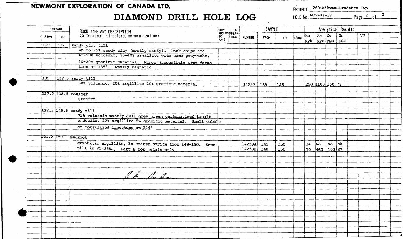
NEWMONT EXPLORATION OF CANADA LTD.
DIAMOND DRILL HOLE LOGPROJECT 260-Mikwam-Bradette Twp
HOLEMOV-83-18 Page of-
FOOTAGE
FROM
129
135
137.5
138.5'
L45.5
TO
135
137.5
138.5
145.5
150
ROCK TYPE AND DESCRIPTION (alteration, structure, mineralization)
sandy clay tillup to 253; sandy clay (mostly sandy) . Rock chips are45-50% volcanic, 35-40% argillite with some greywacke,ID-20% granitic material. Minor jasperlitic iron forma tion at 135" - weakly magnetic
sandy till601 volcanic, 20% argillite 20S; gramitic material
bouldergranite
sandy till75** volcanic mostly dull grey green carbonatized basaltandesite, 20% argillite 53; granitic material. Small cobb}of forsilized limestone at 114'
Bedrockgraphitic argillite, 1* coarse pyrite from 149-150. Some*till in #14258A, Part B for metals only
/j S ^- r *^~ /-t^i.**-*1̂ ,~
COREANGLESTO AXIS
e
SULPH IDES
^^MU.^.H
SAMPLENUMBER
14257
14258A14258B
FROM
135
145148
TO
145
150150
LENGTh
Analytical Result:AuPPb
210
1410
Asppm
1100
NA460
Cuppm
150
NA100
Znppm
77
NA87
VG
!
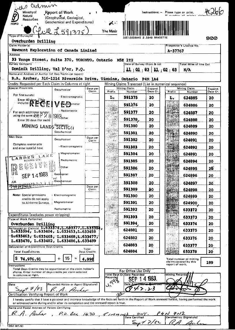
Ministry ofNaturfc'.^Resources
i Report of Work *(Geophysical, Geological, Geochemical and Expenditures)
Instructions: — Please type or print.K ~..~u~, ~i —:-:-.
Type of Survey(s)
Overburden Drilling3aE12SE0045 2.5840 BRADETTE 900
Claim Holder(s)
Newmont Ejcploratlon of Canada LimitedAddress
S3 Yonge Street, Suite 370, TORONTO, Ontario M5E 1T2
Prospector's Licence No.
A-37767
Survey Company
Dominik Drilling, Val D'or, P.Q.Date of Survey (from Si to)
Name and Address of Author (of Geo-Technical report)
R,A. Archer, 316-1214 Riverside Drive, Titmuins, Ontario P4R 1A4
Total Miles of line Cut
N/A
Credits Requested per Each Claim in Columns at rightSpecial Provisions
For first survey:
Enter 40 days-JThjs includes left pt trig) F, 1
l\ Em Vfl L, \
i For each additional sjjrvey: using the same gVj^-. p ^ Q
Enter 20 days (for each)
MINING LAND
Man Days
Complete reverse side and enter total (s) here
•'Vj p \\n f ! '' Ir
.•P SEP 14 W '"AM f) ^ /i
Note: Special provisions credits do not apply to Airborne Surveys.
Geophysical
- Electromagnetic
W f* 9^ meterW Bw IL^
- Radiometric
198a,tner
s GSWfbuGeochemical
Geophysical
- Electromagnetic
(Magnetometer
Radiometric
1 -; Other
GeologicalP W
r Geochemical
Electromagnetic
Magnetometer
Radiometric
Days per Claim
Days per Claim
——————
Days per Claim
Mining Claims Traversed (List in numerical sequence)
Expenditures (excludes power stripping)Type of Work Performed
Overburden DrillingPerformed on Claim(s) L.D333L. 633394, L. 633404,
L. 633478, L. 63 3482*,
L. 633453, L.633458L V633468 , L.M34777 L. 633486, L. 633489
Calculation of Expenditure Days Credits j- Total
Total Expenditures Days Credits
S 74,976.91 •J- 15 - 4,998.Instructions
Total Days Credits may be apportioned at the claim holder's choice. Enter number of days credits per claim selected in columns at right.
Mining ClaimPrefix
L.
.jV.'l'f'S,': t 1 '*VViS!
Number
S91375
591377591378591380
591381591382
591383591384
591385
591386
591387
J91388591389591390591391591392
591393591394
624881
624882
624883624884
Expend. Days Cr.
20
20
20
2020
20
20
2020
20
20
20
20do2020
-2JL 202020
20
20^ 20
Mining ClaimPrefix
L.Number
624885
624686
62488?624888624889
624890
624691
624892624893
624894
624895624896
624897
624898624899
633372
633373
633374633375633376633377633378
Expend. Days Cr.
20
20
20202020
20
2020
20
20
20
20
202020
20
202020
20
2020
Total number of mining claims covered by this report of work. 189
Date
A3Recorded Holder or Agent (Signature)
Certification Verifying Report of Workl hereby certify that l have a personal and intimate knowledge of the facts set lorth in the Report of Work annexed hereto, having performed the work or witnessed same during and/or after its completion and the annexed report is true.
Name and Postal Address of Person Certifying
Date Certified Certified by (Signature)
1362 (81/9)

Assessment Work Breakdown
Man Days are based on eight (8) hour Technical or Line-cutting days. Technical days include work performed ^^ v consultants, draftsmen, etc..
Type of Survey
Technical Days Credits
Line-cutting Days Total Credits
No. of Claims
Days per Claim
X 7
Days per Claim
X 7
X 7
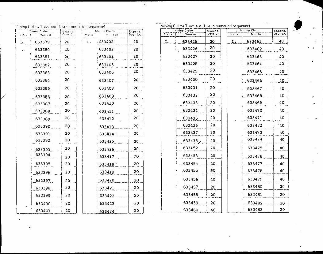
,'ining Claims Tiaveised (Lisl in numenca! sequence)V ning C'liirn
L. ' 633379
., '..633380.
! 633381
1^633382
'633383
'633384
,.. .6.33386 .
1 ....633387,
l 633388
! 633389
L 633390
; 633391
633392
; 633393; 633394
633395
J533396.
..633397 .
633398
633400
: 633401
Diiy'. Cr.
20
20 ..
20
20
20
20 -20
20 .'
.20 j20
20
20
20
20
20
.20
20
20
20
20
20
20
20
Pr of ix 1 Number
L. i 633402
' 633403
i 633404
'633405
633406•- - - - - - --633407
633408'633409
633410
Expend. Days Cr.
20
20
20
20
20
20
20 •i20 :•l20
633411 1 20 j
633412
' 633413
633S14 -
633415
633416
633417 ^
' 633418 '
, 633419 ^^
! 633420 ^ ^
633421
i 633422i ! 63 34 23 -
i 633424
20
20
20
20
20
20
20
20 ̂
. 20
20
20
20"20'
Mining Claims Tiaveised (Lisl in numerical sequence)l/mirifl Claim
Prefix l Number
L. i 633425
: 63342jL....
633427
i 633428
i 633429
633430
633431
633432
i ..633433
, ..633434
633435
633436
633437
...6.33438,,,.
633452
i . 633453
' 633454
' .633455, . . . . ... — -- . -— -
633456— - — - --
: 633457
633458
633459
633460
Exptnd.Days Cr,
20
20
20
20
20
20
20
20
20
20
20
20
20
-JA- .20
20
20
ao*~" " ——— --— -
40-- — — — ———
20
20
20
40
' Mining CifiimPrefix j Number
L. ! 633461
i 6334621 l 633463
! 633464
633465
'.633.466
' .633467 . .
i.. .6.33468
633469
, 633470
633471
633472
633473
i 633474
; 633475
! 633476
633477
633478r "~"- " " -——'633479
J- - * — - -* - -- — -
633480t "633481
633482
633483
Expend.Days Cr,
40
—40^
40
40
40
...40..
40..
40..
40
40
40•'40
40
40
40
40
40
40— ̂-n— — - --—
40— — .. . . ——
20
20
20
20

— — - .
- - -- -
-~- — --
——— ——————————— ——————— N ————
•o 5ABa-p.ja.lx3
i
l
1
... ..... . .. J
11 1
j
1
..™...,. ...J
i
i1
i
jsquinM | xi)0jjUJ..IID O.JIUHN
-— -- ——
—— — —-
Of""bf""
02
'O sA8Q•puadxj
1
j
-— — --—— - . ——— ;
t
- - - - - - -
2969E9 '
~" "~f 96969 ; ~ ""096999 '
6S69E9
8S69E9 "Iiai|oinN xil^'d
UJIBO 8.I.U./V
oz02
" 05
OfOf
bfOf
.Of
Of
Of
Of
OfOf
Of,
Of
OfOf"
OfOf"
Of
OfOf
•13 lAeg .
iS69E99S69E9
556969.j
f6EfE9 iE6efE9
"'""zCtvW
' T6EfE9 "|
06efC9
"686*6988EfE9: ' i86fC9
'
S8EfE9f8efE9
686*69 .. . . ....28Efe9
"~ ISef 69 '
-- ---oeeTeg-
6z.efe9i "~ "8i"6*69 ;i
9Ltis9" " "StWE9" "1
JdilUJMNi l XI l*) M— ..—. , .. . -. .f ... 1. . ..' .,. .
OfOf "
Ofbf "
Of
Of
Of
0,
Of
OfOf
Of""Of"
Of"
Of"
-QZOZ
ozozoz "
oz ' oz"
oz'JQ S A l? Qpu-idx 3
UEfr69""""eieVeg"' ~2^E"fE"9""
iT/LEfCS i '
. .. . . . ....t
' ""'1369669"";
""^69669" ii
X'fe9ee9 -eegeeg269E69"icgeegoegeeg
"' "629eE9";
"~-~829669"1
"~~Zz;9ee9~i.y. . . :. . j
isfeeg "06fE69"
"""68f669"
88fee9~-"""L9rit9"
98fee91 ""ssfeeg
fsfeeg , "T- tjtHtuj n (\j j t ( ^n i.
(oouanbos leouauinu u;

Ontario
Ministry of Natural
GeotechnicalReportApproval
File
Mining Lands Comments
J^,v ,..^.,'A//^
D To: Geophysics
Comments
l l Approved | | Wish to see again with correctionsDate Signature
To: Geology- Expenditures
Comments
[ ) Approved l Wish to see again with correctionsDate Signature
1 1^ To: Geochemistry
Comments
Approved l l Wish to see again with corrections
l [TO: Mining Lands Section, Room 6462, Whitney Block. (Tel: 5-1380)
1E93 /81/10J

File '. SB y^
Mining Lands Comments
To: Geophysics
Comments
[J Approved | ] Wish to see again with correctionsDate Signature
fo: Geology - Expenditures ^Comments
f""] Approved [~] Wish to see again with correctionsDate Signature
To: Geochemistry
[^Approved (^Wish to see again with corrections
l To: Mining Lands Section, Room 6462, Whitney Block, (Tel: 5-1380)
1B93 IB)/)D)

1983 10 06
266
2.5840
Mr. George J. KoleszarMining RecorderMinistry of Natural Resources4 Government Road EastP.O. Box 984Kirkland Lake, OntarioP2N 1A2
Dear Sir:
We have received data for Overburden drilling submitted under Section 77(19) of The Mining Act R.S.O. 1980 for mining claims L 591375 et al 1n the Township of Bradette.
This material will be examined and assessed and a statement of assessment work credits will be Issued.
Yours very truly,
E.F. AndersonDirectorLand Management Branch
Whitney Block, Room 6450 Queen's Park Toronto, Ontario M7A 1W3 Phone:(416)965-1380
A. Barr:mc
cc: Newmont Exploration of Canada Limited 33 Yonge Street Suite 370 Toronto, Ontario M5E 1T2
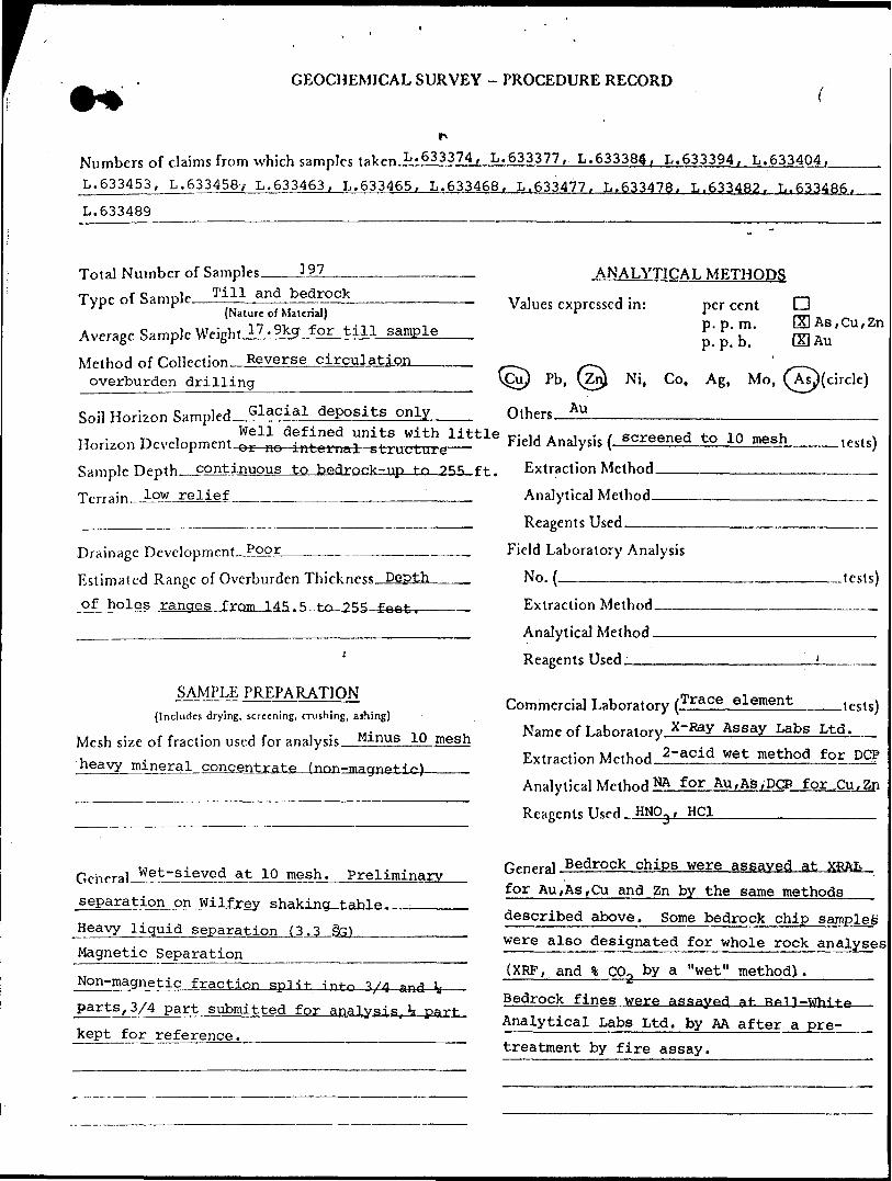
GEOCHEMICAL SURVEY - PROCEDURE RECORD
Numbers of claims from which samples tal^n L.633374, L.633377, L.633384. L.633394, L.633404,
L.633453, L.6334587 L.633463, L.633465, L.633468, L.633477. L.633478. L.633482. L.633486 f
L.633489
Til1 and bedrockTotal Number of Samples Type of Sample
(Nature of Material)Average Sample Wright 17.9kg for till sample
Method of r.nlWtirm Reverse circulation .^. overburden drilling
ANALYTICAL METHODS
Values expressed in: per cent p.p. m. p. p. b.
aQ[)As,Cu,Zn
Soil Horizon Glacial deposits only
Pb, (Zr
Others Au
Ni, Co, Ag, Mo, f Asj(circle)
Well defined units with little Horizon Development or no internal structure——Sample Depth continuous to bedrock-np t-.n ?R5 ft.
Terrain low relief______^________________
.Drainage Development.
Estimated Range of Overburden Thickness. Depth
of holes ranges from 145.R to 255 feet.—
SAMPLE PREPARATION{Includes drying, screening, crushing, ashing)
Mesh size of fraction used for analysis Minus 10 mesh
heavy mineral concentrate fnnn-magnPt-in)
Wet-sieved at 10 mesh. Preliminaryseparation on Wilfrey shaking
Heavy liquid separation (3.3 SG) ——....———— Magnetic Separation --—————-—-———-————
Non-magnetic fraction split-. inf-o 3/4 and i,
parts, 3/4 part submitted for analysis, ^ part-.
kept for reference.
Field Analysis { screened to 10 mesh
Extraction Method—————-—^———
Analytical Method-————————^—
Reagents Used.-—————————.—.—.
.tests)
Field Laboratory Analysis
No. ___________ _tests)
Extraction Method-— Analytical Method __ Reagents Used.:-——.
Commercia] Laboratory (Trace elementName of T-ahorafnry X-Ray Assay Labs Ltd.
Extraction 2-acid wet method for DGP
Analytical Method NA for Au,As,DCP for,Cu.Zn
Reagents Tkrd HN03 , HC1_____^________
General Bedrock chips were assayed at XRAL for Au,As,Cu and Zn by the same methods described above. Some bedrock chip samples were also designated for whole rock analyses
(XRF, and 3i C02 by a "wet" method). Bedrock fines were assayed gt R^ll-WhlteAnalytical Labs Ltd, by M after a pre- treatment by fire assay.

r GEOCHEMICAL SURVEY - PROCEDURE RECORD
Numbers of claims from which samples laWn'L.633374, L.633377, L.633384, L.633394, L.633404.__.
L.633453^^6334587 L.633463, L.633465, L.633468. L.633477. L.633478. L.633482. L.633486.
L.633489
Total Number of Samples
Type of
197
t11 *(Nature of Material)
Average Sample Weight ̂ L^Sjo Method of Collection Reverse ci relation
overburden drilling _____________
Soil Horizon Sampled Glacial deposits.jonlyWell defined units with little
Horizon
ANALYTICAL METHODS
Values expressed in: per cent p.p. m. p. p. b.
OEI As, Cu, Zi GO Au
Pb, (Zr
Othcrs-J^L
Ni, Co, Ag, Mo, (Ts)(circle)
__tests)
Sample Depth _ continuous to,bedrQckr.up to 25S-ft.
Terrain —Low-relief ______ ———————————————
Drainage Development—?-2p.7"———--—————————.
Estimated Range of Overburden Thickness-Depth of
SAMPLE PREPARATION(Includes drying, screening, crushing, ashing)
Mesh size of fraction used for analysis Mi nus 10 mesh heavy mineral^concentrate (non-magnetic)————
Field Analysis ( screened to 10 mesh
Extraction Method————.—.————-
AnalyticaJ Method————-——-—————
Reagents Used.—————..———.——.—
Field Laboratory Analysis
No. ——.—.—-—.-- .tests)
Extraction Method.
Analytical Method-
Reagents Used.——.
CommcrciaJ Laboratory ( Name of T.abnralnry
Extraction
Analytical
Reagents
Trace element
Assay Labs Ltd.
2-acid wet method for DCP
for Au, As, DCP for Cu.Zn
, HC1 —,———-————
C cncralJ^et-sieved at 10 mesh. Preliminary
separa tion^n JJi lIrey^ shakincuiahle.._:——.
Jie^yy^li^uid separation (3.3 SG) Magnetic Separation
^magnetic fraction split into-3/4 -and -V
3/4 part submitted for analysis^
kept for reference._______________
General Bedrock chips were assayed at XRAL
for au, As, Cu and 2n by the same methods —-^
described above. Some bedrock chip samples were a l so designated for whole rock analyse
(XRF, and % CO2 by a "wet" method).
Bedrock fines were assayed at R^n -whiteAnalytical Labs Ltd. by AA after a pre-
treatment by fire assay.
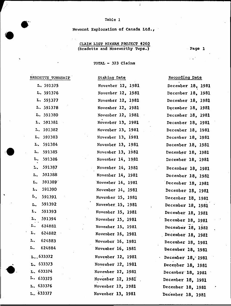
Table l
Newnont Exploration of Canada Ltd.,
CLAIM LIST MIKWAM PROJECT 0260 {Bradette and Noseworthy Twps.) Page l
BRADETTE TOWNSHIP
L. 591375L. 591376L. 591377L. 591378L. 591380L. 591381L. 591382L. 591383L. 591384L. 591385L. 591386
L. 591387L. 591388L. 591389L. 591390
L. 591391L. 591392L. 591393
L. 591394L. 624881L. 624882
L. 624883L. 624884
L..633372
L. 633373 L. 633374 L. 633375 L. 633376
L.. 633377
TOTAL - 323 Claims
Staking Date
November 12, 1981 November 12, 1981 November 12, 1981 November 12, 1981 November 12, 1981 November 13, 1981 November 13, 1981 November 13, 1981 November 13, 1981
November 13, 1981 November 14, 19.81
November 14, 1981
November 14, 1981 November 14, 1981 November 14, 1981
November 15, 1981 November. 15, 1981 November 15, 1981 November 15, 1981 November 15, 1981 November 16, 1981 November 16, 1981 November 16, 1981
November 12, 1981
November 12, 1981 November 12, 1981 November 12, 1981' November 12, 1981
November 13, 1981
Recording Date
December 18, 1981 December 18, 1981 December 18, 1981 December 18, 1981 December 18, 1981 December 18, 1981 December 18, 1981 December 18, 1981
December 18, 1981 December 18, 1981 December 18, 1981
December 18, 1981 December 18, 1981
December 18, 1981 December 18, 1981
December 18, 1981 December 18, 1981 December 18, 1981 December 18, 1981 December 18, 1981
. December 18, 1981 December 18, 1981 December 18, 1981
December 18,- 1981
December 18, 1981 December 18, 1981 December 18, 1981 December 18, 1981
December 18, 1981

Table l Con't
Newnont Exploration of Canada Ltd.,
CLAIM LIST MIKWAM PROJECT #260 {Bradette and Noseworthy Twps.) Page 2
Bradette Twp. Cont'd
L. 633378
L. 633379
L. 633380 :
L. 633381
L. 633382
L. 633383
L. 633384
L. 633385
L. 633386
L. 633387
L. 633388
L. 633389
L. 633390
L. 633391
L. 633392
L. 633393
L. 633394
L. 633395
L. 633396
L. 633397 '
L. 633398
L. 633399
L. 633400
L. 633401
L. 633402
L. 633403
L. 633404
TOTAL - 323 Claims
Staking Date
November 13, 1981
November 13, 1981
November 13, 1981
November 13, 1981
November 14, 1981
November 14, 1981
.November 14, 1981
November 14, 1981
November 14i -1981
November 15, 1981
November 15, 1981
November 15, 1981
November 15, 1981
November 15, 1981
November 16, 1981
November 16, 1981
November 16, 1981
. November 16, 1981
November 16, 1981
November 17, 1981
November 17, 1981
November 17, 1981
November 17, 1981
November 17, 1981
November 18, 1981
November 18, 1981
November 18, 1981
Recording Date
December 18, 1981
'December 18, 1981
December 18, 1981
December 18, 1981
December 18, 1981
December 18, 1981
December 18, 1981
December 18, 1981
December 18, 1981
December 18, 1981
December 18, 1981
. December 18, 1981
December 18, 1981
December 18, 1981
December 18, 1981
December 18, 1981
! December 18, 1981
December 18, 19.81
December 18, 1981
' December 18, 1981
December 18, 1981
December 18, 1981
December 18, 1981
December 18, 1981
December 18, 1981
- December 18, 1981
December 18, 1981
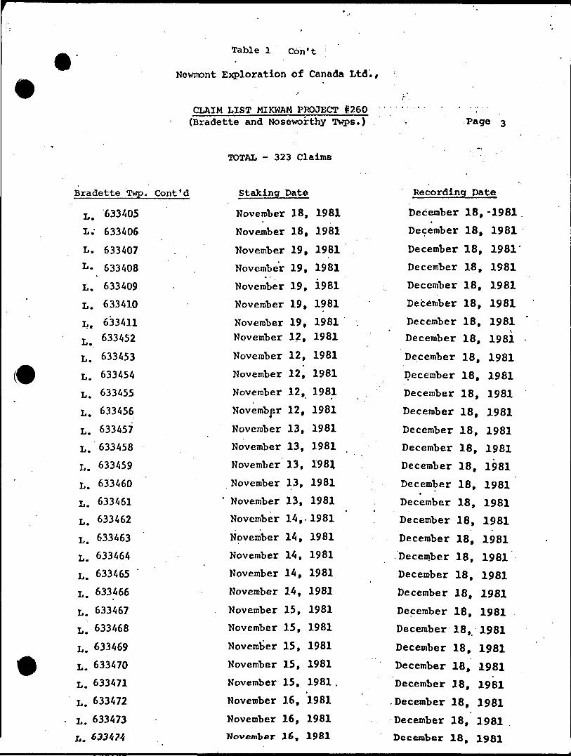
Table l Con 1 t :
Newnont Exploration of Canada Ltd.,
CIAIM LIST MIKWAM PROJECT 0260 (Bradette and Noseworthy Twps.) Page 3
Bradette Twp. Cont'd
L. 633405
L." 633406
L. 633407
L. 633408
L. 633409
L. 633410
Lt 633411L.. 633 *52
L. 633453
L. 633454
L. 633455
L. 633456
L. 633457
L. 633458
L. 633459
L. 633460
L. 633461
L. 633462
L. 633463
L. 633464
L. 633465
L. 633466
L. 633467
L. 633468
L. 633469
L. 633470
L. 633471
L. 633472
L. 633473
L. 633474
TOTAL - 323 Claims
Staking Pate
November 18, 1981
November 18, 1981
November 19, 1981
November 19, 1981
November 19, 1981
November 19, 1981
November 19, 1981 November 12, 1981
November 12, 1981
November 12, 1981
November 12, 1981
November 12, 1981
November 13, 1981
November 13, 1981
November 13, 1981
November 13, 1981
' November 13, 1981
November 14,. 1981
November 14, 1981
November 14, 1981
November 14, 1981
November 14, 1981
November 15, 1981
November 15, 1981
November 15, 1981
November 15, 1981
November 15, 1981 .
November 16, 1981
November 16, 1981 November 16, 1981
Recording Date
December 18,-1981
December 18, 1981
December 18, 1981'
December 18, 1981
December 18, 1981
December 18, 1981
December 18, 1981 December 18, 1981
December 18, 1981
December 18, 1981
December 18, 1981
December 18, 1981
December 18, 1981
December 18, 1981
December 18, 1981
December 18, 1981*
December 18, 1981
December 18, 1981
December 18, 1981
.December 18, 1981
December 18, 1981
December 18, 1981
December 18, 1981
December 18, 1981
December 18, 1981
December 18, 1981
December 18, 1981
.December 18, 1981
December 18, 1981
December 18, 1981

Table l Con'tl
Newnont Exploration of Canada Ltd./
CLAIM LIST MIKWAM PROJECT #260 (Bradette and Noseworthy Twps.) Page 4
Bradette Twp. Coht'd
L. 633475
L. 633476
L. 633477
L . 633478
•L. 633479
L. 633480
L. 633481
L. 633482
L. 633483
L. 633484
L. 633485
4 L. 633486
L. 633487
L. 633488
L. 633489
L. 633490
L. 633491
Noseworthy Twp.
L. 624885
L. 624886
L. 624887
L. 624888
L. 624889
L. 624890
L. 624891
L. 624892
L. 624893
i. 624894
TOTAL - 323 Claims
Staking Date
November 16, 1981
November 16, 1981
November 17, 1981
November 17, 1981.
November 17, 1981
November 17, 1981
November 17, 1981
November 18, 1981
November 18, 1981
November 18, 1981
November 18, 1981
November 18, 1981
November 19, 1981
November 19, 1981
November 19, 1981
November 19, 1981
November 19, 1981
Staking Date
November 16, 1981
November 16, 1981
November 17, 1981
November 17, JL981
November 17, 1981
November 17, 1981
November 17, 19.81
November 18, 1981
November 18, 1981
November 18, 1981
Recording Date
December 18, 1981
December 18, 1981
December 18, 1981
December 18. 1981 December 18, 1981
December 18, 1981
- December 18, 1981
December 18, 1981
December 18, 1981
December 18, 1981
December 18, 1981
December 18, 1981
December 18, 1981
December 18, 1981
December 18, 1981
December 18, 1981
December 18, 1981
Recording Date
December 18, 1981
December -18, 1981
December 18, 1981
December 18, 1981
December 18, 1981
December 18, 1981
December 18, 1981
December 18, 1981
December 18, 1981
December 18, 1981
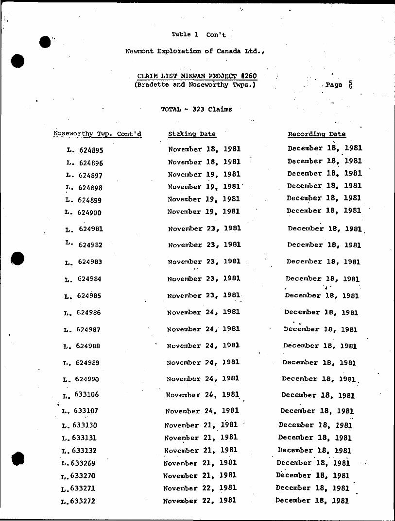
Table l Con't i
Newmont Exploration of Canada Ltd./
CLAIM LIST MIKWAM PROJECT 0260 (Bradette and Noseworthy Twps.)
TOTAL - 323 Claims
Page
Noseworthy Twp. Cont'd
L. 624895
L. 624896
L. 624897
L. 624898
L. 624899
L. 624900
L. 624981
L - 624982
L. 624983
L. 624984
L. 624985
L. 624986
L. 624987
L. 624988
L. 624989
L. 624990
L. 633106
L. 633107
L. 633130 L. 633131 L. 633132 L.633269 L.633270 L.633271
L.633272
Staking Date
November 18, 1981 November 18, 1981 November 19, 1981 November 19, 1981 November 19, 1981 November 19, 1981
November 23, 1981
November 23, 1981
November 23, 1981
November 23, 1981
November 23, 1981
November 24, 1981
November 24, 1981
November 24, 1981
November 24, 1981
November 24, 1981
November 24, 1981
November 24, 1981
November 21, 1981 November 21, 1981 November 21, 1981 November 21, 1981 November 21, 1981 November 22, 1981 November 22, 1981
Recording Date
December 18, 1981
December IB, 1981 December 18, 1981 December 18, 1981 December 18, 1981 December 18, 1981
December 18, 1981
December 18, 1981
December 18, 1981
December 18, 1981'4 '
December 18, 1981
December 18, 1981*
December 18, 1981
December 18, 1981
December 18, 1981
December 18, 1981.
December 18, 1981
December 18, 1981
December 18, 1981
December 18, 1981
December 18, 1981
December 18, 19Si
December 18, 1981
December 18, 1981
December 18, 1981

Table l Con't j
Newnont Exploration bf Canada Ltd./
CLAIM LIST MIKWAM PROJECT #260 {Bradette and Noseworthy Twps.) Page
Noseworthy Twp. Cont'd
L.633273
L. 633312 L .633313
L. 633314
L. 633315
L. 633316 L. 633317 L. 633318
L. 633319
L. 633320 L. 633321-
L. 633322
L. 633323 L. .633324
L. 633325 L. 633326
L. 633327 L. 633328
L. 633329 L. 633330 L. 633331 L. 633332
L. 633333 L. 633334
L. 633335 L. 633336 L. 633337 L. 633338
L. 633339
TOTAL - 323 Claims
Staking Date
November 22, 1981 November 12, 1981 November 12, 1981
November 12, 1981 November 12, 1981
November 12, 1981
November 13, 1981 -' November 13, 1981
November 13, 1981
November 13, 1981 November 13, 1981
November 14, 1981 November 14, 1981 November 14, 1981
November 14, 1981 November 14, 1981
November 15, 1981 November 15, 1981
November 15, 1981 November 15, 1981 November 15, 1981' November 16, 1981
November 16, 1981 November 16, 1981
November 16, 1981 November 16^ 1981 November 17, 1981 November 17, 1981
November 17,. 1981
Recording Pate
December 18, 1981 December 18, 1981 December 18, 1981
December 18, 1981 December 18, 1981 December 18, 1981
December 18, 1981 December 18, 1981
December 18, 1981
December 18, 1981 December 18, 1981
December 18, 1981
December 18, 1981
December 18, 1981 December 18, 1981
December 18, 1981 December 18, 1981 December 18, 1981
December 18, 1981 December 18, 1981 December 18, 1981 December 18, 1981 December 18, 1981 December 18, 1981
December 18, 1981 December 18, 1981 December 18, 1981 December 18, 1981
December 18, 1981
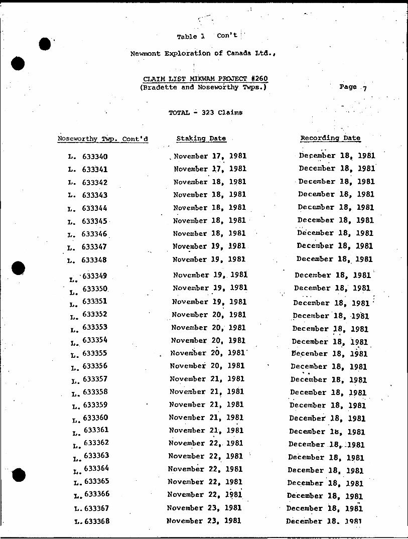
Table l Con 1 1
Newmont Exploration of Canada Ltd./
CLAIM LIST MIKWAM PROJECT #260 (Bradette and Noseworthy Twps.) Page 7
Noseworthy Twp. Cont'd
L. 633340
L. 633341
L. 633342
L. 633343
L. 633344
L. 633345
L. 633346
L. 633347
L. 633348
T -633349 L.LB 633350.
T 633351 Jj.T 633352 Jj.L ^ 633353
T 633354 ij*L. 633355
L. "3356
L . 633357
L. 633358
L . 633359
633360
L.
L.
L.
633361
633362
633363
T 633364 jj.L . 633365
L , 633366
L. 633367
L. 633368
TOTAL - 323 Claims
Staking Date
. Kovember 17, 1981
November 17, 1981
November 18, 1981
November 18, 1981
November 18, 1981
November 18, 1981
November 18, 1981
November 19, 1981
November 19, 1981
November 19, 1981
November 19, 1981
November 19, 1981
November 20, 1981
November 20, 1981
November 20, 1981
, November 20, 1981
November 20, 1981
November 21, 1981
November 21, 1981
November 21, 1981
November 21, 1981
November 21, 1981
November 22, 1981
November 22, 1981 '
November 22, 1981
November 22, 1981
November 22, 1981
November 23, 1981
November 23, 1981
Recording Date
December 18, 1981
December 18, 1981
December 18, 1981
December 18, 1981
December 18, 1981
December 18, 1981
December 18, 1981
December 18, 1981
December 18, 1981
December 18, 1981
December 18, 1981
December 18, 1981 :
December 18, 1981
December 18, 1981
December 18, 1981 December 18, 1981
December 18, 1981* .December 18, 1981
December 18, 1981
December 18, 1981
December 18, 1981
December Ib, 1981
December 18, :i981
December 18, 1981
December 18, 1981
December 18, 1981
December 18, 1981
December 18, 1981
December 18. 3981
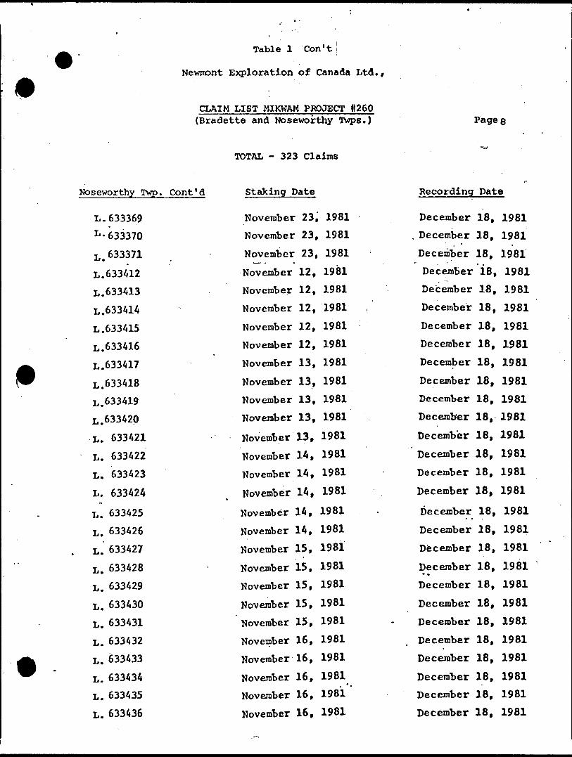
Table l Con't j
Newmont Exploration of Canada Ltd.,
CLAIM LIST MIKWAM PROJECT 0260 (Bradette and Noseworthy Twps.) Page
TOTAL - 323 Claims
Noseworthy Twp. Cont'd Staking Date Recording Pate
L.633369 L -633370
L.633371
L. 633412 L.633413 L.633414
L.633415 L.633416 L.633417
L.633418 L.633419 L.633420 L. 633421
L. 633422 L. 633423
L. 633424
L. 633425 L. 633426 L. 633427
L. 633428 L. 633429
L. 633430 L. 633431
L. 633432 L. 633433
L. 633434 L. 633435
L. 633436
November 23, 1981 November 23, 1981 November 23, 1981 November 12, 1981 November 12, 1981 November 12, 1981
November 12, 1981 November 12, 1981 November 13, 1981
November 13, 1981 November 13, 1961 November 13, 1981
November 13, 1981 November 14, 1981 November 14, 1981
November 14, 1981
November 14, 1981 November 14, 1981
November 15, 1981
November 15, 1981 November 15, 1981 November 15, 1981 November 15, 1981 November 16, 1981 November 16, 1981
November 16, 1981 November 16, 1981
November 16, 1981
December December
December December December December
December December December
December December December
December December
December
December
December
December December
December* *
December
December
December
December
December
December
December
December
18, 1981 18, 1981
18, 1981 'l8, 1981
18, 1981
18, 1981
18, 1981
18, 1981 18, 1981
18, 1981 18, 1981 18, 1981 18, 1981
18, 1981 18, 1981
18, 1981
18, 1981
18, 1981
18, 1981
18, 1981 18, 1981
18, 1981
18, 1981
18, 1981
18, 1981
18, 1981 18, 1981
18, 1981
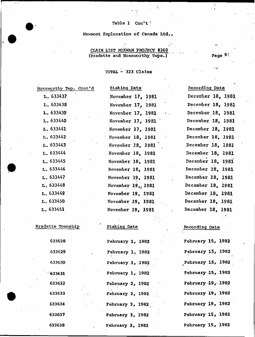
Table l Con't '
Newnont Exploration of Canada Ltd.,
CLAIM LIST MIKWAM PROJECT #260 (Bradette and Noseworthy Twps.) Page
Noseworthy Twp. Cont'd L. 633437 L. 633438 L. 633439 L. 633440 L. 633441 L. 633442 L. 633443 L. 633444 L. 633445 L. 633446 L. 633447 L. 633448 L. 633449 L. 633450 L. 633451
TOTAL - 323 Claims
Staking Date
November 17, 1981 November 17, 1981 November 17, 1981 November 17, 1981 November 17, 1981 November 18, 1981 November 18, 1981 November 18, 1981 November 18, 1981 November 18, 1981 November 19, 1981 November 19 N 1981 November 19, 1981 November 19, 1981 November 19, 1981
Recording Date
December 18, 1981 December 18, 1981 December 18, 1981 December 18, 1981 December 18, 1981 December 18, 1981 December 18, 1981 December 18, 1981 December 18, 1981 December 18, 1981 December 18, 1981 December 18, 1981 December 18, 1981 December 18, 1981 December 18, 1981
Bradette Township
633628
633629
633630
'633631
633632
633633
633634
633637
63363B
Staking Date
February l, 1982
February l, 1982
February l, .1982
February l, 1982
February 2, 1982
February 2, 1982
February 2, 1982
February 3, 1982
February 3, 1982
Recording Date
February
February
^February
February
February
February
February
February
February
15, 1982
15, 1982
15, 1982
15, 1982
19, 1982
19, 1982
19, 1982
15, 1982
15, 1982

Table l Con't |
Newnont Exploration of Canada Ltd.,
CLAIM LIST MIKWAM PROJECT #260 {Bradette and Noseworthy Twps.)
TOTAL - 323 Claims
Bradette Twp. Cont'd
634392
634393
634394
636955
636956
636957
636958
636959
6369604 '
636961
636962
Noseworthy Twp.
633548
633549
633550
633551
633552
633553
633554
633555
633556
Staking Date
February 8, 1982
February 8, 1982
February 8, 1982
February l, 1982
February l, 1982
February l, 1982
February l, 1982
February 2, 1982
February 2, 1982
February 2, 1982
February 2, 1982
Staking Date
February l, 1982
February l, 1982
February l, 1982
February l, 1982
February l, 1982.
February 2, 1982
February 2, 1982
February 3, 1982
February 3, 1982
Page 10
Recording Date
February 15, 1982
February 15, 1982
February 15, 1982
February 15, 1982
February 15, 1982
February 15, 1982
February 15, 1982
February 15, 1982
..February 15, 1982
February 15, 1982
February 15, 1982
Recording Date
February
February
February
February
February
February
February
February
February
19, 1982
19, 1982
19, 1982
19, 1982
19, 1982
19, 1982
19, 1982
19, 1982
19, 1982
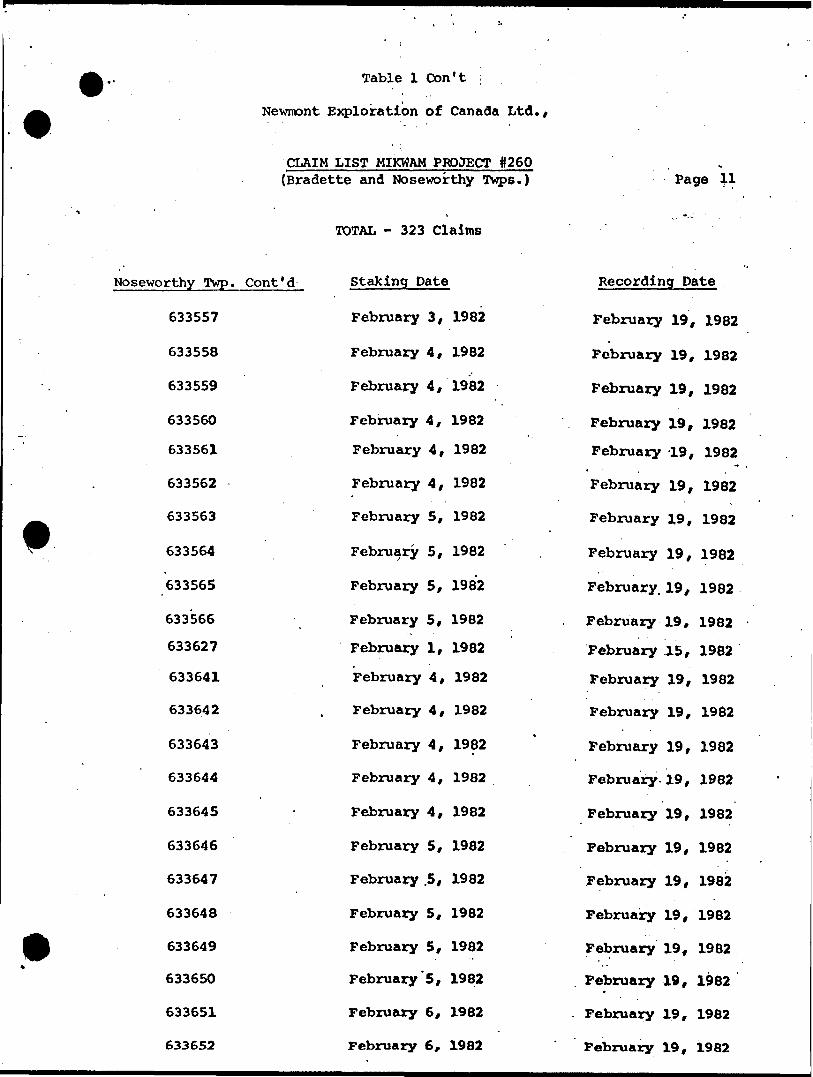
Table l Con't
Newrnont Exploration of Canada Ltd./
CLAIM LIST MIKWAM PROJECT 0260 (Bradette and Noseworthy Twps.)
TOTAL - 323 Claims
Page 5-1
Noseworthy Twp. Cont'd
633557
633558
633559
633560
633561
633562
633563
633564
633565
633566
633627
633641
633642
633643
633644
633645
633646
633647
633648
633649
633650
633651
633652
Staking Date
February 3, 1982
February 4, 1982
February 4, 1982
February 4, 1982
February 4, 1982
February 4, 1982
February 5, 1982
February 5, 1982
February 5, 1982
February 5, 1982
February l, 1982
February 4, 1982
February 4, 1982
February 4, 1982
February 4, 1982
February 4, 1982
February 5, 1982
February .5, 1982
February 5, 1982
February 5, 1982
February'5, 1982
February 6, 1982
February 6, 1982
Recording Date
February 19, 1982
February 19, 1982
February 19, 1982
February 19, 1982
February -19, 1982
February 19, 1982
February 19, 1982
February 19, 1982
February. 19, 1982
February 19, 1982
February .15, 1982
February 19, 1982
February 19, 1982
February 19, 1982
February.19, 1982
February 19, 1982
February 19, 1982
February 19, 1982
February 19, 1982
February 19, 1982
February 19, 1982
February 19, 1982
February 19, 1982

Table l Con't
Newnont Exploration of Canada Ltd.,
CLAIM LIST MIKWAM PROJECT #260(Bradette and Noseworthy Twps.)
TOTAL - 323 Claims
Page
Noseworthy Twp. Cont'd
633653
633654
633655
633656
634364
634365
634366
634367
634368
634369
634370
634371
634372
634373
634374
634375
634376
634377
634378
634379
634380
634381
Staking Date
February 6, 1982
February 6, 1982
February 6, 1982
February 7, 198?
February 6, 1982
February 6, 1982
February 6, 1982
February 6, 1982
February 6, 19824
February 6, 1982
February 7, 1982
February 7, 1982
February 7, 1982
February 7, 1982
February 7, 1982
February 8, 1982
February 8, 1982
February 8, 1982
February 8, 1982
February 8, 1982
February 9, 1982
February 9, 1982
Recording Date
February 19, 1982
February 19, 1982
February 19, 1982
February 19, 1982
February 19, 1982*
February 19, 1982
February 19, 1982
February 19, 1982
February 19, 1982
February 19, 1982
February 19, 1982
February 19, 1982
February 19, 1982
February 19, 1982
February 19, 1982
February 19, 1982
February 19, 1982
February 19, 1982
February 19, 1982
February 19, 1982
February 19, 1982
February 1982

Table l Cton"t
Newmont Exploration"of Canada Ltd.,
CLAIM LIST MIKWAM PROJECT #260 (Bradette and Noseworthy Twps.)
TOTAL - 323 Claims
Noseworthy Twp. Cont'd
6343B2
634383
634384
634385
634386
634387
634388
634389
4 634390
634391
Staking Date*
February 9, 1982
February 9, 1982
February 9, 1982
February 10, 1982
February 10, 1982
February 10, 1982
February 10, 1982
February 9,.1982
February 9, 1982
February 9, 1982
Page
Recording Date
February 19, 1982
February 19, 1982
February 19, 1982
February 19, 1982
February 19, 1982
February 19, 1982
February 19, 1982
February 19, 1982x
February 19, 1982
February 19, 1982
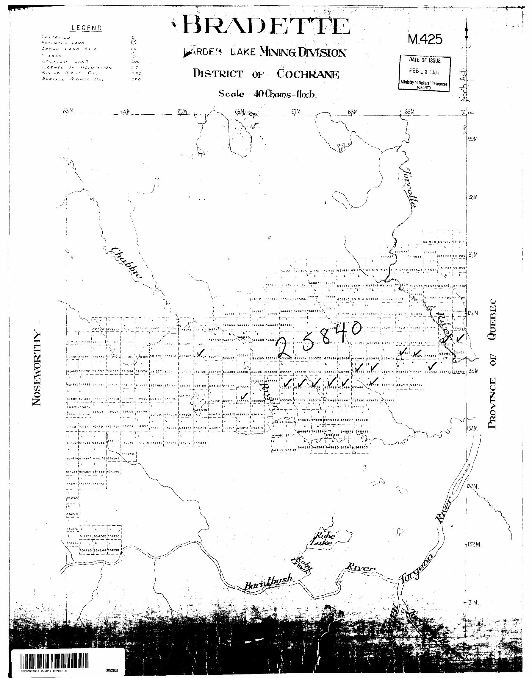
LEGENDT r FT
C 4 -v C E L t, t. i
PA. -t t^w r t- oC x o U'A/ LAND S A L
s r s*L o c
L/C
n5 r J * 0CC t/'VA 7 /O V
/V/.-V -vG /?/ C -. - - O ^ . -
•5 f tf /- x c .E /7/owT.T
c©C 5
Loc.i- C
V ffO
M.425LAKE
DISTRICT OF COCHRANEScale - 40O?aii?s IJrich.
DATE
Ministry of Nalural Resources____ TORONTO •A
32E12SE0045 2.5640 BRADETTE
651909 651910 '651911
7 i fi * i. P 6^1909 714537 T! ''14535' "' ! 6 5 i 9 07 |6 5 l 90 6
6 5-934 651905'16 5 l 9 ?X" '6^1919 7145
LI L ^ L
6519)6 G 51 91 7 i65 l 9 IS, -L - - - - -L -
46 MS 7 ' - -boob 6-". l 49 .' , fi 4 1496 Ifi41--\9ft65I9I5165I9I4 .65 l 9 13J, — —— L— - - -
S4BBBS 548393 S4B88p4 i,j - 1*13467 l 63'4 f.P
-. . T .,— - —l — — — — —v: - L. - -
68 l *^ (633457 G33462
—. — _ -(- — — -f- i L i L ^ , L
.— -— — i—
633490 S633485 .635482 633477 S3347459(384.591378 ^46^4 633jl63 |^ 33J156 ^633400C33399 633396 •633388 .633383
633387
. ~ "" ~ ' ~ "l f
• 4n 5 l e '4- E*4 (634 1853931 i' ,ric : c. 6378 |6334'i (63347! 633470) 634 l 8R 6 34 : 63 T3.1 :' 63*3,74 .633489'fi33486 635461
633375 '6354881633487 f, 334BO '633479 6^3^47?'(634IB2 |634K*t [6 J339 4 633 393~~ —— "' —— —— l —— —— - -*- —— ~. . * —— J ——— A .. —— , ——— J ——— ——— ^L — ——— . ——
f' '.:-93 L R34^4
345174,348699r, -T--r.
51"?2fl 545549 843 tiO
Si4246(6.^^4^(6.542 ^8 163^249
^ - — —t- — - J
——— — — — -L — — —
6M383 |634Z84 I634290 f/-- J.-
200