newsletter - nrs. 10 of 2014 annum 4 · newsletter - nrs. 10 of 2014 ... in addis ababa organized...
TRANSCRIPT
Newsletter of the Geological Society of Africa (GSAf) – Nr. 10; October, 2014 – Annum 4. 1
Geological Society of Africa www.geologicalsocietyofafrica.org
NEWSLETTER - Nrs. 10 of 2014 – Annum 4
Contents
GSAF MATTERS 2 THE COUNTRY MINING VISION METHODOLOGY WORKSHOP, DEBRE ZEIT, ETHIOPIA 2 THE GEOLOGICAL SOCIETY OF AFRICA CONGRATULATES PROF. LOPO VASCONCELOS 3 SPECIAL VOLUME OF THE JOURNAL OF AFRICAN EARTH SCIENCES, DEDICATED TO CAG24 IN ADDIS ABABA, ETHIOPIA (JANUARY 2013) 3
NEWS 4 ABOUT AFRICA 4 ABOUT THE WORLD 14 ABOUTSPACE/ASTRONOMY 26
INTERESTING LINKS 29
LITERATURE 30 AFRICA 30 OTHER AREAS 31 LINKS TO JOURNALS, REVIEWS & NEWSLETTERS 32
EVENTS 34 IN AFRICA AND ABOUT AFRICA 34 REST OF THE WORLD 35
PROFESSIONAL COURSES/WORKSHOPS/SCHOLARSHIPS 36
INTERESTING PHOTOS 37
Edited by
Lopo Vasconcelos Editor of the GSAf Newsletter [email protected]

Newsletter of the Geological Society of Africa (GSAf) – Nr. 10; October, 2014 – Annum 4. 2
GSAf Matters
The Country Mining Vision Methodology Workshop, Debre Zeit, Ethiopia
By Aberra Mogessie (GSAf President) It is to be noted that the African Union Commission has formulated the Africa Mining Vision in 2009 after several years of deliberation by prominent experts in the different fields of mineral resources. The main objectives of the Africa Mining Vision are as follows:
Africa Mining Vision: “Transparent, equitable and optimal exploitation of mineral resources to underpin broad-based sustainable growth and socio-economic
development”
This shared vision will comprise:
A knowledge-driven African mining sector that catalyses & contributes to the broad-based growth & development of, and is fully integrated into, a single
African market through:
o Down-stream linkages into mineral beneficiation and manufacturing;
o Up-stream linkages into mining capital goods, consumables & services industries;
o Side-stream linkages into infrastructure (power, logistics; communications, water) and skills & technology development (HRD and R&D);
o Mutually beneficial partnerships between the state, the private sector, civil society, local communities and other stakeholders; and
o A comprehensive knowledge of its mineral endowment.
A sustainable and well-governed mining sector that effectively garners and deploys resource rents and that is safe, healthy, gender & ethnically inclusive,
environmentally friendly, socially responsible and appreciated by surrounding communities;
A mining sector that has become a key component of a diversified, vibrant and globally competitive industrializing African economy;
A mining sector that has helped establish a competitive African infrastructure platform, through the maximization of its propulsive local & regional
economic linkages;
A mining sector that optimizes and husbands Africa’s finite mineral resource endowments and that is diversified, incorporating both high value metals
and lower value industrial minerals at both commercial and small-scale levels;
A mining sector that harness the potential of artisanal and small-scale mining to stimulate local/national entrepreneurship, improve livelihoods and
advance integrated rural social and economic development; and
A mining sector that is a major player in vibrant and competitive national, continental and international capital and commodity markets.
In order to implement this vision, attempts are being made on a country and regional level. To facilitate the implementation, the Africa Mineral Development Center, (AMDC-UNECA) in Addis Ababa organized an expert workshop on the Country Mining Vision Methodology in Debre Zeit, Ethiopia, from 15-20 September 2014. The aim was to write a country mining vision methodology Guidebook. A 200 page Guide book was written in five days using the book sprints methodology. “The objectives of the Country Mining Vision (CMV) guidebook are to help member States domesticate the Africa Mining Vision (AMV) at the national level through a multi-stakeholder consultative process with a view to formulating a shared vision on how mineral resources exploitation can promote broad based development and structural transformation of their respective countries. The guidebook offers a step-by-step guide for strategic assessment, identification of instruments for policy dialogue, and mechanisms for conducting stakeholder consultation, along with the steps for policy design and for the formulation of a CMV implementation, monitoring and evaluation tool”.
As stated in the Guidebook “the book is the product of the collective efforts of mainly African experts in the field of mining, economic and political governance, fiscal policies, environmental, geological, and development issues drawn from governments, civil society, academia and development partners. Using the Book Sprint technique, the contributors began their work in Debre Zeit near Addis Ababa in Ethiopia on Monday 15 September and finished on Saturday 20 September, 2014. A Book Sprint is a facilitated process through which a group of contributors with a wide range of expertise and perspectives come together to write a book collaboratively. Building on ongoing efforts in a number of African countries to domesticate the Africa Mining Vision, the writers started with a title only, spent a day deciding on an outline, and then wrote, illustrated, edited, proofread and “published” the book in the remaining five days. Building the book in a Sprint has resulted in a comprehensive resource that benefits from the dynamic interaction of a diverse group of leading experts working at the intersection of extractive and
social and economic development. This book is therefore the product of an intense team work, not group think, nor a consensus document”.
I am happy to inform our members and readers of our online newsletter that the Geological Society of Africa (GSAf) is recognized as one of the major partners for the implementation of the Africa Mining Vision of 2009, and we have to be ready for this important challenge which will help our continent move forward in a sustainable way.
Those who participated in the workshop and contributed in writing the book are as follows:
Item no.
First Name Family Name Organization Functional Title City, Country
1 Aberra Mogessie University of Graz; Geological Society of Africa
Professor Graz, Austria

Newsletter of the Geological Society of Africa (GSAf) – Nr. 10; October, 2014 – Annum 4. 3
2 Paul Jourdan Consultant Johannesburg, South Africa
3 Fui Tsikata Reindorf Chambers Senior Partner Accra, Ghana
4 Benjamin Aryee Ministry of Lands and Natural Resources
Advisor (Mining) Accra, Ghana
5 Moussa Sylla GEOMIN (Co.) General Director Dakar, Senegal
6 Joe Amoako-Tuffour ACET Senior Advisor Accra, Ghana
7 Yao Graham Third World Network -Africa-TWN-Africa
Coordinator Accra, Ghana
8 Silas Olang NRGI Senior Regional Associate Da es Salaam, Tanzania
9 Florens Dominic Luoga University of Dar es Salaam Professor of Law Deputy Vice Chancellor, Research
Dar es Salaam, Tanzania
10 Oliver Maponga UNECA Economic Affairs Officer, SRO-SA Lusaka, Zambia
11 Antonio Pedro UNECA Director, SRO-EA Kigali, Rwanda
12 Kojo Busia UNECA Officer-In-Charge, AMDC Addis Ababa, Ethiopia
13 Marit Kitaw UNECA Economic Affairs Officer, AMDC Addis Ababa, Ethiopia
14 Valerio Bosco UNECA Mineral Sector Governance Advisor Addis Ababa, Ethiopia
15 Ahmed Khalid Eldaw AfDB Natural Resources (Water) Tunis
16 Erick Ordeman Embassy of Canada First Secretary-Development Addis Ababa, Ethiopia
17 Andre Ufer GIZ Advisor, Global extractive Resources Initiative (GeRI)
Bonn, Germany
18 Herbert M'cleod UNDP Consultant interim program manager Addis Ababa, Ethiopia
19 Laurent Coche GIZ Consultant Johannesburg, South Africa
20 Lynne Stuart Idea in a Forest Graphic Designer Cape Town, South Africa
21 Laia Ros Gasch Book Sprints Facilitator Brussels
22 Barbara Ruehling Book Sprints Facilitator Colombia
23 Elise Nalbandian Australian High Commission Senior Program Manager Addis Ababa, Ethiopia
24 Carolyne Tumuhimbise AUC Trade Advisor Addis Ababa, Ethiopia
25 Hussein Hassan AUC Head-Industry Addis Ababa, Ethiopia
26 Mooya Lumamba Ministry of Mines Director of Mines Lusaka, Zambia
27 Lwanda George UNDP Economic Advisor Lusaka, Zambia
The Geological Society of Africa Congratulates Prof. Lopo Vasconcelos
By A. Mogessie (GSAf Pesident)
In my name and the Council of the Geological Society of Africa and its members I congratulate our former Vice President for the Southern African Region and present Newsletter Editor of the Geological Society of Africa, Prof. Lopo Vasconcelos for being awarded at an Academic ceremony “The 1st Degree Excellence Prize in Teaching” form his University - Universidade Eduardo Mondlane, Mozambique. As usual he was busy attending a conference in India and the prize was presented to his wife and son who attended the ceremony.
It is important to note that our colleague and friend Prof. Lopo Vasconcelos is one of the few people I know who is investing his time and energy to make a difference in his country, the African continent and in the international arena on an honorary basis. Having worked with him for the last six years to strengthen the Geological Society of Africa and make it a useful and reliable organization for the earth scientists in the continent and our friends world-wide, I can say that his contribution has been immense. Those of you who receive the average 40 pages online GSAf newsletter every month will agree with me that the prize he has been awarded by his University is appropriate and deserved. Congratulations!!
Special Volume of the Journal of African Earth Sciences, dedicated to CAG24 in Addis Ababa, Ethiopia (January 2013)
The Geological Society of Africa is proud to announce the publication of a Special Issue of the Journal of African Earth Sciences (Vol. 99, Part II, pp. 211-756) dedicated to the 24th CAG. The link is the following: http://www.sciencedirect.com/science/journal/1464343X/99/part/P2

Newsletter of the Geological Society of Africa (GSAf) – Nr. 10; October, 2014 – Annum 4. 4
NEWS
About Africa
Nigeria’s quick response tames Ebola’s spread in key nation
October 1, 2014 at 10:12 AM
Although officials are pleased that success was achieved in a country of 177 million that is a major transport and business hub — and whose largest city, Lagos, has 21 million people — the lessons here are not easily applicable to the countries at the epicenter: Guinea, Liberia and Sierra Leone. By DONALD G. McNEIL Jr, The New York Times
Nigerian health officials in August wait to screen passengers arriving at Murtala Muhammed International Airport in Lagos. Nigeria’s first Ebola patient, who became infected in Liberia, flew into Lagos in July.
With quick and coordinated action by some of its top doctors, Nigeria, Africa’s most populous country, appears to have contained its first Ebola outbreak, the U.S. Centers for Disease Control and Prevention said Tuesday.
As the epidemic rages out of control in three nations a few hundred miles away, Nigeria is the only country to have an outbreak with hundreds of potential victims in a city with vast, teeming slums and yet to beat it back.
“For those who say it’s hopeless, this is an antidote — you can control Ebola,” said Dr. Thomas R. Frieden, director of the CDC.
Although officials are pleased that success was achieved in a country of 177 million that is a major transport and business hub — and whose largest city, Lagos, has 21 million people — the lessons here are not easily applicable to the countries at the epicenter: Guinea, Liberia and Sierra Leone.
Nigeria’s outbreak grew from a single airport case, while in the three other countries the disease smoldered for months in remote rain-forest provinces
and spread widely before a serious response was mounted. Ebola, Frieden said, “won’t blow over; you have to make a rapid, intense effort.”
While the danger in Nigeria is not over, the health minister, Dr. Onyebuchi Chukwu, said his country was now better prepared, with six laboratories able to make diagnoses, and response teams and isolation wards ready in every major state.
After the first patient — a dying Liberian American — flew into Lagos on July 20, Ebola spread to 20 people there and in a smaller city, Port Harcourt.
They have all died or recovered, and the cure rate — 60 percent — was unusually high for an African outbreak.
Meanwhile, local health workers paid 18,500 face-to-face visits to repeatedly take the temperatures of nearly 900 people who had contact with them. The last confirmed case was detected Aug. 31, and virtually all contacts have passed the 21-day incubation period without falling ill.
The success was in part the result of an emergency command center financed in 2012 by the Bill & Melinda Gates Foundation to fight polio.
As soon as the outbreak began, it was turned into the Ebola Emergency Operations Center.
Dr. Susan Desmond-Hellmann, CEO of the Seattle-based foundation, said she was “heartened to see this positive result of the efforts of so many in Nigeria.”
Also, the CDC had 10 experts in Nigeria working on polio and HIV who had already trained 100 local doctors in epidemiology; 40 of them were immediately reassigned to Ebola and oversaw the contact tracing.
The chief of the command center, Dr. Faisal Shuaib, gave credit to a coordinated effort by the health ministry, the CDC, the World Health Organization, UNICEF, Doctors Without Borders and the International Committee for the Red Cross.
Also, he noted, Nigeria has significant advantages over poorer countries where the outbreak is out of control: It has many more doctors per capita, some educated abroad at top medical schools.
More at http://seattletimes.com/html/nationworld/2024665887_nigeriaebolaxml.html
Output from Minas Moatize to remain stalled until coal prices rally
By: Natalie Greve, 23rd September 2014 Edited by: Chanel de Bruyn.
JOHANNESBURG (miningweekly.com) – Coal asset developer Beacon Hill says its flagship Minas Moatize mine, in northern Mozambique, will likely remain on care and maintenance until coal prices recover and the project’s expanded wash plant is completed by early next year.
The plant was placed on care and maintenance in November 2013, when coking coal prices fell significantly below the current cost of production ahead of the completion of the wash plant expansion project.
“The depressed market for coal prices globally has meant that the project will likely remain on care and maintenance, with a key focus to re-enter production as a tier-one cost producer.
“Therefore, with no anticipated production during the second half of 2014, focus of the board and management will be solely on debt and equity expansion project funding, logistics and restructuring the existing debt on the balance sheet,” chairperson Justin Farr-Jones said in an interim results statement for the six months ended June 30.
Beacon Hill expected prices to remain subdued for the second half of 2014, as the market rebalanced demand and supply, predicting premium low-volatile spot prices to average $120/t between July and December.
Noting that there were “significant hurdles to overcome”, he added that the group aimed to also conclude the sub-lease of its rail allocation to offset rail
costs, as well as complete a new $20-million senior debt equity facility to fund capital expenditure.
Beacon Hill would also restructure the $25-million existing senior and subordinated debt and look to raise up to $17-million in additional equity or working capital to execute the engineering, procurement and construction management contract for the expansion project.
Farr-Jones outlined that significant progress had been made at Minas Moatize during the first half of 2014, despite the “very challenging” pricing environment for coal.
“Notably, the company shipped and commissioned five new locomotives and 89 purpose-built wagons with a value of $21-million, which are to be leased on a ten-year basis, and completed the commissioning of the coal loading facility with our joint venture partner, following 12 months of infrastructure development,” he said.
The company was now focussed on pursuing the Phase 2B/2C implementation for the fourth quarter of the year to deliver the 3.2-million-ton run-of-mine volume that was expected to reduce unit production costs to that of a tier-one global hard coking coal producer.
More at http://www.miningweekly.com/article/output-from-minas-moatize-to-remain-stalled-until-coal-prices-
rally-2014-09-23
Newsletter of the Geological Society of Africa (GSAf) – Nr. 10; October, 2014 – Annum 4. 5
Savannah Resources finds high grades of heavy sands at surface in Mozambique
By Giles GwinnettSeptember 18 2014.
Savannah Resources' (LON:SAV) chief executive David Archer declared himself 'delighted' with the results of a scout drilling programme at the group's Jangamo heavy mineral sands (HMS) project in Mozambique.
The company said the assays from the 96 hole programme showed good grades of mineralisation, near surface, and excellent strike lengths.
The firm added it was on track to potentially define a JORC compliant mineral resource estimate later this year.
The project area is 180 square kilometres and is prospective for ilmenite, zircon and rutile.
Drilling confirmed five heavy mineral sands zones and the potential for higher grade mineralisation ranging from between 2km and 15km in strike length.
Highlights included 33 metres at 5.9% HMS from surface, including 12 metres at 9.2% HMS, and 33 metres at 5.1% from surface, including 12 metres at 7% heavy mineral sands.
Archer told investors: "Drilling has already started on a major, 15km strandline in the western part of the project area, which is the longest combined airmagnetic and radiometric anomaly and remains largely untested.
"This will be followed by a drill-out of four discrete HMS zones identified in the east of the project area which are shaping up to host a potential mineral resource.
“Although Jangamo is a large system, we are focused on defining a higher grade project that has superior economic characteristics for the development of a profitable mining operation with modest capital costs.
"Much of the mineralisation we are seeing in the four eastern zones is from surface which brings significant economic benefits from low stripping ratios and the potential for more flexible dry mining techniques.
"This complements the favourable local infrastructure setting that benefits from nearby roads, power and a port."
More at http://www.proactiveinvestors.co.uk/companies/news/72350/savannah-resources-finds-high-grades-of-
heavy-sands-at-surface-in-mozambique-72350.html
Q2 turnover of all industries in SA economy down 0.5%
By: Leandi Kolver. 29th September 2014. Edited by: Chanel de Bruyn
During the three months ended June 30, the total turnover of all industries in the South African economy, excluding agriculture, financial intermediation, insurance and government institutions, declined by 0.5% quarter-on-quarter to R1.86-trillion, with the mining and manufacturing sectors having shown significant declines, data released by Statistics South Africa (Stats SA) on Monday showed.
During the quarter, the turnover of the mining and quarrying sector was down 5.7%, while manufacturing turnover declined 2.5%.
Statistician-general Pali Lehohla said the decline in the mining and quarrying sector was as a result of lower tonnages sold, combined with the effects of industrial action, while lower sales led to the decline in the manufacturing turnover.
However, he pointed out that mining and manufacturing turnover had increased 1.9% and 9.4% respectively year-on-year.
Meanwhile, community, social and personal services, also showed a 4.5% quarter-on-quarter decline in turnover, while trade was down 0.2%.
However, turnover increases were recorded for the electricity, gas and water supply sector, which gained 14.5%; the construction sector, which achieved a 4.4% increase; and the transport, storage and communication and real estate and other business services segments, which saw increases in turnover of 2.2% and 1.7% respectively.
Meanwhile, the total capital expenditure (capex) on property, plant and equipment for the second quarter of 2014 was estimated at R86.32-billion, compared with R106.52-billion for the first quarter of 2014, representing a decrease of 19%.
The largest decrease, at 55.1%, was recorded for electricity, gas and water supply, followed by transport, storage and communication, at 31.7%, community, social and personal services, at 18.1%, and real estate and other business at 5.3%.
Increases in capex were recorded for manufacturing, at 42.2%, mining and quarrying at 7.8%, trade, with capex up 3.6%, and construction with a 3% increase.
PERIODIC LARGE SAMPLE SURVEY
Meanwhile, according to the periodic large sample survey for mining, also released on Monday, which measured the state of the mining industry in 2012, the total income for the mining industry in 2012 was R408-billion, with platinum-group metals (PGMs) having been the largest contributor to the total income at 29%.
Coal and lignite made up a further 23% of the mining industry’s income in 2012, followed by iron-ore at 17% and gold and uranium ore at 16%.
Lehohla further said the total value of mineral sales for 2012 was R377-billion, of which R286-billion related to exports.
Of the R377-billion sold, 24%, or R91-billion, was coal, followed by PGMs at 23%, gold at 18% and iron-ore at 17%.
The major exported minerals were PGMs, at 28%, gold, at 23%, iron-ore at 20% and coal at 18%.
The Stats SA data also showed that, during 2012, the mining industry had the highest profit margin, at 15.8%, compared with other industries such as electricity, gas and water supply with a profit margin of 11.5% and transport with a margin of 6%.
More at http://www.miningweekly.com/article/q2-turnover-of-all-industries-in-sa-economy-down-05-2014-09-29
In with the New and Out with the Old: Mozambique’s New Petroleum Law
Posted on: September 30, 2014
“We believe, as we go into the next decade, Mozambique will emerge as the third-largest exporter of LNG in the world,” Al Walker, Anadarko Chairman, President and CEO1 In February’s edition of “Notes From the Field,” we looked at realising the potential in East Africa and highlighted that new entrants to, and existing participants in, the rapidly evolving East African gas market will want to identify and mitigate the risks of doing transactions against this changing legal and political backdrop.
The development of the oil and gas industry in East Africa, to the extent that East Africa is now regarded as containing some of the most significant gas provinces in the world, has catapulted the region into becoming a core geographical focus for many international oil companies ("IOCs") looking to expand their oil and gas portfolios.
The underlying oil and gas legislation in these jurisdictions which will regulate IOCs investments in oil and gas projects reflect the fact that the oil and gas industry in these jurisdictions are in their relative infancy compared to other jurisdictions with a “mature” oil and gas industry like the UK North Sea. These lead to the inevitable issues which arise from inadequate legislation which fails
to address the complexities of oil and gas production from such large discoveries.
A prime example of this has been Mozambique. Though oil and gas exploration in Mozambique dates back to as early as 1904, it has been the 2012 offshore discoveries of Eni, Anadarko and their partners that has transformed Mozambique into a major new gas province with realistic ambitions at become a key player in the LNG market.
The Government along with IOCs recognised that the 2001 Petroleum Law (Law No.3/2001) failed to provide a suitably robust legal framework which was needed to regulate IOC investment in these discoveries which may hold significant reserves of gas and to allow IOCs to monetise these discoveries by developing the necessary LNG facilities. Allied to this was the need for the Government to ensure from a local content perspective that Mozambique secured the economic benefits of these large gas provinces.
To achieve this, the Government passed a new petroleum law (Law No. 21/2014) which came into force on 18 August 2014 and is still subject to further regulation by Mozambique’s Government (“2014 Petroleum Law”).
Much more at http://www.natlawreview.com/article/new-and-out-old-mozambique-s-new-petroleum-law

Newsletter of the Geological Society of Africa (GSAf) – Nr. 10; October, 2014 – Annum 4. 6
Ivanhoe Mines reports positive bench-scale testwork on Kamoa, DRC
By: Henry Lazenby. 29th September 2014
TORONTO (miningweekly.com) – Africa-concerned project developer Ivanhoe Mines on Monday reported the positive initial results of bench-scale metallurgical flotation testwork at the company's Kamoa copper project, near the mining centre of Kolwezi, in the Democratic Republic of Congo's southern province of Katanga.
XPS Consulting & Testwork Services laboratories in Falconbridge, Ontario, conducted work on a composite sample of drill core from the Kansoko Sud and Kansoko Centrale areas in the southern part of the Kamoa resource area.
TSX-listed Ivanhoe explained that the sample was representative of the first four to five years of planned production from Kamoa, when Ivanhoe would start producing and selling a clean, high-grade copper flotation concentrate.
The tests returned copper recoveries of 88.3% at a concentrate grade of 39% copper, an improvement on the previously reported 85.9% life-of-mine average copper recovery projected in the November 2013 Kamoa preliminary economic assessment (PEA).
The tests also resulted in low arsenic levels in concentrate, which were expected to attract a premium from concentrate traders. Arsenic levels in concentrate were measured to be 0.010%, which was significantly lower than the limit of 0.5% imposed by Chinese smelters. Ivanhoe believed that Kamoa concentrate with such low arsenic levels should attract a premium from concentrate traders.
Flow sheet improvements derived from this testwork were also expected to result in lower up-front capital costs and reduced operational costs and risks.
The testing was the first metallurgical work done on material from the Kansoko Sud area of the resource. The results were integral to the final metallurgical-design input parameters that would be needed to complete the Kamoa development studies.
“This testwork further confirms the attractiveness of the high-grade Kansoko Sud area for initial mine development at Kamoa," said Ivanhoe executive chairperson Robert Friedland.
The testwork results were achieved using a laboratory flow sheet with a single stage of primary milling, followed by rougher and scavenger flotation. The rougher concentrate was cleaned in two stages to produce a high-grade copper concentrate without regrinding.
The scavenger concentrate and a screened, coarse portion of the final tailings were combined and reground to between 10 micrometres (µm) and 15 µm,
before being cleaned in two stages. The concentrate was then combined with the cleaned, rougher concentrate to form the final concentrate. The new flow sheet was a simplification of the previous flow sheet, which included two stages of mainstream grinding and two separate regrind stages.
In line with the phased approach to project development outlined in the 2013 updated Kamoa PEA, the Kamoa development studies were progressing on the basis of an initial three-million-tonne-a-year mine and concentrator. The mine plan produced in the PEA focused initial mining in the shallower portion of Kansoko Sud, an area previously drilled with holes spaced 400 m apart.
Since completing the PEA, Ivanhoe had concentrated on substantially reducing the drill spacing in this area, initially to 100 m spacing on 200-m-spaced, east-west lines and, subsequently, to a 100-m-spaced grid. The goal of the drilling programme was to confirm grade and structural continuity of this high-grade zone at potentially elevated cutoffs.
Ivanhoe stated that results to date from the infill drilling were encouraging and had confirmed the continuity of the deposit and its copper grades. The close-spaced drilling, combined with a better understanding of geological controls, would allow resource models to be constrained at higher-grade cutoffs than the 1% total copper used to define the mineralised zone in the current estimate.
The mine and concentrator could further be split into modules to potentially better match the underground ramp-up and further reduce the preproduction development capital. This would be examined in more detail as part of the development studies to provide flexibility to the development of the Kamoa project, Ivanhoe said.
Meanwhile, the initial box cut for the decline portals, which were being built by Lubumbashi-based mining company Katanga SPRL, was progressing well.
Work on the box cut started in July and was expected to take about five months, after which the first set of twin declines could be started. The declines had been designed to intersect the high-grade copper mineralisation in the Kansoko Sud area, about 150 m below surface.
A recently reported drill hole in Kansoko Sud intercepted 15.7 m (true width) of 7.04% copper, at a 1.5% total copper cutoff.
Edited by: Tracy Hancock
At http://www.miningweekly.com/article/ivanhoe-mines-reports-positive-bench-scale-testwork-on-kamoa-drc-2014-
09-29
Positive legacy becoming important part of responsible mining
By: Leandi Kolver, 1st October 2014 .Edited by: Chanel de Bruyn
JOHANNESBURG (miningweekly.com) – Leaving behind a positive legacy was increasingly becoming an important component of responsible mining, University of the Witwatersrand Centre for Sustainability in Mining and Industry director Professor Caroline Digby said on Wednesday at the opening session of the Mine Closure 2014 conference, in Sandton.
She pointed out that, in addition to the well-known aspects of responsible mining, such as respecting human rights; providing safe, healthy and respectful workplaces; and avoiding or minimising harm to the environment, the Initiative for Responsible Mining Assurance had also included leaving a positive legacy in its Standard for Responsible Mining, which was currently open for public comment.
Digby emphasised the importance of this standard, of which a draft had been published in July, saying it could provide a one-stop shop for small or junior miners in terms of what had to be done to mine responsibly and, therefore, the inclusion of a mine’s legacy in the standard was worth noting.
“We need to get on the front foot [in terms of mine closure]. As functioning practitioners we are reactive, reactive to the legislation, reactive to civil society,” she said.
However, mine closure was a complicated and complex subject, Digby said, explaining that there were a lot of variables that could not be predicted, which made an adaptive management approach important.
She added that there were also various other challenges that prevented mining companies from “getting mine closure right”.
These included a deep resistance to talking about mine closure and the fact that mines never really closed but were rather continuously passed on to smaller miners to mine what remained of the resource.
“Those that open the mines, develop closure plans, build relationships with communities and make financial provision, seldom close the mine, [which leads to] promises not being kept,” she said.
Further, there were also problems relating to the governance of an asset after closure, as well as to the timeframes relating to ensuring sustainable mine closures – as building social and human capital could take longer than the life of the mine.
The scale of most mine closure plans was also problematic as these mostly focused on an individual mine, as opposed to considering the entire area surrounding the mine, which might include other mines, and the labour sending areas.
Meanwhile, South Africa’s legislation also did not adequately accommodate social issues relating to mine closure.
Digby noted that the job losses that occurred when a mine closed and the impact of this on the surrounding community, was also something that had to be considered in mine closure plans.
“Employment in [the] gold mining [sector] in South Africa has gone from 528 000 to 134 000 in 2013. This is mine closure,” she said, noting that once respectable workers had become unemployed through this period.
To deal effectively with these issues, Digby believed there had to be a cross-disciplinary approach to mine closure.
Further, there also had to be good local government plans to drive the process and regulators in the government departments had to be trained to deal with issues.
Digby said the private sector could be part of the solution in this respect through providing training and mentorship to employees in the local municipalities where they operated.
At http://www.miningweekly.com/article/positive-legacy-becoming-important-part-of-responsible-mining-2014-10-01

Newsletter of the Geological Society of Africa (GSAf) – Nr. 10; October, 2014 – Annum 4. 7
GIA researchers explore ruby deposit in Mozambique
Sep 30 2014 10:17AM.
A team of GIA (Gemological Institute of America) field researchers visited the Montepuez mining area of Mozambique, in early September 2014, to collect ruby samples for the Institute’s gem identification database and to document the current state of the deposit. The GIA team, consisting of Field Gemologists Andrew Lucas and Vincent Pardieu, Gems & Gemology (G&G) Technical Editor Tao Hsu, videographer Didier Gruel and expedition guest Stanislas Detroyat, discovered an ample variety of ruby specimens ranging in size, color and iron content.
This is the third expedition of GIA researchers to the Montepuez ruby deposit since its discovery in 2009. The Montepuez Ruby Mining Company (MRM) has rapidly expanded since operations reached the production stage in 2012, handling 1.6 million tons of rock and recovering eight million carats of ruby and corundum to date.
“It is truly fascinating to witness the evolution of this major deposit. While it is clear from our expedition that the MRM operation has reached production
stage, I believe that this is just the beginning. The deposit seems to be incredibly rich, easy to mine and conveniently located along a major road and close to Mozambique’s port city of Pemba,” said Pardieu.
At the MRM, two types of deposits are found: at Maninge Nice, rubies in a primary deposit associated with amphibole, mica and feldspar. In Mugloto, Ntorro and Glass, rubies are found in secondary deposits along current or former river beds. The company is currently focusing mining production on secondary deposits in the Mugloto area since it is shallow (4-8 meters) and rich in high quality clean rubies, a result of millions of years of weathering. Although the mine is in production, exploration continues at a fast pace, with core drilling into primary deposits and auger drilling into secondary deposits. “This deposit will not only change the supply structure of ruby on the global market, but may also contribute to changing the way business is done in the ruby trade,” added Lucas.
At http://www.diamondworld.net/contentview.aspx?item=9652
BlueRock to start commercial mining at Kareevlei
By: Leandi Kolver, 30th September 2014
JOHANNESBURG (miningweekly.com) – Aim-listed BlueRock Diamonds has reached the end of its trial mining period at its Kareevlei tenements, in the Northern Cape, and was ready to move on to commercial production, executive chairperson Paul Beck said on Tuesday.
BlueRock had also completed the transfer of the Kareevlei tenements to its subsidiary Kareevlei Mining.
Beck said production at Kareevlei, to date, had indicated that the predicted grade and dollar per carat value of the project were higher than initially expected.
BlueRock had removed about 10% of the kimberlite from the combined area of the K1 and K2 Kareevlei pipes, with no work having been carried out on the K3, K4 and K5 pipes.
On September 15, the company put its entire diamond inventory on hand, as at August 31, of 327.3 ct up for sale by tender.
The diamonds were offered for sale in a number of parcels and attracted offers of $77 571 in total, resulting in an average price of $237/ct, which was in line
with the revenue per carat estimate provided by Z Star Mineral Resource Consultants.
“However, it should be noted that the size of the parcels tendered remains comparatively small and we will get greater certainty as to the overall quality of the diamonds recovered from the Kareevlei tenements once a total of 1 000 ct have been recovered and sold,” Beck said.
Meanwhile, as the company moved into commercial mining, the BlueRock board had decided to invest in new plant and equipment to upgrade the existing mining plant at a total cost of about £400 000, including working capital requirements.
This investment would increase the production of the facility, which was currently running at a capacity of less than 20 t/h, to 80 t/h, which translated into about 14 000 t/m based on a single shift a day.
Beck also noted that, during the six months ended June 30, the company recorded an operating loss and total comprehensive loss of £321 850.
Edited by: Chanel de Bruyn
At http://www.miningweekly.com/article/bluerock-to-start-commercial-mining-at-kareevlei-2014-09-30
PEA gives Namibia Rare Earths investors a sense of things to come
By: Henry Lazenby, 1st October 2014
TORONTO (miningweekly.com) – A preliminary economic assessment (PEA) of the Lofdal rare earths project, in Namibia, had given investors in project promoter Namibia Rare Earths their first positive indications of the economic potential of the project.
The TSX-listed project developer on Wednesday reported the positive findings of a PEA on the $155.74-million rare earths project, indicating an after tax cumulative cash flow of $257-million, with a net present value at a 10% discount rate of $147-million and an internal rate of return of 43%.
The study confirmed that based the initial National Instrument 43-101-compliant mineral resources for the Area 4 deposit, the north-western Namibia project could produce an average of 1 500 t/y of separated rare earth oxides (REO) to be sold at the base case average price of $105.77/t.
“The PEA confirms the strengths of the project in terms of its favourable rare earth distribution and amenability to conventional mining and processing, and demonstrates its financial strengths in terms of the low capital costs and significant cash flows.
“The PEA provides a clear path forward for development of the project. Management believes that there remains considerable upside to the project as we move towards prefeasibility and feasibility studies. Together with on-going metallurgical optimisations, we will target additional drilling to significantly expand mineral resources and to establish mineable reserves thereby extending the life of mine. The company will aggressively pursue the most expeditious path towards development of Lofdal through all available options,” Namibia Rare Earths president Donald Burton said.
At a cut-off grade of 0.1% total rare earth oxides (TREO), the Area 4 deposit currently held a resource of 2.88-million tonnes in the indicated category, yielding 9 230 t of REO, of which 7 050 t were estimated to be heavy rare earth oxides (HREO) and 3.28-million tonnes in the inferred category, yielding 8 970
t of REO, of which 6 700 t were estimated to be HREO. The remainder of the REO was made up of light rare earth oxides.
The PEA indicated that there was considerable potential to expand the current mineral resource and recommended more drilling to see whether the mine life could be extended beyond the current 7.25 years. This would be carried out in conjunction with a forthcoming six-month prefeasibility study programme.
Mining would be by conventional openpit methods using an owner-operated mine fleet at a mining rate of 2 500 t/d, or 840 000 t/y, with the ultimate pit reaching a vertical depth of 200 m, providing a total of 6.04-million tonnes of ore at a diluted grade of 0.28% TREO over the current mine life.
PROCESS FLOW SHEET
The PEA had established tentative flow sheets for processing the Lofdal ores.
After secondary and tertiary crushing the feed would be delivered to X-ray technology and X-ray fluorescent sorters to eliminate internal waste, thereby reducing the volume proceeding to the ball mill for fine grinding. The ball mill product slurry would be fed to the rougher magnetic separator with tails going through three scavenger magnetic stages. The magnetic concentrate product would be subjected to a cleaner flotation circuit and then passed through a concentrate thickener before the acid leach circuit.
The leach circuit would use a four-stage hydrochloric acid (HCl) leach to dissolve the carbonate minerals. A gangue leach centrifuge circuit would provide for a primary acid water wash to remove the entrained dissolved calcium chloride solution and a secondary potable water wash, with a second centrifuge for solid/liquid separation. The resulting solids would be filtered in a press for final concentrate bagging and shipping to a hydrometallurgical facility, which the company had proposed to build at the deep water port of Walvis Bay.
More at http://www.miningweekly.com/article/pea-gives-namibia-rare-earths-investors-a-sense-of-things-to-
come-2014-10-01

Newsletter of the Geological Society of Africa (GSAf) – Nr. 10; October, 2014 – Annum 4. 8
Kefi declares probable reserve of 12.9Mt at Tulu Kapi
By: Natalie Greve, 6th October 2014
JOHANNESBURG (miningweekly.com) – Emerging gold miner Kefi Minerals has announced an updated Joint Ore Reserves Committee-compliant probable ore reserve of 12.9-million tons at 2.41 g/t of gold for one-million ounces of gold at its wholly-owned Tulu Kapi project, in Ethiopia.
“The independent verification of the one-million-ounce Tulu Kapi reserve complements our recently published production, cost and valuation estimates and completes the independent substantiation of Kefi’s overhaul of the Tulu Kapi gold project.
“With the achievement of this latest milestone, we are on track for starting project development in the first half of 2015,” Kefi chairperson CEO Harry Anagnostaras-Adamssaid in a statement on Monday.
The mineralisation modelled and metallurgical testwork available indicated that conventional carbon-in-leach extraction could be used to produce gold.
The company would apply for a mining licence this month.
Kefi was also negotiating a power purchase deal with local authorities.
Edited by: Chanel de Bruyn
At http://www.miningweekly.com/article/kefi-declares-probable-reserve-of-129mt-at-tulu-kapi-2014-10-06
Amara Mining's Ivory Coast gold mine to start production in 2017
By: Reuters, 2nd October 2014
ANGOVIA, Ivory Coast – Amara Mining will invest $400-million over the next two years to build one of Africa's largest gold mines at its Yaoure property in Ivory Coast with production due to start in 2017, the London-listed company's CEO said on Wednesday.
Resources have been evaluated at 6.3-million ounces, John McGloin said during a visit to the site in the centre of the West African nation.
"We expect to produce an average of 325 000 ounces per year. With this level of output we'll be in the top ten of the largest mines in Africa and the largest in Ivory Coast," he said.
Construction, which will be financed by the company, private investors, banks and through market fundraising, will begin in 2016 and last 18 months.
The mine has a projected lifespan of 12 years. McGloin said the company, which has already spent around $24-million on exploration at the site, hopes that further drilling will lead to discoveries that could prolong the mine's life to around 20 years.
"It's a mine that will have a low cost of production. Even if the price per ounce falls to around $1 000, the project will still be profitable for us," he said,
highlighting the proximity to the Kossou hydroelectric dam, some 5 km (3 miles) away.
Spot gold is trading around $1 217 an ounce.
Amara placed its Baomahun project in Sierra Leone on hold earlier this year due to the Ebola outbreak in the country.
"We're working with the government of Sierra Leone, giving them vehicles to transport the sick," McGloin said.
The company also owns three early-stage exploration licences in Liberia.
Ivory Coast, long a world leader in agricultural commodities, is seeking to grow its long-neglected mining sector as part of efforts to diversify the economy following a decade of political turmoil that ended in a brief 2011 civil war.
After producing 15.5 t of gold last year, the government expects output to increase to 17 t this year and 22 t in 2016.
Canada's Endeavour Mining opened its Agbaou gold mine earlier this year, with annual production expected to reach three tonnes. London-listed Randgold and Australia's Newcrest are the other large operators in Ivory Coast's gold-dominated mining sector.
At http://www.miningweekly.com/article/amara-minings-ivory-coast-gold-mine-to-start-production-in-2017-2014-10-02
Nuclear energy should contribute half of new power generation by 2025
2014.10.03.
Owing to electricity consumption in South Africa increasing rapidly since 1980, South Africa needs 40 GW of new power generation by 2025, about half of which should be nuclear energy, says State-owned power utility Eskom.
Eskom supplies about 95% of South Africa’s electricity and about 45% of Africa’s. Of its total installed net capacity of 40.5 GW (44.2 GW gross), coal-fired power stations account for 34.3 GW and nuclear accounts for 1.8 GW, notes nuclear powerpromoter the World Nuclear Association (WNA).
South Africa is part of the Southern African Power Pool (SAPP), which is a cooperation of the national electricity companies in Southern Africa under the auspices of the Southern African Development Community (SADC). The members of SAPP have created a common power grid between their countries and a common market for electricity in the SADC region, notes WNA.
SAPP was founded in 1995 and the total installed generating capacity in the SAPP countries is 54.7 GW, of which around 80% is South African, mostly coal-fired, and largely under the control of Eskom.
In 2008, Eskom power stations produced 230-billion kWh (TWh) of electricity (out of total South African electricity production of 239.5 TWh), of which the Koeberg nuclear plant generated 12.7 TWh – about 5.3% of total South African generation.
In 2011, the country produced 262.5 TWh – 243.4 TWh from coal, 13.5 TWh from nuclear energy and 5 TWh from hydropower. That year, it imported 12 TWh and exported 15 TWh.
Over the five years to March 2013, Eskom planned to spend R385-billion (around $50-billion) on new capacity – mainly coal- and gas-fired power plants, as well as on returning mothballed coal-fired power stations to service.
Eskom says the country remains heavily dependent on coal, with power plants built near the mines, and the two largest coal-firedpower plants in the world
under construction – 4 800 MWe each. Also, the country gets 40% of its oil/fuel needs from coal-to-liquids plants.
In October 2010, the Department of Energy released its draft Integrated Electricity Resource Plan (IRP) for 2010 to 2030. The IRP outlines the country’s electricity demand, how this demand might be supplied, and what it is likely to cost.
Its balanced scenario represents the best trade-off between least-investment cost, climate change mitigation, and diversity of supply, as well as localisation and regional development. The IRP requires 52 GW of new capacity by 2030, assuming 3.4 GW of demand-side savings.
After public consultation, the IRP was revised early in 2011 and passed by Cabinet in March. According to this scenario, South Africa’s generation mix by 2030 should include: 48% coal, 13.4% nuclear, 6.5% hydro, 14.5% other renewables and 11% peaking open cycle gas turbine.
Although nuclear is included in the energy mix only from 2023, a decision on this must be finalised as quickly as possible and a procurement process set up, says WNA. At least 9.6 MWe of new nuclear capacity by 2030 is included in the plan confirmed in mid-2011, significantly less than the 2007 target.
In December 2013, the projected 2030 demand was reduced by 6 600 MWe to no more than 61.2 GW.
In the May 2011 Budget Vote speech, the Energy Minister reaffirmed that 22% of new generating capacity by 2030 would be nuclearand 14% coal-fired. The budget also provided R586-million for the Nuclear Energy Corporation of South Africa to continue with its central role as the anchor for nuclear energy research and development and innovation, says WNA.
Edited by: Megan Wait
At http://www.engineeringnews.co.za/article/nuclear-energy-should-contribute-half-of-new-power-generation-by-
2025-2014-10-03/rep_id:3182

Newsletter of the Geological Society of Africa (GSAf) – Nr. 10; October, 2014 – Annum 4. 9
Zambia considers simpler tax for miners as VAT row simmers – source
By: Reuters, 6th October 2014
LUSAKA/JOHANNESBURG – Zambia could simplify its fiscal regime for mining companies by scrapping corporate tax for the sector next year, a government source said on Friday, a move that comes against the background of a simmering dispute over value-added tax (VAT).
Instead of corporate tax, regarded as hard to administer, companies would face a higher mineral royalty rate in Africa's second-largest copper producer, the source said, without detailing the size of the rise. The rate is currently 6%.
"This is under very serious consideration and may be announced by the finance minister," said the source, who asked not to be named. Zambia's 2015 national budget is set to be presented to parliament next week.
Like many producer countries, Zambia would like to see a bigger slice of mine revenue remain at home, and it has periodically been at loggerheads with mining companies, claiming in the past that it was owed hundreds of millions of dollars in unpaid taxes.
Now the industry says $600-million of VAT refunds are being withheld by the government under a previously unenforced 1997 rule, prompting threats to cut back investment.
Glencore, the mining group and commodity trader, has halted its zinc operations in the southern African country. Its Mopani copper unit has suspended some of its planned $800 million investment in Zambian projects.
Konkola Copper Mines (KCM), owned by Vedanta Resources, said the issue of its VAT being withheld was hindering its investments and could have a "long-term negative impact".
The roots of the VAT row lie in Zambia's efforts to get to grips with the destination of its copper exports.
The regulation in question requires mining companies and other exporters to produce import certificates from destination countries to qualify for tax refunds.
This was aimed at determining whether or not Zambia was getting fair value and revenue for its mineral resource.
For example, a 2010 study by Christian Aid showed that as Zambia's copper production soared in the 2000s, Switzerland came to account for more than half of the southern African country's exports of the commodity. But the price of Swiss re-exports of the copper was far higher than that received in Zambia.
In 2008, the study estimated, Zambia's GDP would have been 80% higher if the copper leaving its borders in that year alone had received the same price as Switzerland.
"The international trade data suggest that Zambia may be suffering losses in the billions of dollars by failing to receive the real value of its exports," said Alex Cobham of the Centre for Global Development, a trade and aid think tank.
IMPOSSIBLE TO TRACE?
The industry for its part says that it is almost impossible to get produce such documentation because it sells to multi-national trading houses.
"Products once received by the traders can be split, can change hands several times and may even be changed into different products before reaching the final point," Zambia's chamber of mines said in a recent statement.
"It is impossible for the seller/exporter to track the products and obtain documentation from the receiving customs jurisdiction to confirm that the products did reach that destination or destinations," it said.
More at http://www.miningweekly.com/article/zambia-considers-simpler-tax-for-miners-as-vat-row-simmers-
source-2014-10-06
Géoparc de M’Goun récompensé par l’Unesco: quelles conséquences? Les fossiles, mais aussi les
cascades et autres éléments géologiques sont valorisés. Crédit : Antony Drugeon.
7 octobre 2014.
Le géoparc de M’Goun dans la région Tadla-Azilal vient de recevoir le label mondial de l’Unesco. Cette qualification
est censée valoriser le patrimoine géologique du site mais aussi inciter à son développement économique. Comment concilier les deux ?
Le parc de M’Goun a reçu à la fin du mois de septembre le label géoparc mondial de l’Unesco. C’est le premier site en Afrique a recevoir cette qualification très sélective. Ce label n’a pas de conséquence directe sur la protection du parc mais lui permet de faire partie d’un réseau mondial de 111 géoparcsqui peuvent ainsi s’échanger leurs bonnes pratiques.
Pour décerner la qualification, l’Unesco n’a pas regardé seulement le patrimoine géologique (site d’Iouaridène et ses centaines de pas de dinosaures, entre autres) mais tout l’environnement qui l’entoure (gravures rupestres, cascades etc.). « On ne peut pas labelliser un site où il n’y a pas de personnes qui y vivent. On regarde s’il y a de la population. Ce n’est pas juste un label pour assurer la sauvegarde de la géologie, il faut que ça profite aux gens qui y habitent », nous explique Margarete Patzak, en charge des géoparcs à l’Unesco.
Une ressource pour les guides et les gîtes ruraux
Stephane Legal est l’un des géologues mandatés par l’Unesco pour aller vérifier les informations sur place et il nous explique la décision de l’agence onusienne :
Il y a des empruntes et un patrimoine incroyable mais surtout un vrai lien avec la population locale.
Le scientifique donne l’exemple de la vallée heureuse, où avec la chute d’un pan de montagne, l’eau est montée, les sédiments ont enrichi la vallée et les habitants ont su en profiter.
Margarete Patzak nous précise que ce label offre trois avantages : le réseau, la reconnaissance du travail sur place, et la visibilité. Cette visibilité est mise à profit pour attirer les visiteurs et ainsi participer au développement économique et social du site avec l’utilisation de guides, gîtes ruraux, etc. Pour Ahmed El Haouti, président de l’association du géoparc de M’Goun (AGM), le site peut réellement participer au développement économique :
Nous proposons des circuits allant de cinq à dix jours, des durées de séjours beaucoup plus longues que le balnéaire, donc.
Un touriste cible
Mais faut-il encore que l’affluence soit limitée, pour ne pas dégrader le patrimoine justement mis en valeur. En Chine, certains géoparcs reçoivent deux millions de visiteurs par an, et commencent à pâtir du tourisme de masse. Mais Ahmed El Haouti se veut rassurant. S’il entend « attirer le maximum de curieux », il assure qu’il ne s’agira pas d’une affluence massive étant donné la « population cible », à savoir les passionnés de géologie, étudiants notamment.
Mais quelles mesures concrètes ont été prises pour protéger le patrimoine géologique ? Hormis le parcours de la route des dinosaures qui évite que les visiteurs ne s’éloignent trop de l’itinéraire, des travaux ont déjà été réalisés. Des géologues et paléontologues français, espagnols et marocains ont colmaté des traces, à l’aide de résine notamment, nous explique Mustapha Ouabbas, directeur du géoparc. Ensuite, une clôture a été installée. Les visiteurs doivent maintenant demander à la population locale, organisée en association, pour pouvoir accéder aux fossiles. C’est un dispositif « qui fait d’une pierre deux coups : il protège le site et implique la population. »
Sensibiliser les populations
Il est vrai qu’il est très difficile de protéger le patrimoine géologique tout en le valorisant. Parfois, certains fossiles sont protégés par des plaques de verre, mais le site perd alors en esthétique. Dans le Luberon, où travaille Stephane Legal, une partie a même été recouverte de sable, elle est alors cachée aux visiteurs pour être préservée.
Le principal objectif des autorités est vraiment que les locaux et les visiteurs aient conscience de la richesse de ce patrimoine. A ce sujet, l’expert français est plutôt optimiste pour le site marocain :
A M’Goun, il y a déjà une prise de conscience de la population locale, il faut la conserver maintenant. Les gens surveillent, expliquent aux visiteurs.
« Il est important de sensibiliser, les jeunes notamment, pour lutter contre le trafic d’ossements, revendus sur le marché noir », nous raconte Ahmed El Haouti. Rien que le site d’Iouaridène, avec ses traces de dinosaures très divers (herbivores et carnivores), est l’un des principaux sites du monde expliquant le processus de leur disparition.
At http://telquel.ma/2014/10/07/geoparc-mgoun-recompense-lunesco-quelles-consequences_1418345

Newsletter of the Geological Society of Africa (GSAf) – Nr. 10; October, 2014 – Annum 4. 10
Metals of Africa conducts aerial prospecting in Mozambique
October 8th, 2014
Australia’s Metals of Africa has extended the due diligence period of the Central Balama block, in the province of Cabo Delgado in Mozambique, for another six weeks to allow for aerial electromagnetic prospecting, the company recently announced.
The block in question is adjacent to the one currently being explored by another Australian company, Syrah Resources, which contains the world’s largest graphite deposits totalling 1.15 billion tons, and a graphite content of 10.2 percent.
After the extension of the due diligence period, Metals of Africa will complete the acquisition of Central Balama block, using a mixture of cash and shares and then immediately begin exploration activities.
In August Metals of Africa signed a purchase contract with Mozambique’s Dombeya Mineração Lda (Dombeya) to buy the block’s operating license, which was conditional on completion of the due diligence process.
Under the terms of the agreement, the Australian company paid US$50,000 on the day the contract was signed – 21 August – and by 13 November it will hand over shares worth US$200,000. Once the license is officially transferred it will make a final cash payment of US$200,000.
The Central Balama block covers an area of 9,600 hectares and has yet to be the target of any active mining. (macauhub/MZ)
At http://www.macauhub.com.mo/en/2014/10/08/metals-of-africa-conducts-aerial-prospecting-in-mozambique/
Modernise South African mining or bust – Valli Moosa
By: Martin Creamer. 8th October 2014.
JOHANNESBURG (miningweekly.com) – The South African mining industry needed to undergo a fundamental phase in modernisation in every way, Anglo American Platinum (Amplats) independent chairperson Valli Moosa said on Wednesday.
The former South African Cabinet Minister and apartheid struggle veteran told a key Joburg Indaba session, chaired by former mining industry luminary Michael Spicer, that the five-month strike on the platinum belt was tantamount to a revolt against back-breaking low-wage, low-skill jobs and meant that the industry needed to move towards a high degree of mechanisation as the first leg of a complete modernisation process.
In a second modernisation leg, he saw no reason why workers should not participate in decision-making and be owners whose representatives could attend annual general meetings to put questions.
Thirdly, a decisive move should be made away from the migrant labour system, which had been introduced by the apartheid government to keep blacks out of urban areas.
He believed that South Africa had reached a juncture where it could begin to take all of these modernisation steps in the relatively short-term, against the
background of a five-month platinum strike that was akin to South Africa's 1922 White Mineworker Revolt and a signal that everything about South African mining needed to change.
“There is no reason why we can’t come out of the dark ages and become a truly modern industry in which mining jobs are among the most valued in the South African economy,” Moosa said.
In response to Spicer, who queried whether his comments were merely directed at others in the industry but not necessarily earmarked for implementation within Amplats, Moosa spelt out that his job as the company’s independent chairperson was to view the shareholders and the workers, as well as society in general and the government, as equally important stakeholders.
“The return that this industry is producing for shareholders is pathetic. It’s a wonder that shareholders are still with us. So we have to look after shareholders. But our workers are no less important stakeholders,” he said, adding that Amplats, as the world leader in the platinum sector, had a responsibility not to be led by others, but to lead.
“And we are leading,” he assured.
Edited by: Creamer Media Reporter. More at http://www.miningweekly.com/article/modernise-
south-african-mining-or-bust-valli-moosa-2014-10-08
Zimbabwe's Metallon targets 500 000 oz gold output in five years
By: Reuters. 8th October 2014. HARARE – Zimbabwe's largest gold producer, Metallon Gold, plans to ramp up output to half a million ounces a year in the next five years and will be looking for acquisition opportunities, its incoming chief executive said on Wednesday.
Ken Mekani told a mining conference in Harare that gold production would hit 100 000 oz this year, up from 82 000 oz in 2013.
Metallon has five gold mines in Zimbabwe, but only four are operating.
"Some of our operations are not running at full capacity. Our plan really is that in the next five years, Metallon should produce at least half a million ounces a year," Mekani said.
"Wherever possible we are going to do mergers and acquisitions if an opportunity fits our strategic vision."
Metallon owns How Mine, its flagship asset in western Zimbabwe, Mazowe and Shamva north of the capital, Arcturus near Harare and the closed Redwing in the east. Redwing will be reopened in mid-2015, according to Mekani.
Mekani said Metallon's average production costs were $900/oz and that the company would reduce this to $800. The spot gold price rose to a session high of $1,220.40 on Wednesday.
Costs at How Mine, which produces half of Metallon's total output, are among the lowest in the world at $600/oz, Mekani said. "Even if the price of gold continues to fall, How Mine will continue to survive," he said.
The Zimbabwe government this month cut the royalties imposed on gold to 5% from 7%, which Mekani said would boost the company's finances.
The government is set to approve Metallon's black economic empowerment plan, he said, which is designed to comply with a law that requires foreign-owned mines to sell majority shares to blacks.
Uncertainty over the black empowerment drive, frequent power cuts, shortage of finance to expand production and weakening bullion prices have dampened gold production.
Zimbabwe's gold output fell 26% to 6 t during the January-July period this year from the year before, according to official data.
Alex Mhembere, Chamber of Mines president, told the mining conference that production could rise to 28 t a year by 2018 if the sector received $420-million in financing.
Edited by: Reuters. At http://www.miningweekly.com/article/zimbabwes-metallon-targets-500-000-oz-
gold-output-in-five-years-2014-10-08
Polarcus Northwest Africa 3D multi-client projects in the spotlight
09 Oct 2014. Source: Polarcus
The FAN-1 oil discovery offshore Senegal announced by Cairn Energy and its joint venture partners on 07 October is exciting news for companies exploring this northwest African shelf. The basic play model is similar along the entire paleo continental shelf edge from Senegal to Guinea-Bissau and the discovery proves up the existence of a petroleum system that could open up exploration along the entire ~800 km coastline, just as the Jubilee oil discovery, the largest oil find offshore west Africa, did for Ghana, Sierra Leone and Liberia in 2007.
Polarcus has two strategically located and brand new 3D multi-client surveys, totaling over 3,350 sq. km, on this shelf edge that come firmly into the spotlight on account of the discovery. One in the joint maritime commission zone between Senegal and Guinea-Bissau (known as the 'AGC'), and the second offshore Guinea-Bissau in Block 7B. These modern multi-client projects were both acquired by the technologically advanced 3D seismic vessel Polarcus
More at http://www.energy-pedia.com/news/general/new-161118

Newsletter of the Geological Society of Africa (GSAf) – Nr. 10; October, 2014 – Annum 4. 11
South Boulder improves plant design efficiency at Eritrea project
By: Natalie Greve. 6th October 2014
JOHANNESBURG (miningweekly.com) – Following the successful completion of metallurgical testwork that eliminated certain grinding and thickening infrastructure from the initial process design, Sydney-listed South Boulder Mines has finalised the feasibility study processing plant design for the Colluli potash project in Eritrea.
Potassium yields in excess of 80% had been achieved from the testwork to date, with overall recovery further enhanced by the capture and processing of brines through a series of recovery ponds.
The precipitated potassium salts created in these ponds would be reclaimed and combined with the processing plant feed streams.
“Importantly, the improved capital and operating costs, combined with improved yields, are expected to have a material positive economic impact,” the company said in a statement on Monday.
MD Paul Donaldson added that the most encouraging aspect of the Colluli development path was that the company was able to lower its cost base to produce a product that offered a “substantial” price premium.
“We are extremely happy with the progress the project team has made on the processing plant design and testwork. The simplicity of the process, the use of all potassium-bearing salts, the highly favourable yields and the robustness of the mine plan are positioning the project for an exciting future,” he commented.
South Boulder was now looking to complete the preliminary feasibility study and was in the process of collecting samples to provide feed material to pilot a number of elements of the process.
Edited by: Mariaan Webb
At http://www.miningweekly.com/article/south-boulder-improves-plant-design-efficiency-at-eritrea-project-2014-10-
06
Taipan Resources secures rig for Badada well on Block 2B, onshore Kenya
08 Oct 2014. Source: Taipan Resources
Taipan Resources has announced that its wholly owned, Kenya based subsidiary Lion Petroleum has entered into a letter of intent with Greatwall Drilling Company of China to contract the GW-190 rig for its planned Badada well on Block 2B in north east Kenya. Taipan is fully carried by partners Premier Oil and Tower Resources on the Badada well.
Ground has been broken on the Badada well site on Block 2B in the Anza Basin, where a water well is presently being drilled and site preparation underway in advance of the delivery of the rig. Taipan has also contracted or is in the process of contracting with a number of local Kenyan companies from the surrounding area for a range of services including site construction, road repair and the provision of food and other supplies. It is anticipated the well will be spud between mid-December 2014 and mid-January 2015, and will take approx. 70 days to complete.
The Badada well is targeting 251mmbbl of oil in the Tertiary rift play where evidence suggests there is an oil-prone lower Tertiary source (Hothori-1 well, drilled in Taipan's acreage, in 1989). Taipan believes there is significant
potential for an oil-prone Tertiary play in Block 2B and believes there are similar structural elements on this block when compared to the initial discoveries in the Lokichar basin of Kenya.
The Badada Prospect has been independently estimated by Sproule International to have Mean Gross Unrisked Prospective Resources of 251 MMBOE and High (P10) Estimate Gross Unrisked Prospective Resources of 498 MMBOE. The total estimated Mean Gross Unrisked Prospective Resources on Block 2B is 1,593 MMBOE based on 19 exploration leads.
The Anza Basin is one of the largest Tertiary-age rift-basins in the East African Rift system that together contain multi-billion barrel oil discoveries. Mr. Maxwell Birley, CEO of Taipan commented 'We continue to believe that the 'sweet spot' of the Anza Basin is located on Block 2B. This is an exciting time for the Taipan team and for our shareholders as we prepare to spud this well later this year.'
The Company will provide a further update upon the formal contracting of the GW-190 rig and mobilisation to the Badada-1 drill site and other operational progress in due course.
At http://www.energy-pedia.com/news/kenya/new-161105
Chad to double oil output by 2016 - minister
07 Oct 2014. Source: Reuters.
Chad expects to double oil production by the end of 2015 as new fields come on stream and has appointed firms to inventory potential mineral deposits in an effort to diversify the economy, its finance minister said.
The former French colony, one of the poorest nations in the world, has been rocked by humanitarian crises over the past decade including conflicts in the east and south, drought in the arid Sahel region and flooding. That has been compounded since 2012 by instability on its borders with Libya, Nigeria and Central African Republic, forcing Chad to increase its security budget to handle thousands of new refugees and counter a growing cross-border threat. The landlocked central African country has, nevertheless, seen strong growth over the past decade as it has become an oil producer, although GDP growth slowed to 3.5 percent in 2013 due primarily to lower income from ageing wells in its Doba oilfield.
Speaking to Reuters, Kordje Bedoumra, said the country expected a rebound in the growth rate this year to 11-13 percent and double digits again in 2015 as oil production ramps up. 'We are more or less at around 100,000 barrels per day (bpd),' he said in an interview at an OECD forum on Africa. 'Our expectation is that by the end of this year we can move to 130,000 bpd and by the end of next year probably double that production because we will have new fields.'
Bedoumra said output would increase from the Mangara and Badila fields, which are operated by mining company Glencore Xstrata, and a new field managed by a China National Petroleum Corp (CNPC) subsidiary. Chad earlier this year suspended CNPC's further exploration activity, citing violations of environmental standards while it was drilling for crude oil in the south of the country. It has ordered the company to pay a $1.2 billion fine, for
which it filed a claim at the international arbitration court in Paris, and has cancelled five exploration licences held by CNPC, warning that if the fine is not paid it will re-auction them.
Bedoumra said Chad was trying to finally unlock mineral resources after appointing firms, including French consultancy BRGM on a 3.5 year contract, to identify potential sites. 'It's not just oil that we have underground. There are strong indications of gold, nickel, uranium and other minerals. We appointed consultants to identify what there is,' he said. He said GPB Global Resources, a unit of Russia's state-owned Gazprombank Group which in 2012 was awarded a five-year licence to explore for gold in southern Chad, had seen 'positive' results and could begin exploiting its field in 2015.
Since seizing power in a 1990 coup, President Idriss Deby has won a series of elections disputed by international observers and faced allegations of graft and rights abuses. He has weathered several rebellions, the most recent in 2008. Deby has been accused of spending too much on internal security and the military to the detriment of local communities, health and education. However, he has been able to position himself as a regional powerbroker since 2013 after taking part in peace-keeping operations in Mali and Central African Republic.
Chad this year bought three MIG fighter jets to protect against threats from rebels on the Sudanese border, al Qaeda-linked militants in Libya, Nigeria-based Boko Haram from the Lake Chad region, and rebels in Central African Republic. Bedoumra said there was no price for ensuring stability. 'It's not just the refugees. The situation of our neighbours on all sides is a big burden, but we have no choice. We must have measures in place to ensure peace and security,'
At http://www.energy-pedia.com/news/chad/new-161085

Newsletter of the Geological Society of Africa (GSAf) – Nr. 10; October, 2014 – Annum 4. 12
Circle Oil announces gas discovery in the Sebou Permit, onshore Morocco
07 Oct 2014. Source: Circle Oil
AIM-listed Circle Oil, the Middle East and North Africa focused oil and gas exploration, development and production company, has announced the preliminary results of drilling of the well CGD-12 in the Sebou Permit, onshore Morocco.
The well is located within the western central area of the Sebou Permit, about 4 kms to the south of the main gas gathering station. The well was spud on 25 August and drilled to a TD of 1,232 metres MD. Gas shows, which were confirmed by wire logging, were encountered at different levels within the Guebbas and Hoot sands.
The total net gas pay encountered in the well from wireline log analysis is 9.7 metres. The seven inch liner was run and cemented and the first test over the secondary target Intra Hoot sands flowed at a sustained rate of 2.21 MMscf/d on a 18/64" choke. The second test over the main target Main Hoot sands
flowed at a sustained rate of 4.62 MMscf/d on a 24/64" choke. The well will be completed for future production and the Upper Hoot and Guebbas sands will be available for production at a later date.
The rig will now be moved to drill KSR-12, the third well of the Sebou campaign. Further updates will be provided in due course.
Commenting on the results of the CGD-12 well Prof. Chris Green, CEO, said:
'We are very pleased to have another successful discovery in our Sebou permit and have proven additional reserves for potential gas production. This is the second well of a six well programme to be drilled with our partner ONHYM in the Sebou permit and is coupled with another six well programme in the Lalla Mimouna permit.'
At http://www.energy-pedia.com/news/morocco/new-161076
The Red Sea: An ocean like all others, after all
Bathymetry of a 70-kilometer long section of the rift zone in the Red Sea. In the lower right is the same section in the previous resolution. Credit: Graphics: N. Augustin, GEOMAR
07.05.2014
The Red Sea has turned out to be an ideal study object for marine geologists. There they can observe the formation of an ocean in its early phase. However, the Red
Sea seemed to go through a different birthing process than the other oceans. Now, scientists at the GEOMAR Helmholtz Centre for Ocean Research Kiel and the King Abdulaziz University in Jeddah have been able to show that salt glaciers have distorted the previous models. The study was just published in the international journal Earth and Planetary Science Letters.
Pacific, Atlantic and Indian Ocean, with the land masses of the Americas, Europe, Asia, Africa and Australia in between -- that's how we know our Earth. From a geologist's point of view, however, this is only a snapshot. Over the course of Earth's history, many different continents have formed and split again. In between oceans were created, new seafloor was formed and disappeared again: Plate tectonics is the generic term for these processes.
The Red Sea, where currently the Arabian Peninsula separates from Africa, is one of the few places on earth where the splitting of a continent and the emergence of the ocean can be observed. During a three-year joint project, the Jeddah Transect Project (JTP), researchers at the GEOMAR Helmholtz Centre for Ocean Research Kiel and the King Abdulaziz University (KAU) in Jeddah, Saudi Arabia, have taken a close look at this crack in Earth's crust by means of seabed mapping, sampling and magnetic modeling. "The findings have shed new light on the early stages of oceanic basins, and they specifically change the school of thought on the Red Sea," says Dr. Nico Augustin from GEOMAR, lead author of the study.
It is, and was, undisputed that a continent is stretched and thinned out by volcanic activity before it ruptures and a new ocean basin is formed. The rifting occurs where the greatest stretching takes place. However, the detailed processes during the break-up are debated in research. On the one hand, one needs to better understand the dynamics of our home planet. "On the other hand, most marine oil and gas resources are located near such former fracture
zones. This research can therefore also have economic and political implications," says Professor Colin Devey (GEOMAR), co-author of the study.
Until now, conventional knowledge said that a continent is breaking apart more or less simultaneously along an entire line, and the ocean basin is formed all at once. The Red Sea, however, did not fit into this picture. Here, a model was favored with several smaller fracture zones, lined up one after the other, that would unite gradually, which in turn would lead to a relatively slow emergence of the ocean during a long transition phase. "Our studies show that the Red Sea is not an exception but that it takes its place in line with the other ocean basins," says Augustin. The previous picture we had of the ocean floor in the Red Sea was simply corrupted by salt glaciers. "The volcanic rocks we recovered are similar to those from other normal mid-ocean ridges," says co-author Froukje van der Zwan, working on her PhD as part of the JTP.
During the early formation stages of the Red Sea, the area was covered by a very shallow sea that dried up repeatedly. This created thick salt deposits that later on broke apart with the continental crust. Over geologic time periods, salt shows tar-like behavior and begins to flow. "Our new high-resolution seabed maps and magnetic modeling show that the kilometer-thick salt deposits, after the break-up of the Arabian Plate from Africa, flowed like glaciers toward the newly created trench and thus over the oceanic crust due to gravity," says Augustin. Since these submarine salt glaciers do not cover the rifting zone uniformly over the entire length, the impression of several small fracture zones was created.
The consequences of this discovery are profound: For one, there really seems to be only one single mechanism worldwide for the dispersal of a continent. And secondly, is not yet known how much ocean crust is covered by salt. This questions the previous dating of the opening of the Red Sea. In addition, the volcanically active trench rift zone of the Red Sea, surrounded by salt glaciers, is host of a giant sink filled with a very hot and very salty solution. "Since the sediment in the salt solution is rich in metals, this so-called Atlantis II Deep is also of economic interest," says co-author Devey. It is quite conceivable that over the course of Earth's history similar deposits associated with volcanism and salt deposits were created during the opening phase of other oceans. "Thus, our studies help to clarify older research questions. But they also provide starting points for new investigations in all of the oceans," says Augustin.
Note : The above story is based on materials provided by Helmholtz Centre for Ocean Research Kiel (GEOMAR).
At http://www.geologypage.com/2014/05/the-red-sea-ocean-like-all-others-after.html
Senegal: Cairn Energy announces oil discovery offshore Senegal
07 Oct 2014. Source:Cairn Energy
Cairn Energy, together with its joint venture partners, has announced that the FAN-1 exploration well, offshore Senegal, has discovered oil. The well, located in 1,427 metres (m) water depth and approx. 100 kms offshore in the Sangomar Deep block, has reached a Target Depth (TD) of 4,927 m and was targeting multiple stacked deepwater fans.
Preliminary analysis indicates:
29m of net oil bearing reservoir in Cretaceous sandstones
No water contact was encountered in a gross oil bearing interval of more than 500m
Distinct oils types ranging from 28° API up to 41° API indicated so far from a number of oil samples recovered to surface
Initial gross STOIIP estimates for the FAN-1 well range from P90, 250 mmbbls, 0, 950 mmbbls to P10, 2,500 mmbbls and are broadly in line with pre-drill STOIIP estimates
As stated prior to the commencement of operations there are no plans for immediate well testing. Further evaluation will now be required to calibrate the well with the existing 3D seismic in order to determine future plans and optimal follow up locations to determine the extent of the discovered resource. Once operations are completed on the FAN-1 well, the rig will move to complete the second well, SNE-1 where the top hole has been drilled pending re-entry. This

Newsletter of the Geological Society of Africa (GSAf) – Nr. 10; October, 2014 – Annum 4. 13
Shelf Edge Prospect targeting a dual objective in 1,100m water depth is in the Sangomar Deep block.
The FAN-1 well was drilled using the semi-submersible drilling unit 'Cajun Express'. It is the third well in Cairn's North West Africa programme and first in Senegal. Cairn has a 40% Working Interest (WI) in three blocks offshore Senegal (Sangomar Deep, Sangomar Offshore and Rusifique)ConocoPhillips has 35% WI, FAR Ltd 15% WI and Petrosen, the national oil company of Senegal 10% WI. The three blocks cover 7,490 km2.
Simon Thomson CEO Cairn Energy said;
'The oil discovered in the FAN-1 prospect is an important event for Senegal and the Joint Venture. We have encountered a very substantial oil bearing interval which may have significant potential as a standalone discovery. Furthermore, this result materially upgrades the prospectivity of the block with a proven petroleum system and a number of deep fan and shelf prospects established. Work is already underway with the Joint Venture partners to determine follow up activity which is targeted for 2015 onwards. Cairn looks forward to working with the Government of Senegal and our partners to realise the full potential from this large acreage position off the West coast of Senegal.'
At http://www.energy-pedia.com/news/senegal/new-161079
Stellar recovers first diamonds from Baoulé project
By: Natalie Greve. 9th October 2014.
JOHANNESBURG (miningweekly.com) – Diamond developer Stellar Diamonds has recovered the first diamonds from the Baoulé kimberlite pipe, in Guinea, following the commissioning of the mine’s 100 t/h treatment plant, in September.
First ore processed yielded over 50 ct, including stones of 3.76 ct and 1.37 ct.
CEO Karl Smithson said the company’s next objective was to improve the efficiency of the commissioning of the plant before increasing the throughput of kimberlite ore, which could take a few weeks.
‘While this large-scale bulk-sampling, or trial mining, is expected to establish the diamond grade and value of the kimberlite pipe to a high degree of confidence, it is also expected to provide cash flow to the company over the next 12 months,” he outlined.
Stellar now planned to move into full-scale trial mining once plant optimisation was complete and would look to process at least 100 000 t for diamond grade and value estimation.
Meanwhile, as announced in December last year, Stellar signed a joint venture (JV) agreement with local group Société Tassiliman in relation to a licence to mine an area covering 1 km that hosted the Baoulé kimberlite pipe.
Under the terms of the deal, Stellar was entitled to earn a 75% interest in the JV project once it had spent $5-million.
“Stellar has now achieved this milestone … through a combination of expenditure by Stellar and vending into the project of plant and machinery. As a result, a new JV company has now been created and the licence is being transferred from Tassiliman to this JV,” the company outlined.
Stellar had the option to buy the remaining 25% of the new JV at fair market value and with the agreement of the JV partners.
Edited by: Tracy Hancock
At http://www.miningweekly.com/article/stellar-recovers-first-diamonds-from-baoul-project-2014-10-09
Other stories
Zambia's Copperbelt Energy restores power to Konkola mines. By: Reuters, 29th September 2014. http://www.miningweekly.com/article/zambias-copperbelt-energy-restores-power-to-konkola-
mines-2014-09-29
Drill programme lifts Amara’s Yaoure gold deposit, By: Natalie Greve, 29th September 2014. http://www.miningweekly.com/article/drill-programme-lifts-amaras-yaoure-gold-deposit-2014-09-29
Illegal mining solutions sought to end R5.6bn in gold thefts. 26 SEP 2014. http://www.bizcommunity.com/Article/196/524/119353.html
Mining fundamental for SA economy. 30 SEP 2014. HTTP://WWW.BIZCOMMUNITY.COM/ARTICLE/196/524/119473.HTML#TOPSTORY
Smacked by Ebola, low prices, West Africa iron mining faces reshape, By: Reuters, 30th September 2014, http://www.miningweekly.com/article/smacked-by-ebola-low-prices-west-africa-
iron-mining-faces-reshape-2014-09-30 Drill results reveal possible presence of kimberlite at Orapa. Natalie Greve, 2nd October 2014. http://www.miningweekly.com/article/drill-results-reveal-possible-presence-of-kimberlite-at-orapa-
2014-10-02
Savannah on track to define Jorc-compliant Jangamo resource by end-2014. Leandi Kolver, 2nd October 2014. http://www.miningweekly.com/article/savannah-on-track-to-define-jorc-
compliant-jangamo-resource-by-end-2014-2014-10-02
Firestone to conclude Botswana asset disposal in 2015, to focus on Liqhobong. Leandi Kolver, 2nd October 2014. http://www.miningweekly.com/article/firestone-to-conclude-
botswana-asset-disposal-in-2015-to-focus-on-liqhobong-development-2014-10-02
Collaborative solutions for mining in South Africa, KPMG South Africa, 3 Oct 2014. http://www.bizcommunity.com/Article/196/647/119698.html#more Mozambique is Africa’s third largest charcoal producer. October 8th, 2014. http://www.macauhub.com.mo/en/2014/10/08/mozambique-is-africas-third-largest-charcoal-producer/
Tullow and Swala select drill target in Kenya Block 12B, 09 Oct 2014, http://www.energy-pedia.com/news/kenya/new-161109 Spectrum signs new seismic agreement with Madagascar’s OMNIS. 08 Oct 2014. http://www.energy-pedia.com/news/madagascar/new-161103
Ivory Coast to seek investors for deepwater oil blocks. 07 Oct 2014. http://www.energy-pedia.com/news/cote-divoire/new-161086
South Africa: Sunbird Energy secures major strategic partner for Ibhubesi Gas Project. 07 Oct 2014. http://www.energy-pedia.com/news/south-africa/new-161077
S Africa mine output down 10.1% in August, 09.10.2014. http://www.miningweekly.com/article/s-africa-mine-output-down-101-in-august-2014-10-09 Sable completes drilling at Nimba, BFS due H1 2015, Tracy Hancock, 9th October 2014. http://www.miningweekly.com/article/sable-completes-drilling-at-nimba-bfs-due-h1-2015-
2014-10-09
Nigeria: Eland Oil & Gas announces new CPR and operational update for OML 40. 08 Oct 2014. Source: Eland Oil & Gas. http://www.energy-pedia.com/news/nigeria/new-161093
Keep up-to-date on the latest happenings in geoscience, energy and environment news with EARTH Magazine. EARTH is your source for the science behind the headlines, giving readers definitive coverage on topics from natural resources, natural disasters and the environment to space exploration and paleontology. Order your subscription to EARTH online at www.earthmagazine.org.

Newsletter of the Geological Society of Africa (GSAf) – Nr. 10; October, 2014 – Annum 4. 14
About the World
Pacific plate shrinking as it cools A map produced by scientists at the University of Nevada, Reno, and Rice University shows predicted velocities for sectors of the Pacific tectonic plate relative to points near the Pacific-Antarctic ridge, which lies in the South Pacific Ocean. The researchers show
the Pacific plate is contracting as younger sections of the lithosphere cool. Credit: Corné Kreemer and Richard Gordon
The tectonic plate that dominates the Pacific "Ring of Fire" is not as rigid as many scientists assume, according to researchers at Rice University and the University of Nevada.
Rice geophysicist Richard Gordon and his colleague, Corné Kreemer, an associate professor at the University of Nevada, Reno, have determined that cooling of the lithosphere -- the outermost layer of Earth -- makes some sections of the Pacific plate contract horizontally at faster rates than others and cause the plate to deform.
Gordon said the effect detailed this month in Geology is most pronounced in the youngest parts of the lithosphere -- about 2 million years old or less -- that make up some the Pacific Ocean's floor. They predict the rate of contraction to be 10 times faster than older parts of the plate that were created about 20 million years ago and 80 times faster than very old parts of the plate that were created about 160 million years ago.
The tectonic plates that cover Earth's surface, including both land and seafloor, are in constant motion; they imperceptibly surf the viscous mantle below. Over time, the plates scrape against and collide into each other, forming mountains, trenches and other geological features.
On the local scale, these movements cover only inches per year and are hard to see. The same goes for deformations of the type described in the new paper, but when summed over an area the size of the Pacific plate, they become statistically significant, Gordon said.
The new calculations showed the Pacific plate is pulling away from the North American plate a little more -- approximately 2 millimeters a year -- than the rigid-plate theory would account for, he said. Overall, the plate is moving northwest about 50 millimeters a year.
"The central assumption in plate tectonics is that the plates are rigid, but the studies that my colleagues and I have been doing for the past few decades show that this central assumption is merely an approximation -- that is, the plates are not rigid," Gordon said. "Our latest contribution is to specify or predict the nature and rate of deformation over the entire Pacific plate."
The researchers already suspected cooling had a role from their observation that the 25 large and small plates that make up Earth's shell do not fit together as well as the "rigid model" assumption would have it. They also knew that lithosphere as young as 2 million years was more malleable than hardened lithosphere as old as 170 million years.
"We first showed five years ago that the rate of horizontal contraction is inversely proportional to the age of the seafloor," he said. "So it's in the youngest lithosphere (toward the east side of the Pacific plate) where you get the biggest effects."
The researchers saw hints of deformation in a metric called plate circuit closure, which describes the relative motions where at least three plates meet. If the plates were rigid, their angular velocities at the triple junction would have a sum of zero. But where the Pacific, Nazca and Cocos plates meet west of the Galápagos Islands, the nonclosure velocity is 14 millimeters a year, enough to suggest that all three plates are deforming.
"When we did our first global model in 1990, we said to ourselves that maybe when we get new data, this issue will go away," Gordon said. "But when we updated our model a few years ago, all the places that didn't have plate circuit closure 20 years ago still didn't have it."
There had to be a reason, and it began to become clear when Gordon and his colleagues looked beneath the seafloor. "It's long been understood that the ocean floor increases in depth with age due to cooling and thermal contraction. But if something cools, it doesn't just cool in one direction. It's going to be at least approximately isotropic. It should shrink the same in all directions, not just vertically," he said.
A previous study by Gordon and former Rice graduate student Ravi Kumar calculated the effect of thermal contraction on vertical columns of oceanic lithosphere and determined its impact on the horizontal plane, but viewing the plate as a whole demanded a different approach. "We thought about the vertically integrated properties of the lithosphere, but once we did that, we realized Earth's surface is still a two-dimensional problem," he said.
For the new study, Gordon and Kreemer started by determining how much the contractions would, on average, strain the horizontal surface. They divided the Pacific plate into a grid and calculated the strain on each of the nearly 198,000 squares based on their age, as determined by the seafloor age model published by the National Geophysical Data Center.
"That we could calculate on a laptop," Gordon said. "If we tried to do it in three dimensions, it would take a high-powered computer cluster."
The surface calculations were enough to show likely strain fields across the Pacific plate that, when summed, accounted for the deformation. As further proof, the distribution of recent earthquakes in the Pacific plate, which also relieve the strain, showed a greater number occurring in the plate's younger lithosphere. "In the Earth, those strains are either accommodated by elastic deformation or by little earthquakes that adjust it," he said.
"The central assumption of plate tectonics assumes the plates are rigid, and this is what we make predictions from," said Gordon, who was recently honored by the American Geophysical Union for writing two papers about plate movements that are among the top 40 papers ever to appear in one of the organization's top journals. "Up until now, it's worked really well."
"The big picture is that we now have, subject to experimental and observational tests, the first realistic, quantitative estimate of how the biggest oceanic plate departs from that rigid-plate assumption."
The National Science Foundation supported the research. Gordon is the Keck Professor of Geophysics and chairman of the Earth Science Department at Rice.
Note: The above story is based on materials provided by Rice University.
At http://www.geologypage.com/2014/08/pacific-plate-shrinking-as-it-cools.html#ixzz3EcEHvMO8
India looking to revise coal imports
By: Ajoy K Das, 30th September 2014
KOLKATA (miningweekly.com) - The Indian government is working on a possible upward revision of planned coal imports for 2014/15.
The Coal and Power Ministries had started working on a new import plan midway through the current financial year to tide over a rising coal supply shortage and plug loopholes in imports, an official in the Coal Ministry said.
With half the number of thermal power plants across the country currently having less than one week’s requirement of coal stocks, the 94-million tonnes of imported coal planned earlier this year would not suffice to bridge the demand gap, the official said.
Moreover, in an error of judgment, the 94-million tonne imported coal projection had not taken into account demand for feedstock from the new
thermal power plants that were scheduled to go on stream over the next 6 to 12 months, he added.
Apportioning some blame to electricity advisory and planning body, the Central Electricity Authority (CEA), the Coal Ministry noted that the latter had not factored in the additional coal requirement of new thermal power plants going in commercial production during the year, while forecasting total coal required from domestic mines and imports.
The Coal Ministry also sought involvement by the Power Ministry and CEA in the import planning process to ensure efficient demand projection and sourcing from Coal India Limited (CIL), contingency demand and imports to bridge the demand-supply gap.
Edited by: Esmarie Swanepoel. More at http://www.miningweekly.com/article/india-looking-to-
revise-coal-imports-2014-09-30
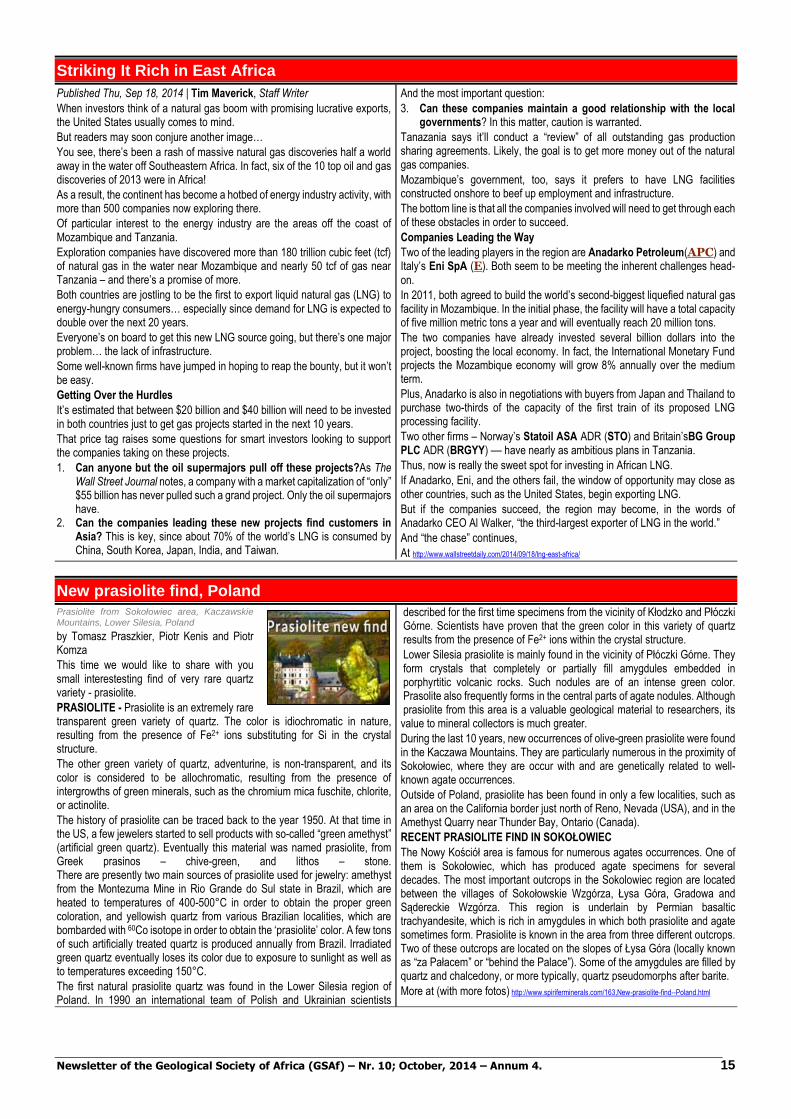
Newsletter of the Geological Society of Africa (GSAf) – Nr. 10; October, 2014 – Annum 4. 15
Striking It Rich in East Africa
Published Thu, Sep 18, 2014 | Tim Maverick, Staff Writer When investors think of a natural gas boom with promising lucrative exports, the United States usually comes to mind.
But readers may soon conjure another image…
You see, there’s been a rash of massive natural gas discoveries half a world away in the water off Southeastern Africa. In fact, six of the 10 top oil and gas discoveries of 2013 were in Africa!
As a result, the continent has become a hotbed of energy industry activity, with more than 500 companies now exploring there.
Of particular interest to the energy industry are the areas off the coast of Mozambique and Tanzania.
Exploration companies have discovered more than 180 trillion cubic feet (tcf) of natural gas in the water near Mozambique and nearly 50 tcf of gas near Tanzania – and there’s a promise of more.
Both countries are jostling to be the first to export liquid natural gas (LNG) to energy-hungry consumers… especially since demand for LNG is expected to double over the next 20 years.
Everyone’s on board to get this new LNG source going, but there’s one major problem… the lack of infrastructure.
Some well-known firms have jumped in hoping to reap the bounty, but it won’t be easy.
Getting Over the Hurdles
It’s estimated that between $20 billion and $40 billion will need to be invested in both countries just to get gas projects started in the next 10 years. That price tag raises some questions for smart investors looking to support the companies taking on these projects.
1. Can anyone but the oil supermajors pull off these projects?As The Wall Street Journal notes, a company with a market capitalization of “only” $55 billion has never pulled such a grand project. Only the oil supermajors have.
2. Can the companies leading these new projects find customers in Asia? This is key, since about 70% of the world’s LNG is consumed by China, South Korea, Japan, India, and Taiwan.
And the most important question:
3. Can these companies maintain a good relationship with the local governments? In this matter, caution is warranted.
Tanazania says it’ll conduct a “review” of all outstanding gas production sharing agreements. Likely, the goal is to get more money out of the natural gas companies.
Mozambique’s government, too, says it prefers to have LNG facilities constructed onshore to beef up employment and infrastructure.
The bottom line is that all the companies involved will need to get through each of these obstacles in order to succeed.
Companies Leading the Way
Two of the leading players in the region are Anadarko Petroleum(APC) and Italy’s Eni SpA (E). Both seem to be meeting the inherent challenges head-
on. In 2011, both agreed to build the world’s second-biggest liquefied natural gas facility in Mozambique. In the initial phase, the facility will have a total capacity of five million metric tons a year and will eventually reach 20 million tons.
The two companies have already invested several billion dollars into the project, boosting the local economy. In fact, the International Monetary Fund projects the Mozambique economy will grow 8% annually over the medium term.
Plus, Anadarko is also in negotiations with buyers from Japan and Thailand to purchase two-thirds of the capacity of the first train of its proposed LNG processing facility.
Two other firms – Norway’s Statoil ASA ADR (STO) and Britain’sBG Group PLC ADR (BRGYY) –– have nearly as ambitious plans in Tanzania.
Thus, now is really the sweet spot for investing in African LNG.
If Anadarko, Eni, and the others fail, the window of opportunity may close as other countries, such as the United States, begin exporting LNG.
But if the companies succeed, the region may become, in the words of Anadarko CEO Al Walker, “the third-largest exporter of LNG in the world.”
And “the chase” continues,
At http://www.wallstreetdaily.com/2014/09/18/lng-east-africa/
New prasiolite find, Poland Prasiolite from Sokołowiec area, Kaczawskie
Mountains, Lower Silesia, Poland
by Tomasz Praszkier, Piotr Kenis and Piotr Komza This time we would like to share with you small interestesting find of very rare quartz variety - prasiolite.
PRASIOLITE - Prasiolite is an extremely rare transparent green variety of quartz. The color is idiochromatic in nature, resulting from the presence of Fe2+ ions substituting for Si in the crystal structure.
The other green variety of quartz, adventurine, is non-transparent, and its color is considered to be allochromatic, resulting from the presence of intergrowths of green minerals, such as the chromium mica fuschite, chlorite, or actinolite.
The history of prasiolite can be traced back to the year 1950. At that time in the US, a few jewelers started to sell products with so-called “green amethyst” (artificial green quartz). Eventually this material was named prasiolite, from Greek prasinos – chive-green, and lithos – stone. There are presently two main sources of prasiolite used for jewelry: amethyst from the Montezuma Mine in Rio Grande do Sul state in Brazil, which are heated to temperatures of 400-500°C in order to obtain the proper green coloration, and yellowish quartz from various Brazilian localities, which are bombarded with 60Co isotope in order to obtain the ‘prasiolite’ color. A few tons of such artificially treated quartz is produced annually from Brazil. Irradiated green quartz eventually loses its color due to exposure to sunlight as well as to temperatures exceeding 150°C.
The first natural prasiolite quartz was found in the Lower Silesia region of Poland. In 1990 an international team of Polish and Ukrainian scientists
described for the first time specimens from the vicinity of Kłodzko and Płóczki Górne. Scientists have proven that the green color in this variety of quartz results from the presence of Fe2+ ions within the crystal structure.
Lower Silesia prasiolite is mainly found in the vicinity of Płóczki Górne. They form crystals that completely or partially fill amygdules embedded in porphyrtitic volcanic rocks. Such nodules are of an intense green color. Prasolite also frequently forms in the central parts of agate nodules. Although prasiolite from this area is a valuable geological material to researchers, its value to mineral collectors is much greater.
During the last 10 years, new occurrences of olive-green prasiolite were found in the Kaczawa Mountains. They are particularly numerous in the proximity of Sokołowiec, where they are occur with and are genetically related to well-known agate occurrences.
Outside of Poland, prasiolite has been found in only a few localities, such as an area on the California border just north of Reno, Nevada (USA), and in the Amethyst Quarry near Thunder Bay, Ontario (Canada).
RECENT PRASIOLITE FIND IN SOKOŁOWIEC
The Nowy Kościół area is famous for numerous agates occurrences. One of them is Sokołowiec, which has produced agate specimens for several decades. The most important outcrops in the Sokolowiec region are located between the villages of Sokołowskie Wzgórza, Łysa Góra, Gradowa and Sądereckie Wzgórza. This region is underlain by Permian basaltic trachyandesite, which is rich in amygdules in which both prasiolite and agate sometimes form. Prasiolite is known in the area from three different outcrops. Two of these outcrops are located on the slopes of Łysa Góra (locally known as “za Pałacem” or “behind the Palace”). Some of the amygdules are filled by quartz and chalcedony, or more typically, quartz pseudomorphs after barite.
More at (with more fotos) http://www.spiriferminerals.com/163,New-prasiolite-find--Poland.html
Newsletter of the Geological Society of Africa (GSAf) – Nr. 10; October, 2014 – Annum 4. 16
Tooth buried in bone shows prehistoric predators tangled across land, sea Teeth from phytosaurs, a reptile from the Triassic
Period about 210 million years ago in what is now the western United States. The blue tooth on the left is a 3-D printed replica of a tooth embedded in the thigh bone of a rauisuchid, another Triassic period carnivore. The details of the tooth were digitally extracted using CT scans. Credit: Virginia Tech
30.09.2014.
About 210 million years ago when the supercontinent of Pangea was starting to break up and dog-sized dinosaurs were hiding from nearly everything, entirely different kinds of reptiles called phytosaurs and rauisuchids were at the top of the food chain.
It was widely believed the two top predators didn't interact much as the former was king of the water, and the latter ruled the land. But those ideas are changing, thanks largely to the contents of a single bone. In a paper published online in September in the German journal Naturwissenschaften, Stephanie Drumheller of the University of Tennessee and Michelle Stocker and Sterling Nesbitt, vertebrate paleontologists with the Virginia Tech's Department of Geosciences, present evidence the two creatures not only interacted, but did so on purpose.
"Phytosaurs were thought to be dominant aquatic predators because of their large size and similarity to modern crocodylians," said Stocker, "but we were able
to provide the first direct evidence they targeted both aquatic and large terrestrial prey."
The evidence? A tooth. Not just any tooth, but the tooth of a phytosaur lodged in the thigh bone of a rauisuchid, a creature about 25 feet long and 4 feet high at the hip. The tooth lay broken off and buried about two inches deep in bone, and then healed over, indicating the rauisuchid survived the attack.
"Finding teeth embedded directly in fossil bone is very, very rare," Drumheller said. "This is the first time it's been identified among phytosaurs, and it gives us a smoking gun for interpreting this set of bite marks."
The researchers came across the bone by chance at the University of California Museum of Paleontology in Berkeley.
"It was remarkable we were able to reconstruct a part of an ancient food web from over 210 million years ago from a few shallow marks and a tooth in a bone," said Nesbitt. "It goes to show how careful observation can lead to important discoveries even when you're not seeking those answers.
"We came across this bone and realized pretty quickly we had something special," Nesbitt said. "There are many bones that get dug up, not all are immediately processed, prepared, and studied. No one had recognized the importance of this specimen before but we were able to borrow it and make our study."
Note: The above story is based on materials provided by Virginia Tech.
More at http://www.geologypage.com/2014/09/tooth-buried-in-bone-shows-prehistoric.html
Living in the Anthropocene - The Age of Humans Pack ice and fjord walls with sedimentary
strata. (Frans Lanting/Corbis)
Have Humans Really Created a New Geologic Age?
We are living in the Anthropocene. But no one can agree when it started or how human activity will be preserved
By Victoria Jaggard, SMITHSONIAN.COM, 2014.09.30
If you know how to read it, the face of a cliff can be as compelling as the latest bestselling novel. Each layer of rock is a chapter in Earth’s history, telling stories of birth and death, winners and losers that help scientists understand the evolution of the planet over the past 4.6 billion years.
While humans arrived only recently on geologic time scales, our species already seems to be driving some major plot developments. Agriculture occupies about one-third of Earth's land. The atmosphere and oceans are filling up with chemical signatures of our industrial activity. Whole ecosystems have been reshaped as species are domesticated, transplanted or wiped out.
These changes have become so noticeable on a global scale that many scientists believe we have started a new chapter in Earth’s story: the Anthropocene. Atmospheric chemist Paul Crutzen popularized the term in the early 2000s, and it has become engrained in the scientific vernacular. But don’t ask what the Anthropocene technically means unless you’re in the mood for some drama.
“It’s not research, it is diplomacy. It’s not necessary for geologists,” says Lucy Edwards, a researcher with the U.S. Geological Survey. Others think there is a case to be made for at least trying to codify the Anthropocene, because it is forcing the global community to think about the true extent of human influence. "It focuses us on trying to work out how we measure the relative control of humans as opposed to nature," says Tony Brown, a physical geographer at the University of Southampton in the United Kingdom.
"For example, is human activity altering the rate of uplift of mountains? If you had asked that question 20 years ago, geologists would have looked at you as if you were mad," says Brown. "But we know some faults are lubricated by precipitation, so if we are altering global precipitation patterns, there is a slight chance of a link. If that is the case that is quite a profound potential interaction between humans and their environment."
The International Commission on Stratigraphy—the ruling body that sets formal boundaries on geologic ages—has set up a working group to study the case for making the Anthropocene official. The crux of the debate is where to place the starting boundary line, or base. Geologists continue to tinker with the bases for well-established epochs, eras and ages, and there is usually a relatively wide margin of error. "Even the most precisely defined, the end of the Cretaceous 66 million years ago, is plus or minus 3,000 years. This is minute in geological terms but very big in humans’ terms," says Brown.
More at http://www.smithsonianmag.com/science-nature/have-humans-really-created-new-geologic-age-
180952865/?utm_source=facebook.com&no-ist
Prehistoric volcanic eruption leaves intercontinental footprint
A new study led by University of Alberta researchers has shown that a volcanic eruption 1,200 years ago scattered ash from Alaska to Europe—a discovery that will help researchers understand how future eruptions could affect the world.
Britta Jensen and Duane Froese in the U of A's Faculty of Science led the research, which showed that a distinct deposit of white, sand-sized grains of volcanic ash visible just below the modern forest floor over much of the Yukon and southern Alaska is present not only near the originating Mount Bona-Churchill in Alaska, but also in the Greenland Ice Sheet and across northwestern Europe.
The deposit, commonly known as the White River Ash, is so prominent that locals sometimes refer to it as "Sam McGee's Ashes" in reference to the Robert Service poem.
As part of the study, samples of the White River Ash, along with ash previously assumed to be from Iceland, were gathered from northern Canada, eastern North America, Greenland, Northern Ireland and Germany. By comparing characteristic features of these samples, the researchers showed that all of
the ash originated from the same large prehistoric volcanic eruption in Alaska about 1,200 years ago.
Ash beds, known as tephra, are important to researchers because they take just days to weeks to deposit—which creates precise links between geologic records. As a result, each ash bed represents a specific moment in time, and provides important insights into the frequency and effects of moderate to large volcanic eruptions.
Although it was generally thought that only rare "super eruptions" were capable of spreading volcanic ash across more than one continent—only the exceptional eruption of Toba (Indonesia), which occurred 75,000 years ago, has a proven ash distribution equal to the White River Ash—Jensen says this research illustrates that more frequent and moderate-sized eruptions can also lead to intercontinental distribution.
Note : The above story is based on materials provided by University of Alberta
More at http://www.geologypage.com/2014/09/prehistoric-volcanic-eruption-leaves.html
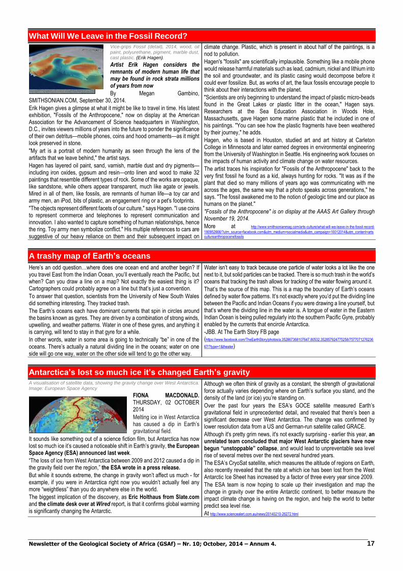
Newsletter of the Geological Society of Africa (GSAf) – Nr. 10; October, 2014 – Annum 4. 17
What Will We Leave in the Fossil Record? Vice-grips Fossil (detail), 2014, wood, oil
paint, polyurethane, pigment, marble dust, cast plastic. (Erik Hagen).
Artist Erik Hagen considers the remnants of modern human life that may be found in rock strata millions of years from now
By Megan Gambino, SMITHSONIAN.COM, September 30, 2014.
Erik Hagen gives a glimpse at what it might be like to travel in time. His latest exhibition, "Fossils of the Anthropocene," now on display at the American Association for the Advancement of Science headquarters in Washington, D.C., invites viewers millions of years into the future to ponder the significance of their own detritus—mobile phones, coins and hood ornaments—as it might look preserved in stone.
"My art is a portrait of modern humanity as seen through the lens of the artifacts that we leave behind," the artist says.
Hagen has layered oil paint, sand, varnish, marble dust and dry pigments—including iron oxides, gypsum and resin—onto linen and wood to make 32 paintings that resemble different types of rock. Some of the works are opaque, like sandstone, while others appear transparent, much like agate or jewels. Mired in all of them, like fossils, are remnants of human life—a toy car and army men, an iPod, bits of plastic, an engagement ring or a pet's footprints.
"The objects represent different facets of our culture," says Hagen. "I use coins to represent commerce and telephones to represent communication and innovation. I also wanted to capture something of human relationships, hence the ring. Toy army men symbolize conflict." His multiple references to cars are suggestive of our heavy reliance on them and their subsequent impact on
climate change. Plastic, which is present in about half of the paintings, is a nod to pollution.
Hagen's "fossils" are scientifically implausible. Something like a mobile phone would release harmful materials such as lead, cadmium, nickel and lithium into the soil and groundwater, and its plastic casing would decompose before it could ever fossilize. But, as works of art, the faux fossils encourage people to think about their interactions with the planet.
"Scientists are only beginning to understand the impact of plastic micro-beads found in the Great Lakes or plastic litter in the ocean," Hagen says. Researchers at the Sea Education Association in Woods Hole, Massachusetts, gave Hagen some marine plastic that he included in one of his paintings. "You can see how the plastic fragments have been weathered by their journey," he adds.
Hagen, who is based in Houston, studied art and art history at Carleton College in Minnesota and later earned degrees in environmental engineering from the University of Washington in Seattle. His engineering work focuses on the impacts of human activity and climate change on water resources.
The artist traces his inspiration for "Fossils of the Anthropocene" back to the very first fossil he found as a kid, always hunting for rocks. "It was as if the plant that died so many millions of years ago was communicating with me across the ages, the same way that a photo speaks across generations," he says. "The fossil awakened me to the notion of geologic time and our place as humans on the planet."
"Fossils of the Anthropocene" is on display at the AAAS Art Gallery through November 19, 2014.
More at http://www.smithsonianmag.com/arts-culture/what-will-we-leave-in-the-fossil-record-
180952666/?utm_source=facebook.com&utm_medium=socialmedia&utm_campaign=10012014&utm_content=artscultureanthropocenefossils
A trashy map of Earth’s oceans
Here’s an odd question…where does one ocean end and another begin? If you travel East from the Indian Ocean, you’ll eventually reach the Pacific, but when? Can you draw a line on a map? Not exactly the easiest thing is it? Cartographers could probably agree on a line but that’s just a convention.
To answer that question, scientists from the University of New South Wales did something interesting. They tracked trash.
The Earth’s oceans each have dominant currents that spin in circles around the basins known as gyres. They are driven by a combination of strong winds, upwelling, and weather patterns. Water in one of these gyres, and anything it is carrying, will tend to stay in that gyre for a while.
In other words, water in some area is going to technically “be” in one of the oceans. There’s actually a natural dividing line in the oceans; water on one side will go one way, water on the other side will tend to go the other way.
Water isn’t easy to track because one particle of water looks a lot like the one next to it, but solid particles can be tracked. There is so much trash in the world’s oceans that tracking the trash allows for tracking of the water flowing around it.
That’s the source of this map. This is a map the boundary of Earth’s oceans defined by water flow patterns. It’s not exactly where you’d put the dividing line between the Pacific and Indian Oceans if you were drawing a line yourself, but that’s where the dividing line in the water is. A tongue of water in the Eastern Indian Ocean is being pulled regularly into the southern Pacific Gyre, probably enabled by the currents that encircle Antarctica.
-JBB. At The Earth Story FB page (https://www.facebook.com/TheEarthStory/photos/a.352867368107647.80532.352857924775258/7577071276236
67/?type=1&theater)
Antarctica’s lost so much ice it’s changed Earth’s gravity A visualisation of satellite data, showing the gravity change over West Antarctica. Image: European Space Agency
FIONA MACDONALD. THURSDAY, 02 OCTOBER 2014
Melting ice in West Antarctica has caused a dip in Earth’s gravitational field.
It sounds like something out of a science fiction film, but Antarctica has now lost so much ice it’s caused a noticeable shift in Earth’s gravity, the European Space Agency (ESA) announced last week.
“The loss of ice from West Antarctica between 2009 and 2012 caused a dip in the gravity field over the region,” the ESA wrote in a press release.
But while it sounds extreme, the change in gravity won’t affect us much - for example, if you were in Antarctica right now you wouldn’t actually feel any more “weightless” than you do anywhere else in the world.
The biggest implication of the discovery, as Eric Holthaus from Slate.com and the climate desk over at Wired report, is that it confirms global warming is significantly changing the Antarctic.
Although we often think of gravity as a constant, the strength of gravitational force actually varies depending where on Earth’s surface you stand, and the density of the land (or ice) you’re standing on.
Over the past four years the ESA’s GOCE satellite measured Earth’s gravitational field in unprecedented detail, and revealed that there’s been a significant decrease over West Antarctica. The change was confirmed by lower resolution data from a US and German-run satellite called GRACE.
Although it's pretty grim news, it's not exactly surprising - earlier this year, an unrelated team concluded that major West Antarctic glaciers have now begun “unstoppable” collapse, and would lead to unpreventable sea level rise of several metres over the next several hundred years.
The ESA’s CryoSat satellite, which measures the altitude of regions on Earth, also recently revealed that the rate at which ice has been lost from the West Antarctic Ice Sheet has increased by a factor of three every year since 2009.
The ESA team is now hoping to scale up their investigation and map the change in gravity over the entire Antarctic continent, to better measure the impact climate change is having on the region, and help the world to better predict sea level rise.
At http://www.sciencealert.com.au/news/20140210-26272.html
Newsletter of the Geological Society of Africa (GSAf) – Nr. 10; October, 2014 – Annum 4. 18
Previously unseen details of seafloor exposed in new map A new seafloor map reveals new details on
earthquakes (red dots), seafloor spreading ridges, and faults. Credit: Image courtesy of University of California - San Diego
October 2, 2014. University of California - San Diego
Accessing two previously untapped streams of satellite data, scientists at Scripps Institution of Oceanography at UC San Diego and their colleagues have created a new map of the world's seafloor, creating a much more vivid picture of the structures that make up the deepest, least-explored parts of the ocean. Thousands of previously uncharted mountains rising from the seafloor and new clues about the formation of the continents have emerged through the new map, which is twice as accurate as the previous version produced nearly 20 years ago.
Developed using a scientific model that captures gravity measurements of the ocean seafloor, the new map extracts data from the European Space Agency's (ESA) CryoSat-2 satellite, which primarily captures polar ice data but also operates continuously over the oceans, and Jason-1, NASA's satellite that was redirected to map the gravity field during the last year of its 12-year mission.
Combined with existing data and drastically improved remote sensing instruments, the new map, described in the journal Science, has revealed details of thousands of undersea mountains, or seamounts, extending a kilometer or more from the ocean bottom. The new map also gives geophysicists new tools to investigate ocean spreading centers and little-studied remote ocean basins.
"The kinds of things you can see very clearly now are abyssal hills, which are the most common land form on the planet," said David Sandwell, lead scientist of the paper and a geophysics professor in the Cecil H. and Ida M. Green Institute of Geophysics and Planetary Physics (IGPP) at Scripps.
The authors of the study say the map provides a new window into the tectonics of the deep oceans. Previously unseen features in the map include newly
exposed continental connections across South America and Africa, and new evidence for seafloor spreading ridges at the Gulf of Mexico that were active 150 million years ago and are now buried by mile-thick layers of sediment.
"One of the most important uses of this new marine gravity field will be to improve the estimates of seafloor depth in the 80 percent of the oceans that remains uncharted or is buried beneath thick sediment," the authors say in the report.
"Although CryoSat-2's primary mission is in the cryosphere, we knew as soon as we selected its orbit that it would be invaluable for marine geodesy, and this work proves the point," said Richard Francis, a coauthor of the paper and project manager for the development of CryoSat-2 at the European Space Agency, and honorary professor in the Department of Earth Sciences at University College London.
The new map also provides the foundation for the upcoming new version of Google's ocean maps to fill large voids between shipboard depth profiles.
"The team has developed and proved a powerful new tool for high-resolution exploration of regional seafloor structure and geophysical processes," says Don Rice, program director in the National Science Foundation's (NSF) Division of Ocean Sciences. "This capability will allow us to revisit unsolved questions and to pinpoint where to focus future exploratory work."
"The use of satellite altimeter data and Sandwell's improved data processing technique provides improved estimates of marine gravity and bathymetry world-wide, including in remote areas," said Joan Cleveland, Office of Naval Research (ONR) deputy director, Ocean Sensing and Systems Division. "Accurate bathymetry and identifying the location of seamounts are important to safe navigation for the U.S. Navy."
The map can be accessed at: http://topex.ucsd.edu/grav_outreach/
At http://www.sciencedaily.com/releases/2014/10/141002141801.htm?utm_source=feedburner&utm_medium=email&utm_campaign=Feed%3A+sciencedaily%2Fearth_climate+%28Earth+%26+Climate+News+--+ScienceDaily%29
Strange formation on Colorado Rockies sheds light on Earth's past Central Colorado’s Tava sandstone (light-colored band of rock at center, with geology student for scale) probably formed between 680 million and 800 million years ago, a new study suggests. Siddoway and Gehrels, Lithosphere (2014)
In the Front Range of the Colorado Rockies, smack in the middle of a cliff that overlooks U.S. Highway 24, resides a very unusual geological formation. This reddish gray, sharp-edged, and erosion-resistant swath of
sandstone stands in stark contrast to the crumbling, heavily weathered granites that lie on either side. Now, scientists say they have narrowed down when this anomaly and others like it in this region formed—a discovery that may give researchers new clues about the breakup of an ancient supercontinent hundreds of millions of years ago.
Many outcrops of the “Tava sandstone”—derived from a Native American name for Pikes Peak, a local landmark—are found along the Ute Pass fault, which runs along the Front Range near Colorado Springs. First noted by geologists more than 130 years ago, these deposits have long been recognized as strange, says Christine Siddoway, a geologist at Colorado College, Colorado Springs. Many sandstone formations show layers of some type, signs they were laid down over time in distinct episodes by wind or flowing water. But the individual grains in the Tava sandstone, which typically are bits of quartz measuring from 125 to 250 micrometers across, are well mixed, and they’re peppered with larger bits of quartz up to 3 millimeters in diameter. Once free-flowing but now firmly cemented together with an iron-bearing mineral called hematite, the sand grains were apparently injected into cracks in ancient granite—some of them as much as 6 meters wide—under high pressure. The now-solid Tava deposits apparently flowed from vast reservoirs of once-waterlogged sand, some of them containing more than 1 million cubic meters of material.\“This is a very unusual [sandstone],” says Arlo Weil, a structural geologist at Bryn Mawr College in Pennsylvania, who wasn’t involved in the new study. “It must have been formed by a very rapid, chaotic process.”
The Tava sandstone is unusual for another reason: It may be the only large-scale deposit in the world where sedimentary rocks such as sandstone have been
injected into crystalline rocks such as granite, Siddoway says. Normally, molten material flows into cracks in sedimentary rocks and then solidifies, she explains.
For well over a century, geologists have debated the age of the Tava sandstone, Siddoway notes. Although the deposit obviously must be younger than the surrounding granite, which has an estimated age between 1.03 billion and 1.09 billion years, some teams have suggested that the Tava sandstone might have formed as recently as 280 million years ago. Now, analyses by Siddoway and George Gehrels, a geologist at the University of Arizona (UA) in Tucson, shed new light on when the deposits may have formed.
For their study, the researchers analyzed samples of Tava sandstone collected at six sites near Colorado Springs. First, they extracted between 100 and 125 tiny zircons—tiny bits of erosion- and chemical-resistant mineral—from each sample. Then they used uranium/lead dating to determine the age of each zircon (the time when its parent rock crystallized). Most of the zircons were between 1.33 billion and 970 million years old, and none were younger than 850 million years old, Siddoway says. Sometime after the zircons crystallized, possibly millions of years later, these bits of mineral eroded out of their parent rock and ultimately ended up being washed or blown into what is now central Colorado. So although the zircon ages provide clues to the age of the Tava sandstone, they aren’t definitive.
To help narrow the range of possible ages for the sandstone, Siddoway and Gehrels compared the age distributions of the Tava zircons with the age distributions of zircons found in other sandstone formations in Colorado, Utah, northern Arizona, and southern California. Statistically, the Tava distribution most closely matched the patterns in sandstones that had been deposited between 680 million and 800 million years ago, the researchers will report in an upcoming issue of Lithosphere.
The paper’s results are “strong, compelling evidence that this age range [for the sandstone’s deposition] is correct,” says Peter Reiners, a geophysicist at UA who was not involved in the new study.
Note : The above story is based on materials provided by Sid Perkins "American Association for the Advancement of Science."
More at http://www.geologypage.com/2014/09/strange-formation-on-colorado-rockies.html

Newsletter of the Geological Society of Africa (GSAf) – Nr. 10; October, 2014 – Annum 4. 19
China to build comprehensive earth observation system in 10 years
Sep 28, 2014. BEIJING: China plans to build an earth observation system that integrates use of air, space and ground based technology, including drones, satellites and GPS systems in the next ten years, a top official said today.
China has already built a network of satellites and other facilities for earth observation in pursuing its space programs including manned space navigation, lunar probe and Beidou GPS navigation system but officials said much remains to be done in the actual application of the technology.
Remote sensing via satellites and other technology has played an important role in the national economic and social development, Xu Dazhe, head of the State Administration of Science, Technology and Industry for National Defence, was quoted as saying by the state-run Xinhua news agency.
The administration will promote the construction of a high-definition earth observation system (EBS) and the spatial data infrastructure, he said.
The Beidou GPS network, operational in China since December 2011 has 16 navigation satellites providing GPS services across Asia-Pacific region.
China plans to increase this number to 30 satellites by 2020 to make it a comprehensive GPS which it hopes to market widely in the region including India.
"China's remote sensing satellites have been developed from the phase of experimental application to business service," Luo Ge, an official with the State Administration of Science, Technology and Industry for National Defence, said.
More at http://articles.economictimes.indiatimes.com/2014-09-28/news/54400544_1_foreign-satellites-navigation-gaofen-1
Underwater landslide doubled size of 2011 Japanese tsunami
03.10.2014. An ocean engineer at the University of Rhode Island has found that a massive underwater landslide, combined with the 9.0 earthquake, was responsible for triggering the deadly tsunami that struck Japan in March 2011.
Professor Stephan Grilli, an international leader in the study of tsunamis, said the generally accepted explanation for the cause of the tsunami had been the earthquake, the fifth largest ever measured, which created a significant uplift and subsidence of the seafloor. While that adequately explains the 10-meter surge that affected much of the impacted area, Grilli said it cannot account for the 40-meter waves that struck a 100-kilometer area of Japan's mountainous Sanriku Coast.
"Computer models have not been able to explain the large inundation and run-up on the Sanriku Coast using the earthquake alone," Grilli said. "Our model could only get inundation up to 16 or 18 meters, not 40. So we knew there must be another cause."
His findings were published this week in the journal Marine Geology.
In a series of models, Grilli and his former doctoral student Jeff Harris worked backwards in time to recreate the movement of the seafloor from the earthquake and concluded that an additional movement underwater about 100 kilometers north of the earthquake's epicenter must have occurred to propagate the large waves that struck Sanriku. So the URI engineers and
colleagues at the British Geological Survey and the University of Tokyo went looking for evidence that something else happened there.
Reviewing surveys of the seafloor conducted by Japanese scientists before and after the earthquake, the scientists found signs of a large slump on the seafloor -- a rotational landslide 40 kilometers by 20 kilometers in extent and 2 kilometers thick that traveled down the slope of the Japan Trench, leaving a horizontal footprint the size of Paris that could only have been created by a 100-meter uplift in the seafloor. The earthquake only raised the seafloor 10 meters.
"Underwater landslides tend to create shorter period tsunami waves, and they tend to concentrate their energy in a small stretch of coastline," said Grilli. "The train of waves from the landslide, combined with the earthquake generated waves, together created the 40 meter inundation along the Sanriku Coast."
Grilli said it has been difficult to convince his Japanese colleagues of his research group's results. Most assumed that the massive size of the earthquake was enough to create the waves that were observed.
Note : The above story is based on materials provided by University of Rhode Island.
More at http://www.geologypage.com/2014/10/underwater-landslide-doubled-size-of.html
Rating the planet's oceans
September 30, 2014. University of California - Santa Barbara
The most comprehensive assessment conducted by the Ocean Health Index rates Earth's oceans at 67 out of 100 in overall health. In addition, for the first time, the report assessed the Antarctic and the 15 ocean regions beyond national jurisdiction (high-seas areas) -- all critical regions for maintaining a healthy climate, safeguarding biodiversity and providing sustainable food sources.
In the third annual update of the index, a partnership led by scientists from UC Santa Barbara's National Center for Ecological Analysis and Synthesis (NCEAS) and Conservation International (CI), the Antarctic and the Southern Ocean region scored 72, while the average score of the high seas was 67 out of 100. These distant areas had not been included in earlier assessments because they required additional data.
Together with the 220 exclusive economic zones (EEZs) measured in 2012 and 2013, the index now measures all of the oceans on planet Earth. The overall score for global EEZ, accounting for modification and updates of data and methods, was 67 in the first two years and 68 in 2014. These EEZs along with the inclusion of the high seas and Antarctica and the Southern Ocean assessments begin to provide a more complete picture of ocean health, even though most of those areas are not yet adequately studied.
"During our first two years, we were able to show the health of the oceans within 200 nautical miles of coastlines, but it was like doing a jigsaw puzzle where you put the edges together first," said Ben Halpern, professor at UCSB's Bren School of Environmental Science and Management and an NCEAS associate. "Filling in the rest of the puzzle with Antarctica and the high seas completes the picture and is a major step toward better understanding the state of our entire oceans."
For the Antarctic and Southern Ocean the eight goals assessed were Food Production (55), Natural Products (29), Coastal Protection (99), Economies
and Livelihoods (83), Tourism and Recreation (55), Sense of Place (46), Coastal Protection (99), Clean Water (100) and Biodiversity (94).
"The Antarctic's biodiversity score of 94 out of 100 is encouraging, but it is based on data from only 132 species that have been formally assessed," said Catherine Longo, project scientist at NCEAS and lead scientist of the Antarctica assessment.
"Antarctica and the Southern Ocean are protected by distance from many of the threats caused by human populations, such as chemicals, excessive nutrients, and pathogens and trash," noted Greg Stone, chief scientist and executive vice president of the Moore Center for Science and Oceans at Conservation International. "That's why we see a very high score in a goal like Clean Water."
"The score of 100 that is set as a target for each goal reflects a status that is feasible to achieve and can sustainably produce maximum benefits now and in the future," added Steve Katona, managing director for the Ocean Health Index. "Any score below 100 means there is room for improvement."
The high seas assessment included three goals and subgoals: Fisheries, Iconic Species and Biodiversity (measured as the threat of extinction to all assessed species). "The high seas are home to important fisheries for species such as tuna and provide habitat or migratory pathways for iconic species such as whales, sharks and sea turtles," said Elizabeth Selig, conservation scientist with CI and the lead scientist on the high-seas assessment. "Like the Antarctic assessment, the vast size and remoteness of the high seas has limited our ability to study all of the habitats and organisms present, so the biodiversity scores for these regions were based only on species whose populations have been formally assessed."
More at http://www.sciencedaily.com/releases/2014/09/140930160711.htm?utm_source=feedburner&utm_medium=email&utm_campaign=Feed%3A+sciencedaily%2Fearth_climate+%28Earth+%26+Climate+News+--+ScienceDaily%29
More accurate model for greenhouse gases from peatlands

Newsletter of the Geological Society of Africa (GSAf) – Nr. 10; October, 2014 – Annum 4. 20
October 3, 2014. DOE/Argonne National Laboratory
Scientists at the U.S. Department of Energy's Argonne National Laboratory have created a new model to more accurately describe the greenhouse gases likely to be released from Arctic peatlands as they warm. Their findings, based on modeling how oxygen filters through soil, suggest that previous models probably underestimated methane emissions and overrepresented carbon dioxide emissions from these regions.
Peatlands, common in the Arctic, are wetlands filled with dead and decaying organic matter. They are the result of millions of years of plants dying and breaking down into rich soil, so they contain a massive amount of carbon.
"Peatlands cover about four percent of all land, but they hold 20 percent of all carbon stored on land," said Argonne scientist Zhaosheng Fan, who led the study.
Cold temperatures keep the carbon locked in the soil. As the ground warms, however, microbes come to life and begin to decompose all that organic matter, which releases carbon into the atmosphere.
Unfortunately, the extreme northern regions of the world are where warming has accelerated the most quickly -- and it's expected to pick up in the future. Scientists are concerned that Arctic warming could spiral quickly into a self-reinforcing cycle that dumps an enormous amount of carbon into the atmosphere.
Scientists create complex models to estimate how this might unfold, combining data taken on the ground with varying emissions scenarios to forecast climate change far into the future.
One area of particular interest is which form of carbon will be released. Microbes can create either CO2 or methane, and each gas has different effects on the atmosphere. CO2 is a long-lived greenhouse gas, staying in the atmosphere for up to a century or more. Methane delivers a powerful punch -- its impact is about 20 times greater than CO2 -- but filters out of the atmosphere in about 12 years. Accurately predicting how much of each gas will be released, therefore, is important.
Down in the ground, the conditions that microbes find themselves in will affect what form of carbon they release. If there's a lot of oxygen and water available, microbes will only produce CO2. If there isn't enough oxygen, they will produce methane and CO2.
Up until now, researchers had been using a simple model that assumed water was the primary divider; soil above the water table would produce microbes that made CO2, and microbes below would produce methane.
"But experiments had been showing that there could be significant limits on oxygen availability above the water table, and this would affect what form of carbon microbes release," Fan said.
More at http://www.sciencedaily.com/releases/2014/10/141003214355.htm?utm_source=feedburner&utm_medium=email&utm_campaign=Feed%3A+sciencedaily%2Fearth_climate+%28Earth+%26+Climate+News+--+ScienceDaily%29
Earth's ocean abyss has not warmed, NASA study finds
October 6, 2014. NASA/Jet Propulsion Laboratory
The cold waters of Earth's deep ocean have not warmed measurably since 2005, according to a new NASA study, leaving unsolved the mystery of why global warming appears to have slowed in recent years.
Scientists at NASA's Jet Propulsion Laboratory in Pasadena, California, analyzed satellite and direct ocean temperature data from 2005 to 2013 and found the ocean abyss below 1.24 miles (1,995 meters) has not warmed measurably. Study coauthor Josh Willis of JPL said these findings do not throw suspicion on climate change itself.
"The sea level is still rising," Willis noted. "We're just trying to understand the nitty-gritty details."
In the 21st century, greenhouse gases have continued to accumulate in the atmosphere, just as they did in the 20th century, but global average surface air temperatures have stopped rising in tandem with the gases. The temperature of the top half of the world's ocean -- above the 1.24-mile mark -- is still climbing, but not fast enough to account for the stalled air temperatures.
Many processes on land, air and sea have been invoked to explain what is happening to the "missing" heat. One of the most prominent ideas is that the bottom half of the ocean is taking up the slack, but supporting evidence is slim. This latest study is the first to test the idea using satellite observations, as well as direct temperature measurements of the upper ocean. Scientists have been taking the temperature of the top half of the ocean directly since 2005, using a network of 3,000 floating temperature probes called the Argo array.
"The deep parts of the ocean are harder to measure," said JPL's William Llovel, lead author of the study, published Sunday, Oct. 5 in the journal Nature Climate Change. "The combination of satellite and direct temperature data gives us a glimpse of how much sea level rise is due to deep warming. The answer is -- not much."
The study took advantage of the fact that water expands as it gets warmer. The sea level is rising because of this expansion and water added by glacier and ice sheet melt.
To arrive at their conclusion, the JPL scientists did a straightforward subtraction calculation, using data for 2005 to 2013 from the Argo buoys, NASA's Jason-1 and Jason-2 satellites, and the agency's Gravity Recovery and Climate Experiment (GRACE) satellites. From the total amount of sea level rise, they subtracted the amount of rise from the expansion in the upper ocean, and the amount of rise that came from added meltwater. The remainder represented the amount of sea level rise caused by warming in the deep ocean.
The remainder was essentially zero. Deep ocean warming contributed virtually nothing to sea level rise during this period.
Coauthor Felix Landerer of JPL noted that during the same period, warming in the top half of the ocean continued unabated, an unequivocal sign that our planet is heating up. Some recent studies reporting deep-ocean warming were, in fact, referring to the warming in the upper half of the ocean but below the topmost layer, which ends about 0.4 mile (700 meters) down.
Landerer also is a coauthor of another paper in the same Nature Climate Changejournal issue on ocean warming in the Southern Hemisphere from 1970 to 2005. Before Argo floats were deployed, temperature measurements in the Southern Ocean were spotty, at best. Using satellite measurements and climate simulations of sea level changes around the world, the new study found the global ocean absorbed far more heat in those 35 years than previously thought -- a whopping 24 to 58 percent more than early estimates.
Both papers result from the work of the newly formed NASA Sea Level Change Team, an interdisciplinary group tasked with using NASA satellite data to improve the accuracy and scale of current and future estimates of sea level change. The Southern Hemisphere paper was led by three scientists at Lawrence Livermore National Laboratory in Livermore, California.
NASA monitors Earth's vital signs from land, air and space with a fleet of satellites and ambitious airborne and ground-based observation campaigns. NASA develops new ways to observe and study Earth's interconnected natural systems with long-term data records and computer analysis tools to better see how our planet is changing. The agency shares this unique knowledge with the global community and works with institutions in the United States and around the world that contribute to understanding and protecting our home planet.
For more information about NASA's Earth science activities in 2014, visit:http://www.nasa.gov/earthrightnow
For more information on ocean surface topography from space, visit:http://sealevel.jpl.nasa.gov
More information on NASA's GRACE satellites is available at: http://grace.jpl.nasa.gov
For more information on the Argo array, visit: http://www.argo.ucsd.edu/index.html
At http://www.sciencedaily.com/releases/2014/10/141006101043.htm?utm_source=feedburner&utm_medium=feed&utm_campaign=Feed%3A+sciencedaily%2Ftop_news%2Ftop_science+%28ScienceDaily%3A+Top+Science+News%29&utm_content=FaceBook

Newsletter of the Geological Society of Africa (GSAf) – Nr. 10; October, 2014 – Annum 4. 21
Major new fault found in New Zealand capital
A new geological fault capable of generating a 7.1-magnitude earthquake has been found in Wellington, confirming the New Zealand capital's status as one of the world's most seismically active cities, scientists revealed Wednesday.
Geologists from the official NIWA research agency said the Aotea fault began on the floor of Wellington Harbour and was believed to extend through the central city and southern suburbs.
NIWA marine geologist Philip Barnes said there was evidence that the most recent earthquake caused by the fault occurred about 6,200 years ago and it was impossible to know if another temblor was overdue. "We do believe that it has recurrence intervals of several thousand years," he told reporters. "We have no idea when it might rupture in the future."
New Zealand Prime Minister John Key said it was "fanciful" to suggest the country's capital should be moved because of the quake threat.
"It doesn't actually change anything—there are other big fault lines in Wellington," he told reporters.
"This just shows we're getting better at finding out where they are."
GeoNet earthquake geologist Russ Van Dissen said the latest discovery was just one of "dozens" of active faults crisscrossing the Wellington terrain, the biggest capable of generating an 8.5-magnitude tremor.
He said the city's existing building codes should deal with any quake from the new fault.
"There's no way of saying that a magnitude seven is inconsequential, it would be damaging," he said. "But the level of shaking for this fault, we anticipate, would be less than what this city's already designed for."
Van Dissen said there were probably more undiscovered faults beneath the city.
"How does it compare internationally? You've got the North Anatolian fault going right through Istanbul, there's a number of other cities, Tokyo, San Francisco, Los Angeles, Seattle that all have a significant active fault earthquake hazard," he said.
New Zealand, known colloquially as the Shaky Isles, lies on the boundary of the Australian and Pacific tectonic plates, forming part of the so-called "Ring of Fire", and experiences up to 15,000 tremors a year.
In 2011, a devastating 6.3-magnitude quake on a previously unknown fault in the South Island city of Christchurch killed 185 people—one of the nation's deadliest disasters of the modern era.
Wellington was the scene of the country's most powerful earthquake in 1855.
That 8.2-magnitude jolt changed the city's entire geography, pushing the shoreline out 200 metres (660 feet) as it thrust the harbour floor upwards, but only caused four deaths.
The capital has experienced three quakes measuring 6.3 or above since July last year, with little damage beyond items falling off shelves and cracked masonry.
Shaking from a 5.1 tremor on the other side of the North Island was felt in the city as recently as Monday, barely raising comment among locals.
Note : The above story is based on materials provided by © 2014 AFP At http://www.geologypage.com/2014/10/major-new-fault-found-in-new-zealand.html
Fatal landslides in the first seven months of 2014
6 October 2014. Posted by dr-dave
I have now analysed the data on fatal landslides (i.e. those that caused loss of life) for the first seven months of the year. This is the dataset that I’ve been collecting since 2002 (i.e. for over 12 years), and that I wrote up for my paper in Geology a couple of years ago (Petley 2012). This map shows the distribution of the landslides for the period January to July 2014
Each dot represents a single landslide that killed at least one person; there is no representation of how many people were killed in each event. The background image is a digital elevation model. As usual the map shows hotspots in South Asia, China, Indonesia and the Philippines, plus a scattering of landslide events elsewhere. There are slightly more landslides in Africa than normal.
In this seven month period I recorded 222 landslides that caused loss of life, resulting in 1466 deaths. The largest event occurred in Afghanistan in May, with about 500 deaths (although early reports suggested many more). The
average number of landslides in the first seven months of the year for the period 2003-2013 is 202, so at a little over halfway 2014 is slightly above average. At the same point in the last few years the totals were:- 2010: 303; 2011: 214; 2012: 220; 2013: 237. Of course the severity of the year in terms of landslides is defined by the period July to September, so I will need to analyse the more recent data to be able to determine this.
The fatality data shows much more inter-annual variation, but the average over the period 2003-2013 is 2318 lives lost, so in this respect 2014 is less severe than the previous decade or so.
Reference
Petley, D.N. 2012. Global patterns of loss of life from landslides. Geology 40 (10), 927-930.Petley, D.N. 2012. Global patterns of loss of life from
landslides. Geology 40 (10), 927-930.
At http://blogs.agu.org/landslideblog/2014/10/06/fatal-landslides-in-the-first-seven-months-of-2014/
Diverse microbes found deep beneath Antarctic ice sheet
By Deanna Conners Oct 08, 2014
Nearly 4,000 species of microorganisms were found in the cold, dark waters of Lake Whillans, which sits about half a mile below Antarctica’s ice sheet.
One of the “coolest” science papers to be published in 2014 was this summer’s announcement in the journal Nature that diverse microbes are thriving in a subglacial lake deep beneath the Antarctic ice sheet. Nearly 4,000 species of microorganisms were found in the cold, dark waters of Lake Whillans, which sits about half a mile below the surface of the ice. The presence of microbes in one of Earth’s harshest environments could have implications for discovering life elsewhere in the solar system.
On January 27, 2013, a research team led by John Priscu of Montana State University drilled successfully through 800 meters of ice (0.5 miles) to reach the waters of Lake Whillans, where they retrieved pristine samples of water and sediment. They used a hot water drilling system that was equipped with disinfectants, ultraviolet radiation, and filtration technologies to ensure that the samples were free of contamination. Samples of water and sediment were brought back to the laboratory and analyzed for the presence of microorganisms.
Back in the laboratory, scientists isolated the genetic material (ribosomal RNA gene sequences) and detected nearly 4,000 species of bacteria in the water and almost 2,500 species of bacteria in the sediment. Not only was the number of species high, but the total number of bacterial cells in the water was high
too—the density amounted to 130,000 cells per milliliter of water. Other tests confirmed that these microorganisms were metabolically active.
The findings were published in the journal Nature on August 21, 2014. Brent Christner, lead author of the new study, is a microbiologist at Louisiana State University. He commented on the high cell counts in a news article:
I think we were all surprised by that number. We’ve got lakes here on campus that we can take samples of and the numbers are about in that range.
Unlike microbial communities in sunlit lakes, which are fueled by photosynthesis, microbial communities in deep, dark waters are fueled by chemosynthetic processes. Indeed, many of the bacterial species detected in Lake Whillan appear to be similar to known chemoautotrophs that use iron, nitrogen, or sulfur compounds as energy sources.
Subglacial lakes in Antarctica consist of water that has melted from the underside of the ice sheet. Despite the frigid temperatures, melt water is produced at depth by heat supplied through geothermal energy and friction from ice flows. Since the 1990s, scientists have discovered about 400 subglacial lakes in Antarctica with the use of ice-penetrating radar technologies. Studies on other Antarctic subglacial lakes are being planned for the future.
More at http://earthsky.org/earth/diverse-microbes-found-deep-beneath-antarctic-ice-
sheet?utm_source=EarthSky+News&utm_campaign=cdc4d3e3bf-EarthSky_News&utm_medium=email&utm_term=0_c643945d79-cdc4d3e3bf-393647361

Newsletter of the Geological Society of Africa (GSAf) – Nr. 10; October, 2014 – Annum 4. 22
Geology professor presents CSG science at meeting
Thursday, 09 October 2014.
The University of Newcastle’s Institute of Resources and Energy has defended the coal seam gas industry at an information session in Narrabri this week.
Professor Bill Collins was invited by the Chamber of Commerce to give a scientific explanation of the industry, and answer questions from the audience of approximately 50 people.
His presentation looked at the geological formations implicated in CSG extraction and the structural integrity of bore pipeline casings.
Collins concluded that the risk of water leaking from the Gunnedah Basin where coal seam gas is extracted, into the Great Artesian Basin, was very low.
He also said mining has so far had a very small impact on land and water quality in NSW, compared to other existing industries.
Max Davis, whose property neighbours CSG operations in the Pilliga, felt the session was highly informative.
“I learnt quite a bit tonight, and I feel pretty confident with the explanation from an independent figure,” he said.
“I live two properties over from the Leewood site owned by Santos, and in a way I’m happy that they’ve taken over from Eastern Star Gas, because I was a bit concerned about some aspects of their operations.
“I haven’t signed an access agreement, I would just like to see it happen for Narrabri, to see the town grow, we’re deluding ourselves if we think we can exist on agriculture alone.”
Wee Waa landholder Victoria Hamilton was pleased that a strong emphasis was placed on the need for more sophisticated, centralised data collection to monitor the long term impacts of the coal seem gas industry.
She continues to harbour concerns about the development and believes some key pieces of the puzzle are still missing.
“There has to be cumulative impacts due to the above ground and below ground infrastructure that will be installed in an area of recharge for the Great Artesian Basin,” she said.
“It’s not fear mongering, it’s that we’ve got million dollar businesses that we are not going to put at risk, just so they can have 20 years of gas.
“All these people without concern are the ones who don’t have their businesses on the line.”
She also had reservations about the graphs and facts provided.
“There were graphs at the presentation showing the emission levels, but the industry hasn’t started her yet, it’s like saying ‘I’ve smoked for six weeks, but I haven’t got lung damage yet.’”
At http://www.thecourier.net.au/news-feed/item/2518-geology-professor-presents-csg-science-at-meeting
World's tectonic plate movement mapped
27.08.2014.
A group of geophysicists is testing the hypothesis that the rate of "supercontinent assembly"—or tectonic plate movement—changes over time.
Study co-author Professor Sergei Pisarevskiy says plate tectonics is the study of the horizontal movement of tectonic plates over the Earth's surface.
"This is not uniform movement," he says.
"Sometimes there are periods where there was very quick movement all together globally, and sometimes very slow movements.
"We try to analyse that and to populate the mean angular velocity of the average plate movements on the surface of the earth."
He has come to the tentative conclusion that the average rate of tectonic plate movement does change.
"Right now for example it's slower than it was half a billion years ago—but approximately the same as it was one and a half billion years ago," he says.
"But there are many problems to be resolved before the final answer.
"It's sort of half guessing I would say at this stage."
He says beside the uneven level of the same analysis in different countries, he and lead author Kent Condie are addressing various other problems.
One is the inconsistent rate at which plates appear to move, both individually and relative to each other.
"For example Africa moved very slowly for the last few hundred million years, on the other hand India as you probably know moved very fast," he says.
"When you calculate the average movement … of the continents of the earth you cannot just average the movement, the speed of a continent like Africa and some very small block like Madagascar for example.
"They must be weighted, so we normalise the speeds by the area of that particular continental block."
"When talking about the average speed, we also found some quieter periods, not exactly the periodicity but some maximums and minimums."
Another problem is the way in which evidence tends to deteriorate over time with more recent "overprints" creating statistical "noise".
"The older the rocks, the less information you will have," he says. "This noise increases—going back in time it's more difficult to extract this information."
They are also contending with the phenomena of "passive margins" between plates.
One of these is thought to exist beneath the ocean south of Australia—it shows little or no movement for at least a billion years.
"There are no major tectonisms here or seismicity, it's just accumulations of sediments mostly," he says.
More information: Kent Condie, Sergei A. Pisarevsky, Jun Korenaga, Steve Gardoll, "Is the rate of supercontinent assembly changing with time?", Precambrian Research, Available online 4 August 2014, ISSN 0301-9268, http://dx.doi.org/10.1016/j.precamres.2014.07.015
Note: The above story is based on materials provided by Science Network WA
More at http://www.geologypage.com/2014/08/worlds-tectonic-plate-movement-mapped.html
Composition of Earth's mantle revisited
27.08.2014. Research published last week in Science suggested that the makeup of Earth's lower mantle, which makes up the largest part of Earth by volume, is significantly different than previously thought.
The work, performed at the Advanced Photon Source at the U.S. Department of Energy's Argonne National Laboratory, will have a significant impact on our understanding of the lower mantle, scientists said. Understanding the composition of the mantle is essential to seismology, the study of earthquakes and movement below Earth's surface, and should shed light on unexplained seismic phenomena observed there.
Though humans haven't yet managed to drill further than seven and a half miles into Earth, we've built a comprehensive picture of what's beneath our feet through calculations and limited observation. We all live atop the crust, the thin outer layer; just beneath is the mantle, outer core and finally inner core. The lower portion of the mantle is the largest layer -- stretching from 400 to 1,800 miles below the surface -- and gives off the most heat. Until now, the entire lower mantle was thought to be composed of the same mineral throughout: ferromagnesian silicate, arranged in a type of structure called perovskite.
The pressure and heat of the lower mantle is intense -- more than 3,500° Fahrenheit. Materials may have very different properties at these conditions; structures may exist there that would collapse at the surface.
To simulate these conditions, researchers use special facilities at the Advanced Photon Source, where they shine high-powered lasers to heat up the sample inside a pressure cell made of a pair of diamonds. Then they aim powerful beams of X-rays at the sample, which hit and scatter in all directions. By gathering the scatter data, scientists can reconstruct how the atoms in the sample were arranged.
The team found that at conditions that exist below about 1,200 miles underground, the ferromagnesian silicate perovskite actually breaks into two separate phases. One contains nearly no iron, while the other is full of iron. The iron-rich phase, called the H-phase, is much more stable under these conditions.
Note : The above story is based on materials provided by DOE/Argonne National Laboratory. The original article was written by Louise Lerner.
At http://www.geologypage.com/2014/08/composition-of-earths-mantle-revisited.html

Newsletter of the Geological Society of Africa (GSAf) – Nr. 10; October, 2014 – Annum 4. 23
Gas leaks from faulty wells linked to contamination in some groundwater As researchers study hydraulic
fracturing, a team led by Thomas Darrah at The Ohio State University has identified a key source of groundwater contamination (labeled 5, center right) caused by faulty well casings. Credit: Image courtesy of Thomas Darrah, The Ohio State University
A study has pinpointed the likely source of most natural gas contamination in drinking-water wells associated with hydraulic fracturing, and it's not the source many people may have feared.
What's more, the problem may be fixable: improved construction standards for cement well linings and casings at hydraulic fracturing sites.
A team led by a researcher at The Ohio State University and composed of researchers at Duke, Stanford, Dartmouth, and the University of Rochester devised a new method of geochemical forensics to trace how methane migrates under the earth. The study identified eight clusters of contaminated drinking-water wells in Pennsylvania and Texas.
Most important among their findings, published this week in the Proceedings of the National Academy of Sciences, is that neither horizontal drilling nor hydraulic fracturing of shale deposits seems to have caused any of the natural gas contamination.
"There is no question that in many instances elevated levels of natural gas are naturally occurring, but in a subset of cases, there is also clear evidence that there were human causes for the contamination," said study leader Thomas Darrah, assistant professor of earth sciences at Ohio State. "However our data suggests that where contamination occurs, it was caused by poor casing and cementing in the wells," Darrah said.
In hydraulic fracturing, water is pumped underground to break up shale at a depth far below the water table, he explained. The long vertical pipes that carry the resulting gas upward are encircled in cement to keep the natural gas from leaking out along the well. The study suggests that natural gas that has leaked into aquifers is the result of failures in the cement used in the well.
"Many of the leaks probably occur when natural gas travels up the outside of the borehole, potentially even thousands of feet, and is released directly into drinking-water aquifers" said Robert Poreda, professor of geochemistry at the University of Rochester.
"These results appear to rule out the migration of methane up into drinking water aquifers from depth because of horizontal drilling or hydraulic fracturing, as some people feared," said Avner Vengosh, professor of geochemistry and water quality at Duke.
"This is relatively good news because it means that most of the issues we have identified can potentially be avoided by future improvements in well integrity," Darrah said.
"In some cases homeowner's water has been harmed by drilling," said Robert B. Jackson, professor of environmental and earth sciences at Stanford and Duke. "In Texas, we even saw two homes go from clean to contaminated after our sampling began."
The method that the researchers used to track the source of methane contamination relies on the basic physics of the noble gases (which happen to leak out along with the methane). Noble gases such as helium and neon are so called because they don't react much with other chemicals, although they mix with natural gas and can be transported with it.
Note: The above story is based on materials provided by Ohio State University. The original article was written by Pam Frost Gorder.
More at http://www.geologypage.com/2014/09/gas-leaks-from-faulty-wells-linked-to.html
Animals first flex their muscles " A new fossil discovery "
27.08.2014. A new fossil discovery identifies the earliest evidence for animals with muscles. An unusual new fossil discovery of one of the earliest animals on earth may also provide the oldest evidence of muscle tissue -- the bundles of cells that make movement in animals possible.
The fossil, dating from 560 million years ago, was discovered in Newfoundland, Canada. On the basis of its four-fold symmetry, morphological characteristics, and what appear to be some of the earliest impressions of muscular tissue, researchers from the University of Cambridge, in collaboration with the University of Oxford and the Memorial University of Newfoundland, have interpreted it as a cnidarian: the group which contains modern animals such as corals, sea anemones and jellyfish. The results are published today (27 August) in the journal Proceedings of the Royal Society B. Historically, the origin, evolution and spread of animals has been viewed as having begun during the Cambrian Explosion, a period of rapid evolutionary development starting 541 million years ago when most major animal groups first appear in the fossil record.
"However, in recent decades, discoveries of preserved trackways and chemical evidence in older rocks, as well as molecular comparisons, have indirectly suggested that animals may have a much earlier origin than previously thought," said Dr Alex Liu of Cambridge's Department of Earth Sciences, lead author of the paper.
"The problem is that although animals are now widely expected to have been resent before the Cambrian Explosion, very few of the fossils found in older rocks possess features that can be used to convincingly identify them as animals," said Liu. "Instead, we study aspects of their ecology, feeding or reproduction, in order to understand what they might have been."
The new fossil, named Haootia quadriformis, dates from the Ediacaran Period, an interval spanning 635 to 541 million years ago. It differs from any previously described Ediacaran fossil, as it comprisesof bundles of fibres in a broadly four-fold symmetrical arrangement: a body plan that is similar to that seen in modern cnidarians.
The researchers determined that the similarities between Haootia quadriformis and both living and fossil cnidarians suggest that the organism was probably a cnidarian, and that the bundles represent muscular tissue. This would make it not only a rare example of an Ediacaran animal, but also one of the oldest fossils to show evidence of muscle anywhere in the world.
"The evolution of muscular animals, in possession of muscle tissues that enabled them to precisely control their movements, paved the way for the exploration of a vast range of feeding strategies, environments, and ecological niches, allowing animals to become the dominant force in global ecosystems," said Liu.
Note : The above story is based on materials provided by University of Cambridge. The original story is licensed under a Creative Commons Licence. At http://www.geologypage.com/2014/08/animals-first-flex-their-muscles-new.html#ixzz3FhDjoXGE
Life can persist in cold, dark world: Life under Antarctic ice explored
2108.2014. The first breakthrough paper to come out of a massive U.S. expedition to one of Earth's final frontiers shows that there's life and an active ecosystem one-half mile below the surface of the West Antarctic Ice Sheet, specifically in a lake that hasn't seen sunlight or felt a breath of wind for millions of years.
The life is in the form of microorganisms that live beneath the enormous Antarctic ice sheet and convert ammonium and methane into the energy required for growth. Many of the microbes are single-celled organisms known as Archaea, said Montana State University professor John Priscu, the chief scientist of the U.S. project called WISSARD that sampled the sub-ice environment. He is also co-author of the MSU author-dominated paper in the Aug. 21 issue of Nature.
"We were able to prove unequivocally to the world that Antarctica is not a dead continent," Priscu said, adding that data in the Nature paper is the first direct evidence that life is present in the subglacial environment beneath the Antarctic ice sheet. Lead author Brent Christner said, "It's the first definitive evidence that there's not only life, but active ecosystems underneath the Antarctic ice sheet, something that we have been guessing about for decades. With this paper, we pound the table and say, 'Yes, we were right.'"
Priscu said he wasn't entirely surprised that the team found life after drilling through half a mile of ice to reach Subglacial Lake Whillans in January 2013. An internationally renowned polar biologist, Priscu researches both the South

Newsletter of the Geological Society of Africa (GSAf) – Nr. 10; October, 2014 – Annum 4. 24
and North Poles. This fall will be his 30th field season in Antarctica, and he has long predicted the discovery.
More than a decade ago, he published two manuscripts in the journal Science describing for the first time that microbial life can thrive in and under Antarctic ice. Five years ago, he published a manuscript where he predicted that the Antarctic subglacial environment would be the planet's largest wetland, one not dominated by the red-winged blackbirds and cattails of typical wetland
regions in North America, but by microorganisms that mine minerals in rocks at subzero temperatures to obtain the energy that fuels their growth.
Following more than a decade of traveling the world presenting lectures describing what may lie beneath Antarctic ice, Priscu was instrumental in convincing U.S. national funding agencies that this research would transform the way we view the fifth largest continent on the planet.
More at http://www.geologypage.com/2014/08/life-can-persist-in-cold-dark-world.html
Earth's magnetic field could flip within a human lifetime
October 14, 2014, University of California - Berkeley
Earth's last magnetic reversal took place 786,000 years ago and happened very quickly, in less than 100 years -- roughly a human lifetime. The rapid flip, much faster than the thousands of years most geologists thought, comes as new measurements show the planet's magnetic field is weakening 10 times faster than normal and could drop to zero in a few thousand years.
Imagine the world waking up one morning to discover that all compasses pointed south instead of north.
It's not as bizarre as it sounds. Earth's magnetic field has flipped -- though not overnight -- many times throughout the planet's history. Its dipole magnetic field, like that of a bar magnet, remains about the same intensity for thousands to millions of years, but for incompletely known reasons it occasionally weakens and, presumably over a few thousand years, reverses direction.
Now, a new study by a team of scientists from Italy, France, Columbia University and the University of California, Berkeley, demonstrates that the last magnetic reversal 786,000 years ago actually happened very quickly, in less than 100 years -- roughly a human lifetime. "It's amazing how rapidly we see that reversal," said UC Berkeley graduate student Courtney Sprain. "The
paleomagnetic data are very well done. This is one of the best records we have so far of what happens during a reversal and how quickly these reversals can happen."
Sprain and Paul Renne, director of the Berkeley Geochronology Center and a UC Berkeley professor-in- residence of earth and planetary science, are coauthors of the study, which will be published in the November issue of Geophysical Journal International and is now available online.
Flip could affect electrical grid, cancer rates
The discovery comes as new evidence indicates that the intensity of Earth's magnetic field is decreasing 10 times faster than normal, leading some geophysicists to predict a reversal within a few thousand years.
Though a magnetic reversal is a major planet-wide event driven by convection in Earth's iron core, there are no documented catastrophes associated with past reversals, despite much searching in the geologic and biologic record. Today, however, such a reversal could potentially wreak havoc with our electrical grid, generating currents that might take it down.
More at http://www.sciencedaily.com/releases/2014/10/141014170841.htm?utm_source=feedburner&utm_medium=email&utm_campaign=Feed%3A+sciencedaily%2Fearth_climate+%28Earth+%26+Climate+News+--+ScienceDaily%29
Ancient fossils of bizarre figure-eight water creatures confirmed among our strangest distant cousins A 500-million-year-old fossil used by Australian researchers to make their
discovery about vetulicolians. These marine creatures had a rod through their tail similar to a backbone, which places them as distant cousins of vertebrate animals.
Credit: University of Adelaide/South Australian Museum
October 15, 2014, University of Adelaide
More than 100 years since they were first discovered, some of
the world's most bizarre fossils have been identified as distant relatives of humans, thanks to the work of University of Adelaide researchers.
The fossils belong to 500-million-year-old blind water creatures, known to scientists as "vetulicolians" (pronounced: ve-TOO-lee-coal-ee-ans).
Alien-like in appearance, these marine creatures were "filter-feeders" shaped like a figure eight. Their strange anatomy has meant that no one has been able to place them accurately on the tree of life, until now.
In a new paper published in BMC Evolutionary Biology, researchers at the University of Adelaide and the South Australian Museum argue for a change
in the way these creatures are viewed, placing them with the same group that includes vertebrate animals, such as humans.
"Although not directly related to humans in the evolutionary line, we can confirm that these ancient water creatures are among our distant cousins," says the lead author of the paper, Dr Diego Garcia-Bellido, ARC Future Fellow with the University's Environment Institute.
"They are close relatives of vertebrates -- animals with backbones, such as ourselves. Vetulicolians have a long tail supported by a stiff rod. This rod resembles a notochord, which is the precursor of the backbone and is unique to vertebrates and their relatives," he says.
Although the first specimens were studied in 1911, it took until 1997 for the fossils to be described as a group on their own: the vetulicolians. These fossils have now been discovered in countries all across the globe, such as Canada, Greenland, China and Australia.
More a http://www.sciencedaily.com/releases/2014/10/141015101341.htm?utm_source=feedburner&utm_medium=email&utm_campaign=Feed%3A+sciencedaily%2Fearth_climate+%28Earth+%26+Climate+News+--+ScienceDaily%29
Discarded cigarette ashes could go to good use -- removing arsenic from water
October 15, 2014. American Chemical Society
Arsenic, a well-known poison, can be taken out of drinking water using sophisticated treatment methods. But in places that lack the equipment or technical know-how required to remove it, it still laces drinking water and makes people sick. To tackle this problem, scientists have come up with a new low-cost, simple way to remove arsenic using leftovers from another known health threat -- cigarettes. They report their method in ACS' journal Industrial & Engineering Chemistry Research.
Jiaxing Li and colleagues explain that naturally occurring and industry-related arsenic contaminates groundwater at high levels in many countries, including Chile, China, Hungary and Mexico. The odorless, tasteless element can cause skin discoloration, stomach pain, partial paralysis and a range of other serious health problems. While the technology for removing arsenic from water exists and is in widespread use in industrialized areas, it is expensive and impractical
for rural and developing regions. Scientists have been exploring the use of natural waste materials such as banana peels and rice hulls for removing arsenic from water, but these so far have shown limited efficiency. Recognizing that the porous structure of cigarette ash could be better suited to this purpose, Li's team decided to test it.
In a simple, inexpensive, one-step method, the researchers prepared cigarette ash with a coating of aluminum oxide. When they tested the material with contaminated ground water, they found it removed more than 96 percent of the arsenic, reducing its levels to below the standard set by the World Health Organization. Because cigarette ashes are discarded in countries around the world and can be easily collected in places where public smoking is allowed, it could be part of a low-cost solution for a serious public health issue, they say.
More at http://www.sciencedaily.com/releases/2014/10/141015112327.htm?utm_source=feedburner&utm_medium=email&utm_campaign=Feed%3A+sciencedaily%2Fearth_climate+%28Earth+%26+Climate+News+--+ScienceDaily%29

Newsletter of the Geological Society of Africa (GSAf) – Nr. 10; October, 2014 – Annum 4. 25
Journey to the center of the Earth: Geochemist uses helium and lead isotopes to gain insight into makeup of planet’s deep interior
This map of the Samoan hotspot
shows its division into three parallel volcanic lineaments. Credit: UCSB
October 16, 2014, University of California - Santa Barbara
A UC Santa Barbara geochemist studying Samoan volcanoes has found
evidence of the planet's early formation still trapped inside the Earth. Known as hotspots, volcanic island chains such as Samoa can ancient primordial signatures from the early solar system that have somehow survived billions of years.
Matthew Jackson, an associate professor in UCSB's Department of Earth Science, and colleagues utilized high-precision lead and helium isotope measurements to unravel the chemical composition and geometry of the deep mantle plume feeding Samoa's volcanoes. Their findings appear today in the journal Nature.
In most cases, volcanoes are located at the point where two tectonic plates meet, and are created when those plates collide or diverge. Hotspot volcanoes, however, are not located at plate boundaries but rather represent the anomalous melting in the interior of the plates.
Such intraplate volcanoes form above a plume-fed hotspot where the Earth's mantle is melting. The plate moves over time -- at approximately the rate human fingernails grow (3 inches a year) -- and eventually the volcano moves off the hotspot and becomes extinct. Another volcano forms in its place over the hotspot and the process repeats itself until a string of volcanoes evolves.
"So you end up with this linear trend of age-progressive volcanoes," Jackson said. "On the Pacific plate, the youngest is in the east and as you go to the west, the volcanoes are older and more deeply eroded. Hawaii has two linear trends of volcanoes -- most underwater -- which are parallel to each other. There's a southern trend and a northern trend."
Because the volcanic composition of parallel Hawaiian trends is fundamentally different, Jackson and his team decided to look for evidence of this in other hotspots. In Samoa, they found three volcanic trends exhibiting three different chemical configurations as well as a fourth group of a late-stage eruption on top of the third trend of volcanoes. These different groups exhibit distinct compositions.
"Our goal was to figure out how we could use this distribution of volcano compositions at the surface to reverse-engineer how these components are distributed inside this upwelling mantle plume at depth," Jackson said.
Each of the four distinct geochemical compositions, or endmembers, that the scientists identified in Samoan lavas contained low Helium-3 (He-3) and Helium-4 (He-4) ratios. The surprising discovery was that they all exhibited evidence for mixing with a fifth, rare primordial component consisting of high levels of He-3 and He-4.
More at http://www.sciencedaily.com/releases/2014/10/141016144007.htm?utm_source=feedburner&utm_medium=email&utm_campaign=Feed%3A+sciencedaily%2Fearth_climate+%28Earth+%26+Climate+News+--+ScienceDaily%29
Mysterious Midcontinent Rift is a geological hybrid
An international team of geologists has a new explanation for how the Midwest's biggest geological feature -- an ancient and giant 2,000-mile-long underground crack that starts in Lake Superior and runs south to Oklahoma and to Alabama -- evolved.
Scientists from Northwestern University, the University of Illinois at Chicago (UIC), the University of Gottingen in Germany and the University of Oklahoma report that the 1.1 billion-year-old Midcontinent Rift is a geological hybrid, having formed in three stages: it started as an enormous narrow crack in the Earth's crust; that space then filled with an unusually large amount of volcanic rock; and, finally, the igneous rocks were forced to the surface, forming the beautiful scenery seen today in the Lake Superior area of the Upper Midwest.
The rift produced some of the Midwest's most interesting geology and scenery, but there has never been a good explanation for what caused it. Inspired by vacations to Lake Superior, Seth and Carol A. Stein, a husband-and-wife team from Northwestern and UIC, have been determined to learn more in recent years.
Their study, which utilized cutting-edge geologic software and seismic images of rock located below the Earth's surface in areas of the rift, will be presented Oct. 20 at the Geological Society of America annual meeting in Vancouver.
"The Midcontinent Rift is a very strange beast," said the study's lead author, Carol Stein, professor of Earth and Environmental Sciences at UIC. "Rifts are
long, narrow cracks splitting the Earth's crust, with some volcanic rocks in them that rise to fill the cracks. Large igneous provinces, or LIPs, are huge pools of volcanic rocks poured out at the Earth's surface. The Midcontinent Rift is both of these -- like a hybrid animal."
"Geologists call it a rift because it's long and narrow," explained Seth Stein, a co-author of the study, "but it's got much more volcanic rock inside it than any other rift on a continent, so it's also a LIP. We've been wondering for a long time how this could have happened." He is the William Deering Professor of Geological Sciences at the Weinberg College of Arts and Sciences.
This question is one of those that EarthScope, a major National Science Foundation program involving geologists from across the U.S., seeks to answer. In this case, the team used images of the Earth at depth from seismic experiments across Lake Superior and EarthScope surveys of other parts of the Midcontinent Rift. The images show the rock layers at depth, much as X-ray photos show the bones in people's bodies.
In reviewing the images, the researchers found the Midcontinent Rift appeared to evolve in three stages.
Note: The above story is based on materials provided by Northwestern University.
More at http://www.geologypage.com/2014/10/mysterious-midcontinent-rift-is.html
Other stories!!!!
- 52-million-year-old amber preserves 'ant-loving' beetle. October 2, 2014. American Museum of Natural History.
http://www.sciencedaily.com/releases/2014/10/141002123635.htm?utm_source=feedburner&utm_medium=email&utm_campaign=Feed%3A+sciencedaily%2Fearth_climate+%28Earth+%26+Climate+News+--+ScienceDaily%29 - World’s first large-scale carbon capture plant launched in Canada. http://www.engineeringnews.co.za/article/worlds-first-large-scale-carbon-capture-plant-launched-in-canada-2014-10-
02/rep_id:3182
- 'Jaws' lived in Doncaster, England, 16.10.2014. http://www.geologypage.com/2014/09/jaws-lived-in-doncaster-england.html#ixzz3FwKua057 - Massive icebergs once drifted to Florida. Oct 14, 2014. http://earthsky.org/earth/massive-icebergs-once-drifted-to-florida?utm_source=EarthSky+News&utm_campaign=5716947383-
EarthSky_News&utm_medium=email&utm_term=0_c643945d79-5716947383-393647361
- Weather history 'time machine' created. October 15, 2014.
http://www.sciencedaily.com/releases/2014/10/141015143257.htm?utm_source=feedburner&utm_medium=email&utm_campaign=Feed%3A+sciencedaily%2Fearth_climate+%28Earth+%26+Climate+News+--+ScienceDaily%29 - Carbonate rocks are unrecognized methane sink. October 15, 2014.
http://www.sciencedaily.com/releases/2014/10/141015101831.htm?utm_source=feedburner&utm_medium=email&utm_campaign=Feed%3A+sciencedaily%2Fearth_climate+%28Earth+%26+Climate+News+--+ScienceDaily%29
- Microbial Life Discovered Inside Deep-Sea Rocks. October 15, 2014, Janet Fang. http://www.iflscience.com/environment/methane-breathing-microbes-discovered-within-deep-sea-rocky-mounds
- Mysterious Midcontinent Rift is a geological hybrid. October 16, 2014.
http://www.sciencedaily.com/releases/2014/10/141016132850.htm?utm_source=feedburner&utm_medium=email&utm_campaign=Feed%3A+sciencedaily%2Fearth_climate+%28Earth+%26+Climate+News+--+ScienceDaily%29 - Rivers flow differently over gravel beds. October 16, 2014.
http://www.sciencedaily.com/releases/2014/10/141016085902.htm?utm_source=feedburner&utm_medium=email&utm_campaign=Feed%3A+sciencedaily%2Fearth_climate+%28Earth+%26+Climate+News+--+ScienceDaily%29 - Ancient crater points to massive meteorite strike. http://www.geologypage.com/2014/05/ancient-crater-points-to-massive.html

Newsletter of the Geological Society of Africa (GSAf) – Nr. 10; October, 2014 – Annum 4. 26
AboutSpace/Astronomy
NASA's Swift mission observes mega flares from nearby red dwarf star
September 30, 2014, NASA/Goddard Space Flight Center.
On April 23, NASA's Swift satellite detected the strongest, hottest, and longest-lasting sequence of stellar flares ever seen from a nearby red dwarf star. The initial blast from this record-setting series of explosions was as much as 10,000 times more powerful than the largest solar flare ever recorded.
"We used to think major flaring episodes from red dwarfs lasted no more than a day, but Swift detected at least seven powerful eruptions over a period of about two weeks," said Stephen Drake, an astrophysicist at NASA's Goddard Space Flight Center in Greenbelt, Maryland, who gave a presentation on the "superflare" at the August meeting of the American Astronomical Society's High Energy Astrophysics Division. "This was a very complex event."
At its peak, the flare reached temperatures of 360 million degrees Fahrenheit (200 million Celsius), more than 12 times hotter than the center of the sun.
In April 2014, NASA's Swift mission detected a massive superflare from a red dwarf star in the binary system DG CVn, located about 60 light-years away. Astronomers Rachel Osten of the Space Telescope Science Institute and Stephen Drake of NASA Goddard discuss this remarkable event.
The "superflare" came from one of the stars in a close binary system known as DG Canum Venaticorum, or DG CVn for short, located about 60 light-years away. Both stars are dim red dwarfs with masses and sizes about one-third of our sun's. They orbit each other at about three times Earth's average distance from the sun, which is too close for Swift to determine which star erupted.
"This system is poorly studied because it wasn't on our watch list of stars capable of producing large flares," said Rachel Osten, an astronomer at the Space Telescope Science Institute in Baltimore and a deputy project scientist for NASA's James Webb Space Telescope, now under construction. "We had no idea DG CVn had this in it."
Most of the stars lying within about 100 light-years of the solar system are, like the sun, middle-aged. But a thousand or so young red dwarfs born elsewhere drift
through this region, and these stars give astronomers their best opportunity for detailed study of the high-energy activity that typically accompanies stellar youth. Astronomers estimate DG CVn was born about 30 million years ago, which makes it less than 0.7 percent the age of the solar system.
Stars erupt with flares for the same reason the sun does. Around active regions of the star's atmosphere, magnetic fields become twisted and distorted. Much like winding up a rubber band, these allow the fields to accumulate energy. Eventually a process called magnetic reconnection destabilizes the fields, resulting in the explosive release of the stored energy we see as a flare. The outburst emits radiation across the electromagnetic spectrum, from radio waves to visible, ultraviolet and X-ray light.
At 5:07 p.m. EDT on April 23, the rising tide of X-rays from DG CVn's superflare triggered Swift's Burst Alert Telescope (BAT). Within several seconds of detecting a strong burst of radiation, the BAT calculates an initial position, decides whether the activity merits investigation by other instruments and, if so, sends the position to the spacecraft. In this case, Swift turned to observe the source in greater detail, and, at the same time, notified astronomers around the globe that a powerful outburst was in progress.
"For about three minutes after the BAT trigger, the superflare's X-ray brightness was greater than the combined luminosity of both stars at all wavelengths under normal conditions," noted Goddard's Adam Kowalski, who is leading a detailed study on the event. "Flares this large from red dwarfs are exceedingly rare."
…….
Cite This Page:
NASA/Goddard Space Flight Center. "NASA's Swift mission observes mega
flares from nearby red dwarf star." ScienceDaily. ScienceDaily, 30 September
2014. <www.sciencedaily.com/releases/2014/09/140930171548.htm>.
Swirling cloud at Titan's pole is cold and toxic These two views of Saturn's moon Titan
show the southern polar vortex, a huge, swirling cloud that was first observed by NASA's Cassini spacecraft in 2012. Credit: NASA/JPL-Caltech/ASI/University of Arizona/SSI/Leiden Observatory and SRON
October 1, 2014. NASA/Jet Propulsion Laboratory
Scientists analyzing data from NASA's Cassini mission have discovered that a giant, toxic cloud is hovering over the south pole of Saturn's largest moon, Titan, after the atmosphere there cooled dramatically.
The scientists found that this giant polar vortex contains frozen particles of the toxic compound hydrogen cyanide, or HCN.
"The discovery suggests that the atmosphere of Titan's southern hemisphere is cooling much faster than we expected," said Remco de Kok of Leiden Observatory and SRON Netherlands Institute for Space Research, lead author of the study published today in the journal Nature.
Titan is the only moon in the solar system that is cloaked in a dense atmosphere. Like our home planet, Earth, Titan experiences seasons. As it makes its 29-year orbit around the sun along with Saturn, each season lasts about seven Earth years. The most recent seasonal switch occurred in 2009, when winter gave way to spring in the northern hemisphere, and summer transitioned to autumn in the southern hemisphere.
In May 2012, while Titan's southern hemisphere was experiencing autumn, images from Cassini revealed a huge swirling cloud, several hundred miles across, taking shape above Titan's south pole. This polar vortex appears to be an effect of the change of season.
A puzzling detail about the swirling cloud is its altitude, some 200 miles (about 300 kilometers) above Titan's surface, where scientists thought the temperature was too warm for clouds to form. "We really didn't expect to see such a massive cloud so high in the atmosphere," said de Kok.
Keen to understand what could give rise to this mysterious cloud, the scientists dove into Cassini's observations and found an important clue in the spectrum of sunlight reflected by Titan's atmosphere.
A spectrum splits the light from a celestial body into its constituent colors, revealing signatures of the elements and molecules present. Cassini's visual and infrared mapping spectrometer (VIMS) maps the distribution of chemical compounds in Titan's atmosphere and on its surface.
"The light coming from the polar vortex showed a remarkable difference with respect to other portions of Titan's atmosphere," says de Kok. "We could clearly see a signature of frozen HCN molecules."
More at http://www.sciencedaily.com/releases/2014/10/141001140001.htm?utm_source=feedburner&utm_medium=feed&utm_campaign=Feed%3A+sciencedaily%2Ftop_news%2Ftop_science+%28ScienceDaily%3A+Top+Science+News%29
"The Cosmic Web" - Astronomers Create 3-D Map of the Universe as it was 11 Bio Years Ago!
A team led by astronomers from the Max Planck Institute for Astronomy has created the first three-dimensional map of the ‘adolescent’ Universe, just 3 billion years after the Big Bang. This map, built from data collected from the W. M. Keck Observatory, is millions of light-years across and provides a tantalizing glimpse of large structures in the ‘cosmic web’ – the backbone of cosmic structure.
On the largest scales, matter in the Universe is arranged in a vast network of filamentary structures known as the ‘cosmic web’, its tangled strands spanning hundreds of millions of light-years. Dark matter, which emits no light, forms the backbone of this web, which is also suffused with primordial hydrogen gas left over from the Big Bang…....Read more at: http://www.dailygalaxy.com/my_weblog/2014/10/the-cosmic-web-astronomers-create-3-d-map-of-the-universe-as-it-was-11-billion-years-ago-.html#more

Newsletter of the Geological Society of Africa (GSAf) – Nr. 10; October, 2014 – Annum 4. 27
Could Martian Volcanoes Help With Search For Water On The Red Planet? Mars volcanoes Ceraunius Tholus and
Uranius Tholus, as seen by Mars Express. Credits: ESA/DLR/FU Berlin (G. Neukum). Click for larger version.
By Elizabeth Howell On October 6, 2014
Could a Martian volcanic explosion show off the path to water? One research team thinks so. They analyzed volcanic rock
samples on Earth and Mars and came up with a way of predicting which ones touched water during their formation.
The Mars results are so far negative: no water using this method was found at the Curiosity rover’s landing site at Gale Crater and the Spirit rover’s former
stomping grounds at Gusev Crater. That said, the science team believes this could supplement existing searches for water on Mars in sedimentary rock.
“I think this quantification of volcanic textures is a new facet of the water story that hasn’t yet been explored,” stated Kellie Wall, a geology undergraduate student at Washington State University who led the research.
“Most of the studies searching for water have focused on either looking for sedimentary structures—large- and small-scale—for evidence of water, or looking for rocks like limestones that actually would have formed in a water-rich environment.”
More at http://www.universetoday.com/115031/could-martian-volcanoes-help-with-search-for-water-on-the-red-
planet/
New origin for mysterious lunar Ocean of Storms The Ocean of Storms (Oceanus Procellarum) on the moon
is a vast lunar mare on the western edge of the moon’s near side. In this image, the dark Oceans of Storms is in the upper center, with the Sea of Rains (Mare Imbrium) above it and the smaller circular Sea of Moisture (Mare Humorum) below.
Release Date: Oct 02, 2014 An ancient asteroid impact was thought to have created moon’s Ocean of Storms. Now scientists
think it formed via processes within the moon itself.
The Oceans of Storms on the moon (Oceanus Procellarum) is the only one of the lunar maria orseas to be called an ocean. That’s because it’s the largest of the maria, stretching more than 1,600 miles (2,500 km) across. Early theories about this part of the moon suggested it was the site of an ancient asteroid impact. Now scientists studying data from the Grail mission – which orbited the moon in 2011 and 2012 – believe they have found evidence that this region formed not in an asteroid impact, but instead via processes going on beneath the moon’s surface. The journal Nature published these findings on October 2, 2014.
These scientists are suggesting that a rift valley on the moon lies beneath the dark lava of the Ocean of Storms. On Earth, rift valleys are created by geologic activity, typically along the boundaries of tectonic plates, in places where be a fault, or crack in the land, or where areas of land are being pulled apart. On the moon, the rifts detected by GRAIL’s gravity data are buried beneath ancient lava on the moon’s nearside. The scientists say these lava-flooded rift valleys on the moon are unlike anything found anywhere else on the lunar
surface and may at one time have resembled rift zones on Earth, Mars and Venus. Maria Zuber, principal investigator of NASA’s GRAIL mission, said in a press release:
We interpret the gravity anomalies discovered by GRAIL as part of the lunar magma plumbing system — the conduits that fed lava to the surface during ancient volcanic eruptions.
These scientists say this region might have formed as a result of churning deep in the interior of the moon that led to a high concentration of heat-producing radioactive elements in the crust and mantle on this part of the moon.
They formed their ideas by study the gravity data from GRAIL and noted a rectangular shape – a pattern of gravity anomalies – in the Ocean of Storms region. This rectangular pattern, with its angular corners and straight sides, contradicts the theory that Ocean of Storms is an ancient asteroid impact site, since such an impact would tend to create a circular basin. Their press release said:
Over time, the region would cool and contract, pulling away from its surroundings and creating fractures similar to the cracks that form in mud as it dries out, but on a much larger scale.
The study also noted a surprising similarity between the rectangular pattern of structures on the moon, and those surrounding the south polar region of Saturn’s icy moon Enceladus. Both patterns appear to be related to volcanic and tectonic processes operating on their respective worlds.
More at http://earthsky.org/space/new-ideas-about-origin-of-lunar-ocean-of-
storms?utm_source=EarthSky+News&utm_campaign=036670a380-EarthSky_News&utm_medium=email&utm_term=0_c643945d79-036670a380-393647361
Bizarre Shape of Uranus' 'Frankenstein' Moon Explained Uranus' icy moon Miranda is seen in this image from NASA's Voyager 2 probe on Jan. 24, 1986. Credit: NASA/JPL-Caltec
By Charles Q. Choi, Space.com Contributor, October 03, 2014.
The strange appearance of Uranus' moon Miranda may finally have an explanation.
Miranda resembles Frankenstein's monster — a bizarre jumble of parts that didn't quite merge properly. Now, researchers suggest they may know why Miranda looks so odd: Constant squeezing and stretching from Uranus caused the moon's insides to heat up and churn.
Miranda is the innermost of Uranus' five major moons. Though Miranda is only 293 miles (471 kilometers) wide — about one-seventh as large as Earth's moon — this ball of ice and rock possesses one of the oddest and most varied landscapes known among extraterrestrial bodies, including giant canyons up to 12 times deeper than the Grand Canyon.
"Miranda has a really bizarre, deformed surface," said study lead author Noah Hammond, a planetary scientist at Brown University in Rhode Island. "It's a really beautiful and exotic moon."
Miranda has three giant features known as coronae that are unique among known objects in the solar system. They are shaped crudely, either like ovals or trapezoids, and each is least 120 miles (200 km) wide.
The coronae are separated from their more heavily cratered surroundings by belts of concentric ridges and troughs, making the coronae look like
mismatched patches on a moth-eaten coat. The three coronae — Arden, Elsinore and Inverness — are named after locations in Shakespeare's plays.
Researchers have long wondered how the coronae formed. One possibility is that Miranda may have been disrupted by some catastrophic impact, after which its pieces chaotically reassembled. The coronae formed as rocky material sank downward, triggering concentric wrinkles on Miranda's surface as it contracted, this idea goes. Another possibility — one suggested by most scientists in the field — is that the coronae formed as buoyant domes of ice rose, causing Miranda's surface to crumple as matter was added to it. However, it was not known where the heat to drive this ice upward might have come from. Since Miranda is relatively small, it would have cooled quickly after its creation, and it does not have the radioactive material that Earth possesses to help keep its innards hot.
Now, researchers show the gravitational pull of Uranus may have distorted Miranda enough to heat it up, leading its innards to churn much as Earth's does — thus explaining the coronae.
The gravity of Uranus pulls on Miranda, generating tidal forces, much as Earth's moondoes to Earth. Tidal forces elsewhere in the solar system can be far greater than tidal effects on Earth — for instance, Jupiter's gravitational pull causes the solid rock surface of its third-largest moon Io to bulge up and down by as much as 300 feet (90 meters), generating enough heat to drive volcanic eruptions.
More at http://www.space.com/27334-uranus-frankenstein-moon-
miranda.html?cmpid=514630_20141004_32849726
Newsletter of the Geological Society of Africa (GSAf) – Nr. 10; October, 2014 – Annum 4. 28
Mapping the weather on an extreme exoplanet
Oct 09, 2014. Scientists using the Hubble Space Telescope have completed the first map of temperature and water vapor on a “hot Jupiter,” an exoplanet called WASP 43b.
Ever wonder what the weather might be like on an alien world? If the world is WASP-43b – approximately 260 light years away, in the direction of the southern constellation Sextans – the answer is hot nights, and even hotter days. Scientists using the Hubble Space Telescope have now mapped the temperature and water vapor in this exoplanet’s atmosphere. They say their work has resulted in the most detailed map of its kind. The map and new results about this distant world’s weather are presented in two new papers. One is published online today (October 9, 2014) in Science Express, and the other was published on September 12 in The Astrophysical Journal Letters.
This planet has different sides for day and night because it is tidally locked to its star. That is – much as our moon keeps a single face toward Earth – WASP 43b keeps a single face toward its star. The observations show that the exoplanet has winds that howl at the speed of sound from a day side
that is hot enough to melt iron — where temperatures soar to nearly 3,000 degrees Fahrenheit (1,500 Celsius) — to the pitch-black night side that sees temperatures plunge to a relatively cool 1,000 degrees F (500 degrees C).
WASP-43b is about the size of Jupiter, but it has twice as much mass as our solar system’s largest planet. Its orbit brings it much closer to its parent star than any planet in our solar system, and thus WASP 43b has one of the shortest years ever measured for an exoplanet of its size — lasting just 19 hours.
Astronomers working on the two companion studies say their work is the first of its kind in terms of providing a two-dimensional map of the planet’s thermal structure.
They say the maps can be used to constrain circulation models that predict how heat is transported from an exoplanet’s hot day side to its cooler – but still blazing – night side.
More at http://earthsky.org/space/mapping-the-weather-on-an-extreme-
exoplanet?utm_source=EarthSky+News&utm_campaign=ac7ebc8f32-EarthSky_News&utm_medium=email&utm_term=0_c643945d79-ac7ebc8f32-393647361
Active moon volcanos in geologically recent times This feature on the moon is called Maskelyne. It appears to be a relatively young volcanic deposit. Image via NASA/GSFC/Arizona State University
Oct 12, 2014 Last volcanic activity on moon thought to be a billion years ago. Now small lava flows on moon’s dark plains suggest activity as recently as 50 million years ago.
Lunar scientists have long thought that dark outpourings of lava gave the man in the moon its characteristic face more than three billion years ago, and that the moon’s volcanic activity halted a billion years ago. Now geologists at Arizona State University’s School of Earth and Space Exploration are saying that the moon has seen small but widespread eruptions of basaltic lava during the last 50 million years, a geologically recent period. Their paper was published October 12, 2014 in the journal Nature Geoscience.
The scientists estimate the scores of distinctive rock deposits are less than 100 million years old. This time period corresponds to Earth’s Cretaceous period, the heyday of dinosaurs. Some areas may be less than 50 million years old.
The science team identified 70 small volcanic features scattered across the moon’s dark volcanic plains, or maria. The features show as a combination of smooth, low, rounded mounds near patches of rough, blocky terrain. The scientists refer to these unusual areas as irregular mare patches.
The features are too small to be seen from Earth, averaging less than a third of a mile (500 meters) across their largest dimension. One feature named Ina has been known for a long time, having been imaged from lunar orbit by Apollo
15 astronauts in the 1970s. Several early studies indicated that Ina could be very young (10 million years or less), but only a few irregular mare patches were known then, and their significance was unclear.
It was not until the scientists had high-resolution images from cameras on NASA’s Lunar Reconnaissance Orbiter (LRO) spacecraft showing the entire moon that the full extent and significance of the small lava features were understood.
John Keller is LRO project scientist at NASA’s Goddard Space Flight Center in Greenbelt, Maryland. He said:
This finding is the kind of science that is literally going to make geologists rewrite the textbooks about the moon.
The ages of the irregular mare patch features come from studies of crater sizes and numbers within a given area. These crater-counting dates are linked to laboratory ages provided by Apollo and Luna samples. The results show that instead of lunar volcanism stopping abruptly about a billion years ago, it ended more gradually, continuing until less than 50 million years ago.
Activity at Ina, the scientists found, ended about 33 million years ago, and at another irregular mare patch, Sosigenes, it stopped only about 18 million years ago. (In contrast, most of the lava flows that make up the dark plains visible by eye from Earth erupted between 3.5 and 1 billion years ago.)
The researchers note that the new discovery is hard to reconcile with what’s currently thought about the temperature of the moon’s interior.
At http://earthsky.org/space/moon-saw-volcanic-eruptions-in-geologically-recent-
times?utm_source=EarthSky+News&utm_campaign=232a84b8b6-EarthSky_News&utm_medium=email&utm_term=0_c643945d79-232a84b8b6-393647361
Astronomers spot faraway Uranus-like planet View of Uranus by Hubble. The clouds seen here as the pinkish features have been observed since the mid-1990s. Image credits: Erich Karkoschka (University of Arizona) and NASA.
2014.10.15 by Pam Frost Gorder. Our view of other solar systems just got a little more familiar, with the discovery of a planet 25,000 light-years away that resembles our own Uranus.
Astronomers have discovered hundreds of planets around the Milky Way, including rocky planets similar to Earth and gas planets similar to Jupiter. But there is a
third type of planet in our solar system—part gas, part ice—and this is the first time anyone has spotted a twin for our so-called "ice giant" planets, Uranus and Neptune.
An international research team led by Radek Poleski, postdoctoral researcher at The Ohio State University, described the discovery in a paper appearing online in The Astrophysical Journal.
While Uranus and Neptune are mostly composed of hydrogen and helium, they both contain significant amounts of methane ice, which gives them their bluish appearance. Given that the newly discovered planet is so far away, astronomers can't actually tell anything about its composition. But its distance from its star
suggests that it's an ice giant—and since the planet's orbit resembles that of Uranus, the astronomers are considering it to be a Uranus analog.
Regardless, the newly discovered planet leads a turbulent existence: it orbits one star in a binary star system, with the other star close enough to disturb the planet's orbit.
The find may help solve a mystery about the origins of the ice giants in our solar system, said Andrew Gould, professor of astronomy at Ohio State.
"Nobody knows for sure why Uranus and Neptune are located on the outskirts of our solar system, when our models suggest that they should have formed closer to the sun," Gould said. "One idea is that they did form much closer, but were jostled around by Jupiter and Saturn and knocked farther out."
"Maybe the existence of this Uranus-like planet is connected to interference from the second star," he continued. "Maybe you need some kind of jostling to make planets like Uranus and Neptune."
The binary star system lies in our Milky Way galaxy, in the direction of Sagittarius. The first star is about two thirds as massive as our sun, and the second star is about one sixth as massive. The planet is four times as massive as Uranus, but it orbits the first star at almost exactly the same distance as Uranus orbits our sun.
More at http://phys.org/news/2014-10-astronomers-faraway-uranus-like-planet.html

Newsletter of the Geological Society of Africa (GSAf) – Nr. 10; October, 2014 – Annum 4. 29
Alright! Hubble finds potential targets for Pluto spacecraft
Oct 15, 2014 After a several-year search using both ground-based and space telescopes, scientists have now been able to identify three possible new targets for the New Horizons spacecraft after it flies by Pluto in July 2015. A team of Pluto researchers were awarded time on the Hubble Space Telescope earlier this year in order to search for suitable new targets. The team said on October 15, 2014 that they have found three potentially suitable Kuiper Belt objects (KBOs).
What’s so exciting about this? For one thing, we’ve never come close to visiting a Kuiper Belt object before, nor are we likely to anytime soon without New Horizons’ help. The New Horizons mission has been en route to Pluto since 2006. No future Pluto mission, or Kuiper Belt missions, are scheduled at this time. But, because it is a flyby and not an orbital mission, New Horizons has the potential to go further out in our solar system than Pluto, which was once considered our solar system’s outermost planet, and which today is categorized as one of several dwarf planets.
Most Kuiper Belt objects are even more distant than Pluto. NASA described
the Kuiper Belt as:
… a vast rim of primordial debris encircling our solar system. KBOs belong to a unique class of solar system objects that has never been visited by spacecraft and which contain clues to the origin of our solar system.
The KBOs Hubble found are each about 10 times larger than typical comets, but only about 1-2 percent of the size of Pluto. Unlike asteroids, KBOs have not been heated by the sun and are thought to represent a pristine, well preserved deep-freeze sample of what the outer solar system was like
following its birth 4.6 billion years ago. The KBOs found in the Hubble data are thought to be the building blocks of dwarf planets such as Pluto.
The New Horizons team started to look for suitable KBOs in 2011 using some of the largest ground-based telescopes on Earth. They found several dozen KBOs, but none was reachable within the fuel supply available aboard the New Horizons spacecraft. New Horizons science team member John Spencer said:
We started to get worried that we could not find anything suitable, even with Hubble, but in the end the space telescope came to the rescue. There was a huge sigh of relief when we found suitable KBOs; we are ‘over the moon’ about this detection.
The three KBOs identified each are a whopping 1 billion miles beyond Pluto. Two of the KBOs are estimated to be as large as 34 miles (55 kilometers) across, and the third is perhaps as small as 15 miles (25 kilometers).
The New Horizons spacecraft, launched in 2006 from Florida, is the first mission in NASA’s New Frontiers Program. Once a NASA mission completes its prime mission, the agency conducts an extensive science and technical review to determine whether extended operations are warranted.
The New Horizons team expects to submit such a proposal to NASA in late 2016 for an extended mission to fly by one of the newly identified KBOs. Hurtling across the solar system, the New Horizons spacecraft would reach the distance of 4 billion miles from the sun at its farthest point roughly three to four years after its July 2015 Pluto encounter.
Via NASA. More at http://earthsky.org/space/alright-hubble-finds-potential-targets-for-pluto-
spacecraft?utm_source=EarthSky+News&utm_campaign=5716947383-EarthSky_News&utm_medium=email&utm_term=0_c643945d79-5716947383-393647361
Other Stories
Merging galaxies can produce disk galaxies. Sep 17, 2014, http://earthsky.org/space/merging-galaxies-can-produce-disk-
galaxies?utm_source=EarthSky+News&utm_campaign=d946c026fa-EarthSky_News&utm_medium=email&utm_term=0_c643945d79-d946c026fa-393647361 Meteorite fragments discovered 20 years after bolide event in Czech Republic, 16.10.2014. http://www.geologypage.com/2014/10/meteorite-fragments-discovered-20-years.html
Cassini Caught in Hyperion's Particle Beam. October 16, 2014. At http://www.nasa.gov/jpl/cassini-caught-in-hyperions-particle-beam/index.html#.VEC_rfmSx8F Wobbling of Mimas Hints at What Lies Beneath. ©NASA/JPL/SSI. Source: Cornell University; October 16, 2014. http://spaceref.com/saturn/wobbling-of-mimas-hints-at-what-lies-beneath.html
INTERESTING LINKS
Planet Press: EGU news for children! http://www.egu.eu/news/110/planet-press-egu-news-for-children/
UNESCO Institute for Statistics (UIS) - the primary source for cross-nationally comparable statistics on education, science and technology,
culture, and communication for more than 200 countries and territories. http://www.uis.unesco.org/Pages/default.aspx U.S. Releases Enhanced Shuttle Land Elevation Data. http://www.jpl.nasa.gov/m/news/news.php?release=2014-321#.VCpdQPmSx8F
Travel Through Deep Time With This Interactive Earth - Explore key moments in Earth’s transformative history as continents drift and
climate fluctuates over 4.6 billion years. http://www.smithsonianmag.com/science-nature/travel-through-deep-time-interactive-earth-180952886/?utm_source=facebook.com&utm_medium=socialmedia&utm_campaign=09302014&utm_content=sciencedeeptimemap
High Resolution Imaging Science Experiment. High resolution digital terrain models (DTM) of Mars are created from HiRISE stereo pairs.
http://www.uahirise.org/dtm/
Make Cities Explode in Size With These Interactive Maps. http://www.smithsonianmag.com/science-nature/make-cities-explode-size-
these-interactive-maps-180952832/?utm_source=facebook.com&no-ist
Exploring Ocean Tectonics from Space. Data on slight variations of the pull of gravity over the oceans are recorded with satellite altimetry, and
are then combined to map the seafloor globally. http://topex.ucsd.edu/grav_outreach/
GeoTriple for Oil & Gas Exploration is a Geoforge geoscience software-platform that handles Oil&Gas Exploration (i.e. Wells, 2D and 3D seismic
surveys). http://www.geologypage.com/2014/05/geotriple-for-oil-gas-exploration.html#ixzz3FebX2qye

Newsletter of the Geological Society of Africa (GSAf) – Nr. 10; October, 2014 – Annum 4. 30
LITERATURE
Africa
Emmanuel Owden Kazimoto, Volker Schenk, Jasper Berndt. Neoarchean and Paleoproterozoic crust formation in the Ubendian Belt of Tanzania: Insights from zircon geochronology and geochemistry. Precambrian Research, 252, Pages 119-144 (October 2014) http://www.sciencedirect.com/science/journal/03019268/252
S. Rekha, A. Bhattacharya, N. Chatterjee. Tectonic restoration of the Precambrian crystalline rocks along the west coast of India: Correlation with eastern Madagascar in East Gondwana. Precambrian Research, 252, Pages 191-208 (October 2014) http://www.sciencedirect.com/science/journal/03019268/252
Dirk van Reenen, M. Santosh, Leonid Aranovich, Daniel Harlov, Oleg Safonov. Fluid composition and propagation in the deep crust: Case studies from the Limpopo Complex, South Africa. Precambrian Research, Volume 253, Pages 1-5 (October 2014). Fluid composition and propagation in the deep crust: case studies from the Limpopo Complex, South Africa. Edited by Santosh M, Aranovich L.Y, Harlov D.E, Safonov O.G and van Reenen D.D. http://www.sciencedirect.com/science/journal/03019268/253
D.D. Van Reenen, J.M. Huizenga, C.A. Smit, C. Roering. Fluid-rock interaction during high-grade metamorphism: Instructive examples from the Southern Marginal Zone of the Limpopo Complex, South Africa. Precambrian Research, Volume 253, Pages 63-80 (October 2014). Fluid composition and propagation in the deep crust: case studies from the Limpopo Complex, South Africa. Edited by Santosh M, Aranovich L.Y, Harlov D.E, Safonov O.G and van Reenen D.D. http://www.sciencedirect.com/science/journal/03019268/253
Christof A. Smit, Dirk D. van Reenen, Chris Roering. Role of fluids in the exhumation of the Southern Marginal Zone of the Limpopo Complex, South Africa. Precambrian Research, Volume 253, Pages 81-95 (October 2014). Fluid composition and propagation in the deep crust: case studies from the Limpopo Complex, South Africa. Edited by Santosh M, Aranovich L.Y, Harlov D.E, Safonov O.G and van Reenen D.D. http://www.sciencedirect.com/science/journal/03019268/253
Jan D. Kramers, Michel Henzen, Laurent Steidle. Greenstone belts at the northernmost edge of the Kaapvaal Craton: Timing of tectonic events and a possible crustal fluid source. Precambrian Research, Volume 253, Pages 96-113 (October 2014). Fluid composition and propagation in the deep crust: case studies from the Limpopo Complex, South Africa. Edited by Santosh M, Aranovich L.Y, Harlov D.E, Safonov O.G and van Reenen D.D. http://www.sciencedirect.com/science/journal/03019268/253
Oleg G. Safonov, Daria S. Tatarinova, Dirk D. van Reenen, Maria A. Golunova, Vasily O. Yapaskurt. Fluid-assisted interaction of peraluminous metapelites with trondhjemitic magma within the Petronella shear-zone, Limpopo Complex, South Africa. Precambrian Research, Volume 253, Pages 114-145 (October 2014). Fluid composition and propagation in the deep crust: case studies from the Limpopo Complex, South Africa. Edited by Santosh M, Aranovich L.Y, Harlov D.E, Safonov O.G and van Reenen D.D. http://www.sciencedirect.com/science/journal/03019268/253
Tatsuya Koizumi, Toshiaki Tsunogae, Dirk D. van Reenen. Fluid evolution of partially retrogressed pelitic granulite from the Southern Marginal Zone of the Neoarchean Limpopo Complex, South Africa: Evidence from phase equilibrium modelling. Precambrian Research, Volume 253, Pages 146-156 (October 2014). Fluid composition and propagation in the deep crust: case studies from the Limpopo Complex, South Africa. Edited by Santosh M, Aranovich L.Y, Harlov D.E, Safonov O.G and van Reenen D.D. http://www.sciencedirect.com/science/journal/03019268/253
Toshiaki Tsunogae, Dirk D. van Reenen. High- to ultrahigh-temperature metasomatism related to brine infiltration in the Neoarchean Limpopo Complex: Petrology and phase equilibrium modeling. Precambrian Research, Volume 253, Pages 157-170 (October 2014). Fluid composition and propagation in the deep crust: case studies from the Limpopo Complex, South Africa. Edited by Santosh M, Aranovich L.Y, Harlov D.E, Safonov O.G and van Reenen D.D. http://www.sciencedirect.com/science/journal/03019268/253
Njoud Gallala. Biostratigraphie, paléoécologie et zones d’acmé des foraminifères planctoniques au passage Crétacé-Paléogène dans la Téthys (Tunisie et Espagne) et l’Atlantique (France). Annales de Paléontologie, Volume 100, Issue 3, Pages 193-215 (July–September 2014). http://www.sciencedirect.com/science/journal/07533969
K.F. Ngetich, J. Diels, C.A. Shisanya, J.N. Mugwe, M. Mucheru-muna, D.N. Mugendi. Effects of selected soil and water conservation techniques on runoff, sediment yield and maize productivity under sub-humid and semi-arid conditions in Kenya. CATENA, Volume 121, Pages 288-296 (October 2014). http://www.sciencedirect.com/science/journal/03418162/121
Juan Francisco Sanchez-Moreno, Chris M. Mannaerts, Victor Jetten. Applicability of satellite rainfall estimates for erosion studies in small offshore areas: A case study in Cape Verde Islands. CATENA, Volume 121, Pages 365-374 (October 2014). http://www.sciencedirect.com/science/journal/03418162/121
Karen A. Hudson-Edwards, Charlie S. Bristow, Giannantonio Cibin, Gary Mason, Caroline L. Peacock. Solid-phase phosphorus speciation in Saharan Bodélé Depression dusts and source sediments. Chemical Geology, Volume 384, 16-26 (25 September 2014). http://www.sciencedirect.com/science/journal/00092541/384
Alisson Akerman, Franck Poitrasson, Priscia Oliva, Stéphane Audry, Jonathan Prunier, Jean-Jacques Braun. The isotopic fingerprint of Fe cycling in an equatorial soil–plant–water system: The Nsimi watershed, South Cameroon. Chemical Geology Volume 385, 104-116 (14 October 2014). http://www.sciencedirect.com/science/journal/00092541/385
Gianluca Bianchini, Julia G. Bryce, Janne Blichert-Toft, Luigi Beccaluva, Claudio Natali. Mantle dynamics and secular variations beneath the East African Rift: Insights from peridotite xenoliths (Mega, Ethiopia). Chemical Geology, Volume 386, 49-58 (29 October 2014). http://www.sciencedirect.com/science/journal/00092541/386
Aurélien Eglinger, Alexandre Tarantola, Cyril Durand, Clément Ferraina, Olivier Vanderhaeghe, Anne-Sylvie André-Mayer, Jean-Louis Paquette, Etienne Deloule. Uranium mobilization by fluids associated with Ca–Na metasomatism: A P–T–t record of fluid–rock interactions during Pan-African metamorphism (Western Zambian Copperbelt). Chemical Geology, Volume 386, 218-237 (29 October 2014). http://www.sciencedirect.com/science/journal/00092541/386
Samir Zouhri, Philip D. Gingerich, Najia Elboudali, Samira Sebti, Abdelmajid Noubhani, Meriem Rahali, Saïd Meslouh. New marine mammal faunas (Cetacea and Sirenia) and sea level change in the Samlat Formation, Upper Eocene, near Ad-Dakhla in southwestern Morocco. Comptes Rendus Palevol, Volume 13, Issue 7, Pages 599-610 (October 2014). http://www.sciencedirect.com/science/journal/16310683
Marouf A.M. Abdelhamid. Revision of the echinoid genus Micropedina Cotteau, 1866 and description of a new species from the upper Cenomanian of Egypt. Cretaceous Research, Volume 51, Pages 95-111 (September 2014) http://www.sciencedirect.com/science/journal/01956671/51

Newsletter of the Geological Society of Africa (GSAf) – Nr. 10; October, 2014 – Annum 4. 31
Andrea Giuliani, David Phillips, Roland Maas, Jon D. Woodhead, Mark A. Kendrick, Alan Greig, Richard A. Armstrong, David Chew, Vadim S. Kamenetsky, Marco L. Fiorentini. LIMA U–Pb ages link lithospheric mantle metasomatism to Karoo magmatism beneath the Kimberley region, South Africa. Earth and Planetary Science Letters, Volume 401, Pages 132-147 (1 September 2014) http://www.sciencedirect.com/science/journal/0012821X/401
Mohamed Ahmed, Mohamed Sultan, John Wahr, Eugene Yan. The use of GRACE data to monitor natural and anthropogenic induced variations in water availability across Africa. Earth-Science Reviews, Volume 136, Pages 289-300
Matthias Vanmaercke, Jean Poesen, Jente Broeckx, Jan Nyssen. Sediment yield in Africa. Earth-Science Reviews, Volume 136, Pages 350-368 (September 2014). http://www.sciencedirect.com/science/journal/00128252/136
Paul H. Warren, Alan E. Rubin, Junko Isa, Nicholas Gessler, Insu Ahn, Byeon-Gak Choi. Northwest Africa 5738: Multistage fluid-driven secondary alteration in an extraordinarily evolved eucrite. Geochimica et Cosmochimica Acta, Volume 141, Pages 199-227 (15 September 2014) http://www.sciencedirect.com/science/journal/00167037/141
Patrick J. Frings, Christina De La Rocha, Eric Struyf, Dimitri van Pelt, Jonas Schoelynck, Mike Murray Hudson, Mangaliso J. Gondwe, Piotr Wolski, Keotsheple Mosimane, William Gray, Jörg Schaller, Daniel J. Conley. Tracing silicon cycling in the Okavango Delta, a sub-tropical flood-pulse wetland using silicon isotopes. Geochimica et Cosmochimica Acta, Volume 142, Pages 132-148 (1 October 2014) http://www.sciencedirect.com/science/journal/00167037/142
M.A. van Zuilen, P. Philippot, M.J. Whitehouse, A. Lepland. Sulfur isotope mass-independent fractionation in impact deposits of the 3.2 billion-year-old Mapepe Formation, Barberton Greenstone Belt, South Africa. Geochimica et Cosmochimica Acta, Volume 142, Pages 429-441 (1 October 2014) http://www.sciencedirect.com/science/journal/00167037/142
Yannick Garcin, Enno Schefuß, Valérie F. Schwab, Vincent Garreta, Gerd Gleixner, Annie Vincens, Gilbert Todou, Olivier Séné, Jean-Michel Onana, Gaston Achoundong, Dirk Sachse. Reconstructing C3 and C4 vegetation cover using n-alkane carbon isotope ratios in recent lake sediments from Cameroon, Western Central Africa. Geochimica et Cosmochimica Acta, Volume 142, Pages 482-500 (1 October 2014) http://www.sciencedirect.com/science/journal/00167037/142
Jan Marten Huizenga, Dirk van Reenen, Jacques L.R. Touret. Fluid-rock interaction in retrograde granulites of the Southern Marginal Zone, Limpopo high grade terrain, South Africa. Geoscience Frontiers, Volume 5, Issue 5, Pages 673-682 (September 2014). SPECIAL ISSUE: The role of fluids in the lower crust and upper mantle: A tribute to Jacques Touret. Edited by Daniel Harlov. http://www.sciencedirect.com/science/journal/16749871/5/5
Other areas
Massimo Tiepolo, Riccardo Tribuzio, Wei-Qiang Ji, Fu-Yuan Wu, and Michele Lustrino. Alpine Tethys closure as revealed by amphibole-rich mafic and ultramafic rocks from the Adamello and the Bergell intrusions (Central Alps). Journal of the Geological Society published 17 September 2014, http://jgs.lyellcollection.org/cgi/content/abstract/jgs2013-139v1?source=gsw
Balz S. Kamber, Gregory E. Webb, and Meabh Gallagher. The rare earth element signal in Archaean microbial carbonate: information on ocean redox and biogenicity. Journal of the Geological Society published 17 September 2014, http://jgs.lyellcollection.org/cgi/content/abstract/jgs2013-110v1?source=gsw
Peter A. Cawood, Robin A. Strachan, Renaud E. Merle, Ian L. Millar, Staci L. Loewy, Ian W.D. Dalziel, Peter D. Kinny, Fred Jourdan, Alexander A. Nemchin, and James N. Connelly. Neoproterozoic to early Paleozoic extensional and compressional history of East Laurentian margin sequences: The Moine Supergroup, Scottish Caledonides. Geological Society of America Bulletin published 16 September 2014, http://gsabulletin.gsapubs.org/cgi/content/abstract/B31068.1v1?source=gsw
A. R. Kampf, S. J. Mills, F. Hatert, B. P. Nash, M. Dini, A. A. Molina Donoso, and M. Welch. Canutite, NaMn3[AsO4][AsO3(OH)]2, a new protonated alluaudite-group mineral from the Torrecillas mine, Iquique Province, Chile. Mineralogical Magazine. 2014; 78(4): p. 787-795. http://minmag.geoscienceworld.org/cgi/content/abstract/78/4/787?source=gsw
P. A. Williams, F. Hatert, M. Pasero, and S. J. Mills. New minerals and nomenclature modifications approved in 2014. Mineralogical Magazine. 2014; 78(4): p. 797-804. http://minmag.geoscienceworld.org/cgi/content/full/78/4/797?source=gsw
Dario Pedrazzi, Gerardo Aguirre Diaz, Stefania Bartolini, Joan Marti, and Adelina Geyer. The 1970 eruption on Deception Island (Antarctica): eruptive dynamics and implications for volcanic hazards. Journal of the Geological Society published 15 September 2014, 10.1144/jgs2014-015. http://jgs.lyellcollection.org/cgi/content/abstract/jgs2014-015v1?source=gsw
Jordane Corbeau, F. Rolandone, S. Leroy, A. Al-Lazki, A.L. Stork, D. Keir, G.W. Stuart, J.O.S. Hammond, C. Doubre, J. Vergne, A. Ahmed, and K. Khanbari. Uppermost mantle velocity from Pn tomography in the Gulf of Aden Geosphere. 2014; 10(5): p. 958-968 http://geosphere.gsapubs.org/cgi/content/abstract/10/5/958?source=gsw
I.N. Bindeman and A.G. Simakin. Rhyolites--Hard to produce, but easy to recycle and sequester: Integrating microgeochemical observations and numerical models. Geosphere. 2014; 10(5): p. 930-957 http://geosphere.gsapubs.org/cgi/content/abstract/10/5/930?source=gsw
Benjamin R. Cowie, Bruce James, Michael Nightingale, and Bernhard Mayer. Determination of the stable isotope composition and total dissolved solids of Athabasca oil sands reservoir porewater: Part 1. A new tool for aqueous fluid characterization in oil sands reservoirs. AAPG Bulletin. 2014; 98(10): p. 2131-2141 http://aapgbull.geoscienceworld.org/cgi/content/abstract/98/10/2131?source=gsw
Jessica W. Hudock, Peter P. Flaig, and Lesli J. Wood. Washover Fans: A Modern Geomorphologic Analysis and Proposed Classification Scheme To Improve Reservoir Models. Journal of Sedimentary Research. 2014; 84(10): p. 854-865. http://jsedres.sepmonline.org/cgi/content/abstract/84/10/854?source=gsw
S. L. Potter-McIntyre, M. A. Chan, and B. J. McPherson. Concretion Formation In Volcaniclastic Host Rocks: Evaluating the Role of Organics, Mineralogy, and Geochemistry On Early Diagenesis. Journal of Sedimentary Research. 2014; 84(10): p. 875-892. http://jsedres.sepmonline.org/cgi/content/abstract/84/10/875?source=gsw
Felipe Aron, Jose Cembrano, Felipe Astudillo, Richard W. Allmendinger, and Gloria Arancibia. Constructing forearc architecture over megathrust seismic cycles: Geological snapshots from the Maule earthquake region, Chile. Geological Society of America Bulletin published 6 October 2014,. 10.1130/B31125.1. http://gsabulletin.gsapubs.org/cgi/content/abstract/B31125.1v1?source=gsw
Jon E. Olson and Stephen E. Laubach. Introduction to this special section: Hydrofracturing -- Modern and novel methods. The Leading Edge. 2014; 33(10): p. 1088. http://tle.geoscienceworld.org/cgi/content/abstract/33/10/1088?source=gsw
Newsletter of the Geological Society of Africa (GSAf) – Nr. 10; October, 2014 – Annum 4. 32
Igor V. Pekov, Natalia V. Zubkova, Vasiliy O. Yapaskurt, Pavel M. Kartashov, Yury S. Polekhovsky, Mikhail N. Murashko, and Dmitry Y. Pushcharovsky. Koksharovite, CaMg2Fe3
+4(VO4)6, and grigorievite, Cu3Fe3+2Al2(VO4)6, two new howardevansite-group minerals from volcanic exhalations. European
Journal of Mineralogy. 2014; 26(5): p. 667-677. http://eurjmin.geoscienceworld.org/cgi/content/abstract/26/5/667?source=gsw
M. A. Baptista, J. M. Miranda, and J. Batlló. The 1531 Lisbon Earthquake: A Tsunami in the Tagus Estuary? Bulletin of the Seismological Society of America, October 2014, v. 104,. p. 2149-2161, First published on September 16, 2014,. doi:10.1785/0120130316 http://bssa.geoscienceworld.org/content/104/5/2149.abstract?etoc
Links to Journals, Reviews & Newsletters
AAPG Bulletin: http://aapgbull.geoscienceworld.org/
Acta Geologica Sinica: http://onlinelibrary.wiley.com/journal/10.1111/(ISSN)1755-6724
Advances in Space Research: http://www.sciencedirect.com/science/journal/02731177
Advances in Water Resources: http://www.sciencedirect.com/science/journal/03091708
Aeolian Research: http://www.sciencedirect.com/science/journal/18759637
Agricultural Meteorology: http://www.sciencedirect.com/science/journal/00021571
Agricultural Water Management: http://www.sciencedirect.com/science/journal/03783774
American Mineralogist: http://ammin.geoscienceworld.org/
Annales de Paléontologie: http://www.sciencedirect.com/science/journal/07533969
Anthropocene: http://www.sciencedirect.com/science/journal/22133054
Applied Clay Science: http://www.sciencedirect.com/science/journal/01691317
Applied Geochemistry: http://www.sciencedirect.com/science/journal/08832927
ASLO: Limnology and Oceanography: http://www.aslo.org/lo/
ATBU Journal of Environmental Technology: http://www.ajol.info/index.php/atbu
Atmospheric Environment: http://www.sciencedirect.com/science/journal/13522310
Atmospheric Research: http://www.sciencedirect.com/science/journal/01698095
Bulletin of Canadian Petroleum Geologyhttp://bcpg.geoscienceworld.org/
Bulletin of Geosciences Czech Geological survey: http://www.geology.cz/bulletin/
Bulletin of the SeismologicalSocietyofAmericahttp://bssa.geoscienceworld.org/
CanadianJournalofEarthScienceshttp://cjes.geoscienceworld.org/
CATENA: http://www.sciencedirect.com/science/journal/03418162
Chemical Geology: http://www.sciencedirect.com/science/journal/00092541
Chemie der Erde: Geochemistry: http://www.sciencedirect.com/science/journal/00092819
Clays and Clay Mineralshttp://ccm.geoscienceworld.org/
Cold Regions Science and Technology: http://www.sciencedirect.com/science/journal/0165232X
Comptes Rendus Geoscience: http://www.sciencedirect.com/science/journal/16310713
Comptes Rendus Palevol: http://www.sciencedirect.com/science/journal/16310683
Computers & Geosciences: http://www.sciencedirect.com/science/journal/00983004
Computers and Geotechnics: http://www.sciencedirect.com/science/journal/0266352X
Continental Shelf Research: http://www.sciencedirect.com/science/journal/02784343
Cretaceous Research: http://www.sciencedirect.com/science/journal/01956671
Crystals: http://www.mdpi.com/journal/crystals
Current Opinion in Environmental Sustainability: http://www.sciencedirect.com/science/journal/18773435
Current Science on-line: http://www.currentscience.ac.in/
Deep Sea Research Part I: Oceanographic Research Papers: http://www.sciencedirect.com/science/journal/09670637
Deep Sea Research Part II: Topical Studies in Oceanography: http://www.sciencedirect.com/science/journal/09670645
Dendrochronologia: http://www.sciencedirect.com/science/journal/11257865
Directory of open access journals: http://www.doaj.org/doaj?func=abstract&id=171996&toc=y
Doklady Earth Sciences: http://www.maik.rssi.ru/cgi-bin/journal.pl?name=earthsci&page=main
Dynamics of Atmospheres and Oceans: http://www.sciencedirect.com/science/journal/03770265
Earth and Planetary Science Letters: http://www.sciencedirect.com/science/journal/0012821X
Earth Science Frontiers: http://www.sciencedirect.com/science/journal/18725791
Earth Science Reviews: http://www.sciencedirect.com/science/journal/00128252
Earth System Science: India: http://www.ias.ac.in/jess/index_body.html
Earth’s Future: http://onlinelibrary.wiley.com/journal/10.1002/(ISSN)2328-4277
Ecohydrology: http://onlinelibrary.wiley.com/journal/10.1002/(ISSN)1936-0592
Elementa: Science of the Anthropocene: http://www.elementascience.org/
Elements: http://www.elementsmagazine.org/
Energies: http://www.mdpi.com/journal/energies
Engineering Geology: http://www.sciencedirect.com/science/journal/00137952
Enseñanza de las ciencias de la tierra (Spanish): http://dialnet.unirioja.es/servlet/revista?codigo=1892
Environmental and Engineering Geoscience: http://eeg.geoscienceworld.org/
EnvironmentalHealthPerspectives: http://ehp.niehs.nih.gov/
ENVOLVERDE: Revista Digital de Meio Ambiente e Desenvolvimento (Portuguese): http://envolverde.com.br/
Episodes: http://www.episodes.co.in/
Estuarine, CoastalandShelfScience: http://www.sciencedirect.com/science/journal/02727714
EstudosGeologicos (Spanish): http://estudiosgeol.revistas.csic.es/index.php/estudiosgeol/issue/archive
European Journal of Mineralogy: http://eurjmin.geoscienceworld.org/
Fuel Processing Technology: http://www.sciencedirect.com/science/journal/03783820
Fuel: http://www.sciencedirect.com/science/journal/00162361
Geo thermics: http://www.sciencedirect.com/science/journal/03756505
Geobios: http://www.sciencedirect.com/science/journal/00166995
GEOBRASIL (Portuguese): http://www.geobrasil.net/geobrasil.htm
Geochemistry, Geophysics, Gedosystems: http://onlinelibrary.wiley.com/journal/10.1002/(ISSN)1525-2027
Geochimica et Cosmochimica Acta: http://www.sciencedirect.com/science/journal/00167037
Geoderma: http://www.sciencedirect.com/science/journal/00167061
Geologica Acta: http://www.geologica-acta.com/ContentsAC.do
Geological Survey of Denmark and Greenland Bulletin: http://www.geus.dk/publications/bull/index-uk.htm
Geology (GSA): http://geology.gsapubs.org/
Geomorphology: http://www.sciencedirect.com/science/journal/0169555X
Geophysical Journal Internationalhttp://gji.oxfordjournals.org/
Geophysics (GSA): http://geophysics.geoscienceworld.org/
Geoscience Australia AusGeo: http://www.ga.gov.au/ausgeonews/ausgeonews201309/
Geoscience Data Journal: http://onlinelibrary.wiley.com/journal/10.1002/(ISSN)2049-6060
Geoscience Frontiers: http://www.sciencedirect.com/science/journal/16749871
Geosciencee-JournalsA t-A-Glance: http://www.univ-brest.fr/geosciences/e-journals/iconography.html
Geosciences: http://www.mdpi.com/journal/geosciences
Geosphere: http://geosphere.geoscienceworld.org/
Geotextiles and Geomembranes: http://www.sciencedirect.com/science/journal/02661144
Global and Planetary Change: http://www.sciencedirect.com/science/journal/09218181
Global Biogeochemical Cycles: http://onlinelibrary.wiley.com/journal/10.1002/(ISSN)1944-9224
Global Journal of Environmental Sciences: http://www.globaljournalseries.com/index.php/gjes
Global Journal of Geological Sciences: http://www.globaljournalseries.com/index.php/gggs
Gondwana Research: http://www.sciencedirect.com/science/journal/1342937X
GSA Bulletinhttp://gsabulletin.gsapubs.org/
GSA-Field Guides Book Reviews: http://fieldguides.gsapubs.org/
GSA-Geological Society of America Bulletin: http://gsabulletin.gsapubs.org/
GSA-Geology: http://geology.gsapubs.org/
GSA-Geosphere: http://geosphere.gsapubs.org/
GSA-Lithosphere: http://lithosphere.gsapubs.org/
GSA-Memoirs: http://memoirs.gsapubs.org/
GSA-Reviews in Engineering Geology: http://reg.gsapubs.org/
GSA-Special Papers: http://specialpapers.gsapubs.org/
Hydrometallurgy: http://www.sciencedirect.com/science/journal/0304386X
Icarus: http://www.sciencedirect.com/science/journal/00191035
International Council for Science (ICSU) Newsletter: http://www.icsu.org/news-centre/insight
International Geosphere-Biosphere Programme (IGBP) E-bulletin: http://www.igbp.net/
International Journal of Applied Earth Observation and Geoinformation: http://www.sciencedirect.com/science/journal/03032434
International Journal of Coal Geology: http://www.sciencedirect.com/science/journal/01665162
International Journal of Disaster Risk Reduction: http://www.sciencedirect.com/science/journal/22124209

Newsletter of the Geological Society of Africa (GSAf) – Nr. 10; October, 2014 – Annum 4. 33
International Journal of Greenhouse Gas Control: http://www.sciencedirect.com/science/journal/17505836
International Journal of Mineral Processing: http://www.sciencedirect.com/science/journal/03017516
International Journal of Mining Science and Technology: http://www.sciencedirect.com/science/journal/20952686
International Journal of Rock Mechanics and Mining Sciences: http://www.sciencedirect.com/science/journal/13651609
International Journal of Sediment Research: http://www.sciencedirect.com/science/journal/10016279
International Peat Journal: http://www.peatsociety.org/publications/international-peat-journal
International Union of Geodesy and Geophysics (IUGG) E-Journals: http://www.iugg.org/publications/ejournals/
Island Arc: http://onlinelibrary.wiley.com/journal/10.1111/(ISSN)1440-1738
ISPRS International Journal of Geo-Information: http://www.mdpi.com/journal/ijgi
ISPRS Journal of Photogrammetry and Remote Sensing: http://www.sciencedirect.com/science/journal/09242716
Journal for Nature Conservation: http://www.sciencedirect.com/science/journal/16171381
Journal of Advances in Modeling Earth Systems: http://onlinelibrary.wiley.com/journal/10.1002/(ISSN)1942-2466
Journal of Aerosol Science: http://www.sciencedirect.com/science/journal/00218502
Journal of African Earth Sciences: http://www.sciencedirect.com/science/journal/1464343X
Journal of Applied Geophysics: http://www.sciencedirect.com/science/journal/09269851
Journal of Arid Environments: http://www.sciencedirect.com/science/journal/01401963
Journal of Asian Earth Sciences: http://www.sciencedirect.com/science/journal/13679120
Journal of Atmospheric and Solar-Terrestrial Physics: http://www.sciencedirect.com/science/journal/13646826
Journal of Contaminant Hydrology: http://www.sciencedirect.com/science/journal/01697722
Journal of Environmental Quality: https: //www.agronomy.org/publications/jeq
Journal of Flood Risk Management: http://onlinelibrary.wiley.com/journal/10.1111/(ISSN)1753-318X
Journal of Great Lakes Research: http://www.sciencedirect.com/science/journal/03801330
Journal of Hydrology: http://www.sciencedirect.com/science/journal/00221694
Journal of Integrated Coastal Management: http://www.aprh.pt/rgci/index_eng.html
Journal of Marine Systems: http://www.sciencedirect.com/science/journal/09247963
Journal of Meteorology and Climate Science: http://www.ajol.info/index.php/jmcs
Journal of Mining and Geology (Nigeria): http://www.ajol.info/index.php/jmg/index
Journal of Natural Gas Science and Engineering: http://www.sciencedirect.com/science/journal/18755100
Journal of Paleontology (GSA): http://jpaleontol.geoscienceworld.org/
Journal of Petroleum Geologyhttp://www.jpg.co.uk/
Journal of Petroleum Science and Engineering: http://www.sciencedirect.com/science/journal/09204105
Journal of Rock Mechanics and Geotechnical Engineering: http://www.sciencedirect.com/science/journal/16747755
Journal of Sedimentary Research: http://jsedres.geoscienceworld.org/
Journal of Soil and Water Conservationhttp://www.jswconline.org/
Journal of South American Earth Sciences: http://www.sciencedirect.com/science/journal/08959811
Journal of Structural Geology-http://www.sciencedirect.com/science/journal/01918141
Journal of Terramechanics: http://www.sciencedirect.com/science/journal/00224898
Journal of the Geological Societyhttp://jgs.geoscienceworld.org/
Journal of Unconventional Oil and Gas Resources: http://www.sciencedirect.com/science/journal/22133976
Journal of Volcanology and Geothermal Research: http://www.sciencedirect.com/science/journal/03770273
JournalofGeochemicalExploration: http://www.sciencedirect.com/science/journal/03756742
JournalofGeodynamics: http://www.sciencedirect.com/science/journal/02643707
JournalofGeographyandRegionalPlanning: http://www.academicjournals.org/JGRP/Archive.htm
Laboratório Nacional de Engenharia e Geologia (Portuguese): http://www.lneg.pt/iedt/unidades/16/paginas/26/30/38
Lithology and Mineral Resources: http://www.springerlink.com/content/106290/
Lithos: http://www.sciencedirect.com/science/journal/00244937
Madagascar Conservation & Development: http://www.ajol.info/index.php/mcd
Marine and Petroleum Geology: http://www.sciencedirect.com/science/journal/02648172
Marine Chemistry: http://www.sciencedirect.com/science/journal/03044203
Marine Environmental Research: http://www.sciencedirect.com/science/journal/01411136
Marine Geology: http://www.sciencedirect.com/science/journal/00253227
Marine Micropaleontology: http://www.sciencedirect.com/science/journal/03778398
Marine Pollution Bulletin: http://www.sciencedirect.com/science/journal/0025326X
Mineral Research & Exploration Bulletin(Turkey): http://www.mta.gov.tr/v2.0/eng/all-bulletins.php?id=145#down
Mineralium Deposita: http://link.springer.com/journal/126
Minerals Engineering: http://www.sciencedirect.com/science/journal/08926875
Minerals: http://www.mdpi.com/journal/minerals
Mining Science and Technology (China): http://www.sciencedirect.com/science/journal/16745264
Mining Weekly: http://www.miningweekly.com/
Monthly Notes of the Astronomical Society of Southern Africa: http://www.mnassa.org.za/
Nature: http://www.nature.com/nature/index.html
NERC Open Research Archive: http://nora.nerc.ac.uk/
New Scientist: http://www.sciencedirect.com/science/journal/02624079
New Zealand Journal of Geology & Geophysics: http://www.royalsociety.org.nz/publications/journals/nzjg
Ocean & Coastal Management: http://www.sciencedirect.com/science/journal/09645691
Ocean Modelling: http://www.sciencedirect.com/science/journal/14635003
Oil Geology in Geology & Geophysics: Africa-Offshore Magazine: http://www.offshore-mag.com/geology-geophysics/africa.html
Ore Geology Reviews: http://www.sciencedirect.com/science/journal/01691368
Organic Geochemistry: http://www.sciencedirect.com/science/journal/01466380
Palaeogeography, Palaeoclimatology, Palaeoecology: http://www.sciencedirect.com/science/journal/00310182
Palaeoworld: http://www.sciencedirect.com/science/journal/1871174X
Petroleum Exploration and Development: http://www.sciencedirect.com/science/journal/18763804
Petroleum Geoscience: http://pg.eage.org/publication/latestissue?p=3
Photogrammetria: http://www.sciencedirect.com/science/journal/00318663
Physics and Chemistry of the Earth, PartsA/B/C: http://www.sciencedirect.com/science/journal/14747065
Physics of the Earth and Planetary Interiors: http://www.sciencedirect.com/science/journal/00319201
Planetary and Space Science: http://www.sciencedirect.com/science/journal/00320633
PLOSONE: http://www.plosone.org/
Polar Science: http://www.sciencedirect.com/science/journal/18739652
Precambrian Research: http://www.sciencedirect.com/science/journal/03019268
Procedia Earth and Planetary Science: http://www.sciencedirect.com/science/journal/18785220
Proceedings of the Geologists' Association: http://www.sciencedirect.com/science/journal/00167878
Proceedings of the National Academy of Sciences of the United States of America: http://www.pnas.org/
Proceedings of the National Academy of Sciences of the USA: http://www.pnas.org/content/current
ProGEO – The European Association for the Conservation of the Geological Heritage: http://www.progeo.se/
Progress in Oceanography: http://www.sciencedirect.com/science/journal/00796611
Progress in Physical Geography: http://ppg.sagepub.com/
Quarterly Journal of Engineering Geology and Hydrogeology: http://qjegh.geoscienceworld.org/
Quarterly Journal of Engineering Geology and Hydrogeology: http://qjegh.geoscienceworld.org/
Quaternary Geochronology: http://www.sciencedirect.com/science/journal/18711014
Quaternary International: http://www.sciencedirect.com/science/journal/10406182
Quaternary Research: http://www.sciencedirect.com/science/journal/00335894
Quaternary Science Reviews: http://www.sciencedirect.com/science/journal/02773791
Remote Sensing of Environment: http://www.sciencedirect.com/science/journal/00344257
Remote Sensing: http://www.mdpi.com/journal/remotesensing
Resources Policy: http://www.sciencedirect.com/science/journal/03014207
Review of Palaeobotany and Palynology: http://www.sciencedirect.com/science/journal/00346667
Revista de Geociencias (Portuguese): http://www.revistageociencias.com.br/
Revista geologica de Chile (Spanish): http://www.scielo.cl/scielo.php?script=sci_issuetoc&pid=0716-020820050002&lng=es&nrm=iso
Revue de Micropaléontologie (French): http://www.sciencedirect.com/science/journal/00351598
Royal Society Publishing: Earth Sciences: http://royalsocietypublishing.org/site/authors/earthscience.xhtml
Russian Geology and Geophysics: http://www.sciencedirect.com/science/journal/10687971
Science Frontiers Digest of Scientific Anomalies: http://www.science-frontiers.com/index.htm
Science Magazine Online: http://www.sciencemag.org/contents-by-date.0.shtml
Sedimentary Geology: http://www.sciencedirect.com/science/journal/00370738
Société Algérienne de Géophysique (SAGA) Newsletter: http://www.sag.dz/

Newsletter of the Geological Society of Africa (GSAf) – Nr. 10; October, 2014 – Annum 4. 34
Soil Dynamics and Earthquake Engineering: http://www.sciencedirect.com/science/journal/02677261
Soils and Foundations: http://www.sciencedirect.com/science/journal/00380806
South African Journal of Geology: http://sajg.geoscienceworld.org/archive/
South African Journal of Plant and Soil: http://www.ajol.info/index.php/sajps
Space Research Today: http://www.sciencedirect.com/science/journal/17529298
Spatial Statistics: http://www.sciencedirect.com/science/journal/22116753
Tectonophysics: http://www.sciencedirect.com/science/journal/00401951
The Anthropocene Review: http://anr.sagepub.com/
The Egyptian Journal of Remote Sensing and Space Science: http://www.sciencedirect.com/science/journal/11109823
The Leading Edgehttp://tle.geoscienceworld.org/
The Open Geology Journal: http://bentham.org/open/togeoj/index.htm
Trends in Ecology & Evolution: http://www.sciencedirect.com/science/journal/01695347
Tunnelling and Underground Space Technology: http://www.sciencedirect.com/science/journal/08867798
Turkish Journal of Earth Sciences: http://journals.tubitak.gov.tr/earth/index.php
UN-SPIDER Knowledge Portal: http://www.un-spider.org/about/updates/
Urban Climate: http://www.sciencedirect.com/science/journal/22120955
Vadose Zone Journalhttp://vzj.geoscienceworld.org/
Waste Management: http://www.sciencedirect.com/science/journal/0956053X
Water Research: http://www.sciencedirect.com/science/journal/00431354
Wave Motion: http://www.sciencedirect.com/science/journal/01652125
Weather and Climate Extremes: http://www.sciencedirect.com/science/journal/22120947
EVENTS
The events not announced in former Bulletins are highlighted with dates in yellow
In Africa and about Africa
Next Month (November 2014): 2014.11.03-09 Earth Sciences and Climate Change: Challenges to Development in Africa, Windhoek, Namibia
http://www.mme.gov.na/gsn/CAAWG7/welcome.html NEW WEBSITE
2014.11.04-06 3rd Senegal International Mining Conference & Exhibitions 2014, Dakar, Senegal, http://www.events-africa.com/senegal-international-mining-conference-&-exhibitions-events-africa-2014.html#
2014.11.06-07 Geo-East Africa Conference & Expo, Nairobi, Kenya. http://www.gsk.or.ke/geoeace-event/
2014.11.07 African Exploration Showcase, Johannesburg, South Africa. Email [email protected]
2014.11.27-28 Energy Indaba, Cape Town, South Africa, http://www.fossilfuel.co.za/19th-southern-african-coal-science-technology-conference-tbc-november-2014/
2014.12.01 8th Investing in African Mining - London, UK, http://www.mineafrica.com/London/london-about.htm
2014.12.01-1 2nd National Conference on Global Change, NPort Elizabeth, South Africa. https://gallery.mailchimp.com/f4183e3a96a81960cc22b0537/files/Global_Change_Conference_2nd_Announcement_Sept_2014_03.pdf
2014.12.02-0 Mozambique Gas Summit – Strategic Conference & Exhibition, Maputo, Mozambique, http://www.mozambique-gas-summit.com/?utm_medium=email&utm_source=The+CWC+Group&utm_campaign=4783790_JK+-+MGS+2014+EM5+Programme+Focus+%2b+NCD+promo&utm_content=website&dm_i=S3A,2UJ72,6U8J7E,ABTQT,1
2015.01.12-14 7th Igneous and Metamorphic Studies Group Conference, Un. Pretoria, South Africa, Any queries can be sent to [email protected]
2015.02-04 3MA: Magmatism, Metamorphism, Associated Mineralizations, Taroudant and Agadir (Souss, SW Morocco,) [email protected]
2015.02.09-12 Mining Indaba, Cape Town, http://www.miningindaba.com/ehome/index.php?eventid=84507&
2015.02.24-25 Rwanda Mining & Energy Conference and Exhibition, Kigali, Rwanda, http://rimec-rwanda.com/
2015.03.03 MineAfrica at PDAC – Toronto, Canada, http://www.mineafrica.com/MineAfricaatPDAC/mineafricaatpdac-about.htm
2015.03.16-19 Nigeria Power Forum, Abuja, Nigeria http://www.nigeria-power.com/?utm_medium=email&utm_source=The+CWC+Group&utm_campaign=4774795_JK+-+NP+2015+EM1+Event+Announcement&utm_content=website&dm_i=S3A,2UC97,6U8J7E,AB8SR,1
2015.03.19-20 ZAMBIAWATER: Zambia Water Infrastructure, Lusaka, Zambia, http://www.zambiawater.com
2015.04.21-27 First International Congress on Continental Ichnology [ICCI-2015], El Jadida, Morocco, https://sites.google.com/site/icci2015congress/home
2015.04.22-24 CIEMC: 2nd Congo International Mining Conference & Exhibition, Brazzaville, Republic of Congo, http://ciemcongo.com/
2015.05.20-21 UMEC: 2nd Uganda Mining, Energy and Oil & Gas Conference and Exhibition, Kampala, Republic of Uganda, http://www.umec-uganda.com/
2015.05.27-29 CIMEC: 2nd Cameroon International Mining Conference & Exhibition, Yaoundé, Cameroon, http://cimecameroon.com/
2015.06.18-19 ZIMEC: 5th Zambia International Mining and Energy Conference & Exhibition, Lusaka, Zambia, http://www.zimeczambia.com/
2015.09.21-23 14th Groundwater Division of the Geological Society of South Africa Conference, Muldersdrift, Ekudeni, South Africa http://gwd.org.za/events/14th-biennial-groundwater-conference-theory-action-gwd-0
2015.09.23-24 EIMC: Ethiopia International Mining Conference, Addis Ababa, Ethiopia, http://miningethiopia.com/
2015.10.05-09. International Conference on the Rise of Animal LIfe: Cambrian and Ordovician biodiversification events", Marrakesh, Morocco, http://www.fstg-marrakech.ac.ma/rali2015/
2015.10.06-08 ECOMOF: ECOWAS Mining & Petroleum Forum, Accra, Ghana, http://www.ecomof.com/
2015.11.17-19 JMP Mali 2015 - 6th International Mali Mining and Petroleum Conference & Exhibition, Bamako, Mali, http://jmpmali.com/
2016.08.27-2016.09.04
35th International Geological Congress (35IGC), Cape Town, South Africa.http://www.35igc.org/
2016.08.27-
2016.09.04
1st Circular: http://www.35igc.org/Content/Downloads/35th_IGC_AnnouncementDoc_LR.pdf

Newsletter of the Geological Society of Africa (GSAf) – Nr. 10; October, 2014 – Annum 4. 35
Rest of the World
Next Month (November 2014): 2014.11.02-05 XIV ALAGO (Latin-American Association of Organic Geochemistry) Congres Armação dos Búzios (Rio de Janeiro, Brasil). http://alago.co/blog/xiv-
congresso-da-alago
2014.11.05-07 The Eastern Unconventional Oil & Gas Symposium, Un. Kentucky, USA http://www.euogs.org/
2014.11.05-08 74th Annual Meeting of the Society of Vertebrate Paleontology, Berlin, Germany. http://vertpaleo.org/Annual-Meeting/Home.aspx
2014.11.06-08 2ndInternationalConference–UrbanTransitionsandTransformations:Science,SynthesisandPolicy,Taipei,Taiwan.http://ugec.org/2nd-international-ugec-conference/
2014.11.10-13 First International Conference on Fractured Rock Hydrogeology on American Continent, Porto Alegre, Brazil, http://frhgconference2014.org/
2014.11.11-13 Geothermal Congress “DGK2014”, Essen, Germany, http://www.geothermie.de/aktuelles/der-geothermiekongress-2014/english.html
2014.11.16-19 Second EAGE Integrated Reservoir Modelling Conference – Uncertainty Quantification: Arewe Doing it Right? Dubai, United Arab Emirates, http://www.eage.org/events/index.php?eventid=1147&Opendivs=s3
2014.11.19-21 1st International Meeting of Young Researchers on Heritage, Baeza, Spain http://www10.ujaen.es/Meeting_Young_Researchers_Heritage_Welcome
2014.11.20-21 "MIN WIN‐WIN: Establishing Europe-wide Mineral Reporting Standards - The Key to Reducing Risk and Increasing Opportunity", Brussels, Belgium, http://eurogeologists.eu/min-win%E2%80%90win/
2014.11.21-22 12th Swiss Geoscience Meeting, Fribourg, Switzerland. http://geoscience-meeting.scnatweb.ch/sgm2014/index.html
2014.11.26-27 Minerals in Circular Economy (MINCE), Espoo, Finland http://www.mince.fi/index.html
2014.12.06-13 IMME2014 – 12th International Mining and Machinery Exhibition, Kolkata, India,http://www.immeindia.in/
2014.12.07-09 Second EAGE Forum for Students & Young Professionals - Mentoring, Empowering & Valuing Young Talents, Muscat, Oman. http://www.eage.org/events/index.php?eventid=1123&Opendivs=s3
2014.12.16-18 Energy and Sustainability 2014 - 5th International Conference on Energy and Sustainability, Kuala Lumpur, Malaysia, http://www.wessex.ac.uk/14-conferences/energy-and-sustainability-2014.html
2015 27th International Cartographic Conference and 16th General Assembly of ICA. Rio de Janeiro, Brazil. http://icaci.org/calendar
2015.01.08-10 Conference on Spacecraft Reconnaissance of Asteroid and Comet Interiors, Tempe, Arizona, USA, http://www.hou.usra.edu/meetings/astrorecon2015/
2015.02.12-16 2015 Annual Meeting of the American Association for the Advancement of Science, San Jose, Ca., USA. http://www.aaas.org/page/2015-meeting-location-san-jose
2015.02.13-14 European Student Conference, Yale, UK. http://escatyale.com/
2015.02.19-20 International Conference on "Current perspectives and emerging issues in Gondwana evolution, Lucknow, India, http://www.bsip.res.in/International%20conference%20.html
2015.02.22-25 SME Annual Meeting and Exhibit, Denver, USA. http://www.smenet.org/calendar/detail.cfm?eventKey=1052
2015.03.02-04 4th CoalTrans India, New Delhi, http://www.coaltrans.com/india/details.html?WT.tsrc=Email&WT.mc_id=C14I2760E006&LS=C14I2760E006
2015.03.14-17 Third UN World Conference on Disaster Risk Reduction, Sendai, Japan, http://www.wcdrr.org/conference/programme
2015.03.16-20 46th Lunar and Planetary Science Conference, The Woodlands, Texas, USA. http://www.hou.usra.edu/meetings/lpsc2015/
2015.04.12-17 European Geosciences Union General Assembly 2015, Vienna, Austria. http://www.egu2015.eu/home.html
2015.04.14-17 The World Coal-To-X Conference, Beijing. PR China, http://worldctx.com/
2015.04.14-17 24th International Mining Congress and Exhibition of Turkey, Antalya, Turkey. http://imcet.org.tr/defaulten.asp
2015.04.20-30 Arctic Science Summit Week (ASSW) 2015, Toyama, Japan, http://www.assw2015.org/
2015.04.29-2015.05.06
ISRM 13th International Congress on Rock Mechanics, Montreal, Canada, http://www.isrm.net/conferencias/detalhes.php?id=3024&show=conf
2015.05.04-07 2015 World of Coal Ash Conference (WOCA), Nashville, Ten., USA - http://www.worldofcoalash.org/
2015.05.08-05 VI Cuban Earth Science Convention, Havana, Cuba. http://www.cubacienciasdelatierra.com/
2015.05.14-15 9th International Industrial Minerals Symposium, Izmir, Turkey, http://indmin.org/en/
2015.05.20-22 Disaster Management 2015 - 4th International Conference on Disaster Management and Human Health: Reducing Risk, Improving Outcomes, Istanbul, Turkey. http://www.wessex.ac.uk/15-conferences/disaster-management-2015.html
2015.06.01-03 Air Pollution 2015, 23rd International Conference on Modelling, Monitoring and Management of Air Pollution, Valencia, Spain, http://www.wessex.ac.uk/air2015?e=1-225297
2015.06.01-04 77th EAGE Conference & Exhibition 2015, Madrid, Spain. http://www.eage.org/index.php?evp=4021
2015.06.03-05 ECOSUD2015-10th International Conference on Ecosystems and Sustainable Development, València, Spain. http://www.wessex.ac.uk/15-conferences/ecosud-2015.html
2015.06.22-2015.07.05
IAVCEI General Assembly, Prague, Czech Republic, http://www.iugg2015prague.com/
2015.07.02-04 IAG/AIG Regional Conference 2015 on Gradualism vs catastrophism in landscape evolution, Barnaul, Russia, http://iag2015.rurs.net/
2015.07.06-10 9th International Convention on Environment and Development, Havana, Cuba http://www.cubambiente.com/
2015.07.13-17 ISAES XII - 12th International Symposium on Antarctic Earth Sciences, Goa, India. http://isaes2015.ncaor.gov.in
2015.07.18-21 Esri Education GIS Conference, San Diego, Ca., USA, http://www.esri.com/events/educ?utm_source=esri&utm_medium=email&utm_term=66502&utm_content=banner&utm_campaign=ed_gis_conference_2015
2015.07.19-23 STRATI 2015 - 2nd International Congress on Stratigraphy, Graz, Austria, http://www.stratigraphy.org/index.php/ics-news-and-meetings/96-strati-2015-2nd-international-congress-on-stratigraphy-to-be-held-in-graz-austria-19-23-july-2015
2015.07.26-2015.08.01
Facing challenges and seeking solutions to promote human health, Aveiro Portugal, http://medgeo15.web.ua.pt
2015.08.07-15 18th International Congress on the Carboniferous and Permian, Kazan, Russia. http://www.iccp2015.ksu.ru
2015.08.16-21 Goldschmidt Conference 2015, Prague, Czech Republic, http://goldschmidt.info/2015/
2015.08.23-28 European Crystallographic Meeting – ECM29, Rovinj (Croatia). http://ecm29.ecanews.org/
2015.08.24-29 International Symposium on Contemporary Ice-Sheet Dynamics, Cambridge, UK, http://www.scar.org/events/51-events/31-contemporary-ice-sheet-dynamics
2015.09.13-15 42nd IAH International Congress, AQUA2015, Rome, Italy, http://www.iah2015.org/

Newsletter of the Geological Society of Africa (GSAf) – Nr. 10; October, 2014 – Annum 4. 36
2015.11.01-04 GSA2015, Baltimore, USA, http://www.globaleventslist.elsevier.com/events/2015/11/the-geological-society-of-america-gsa-2015-annual-meeting/
2015.12.05-08 AsCA 2015 Science City, Kolkata, India, http://www.asca2015.org/
2016.06.26-2016.07.01
Goldschmidt Conference 2015, Yokohama, Japan, http://goldschmidt.info/2016/
2016.10.16-21 15 Water Rock Interation, Évora, Portugal. http://wri15portugal.org/
2017.04.14-17 24th International Mining Congress and Exhibition of Turkey (IMCET 2015), Antalya, Turkey http://imcet.org.tr/defaulten.asp
PROFESSIONAL COURSES/WORKSHOPS/SCHOLARSHIPS
Drilling Methods and Techniques in Resource Delineation A THREE-DAY COURSE
4, 5 & 6 November 2014
Glen Hove Conferencing, Melrose, Johannesburg
COURSE LEADER – Colin Rice
This course is limited to 20 participants.
FOR MORE INFORMATION PLEASE CONTACT RCA Conference Organisers
PO Box 72147 Parkview 2122
Tel +27 11 487 3819 / 2260 Fax 086 653 7108 [email protected] www.rca.co.za
http://www.gssa.org.za/GSSADrillingSkillsAnnouncem entNov2014.pdf
Geology of Gold Deposits Date: February 7-8, 2015
Location: Rondebosch, Cape Town, South Africa
Website: www.segweb.org/events#15RGOLDUCT
SEG is again offering its highly successful Gold Workshop the weekend prior to the Mining Indaba meeting. The course will focus on the distribution, geology, important characteristics (geochemistry, geophysics, structure, alteration, mineralogy), genesis, and exploration criteria of the most important gold deposit types. Industry geologists, as well as upper level undergraduate and graduate students in economic geology, will find the course relevant and useful.
Presenters: Richard J. Goldfarb, Stuart F. Simmons, Hartwig Frimmel, and Brian Rusk.
Please reply to [email protected]

Newsletter of the Geological Society of Africa (GSAf) – Nr. 10; October, 2014 – Annum 4. 37
INTERESTING PHOTOS
Victoria Falls, Zambia and Zimbabwe
1. http://famouswonders.com/wp-content/gallery/victoria-falls/a-rainbow-forms-as-the-turbulent-waters-of-zambezi-river-
rush-over-victoria-falls.jpg
2. http://i1.trekearth.com/photos/80976/victoria_falls.jpg
3. http://www.intoafrica.com/wp-content/gallery/victoria-falls/1301735270-o7kxf31a.jpg
4. http://famouswonders.com/wp-content/gallery/victoria-falls/sunset-view-at-victoria-falls.jpg
5. http://www.victoriafalls-guide.net/image-files/large-vic-falls-bridge-arie.jpg
6. http://zimlegends.com/wp-content/uploads/2013/03/Victoria-Falls.jpg
LOCATION: 17°55'30.10"S / 25°51'20.92"E