ni 43-101 technical report: reconnaissance exploration
TRANSCRIPT

NI 43-101 Technical Report: Reconnaissance
Exploration Activities on the Mineral Concessions of Liberty Diamond International Inc. and Canlib
Resources Inc., Liberia, West Africa
Prepared for:
LLiibbeerrttyy DDiiaammoonndd IInntteerrnnaattiioonnaall IInncc..
aanndd
CCaannlliibb RReessoouurrcceess IInncc..
PPrreeppaarreedd bbyy::
Robin J. Whiteaker, P.Geo. WHITEAKER GEOSCIENCE
1629 Coldwater Dr. Kamloops, B.C.
V2E 2M4
November 26, 2006

Liberty Group 43-101 Technical Report Liberia Project
Whiteaker Geoscience November 2006 Mining and Mineral Exploration Services
2
TABLE OF CONTENTS 3.0 SUMMARY 6 4.0 INTRODUCTION AND TERMS OF REFERENCE 4.1 Terms of Reference 7 4.2 Exploration Status 10 4.3 Political Situation 12 5.0 RELIANCE ON OTHER EXPERTS 13 6.0 PROPERTY DESCRIPTION AND LOCATION 13 6.1 Company and Property History 15 6.2 Property Status and Title 18 6.3 Mineral Exploration Agreements 18 7.0 ACCESSIBILITY, CLIMATE, LOCAL RESOURCES,
INFRASTRUCTURE AND PHYSIOGRAPHY 7.1 Accessibility 22 7.2 Climate 22 7.3 Local Resources 22 7.4 Infrastructure 22 7.5 Physiography 23
8.0 HISTORY 23 9.0 GEOLOGICAL SETTING 24 10.0 DEPOSIT TYPES 27 11.0 MINERALISATION 27 12.0 EXPLORATION 28 12.1 Liberty Gold and Diamond Mining Inc. 28 12.1.1 Kpo Mountain/Gbapolu County 29 12.1.2 River Cess 29 12.1.3 Kpetu 30 12.1.4 Tappeta 30 12.1.5 Zia 31 12.2 Golden Ventures Inc. 12.2.1 Putu Property 31 12.3 Magma Mineral Resources Inc. 12.3.1 Nimba South/Coldbahn Mtn 32

Liberty Group 43-101 Technical Report Liberia Project
Whiteaker Geoscience November 2006 Mining and Mineral Exploration Services
3
12.4 G-10 Exploration Inc. 32 12.4.1 Lofa Bend/River 32 12.4.2 Graveyard 33 12.4.3 Tubmanburg 33 12.4.4 Alasala/Bomi 33 12.4.5 Artinton 33 12.4.6 Belefuani 34 12.4.7 Upper St.Paul (St. Paul River) 34 12.5 Craton Developments Inc. 34 12.5.1 Gibi West 34 12.5.2 Gibi Mountains 35 12.6 T-Rex Resources Inc. 35 12.6.1 Grand Kru 35 12.6.2 Nimba East 35 13.0 DRILLING 36 14.0 SAMPLING METHOD AND APPROACH 36 15.0 SAMPLE PREPARATION, ANALYSES AND SECURITY 36 15.1 Statistical Analysis of the Results 38 16.0 DATA VERIFICATION 39 17.0 ADJACENT PROPERTIES 41 18.0 MINERAL PROCESSING AND METALLURGICAL
TESTING 42 19.0 MINERAL RESOURCES AND MINERAL RESERVE
ESTIMATES 43 20.0 OTHER RELEVANT DATA AND INFORMATION 43 21.0 INTERPRETATION AND CONCLUSIONS 43 22.0 RECOMMENDATIONS 44 23.0 SIGNATURE PAGE 48 24.0 REFERENCES 49 25.0 DATE AND SIGNATURE PAGE 50

Liberty Group 43-101 Technical Report Liberia Project
Whiteaker Geoscience November 2006 Mining and Mineral Exploration Services
4
26.0 ADDITIONAL REQUIREMENTS FOR TECHNICAL
REPORTS ON DEVELOPMENT PROPERTIES AND PRODUCTION PROPERTIES 52
27.0 ILLUSTRATIONS 52
LIST OF FIGURES FIGURE 1: LOCATION MAP OF LIBERIA, WEST AFRICA 9
FIGURE 2: POLITICAL MAP OF LIBERIA 11 FIGURE 3: ORIGINAL TERRITORIES UNDER
RECONNAISSANCE LICENSES 17
FIGURE 4: TERRITORIES IN LIBERIA CURRENTLY HELD
UNDER MINERAL EXPLORATION LICENSES
BY THE LIBERTY GROUP OF COMPANIES 20
FIGURE 5: GENERALIZED GEOLOGIC PROVINCES AND STRUCTURES OF LIBERIA 26
FIGURE 6: RIVER CESS PROPERTY—PHASE I SAMPLE
LOCATIONS (WITH PPB GOLD ASSAY VALUES) 53 FIGURE 7: PUTU PROPERTY—PHASE I SAMPLE
LOCATIONS (WITH PPB GOLD ASSAY VALUES) 54 FIGURE 8: NIMBA SOUTH-COLDBAHN MOUNTAIN
PROPERTY—PHASE I SAMPLE LOCATIONS (WITH PPB GOLD ASSAY VALUES) 55
FIGURE 9: ALASALA/BOMI PROPERTY—PHASE I SAMPLE
LOCATIONS (WITH PPB GOLD ASSAY VALUES) 56 FIGURE 10: GRAND KRU PROPERTY—PHASE I SAMPLE
LOCATIONS (WITH PPB GOLD ASSAY VALUES) 57
Liberty Group 43-101 Technical Report Liberia Project
Whiteaker Geoscience November 2006 Mining and Mineral Exploration Services
5
LIST OF TABLES
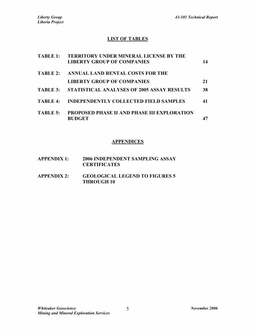
TABLE 1: TERRITORY UNDER MINERAL LICENSE BY THE
LIBERTY GROUP OF COMPANIES 14
TABLE 2: ANNUAL LAND RENTAL COSTS FOR THE
LIBERTY GROUP OF COMPANIES 21
TABLE 3: STATISTICAL ANALYSES OF 2005 ASSAY RESULTS 38 TABLE 4: INDEPENDENTLY COLLECTED FIELD SAMPLES 41 TABLE 5: PROPOSED PHASE II AND PHASE III EXPLORATION BUDGET 47
APPENDICES APPENDIX 1: 2006 INDEPENDENT SAMPLING ASSAY
CERTIFICATES APPENDIX 2: GEOLOGICAL LEGEND TO FIGURES 5 THROUGH 10
Liberty Group 43-101 Technical Report Liberia Project
Whiteaker Geoscience November 2006 Mining and Mineral Exploration Services
6
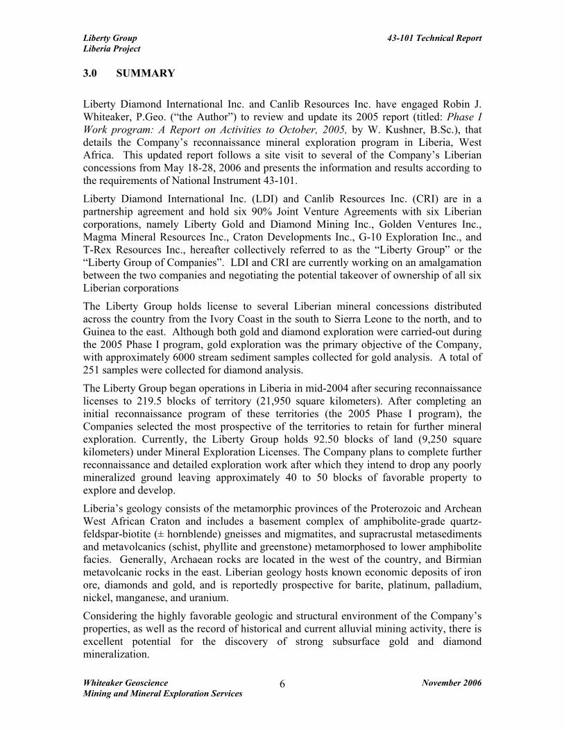
3.0 SUMMARY
Liberty Diamond International Inc. and Canlib Resources Inc. have engaged Robin J. Whiteaker, P.Geo. (“the Author”) to review and update its 2005 report (titled: Phase I Work program: A Report on Activities to October, 2005, by W. Kushner, B.Sc.), that details the Company’s reconnaissance mineral exploration program in Liberia, West Africa. This updated report follows a site visit to several of the Company’s Liberian concessions from May 18-28, 2006 and presents the information and results according to the requirements of National Instrument 43-101.
Liberty Diamond International Inc. (LDI) and Canlib Resources Inc. (CRI) are in a partnership agreement and hold six 90% Joint Venture Agreements with six Liberian corporations, namely Liberty Gold and Diamond Mining Inc., Golden Ventures Inc., Magma Mineral Resources Inc., Craton Developments Inc., G-10 Exploration Inc., and T-Rex Resources Inc., hereafter collectively referred to as the “Liberty Group” or the “Liberty Group of Companies”. LDI and CRI are currently working on an amalgamation between the two companies and negotiating the potential takeover of ownership of all six Liberian corporations
The Liberty Group holds license to several Liberian mineral concessions distributed across the country from the Ivory Coast in the south to Sierra Leone to the north, and to Guinea to the east. Although both gold and diamond exploration were carried-out during the 2005 Phase I program, gold exploration was the primary objective of the Company, with approximately 6000 stream sediment samples collected for gold analysis. A total of 251 samples were collected for diamond analysis.
The Liberty Group began operations in Liberia in mid-2004 after securing reconnaissance licenses to 219.5 blocks of territory (21,950 square kilometers). After completing an initial reconnaissance program of these territories (the 2005 Phase I program), the Companies selected the most prospective of the territories to retain for further mineral exploration. Currently, the Liberty Group holds 92.50 blocks of land (9,250 square kilometers) under Mineral Exploration Licenses. The Company plans to complete further reconnaissance and detailed exploration work after which they intend to drop any poorly mineralized ground leaving approximately 40 to 50 blocks of favorable property to explore and develop.
Liberia’s geology consists of the metamorphic provinces of the Proterozoic and Archean West African Craton and includes a basement complex of amphibolite-grade quartz-feldspar-biotite (± hornblende) gneisses and migmatites, and supracrustal metasediments and metavolcanics (schist, phyllite and greenstone) metamorphosed to lower amphibolite facies. Generally, Archaean rocks are located in the west of the country, and Birmian metavolcanic rocks in the east. Liberian geology hosts known economic deposits of iron ore, diamonds and gold, and is reportedly prospective for barite, platinum, palladium, nickel, manganese, and uranium.
Considering the highly favorable geologic and structural environment of the Company’s properties, as well as the record of historical and current alluvial mining activity, there is excellent potential for the discovery of strong subsurface gold and diamond mineralization.

Liberty Group 43-101 Technical Report Liberia Project
Whiteaker Geoscience November 2006 Mining and Mineral Exploration Services
7
During May of 2006 the Author was able to collect some stream, soil and rock samples for assay analysis at an independent lab in Canada. Two pyritic greenstone grab samples from the Alalsala-Mandingo Hill mining area returned the most encouraging gold values (6.23 g/t Au, sample L8900 and 13.49 g/t Au, sample L8901). As well, soil samples from the Solo Camp area (Putu block) carried up to 0.53 g/t Au. The Author did not collect any diamond indicator samples for verification for the following reason: The 251 samples from 2005 are reported to have been poorly gathered in the field (improper methods and due-care taken), and therefore may not have produced analyses representative of diamond mineralization on the Company’s properties. SGS Laboratories in Lakefield, Ontario received 77 diamond indicator samples from the 2005 program, of which 56 produced illmenites, chromites, or both; these samples were not probed using an electron microprobe. Of the 174 samples analyzed at CF Mineral Research Ltd. in Kelowna, British Columbia, only 2 contained indicator minerals with diamond inclusion chemistry. Regardless, 2005 diamond indicator sample collection methods and analyses are discussed in this report. The Phase I 2005 regional stream sediment sampling program succeeded in collecting enough samples to at least bring into focus some ‘general’ mineralization trends across the Company’s properties A Phase II exploration program consisting of extensive grid line-cutting, soil sampling, mapping, trenching and geophysics is recommended for the following concessions: the Alasala, Putu, Nimba South/Coldbahn Mountain, River Cess and Grand Kru properties. The proposed Phase II program budget is US $1,530,100. Contingent on results from Phase II exploration work a Phase III drilling program would be undertaken and is estimated at US $1,287,000. 4.0 INTRODUCTION 4.1 TERMS OF REFERENCE In early May 2006 Robin J. Whiteaker, P.Geo. (“The Author”) was commissioned by Len Lindstrom, President of both Liberty Diamond International Inc. and Canlib Resources Inc. to undertake a site visit to the Company’s mineral exploration concessions in Liberia, West Africa (Figure 1). The Author was also asked to prepare a National Instrument 43-101 compliant technical report on the reconnaissance field program undertaken by the Liberty Group between March and October of 2005. This 2005 mineral exploration field program consisted primarily of regional stream sampling with some limited reconnaissance field mapping. The results of the work were compiled into a report by Willie Kushner, B.Sc., who also directly supervised the 2005 work program. The Author has drawn heavily on the Kushner report and other Company in-house documents for information on the activities of the Liberty Group.
The report covers 15 mineral concessions currently held under joint venture agreement by Liberty Diamond International Inc. and Canlib Resources Inc.

Liberty Group 43-101 Technical Report Liberia Project
Whiteaker Geoscience November 2006 Mining and Mineral Exploration Services
8
In compliance with the mineral reconnaissance licenses granted to the Liberty Group of Companies (of which Liberty Diamond holds a 90% joint venture interest), a 2005 program of ‘rapid reconnaissance’ exploration and sampling was initiated. This work program was to be carried-out over the concessions held by the Liberty Group with the aim of identifying anomalous and prospective areas for further mineral detailed work.
These rapid reconnaissance surveys covered considerable portions of the Company’s reconnaissance licenses (21,950 km2 or 219.5 concession blocks) in the following territories: Gbarpolu, Montserrado, Margibi, Grand Kru, Rivercess, Nimba, Grand Gedeh, Bong and Bomi Counties. Altogether, almost 7,000 samples were collected and processed at the SGS laboratories in Ghana and Guinea. Upon the completion of its 2005 reconnaissance program the Liberty Group was granted Mineral and Exploration licenses on 9,250 km2 or 92.50 concession blocks. Stream sediment samples and select rock samples were collected on a regional scale and submitted for gold geochemical analysis. Results were tabulated and the locations plotted on regional maps of the properties. Areas anomalous in gold were further studied and select blocks were identified for additional detailed field work.
Due to the dubious manner in which the 251 diamond indicator samples were collected during the 2005 Phase I Program the results of the diamond analyses are in question. For this reason this NI 43-101 report primarily focuses on the gold exploration work of the Companies.
Although no detailed mapping or sampling program has been undertaken to confirm the complete accuracy of past work, the Author’s May 18-28, 2006 field visit to the Company’s Liberian properties has confirmed the presence of gold mineralization in selected stream, soil and rock samples. Unfortunately, based on the limited 2005 diamond field work performed the Author cannot comment on the diamond potential of the Company’s properties, other than to state that numerous historical and current artisanal and placer mining operations (exploiting both alluvial diamonds and/or gold) were examined during the Authors visit in May of 2006. The recent site visit and independent collection of field samples for gold mineralization have now enabled the Author to prepare an updated technical report in accordance with National Instrument 43-101 guidelines.

Figure 1 Location Map of Liberia, West Africa

Liberty Group 43-101 Technical Report Liberia Project
Whiteaker Geoscience November 2006 Mining and Mineral Exploration Services
10
4.2 EXPLORATION STATUS The Liberty Group is currently engaged in more advanced gold exploration programs on several of its territories. This began with a continuation of rapid reconnaissance over unexplored areas as well as some infill stream and soil sampling in prospective areas. After analyses of the results, the Companies may further reduce the size of licensed areas to more manageable sized packages. This could substantially reduce the annual costs of holding such sizeable territory and allow the Companies to concentrate exploration efforts on areas of greatest mineral potential.
Between February and September 2006, further reconnaissance work was conducted by the Liberty Group on over 800 square kilometers on the eastern side of the Putu license which was followed by extensive soil sampling and line cutting in the CVI region of the Putu license. A work program of line-cutting and sampling was carried-out in Grand Geddeh County and the Coldbahn Mountain region in the Nimba South County license.
The Company is currently engaged in, or is planning to carry-out in late 2006 or early 2007, further line-cutting, geological saprolite/regolith mapping, and geochemical sampling (soil, stream and rock) on the Alasala, CVI, Putu, Coldbahn Mountain, River Cess, and Zigigai project regions. Areas of interest are planned to be followed-up with more advanced exploration programs which include trenching, pitting and diamond drilling.
As of late summer/fall 2006, a trenching program has been underway on the Mandingo Hill project in the Alasala region of Bomi County, and a mapping and pitting program was started in the River Cess County license. In November 2006, the Liberty Group initiated a drill campaign on the Mandingo Hill/Bomi County project, with further work planned.
Over the last six months of 2006 it is anticipated that the Liberty Group of companies will spend in excess of $1,500,000 US on gold exploration projects in Liberia. It is expected that this 2006 exploration and confirmation work will provide the Companies with 3-6 properties containing prospective drill targets—most notably the Putu, CVI, Nimba South, Grand Kru and Alasala concessions. It is estimated that approximately 20,000 soil samples will be collected across these new grid lines (the Putu, Nimba South, Grand Kru and Alasala concessions). In addition, a geophysical survey (magnetometer) is planned for these property grids. The Gbapolu/Kpo Mountain property and the contiguous Upper St Paul property are scheduled for initial systematic diamond indicator sampling after which the samples with the aim of identifying the potential for diamondiferous kimberlite pipes on the properties
The Companies are also interested in entering into Joint Venture agreements with other diamond exploration companies on several of its diamond exploration projects—most notably the Kpo Mountain/Upper St Paul properties, as well as in the Tubmanburg and Gibi Mountain regions.

Figure 2 Political Map of Liberia

Liberty Group 43-101 Technical Report Liberia Project
Whiteaker Geoscience November 2006 Mining and Mineral Exploration Services
12
4.3 POLITICAL SITUATION The prospects for political stability and economic recovery in Liberia (Figure 2) have improved considerably since the completion of the disarmament and repatriation processes of rebel militants began, and subsequent 2005 democratic elections were held. The civil war in Liberia formally came to an end in early 2003 with the introduction of widespread disarmament measures. Hundreds of thousands of refugees fled the country during wartime, some of whom have returned since peace was restored. Unfortunately, Liberia is still recovering from many years of conflict which has seen its population reduced by 150,000-200,000 lives and its infrastructure badly ruined. Current estimates place the Liberian population around 3.48 million with an 85% unemployment rate and 80% of the population living below the poverty line (Kushner, 2005). However, Liberia leads all other West African nations currently engaged in a mineral exploration boom with a 15 percent increase in economic growth in 2004/2005. In 2001 the United Nations placed a ban on the international sale of diamonds from Sierra Leone in an attempt to undermine the purchasing of arms for war, and in May of the following year it also imposed sanctions on the diamonds mined in Liberia.
In June 2003, the International Criminal Court issued an indictment for war crimes against the then President Charles Taylor, and in August of that year he resigned. Nigeria offered him asylum to help end the war with Taylor accepting. A peace agreement was signed with the two rebel groups, and several thousand West African peacekeepers arrived, supported temporarily by an offshore U.S. force. In Oct., 2003, the West African force was placed under UN command and reinforced with troops from other nations. Gyude Bryant was appointed as president of a new power-sharing government called the National Transitional Government of Liberia (NTGL) for a two year term until democratic elections could be held.
The much anticipated democratic elections held on October 11, 2005 were overseen by the international community and were largely fair and free of violence. Ellen Johnson-Sirleaf, a woman with strong political experience and international respect, was declared President of Liberia in October, 2005 and inaugurated January 12, 2006. The Liberian government is a multiparty republic whereby the executive branch is headed by a president who is elected for a six year term.
The UN Security Council has welcomed the strong commitments and determination of President Ellen Johnson-Sirleaf, to meet the conditions for terminating the imposed measures and to control illicit mining and smuggling of diamonds out of the country. The sanctions on timber were removed in June 2006 and the removal of the sanction against the exportation of diamonds is currently under negotiation. There is no sanction against exploration for diamonds, nor has there ever been a sanction against the exploration, mining or exportation of gold. Nevertheless, the removal of all economic sanctions will significantly help Liberia in its move towards economic recovery as it will then be able to export all of its natural resources, encouraging greater foreign investment and consequently providing employment for its impoverished citizens.

Liberty Group 43-101 Technical Report Liberia Project
Whiteaker Geoscience November 2006 Mining and Mineral Exploration Services
13
The United Nations continues to maintain its peace keeping force of 15,000 members and its 3,000 administrative and humanitarian workers within Liberia. It is not expected that the UN will pull-out of Liberia in the near future as the continuing political stability and economic redevelopment of the nation remain a persistent goal.
The former president of Liberia, Charles Taylor, has been in exile in Nigeria since August 2003. He was extradited in June 2006 to The Hague to face a War Crimes Tribunal, a move which has the potential to greatly reduce the possibility of any new uprising in Liberia and add further stability to West Africa.
The African Union, the United Nations, the European Commission, the Economic Community of West African States and the United States of America have all been key partners with Liberia, and the country relies on their continued support for sustained order, peace and economic revival.
5.0 RELIANCE ON OTHER EXPERTS Robin J. Whiteaker, P.Geo. (“The Author”) is an independent mining consultant and holds no interest in Liberty Diamond International Inc. or Canlib Resources Inc., their partners or their affiliated companies. The Author will be paid a fee for the preparation of this report according to normal consulting practices. The author has relied on other experts for particular opinions on legal, environmental, political or other issues that might be relevant to this report. The Author has reviewed a letter from the Liberian Ministry of Lands, Mines and Energy, dated September 6, 2006, that expressly states the validity of the Companies title to the mineral concessions described in this report. The Author has examined reports from both SGS Laboratories (Lakefield, Ontario) and CF Mineral Research Ltd. (Kelowna, British Columbia), which detail the diamond analyses work carried out on 251 samples collected in 2005 by the Liberty Group. To the extent known, all environmental liabilities to which the property is subject are as follows. The author has received letters from Liberty Diamond International Inc. and Canlib Resources Inc. which state, that to the best of their knowledge, their exists no foreseen environmental liabilities with respect to their properties and work. It should be noted that many of the documents and information that constitutes the bulk of this report were supplied to the Author by Liberty Diamond International Inc. and Canlib Resources Inc.—in particular the 2005 report by W. Kushner. 6.0 PROPERTY DESCRIPTION, TITLE AND LOCATION The Author has not undertaken a legal review of the Liberty Group of Company’s title to their Liberian properties; however, the Author has been supplied with copies of the Mineral and Exploration Licenses, current Joint Venture agreements and territory maps of the Companies, which convey the rights as stated by Liberty Diamond International

Liberty Group 43-101 Technical Report Liberia Project
Whiteaker Geoscience November 2006 Mining and Mineral Exploration Services
14
Inc. and Canlib Resources Inc. The Author has also received a letter from the Liberian Ministry of Lands, Mines and Energy, dated September 6, 2006, outlining the validity of the Companies mineral exploration licenses and agreement titles as detailed in this report. The Author has relied on the Liberty Group to provide accurate details of the rights conveyed by these. The current licenses held by the Liberty Group of Companies are listed in Table 1 and their locations are illustrated in Figures 3 and 4. During Phase I of exploration the Liberty Group held over 21,950 square kilometers (219.5 blocks) of property within Liberia, of which 92.50 blocks (9,250 square kilometers) has been granted to the Companies in the form of Mineral Exploration Licenses. TABLE 1 TERRITORY UNDER MINERAL EXPLORATION LICENSE BY
THE LIBERTY GROUP OF COMPANIES
COMPANY NAME LICENSE AREA BLOCK SIZE
SIZE (KM2)
Liberty Gold and Diamond Mining Inc. Kpo Mtn. (Gbapolu County)
10 1,000
River Cess 11.5 1,150 Zia, Kpetu,
Tappeta 3 300
Golden Ventures Inc. Putu 13.75 1,375 Magma Mineral Resources Inc. Nimba South
(Coldbahn Mtn) 10 1,000
G-10 Exploration Inc. Lofa Bend/River 1 100 Graveyard 1 100 Tubmanburg 3.5 350 Alasala/Bomi 1.5 150 Artinton 1 100 Belefuani 2 200 Upper St.Paul
(River) 10 1,000
Craton Developments Inc. Gibi West 5.5 550 Gibi Mountains 4.5 450 T-Rex Resources Inc. Grand Kru 7.50 750 Nimba East 6.75 675 Total Territory Under Mineral License 92.50 9,250

Liberty Group 43-101 Technical Report Liberia Project
Whiteaker Geoscience November 2006 Mining and Mineral Exploration Services
15
6.1 COMPANY AND PROPERTY HISTORY The following is a summary of the general development of the business of LDI, CRI and the six Liberian companies that comprise the Liberty Group of Companies with which they hold Joint Venture Agreements on the licensed properties:
• On June 21, 2004, Liberty Gold and Diamond Mining Inc ("LGDMI") was incorporated by Len Lindstrom and associates in Liberia for the purpose of acquiring two mineral exploration licenses over 13 Blocks (1,300 square kilometres) and three reconnaissance licenses over approximately 57 Blocks (5,700 square kilometres for a total of 70 blocks (approximately 7,000 square kilometres) under license in Liberia.
• On July 19, 2004, a second company, Golden Ventures Inc ("GVI") was incorporated in Liberia and between LGDMI and GVI an additional 14,950 square kilometres of territory was acquired under reconnaissance licenses bringing the Companies’ total licensed territory to 219.5 licensed blocks.
• On August 25, 2004, a third Liberian company, Magma Mineral Resources Inc ("MMRI"), was incorporated for the purpose of acquiring future licenses and/or territory in Liberia.
• On July 6, 2004, LDI was incorporated in British Columbia. LDI entered into Joint Venture Agreements with LGDMI, GVI and MMRI under which LDI agreed to fund all exploration and related costs in exchange for 90% of all net profits.
• On February 17, 2005, CRI was incorporated in British Columbia and a Partnership Agreement was entered into between LDI and CRI.
• On August 17, 2005, three new companies were incorporated in Liberia, G-10 Exploration Inc. ("G10"), Craton Developments Inc. ("CDI") and T-Rex Resources Inc. ("TRX"). Due to the large amount of territory the companies deemed worthy of further exploration these new corporations were registered in Liberia in order to apply for all the desired Mineral Exploration Licenses.
• On October 26, 2005, after determining that 92.5 blocks were worthy of further exploration, the territories were divided between the six Liberian Companies who each received one new mineral exploration license collectively covering 7,950 square kilometres. When added to the original two mineral exploration licenses, the Liberty Group currently holds a total of eight mineral exploration licenses covering 92.50 blocks (9,250 square kilometres).
• On October 27, 2005, new Joint Venture agreements were entered into between LDI and each of the Liberian Companies. Under the terms of the six Joint Venture agreements, LDI agreed to fund all exploration and administration expenses and all government fees and licensing costs in exchange for 90% of the proceeds from

Liberty Group 43-101 Technical Report Liberia Project
Whiteaker Geoscience November 2006 Mining and Mineral Exploration Services
16
the sale of an interest in the Licenses or 90% of the net profit from any mining operations, with the balance to be retained by the Liberian companies.
• On October 27, 2005, a new Partnership Agreement was entered into between LDI and CRI under which they agreed to form a partnership called the “Liberia Exploration and Mining Partnership” concerning the joint venture interests held by LDI, with each partner’s interest in the partnership being equal to their proportionate contribution made to or on account of the joint venture interests.
• On August 26, 2006, the shareholders of LDI and CRI unanimously passed resolutions approving the amalgamation of those two companies.
• On November 22, 2006, CRI completed the purchase of all the issued shares of the Liberian companies from Len Lindstrom, Michael Lindstrom and James Arku, a resident of Liberia, in exchange for 20,000,000 shares of the Issuer plus US$5,000 in cash to James Arku. These transactions terminated the six Joint Venture Agreements and effectively made all six Liberian corporations wholly owned subsidiaries of CRI.
• Procedures are currently underway for Liberty Diamond International Inc. and Canlib Resources Inc. to amalgamate their companies into one corporation which will be registered as Liberty International Mineral Corporation. The proposed amalgamation is expected to be completed on November 28th, 2006.
Len Lindstrom is the President and Chief Executive Officer of all six Liberian corporations that comprise the Liberty Group of Companies and also the President and Chief Executive Officer of LDI and CRI in Canada. He is also the major shareholder in all eight of these companies.

Figure 3 Original Territories Under Reconnaissance Licenses

Liberty Group 43-101 Technical Report Liberia Project
Whiteaker Geoscience November 2006 Mining and Mineral Exploration Services
18
6.2 PROPERTY STATUS AND TITLE
In April 2000, the Minerals and Mining Law of 1956 was repealed and a new Liberian Code of Laws was enacted which set-out new rules governing all aspects of mining and exploration in Liberia. Following, is a brief summary of pertinent aspects of the law pertaining to the Liberty Group of Companies.
In Liberia a certain amount of work must be performed on a mineral property and the stated or negotiated fees paid in order to qualify for the renewal of the reconnaissance license. In 2005 most of the Liberty Group properties were under Reconnaissance licenses which were only valid for six months and renewable for another six months. Upon completion of reconnaissance of the designated area, the holder may apply for an Exploration License to conduct detailed exploration on any or all of the area originally granted. Over that period of time sufficient scientific and historical research needed to be completed to determine mineral delineation.
Original deadlines for work decreed that all reconnaissance activity be completed by June 30, 2005, however extensions were granted enabling fieldwork to continue to August 31, 2005. The delineation process was finalized on October 6, 2005 and territories covering a total of 92.50 blocks were applied for by the Liberty Group’s six companies. Mineral Exploration Agreements between the Liberty Group of Companies and the Republic of Liberia were finalized and signed on October 26, 2005.
The agreement spells out specifics of the mining act, whereby under the terms of the agreement, the Exploration period is granted for a term of three years. The Mining Act allows an extension period of two years; in the agreement this option is available “plus any period of renewal to which the Government may agree”, thus removing the time restraints for exploration of the property.
6.3 MINERAL EXPLORATION AGREEMENTS The Mineral Exploration Agreement grants the Company the exclusive right to explore for gold, diamonds, associated minerals and any other mineral deposit except iron ore. It states that exploration must commence within six months of signing, and that foreign unskilled labor may not be employed. It also states that Liberian employees must be provided with training and also states that at least two geologists or mining engineers from the Ministry must be employed per License by the company. Since Liberia is seriously undersupplied in the number of available local professional geologists to cover the Company’s personnel requirements the Liberty Group obtained permission to contract 15 foreign geologists from Ghana for its exploration program.
A royalty of 3% NSR shall be paid to the Liberian government on any gold produced under pilot mining during the exploration period. The rate of royalty on any other minerals mined is left open to negotiation, and the rate of royalties to be paid in the production stage of gold mining has not been noted. There is no set royalty rate on diamonds under the current Mineral Laws of Liberia.

Liberty Group 43-101 Technical Report Liberia Project
Whiteaker Geoscience November 2006 Mining and Mineral Exploration Services
19
The Agreement states that each company must pay a fee of US $5000 for the grant or renewal of the Exploration License. Annual rental payments of US $0.18 per acre must be paid for the territory under exploration and any area subjected to pilot mining will face a land rental fee of US $3 per acre. The first payment can be paid in accordance with a plan agreed to by both parties. Subsequent annual payments must be paid within 30 days of each anniversary of the signing date or as negotiated with the Department of Lands and Mines. If, and when, the Liberty Group moves forward with advanced active mining, a future Mining Development Agreement (MDA) between the Liberty Group of Companies and the Liberian Department of Lands and Mines would include the particulars concerning any mining surface rights, potential processing plant sites, and possible tailings storage areas and waste disposal sites. In addition, the Companies are required to reclaim any disturbed land to a form similar to that prior to the commencement of mineral exploration and mining activity. Any contaminates and waste left on site must be controlled or removed as per Liberian law, and similar to Canadian laws. Once mining activity is complete any structures which cannot be removed by the Liberty Group would become the property of the Liberian government. Liberian artisanal gold and diamond miners who are actively working small claims on parts of the Company’s concessions can be broadly divided into two groups; those who are mining illegally (activity that is not recognized by the Liberian government and poses no legal hindrance to future mining activity), and those who actually own a legal mining license for their parcel (active for one year from the date of acquisition). The Liberian Department of Lands and Mines has advised the Liberty Group that local artisanal mining licenses within the Company’s concessions will not be renewed once applications for an MDA are accepted. Some compensation packages will most likely need to be negotiated with former small claim holders. Typically mining companies engaged in advanced exploration or mining activity in areas containing expired artisanal mining claims will employ local miners and villagers for their work programs and assist with selected community development programs.

Liberty Group 43-101 Technical Report Liberia Project
Whiteaker Geoscience November 2006 Mining and Mineral Exploration Services
20
FIGURE 4 TERRITORIES IN LIBERIA CURRENTLY HELD UNDER MINERAL EXPLORATION LICENSES BY THE LIBERTY GROUP OF COMPANIES
(Note: For Figure 4 the Kpo Mountain block is referred to as Gbapolu County; Graveyard is included in the Lofa River territory; the Artinton and Alasala blocks are named the Bomi territory; and the Gibi West block is included in the Gibi Mtn territory).

Liberty Group 43-101 Technical Report Liberia Project
Whiteaker Geoscience November 2006 Mining and Mineral Exploration Services
21
Table 2 details the land rental fees that are payable per year (based on the Mineral Laws of Liberia), for the amount of territory the Liberty Group of Companies currently hold under Mineral Exploration licenses. During the June 2004 to September 2005 period the Liberty Group paid a total of $417,010 USD to the Department of Lands, Mines and Energy to cover all land rental fees, licenses and permits.
TABLE 2 ANNUAL LAND RENTAL COSTS FOR THE LIBERTY GROUP OF COMPANIES
SIZE ANNUAL COSTS
COMPANY PROPERTY BLOCKS Km2 ACRES LAND RENTAL LGDMI Kpo Mtn./Gbapolu 10 1000 247,100.00 $44,478.00
Rivercess 11.5 1150 284,165.00 $51,149.70
Zia, Kpetu &
Tappeta 3 300 74,130.00 $13,343.40 GVI Putu 13.75 1375 339,762.50 $61,157.25
MMRI Nimba South
(Coldbahn Mtn) 10 1000 247,100.00 $44,478.00 G-10 Lofa Bend/River 1 100 24,710.00 $4,447.80
Graveyard 1 100 24,710.00 $4,447.80 Tubmanburg 3.5 350 86,485.00 $15,567.30 Alasala/Bomi 1.5 150 37,065.00 $6,671.70 Artinton 1 100 24,710.00 $4,447.80 Belefuani 2 200 49,420.00 $8,895.60
Upper St. Paul
(River) 10 1000 247,100.00 $44,478.00 CDI Gibi Mountain 4.5 450 111,195.00 $20,015.10
Gibi West 5.5 550 135,905.00 $24,462.90 T-REX Grand Kru 7.50 750 185,325.00 $33,358.50
Nimba East 6.75 675 166,792.50 $30,022.65 TOTALS 92.50 9,250 2,285,675.00 $411,421.50
The Liberty Group negotiated a special flat rate of US$200,000.00 for all eight mineral exploration licenses and land rental fees listed above for the period of October 26, 2005 to October 25, 2006. It is expected that the October 26, 2006 to October 25, 2007 licensing and land rental fees will be similar to last year’s payments, with a final amount and payment schedule yet to be confirmed."

Liberty Group 43-101 Technical Report Liberia Project
Whiteaker Geoscience November 2006 Mining and Mineral Exploration Services
22
7.0 ACCESSIBILITY, CLIMATE, LOCAL RESOURCES, INFRASTRUCTURE AND PHYSIOGRAPHY
7.1 ACCESSIBILITY Liberia is located 720 kilometers north of the equator on the Atlantic coast of West Africa, centered at approximately 6o30’ North latitude, 9o30’ West longitude (Figure 1). Liberia has an International Airport which is serviced by flights from Europe and Ghana. Although many highways have suffered neglect and damage during wartime Liberia is accessible by road from Sierra Leone, Guinea and Ivory Coast. Travel throughout Liberia is primarily by way of rough dirt roads with some paved highway locally.
In general, the majority of the properties of the Liberty Group of Companies are accessible by highway, rough roads and local trail systems (Figure 2). Some of the more remote parts of certain concessions (i.e. Putu, Grand Kru and eastern Gbapolu and Nimba East, etc.) are not easily accessed, especially during the rainy season, and may require road and/or trail development.
7.2 CLIMATE The climate of Liberia is that of an equatorial rainforest with average annual temperatures ranging between 24°C to 30°C and very high humidity. The highest temperatures occur between January and March and the lowest temperatures during the months of August and September. These low temperatures are mainly caused by the large amount of cloud cover, which is common over much of coastal West Africa. The average annual rainfall near the coast is estimated at 4770mm while towards the interior of the country it is an average annual amount of approximately 2080mm. The dry season typically lasts from November to May while the rainy season extends from May to November. Although fieldwork can be successfully carried-out year-round in Liberia, the months between November and June offer the best ‘window’ for exploration work.
7.3 LOCAL RESOURCES Liberia is rich in natural resources. Rubber tree farming contributes a great deal to the economy as does local agricultural farming (cocoa, rice, vegetables and fruit, etc.). Historically the country has been sourced for its hardwood lumber, and this industry still remains a promising resource for the nation. In the mining sector, iron, diamonds and gold have all historically (pre-war) contributed to the well-being of the country. Vast areas of territory still remain unexplored for their mineral potential.
7.4 INFRASTRUCTURE Due to more than 14 years of civil conflict much of Liberia’s infrastructure was destroyed, including its main electrical plant, the Liberia Electricity Corporation (LEC). Private generators are currently the only source of electrical power generation throughout the country. Charcoal and fuel wood is the main source of energy in the villages and country sides, which accounts for over 70 percent of Liberia’s annual energy

Liberty Group 43-101 Technical Report Liberia Project
Whiteaker Geoscience November 2006 Mining and Mineral Exploration Services
23
consumption. Because of the country’s high dependence on charcoal and fuel wood for energy, many areas of the country are experiencing deforestation which is estimated at an annual rate of 1 percent (37,000 hectares per annum).
During civil warfare many business people fled the country as rebel forces gained control over vast quantities of gold, diamonds, natural rubber, and tropical hardwoods. Historically, these commodities produced the bulk of Liberia’s export earnings. Currently the value of imports greatly exceeds that of exports, and as a result the country has accumulated enormous international debts. Liberia's main trading partners are the United States and the countries of the European Union (Kushner, 2005).
Liberia has approximately 10,600 kilometers of roads throughout the country, of which only 650 kilometers are paved highway. Many of the dirt roads in the interior of the country were constructed by an Asian timber company during the 1990’s. These roads were well constructed and maintained at the time, but have since fallen into disrepair. This situation is only made worse by the heavy rains common in Liberia between the months of July and October.
The 490 kilometers of railway in Liberia were primarily constructed to haul ore from interior iron-ore mines. The current status of the rail system is unclear, but it is thought to be either non-functional or badly damaged from years of war.
Monrovia is the country’s capital, largest city, commercial center and main seaport and harbor. Smaller ports are located in the towns of Buchannan, Greenville and Harper.
7.5 PHYSIOGRAPHY
Liberia has an area of approximately 111,369 square kilometers, with 570 kilometers of Atlantic coastline along the southwest. Liberia is bordered on the northwest by Sierra Leone, to the north by Guinea and on the east by Côte d'Ivoire (Figure 2).
Liberia can be divided into three distinct topographical areas: Firstly, a flat coastal plain some 15-80 kilometers wide, with creeks, lagoons, and mangrove swamps; secondly, an area which covers most of the country containing broken, forested hills with elevations from 180 to 370 meters; and thirdly, an area of mountains in the northern highlands, with elevations reaching 1,384 meters in the Nimba Mountains and 1,380 meters in the Wutivi Mountains. Liberia's six main rivers all flow southwest into the Atlantic (Kushner, 2005). Vegetation throughout much of the country consists of dense forest growth, typical of tropical rain forests.
8.0 HISTORY Prior to the civil war some sparse reconnaissance geological mapping and mineral exploration work had been carried-out in various parts of Liberia. The most comprehensive work was probably performed between the 1960’s and late 1970’s by the Liberian Geological Survey who firstly collaborated with the US Geological Survey under the sponsorship of the United States Agency for International Development

Liberty Group 43-101 Technical Report Liberia Project
Whiteaker Geoscience November 2006 Mining and Mineral Exploration Services
24
(Dorbor, 2005). This team produced a geologic map of the country on 10 quadrangle sheets. It is from this work that much of the current geology and mineralization is based.
Besides artisanal and placer diamond and gold mining (for which it is impossible to obtain reliable production figures) the only historical and major mining activity in Liberia to date has been the extraction of iron ore. Three major mining areas were operated in the past: Bomi Hills, Bong Mines and Nimba Mountains which accounted for almost half the nation’s GDP before the war. Mineral processing plants for the iron ore are located near the towns of Buchanan and Bong. The Liberian American Swedish Minerals Company (LAMCO) operated the Nimba Iron Project until 1990 when it closed due to civil war activity. Negotiations are underway with large steel companies bidding to re-open the Yakepa Nimba mining area and develop a projected 1 billion tonnes of iron ore reserves in northern Liberia (Kushner, 2005).
Gold, diamonds, barite and kyanite have also been mined extensively by locals in alluvial operations but scant reliable geological exploration for gold or diamonds has taken place in Liberia, and no underground mining has ever occurred (Kushner, 2005).
9.0 GEOLOGICAL SETTING The exceptionally limited amount of available detailed geological data for Liberia (and of West Africa in general) makes geologic interpretations and modeling a challenge. Due to years of civil war and inconsistent historical exploration programs the geology and the nature of gold and diamond mineralization across much of Liberia is poorly understood. A highly generalized geologic province map showing the main structural corridors of Liberia has been compiled (Figure 5).
The exploration concessions of the Liberty Group are spread out across Liberia and cover the metamorphic provinces of the Proterozoic and Archean (Precambrian) West African Craton. These include: (i) a basement complex of amphibolite-grade quartz-feldspar-biotite (± hornblende) gneisses and migmatites of granodioritic composition; (ii) supracrustal metasediments and metavolcanics (schist, phyllite and greenstone) displaying metamorphism in the greenschist to lower amphibolite facies; and (iii) granitic intrusions that cross-cut both (i) and (ii) (Wright, 1985). The following description of Liberian geology is from Kushner (2005):
“The geology of Liberia is dominated by Precambrian rocks of the West African Craton (Figure 2). Metamorphosed rocks of the Liberian Province underlie the western two-thirds of Liberia while metamorphites and granites of the Paleoproterozoic Eburnian Province dominate the eastern part of Liberia. The iron ore deposits of the Bong Range occur in the Liberian Province. A narrow belt of supracrustal rocks affected by the Neoproterozoic to lower Cambrian Pan-African event strike parallel to the coastline. Unmetamorphosed Paleozoic to Recent sediments occurs along the coast.
The country is cut by three major regional shear zones (Figure X): the Cestos and Dugbe shear zones in eastern Liberia which are steeply dipping zones trending NE-SW, and the Todi shear zone found in the western portion of the country, which trends NW-SE, cutting

Liberty Group 43-101 Technical Report Liberia Project
Whiteaker Geoscience November 2006 Mining and Mineral Exploration Services
25
the main lithological trends. These major shears are associated with placer gold deposits and are extremely prospective targets for a source of the placer gold. Economic mineralization throughout Liberia is typical of Archean craton deposits. Types of mineralization to be expected in such a terrain are iron deposits as well as quartz vein hosted gold deposits associated with greenstone belts. This environment is also favorable for the discovery of kimberlite pipes. Kimberlite dykes have been discovered in western Liberia, and some are reported to be diamondiferous. The prevalence of abundant placer gold and alluvial diamond deposits throughout the country indicates the likelihood of local sources to the placer deposits”.

Figure 5 Generalized Geologic Provinces and Structures of Liberia

Liberty Group 43-101 Technical Report Liberia Project
Whiteaker Geoscience November 2006 Mining and Mineral Exploration Services
27
10.0 DEPOSIT TYPES Based on current geologic and structural information Liberia is thought to host an Archean to Lower Proterozoic cratonic style of metallogeny. Liberia’s geologic environment is favorable to following economic deposit types (after Dorbor, 2005): (i) gold-quartz veins and disseminated (and possibly lode) gold associated with regional greenstone belts, (ii) Homestake-type deposits associated with iron formations; (iii) diamondiferous kimberlite pipes of a younger age than the host gneissic basement complex; and (iv) alluvial/placer gold and diamond concentrations derived from (i), (ii) and (iii). A very thick and extensive package of metasediments and metavolcanics (the Birimian sequence) has been recognized in the Lower Protereozoic rocks of West Africa (Figure 5). Gold mineralisation within these units is probably of syngenetic volcano-exhalative origin, related to greenstone volcanism and sedimentation, remobilized during subsequent metamorphic events to become concentrated in quartz veins and localized along major deep-seated shear zones (Wright, 1985). These units are known to host significant gold mineralization in Ghana, Ivory Coast, Guinea, southern Mali and eastern Senegal. Birmian rocks and associated gold mineralization have also been mapped in parts of Liberia and remains an important exploration target for gold mineralization, especially within the identified regional shear zones. 11.0 MINERALISATION Liberia has a history of extensive alluvial gold and diamond mineralization. Small mining operations have been working for generations, and continue to the present day. These deposits are alluvial-fluvial in origin and are presumably weathered detritus that was deposited in wide basins adjacent to earlier mountain ranges. In addition, rudimentary artisanal mining across Liberia (and West Africa) has exploited local pockets of gold and/or diamond mineralization in saprolitic soils above sub-surface bedrock. These areas are of the most interest for further advanced exploration work as they have the potential to host substantial primary ‘bedrock’ gold and/or diamond deposits. Quartz veins are mined only if visible gold is present, thus limiting the work to the highest grade veins (Kushner, 2005). Gold is extracted by manually crushing and pulverizing quartz, and in some cases mineralized schist, and panning the fine material to concentrate heavy grains such as gold. What is referred to locally as a gold mining operation consists of a one to ten man operation working with spades and a simple sluice box to wash the gravels. Many excavated pit areas are tens of metres deep and up to 500 square metres of aerially extent. Gold dust and nuggets are collected in riffles and a carpet on the bottom of the sluice. Diamond mining occurs in much the same manner, whereby gravels are excavated by hand, picked of larger stones and then washed and ‘jigged’ by hand. This results in an

Liberty Group 43-101 Technical Report Liberia Project
Whiteaker Geoscience November 2006 Mining and Mineral Exploration Services
28
‘eye’ of concentrate. This material is then visually examined for the appearance of diamonds. The local miners appear to be interested only in alluvial deposits and in most cases, if their operations encounter bedrock or solid quartz the operation is abandoned (Kushner, 2005). Unfortunately, local miners appear to have very limited geologic knowledge of the areas in which they work, resulting in little systematic exploration being carried out by local Liberians.
12.0 EXPLORATION In 2004, the Liberty Group established a regional office in Monrovia, Liberia staffed by a team of exploration and resource geologists, national geologists and support staff. The Liberty Group has managed to cultivate good working relationships with both provincial and national government agencies. In order to facilitate the establishment of their exploration camps and gain access to the more remote properties the Liberty Group has held open and informal meetings with local community representatives at most of their mineral concessions. An exploration permit is obtained from the Department of Lands and Mines for each region they work in prior to commencing the work program. The Company currently employs 15 geologists, all with experience in West African mineral exploration. The purpose of conducting the 2005 regional exploration program was to examine and sample the vast territories held under license in order to delineate prospective areas for application of Mineral Licenses and to further explore and locate profitable areas for gold and possibly diamond mining. Based on the analysis of the results of Phase I, a total of 92.50 of the 219.5 blocks were identified as warranting retention and further division of licenses within the Liberty Group of companies.
Limited by time and budgetary constraints a regional program of diamond indicator mineral sampling was not carried out by the Liberty Group of Companies during the 2005 reconnaissance program. Instead, a rapid sample program was initiated and quickly carried out during the final weeks of the 2005 field program. These samples were collected from areas of alluvial diamond mining activity within, or near regions undergoing more extensive sampling for gold. The Company reports that diamond sampling methodology was largely flawed and conducted in a hasty and unsystematic manner by field technicians who were not adequately trained or equipped for diamond indicator mineral sampling (L. Lindstrom, Personal Comm.). These samples were also gathered without the supervision of a qualified diamond exploration geologist. This work resulted in diamond indicator mineral samples being collected in the same manner as the gold stream and soil samples, and without the knowledge of appropriate diamond indicator mineral collection methods. This method of diamond indicator sampling was not intended to delineate possible territories but rather to test an inexpensive and simple method of sample collection in areas of known alluvial diamond activity (Kushner, 2005).

Liberty Group 43-101 Technical Report Liberia Project
Whiteaker Geoscience November 2006 Mining and Mineral Exploration Services
29
Regardless, 251 diamond indicator mineral samples were collected during the 2005 program and sent to Canada for analysis (SGS Laboratories in Lakefield, Ontario and CF Mineral Research Ltd. in Kelowna, British Columbia). These samples were gathered from the Lofa Bend/Graveyard, Nimba NE and Gibi West concessions (Figure 4).
Although extensive sampling for gold was performed across almost all of the Company’s concessions, the following text briefly describes property exploration highlights from the 2005 Phase I activities as documented by Kushner (2005). Note that only the most prospective concessions from the 2005 program contain a narrative (with corresponding Figures located in Section 27.0 of this report), of Phase I anomalous gold results—these include the Alasala, Putu, Nimba South/Coldbahn Mountain, River Cess and Grand Kru blocks.
This summary pertains only to the 2005 Phase I reconnaissance activity within the territories presently held under Mineral Exploration license by the Liberty Group of Companies. Figure 4 illustrates these exploration license locations within Liberia.
12.1 LIBERTY GOLD AND DIAMOND MINING INC. Liberty Gold and Diamond Mining Inc. (LGDMI) holds license to a total of 24.5 blocks. The Kpo Mountain property is mainly a diamond prospect with areas of strong gold potential, while the River Cess property is prospective for both gold and diamonds. In addition, LGDMI holds three separate blocks called Zia, Kpetu and Tappeta in Nimba South County all hosting potential gold mineralization.
12.1.1 KPO MOUNTAIN/GBAPOLU COUNTY LGDMI acquired license to 10 blocks of territory adjacent to an area held by Mano River Resources where a cluster of five kimberlites were discovered approximately 5-10 kilometers to the northwest (Figure 4).
Due to the proximity of known kimberlite pipes in the area the Kpo Mountain property was registered directly under an Exploration License without going through the initial prospecting stage. As a result, only minor attention was paid to sampling these blocks for gold during Phase I.
The kimberlites discovered just north of the property are reported to be located in Archean aged rocks of the Guinea shield and are cut by numerous regional NW-SE trending faults that extend through the Kpo Mountain property into rocks of the same geological package. The Kpo Mountain range runs between the two properties and may serve as a barrier to alluvial emplacement of diamonds from the outcropping kimberlites to the north. Extensive alluvial diamond mining activities to the south and southwest of the Kpo Mountains indicate a possible source may occur within the Kpo Mountain and Upper St. Paul regions. The Company is planning to carry-out further diamond exploration work in this area.
Locally, the Ziligai area (located in the north-central arm of the property), is well known for its alluvial gold mining history, and contains numerous small-scale placer gold mining operations. This area was part of the territory secured under exploration license and therefore not sampled during the Phase I program. African Aura Resources holds

Liberty Group 43-101 Technical Report Liberia Project
Whiteaker Geoscience November 2006 Mining and Mineral Exploration Services
30
three adjacent blocks in the Bella Yella forest to the north of the reported gold area on this property, and they are currently conducting gold exploration in the area.
12.1.2 RIVER CESS The southwest third of Liberia has historically been considered the major gold belt area of the nation and primarily consists of greenstone formations (Figures 4 and 5). LGDMI holds license on 11.5 blocks of territory to the north of the coastal town of River Cess which falls well within this prospective region. The area was initially obtained under a Reconnaissance License due to encouraging reports of recent gold discoveries in the area, but recently it has emerged as a prospective area for diamonds as well. Around May of 2005 a major alluvial diamond rush occurred in the area northwest of Greenville. Due to health and sanitation issues it ultimately required UN and governmental intervention to halt activity in the area.
The River Cess territory strikes for many kilometres directly along the Todi Shear Zone, starting between Greenville and River Cess and continuing westward (Figure 5). The Todi Shear Zone is a regional feature where Iburnian aged lithologies are in contact with Pan African age rocks (Kushner, 2005). The Todi shear zone may have provided a conduit for kimberlites and intrusive bodies to intrude. As a result, when LGDMI delineated their territory in this concession they included approximately 45 kilometers of the Todi Shear zone which is very prospective for both gold and possibly diamonds (L. Lindstrom, personal comm.).
Numerous samples returned gold values between 102-123 ppb, with many between 124-250 ppb. These sites appear to be scattered across the middle to western portions of the property (Figure 6), and indicate numerous possible sources (Kushner, 2005).
Amlib United Minerals is thought to hold about 15 blocks to the east, and adjacent to the River Cess property, and Ducor Minerals has recently acquired an adjacent strip of about 10 blocks to the north (Kushner, 2005).
12.1.3 KPETU
The Kpetu Property was acquired directly under an Exploration License based on the recommendations of local mining agents because of the number of alluvial gold operations in the area. It is located in Central Nimba, and is positioned near the town of Kpetu. The property is on strike with a highly anomalous gold zone running through the Coldbahn Mountain region licensed to one of the Liberty Group companies, Magma Mineral Resources Inc. Due to time constraints in completing the vast amount of reconnaissance work during Phase I no samples were collected from this block. It is expected that Phase II should see the Kpetu property undergo a rigorous stream sediment sampling and mapping program.
12.1.4 TAPPETA Due to some promising reports from persons in the Ministry concerning the gold prospects in this area the Tappeta block was acquired directly under Mineral Exploration license (Kushner, 2005). Sampling conducted in the SW quarter of the property did not return favorable gold results, although much of the block contained float and bedrock of quartz veins. Future work should focus on the SE quarter of the block near a mapped

Liberty Group 43-101 Technical Report Liberia Project
Whiteaker Geoscience November 2006 Mining and Mineral Exploration Services
31
iron formation and where a number of alluvial gold activities have been reported (Kushner, 2005).
12.1.5 ZIA The Zia block is 100 km2 in size, and was acquired directly under exploration license because of the numerous gold prospects it was known to contain. This concession is directly adjacent to the north boundary of the Nimba South concession held by MMRI, with the village of Zia located within its boundaries. Locals have reportedly mined gold for years from the slopes of a small nearby mountain (Kushner, 2005).
The Zia property underwent a stream sediment sampling program equivalent in concentration to the rest of the project areas. Favorable gold anomalies appear to be clustered in the SE corner of the block which is also on strike with the Coldbahn Mountain region which had numerous stream results that were highly anomalous in gold.
12.2 GOLDEN VENTURES INC.
12.2.1 PUTU PROPERTY Golden Ventures Inc. (GVI) holds license to the Putu Property, covering 13.75 blocks of territory in east-central Liberia (Figures 4 and 7). Based on the reconnaissance sampling program conducted over much of the Liberty Group territories, there seems to be a correlation between iron deposits and strong gold mineralization. Sampling has shown that anomalous gold values are often clustered along the flanks of known iron mineralization. This relationship is especially evident in the sampling conducted on the Putu Property where anomalous gold results were discovered neighboring the regionally mapped iron deposits, and in some instances high gold values were discovered in rock samples collected within the iron units (Figure 7). Gold assays of 124-250 ppb and >254 ppb were collected from the north-east and south-west portions of the mapped iron deposits.
Historically, the main alluvial gold mining area in this region is called the CVI Territory which is located in the central eastern third of the Putu property. This remote region supports a population of over 600 people who have placer mined the area continuously for several years. The entire mineralized area is reported by the Company’s Chief Geologist to be up to 3 kilometers wide by 12 kilometers in length. Access to the CVI area is obtained by walking well-worn bush trails from the village of John David. An old road was recently opened and new bridges installed by the Liberty Group such that vehicles are now able to drive as far as the old CVI surface mining area.
The Putu property is cut by the NE-SW trending Putu Shear Zone (Figure 5), the lower portion of which hosts numerous alluvial gold mining operations (Kushner, 2005).

Liberty Group 43-101 Technical Report Liberia Project
Whiteaker Geoscience November 2006 Mining and Mineral Exploration Services
32
12.3 MAGMA MINERAL RESOURCES INC.
12.3.1 NIMBA SOUTH/COLDBAHN MTN The Nimba South concession covers part of the Coldbahn Mountain Range (a series of hills northeast of the town of Tappeta), where Magma Mineral Resources Inc. (MMRI) has an Exploration License covering 10 blocks of territory (Figures 4 and 8). The entire area is reportedly cut by quartz veins (Kushner, 2005) and numerous placer gold mining operations are working in the area. The Nimba South will require detailed geological mapping to determine the importance of the regional quartz veining, as well as extensive soil grids cut and sampled on 50 meter intervals across the main areas of prospective gold mineralization.
Sampling conducted on the Nimba South property during the Phase I program returned favorable gold results in stream and soil samples collected in areas flanking local iron formations. Phase I stream sampling identified approximately 12-13 locations with 102-123 ppb gold and 12 with 124-250 ppb gold, and 5-6 sample sites containing >254 ppb gold (Figure 8).
The property also displays a strongly defined anomalous gold zone striking NE-SW and following the low-lying mountains through the middle of the property. This range of hills is an area of interest for further exploration. The results of further detailed mapping and sampling should help delineate the source of this gold anomaly on the property—an anomaly about 7 kilometers wide and over 40 kilometers in length along the Nimba Mountains (Kushner, 2005).
12.4 G-10 EXPLORATION INC. G10-Exploration Inc. (G-10) holds a substantial portion of the Liberty Group’s various potential diamond properties located in the western portion of Liberia (Figures 2 and 4). The entire western region of Liberia is well known as the primary alluvial diamond producing area in the country. The Kpo Mountains along the northern corridor of the property may have prevented drainage into this region from the area covered by a recently discovered cluster of kimberlites to the north. Therefore there is a possibility that undiscovered diamondiferous kimberlites may be located in the areas held by G-10 to the south and west of the range (Kushner, 2005). In addition to diamond properties the Company also holds several blocks that are highly prospective for gold mineralization.
12.4.1 LOFA BEND/RIVER The area around a major bow in the Lofa River is referred to as the Lofa Bend (Figures 2 and 4). Historically the Lofa Bend has been a location for successful dredging of large alluvial diamonds, and therefore this 1 block of property has been selected for the alluvial diamond prospects it hosts. The few gold samples collected from the property did not return anomalously high assay results. The Company may conduct future diamond and/or gold exploration work on these concessions, but it is not planned for the next phase of work.
Liberty Group 43-101 Technical Report Liberia Project
Whiteaker Geoscience November 2006 Mining and Mineral Exploration Services
33
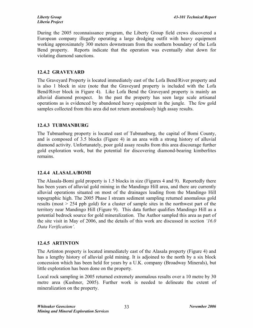
During the 2005 reconnaissance program, the Liberty Group field crews discovered a European company illegally operating a large dredging outfit with heavy equipment working approximately 300 meters downstream from the southern boundary of the Lofa Bend property. Reports indicate that the operation was eventually shut down for violating diamond sanctions.
12.4.2 GRAVEYARD The Graveyard Property is located immediately east of the Lofa Bend/River property and is also 1 block in size (note that the Graveyard property is included with the Lofa Bend/River block in Figure 4). Like Lofa Bend the Graveyard property is mainly an alluvial diamond prospect. In the past the property has seen large scale artisanal operations as is evidenced by abandoned heavy equipment in the jungle. The few gold samples collected from this area did not return anomalously high assay results.
12.4.3 TUBMANBURG The Tubmanburg property is located east of Tubmanburg, the capital of Bomi County, and is composed of 3.5 blocks (Figure 4) in an area with a strong history of alluvial diamond activity. Unfortunately, poor gold assay results from this area discourage further gold exploration work, but the potential for discovering diamond-bearing kimberlites remains.
12.4.4 ALASALA/BOMI The Alasala-Bomi gold property is 1.5 blocks in size (Figures 4 and 9). Reportedly there has been years of alluvial gold mining in the Mandingo Hill area, and there are currently alluvial operations situated on most of the drainages leading from the Mandingo Hill topographic high. The 2005 Phase I stream sediment sampling returned anomalous gold results (most > 254 ppb gold) for a cluster of sample sites in the northwest part of the territory near Mandingo Hill (Figure 9). This data further qualifies Mandingo Hill as a potential bedrock source for gold mineralization. The Author sampled this area as part of the site visit in May of 2006, and the details of this work are discussed in section ‘16.0 Data Verification’.
12.4.5 ARTINTON The Artinton property is located immediately east of the Alasala property (Figure 4) and has a lengthy history of alluvial gold mining. It is adjoined to the north by a six block concession which has been held for years by a U.K. company (Broadway Minerals), but little exploration has been done on the property.
Local rock sampling in 2005 returned extremely anomalous results over a 10 metre by 30 metre area (Kushner, 2005). Further work is needed to delineate the extent of mineralization on the property.
Liberty Group 43-101 Technical Report Liberia Project
Whiteaker Geoscience November 2006 Mining and Mineral Exploration Services
34
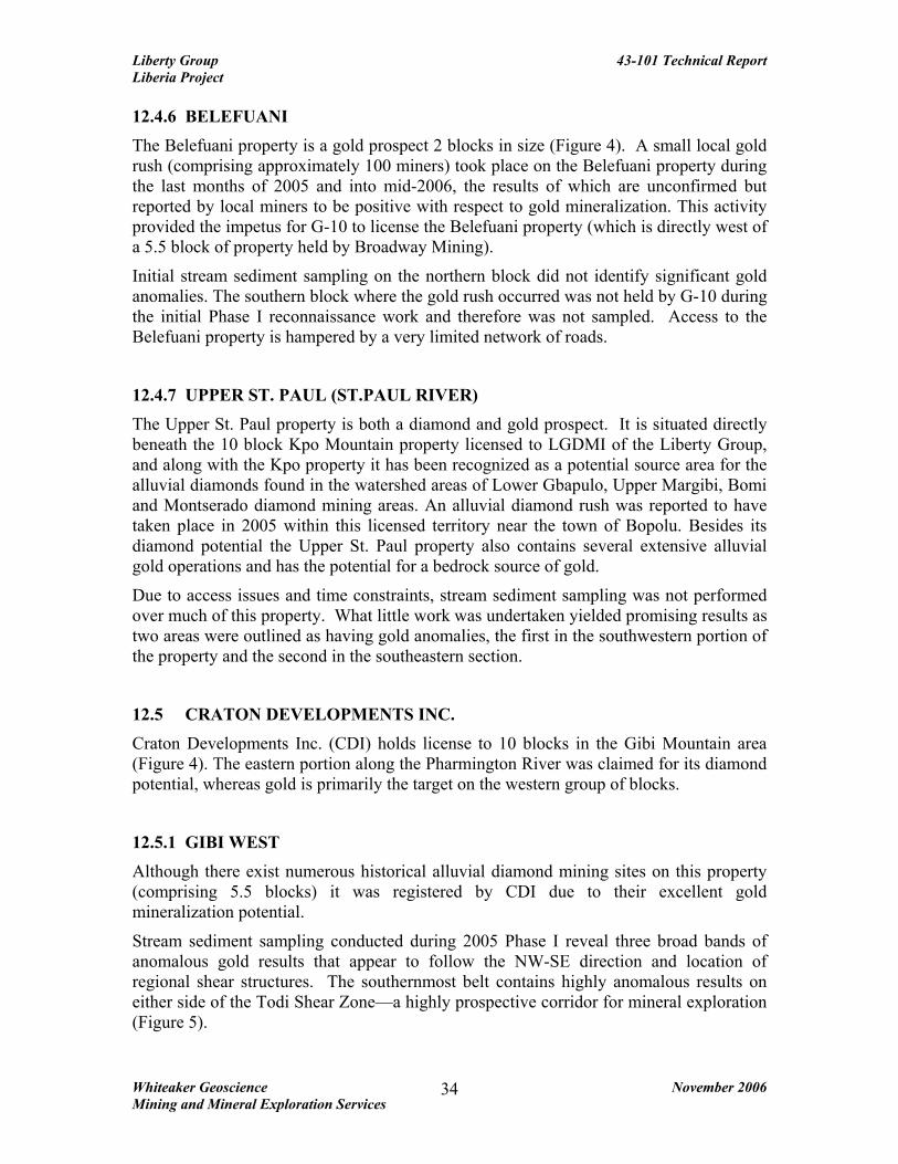
12.4.6 BELEFUANI The Belefuani property is a gold prospect 2 blocks in size (Figure 4). A small local gold rush (comprising approximately 100 miners) took place on the Belefuani property during the last months of 2005 and into mid-2006, the results of which are unconfirmed but reported by local miners to be positive with respect to gold mineralization. This activity provided the impetus for G-10 to license the Belefuani property (which is directly west of a 5.5 block of property held by Broadway Mining).
Initial stream sediment sampling on the northern block did not identify significant gold anomalies. The southern block where the gold rush occurred was not held by G-10 during the initial Phase I reconnaissance work and therefore was not sampled. Access to the Belefuani property is hampered by a very limited network of roads.
12.4.7 UPPER ST. PAUL (ST.PAUL RIVER) The Upper St. Paul property is both a diamond and gold prospect. It is situated directly beneath the 10 block Kpo Mountain property licensed to LGDMI of the Liberty Group, and along with the Kpo property it has been recognized as a potential source area for the alluvial diamonds found in the watershed areas of Lower Gbapulo, Upper Margibi, Bomi and Montserado diamond mining areas. An alluvial diamond rush was reported to have taken place in 2005 within this licensed territory near the town of Bopolu. Besides its diamond potential the Upper St. Paul property also contains several extensive alluvial gold operations and has the potential for a bedrock source of gold.
Due to access issues and time constraints, stream sediment sampling was not performed over much of this property. What little work was undertaken yielded promising results as two areas were outlined as having gold anomalies, the first in the southwestern portion of the property and the second in the southeastern section.
12.5 CRATON DEVELOPMENTS INC. Craton Developments Inc. (CDI) holds license to 10 blocks in the Gibi Mountain area (Figure 4). The eastern portion along the Pharmington River was claimed for its diamond potential, whereas gold is primarily the target on the western group of blocks.
12.5.1 GIBI WEST Although there exist numerous historical alluvial diamond mining sites on this property (comprising 5.5 blocks) it was registered by CDI due to their excellent gold mineralization potential.
Stream sediment sampling conducted during 2005 Phase I reveal three broad bands of anomalous gold results that appear to follow the NW-SE direction and location of regional shear structures. The southernmost belt contains highly anomalous results on either side of the Todi Shear Zone—a highly prospective corridor for mineral exploration (Figure 5).

Liberty Group 43-101 Technical Report Liberia Project
Whiteaker Geoscience November 2006 Mining and Mineral Exploration Services
35
12.5.2 GIBI MOUNTAINS The Gibi Mountains property (4.5 blocks in size) is located along the eastern border of the Gibi property in the northwest portion of the country (Figure 4). Again, this property was retained by the Company due to its local history as a diamond source. Local prospectors believe that the diamonds that are found throughout the Pharmington River have their source in the area of the Gibi Mountains. The majority of the local diamond activity is based along the tributaries on the northern side of the river.
The 2005 Phase I program also returned promising gold numbers for the Gibi Mountains property (Kushner, 2005). Gold anomalies also appear to follow structural shear zones and are especially prospective in the center of the property around the village of Falasa. A recent (summer-fall 2005) gold rush in the Ben Ben Village area lost momentum when locals were unable to progress further into the quartz veins which were over a metre thick, but later resumed their activities in nearby surface areas. Similar quartz veins outcrop along a local ridge for over five kilometers which is within a well known alluvial gold mining area. This particular ridge is a very prospective area for further mineral exploration.
12.6 T-REX RESOURCES INC. T-Rex Resources Inc. (TRX) is the operator of two properties along the eastern border of Liberia totaling 14.25 blocks (Figure 4). Both the Grand Kru and Nimba NE properties possess gold potential, with the Nimba NE property being prospective for diamonds as well.
12.6.1 GRAND KRU The 7.50 blocks of Grand Kru Property (Figures 4 and 10) are cut by the NE-SW trending Dube Shear Zone and are locally said to be very prospective for alluvial gold.
Access is difficult in this part of the country as road conditions are extremely poor and are exacerbated during the rainy season. Many areas are accessible only by walking trails. Due to limited access large areas of the property under reconnaissance license did not undergo a 2005 sampling program. However, the limited reconnaissance sampling that was completed in this area produced anomalous gold values that appear to follow the trend of the 4 kilometer wide Dube Shear Zone (Figure 5). A cluster of highly anomalous gold values located in the east-central portion of the property outlines a ridge over 6 kilometers in length. Consistently high values in stream sediment samples were collected from either side of the ridge. Numerous samples assayed anomalous gold values greater than 100 ppb, with several in the > 254 ppb range (Figure 10).
Another area approximately 5 kilometers south-southwest from this ridge also contains anomalous gold values.
12.6.2 NIMBA EAST The Nimba East property consists of 6.75 blocks of territory in the south-east part of Nimba County adjacent to the border with Côte d'Ivoire (Figure 4). Much of this property has been retained based on reports of diamond rich areas contained within. The

Liberty Group 43-101 Technical Report Liberia Project
Whiteaker Geoscience November 2006 Mining and Mineral Exploration Services
36
Lamtuo area in the north contains numerous historical diamond mining areas such as Niatuo, Bimpea, Lapula and Lamtuo Town which are believed to have produced good quality alluvial diamonds (Kushner, 2005). Artesian mining is reported to venture as deep as 100 feet.
Stream sediment sampling for gold returned a few scattered highly anomalous results. There are a number of small iron formations that outcrop across the property and appear to have associated gold numbers.
13.0 DRILLING No recent drilling has taken place on the Mineral Properties of the Liberty Group of companies.
14.0 SAMPLING METHOD AND APPROACH The Liberty Group began mineral exploration in Liberia by contracting local geologists during periods of availability. Sampling progressed in an unsupervised manner until March of 2005, when the Company hired a Canadian geologist (W. Kushner) to supervise the 2005 Phase I reconnaissance exploration program. Due to questions concerning quality control and sampling techniques it was decided by the Company to set aside all previous work and start fresh by properly training local geologists and field crews to work according to internationally accepted sampling collection and preparation standards. Personnel were trained and employed to conduct a systematic reconnaissance stream sediment sampling program over the entire territory held by the Liberty Group of Companies. Original governmental deadlines for work decreed that all activity be completed by June 30th, 2005; however extensions were applied for and granted, enabling work in the field to continue to August, 31 2005.
The Author is not aware of any information relating to quality of the 2005 gold samples, whether the samples were representative, or of any other factors that may have resulted in sample bias. Sample collection methodology is discussed in the following section—Sample Preparation, Analysis and Security.
15.0 SAMPLE PREPARATION, ANALYSES AND SECURITY Nearly 6000 stream sediment samples (gold) were collected from properties throughout the entire country under the supervision of W. Kushner, B.Sc. (Geology). Sample locations were located using a GPS (Global Positioning System). Sampling was conducted from late March until the end of August, when the onset of the rainy season rendered stream sampling impossible due to high water levels in streams. Mr. Kushner was the 2005 reconnaissance program supervising geologist in Liberia and was in charge of training many of the workers conducting the fieldwork.
The following two paragraphs are excerpts from the 2005 Kushner report and outline the sample collection methodology of the Phase I program:

Liberty Group 43-101 Technical Report Liberia Project
Whiteaker Geoscience November 2006 Mining and Mineral Exploration Services
37
“Sampling procedures were organized to ensure that all sampling would be conducted in exactly the same manner. Silt sediment samples were collected from actively flowing streams below the layer of vegetation and mud (if present). In extremely rocky samples, silt would be sieved from the sample at the time of collection using a ¼” mesh screen crafted locally. Samples were collected in kraft paper sample bags and later in plastic zip-loc freezer bags which were much easier to obtain locally. Sample locations were recorded using handheld GPS units. The locations were later plotted and compiled using ARCGIS”.
“The kraft samples were air dried to reduce weight. The first batch of samples (consisting of approximately 400 samples) were air-freighted to Accra, Ghana, and then shipped by truck to the SGS lab in Tarkwa for analysis by Aqua Regia. Difficulties and delays in transporting the samples led the Company to send all subsequent samples directly by truck from Monrovia to the SGS lab in Siguri, Guinea. Initial results indicated low background levels of gold present. It was decided to use BLEG sampling analysis with a detection of 1 ppb to analyze all the samples sent to Siguri, Guinea”.
Prior to being sent to assay labs the field samples were stored at the Company’s guarded compound in Monrovia. Un-assayed duplicates were also kept at this location.
Two hundred and fifty one diamond indicator mineral samples were collected from the Lofa Bend, Graveyard, Nimba NE and Gibi West properties (Figure 4) under the supervision of 2005 Project Geologist W. Kushner, B.Sc. (Geology).
Geologists and field technicians who were well trained in the collection of gold stream and soil samples utilized these same methods to collect diamond indicator mineral samples. Ten kilogram samples were collected from streams and transported to the Company compound in Monrovia, where they were panned of organics and fine silt and screened by hand using ¼ inch mesh and examined by geologists using hand lenses. Samples containing a selection of green, pink or red minerals (suspected ilmenites or garnets), were split to smaller sized fractions and panned in order to concentrate heavier minerals. Altogether, 77 samples were sent to the SGS Diamond Laboratory in Lakefield, Ontario, and 174 samples were sent to the CF Minerals Diamond Laboratory in Kelowna, British Columbia. Samples sent to the SGS Laboratory were dried, the concentrates submitted for heavy mineral separation and then screened at 60 meshes. This material was added to heavy liquids, submitted to further dry screening (10, 20, and 35 mesh) and magnetic separation (hand magnet and Frantz electromagnetic separator). The mineral concentrates were observed with a binocular microscope for the selection of diamond indicator species. Reviews of the selection results show that recovered kimberlite indicator minerals were ilmenite and chromite. Ruby, sapphire and gold were also noted in some samples. The size fraction -35 +60 mesh contained the highest concentrations with a total of 56 of the 77 samples collected containing either ilmenites, chromites or both. The potential indicator minerals sampled at the SGS Laboratory were not probed by electron microprobe. The 174 samples sent to the CF Minerals Laboratory underwent standard laboratory processing including washing, dry sieving, and heavy liquid separations utilizing

Liberty Group 43-101 Technical Report Liberia Project
Whiteaker Geoscience November 2006 Mining and Mineral Exploration Services
38
tetrabromoethane and methylene iodide before being further concentrated using electromagnetics to produce heavy mineral fractions. Selected fractions were picked under binocular microscopes to recover diamond indicator minerals. The grains were mounted on epoxy plugs and scanned by a Scanning Electron Microscope (SEM), after which they were classified and ranked using the proprietary classification programs. The following text is from the CF Mineral Laboratory report on the Company’s diamond indicator analyses: “Most of the grains selected for microprobe analyses were clinopyroxenes, orthopyroxenes, chromites and picroilmenites. One orthoproxene from Sample L3212D displays chemistries that are consistent with diamond inclusion orthopyroxenes, however it also overlaps with the field for non-diamond inclusion orthopyroxenes. Sample JDS #330 contains two diamond-inclusion type chromites and one Ti-chromite which possibly originated from a magmatic source. None of the analyzed clinopyroxenes contained diamond inclusion chemistry. Picroilmenite is an indicator of diamond preservation potential and is significant only if diamonds are present in an ore body.”
15.1 STATISTICAL ANALYSIS OF THE RESULTS The purpose of conducting the 2005 regional reconnaissance sampling program was to obtain a sample population sufficient enough to determine the mean values for background gold throughout the Company’s territories. Statistics were performed on the assays by W. Kushner and results of these analyses are presented in Table 3. In order to perform a balanced analysis, all samples below detection (<1 ppb Au) were assigned a value of zero. Also, samples with an analysis greater than 800 ppb Au were also not included in the statistical analysis (approximately 25 samples).
TABLE 3 STATISTICAL ANALYSES OF 2005 ASSAY RESULTS
Statistical Divisions (in ppb)
Mean Standard Deviation
Below Detection
Under Mean
First Dev.
Slightly Anom. Anom.
Very Anom.
Highly Anom. Highest
12 22 <1 2-11 12-33 34-55 56-77 78-100 101-122 >123
The mean value for gold in the stream silt samples was 12 ppb. Samples were divided into groups based on the standard deviations from the mean, and anomalous results were then studied and plotted on regional maps with assigned UTM co-ordinates.
After a complete analysis of the collected silt samples, and a comparison against historical placer gold and diamond mining for Liberia, the most promising areas for additional mineral exploration were retained by the Company.

Liberty Group 43-101 Technical Report Liberia Project
Whiteaker Geoscience November 2006 Mining and Mineral Exploration Services
39
16.0 DATA VERIFICATION In May of 2006 the Author visited many of the Liberian territories of the Liberty Group of Companies with the aim of conducting a geological examination of numerous mineral workings and showings, as well as collecting field samples (gold stream and soil) for assay verification of the Phase I 2005 reconnaissance work. The Author did not collect any diamond indicator mineral samples for verification. Although mappable bedrock is rare in much of Liberia, the Author was able to find some sparse outcrops of granitic gneiss (locally with quartz-rodding), mica schist, greenstone/amphibolite, and oxidized tectonic breccia rock. Local float and stream-bed boulders of the above lithologies as well as hornblende-diorite and quartz veined greenstone were not uncommon in areas of higher relief. These rock types correlate well with the units reported by Kushner (2005) and other authors. Fifteen samples were collected under the direct supervision of the Author and are listed in Table 4 and plotted on Figures 6-10. The location of the samples was determined using a GPS unit and the UTM coordinates of the stations recorded. These locations were entered into a database along with the sample number and sample description. The samples were packaged and shipped to Canada for assay analysis at an independent ISO Certified Laboratory (Eco-Tech Laboratory Ltd., Kamloops, British Columbia), where Quality Control (QA/QC) procedures are followed. The samples were analyzed for gold (30 gram) and 28 element ICP analysis (assay certificates may be found in Appendix 1). Due to the typically coarse nature of the gold over much of the Company’s concessions a metallic screen was utilized during the assay process. To the Author’s knowledge none of the 2005 stream samples were subjected to a metallic screen during analysis. Many of the low lying streams in Liberia undoubtedly drain through areas consisting of alluvial material, which may in turn contain alluvial gold and diamonds. This raises the possibility that some of the 2005 and 2006 samples may have been contaminated by coarser alluvial gold. To be consistent the Author collected stream samples in a similar manner as was done during the 2005 stream sediment sampling program (see section 15.0—Sample Preparation, Analysis and Security). The limited number of collected samples along with their assay results is insufficient to enable comment on the accuracy and precision of historical methods; however, they do provide independent verification of gold mineralization on the sampled properties of the Company. During the Author’s May 2006 property visits an attempt was made to locate as many Phase I sample sites as possible with the motive of duplicating some 2005 assay results. Unfortunately, only a few 2005 sites were found (see Table 4 narrative). Three sites were located on the Gibi property (L0412, L4788 and L5053). Of these samples the following results were noted: the 2005 sample L0412 (254 ppb Au) does not correlate with the 2006 sample L8902 (<0.03 g/t Au); the 2005 sample L5053 (121 ppb Au) does not correlate with the 2006 sample L8905 (<0.03 g/t Au); but the 2005 sample L4788 (5 ppb Au) was

Liberty Group 43-101 Technical Report Liberia Project
Whiteaker Geoscience November 2006 Mining and Mineral Exploration Services
40
closely comparable with the 2006 sample L8904 (<0.03 g/t Au). One 2005 sample site was located on the Nimba South-Coldbahn Mountain block. Phase I sample L1132 (9 ppb Au) correlates with a May 2006 sample L8912 (0.03 g/t Au). Considering the enormous number of samples collected during the 2005 reconnaissance stream sampling program a larger population of new confirmation samples would be required to verify the Phase I results. The handful of samples collected in May of 2006 is statistically too small to establish the presence or absence of mineralization within those specific areas. Two grab samples of angular, dark grey-green to orange-green, pyrite-bearing metasediments/metavolcanics collected from an active mining area on the Alasala/Bomi block (Mandingo Hill camp) returned elevated gold values of 6.23 g/t Au (sample L8900) and 13.49 g/t (sample L8901). Sample L8900 had a tectonically brecciated texture. The samples were taken from a recently excavated, partly limonitic rock pile adjacent to a large hand-dug pit. This mineral occurrence is on strike with a large regional structure (the Todi Shear—Figures 5 and 9), and is the ideal tectonic and geologic environment for hosting gold mineralization. At Solo village (Putu property) the Author was able to witness the sieving and panning of dark-brown, saprolitic soil samples that yielded fine native gold in a silty, dark-grey, mafic concentrate. These samples were collected from locations near samples L8906 and L8907 (Figure 7). This exercise was repeated at the Solo mining camp, located a short distance from Solo village, where visual gold was sieved and panned from deep orange-brown saprolite. The author has examined digital copies of official assay certificates (SGS Mineral Services Guinea SARL) and a UTM coordinate database for samples collected from the 2005 Reconnaissance Program. Due to the large volume of samples retrieved during the 2005 work a more extensive re-sampling program would be required for more thorough assay verification. The author was unable to independently re-assay pulps from the 2005 program as they presently remain in storage at SGS Mineral Services, Guinea.

Liberty Group 43-101 Technical Report Liberia Project
Whiteaker Geoscience November 2006 Mining and Mineral Exploration Services
41
TABLE 4 INDEPENDENTLY COLLECTED FIELD SAMPLES Sample Number
UTM Coordinates SampleType
Au (g/t)
Location/ Property
Narrative
L 8900 307367E/728827N Rock 6.23 Alasala Grab sample of oxidized metavolcanics (greenstone?) w/ 1-2% pyrite. Tectonic brecciation.
L8901 307379E/728836N Rock 13.49 Alasala Grab sample of greenstone (metavolcanics) w/ 3-4% disseminated pyrite.
L8902 306537E/728719N Stream <0.03 Alasala Light to medium-greyish brown, fine sand. Near 2005 sample site L0412, 254 ppb Au.
L8903 356250E/721464N Stream <0.03 Gibi Light-grey to brown, fine gravelly sand.
L8904 355494E/721627N Stream <0.03 Gibi Light-grey, quartz-rich, fine gravelly sand. Previous sample site L4788, dated June 27/05, 5 ppb Au.
L8905 342631E/714749N Stream <0.03 Gibi Light-grey sand sample. Previous sample site of L5053, dated July 2/05, 121 ppb Au.
L8906 617659E/621696N Soil 0.17 Putu 30cm depth, dark brownish-grey soil from Solo village.
L8907 617659E/621696N Soil <0.03 Putu 50cm depth, dark brownish-grey soil from Solo village.
L8908 616816E/621536N Soil 0.24 Putu Orange-brown saprolitic soil at Solo mining camp excavation site.
L8909 616887E/621525N Soil 0.53 Putu Orange-brown saprolitic soil at Solo mining camp excavation site. Mica in soil, possible granitic gneiss (?).
L8910 616009E/622252N AlluvialSoil
0.03 Putu Light-grey, quartz-rich alluvial sand and fine gravel from a 10 m deep pit at the New Creek mining excavation site.
L8911 623846E/611179N Stream 2.03 Putu Light-grey, quartz-rich sand w/ mafic flecks, from old alluvial workings.
L8912 506622E/720686N Stream 0.03 Coldbahn Light grey-brown sand. Previous 2005 sample site L1332, 9 ppb Au.
L8913 511066E/723946N Stream <0.03 Coldbahn Light to medium, grey-brown sand.
L8914 511106E/724025N Stream <0.03 Coldbahn Light to medium, grey-brown sand.
17.0 ADJACENT PROPERTIES
In 2005, it was reported that approximately 23 international and local mineral exploration companies had either mining or reconnaissance/exploration licenses in Liberia (Kushner, 2005). It is difficult to acquire detailed information about the holdings of these companies from the Ministry of Lands and Mines, therefore verification of these numbers is problematic. The following is a list of other companies thought to be currently operating in Liberia along with the number of land holdings in their tenure:

Liberty Group 43-101 Technical Report Liberia Project
Whiteaker Geoscience November 2006 Mining and Mineral Exploration Services
42
• Africa Aura Resources – 8 blocks • AMA – 3.5 blocks • Amlib United Minerals – 22 blocks • Bea Mountain Mining Corporation – 10 blocks • Broadway Mining – 30.5 blocks • Diamond Fields International – 33 blocks • Diamond Mineral Trading and Investment Company – 6.5 blocks • Ducor Minerals – 19 blocks • Earthservices – 1 block • Freedom Gold – 9 blocks • Hope National Investment Corporation – 9.5 blocks • Intervest – 3 blocks • Kpo Resources – 2 blocks • Precious Minerals Mining Company – 5 blocks • Sino King International Holdings – 12 blocks • Yamereco – 1 block
In addition, Mano River Resources holds approximately 130 blocks in Lofa County under a special Mineral Co-operation Agreement with the government for potential future exploration. Several large iron mining companies are negotiating the redevelopment of the Yakepa iron deposit in North Nimba. Mano River Resources has also recently applied for an Iron Exploration License for 6 blocks within the Putu property. There exist two known large iron ridges outcropping near the center of the Putu property and are flanked by highly anomalous gold values. Iron ore is covered under a separate license from gold and diamonds, and as such the Company was advised by the Department of Lands and Mines that this would not impose any license risk upon the holdings of the Liberty Group in this area.
BHP Billiton recently completed rapid reconnaissance on 13 concessions for iron deposits resulting in the signing of 6 Exploration Licenses. Cassidy Gold is thought to have a number of contiguous blocks north of the Liberty Group’s River Cess property and an unknown company has apparently acquired territory adjacent to both sides of the Liberty Group’s Putu property in southeastern Liberia.
Clarification of laws concerning the staking of iron properties may be obtained from the Ministry of Lands and Mines along with guarantees concerning the Liberty Groups mineral exploration rights for gold, diamonds and other elements on territory within the Putu block. The Liberian Mining Act stipulates that no company may claim minerals on ground that has been previously licensed to another group.
18.0 MINERAL PROCESSING AND METALLURGICAL TESTING To the Authors knowledge no mineral processing or metallurgical testing has been completed on the Liberian mineral properties of the Liberty Group.

Liberty Group 43-101 Technical Report Liberia Project
Whiteaker Geoscience November 2006 Mining and Mineral Exploration Services
43
19.0 MINERAL RESOURCE AND MINERAL RESERVE CALCULATIONS There is no current resource estimate for the Liberty Group properties in Liberia, West Africa and the Author has not performed any mineral resource estimate. 20.0 OTHER RELEVANT DATA AND INFORMATION The Author knows of no other relevant data or information that could be included in this report that if not included, would make this report misleading. 21.0 INTERPRETATION AND CONCLUSIONS Although there are numerous historical and working alluvial gold and diamond operations throughout Liberia, several mineral exploration properties of the Liberty Group of Companies also cover areas that are geologically favorable to hosting potential bedrock-saprolite gold and diamond mineralization. The Phase I 2005 regional stream sediment sampling program succeeded in collecting enough samples to at least bring into focus some ‘general’ gold mineralization trends across the Company’s properties—many of which have chiefly tested areas of alluvial deposition of gold and diamonds. Of all the samples collected during the Authors site visit, two from the Alalsala-Bomi trench mining area (Mandingo Hill) returned the most encouraging gold values, with angular grab samples of pyrite-bearing metasediments/metavolcanics containing 6.23 g/t Au (sample L8900) and 13.49 g/t Au (sample L8901). This is very encouraging as these rocks were from a newly excavated, partly limonitic ‘waste’ pile adjacent to a large hand-dug pit. This mineral occurrence is on strike with a large regional structure (the Todi Shear), and is the ideal tectonic and geologic environment for further exploration work. The very limited volume of geologic information of Liberia has made for a difficult detailed geological interpretation of any of the Company’s concessions. Therefore the extent of primary gold and diamond mineralization on the territories of the Liberty Group of Companies is poorly understood. Some of the most promising geological settings for gold are those areas mapped as containing metasediments and metavolcanics (greenstones and amphibolites) of the Birimian sequence that are located within zones of large scale NW-SE and NE-SW trending regional structures (i.e. the Todi, Dube and Cestos Shear zones). In addition, gold exploration should also concentrate on areas mapped as containing quartz veins and brecciated rocks. Based on the hurried nature and substandard methodology of the Company’s brief 2005 diamond indicator mineral sampling program it is difficult to accept that the analyses of the 251 samples equitably represents the diamond potential of—or possible absence of—the sampled material. The Author visited numerous operational and historical alluvial diamond operations on the Company’s concessions—evidence that diamonds have been (and are currently being) mined on portions of some of the Liberty Group territories. Of

Liberty Group 43-101 Technical Report Liberia Project
Whiteaker Geoscience November 2006 Mining and Mineral Exploration Services
44
the 251 diamond indicator samples that underwent laboratory analysis for diamond indicator mineralogy, many contained concentrations of clinopyroxene, orthopyroxene, picroilmenites and chromites, but only 2 were reported to contain possible diamond-inclusion chemistry. In the Authors opinion a fully detailed, professional and quantifiable diamond indicator mineral sample survey of the Company’s concessions has yet to be executed. In order to adequately explore the potential diamond mineralization across their vast mineral exploration packages the Liberty Group of Companies has expressed an interest in entering into a joint venture with other diamond exploration companies. This may facilitate progress in the identification of prospective drill targets of diamond mineralization. The Liberty Group should consider further professional diamond exploration work on their most prospective diamond concessions—namely the Kpo Mountain/Gbapolu County, Upper St. Paul River, Lofa Bend, Graveyard, Gibi Mountains and Tubmanburg areas. Of these the Kpo Mountain/Gbapolu County territories are located in an area of known kimberlite pipe occurrences (Kushner, 2005). Based on the property visit of the Author, the available geological and structural data, and anomalous gold values from the 2005 Phase I sampling program the following licensed properties are considered the most promising for further gold exploration work: (i) Alasala, (ii) Putu, (iii) Nimba South/Coldbahn Mountain, (iv) River Cess and (v) Grand Kru. Detailed sample location maps with gold assay values for each of these 5 concessions are presented in Figures 6 through 10. The exclusion of the Company’s remaining mineral concessions from this list does not negate the potential for mineralization on these properties, but is a result of the limited reconnaissance work, sampling and insufficient geological information for those areas. Ultimately a great deal more regional and local scale exploration work is required to develop a better understanding of the nature of, and controls on gold and diamond mineralization. 22.0 RECOMMENDATIONS The land positions held by the Liberty Group of Companies contain the potential for the discovery of major gold and diamond deposits. The abundance of alluvial gold and diamonds and the long history of alluvial mining operations indicate probable local sources for the gold and diamonds.
Two additional phases of gold exploration work are proposed for six of the properties listed in the previous section of this report—the Alasala/Bomi, Putu, Nimba South/Coldbahn Mountain, River Cess, Grand Kru and Kpo Mountain concessions (as of this report no further work is recommended for the remaining properties of the Liberty Group). Based on current geological data these six areas are considered ideal for detailed gold exploration. An aggressive 9-month Phase II work program would consist of systematic line-cutting, soil sampling, regolith mapping (lithology, alteration, structure

Liberty Group 43-101 Technical Report Liberia Project
Whiteaker Geoscience November 2006 Mining and Mineral Exploration Services
45
and mineralization, etc.), and geophysical surveys (magnetics). The location and orientation of grid lines should be based on a combination of 2005 sample results, structural data, local geology and the historical mining in the area. Approximately 800 kilometres of grid-line along with 16,000 geochemical soil samples is proposed for these properties. But actual field work may vary based on geological information, logistics and topography. A detailed orientation survey may be carried out prior to designing or implementing a regional grid soil-sampling program. This survey would involve kilometer-scale soil sampling over a variety of terrains selected from existing regional information. The orientation survey would be designed to establish the detailed sampling parameters such as depth of sampling and the size fraction to be sampled. Phase II sampling should focus on conducting multi-element analysis along with gold assays on all samples to investigate possible correlations with gold, to explore the possibility of lithogeochemical mapping, and to establish analytical requirements for the regional sampling program. Detailed topographic maps should be digitized from 1:50,000 scale paper copies (if available), and areas where only 1:1,000,000 scale topographic maps are available satellite mapping could be employed to produce topographic maps. Depending on accessibility and logistical issues trench work could be undertaken to test the depth and extension of zones of known anomalous gold mineralization (from regional geochemical studies). Trenches may be excavated by hand to 3-4 metres or to bedrock if it is shallower. Channel or chip sampling at one metre intervals is advised along with detailed trench mapping by the site geologist. In addition, further regional stream and soil reconnaissance sampling could be carried-out over ‘missed’ areas based upon the results from last years work. This should aid in the identification of greater gold mineralization trends on the Company’s licenses. Although it is not included in the Phase II or Phase III mineral exploration budgets (which is focused on gold exploration), the Liberty Group of Companies should consider implementing future diamond exploration work on their prospective concessions (the Kpo Mountain/Gbapolu County, Upper St. Paul River, Lofa Bend, Graveyard, Gibi Mountains and Tubmanburg areas). It is recommended that any work program of this nature be designed and supervised by qualified diamond exploration geologists, and that all sampling for diamond indicator minerals be carried-out by these same geologists or by carefully trained field technicians. Due to the critical importance of structural controls on mineralization an airborne geophysical survey and analysis of high resolution Landsat data and aerial photography should be considered (although this type of information may not be available for much of Liberia). An airborne magnetics survey would also be useful for the exploration of diamond-bearing kimberlite pipes. Unfortunately, the costs of an airborne geophysical survey may be prohibitive for the Company at this point. A joint venture with other diamond exploration companies may help facilitate this type of expensive field work.

Liberty Group 43-101 Technical Report Liberia Project
Whiteaker Geoscience November 2006 Mining and Mineral Exploration Services
46
All data would be entered into a digital database system with a careful analysis and interpretation of the results with the objective of identifying areas for further detailed work and potential drill targets. Ultimately a geological model should be developed for the properties of interest and how they relate to each other on a regional scale. A Phase III work program (consisting mainly of drilling, and some additional trenching, geophysics and detailed sampling), would be dependent upon positive results from Phase II exploration. The initial phase of drilling will provide very useful information on the geology of the properties, the controls of gold mineralization and in general, the gold content of the saprolite-laterite and underlying bedrock. Exploration drilling (RC or diamond drilling) should be intended to test the strike and dip extensions of the modeled mineralized zones, and would also test new anomalies highlighted from regional ground prospecting or aeromagnetic targets. Due to the isolated nature of some of the properties drilling may locally require significant road construction and/or helicopter assistance. According to the Company’s Exploration Agreement, fees are paid only for the amount of time ground is held. Therefore during the first few months of the Phase II program, work should concentrate on fully evaluating the licenses held and gaining further information where required. As detailed exploration continues a reduction in the land holdings may result. In this way the Liberty Group of Companies will retain license to only those territories it considers most prospective for gold and diamond mineralization. This will reduce Company costs and enable efforts to be concentrated on the most promising land holdings.
Due to various logistical challenges and tentative costs of operating a mineral exploration program in Liberia it is difficult to propose an accurate Phase II or Phase III program budget. However, based upon expenditure information provided to the Author by the Liberty Group of Companies every effort has been made to produce a realistic exploration budget. For this reason a contingency figure of 10% has been added to the Phase II program.
The budget for the Phase II program is US $1,530,100 and a contingent Phase III drill program is US $1,287,000 details of which are listed in Table 5.

Liberty Group 43-101 Technical Report Liberia Project
Whiteaker Geoscience November 2006 Mining and Mineral Exploration Services
47
TABLE 5 PROPOSED PHASE II AND PHASE III EXPLORATION BUDGETS
Expense Item Details Cost (US $) Phase II: (6 Month Program) Database Compilation/Maps $10,000 Geologists (Ghanian and Liberian) 20 X $60,000/month $360,000 Geological Assistants 20 X $9,000/month $54,000 Field Support (Guides, Laborers, etc.) 250 X
$37,500/month $225,000
Analytical Costs (geochemical samples) 20,000 X $7.00 $140,000 Transportation (vehicle purchase and fuel, etc) $220,000 Administration $10,000/month $60,000 Accommodation in Monrovia $20,000 Work Visas and Geologist Permits 20 X $900 $18,000 Field/Camp Supplies $30,000/month $180,000 Road Construction/Access $20,000 Sample delivery to Guinea Assay Laboratory 6 X $4,000 $24,000 Reports and QP Site Visit $20,000 Geological Equipment $40,000 Contingency @ 10% $139,100 Total $1,530,100 Phase III: (Reliant on Phase II Results) (4 Month Program) Drilling 6,000 m X $120/m $720,000 Drill Support (geologists, access and drill pads construction, core-splitting, labor, assaying, etc.)
$75,000/month $450,000
Contingency @ 10% $117,000 Total $1,287,000

Liberty Group 43-101 Technical Report Liberia Project
Whiteaker Geoscience November 2006 Mining and Mineral Exploration Services
48
23.0 SIGNATURE PAGE This report titled “NI 43-101 Technical Report: Reconnaissance Exploration Activities on the Mineral Concessions of Liberty Diamond International Inc. and Canlib Resources Inc.” dated November 26 2006 was prepared by and signed by the following author: “Signed and Sealed” Dated at Kamloops, British Columbia November 26, 2006 Robin J. Whiteaker, P.Geo. Consulting Geologist

Liberty Group 43-101 Technical Report Liberia Project
Whiteaker Geoscience November 2006 Mining and Mineral Exploration Services
49
24.0 REFERENCES Dorbor, J., R. Tarnue and H. Linclon, 2005. Local Geologists Report on the Licenses of
Liberty Gold and Mining Inc. and Associated Companies; Unpublished Company Report, 18 pages
Kushner, W. 2005. The Liberty Group of Companies: Phase I Work Program—A
Report on Activities to October, 2005; Unpublished Company Report, 53 pages. Wright, J.B., (Editor and Principal Author), 1985. Geology and Mineral Resources of
West Africa, George Allen and Unwin, London, 187 pages.

Liberty Group 43-101 Technical Report Liberia Project
Whiteaker Geoscience November 2006 Mining and Mineral Exploration Services
50
25.0 DATE AND SIGNATURE
Robin J. Whiteaker, P.Geo. Whiteaker Geoscience
1629 Coldwater Dr. Kamloops, B.C., V2E 2M4
CERTIFICATE of AUTHOR
To Accompany the Report Entitled “NI 43-101 Technical Report: Reconnaissance Exploration Activities on the Mineral Concessions of Liberty Diamond
International Inc. and Canlib Resources Inc.” Dated November 26, 2006. I, Robin J. Whiteaker, P.Geo. do hereby certify that: 1. I reside at, 1629 Coldwater Dr., Kamloops, British Columbia, Canada. 2. I am a graduate from the University of British Columbia, with an Honours B.Sc.
Degree in Geological Sciences (1996). In addition, I have obtained a B.Ed. Degree from the University of British Columbia (2000).
3. I am a registered member of the Association of Professional Engineers and
Geoscientists of British Columbia (license # 30197). 4. I have worked as a geologist for approximately 9 years since graduation from
university, primarily in the mining and mineral exploration industry. My relevant experience for the purpose of the Technical Report is: Exploration experience on copper-gold properties throughout Canada and Central America.
5. I have read the definition of “qualified person” set out in National Instrument 43-
101 (“NI 43-101”) and certify that by reason of my education, affiliation with a professional association (as defined in NI 43-101) and past relevant work experience, I fulfill the requirements to be a “qualified person” for the purpose of NI 43-101.
6. I am responsible for the preparation of the body of the technical report titled “NI 43-101 Technical Report: Reconnaissance Exploration Activities on the Mineral Concessions of Liberty Diamond International Inc. and Canlib Resources Inc., Liberia, West Africa” and dated November 26, 2006 (the “Technical Report”) relating to the Liberian properties of the Liberty Group of Companies. I personally visited the Liberian mineral properties of the Liberty Diamond International Inc. and Canlib Resources Inc. between the dates of May 18th and 28th, 2006.

Liberty Group 43-101 Technical Report Liberia Project
Whiteaker Geoscience November 2006 Mining and Mineral Exploration Services
51
7. I am independent of the issuer as described in section 1.4 of National Instrument 43-101.
8. I have not had prior involvement with the properties that are the subject of the
Technical Report. 9. I have read National Instrument 43-101 and Form 43-101F1, and the Technical
Report has been prepared in compliance with that instrument and form. 10. To the best of my knowledge, information and belief, the Technical Report
contains all scientific and technical information that is required to be disclosed to make the report not misleading.
11. I consent to the filing of this Technical Report with any stock exchange and other
regulatory authority and any publication by them, including electronic publication in the public company files on their websites accessible by the public.
This report dated 26th Day of November, 2006 “Signed and Sealed” Robin J. Whiteaker, P .Geo.

Liberty Group 43-101 Technical Report Liberia Project
Whiteaker Geoscience November 2006 Mining and Mineral Exploration Services
52
26.0 ADDITIONAL REQUIREMENTS FOR TECHNICAL REPORTS ON DEVELOPMENT PROPERTIES AND PRODUCTION PROPERTIES
None of the Liberian mineral properties of the Liberty Group of Companies are development or production properties. 27.0 ILLUSTRATIONS

Figure 6 River Cess Property--Phase I Sample Locations

Figure 7 Putu Property--Phase I Sample Locations

Figure 8 Nimba South Property--Phase I Sample Locations

Figure 9 Alasala/Bomi Property--Phase I Sample Locations

Figure 10 Grand Kru Property--Phase I Sample Locations

Liberty Group 43-101 Technical Report Liberia Project
Whiteaker Geoscience November 2006 Mining and Mineral Exploration Services
58
APPENDIX I
2006 INDEPENDENT SAMPLING ASSAY CERTIFICATES

Liberty Group 43-101 Technical Report Liberia Project
Whiteaker Geoscience November 2006 Mining and Mineral Exploration Services
59

Liberty Group 43-101 Technical Report Liberia Project
Whiteaker Geoscience November 2006 Mining and Mineral Exploration Services
60

Liberty Group 43-101 Technical Report Liberia Project
Whiteaker Geoscience November 2006 Mining and Mineral Exploration Services
61

Appendix 2 Geological Legend to Figures 5 through 10

Appendix 2 Geological Legend to Figures 5 through 10