no 59 june 2012 joint edition of the newsletter of the ... la climatología del modelo para el área...
TRANSCRIPT
VAM
OS!
No 59 June 2012
No. 8 2012
CLIVAR is an international research programme dealing with climate variability and predictability on time-scales from months to centuries. CLIVAR is a component of the World Climate Research Programme (WCRP). WCRP is sponsored by the World Meteorological Organization, the International Council for Science and the Intergovernmental Oceanographic Commission of UNESCO.
International CLIVAR Project OfficeNational Oceanography Centre, Southampton SO14 3ZH, United Kingdom
Tel: +44 23 80 596777 Fax: +44 23 80 596204 Email: [email protected] address: www.clivar.org
VAMOS Newsletterc/o Departamento de Ciencias de la Atmosfera - UBA
Pabellon II - 2° piso - Ciudad Universitaria - 1428 Buenos Aires, ArgentinaTel: (54-11) 4576-3356 or 4576-3364 ext. 20: Fax (54-11) 4576-3356 or 4576-3364 ext.12
Email: [email protected]
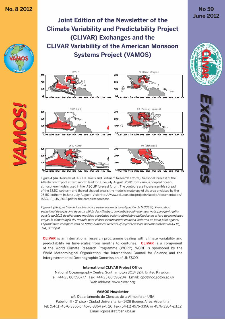
Figure 4 (An Overview of IASCLIP Goals and Pertinent Research Efforts): Seasonal forecast of the Atlantic warm pool at zero month lead for June-July-August, 2012 from various coupled ocean-atmosphere models used in the IASCLiP forecast forum. The contours are intra-ensemble spread of the 28.5C isotherm and the red shaded area is the model climatology of the area enclosed by the 28.5C isotherm in June-July-August. Visit http://www.eol.ucar.edu/projects/iasclip/documentation/IASCLIP_JJA_2012.pdf for the complete forecast.
Figura 4 (Perspectiva de los objetivos y esfuerzos en la investigación de IASCLIP): Pronóstico estacional de la piscina de agua cálida del Atlántico, con anticipación mensual nula, para junio-julio-agosto de 2012 de diferentes modelos acoplados océano-atmósfera utilizados en el foro de pronóstico xrojas, la climatología del modelo para el área circunscripta en dicha isoterma en junio-julio-agosto. El pronóstico completo está en http://www.eol.ucar.edu/projects/iasclip/documentation/IASCLIP_JJA_2012.pdf.
Joint Edition of the Newsletter of the Climate Variability and Predictability Project
(CLIVAR) Exchanges and the CLIVAR Variability of the American Monsoon
Systems Project (VAMOS)

2 CLIVAR Exchanges No. 59, June 2012 / VAMOS No. 8
VAMOS Newsletter EditorialDavid J. Gochis1, Ernesto Hugo Berbery2
1 National Center for Atmospheric Research, VAMOS co-chair2 University of Maryland, VAMOS co-chair
Assessment, prediction and mitigation of the impact of climate variability and change on many societal sectors such as agriculture, water resources, electricity production and health are broadly being organized under the banner of ‘climate services’. As societal development and sustainability challenges facing many countries continue to mount, there is a growing need for relevant, timely and accurate information on climate processes and improved climate services. The CLIVAR Variability of the American Monsoon Systems (VAMOS) panel seeks to contribute to the development of comprehensive international and domestic climate services by coordinating and conducting foundational climate research on climate processes and their societal impacts. With this goal in mind we are pleased to present this issue of the VAMOS! Newsletter, which contains a series of contributions that relate to current activities in climate research and regional capacity building activities. Five articles are contained herein and discuss a range of activities emerging from the VAMOS community. Douglas et al. provide a comprehensive update on the VAMOS Intra-Americas Study of Climate Processes (IASCLiP) program which has been coordinating a host of modeling, observation network assessment and forecasting activities for the Intra-America Seas region. Next, Taylor et al. describe the evolution of the Caribbean Climate Modeling Initiative which focuses on generating new regional scenarios of climate impacts on Caribbean island nations and on building future modeling capacity in the region. Kirtman et al. then provide a high-level summary of how modeling activities within VAMOS are being coordinated internally and are being connected to extra-VAMOS research efforts. Mechanisms for assessing and prioritizing societal vulnerabilities to climate variability across many time scales is discussed by Baethgen and, lastly, Gochis et al. provide an update on observational infrastructure enhancement in the Caribbean and meso-American regions through the development of an integrated Global Positioning System precipitable water vapor (GPS-PWV) observing network. Combined, we hope these articles stimulate further awareness and progress on meeting the demands of climate services for the American Monsoon region.
Finally, 2012 marks the 15th year of VAMOS coordinated activities. As such we express our sincere gratitude and appreciation to US CLIVAR and the International CLIVAR Project Office (ICPO) for supporting VAMOS over the years and in supporting this new joint issue of VAMOS! and CLIVAR Exchanges. The bilingual format of our newsletter helps us reach a wide range of institutions and scientists throughout the Americas with information about CLIVAR and VAMOS activities.
EditorialLa evaluación, predicción y mitigación de los impactos de la variabilidad y cambios del clima sobre muchos sectores sociales como la agricultura, los recursos hídricos, la generación de electricidad y la salud se están agrupando bajo el título de ‘servicios climáticos’. A medida que en numerosos países continúan creciendo los retos planteados por el desarrollo social y la sustentabilidad, aumenta la necesidad de contar con información relevante, oportuna y precisa acerca de los procesos climáticos así como con mejores servicios climáticos. El panel de CLIVAR sobre la Variabilidad de los Sistemas Monzónicos Americanos (VAMOS) busca contribuir al desarrollo de servicios climáticos integrales, internacionales y nacionales, mediante la coordinación y realización de investigaciones climáticas fundacionales de los procesos climáticos y sus impactos sociales. Con este objetivo en mente, tenemos el gusto de presentar esta edición de la Revista VAMOS! que contiene aportes que relacionan las actividades actuales en investigación climática y desarrollo de capacidades en la región. Los cinco artículos aquí presentados analizan varias actividades emergentes de la comunidad de VAMOS. Douglas y otros ofrecen una exhaustiva puesta al día sobre el programa de VAMOS llamado “Estudio de los Procesos Climáticos en la región Intraamericana (IASCLiP) que ha estado coordinando numerosas actividades de modelado, observación, evaluación de redes y de pronóstico para la región de los mares Intraamericanos. A continuación, Taylor y otros describen la evolución de la Iniciativa de Modelado del Clima en el Caribe, dirigida a la generación de nuevos escenarios regionales de los impactos del clima en las naciones insulares del Caribe y al desarrollo futuro de capacidades de modelado en la región. A continuación, Kirtman y otros brindan un resumen de alto nivel de cómo se coordinan internamente en VAMOS las actividades de modelado y cómo se relacionan con esfuerzos de investigación extra-VAMOS. Baethgen analiza los mecanismos de evaluación y establecimiento de prioridades de las vulnerabilidades sociales a la variabilidad climática en varias escalas. Finalmente, Gochis y otros presentan las novedades en el mejoramiento de la infraestructura de observaciones en las regiones del Caribe y Mesoamérica mediante el desarrollo de una red integrada de observaciones del agua precipitable mediante el Sistema de Posicionamiento Global (GPS-PWV, por sus siglas en inglés). Esperamos que este conjunto de artículos estimule la toma de conciencia y los avances para satisfacer la demanda por servicios climáticos en la región del Monzón americano.
Finalmente, en el año 2012 se cumple el 15º aniversario de las actividades coordinadas de VAMOS. Por ello, manifestamos nuestro sincero agradecimiento y aprecio a US CLIVAR y a la Oficina Internacional del Proyecto CLIVAR (ICPO, por sus siglas en inglés) por su apoyo a VAMOS a lo largo de los años y a este nuevo número conjunto de VAMOS! y CLIVAR Exchanges. El formato bilingüe de nuestro boletín nos ayuda a llevar información acerca de las actividades de CLIVAR y VAMOS a una gran variedad de instituciones y científicos de las Américas.

3CLIVAR Exchanges No. 59, June 2012 / VAMOS No. 8
An Overview of IASCLIP Goals and Pertinent Research Efforts Art Douglas1, David Enfield2
1 Creighton University, Omaha Nebraska2 AOML, Miami Florida
I. IntroductionThe Intra-Americas Science Climate Processes Program (IASCLiP) seeks to improve and expand the observational network across the warm water pool region of the Americas as a means to improve the accuracy of operational models and regional forecasts. Early warning systems and long term climate monitoring will benefit from the proposed network for IASCLiP (e.g. subsurface buoy data and GPS precipitable water monitoring). IASCLiP seeks to link modeling research efforts to climate related societal applications across the 41 nation domain. The Prospectus, Monitoring and Modeling plans for IASCLIP can be accessed directly at http://www.eol.ucar.edu/projects/iasclip/.
Most coupled climate models do not reproduce the western hemisphere warm pool well with a noted cold bias in sea surface temperatures (SSTs). In recent decades declining subsurface temperature data, combined with a dwindling upper air network, have placed severe limitations on our ability to characterize and model the climate of the Intra-Americas Seas (IAS) region. Improvement of climate forecast modeling for the region is paramount to IASCLIP’s success and this can, in part, be achieved by leveraging the climate memory associated with stored oceanic heat content of the region.
Starting in the summer of 2010 a team of IASCLiP members visited the IAS region to assess university and government interest in this new VAMOS initiative. Understanding and predicting severe weather events (hurricanes, droughts, floods and heat waves) were revealed to be key areas of interest for federal governments. Another key question was how operational forecast models could be improved, and what roles regional partnerships could play in this effort. Finally, short and long term changes in climate were noted as major areas of concern.
Real time monitoring of subsurface temperature and heat content is paramount to the IASCLiP initiative. In 2011 an IASCLiP proposal was developed to place four subsurface temperature sensors on NOAA buoys currently deployed in the Caribbean; and this proposal will continue to be pressed by IASCLiP. Over the past 20 years the IAS has sustained a nearly 50% reduction in the radiosonde network and therefore alternative sources of real time meteorological data have been investigated. The IASCLiP community has been working with NSF researchers as they develop a dense GPS network in the Caribbean, which has the potential to provide surface
Perspectiva de los objetivos y esfuerzos en la investigación de IASCLIP I. IntroducciónEl Programa Científico sobre Procesos Climáticos en la región Intraamericana (IASCLiP) busca mejorar y expandir la red de observaciones en la región de las piscinas de agua cálida de las Américas como medio para aumentar la precisión de los modelos operativos y los pronósticos regionales. La red propuesta para IASCLiP (por ejemplo, datos de boyas subsuperficiales y monitoreo mediante GPS del agua precipitable) traerá beneficios para los sistemas de alerta temprana y el monitoreo de largo plazo. IASCLiP busca vincular los esfuerzos de investigación en modelado con aplicaciones sociales relacionadas con el clima en el dominio de 41 naciones. Puede accederse directamente al Prospecto, y los planes de Monitoreo y Modelado de IASCLIP en http://www.eol.ucar.edu/projects/iasclip/ .
La mayoría de los modelos climáticos acoplados no reproducen adecuadamente la piscina cálida del hemisferio occidental y es sabido que dan un sesgo frío a las temperaturas de la superficie del mar (SST, por sus siglas en inglés). En las últimas décadas, la merma de datos de temperatura subsuperficial junto con la reducción de la red de observaciones atmosféricas de altura ha limitado seriamente nuestra capacidad de caracterizar y modelar el clima de la región de los Mares Intraamericanos (IAS, por sus siglas en inglés). Para que IASCLIP tenga éxito, es fundamental mejorar el modelado para realizar pronósticos climáticos en la región. Esta mejora puede, en parte, lograrse mediante el apalancamiento de la memoria oceánica del clima, asociada con el contenido de calor oceánico almacenado en la región.
Desde el verano de 2010, un grupo de miembros de IASCLiP ha visitado la región IAS para evaluar el interés de las universidades y los gobiernos en esta nueva iniciativa de VAMOS. La comprensión y predicción de eventos climáticos severos (huracanes, sequías, inundaciones y olas de calor) resultaron ser áreas clave de interés para los gobiernos federales. Otro interrogante clave fue cómo mejorar los modelos operativos de pronóstico y qué papel podían tener las asociaciones regionales en este esfuerzo. Finalmente, los cambios climáticos de corto y largo plazo también fueron indicados como importantes áreas de interés.
El monitoreo en tiempo real de la temperatura subsuperficial y del contenido de calor es fundamental para la iniciativa. En 2011 se ha elaborado una propuesta de IASCLiP para instalar cuatro sensores de temperatura subsuperficial en boyas de la NOAA actualmente ubicadas en el Caribe. IASCLiP continuará insistiendo con esta propuesta. En los últimos 20 años, la red de radiosondeo en IAS se ha visto reducida en casi un 50% por lo que se han analizado fuentes alternativas de datos meteorológicos en tiempo real. La comunidad de IASCLiP
4 CLIVAR Exchanges No. 59, June 2012 / VAMOS No. 8
observations and precipitable water calculations in real time. This NSF effort (Continuously Operating Caribbean GPS Observational Network - COCONET) will potentially provide information on local moisture transports within the IAS. The current 50 station GPS grid will be expanded to 100 stations and NSF principal investigators have worked with IASCLiP to ensure an optimal grid spacing for meteorological monitoring. TLALOC is a similar NSF program being proposed for Mexico and it has the ability to piggy back with COCONET to provide broad monitoring of moisture fluxes between the Caribbean, Gulf of Mexico and tropical east Pacific. Both of these efforts are described in a adjoining article by Gochis et al..
II Caribbean vulnerability to weather and climate phenomena
1. Tropical Cyclone (TC) strike probabilities in the IASCLiP
domainPhil Klotzbach at Colorado State University has developed a climatology of tropical storm strike probabilities for most of the 41 countries within the IASCLiP domain, presented via interactive webpages available at: http://www.e-transit.org/hurricane/welcome.html. The intrinsic value of this information is pertinent to a broad range of users including civil defense agencies, engineering designers, regional agriculture, fisheries, and local and international shipping concerns. Strike probabilities of various storm strengths and intervals can be calculated on this page and an example is shown in Table 1.
CountryProb. MH (50 Miles)
5 Years
Prob. MH (50 Miles)10 Years
Prob. MH (50 Miles)50 Years
Bahamas, The 78% 95% >99%
Cuba 79% 96% >99%
Guatemala 14% 26% 77%
Haiti 39% 63% 99%
Jamaica 42% 66% >99%
Nicaragua 33% 55% 98%
Puerto Rico 22% 39% 92%
Table 1: Probability of a major hurricane tracking within 50 miles of selected islands in the Caribbean and countries in Central America over 5, 10 and 50-year periods per Klotzbach (see text).
Tabla 1: Probabilidad de que la trayectoria de huracanes pase dentro de las 50 millas de una selección de islas del Caribe y países de América Central en períodos de 5, 10 y 50 años según Klotzbach (ver texto).
2. TC storm tracks as modulated by the Atlantic warm poolRecent research shows that the Atlantic Warm Pool (AWP) also plays an important role in shaping TC genesis and storm tracks (Wang et al., 2011). The AWP expands and contracts seasonally toward the east, with maximum extent occurring in August through October. Its overall extent varies significantly on interannual scales (Figure 1). TC activity increases with an eastward shift of warm water and associated reduction in vertical wind shear. More TCs are formed east of 40°W in large AWP years due to the increased SST and atmospheric convective instability. The eastward shift in TC genesis increases the possibility that hurricanes will move northward without making landfall in the United States. The North
ha estado trabajando con investigadores de la NSF que están desarrollando una densa red GPS en el Caribe con el potencial de proveer observaciones de superficie y estimaciones de agua precipitable en tiempo real. Este esfuerzo de NSF (Red de Observación de GPS de Operación Continua en el Caribe – COCONET, por sus siglas en inglés) podría brindar datos del transporte local de humedad dentro de la región de IAS. La retícula actual de 50 estaciones GPS se expandirá a 100 estaciones y los investigadores principales de NSF han trabajado con IASCLiP para asegurar un espaciamiento de grilla óptimo para monitoreos meteorológicos. TLALOC es un programa similar de la NSF, propuesto para México y con la capacidad de combinarse con COCONET para brindar un amplio monitoreo de los flujos de humedad entre el Caribe, el Golfo de México y el Pacífico Oriental tropical. Un artículo de Gochis y otros, en esta revista describe estos dos esfuerzos.
II. Vulnerabilidad del Caribe a eventos climáticos y del tiempo
1. Probabilidad de recalada de los ciclones tropicales (CTs) en el dominio de IASCLiP
Phil Klotzbach de la Universidad Estatal de Colorado ha desarrollado una climatología de la probabilidad de recalada de tormentas tropicales para la mayoría de los 41 países del dominio IASCLiP presentada a través de una página interactiva disponible en http://www.e-transit.org/hurricane/welcome.html. Esta información tiene un valor intrínseco para una gran variedad de usuarios, como agencias de defensa civil, diseñadores técnicos, agricultura regional, pesquerías y cuestiones del transporte local e internacional. En esta página puede calcularse la probabilidad de recalada para tormentas de variada intensidad y diferentes intervalos. En la Tabla 1 se muestra un ejemplo.
2. Trayectoria de las tormentas de los CT moduladas por la Piscina Cálida del Atlántico
Investigaciones recientes muestran que la Piscina de Agua Cálida del Atlántico (AWP, por sus siglas en inglés) también tiene un papel importante en la modulación de la génesis de los CT y las trayectorias de las tormentas (Wang et al. 2011). La AWP se expande y contrae estacionalmente hacia el este, alcanzando su máxima extensión entre agosto y octubre. Su extensión varía significativamente en escalas interanuales (Fig. 1). La actividad de los CT aumenta con el desplazamiento de agua cálida hacia el este y la disminución asociada de la cortante vertical del viento. En los años en que la AWP es grande, se forman más CTs al este de 40°W debido al aumento en la SST y a la inestabilidad convectiva de la atmósfera. El corrimiento hacia el este de la génesis de los CT aumenta la posibilidad de que los huracanes se desplacen hacia el norte sin entrar en el territorio de los Estados Unidos. Con AWP grande, el sistema de alta presión del Atlántico Norte subtropical se repliega hacia el noreste, lo que favorece que un recurvamiento más frecuente de los CT hacia el noreste mientras que las tormentas en el Golfo son más frecuentes con AWP más pequeñas y una extensión de la cuña hacia el sudeste.

5CLIVAR Exchanges No. 59, June 2012 / VAMOS No. 8
Atlantic subtropical high retreats northeastward with a large AWP and this favors more frequent recurvature of TCs to the northeast while Gulf storms are more frequent with a smaller AWP and extension of the ridge towards the Southeast.
3. Modulation of heavy rain events by the Madden-Julian
Oscillation (MJO) in the IASCLiP domainExtreme rainfall events (both tropical storm and non tropical storm) over islands in the Caribbean show a strong relationship with MJO phase, with extreme events being most common in Phases 1 and 2 of an MJO event as shown in Figure 2 (Martin
3. Modulación de los fenómenos de lluvias intensas por la Oscilación de Madden-Julian (MJO) en el dominio de IASCLiP
Los fenómenos de lluvias intensas (tanto tormentas tropicales como no tropicales) en las islas del Caribe muestran una fuerte relación con las fases de la MJO. En las fases 1 y 2 de la MJO, son más comunes los eventos extremos, como se ve en la Figura 2 (Martin y Schumacher 2011a). Esta relación entre la MJO y las lluvias intensas tiene importantes implicaciones para la predictibilidad de los extremos de precipitación en el Caribe. Las investigaciones del reciente experimento sobre la Dinámica
Figure 1. Tropical cyclone (TC) genesis location and Atlantic warm pool (AWP) variability. Shown are the TC genesis location (dots) and SST (color shading) for ten (a) large and (b) small AWP years.
Figura 1. Ubicación del área de génesis de los ciclones tropicales (CT) y variabilidad de la piscina de agua cálida del Atlántico (AWP). Los puntos indican la ubicación de la génesis de las CTy los colores, la SST para diez años de AWP (a) grande y (b) pequeña.
Figure 2. Number of days in each phase of the MJO for the 100 highest rain rate days (across all seasons and years) at four Caribbean locations. Only days with strong MJO events are included. Striped bars indicate the number of days in each phase at each location that were directly associated with tropical storms. (Martin and Schumacher, 2011a)
Figura 2. Cantidad de días de cada fase de la MJO para los 100 días de mayor precipitación (en todas las estaciones y años) en cuatro sitios del Caribe. Solo se consideran días con eventos MJO intensos. Las barras rayadas indican la cantidad de días de cada fase y ubicación que fueron asociados con tormentas tropicales. (Martin and Schumacher, 2011a)
6 CLIVAR Exchanges No. 59, June 2012 / VAMOS No. 8
and Schumacher 2011a). This relationship between the MJO and extreme rainfall events has important implications for predictability of precipitation extremes in the Caribbean. Research from the recent Dynamics of the Madden-Julian Oscillation experiment (DYNAMO) conducted in the Indian Ocean should shed light on the predictability of MJO events that eventually impact IASCLiP regional climate.
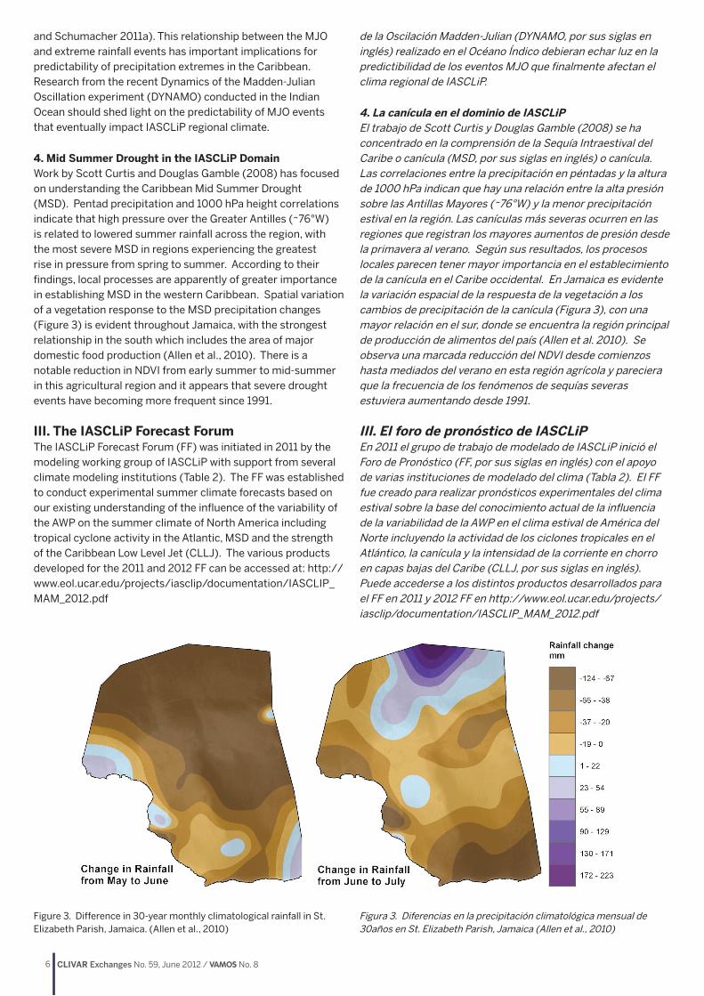
4. Mid Summer Drought in the IASCLiP DomainWork by Scott Curtis and Douglas Gamble (2008) has focused on understanding the Caribbean Mid Summer Drought (MSD). Pentad precipitation and 1000 hPa height correlations indicate that high pressure over the Greater Antilles (~76°W) is related to lowered summer rainfall across the region, with the most severe MSD in regions experiencing the greatest rise in pressure from spring to summer. According to their findings, local processes are apparently of greater importance in establishing MSD in the western Caribbean. Spatial variation of a vegetation response to the MSD precipitation changes (Figure 3) is evident throughout Jamaica, with the strongest relationship in the south which includes the area of major domestic food production (Allen et al., 2010). There is a notable reduction in NDVI from early summer to mid-summer in this agricultural region and it appears that severe drought events have becoming more frequent since 1991.
III. The IASCLiP Forecast ForumThe IASCLiP Forecast Forum (FF) was initiated in 2011 by the modeling working group of IASCLiP with support from several climate modeling institutions (Table 2). The FF was established to conduct experimental summer climate forecasts based on our existing understanding of the influence of the variability of the AWP on the summer climate of North America including tropical cyclone activity in the Atlantic, MSD and the strength of the Caribbean Low Level Jet (CLLJ). The various products developed for the 2011 and 2012 FF can be accessed at: http://www.eol.ucar.edu/projects/iasclip/documentation/IASCLIP_MAM_2012.pdf
de la Oscilación Madden-Julian (DYNAMO, por sus siglas en inglés) realizado en el Océano Índico debieran echar luz en la predictibilidad de los eventos MJO que finalmente afectan el clima regional de IASCLiP.
4. La canícula en el dominio de IASCLiP El trabajo de Scott Curtis y Douglas Gamble (2008) se ha concentrado en la comprensión de la Sequía Intraestival del Caribe o canícula (MSD, por sus siglas en inglés) o canícula. Las correlaciones entre la precipitación en péntadas y la altura de 1000 hPa indican que hay una relación entre la alta presión sobre las Antillas Mayores (~76°W) y la menor precipitación estival en la región. Las canículas más severas ocurren en las regiones que registran los mayores aumentos de presión desde la primavera al verano. Según sus resultados, los procesos locales parecen tener mayor importancia en el establecimiento de la canícula en el Caribe occidental. En Jamaica es evidente la variación espacial de la respuesta de la vegetación a los cambios de precipitación de la canícula (Figura 3), con una mayor relación en el sur, donde se encuentra la región principal de producción de alimentos del país (Allen et al. 2010). Se observa una marcada reducción del NDVI desde comienzos hasta mediados del verano en esta región agrícola y pareciera que la frecuencia de los fenómenos de sequías severas estuviera aumentando desde 1991.
III. El foro de pronóstico de IASCLiP En 2011 el grupo de trabajo de modelado de IASCLiP inició el Foro de Pronóstico (FF, por sus siglas en inglés) con el apoyo de varias instituciones de modelado del clima (Tabla 2). El FF fue creado para realizar pronósticos experimentales del clima estival sobre la base del conocimiento actual de la influencia de la variabilidad de la AWP en el clima estival de América del Norte incluyendo la actividad de los ciclones tropicales en el Atlántico, la canícula y la intensidad de la corriente en chorro en capas bajas del Caribe (CLLJ, por sus siglas en inglés). Puede accederse a los distintos productos desarrollados para el FF en 2011 y 2012 FF en http://www.eol.ucar.edu/projects/iasclip/documentation/IASCLIP_MAM_2012.pdf
Figure 3. Difference in 30-year monthly climatological rainfall in St. Elizabeth Parish, Jamaica. (Allen et al., 2010)
Figura 3. Diferencias en la precipitación climatológica mensual de 30años en St. Elizabeth Parish, Jamaica (Allen et al., 2010)

7CLIVAR Exchanges No. 59, June 2012 / VAMOS No. 8
Name Purpose
NOAA/ NCEP CPC Monthly ocean briefing & NCEP seasonal forecast from CFS
APCC Seasonal forecast from POAMA and CWB
NASA/GMAO Seasonal forecast from GEOS5
UM/RSMAS Seasonal forecast from CCSM3
Scripps/ECPC Seasonal forecast from GSM
FSU/COAPS Seasonal hurricane forecast from FSUGSM
NOAA/ESRL Map room
Columbia University/IRI Seasonal forecast from ECHAM5-MOM4
Table 2: Participating climate modeling institutions in the IASCLiP Forecast Forum. Forecasts are available at the JOSS site cited in the text.
Tabla 2: Instituciones de modelado del clima participantes en el Foro de Pronóstico de IASCLiP. Los pronósticos están disponibles en el portal de JOSS citado en el texto.
An initial challenge for the FF was how to deal with the biased climatology of the global seasonal prediction models over the IASCliP region (Figure 4, see cover page). The resolutions of these models ranged from 100km to 200km with the number of ensemble members ranging from 6 to 12. Furthermore, ocean analyses over the region are conducted with a noted paucity of in-situ observations for sub-surface Ocean. In fact the density of in-situ observations over the IASCLiP region is as poor as the polar oceans. As a result, any ocean analysis in the IASCLiP region is heavily dependent on the fidelity of the data assimilation from ocean models.The FF used a combination of near term (zero lead) seasonal forecasts along with direct predictions from regional teleconnections (e.g. El Niño-southern Oscillation (ENSO) effects). Zero lead forecasts were employed because a majority of the coupled models have a tendency to persist with their initial conditions for a season before both the model and initialization errors begin to prevail. The leveraging of the nowcasting skills for this forum was largely built on heuristic models established from prior observational and modeling studies that examined the impacts on IASCLiP circulation from: 1) Amazonian convection; 2) ENSO; 3) the AMO (Atlantic Multidecadal Oscillation; and 4) the NAO (North Atlantic Oscillation). Numerous studies have shown the influence of these features on IAS climate.
Three sets of experimental three-month forecasts were issued in 2011 (March, June and August). The final forecasts were a “consensus” forecast, but the experimental advisory forecast group cautioned on the probabilistic nature of these forecasts. With the upcoming 2012 forecasts, participating FF members clearly recognize the limitations of the forecast tools available. The FF members propose including the newly established US National Multi-Model Seasonal Ensembles in future forecasts. The experimental FF is a dynamic motivating force within the IASCLiP research community despite observational and modeling issues.
IV. IASCLiP Climate Simulations from IPCC ModelsMartin and Schumacher (2012) have examined 24 coupled (CMIP) and 13 uncoupled (AMIP) models from the IPCC’s Fourth Assessment Report as a means of establishing the
Un reto inicial para el FF fue cómo abordar la climatología sesgada de los modelos globales de predicción estacional en la región de IASCliP (Figura 4, en la tapa) . El rango de resolución de dichos modelos es de 100km a 200km, con ensambles de 6-12 miembros. Además, los análisis oceánicos en la región se realizan con una marcada escasez de observaciones in-situ del océano subsuperficial. De hecho, la densidad de las observaciones in-situ en la región de IASCLiP es tan baja como en los océanos polares. En consecuencia, cualquier análisis del océano en la región de IASCLiP depende en gran medida de la fidelidad de la asimilación de datos de los modelos oceánicos.
El FF utilizó una combinación de pronósticos estacionales de corto plazo (tiempo de anticipación nulo) y predicciones directas de teleconexiones regionales (ej., efectos del ENOS, El Niño-Oscilación del Sur). Se utilizaron pronósticos sin anticipación porque la mayoría de los modelos acoplados tienden a persistir con sus condiciones iniciales durante una estación antes de que comiencen a prevalecer los errores del modelo y de inicialización. La mejora de la capacidad de hacer pronósticos inmediatos lograda por este foro se apoyó en gran medida en modelos heurísticos creados a partir de estudios previos de observaciones y modelado que estudiaban los impactos en la circulación de IASCLiP de: 1) la convección amazónica, 2) el ENOS, 3) la AMO (Oscilación Multidecenal del Atlántico) y 4) la NAO (Oscilación del Atlántico Norte). Numerosos estudios han mostrado la influencia de estos fenómenos en el clima de la región IAS.
En 2011 se publicaron tres conjuntos de pronósticos experimentales de tres meses (marzo, junio y agosto). Los pronósticos finales fueron pronósticos por “consenso”, pero el grupo asesor de pronosticadores advirtió acerca de la naturaleza probabilística de esos pronósticos. Para los pronósticos de 2012, los miembros de FF ven con claridad las limitaciones de las herramientas de pronóstico disponibles y proponen incluir los recientemente creados Ensambles Estacionales Multi-Modelo Nacionales de EE.UU. en futuros pronósticos. El FF experimental es una fuerza dinámica motivadora dentro de la comunidad de investigadores de IASCLiP pese a los inconvenientes en las observaciones y el modelado.
IV. Simulaciones climáticas de IASCLiP a partir de modelos del IPCC
Martin y Schumacher (2012) han examinado 24 modelos acoplados (CMIP) y 13 no acoplados (AMIP) del Cuarto Informe de Evaluación del IPCC como un medio para determinar la habilidad de los modelos climáticos para simular los procesos de precipitación en el dominio de IAS. Se observó que los modelos CMIP subestiman la precipitación y la SST y que los modelos AMIP sobreestiman la precipitación. Los ciclos anuales de la presión a nivel del mar, el gradiente de presión y los vientos zonales no lograban captar la génesis de la circulación de la canícula. Grandes sobreestimaciones de la precipitación con cualquier SST (y especialmente las superiores a 28°C) fueron inherentes a los modelos AMIP. Los modelos con parametrizaciones convectivas de tipo espectral fueron los que mejor funcionaron. En los modelos acoplados, los errores en la frecuencia de ocurrencia de SSTs altas (dominio del sesgo frío) y circulación vertical por convección

8 CLIVAR Exchanges No. 59, June 2012 / VAMOS No. 8
ability of climate models to simulate precipitation processes in the IAS domain. CMIP models were found to underestimate both rainfall and SST and AMIP models overestimate rainfall. The annual cycles of sea level pressure, pressure gradient and zonal wind failed to capture the formation of the MSD circulation. Large overestimates of precipitation at all SSTs (and particularly above 28°C) were inherent in the AMIP models. Models with spectral type convective parameterizations performed the best. In coupled models the errors in the frequency of occurrence of warm SSTs (cold bias dominates) and deep convective vertical circulations (reduced frequency) lead to an underestimation of IAS precipitation.
The simulation of the MSD proved a challenge for the models, despite their ability to produce a CLLJ in the correct location.
profunda (menor frecuencia) llevan a una subestimación de la precipitación en IAS.
La simulación de la canícula resultó un desafío para los modelos, pese a su habilidad de generar la CLLJ en el lugar adecuado. Los errores en la CLLJ fueron más pronunciados en los modelos CMIP y se los atribuyó a problemas con la ubicación y evolución estacional de la Alta tanto en los modelos CMIP como los AMIP. La habilidad de los modelos para simular la relación entre la CLLJ y la precipitación en EE.UU. variaba según la estación y era particularmente problemática en las simulaciones AMIP (Martin y Schumacher 2011b). Las SSTs estacionales de las reconstrucciones extendidas del Centro Nacional de Datos Climáticos (NCDC) se presentan en las Figuras 5a1-4. Liu, Wang, Lee y Enfield (2012) calcularon
Figure 5. Observational SST and model SST bias in the AWP region. Shown are (a1-a4) ERSST SST averaged in four seasons, (b1-b4) the seasonal SST bias of the 22 model ensemble, and (c1-c4, d1-d4, e1-e4) the seasonal SST bias for selected models. Units are °C.
Figura 5. SST observada y sesgo de la SST modelada en la región de AWP. (a1-a4) muestran el promedio de la SST de ERSST en las cuatro estaciones, (b1-b4) el sesgo estacional de la SST para el ensamble de 22 modelos, y (c1-c4, d1-d4, e1-e4) sesgo estacional de la SST para algunos modelos. Las unidades son °C.

9CLIVAR Exchanges No. 59, June 2012 / VAMOS No. 8
Errors in the CLLJ were most pronounced in the CMIP models and they were attributed to problems with the location and seasonal evolution of the Bermuda High in both CMIP and AMIP models. The ability of the models to simulate the relationship between the CLLJ and US precipitation varied based on season and was particularly problematic in the AMIP simulations (Martin and Schumacher 2011b).
Seasonal SSTs from the National Climate Data Center’s (NCDC) extended reconstructed SSTs are shown in Figures 5a1-4. Liu, Wang, Lee and Enfield (2012) calculated mean IPCC model bias from these means per Figures 5b1-4. A cold SST bias in the IAS region is a common problem with many of the models which also overestimate the strength of the surface trades. In contrast, they note a pronounced warm SST bias is common to many models in the cold tongue region of the tropical southeast Atlantic and in the Angola-Benguela coastal region.
V. SummaryIASCLiP is an integrated ocean-atmosphere research program focusing on the prediction of weather and climate impacts of the warm water pool of the Intra Americas Seas. The program seeks to improve operational and research modeling efforts across the Americas through a better understanding of the climate processes within the region. Thus, partnerships between the research community and federal agencies within the 40 plus nation domain are critical to the success of the program. Research emphasis is placed on the structural development of the warm water pool and associated impacts on the development and transition of the monsoon systems in South and North America.
References // ReferenciasAllen, T., S. Curtis, and D. Gamble, 2010. The mid-summer dry spell’s impact on vegetation in Jamaica. Journal of Applied Meteorology and Climatology. DOI: 10.1175/2010JAMC2422.1
Gamble, D.W., D.B. Parnell, and S. Curtis, 2008. Spatial Variability of the Caribbean Mid-summer Drought and Relation to the North Atlantic High, International Journal of Climatology 28: 343-350.
Liu, H., C. Wang, S.-K. Lee, and D. B. Enfield, 2012: Atlantic Warm Pool Variability in the IPCC-AR4 CGCM Simulations. Journal of Climate, in press.
Martin, E. R., and C. Schumacher, 2011a: Modulation of Caribbean precipitation by the Madden-Julian Oscillation. J. Climate, 24, 813-824.
Martin, E. R., and C. Schumacher, 2011b: The Caribbean low-level jet and its relationship with precipitation in IPCC AR4 models. J. Climate, 24, 5935-5950.
Martin, E. R., and C. Schumacher 2012: The relationship between warm pool precipitation, sea surface temperature, and large-scale vertical motion in IPCC AR4 Models. J. Atmos. Sci., 69, 185-194.
Wang, C., H. Liu, S.-K. Lee, and R. Atlas, 2011: Impact of the Atlantic warm pool on United States landfalling hurricanes. Geophys. Res. Lett., 38, L19702, doi:10.1029/2011GL049265.
cuánto en promedio se desvían de estas medias los modelos del IPCC (Figs. 5b1-4). Un problema común es un sesgo frío en las SST en la región IAS, con muchos de los modelos que también sobreestiman la intensidad de los alisios en superficie. Por el contrario, notaron que un marcado sesgo cálido en la SST es común a muchos modelos en la región de la lengua fría del Atlántico sudoriental tropical y en la región costera de Angola-Bengala.
V. SíntesisIASCLiP es un programa de investigación integrada del océano y la atmósfera dirigido a la predicción de los impactos de la piscina de agua cálida de los Mares Intraamericanos en el tiempo y el clima. El programa busca mejorar el modelado operativo y para investigación en las Américas a través de una mejor comprensión de los procesos climáticos en la región. Por ello, las asociaciones entre la comunidad de investigadores y las agencias federales de los más de 40 países del dominio resultan críticas para el éxito del programa. La investigación es concentra en el desarrollo estructural de la piscina de agua cálida y los impactos asociados en el desarrollo y transición de los sistemas monzónicos de las Américas del Norte y del Sur.
10 CLIVAR Exchanges No. 59, June 2012 / VAMOS No. 8
The Caribbean Modelling InitiativeMichael A. Taylor1, Jayaka D. Campbell1,
Tannecia S. Stephenson1, Abel Centella2,
Arnoldo Benzanilla2, John Charlery3,
Riad Nurmohamed4
1 Climate Studies Group, Mona Dept of Physics, University of the West Indies, Mona
2 Instituto de Meteorologia de la Republica de Cuba3 Department of Computer Science, Mathematics and Phys-
ics, University of the West Indies, Cave Hill Campus4 Department of Infrastructure, Anton de Kom University of
Suriname
Prior to the year 2000, there was a distinct lack of climate change science information at scales relevant to the Caribbean. This was against a backdrop of increasing vulnerability of the largely Small Island Developing States that constitute the region due to climate change - its warmer temperatures, rising sea levels, changing rainfall regimes and the possibility of even more extreme events. To address the dearth of information and to provide long term climatic information to facilitate planning, a grouping of Caribbean climate scientists from Cuba, Jamaica, Barbados, Trinidad (original member but no longer active) and Suriname (later joined), in collaboration with the Caribbean Community Climate Change Centre in Belize, initiated the Caribbean Modelling Initiative (CMI) in 2003.
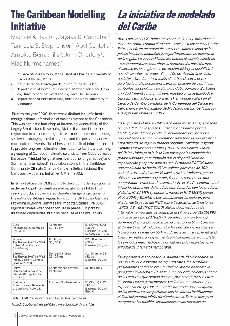
In its first phase the CMI sought to develop modelling capacity in the participating countries and institutions (Table 1) to quickly produce downscaled climate change projections for the entire Caribbean region. To do so, the UK Hadley Centre’s Providing REgional Climates for Impacts Studies (PRECIS) regional model was chosen for use in phase 1, in part for its touted capabilities, but also because of the availability
La iniciativa de modelado del CaribeAntes del año 2000, había una marcada falta de información científica sobre cambio climático a escalas relevantes al Caribe. Esto sucedía en un marco de creciente vulnerabilidad de los países insulares pequeños y mayoritariamente en desarrollo de la región. La vulnerabilidad era debida al cambio climático –sus temperaturas más altas, el aumento del nivel del mar, el cambio en los regímenes de precipitación y la posibilidad de más eventos extremos. Con el fin de abordar la escasez de datos y brindar información climática de largo plazo para facilitar el planeamiento, una agrupación de científicos caribeños especialistas en clima de Cuba, Jamaica, Barbados, Trinidad (miembro original, pero inactivo en la actualidad) y Surinam (sumado posteriormente), en cooperación con el Centro de Cambio Climático de la Comunidad del Caribe en Belice, lanzaron la Iniciativa de Modelado del Caribe (CMI, por sus siglas en inglés) en 2003.
En su primera etapa, el CMI buscó desarrollar las capacidades de modelado en los países e instituciones participantes (Tabla 1) con el fin de producir rápidamente proyecciones regionalizadas de cambio climático para toda la región Caribe. Para hacerlo, se eligió el modelo regional Providing REgional Climates for Impacts Studies (PRECIS) del Centro Hadley del Reino Unido para la fase 1 en parte por las capacidades promocionadas, pero también por la disponibilidad de capacitación y soporte para su uso. El modelo PRECIS tiene una resolución de hasta 25 km, salidas para más de 300 variables atmosféricas en 19 niveles de la atmósfera, puede ubicarse en cualquier lugar del planeta, y correrse en una computadora estándar de escritorio. En el diseño experimental inicial los contornos del modelo eran forzados con los modelos globales HADAM3H (y posteriormente el HADAM3P) (Jones et al. 2004) y ECHAM4. Las simulaciones se hicieron para el Informe Especial del IPCC sobre Escenarios de Emisiones (SRES) A2 y B2 (IPCC 2000) utilizando un enfoque de intervalos temporales para simular el clima actual (1961-1990) y de final de siglo (2071-2100). Se seleccionaron tres (3) dominios (Figura 1) que abarcan la cuenca del Gran Caribe y el Caribe Oriental y Occidental, y las corridas del modelo se hicieron con resolución 50 km y 25 km (ver otra vez la Tabla 1). Luego se realizaron experimentos adicionales para completar los períodos intermedios que no habían sido cubiertos en el enfoque de intervalos temporales.
Es importante mencionar que, además de decidir acerca de un modelo y un conjunto de experimentos, los científicos participantes establecieron también el marco cooperativo para guiar la iniciativa. Es decir, hubo acuerdo colectivo acerca de las corridas que debían hacerse, que se repartieron entre las instituciones participantes (ver Tabla 1 nuevamente). La expectativa era que los resultados obtenidos por cualquiera de los centros se compartieran con las demás instituciones al final del período inicial de simulaciones. Esto se hizo para compensar las posibles limitaciones en los recursos de
CubaInstituto de Meteorologia (INSMET)
Caribbean50 _ 50 km
B1 (30 yrs) & A2 (30 yrs)Baseline (30 yrs) Reanalysis (15 yrs)
JamaicaThe University of the West Indies, Mona Campus (UWI-Mona)
Caribbean50 _ 50 km
A2 (30 yrs) & B2 (30 yrs)Baseline (30 yrs)
BarbadosThe University of the West Indies, Cave Hill Campus (UWI-Cave Hill)
Eastern Caribbean25 _ 25 km
A2 (30 yrs) & B2 (30 yrs)Baseline (30 yrs)
BelizeCaribbean Community Climate Change Centre (CCCCC)
Caribbean and Eastern Caribbean
Multiple runs
SurinameAntom de Kom University of Suriname (AdeKUS)
Northern South America B1 (30 yrs) & A2 (30 yrs)Baseline (30 yrs)ERA40
Table 1: CMI Collaborators and Initial Division of Runs
Tabla 1: Colaboradores del CMI y reparto inicial de corridas

11CLIVAR Exchanges No. 59, June 2012 / VAMOS No. 8
of training and support for its use. The PRECIS model has a resolution of up to 25 km, outputs over 300 atmospheric variables at up to 19 levels of the atmosphere, is locatable over any part of the globe, and can be run on a standard desktop computer. In the initial experimental design the model was forced at its boundaries by the HADAM3H (and later HADAM3P) (Jones et al., 2004) and ECHAM4 global models. Simulations were done for the IPCC Special Report on Emission Scenarios (SRES) A2 and B2 emission scenarios (IPCC 2000) using a time slice approach which simulated present (1961-1990) and end of century (2071-2100) climates. Three (3) domains (Figure 1) spanning the greater Caribbean basin and the eastern and western Caribbean were chosen, and model runs were done at both 50 km and 25 km resolutions (see again Table 1). Additional experiments were later conducted to fill the intermediate periods not covered by the time slice approach.
Importantly, in addition to deciding on a model and a set of experiments, the participating scientists also decided upon a collaborative framework to guide the initiative. That is, there was a collective agreement on runs to be performed and these were divvied up amongst the participating institutions (see again Table 1). The expectation was that results gained by any one centre would be shared across all institutions at the end of the initial simulation period. This was to offset the limiting factor of inadequate resources at any one participating institution which would have mitigated against producing quick results. Notwithstanding some unforeseen delays the suite of model runs were completed two years after the project’s initiation.
In keeping with the mandate to make Caribbean climate change information available for planning, the CMI first produced a sensitization document with initial results for policy makers entitled Glimpses of the Future (Taylor et al., 2007), and developed a repository (www.preciscaribe.htm) for quick and easy dissemination of data. The projections delivered under the first phase of the CMI (see for example Figure 2) have since been used in a growing number of impact studies examining national and regionally important sectors including water, agriculture, health and tourism. They have also been used as the basis for the 2nd National Communications of several Caribbean territories for reporting purposes to the United Framework Convention on Climate Change (UNFCC), and they have given the region a voice in the peer reviewed literature (e.g. Campbell
cualquier institución participante que pudieran demorar la obtención de resultados rápidos. Pese a algunos retrasos imprevistos, el conjunto de corridas se completó dos años después del inicio del proyecto.
Para cumplir con el mandato de hacer disponible la información sobre el cambio climático en el Caribe para el planeamiento, el CMI produjo en primer lugar un documento de sensibilización, llamado Vislumbrando el Futuro, que mostraba resultados iniciales a los formuladores de políticas (Taylor et al., 2007), y generó un repositorio (www.preciscaribe.htm) para la rápida y fácil divulgación de los datos. Desde entonces, se ha venido intensificando el uso de las proyecciones provistas en la primera fase del CMI (por ejemplo, Figura 2) en estudios de impacto para sectores de importancia nacional y regional como el agua, la agricultura, la salud y el turismo. También se los utilizó como base para las 2as Comunicaciones Nacionales de varias naciones caribeñas a la Convención Marco de las Naciones Unidas sobre Cambio Climático (CMNUCC), y la han dado entidad a la región en la literatura evaluada por pares (ej., Campbell et al. 2010, Charlery y Nurse, 2010, Cashman et al., 2010, Taylor et al., 2011). No menor es la importancia de la contribución del CMI a una mejor comprensión y apreciación del cambio climático y sus posibles impactos en la región del Caribe.
Contando con las lecciones recogidas en la etapa inicial, el CMI ha iniciado una nueva etapa. En esta, los científicos participantes de la región han articulado una estrategia de modelado para el Caribe que tiene por objeto (i) afianzar la capacidad de modelado desarrollada en la fase 1 (ii) expandir el análisis de los datos obtenidos en la fase 1 (por ejemplo, examinar los cambios en los extremos climáticos) (iii) incorporar nuevos modelos y nuevos experimentos de modelado (como permitir la participación de la región en CORDEX y la entrega de proyecciones basadas en los nuevos RCPs) (iv) seguir utilizando los resultados científicos como base para construir resiliencia al clima, y (v) capacitar a un equipo de modeladores caribeños jóvenes. La segunda etapa ya está en marcha y nuevamente utiliza el enfoque de un uso coordinado de recursos compartidos para producir resultados significativos. Todo aporte es bienvenido.
Figure 1: Caribbean Domains - Big Domain at 50 km (All Caribbean, Central America, southern United States and northern South America) and two smaller domains at 25 km – Western (Red) & Eastern (Black) Caribbean Domains.
Figura 1: Dominios en el Caribe – Dominio grande en 50 km (todo el Caribe, América Central, sur de Estados Unidos y norte de América del Sur) y dos dominios menores en 25 km – Caribe Occidental (rojo) y Oriental (negro).

12 CLIVAR Exchanges No. 59, June 2012 / VAMOS No. 8
et al., 2010; Charlery and Nurse, 2010; Cashman et al., 2010; Taylor et al., 2011). Importantly the CMI has also contributed to a greater level of understanding and appreciation of climate change and its likely impacts within the Caribbean region.
It is armed with the lessons gleaned from the initial stage, that the CMI has entered a new phase. Under this second phase, the participating regional scientists have articulated a modelling strategy for the Caribbean which seeks to: (i) entrench modelling capacity developed under phase 1; (ii) expand the analysis of existing data from phase 1 (e.g. to examine changes in climate extremes); (iii) introduce new models and new modelling experiments (for example enabling the region’s participation in CORDEX and delivering projections based on the new RCPs); (iv) further utilise science results as a basis for building climate resilience; and (v) train a cadre of young Caribbean modellers. The second phase is already underway and is again utilising the approach of a coordinated use of shared resources to produce meaningful results. Collaborations are welcomed.
References // ReferenciasCampbell, J. D., M. A. Taylor, T. S. Stephenson, R. A. Watson, F. S. Whyte (2010). Future climate of the Caribbean from a regional climate model. Int. J. Climatol. In press
Charlery, J., and L. Nurse (2010). Areal downscaling of global climate models - An approach that avoids data remodelling. Climate Research, 43: 241–249. doi: 10.3354/cr00875
Cashman, A., L. Nurse, J. Charlery (2010). Climate Change in the Caribbean: The Water management implications. Journal of Environment & Development 19(1) 42 – 67
IPCC, 2000. Emissions Scenarios. A Special Report of Working Group III of the Intergovernmental Panel on Climate Change. Cambridge University Press: Cambridge.
Jones, R.G., M. Noguer, D. Hassell, D. Hudson, S. Wilson, G. Jenkins, and J. Mitchell. 2004. Generating high resolution climate change scenarios using PRECIS. . Exeter, UK.: Met Office Hadley Centre.
Taylor, M. A., T. S. Stephenson, A. Owino, A. A. Chen, and J. D. Campbell (2011), Tropical gradient influences on Caribbean rainfall. J. Geophys. Res., 116, D00Q08, doi:10.1029/2010JD015580.
Taylor, M.A., A. Centella, J. Charlery, I. Borrajero, A. Bezanilla, J.D. Campbell, R. Rivero, T.S. Stephenson, F.S. Whyte, and R. Watson. (2007). Glimpses of the future : A briefing from the PRECIS Caribbean climate change project. Belmopan, Belize: Caribbean Community Climate Change Centre.
Figure 2: Diagram showing the spatial distribution of annual precipitation as represented by (a) CMAP observations and (b) PRECIS simulated baseline for the period 1979-90. Panels (c) and (d) show annual temperature as represented by NCEP reanalysis and the PRECIS simulated baseline respectively for the period 1979-90.
Figura 2: Diagrama de la distribución espacial de la precipitación anual según la representación de (a) observaciones CMAP y (b) línea de base simulada con PRECIS para el período 1979-90. Los paneles (c) y (d) muestran la temperatura anual según la representación de los reanálisis NCEP y la línea de base simulada por PRECIS respectivamente para el período 1979-90.

13CLIVAR Exchanges No. 59, June 2012 / VAMOS No. 8
The Variability of the American Monsoon Systems (VAMOS) Panel: Modeling Plans and ActivitiesAuthor: VAMOS Panel
The overarching goal of VAMOS modeling is to improve the prediction of warm season precipitation over the Americas, both for societal benefit and to assess the implications of climate change. Success in meeting this overarching goal is critical to the new World Climate Research Programme (WCRP) strategic framework. In meeting this goal, the VAMOS program works to:
1. describe, understand, and simulate the mean and seasonal aspects of the American monsoon systems;
2. simulate American monsoon system lifecycles, including diurnal cycles and the intraseasonal, interannual and interdecadal interactions with, and influences on, them;
3. investigate American monsoon system predictability and to make predictions to the extent possible;
4. improve the predictive capability through model development and analysis techniques; and
5. prepare products with a view to meeting societal needs, including studies of the impacts of different climate change scenarios on the American monsoon system.
VAMOS focuses on rainfall and the probability of occurrence of significant weather events such as tropical storms, mesoscale convective systems, and persistent and heavy rains associated with synoptic systems and temperature extremes. The term “monsoon system” encompasses not only the summer monsoon rainfall in the tropical Americas, but also the associated perturbations in the planetary, synoptic and mesoscale flow patterns, including those in the winter hemisphere. In addition, the region of interest covers both the tropical and the extratropical Americas and surrounding oceans. This complexity, in terms of spatial and temporal scales and climate system interactions (i.e., land-atmosphere or ocean-atmosphere), necessitates an integrated multi-tiered modeling and data analysis and assimilation strategy.
To achieve its objectives, VAMOS has adopted a multi-scale approach, which includes monitoring, diagnostic and modeling activities on local, regional, and continental scales. In this multi-scale approach, local processes are embedded in, and are fully coupled with, larger-scale dynamics.
The modeling strategy which was approved in 2009 is organized into four science themes: (A) simulating, understanding and predicting the diurnal cycle; (B) predicting
Planes y actividades de modelado en el panel sobre Variabilidad de los Sistemas Monzónicos Americanos (VAMOS) El objetivo general del componente de modelado de VAMOS (por sus siglas en inglés) es mejorar las predicciones de la precipitación durante la estación cálida en las Américas, para beneficio de la sociedad así como para evaluar los efectos del cambio climático. El éxito en lograrlo es central para el nuevo marco estratégico del Programa Mundial de Investigaciones Climáticas (WCRP, por sus siglas en inglés). Con el fin de cumplir este objetivo, el programa VAMOS trabaja para
1. describir, comprender y simular las características medias y estacionales de los sistemas monzónicos americanos,
2. simular los ciclos de vida del sistema monzónico americano, incluyendo sus ciclos diurnos, y las interacciones intraestacionales, interanuales e interdecenales y los factores que los influyen,
3. investigar la predictibilidad del sistema monzónico americano y hacer predicciones con el mayor alcance posible,
4. mejorar la capacidad predictiva mediante el desarrollo de modelos y técnicas de análisis, y
5. preparar productos dirigidos a satisfacer necesidades sociales, incluyendo el estudio de los impactos de los diferentes escenarios de cambio climático en los sistemas monzónicos americanos.
VAMOS se concentra en la precipitación y en la probabilidad de ocurrencia de eventos de tiempo significativos como tormentas tropicales, sistemas convectivos de mesoescala y lluvias intensas persistentes asociadas con sistemas sinópticos y temperaturas extremas. El término “sistema monzónico” no se refiere sólo a las lluvias monzónicas estivales de la región tropical de América, sino también a las perturbaciones asociadas en los patrones de circulación planetaria, sinóptica y de mesoescala, incluyendo las del hemisferio invernal. Además, la región de interés abarca las regiones tropicales y extratropicales de las Américas y los océanos circundantes. Esta complejidad en términos de escalas espaciales y temporales y de las interacciones del sistema climático (es decir, tierra-atmósfera u océano-atmósfera) requiere de una estrategia integrada de múltiples niveles de modelado y análisis y asimilación de datos.
Para lograr sus objetivos, VAMOS ha adoptado un enfoque de escala múltiple, que incluye actividades de monitoreo, diagnóstico y modelado en escala local, regional, y continental. En esta propuesta, los procesos locales están inmersos en la dinámica de mayor escala y completamente acoplados a ella.
La estrategia de modelado aprobada en 2009 se organiza

14 CLIVAR Exchanges No. 59, June 2012 / VAMOS No. 8
and describing the Pan-American monsoon onset, maturation and demise stages; (C) modeling and predicting sea surface temperature (SST) variability in the Pan-American Seas; and (D) improving the prediction of droughts and floods. It is clear that all four of these science themes are interdependent; indeed, some of the scientific questions (such as issues related to scale interactions) transcend all four themes. Nevertheless, this organizational structure provides the focus required to tackle the most important modeling issues.
When the modeling plan was first developed it was recognized that over time the above themes would need to be revisited and modified according to improvements in modeling and understanding. Indeed, there have been several workshops and panel meetings that have, at least in part, addressed critical VAMOS modeling issues. For example, here we briefly summarize outcomes from a recent workshop that was held at the University of Miami, Miami, Florida in March 2011. This specific workshop focused on the physical processes underlying the bias problem in the tropical Atlantic. This is discussed in the dedicated Summer 2011 issue of US CLIVAR Variations, with presentations available at http://www.clivar.org/organization/atlantic/meetings/tropical_bias/miami.php. The 2.5-day workshop succeeded in demonstrating clear, high interest in the problem of Atlantic SST biases, and in setting up a framework for development of a careful, consensual synthesis of state-of-the-art Atlantic SST model biases and their causes. The workshop participants agreed on the following major issues. First, even though several observational campaigns have been held in the Atlantic (e.g. Prediction and Research Moored Array in the Tropical Atlantic (PIRATA), Tropical Atlantic Climate Experiment TACE)), the many and important datasets obtained have not been organized at a level comparable to those in the eastern Pacific by Eastern Pacific Investigation of Climate Processes on the Coupled Ocean-Atmosphere System (EPIC) and the VAMOS Ocean-Cloud- Atmosphere-Land Study (VOCALS). Further organization and improved accessibility of data are required in support of modeling research. Second, the hypotheses that organized research in the tropical Pacific may have to be revised for the Atlantic; it seems clear that the ocean circulation plays a stronger role due to the special configuration of the African coast. Third, improvement in regional processes may not suffice since the Atlantic is influenced by the climate over the American, African, and Asian continents. Errors in the trade winds may have a large impact on the simulation of the equatorial cold tongue in the Atlantic, and subsidence associated with the monsoons over those three continents affects the subtropical highs to a stronger extent than in the larger Pacific. Fourth, the potential for societal impacts is very large, ranging from droughts in Northeast Brazil and the Sahel to widespread destruction over Central and North America by tropical depressions. Altogether, the workshop demonstrated that a scientifically and societally important problem is mature and that significant progress can be achieved by a coordinated community effort. One additional outcome of the Miami workshop was the formation of a US CLIVAR working group focused on tropical Atlantic biases.
The Miami workshop summarized above and many others in the last few years clearly demonstrate that there has been
alrededor de cuatro temas científicos: (A) simulación, comprensión y predicción del ciclo diurno, (B) predicción y descripción de las etapas de inicio, maduración y desaparición del monzón panamericano, (C) modelado y predicción de la variabilidad de la temperatura de la superficie del mar (SST) en los mares panamericanos, y (D) mejora de la predicción de sequías e inundaciones. Resulta claro que estos cuatro temas científicos son interdependientes. En efecto, algunos de los interrogantes científicos (como los relacionados con las interacciones entre escalas) trascienden los cuatro temas en cuestión. Sin embargo, esta estructura organizativa provee el enfoque necesario para abordar los más importantes aspectos del modelado.
La primera vez que se desarrolló el plan de modelado, se acordó que a medida que fueran mejorando los modelos y los conocimientos, habría que ir revisando y modificando los temas antes mencionados. En efecto, ha habido varios talleres y reuniones del panel en los que se analizaron las cuestiones críticas del modelado de VAMOS, al menos en parte. Por ejemplo, brindamos aquí una breve reseña de los resultados de un taller que se realizó recientemente en la Universidad de Miami en Miami, Florida en marzo de 2011. Este taller en particular se concentró en los procesos físicos que subyacen al problema del sesgo en el Atlántico tropical. Este análisis se publicó en el número de verano de 2011 de US CLIVAR Variations, y las presentaciones pueden hallarse en http://www.clivar.org/organization/atlantic/meetings/tropical_bias/miami.php. En el taller de 2 días y medio de duración se vio un claro interés en el problema de los sesgos de la SST del Atlántico, y se estableció un marco para el desarrollo de una cuidadosa síntesis consensual de lo último sobre los sesgos de la SST Atlántica en los modelos y sus causas. Los participantes del taller concordaron en las siguientes importantes cuestiones: primero, pese a que se han realizado varias campañas de observación en el Atlántico (ej., Conjunto de Boyas Fijas para la Predicción e Investigación en el Atlántico Tropical (PIRATA), el Experimento de CLIVAR sobre el Atlántico Tropical (TACE)), los numerosos e importantes conjuntos de datos obtenidos no han sido organizados a un nivel comparable al de la Investigación de los Procesos Climáticos en el Pacífico Oriental (EPIC) y el Estudio de VAMOS sobre Océano-Nubes-Atmósfera-Tierra (VOCALS) en el Pacífico Oriental. Es necesario que los datos estén más organizados y sean más accesibles para que sirvan de apoyo a la investigación en modelado. Segundo, es posible que para el Atlántico haya que revisar las hipótesis que estructuraron la investigación en el Pacífico tropical. Parece claro que la circulación oceánica tiene un papel más importante debido a la particular configuración de la costa africana. Tercero, la mejora en la descripción de los procesos regionales puede no ser suficiente, dado que el Atlántico está afectado por el clima de los continentes americano, africano y asiático. Los errores en los alisios pueden tener gran impacto en la simulación de la lengua fría ecuatorial del Atlántico, y la subsidencia asociada a los monzones de esos tres continentes afecta las altas subtropicales en mayor medida que en el más amplio Océano Pacífico. Cuarto, los impactos potenciales sobre la sociedad son muy grandes, y van desde las sequías en el noreste de Brasil y el Sahel a la destrucción generalizada por depresiones tropicales en América Central y del Norte. En conjunto, el taller

15CLIVAR Exchanges No. 59, June 2012 / VAMOS No. 8
significant progress in understanding the major modeling challenges that are relevant to VAMOS. These workshops also indicate that substantial challenges remain. The VAMOS community, however, has not had the opportunity to synthesize the outcomes of these workshops or recent results into a coherent picture of how well we have addressed the VAMOS modeling plan, and perhaps more importantly, where the VAMOS modeling vision needs to be modified. Now is the time to assess VAMOS modeling progress and revisit and revise the modeling strategy. As such, the VAMOS panel is pleased to announce the CLIVAR VAMOS Workshop on Modeling and Predicting Climate in the Americas, to be held at the Laboratorio Nacional de Computação Cientifica (LNCC) in Petropolis, Brazil, on June 4-8 2012.
The main goals of this workshop are to review the state of modeling research in the VAMOS domain related to: (i) sub-seasonal to multi-decadal climate prediction; and (ii) understanding of dynamical and physical processes underpinning potential sources of predictability, variability and climate change. In order to advance prediction at all of these time-scales it is essential to develop, use and understand models that integrate all relevant physical and dynamical processes. This integrative approach is a core element of the Modeling Plan for VAMOS as it seeks to improve the prediction of warm season precipitation over the Americas, for societal benefit and to assess the implications of climate change.
The workshop will be organized following the Modeling Plan for VAMOS, with the following core themes: a) Simulating, understanding and predicting the diurnal cycle.b) Predicting the Pan-American monsoon onset, mature and
demise stages.c) Modeling and predicting SST variability in the Pan-American
Seas.d) Improving the prediction of droughts and floods.
While these core themes are focused on the VAMOS region, special emphasis will be placed on assessing how these aspects of the Pan-American monsoon are represented in global models. The workshop will also emphasize understanding of and predicting extreme events in the VAMOS region, and how the VAMOS research contributes to climate change assessments.
In addition to reviewing the current state of modeling research, the workshop will have talks and discussion sessions specifically designed to develop the future of VAMOS modeling research as a fundamental contribution to the WCRP.
demostró que este problema de importancia científica y social está maduro y que pueden lograrse avances significativos mediante un esfuerzo coordinado de la comunidad. Un resultado adicional del taller de Miami fue la formación de un grupo de trabajo de US CLIVAR dirigido a los sesgos del Atlántico tropical.
El taller de Miami que se sintetizó más arriba y muchos otros que tuvieron lugar en los últimos años demuestran claramente que ha habido avances significativos en la comprensión de los principales desafíos en modelado que son relevantes a VAMOS. Estos talleres también muestran que quedan desafíos considerables. La comunidad de VAMOS, no obstante, no ha tenido la oportunidad de sintetizar las conclusiones de estos talleres o sus resultados recientes en un cuadro coherente que muestre cuán adecuadamente se ha abordado el plan de modelado de VAMOS, y quizá más importante, que muestre dónde es necesario modificar la visión del componente de modelado de VAMOS. Ahora es tiempo de evaluar el progreso en las actividades y revisar la estrategia de modelado. En ese sentido, el panel VAMOS tiene el gusto de anunciar el Taller de CLIVAR VAMOS sobre Modelado y Predicción del Clima en las Américas que se realizará en el Laboratorio Nacional de Computação Cientifica (LNCC) en Petrópolis, Brasil, los días 4-8 de junio de 2012.
Los objetivos principales de este taller son evaluar el estado de la investigación en modelado en el dominio de VAMOS en relación con: (i) la predicción climática sub-estacional a multidecenal y (ii) la comprensión de los procesos dinámicos y físicos que sostienen las fuentes potenciales de predictibilidad, variabilidad y cambio climático. Para avanzar la predicción en todas estas escalas temporales es fundamental desarrollar, utilizar y comprender modelos que integren todos los procesos físicos y dinámicos pertinentes. Este enfoque integrador es un elemento central del Plan de Modelado de VAMOS dado que busca mejorar la predicción de la precipitación de la estación cálida en las Américas, para el beneficio de la sociedad y para evaluar las implicancias del cambio climático.
El taller se organizará según el Plan de Modelado de VAMOS, es decir, que sus temas centrales serán a) Simulación, comprensión y predicción del ciclo diurnob) Predicción de las etapas de inicio, maduración y
desaparición del monzón panamericanoc) Modelado y predicción de la variabilidad de la SST en los
mares panamericanos d) Mejora en la predicción de sequías e inundaciones
Si bien estos temas centrales se concentran en la región de VAMOS, se pondrá especial énfasis en la evaluación del modo en que estos aspectos del monzón panamericano están representados en los modelos globales. El taller también pondrá énfasis en la comprensión y predicción de eventos extremos en la región de VAMOS, y en cómo la investigación de VAMOS contribuye a las evaluaciones del cambio climático.
Además de revisar el estado actual de la investigación en modelado, el taller incluirá charlas y sesiones de debate específicamente diseñadas para desarrollar el futuro del componente de investigación en modelado de VAMOS como aporte fundamental al WCRP.

16 CLIVAR Exchanges No. 59, June 2012 / VAMOS No. 8
Climate Information for Improving Adaptation to Climate Variability and ChangeWalter E. Baethgen1
1 International Research Institute for Climate and Society, Columbia University, USA
Decision makers (including policy makers) in developing countries are often faced with problems that require immediate action. Moreover, there is pressure to see the effect of such action during the (typically) short terms in which decision makers operate (2-5 years, sometimes up to 10 years). Consequently, issues that take time to resolve (e.g. 50 or more years) tend to attract less attention and become a lower priority within decision making spheres.
Conversely, climate scientists commonly look further ahead, producing climate scenarios 50 to 100 years into the future. For example, the IPCC assessment reports provide the best available projections of the world’s climatology based on the anticipated changes in the composition of the atmosphere and its impact on the Earth’s energy balance. This research approach and the communicated results have been instrumental in raising public awareness on the issue of climate change in both developed and developing countries. This in turn has contributed public support for cleaner energy sources, practices that reduce deforestation, carbon sequestration, and other means to reduce GHG emissions.
However, there are still shortcomings in using these climate projections to assess potential socioeconomic impacts, upon which to base decisions and policies. Firstly, they project changes in the climatology, thereby providing only a limited amount of information to assist decision making and planning. The IPCC Assessment Reports were originally intended as an international effort to create consensus on the role of human activities in climate change and to encourage mitigation policy and actions (IPCC, 1990), but not to predict socioeconomic impacts of such changes.
Future climate scenarios are important for policy development, in terms of assessing the expected impacts on key socioeconomic sectors (e.g. agriculture, health, energy). It is further believed that climate scenarios can help to identify improved adaptive practices, technologies and policies that will assist those sectors to cope with any changes in climate.
However, even predictions produced using the best available scientific methods include uncertainty levels that impose challenges for decision makers. These uncertainties arise partially from limitations in the scientific knowledge used
Información climática para mejorar la adap-tación a la variabilidad y cambio del climaLos tomadores de decisiones (incluidos los responsables de formular políticas) de los países en desarrollo suelen enfren-tar problemas que requieren acción inmediata. Es más, están presionados para que los efectos de sus acciones sean visibles en el transcurso de los períodos (generalmente) breves en que están en funciones (2-5 años, a veces hasta 10). En consecuen-cia, las cuestiones cuya resolución requiere tiempo (por ejem-plo, 50 años o más) tienden a ser menos atractivas y adquieren menor prioridad en el ámbito de la toma de decisiones.
En cambio, los científicos del clima miran más allá, gener-ando escenarios climáticos a 50 o 100 años. Por ejemplo, los informes de evaluación del IPCC ofrecen las mejores proyec-ciones disponibles de la climatología mundial sobre la base de los cambios previstos en la composición de la atmósfera y sus impactos en el balance de energía de la Tierra. Este acercami-ento a la investigación y la comunicación de resultados han sido centrales para crear conciencia en el público acerca del cambio climático tanto en países desarrollados como en desar-rollo. Esto a su vez, contribuyó a que el público apoyara el uso de energías más limpias, las prácticas para reducir la defor-estación, la captura de carbono y otras formas de reducir las emisiones de gases de invernadero.
Sin embargo, todavía hay ciertas fallas en la aplicación de estas proyecciones climáticas para la evaluación de los potenciales impactos socioeconómicos sobre los que basar la toma de decisiones y la formulación de políticas. En primer lugar, los escenarios proyectan cambios en la climatología, lo que aporta solo una cantidad limitada de información para las decisiones y el planeamiento. Originalmente los informes del IPCC estaban dirigidos a generar consenso internacional acerca del papel de las actividades humanas en el cambio climático y promover políticas y acciones de mitigación (IPCC, 1990), pero no a pre-decir los impactos socioeconómicos de esos cambios.
Los escenarios climáticos futuros son importantes para el desarrollo de políticas en el sentido de evaluar los impactos es-perados en sectores socioeconómicos clave (agricultura, salud, energía, etc.). Además, se cree que los escenarios climáticos pueden contribuir a identificar mejores prácticas, tecnologías y políticas de adaptación que ayuden a esos sectores a enfrentar cambios en el clima.
No obstante, aun en las predicciones generadas con los me-jores métodos científicos disponibles, hay niveles de incerti-dumbre que plantean desafíos a los tomadores de decisiones. Estas incertidumbres se deben parcialmente a las limitaciones en los conocimientos científicos que se aplican en el desar-rollo de los modelos climáticos (un problema concreto de las

17CLIVAR Exchanges No. 59, June 2012 / VAMOS No. 8
to develop the climate models (this is a particular problem for rainfall projections). Uncertainties also result from assumptions about future socioeconomic scenarios, which determine estimations of future atmospheric greenhouse gas concentration that drives the climate models. These socioeconomic scenarios consider a wide range of assumptions, from trade, to energy sources, to technology transfer, over the next 50-100 years, inevitably building greater uncertainty into the models.
Another complication is the “double conflict of scales”: on the one hand climate change scenarios are provided for periods that are much farther in the future than required by decision-making and planning; on the other hand the spatial scales are too large – and hence spatial resolution too low – than what is most often needed for actual decision-making (regional to local level).
One analysis that can help to identify the type of information needed to assist decision-making is an estimation of the relative magnitude of climate variability at different temporal scales (seasonal, decadal, longer-term) observed throughout the last century. Relying on climate models for generating future climate scenarios requires the consideration of this relative magnitude in order to take into account how climate variations at different time scales may combine to produce climate related impacts. For example, subregions with a large observed component of decadal variability will require careful interpretation of climate projections when obtained from climate models that do not perform well in simulating the observed variability at that scale.
Greene et al. (2011) of the IRI (International Research Institute for Climate and Society, Columbia University) developed a web-based tool entitled “Time Scales Map Room” (http://iridl.ldeo.columbia.edu/maproom/.Global/.Time_Scales/), which aims to describe the characteristics of historical temperature and precipitation variability, in order to assist in the understanding of the potential usefulness of different types of climate information (scenarios, uncertainties). The tool is designed to assess (globally or regionally) the relative contribution of interannual, decadal and longer-term climate variability on the observed historical climate.
In order to illustrate the relative magnitude of the different temporal scales observed in precipitation over Latin America and Caribbean (LAC) over the 20th century, Greene et al. (2011) tool was used to partition the total observed variability into the three components mentioned above: (a) long-term trend (“climate change”), (b) decadal, and (c) interannual (Figure 1). The results indicated that the long-term trend or “climate change” component explained up to 20% of the total precipitation variance, and most of the LAC subregions presented values of 5-10%. The decadal component explained 10-30% of the total variance in most subregions and seasons. As expected, the reminding 50-60% or more of the total precipitation variance was explained by the interannual component.
These findings emphasize the importance of interannual climate variability as compared with long-term and decadal variability. They also stress the shortcomings of considering
proyecciones de la precipitación). Las incertidumbres tam-bién surgen de los supuestos acerca de los escenarios socio-económicos futuros, que determinan las estimaciones de la concentración futura de gases de invernadero en la atmósfera que alimenta los modelos climáticos. Estos escenarios socio-económicos incluyen una amplia variedad de suposiciones relacionadas con el comercio, las fuentes de energía, la trans-ferencia de tecnología, de los próximos 50-100 años, lo que inevitablemente introduce más incertidumbres en los modelos.
Una complicación adicional es el “doble conflicto de escalas”: por un lado, los escenarios de cambio climático se brindan para períodos mucho más alejados en el futuro que los necesarios para la toma de decisiones y la planificación, por el otro, las escalas espaciales son muy grandes –y por ende la resolución espacial demasiado baja- para los que suele necesitarse en la toma de decisiones reales (nivel regional a local).
Un análisis que puede ayudar a identificar el tipo de información necesaria para asistir en la toma de decisiones y la formulación de políticas es la estimación de la magnitud relativa de la vari-abilidad climática en diferentes escalas temporales (estacional, decadal, largo plazo) observada durante el siglo pasado. Apo-yarse en los modelos climáticos para generar escenarios posi-bles del clima futuro requiere considerar esta magnitud relativa de manera de tomar en cuenta cómo pueden combinarse las variaciones climáticas de distintas escalas para producir im-pactos climáticos. Por ejemplo, en las subregiones con un gran componente de variabilidad decadal observada se requerirá una interpretación cuidadosa de las proyecciones climáticas obte-nidas con modelos climáticos que no logran simular adecuada-mente la variabilidad observada en esa escala.
Greene et al. (2011) del IRI (Instituto Internacional de Investi-gación para el Clima y la Sociedad, Universidad de Columbia) desarrollaron una herramienta basada en la red llamada “Time Scales Map Room” (http://iridl.ldeo.columbia.edu/maproom/.Global/.Time_Scales/) que tiene por objeto describir las características de la variabilidad histórica de la temperatura y la precipitación, para contribuir a entender la utilidad poten-cial de diferentes tipos de información climática (escenarios, incertidumbres). La herramienta está diseñada para evaluar (global o regionalmente) la contribución relativa de la variabili-dad climática interannual, decadal y de más largo plazo en las observaciones históricas del clima.
Con el objeto de ilustrar la magnitud relativa de las diferentes escalas temporales observadas en el siglo XX en la precipi-tación de América Latina y el Caribe (LAC) se utilizó la herrami-enta de Greene et al. (2011) para separar la variabilidad total observada en las tres componentes mencionadas antes: (a) tendencia de largo plazo (“cambio climático”), (b) decadal, e (c) interanual (Figura 1). Los resultados indican que la com-ponente de la tendencia de largo plazo o “cambio climático” explica hasta el 20% de la varianza total de la precipitación, y que la mayoría de las subregiones de LAC presenta valores de 5-10%. La componente decadal explica 10-30% de la varianza total en la mayoría de las subregiones y estaciones. Como se esperaba, el restante 50-60% o más de la varianza total lo explica la componente interanual.

18 CLIVAR Exchanges No. 59, June 2012 / VAMOS No. 8
only observed or projected long-term trends in subregions with relatively large decadal variability (Goddard et al., 2010; Vera et al., 2010).
Early interaction between the climate science community and stakeholders needing to improve adaptation to climate change highlighted some key challenges. Stakeholders found it difficult to act upon the available climate scenarios (e.g. from IPCC reports) given the limitations resulting from the uncertainty levels and the spatial and temporal scales of such scenarios, as discussed above.
In response to these challenges, an alternative approach was developed by boundary organizations (Cash and Buizer, 2005), such as the IRI, for interaction with stakeholders from a range of sectors. This approach considers longer-term climate variation (“climate change”) as part of the continuum of climate variability, from seasons through decades to centuries, and aims to generate information at the temporal scale that is most relevant and applicable for the particular time frames or planning horizons of the different stakeholders. This approach allows for consideration of climate change as a problem of the present (as opposed to a problem of the future) and aims to inform the decision-making, planning, and policy-making processes to reduce current and potential future vulnerabilities to climate variability and change.
One of the key premises of this proposed approach to climate change adaptation is that improving year-to-year planning activities and decisions better prepares societies for longer term climate change (Baethgen, 1997; 2010). Especially for the most vulnerable regions and communities, it is imperative to develop decision making systems that can use seasonal to interannual (SI) predictions to help mitigate risk in bad years and take advantage of good years. For example, during moderate to strong El Nino and La Nina events, the land area over which skillful forecasts can be made increases dramatically (Goddard and Dilley, 2005), which allows for more targeted decisions.
The approach that we propose to manage the full spectrum of risks and opportunities associated with a changing climate (“climate risk management” or CRM) is sustained on four key pillars (Baethgen, 2010):
1 Identifying vulnerabilities and potential opportunities due to climate variability/ change for a given system (agriculture, water, public health, natural ecosystems, etc.), in close collaboration with stakeholders. For example, livelihoods where food security depends mainly on the crops that the community sows (as opposed to communities with off-farm income and ability to purchase food) are especially vulnerable to climate variability. On the other hand, accessing timely information on the most likely rainfall scenario for the following season can result in better planning and higher income in crop production, more efficient water use in multipurpose dams, timely interventions in the health services, etc.
2. Characterizing and quantifying uncertainties in climate
Estas conclusiones ponen de relieve la importancia de la vari-abilidad climática interanual respecto de la variabilidad en las otras dos escalas. Asimismo subrayan las fallas de considerar solo las tendencias de largo plazo sea observadas o proyecta-das en subregiones con una variabilidad decadal relativamente grande (Goddard et al., 2010; Vera et al., 2010).
La interacción temprana entre la comunidad de científicos del clima y los actores sociales que necesitan una mejor adap-tación al cambio climático se ha topado con importantes retos. Los actores sociales encontraron difícil actuar en función de los escenarios climáticos disponibles (por ejemplo, los de los informes del IPCC), dadas las limitaciones resultantes de los niveles de incertidumbre y las escalas espaciales y temporales de dichos escenarios, como se analizó más arriba.
En respuesta a estos retos, “instituciones de borde” (“boundary institutions” en inglés) que trabajan en el nexo ciencia- política (Cash y Buizer, 2005) como el IRI desarrollaron un enfoque alternativo para la interacción con actores sociales de distin-tos sectores. Este enfoque toma en cuenta las variaciones climáticas de más largo plazo (“cambio climático”) como parte del continuo de la variabilidad climática, desde la esta-cional, pasando por las décadas hasta las centurias, y tiene por objeto generar información en la escala temporal que sea más relevante y aplicable en los marcos temporales u horizontes de planeamiento de los diferentes actores sociales. Este enfoque permite considerar el cambio climático como un problema pre-sente (en contraposición a un problema futuro) y busca brindar información a los procesos de toma de decisiones, planeami-ento y formulación de políticas con el fin de reducir las vulnera-bilidades actuales y futuras a la variabilidad y cambio del clima.
Una de las premisas clave del acercamiento propuesto a la adaptación al cambio climático es que mejorando las deci-siones y la planificación de año en año contribuye a que las so-ciedades estén mejor preparadas para los cambios climáticos de más largo plazo (Baethgen, 1997; 2010). Resulta imperativo desarrollar sistemas de decisiones que puedan utilizar predic-ciones estacionales a interanuales (SI) para ayudar a mitigar el riesgo en años malos y aprovechar los buenos, especialmente para las regiones y comunidades más vulnerables. Por ejem-plo, durante eventos El Niño o La Niña moderados a fuertes, la superficie sobre la que pueden hacerse pronósticos buenos au-menta notablemente (Goddard y Dilley 2005), lo que permite una toma de decisiones más dirigida.
El enfoque que proponemos para manejar todo el espectro de riesgos y oportunidades asociados con el cambio climático (“gestión de riesgo climático” o CRM, por sus siglas en inglés) se apoya en cuatro pilares clave (Baethgen, 2010):
1. Identificación de vulnerabilidades y oportunidades poten-ciales debidas a la variabilidad o cambio del clima en un sistema dado (agricultura, agua, salud pública, ecosistemas naturales, etc.), en estrecha cooperación con los actores so-ciales. Por ejemplo, los medios de vida en que la seguridad alimentaria depende principalmente de los cultivos que pro-duce la comunidad (en contraposición a las comunidades con ingresos no agrícolas y capacidad de comprar ali-

19CLIVAR Exchanges No. 59, June 2012 / VAMOS No. 8
information in order to improve the use of such information for different socioeconomic sectors. Understanding the climate aspects of vulnerabilities, challenges, and opportunities requires: (a) learning from the past, i.e., understanding the characteristics of climate at different time scales and assessing its socioeconomic impacts, (b) monitoring the present conditions of relevant environmental factors (climate, vegetation, streamflow, diseases, etc.), and (c) providing the best possible information of the future, at relevant time scales (weeks to decades).
3. Identifying technologies and practices that optimize results in normal or favorable years and/or reduce vulnerabilities to climate variability and change. Examples in agriculture include crop diversification, crop rotations, improved tillage systems, increased water soil storage, improved crop water use efficiency, drought-resistant cultivars.
4. Identifying policies and institutional arrangements that reduce exposure to climate hazards and enable regions to take advantage of favorable climatic conditions. Exposure reduction can be achieved, for example, with improved early warning and response systems, and by transferring portions of existing risk with different forms of insurance.
Typically a portfolio of approaches is necessary. For example, insurance to cover extreme events, diversification to cover moderate events, and forecast/scenario use to capture opportunities in years with favorable climate conditions.
References // ReferenciasBaethgen, W.E. 1997. Vulnerability of the agricultural sector of Latin America to climate change. Climate Res. 9:1-7
Baethgen, W.E. 2010. Climate Risk Management for Adaptation to Climate Variability and Change. Crop Sci. 50(2):70–76
Cash D., J. Buizer. 2005. Knowledge–action systems for seasonal to interannual climate forecasting: summary of a workshop, report to the Roundtable on Science and Technology for Sustainability, Policy and Global Affairs. The National Academies Press, Washington, D.C. Available at: http://books.nap.edu/catalog/11204.html
Goddard, L. and M. Dilley. 2005. El Nino: Catastrophe or opportunity. J. Climate, 18: 651-665.
Goddard, L., Y. Aitchellouche, W. Baethgen, M. Dettinger, R. Graham, P. Hayman, M. Kadi, R. Martínez, and H. Meinke, 2010: Providing seasonal-to-interannual climate information for risk management and decision making, in press. (Meeting draft available at: http://www.wcc3.org/wcc3docs/pdf/WS3_WP_needs.doc).
Greene, A.M, L. Goddard and R. Cousin. 2011. Interactive “Maproom” Provides Perspective on 20th-Century Climate Variability and Change, EOS (in press)
Vera, C., M. Barange, O.P. Dube, L. Goddard, D. Griggs, N. Kobysheva, E. Odada, S. Parey, J. Polovina, G. Poveda, B. Seguin, K. Trenberth, 2010: Needs assessment for climate information on decadal time scales and longer. Proc: Earth and Planet. Sci., in press. (Meeting draft available at: http://www.wcc3.org/wcc3docs/pdf/WS9_WP_ needs.doc)
IPCC. 1990. Climate Change: The IPCC Scientific Assessment (1990). Report prepared for Intergovernmental Panel on Climate Change by Working Group I. J.T. Houghton, G.J. Jenkins and J.J. Ephraums (eds.). Cambridge University Press, Cambridge, Great Britain, New York, NY, USA and Melbourne, Australia 410 pp.
mentos), son particularmente vulnerables a la variabilidad climática. Por otra parte, el acceso a información oportuna acerca del escenario de precipitación más probable para la estación siguiente puede permitir un planeamiento mejor, mayores ingresos de la producción de cultivos, un uso más eficiente del agua en diques multipropósito, intervenciones oportunas en los servicios de salud, etc.
2. Caracterización y cuantificación de las incertidumbres de la información climática con el fin de mejorar el uso de dicha información en los distintos sectores socioeconómicos. La comprensión de los aspectos climáticos de las vulnerabi-lidades, desafíos y oportunidades requiere: (a) aprender del pasado, es decir, entender las características del clima en diferentes escalas temporales y evaluar sus impactos socioeconómicos, (b) monitorizar las condiciones actuales de los factores ambientales relevantes (clima, vegetación, caudales, enfermedades, etc.), y (c) brindar la mejor infor-mación posible acerca del futuro, en escalas temporales pertinentes (semanas a décadas).
3 Identificación de las tecnologías y prácticas que optimizan los resultados en años normales o favorables y/o reducen las vulnerabilidades a la variabilidad y cambio climáticos. Los ejemplos en la agricultura incluyen la diversificación de cultivos, su rotación, mejores sistemas de labranza, mayor almacenamiento de agua en el suelo, mayor eficiencia en el uso del agua por los cultivos, cultivares resistentes a las sequías.
4. Identificación de políticas y arreglos institucionales que reduzcan la exposición a las amenazas climáticas y permi-tan aprovechar las condiciones climáticas favorables. La reducción de la exposición puede lograrse, por ejemplo, con mejores sistemas de alerta temprana y de respuesta temprana, y transfiriendo parte de los riesgos existentes mediante distintas formas de seguros.
En general, se requiere un conjunto de enfoques. Por ejemplo, seguros que cubren eventos extremos negativos, diversifi-cación para enfrentar eventos moderadamente negativos, y el uso de pronósticos /escenarios para captar las oportunidades en años con condiciones climáticas favorables.

20 CLIVAR Exchanges No. 59, June 2012 / VAMOS No. 8
Figure 1: Percent of precipitation variance observed in 1920-2000 explained by climate variability at three temporal scales: (a) long-term trend, (b) decadal, and (c) interannual.
Figura 1: Porcentaje de varianza de la precipitación observada en 1920-2000 que se explica por la variabilidad climática en tres escalas temporales: (a) tendencia de largo plazo, (b) decenal e (c) interanual.
Filling the gaps: GPS Water Vapor Retrievals Provide Critical Information Coverage in the VAMOS RegionDavid Gochis1, John Braun2,
Art Douglas3
1 NCAR – Research Applications Laboratory, USA2 UCAR – Constellation Observing System for Meteorology,
Ionosphere and Climate3 Creighton University, Omaha, Nebraska, USA
OverviewAtmospheric column-integrated precipitable water retrievals can now be derived from ground-based global positioning system (GPS) base stations offering improved, time-evolving moisture characterization of the atmosphere. Successful assimilation of GPS precipitable water vapor (GPS-PWV) data into models has the potential to markedly improve the characterization of the moisture field in places where the existing radiosonde sounding network is deficient or decaying or where there are few, if any, other atmospheric observations available, such as those from aircraft pilot reports. As commented on by Douglas et al. in this issue, the Intra-America Seas (IAS) region of the trans-America Monsoon domain (aka the ‘VAMOS-domain’) has seen a precipitous decline in the number of operational radiosonde stations in recent decades.
Llenando los vacíos: Determinaciones del vapor de agua con observaciones GPS brindan una cobertura crítica de información en la región de VAMOS Visión generalEn la actualidad pueden obtenerse observaciones de agua precipitable integrada sobre la columna atmosférica en estaciones en tierra pertenecientes al sistema de posicionamiento global (GPS, por sus siglas en inglés), que ofrece una mejor caracterización de la humedad de la atmósfera y de su evolución en el tiempo. La asimilación exitosa de datos GPS de vapor de agua precipitable (GPS-PWV, por sus siglas en inglés) en los modelos tiene el potencial de mejorar notablemente la descripción del campo de humedad en lugares donde la red de radiosondeo es deficiente, está deteriorándose o donde, en caso de haberlas, otras observaciones de la atmósfera son escasas, como los reportes de pilotos de aviones. Según el artículo de Douglas et al. en esta revista, en las últimas décadas, la cantidad de estaciones operativas de radiosondeo se ha visto drásticamente reducida en la región de los Mares Intraamericanos (IAS) perteneciente al dominio del monzón transamericano (también conocido como ‘dominio VAMOS’). Como muchas estaciones están

21CLIVAR Exchanges No. 59, June 2012 / VAMOS No. 8
As significant operational costs are causing many radiosonde sites to be decommissioned, forecasters and researchers alike are actively searching for new, lower-cost ways to operationally sense the atmosphere. GPS-PWV measurements provide one possible solution.
Data from high precision GPS instrumentation can be analyzed using sophisticated processing methods to estimate the delay of the GPS signals as they pass through the troposphere. When combined with a measurement of surface pressure, these delays can be transformed into their equivalent amount of precipitable water vapor (Ware et al., 2000). Because GPS signals are broadcast in the L-band, they are insensitive to liquid and ice water, making them an all-weather and continuous operating measurement platform.
Two new GPS ground networks have been proposed for the Intra-America Seas region, COCONET (the Continuously Operating Caribbean GPS Observational Network) for the Caribbean domain and TLALOC-NET for Mexico. These two different network development efforts are underway and are described below. They share several commonalities in their scientific and implementation objectives. Both efforts seek to make significant impacts on weather and climate and solid Earth system research and predictions. Neither effort is starting from scratch, however, instead, they build upon existing but loosely affiliated or loosely standardized networks of GPS monitoring stations deployed primarily for plate tectonics and geodetic monitoring. Therefore, one common theme behind the development of both networks is to implement a common suite of core and companion measurements and measurement standards to compliment the basic GPS derived measurements. For meteorological and climate monitoring applications these include basic meteorological measurements such as surface air pressure, temperature, humidity, solar radiation, wind and precipitation. Efforts are also underway to explore how data from these networks can be included into the global telecommunications System (GTS) so that the data can be used by operational prediction centers and archived by national and global data centers. It is this potential impact on operational forecasting, as well on the long-term climate records of some relatively poorly monitored regions (e.g. across the island nations), that has piqued the interest of the VAMOS community. In the paragraphs below we provide a brief status update on how COCONET and TLALOC-NET are evolving.
The Caribbean GPS-PWV Network - COCONETThe Continuously Operating Caribbean Observational Network (COCONet) is a geohazards (atmospheric and tectonic) project focused on infusing large-scale state-of-the-art observational infrastructure into the Caribbean and Latin America (Braun et al, 2012). COCONet is a collaborative project funded by the United States National Science Foundation (US NSF), with a research team that includes UNAVCO (www.unavco.org), Purdue University, the University of Puerto Rico, Mayagüez (UPRM), and the University Corporation for Atmospheric Research (UCAR). From an atmospheric perspective, it provides an opportunity to collect continuous measurements of GPS-PWV, as well as surface measurements of temperature, relative
dejando de funcionar por causa de los elevados costos operativos, pronosticadores e investigadores buscan activamente formas nuevas y más económicas de realizar observaciones operativas de la atmósfera. Las mediciones GPS-PWV son una solución posible.
Los datos del instrumental GPS de alta precisión pueden analizarse utilizando métodos sofisticados de procesamiento para estimar el tiempo que tardan las señales GPS en atravesar la tropósfera. Combinados con observaciones de la presión en superficie, estos tiempos pueden convertirse a su equivalente de vapor de agua precipitable (Ware et al., 2000). Como las señales GPS se emiten en la banda L, son insensibles al agua líquida o en forma de hielo, lo que las convierte en una plataforma de medición continua y para cualquier estado del tiempo.
Se ha propuesto la instalación de dos nuevas redes GPS en tierra para la región de los mares intraamericanos, la Red de Observación de GPS de Operación Continua en el Caribe (COCONET) en el dominio del Caribe y TLALOC-NET en México. Actualmente estos dos desarrollos están en curso y se describen más adelante. Hay varios elementos comunes en los objetivos científicos y de implementación de ambas redes. Por ejemplo, ambas buscan tener un impacto significativo en la investigación y las predicciones del tiempo, el clima y el sistema Tierra sólida. Sin embargo, ninguna parte desde cero, ya que se apoyan en redes de estaciones de
Figure 1: New Continuously Operating Caribbean Observation Network (COCONet) sites defined during the February 2011 meeting (n = 25) are shown as red circles. COCONet sites defined during the June 2011 meeting (n = 25) are shown as orange circles. Existing or planned sites (n = 62) to be included in the COCONet archive are shown as blue squares. Existing sites to be upgraded (n = 15) are shown as green diamonds. Bathymetry and topography are from ETOPO1, a 1-arc-min global relief model of the Earth’s surface. Faults and block boundaries are shown as black lines. (Figure from Braun et al., 2012.)
Figura 1: Los círculos rojos indican las estaciones de la Red de Observación de GPS de Operación Continua en el Caribe (COCONet) definidas en la reunión de febrero de 2011 (n = 25). Los círculos anaranjados representan las estaciones COCONet definidas durante la reunión de junio de 2011 (n = 25). Los cuadrados azules representan sitios existentes o propuestos (n = 62) para ser incluidos en el archivo de COCONet; los rombos verdes, sitios existentes a ser mejorados (n = 15). La batimetría y topografía son de ETOPO1, un modelo 1-arc-min global de relieve de la superficie terrestre. Las fallas y los contornos de los bloques se muestran como líneas negras. (Figura de Braun et al., 2012.)

22 CLIVAR Exchanges No. 59, June 2012 / VAMOS No. 8
humidity, pressure, horizontal winds and precipitation across the entire Caribbean basin.
COCONet will establish a network of 50 new continuous Global Positioning System (cGPS) and meteorology stations, refurbish an additional 15 stations, and archive data from 62 cGPS stations that are already or will soon be in operation (see Figure 1). Significant progress has been accomplished in the initial 16 months of the project. Engineers have performed site reconnaissance at 50 locations in 24 countries, are securing land use permits for 39 sites, and currently have 13 stations installed. The network is expected to be fully operational by the end of 2013.
The project will provide raw GPS data, GPS-PWV, surface meteorology measurements, time series of daily positions, as well as a station velocity field to support a broad range of geoscience investigations. All the new and refurbished stations will have sub-daily data latency. A number of the sites will provide high rate and real-time data streams to support seismic and tsunami warning research. Atmospheric data products will be distributed to the researchers using both Local Data Manager (LDM) and web Internet distribution systems. Geodetic data products will be available from the UNAVCO public archive and potential regional data partners in the Caribbean. All of the participants in the project have committed to a free and open data policy.
Expanded observations are critical for improved initialization of numerical weather prediction systems, to improve and validate large-scale analysis and reanalysis projects, and to assess model skill related to precipitation and latent heat transport. The distribution of COCONet stations across the Caribbean basin will allow large and small-scale processes to be studied: stations along the boundary of the Caribbean Sea will be important for regional moisture studies; North-South transects, on both the eastern and western edges, will measure differences in moisture transport from low level jets into the mid-latitudes; and data collected from small and large landmasses will reveal the interaction between the ocean, land, and atmosphere.
The Mexican GPS-PWV Network – TLALOC-NETEfforts on developing a GPS-PWV network in Mexico have also been initiated but are not yet as advanced as those of COCONET. During September 20-22, 2010, a workshop sponsored jointly by the US NSF and the Consejo Nacional de Ciencia y Tecnología (CONACyT) of Mexico was held in Puerto Vallarta, Mexico, to discuss the rationale, uses, and implementation of a state-of-the-art atmospheric and GPS network in Mexico for applied research in climate and weather forecasting and the physical processes controlling earthquakes and volcanoes. Thirty-five international scientists from 22 universities and agencies attended, spanning atmospheric, climatic, hydrologic, solid earth, and space weather disciplines. The outgrowth of this workshop was TLALOC-NET and a report from that meeting has been prepared (Cabral-Cano et al., 2011). Mexico’s Servicio Meteorológico Nacional (SMN) is now evaluating the potential benefit of TLALOC-NET and determining how such a network may potentially be funded. A
monitoreo GPS existentes, pero escasamente estandarizadas o con pocas estaciones afiliadas, que habían sido instaladas principalmente para monitoreos geodésicos y de tectónica de placas. Por ello, el desarrollo de ambas redes comparte la implementación de un conjunto común de mediciones centrales, y de acompañamiento y estándares de medición para complementar las mediciones básicas obtenidas del GPS. Para aplicaciones de monitorización meteorológica y climática se incluyen mediciones meteorológicas básicas como la presión en superficie, temperatura, humedad, radiación solar, viento y precipitación. También se está explorando cómo pueden incorporarse los datos de estas redes al sistema global de telecomunicaciones (GTS, por sus siglas en inglés) para que los datos puedan ser utilizados por los centros operativos de predicción y archivados por los centros nacionales y mundiales de datos. Lo que ha atraído el interés de la comunidad de VAMOS es el impacto potencial en los pronósticos operativos y en los registros climáticos de largo plazo de algunas regiones en las que el monitoreo es relativamente pobre (por ejemplo, en las naciones insulares). A continuación presentaremos una breve actualización sobre la evolución de COCONET y TLALOC-NET.
La red GPS-PWV del Caribe - COCONETLa Red de Observación de GPS de Operación Continua en el Caribe (COCONet, por sus siglas en inglés) es un proyecto sobre geoamenazas (atmosféricas y tectónicas) dirigido a establecer una infraestructura moderna de observaciones de gran escala en el Caribe y América latina (Braun et al, 2012). COCONet es un proyecto cooperativo financiado por la Fundación Nacional de Ciencias de Estados Unidos con un equipo de investigación que incluye a UNAVCO (www.unavco.org), la Universidad Purdue, la Universidad de Puerto Rico, Mayagüez (UPRM) y la Corporación Universitaria de Estudios Atmosféricos (UCAR). Desde el punto de vista de la atmósfera, ofrece una oportunidad de obtener mediciones GPS-PWV continuas, y mediciones en superficie de temperatura, humedad relativa, presión, viento horizontal y precipitación en toda la cuenca del Caribe.
COCONet establecerá una red de 50 nuevas estaciones del Sistema de Posicionamiento Global (cGPS) y meteorológicas, renovará 15 estaciones adicionales y archivará datos de las 62 estaciones cGPS que están en funcionamiento o lo estarán en breve (Figura 1). En los primeros 16 meses del proyecto se han hecho avances significativos. Los ingenieros han realizado un reconocimiento en 50 lugares de 24 países, han obtenido permisos de acceso en 39 sitios y llevan instaladas 13 estaciones. Se espera que la red esté completamente operativa a fines de 2013.
El proyecto brindará datos GPS crudos, GPS-PWV, mediciones meteorológicas en superficie, series temporales de posición diaria, así como un campo de velocidad de la estación en apoyo a una gran variedad de investigaciones en geociencias. Todas las estaciones nuevas y renovadas tendrán una recurrencia de datos menor a la diaria. Varias estaciones proveerán flujo continuo en alta velocidad de datos en tiempo real para soporte de investigaciones de alerta sísmicas y tsunamis. Los productos de datos atmosféricos serán distribuidos a los investigadores utilizando Local Data Manager (LDM)

23CLIVAR Exchanges No. 59, June 2012 / VAMOS No. 8
preliminary distribution of stations for TLALOC-Net is shown in Figure 2. A key paragraph from the summary report eloquently lists the potential utility and beneficial impacts that TLALOC-NET may bring to weather, climate and water research and operations in Mexico:
“The need for [an improved] GPS/meteorological Network across Mexico is also driven by the limited utility of satellite meteorological data over continental Mexico. Visible and infrared wavelengths cannot penetrate clouds and land-surface emissivity variations make passive microwave measurements very difficult to interpret. While Mexico’s 14 radiosonde sites presently profile the atmosphere once or twice per day, these measurements are spatially sparse and temporally infrequent, and, at some sites, have been completely unavailable for extended periods, adversely affecting both Mexican and U.S. weather prediction and climate monitoring. In contrast, measurements of water column and surface water vapor at one hundred or more TLALOC-Net sites will provide near-continuous data to be assimilated into weather-forecasting centers in the U.S. and Mexico and [will help] quality control radiosonde humidity profiles… TLALOC-Net’s automated [precipitation] gauges will also vastly improve upon the sparse existing rainfall network in Mexico, much of which only reports a single, manual measurement each day. Near-real-time transmission of the new, time-resolved rainfall measurements will reveal significant rainfall events as they occur and provide the ground truth [data] needed to correct satellite observations and hydrometeorological models…” (from Cabral-Cano et al., 2011)
While it is still too early to estimate –much less measure– the full impact of the emerging GPS-PWV networks within the VAMOS domain it is hopeful that these technological innovations will help fill important gaps in the existing observational network throughout the region, and ultimately help in building additional resiliency against weather and climate events through improved prediction development.
References // ReferenciasBraun, J. J., G. Mattioli, E. Calais, D. Carlson, M. Jackson, R. Kursinski, M. Miller, R. Pandya, 2012: Multi-disciplinary natural hazards research initiative begins across Caribbean basin, EOS. Transactions of the American Geophysical Union, Vol 93, No 9, doi:10.1029/2012EO090001.
Cabral-Cano, E., V. Kostoglodov, C. DeMets, E. R. Kursinski, M. Jackson and M. Miller, 2011: White Paper for the 2010 Mexico GPS Workshop: TLALOC-Net – a next-generation, multi-sensor atmospheric and GPS array for hazards, weather, climate, and earthquake monitoring, forecasting and research in the Americas. September 20-22, 2010. Puerto Vallarta, Mexico.
Ware, R. H., and Coauthors, 2000: SuomiNet: A real-time na- tional GPS network for atmospheric research and education. Bull. Amer. Meteor. Soc., 81, 677–694.
y sistemas de distribución por internet. Los productos de datos geodésicos estarán disponibles en el archivo público de UNAVCO y socios potenciales de datos regionales en el Caribe. Todos los participantes del proyecto se han comprometido a una política de uso libre y abierto de los datos.
Una ampliación en las observaciones es crítica para una mejor inicialización de los sistemas numéricos de predicción del tiempo, para mejorar y validar los proyectos de análisis y reanálisis de gran escala y para evaluar la habilidad de los modelos en simular la precipitación y el transporte de calor latente. La distribución de las estaciones de COCONet en la cuenca del Caribe permitirá estudiar procesos de gran y pequeña escala: las estaciones a lo largo del contorno del Mar Caribe serán importantes para los estudios regionales de humedad; las transectas Norte-Sur en los bordes oriental y occidental medirán las diferencias en el transporte de humedad desde las corrientes en chorro de capas bajas hacia las latitudes medias; y los datos colectados en masas de tierra pequeñas y grandes revelarán la interacción entre el océano, la tierra y la atmósfera.
La red mexicana de GPS-PWV – TLALOC-NETTambién se han iniciado esfuerzos por desarrollar una red GPS-PWV en México aunque su estado no es tan avanzado aún como el de COCONET. Entre el 20 y el 22 de septiembre de 2010, se realizó un taller en Puerto Vallarta, México patrocinado por la NSF de EE.UU. y el Consejo Nacional de Ciencia y Tecnología (CONACyT) de México dirigido a analizar los principios, usos e implementación de una moderna red atmosférica y de GPS en México para la investigación aplicada en el pronóstico del clima y el tiempo y de los procesos físicos que controlan los terremotos y los volcanes. Participaron treinta y cinco científicos de 22 universidades y agencias de distintos países, de las ciencias atmosféricas, climáticas, hidrológicas, de la tierra sólida y del clima espacial. TLALOC-NET es el fruto de este taller sobre el que Cabral-Cano et al. (2011) han preparado un informe. El Servicio Meteorológico Nacional mexicano (SMN) está evaluando los beneficios potenciales de TLALOC-NET y determinando cómo podría establecerse esta red. En la Figura 2 se muestra la distribución preliminar de estaciones de la Red TLALOC. Un párrafo clave del informe de síntesis enumera de forma elocuente la utilidad y los potenciales impactos positivos que TLALOC puede aportar a la investigación y operaciones en tiempo y clima en México:
“La necesidad de una [mejor] Red GPS/meteorológica en México también tiene su origen en la limitada utilidad de los datos meteorológicos satelitales de México continental. Las ondas en el rango visible e infrarrojo no pueden penetrar las nubes y las variaciones en la emisividad de la superficie de la tierra hacen que las mediciones de ondas pasivas sean muy difíciles de interpretar. Si bien actualmente las 14 estaciones mexicanas de radiosondeo perfilan la atmósfera una o dos veces por día, estas mediciones están espacialmente dispersas y son poco frecuentes. Algunas estaciones registran prolongados períodos sin mediciones, con efectos adversos en el pronóstico del tiempo y el monitoreo del tiempo en México y EE.UU.. Por otra parte, las mediciones de la columna de agua y el vapor de agua en superficie en un centenar de sitios o

24 CLIVAR Exchanges No. 59, June 2012 / VAMOS No. 8
más de la red TLALOC brindarán datos casi continuos para su asimilación en los centros de pronóstico del tiempo de EE.UU. y México y [ayudarán] al control de calidad de los perfiles de humedad de los radiosondeos … Además, los pluviómetros de la red TLALOC mejorarán en gran medida la dispersa red de estaciones pluviométricas existente en México, muchas de las cuales sólo informan una medición simple manual por día. La transmisión en tiempo casi real de las nuevas mediciones de resolución temporal de la precipitación mostrarán los eventos significativos de precipitación en el momento de su ocurrencia y proveerá los datos de verificación en tierra necesarios para corregir las observaciones satelitales y los modelos hidrometeorológicos …” (de Cabral-Cano et al., 2011)
Si bien es todavía demasiado pronto para estimar -y mucho menos medir- el impacto completo de las nuevas redes de GPS-PWV en el dominio VAMOS se espera que estas innovaciones tecnológicas ayuden a cubrir importantes vacíos en la red observacional existente en la región y, en última instancia, contribuyan a desarrollar una mayor resiliencia a eventos del tiempo y el clima mediante el desarrollo de mejores predicciones.
Figure 2: A proposed distribution of approximately 100 stations from the Mexican TLALOC-NET includes collocation of 80 stations (red dots) at existing SMN observatories, with an additional 20 sites (green dots) which are distributed across the country to improve spatial sampling.
Figura 2: Propuesta de distribución para aproximadamente 100 estaciones de la Red mexicana TLALOC-NET; incluye la instalación de 80 estaciones (puntos rojos) en observatorios existentes del SMN, con 20 sitios adicionales (puntos verdes), dispuestos a lo largo del país para mejorar espacialmente los muestreos.
VAMOS Panel Members
E.H. Berbery (co-chair) (2012) University of Maryland, College Park, USA
D. Gochis (co-chair) (2014) NCAR RAO, Boulder, Colorado, USA
Raymond Arritt (2014) Iowa State University, USA
Walter E. Baethgen (2014) IRI, Palisades, USA
Marcelo Barreiro (2014) Universidad de la Republica, Uruguay
Iracema Cavalcanti (2014) CPTEC, INPE, Brazil
Art Douglas (2014) Creighton University, USA
Benjamin Kirtman (2012) Rosenstiel School of Marine and Atmos. Sciences, Uni. of Miami and
COLA, USA.
Maisa Rojas (2014) University of Chile, Chile
Paola Salio (2014) CIMA, Universidad de Buenos Aires, Buenos Aires, Argentina
Michael Taylor (2014) University of the West Indies, Jamaica
Robert Wood (2014) University of Washington, USA
Paquita Zuidema (2013) Rosenstiel School of Marine and Atmos. Sciences, Uni. of Miami
The ICPO contact for the CLIVAR VAMOS Panel is Carlos Ereño.

25CLIVAR Exchanges No. 59, June 2012 / VAMOS No. 8
Role: Director of the International CLIVAR Project Office (ICPO) Base: National Oceanography Centre - Southampton Start date: 1 August 2012 (negotiable)
An exciting opportunity has arisen for a secondment with the World Climate Research Programme (WCRP) and the UK’s National Oceanography Centre (NOC) for the position of Director of the International CLIVAR Project Office (ICPO), located at NOC’s Southampton headquarters. The secondment period will be until 31 March 2014.
The Climate Variability and Predictability (CLIVAR) project is one of four core projects of the WCRP. CLIVAR coordinates and facilitates national and international activities that contribute to our understanding and prediction of climate variability and change on seasonal, decadal and centennial timescales.
You will take a leading role in the implementation and coordination of CLIVAR activities under the general guidance of the CLIVAR Scientific Steering Group. Having lead responsibility for CLIVAR, you will direct the implementation of the plans and activities of each of the project elements of CLIVAR in support of the overall mission and strategy of WCRP.
You will maintain active links between CLIVAR and the wider science community that requires inspiring and organizing scientific meetings, workshops and conferences to ensure the timely flow of information on CLIVAR. You will have direct management of the Project Office staff, budgets, and operations. You will also undertake work in maintaining and developing its funding base.
The role would be an excellent opportunity for those wanting to increase their knowledge of the working in climate-science and develop a career in senior management.
You will have a PhD or equivalent experience in a relevant field. A proven ability in science management including obtaining external funding is essential. You should have demonstrated the ability to organize, manage and coordinate interdisciplinary and international science activities and initiate and sustain international cooperation.
This post will be funded by the Natural Environment Research Council and graded to a NERC Band 3 with a salary range of £47,630 to £60,420 per annum. An agreement would be entered with the successful applicant’s current employer concerning specific terms for the secondment.
Alternative locations may be considered for the Director but there would need to be frequent travel to Southampton to be part of the team. The role will include periods of travel both within the UK and internationally.
Further details concerning the role can be found in the attached further particulars, for an informal discussion, please contact Sarah Buckley on 00 44 (0) 2380 59 6134.
You can apply by sending a CV and a cover letter (including salary information and indication of your availability) by emailing [email protected] or alternatively by post to: HR Department, National Oceanography Centre, Waterfront Campus, European Way, Southampton, Hampshire, SO14 3ZH.
Closing date: 14 June 2012
Further information on CLIVAR can be found at http://www.clivar.org/

26 CLIVAR Exchanges No. 59, June 2012 / VAMOS No. 8
Job Description
Department / Division:International and Strategic Partnerships office (ISPO), National Oceanography Centre, Southampton
Post Title: Director, International Climate Variability and Predictability (CLIVAR) Project Office (ICPO)
Grade: NERC Band 3Posts Responsible to (and Level):
Head of ISPO and Director, World Climate Research Programme
Posts Responsible for (and Level):
NERC Bands 6 (two); NERC Band 8 (one) plus 2.5 full time external contractors funded by US CLIVAR office and others as may be sec-onded internationally to the IPCO from time to time.
Job Purpose:
The primary function of the Director, ICPO is provide scientific guidance and programmatic leadership to ensure, that the ICPO provides an effective executive arm of the CLIVAR Scientific Steering Group (SSG) and its panels and working groups and contributes to meeting the overall mission and strategy of the World Climate Research Programme (WCRP).
Key Accountabilities/Primary Responsibilities (6-10 bullet points maximum)
1. Be responsible for maintaining adequate funding for the ICPO through appropriate resource mobilization.
2. Be responsible for the management of the Project Office staff, budget and operations, in accordance with the procedures laid out by the hosting institution and those of contributing agencies or organizations.
3. Oversee and manage the implementation of the plans and activities of each of the project elements of CLIVAR as determined by the CLIVAR SSG and its’ expert panels and working groups.
4. Support the CLIVAR SSG and its Panels and Working Groups by organizing meetings, workshops and scientific conferences and implementing SSG decisions.
5. Ensure that CLIVAR develops as an effective component of the WCRP, coordinating with its evolving priorities and contributing effectively both to its Strategic Plan 2005-15 and related implementation activities and as a player in the wider field of global change research.
6. Maintain effective links between CLIVAR as an international project and the wider community that contributes to and benefits from CLIVAR research; encourage and promote the application of CLIVAR research to wider societal benefit.
7. Ensure the timely flow of pertinent information to CLIVAR participants and relevant international scientific bodies, representing CLIVAR in various international forums and promoting CLIVAR objectives in the broader science community. In particular publish a regular project newsletter; maintain a CLIVAR web site and produce publicity material as appropriate.
% Time
1 & 2:40%
3, 4 & 5:40%
10%
10%
Job Description and Person Specification

27CLIVAR Exchanges No. 59, June 2012 / VAMOS No. 8
Personal Specification
Criteria Essential DesirableHow to be assessed
Qualifications, Knowledge and Experience:
• Ph.D. or equivalent work related experience in a relevant field.
• Considerable experience of working in climate science.
• Internationally known and respected.
• Demonstrated ability to win external funding.
• Proven record of science management.
• Knowledge of national and international organizational structures in the climate sciences.
• Previous experience in management of international projects and of international programmes.
3
3
3
3
3
3
3
Application/Interview
Planning and Organising:
• Demonstrated ability to conceive, organize and manage interdisciplinary and international science activities and initiate and sustain international cooperation
3Application/
Interview
Problem Solving and Initiative:
• Must be able to tackle problems across a range of climate science and seek solutions acceptable to the international science community
3Application/
Interview
Management and Teamwork:
• Clear ability to work with others. Must be a team player who enjoys working with people and getting the best out of them, at the same time providing clear leadership.
3Application/
Interview
Communicating and Influencing:
• Excellent written and oral communication skills in English.
• Must be able to communicate ideas and influence in a manner that enables agreement/consensus amongst the international science community.
3
3
Application/Interview
Other Skills and Behaviours:
Ability to represent CLIVAR on the international stage. 3Interview

CO
NT
EN
TS
CO
NT
EN
IDO
The CLIVAR Exchanges is published by the International CLIVAR Project OfficeISSN No: 1026-0471
Editor: Carlos Ereno and Catherine BeswickLayout & Printing: Indigo Press, Southampton, UK
CLIVAR Exchanges is distributed free of charge upon request (email: [email protected])
Note on Copyright:
Permission to use any scientific material (text as well as figures) published in CLIVAR Exchanges should be obtained from the authors. The
reference should appear as follows: Authors, Year, Title. CLIVAR Exchanges, No. pp. (Unpublished manuscript).
The ICPO is supported by the UK Natural Environment Research Council and NASA, NOAA and NSF through US CLIVAR.
If undelivered please return to:
International CLIVAR Project Office
National Oceanography Centre
European Way, Southampton, SO14 3ZH,
United Kingdom
http://www.clivar.org
Please recycle this newsletter by passing on to a colleague or library or disposing in a recognised recycle point
VAMOS Newsletter Editorial . . . . . . . . . . . . . . . . . . . . . . . . . . . . . . . . . . . . . . . . . . . . . . . . . . . . . . . . . . . . . 2
An Overview of IASCLIP Goals and Pertinent Research Efforts . . . . . . . . . . . . . . . . . . . . . . . . . . . . . . . 3
The Caribbean Modelling Initiative . . . . . . . . . . . . . . . . . . . . . . . . . . . . . . . . . . . . . . . . . . . . . . . . . . . . . . . 10
The Variability of the American Monsoon Systems (VAMOS) Panel: Modeling Plans and Activities 13
Climate Information for Improving Adaptation to Climate Variability and Change . . . . . . . . . . . . . . 16
Filling the gaps: GPS Water Vapor Retrievals Provide Critical Information Coverage in the VAMOS Region . . . . . . . . . . . . . . . . . . . . . . . . . . . . . . . . . . . . . . . . . . . . . . . . . . . . . . . . . . . . . . . . . . . . . 20
VAMOS Panel Members . . . . . . . . . . . . . . . . . . . . . . . . . . . . . . . . . . . . . . . . . . . . . . . . . . . . . . . . . . . . . . . . 24
Announcement for the Director Post . . . . . . . . . . . . . . . . . . . . . . . . . . . . . . . . . . . . . . . . . . . . . . . . . . . . . 25
Editorial . . . . . . . . . . . . . . . . . . . . . . . . . . . . . . . . . . . . . . . . . . . . . . . . . . . . . . . . . . . . . . . . . . . . . . . . . . . . . . . 2
Perspectiva de los objetivos y esfuerzos en la investigación de IASCLIP . . . . . . . . . . . . . . . . . . . . . . 3
La iniciativa de modelado del Caribe . . . . . . . . . . . . . . . . . . . . . . . . . . . . . . . . . . . . . . . . . . . . . . . . . . . . . . 10
Planes y actividades de modelado en el panel sobre Variabilidad de los Sistemas Monzónicos Americanos (VAMOS) . . . . . . . . . . . . . . . . . . . . . . . . . . . . . . . . . . . . . . . . . . . . . . . . . . . . . . . . . . . . . . . . . . 13
Información climática para mejorar la adaptación a la variabilidad y cambio del clima . . . . . . . . . 16
Llenando los vacíos: Determinaciones del vapor de agua con observaciones GPS brindan una cobertura crítica de información en la región de VAMOS . . . . . . . . . . . . . . . . . . . . . . . . . . . . . . . 20
VAMOS Panel Members . . . . . . . . . . . . . . . . . . . . . . . . . . . . . . . . . . . . . . . . . . . . . . . . . . . . . . . . . . . . . . . . 24
Announcement for the Director Post . . . . . . . . . . . . . . . . . . . . . . . . . . . . . . . . . . . . . . . . . . . . . . . . . . . . . 25
VAMOS!