no: bh2017/02410 ward: north portslade ward app type
TRANSCRIPT
OFFRPT
No: BH2017/02410 Ward: North Portslade Ward
App Type: Outline Application
Address: Land Off Overdown Rise & Mile Oak Road, Portslade
Proposal: Outline application for the erection of up to 125 dwellings with associated access, landscaping and informal open space and approval of reserved matter for access only.
Officer: Liz Arnold, tel: 291709 Valid Date: 17.07.2017
Con Area: N/A Expiry Date: 16.10.2017
Listed Building Grade: N/A EOT:
Agent: DMH Stallard LLP Gainsborough House Pegler Way Crawley RH11 7FZ
Applicant: Crest Strategic Projects Crest House Pyrcroft Road Chertsey KT16 9GN
1. RECOMMENDATION 1.1 That the Committee has taken into consideration and agrees with the reasons for the recommendation set out below and resolves to be MINDED TO GRANT planning permission subject to a s106 agreement on the Heads of Terms set out below and the following Conditions and Informatives: S106 Heads of Terms
A contribution of £51,100 towards the Local Employment Scheme,
Construction Training and Employment Strategy including a commitment to using 20 percent local employment during the demolition and construction phases of the development,
40 percent affordable housing (55%/28 units for affordable rental and 45%/22 units for shared ownership),
A contribution of £33,000 towards an Artistic Component / public realm,
A total education contribution of £651,771 towards the cost of providing nursery (£160,623), primary (£184,101), secondary (£254,393) and sixth form education (£52,654);
A contribution of £456,967 towards open space and indoor sport,
A long-term management and maintenance plan for the proposed/retained open space areas,
A contribution of £30,400 towards shrub clearance and 10 years sheep grazing of Whitehawk Hill Local Nature Reserve.
A Transport Contribution of £250,000 towards pedestrian and public transport infrastructure improvements within the vicinity of the site and towards the identified highway improvement works at the junction of the Hangleton Link Road/A27,
A residential Travel Plan, to be provided for all first occupiers of the development, and
5
OFFRPT
Walkways Agreement to agree a means of access and management of the pedestrians/cycle routes within the site.
Conditions: 1. The development hereby permitted shall be carried out in accordance with the
approved drawings listed below. Reason: For the avoidance of doubt and in the interests of proper planning.
Plan Type Reference Version Date Received Location Plan 2315-A-1000 Rev. B 17 July 2017
2. a) Details of the reserved matters set out below ("the reserved matters") shall be
submitted to the Local Planning Authority for approval within three years from the date of this permission:
(i) Layout; (ii) Scale; (iii) Appearance, and; (iv) Landscaping.
b) The reserved matters shall be carried out as approved. c) Approval of all reserved matters shall be obtained from the Local Planning Authority in writing before any development is commenced. Reason: To enable the Local Planning Authority to control the development in detail and to comply with Section 92 (as amended) of the Town and Country Planning Act 1990.
3. The development hereby permitted must be begun not later than the expiration
of two years from the final approval of the reserved matters or, in the case of approval on different dates, the final approval of the last such matter to be approved. Reason: To ensure that the Local Planning Authority retains the right to review unimplemented permissions.
4. Prior to submission of any reserved matters an Ecological Mitigation Strategy
shall be submitted to and approved in writing by the Local Planning Authority. The Strategy shall set out details for the protection of the ecological interests of the application site before, during and after any archaeological investigation of the application site and the approved Strategy shall be carried out in full, unless otherwise agreed in writing by the Local Planning Authority. Reason: To protect the ecological interests of the site before and during construction in accordance with retained Policies QD18 and NC4 of the Brighton and Hove Local Plan 2005.
5. No development shall commence and prior to submission of any reserved
matters, a programme of archaeological work shall be secured in accordance with a Written Scheme of Archaeological Investigation which has been submitted to and approved in writing by the Local Planning Authority. Reason: This condition is imposed because it is necessary to ensure that the heritage assets are fully investigated and evaluated and subsequently where
6

OFFRPT
necessary, safeguarded and recorded in order to comply with retained Policy HE12 of the Brighton & Hove Local Plan and Policy CP15 of the Brighton and Hove City Plan Part One.
6. Applications for approval of reserved matters shall not be made until the
archaeological site investigation and post investigation assessments has been completed in accordance with the programme set out in the Written Scheme of Investigation approved under condition 5 and that provision for analysis, publication and dissemination of results and archive deposition has been secured. Reason: This pre-commencement condition is imposed to ensure that the heritage assets of the site are safeguarded and recorded in order to comply with retained Policy HE12 of the Brighton & Hove Local Plan and Policy CP15 of the Brighton and Hove City Plan Part One.
7. The hard surface hereby approved shall be made of porous materials and
retained thereafter or provision shall be made and retained thereafter to direct run-off water from the hard surface to a permeable or porous area or surface within the curtilage of the property. Reason: To reduce the risk of flooding and pollution and increase the level of sustainability of the development and to comply with policies CP8 and CP11 of the Brighton & Hove City Plan Part One.
8. A minimum of 10% of the affordable housing units and 5% of the total of all of
the residential units hereby approved shall be built to wheelchair accessible standards. The wheelchair accessible dwellings shall be completed in compliance with Building Regulations Optional Requirement M4(3)(2b) (wheelchair user dwellings) prior to first occupation and shall be retained as such thereafter. All other dwelling(s) hereby permitted shall be completed in compliance with Building Regulations Optional Requirement M4(2) (accessible and adaptable dwellings) prior to first occupation and shall be retained as such thereafter. Evidence of compliance shall be notified to the building control body appointed for the development in the appropriate Full Plans Application, or Building Notice, or Initial Notice to enable the building control body to check compliance. Reason: To ensure satisfactory provision of homes for people with disabilities and to meet the changing needs of households and to comply with policy HO13 of the Brighton & Hove Local Plan.
9. All habitable rooms shall be fitted with glazing that mitigate noise levels by at
least 26dB Rw + C and ventilation that mitigates noise levels by at least 26dB Rw + C. Reason: To ensure that an acceptable standard of accommodation is provided in terms of air quality, ventilation and noise attenuation to the occupiers of the residential units hereby approved and to comply with policies SU9, SU10 and QD27 of the Brighton & Hove Local Plan.
10. If during construction, contamination not previously identified is found to be
present at the site then no further development (unless otherwise agreed in writing by the Local Planning Authority), shall be carried out until a method
7

OFFRPT
statement identifying, assessing the risk and proposing remediation measures, together with a programme, shall be submitted to and approved in writing by the Local Planning Authority. The remediation measures shall be carried out as approved and in accordance with the approved programme. Reason: To safeguard the health of future residents or occupiers of the site and to comply with policy SU11 of the Brighton & Hove Local Plan.
11. No hedgerow, tree or shrub shall be removed from the site between 1st March
and 31st August inclusive, unless a qualified Ecologist has undertaken a careful, detailed check of vegetation for active birds' nests immediately before the vegetation is cleared and provided written confirmation that no birds will be harmed and/or that there are appropriate measures in place to protect nesting bird interest on site. Any such written confirmation should be submitted to and agreed in writing by the Local Planning Authority. Reason: To ensure that wild birds building or using their nests are protected, in
accordance with QD18 of the Brighton & Hove Local Plan. 12. The buildings within the reserved matters submission shall not exceed 2 storeys
in height. Reason: To ensure the development integrates effectively with its surroundings including the setting of the South Downs National Park and to comply with policies SA4, SA5 and CP12 of the Brighton and Hove City Plan Part One.
13. The number of residential units shall not exceed 125 units.
Reason: For the avoidance of doubt over what has been approved. 14. Prior to commencement of development, a Method Statement showing detailed
design of foundations, piling configurations, drainage, services and the preservation of archaeological remains, shall be submitted to and approved in writing by the Local Planning Authority and development shall be carried out in accordance with the approved Method Statement. Reason: This pre-commencement condition is imposed to ensure that the heritage assets of the site are safeguarded and recorded in context in order to comply with retained Policy HE12 of the Brighton & Hove Local Plan and Policy CP15 of the Brighton and Hove City Plan Part One.
15. No development shall commence until full details of existing and proposed
ground levels (referenced as Ordnance Datum) within the site and on land and buildings adjoining the site by means of spot heights and cross-sections, proposed siting and finished floor levels of all buildings and structures, have been submitted to and approved by the Local Planning Authority. The development shall then be implemented in accordance with the approved level details. Reason: As this matter is fundamental to the acceptable delivery of the permission to safeguard the amenities of nearby properties and to safeguard the character and appearance of the area, in addition to comply with policy QD27 of the Brighton and Hove Local Plan and CP12 of the Brighton & Hove City Plan Part One.
8
OFFRPT
16. Prior to commencement of development a detailed design and associated management and maintenance plan of surface water drainage for the site using sustainable drainage methods shall be submitted to and approved in writing by the Local Planning Authority. The approved drainage system shall be implemented in strict accordance with the approved detailed design prior to the development commencing. Reason: As this matter is fundamental to the acceptable delivery of the permission to ensure that the principles of sustainable drainage are incorporated into the proposal in accordance with retained Policy SU3 in the Brighton & Hove Local Plan 2005 and Policy CP11 in the Brighton & Hove City Plan Part One.
17. Prior to the commencement of the development hereby approved, details of
measures which will be undertaken to protect the underground water supply resources shall be submitted to and approved in writing by the Local Planning Authority. The approved measures shall be implemented in strict accordance with the approved details before the development is completed. Reason: As this matter is fundamental to the acceptable delivery of the permission to prevent pollution of controlled waters by ensuring the provision of a satisfactory means of surface water disposal and to comply with policy SU3 of the Brighton & Hove Local Plan.
18. Prior to the commencement of the development hereby approved, details of the
proposed means of foul and surface water sewerage disposal shall be submitted to and approved in writing by the Local Planning Authority. The approved development shall be implemented in strict accordance with the approved details before the development is completed. Reason: As this matter is fundamental to the acceptable delivery of the permission to ensure that the principles of sustainable drainage are incorporated into this proposal and to comply with policy SU3 of the Brighton & Hove Local Plan.
19. Prior to the commencement of the development hereby approved, a drainage
strategy detailing the proposed means of foul disposal and an implementation timetable shall be submitted to and approved in writing by the Local Planning Authority. The development shall be implemented in strict accordance with the approved scheme and timetable. Reason: As this matter is fundamental to the acceptable delivery of the permission to ensure that the principles of sustainable drainage are incorporated into this proposal and to comply with policy SU3 of the Brighton & Hove Local Plan.
20. No development shall take place until a Construction Environmental
Management Plan (CEMP) has been submitted to and approved in writing by the Local Planning Authority. The CEMP shall include but not be limited to:
The phases of the Proposed Development including the forecasted completion date(s)
9
OFFRPT
A commitment to apply to the Council for prior consent under the Control of Pollution Act 1974 and not to Commence Development until such consent has been obtained
A scheme of how the contractors will liaise with local residents to ensure that residents are kept aware of site progress and how any complaints will be dealt with reviewed and recorded (including details of any considerate constructor or similar scheme)
A scheme of how the contractors will minimise complaints from neighbours regarding issues such as noise and dust management vibration site traffic and deliveries to and from the site
Details of hours of construction including all associated vehicular movements
Details of the construction compound
A plan showing construction traffic routes
An audit of all waste generated during construction works, to include;
a) The anticipated nature and volumes of waste that the development will generate,
b) The steps to be taken to ensure effective segregation of wastes at source including, as appropriate, the provision of waste sorting, storage, recovery and recycling facilities
c) Any other steps to be taken to manage the waste that cannot be incorporated within the new development or that arises once development is complete.
The construction shall be carried out in accordance with the approved CEMP. Reason: As this matter is fundamental to the protection of amenity, highway safety and managing waste throughout development works and to comply with policies QD27, SU9, SU10 and TR7 of the Brighton & Hove Local Plan, policy CP8 of the Brighton & Hove City Plan Part One, and WMP3d of the East Sussex, South Downs and Brighton & Hove Waste and Minerals Local Plan 2013 and Supplementary Planning Document 03 Construction and Demolition Waste.
21. No development shall commence until fences for the protection of
trees/hedgerows to be retained within the site or adjacent to the site have been erected in accordance with a scheme which has been submitted to and approved in writing by the Local Planning Authority. The fences shall be erected in accordance with BS5837 (2012) and shall be retained until the completion of the development and no vehicles, plant or materials shall be driven or placed within the areas enclosed by such fences. Reason: As this matter is fundamental to protecting the trees and hedgerows which are to be retained on or adjacent to the site during construction works in the interest of the visual amenities of the area and to comply with policies QD16 of the Brighton & Hove Local Plan and CP12 of the Brighton & Hove City Plan Part One.
22. (i) The development hereby permitted shall not be commenced until conditions
4, 5 and 6 have been formally discharged by the Local Planning Authority and
10
OFFRPT
until there has been submitted to and approved in writing by the Local Planning Authority:
a) A site investigation report documenting the ground conditions of the site and
incorporating chemical and gas analysis identified as appropriate by the desk top study in accordance with BS10175:2001; and, unless otherwise agreed in writing by the Local Planning Authority,
b) A detailed scheme for remedial works and measures to be undertaken to
avoid risk from contaminants and/or gases when the site is developed and proposals for future maintenance and monitoring. Such scheme shall include the nomination of a competent person to oversee the implementation of the works.
(ii) The development hereby permitted shall not be occupied or brought into use
until there has been submitted to the Local Planning Authority verification by the competent person approved under the provisions of (i) (b) above that any remediation scheme required and approved under the provisions of (i) (b) above has been implemented fully in accordance with the approved details (unless varied with the written agreement of the Local Planning Authority in advance of implementation). Unless otherwise agreed in writing by the Local Planning Authority such verification shall comprise:
a) As built drawings of the implemented scheme; b) Photographs of the remediation works in progress; and c) Certificates demonstrating that imported and/or material left in situ is free from
contamination.
Thereafter the scheme shall be monitored and maintained in accordance with the scheme approved under (i) (b). Reason: As this matter is fundamental to the acceptable delivery of the permission to safeguard the health of future residents or occupiers of the site, to protect the ecological interests of the site, to safeguard and record the heritage assets of the site and to comply with policies SU11, QD18, NC4 and HE12 of the Brighton & Hove Local Plan and CP15 of the Brighton & Hove City Plan Part One.
23. The development within the reserved matters submission shall provide up to a
maximum of 188 off-street parking spaces. Reason: As this matter is fundamental to the acceptable delivery of the permission to ensure that an appropriate level of parking provision is provided and to comply with policy CP9 of the Brighton & Hove City Plan Part One and Parking Standards SPD14.
24. No development shall be commenced until full design and layout, engineering,
drainage, street lighting (including levels of luminance) and constructional design details, including full details of signing and lining and construction materials of the streets including footpaths proposed within the development have been submitted to and approved in writing by the Local Planning Authority. The development shall, thereafter, be constructed in accordance with the
11

OFFRPT
approved details, unless otherwise agreed in writing with the Local Planning Authority. No dwelling hereby approved shall be occupied until the approved highway works and external lighting have been carried out in accordance with the approved details. Reason: As this matter is fundamental to the acceptable delivery of the permission to ensure a satisfactory appearance to the highways infrastructure serving the approved development, to safeguard the interests of users of the highway and to strike an acceptable balance between highway public safety and safeguarding the wider amenities of the urban fringe, including ecological interests and the nearby South Downs National Park and to comply with Policies TR7, CP9 and SA5 of the Brighton & Hove City Plan Part One and policies QD25 and QD27 of the Brighton & Hove Local Plan.
25. No dwelling shall be occupied until all the car parking areas have been
constructed and provided in accordance with the approved plans. The vehicle parking area shown on the approved plans shall not be used otherwise than for the parking of private motor vehicles and motorcycles belonging to the occupants of and visitors to the development hereby approved. Reason: To ensure that adequate parking provision is retained and to comply with policy CP9 of the Brighton & Hove City Plan Part One.
26. No development shall take place until a scheme setting out the highway works
relating to the site accesses has been submitted to and approved in writing by the Local Planning Authority. The scheme shall include details of the following:
Proposed site vehicular and pedestrian accesses from Overdown Rise;
Proposed site vehicular accesses from Mile Oak Road,
Footway on the eastern side of Mile Oak Road from the site access southwards to connect the new development with the existing footway on the western side of Mile Oak Road;
Provision of pedestrian crossing to include dropped kerbs and tactile paving between the new footway on the eastern side of Mile Oak Road and the existing footway on the western side;
Provision of a left turn approach lane for a distance of 40m on the western arm (Fox Way) of the Hangleton Lane/ A293 junction.
No part of the buildings hereby approved shall be occupied until the approved highway works have been carried out and implemented in full accordance with the approved scheme. Reason: To ensure that suitable vehicle and pedestrian access provision is provided to and from the development and to comply with policies TR7 of the Brighton & Hove Local Plan and CP9 of the Brighton & Hove City Plan Part One.
27. Notwithstanding the Aspect Framework Ecological Management Plan submitted,
no development shall take place until a Landscape and Ecological Management Plan (LEMP) has been submitted to, and approved in writing by, the Local Planning Authority prior. The content of the LEMP shall include the following:
a) Description and evaluation of features to be managed; b) Ecological trends and constraints on site that might influence management;
12

OFFRPT
c) Aims and objectives of management; d) Appropriate management options for achieving aims and objectives; e) Prescriptions for management actions, together with a plan of management
compartments; f) Preparation of a work schedule (including an annual work plan capable of
being rolled forward over a five-year period; g) Details of the body or organisation responsible for implementation of the plan; h) Ongoing monitoring and remedial measures.
The LEMP aims and objectives should include reference to the SNCI and its reason for designation. The LEMP shall also include details of the legal and funding mechanism(s) by which the long-term implementation of the plan will be secured by the developer with the management body(ies) responsible for its delivery. The plan shall also set out (where the results from monitoring show that conservation aims and objectives of the LEMP are not being met) how contingencies and/or remedial action will be identified, agreed and implemented so that the development still delivers the fully functioning biodiversity objectives of the originally approved scheme. The approved plan will be implemented in accordance with the approved details. Reason: As this matter is fundamental to the acceptable delivery of the permission to ensure the long-term management of the ecological areas and to comply with policies QD18 and NC4 in the Brighton and Hove Local Plan 2005, policy CP10 of the Brighton & Hove City Plan Part One and Supplementary Planning Document SPD11 Nature Conservation and Development.
28. Notwithstanding the Aspect Ecological Appraisal and Aspect Framework
Ecological Management Plan submitted, no development shall take place until an Ecological Design strategy (EDS) addressing mitigation, compensation and enhancement, has been submitted to and approved in writing by the Local Planning Authority. The EDS shall include the following:
a) Purpose and conservation objectives for the proposed works; b) Review of site potential and constraints; c) Detailed design(s) and/or working method(s) to achieve stated objectives; d) Extent and location/area of proposed works on appropriate scale maps and
plans; e) Type and source of materials to be used where appropriate, eg native
species of local provenance; f) Timetable for implementation demonstrating that works are aligned with the
proposed phasing of development; g) Persons responsible for implementing the works; h) Details of initial aftercare and long-term maintenance; i) Details for monitoring and remedial measures; j) Details for disposal of any wastes arising from works.
The EDS shall be implemented in accordance with the approved details and all features shall be retained in that manner thereafter. Reason: As this matter is fundamental to the acceptable delivery of the permission to ensure the protection and enhancement of the landscape and ecological interests of the site in accordance with policies QD18 and NC4 in the
13

OFFRPT
Brighton and Hove Local Plan 2005, policy CP10 of the Brighton & Hove City Plan Part One and Supplementary Planning Document SPD11 Nature Conservation and Development.
29. Notwithstanding the Aspect Ecological Appraisal and Aspect Framework
Ecological Management Plan submitted, no development shall take place (including demolition, ground works, site clearance and archaeological investigation) until a method statement for the rescue and protection of reptiles has been submitted to and approved in writing by the local planning authority. The content of the method statement shall include the:
a) Purpose and objectives for the proposed works; b) Detailed design(s) and/or working method(s) necessary to achieve stated
objectives (including, where relevant, type and source of materials to be used);
c) Extent and location of proposed works shown on appropriate scale maps and plans (to include the receptor site);
d) Timetable for implementation, demonstrating that works are aligned with the proposed phasing of construction;
e) Persons responsible for implementing the works; f) Initial aftercare and long-term maintenance (where relevant); g) Disposal of any wastes arising from the works. The works shall be carried out in accordance with the approved details and shall be retained in that manner thereafter. Reason: As this matter is fundamental to the acceptable delivery of the permission to protect the ecological interests of the site and ensure the long-term management of the ecological areas and to comply with policies QD18 and NC4 in the Brighton and Hove Local Plan 2005, policy CP10 of the Brighton & Hove City Plan Part One and Supplementary Planning Document SPD11 Nature Conservation and Development.
30. Prior to first occupation of the development hereby permitted, full details of
electric vehicle charging points within the proposed car park hereby approved have been submitted to and approved in writing by the Local Planning Authority. These facilities shall be fully implemented and made available for use prior to the occupation of the development hereby permitted and shall thereafter be retained for use at all times. Reason: To encourage travel by more sustainable means and seek measures which reduce fuel use and greenhouse gas emissions and to comply with policy CP9 of the Brighton & Hove City Plan Part One and SPD14 Parking Standards.
31. No development above ground floor slab level of any part of the development
hereby permitted shall take place until an Energy Assessment and Strategy has been submitted and approved in writing by the Local Planning Authority. The Strategy should include; i) How energy efficiency will deliver carbon reduction, ii) How use of efficient building services will reduce carbon emissions, iii) How application of renewable energy technologies will deliver carbon reductions, and
14
OFFRPT
iv) How 19% carbon emissions reduction will be achieved as a minimum. The approved measures shall be implemented in strict accordance with the approved details prior to the first occupation of the development and shall thereafter be retained as such. Reason: To ensure that the development is sustainable and makes efficient use of energy and to comply with policy CP8 of the Brighton & Hove City Plan Part One.
32. No development above ground floor slab level of any part of the development
hereby permitted shall take place until a Sustainability Statement and an online Sustainability Checklist demonstrating how the scheme addresses Brighton & Hove City Plan Policy CP8 has been submitted and approved in writing by the Local Planning Authority. The approved measures shall be implemented in strict accordance with the approved details prior to the first occupation of the development and shall thereafter be retained as such. Reason: To ensure that the development is sustainable and makes efficient use of energy and to comply with policy CP8 of the Brighton & Hove City Plan Part One.
33. None of the residential units hereby approved shall be occupied until each
residential unit built has achieved an energy efficiency standard of a minimum of 19% CO2 improvement over Building Regulations requirements Part L 2013 (TER Baseline). Reason: To ensure that the development is sustainable and makes efficient use of energy to comply with Policy CP8 of the Brighton & Hove City Plan Part One.
34. None of the residential units hereby approved shall be occupied until each
residential unit built has achieved a water efficiency standard using not more than 110 litres per person per day maximum indoor water consumption. Reason: To ensure that the development is sustainable and makes efficient use of water to comply with policy CP8 of the Brighton & Hove City Plan Part One.
35. None of the residential units hereby approved shall be occupied until evidence
has been submitted and approved in writing by the Local Planning Authority demonstrating that each residential unit has been constructed to achieve a minimum of a Home Quality Mark One Star. Reason: To ensure that the development is sustainable and makes efficient use of energy and to comply with policy CP8 of the Brighton & Hove City Plan Part One.
36. Prior to first occupation of the development hereby permitted a scheme for the
storage of refuse and recycling shall have been submitted to and approved in writing by the Local Planning Authority. The scheme shall be carried out in full as approved prior to first occupation of the development and the refuse and recycling storage facilities shall thereafter be retained for use at all times. Reason: To ensure the provision of satisfactory facilities for the storage of refuse and to comply with policy QD27 of the Brighton & Hove Local Plan.
15

OFFRPT
37. The development shall not include appliances for solid or liquid fuel burning and any boilers within the development hereby approved shall be ultra-low NOx gas boilers (emission rates below 16mg/kwh), details of which shall be submitted to and approved in writing by the Local Planning Authority prior to installation. Reason: To mitigate the impact of the development on the Portslade Air Quality Management Area and to comply with policy SU9 of the Brighton & Hove Local Plan.
38. Prior to first occupation of the development hereby permitted, details of secure
cycle parking facilities for the occupants of, and visitors to, the development shall have been submitted to and approved in writing by the Local Planning Authority. The approved facilities shall be fully implemented and made available for use prior to the first occupation of the development and shall thereafter be retained for use at all times. Reason: To ensure that satisfactory facilities for the parking of cycles are provided and to encourage travel by means other than private motor vehicles and to comply with policy TR14 of the Brighton & Hove Local Plan, CP9 of the Brighton & Hove City Plan Part One and SPD14 Parking Standards.
39. Prior to first occupation of the development hereby permitted, details of disabled
car parking provision for the occupants of, and visitors to, the development shall have been submitted to and approved in writing by the Local Planning Authority. The approved scheme shall be fully implemented and made available for use prior to the first occupation of the development and shall thereafter be retained for use at all times. Reason: To ensure the development provides for the needs of disabled staff and visitors to the site and to comply with policy TR18 of the Brighton & Hove Local Plan, CP9 of the Brighton & Hove City Plan Part One and SPD14 Parking Standards.
Informatives: 1. In accordance with the National Planning Policy Framework and Policy SS1 of
the Brighton & Hove City Plan Part One the approach to making a decision on this planning application has been to apply the presumption in favour of sustainable development. The Local Planning Authority seeks to approve planning applications which are for sustainable development where possible.
2. The applicant is advised that advice regarding permeable and porous
hardsurfaces can be found in the Department of Communities and Local Government document 'Guidance on the permeable surfacing of front gardens' which can be accessed on the DCLG website (www.communities.gov.uk).
3. The applicant is advised that at the reserved matters stage regarding
landscaping and layout the comments made by the comments made by the Transport Officer regarding pedestrian permeability into and across the site, the Council's Arboriculturist regarding the spacing between the proposed dwellings and the comments made by the County Landscape Architect regarding enhanced planting and a reduction of the extent of development on the west side should be considered. In addition the developer should have regard to the Council's Open Spaces Strategy.
16

OFFRPT
4. To discharge the condition regarding surface water drainage the Lead Local
Flood Authority would expect to see the following:
An appropriate soakaway test in accordance with Building Research Establishment Digest 365 (BRE365). Details of the results will need to be provided.
Appropriate calculations to demonstrate that the final proposed drainage system will be able to cope with both winter and summer storms for a full range of events and storm durations.
The applicant should demonstrate the surface water drainage system is designed so that flooding does not occur on any part of the site for a 1 in 30 year rainfall event, and so that flooding does not occur during a 1 in 100 (+40% allowance for climate change) year event in any part of a building, as per the Non-statutory technical standards for sustainable drainage systems
The applicant will also need to provide a comprehensive maintenance plan for the drainage system in a formal maintenance plan. This should describe who will maintain the drainage, how it should be maintained and the frequency needed to monitor and maintain the system for the lifetime of the development. Examples of suitable maintenance plans can be found at www.susdrain.org.
5. The applicant is advised that a formal application to requisition water
infrastructure is required form Southern Water in order to service the development. The developer should contact Southern Water for more information - Southern House, Sparrowgrove, Otterbourne, Hampshire, SO21 2SW (tel 0330 303 0119), or www.southernwater.co.uk
6. The applicant is advised that the measures to be addressed during the
development design for the conditions regarding the protection of the underground water supply resources should include but not be limited to the following;
Contaminated land desk studies, groundwater table investigations, reports and risk assessments (re: any intended use of soakaways and possibly SUDS) to be carried out;
No drainage systems for the infiltration of surface water drain age into the ground is permitted other than with the express written consent of the Local Planning Authority, which may be given for those parts of the site where it has been demonstrated that there is no resultant unacceptable risk to controlled waters;
No deep bore soakaways should be constructed;
Soakaways in the vicinity of the adit should be restricted to disposal of surface water derived from roof areas only;
No piling methods should be employed in the Northern half of the site (in the vicinity of the adit);
If piling methods are being considered for the southern half of the site, please contact Southern Water to determine safe working methods and stand-off distances from the adit;
17

OFFRPT
No storage of fuel within 50 metres of the adit, - all potential contaminants should be keep within bunded containment in accordance with appropriate regulations.
7. Southern Water has advised that no development or new tree planting should
be located within 3m either side of the centreline of the public sewer and all existing infrastructure should be protected during the course of construction works and no new soakaways should be located within 5m of a public sewer. Due to changes in legislation that came in to force on 1st October 2011 regarding the future ownership of sewers it is possible that a sewer now deemed to be public could be crossing the site. Therefore, should any sewer be found during construction works, an investigation of the sewer will be required to ascertain its condition, the number of properties served, and potential means of access before any further works commence on site. For further advice, the applicant is advised to contact Southern Water, Sparrowgrove House, Sparrowgrove, Otterbourne, Hampshire SO21 2SW (Tel: 0330 303 0119) or www.southernwater.co.uk.
8. The applicant is advised that accredited energy assessors are those licensed
under accreditation schemes approved by the Secretary of State (see Gov.uk website); two bodies currently operate in England: National Energy Services Ltd; and Northgate Public Services. The production of this information is a requirement under Part L1A 2013, paragraph 2.13.
9. The water efficiency standard required by condition is the 'optional requirement'
detailed in Building Regulations Part G Approved Document (AD) Building Regulations (2015), at Appendix A paragraph A1. The applicant is advised this standard can be achieved through either: (a) using the 'fittings approach' where water fittings are installed as per the table at 2.2, page 7, with a maximum specification of 4/2.6 litre dual flush WC; 8L/min shower, 17L bath, 5L/min basin taps, 6L/min sink taps, 1.25L/place setting dishwasher, 8.17 L/kg washing machine; or (b) using the water efficiency calculation methodology detailed in the AD Part G Appendix A.
10. Should the applicant wish the internal estate roads to be adopted they are
advised that they should enter into a Section 38 Agreement with the Highway Authority prior to any works commencing on the construction of the internal estate roads. The applicant is advised to obtain technical approval for all estate road details from the Local Highway Authority prior to the submission of such approved details to the Local Planning Authority to discharge condition 24 of this consent.
11. The applicant is advised that they must enter into a Section 278 Agreement with
the Highway Authority prior to any works commencing on the adopted highway. The applicant is advised to obtain technical approval for all estate road details from the Local Highway Authority prior to the submission of such approved details to the Local Planning Authority to discharge condition 26 of this consent.
12. The applicant is advised that the required Constriction Environment
Management Plan (CEMP) should include but not be limited to; commitments to
18
OFFRPT
implementing appropriate working practices and managing construction vehicle movements to that which avoid peak times and in particular the start and end of the school day for the nearby schools and college, wheel wash facilities at the site access, construction vehicle parking and construction worker travel plan for the site.
13. Scotland Gas Networks advise that there is a pressure gas main near the site.
They advise there should be no mechanical excavations taking place above or within 0.5m of a low/medium pressure system or above or within 3m of an intermediate pressure system. You should, where required confirm the position using hand dug trial holes. Safe digging practices, in accordance with HSE publication HSG47 "Avoiding Danger from Underground Services" must be used to verify and establish the actual position of mains, pipes, services and other apparatus on site before any mechanical plant is used. It is your responsibility to ensure that this information is provided to all relevant people (direct labour or contractors) working for you on or near gas plant.
2. SITE LOCATION & APPLICATION DESCRIPTION 2.1 Mile Oak is a predominantly residential suburb on the north-western outskirts of Brighton and Hove. Its development can be traced back to the 1920s with outlying housing development east of (what is now known as) Mile Oak Road. Major expansion came in the 1960s with Local Authority flats and houses as well as private, mainly bungalow, development resulting in coalescence with the historic core of Portslade village. Expansion northwards was checked in the 1990s by the by-pass but which also hindered access to Downland. The most recent developments have been denser infill schemes mainly on higher slopes to the east off Fox Way, which at the time was a new road linking Mile Oak to the Hangleton Link Road and the By-pass or Old Shoreham Road beyond. Previous to this the main access to Mile Oak had been through Portslade village from Southern Cross which remains today. 2.2 To complement the housing, Mile Oak has a Primary and a Secondary school
with Sixth Form, sports centre, recreation ground, football club, community centre, churches, public library, two Medical Centres at Mile Oak and Portslade incorporating GP surgery, convenience stores, post office counter, a pub, takeaways and other business serving the local population. A Co-op store has recently been constructed attached to the Mile Oak Inn and there are larger supermarkets further afield at Benfield Valley (Sainsbury’s) to the east and at Holmbush (Tesco/M&S) to the west.
2.3 The nearest bus stop is located approximately 0.2miles/a 5 minute walk from
the development site, and is served by the main services for the area, the 1 and 1A route which runs between Whitehawk and Mile Oak. These services serve Portslade Station, Portslade Old Village, Hove, central Brighton and the Royal Sussex County Hospital.
2.4 The boundary of the South Downs National Park (SDNP) is located to the north of the A27. Access on foot to the SDNP is available via Southwick Hill as well as via two routes under the A27 close to the application site.
19

OFFRPT
2.5 Mile Oak itself partly straddles a ridge rising to Cockroost Hill in the north and also occupies the valley between the higher ridges at Foredown Hill / Mount Zion to the east and Southwick Hill to the west. Cockroost Hill and Mount Zion ridges have been bisected by the By-Pass although it is in a tunnel beneath Southwick Hill. 2.6 Mile Oak is enclosed to the east and west by the SDNP which largely abuts
back gardens. To the north the National Park is on the north side of the By-Pass but nevertheless this enclosure results in the National Park being clearly visible in many views from within Mile Oak itself giving the area a semi-rural character and setting.
2.7 The application site is part of an area in the north of Mile Oak considered by the
Urban Fringe Assessment (UFA) which has informed the City Plan process. The UFA identifies the site’s potential for housing. Further details on the UFA, especially regarding the application site, is located in section 8 of this report.
2.8 The UFA divides the area into 6 plots known as 4, 4a, 4b, 5, 5a and 6. The
planning application site is a combination of UFA sites 4b, 5 and 5a, comprising an area of 8.88 hectares which straddles the ridge rising to Cockroost Hill. It lies between the northern fringe of housing in Graham Avenue/ Gorse Close/Overdown Rise and the By-pass and is roughly T-shaped. The westernmost slope is currently used for grazing with a field shelter facing Mile Oak Road (site 4b). The remainder of the application site is characterised by dense scrub with a thin woodland belt along the northern edge and hedging along the main western edge (site 5). There are clear paths worn into the central and eastern parts of the site although these are not public rights of way. On the other hand, although private land, these parts of the site are clearly used for informal recreation with access via Overdown Rise, from the east off Ridge Close or from the Downs.
2.9 The outline proposal is to provide up to 125 dwellings with vehicular access from
Overdown Rise. There is an existing track located between nos. 21 Overdown Rise and 21 Gorse Close, leading to the existing allotments (site 6). The proposal would formalise this access as the main site access to the housing development, whilst retaining and improving access to the allotments and providing formal access to the rear garden of 21 Graham Avenue. A footpath and cycle path would be provided from Mile Oak Road linking up the main site and existing Public Right of Way to the north-east and north-west of the site.
2.10 The outline application seeks permission for access with all other matters (scale,
layout, appearance and landscaping) reserved for future approval. Nevertheless the application is supported by a considerable amount of background information and reports. An indicative layout shows the proposed housing to be located on the lower slopes of the central portion of the application site (UFA Site 5). UFA Sites 5a and 4b would be left undeveloped. Just under half the application site is proposed to be developed (3.55Ha/42%) therefore just over half (5.33Ha/58%) is to remain undeveloped in perpetuity and enhanced for
20
OFFRPT
biodiversity and recreational purposes through a management agreement, the intention being to dedicate footpaths and cycle links within the site for public use.
2.11 Buildings are intended to be 2 storeys in height with a mix of 1 bed flats up to 4
bed semi and detached houses, 40% of which would be affordable housing. Parking appears to be mostly off-street arranged in a combination of garaging, forecourt and communal areas. The proposed layout reflects the site contours with a main crescent or ‘boulevard’ and 2 spine roads off this rising northwards up the ridge. Indicative landscaping is set out in a Masterplan which shows retention of hedging and scrub along the west and southern boundaries, new tree/hedge planting and green spaces within the housing layout, formalised links into the footpath network around the site and management and enhancement of the remaining SNCI in perpetuity.
2.12 The Applicants request that the proposals be screened under the Environmental
Impact Assessment (EIA) Regulations was received in February 2016 and the Council formally issued its opinion in April 2016, stating that EIA is not required.
2.13 This application follows the refusal of a previous application (BH2016/05908) for
a development of a similar form. The earlier application was refused on the following grounds;
Vehicular movements to and from the development using the access from Mile Oak Road, by virtue of the narrowness and layout of Mile Oak Road, would result in dangers to highway safety;
Increased traffic generation and displaced parking from the development would have an adverse impact on surrounding residential roads;
The proposed mitigation, compensation and enhancement measures would not satisfactorily address the harmful impacts of the development on the ecology and biodiversity of the Mile Oak Fields Site of Nature Conservation Importance;
The applicant has failed to demonstrate that appropriate mitigation; measures are proposed to manage and reduce flood risk in the locality, and
The applicant has failed to demonstrate that appropriate sustainability measures have been incorporated into the development.
The reasons for refusal did not relate to the principle of development of the Urban Fringe site, and as such development on the site for housing is accepted. The revised application differs to the previous scheme in the following ways,
The omission of 5 dwellings accessed from Mile Oak Road,
The removal of the vehicular access from Mile Oak Road,
The provision of 5 additional dwellings within the main development area,
A change to the proposed housing mix, resulting in 21 more flats but 21 fewer houses, than the previous application,
An increase of the proposed development density (from 30 dph to 43dph),
The retention of the northern part of UFA Site 5 and all of UFA Sites 5a and 4a to be incorporated within the SNCI and proposed informal open space,
21
OFFRPT
The submission of additional traffic surveys,
The translocation of reptiles from the application site to a receptor site,
Further clarification of the proposed measures to mitigate flood risk, and
The submission of a supplementary sustainability report. 3. RELEVANT PLANNING HISTORY
BH2016/05908 – Outline application for the erection of up to 125 dwellings with associated access, landscaping and informal open space and approval of reserved matter for access only. Refused 28.04.2017. Appeal lodged. Member Pre-Application Briefing Following refusal of application BH2016/05908 the proposal was revised and presented to members at pre-application stage on the 20th June 2017. Members’ feedback included the following points:
Members were pleased that the 5 dwellings accessed from Mile Oak Road have been removed,
Councillors welcomed the overall clarity of elements of the proposal, especially drainage and flood risk,
Whilst members welcomed the proposed changes to Fox Way, they had concerns regarding the impacts of the proposal on traffic utilising roads to the south of the site through Portslade Village and along Locks Hill to the Old Shoreham Road,
Members noted the commitment to sustainability and City Plan Part 1 policy CP8,
Welcomed habitat management and reptile translocation proposal for Whitehawk however the ten year contribution towards this mitigation should be additional to a S106 open space contribution,
Welcome the management plan for the retained open space at the site would be in perpetuity,
Height of properties should not impact upon the South Downs National Park or surrounding area (should be a maximum of 2 storey), and
40% affordable housing provision should be on-site.
Other Pre-Application Proposals for the development of this Urban Fringe Site was also subject to
pre-application discussion with officers in early 2015 (for 150 dwellings) and late 2016 (for 120 dwellings) and assessed by the Design South East Review Panel in September 2016 (for 125 dwellings).
The 2016 pre-application officer response confirmed that the Urban Fringe Assessments (2014 and 2015) established the principle of some residential development on parts of the application site provided that appropriate mitigation and enhancement measures were properly incorporated to address the potential for adverse impacts particularly with respect to landscape, ecology, open space, flood risk and archaeology. A ‘Masterplan’ approach was stated to offer the best opportunity to bringing forward the relevant cluster of Urban Fringe Sites (sites 4, 4a, 4b, 5, 5a and 6) for a development of the quantity indicated in the Urban Fringe Assessments.
22

OFFRPT
A Statement of Community Involvement has been submitted as part of the current application, in which it is stated that pre-application discussions regarding the original application were undertaken with a Ward Councillor and that the original proposal had been subject of a public exhibition (held September 2016)
4. REPRESENTATIONS
Three hundred and fifty three (353) letters have been received from residents in the vicinity of the site, objecting to the proposed development for the following reasons: Design/Visual Amenities/Landscape Impacts
Development will spoil an area of natural beauty,
Development will be of harm to and dominate landscape, and
Harm to South Downs National Park, Amenity Issues
Loss of views/outlook,
Negatively impact on local community, including further loss of any community cohesion and loss on village feel,
Increase of anti-social behaviour/crime,
Will impact on peace/enjoyment of adjacent allotments,
Adjoining residents will suffer overshadowing, loss of daylight/sunlight, overlooking and loss of privacy,
Loss of precious open space/’green lung’ in area with existing limited amenity space. Land popular with local residents especially for dog walkers,
Increased levels of air pollution, will have adverse impact on residents health,
Increased noise/dirt/mud/pollution levels, especially during construction phase,
Lack of activities in area for children,
Disruption/aggravation/stress to local residents during construction phase, and
Will result in loss of peaceful rural/countryside feel. Transport/Highway/Access Issues
The local road infrastructure is currently inadequate and not fit for modern traffic, roads are too narrow and congested so additional traffic, including construction traffic, will exacerbate existing transport problems. Additional traffic will cause further damage/wear and tear to roads/kerbs, will result in residential roads being used as ‘rat-runs’ and additional congestion will create difficulties for emergency services entering/leaving Mile Oak. The minor alterations proposed at bottom of Fox Way will only help marginally. Traffic calming measures and a by-pass entrance/exit is urgently required,
Proposal will adversely affect road safety for pedestrians, pets, horse riders, cyclists and motorists,
Additional traffic will alter quality of life for residents,
People will not car share or cycle as implied by developer,
23

OFFRPT
Will add to existing parking problems in the area, including during construction phase. Each proposed dwelling will have more than one vehicle. Will impact on emergency services accessing roads in area if more cars parked on side roads/verges,
Widening the entrance to the roundabout on the A293 will achieve nothing since it is the not the lack of entrance lanes from the western junction with Hangleton Lane that causes the queue, rather it is the volume of northbound A293 traffic which has priority,
A sole access road off Overdown Rise is not adequate and is dangerous, especially in terms of access for emergency services. An alternative access/egress route is needed from Mile Oak Road,
Inadequate/inaccurate traffic survey date undertaken/submitted, and
Local public transport links already strained/inadequate. Additional bus services will be required, although putting on extra services will add to traffic problems. Buses are expensive and there is no bus service that heads west to Shoreham.
Other Issues
Area is inaccessible during periods of ice/snow so residents become isolated,
Loss of trees,
A much greater proportion of development for the use of disabled people, which is wheelchair sensitive, should be provided,
Increase in population. Over-development/over-crowding,
Area is already heavily developed, additional homes are not needed,
Loss of part of SNCI. Imperative the contractor for the management of the retained SNCI has extensive experience of similar nature conservation. How will the management be funded?
Who will the affordable homes be affordable for? Houses will only be affordable to first purchaser then unaffordable after that. Will the developer actually provide the proposed affordable housing once permission is granted?
Impacts upon any below-ground archaeological deposits,
There are other areas in City which should be developed first/instead, including brownfield sites and vacant buildings/properties,
Harm to wildlife and fauna. Reason site is currently so diverse for wildlife is that it is undeveloped/unmanaged,
Translocation of reptiles to Whitehawk Hill Reserve is not acceptable; they should be retained at the site. Using another area to justify spoiling this area is not acceptable/would do nothing for local wildlife in Portslade,
Smell from attenuation ponds,
Will set a precedent for the development of other green spaces, including adjacent allotments,
Council previously deemed that this land should remain rural to protect the underground water,
Local services and facilities (schools, nurseries, doctors, dentists, parks etc.) are already poorly maintained/lacking/oversubscribed and cannot cope with new development,
New application does not address local residents concerns/reasons for refusal of previous application,
Site only identified in principal as a potential site for development,
24

OFFRPT
Contrary to City planning policies,
Additional strain on utility supplies,
Lack of local resident consultation,
Decrease of property prices/ability to sell existing houses in area,
Increased amount of hardstanding/impermeable surfacing, resulting in increased surface water run off/flood risk. Existing drainage/sewerage system inadequate,
Requires on-going maintenance of balancing ponds and foul water pump, if not maintained will increase flood risk,
Area will require extra policing and extra council services i.e. refuse/recycling collection, and
Additional homes on other sites in the area are also planned, will have a cumulative adverse impact on area.
Thirty six (36) letters have been received from residents in the vicinity of the site, supporting the proposed development for the following reasons:
Have no objections to the proposal,
Prefer revised scheme,
More houses for area to thrive,
Housing is much needed in City, especially family/affordable housing, and will help first time buyers,
Additional residents in area will be good for local businesses,
Country needs change and this is the perfect thing we need,
Building homes creates jobs and income for the nation,
This is derelict land which should be used,
The site is getting worse for wildlife and does need vital management,
Welcome footpath and green area available to the public,
In agreement to the road/junction on Fox Way being widened/improved due to the current congestion issues,
Five (5) letters have been received from residents in the vicinity of the site, commenting on the proposed development for the following reasons:
Not averse to the application however extremely concerned about the infrastructure for additional vehicles utilising local roads. Children walking to school will have to cross much busier roads with no formal crossing place,
Appreciate housing is required but have concerns regarding road access. Request an alternative location for access/egress for the potential of so many vehicles,
Investment in the local schools, doctors and crossing facilities is essential. Would make more sense to invest in the infrastructure and get everything in place ready for the expansion of houses, population and cars,
No longer have any police in the area as the PCO’s were taken away some considerable time ago,
Looking to buy in area,
25

OFFRPT
Traffic data does not seem to shown queues in Fox Way from 7.30am onwards, and
Query where wildlife will go to if field built on.
5. CONSULTATIONS 5.1 External
Brighton & Hove Archaeological Society: The proposed development is close to the site of the Bronze Age settlement found prior to the construction of the Brighton bypass. It is also close to known Neolithic remains at Cockroost Hill. The whole area appears to have features dating the prehistoric period. It is possible that other prehistoric features are still undiscovered. The Society suggests the County Archaeologist is consulted.
5.2 County Archaeologist: Comment. The proposed development is within an Archaeological Notification Area, defining an area of significant prehistoric activity, including settlement and human burials. The site has not been subject to archaeological fieldwork assessment, as required by section 128 of the NPPF when there is uncertainty regarding the existence and significance of heritage assets within a site; however understand that the site contains significant ecology that would be disturbed by intrusive pre-determination evaluation excavation. 5.3 The only solution therefore is to relocate the ecology, evaluate the site to identify archaeological remains, and then for areas of significant archaeology to be removed from the development plan to achieve preservation in-situ. It is assumed that the applicant is prepared for the risk of losing large sections of the developable area. 5.4 In light of the potential for impacts to heritage assets with archaeological interest
resulting from the proposed development, the area affected by the proposals should be the subject of further archaeological assessment defined by a programme of archaeological works and the results used to inform a sympathetic design enabling the retention in-situ of the archaeological remains with the development.
5.5 County Ecologist: No objection. Surveys were carried out in accordance with
best practice and are sufficient to inform appropriate mitigation, compensation and enhancement.
5.6 The site lies within Mile Oak Fields Site of Nature Conservation Importance
(SNCI), designated for its rough grassland, badger foraging and nesting skylark. Whilst the SNCI has habitat and species interest, its primary interest relates to its public accessibility and its recreational value. Some localised areas of chalk grassland are present in the northern part of the site, but the majority of the grassland is declining due to lack of management. Other than the chalk grassland, the habitats of greatest significance are woodland along the northern edge and the bands of scrub within the site which are largely constrained to the peripheral areas.
26

OFFRPT
5.7 The indicative development will lead to the permanent loss of approximately 42% of the SNCI (including formal amenity land). However, the woodland to the north and the grassland in the northern half of the site, including the chalk grassland, will be retained and the grassland brought into positive management to encourage the spread of the priority chalk grassland habitat. It is proposed that an additional area of horse-grazed grassland adjacent to the north western boundary which is currently outside the SNCI will also be managed to enhance the grassland. Scrub and woodland should be protected in accordance with BS5837:2012. The proposed management would benefit a range of species and would help support Biosphere Objectives.
5.8 Scrub clearance and subsequent grassland management within the Whitehawk
Hill Local Nature Reserve (LNR) will provide an additional 4Ha of chalk grassland habitat and will result in a net gain in biodiversity. In light of the above and given the proposed mitigation and the fact that habitats within the SNCI are declining and are likely to continue to do so without development, the loss of a portion of the SNCI is considered acceptable.
5.9 The site is a key reptile site supporting an exceptional population of slow worm,
a good population of common lizard and a low population of adder. Grass snake is also present. Slow worms, grass snakes, common lizards and adders are protected against intentional killing or injuring under Schedule 5 of the Wildlife and Countryside Act 1981, as amended.
5.10 The proposed mitigation for reptiles (translocation of populations to receptor
areas on and off site and management of those habitats for reptiles) is considered broadly acceptable. Receptor sites must be prepared prior to translocation taking place. An estimate of the proportion of the populations to be retained on site and moved off site should be provided, based on carrying capacity. Snakes should be retained on site. Adders return to the same hibernacula over many years so destruction of such sites can have significant negative impacts on populations. The majority of habitat likely to be used for hibernation (woodland and scrub) is to be retained and protected. If any areas of scrub that could provide hibernacula are identified for removal, these should first be subject to a spring survey, and if hibernacula are identified, the scrub should be retained and protected.
5.11 The scrub and tree planting along the northern boundary of the development
should include a high proportion of species that will deter predators, e.g. hawthorn and blackthorn, and hibernacula should be placed away from the northern boundary of the development. Long term monitoring of both the development site and the off-site receptor area should be undertaken to ensure the conservation objectives of the mitigation are met.
5.12 Bats were recorded foraging and commuting across the site, albeit in low numbers. All species of bats are fully protected under the Wildlife and Countryside Act 1981, as amended, and the Conservation of Habitats and Species Regulations 2010, making them European Protected Species.
27
OFFRPT
5.13 Artificial light can negatively impact on bats through, for example, causing disturbance at the roost, affecting feeding behaviour, avoidance of lit areas and increasing the chances of bats being preyed upon. It is therefore recommended all lighting design should take account of national guidance. In particular, the woodland at the northern boundary should be unlit and any footpaths through the northern portion of the site should be unlit.
5.14 The site supports breeding birds. Under Section 1 of the Wildlife and
Countryside Act 1981 (as amended), wild birds are protected from being killed, injured or captured, while their nests and eggs are protected from being damaged, destroyed or taken. To avoid disturbance to nesting birds, any removal of scrub/trees that could provide nesting habitat should be carried out outside the breeding season (generally March to August).
5.15 No badger setts were recorded on site and there were no signs of foraging.
However, one badger was recorded commuting along the northern boundary and the SNCI citation includes badger foraging habitat. Badgers are protected under the Protection of Badgers Act 1992. Best practice working methods should be employed to ensure protection of badgers during construction. Boundaries within the development should also be made permeable to wildlife.
5.16 Hedgehogs are present on site. The hedgehog is a Species of Principle
Importance under Section 41 of the NERC Act. Mitigation for badgers should also benefit hedgehogs.
5.17 There are several records of notable species from the site including birds, plants and invertebrates. It is considered that the proposed mitigation and enhancement measures are likely to benefit some of these species. 5.18 The proposed development is considered unlikely to have any impacts on any other protected species and therefore no specific mitigation is required. If protected species are encountered during works, works should stop and advice should be sought from an ecologist on how to proceed. 5.19 The mitigation measures described in the Ecological Appraisal report are
considered appropriate and should be implemented. It is also recommended that the woodland block to the east of the allotments is brought into positive management. The site offers opportunities for enhancement that will help the Council address its duties and responsibilities under the NPPF and the NERC Act. The enhancements listed in the report are supported. Consideration should also be given to green (chalk grassland) roofs.
5.20 The location of bat boxes must take account of the external lighting scheme to
ensure flight paths to and from the boxes remain unlit. The provision of house sparrow boxes within the development is welcomed. Boxes should also target swifts and starlings.
5.21 The Framework Ecological Management Plan and Landscape Management
Plan are broadly acceptable. Hedges should be cut in late winter. Weed control should be done manually rather than through the use of herbicides. Grazing is
28

OFFRPT
the preferred management approach for the grassland. It is recommended that an Ecological Design Strategy and Landscape and Ecology Management Plan (LEMP) are required by condition. Aims and objectives should include reference to the SNCI and reasons for designation. A five yearly review of the management plan is supported and should be informed by a monitoring strategy; this is likely to form part of a wider LEMP.
5.22 In summary, provided the recommended mitigation measures are implemented,
it is recommended that the proposed development can be supported from an ecological perspective. The site offers opportunities for enhancement that will help the Council address its duties and responsibilities under the NPPF and NERC Act. In line with BS42020:2013, conditions for a Reptile Mitigation Strategy, Ecological Design Strategy and Landscape and Ecological Management Plan should be applied to the permission.
5.23 County Landscape Architect: No objection. 5.24 Impact on Local Landscape character - The submitted Landscape Character
and Visual Impact Assessment (LVIA) provides an accurate detailed description of the landscape context and landscape character of the site and surroundings and an accurate assessment of the visual context of the site including longer distance views from the wider downland in the South Downs National Park (SDNP).
5.25 The LVIA concludes that the proposed development would have a substantial
beneficial effect on the site itself (referred to as Landscape Character Area 1). It is assumed that this is based on the entire area within the red line boundary. It is feasible that bringing the undeveloped part of the site into positive management would have a beneficial effect on this part of the site. However the loss of green field land to built development would not have a beneficial effect on the developed part of the site. The effect would be more likely to be neutral once the landscape mitigation has matured. It is acknowledged that the development would provide an opportunity to create a new softer landscaped transition to the settlement edge than currently exists. Importantly the open spaces will be brought into positive management and should be protected from development in perpetuity. Some modifications to the detailed design and mitigation are suggested to ensure that these benefits are optimised.
5.26 The overall conclusion that the development would have a neutral effect on the
character of the SDNP by year 15, once the tree planting has matured, is a fair assessment. This will be more successful if the additional planting mitigation measures suggested below are included in the masterplan.
5.27 Visual Impact - The visual impact assessment concludes that views from
surrounding residential areas would benefit with the development in place and once the associated landscape treatment has matured. It is difficult to agree that this would be the case as the green field site would be lost to development. However the visual effects from local residential areas do need to be considered in the context of the existing built up area of Mile Oak. It is considered that the
29
OFFRPT
long term visual effects of the development would be minor or negligible from surrounding residential areas.
5.28 The views from the wider downland in the north would be against the
background of the built up area of Mile Oak. The proposed mitigation planting and landscape buffer to the north of the development would ensure that these visual impacts are negligible over time. This will be more successful if the additional planting mitigation measures suggested are included in the masterplan.
5.29 The view from Southwick Hill across the development site is the most sensitive
of views to the site from the SDNP. The sinuous edge to the proposed development is supported as this will help to break up the impact in views from Southwick Hill.
5.30 The omission of the 5 units, which were situated to the west of the development
adjacent to Mile Oak Road, is welcomed as this part of the site is prominent from Southwick Hill.
5.31 Proposed Mitigation - There would appear to be two blocks of flats in the south
east corner of the site adjacent to the balancing pond. These should be no higher than 2 storeys to ensure that the development is in character with the surrounding residential area.
5.32 The proposed tree planting is quite sparse across the development. This is not
out of character with the existing housing areas, however these lack adequate tree cover to soften the built up area. The transition from the built up edge to countryside would be more successful if additional planting is incorporated into the scheme.
5.33 It is understood that the ecologist have suggested that the small block of
woodland to the east of the allotments be brought into positive management as part of this scheme. The public footpath around the edge of this wood is currently overgrown and intimidating and enhancement to this would be a positive compensatory measure for the proposed development.
5.34 It is recommended that the application can be supported in principal subject to
consideration of the reduction of the extent on the west side and enhanced planting proposals as outlined.
5.35 Natural England: Comment. Advise that the proposal is unlikely to affect any
statutorily protected sites. 5.36 Sussex Police Crime Prevention Design Adviser: Comment. This application
is a resubmission of the refused application with some changes, however previous comments remain extant. More in-depth advice to be made at reserved matters stage.
30

OFFRPT
5.37 Office for the Police & Crime Commissioner for Sussex: Comment. A financial contribution of £31,825.49, for essential policing infrastructure, would be required to make this development acceptable in planning terms.
5.38 Highways England: No objection. Highways England concerns itself with
proposals that have potential to impact on the safe and efficient operation of the Strategic Road Network (SRN), in this case the A27 trunk road.
5.39 Having considered the proposals, previous comments on BH2016/05908 still
stand. Satisfied that, if granted consent the development in its own right would not have a severe impact on the safe operation of the SRN. However as the site is part of the urban fringe special area of development and accordingly contributes towards the cumulative traffic impacts on the A27 junctions which have been identified for mitigation as part of CPP1 the City Council should seek an appropriate contribution towards agreed A27 junction improvements required to deliver CPP1. On this basis Highways England has no objection to the proposals.
5.40 Southern Water: Comment. Proposed development would lie within a Source
Protection Zone around one of Southern Water’s public water supply sources as defined under the Environment Agency’s Groundwater Protection Policy. The site lies within a sensitive water supply groundwater extraction area (source of drinking water) with an underground groundwater adit running along the northern border of the site. Should the Council be minded to grant, request a condition be attached requesting details of measures which will be undertaken to protect the underground water supply resources.
5.41 The exact position of a public combined sewer within the site must be
determined before any proposed layout is finalised. There is a decommissioned water trunk within the site. No development or new tree planting should be located within 3m either side of the centreline of the public sewer and all existing infrastructure should be protected during the course of construction works and no new soakaways should be located within 5m of a public sewer. Furthermore, due to changes in legislation that came in to force on 1st October 2011 regarding the future ownership of sewers it is possible that a sewer now deemed to be public could be crossing the above property. Therefore, should any sewer be found during construction works, an investigation of the sewer will be required to ascertain its condition, the number of properties served, and potential means of access before any further works commence on site.
5.42 An initial desk top study indicates that Southern Water currently cannot
accommodate the needs of this proposal without additional local infrastructure being provided. The proposal would increase flows into the wastewater sewerage system as a result increase risk of flooding in and around the area contrary to NPPF paragraph 109.
5.43 The application makes reference to drainage using Sustainable Urban Drainage
Systems (SUDS). Under current legislation and guidance SUDS rely upon facilities which are not adoptable by sewerage undertakers. Therefore, the applicant will need to ensure that arrangements exist for the long term
31
OFFRPT
maintenance of the SUDS facilities. It is critical that the effectiveness of these systems is maintained in perpetuity. Good management will avoid flooding from the proposed surface water system, which may result in the inundation of the foul sewerage system.
5.44 Should the Council be minded to grant, requests that conditions be attached to
secure agreement for the means of foul disposal and foul and surface water sewerage disposal.
5.45 Following initial investigations, there is currently inadequate capacity in the local
network to provide a water supply to service the proposed development. Additional off-site mains or improvements to existing mains will be required to provide sufficient capacity to service the development.
5.46 Scottish Gas Network: Note the presence of Low/Medium/Intermediate
pressure gas main near the site. There should be no mechanical excavations taking place above or within 0.5m of the low/medium pressure system or above or within 3m of an intermediate pressure system. Should where required confirm the position of mains using hand dug trial holes.
5.47 Environment Agency: No comment. The proposal does not fall within its
checklist by virtue of the type of development proposed. 5.48 Internal:
Arboriculturist: No objection. The site is relatively open and treeless apart from the young pioneer plants that have only just started colonizing the site since grassing was halted. In view of the minimal loss of tree cover and the potential for future planting, have no objection to the application.
5.49 City Parks: Comment. Regarding the relocation of reptiles from land in Mile Oak to a suitable, four hectare, location on Whitehawk Hill LNR, can provisionally confirm that City Parks would agree to this. 5.50 Whitehawk Hill is home to some of the City’s best remaining ancient chalk
grassland, which is a European priority habitat and is incredibly species-rich, however large parts of the hill are dominated by advancing bramble and other scrub such as cotoneaster, privet etc. Several years ago City Parks re-introduced sheep grazing to some areas of open grassland here, which is already having a positive impact, but City Parks are unable to expand any further until the larger blocks of scrub are cleared. Reptiles such as slow worm and common lizard thrive in habitats such as chalk grassland due to the relatively high ground temperature, open aspect for basking, free-draining soil and abundant food sources. With a contribution from the developer would be able to clear the scrub and introduce sheep with the aim of grazing the area year-round at a low pressure, which will gradually eradicate the invasive species and restore chalk grassland.
5.51 The total cost is estimated at £30,400. The cost would cover payment for ten
years of grazing, various grazing materials and scrub clearance by contractors.
32

OFFRPT
5.52 City Regeneration: Supports the proposal from the perspective that the development will provide 125 much needed dwellings of mixed tenure, an agreed percentage of which will be affordable homes in line with council policy. This will make a significant contribution to the City’s challenging housing targets.
5.53 Should the application be approved, through a S106 Agreement, an
Employment and Training Strategy will be required. To be submitted at least 1 month before commencement.
5.54 In addition, in accordance with the Developer Contributions Technical Guidance,
requests a contribution through a S106 Agreement for the payment of £50,100 towards the Council’s Local Employment Scheme and construction related training.
5.55 Education Officer: Comment. There are currently shortfalls in pupil numbers at
the Primary School and the Aldridge Academy (PACA) closest to this development. The Primary School has between 12 and 27 free places in each Year Group and PACA also has places available. However the proposal is outline therefore necessary contribution to education infrastructure should be secured in principle with calculations made when construction commences. A total sum of £651,771 is sought.
5.56 Environmental Health Officer: Recommends approval subject to conditions.
Comments remain the same as for application BH2016/05908. While the layout has changed, this will have minimal effect on road traffic noise levels, and no impact on overall recommendations.
5.57 Environmental Health Air Quality Officer: Recommends approval subject to
conditions. 5.58 Sustainability Officer: Comment. The letter provided by the Agent states that
the scheme will address policy CP8 as part of detailed design at reserved matters stage.
5.59 In the revised overall site layout, there is no further information about energy
efficiency, passive design or incorporation of renewable energy technologies. 5.60 In order to ensure Policy CP8 is addressed, it is recommended that the
applicant be requested to submit prior to commencement of development an energy assessment detailing how energy efficiency will deliver carbon reduction, use of efficient building services will further reduce carbon emissions, and how application of renewable energy technologies will deliver yet further carbon reductions. This energy assessment should set out how 19% carbon emissions reduction will be achieved as a minimum.
5.61 The applicant will be required to submit a Sustainability Checklist which must
indicate how other aspects of Policy CP8 are addressed. Previously the proposed conditions suggested in the comments dated 06.12.16 were as follows:
33

OFFRPT
In the event of permission being granted, the following conditions are proposed:
Minimum energy and water performance standards
Home Quality Mark One Star as a minimum pre occupation
Further details to demonstrate how the scheme addresses Policy CP8 at detailed design stage, and
Energy Assessment and strategy; the strategy should be implemented prior to occupation.
5.62 Planning Policy: No objection. A previous application for a similar proposal on the site (BH2016/05908) was refused at committee in April on five grounds, none of which were related to the planning policy comments provided, which were supportive of the proposed scheme. 5.63 The revised application seeks to address the reasons for refusal with the major alteration to the layout being that the 5 dwellings, which were proposed to be access from Mile Oak Road, have been re-located within main part of the application site accessed from Overdown Rise. 5.64 The principle of some residential development at Mile Oak Hill has been established through the 2014 Urban Fringe Assessment and confirmed through the 2015 Further Assessment of Urban Fringe Sites (Ecology, Landscape and Archaeology). 5.65 The revised proposal now under consideration has an increased density of
43dph, due to the removal of the area of development on site 4b that was previously proposed and the relocation of the dwellings proposed for that area to site 5. Although still below the 50dph level, this increased density is welcomed, and the revised proposal is therefore able to be more strongly supported in planning policy terms.
5.66 The housing mix has also been slightly altered, however the mix of both
affordable and market housing remains weighted towards family sized housing (2 and 3 bed units) and this is considered appropriate for the site and location and in accordance with policies CP19 and SA6 of City Plan Part One.
5.67 The proposed scheme retains the previously proposed 40% affordable element
and is therefore is in line with the requirements of City Plan Part One CP20. 5.68 Public Art Office: No objection. To make sure the requirements of local
planning policy are met at implementation stage, it is recommended that an 'Artistic Component' schedule, to the value of £33,000, be included in the section 106 agreement.
5.69 Housing Strategy: No objection. Welcome the inclusion of the policy compliant
number of affordable housing units as 50 (40%). The developer has confirmed that the number and tenure of units will be policy compliant. The mix of unit sizes, while not fully compliant, is an acceptable mix. Provision of wheelchair housing and the size of units needs to be confirmed.
34

OFFRPT
5.70 Sustainable Transport: The Highway Authority has no objections in principle to the application subject to the inclusion of necessary conditions and clauses within a S106 agreement.
5.71 Flood Risk Management Officer: Recommends approval as has no objections
to the application subject to the inclusion of a condition regarding the detailed design and associated management and maintenance plan of surface water drainage for the site using sustainable drainage methods.
6. MATERIAL CONSIDERATIONS 6.1 In accordance with Section 38 (6) of the Planning and Compulsory Purchase Act 2004, this decision has been taken having regard to the policies and proposals in the National Planning Policy Framework, the Development Plan, and all other material planning considerations identified in the "Considerations and Assessment" section of the report 6.2 The development plan is:
Brighton & Hove City Plan Part One (adopted March 2016);
Brighton & Hove Local Plan 2005 (retained policies March 2016);
East Sussex, South Downs and Brighton & Hove Waste and Minerals Plan (adopted February 2013);
East Sussex, South Downs and Brighton & Hove Waste and Minerals Sites Plan (adopted February 2017);
6.3 Due weight has been given to the relevant retained policies in the Brighton & Hove Local Plan 2005 according to their degree of consistency with the NPPF. 7. POLICIES The National Planning Policy Framework (NPPF) Brighton & Hove City Plan Part One SS1 Presumption in Favour of Sustainable Development CP1 Housing delivery CP7 Infrastructure and developer contributions CP8 Sustainable buildings CP9 Sustainable transport CP10 Biodiversity CP11 Flood risk CP12 Urban design CP13 Public streets and spaces CP14 Housing density CP16 Open space CP17 Sports provision CP18 Healthy city CP19 Housing mix CP20 Affordable housing
SA4 Urban Fringe
35

OFFRPT
SA5 The Setting of the National Park SA6 Sustainable Neighbourhoods
Brighton and Hove Local Plan (retained policies March 2016): TR4 Travel plans TR7 Safe Development TR14 Cycle access and parking SU3 Surface Water Drainage
SU5 Surface water and foul sewage disposal infrastructure SU9 Pollution and nuisance control SU10 Noise Nuisance
SU11 Polluted land and buildings QD5 Design - street frontages QD15 Landscape design QD16 Trees and hedgerows QD18 Species protection QD27 Protection of amenity HO5 Provision of private amenity space in residential development HO13 Accessible housing and lifetime homes NC4 Sites of Nature Conservation Importance Supplementary Planning Documents: SPD03 Construction & Demolition Waste SPD06 Trees & Development Sites SPD11 Nature Conservation & Development SPD14 Parking Standards
Supplementary Planning Guidance SPGBH9 A Guide for Residential Developers on the Provision of Recreational Space
Urban Fringe Assessment 2014
Further Assessment of Urban Fringe Sites 2015 – Landscape and Ecological Assessments
Brighton and Hove: Further Assessment of Urban Fringe Sites 2015: Archaeological Desk-Based Assessment Urban Characterisation Study 2009 8. CONSIDERATIONS & ASSESSMENT 8.1 The loss of a view or devalued property prices as a result of the development,
which were matters raised in some objections, are not material planning considerations. The main considerations in the determination of this outline application relate to the principle of development, landscape impacts, ecology, archaeology, transport and highway safety, affordable housing, potential impact on neighbouring amenity, flooding and sustainability.
36

OFFRPT
8.2 Principle of Development: The City Plan Part 1 Inspector’s Report was received in February 2016. The Inspector’s conclusions on housing were to agree the target of 13,200 new homes for the City until 2030 as a minimum requirement. It is against this minimum housing requirement that the City’s five year housing land supply position is assessed annually. The most recent land supply position was published in the 2016 SHLAA Update (February 2017) which demonstrates a 5.6 year supply position. The Council can therefore demonstrate an up to date housing supply position in accordance with the NPPF.
8.3 The Council’s housing delivery strategy is set out in City Plan Policy CP1. This identifies that approximately 1060 dwellings could be provided on urban fringe sites, such as that the subject of this application, across the city. 8.4 As set out previously, the reasons for refusal of the earlier application did not relate to the principle of the development of the Urban Fringe site. 8.5 Urban Fringe City Plan Policy SA4 relates to the City’s urban fringe. This policy seeks, where appropriate, to promote and support the careful use and management of land within the urban fringe to achieve 5 objectives in addition to stating that development within the urban fringe will not be permitted except where:
a) A site has been allocated for development in a development plan document; or
b) A countryside location can be justified; and where it can be clearly demonstrated that:
c) The proposal has regard to the downland landscape setting of the city; d) Any adverse impacts of development are minimised and appropriately
mitigated and/or compensated for; and e) Where appropriate, the proposal helps to achieve the 5 objectives set out in
the policy. 8.6 Part 2 of the City Plan (CPP2) is in the very early stages of preparation. As such
sites within the urban fringe may have potential to provide housing but have not been assessed in detail or formally allocated for housing. Proposals which come forward in advance of CPP2 will be judged on their own merits with the 2014 Urban Fringe Assessment (UFA 2014): a material planning consideration in the determination of such applications. Further Assessment (Further Assessment of Urban Fringe Sites 2015 (UFA 2015)), not mentioned in CPP1, was commissioned in Summer 2015 to undertake more detailed ecological, landscape and, subsequently, archaeological assessments of some of the urban fringe sites in order to inform preparation of CPP2. The UFA 2015 is therefore also a material consideration in the determination of applications for Urban Fringe Sites.
8.7 The Inspector’s report into CPP1 makes clear that decisions on whether
individual sites should be developed will be made through the CPP2 process or through the development management process. Therefore whilst the UFA 2014 and UFA 2015 might indicate potential for housing on a given site they are high level studies aimed at assessing the development potential of a number of
37

OFFRPT
urban fringe sites. They do not firmly establish the principle of development or allocate sites. However the Urban Fringe sites are identified in the up-dated Strategic Housing Land Availability Assessment (SHLAA) (published February 2017) as contributing towards the city’s 5 year housing supply.
8.8 However Policy SA4 sets out policy objectives as well as development
criteria and does state that UFA 2014 is a material consideration in considering applications for residential development in the urban fringe. The acceptability, or otherwise, of residential development on the site is dependant primarily on how it meets the policy objectives and satisfies development criteria together with assessments of the impact on the biodiversity and ecology of the SNCI, archaeology and landscape/visual impact. Development which would cause harm is unlikely to be supported.
8.9 Urban Fringe Assessment 2014
The Urban Fringe Assessment 2014 (UFA) is an independent study that was commissioned by the Council in response to the Planning Inspector’s initial conclusions on the City Plan. The assessment, published in June 2014, provides an indication of the overall potential for housing within each of the City’s identified urban fringe sites, 66 in total, against 5 key criteria (landscape, open space, historic environment, ecology and environment) and considers the scope for mitigation of any adverse impacts identified.
8.10 As stated within the assessment “Accommodating housing in the urban fringe will contribute towards the objectively assessed need (OAN) for housing in the city. It will also benefit the wider local economy and present opportunities for investment and regeneration in the more outlying communities of the city, both around the main urban area, and at the edges of the ‘satellite’ settlements to the east”. 8.11 The assessment goes on to state that, “This investment has the potential to result in wider economic, environmental and social (e.g. health and wellbeing) benefits to the city and not just individual communities”. 8.12 The application site is challenging as it comprises a locally designated Site of
Nature Conservation Importance (SNCI) called Mile Oak Fields (largely UFA sites 5 and 5a). In addition, it straddles the ridge of a spur dissected by the A27 by-pass but which nevertheless is a prominent site in immediate and other, more distant, strategic views from within the SDNP. In particular this is from Southwick Hill to the west and to a lesser, but no less important extent, from the east and the north. In addition UFA 2015 suggests there are reasons to believe there may be undisturbed archaeological interest in parts of the application site.
8.13 The application comprises 3 sites (4b, 5 and 5a) identified in the UFA 2014 as
part of an area comprising a cluster of 6 sites (known as Sites 4, 4a, 4b, 5, 5a and 6) collectively termed Land at Mile Oak Hill, having a total area of approximately 12.8 hectares. Of this total, the UFA 2014 suggests the upper slopes of site 5 should not be developed because of landscape impact. Furthermore it states “Development in site 5 would have greater adverse impact in isolation if the areas to the east and west were not developed.”
38

OFFRPT
8.14 Omitting the upper parts of site 5 retains approximately 7.5ha of the total area of
the cluster identified within the UFA’s with potential for (housing) development. UFA 2014 recommended that only 5.6 hectares (of the 7.5 hectares formed by the cluster of urban fringe sites, about 75%) in total be developed to allow for appropriate mitigation of potential adverse impacts. In particular, were all sites to be developed UFA 2014 states there would be significant net loss of open space (in sites 5a and 6) and significant adverse ecological impacts (in sites 5 and 5a). Additionally the UFA set out that there may be potential archaeological interest across the Study Area which should be considered at pre-application stage. Such potential is described as “very high” in the case of sites 5, 5a and 6.
8.15 The application site comprises urban fringe sites 4b, 5 and 5a with a collective
area of approximately 8.88 hectares. The indicative layout accompanying the outline application shows approximately 3.55ha of built development on the lower slopes of Site 5, with the remainder of Site 5 together with Sites 4b and 5a, a combined area of approximately 5.33ha, to be retained and enhanced as SNCI and open space. Section 4.5 of the Framework Ecological Management Plan (FEMP) states that retained SNCI to the north of the site would be subject to a covenant preventing future development and it is “anticipated that a management company would be formed or appointed to implement the management plan”.
8.16 Urban Fringe Assessment 2015
Utilising the results of the UFA 2014, the subsequent UFA 2015 was undertaken to assist a reduction in the shortfall between the housing target and the Objectively Assessed Need of 30,120 dwellings for the period 2010 to 2030. It identified Study Areas for further landscape and/or ecological assessment in order to provide a more detailed basis to test previous assumptions made in the UFA 2014 about principles and potential densities of development.
8.17 In terms of the Mile Oak Hill Study Area, to which this application relates, the UFA 2015 agreed with the conclusion of UFA 2014 in respect of the principle of housing capable of being delivered at certain parts of the potential development areas without significant impacts of landscape and ecology but revised assumptions regarding:
The size of potential development areas and yield is reduced to address the potential for significant ecological impacts, with a greater proportion of grassland habitats in particular retained to enable mitigation to be delivered,
Habitat enhancement can be assured within the remainder of the Study Area, including within the development,
Built development is minimised at the upper slopes of Site 4b and permeability is maintained through developments (to minimise landscape impacts), and
Incorporation of robust mitigation measures to address any impacts on protected species.
8.18 Furthermore, the 2015 assessment advocates that “Given the issues associated with development of these sites, and the importance of developing
39

OFFRPT
robust mitigation proposals, this Study Area would benefit from the development of a Masterplan to guide detailed design”. 8.19 Whilst a Masterplan approach for the development of Urban Fringe Sites 4, 4a, 4b, 5, 5a and 6 was suggested in the conclusions of the UFA 2015 it is noted that the cluster of sites are in 3 different ownerships. 8.20 At pre-application stage it was stated that the applicant had not been able to
gain sufficient interest for a masterplan despite approaches to the owner of Sites 4 and 4a. Site 6 is allotments in Council ownership and, in the applicant’s opinion, unlikely to be considered for other uses. These factors hinder preparation of an overall Masterplan, however the proposal does provide a Masterplan Strategy for the majority of the site including for the area of open space forming Sites 4b, 5 and 5a. The applicant agrees with the UFA 2015 about the reduced potential for housing development compared to the UFA 2014 and adds that while Sites 4 and 4a may be promoted by the current owner, in the applicant’s opinion the Council’s assessment of Sites 4b, 5 and 5a likely potential housing numbers of 280 across the cluster of sites at Mile Oak is optimistic (by approximately 100 units) given the “topography of the area, which makes certain sections of the site very difficult to construct and/or undesirable due to landscape impacts”. Impacts on landscape, ecology and archaeology are discussed in more details below.
8.21 Ecology and Archaeology The outline application is accompanied by an Ecological Appraisal and Framework Ecological Management Plan and an Archaeological Desk-Based Assessment. 8.22 From an archaeological point of view the site is identified as being located within an Archaeological Notification Area, defining an area of significant prehistoric activity, including settlement and human burials. 8.23 Policy HE12 of the Brighton & Hove Local Plan states that development proposals must preserve and enhance sites of known archaeological interest. Proposals likely to have an adverse impact on archaeological interest will not be permitted except where the Planning Authority, in balancing the relative importance of the site against need or the proposal, is satisfied the adverse impacts are minimised and need for the proposal outweighs likely harm. 8.24 The further 2015 Archaeological Assessment of the Urban Fringe Sites concludes that any future residential development would have significant impacts upon buried archaeological deposits. In light of the potential loss of archaeological deposits on the site a programme of non-intrusive and intrusive archaeological evaluation would be required to evaluate the potential, the results of which would form the basis for future decisions. There is no indication that the potential development area contains buried archaeological deposits of national significance that would necessitate preservation in situ or which would constitute an insurmountable constraint for development (although this remains an option for the planning authority to consider). Nevertheless any future planning applications should expect to be required to conduct a comprehensive
40

OFFRPT
suite of pre-application and post-determination archaeological works. If further archaeological evaluation indicates very high potential for significant archaeological remains, then parts of the site may not be suitable for development. 8.25 With regard to the Archaeological Assessment accompanying the application
there is some difference between this and the County Archaeologist’s assessment in respect of past activities that may have occurred on site. Nevertheless the County Archaeologist does not dispute the conclusion of the applicant’s Assessment; that proposed development (which would include not only buildings but roads, footpaths landscaping and balancing ponds as well) is likely to impact on any below ground deposits so further mitigation work would be appropriate or reasonable. As the County Archaeologist notes, the NPPF states such work should take place before planning applications are made in order that the Planning Authority is aware of all factors in taking a decision. However as the applicant’s archaeological advisor also notes there are ecological interests on the site which have prevented the recommended investigations and assessment of the significance of any archaeological interest. It is also noted that the County Ecologist would object to such archaeological investigations unless the potential ecological impacts of such investigations are first addressed. It is in the context of these relatively unusual circumstances that the County Archaeologist recommends that ground investigations could take place as a condition of consent albeit with the fundamental proviso that the findings may have significant impacts on the developable area and consequently the numbers of dwellings that could be built. In turn this could impact on other factors such as the assessment of highways impacts, affordable housing and necessary infrastructure contributions. Indeed it may transpire archaeological interests are so significant that harm caused by development could prevent any building at all, although as the UFA’s note there is no indication at this stage that this could be the case.
8.26 There is therefore further ecological mitigation work to be carried out followed by
investigative archaeological work the results of which are fundamental to the amount of development the site can accommodate. In terms of Policy HE12 therefore, without a proper assessment of the archaeological interest of the site it is not possible to give particular weight to that interest nor is it possible to make an informed judgement about the balance to strike relative to the need for the proposal itself. Whilst this might point towards failure to comply with Policy HE12, owing to the unusual circumstances of the known ecological interest preventing investigative archaeological works at this stage and the acknowledged need for additional housing across the City, it is considered more appropriate to condition such investigations in order to inform the balancing exercise set out in Policy HE12 which should be carried out at reserved matters stage.
8.27 Policy NC4 in the Brighton & Hove Local Plan states planning permission will
not be granted for a proposal within an SNCI where it is likely to have an adverse impact. Exceptions will only be made where damaging impacts can be prevented through protection, enhancement and management, or a proposal is essential and cannot be located elsewhere and meets other requirements.
41

OFFRPT
8.28 The proposal would result in the permanent loss of approximately 42% of the
SNCI, including formal amenity land. However the woodland to the north and the grassland in the northern half of the site, including the chalk grassland, would be retained and the grassland would be brought into long-term positive management to encourage the spread of the priority chalk grassland habitat. In addition the parcel of land adjacent identified as site 4b in the UFA, which is outside of the boundary of the SNCI, would also be managed to enhance the grassland.
8.29 The Ecological Appraisal accompanying the application found that the SNCI has
not been managed which has degraded its value over time as a result of encroachment by scrub and tall ruderal vegetation. Without intervention degradation will likely continue. Variously sized populations of wildlife were found including a significant population of slow worm and housing development will result in loss of part of the SNCI. Therefore the Appraisal sets out a range of measures to halt the decline of the retained SNCI, which includes restoring the calcerous grassland by active management and safeguarding against the encroachment on invasive species. It is proposed that the land immediately to the north of the proposed dwellings would be more actively managed and left accessible to residents, with a footpath running through this area connecting with the Public Rights of Way to the north-east and north-west. It is stated that public access would not however be encouraged to the north of the proposed footpath and this land would be manged to achieve the aims of the submitted Management Plan.
8.30 The submitted Ecological Appraisal sets out a range of ecological enhancement
measures including,
New native planting to the SNCI and within the residential area,
Provision of species rich grassland within the residential area,
Developing the attenuation basis as ecological features over time;
Provision and management of public footpaths, and
Provision of bat and bird boxes and hedgehog nesting domes.
8.31 Application BH2016/05908 was refused on ecology grounds, namely,
“The proposed mitigation, compensation and enhancement measures would not satisfactorily address the harmful impacts of the development on the ecology and biodiversity of the Mile Oak Fields Site of Nature Conservation Importance”.
8.32 In addition to the above measures, following refusal of the earlier scheme, a receptor site has now been found which would receive reptiles translocated from the application site and as such would provide off-site habitat restoration. 8.33 It is proposed that Whitehawk Hill Local Nature Reserve (LNR) would be
enhanced, firstly by removing scrub and subsequently grazed by sheep in order to return it back to a chalk grassland habitat which is considered to have a high biodiversity value. Once the LNR has been enhanced reptiles from the application site would be translocated. A contribution to secure a 10 year
42
OFFRPT
management plan for the LNR would also be provided by the applicant as part of the proposal. Whilst the proposal would result in approximately 3.55 Ha of existing SNCI being lost at Mile Oak Hill, the proposal would secure measures to reverse degradation of the remaining Mile Oak Fields SNCI (5.33Ha) in addition to the enhancement of Whitehawk Hill LNR (4.24Ha), with the overall result being that the proposal would secure higher quality habitats within the city, representing an overall net gain in biodiversity.
8.34 Provided the recommendations set out in the submitted Ecology Appraisal can
be secured by condition or agreement, it is considered the package of measures amount to the exception requiring prevention of damage set out in Policy NC4.
8.35 Design and Appearance
As part of the application a Landscape Character and Visual Impact Assessment (LVIA) and a Landscape Management Plan have been submitted. The LVIA is considered to provide accurate detailed description of the landscape context and landscape character of the site and surrounds in addition to an accurate assessment of the visual context of the site, including longer distance views from the wider downland in the SDNP.
8.36 Policy CP12 sets out the design objectives for development, including raising the standard of architecture and design in the City and establishing a strong sense of place by respecting the diverse character and urban grain of the City’s identified neighbourhoods (which is set out in the Urban Characterisation Study 2009).
8.37 Whilst the application seeks consent for access only, with the final scale and
design being subject to a reserved matters application, an indicative layout for a development of up to 125 dwellings has been provided which shows all of the proposed development in the lower section of urban fringe Site 5.
8.38 The landscape proposal shows open space retained north of the proposed built
form, forming a buffer between the proposed dwellings and the boundary with the A27. This proposed retained open space would comprise two elements;
Land immediately north of the proposed dwellings which would be more formally managed green space comprising hedge, shrub and tree planting, and
A pedestrian and cycle link though the north of the site, beyond which would lie a green corridor through the north of the site across Sites 4b, 5 and 5a, which would be managed for the purposes of improving the sites ecological value.
8.39 The indicative layout plans submitted shows that orientation of the key frontages of the proposed development would vary across the site. 8.40 Within the submission it is stated that the proposed dwellings would be restricted to 2 storeys in height. It is considered that the height of development should be restricted to 2 storeys via a condition, in order to ensure that the
43

OFFRPT
development is in character with the surrounding residential area and not of adverse harm to the surrounding landscape. 8.41 A condition removing householder permitted development rights could be attached to a reserved matters application when the layout and design of the proposed development is known, if it is considered that future alterations to the proposed dwellings would have an adverse impact upon the visual amenities of the surrounding area, including the setting of the SDNP. 8.42 Impact Upon Setting Of South Downs National Park
The South Downs is a landscape of national importance. As set out above the application site is located in the setting of the SDNP.
8.43 Policy SA5 requires proposals within the setting of the National Park (SDNP) to have regard to its impact. Development within the setting of the Park should be consistent with and not prejudice the Park’s purposes and must respect and not significantly harm the Park and its setting and should have due regard to the Council’s priorities for the South Downs where appropriate. 8.44 Paragraph 109 of the NPPF requires development to contribute to and enhance the nature and local environment including by protecting and enhancing valued landscapes. In addition “Great weight should be given to conserving landscape and scenic beauty in National Parks […], which have the highest status of protection in relation to landscape and scenic beauty” (paragraph 115). 8.45 The National Parks and Access to the Countryside Act 1949 imposes certain
duties on local planning authorities, when determining planning applications in relation to, or affecting, National Parks. Specifically, s11A (2) of that Act, as inserted by s.62 of the Environment Act 1995, states:
“In exercising or performing any functions in relation to, or so as to affect, land in a National Park, any relevant authority shall have regard to the purposes specified in subsection (1) of section five of this Act and, if it appears that there is a conflict between those purposes, shall attach greater weight to the purpose of conserving and enhancing the natural beauty, wildlife and cultural heritage of the area comprised in the National Park.”
8.46 The purposes of National Parks, as set out in s5(1) of the 1949 Act, are:
“(a) of conserving and enhancing the natural beauty, wildlife and cultural heritage of [National Parks]; and
(b) of promoting opportunities for the understanding and enjoyment of the special qualities of [National Parks] by the public.”
8.47 As the proposed development is not sited within the National Park it is not considered that s5(1)(b) above applies in this instance. The proposal would however, result in the creation of new public footpaths across the site, which would enhance access to the nearby existing SDNP footpaths located near the site.
44
OFFRPT
8.48 As a result of the 1949 Act, in determining this application, regard therefore must be given to the statutory purpose of conserving and enhancing the natural beauty, wildlife and cultural heritage of the SDNP. The proposed development’s enhanced landscaping scheme, ecological enhancement measures and the assessment with regards to archaeology are referred to later in the report. 8.49 The application site can be seen from within the SDNP from the all directions
east, north and west although despite being on a ridge is only intermittently visible in views from Foredown Ridge and Mount Zion to the east. From the north the site is seen beyond the By-Pass and against a backdrop of existing development of Mile Oak. It is most visible from Southwick Hill to the west from where it can be clearly seen in sweeping views between the sea and Cockroost Hill. Even so the current appearance of the site, being predominantly scrub, differs from the wider chalk Downland within the SDNP. The site is also contained by the By-Pass which tends to associate it with the built-up area of Mile Oak rather than the wider SDNP so appropriate development would be seen as an extension of the built-up area rather than an incursion into the SDNP. The indicative layout reflects the UFA recommendation in avoiding development on the upper slopes although it is noted that it might appear rather odd in views from Southwick Hill if the adjoining Sites 4 and 4a are not developed.
8.50 The County Landscape Officer’s reservations about the applicant’s positive
assessment of the visual impact of development compared to its current greenfield state are noted. However the County Landscape Officer’s overall conclusions and recommendations are generally supportive in terms of the impacts on the SDNP to the extent that Policy SA5 is considered to be satisfied (bearing in mind the layout is indicative). The recommendations regarding additional planting and management can be secured by condition or agreement.
8.51 Taking these findings forward within the overarching policy context provided by
SA4 it can be concluded that the proposals, being in advance of CPP2, reflect the findings in the UFA and satisfy the key criteria in SA4 c) and d) in having regard to the downland landscape setting of the City and appropriately mitigating or compensating for any adverse impacts of development subject to further investigative archaeological investigation. In addition the proposals help to achieve many of the relevant SA4 objectives with regard to protecting the setting of the SDNP, securing better management of the urban fringe, improving public access, biodiversity enhancement and protection of groundwater.
8.52 Landscaping
Most of the land to which the application relates has in the past been used for open grazing or agriculture and therefore would have been relatively treeless. The Council’s Arboriculturist notes that there is now a considerable invasion of pioneer species on the site with a mixture of young tree and shrubs appearing such as hawthorn, dogwood, wayfaring tree, blackthorn etc. There is also considerable highway planting on the land to the north of the site along the bypass which is starting to spread or encroach onto the application site. In addition there is a hedgerow to the west (mainly elm) and south of the site plus
45

OFFRPT
a small woodland conservation area (former allotment land) some distance away to the far east of the site beyond the existing allotment site.
8.53 It is considered that the proposed development would have minimal impact on the existing trees and shrubs on and around the site other than young plants recently established which will be completely lost in order to accommodate the proposal. 8.54 Landscaping of the proposed development is not being considered at this stage
however the indicative layout plan provided shows the retention of the SNCI to the north of the main part of the proposal and planting around the boundaries and within the site. The potential conflicts regarding the location of certain plots and the recommendations of the County Landscape Architect regarding additional planting within the proposal are noted.
8.55 Further details regarding landscaping of the proposal and associated
management would be provided as part of subsequent reserved matter applications or via conditions.
8.56 Impact on Amenity:
Policy QD27 of the Brighton & Hove Local Plan states that planning permission for any development or change of use will not be granted where it would cause material nuisance and loss of amenity to the proposed, existing and/or adjacent users, residents, occupiers or where it is liable to be detrimental to human health.
8.57 While the layout is to be finalised and subject to separate approval when details would be given careful scrutiny, the indicative layout suggests retention of prominent hedging and dense scrub along the southern and western boundaries of Site 5, the former also providing screening to/from the nearest site neighbours in Graham Avenue to the south. The alignment of the layout reflects that prevailing in the area and there is some commonality with proposed houses set back behind front gardens/hardstandings and there is a less rigidity in, for example, the set back of houses from the roads and greater variety in house sizes which should result in a more interesting streetscape for future residents.
8.58 Some concerns have been raised by objectors, mainly in Graham Avenue and
Gorse Close, to potential loss of privacy from houses proposed along the southern site boundary. However many of the rear gardens of these existing houses are currently open to view as they can be clearly seen when using the current open space. Moreover the indicative layout shows the separating distance between existing and proposed houses to be little different to that prevailing in the area. There are no apparent reasons why the proposed layout should result in material nuisance or loss of amenity to existing residents and should therefore satisfies policy QD27.
8.59 The sole access to the proposal would be between 21 Gorse Close and 21
Overdown Rise. Whilst it is acknowledged that such access point would create additional traffic passing the side elevations of these neighbouring properties it is considered that the proposal would not have a significant adverse impact
46

OFFRPT
upon the amenities of these properties given that the windows that would face the access road appear to be secondary windows. Furthermore the indicative plan provided shows landscaped areas to the side of the proposed access road. It is considered that planting could provide a visual screen between the access road and neighbouring properties which would also help to reduce the potential perception of traffic noise from the proposed access road. Landscaping of the proposal is subject to reserved matters stage and therefore this issue would be addressed at a later stage.
8.60 A condition removing householder permitted development rights could be
attached to a reserved matters application when the layout and design of the proposed development is known, if it is considered that future alterations to the proposed dwellings would have an adverse impact upon the amenities of neighbouring properties.
8.61 Standard of Accommodation and Accessibility:
It is considered that a detailed scheme could be designed which would provide an acceptable standard of accommodation for future occupiers. In regard to the sloping nature of the site it would be important to ensure that level access to the dwellings is provided to ensure that optional access standards could be incorporated and comply with Policy HO13 of the Brighton & Hove Local Plan.
8.62 Given the locality of the site it is expected that there could be high road traffic noise levels due to the nearby A27. An Environmental Noise Survey and Assessment has been provided as part of the application. The report findings indicate the mitigation levels that will be needed with regards to glazing and ventilation in order to protect future residents. The Council’s Environmental Health Officer considers that most standard double glazing should reach the level of protection needed, but recommends that it should still be conditioned to ensure that adequate protection is put in place.
8.63 There is some concern over the road traffic levels that may be experienced in
some of the gardens closest to the A27. However it is understood that very little could be done to mitigate these levels further and that it would be preferable to have gardens designated for the proposed dwellings with road traffic noise levels, than no open space provision.
8.64 Housing Mix and Affordable Housing:
Although the application is outline it is intended that the revised scheme would provide the following housing provision),
8 x 1 bed flat (no change from refused application),
20 x 2 bed flat (+20 compared to previous application),
1 x 3 bed flat (+1 compared to previous application),
34 x 2 bed house (-14 compared to previous application),
57 x 3 bed house (- 4 compared to previous application),
5 x 4 bed house (- 3 compared to previous application) 8.65 Compared to the previously refused scheme the proposed housing mix comprises 21 more flats but 21 fewer houses.
47

OFFRPT
8.66 Policy CP14 relates to development density. The acceptability of the previous
application was a finely balanced judgement due to the previously proposed density being 30dph, which was significantly below the 50dph requirement set out in policy CP14 and which was the density level suggested for the site in the 2014 UFA. Further information submitted, in respect of the earlier application, was considered to justify the lower density in that instance, with considerable weight being given to the comments of the County Landscape Architect and the sensitivity of the surrounding National Park landscape in reaching that view.
8.67 The development now proposed, as shown in the indicative layout plan
submitted, would have a density of approximately 43dph, due to the removal of the area of development in Site 4b and the relocation of the 5 dwellings from Site 4b to Site 5. Although the proposed density is still below the UFA/policy CP14 required density of 50dph, the increased density is welcomed and as such the proposal is able to be more strongly supported in terms of policy CP14.
8.68 Polices CP19 seeks to improve housing choice and ensure an appropriate mix
of housing is achieved across the city. New residential development will have regard to the characteristics of existing neighbourhoods and communities to ensure development makes a positive contribution to the achievement of mixed and sustainable communities. The City Plan considers there is clear evidence of a city-wide bias towards smaller dwelling types and due to the limitations of central sites it will be important to maximise opportunities for family sized accommodation on suitable sites. The Objectively Assessed Need for Housing (June 2015) recommends the following mix of market housing across the city; 15% one bed, 35% two bed, 35% three bed and 15% 4+ bed.
8.69 Policy CP20 sets out the Council’s targets for onsite affordable housing
provision. There is a sliding scale rising to 40% on sites of 15 or more dwellings. Such housing should be appropriately integrated throughout the development with the level and type of affordable housing determined according to local need (with emphasis on family sized units), accessibility, viability and without prejudicing the overall development or other planning objectives. There should be a mix of tenures within the affordable housing provision, with policy stipulating a preferred city-wide mix of 30% one bed, 45% two bed and 25% 3+ bed units. On individual sites the preferred affordable mix is to be negotiated and informed by up-to-date assessment of local need and neighbourhood characteristics.
8.70 The submitted outline proposal indicates the mix below (affordable and market
housing) in the column titled Proposed compared with the recommended proportions set out in the City Plan and the Objectively Assessed Need. This assumes 125 units, 50 of which would be affordable.
Market Mix
Recommended Proposed Difference
1 Bedroom 15% 0% -15%
2 Bedroom 35% 32% -3%
3 Bedroom 35% 63% +28%
48
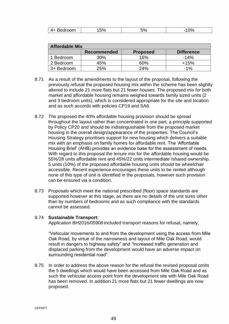
OFFRPT
4+ Bedroom 15% 5% -10%
Affordable Mix
Recommended Proposed Difference
1 Bedroom 30% 16% -14%
2 Bedroom 45% 60% +15%
3+ Bedroom 25% 24% -1%
8.71 As a result of the amendments to the layout of the proposal, following the previously refusal the proposed housing mix within the scheme has been slightly altered to include 21 more flats but 21 fewer houses. The proposed mix for both market and affordable housing remains weighed towards family sized units (2 and 3 bedroom units), which is considered appropriate for the site and location and as such accords with policies CP19 and SA6. 8.72 The proposed the 40% affordable housing provision should be spread
throughout the layout rather than concentrated in one part, a principle supported by Policy CP20 and should be indistinguishable from the proposed market housing in the overall design/appearance of the properties. The Council’s Housing Strategy prioritises support for new housing which delivers a suitable mix with an emphasis on family homes for affordable rent. The ‘Affordable Housing Brief’ (AHB) provides an evidence base for the assessment of needs. With regard to this proposal the tenure mix for the affordable housing would be 55%/28 units affordable rent and 45%/22 units intermediate /shared ownership. 5 units (10%) of the proposed affordable housing units should be wheelchair accessible. Recent experience encourages these units to be rented although none of this type of unit is identified in the proposals, however such provision can be ensured via a condition.
8.73 Proposals which meet the national prescribed (floor) space standards are
supported however at this stage, as there are no details of the unit sizes other than by numbers of bedrooms and as such compliance with the standards cannot be assessed.
8.74 Sustainable Transport:
Application BH2016/05908 included transport reasons for refusal, namely;
“Vehicular movements to and from the development using the access from Mile Oak Road, by virtue of the narrowness and layout of Mile Oak Road, would result in dangers to highway safety” and “Increased traffic generation and displaced parking from the development would have an adverse impact on surrounding residential road”.
8.75 In order to address the above reason for the refusal the revised proposal omits the 5 dwellings which would have been accessed from Mile Oak Road and as such the vehicular access point from the development site with Mile Oak Road has been removed. In addition 21 more flats but 21 fewer dwellings are now proposed.
49

OFFRPT
8.76 Further to the Transport Assessment, which was submitted a part of the previous application; additional traffic surveys have been carried out and submitted as part of the revised proposal as part of an addendum to the resubmitted Transport Assessment. The additional traffic surveys shows that the 2016 flow data was robust and confirms that the modelling presented in the resubmitted TA remains an appropriate assessment of the proposal. In addition the additional surveys demonstrate that the total increase in traffic movements on local routes south of the site to Portslade and Hove would be negligible once traffic has dispersed across the network.
8.77 Pedestrian Access
The main pedestrian access to the site would be from Overdown Rise with the access plan showing a 2m footway on both sides of the carriage way. The submitted Indicative Landscape Plan does not show an eastern footway alongside the allotments to Overdown Rise and it should be extended to provide a continuous footway on both sides. This issue can be dealt with via a condition.
8.78 The other main pedestrian entrance to the site is from Mile Oak Road. Although the vehicle access previously proposed in the refused application is removed, the Highway Authority would continue to seek amendments to this access, to be secured as part of the S278 agreement. 8.79 The indicative layout plan shows various pedestrian routes within the site, some
of which are already established routes but with no legal status. These include footpaths along the main vehicular routes but also within the SNCI to the north of the built area. The majority of the routes in the SNCI run east/west but there are also links running north/south from the proposed development itself. These are considered to provide convenient access to the wider area and the public rights of way beyond the development site and are welcomed by the Highway Authority. It is assumed that these routes are to remain private.
8.80 In order to maintain pedestrian permeability into and through the site the
Highway Authority requires the applicant to enter into a walkways agreement for the proposed pedestrian routes within the site, as part of the S106 agreement. In addition further details of the layout and design of the internal access roads and footpaths should be secured via a condition.
8.81 The applicant has previously confirmed that they wish the road to be adopted
and a S38 agreement would therefore be required. The Highway Authority would adopt the main spine road only and not the cul-de-sacs off the main route.
8.82 Vehicular Access
As set out above the formerly proposed Mile Oak Road vehicular access point has been omitted from the proposal but it retains the main vehicular access point between 21 Gorse Close and 21 Overdown Rise. This retained access is in the form of a simple priority junction with priority being given to Overdown Rise, as previously recommended by the Highway Authority.
8.83 Cycle Parking
50
OFFRPT
SPD14 states that a minimum of 1 cycle parking space per unit for 1 to 2 bed units and a minimum of 2 cycle parking spaces per unit for 3 to 4+ bed units is required. Visitor cycle parking should be provided at a rate of 1 space per 3 units.
8.84 For this development of up to 125 residential units (62 x 1-2 bed units and 63 x 3+ bed units) the minimum cycle parking standard is 230 cycle parking spaces in total (188 residents and 42 visitor spaces). 8.85 All houses appear to have either a garage or the potential for side access into the back garden; whilst the flats have adequate space to accommodate cycle parking within the vicinity of the building. Further details of cycle parking facilities should be secured via a condition. 8.86 Servicing
The main servicing activity associated with the proposed development is considered to be that of the collection of refuse and recycling and deliveries to each property. The applicant has submitted a swept path analysis of a refuse vehicle (10.980m in length) accessing the site, however is noted that this is based on the originally proposed layout, although this has not changed substantially. The Highway Authority has no objections to the proposed servicing arrangements.
8.87 Car Parking SPD14 states that in this location the maximum of car parking provision is 1 space per dwelling plus 1 space per 2 dwellings for visitors. For this development of up to 125 residential units the maximum car parking standard is 188 spaces (125 spaces for residents & 63 visitor spaces).
8.88 The proposal comprises 221 spaces in addition to 63 garage spaces. The applicant acknowledges that this is in excess of the Council’s SPD14 standard and the level previously recommended by the Highway Authority. 8.89 When assessing all available census data for car ownership the likely residential car parking demand for a development of up to 125 residential units, in this location, is between 143 and 155 cars. 8.90 The design and layout of parking would be provided at reserved matters stage
and as a result it is recommended that a condition is attached, should overall the proposal be considered acceptable, that states that the detailed layout shall not provide more than 188 off street car parking spaces, in order to limit the level of parking. This is in addition to the on-street capacity that would be created within the development. The current proposal to provide 221 spaces plus 63 garages plus on-street capacity would therefore be substantially greater that the maximum permitted. It is necessary to provide an appropriate balance between over providing for car parking and limiting overspill parking. However, taking account of on-street capacity within the site that the proposal would create and local car ownership levels it is not considered that overspill parking beyond the site would be substantial.
51

OFFRPT
8.91 Electric Vehicle Charing Points SPD14 requires that a minimum 10% of the car parking provision to have electric vehicle charging provision and a minimum of 10% of the car parking provision to have a passive provision to allow conversion at a later date. Although the applicant acknowledges such requirement, no details of electric vehicle charging provision have been provided within the submission. Such provision could however be secured via condition.
8.92 Disabled Parking SPD14 states that the minimum standard for disabled parking is 1 disabled space per wheelchair accessible unit plus 50% of the minimum parking standard to cater for visitors.
8.93 From the submitted illustrative layout plan it appears that the majority of units have access to at least 1 dedicated car parking space. If a resident was disabled they would therefore have a dedicated bay which would be for their sole use. Therefore in this instance it is not necessary for any of the houses to have a dedicated disabled bay. 8.94 However, for the communal parking for the flats and visitors the Highway Authority would look for dedicated disabled bays. Further details of the disabled car parking provision including numbers and layout should be secured via condition. 8.95 Public Transport
The nearest bus stops to the site are located on Graham Avenue outside the local shopping area. This is approximately 0.2mile/a 5 minute walk from the development site. This bus stop has a shelter, accessible kerb but no real time information sign.
8.96 This bus stop is served by the main services for the area, the 1 and 1A route which runs between Whitehawk and Mile Oak. These services serve Portslade Station, Portslade Old Village, Hove, central Brighton and the Royal Sussex County Hospital. 8.97 Improvements are needed to public transport infrastructure in order for the development to benefit from a quality public transport service that provides a real choice and alternative to the private car for future residents of the development. Such improvements can be secured via the S106 agreement. 8.98 Trip generation/Highway Impact
An Addendum to the previously submitted Transport Assessment has been submitted as part of the revised application in order to address the concerns raised in the earlier reasons for refusal and the feedback provided by Councillors at the Pre-application Briefing with regards to traffic volumes travelling from the site in a southerly direction, to Portslade and/or Hove.
8.99 In order to forecast the potential trip generation of the proposals and to forecast the likely impact on the road network the proposed development would have the
52
OFFRPT
applicant has resubmitted previous junction assessments, covering the following junctions;
Proposed site access Overdown Rise,
Graham Avenue/Graham Crescent
New England Rise/Thornhill Rise
Fox Way/Hangleton Link (A293) roundabout 8.100 In order to obtain existing traffic movements on the network the applicant has undertaken traffic count surveys at various locations in 2016 and an additional survey in June 2017, following the earlier refusal. The 2017 data suggests that the data used in the original assessment is a reasonable basis for assessment. 8.101 In order to forecast the trip generation from the development the applicant has resubmitted the data previously deemed acceptable by the Highway Authority using the industry standard TRICS database. As the number of units has not changed, this is considered acceptable in this instance. 8.102 In order to assign the forecast trips through the road network consideration has been given to 2011 census travel to work data but also the original 2016 surveyed data from classified turning counts. This approach is widely accepted by Highway Authorities as a method of assigning traffic to the highway network. 8.103 Previous junction modelling undertaken using industry standard software in the following scenarios has been resubmitted: 2018 base, 2018 base and development, 2021 base and 2021 base and development. 8.104 The modelling results show that the priority junctions are all forecast to operate within acceptable capacity thresholds and that the additional development traffic would not have a significant impact upon their operation in all modelling scenarios. 8.105 The current application retains the previously proposed improvement scheme
that can be delivered to improve traffic flow on the Fox Way arm of the Fox Way/A293 roundabout. The improvement scheme provides a two lane approach arm for a length of 40m to Fox Way, where currently there is only a one arm approach. The applicant has undertaken modelling which demonstrates the proposed works improve the performance of the Fox Way arm.
8.106 S106
To comply with the Brighton and Hove Local Plan 2005 policy TR7, TR11 and TR12, Policy CP7 and CP9 of the City Plan Part One, the National Planning Policy Framework and the Council’s Guidance on Developer Contributions the applicant is expected to make a financial contribution towards highway infrastructure in the vicinity of the site.
8.107 The Highway Authority would look for the S106 contribution of £250,000, to go towards pedestrian and public transport infrastructure improvements within the vicinity of the site. These works shall be focussed on minor footway improvements such as dropped kerbs and tactile paving, missing links of the
53
OFFRPT
public rights of way network as identified within the Rights of Way Improvement Plan and bus stop improvements including real time passenger information signs and accessible bus stops. This is to ensure that the site has access to a realistic alternative mode to the private car, benefits from a high quality public transport service and the local amenities that will serve future residents are accessible for all irrespective of their level of mobility; in line with the NPPF. 8.108 Additionally, as highlighted in the City Plan Strategic Transport Assessment (May 2013) and the Addendum Report (June 2014) this site forms part of the Urban Fringe developments which were assessed as part of the Addendum Report. Modelling work undertaken as part of this strategic TA details that infrastructure improvements are required at the junction of Hangleton Link Road/A27. 8.109 The proposed development would contribute towards the cumulative traffic impact upon strategic locations of the road network which have been identified for improvements works to accommodate the forecast growth identified as part of the City Plan. Therefore the Highway Authority would look for some of the above contribution to go towards contributing to the cost of the agreed A27/Hangleton Link Road mitigation works which are required to deliver the development identified in the City Plan. 8.110 Travel Plan
The applicant has re-submitted a Framework Residential Travel Information Plan as part of the Transport Assessment. The Highway Authority would look for the need to produce a Travel Plan and provide Residential Travel Information Packs to be secured via S106 and for the following measures to be included within the travel packs as a minimum:
Provision of 2 three month bus season tickets to each first residential property,
Free voucher towards the purchase of a bike – voucher £200 1 per household,
Public Transport Information, and
Local walking & cycling maps. 8.111 S278 Highway Works
The proposed highway works at Overdown Rise and requested footway improvements at Mile Oak Road would need to be undertaken through a S278 agreement with the Highway Authority.
8.112 Additionally, the Highway Authority would look for the applicant to deliver the mitigation measures put forward for the Fox Way/Hangleton Link Road junction through a S278 agreement prior to occupation of the development. 8.113 Sustainability:
City Plan Policy CP8 requires that all new development achieves minimum standards for energy and water performance as well as demonstrating how the proposal satisfies an exhaustive range of criteria around sustainable design features.
54
OFFRPT
8.114 The previous application was refused on grounds including;
“The applicant has failed to demonstrate that appropriate sustainability measures have been incorporated into the development, contrary to policy CP8”.
8.115 As the application is outline only it could be expected that some of the sustainable elements may not yet have been considered however within the current application the applicant confirms the commitment to meeting the requirements of policy CP8 by securing a 19% carbon reduction improvement against Part L 2013 and the “optional” standard for water efficiency, which is defined as not more than 110 litres per person per day maximum indoor water consumption. In addition it is stated that the applicant is willing to commit to a Home Quality Mark, which is equivalent to the requirements set out in policy CP8. In addition within the Appendices of the Planning Statement a supplementary report has been submitted, which assesses the proposal against Buildings for Life 12.
8.116 The application site is located close to a bus service (1 and 1A) which provides
a route to and from Brighton. A Travel Plan has also been submitted in which a range of measures are set out to encourage the use of sustainable transport and to reduce reliance of private vehicles.
8.117 In order to ensure that policy CP8 is addressed it is recommended that the
applicant be requested to submit, prior to commencement of the development, an energy assessment detailing how energy efficiency will deliver carbon reduction, how use of efficient building services will further reduce carbon emissions and how application of renewable energy technologies will deliver yet further carbon reductions.
8.118 Whilst further information regarding energy efficiency, passive design or the
incorporation of renewable energy technologies has not been provided as part of the revised outline application it is acknowledged that further full information would be required at reserved matters stage. Sustainability conditions (some additional to those recommended for the previous application) are recommended, including that the proposal meets minimum energy and water performance standards, to ensure compliance with policy CP8 and as such refusal based on sustainability grounds is not considered justified.
8.119 Other Considerations:
Construction Environmental Management Plan Due to the nature and scale of the development proposed and its location adjacent to the strategic road network, a Construction Environmental Management Plan is requested. As well as providing measures to mitigate the highway impact of the construction phase of the proposal the plan should ensure that the construction traffic avoids the Portslade Air Quality Management Area.
8.120 Land Contamination
55

OFFRPT
As part of the application a contaminated land report (Ground Conditions Desk Study) has been submitted and subsequently scrutinised to ensure that it is robust. The report has identified the classification of site as being very low to low risk in terms of possible contamination. However it has then gone on to suggest an intrusive investigation, partly due to the unknowns of the site. A better understanding may have been gathered through a site walkover as part of the desktop study, which may have negated the need for further testing. However it is appreciated that the report is joint geo-chemical and geo-technical, and further works may have been necessary for geo-technical reasons anyway. Conditions are therefore recommended with regards to further contamination investigation, and any possible future remediation.
8.121 Flood Risk: Despite the site being located in Flood Zone 1 (i.e. has a low probability of flooding) there is history of surface water and groundwater flooding in the area.
8.122 The previous application was refused on grounds that; “The applicant has failed to demonstrate that appropriate mitigation measures are proposed to manage and reduce flood risk in the locality”. 8.123 The Flood Risk Management Office states that the Council has constructed a
series of large soakaways, lagoon and bund in the area of the development on the parcel of land located to the west of the site, to reduce the risk of flooding. The applicant will need to consider and ensure, when finalising the site layout and drainage, that the development would not adversely affect these existing structures.
8.124 Whilst a Flood Risk Assessment and Drainage Strategy was provided as part of
the previous application, as a result of the above reason for refusal further clarification of the measures to mitigate flood risk has been submitted as part of the current application, including garden soakaways, permeable paving, infiltration basins and prevention of run-off,.
8.125 The Flood Risk Assessment and Drainage Strategy, which supports the
indicative layout, suggests surfaces other than roads will be either planted or permeably paved draining to soakaways. Run off from roads will be dealt with by two basins which would need to be at the lowest points of site 5. These are designed to deal with 1:100 year flooding events with an additional 40% increase in rainfall allowance for climate change. Any surface water run-off will therefore be dealt with in the application site without aggravating existing problems that may occur elsewhere. Whilst not necessarily reducing existing problems elsewhere this approach is in accordance with the requirements of the NPPF and CPP1 Policy CP11.
8.126 Southern Water has confirmed that the development would be located within a
Source Protection Zone and around one of their public water supply sources. As such Southern Water requests that a number of conditions, including relating to the protection of the public water supply source and the means of foul and surface water sewerage disposal, are attached if overall the proposal is considered acceptable.
56

OFFRPT
8.127 The Council’s Flood Risk Management Officer has assessed the proposal and
has advised that any concerns can be addressed through an appropriate surface water drainage scheme, which can be secured by planning condition.
8.128 Air Quality
The Council’s Air Quality Officer recommends approval of the planning application, subject to mitigation measures. Whilst there is not a direct impact to human health in terms of air quality, the completed build would generate additional vehicle movements which have the potential to impact the Portslade Air Quality Management Area (AQMA). Given the indirect impacts of the proposal on air quality, there is a requirement for the applicant to implement numerous mitigation measures to address the acceptability and future proofing of the build. These measures including a Construction Environmental Management Plan (CEMP), electric vehicle charging, water and energy requirements, low emission boilers, travel plan etc should be secured by conditions/S106 agreement.
8.129 Financial Contributions The financial Planning Obligations set out above regarding education, open space, local employment scheme, transport and artistic complement have been calculated at the outline application stage based on the methodology set out in the Council’s Developer Contributions Technical Guidance (March 2017) and based on the maximum amount of development proposed, in this case 125 dwellings.
8.130 Conclusion As set out above, a previous application for a similar development was refused by Planning Committee on grounds relating to transport, sustainability, ecology and flooding. An appeal has been lodged against this earlier refusal.
8.131 Since the refusal the developer has undertaken a pre-application Briefing with Councillors regarding the revised scheme subject of this application, namely the removal of the Mile Oak Road vehicle access point and the relation of 5 houses from Urban Fringe Site 4b to Site 5. In addition further information regarding transport impacts, sustainability and flooding have been submitted and a commitment to enhance and management the Whitehawk LNR to allow the translocation of reptiles to this site is proposed, in order to overcome the previous reasons for refusal. As such it is not considered that refusal on the earlier reasons could be sustained.
8.132 The provision of up to 125 new dwellings would be a significant contribution to
the supply of housing in the City, including 40% affordable housing. In addition the proposal would result in the enhancement, management and maintenance of the retained SNCI (which includes a formally defined area for public use) and the enhancement and management of the Whitehawk LNR.
8.133 The NPPF’s presumption in favour of sustainable development means that
development proposals that accord with the development plan should be approved without delay. In this instance it is considered that the proposal
57
OFFRPT
accords with the City Plan Part 1 and the Brighton & Hove Local Plan 2005, represents sustainable development and as such approval is recommended.
9. EQUALITIES 9.1 As this is an outline planning application with all matters reserved, except access, no equalities issues are identified. However the scheme indicated within the outline application would provide 50 units/40% affordable housing (28 units/55 percent for Social/Affordable Rental and 22 units/45 percent for Intermediate Affordable Housing). 9.2 If overall considered acceptable conditions are proposed which would ensure compliance with Building Regulations Optional Requirement M4(2) (accessible and adaptable dwellings) and that 5 percent of the overall development would be built to Wheelchair Accessible Standards.
58