noaa ship ronald h. brown (r-104) u.s. law of the sea
TRANSCRIPT

1
CRUISE REPORT
NOAA Ship Ronald H. Brown (R-104)
U.S. Law of the Sea Cruise to Map the Foot of the Slope
of the Northeast U.S. Atlantic Continental Margin: Leg 7
CRUISE RB12-02
July 2 to July 16, 2012
Charleston, SC to Miami, FL
Andrew A. Armstrong, Brian R. Calder, and Shepard M. Smith
With introduction, multibeam description, onshore processing description, area
description, and pre-cruise daily log sections by James V. Gardner
Center for Coastal and Ocean Mapping/Joint Hydrographic Center
University of New Hampshire
Durham, NH 03824
2
UNH CCOM/JHC Technical Report
July 17, 2012
Table of Contents
Introduction .................................................................................................................. 3
The Multibeam Echosounder and Associated Systems ............................................... 7
Ancillary Systems ................................................................................................. 7
Multibeam Processing .................................................................................................. 8
The Area: The U.S. Atlantic Margin .......................................................................... 9
Pre-cruise Daily Log .................................................................................................. 11
Daily Log ................................................................................................................... 14
Color maps of bathymetry and acoustic backscatter.................................................. 27
References Cited ........................................................................................................ 28
Table 1. Initial system sensor offsets .......................................................................... 7
Table 2. Offset corrections determined by Patch Test ................................................ 7
Table 3. Conversion table of Kongsberg file names to UNH line names .................. 29
Table 4. Location of CTD and XBT casts ................................................................ 32
Appendix 1. Cruise personnel .................................................................................... 37
Appendix 2. Cross-Check Analyses .......................................................................... 38
Appendix 3. Built-in Self Tests (BIST) ..................................................................... 44

3
Introduction
This report details the 2012 Atlantic Extended Continental Shelf (ECS) bathymetry mapping
cruise for the U.S. Extended Continental Shelf Project. This cruise is the seventh ECS cruise to
map the U.S. Atlantic continental margin (Figure 1). Reports of the previous legs can be found
at http://ccom.unh.edu/theme/law-sea/reports. The rational for and objectives of the previous
mapping in the U.S. Atlantic margin can be found in Gardner (2004), Cartwright and Gardner
(2005) and Calder and Gardner (2008). The 2012 cruise was planned after analyses of the 2004,
2005 and 2008 bathymetry demonstrated that gravity-driven down-slope transport of terrigenous
sediments in some regions of the Atlantic margin extends much farther to the east than was
previously documented. Consequently, the 2012 cruise focused on mapping the extent of the
down-slope sediment transport at the base of the lower continental margin.
The Office of Ocean Exploration and Research, National Oceanic and Atmospheric
Administration (NOAA) made available a 30-day window in the schedule of the NOAA Ship
Ronald H. Brown (Figure 2) for the 2012 mapping cruise. The Ronald H. Brown is an 84.5 m
(274 ft) 3250 ton multipurpose oceanographic research vessel with a hull-mounted Kongsberg
EM122 multibeam echo sounder (MBES). The University of New Hampshire (UNH) Center for
Coastal and Ocean Mapping/Joint Hydrographic Center JHC/CCOM leased a Knudsen 3260 3.5-
kHz chirp sub-bottom profiler for the cruise because the ship does not have an adequate deep-
water subbottom profiler. A deep-water subbottom profiler was required to image the top 50± m
of the sediment layer to aid in the identification of deposits of sediment that have been
transported by gravity (down-slope) processes.
NOAA personnel aboard the ship were responsible for system maintenance and real time
data management. UNH CCOM/JHC personnel aboard the ship were responsible for cruise
planning, a patch test of the EM122 MBES, data (MBES, subbottom and water column sound
speed) collection and quality control and data processing of the MBES bathymetry and acoustic-
backscatter and subbottom data.
The cruise required a 27-hour transit to a deep-water (~5000 m water depth) so that a
complete patch test could be performed prior to mapping operations. The patch test included a
calibration of the XBT system with a deep-water CTD cast as well as the determination of
additional static lever-arm offsets in pitch and roll and calibration of heading. Once the patch
test was successfully completed, a dip line was run in the South Area for bathymetry uncertainty
statistics with cross lines and then the mapping commenced. Finally, a transit was run from the
South Area to Miami, FL. The cruise collected and mapped a total area of 69,287 km2.

4
Figure 1. Areas of planned 2012 mapping (yellow polygons) overlain on previous UNH/CCOM
Atlantic multibeam mapping. Only the South Area and a seaward extension of that area was
mapped on the shortened cruise. Red arcs are 350 nautical miles from U.S. baselines.
previous
UNH/CCOM
data

5
Figure 2. NOAA Ship Ronald Brown.
The Multibeam Echo Sounder System and Associated Systems
The hull-mounted Kongsberg Maritime EM122 MBES (s/n 116) system aboard RV Ron
Brown is a 12-kHz multibeam echo sounder that transmits a 1˚ wide (fore-aft) acoustic pulse and
then generates 432-2˚ receive apertures (“beams”) over a 150˚ swath. The system can
automatically adjust the pointing angles of the receive beams to maximize the achievable
coverage or a maximum aperture can be defined by the operator. The transmit cycle can be
rapidly duplicated to provide two swaths per ping, each transmitted with a small along-track
offset that compensates for water depths and ship speed to generate a constant sounding spacing
in the along-track direction. This mode can provide as many as 864 soundings per transmit cycle
swath (432 soundings per swath) in the high-density dual-swath mode. With more than one
sounding generated per beam in the high-density mode, the horizontal resolution is increased and
is almost constant over the entire swath when run in the equidistant mode. In addition, the
transmit beams can be steered as much as 10° forward or aft to reduce the effects of specular
reflection at nadir and near-nadir angles.
The EM122 uses both continuous wave (CW) and frequency modulation (FM) pulses with
pulse compression on reception to increase the signal-to-noise ratio. The transmit pulse is split
into several independently steered sectors to compensate for vessel yaw. The system is pitch,
yaw and roll stabilized to compensate for vehicle motion during transmission. The 15-ms pulse
length (deep mode) used in this survey includes a significantly longer FM chirp pulse waveform
for the outer transmit sectors. Its bandwidth corresponds to the resolution of the 15-ms CW
pulse of the inner and mid-range transmit sectors but the longer duration of the FM chirp pulse
allows pulse compression on reception for a gain in signal-to-noise ratio of about 15 dB.
Kongsberg Maritime states that, at the 15-ms pulse length, the system is capable of depth

6
accuracies of 0.3 to 0.5% of water depth. The Kongsberg Maritime EM122 Product Description
should be consulted for the full details of the MBES system.
Two hull-mounted Reson SVP 70/71 sound-speed sensors were available to measure the
sound speed at the MBES array for accurate beam forming. Each sensor was calibrated at the
factory. Beam forming during this cruise used the high-density equidistant mode with FM
enabled and Automatic mode in deep water. For receive beams at near-normal incidence, the
depth values are determined by center-of-gravity amplitude detection, but for most of the beams,
the depth is determined by split-beam phase detection. The spacing of individual sounding is
approximately every 50 m.
An Applanix POS/MV model 320 version 4 inertial motion unit (IMU) with dual BD960
GPS receivers was configured with its internal differential GPS receiver acquiring Fugro
MarineSTAR satellite-based differential correctors, and thereby achieving an estimated
positioning uncertainty of ~0.35m (rms) in the horizontal and ~0.55m (rms) in the vertical. The
IMU provides roll, pitch and yaw at accuracies of better than 0.02˚ at 100 Hz. The MBES
system can incorporate transmit beam steering up to ±10˚ from vertical, roll compensation up to
±10˚ and can perform yaw corrections as well. All horizontal positions were georeferenced to
the WGS84-derived ellipsoid and vertical referencing was to instantaneous sea level.
The Kongsberg Maritime EM122 is capable of simultaneously collecting full time-series
acoustic backscatter that is co-registered with each bathymetric sounding. The full time-series
backscatter is a time series of acoustic-backscatter values across each beam footprint on the
seafloor. If the received amplitudes are properly calibrated to the outgoing signal strength,
receiver gains, spherical spreading, and attenuation, then the corrected backscatter should
provide clues as to the composition of the surficial seafloor. However, the interpreter must be
cautious because the 12-kHz acoustic signal undoubtedly penetrates the seafloor to an unknown,
but significant (meters) depth, thereby generating a received signal that is a function of some
unknown combination of acoustic impedance, seafloor roughness and volume reverberation.
The sound-speed profiles derived from frequent XBT casts (see below) were used to raytrace
each MBES receive signal to the seafloor and back to the receiver to compensate for the
refraction effects within the water column.
In addition to the MBES, the NOAA Ship Ron Brown is equipped for this cruise with a
Knudsen 3200 high-resolution chirp subbottom profiler. Subbottom data were continuously
collected throughout the cruise, although much of the data were subsequently determined to be
irretrievably garbled as a result of a bug in new firmware installed by the manufacturer.
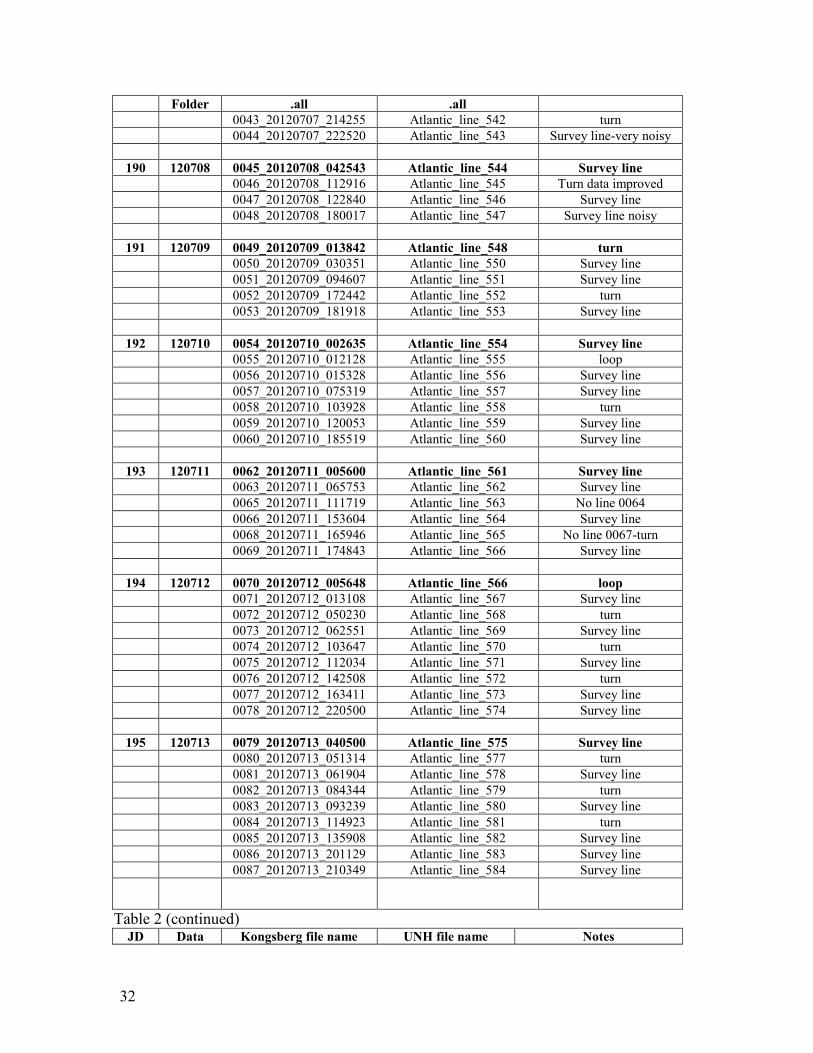
NOAA assigned the 2012 cruise with their designator of RB12-02 All raw MBES files were
initially labeled by the Kongsberg Seafloor Information System (SIS) data capture software with
a unique file designator but the files were renamed to Atlantic_line_X, where X is a consecutive
line number starting with 500 (see Table 3). Beginning the line numbering at 500 differentiates
lines from this 2012 cruise from previous U.S. ECS cruises in the Atlantic while maintaining the
“Atlantic_line_x” format for all Atlantic cruises. Transit lines and patch test lines were given
line numbers prefixed with “tran” or “patch”, respectively. The renaming was done so that the
individual lines would be unequivocally identified with the survey area in the future.
Water-column sound-speed profiles were routinely collected every 6 hrs during the cruise as
well as anytime the sound speed measured at the hull-mounted sensor differed for a significant

7
amount of time by >0.5 m/s from the value at the transducer depth from the XBT-derived sound
speed. Sound speeds were calculated from measurements of water temperature vs depth using
Sippican Deep Blue expendable bathythermographs (XBTs). Deep Blue XBTs have a 760-m
maximum depth of measurement so the profiles were extrapolated to 12,000 m using Kongsberg
software to provide a profile throughout the water column. A Sea Bird Electronics model SBE-
911+917+ CTD was used to calibrate the XBTs during the patch test. The two temperature
sensors (serial no. 2013 and 2700), the conductivity sensor (serial no. 3326) and the pressure
sensor (serial number 92859) were last calibrated by Sea Bird Electronics on May 27, 2011.
Derived sound-speed profiles derived from the two systems (CTD vs XBT) from data collected
during the patch test were compared between the systems to calibrate the XBT (see Daily Log
JD213).
A full patch test was conducted in the survey area to ensure sensor offsets were correct. The
patch test confirmed the existing settings; no modifications were made. Tables 1 and 2 show the
sensor offsets used for the survey. The patch test layout and seafloor is shown in Figure 3.
Figure 3. Seafloor image of patch test site and lines run.

8
Table 1. Initial system sensor offsets
Water Line Vertical Location (m) - WLZ = 0.48
TX Transducer Along Location (m) - S1X = 7.46
TX Transducer Athwart Location (m) - S1Y = -0.52
TX Transducer Vertical Location (m) - S1Z = 5.89
TX Transducer Heading (deg) - S1H = 359.98
TX Transducer Pitch (deg) - S1P = -0.01
TX Transducer Roll (deg) - S1R = -0.03
RX Transducer Along Location (m) - S2X = 12.02
RX Transducer Athwart Location (m) - S2Y = 0.01
RX Transducer Vertical Location (m) - S2Z = 5.97
RX Transducer Heading (deg) - S2H = 0.08
RX Transducer Pitch (deg) - S2P = 0.18
RX Transducer Roll (deg) - S2R = 0.20
Table 2. Offset corrections determined by Patch Test
Offset Value
pitch 0
roll -0.42˚
heading 0
latency 0
Ancillary Systems
Knudsen 3260 chirp subbottom profiler
A Knudsen 3260 chirp subbottom profiler was leased by UNH/CCOM-JHC for the cruise
because the ship did not have a deep-water subbottom system. The Knudsen 3260 electronics
and power supply were installed by a Knudsen engineer two days prior to sailing. The leased
system produces a 3.5-kHz FM signal with a 2-kHz bandwidth with up to 10 KW of power using
the ship’s existing 3x4 hull-mounted transducer array. The system has adjustable pulse lengths
up to 64 ms, power and gain settings that allows it to acquire good bottom detection and
subbottom resolution to about 50 m subbottom. The profiler was synchronized with the EM122
so that the EM122 controlled the profiler, limiting its transmission to coincide with the EM122
transmission and thereby avoid profiler transmission during the multibeam receive cycles. The

9
synchronization eliminated any interference of the profiler signal with the multibeam signal. The
Knudsen chirp profiler was configured to record digital data in SEG-Y format. On July 11,
despite repeated efforts to open and process the SEG-Y files, and multiple consultations with
experts ashore and the manufacturer, we were informed by the manufacturer that a firmware bug
in the system was resulting in no decipherable data being recorded in the SEG-Y files, and that
no shipboard or factory processing could recover any data. We received and installed a new
firmware update from Knudsen, and the SEG-Y data became readable. From that time forward,
we recorded data in both the SEG-Y format and the Knudsen KEB format. SEG-Y line names
were changed to Atlantic_3.5kHz_line_X.sgy where X is a consecutive line number that began
with 500. The SEG-Y line numbers correspond with the MBES line numbers.
MBES Data Processing and Quality Assurance
The raw multibeam bathymetry and acoustic backscatter data were processed aboard ship for
quality control purposes using Caris HIPS and SIPS software. Each Kongsberg .all file was
collected by the onboard Kongsberg SIS data-acquisition system. Once a line was completed,
the .all file was copied to a server that could be accessed by the UNH computer via the shipboard
network. Each .all file was renamed from the Kongsberg-generated file name to
Atlantic_line_n.all (see Table 3) so that later each file could be easily identified to the area and
cruise. The line numbers commenced with Atlantic_line_tran500 beginning with the transit to
the patch-test site and then commenced to Atlantic_line_5XX when the actual mapping began.
Each .all file is composed of individual data packets of beam bathymetry (range and angle),
beam average and full time-series acoustic backscatter, navigation, parameters, sound-speed
profiles, orientation and sound speed at the transducer.
The data were reprocessed ashore for the final ECS products. The first step in the processing
separates each of these data packets into the individual files.
The second step in the processing plots the navigation file so that any bad fixes can be
flagged. Once this step is completed, the validated navigation is merged with the bathymetry
and acoustic backscatter files.
The third step involves editing (flagging) individual soundings that appear to be fliers, bad
points, multipaths, etc. The entire file of soundings is viewed and edited in a sequence of steps
through the file. Once the bathymetry file has been edited, the valid individual soundings are
gridded into subarea DTM maps and the co-registered valid acoustic backscatter full beam time
series is assembled into a file and gridded into subarea mosaics.
The entire region was subdivided into 14 subarea bathymetry maps and (Figure 4). These are
the same subarea maps used in the 2004, 2005 and 2008 mapping and the new data were simply
added to the appropriate subarea map. Each subarea map was designed to maximize the spatial
resolution allowed by the mapped water depths within the area.
A representative sample of swath crossings were analyzed to establish the overall uncertainty
and confirm the internal consistency of the multibeam data. The results are presented in
Appendix 3, and establish that this survey has a depth uncertainty less than 0.3% of water depth
and is well within the applicable IHO Order 2 standards as well as the more stringent Order 1b
standards (IHO 2008).

10
Figure 4. Subareas for the Atlantic
The Area: The US Atlantic Margin
The specific area mapped during this cruise is immediately east of the region defined in
Mayer et al., 2002 as those areas in the North East and South East Atlantic where a potential U.S.
claim beyond the U.S. EEZ could be made under UNCLOS Article 76. In order to satisfy the
requirements of Article 76, the entire continental margin off the eastern U.S. between the 1000
and 5000-m isobaths needed to be mapped. The areas mapped in this 2012 cruise were identified
as additional areas that needed modern MBES bathymetry after analyses of the 2004, 2005 and
2008 data. This region contains numerous large submarine canyons, a chain of volcanic
seamounts, major sediment tongues, and a huge sediment drift (Figure 5).

11
Figure 5. Map of various Quaternary processes that have formed the modern U.S. Atlantic
margin (after Chaytor et al., 2007).
The U.S. eastern margin is a huge constructional prism of sediments and buried reefs that
have accumulated over the continent-ocean boundary since the Late Jurassic opening of the
Atlantic Ocean (Emery and Uchupi, 1984; Sheridan and Grow, 1988; Poag and Graciansky,
1992). A deep mantle plume or hot-spot erupted off the axis of the nascent spreading ridge in
the Early Cretaceous (about 130 m.y. ago). The hot spot produced a string of volcanic
seamounts, the New England Seamounts, which continued for ~50 m.y. until the Late Cretaceous
(about 73 m.y. ago; Duncan, 1984). Most of the present geomorphology of the margin is thought
to be the result of sedimentation and erosion that occurred during Quaternary (the past 1.8 Myr),
a period dominated by at least 18 major fluctuations of eustatic sea level (Shackleton, 1987).
The age of major canyon cutting is unknown but thought to have occurred during the Neogene
and Quaternary.
The southern part of the survey area is dominated by the Blake-Bahama Outer Ridge and
Blake Spur (Pratt and Heezen, 1964). These sedimentary features are thought to be related to the
formation of the Gulf Stream that resulted from the closing of the Isthmus of Panama during the
Late Miocene to Early Pliocene (Kaneps, 1979; Pinet et al., 1981). The barrier diverted the

12
surface waters of the Caribbean and Gulf of Mexico into a anti-cyclonic gyre that merges with
the Antilles Current between Florida and the Bahamas and then continues to the NW.
The entire US eastern margin was subdivided into 4 areas (Figure 6) for generating overview
maps. Each map was gridded with a 100-m cell size because our 12 to 14 kt mapping speed
allowed at least 3 mappings to fall within in each footprint regardless of water depth.
Bathymetry from the 2012 mapping cruise has been combined with earlier USLOTS bathymetry
for the final products.
Figure 6. Subareas of Atlantic margin used to compile all the data from the 2004, 2005, 2008
and 2012 cruises.
Pre- Cruise Daily Log—James V. Gardner
Thursday June 14, 2012 (JD166)
Darren Gibson, an engineer from Knudsen Engineering, and Jim Gardner were picked up at
1330L at the Patriots Pier fuel dock in Mt. Pleasant, SC and ferried to the ship. Once aboard, the
ship steamed out of Charleston Harbor to the open sea. The engineer spent the afternoon testing
the electrical impedance of the ship’s 3.5-kHz transducers and installing a Knudsen 3260 Chirp
subbottom profiler power supply and processing unit.

13
The ship’s scientific equipment was in a state of disarray. The CTD cable was not
terminated, the EM122 had not been turned on since before the yard period a month previously
and the XBT system was in an unknown state.
The Knudsen engineer and Jim Gardner were transferred back to the beach via a 1.25 hr
zodiac ride because the ship had transited out of Charleston harbor onto the shelf during the
afternoon. The ship had to stay on the shelf for the next 24 to 26 hr for dynamic positioning
trials and work on the generators.
Friday June 15, 2012 (JD167)
The ship stayed at sea all day while the science party stayed on the beach. No contact from
the ship.
Saturday June 16, 2012 (JD168)
The ship arrived back at the pier at 2000 hr L but we were not notified the ship had arrived.
Sunday June 17, 2012 (JD169)
The science party arrived at the ship at the prearranged time of 1030 L but no one was aboard
other than the OD. Regardless of the lack of help, the science party set up their computers,
RAID arrays and a local network. However, no one from the ship was there to set up the
network to the ship network. We left about 1330 hr L for food because the ship was not serving
lunch or dinner. The science party spent the remainder of the day in town but spent the night
aboard ship.
Monday June 18, 2012 (JD170)
I was informed by the survey tech that only one hull-mounted velocimeter was installed on
the ship after dry dock and that one was not working properly. The second velocimeter was
aboard ship but not installed. The Ops Officer told me that the installed velocimeter would be
checked out by the ET. However, the ET spent the morning terminating the CTD cable. I
informed the Ops Mgr that the second velocimeter must be installed so he planned for the ship to
hove-to once we are at sea and away from currents and for a diver to install the second
velocimeter.
The work on the generators continued through the day. We spent an hour in the afternoon
installing the Fugro OmniStar upgrade that will provide differential correctors to the POS/MV
positions. By early evening the POS/MV was receiving OmniStar XP differential correctors.
Tuesday June 19, 2012 (JD171)
I was informed by the Captain this morning at breakfast that the generator that has just been
rebuilt blew a piston and the entire generator has to be rebuilt again. The estimate of the work is
that it will take at least until Friday at the earliest and possibly several days longer.
The Captain called an all-hands meeting at 12 noon to inform us all that the most optimistic
estimate to get the generator rebuilt was late afternoon Monday June 25. But even once rebuilt,
there would need to be a trials cruise to make sure the generator was operational. This put the
cruise in grave jeopardy. I sent an email to Andy Armstrong updating him on the estimate of the
delay. Spent the rest of the afternoon awaiting word from Andy.

14
Late in the afternoon the Captain and the Ops Officer dove to the transducers to install the
second sound-speed sensor on the receive array. The existing sound-speed sensor is still not
talking to the SIS.
Wednesday June 20, 2012 (JD172)
The second sound-speed sensor appears to be sending data but the SIS is not receiving the
data. It might be a format problem or a network issue. The ET is working on it. Late in the
morning the ET informed me that he had an article that suggested if the TR-109 transducers were
rewired as specified by the Knudsen engineer, cavitation would occur at the transducer faces. I
strongly suggested the ET contact the Knudsen engineer to discuss this. The issue is that, as
wired, the transducer array will only produce 6 kw of power. The rewiring suggested by the
Knudsen engineer would allow the transducers to produce 10 kw of power. Because the two
survey areas are both in 5000+ m water depths and the objective for the subbottom profiler is to
image the top 50 m of sediment, we need maximum power from the transducers. So far, the
transducers have not been rewired to the Knudsen engineer’s specifications.
The CTD winch cable has not yet been terminated because, according to the technician, the
winch can’t be run (because of the work on the generator) to lower the wire to the deck.
Thursday June 21, 2012 (JD173)
The Captain and Ops Officer held a science and tech meeting in the morning to go over what
still needs to be completed from the science perspective. He reported that Caterpillar had only
two mechanics working 10-hr days to repair the generator. We reviewed progress with the
science systems and I reported that the sound-speed sensors were still not talking to the SIS. In
addition, I reported the reluctance of the ET to rewire the Knudsen and the lack of a termination
of the CTD cable. We provided Knudsen and Kongsberg names and phone numbers for the ship
to contact those technical folks. By 1045L, after contacting Kongsberg, one sound-speed sensor
was communicating with the SIS.
Finally, the Senior Survey Tech informed me that the EM122 and XBT Mk-21 unit are not
networked to any distributed storage, nor are they backed up in any way. This is the case even
though there is a full-rack NetApp server in the lab. I was told by the Senior Survey Tech that he
was told that server could not be turned on. Consequently, data from these two systems need to
be transported by USB thumb drive. The data will be stored and retrieved for processing as
shown below.
Data type Drive Folder
EM122.all local D: RB12-02
Knudsen network C: RB12-02_Knudsen
XBTs
In the early afternoon the ET informed me that two of the 12 TR-109 transducers were dead,
thereby reducing the 4x3 array to a configuration shown below. This will reduce to output
power.
Transducer array showing location of dead TR-109 jugs (red)

15
11 12
7 8 9 10
3 4 5 6
1 2
I was asked which configuration I wanted. I suggested they contact Knudsen Engineering.
They apparently were reluctant to do that. Consequently, I contacted Darren Gibson at Knudsen
and he suggested the transducers be rewired with each row of 4 to have very similar impedances.
By 1330 L Caterpillar had 7 mechanics working on the generator. The ET that left the ship last
weekend was called back to the ship and arrived in the early afternoon. Together, the two ETs
fussed with the Knudsen transducers and communicated with someone in NOAA Ops. They
informed me in the mid-afternoon that they had rewired the transducers and considered that job
complete.
Sometime during the afternoon 5 additional Caterpillar mechanics arrived to work on the
generator, but by 5 pm all 7 were gone.
No word from NOAA HQ or CCOM-JHC throughout the day as to the fate of the cruise.
Friday June 22, 2012 (JD174)
At the 0900 L meeting with the Captain and Ops Officer, the Captain reported that the ABS
inspector overlooking the generator repair was unhappy with the quality of the work being done.
The inspector has requested higher quality work, but the effect of that request on the
workmanship is unknown. However, this request might further delay sailing.
I requested that our SVP laptop, the XBT Mark 21 computer and the SIS computer be
networked so we do not have to transfer data with a USB thumb drive from lab to lab. The
Captain and Ops Officer said it would be done and it was. Only one of the sound-speed sensors
has been tested through the SIS and I requested the second one be tested. The CTD termination
still has not been made but I was told it will be done today.
The Captain held a 1430 L all-hands meeting and announced that our arrival in Miami has
been extended 2 days to 17 July. The plan is for the Caterpillar mechanics to have the generator
assembled by Sunday evening and we will depart Monday morning at 0800 L for testing the
generator. The generator testing will take most of the day and then, if the tests are good, the
mechanics and the ABS inspector will be ferried to the beach by zodiac and the transit to the
patch test site would begin once the zodiac returns to the ship.
Saturday June 23, 2012 (JD175)
The Captain informed me that the delay would be until Monday morning. He said the
generator rebuild was not progressing as suspected. The tentative sailing was set for 0800 L.
Sunday June 24, 2012 (JD176)
The Captain informed me that the delay would be until Monday afternoon. He said the
generator rebuild was not progressing as suspected. The tentative sailing was set for 1400 L. I
made the decision that if we do not depart at 1400 L on Monday, I would cancel the cruise and
the science team would fly home on Tuesday. I informed Andy Armstrong of this decision and
he concurred.

16
Monday June 25, 2012 (JD177)
An offhand remark I made to the ET about the lack of storage backup of the MBES data
elicited a remark that the Kongsberg computer had a RAID array striped 5, thereby providing
backup. I asked to have that computer connected to the local network I had established over a
week ago and he agreed to do it. The computer was networked and a read-only folder was
created on D:/sisdata/raw/RB1202.
I took the science staff to the hotel, came back to the ship and packed up the computers and
Knudsen 3260, packed everything into a rental van and I left the ship at ~2200 L.
Daily Log—Andrew Armstrong, Brian Calder, Shepard Smith
Sunday July 1, 2012 (JD 183)
Second survey crew arrived back at the ship, which has subsequently undergone repairs, and
reports being ready to get underway. Set up computer systems again, and attempted to interface
sound speed process software to SIS. This did not appear to be communicating correctly,
although this was ignored for now while the rest of the system was set up.
Monday July 2, 2012 (JD 184)
Ship got underway at 1400L and proceeded to sea for the first sea-going leg of the cruise. A
BIST test was conducted at ~1515L in relatively shallow water, and completed correctly with no
warning lights. The issue with the SVPEditor connection was that the DataDistrib software on
the SIS machine was not running; once restarted, the SVPEditor software started receiving data
appropriately. The survey parameters on SIS were set for warnings on sound speed at 0.5 m/s,
and errors at 1.0 m/s, and finally only to turn over lines at 10-hr increments. (The plan being to
turn over lines at 6-hr increments, and therefore never have to deal with automatic line
increments.) The ship continued underway at 13 kts heading for the patch test site.
Tuesday July 3, 2012 (JD 185)
Underway as before, heading to the patch test site. Knudsen started in ~60m water at 2100L;
pinging on EM122 at the same time, and no evidence so far of interference. EM 122 is operating
well, with 4X water depth in 4000+ m of water depth, although there are signs of Knudsen
interference in the water column display, and possibly EM122 interference in the Knudsen
display. The seafloor return is not affected in either system, however. Started XBT prior to
CTD cast at ~1755L. Cast in the water ~1840L at 33 18’ 26”N, 73 15’ 20” W for equalization
and then recovered to the surface, and dropping to bottom (~4980m in this location). Cast on the
way up, and preparing second XBT for cross-calibration at 2036L. On the surface at 2143L.
Comparison of XBT and CTD casts showed good agreement in general in the range of depths at
which measurements were taken (Figure 7), differing only in the extension region where the
XBT data were based on the World Ocean Atlas (Figure 8).

17
Figure 7. Comparison of XBT and CTD estimates of the sound speed profile at the patch test
site. Note that both upcast and downcast are shown for the CTD data (in blue), ‘Pre’ indicates
the XBT taken before the CTD, and ‘Post’ indicates the XBT taken afterwards.

18
Figure 8. Comparison of the XBT and CTD estimates of sound speed profile to the maximum
depth recorded by the CTD sensor. The XBT data were extended using information from the
World Ocean Atlas for the area of operation, and therefore show some variability from the CTD
measurements.
Wednesday July 4, 2012 (JD 186)
CTD loaded into SIS via SVP Editor, and start of patch test line for pitch at 0222Z (Kongsberg
Line 0014).
0233Z Beginning Patch Test; bridge reports difficulty with tracking system, so will run this first
line as line 3 at 6 kts.
0440Z Completed first line; turning for second line at 12 kts (line 2 in the patch test line plan,
primarily for pitch calibration).
0514Z Bridge reported speed at 4 kts because of problems with the autopilot computer; they are
investigating.
0519Z Speed started returning. Bridge reported that they believe that they understand the
problem, but are unable to resolve it immediately. They therefore will attempt to drive the rest
of this line with the autopilot, and then switch to driving in hand for the next line.
0543Z EOL. Bridge is going to attempt the turn in line following mode, with the backup plan of
going to a separate system if that doesn’t work; slowing down to accommodate.

19
0622Z Bridge reported that an engineering ‘issue’ was causing them to have to reduce speed to
~8.5 kts while they investigated.
0642ZBack to 12 kts. Line complete 0707Z, moving to roll lines while testing pitch/timing.
Analysis of pitch and timing lines completed without indication of any offset that would make a
significant improvement. These offsets were therefore left as currently configured.
0811Z Started on first roll line; bridge having difficulties getting system into autotrack; achieved
about a third of the way down the track.
0850Z Line complete
0950Z Completed roll lines. Analysis shows no offset to be corrected, even with adjustments in
the 0.01-0.02 degree scale. Roll offset was therefore left as currently configured.
1034Z Started last line, for yaw. Complete 1131Z. Yaw line (#18) processed and compared to
one of the parallel pitch/timing lines (#16) on a distinct ridge on the canyon wall. Analysis
shows no discrepancy between lines, so the Kongsberg was left as currently configured. Begin
dead head to eastern end of dip line. Science team engaged in troubleshooting the Knudsen
triggering, laying out a poster, and establishing a backscatter processing procedure. Bridge team
tuning the DP system for steering survey lines.
1312Z XBT starts SSV 1539.4m/s
Reduced the ping rate for the Knudsen from automatically pinging based on depth to pinging
every 18 seconds, roughly the same interval as the EM122. This has, at least, reduced the
amount of interference.
1743Z Email arrived from Knudsen Engineer via Jim G that input cable should be plugged into
Aux 2 rather than the BNC where we had it. Moved cable and set sync to external; system began
pinging under sync from EM122 as we wanted. Will monitor EM122 data for interference.
1932Z XBT starts SSV 1538m/s. Remarkable agreement between the cast and the WOD (Figure
9.).

20
Figure 9. Cast results within World Ocean Atlas bounds
1945Z Screenshot showing distinct change of seafloor texture, near outer end of dip line (Figure
10.). This is from the dead-head line. Expect similar in reverse on westbound dip line.
Figure 10. Screenshot of Knudsen data showing transition from slumping seafloor to smooth
seafloor
1956Z Dip begins, westbound. Started new line on both Knudsen and EM122.
2216Z Bridge (LT Chamberlain) reports adjusting the autopilot to reduce rate of turn (to 5
deg/min) and reducing the cross track error gain.

21
Thursday July 5, 2012 (JD 187)
0000Z XBT starts. Attempted to use the TSG salinity to adjust the XBT conversion; this is not
used in the processing for the MBES data, but will make the data more useful for the ship and
NODC. Unfortunately, the location in which this can be specified is cryptic; will investigate
further. Meanwhile, profile TD_00014 entered 0015Z.
0155Z XBT starts. Salinity is specified in the ‘Post Processing’ options menu, in parts per
thousand, but needs to be entered before the launch is started. Profile 15 underway with salinity
35.2. Probe went to auto-launch when locked into the launcher, but resetting and reseating the
probe allowed the same canister to be used for profile 16 without loss. Profile 16 added 0207Z.
0305Z XBT starts. Cast misfired twice before getting to launch correctly, although the same
probe was used each time. Profile 19 added 0310Z.
0523Z Start of first line of main scheme. XBT started after turn. Profile 21 added 0530Z.
0547Z XBT started since there appeared to be a localized pocket of water with sound speed
approximately 1.5 m/s lower than the surrounding upslope area. The boundaries of the pocket
appear to be almost exactly on the edge of the survey area. Profile 24 applied 0554Z.
0635Z XBT started, dropped into slower water pocket, then stabilized. The probe launcher
continues to exhibit false launches (where the system believes that the probe has left the launcher
while in fact it is still firmly attached). The probes can be re-seated and re-used, but this may
indicate a creeping failure of the launcher that should be investigated; ST on duty would prefer to
leave this to the ET when he comes on watch in the morning. Applied 0643Z.
0700Z XBT started again after drop of another 1.2 m/s in approximately 5 min. Applied 0710Z.
0800Z XBT started, and launched cleanly first time. Applied 0808Z.
1038Z XBT started, and launched cleanly first time. Applied 1045Z.
1122Z XBT started. Applied cast 31 1133Z (cast 30 failed).
1400Z XBT started. Applied cast 32 1408Z.
1645Z XBT started. Applied cast 33 1651Z
1758Z XBT started. Applied cast 34 1805Z
1827Z XBT started. Applied cast 35 1834Z
2120Z XBT started. Applied cast 36 2124Z
2158Z XBT started. Navigation Failure on MK21 Program. Position input manually. Applied
cast 37 2203Z.
2232Z XBT started. Applied cast 38 2237Z.
Analysis of today’s data overlap areas suggests that the mean depths from the beams on the
starboard side are deeper than depths from port side beams in the same location. This does not
exceed the allowable depth error, however. We suspect some transducer or transceiver
sensitivity loss.

22
Friday July 6, 2012 (JD 188)
Underway, routine mapping operations
0005Z Error in the time series display that records roll/pitch/heave just after turn/new line. Most
likely a display issue. Only lasted a few moments before returning to normal function.
0025Z XBT started. Applied cast 39 0030Z.
0100Z XBT started. Applied cast 40 0110Z.
0150Z POS/MV reported user accuracy issue on heading due to GAMS lock failure. System
recovered in a couple of minutes, but the Secondary receiver reports that it is not achieving
Omnistar XP lock. Since this implies that the primary and secondary will have significantly
different uncertainties, it might be engendering issues with GAMS. It is unknown at this time
whether this is a reception issue that is course related, or something else. For the time being, we
continue to monitor the situation.
0215Z XBT started; first launch failed at start with bad data; cast 42 succeeded and applied
0230Z.
0515Z XBT started. Applied cast 43 0524 Z.
0543Z POS/MV lost GAMS lock and did not recover as before; asked bridge to reverse
direction, move back up the line, and return. This allowed the GAMS to reacquire, although why
it lost lock in the first place is unknown. There is, however, a less than advantageous GPS
constellation currently, with only nine SVs in a rough line oriented with the current survey axis.
Executed the turn, which helped the system lock, although the performance continues to be more
variable than is typical with POS/MV V4 systems. Restarted survey line 33 at 0602Z; line 32 is
the turn and should not be used.
0720Z XBT started; cast 44 applied 0724Z.
0840Z XBT started; cast 45 applied 0846Z.
1057Z XBT started; cast 46 applied 1104Z.
1352Z XBT started; cast 47 applied 1357Z.
1757Z reduced speed to allow a crossing vessel to pass ahead safely. Screenshot included
showing increased swath width as well as current speed (Figure 11). Red boxes added for
clarity.

23
Figure 11. Screenshot of SIS display showing wider swath after reducing speed.
1758Z XBT started; cast 48 applied 1804Z.
1845Z Ship has resumed normal survey speed.
1950Z XBT started; cast 49 applied 1955Z.
2035Z XBT started; cast 51 applied 2040Z. Cast 50 was a false launch for the probe.
2317Z XBT started; cast 52 applied 2321Z.
Saturday 7 July, 2012 (JD 189)
Underway, routine mapping operations
0010Z XBT started; cast 54 applied 0015Z [Cast 53 was a false launch for the probe].
0039Z XBT started; cast 55 applied 0046Z.
0215Z XBT started; cast 56 applied 0221Z.
0429Z XBT started; cast 57 applied 0437Z.

24
0514Z XBT started; cast 58 applied 0520Z.
0623Z XBT started; cast 60 applied 0629Z.
0702Z XBT started; cast 61 applied 0707Z.
0945Z XBT started; cast 62 applied 0950Z.
0958Z XBT started; cast 63 applied 1004Z (small pocket of slower water at the southern end of
the survey area).
1028Z XBT started; cast 64 applied 1035Z.
1432Z XBT started; cast 65 applied 1436Z.
1818Z XBT started; cast 66 applied 1822Z.
2111Z XBT started; cast 67 applied 2115Z.
2225Z XBT started; cast 68 applied 2232Z.
Sunday 8 July, 2012 (JD 190)
Underway; routine mapping operations
0000Z XBT started; cast 69 applied 0008Z.
0428Z XBT started; cast 70 applied 0435Z.
0632Z Bridge passed the word that the primary generator (#1) is causing problems, and therefore
that the ship has to slow down to ~8 kt while this is diagnosed and repaired.
0835Z Bridge passed the word that generator #1 is back on line and the ship will recover to 12 kt
slowly.
0946Z XBT started; cast 71 applied 0955Z.
1802Z XBT started; cast 72 applied 1806Z.
1930Z XBT started; cast 73 applied 1935Z.
Monday 9 July, 2012 (JD 191)
Underway; routine mapping operations
0011Z XBT started; cast 74 applied 0018Z.
0315Z XBT started; cast 75 applied 0324Z.
0513Z XBT started; cast 76 applied 0518Z.
0634Z XBT started; cast 77 applied 0646Z
0828Z XBT started; cast 78 applied 0835Z.
1018Z XBT started: cast 79 applied 1023Z.
1506Z XBT started; cast 80 applied 1512Z.

25
1823Z XBT started; cast 81 applied 1827Z.
2227Z XBT started; cast 82 applied 2232Z.
Tuesday 10 July, 2012 (JD 192)
Underway; routine mapping operations
01221Z Extended GAMS outage caused the accuracy of the heading on the POS/MV to degrade
sufficiently that the ship was turned to a reciprocal heading, reversed track two miles, and then
returned to line in an attempt to recover heading. GAMS locked almost immediately on turning,
and stayed locked during maneuver, line resumed 0152Z.
0235Z XBT started; cast 83 installed 0244Z.
0512Z XBT 84 failed launched
0514Z XBT started; cast 85 applied 0519Z
0728Z XBT started; cast 87 applied 0735Z.
1320Z XBT started; cast 88 applied 1326Z.
1646Z XBT started; cast 89 applied 1650Z.
1804Z XBT started; cast 90 applied 1809Z.
1958Z XBT started; cast 91 applied 2002Z.
2145Z XBT started; cast 92 applied 2149Z.
Wednesday 11 July, 2012 (JD 193)
Underway; routine mapping operations
0119Z XBT started; cast 93 applied 0124Z
0223ZXBT started; cast 94 applied 0227Z.
0251ZXBT started; cast 95 applied 0257Z.
0355Z XBT started; cast 96 applied 0403Z.
0605Z XBT started; cast 97 applied 0611Z.
0823Z XBT started; cast 98 applied 0827Z.
1357Z XBT started; cast 99 applied 1403Z. XBT showed initial temperature value of 4.75C then
showed a temperature of 35.5C for the next 16m. Then probe continued with normal function.
Sound speed profile looked well enough to continue without extra XBT.
1445Z Received email from Jim directing us to change Knudsen recording format from SEG-Y
to KEB. Stopped recording and changed to KEB, resumed recording.
1608Z XBT started; cast 100 applied 1612Z.
1751Z XBT started; cast 101 applied 1755Z.

26
1859Z XBT started; cast 102 applied 1902Z.
2305Z XBT started; cast 103 applied 2311Z.
Thursday 12 July, 2012 (JD 194)
Underway; routine mapping
0000Z XBT started; cast 104 applied 0005Z.
0135Z XBT started; cast 105 applied 0145Z.
0223Z XBT started; cast 106 applied 0229Z.
0440Z XBT started; cast 107 applied 0447Z.
0503Z Restarted Knudsen Computer to apply Windows Updates. During processing, it was
observed that sequential line 67 was missing; this appears to be a double-click of the ‘Line
Count’ button on the SIS computer: lines 66 and 68 adjoin.
0705Z XBT started; cast 108 applied 0711Z.
0850Z XBT started; cast 109 applied 0855Z.
1119Z XBT started; cast 110 applied 1123Z.
1205Z XBT started; cast 112 applied 1210Z.
1636Z XBT started; cast 113 applied 1641Z.
1725Z XBT started; cast 114 applied 1729Z.
1914Z XBT started; cast 115 applied 1918Z.
2239Z XBT started; cast 116 applied 2243Z.
2354Z XBT started; cast 117 applied 2358Z.
Friday 13 July, 2012 (JD 195)
Underway; routine mapping
0055Z XBT started; cast 118 applied 0102Z.
0255Z XBT started; cast 119 applied 0302Z.
0406Z XBT started; cast 120 applied 0412Z.
0453Z XBT started; cast 121 applied 0500Z.
0625Z XBT started; cast 122 applied 0631Z.
0933Z XBT started; cast 123 applied 0940Z.
1407Z Changed .SGY format from raw to filtered on Knudsen 3260 at advice of experts ashore.
1403Z XBT started; cast 124 applied 1408Z.
1642Z XBT started; cast 125 applied 1648Z.

27
2105Z XBT started; cast 126 applied 2110Z.
2248Z XBT started; cast 127 applied 2253Z.
Saturday 14 July, 2012 (JD 196)
Underway; routine mapping
0048Z XBT started; cast 128 applied 0055Z.
0129Z XBT started; cast 129 applied 0134Z.
0155Z XBT started; cast 130 applied 0201Z.
0233Z XBT started: cast 131 applied 0238Z
0250Z XBT started; cast 132 applied 0255Z.
0311Z XBT started: cast 133 applied 0315Z.
0427Z XBT started; cast 134 applied 0432Z.
0510Z XBT started; cast 135 applied 0515Z.
0528Z XBT started; cast 137 applied 0534Z. [Cast 136 was aborted]
0607Z XBT started: cast 139 applied 0612Z. [Cast 138 was aborted]
0640Z XBT started; cast 140 applied 0645Z.
0800Z XBT started; cast 141 applied 0806Z.
1234Z XBT started; cast 142 applied 1238Z.
1614Z XBT started; cast 143 applied 1618Z.
1717Z XBT started; cast 144 applied 1722Z.
2141Z XBT started; cast 145 applied 2145Z.
2154Z began southwestward line down slope of Cape Fear Slide.
Sunday 15 July, 2012 (JD 197)
Underway on final day of mapping in the project area. Discovered that degradation of
multibeam data noted during the evening before coincided with ship trimming down in the stern
to aid in draining wash-down water from the deck. Asked the Captain to maintain forward down
trim at all times.
0200Z XBT started; cast 146 applied 0207Z.
0317Z completed cross line down slope of Cape Fear Slide and began additional main scheme
line along edge of survey area.
0639Z XBT started; cast 148 applied 0642Z. [Cast 147 aborted.]
0805Z XBT started; cast 149 applied 0811Z.

28
1013Z completed extra main scheme line toward the south west and headed to beginning of line
along spine of Blake Ridge.
1256 Z Began line south along spine of Blake Ridge
1417Z XBT started; cast 150 applied 1421Z.
1554Z XBT started; cast 151 applied 1558Z.
1800Z Discovered that the ship had been trimmed down aft for draining water from deck in last
evening and night. This is very likely the reason that multibeam performance was so poor when
steaming into the seas and pitching.
1830Z Completed mapping distal end of Blake Ridge and turned west for transit to Miami. Will
run EM122 until arrival at Bahamas EEZ.
2148Z XBT started; cast 152 applied 2152Z.
2200 Z – 2300Z Ran EM 122 on a flat seafloor in the full range of transmit modes to record any
differences in swath coverage by mode
2330Z Logging secured on EM122 and Knudsen as we enter the Bahamanian EEZ. Configured
the SVP Editor software for server mode, so that SSPs continue to be sent to the EM122 based
on the World Ocean Atlas.
Monday 16 July, 2012 (JD 198)
Transiting to Miami
0015Z Ran EM122 BIST. All passed.
Arrived in Miami and disembarked.

29
Color Maps of Bathymetry and Acoustic Backscatter
Figure 12. Color-coded shaded relief map, top, and acoustic backscatter map, bottom of “South”
area.
Figure 13. Color-coded shaded relief of the total area mapped in the Atlantic ECS Project
showing outline of RB 12-01 survey.

30
References Cited
Calder, B.R. and Gardner, J.V., 2008. U.S. Law of the Sea cruise to map the foot of the slope
and 2500-m 30isobaths of the Northeast U.S. Atlantic continental margin, Cruise
KNOX17RR. University of New Hampshire CCOM/JHC Administrative Report, 128p.
Chaytor, J.D., ten Brink, U.S., Buczkowski, B.J., and Andrews, B.D., 2007, in Lykousis, V.,
Sakellaiou, D. and Locat, J.. (eds.), Submarine mass movements and their consequences,
Springer, New York, NY, p. 395-403.
Cartwright, D. and Gardner, J.V., 2005. U.S. Law of the Sea cruises to map the foot of the slope
and 2500-m 30sobaths of the Northeast U.S. Atlantic continental margin, Cruises PF05-1
and PF05-2. University of New Hampshire CCOM/JHC Administrative Report, 128p. 30p.
Duncan, R.A., 1984. Age progressive volcanism in the New England Seamounts and the
opening of the central Atlantic Ocean. Jour. Of Geophysical Research, v. 89, p. 9980-9990.
Emery, K.O. and Uchupi, E., 1984. The geology of the Atlantic Ocean, Springer-Verlag, New
York, 1050p.
Gardner, J.V., 2004, U.S. Law of the Sea cruise to map the foot of the slope and 2500-m
isobaths of the Northeast U.S. Atlantic continental margin, Cruises H04-1, 2 and 3. Center
for Coastal & Ocean Mapping/Joint Hydrographic Center Rept., 60p.
International Hydrographic Organization, 2008, IHO Standards for Hydrographic Surveys,
Special Publication No S44, 5th Edition, February 2008, International Hydrographic Bureau,
Monaco. 36p.
Kaneps, A., 1979. Gulf Stream: Velocity fluctuations during the late Cenozoic, Scienc3e, v.
204, p. 297-301.
Mayer, L. A., M. Jakobsson and A. Armstrong, 2002. The Compilation and Analysis of Data
Relevant to a U.S. Claim Under the United Nations Law of the Sea Article 76. Center for
Coastal and Ocean Mapping and NOAA-UNH Joint Hydrographic Center, 2002.
[http://www.ccom.unh.edu/law_of_the_sea.html]
Pinet, P.R., Popenoe, P., and Nelligan, D.F., 1981. Gulf Stream: Reconstruction of Cenozoic
flow patterns over the Blake Plateau, Geology, v. 9, p. 266-270.
Poag, C.W. and Graciansky, P.C., 1992. Geologic evolution of Atlantic continental rises, Van
Nostrand Reinhold, New York, 378p.
Pratt, R.M. and Heezen, B.C., 1964,. Topography of the Blake Plateau, Deep-Sea Research, v.
11, p.
Shackleton, N.J., 1987. Oxygen isotopes, ice volume and sea level. Quaternary Science
Reviews, v. 6, p. 183-190,
Sheridan, R.E. and Grow, J.A., 1988,. The Atlantic continental margin: U.S., The Geology of
North America Vol. I-2, Geological Society of America, 610p.

31
Table 3. Conversion table of Kongsberg .all file names to UNH file names by Julian Day
JD Data
Folder
Kongsberg file name
RHB.all
UNH file name
.all
Notes
185 120703 0001_20120703_015541 Atlantic_line_tran500 transit
0002_20120703_020038 Atlantic_line_tran501 transit
0003_20120703_120353 Atlantic_line_tran502 transit
0004_20120703_125254 Atlantic_line_tran503 transit
0005_20120703_134316 Atlantic_line_tran504 transit
0006_20120703_144322 Atlantic_line_tran505 transit
0007_20120703_154316 Atlantic_line_tran506 transit
0008_20120703_160446 Atlantic_line_tran507 transit
0009_20120703_170449 Atlantic_line_tran508 transit
0010_20120703_180446 Atlantic_line_tran509 transit
0011_20120703_190447 Atlantic_line_tran510 transit
0012_20120703_202530 Atlantic_line_tran511 transit
0013_20120703_212521 Atlantic_line_tran512 transit
186 120704 0014_20120704_022331 Atlantic_line_tran513 Patch test
0015_20120704_0443581 Atlantic_line_tran514 Patch test
0016_20120704_060157 Atlantic_line_tran515 Patch test
0017_20120704_081141 Atlantic_line_tran516 Patch test
0018_20120704_085547 Atlantic_line_tran517 Patch test
0019_20120704_103525 Atlantic_line_tran518 Patch test
0020_20120704_114738 Atlantic_line_tran519 Patch test
0021_20120704_194313 Atlantic_line_tran520 Patch test
0021_20120704_194313 Atlantic_line_521 Deadhead to dipline
0022_20120704_195619 Atlantic_line_t22 dipline
187 120705 0023_20120705_000016 Atlantic_line_523 dipline
0024_20120705_040750 Atlantic_line_524 turn
0025_20120705_052333 Atlantic_line_525 First survey line
0026_20120705_115941 Atlantic_line_526 Survey line
0027_20120705_132554 Atlantic_line_527 Turn
0028_20120705_142218 Atlantic_line_528 Survey line
0029_20120705_180016 Atlantic_line_529 Survey line
0030_20120705_225421 Atlantic_line_530 Turn
0031_20120705_235756 Atlantic_line_531 Survey line
_
188 120706 0032_20120706_053337 Atlantic_line_532 Turn lots of pitch/roll
0033_20120706_060211 Atlantic_line_533 Survey line
0034_20120706_095725 Atlantic_line_534 turn
0035_20120706_104808 Atlantic_line_535 Survey line
0036_20120706_180017 Atlantic_line_536 Survey line
0037_20120706_211742 Atlantic_line_537 turn
0038_20120706_221210 Atlantic_line_538 Survey line
189 120707 0039_20120707_040038 Atlantic_line_539 Survey line less noise
0041_20120707_094312 Atlantic_line_540 No line 0040
0042_20120707_170008 Atlantic_line_541 Survey line
Table 2 (continue) JD Data Kongsberg file name UNH file name Notes
32
Folder .all .all
0043_20120707_214255 Atlantic_line_542 turn
0044_20120707_222520 Atlantic_line_543 Survey line-very noisy
190 120708 0045_20120708_042543 Atlantic_line_544 Survey line
0046_20120708_112916 Atlantic_line_545 Turn data improved
0047_20120708_122840 Atlantic_line_546 Survey line
0048_20120708_180017 Atlantic_line_547 Survey line noisy
191 120709 0049_20120709_013842 Atlantic_line_548 turn
0050_20120709_030351 Atlantic_line_550 Survey line
0051_20120709_094607 Atlantic_line_551 Survey line
0052_20120709_172442 Atlantic_line_552 turn
0053_20120709_181918 Atlantic_line_553 Survey line
192 120710 0054_20120710_002635 Atlantic_line_554 Survey line
0055_20120710_012128 Atlantic_line_555 loop
0056_20120710_015328 Atlantic_line_556 Survey line
0057_20120710_075319 Atlantic_line_557 Survey line
0058_20120710_103928 Atlantic_line_558 turn
0059_20120710_120053 Atlantic_line_559 Survey line
0060_20120710_185519 Atlantic_line_560 Survey line
193 120711 0062_20120711_005600 Atlantic_line_561 Survey line
0063_20120711_065753 Atlantic_line_562 Survey line
0065_20120711_111719 Atlantic_line_563 No line 0064
0066_20120711_153604 Atlantic_line_564 Survey line
0068_20120711_165946 Atlantic_line_565 No line 0067-turn
0069_20120711_174843 Atlantic_line_566 Survey line
194 120712 0070_20120712_005648 Atlantic_line_566 loop
0071_20120712_013108 Atlantic_line_567 Survey line
0072_20120712_050230 Atlantic_line_568 turn
0073_20120712_062551 Atlantic_line_569 Survey line
0074_20120712_103647 Atlantic_line_570 turn
0075_20120712_112034 Atlantic_line_571 Survey line
0076_20120712_142508 Atlantic_line_572 turn
0077_20120712_163411 Atlantic_line_573 Survey line
0078_20120712_220500 Atlantic_line_574 Survey line
195 120713 0079_20120713_040500 Atlantic_line_575 Survey line
0080_20120713_051314 Atlantic_line_577 turn
0081_20120713_061904 Atlantic_line_578 Survey line
0082_20120713_084344 Atlantic_line_579 turn
0083_20120713_093239 Atlantic_line_580 Survey line
0084_20120713_114923 Atlantic_line_581 turn
0085_20120713_135908 Atlantic_line_582 Survey line
0086_20120713_201129 Atlantic_line_583 Survey line
0087_20120713_210349 Atlantic_line_584 Survey line
Table 2 (continued) JD Data Kongsberg file name UNH file name Notes

33
Folder .all .all
196 120714 0088_20120714_033002 Atlantic_line_585 turn
0089_20120714_042441 Atlantic_line_586 Survey line
0090_20120714_083804 Atlantic_line_587 turn
0091_20120714_084454 Atlantic_line_588 Survey line
0092_20120714_164424 Atlantic_line_589 turn
0093_20120714_173445 Atlantic_line_590 dipline
0094_20120714_174140 Atlantic_line_591 Survey line
0095_20120714_214946 Atlantic_line_592 Survey line
0096_20120714_215458 Atlantic_line_593 dipline
197 120715 0097_20120715_ Atlantic_line_594 Transit survey line
0098_20120715_ Atlantic_line_595 End of main survey
0100_20120715_ Atlantic_line_596 Survey line
0101_20120715_ Atlantic_line_597 Blake Ridge axis
0102_20120715_ Atlantic_line_598 Blake Ridge axis
0103_20120715_ Atlantic_line_599 transit
0104_20120715_ Atlantic_line_600 transit
0105_20120715_ Atlantic_line_tran601 transit
0106_20120715_ Atlantic_line_602 transit
0107_20120715_ Atlantic_line_603 Knudsen test

34
Table 4. Locations of XBT casts
XBT number
Date/Time
Latitude Longitude
Serial
Number
TYPE
4 2012-07-03/2200 33 18.4873N 73 18.0293W 01179082 Deep Blue
5 2012-07-04/0044 33 18.18311N 73 15.71045W 01179086 Deep Blue
6 Failed
7 2012-07-04/0804 33 16.99048N 72 50.17432W 01179091 Deep Blue
8 Failed
9 2012-07-04/1024 33 16.61011N 72 58.77295W 01179087 Deep Blue
10 2012-07-04/1317 33 04.31763N 72 56.36572W 01179084 Deep Blue
11 2012-07-04/1514 32 51.552N 72 33.01172W 01179088 Deep Blue
12 Failed Deep Blue
13 2012-07-04/1931 32 23.50293N 71 41.8833W 01179093 Deep Blue
14 2012-07-05/0000 32 40.47632N 72 34.01416W 01179089 Deep Blue
15 Aborted (No Probe) (False Launch) Deep Blue
16 2012-07-05/0159 32 48.89746N 72 59.10693W 01179085 Deep Blue
17 Aborted (No Probe) (False Launch) Deep Blue
18 Aborted (No Probe) (False Launch) Deep Blue
19 2012-07-05/0306 32 53.7644N 73 14.00244W 01179034 Deep Blue
20 Aborted (No Probe) (False Launch) Deep Blue
21 2012-07-05/0525 33 2.62476N 73 16.22021W 01179038 Deep Blue
22 Aborted (No Probe) (False Launch) Deep Blue
23 Aborted (No Probe) (False Launch) Deep Blue
24 2012-07-05/0550 32 58.09766N 73 18.53125W 01179042 Deep Blue
25 2012-07-05/0639 32 49.7146N 73 22.81055W 01179043 Deep Blue
26 Aborted (No Probe) (False Launch) Deep Blue
27 2012-07-05/0704 32 45.43994N 73 24.99219W 01179039 Deep Blue
28 2012-07-05/0804 32 34.85278N 73 30.37891W 01179035 Deep Blue
29 2012-07-05/1041 32 6.34912N 73 44.83789W 01179044 Deep Blue
30 Failed Deep Blue
31 2012-07-05/1128 31 57.89331N 73 49.10254W 01179036 Deep Blue
32 2012-07-05/1400 31 31.73535N 73 55.67432W 01179037 Deep Blue
33 2012-07-05/1645 31 55.86621N 73 39.73584W 01179041 Deep Blue
34 2012-07-05/1758 32 9.24438N 73 32.95312W 01179045 Deep Blue

35
35 2012-07-05/1827 32 14.54297N 73 30.24854W 01179061 Deep Blue
36 2012-07-05/2120 32 46.07202N 73 14.18213W 01179060 Deep Blue
37 2012-07-05/2158 32 52.350N 73 10.960W 01179059 Deep Blue
38 2012-07-05/2232 32 59.19189N 73 7.45996W 01179058 Deep Blue
39 2012-07-06/0025 32 58.15405N 72 57.48291W 01179062 Deep Blue
40 2012-07-06/0104 32 51.24048N 73 1.04053W 01179063 Deep Blue
41 Failed Bad Profile Deep Blue
42 2012-07-06/0226 32 36.66992N 73 8.51709W 01179065 Deep Blue
43 2012-07-06/0515 32 5.83691N 73 24.27393W 01179066 Deep Blue
44 2012-07-06/0721 31 49.14502N 73 32.75586W 01179067 Deep Blue
45 2012-07-06/0842 31 34.43115N 73 40.2251W 01179068 Deep Blue
46 2012-07-06/1101 31 16.19775N 73 39.10156W 01179069 Deep Blue
47 2012-07-06/1352 31 46.29297N 73 23.8125W 01179073 Deep Blue
48 2012-07-06/1758 32 30.98096N 73 0.96191W 01179077 Deep Blue
49 2012-07-06/1950 32 48.02271N 72 52.1875W 01179072 Deep Blue
50 Aborted (No Probe) (False Launch)
51 2012-07-06/2035 32 56.12549N 72 48.00781W 01179076 Deep Blue
52 2012-07-06/2317 32 51.56543N 72 39.85547W 01179081 Deep Blue
53 Aborted (No Probe) (False Launch)
54 2012-07-07/0010 32 41.6687N 72 44.96826W 01179080 Deep Blue
55 2012-07-07/0042 32 35.77783N 72 48.01123W 01179071 Deep Blue
56 2012-07-07/0218 32 18.2854N 72 57.02344W 01179075 Deep Blue
57 2012-07-07/0434 31 53.91162N 73 9.52637W 01179079 Deep Blue
58 2012-07-07/0514 31 46.76587N 73 13.18652W 01179078 Deep Blue
59 Aborted (False Launch)
60 2012-07-07/ 0623 31 33.90576N 73 19.750W 01179070 Deep Blue
61 2012-07-07/0707 31 25.4209N 73 24.07422W 01179074 Deep Blue
62 2012-07-07/0947 30 58.54712N 73 27.40039W 01179129 Deep Blue
63 2012-07-07/1001 31 0.86572N 73 26.22412W 01179128 Deep Blue
64 2012-07-07/1030 31 5.74268N 73 23.74365W 01179127 Deep Blue
65 2012-07-07/1432 31 48.39136N 73 1.94092W 01179126 Deep Blue
66 2012-07-07/1818 32 29.75513N 72 40.62793W 01179122 Deep Blue
67 2012-07-07/2111 33 0.15991N 72 24.86035W 01179123 Deep Blue
68 2012-07-07/22:28 33 3.45703N 72 12.60791W 01179124 Deep Blue
69 2012-07-08/00:05 32 45.82983N 72 21.79346W 01179125 Deep Blue
70 2012-07-08/0430 31 58.9834N 72 46.07275W 01179118 Deep Blue

36
71 2012-07-08/ 0949 31 8.74146N 73 11.87842W 00179121 Deep Blue
72 2012-07-08/1802 31 40.01587N 72 45.42773W 01179120 Deep Blue
73 2012-07-08/1930 31 56.04297N 72 37.1416W 01179119 Deep Blue
74 2012-07-09/0015 32 48.75049N 72 9.73291W 01179109 Deep Blue
75 2012-07-09/0317 33 8.05298N 71 48.99463W 01179108 Deep Blue
76 2012-07-09/0513 32 47.62549N 71 59.73633W 01179112 Deep Blue
77 2012-07-09/0637 32 32.62866N 72 7.59033W 01179113 Deep Blue
78 2012-07-09/0831 32 12.14575N 72 18.28857W 01179117 Deep Blue
79 2012-07-09/1018 31 52.57886N 72 28.4668W 01179116 Deep Blue
80 2012-07-09/1506 30 59.21191N 72 56.05566W 01179107 Deep Blue
81 2012-07-09/1823 30 26.96167N 73 2.2915W 01179111 Deep Blue
82 2012-07-09/2227 31 12.30176N 72 38.90527W 01179115 Deep Blue
83 2012-07-09/0237 31 51.73193N 72 18.40869W 01179110 Deep Blue
84 Failed launch
85 2012-07-10/0514 32 20.08887N 72 3.58203W 01179106 Deep Blue
86 Failed Probe Shorted
87 2012-07-10/0732 32 44.64844N 71 50.67969W 01179097 Deep Blue
88 2012-07-10/1320 33 10.76953N 71 25.4834W 01179096 Deep Blue
89 2012-07-10/1646 32 34.63086N 71 44.70312W 01179095 Deep Blue
90 2012-07-10/1804 32 21.25977N 71 51.7832W 01179094 Deep Blue
91 2012-07-10/1958 32 1.43481N 72 2.14307W 01179101 Deep Blue
92 2012-07-10/2145 31 42.76367N 72 11.94434W 01179100 Deep Blue
93 2012-07-10/0119 31 20.93799N 72 13.3916W 01179105 Deep Blue
94 2012-07-11/0223 31 32.77637N 72 7.36963W 01179099 Deep Blue
95 2012-07-11/0251 31 37.97241N 72 4.72754W 01179104 Deep Blue
96 2012-07-11/0359 31 50.45142N 71 58.36377W 01179103 Deep Blue
97 2012-07-11/0608 32 13.56274N 71 46.53955W 01179098 Deep Blue
98 2012-07-11/0824 32 38.39429N 71 33.79199W 01179102 Deep Blue
99 2012-07-11/1357 32 30.3291N 71 27.50635W 01179210 Deep Blue
100 2012-07-11/1608 32 6.62695N 71 39.71045W 01179206 Deep Blue
101 2012-07-11/1751 31 55.0752N 71 35.20312W 01179202 Deep Blue
102 2012-07-11/1859 32 8.05347N 71 28.51416W 01179211 Deep Blue
103 2012-07-11/2305 32 52.78198N 71 5.33594W 01179207 Deep Blue
104 2012-07-12/0000 33 2.50391N 71 0.43994W 01179203 Deep Blue
105 2012-07-12/0137 33 13.76733N 70 54.59082W 01179212 Deep Blue
106 2012-07-12/0226 33 22.42432N 70 50.16455W 01179208 Deep Blue
107 2012-07-12/0442 33 46.6272N 70 37.74414W 01179213 Deep Blue
108 2012-07-12/0708 33 34.87866N 70 54.01758W 01179204 Deep Blue
109 2012-07-12/0852 33 15.77441N 71 4.3042W 01179209 Deep Blue
110 2012-07-12/1119 32 58.98364N 71 22.20117W 01179205 Deep Blue
111 Failed launch
112 2012-07-12/1205 33 7.23267N 71 18.05273W 01179222 Deep Blue
113 2012-07-12/1636 33 32.62207N 70 34.08105W 01179224 Deep Blue
114 2012-07-12/1725 33 24.06396N 70 38.59082W 01179225 Deep Blue
115 2012-07-12/1914 33 4.80127N 70 48.771W 01179218 Deep Blue
116 2012-07-12/2239 32 28.39819N 71 7.89307W 01179219 Deep Blue

37
117 2012-07-12/2354 32 15.13208N 71 14.82959W 01179220 Deep Blue
118 2012-07-13/0058 32 4.06592N 71 20.60254W 01179221 Deep Blue
119 2012-07-13/0259 31 43.18872N 71 31.46777W 01179217 Deep Blue
120 2012-07-13/0410 31 31.26343N 71 37.64844W 01179216 Deep Blue
121 2012-07-13/0457 31 23.33447N 71 41.75781W 01179215 Deep Blue
122 2012-07-13/0628 31 31.62671N 71 46.98242W 01179214 Deep Blue
123 2012-07-13/0936 31 58.66992N 71 44.40674W 01178998 Deep Blue
124 2012-07-13/1403 31 17.29932N 71 34.05566W 01178999 Deep Blue
125 2012-07-13/1642 31 45.24683N 71 19.60352W 01179000 Deep Blue
126 2012-07-13/2105 32 20.06567N 70 50.35156W 01179001 Deep Blue
127 2012-07-13/2248 32 1.55249N 71 0.20557W 01179005 Deep Blue
128 2012-07-14/0052 31 39.0376N 71 12.14502W 01179009 Deep Blue
129 2012-07-14/0129 31 32.38989N 71 15.66211W 01179004 Deep Blue
130 2012-07-14/0158 31 27.20752N 71 18.3999W 01179008 Deep Blue
131 201207-14/0238 31 21.00708N 71 21.66943W 01179003 Deep Blue
132 2012-07-14/0250 31 18.13306N 71 23.18555W 01179007 Deep Blue
133 2012-07014/0315 31 14.52979N 71 25.08252W 01179002 Deep Blue
134 2012-07-14/0427 31 7.2478N 71 17.98584W 01179006 Deep Blue
135 2012-07-14/0510 31 15.76392N 71 13.69629W 01179131 Deep Blue
136 Failed Launch No Probe
137 2012-07-14/0531 31 19.95459N 71 11.57959W 01179138 Deep Blue
138 Failed Launch No Probe
139 2012-07-14/0612 31 26.73267N 71 8.15967W 01179134 Deep Blue
140 2012-07-14/0640 31 32.79077N 71 5.10254W 01179130 Deep Blue
141 2012-07-14/0804 31 48.08716N 70 57.3584W 01179135 Deep Blue
142 2012-07-14/1234 32 19.83203N 71 41.93506W 01179132 Deep Blue
143 2012-07-14/1614 32 43.79395N 72 29.18457W 01179133 Deep Blue
144 2012-07-14/1717 32 50.44897N 72 42.48779W 01179136 Deep Blue
145 2012-07-14/2141 32 7.06763N 73 8.43311W 01179137 Deep Blue
146 2012-07-14/0203 31 36.65771N 72 21.77051W 01179141 Deep Blue
147 Launch Failure
148 2012-07-14/0639 30 58.01636N 72 35.12744W 01179139 Deep Blue
149 2012-07-14/0809 30 41.31543N 72 43.70264W 01179162 Deep Blue
150 2012-07-14/1417 29 31.25049N 73 11.78906W 01179158 Deep Blue
151 2012-07-14/1554 29 14.73804N 72 59.58838W 01179154 Deep Blue
152 2012-07-14/2148 28 42.2627N 73 26.98291W 01179155 Deep Blue

38
Appendix 1. Cruise Personnel
Name Position Organization
Science Party
CAPT (ret) Andy Armstrong Chief Scientist NOAA
CDR Shep Smith Co-Chief Scientist NOAA
Dr. Brian Calder Co-Chief Scientist UNH/CCOM-JHC
Mr. David Armstrong Watchstander UNH undergrad student
Mr. Chukwuma Azuike Watchstander UNH grad student
Ms. Christina Fandel Watchstander UNH grad student
Mr. Brian Meyer Watchstander NOAA/NGDC
Ship
CAPT Mark Pickett Commanding Officer NOAA
LT James Brinkley Field Operations Officer NOAA
LT Paul Chamberlain Field Operations Officer NOAA
Mr. Jonathan Shanahoff Sr. Survey Tech NOAA
Ms. Laurie Roy Survey Tech NOAA
Mr. Clay Norfleet Electronics Tech NOAA

39
Appendix 2. Cross Check Analysis Results
Histogram of sounding-depth differences from cross-line check of Atlantic Line 582 and
Dipline 588. Kongsberg Maritime EM122.
Line 582 vs dipliine 588 Mean water depth 5412 m
Mean Z difference -0.52
Standard deviation 5.54
Number of samples 114,439
Percent of water depth 0.21 at 2
Histogram of sounding-depth differences from cross-line check of Atlantic Line 584 and
Dipline 588. Kongsberg Maritime EM122.
Line 584 vs dipliine 588 Mean water depth 5414 m
Mean Z difference 0.63
Standard deviation 4.05
Number of samples 112,659
Percent of water depth 0.16 at 2

40
Histogram of sounding-depth differences from cross-line check of Atlantic Line 575 and
Dipline 588. Kongsberg Maritime EM122.
Line 575 vs dipliine 588 Mean water depth 5540 m
Mean Z difference 1.48
Standard deviation 4.07
Number of samples 90,247
Percent of water depth 0.18 at 2
Histogram of sounding-depth differences from cross-line check of Atlantic Line 561 and
Dipline 588. Kongsberg Maritime EM122.
Line 561 vs dipliine 588 Mean water depth 5396 m
Mean Z difference -1.10
Standard deviation 3.71
Number of samples 77,559
Percent of water depth 0.16 at 2

41
Histogram of sounding-depth differences from cross-line check of Atlantic Line 563 and
Dipline 588. Kongsberg Maritime EM122.
Line 563 vs dipliine 588 Mean water depth 5400 m
Mean Z difference 0.33
Standard deviation 3.38
Number of samples 82,712
Percent of water depth 0.13 at 2
Histogram of sounding-depth differences from cross-line check of Atlantic Line 566 and
Dipline 588. Kongsberg Maritime EM122.
Line 566 vs dipliine 588 Mean water depth 5405 m
Mean Z difference -0.34
Standard deviation 4.91
Number of samples 107,164
Percent of water depth 0.19 at 2

42
Histogram of sounding-depth differences from cross-line check of Atlantic Line 556 and
Dipline 588. Kongsberg Maritime EM122.
Line 556 vs dipline 588 Mean water depth 5384 m
Mean Z difference 0.91
Standard deviation 3.02
Number of samples 92,046
Percent of water depth 0.13 at 2
Histogram of sounding-depth differences from cross-line check of Atlantic Line 559 and
Dipline 588. Kongsberg Maritime EM122.
Line 559 vs dipline 588 Mean water depth 5392 m
Mean Z difference -0.96
Standard deviation 5.42
Number of samples 122,506
Percent of water depth 0.13 at 2

43
Histogram of sounding-depth differences from cross-line check of Atlantic Line 550 and
Dipline 588. Kongsberg Maritime EM122.
Line 550 vs dipline 588 Mean water depth 5378 m
Mean Z difference 0.71
Standard deviation 4.40
Number of samples 90,671
Percent of water depth 0.18 at 2
Histogram of sounding-depth differences from cross-line check of Atlantic Line 547 and
Dipline 588. Kongsberg Maritime EM122.
Line 547 vs dipline 588 Mean water depth 5367 m
Mean Z difference 1.91
Standard deviation 6.93
Number of samples 115,667
Percent of water depth 0.29 at 2

44
Histogram of sounding-depth differences from cross-line check of Atlantic Line 541 and
Dipline 588. Kongsberg Maritime EM122.
Line 541 vs dipline 588 Mean water depth 5337 m
Mean Z difference 0.72
Standard deviation 5.63
Number of samples 103,399
Percent of water depth 0.22 at 2
Histogram of sounding-depth differences from cross-line check of Atlantic Line 543 and
Dipline 588. Kongsberg Maritime EM122.
Line 543 vs dipline 588 Mean water depth 5353 m
Mean Z difference 1.23
Standard deviation 6.09
Number of samples 91,157
Percent of water depth 0.25 at 2

45
Appendix 3. Kongsberg EM122 Built-in self tests (BIST ) Results
Saved: 2012.06.15 13:04:17
Sounder Type: 122, Serial no.: 116
Date Time Ser. No. BIST Result
------------------------------------------------------------------------------------
2012.06.15 12:50:41.860 116 0 OK
Number of BSP67B boards: 2
BSP 1 Master 2.3 090702 4.3 070913 4.3 070913
BSP 1 Slave 2.3 090702 6.0 080902
BSP 1 RXI FPGA 3.6 080821
BSP 1 DSP FPGA A 4.0 070531
BSP 1 DSP FPGA B 4.0 070531
BSP 1 DSP FPGA C 4.0 070531
BSP 1 DSP FPGA D 4.0 070531
BSP 1 PCI TO SLAVE A1 FIFO: ok
BSP 1 PCI TO SLAVE A2 FIFO: ok
BSP 1 PCI TO SLAVE A3 FIFO: ok
BSP 1 PCI TO SLAVE B1 FIFO: ok
BSP 1 PCI TO SLAVE B2 FIFO: ok
BSP 1 PCI TO SLAVE B3 FIFO: ok
BSP 1 PCI TO SLAVE C1 FIFO: ok
BSP 1 PCI TO SLAVE C2 FIFO: ok
BSP 1 PCI TO SLAVE C3 FIFO: ok
BSP 1 PCI TO SLAVE D1 FIFO: ok
BSP 1 PCI TO SLAVE D2 FIFO: ok
BSP 1 PCI TO SLAVE D3 FIFO: ok
BSP 1 PCI TO MASTER A HPI: ok
BSP 1 PCI TO MASTER B HPI: ok
BSP 1 PCI TO MASTER C HPI: ok
BSP 1 PCI TO MASTER D HPI: ok
BSP 1 PCI TO SLAVE A0 HPI: ok
BSP 1 PCI TO SLAVE A1 HPI: ok
BSP 1 PCI TO SLAVE A2 HPI: ok
BSP 1 PCI TO SLAVE B0 HPI: ok
BSP 1 PCI TO SLAVE B1 HPI: ok
BSP 1 PCI TO SLAVE B2 HPI: ok
BSP 1 PCI TO SLAVE C0 HPI: ok
BSP 1 PCI TO SLAVE C1 HPI: ok
BSP 1 PCI TO SLAVE C2 HPI: ok
BSP 1 PCI TO SLAVE D0 HPI: ok
BSP 1 PCI TO SLAVE D1 HPI: ok
BSP 1 PCI TO SLAVE D2 HPI: ok
BSP 2 Master 2.3 090702 4.3 070913 4.3 070913
BSP 2 Slave 2.3 090702 6.0 080902
BSP 2 RXI FPGA 3.6 080821
BSP 2 DSP FPGA A 4.0 070531
BSP 2 DSP FPGA B 4.0 070531
BSP 2 DSP FPGA C 4.0 070531
BSP 2 DSP FPGA D 4.0 070531
BSP 2 PCI TO SLAVE A1 FIFO: ok
BSP 2 PCI TO SLAVE A2 FIFO: ok
BSP 2 PCI TO SLAVE A3 FIFO: ok
BSP 2 PCI TO SLAVE B1 FIFO: ok
BSP 2 PCI TO SLAVE B2 FIFO: ok
BSP 2 PCI TO SLAVE B3 FIFO: ok

46
BSP 2 PCI TO SLAVE C1 FIFO: ok
BSP 2 PCI TO SLAVE C2 FIFO: ok
BSP 2 PCI TO SLAVE C3 FIFO: ok
BSP 2 PCI TO SLAVE D1 FIFO: ok
BSP 2 PCI TO SLAVE D2 FIFO: ok
BSP 2 PCI TO SLAVE D3 FIFO: ok
BSP 2 PCI TO MASTER A HPI: ok
BSP 2 PCI TO MASTER B HPI: ok
BSP 2 PCI TO MASTER C HPI: ok
BSP 2 PCI TO MASTER D HPI: ok
BSP 2 PCI TO SLAVE A0 HPI: ok
BSP 2 PCI TO SLAVE A1 HPI: ok
BSP 2 PCI TO SLAVE A2 HPI: ok
BSP 2 PCI TO SLAVE B0 HPI: ok
BSP 2 PCI TO SLAVE B1 HPI: ok
BSP 2 PCI TO SLAVE B2 HPI: ok
BSP 2 PCI TO SLAVE C0 HPI: ok
BSP 2 PCI TO SLAVE C1 HPI: ok
BSP 2 PCI TO SLAVE C2 HPI: ok
BSP 2 PCI TO SLAVE D0 HPI: ok
BSP 2 PCI TO SLAVE D1 HPI: ok
BSP 2 PCI TO SLAVE D2 HPI: ok
------------------------------------------------------------------------------------
2012.06.15 12:50:44.694 116 1 OK
High Voltage Br. 1
------------------
TX36 Spec: 108.0 - 132.0
0-1 121.7
0-2 121.7
0-3 121.3
0-4 121.7
0-5 122.1
0-6 120.9
0-7 121.7
0-8 122.1
0-9 122.1
0-10 121.3
0-11 121.7
0-12 122.1
0-13 121.3
0-14 121.7
0-15 121.3
0-16 123.0
0-17 122.1
0-18 122.1
0-19 121.7
0-20 121.7
0-21 121.7
0-22 122.6
0-23 121.7
0-24 122.1
High Voltage Br. 2
------------------
TX36 Spec: 108.0 - 132.0
0-1 122.6

47
0-2 121.7
0-3 121.7
0-4 122.2
0-5 121.7
0-6 121.7
0-7 121.3
0-8 122.6
0-9 122.2
0-10 121.3
0-11 122.6
0-12 122.2
0-13 121.7
0-14 122.2
0-15 121.3
0-16 123.0
0-17 122.2
0-18 121.7
0-19 122.2
0-20 122.2
0-21 122.2
0-22 122.6
0-23 122.2
0-24 121.7
Input voltage 12V
-----------------
TX36 Spec: 11.0 - 13.0
0-1 11.9
0-2 11.9
0-3 11.8
0-4 11.9
0-5 11.9
0-6 11.8
0-7 11.9
0-8 11.9
0-9 11.9
0-10 11.8
0-11 11.9
0-12 11.9
0-13 11.8
0-14 11.9
0-15 11.8
0-16 11.9
0-17 11.9
0-18 11.9
0-19 11.9
0-20 11.9
0-21 11.9
0-22 11.9
0-23 11.9
0-24 11.8
Digital 3.3V
------------
TX36 Spec: 2.8 - 3.5
0-1 3.3
0-2 3.3

48
0-3 3.3
0-4 3.3
0-5 3.3
0-6 3.3
0-7 3.3
0-8 3.3
0-9 3.3
0-10 3.3
0-11 3.3
0-12 3.3
0-13 3.3
0-14 3.3
0-15 3.3
0-16 3.3
0-17 3.3
0-18 3.3
0-19 3.3
0-20 3.3
0-21 3.3
0-22 3.3
0-23 3.3
0-24 3.3
Digital 2.5V
------------
TX36 Spec: 2.4 - 2.6
0-1 2.5
0-2 2.5
0-3 2.5
0-4 2.5
0-5 2.5
0-6 2.5
0-7 2.5
0-8 2.5
0-9 2.5
0-10 2.5
0-11 2.5
0-12 2.5
0-13 2.5
0-14 2.5
0-15 2.5
0-16 2.5
0-17 2.5
0-18 2.5
0-19 2.5
0-20 2.5
0-21 2.5
0-22 2.5
0-23 2.5
0-24 2.5
Digital 1.5V
------------
TX36 Spec: 1.4 - 1.6
0-1 1.5
0-2 1.5
0-3 1.5
0-4 1.5

49
0-5 1.5
0-6 1.5
0-7 1.5
0-8 1.5
0-9 1.5
0-10 1.5
0-11 1.5
0-12 1.5
0-13 1.5
0-14 1.5
0-15 1.5
0-16 1.5
0-17 1.5
0-18 1.5
0-19 1.5
0-20 1.5
0-21 1.5
0-22 1.5
0-23 1.5
0-24 1.5
Temperature
-----------
TX36 Spec: 15.0 - 75.0
0-1 26.8
0-2 26.0
0-3 25.6
0-4 24.4
0-5 25.2
0-6 24.8
0-7 24.8
0-8 25.2
0-9 24.8
0-10 24.0
0-11 25.6
0-12 24.4
0-13 24.4
0-14 24.8
0-15 24.4
0-16 25.2
0-17 26.4
0-18 26.4
0-19 25.2
0-20 25.6
0-21 25.6
0-22 26.4
0-23 24.8
0-24 25.2
Input Current 12V
-----------------
TX36 Spec: 0.3 - 1.5
0-1 0.6
0-2 0.5
0-3 0.5
0-4 0.6
0-5 0.5
0-6 0.5

50
0-7 0.5
0-8 0.6
0-9 0.5
0-10 0.6
0-11 0.5
0-12 0.6
0-13 0.6
0-14 0.6
0-15 0.5
0-16 0.5
0-17 0.6
0-18 0.5
0-19 0.5
0-20 0.5
0-21 0.5
0-22 0.5
0-23 0.5
0-24 0.6
TX36 power test passed
IO TX MB Embedded PPC Embedded PPC Download
2.11 One CPU1.13 Reduced Performance: 1 voice/Mar 5 2007/1.07 Jun 17 2008/1.11
TX36 unique firmware test OK
------------------------------------------------------------------------------------
2012.06.15 12:50:51.394 116 2 OK
Input voltage 12V
-----------------
RX32 Spec: 11.0 - 13.0
7-1 11.8
7-2 11.7
7-3 11.7
7-4 11.8
Input voltage 6V
----------------
RX32 Spec: 5.0 - 7.0
7-1 5.7
7-2 5.7
7-3 5.7
7-4 5.7
Digital 3.3V
------------
RX32 Spec: 2.8 - 3.5
7-1 3.3
7-2 3.3
7-3 3.3
7-4 3.3
Digital 2.5V
------------
RX32 Spec: 2.4 - 2.6
7-1 2.5
7-2 2.5
7-3 2.5
7-4 2.5
Digital 1.5V
------------
RX32 Spec: 1.4 - 1.6
7-1 1.5

51
7-2 1.5
7-3 1.5
7-4 1.5
Temperature
-----------
RX32 Spec: 15.0 - 75.0
7-1 26.0
7-2 28.0
7-3 26.0
7-4 24.0
Input Current 12V
-----------------
RX32 Spec: 0.4 - 1.5
7-1 0.6
7-2 0.6
7-3 0.6
7-4 0.6
Input Current 6V
----------------
RX32 Spec: 2.4 - 3.3
7-1 2.9
7-2 2.8
7-3 2.8
7-4 2.9
RX32 power test passed
IO RX MB Embedded PPC Embedded PPC Download
1.12 Generic1.14 GenericMay 5 2006/1.06 May 5 2006/1.07 Feb 18 2010/1.11
RX32 unique firmware test OK
------------------------------------------------------------------------------------
2012.06.15 12:50:51.494 116 3 OK
High Voltage Br. 1
------------------
TX36 Spec: 108.0 - 132.0
0-1 121.7
0-2 121.7
0-3 121.3
0-4 121.7
0-5 122.1
0-6 120.9
0-7 121.7
0-8 122.1
0-9 122.1
0-10 121.3
0-11 121.7
0-12 122.1
0-13 121.3
0-14 121.7
0-15 120.9
0-16 122.6
0-17 122.1
0-18 121.7
0-19 121.7
0-20 121.7
0-21 121.7

52
0-22 122.6
0-23 121.7
0-24 121.7
High Voltage Br. 2
------------------
TX36 Spec: 108.0 - 132.0
0-1 122.6
0-2 121.7
0-3 121.7
0-4 121.7
0-5 121.7
0-6 121.7
0-7 121.3
0-8 122.6
0-9 121.7
0-10 121.3
0-11 122.2
0-12 122.2
0-13 121.3
0-14 121.7
0-15 121.3
0-16 122.6
0-17 122.2
0-18 121.7
0-19 121.7
0-20 122.2
0-21 121.7
0-22 122.2
0-23 122.2
0-24 121.7
Input voltage 12V
-----------------
TX36 Spec: 11.0 - 13.0
0-1 11.9
0-2 11.9
0-3 11.9
0-4 11.9
0-5 11.9
0-6 11.8
0-7 11.9
0-8 11.9
0-9 11.9
0-10 11.8
0-11 11.9
0-12 11.9
0-13 11.8
0-14 11.9
0-15 11.8
0-16 11.9
0-17 11.9
0-18 11.9
0-19 11.9
0-20 11.9
0-21 11.9
0-22 11.9
0-23 11.9

53
0-24 11.8
RX32 Spec: 11.0 - 13.0
7-1 11.8
7-2 11.8
7-3 11.7
7-4 11.8
Input voltage 6V
----------------
RX32 Spec: 5.0 - 7.0
7-1 5.7
7-2 5.7
7-3 5.7
7-4 5.7
TRU power test passed
------------------------------------------------------------------------------------
2012.06.15 12:50:51.594 116 4 OK
EM 122 High Voltage Ramp Test
Test Voltage:20.00 Measured Voltage: 18.00 PASSED
Test Voltage:60.00 Measured Voltage: 59.00 PASSED
Test Voltage:100.00 Measured Voltage: 100.00 PASSED
Test Voltage:120.00 Measured Voltage: 120.00 PASSED
Test Voltage:80.00 Measured Voltage: 85.00 PASSED
Test Voltage:40.00 Measured Voltage: 45.00 PASSED
6 of 6 tests OK
------------------------------------------------------------------------------------
2012.06.15 12:53:15.542 116 5 OK
BSP 1 RXI TO RAW FIFO: ok
BSP 2 RXI TO RAW FIFO: ok
------------------------------------------------------------------------------------
2012.06.15 12:53:22.475 116 6 OK
Receiver impedance limits [350.0 700.0] ohm
Board 1 2 3 4
1: 651.2 594.1 558.6 566.1
2: 644.0 607.2 594.8 571.5
3: 624.2 572.7 550.5 571.0
4: 612.6 585.4 502.2 607.4
5: 654.2 568.5 588.4 617.8
6: 603.0 563.6 563.3 621.5
7: 557.1 584.5 569.7 572.3
8: 652.5 585.7 554.9 551.2
9: 565.0 556.5 545.1 581.1
10: 643.5 606.8 562.3 556.1
11: 627.0 601.5 600.1 562.2
12: 637.0 606.0 544.8 551.4
13: 566.7 613.5 604.0 551.2
14: 600.4 599.8 612.2 614.7
15: 645.6 575.6 541.2 562.2
16: 653.6 598.3 594.5 561.7
17: 583.7 619.4 597.6 596.1
18: 638.6 621.2 625.4 574.0
19: 620.4 594.7 593.1 530.7
20: 622.8 591.9 596.4 580.3
21: 631.2 576.4 578.1 592.2
22: 653.8 583.0 574.1 620.6
23: 626.6 552.5 546.4 579.3
24: 602.7 556.7 628.9 586.3

54
25: 650.7 583.5 588.6 549.7
26: 540.5 541.8 586.9 609.4
27: 617.1 605.4 556.2 551.5
28: 642.0 560.6 569.5 564.9
29: 622.4 605.0 615.6 579.5
30: 591.0 567.6 594.1 591.8
31: 642.3 602.3 612.7 585.6
32: 582.1 579.9 587.8 572.1
Receiver Phase limits [-20.0 20.0] deg
Board 1 2 3 4
1: -3.1 -0.7 2.3 1.1
2: -2.1 -1.8 -1.7 0.6
3: -1.3 1.1 2.0 0.5
4: -0.3 0.5 6.2 -3.2
5: -2.9 1.5 -0.8 -3.3
6: 2.0 2.5 0.3 -4.1
7: 5.8 0.5 0.5 -0.5
8: -2.6 0.0 2.1 2.4
9: 4.3 1.7 3.3 0.4
10: -1.2 -2.4 1.5 1.1
11: -1.1 -2.4 -1.8 1.8
12: -2.3 -2.0 3.4 2.7
13: 4.7 -2.9 -2.3 2.2
14: 1.0 -0.9 -2.9 -3.5
15: -2.3 1.7 3.5 1.6
16: -2.8 -1.3 -1.1 1.5
17: 2.9 -2.9 -2.2 -1.8
18: -1.8 -3.0 -4.3 0.6
19: -0.7 -1.2 -1.2 3.7
20: -1.0 0.1 -1.7 0.5
21: -0.7 1.1 0.9 -1.1
22: -2.9 0.5 0.3 -3.9
23: -0.9 3.1 2.7 -0.2
24: 2.0 2.9 -4.1 -0.2
25: -2.4 -0.1 -0.6 2.1
26: 6.3 3.7 -0.5 -2.9
27: 0.6 -1.9 2.4 1.6
28: -1.9 2.1 1.2 0.5
29: 0.7 -1.4 -3.0 1.0
30: 1.9 2.3 -1.4 -1.7
31: -1.8 -1.3 -2.9 0.1
32: 3.8 0.9 -0.2 0.5
Rx Channels test passed
------------------------------------------------------------------------------------
2012.06.15 12:53:56.475 116 7 Error
-------------------
Rack 0 Slot 1
No channel errors
-------------------
Rack 0 Slot 2
No channel errors
-------------------
Rack 0 Slot 3
Ch: 4 Hi phase
Ch: 6 Low Z
Ch: 7 Low Z

55
Ch: 9 Low Z
Ch: 11 Low Z
Ch: 12 Low Z
Ch: 13 Low Z
Ch: 14 Low Z
Ch: 18 Low Z
Ch: 19 Low Z
-------------------
Rack 0 Slot 4
Ch: 0 Low Z
Ch: 1 Low Z
Ch: 12 Low Z
Ch: 30 Low Z
-------------------
Rack 0 Slot 5
Ch: 18 Low Z
Ch: 23 Low Z
Ch: 24 Low Z
Ch: 30 Low Z
-------------------
Rack 0 Slot 6
Ch: 8 Low Z
Ch: 11 Low Z
Ch: 12 Low Z
Ch: 14 Low Z
Ch: 19 Low Z
-------------------
Rack 0 Slot 7
Ch: 31 Low Z
Ch: 33 Low Z
Ch: 34 Low Z
Ch: 35 Low Z
-------------------
Rack 0 Slot 8
No channel errors
-------------------
Rack 0 Slot 9
Ch: 21 Low Z
-------------------
Rack 0 Slot 10
No channel errors
-------------------
Rack 0 Slot 11
No channel errors
-------------------
Rack 0 Slot 12
Ch: 11 Low Z
-------------------
Rack 0 Slot 13
Ch: 23 Low Z
-------------------
Rack 0 Slot 14
Ch: 1 Low Z
Ch: 19 Low Z
-------------------

56
Rack 0 Slot 15
Ch: 17 Low Z
-------------------
Rack 0 Slot 16
Ch: 10 Low Z
-------------------
Rack 0 Slot 17
No channel errors
-------------------
Rack 0 Slot 18
Ch: 12 Low Z
-------------------
Rack 0 Slot 19
Ch: 25 Low Z
-------------------
Rack 0 Slot 20
Ch: 11 Low Z
Ch: 23 Low Z
Ch: 26 Low Z
Ch: 31 Low Z
Ch: 35 Low Z
-------------------
Rack 0 Slot 21
Ch: 11 Low Z
Ch: 23 Low Z
Ch: 35 Low Z
-------------------
Rack 0 Slot 22
Ch: 7 Low Z
-------------------
Rack 0 Slot 23
Ch: 24 Low Z
-------------------
Rack 0 Slot 24
No channel errors
** Tx Channels test failed **
------------------------------------------------------------------------------------
2012.06.15 12:56:39.306 116 8 OK
RX NOISE LEVEL
Board No: 1 2 3 4
0: 50.4 48.3 50.3 51.1 dB
1: 50.1 47.5 49.7 51.2 dB
2: 49.7 51.8 49.3 50.9 dB
3: 49.1 49.7 48.7 50.7 dB
4: 51.4 49.9 48.5 50.6 dB
5: 51.2 50.7 47.6 49.9 dB
6: 51.9 51.2 48.3 51.0 dB
7: 49.5 49.9 48.0 50.0 dB
8: 50.2 50.7 47.1 50.3 dB
9: 50.6 51.4 48.9 51.3 dB
10: 50.7 50.6 48.7 51.5 dB
11: 50.4 51.2 49.5 51.4 dB
12: 50.4 51.6 47.1 52.0 dB
13: 50.9 51.0 48.3 51.1 dB
14: 50.1 51.1 50.5 51.5 dB
15: 50.2 49.3 47.9 50.1 dB

57
16: 51.3 51.6 50.6 50.0 dB
17: 50.5 50.6 50.6 50.4 dB
18: 51.7 51.0 50.4 50.1 dB
19: 50.8 50.7 51.0 49.7 dB
20: 50.7 51.4 51.2 50.1 dB
21: 50.3 50.6 49.9 50.4 dB
22: 50.7 51.7 50.3 50.0 dB
23: 49.1 48.9 50.2 49.4 dB
24: 50.5 50.4 48.7 51.6 dB
25: 50.4 48.5 49.3 51.2 dB
26: 50.5 48.2 51.8 50.3 dB
27: 49.9 48.4 50.7 50.8 dB
28: 51.7 49.2 51.4 51.2 dB
29: 50.1 49.3 50.8 50.4 dB
30: 50.7 49.6 50.9 50.7 dB
31: 50.8 48.0 49.5 49.9 dB
Maximum noise at Board 4 Channel 12 Level: 52.0 dB
Broadband noise test
------------------
Average noise at Board 1 50.6 dB OK
Average noise at Board 2 50.3 dB OK
Average noise at Board 3 49.7 dB OK
Average noise at Board 4 50.7 dB OK
------------------------------------------------------------------------------------
2012.06.15 12:56:47.706 116 9 OK
RX NOISE SPECTRUM
Board No: 1 2 3 4
10.0 kHz: 48.3 48.3 47.1 48.3 dB
10.2 kHz: 51.1 50.1 49.3 49.2 dB
10.3 kHz: 51.1 49.6 49.6 50.1 dB
10.4 kHz: 52.0 50.8 50.9 51.0 dB
10.6 kHz: 52.1 51.6 50.8 51.2 dB
10.7 kHz: 52.8 52.2 51.8 52.0 dB
10.9 kHz: 51.9 51.7 51.2 52.1 dB
11.0 kHz: 52.1 50.8 50.5 51.4 dB
11.2 kHz: 51.5 50.9 51.0 51.8 dB
11.3 kHz: 50.2 49.9 49.5 50.8 dB
11.4 kHz: 50.6 50.8 50.3 50.4 dB
11.6 kHz: 52.0 51.4 50.1 50.7 dB
11.7 kHz: 50.7 50.6 50.1 50.7 dB
11.9 kHz: 50.7 49.6 49.7 50.5 dB
12.0 kHz: 50.3 50.0 49.9 50.5 dB
12.1 kHz: 50.2 50.0 49.4 49.7 dB
12.3 kHz: 48.8 49.0 48.4 49.5 dB
12.4 kHz: 48.4 48.2 48.1 48.9 dB
12.6 kHz: 48.4 48.1 47.5 48.8 dB
12.7 kHz: 48.3 46.8 46.7 48.0 dB
12.9 kHz: 47.4 46.4 46.3 47.4 dB
13.0 kHz: 46.5 46.1 45.4 46.9 dB
Maximum noise at Board 1 Frequency 10.7 kHz Level: 52.8 dB
Spectral noise test
------------------
Average noise at Board 1 50.6 dB OK
Average noise at Board 2 50.0 dB OK
Average noise at Board 3 49.6 dB OK
Average noise at Board 4 50.2 dB OK

58
------------------------------------------------------------------------------------
2012.06.15 12:56:56.106 116 10 OK
CPU: PP 432/05x PENTIUM4
Clock 2166 MHz
Die 34 oC (peak: 36 oC @ 2012-06-15 - 12:50:46)
Board 33 oC (peak: 33 oC @ 2012-06-15 - 12:55:40)
Core 1.03 V
3V3 3.27 V
12V 11.91 V
-12V -11.91 V
BATT 1.78 V
Primary network: 157.237.14.60:0xffff0000
Secondary network: 129.100.1.122:0xffff0000
------------------------------------------------------------------------------------
2012.06.15 12:56:56.139 116 15 OK
BIST test 15 June 2012 in 90 m water depths
EM 122
BSP67B Master: 2.2.3 090702
BSP67B Slave: 2.2.3 090702
CPU: 1.2.1 100617
DDS: 3.5.0 100615
RX32 version : Feb 18 2010 Rev 1.11
TX36 LC version : Jun 17 2008 Rev 1.11
VxWorks 5.5.1 Build V1.19-01 Oct 8 2009, 13:31:43
End of BIST test