noaa water - legislative.noaa.gov · forecaster “in the loop” – serial, basin to basin, ......
TRANSCRIPT

WATER
IN IT IAT IVE NOAA Transforming Water Prediction for a Water-Prepared Nation
Tom Graziano, Ph.D. Acting Director, National Water Center National Weather Service, NOAA
Mary Erickson Director, National Centers for Coastal Ocean Science National Ocean Service, NOAA
Peter Colohan Director, Service Innovation and Partnership, National Water Center National Weather Service, NOAA
Ed Clark Director, Geointelligence Division, National Water Center National Weather Service, NOAA
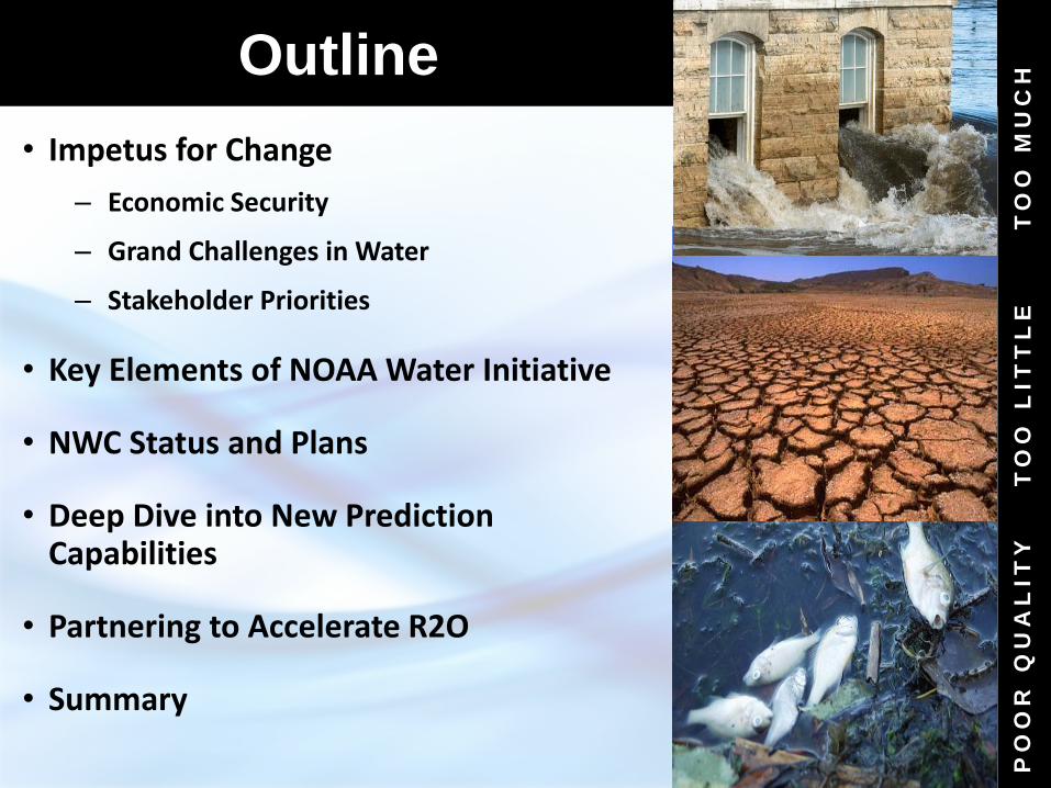
• Impetus for Change
– Economic Security
– Grand Challenges in Water
– Stakeholder Priorities
• Key Elements of NOAA Water Initiative
• NWC Status and Plans
• Deep Dive into New Prediction Capabilities
• Partnering to Accelerate R2O
• Summary
2
Outline
TO
O M
UC
H
PO
OR
Q
UA
LIT
Y
TO
O L
IT
TL
E

Impetus for Change Growing Water Challenges
3
Multiple Threats
• Population growth and economic development are stressing water supplies and increasing vulnerability
• A changing climate is impacting water availability and quality, increasing uncertainty
• An aging water infrastructure is forcing critical, expensive decisions
• Socio-economic risks of floods and droughts are escalating
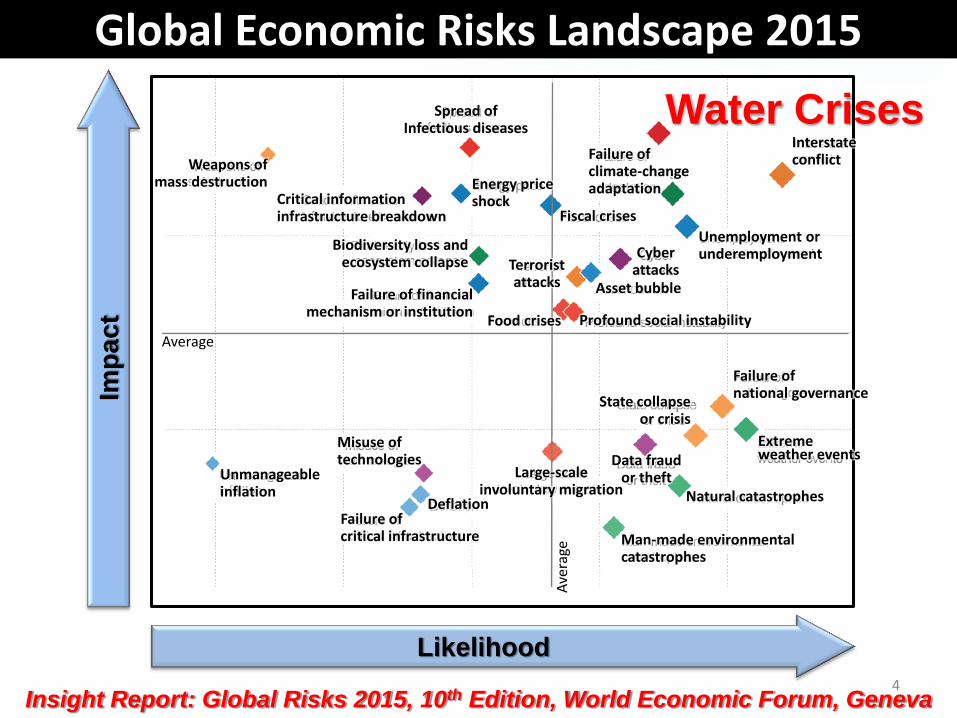
Global Economic Risks Landscape 2015
4 Insight Report: Global Risks 2015, 10th Edition, World Economic Forum, Geneva
Spread of Infectious diseases
Critical information infrastructure breakdown
Failure of climate-change adaptation
Fiscal crises
Unemployment or underemployment Cyber
attacks
Biodiversity loss and ecosystem collapse
Failure of financial mechanism or institution
Misuse of technologies
Asset bubble
Profound social instability
Unmanageable inflation
Deflation Failure of critical infrastructure
State collapse or crisis
Data fraud or theft
Natural catastrophes
Man-made environmental catastrophes
Large-scale involuntary migration
Energy price shock
Terrorist attacks
Food crises
Likelihood
Imp
ac
t
Average
Weapons of mass destruction
Ave
rage
Interstate conflict
Failure of national governance
Extreme weather events
Water Crises
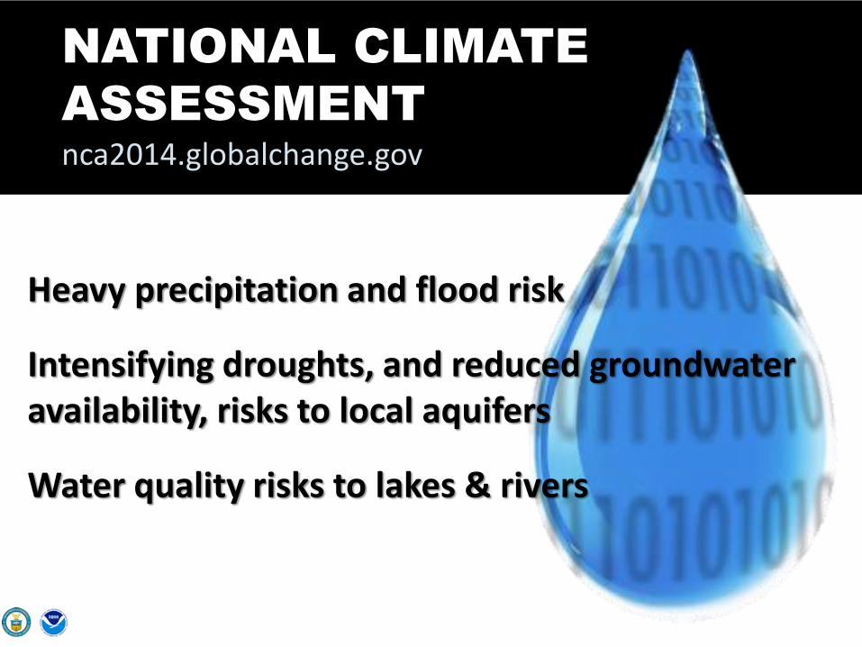
NATIONAL CLIMATE
ASSESSMENT
nca2014.globalchange.gov
Heavy precipitation and flood risk
Intensifying droughts, and reduced groundwater availability, risks to local aquifers
Water quality risks to lakes & rivers

6
WATER EXTREMES
Interrelated Grand Challenges
WATER SECURITY WATER QUALITY

November 28, 2012 May, 10, 2011
Example of Grand Challenge: Mississippi River Above Memphis, TN
25 miles

AFTER BEFORE
Hurricane Sandy
9
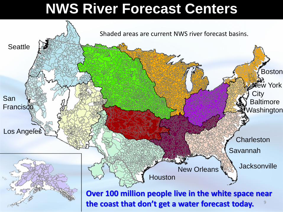
NWS River Forecast Centers
Seattle
San
Francisco
Los Angeles
Houston New Orleans Jacksonville
Savannah
Charleston
Washington Baltimore
New York
City
Boston
Over 100 million people live in the white space near the coast that don’t get a water forecast today.
Shaded areas are current NWS river forecast basins.

10
Integrated accounting for all sources of coastal flood inundation within the National Water Model
• Inland freshwater runoff, tides, storm surge and wave action
• Couple terrestrial hydrology and coastal/estuarine modeling systems within Earth System framework
NOAA’s Water Initiative Enables Total Water Predictions in the Coastal Zone
5 ft Inland
Freshwater
Runoff
(floodwave)

Stakeholder Priorities
11
Flooding Water
Quality Water
Availability Drought
Climate Variability
Need integrated understanding of near- and long-term outlook and risks
Actionable Water Intelligence High Resolution, Integrated Water Analyses, Predictions and Data
Transform information into intelligence by linking hydrologic, infrastructural, economic, demographic, environmental, and political data

NOAA WATER
INITIATIVE
INTEGRATED WATER PREDICTION
DECISION SUPPORT TOOLS SERVICE DELIVERY
USE-INSPIRED USER- ORIENTED
INTEROPERABLE AGILE & NIMBLE
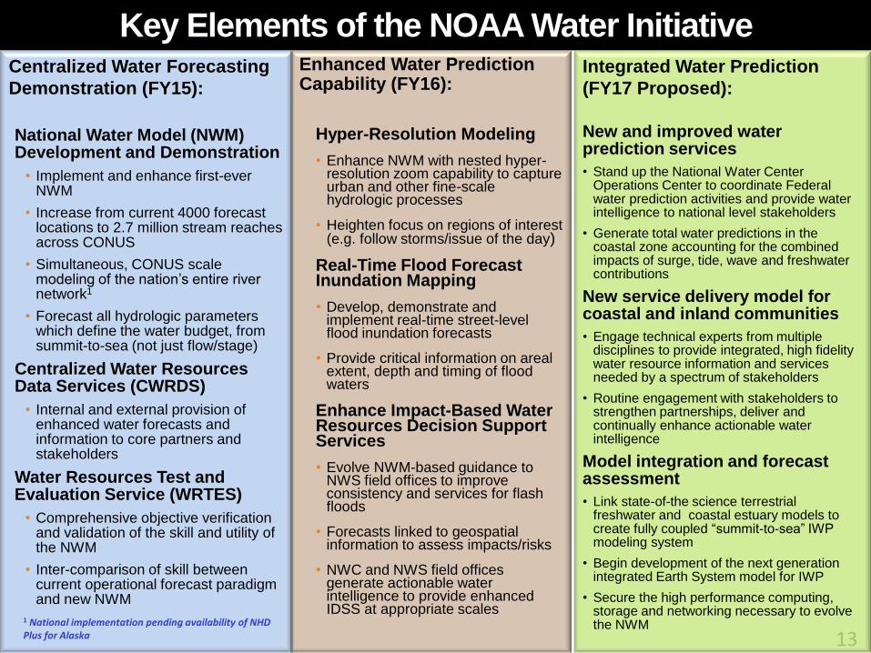
Key Elements of the NOAA Water Initiative Centralized Water Forecasting
Demonstration (FY15):
National Water Model (NWM) Development and Demonstration
• Implement and enhance first-ever NWM
• Increase from current 4000 forecast locations to 2.7 million stream reaches across CONUS
• Simultaneous, CONUS scale modeling of the nation’s entire river network1
• Forecast all hydrologic parameters which define the water budget, from summit-to-sea (not just flow/stage)
Centralized Water Resources Data Services (CWRDS)
• Internal and external provision of enhanced water forecasts and information to core partners and stakeholders
Water Resources Test and Evaluation Service (WRTES)
• Comprehensive objective verification and validation of the skill and utility of the NWM
• Inter-comparison of skill between current operational forecast paradigm and new NWM
Enhanced Water Prediction Capability (FY16):
Hyper-Resolution Modeling
• Enhance NWM with nested hyper-resolution zoom capability to capture urban and other fine-scale hydrologic processes
• Heighten focus on regions of interest (e.g. follow storms/issue of the day)
Real-Time Flood Forecast Inundation Mapping
• Develop, demonstrate and implement real-time street-level flood inundation forecasts
• Provide critical information on areal extent, depth and timing of flood waters
Enhance Impact-Based Water Resources Decision Support Services
• Evolve NWM-based guidance to NWS field offices to improve consistency and services for flash floods
• Forecasts linked to geospatial information to assess impacts/risks
• NWC and NWS field offices generate actionable water intelligence to provide enhanced IDSS at appropriate scales
13
Integrated Water Prediction
(FY17 Proposed):
New and improved water prediction services
• Stand up the National Water Center Operations Center to coordinate Federal water prediction activities and provide water intelligence to national level stakeholders
• Generate total water predictions in the coastal zone accounting for the combined impacts of surge, tide, wave and freshwater contributions
New service delivery model for coastal and inland communities
• Engage technical experts from multiple disciplines to provide integrated, high fidelity water resource information and services needed by a spectrum of stakeholders
• Routine engagement with stakeholders to strengthen partnerships, deliver and continually enhance actionable water intelligence
Model integration and forecast assessment
• Link state-of-the science terrestrial freshwater and coastal estuary models to create fully coupled “summit-to-sea” IWP modeling system
• Begin development of the next generation integrated Earth System model for IWP
• Secure the high performance computing, storage and networking necessary to evolve the NWM
1 National implementation pending availability of NHD Plus for Alaska

Outcome: Useful products that are
acted on to mitigate impacts
Service Delivery Model
Users + Continuous
Feedback
= Partnerships
What tools do you have already?
What is the challenge??
What data do you need? When?
What are your risks and vulnerabilities?
How do you use the data you have?
How does this product look? What do you need changed?
How did the pilot test go? What did the users think?
Let’s train the first group on it.
I’m glad you brought that up. How about this?
Can we share your story? We think others can learn from what we’ve done.
Who is your audience?
Service Delivery Model

National Water Center (NWC)
Initial Operating Capacity: May 26, 2015
15
A catalyst to transform NOAA’s water prediction program
Mission: Nationally Integrated
Water Prediction • Earth system modeling and geo-intelligence
for water prediction
• Operations Center for water resources common operating picture
• Decision support services for spectrum of water stakeholders
• Proving ground to accelerate research to operations
• Interagency and Academia Collaboration

Transforming NOAA Water Prediction
TODAY THE FUTURE
Approximately 4000 forecast locations at points
Approximately 2,700,000 forecast stream reaches
Forecast river flow/stage, from summit to coastal zone
Forecast all hydrologic parameters which define the water budget, from summit-to-sea
Driven by large catchment “lumped” modeling Driven by high/hyper resolution Earth System modeling
Forecaster “in the loop” – serial, basin to basin, modeling of flow through the river network
Forecaster “over the loop” – simultaneous modeling of the nation’s entire river network
Average basin size greater than 420 square miles
Average basin size ~1 square mile
13 River Forecast Centers (RFCs) developing separate versions of the same regional model
13 RFCs, NWC, academia, and federal partners developing/evolving same state-of-the-science national, community-based, model (working with NSF, CUASHI, and other Federal agencies to establish community development version of NWM)
RFC-generated river forecasts coordinated with Weather Forecast Offices (WFOs) to deliver Impact-based forecasts at selected points
National Water Model-based predictions coordinated among NWC, RFCs, and WFOs and linked with detailed local infrastructure data to communicate street level impacts
For the hydrology community, the implementation of the NWM and the leap ahead capability it provides parallels the implementation of mesoscale atmospheric models in the 1970s (i.e., model resolution
substantially greater than available observational network) 16
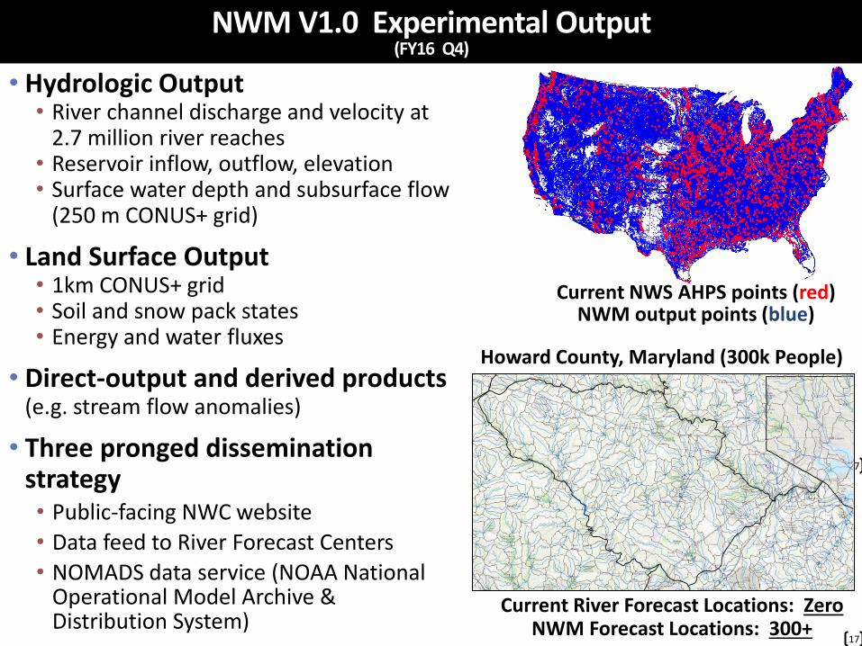
• Hydrologic Output • River channel discharge and velocity at
2.7 million river reaches • Reservoir inflow, outflow, elevation • Surface water depth and subsurface flow
(250 m CONUS+ grid)
• Land Surface Output • 1km CONUS+ grid • Soil and snow pack states • Energy and water fluxes
• Direct-output and derived products (e.g. stream flow anomalies)
• Three pronged dissemination strategy • Public-facing NWC website
• Data feed to River Forecast Centers
• NOMADS data service (NOAA National Operational Model Archive & Distribution System)
17
NWM V1.0 Experimental Output (FY16 Q4)
Current NWS AHPS points (red) NWM output points (blue)
17
17
Howard County, Maryland (300k People)
Current River Forecast Locations: Zero NWM Forecast Locations: 300+
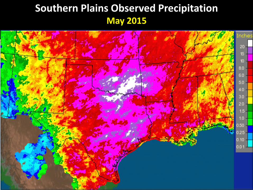
Southern Plains Observed Precipitation May 2015
18
Day 3
19
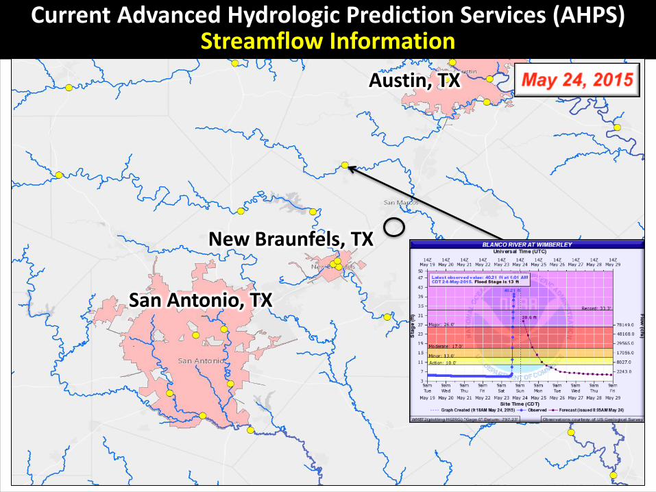
Current Advanced Hydrologic Prediction Services (AHPS) Streamflow Information
San Antonio, TX
New Braunfels, TX
Austin, TX
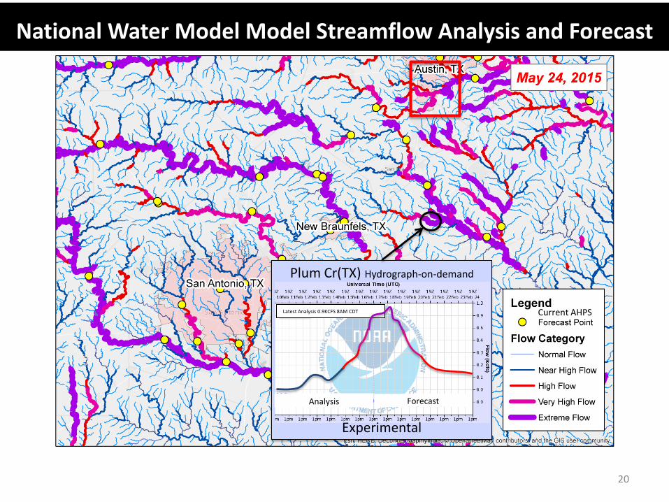
20
Experimental
Plum Cr(TX) Hydrograph-on-demand
Current AHPS
Analysis Forecast
Latest Analysis 0.9KCFS 8AM CDT
National Water Model Model Streamflow Analysis and Forecast
21
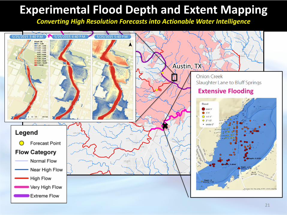
Experimental Flood Depth and Extent Mapping Converting High Resolution Forecasts into Actionable Water Intelligence
Austin, TX
Extensive Flooding

22
https://www.youtube.com/watch?v=lbA2KoYSEsg
Movie (slide show to view)
23
https://www.youtube.com/watch?v=lbA2KoYSEsg

NWC Innovators Program
24
• Partnership between NWS and the academic community (Interagency Agreement between NSF and NOAA)
• Two Thematic Goals
• Provide a framework for collaboration between the federal and academic communities that fosters innovation and creativity, and enables a pathway for that innovation to transition into operational water prediction
• Target emerging technologies such as advanced water resources modeling capabilities, cutting edge data and interoperability services, or interdisciplinary techniques aligned with NOAA and the NWC’s strategic Science and Service
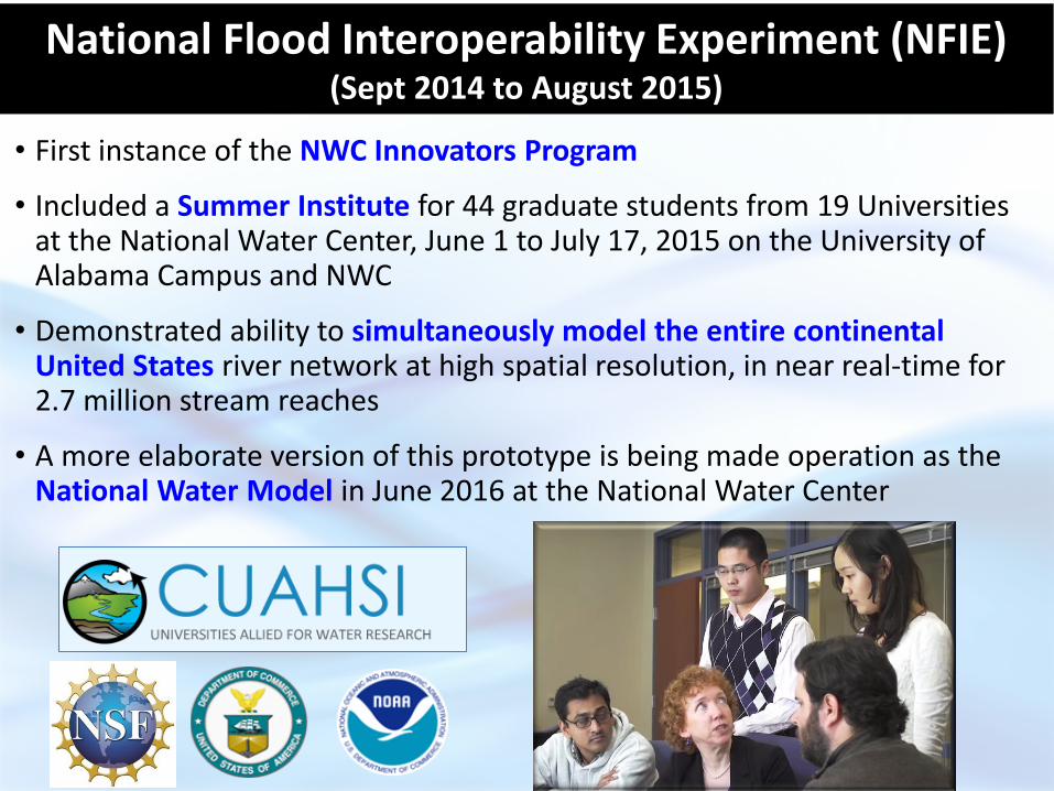
National Flood Interoperability Experiment (NFIE) (Sept 2014 to August 2015)
• First instance of the NWC Innovators Program
• Included a Summer Institute for 44 graduate students from 19 Universities at the National Water Center, June 1 to July 17, 2015 on the University of Alabama Campus and NWC
• Demonstrated ability to simultaneously model the entire continental United States river network at high spatial resolution, in near real-time for 2.7 million stream reaches
• A more elaborate version of this prototype is being made operation as the National Water Model in June 2016 at the National Water Center
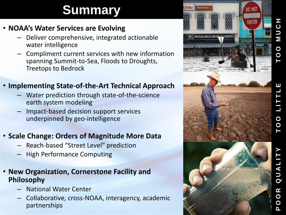
Summary
• NOAA’s Water Services are Evolving – Deliver comprehensive, integrated actionable
water intelligence – Compliment current services with new information
spanning Summit-to-Sea, Floods to Droughts, Treetops to Bedrock
• Implementing State-of-the-Art Technical Approach – Water prediction through state-of-the-science
earth system modeling – Impact-based decision support services
underpinned by geo-intelligence
• Scale Change: Orders of Magnitude More Data – Reach-based “Street Level” prediction – High Performance Computing
• New Organization, Cornerstone Facility and Philosophy
– National Water Center – Collaborative, cross-NOAA, interagency, academic
partnerships
26
TO
O M
UC
H
PO
OR
Q
UA
LIT
Y
TO
O L
IT
TL
E
www.noaa.gov
NOAA WATER
INITIATIVE
For additional information or an individual office briefing, please contact Frances Bothfeld,
Frances.Bothfeld”at”noaa.gov