noaa's coral reef conservation program report to congress ... · the crcp and its partners,...
TRANSCRIPT

I
NO
AA
CR
CP
2007 - 2009 Report to C
ongress IMPLEMENTATION
OF THE NATIONAL CORAL REEF
ACTION STRATEGY
REPORT ON NOAA CORAL REEF CONSERVATION PROGRAM ACTIVITIES FROM 2007 TO 2009
REPORT TO CONGRESS
U.S. Department of CommerceNational Oceanic and Atmospheric Administration
Produced by NOAA’s Coral Reef Conservation Program

IMPLEMENTATION
OF THE NATIONAL CORAL REEF
ACTION STRATEGY
U.S. Department of CommerceNational Oceanic and Atmospheric Administration
Produced by NOAA’s Coral Reef Conservation Program

This document was produced by the National Oceanic and Atmospheric Administration (NOAA), U.S. Department of Commerce, to fulfill requirements of the Coral Reef Conservation Act of 2000 (P.L. 106-562; 16 U.S.C. & 6401 et seq.).
Delivered to the U.S. Congress: April 2010
For information or copies, please contact NOAA’s Coral Reef Conservation Program (CRCP) at [email protected].
For more information on the CRCP, please visit: http://coralreef.noaa.gov/
http://www.coralreef.noaa.gov
About the CoverClownfish and sea anemones live together in a symbiotic relationship. The clownfish provides nutrients to the anemone, and the anemone protects the fish from predators with its stinging cells. Clownfish are a popular target of the aquarium fish trade. © 2001 PhotoDisc, Inc., Georgette Douwma
Bleached Acropora corals on the Great Barrier Reef. Mass bleaching events caused by warmer than usual ocean temperature are increasingly common due to climate change, one of the major threats to coral reefs worldwide. © Commonwealth of Australia (Great Barrier Reef Marine Park Authority)
Soft corals of the Dendrophylliidae family, on the Tokai Maru, in Apra Harbor, Guam. Coral species belonging to this family have been petitioned for listing under the U.S. Endangered Species Act, due to significant population declines. Dave Burdick
A boat fishing illegally off the coast of Navassa, a small, uninhabited U.S. island near Haiti. Fishing impacts, when ecologically unsustainable, can lead to the depletion of key groups of coral reef species. Southeast Fisheries Science Center, NOAA
Elkhorn coral in the Caribbean. Both Elkhorn and Staghorn corals have experienced very large declines in their range, and have been listed as threatened under the Endanged Species Act. Biogeography Branch, NOAA
CRCP staff participating in an outreach event, demonstrat-ing how carbon dioxide can make water more acidic. This process is known as “ocean acidification,” and is one of the threats related to climate change that coral reefs are facing worldwide. Derek Parks, NOAA
Water and sediments entering Lago Loco from the Aquaduct System in Puerto Rico. Land-based sources of pollution, including sediments and excess fertilizers, are one of the major threats for coral reefs. Tom Moore, NOAA
Napoleon Wrasse is a large fish found in coral reef habitats in the Indo-Pacific and Micronesia regions. Its slow-growth, long life span and late maturity makes this fish particularly vulnerable to over-exploitation. NOAA Coral Reef Ecosystem Division
The CRCP and its partners, such as the Southeast Florida Coral Reef Evaluation and Monitoring Project, monitor coral reefs to assess ecosystem health and help inform management actions. Dave Gilliam/National Coral Reef Initiative
Map of a NOAA experimental product on ocean acidification, showing saturation state for aragonite, October 2008. Measurements indicate an increase in waters undersaturated with one of the main buliding blocks of coral skeletal structure. Coral Reef Watch, NOAA
A nursery of Acropora corals off the Florida coast. These nurseries help corals through very vulnerable early life phases, while also working to increase the abundance and combat the effects that low populations and low genetic diversity can have on reef recovery. Tom Moore, NOAA
The Dry Tortugas Ecological Reserve, Florida, is an area where CRCP has conducted long-term monitoring. Marine Protected Areas are valuable management tools for protecting and fostering the recovery of populations, habitats and ecosystems that have been depleted by excessive exploitation. Lauren Chhay, NOAA CRCP
Traditional artisan practising his craft during the Traditional Ecological Knowledge Regional workshop. This workshop was part of CRCP’s ongoing effort to study and understand the human dimension of coral reef ecosystems, including important cultural elements. Pacific Islands Managed and Protected Area Community
Remotely Operated Vehicles are one of the many tools used to study coral reefs ecosystems. They are deployed from research vessels to study the seafloor. Depending upon the model, they can transmit live video or images and collect water or bottom samples for analysis. Paulo Maurin, NOAA
Boat grounding in reefs in the Caribbean. Accidents and careless recreational activities can negatively impact coral reef ecosystems, causing significant ecosystem damage. CRCP helps recreational users minimize their impact by improving navigational aids and proper anchoring guidance. Pedro Rodriguez, Sea Ventures

This report covers coral reef-related activities by the National Oceanic and Atmospheric Administration (NOAA) Coral Reef Conservation Program (CRCP or Program) between 2007 and 2009, and fulfills the requirement under the Coral Reef Conservation Act of 2000 of periodic reporting on the activities undertaken to advance coral reef conservation.
During the period covered by this report, the CRCP operated pursuant to thirteen program goals organized under two themes: Understanding Coral Reef Ecosystems and Reducing the Adverse Impacts of Human Activities. These thirteen goals guided most of the funding and activities undertaken by the CRCP from 2007 to 2009, and the content for this report is organized accordingly. The U.S. Coral Reef Task Force developed these themes and goals in 2000 when it produced the National Action Plan to Conserve Coral Reefs. A National Action Strategy, published in 2002, put forth a strategy to achieve the goals listed in the National Coral Reef Action Plan.
About

2
ContentsExecutive Summary 4
1. NOAA Coral Reef Conservation Program 12
CRCP Restructuring 15 A Roadmap for the Future 15 Addressing the Three Priority Threats 16
CRCP Goals 17 Climate Change Impacts 17 Fishing Impacts 18 Impacts from Land-Based Sources of Pollution 19 International Strategy 20
CRCP Grants 21 National Fish and Wildlife Foundation Grants 22
2. Cross-Goal Initiatives, Partnerships and Developments 24
Local Action Strategies 26 American Samoa 27 Commonwealth of the Northern Mariana Islands (CNMI) 28 Florida 29 Guam 32 Hawai`i 33 Puerto Rico 34 United States Virgin Islands (USVI) 36
Fishery Management Councils 37 Caribbean Fishery Management Council 38 Gulf of Mexico Fishery Management Council 38 South Atlantic Fishery Management Council 39 Western Pacific Regional Fishery Management Council 41
Deep-Sea Coral Ecosystems 42 American Recovery and Reinvestment Act of 2009 44
U.S. Virgin Islands Watershed Stabilization 44 Threatened Coral Recovery and Restoration 44 Maunalua Bay Reef Restoration 44 Laolao Bay Coastal Restoration 45 Pelekane Bay Watershed Restoration 45
Designation of Three National Marine Monuments 45 Acropora: Finalization of the 4(d) rule and Critical Habitat 46
3. Theme 1: Understanding Coral Reef Ecosystems 48
Goal 1: Map All U.S. Coral Reefs 51
Goal 2: Assess, Monitor and Forecast Coral Reef Health 53 Coral Reef Ecosystem Integrated Observing System 53 Pacific Reef Assessment and Monitoring Program 55 Comprehensive Assessment of American Samoa’s Coral Reefs 56 Mariana Archipelago Assessment for U.S. Navy and Regional Managers 57 Coral Reef Ecosystem Biodiversity Assessments 57 Report: The State of Coral Reef Ecosystems of the U.S. and the Pacific Freely Associated States 2008 58 Navassa 59 Coral Reef Information System 59 Goal 3: Conduct Strategic Research 60 NOAA-wide Coral Reef Ecosystem Research Plan 60 Coral Disease and Health Consortium 61 Atlantic Ocean Acidification Test-bed 61

3
NO
AA
CR
CP
2007 - 2009 Report to C
ongress
PAM Flourometry 62 Tools for Addressing Climate Change 63 Training for Managers 65 Report: Status of Caribbean Coral Reefs After Bleaching and Hurricanes in 2005 66
Goal 4: Understand Social and Economic Factors 67 Global Socioeconomic Monitoring Initiative 67 Report: Socioeconomic Conditions along the World’s Tropical Coasts: 2008 68 SEM-Pasifika Socioeconomic Monitoring Guidelines and Training 69 Socioeconomic Profiles of Fishing Communities 69
4. Theme 2: Reducing the Adverse Impacts of Human Activities 70
Goal 5: Improve the Use of Marine Protected Areas 73 Coral Reef Habitat Assessment for U.S. Marine Protected Areas 73 Monitoring Coral Reef Fish Utilization of Marine Protected Areas 74 Hydroacoustic Biomass Assessment of Reef Fish Spawning Aggregations 74 Support of Caribbean, Micronesian and Coral Triangle Conservation Efforts 74
Goal 6: Reduce Adverse Impacts of Fishing 76 Increasing Coral Reef Fisheries Management Capacity in the Pacific 77 Coral Reef Education for Law Enforcement Officers in U.S. Caribbean 77 Ecosystem-scale Larval Reef Fish Connectivity Studies 77 USVI Gill and Trammel Net Bans 78
Goal 7: Reduce Impacts of Coastal Uses 78 Mooring Buoys 78 Abandoned Vessel Inventory Project 78 Maritime Industry and Coastal Construction Impacts 79 Avoidance and Minimization of Ecosystem Impacts to Coral Reef MPAs: A Guide for Coastal Developers 79
Goal 8: Reduce Pollution 79 Marine Debris Removal 80 Watershed Restoration Project Evaluation in Guánica Watershed, Puerto Rico 81 NOAA/USDA Partnership to Address Land-Based Impacts to Coral Reefs 81
Goal 9: Restore Damaged Reefs 82 Caribbean Vessel Grounding Response 83 Ecological Approach to Coral Reef Restoration 83 Aquarius Coral Restoration and Resilience Experiments 84
Goal 10: Improve Outreach and Education 84 Educational Efforts 84 Coral Reef Management Fellowship 85 Coral, Literature, Education and Outreach (CLEO) program 86
Goal 11: Reduce Threats to International Coral Reefs 86 The Coral Triangle Initiative 86 International Year of the Reef (IYOR) 2008 87 International Coral Reef Symposium 87 Report: Status of Coral Reefs of the World: 2008 88 Collaborations: CRCP, Australia, and the World Bank 89 Integrated Coral Observing Network International Collaborations 89
Goal 12: Reduce Impacts from International Trade 90 Advancing the Field of Cyanide Detection 90 Corallium CITES Listing 91
Goal 13: Improve Coordination and Accountability 91
Acronyms 94References 96Appendix: Spend Plan 2007, 2008, and 2009 98
4
Executive Summary
Photo Credit: Tom Moore, NOAA

5
NO
AA
CR
CP
2007 - 2009 Report to C
ongress
Executive Summary

6Coral reefs are among the most productive and diverse ecosystems on the planet. They are found in areas of limited nutrients, yet they form the base of entire marine communities, often found nowhere else. Coral reefs also provide essential benefits to society in terms of food, jobs, recreation and coastal protection, but are impacted by human activities – primarily from global climate change, unsustainable fishing and pollution. It is estimated that a fifth of the world’s reefs have been effectively lost, with an additional fifteen percent seriously threatened with loss in the next two decades, and twenty percent under threat of loss by mid-century. The decline and loss of coral reef ecosystems has significant long-term social, cultural, economic and ecological impacts on people and communities in the United States and around the world. With effective leadership and management, however, healthy and resilient reef ecosystems can continue to provide valuable services to current and future generations. The National Oceanic and Atmospheric
Administration (NOAA) Coral Reef Conservation Program (CRCP or Program) was established in 2000 to help fulfill the agency’s responsibilities under the Coral Reef Conservation Act (CRCA) of 2000 and Presidential Executive Order 13089 on Coral Reef Protection, issued in 1998. The mission of the CRCP is to protect, conserve and restore coral reef resources by maintaining healthy ecosystem function. In strong partnership with managers of coral reef areas, the CRCP works to provide the best available science and conservation tools to reduce harm to, and restore the condition of, coral reefs, including deep-sea corals. This document is the third report on the implementation of the National Coral Reef Action Strategy submitted to Congress, as required by the CRCA. The report highlights NOAA CRCP accomplishments from 2007 to 2009, via obligations of $25.9 million in 2007, $27 million in 2008 and $29.4 million in 2009.
Executive Summary
Coral reefs are home to some of the greatest biodiversity on the planet. Photo Credit: Dave Burdick

7
NO
AA
CR
CP
2007 - 2009 Report to C
ongress
In response to an external review conducted in 2007, the CRCP released the Roadmap for the Future: 2010-2015, a statement of Program direction that focuses on understanding and addressing three key threats: impacts from climate change, fishing and land-based sources of pollution. In 2009, the Program produced national-level goals and objectives for each of these threats and, beginning in the fiscal year 2010, the CRCP is concentrating its efforts to understand and address each one. This organizational accomplishment will make the Program more effective and responsive to the overarching threats affecting coral reefs globally. At the local level, the CRCP employed mechanisms to address localized issues identified by its regional partners during the past three years.
The CRCP has supported Local Action Strategies (LAS) in seven jurisdictions containing coral reefs. Each of these LAS – in American Samoa, Commonwealth of the
Northern Mariana Islands (CNMI), Florida, Guam, Hawai`i, Puerto Rico, and U.S. Virgin Islands (USVI) – target the immediate needs of the locality. Using CRCP funding, LAS projects addressed a variety of pressing issues. For example, American Samoa studied the impacts of land-based pollution on reefs; CNMI began an ambitious watershed revegetation project, planting thousands of seedlings and stabilizing soil upstream of key reef areas; Florida is evaluating reef recovery after damaging events, such as vessel groundings; Guam assembled a coral reef response team that coordinates local multi-agency action following any large-scale event that damages reefs; Hawai`i continued and expanded removal of alien invasive algae from Oahu reefs by means of an innovative “Supersucker” mechanical suction device; Puerto Rico installed navigational aids in a bay of high ecological value; and the USVI implemented a monitoring program for lobster, a species of concern. Funding from the CRCP has allowed
The CRCP supports LAS projects in the seven U.S. State and Territory coral reef jurisdictions. Here, two divers use Supersucker Senior to remove
invasive algae as part of an LAS project in Hawai`i. Photo Credit: Sterling Kaya

8
these projects to continue, and has helped local resource managers and agencies in their efforts to protect coral reefs. The CRCP has provided $12,914,377 in coral reef management and monitoring grants to these seven jurisdictions from 2007 to 2009.
Between 2007 and 2009, the CRCP awarded more than $3 million to four regional fishery management councils – the Caribbean, Gulf of Mexico, South Atlantic, and Western Pacific Regional Fishery Management Councils – to support projects and programs to conserve and manage coral reef fisheries. Regional fishery management councils are decision-making bodies that develop and recommend specific management measures in the form of fishery management plans. These plans, like the LAS, represent key vehicles for the CRCP to respond to locally identified needs. Council projects funded by the CRCP include studies that assisted in the designation of marine protected areas (MPAs) along the South Atlantic shelf
edge; tagging programs for stock assessments of jacks, a key coral reef fishery species; studies on the role of coral reef areas as nursery grounds for target species; and monitoring of the effectiveness of closed areas.
The CRCP, as called for in the CRCA, established the Coral Reef Conservation Fund in association with the National Fish and Wildlife Foundation to fund projects building community-based, public-private partnerships that help reduce and prevent degradation of coral reefs and associated habitats. Between 2007 and 2009, the CRCP provided more than $1.9 million in competitive grants, leveraging federal funds with non-federal resources and providing in excess of $3 million for more than 35 on-the-ground coral reef conservation projects in five U.S. states and territories and more than fifteen countries.
At a larger scale, in January 2009, the President designated three areas in the Pacific as Marine
Over 500 million people worldwide are dependent upon reefs for food, coastal protection, building materials, and income from tourism.
Photo Credit: Dave Burdick
Executive Summary

9
NO
AA
CR
CP
2007 - 2009 Report to C
ongress
National Monuments, giving them a high level of environmental recognition and conservation. These three areas, the Marianas Trench, the Pacific Remote Islands and Rose Atoll Marine National Monuments, together protect 195,274 square miles (an area larger than the state of California) of marine ecosystems from destructive and extractive activities. The CRCP played a crucial role in this major conservation achievement by funding research and providing most of the data used in the designation process, including seafloor mapping and detailed ecological assessments. The information compiled by the Program supports the implementation of conservation measures to protect these unique and rich ecosystems.
Another important milestone in 2009 was the American Recovery and Reinvestment Act of 2009 (ARRA) funding of five large-scale projects related to coral reefs in the USVI, Florida, Hawai`i, and CNMI. These projects, totaling $15 million, will seek to address significant threats to these reef areas through restoration approaches.
The Program continued making headway towards achieving long-established goals during the past three years. When the CRCP was created in 2000, fewer than ten percent of all U.S. coral reefs had been mapped. In the ensuing years the Program made significant progress towards the goal of mapping all U.S. coral reefs using a variety of technological approaches, including satellite, aircraft, and ship-based surveys. Through the use of visual interpretation and spectral analysis of aerial photography and satellite imagery, the CRCP has completed 75 to 100 percent of shallow-water benthic habitat maps for Guam, American Samoa, the Commonwealth of the Northern Mariana Islands , the main Hawaiian Islands, the Republic of Palau, Puerto Rico, and the U.S. Virgin Islands . The Program has
To date, the CRCP has completed shallow-water bathymetric
maps, like this map of the island of Guam, for several of the
U.S. reef jurisdictions. These maps are used for a variety of
assessments and management activities. Photo Credit: NOAA
Coral Reef Ecosystem Division
completed 75 to 100 percent of shallow-water bathymetric maps for Puerto Rico, Navassa, the main Hawaiian Islands, and Guam. To date, more than 3,550 square miles (9,200 km2) of U.S. coral reefs have been mapped.
Using the information gained through CRCP mapping activities, the Program conducts extensive biological and oceanographic assessments of U.S. coral reef ecosystems. In 2008, the Program published the third edition of The State of Coral Reef Ecosystems of the United States and Pacific Freely Associated States, which compiles results from ongoing ecosystem monitoring activities. These comprehensive, periodic monitoring reports offer a detailed and comparable summary of the overall status of coral

10
reefs in the U.S. and provide managers with useful regular updates. In 2008, the Program released the Coral Reef Ecosystem Monitoring Report for American Samoa: 2002-2006, the most comprehensive interdisciplinary coral reef ecosystem assessment of American Samoa ever conducted. It reflects extensive analyses of the integrated ecosystem observations made during three American Samoa Reef Assessment and Monitoring Program research cruises conducted by NOAA scientists and their local partners.
The CRCP has also been leading NOAA’s efforts to assess the human dimension of coral reef resources during 2007 to 2009, studying and understanding social and economic factors associated with coral reef use, their impacts on the marine ecosystem, and the human value associated with coral reefs. In 2008, the CRCP published socioeconomic monitoring guidelines for managers of coastal natural resources in the Pacific Region. These guidelines contain a prioritized list of socioeconomic parameters useful for coastal managers and simplified methods for data collection, archiving and analysis, as well as case studies.
CRCP efforts to reduce impacts from fishing range from research on basic biology and habitat use of reef fish species, support for education and enforcement, and a variety of capacity-building activities to assist in the implementation of marine protected areas and other fishery regulations. In addition, the CRCP helps managers make informed decisions through active monitoring of MPA effectiveness.
The CRCP serves as the Secretariat of the U.S. Coral Reef Task Force and coordinates work with other Task Force members to achieve both scope and depth in researching intricate issues affecting coral reef ecosystems. These partnerships are particularly active in projects
addressing land-based sources of pollution. In the Caribbean, the CRCP has been part of comprehensive multi-agency watershed restoration efforts addressing the impacts of land-based sources of pollution on adjacent reef areas. The CRCP partnered with the U.S. Department of Agriculture to launch a comprehensive evaluation effort of sediment contaminants within the Jobos Bay National Estuarine Research Reserve in Puerto Rico. In conjunction with this effort, the CRCP is partnering on a three-year restoration project in Guánica Bay, aimed at reducing effects of sedimentation and nutrients on southwestern Puerto Rico reefs through the development of a comprehensive restoration plan.
While attentive to long-recognized threats from unsustainable fishing and pollution, the Program has also been responsive to the growing threat to coral reefs worldwide posed by ocean acidification and coral bleaching, both linked to climate change. The ocean’s absorption of carbon dioxide diminishes the availability of the basic building materials used by corals and other invertebrate organisms to grow skeletons. CRCP funding has helped establish a test station in the Atlantic, which provides detailed studies of the changing ocean chemistry and how it affects marine life. In addition, the Program’s funding of Coral Reef Watch has made possible widespread dissemination of alerts for bleaching events, another growing threat to coral reefs, as elevated ocean temperatures can lead to corals losing their symbiotic zooxanthellae (photosynthesizing algae living within their tissues), potentially killing entire colonies. Coral Reef Watch is now able to produce seasonal outlooks for possible regional bleaching events, giving more lead time to managers to respond.
To be truly effective, efforts to conserve coral reefs must be directed beyond the borders of
Executive Summary

11
NO
AA
CR
CP
2007 - 2009 Report to C
ongress
a single country. Most coral reef ecosystems in U.S. waters are interconnected with, depend on, and affect coral reefs in other countries: ocean currents carry essential larvae and juvenile corals, fish, and other invertebrates that replenish reefs. Thus, strategies for supporting healthy coral reef ecosystems in the United States must also consider protecting coral reefs beyond U.S. waters. The CRCP is strengthening its international presence by becoming more actively involved in coral conservation efforts, primarily in the Southwest Pacific (with a focus on Samoa), Micronesia, the Coral Triangle region, and the wider Caribbean, reflected in the recently developed CRCP International Strategy. The Program led international projects and initiatives, coordinating the 2008 International Year of the Reef, and sponsoring the International Coral Reef Symposium in 2008. The CRCP has partnered with several international entities, including the World Bank and Australian institutions, to conduct ongoing coral reef monitoring and to train managers of
coral reef areas worldwide, thereby building human, technical and institutional capacity to conserve reef ecosystems and associated environments, and addressing the effects of global climate change.
NOAA has the responsibility and expertise to help conserve coral reef ecosystems for future generations. To this end, the CRCP continues to work with its partners to conduct coral reef-related monitoring, research, and education, and support essential management and stewardship activities aimed at improving coral reef ecosystem conditions.
The CRCP funds projects to address coral bleaching, one of the effects of global climate change. Bleached corals lose their symbiotic algae, and
thus their color and primary energy source, due to extreme water temperatures. Photo Credit: © Commonwealth of Australia (GBRMPA)
12
Photo Credit: Dave Burdick

13
NO
AA
CR
CP
2007 - 2009 Report to C
ongress
1.NOAA Coral Reef Conservation Program

14
NOAA’s Coral Reef Conservation Program (CRCP or Program) was established in 2000 to help fulfill NOAA’s responsibilities under the Coral Reef Conservation Act of 2000 (CRCA) and Presidential Executive Order 13089 on Coral Reef Protection. The mission of the CRCP is to protect, conserve and restore coral reef resources by maintaining healthy ecosystem function. The CRCP addresses strategic coral reef management needs in a targeted, cost-effective, and efficient manner.
The CRCP is an overarching program between NOAA line offices working on coral reef issues, including the National Ocean Service, the National Marine Fisheries Service, the Office of Oceanic and Atmospheric Research, and the National Environmental Satellite, Data and Information Service. In strong partnership with managers of coral reef areas, the CRCP works to provide the best available science
and conservation tools to reduce harm to, and restore the condition of, coral reefs, including deep-sea corals.
The CRCP funds and conducts conservation activities for the benefit of the Nation’s coral reefs. Areas of focus include the seven primary jurisdictions containing coral reefs: American Samoa, the Commonwealth of the Northern Mariana Islands (CNMI), Florida, Guam, Hawai`i, Puerto Rico, and the U.S. Virgin Islands (USVI). The Program also conducts activities in the northern Gulf of Mexico, Navassa Island, and the Pacific Remote Island Areas (PRIA). The Program further funds conservation activities internationally, including in the Coral Triangle, Micronesia, and the wider Caribbean regions, among others. The Program also works to protect and conserve deep-sea coral ecosystems found off the east and west coasts of the United States.
NOAA Coral Reef Conservation Program
Coral reefs are among the most productive and diverse ecosystems on the planet. They are found in areas of limited nutrients, yet they form the base of entire marine communities, often found nowhere else. Coral reefs also provide essential benefits to society in terms of food, jobs, recreation and coastal protection, and are impacted by human activities – primarily from global climate change, unsustainable fishing, and pollution. It is estimated that a fifth of the world’s reefs have already been effectively lost, with an additional fifteen percent seriously threatened with loss in the next two decades, and twenty percent are under threat of loss by mid-century.1 The decline and loss of coral reef ecosystems have significant and long-term social, cultural, economic, and ecological impacts on people and communities in the United States, and around the world. With effective leadership and management, however, healthy and resilient reef ecosystems can continue to provide valuable services to current and future generations.
1 Wilkinson, 2008.

15
NO
AA
CR
CP
2007 - 2009 Report to C
ongress
The CRCP serves as the Secretariat for the U.S. Coral Reef Task Force (USCRTF), which includes leaders of twelve federal agencies, seven U.S. states and territories, and the freely associated states of Palau, the Republic of the Marshall Islands, and the Federated States of Micronesia.
CRCP RESTRUCTURING
A panel of distinguished experts came together in 2007 to conduct an external review of the CRCP effectiveness over a five-year period (fiscal years 2002-2006) and give recommendations for the future direction of the Program. The CRCP provided the panel with a comprehensive self-assessment of activities, outputs, impacts, and challenges during the evaluation period. The panel met with the CRCP staff and received input from a variety of Program stakeholders. The panel issued its final
report2 at the end of 2007, in which it provided its findings and recommendations to the CRCP.
A Roadmap for the FutureIn response to the panel’s recommendations, in 2008 the CRCP released its Roadmap for the Future, setting the Program’s direction from 2010 through 2015. The document, which received extensive input from both NOAA and external partners, lays out a narrower suite of the Program’s principles and priorities, along with a process for implementing the proposed changes. The Program is focusing its efforts on addressing coral reef management needs, and targets its work to understand and address three key threats: impacts from climate change, fishing, and land-based sources of pollution. Through the new principles and priorities, the CRCP places greater emphasis on management-relevant science and developing coral conservation tools, and products that are user-friendly. The Program
In September 2007, the CRCP held an External Program Review during which a panel of reef experts met with CRCP staff and stakeholders.
Photo Credit: Lauren Chhay, NOAA CRCP
2 Report available at: http://coralreef.noaa.gov/aboutcrcp/strategy/reprioritization/exreview/resources/summary_report.pdf

16
is further strengthening its partnerships and leveraging resources with coral reef managers at the federal, state, territorial, and local level.
Addressing the Three Priority Threats To make the most effective use of resources and to have the largest impact to reverse general declines in coral reef health, the CRCP narrowed the focus of its U.S. domestic program, and shifted allocation of CRCP resources to take on-the-ground and in-the-water action. The CRCP is also strengthening its international presence by becoming more actively involved in coral conservation efforts, primarily in the Southwest Pacific (with a focus on Samoa), Micronesia, the Coral Triangle region, and the Wider Caribbean. Beginning in the fiscal year 2010, the CRCP is concentrating its efforts to understand and address the top three recognized global threats to coral reef ecosystems: impacts from climate change, fishing, and from land-based sources of pollution.
Climate change threatens all coral reef ecosystems around the globe through increased mass coral bleaching and disease, sea level rise, and increased storm activity. In addition, increasing atmospheric carbon dioxide is already reducing calcification rates in some reef-building and reef-associated organisms by altering sea water chemistry including decreasing pH (a process referred as “ocean acidification”). In the long term, failure to address the impacts of rising temperatures and ocean acidification could limit the effectiveness of other management efforts.
Fishing in coral reef areas, when ecologically unsustainable, can lead to the depletion of key functional groups of reef species, with cascading impacts on coral reef habitats and
associated species and ecosystems. Some fishing practices physically damage coral reefs and associated habitats.
Impacts from land-based sources of pollution (such as agriculture, coastal development, road construction, and oil and chemical spills) on coral reef ecosystems include increased sedimentation, eutrophication (nutrient loading that can lead to algal blooms which reduce oxygen in the water), toxins, and pathogen introduction. These pollutants and related synergistic effects can cause disease and mortality in sensitive species, disrupt critical ecological functions, change the foodweb and impede growth, reproduction, and larval settlement of corals.
In 2009, the CRCP engaged a community of experts to help identify the twenty-year strategic goals and five-year objectives that will guide CRCP work to effectively address each of these top three threats to coral reef ecosystems. The Goals and Objectives developed by these groups were published in
NOAA Coral Reef Conservation Program

17
NO
AA
CR
CP
2007 - 2009 Report to C
ongress
July 2009 in two documents: Goals and Objectives for the U.S. domestic program3 and the CRCP International Strategy.4
CRCP GOALS
Effective management should not take a one-size-fits-all approach, but be based on the needs of the varying ecosystems and communities. The CRCP, therefore, is working in partnership with the coral reef managers in each jurisdiction to develop specific management priorities. These management priority documents will be a critical part of the CRCP decision-making. The Program is committed to adopting performance and efficiency measures to improve program effectiveness and better evaluate overall CRCP performance, placing greater emphasis on outcomes that influence ecosystem health rather than outputs such as products and reports. The following discussion summarizes the twenty-year goals to address each of the three threats.
Climate Change Impacts Climate change has been identified by many groups as the most important threat to coral reefs on a global scale. In 2007, the Intergovernmental Panel on Climate Change noted that the evidence is now “unequivocal” that the earth’s atmosphere and oceans are warming and concluded that these changes are primarily due to anthropogenic greenhouse gases, especially the accelerating increase in emissions of carbon dioxide (CO2). Global ocean temperature has risen by 0.74°C/1.3°F since the late 19th century,
most likely exacerbating and causing more frequent and severe bleaching of corals around the world.5 At the same time, the ocean absorbs approximately one-third of the additional CO2 generated every year by human activities, making the ocean more acidic.6 The resulting change to ocean chemistry has important consequences for corals and other marine life, especially those that incorporate calcium carbonate into body structures. These changes have already had deleterious impacts on coral reef ecosystems and will continue to affect coral reef ecosystems globally over the coming century.
Warming seas and an acidifying ocean are already affecting reefs by causing mass coral bleaching events and slowing the growth of coral skeletons.7 Bleaching and infectious disease outbreaks are likely to be more frequent and severe as temperatures rise, increasing coral mortality. Climate change will have other impacts on marine systems such as sea level rise; altered frequency, intensity, and
Bleached Acropora corals on the Great Barrier Reef. Mass bleaching
events caused by warmer than usual ocean temperatures are
increasingly common due to climate change, one of the major
threats to coral reefs worldwide. Photo Credit: © Commonwealth of
Australia (GBRMPA)
3 Document available at http://coralreef.noaa.gov/aboutcrcp/strategy/currentgoals/resources/3threats_go.pdf
4 Document available at http://coralreef.noaa.gov/aboutcrcp/strategy/currentgoals/resources/intl_strategy.pdf
5 Hoegh-Guldberg et al., 2007.
6 Caldeira and Wickett, 2003; Sabine et al., 2004.
7 Hoegh-Guldberg et al., 2007; De’ath et al., 2009.

18
distribution of tropical storms; altered ocean circulation affecting larval connectivity and productivity, and others. All of these impacts will combine, often synergistically, to threaten important ecosystem function and reduce global biodiversity. To address the problems of climate change and ocean acidification, these four goals have been identified to help coral reefs:
Climate Change Impacts Goal 1
Increase coral reef resilience to climate change and ocean acidification through effective management strategies.
Climate Change Impacts Goal 2
Identify, understand, and communicate risks and vulnerability of U.S. coral reef ecosystems, ecosystem services, and dependent human communities to climate change and ocean acidification.
Climate Change Impacts Goal 3
Enhance strategic management of coral reef ecosystems through improved and applied
understanding, forecasts, and projections of climate change and ocean acidification impacts.
Climate Change Impacts Goal 4
Support management efforts to increase survivorship of coral reef species and enhance reef resilience by evaluating and implementing promising intervention strategies that directly reduce climate change and ocean acidification impacts.
Fishing Impacts Coral reefs and associated habitats provide important commercial, recreational, and subsistence fishery resources in the United States. Coral reef fisheries, though often relatively small in scale, can have disproportionately large impacts on the ecosystem if conducted unsustainably. Rapid human population growth, demand for fishery resources, use of increasingly sophisticated fishery technologies, and inadequate management and enforcement have led to the depletion of key reef species and habitat damage in many locations. Specific impacts of fishing on reefs generally include one or more of the following: 1) direct overexploitation of fish, invertebrates, and algae
The Napoleon wrasse, also known as the Humphead wrasse, is a rare sight in the U.S. Pacific, except at Wake Atoll. It is listed as a species of
concern by NOAA Fisheries. Photo Credit: NOAA PIFSC CRED
NOAA Coral Reef Conservation Program

19
NO
AA
CR
CP
2007 - 2009 Report to C
ongress
for food and the aquarium trade; 2) removal of a species or group of species impacting multiple trophic levels; 3) by-catch and mortality of non-target species; and 4) physical impacts to reef environments associated with fishing techniques, fishing gear, and anchoring of fishing vessels.8 These threats are exacerbated when coupled with other coral reef stressors such as climate change and land-based sources of pollution. CRCP has developed these four goals to address impacts of fishing on coral reefs:
Fishing Impacts Goal 1
Increase the abundance and average size of key coral reef fishery species to protect trophic structure and biodiversity and improve coral reef ecosystem condition.
Fishing Impacts Goal 2
Support effective implementation and management of marine protected areas (MPAs) and ecological networks of MPAs that protect key coral reef ecosystem components and functions.
Fishing Impacts Goal 3
Increase stakeholder engagement and capacity to improve local compliance with and enforcement of fisheries management regulations that further coral reef ecosystem conservation.
Fishing Impacts Goal 4
Utilize locally relevant education and communication strategies to increase public and policy maker understanding of fishing impacts in coral reef ecosystems, and support for effective management options.
A sediment plume enters the ocean from a river mouth on the coast
of Puerto Rico. Suspended sediment can cover and smother reefs
and introduce pollutants, nutrients, and pathogens to these fragile
ecosystems. Photo Credit: Tom Moore, NOAA
Impacts from Land-Based Sources of Pollution It is now well accepted that many major coral reef ecosystem stressors originate from land-based sources, most notably, toxicants, sediments, and nutrients. There are numerous locations where coral reef ecosystems are highly impacted by watershed alteration, run-off, and coastal development within the United States.9 The importance of identifying the extent of and reducing these effects has now become crucial, as land-based pollution and coastal development put 22 percent and 30 percent, respectively, of coral reefs on Earth at risk.10 The 2004 Report of the U.S. Commission on Ocean Policy highlighted the need for “an ecosystem and watershed-based management” approach to ocean pollution, and identified both “the astounding decline of coral reef ecosystems” and “an urgent need to address the identified, major factors causing coral declines.”11
8 Waddell, 2005.
9 Bellwood et al., 2004; Pandolfi et al., 2003; Richmond et al., 2007.
10 Bryant et al., 1998.
11 Commission on Ocean Policy, 2004.

20
The suite of problems facing coral reef ecosystems from land-based sources of pollution is broad and includes sediment, nutrients, and other pollutants from a variety of activities that are transported in surface waters, runoff, groundwater seepage, and atmospheric deposition into coastal waters. Sedimentation, including higher levels of suspended sediment in overlying waters, is commonly acknowledged to be one of the primary causes of coral reef ecosystem degradation.12 The combination of suspended, re-suspended, and deposited sediment act to limit coral growth, feeding patterns, photosynthesis, recruitment, and survivorship, as shown by numerous studies in a variety of settings.13 Many Local Action Strategy groups of the U.S. Coral Reef Task Force (USCRTF) have identified land-based pollution to reefs as a major area of concern. The three primary goals of the CRCP’s plan to address land-based sources of pollution are:
Impacts from Land-Based Sources of Pollution Goal 1
Reduce pollutant loading from watersheds to priority coral reef ecosystems.
Impacts from Land-Based Sources of Pollution Goal 2
Promote in-water management activities to restore priority coral reef ecosystems that have been adversely impacted by accumulated sediments, nutrients, and algae.
Impacts from Land-Based Sources of Pollution Goal 3
Build and sustain management capacity at the local level through local, state, regional, and federal coordination of financial, institutional, and human resources to reduce and prevent the
impacts from land-based sources of pollution on coral reef ecosystems.
International StrategyCoral reef ecosystems have great economic, social, and cultural importance to communities, businesses and nations around the world. These ecosystems provide a wide range of valuable ecological services, constituting a major food source, economic base, and future hope for sustainable development in many countries, particularly small island nations. Given these important roles of coral reefs across the globe, U.S. efforts to promote healthy coral reefs internationally are critical to U.S. diplomatic and development strategies to ensure economic and food security, social stability, democratic governance, improved human health, disaster and climate change mitigation, and biodiversity conservation in many countries.
The International Strategy is designed to bring more focus to the CRCP’s international activities on topics and regions where the Program can have the greatest impact by
12 See, for example, Rogers, 1990; Field et al., 2008.
13 Fabricius, 2005.
NOAA Coral Reef Conservation Program

21
NO
AA
CR
CP
2007 - 2009 Report to C
ongress
building on NOAA’s strengths, forming partnerships and leveraging resources and expertise. The International Strategy’s major focus will be to support activities in four priority regions based on their interconnectedness with U.S. reef ecosystems and existing initiatives and partnerships: the Caribbean, Micronesia, Southwest Pacific (with a focus on Samoa), and the Coral Triangle. The priority goal is marine protected area capacity building.
International Goal 1
Work with regional initiatives to build MPA networks and strengthen local management capacity to improve and maintain resilience of coral reef ecosystems and the human communities that depend on them;
International Goal 2
Develop and implement tools and practices to more effectively observe, predict, communicate, and manage climate change impacts in priority international locations.
International Goal 3
Strengthen local and national capacity and policy frameworks to reduce impacts of fishing on coral reef ecosystems.
International Goal 4
Strengthen policy frameworks and institutional capacities to reduce impacts to coral reef ecosystems from pollution due to land-based activities.
The CRCP recognizes that the United States is only one center for coral reef research and conservation. The Program is committed to learning from the efforts of other entities, including regional initiatives, national governments, NGOs, and scientific organizations to further its domestic mission to protect U.S. coral reefs. The CRCP will
continue to engage in international collaborative research to improve science and management for coral reefs around the world.
CRCP GRANTS
The CRCP created the Coral Reef Conservation Grants Program to provide opportunities for non-NOAA entities to support coral reef conservation. Through its grants program, the CRCP has issued more than $33 million in federal funds (with a one-to-one non-federal match) since its inception to a broad array of applicants to help meet the objectives of the CRCA. Each year the NOAA CRCP publishes its Coral Reef Conservation Grant Program Funding Guidance, as authorized by Section 204 of the CRCA, to solicit proposals for coral reef conservation activities. Funds are awarded under the following six categories: •StateandTerritoryCoralReefManagement(Applicants:StateandTerritoryManagementAgencies);•StateandTerritoryCoralReefEcosystemMonitoring(Applicants:StateandTerritoryManagementAgencies);•CoralReefEcosystemResearch(Applicants:Academia,NGOs,andstate,territoryandlocalgovernments);•ProjectstoImproveorAmendCoralReefFisheryManagementPlans(Applicants:Caribbean,GulfofMexico,SouthAtlanticandWesternPacificFisheryManagementCouncils);•GeneralCoralReefConservation(Applicants:Academia,NGOs,LocalandTribalgovernments,communityorganizations,etc.);and•InternationalCoralReefConservation(Applicants:Internationalgovernments,NGOs)

22
These awards represent a third of the CRCP budget and reflect NOAA’s strong support for cooperative partnerships and conservation efforts outside the agency. Funds supported a range of activities, from community conservation projects to large-scale coral reef observation systems, and included support for three congressionally-directed coral reef research institutes Hawai`i Coral Reef Initiative (Hawai`i), National Coral Reef Institute (Florida), and Caribbean Coral Reef Institute (Puerto Rico).
National Fish and Wildlife Foundation Grants
Between 2007 and 2009, the CRCP provided more than $1.9 million in competitive grants through the Coral Reef Conservation Fund, a partnership with the National Fish and Wildlife Foundation (NFWF) to fund projects that build community-based, public-private partnerships to reduce and prevent degradation of coral
reefs and associated habitats. NFWF was established by Congress in 1984 to direct public conservation dollars to pressing environmental needs, matching those investments with private funds. The NFWF Coral Reef Conservation Fund emphasizes projects that involve multiple stakeholders and target a specific audience or address specific threats using a hands-on measurable approach.
From 2007 to 2009, the Coral Reef Conservation Fund leveraged federal funds with non-federal resources, providing in excess of $3 million for more than 35 on-the-ground coral reef conservation projects in five U.S. states and territories and more than fifteen countries. Most projects addressed one or more of the following threats to coral reefs: over-exploitation of coral reef resources; land-based pollution and sedimentation; and recreational uses, including sea cruise tourism, diving and boating. Recent CRCP coral grants awarded by NFWF include:
Mooring buoys, like these ones in Broward County, Florida, help protect reefs from anchor damage. Photo Credits: Broward County
Environmental Protection Department
NOAA Coral Reef Conservation Program

23
NO
AA
CR
CP
2007 - 2009 Report to C
ongress
Anchors Away! Mooring Buoy Projects (Florida state agencies and the Nature Conservancy, $137,000). Boat anchors dropped multiple times at individual sites can produce significant and cumulative impacts on coral reefs. Mooring buoys help diminish these impacts and encourage a reliable system for dive operators to secure their vessels. The AnchorsAway! Program has supported the installation and maintenance of mooring buoys to protect coral reefs from anchor damage and identify MPA boundaries. Between 2007 and 2009, NFWF awarded three AnchorsAway!grants to install mooring buoys in Florida, the U.S. Virgin Islands and Grenada.
Cleaning Waikoko Stream Discharge to Hanalei Coral Reefs (University of Hawai`i, $73,000). The University of Hawai`i is applying Best Management Practices to taro farms near the Waikoko stream to reduce nutrient and sediment runoff and improve coral health and larval recruitment on adjacent reefs.
Nassau grouper, listed as Endangered by the IUCN, were historically targeted by fishing and have subsequently had fishing restrictions put in
place in portions of their range, including at known spawning sites. Illegal and undocumented fishing may account for their continued decline.
Photo Credit: © Florent Charpin
Pride Campaigns for Coral Conservation in Yap and Chuuk (Rare, $100,000). Rare, an environmental social marketing group, is training two Micronesian conservation organizations to conduct Pride conservation outreach campaigns in Yap and Chuuk to raise local awareness and build constituencies around coral conservation in the region.
Shared Stewardship of Cozumel’s Natural Heritage (Conservation International, $58,000). Conservation International is working with local government, shore operators, and cruise vessel operators to alleviate cruise ship visitor impacts to local coral reefs in Cozumel, Mexico.
Bahamian Nassau Grouper Research and Public Education (Reef Environment Educational Foundation, $40,000). This project is working to promote local community and tourist awareness of the endangered status of Nassau grouper, including seasonal closures to protect spawning aggregations in Bahamian waters.
24
Photo Credit: Dave Burdick

25
NO
AA
CR
CP
2007 - 2009 Report to C
ongress
2.Cross-Goal Initiatives, Partnerships and Developments

26
LOCAL ACTION STRATEGIES
Local Action Strategies are a USCRTF-led initiative to identify and implement priority actions needed to reduce key threats to valuable coral reef resources in the seven primary U.S. coral reef jurisdictions. In 2002, the USCRTF adopted the “Puerto Rico Resolution” which calls for the development of three-year LAS by each of the seven USCRTF jurisdictions: American Samoa, CNMI, Florida, Guam, Hawai`i, Puerto Rico, and USVI. These LAS are locally-driven plans for collaborative and cooperative action among federal, state, territory, and non-governmental partners.
The goals and objectives of the LAS are linked to those found in the U.S. National Action Plan to Conserve Coral Reefs (2000). From the thirteen goals identified in this National Action Plan, the Task Force prioritized six areas for immediate local action: overfishing;
land-based sources of pollution; recreational overuse and misuse; lack of public awareness; climate change and coral bleaching; and disease. Applying a collaborative decision-making process based on local needs, concerns and capacities, each of the seven USCRTF jurisdictions developed LAS that contain a variety of projects designed for implementation over a three-year period.
NOAA and the USCRTF are currently working with each jurisdiction to complete implementation of their first round of LAS. Several jurisdictions are now completing the core elements of their initial LAS and are examining how best to revise their LAS to more effectively achieve coral reef management objectives in the future.
The CRCP funded more than $4 million dollars to directly advance LAS projects. Below is a brief description of sample LAS projects
The National Coral Reef Action Strategy (2002) calls for close coordination with state and territory management agencies and Fishery Management Councils to improve management plans for, and conservation of, coral reef areas. The CRCP achieves this goal by funding Local Action Strategies (LAS) and Council projects that are related to coral reefs. In addition, the Program played a key role in two initiatives with major ramifications for environmental protection: the designation of large marine areas in the Pacific as monuments, and continuing the process to recover Caribbean Acropora species under the Endangered Species Act (ESA). Without NOAA CRCP support, funding and involvement, many of these important projects and developments would not have taken place. Another important event for coral reef conservation is the 2009 American Recovery and Reinvestment Act, which funded five restoration projects in U.S. coral reef areas. These large-scale program initiatives and partnerships address several goals at once, and are captured in this section.
Cross-Goal Initiatives, Partnerships and Developments

27
NO
AA
CR
CP
2007 - 2009 Report to C
ongress
completed between 2007 and 2009 by each jurisdiction with these funds.
American SamoaAmerican Samoa, located some 2,600 miles southwest of Hawai`i, is a group of five volcanic islands and two coral atolls that total 76 square miles (197 km2), inhabited by approximately 69,000 people and encompassing an estimated 114 square miles (296 km2) of coral reefs. American Samoa coordinates all of its coral reef management activities through the Governor’s Coral Reef Advisory Group (CRAG). CRAG actively works with other agency staff, community organizations, government agencies, universities, and NGOs, which together collaborate to plan and implement actions to manage American Samoa’s reefs. These interagency management efforts were more clearly defined via the development and implementation of Local Action Strategies. CRAG has identified four primary threats to American Samoa’s coral reefs: global climate
change, land-based sources of pollution, fisheries management, and population pressure. The LAS for each of these threats remain living documents and include steps to address the problems and a timeline for the implementation of targeted, collaborative projects.
Impacts of Land-based Pollution on American Samoa’s Coral Reefs
There is a strong and definitive ecological link between watersheds and coral reef communities. This project identified impaired watersheds and ecological measures that can be incorporated into local water quality standards. These outputs provided direct benefits for existing pollution control programs within the territory. The GIS products provide for simple translations to communities, government officials, and resource managers working to enhance the integrity of American Samoa’s coral reefs.
A fish Rapid Ecological Assessment team conducts a belt transect survey at Ofu, American Samoa during a 2008 research mission. NOAA
scientists, local agencies in American Samoa, and other partners collaborated on this monitoring mission. Photo Credit: Robert Schroeder,
NOAA PIFSC CRED

28
Coral Reef Ecosystem Survey
This survey examined seafloor cover, coral communities, coral diversity, and large invertebrates, with biological measures within each group (such as coral diversity per unit area, total coral diversity, coral community evenness, and a benthic substrate ratio), and correlation between watershed volume, human population density, and the biological measures. The measures were used as biological indicators to assess the effects of non-point source pollution on water quality.
Population Pressure Technical Assistance
Population pressure, mainly from immigration from nearby islands into American Samoa, has been recognized as the root cause of many threats to American Samoa’s coral reefs – including increased fishing activities, coastal development, and agricultural runoff. American Samoa’s local government is using funds to obtain technical assistance on population issues and policy to revise its Population Pressure LAS and develop a Population Pressure Campaign Plan.
Commonwealth of the Northern Mariana Islands CNMI is a chain of 14 tropical islands in the Western Pacific totaling fewer than 185 square miles (479 km2), but stretching more than 375 miles north to south. Only three of the islands— Saipan, Rota, and Tinian—have sizable human populations. All the islands have coral reefs, with those off the southern populated islands being the oldest and most well developed.
Increased population and development over the past decade in the three southern islands has exacerbated the threats to the coral reef ecosystems and has led to the destruction and reduced health of coral reefs and coral reef-
associated habitats. These effects are most noticeable on Saipan, where approximately 90 percent of CNMI’s population resides, and where most coral reef management efforts have focused. From a long-term perspective, the decline in coral reef coverage and marine health threatens CNMI’s cultural heritage, traditional ways of life, and physical protection from storms. This decline, however, also immediately affects CNMI’s tourism and fisheries industries, and thus its economy. To address immediate key threats to CNMI’s coral reef ecosystems, the coral reef committee in collaboration with multiple stakeholders, developed a three-year Coral Reef Protection LAS. The LAS provides a road map of projects focused on four areas: land-based sources of pollution; public awareness and involvement; recreational use; and fisheries management.
Talakhaya Watershed Revegetation Project
The Talakhaya Watershed Revegetation Project aims to reduce the nonpoint source pollution running off steep slopes of the Talakhaya Watershed into the adjacent coral reef ecosystem. Identified as a priority watershed in 2005 in the CNMI LAS, revegetation of the badlands began in 2006 to address deforestation and soil loss caused by illegal burning activities. Bahia grass (Paspalumnotatum) seedlings have successfully stabilized the soil, and more than 17,563 seedlings have been planted. Trees planted include 2,250 da’ok trees (Calophylluminophyllum), 70 pahong (Pandanusdubius), 956 putting (Barringtoniaasiatica), and 659 sosugi (Acaciaconfusa). A total of 21,498 tree and grass seedlings were planted.
CNMI Marine Monitoring Team
The Marine Monitoring Team conducts surveys on the coral reefs adjacent to Talakhaya Watershed as part of their CNMI-wide
Cross-Goal Initiatives, Partnerships and Developments

29
NO
AA
CR
CP
2007 - 2009 Report to C
ongress
monitoring program. Data collected since 2000 reveal that low coral cover and high algae cover exists on Talakhaya’s reefs as compared with most others in CNMI. However, a recent statistically significant increase in coral and decrease in algae over the past two years corresponds with the initiation of upland re-vegetation efforts. These initial trends are promising, and the monitoring team’s continued data collection will help understand benefits of watershed revegetation to the coral reefs.
Watershed Inventory
Characterizing land use impacts on adjacent reef areas is important for prioritizing management activities. Through this project funded by the CRCP, CNMI conducted watershed inventories to provide the islands with data that guided decisions on land-based LAS and overall non-point source pollution plans. Estimated stormwater data was integrated into existing GIS projects – e.g., watershed discharge maps – and used as decision-making tools. Inventories
demarcated exact boundaries of drainages at the sub-watershed level, a level of detail not available before. In combination, these data fostered CNMI’s ability to highlight problematic situations, rank them, and narrow plans to address them efficiently.
FloridaFlorida is home to a reef tract that spans more than 380 miles from the Dry Tortugas to Martin County on the Atlantic Coast. The Florida Reef Tract is the third longest reef system in the world and supports a diverse assemblage of more than 6,000 species. These coral reefs, lying just off the beaches of the most urbanized coastal region in the state, are an extraordinary biological, geological and economic resource. Roughly one third of Florida’s 18 million residents live within this region, which attracts more than 38 million visitors a year. A study of natural and artificial reefs in southeast Florida and the Florida Keys showed that fishing, diving and boating-related expenditures generate $6.3
Runoff is a major threat to CNMI’s reefs and one contributing factor is the practice of vegetation burning. CNMI’s Coral Reef Management
Fellow worked on the island of Rota with the Talakhaya Revegetation Project to mitigate this issue by replanting. Photo Credit: Kathleen
Hermann, CRCP Coral Reef Management Fellow (CNMI 08-10)

30
billion in sales and income and sustain more than 71,000 jobs annually.14, 15
Florida’s LAS was developed and is being implemented through the Southeast Florida Coral Reef Initiative (SEFCRI), a collaborative effort that started in 2003 among government and non-governmental partners to identify and implement priority actions needed to reduce key threats to the coral reef resources off southeast Florida. The targeted area focuses on vulnerable coral resources located along Florida’s mainland Atlantic Coast, adjacent to Miami-Dade, Monroe, Broward, Palm Beach and Martin counties. This extensive northern section of the Florida Reef Tract does not have the protections afforded to those areas to the south that are encompassed within the Florida Keys National Marine Sanctuary and three National Parks (Biscayne, Everglades, and Dry Tortugas).
Benthic Habitat Mapping and Identification of Data Gaps
Benthic habitat mapping activities in southeast Florida have progressed substantially over the last five years through NOAA CRCP support of SEFCRI activities. High resolution laser-airborne depth sounder bathymetry has been taken for the nearshore seafloor (less than 30 meters in depth) from Fowey Rocks in Miami-Dade County to the Jupiter Inlet in Palm Beach County. In addition to bathymetry, the benthic habitats have been identified and mapped for all of Miami-Dade, Broward, and Palm Beach counties using visual interpretation and groundtruthing of the bathymetry. These coral reef communities are under extreme pressure from coastal development and maritime industry impacts, recreational uses, and land-based sources of pollution. These benthic
habitat maps enabled reef managers to work with regulatory agencies to identify and reduce coral reef impacts, modify anchorage areas and rules to reduce vessel groundings and anchoring impacts, and evaluate the potential for new marine managed areas and zoning strategies in southeast Florida.
Evaluation of Reef Recovery on Injury Sites and Mitigation Structures Offshore
The Florida Department of Environmental Protection’s Coral Reef Conservation Program contracted the National Coral Reef Institute to evaluate biotic recovery rates on impacted reef areas (e.g., vessel grounding sites), mitigation structures (e.g., artificial reefs) and non-impacted control sites on the nearshore and inner reefs adjacent to Broward County, Florida. The second phase of this project will evaluate recovery on the middle and outer reefs off Broward, as well as a range of sites along Palm Beach and Miami-Dade counties. The study is focusing on both the benthic biological communities present and the physical characteristics of the sites that may influence recovery. This project is also investigating the stability of materials utilized during the original reef restoration activities. The goal of this project is to provide managers with much needed reef resource recovery rates to be used in determining appropriate compensatory restoration (e.g., using Habitat Equivalency Analysis) and mitigation for coral reef injuries. Combining the outcomes of both phases of the project will yield a model of reef recovery from injury for the southeast Florida region.
Coral Reef Impacts Associated with Boat Anchoring and User Activity
The Florida Coral Reef Conservation Program is working with scientists from the University of
14 Johns et al., 2001.
15 Johns et al., 2004.
Cross-Goal Initiatives, Partnerships and Developments

31
NO
AA
CR
CP
2007 - 2009 Report to C
ongress
Florida to determine which coral reef impacts are associated with boat anchoring and user activity in Miami-Dade County. This project will determine if coral reef use intensity (high and low use) and coral reef use type (anchoring, fishing, and diving) correlate with impact levels quantified on the reef. Data collected for this project spans two years, so short-term rates of coral reef recovery from impact may be inferred as well. These data will establish a link between types of reef use and reef injuries, and provide a mechanism for predicting reef impact level and type (e.g., overturned coral, scraped coral tissue, bent gorgonians, and marine debris-entangled organisms) by use intensity and type. These results will support additional coral reef management tools such as installing mooring buoys or developing a zoning strategy based on use, coral reef injury, and coral reef recovery rates.
Southeast Florida Coral Reef Evaluation and Monitoring Project
The Southeast Florida Coral Reef Evaluation and Monitoring Project (SECREMP) is the
result of a highly successful partnership between Florida’s Coral Reef Conservation Program, the Florida Fish and Wildlife Research Institute and the National Coral Reef Institute. Scientists applied visual and video-based benthic community monitoring methods, originally developed for the Coral Reef Evaluation and Monitoring Project in the Florida Keys, to expand surveys into the southeast Florida region. This long-term monitoring project was initiated in 2003 with 10 sites offshore Miami-Dade, Broward, and Palm Beach counties, and was expanded in 2006 with the establishment of three sites in Martin County. Four additional sites (two in Palm Beach County and two in Miami-Dade County) were installed in 2009, the seventh year of the project. This monitoring data is analyzed in conjunction with SECREMP data to contribute to an overall assessment of coral reef ecosystem condition throughout the Florida Reef Tract.
Ongoing ecosystem surveys by SECREMP partners in Florida show changes in marine resources over time to assist in determining coral
ecosystem condition in the Florida Reef Tract. Photo Credit: Dave Gilliam, National Coral Reef Institute

32
GuamGuam is the largest island in Micronesia and the southernmost island in the Marianas chain, with a landmass of 212 square miles and a population of approximately 161,000 people. Fringing coral reefs, mangroves, and sea grasses surround Guam and more than 11 percent of the coast is currently protected as marine preserves. Guam’s economy is based on tourism, which depends on ecosystem services that the coral reefs provide.
Like other Pacific Island communities, the people of Guam rely on coral reefs and the waters surrounding their island for food, recreation, income, and storm protection. Recognizing the importance of these resources, Guam has identified six priority focus areas for coral reef conservation via the LAS: land-based sources of impacts, fisheries management, public outreach and education, recreational misuse and overuse, climate change and coral bleaching, and increased development.
Attorney General’s Office Prosecutor for Natural Resource Issues
NOAA CRCP funds were used to hire an attorney for prosecution of environmentally related infractions, such as MPA violations and forest arson, and provide assistance to the natural resources agencies to draft and/or amend legislation that strengthens marine resource protection; and give legal counsel. With the increase in legal issues related to the relocation of 8,000 U.S. Marines plus their dependents from Japan into Guam, strong legal assistance is required to ensure long-term coral reef conservation and protection.
Guam Coral Reef Response Team
The primary goal of this project is to facilitate rapid, organized responses to events that may impact the health of Guam’s coral reefs. The objectives include formally establishing the multi-agency coral reef response team through appropriate agreements; formalizing response
A project that provided measures of functional diversity of reef fish assemblages allowed management agencies to evaluate the effectiveness of
Guam’s marine preserves, such as the one pictured. Photo Credit: Dave Burdick
Cross-Goal Initiatives, Partnerships and Developments

33
NO
AA
CR
CP
2007 - 2009 Report to C
ongress
plans for coral disease, coral bleaching, storm damage, vessel groundings and oil/chemical spills; formalizing guidance on restoration/mitigation selection and scaling for impacts; and training response team personnel on response protocols. This project will allow the Guam agencies to provide a more coordinated approach to assessing and managing acute impacts to Guam reefs.
Monitoring the Effectiveness of Marine Preserves
This project provided managers with a comprehensive measure of the functional diversity of reef fish assemblages on Guam. By stratifying the survey design by depth, habitat, and management status, the methodology allows for careful “apples-to-apples” comparison between preserves,16 and the success of Guam’s MPA network can be effectively evaluated. Management agencies can evaluate whether preserve effects are observable after ten years of implementation, and whether effects are persistent between depths and locations.
Hawai`i Hawai`i is the most isolated population center on earth, and home to hundreds of endemic flora and fauna. Hawai`i is composed of about 137 islands, many of which are uninhabited, with eight major islands. Management of coral reefs in the Main Hawaiian Islands is in part based around the strategy outlined in the newly developed Priorities for Coral Reef Management in the Main Hawaiian Islands, 2010- 2020, a result of an extensive multi-stakeholder process that involved updating the priorities of Hawaii’s six LAS, and identifying gaps. Hawaii’s strategy focuses on five key objectives: reduction of anthropogenic threats to priority reefs,
restoration of coral reef fisheries, reduction of impacts from marine recreation, prevention of introductions of marine alien invasive species, and the development of a network of marine managed areas. The entities involved in the LAS planning include members from state and federal agencies, non-governmental organizations, academia, industries, and community groups.
Fisheries Extension Agent
Fishers in Hawai`i are often mistrustful of fisheries management efforts brought forth by the local management entity. The fisheries extension agent, a partnership between Hawai`i Divisions of Aquatic Resources and NOAA Pacific Islands Regional Office, became a liaison and information conduit between NOAA, the state agency, the public in general, and fishers in particular. The project has produced a widely disseminated Fish Measurement Guide and initiated a collaborative Ciguatera Research Program that brings together fishers and University of Hawai`i researchers.
Supersucker Operation
The “Supersucker” is a mechanical suction device developed by the Hawai`i Marine Algae Group to remove the invasive algae Gorilla Ogo (Gracilaria salicornia) on reefs. The Supersucker was used to clear reef patches in Kaneohe Bay, Oahu, which was then monitored for the rate of return of native and non-native algae. To date, 10,472 lbs (4750 kg.) have been removed. The State of Hawai`i Division of Aquatic Resources is studying the combined effects of mechanical removal and increased native herbivory using the native collector urchin Tripneustesgratilla on the biomass re-growth of invasive algae. Experiments
16 The Government of Guam uses the term “preserves” to refer to no-take ecological reserves.

34are being conducted to determine the urchins’ effectiveness in grazing the alien algae, and inhibiting its rapid re-growth after mechanical removal on a scale larger than previous studies.
The Aquatic Invasive Species Team is finishing invasive algae distribution surveys to determine additional strategic areas to employ the Supersucker Jr. to control G.salicornia, preventing its spread. Additional studies will determine the effect of algae removal on reef recovery.
Grazer Impacts on Invasive Algae
This project seeks to determine the relative importance of different sub-groups and size-classes of local grazing fishes in terms of their ability to retard the establishment and growth of invasive algae. Analyses were conducted of the stomach contents of herbivorous species collected at locations where these invasive algae are abundant, such as Waikiki and Kaneohe Bay on Oahu, and Kahekili Beach Park on Maui.
These ongoing studies started in 2007, and have set aside herbivore no-take areas, and monitor resulting algae growth, which will allow comparison to control (open access) areas.
Rapid Response Team for Coral Bleaching and Disease Events
A local team for rapid response was assembled, trained, and equipped to respond to coral bleaching or disease events in Hawai`i. The response team developed protocols for documenting the extent and impact of bleaching or disease events, assembled field kits ready for use in rapid response events, participated in in-situ training, and developed agreements with local research laboratories for follow-up lab work required for the investigation of bleaching and disease events.
Puerto RicoPuerto Rico has a diversity of unique ecosystems including coral reefs. With a
Supersucker Senior and Junior are shipboard algae vacuums used to remove invasive algae from Hawaii’s reefs. Photo Credit: Brian Hauk, DAR
Cross-Goal Initiatives, Partnerships and Developments

35
NO
AA
CR
CP
2007 - 2009 Report to C
ongress
population of about four million people, most of the natural resources have been jeopardized due to housing and industrial development, road construction, and new infrastructure. As a part of the LAS effort, several priority stressors on Puerto Rico’s coral reefs were identified: overfishing, recreational overuse, lack of awareness, and land-based sources of pollution. Local projects addressing these threats are outlined below. The Puerto Rico Coral Reef Program administers coral reef management and monitoring programs. This program oversees the development and implementation of the targeted LAS, as well as the development of an island-wide, long-term coral reef management plan. Puerto Rico Coral Reefs and Watersheds Strategy
This project analyzed potential impacts of non-point pollution on water quality and coral reefs
Land-based sources of pollution, like this influx of sediment from an
aquaduct system, have been identified as a stressor to Puerto Rico’s
reefs. Photo Credit: NOAA Restoration Center
in coastal waters of northeastern Puerto Rico. It investigated how land use patterns in eastern Puerto Rico are affecting microbiological quality (e.g., pathogenic bacteria, viruses, and parasites) of coastal areas with coral reefs and bathing beaches.
Work done in other reserves such as Jobos Bay and Belverede Reserve showed that coral reefs along a significant portion of the southeastern and southwestern Puerto Rico shelf are being severely impacted by non-point source sewage pollution. The current study will determine the impact of the Fajardo River watershed discharge on the coral reefs of the Fajardo area (Las Cabezas de San Juan), La Cordillera Natural Reserve, and Ceiba before the canalization of the river is finished.
Implementation of Coral Reef Outreach and Education Plan
This plan integrates work with municipal governments and coastal communities to reach the public at beaches in the municipalities of Luquillo and Cabo Rojo, where coral reefs are present. Project staff distributes educational materials to personnel and organizations that help disseminate the importance of coral reef conservation to various stakeholders, such as recreational boaters and fisherman, students, recreational and commercial divers, and the general public. Coral Reefs Recreational Overuse - Cayo Aurora, Guánica State Forest
More than 70,000 tourists a year visit Cayo Aurora, commonly known as “Gilligan’s Island,” a mangrove islet in the reef system of Cayos de Caña Gorda. It is one of the principal marine recreational destinations for the south and southwest areas of Puerto Rico. In cooperation with Guánica State Forest, Puerto Rico has implemented a management program with trained personnel to protect island marine
36
resources. To protect marine benthic habitats and minimize impacts of recreational activities, this project has installed ten mooring buoys and several speed limit signs (e.g., four aids to navigation, two manatee alert signs). The marine basin area was designated an area of high ecological value and, as a result, a closed fishing area throughout the shallow back reef zone between the reef flat and the mangrove keys of Cayos de Caña Gorda was created.
United States Virgin IslandsThe USVI are located approximately 1,400 miles south-southeast of Florida. St. Croix, St. John, and St. Thomas are the three largest islands, with many offshore cays surrounding them. Coastal habitats include rocky and sandy beaches, mangrove wetlands, salt ponds, sea grass beds, and coral reefs. Local coral reefs are comprised of fringing, patch, deep reefs, and walls. Hurricanes and major storms, increasing sea surface temperatures, and diseases have combined with direct anthropogenic impacts such as destructive boat anchoring practices, boat groundings and cargo spills, improper land use practices, and impacts from fishing to significantly deteriorate USVI coral reef condition. Live coral cover has declined dramatically, particularly after the 2005-2006 regional bleaching and subsequent coral disease event, while the abundance of macroalgae has increased proportionately. These changes continue to negatively affect the ecosystem goods and services reefs provide to the USVI community, areas that LAS strive to improve via CRCP-funded projects described below.
St. Croix East End Marine Park (STXEEMP) Boundary and Zoning Markers
The installation and maintenance of boundary and management zone markers is an important foundational activity for the park. Installation of the markers, currently in progress and facilitated through collaboration with a local
partner, The Nature Conservancy, is necessary to begin enforcement of the park’s rules and regulations promulgated in 2007. Delineation of the boundary and management zones will result in the full implementation of the USVI’s first marine park, established in 2003. The park covers approximately 60 square miles (155 km2) on the eastern end of St. Croix, an area long-recognized for its ecological and cultural importance. The STXEEMP is a multiple-use park, combining no-take, recreational, wildlife preserve, and open areas. The park represents one of the USVI’s premier marine conservation and education efforts.
Assessment of the Threatened Species Acropora palmata and A. cervicornis
Acroporids were important structure-building corals on Caribbean coral reefs until dramatic population declines in the 1970s and 1980s resulting from coral diseases and frequent, severe storm events. Despite limited and localized recoveries, continued stressors to reef ecosystems have led to a shift from reefs dominated by branching corals, the Acroporids, to those dominated by boulder corals, weedy coral species, and macroalgae. As a result, essential fish habitat for harvested species and ecosystem services has been significantly reduced. To inform resource use and management decisions intended to conserve these species, STXEEMP staff is implementing monitoring programs to assess the condition of Acroporapalmata and A.cervicornis within the park. A rapid synoptic survey of suitable habitat within the STXEEMP was completed in 2008 providing data on the distribution and size structure of Acroporid populations.
Park staff is establishing permanent demographic monitoring stations utilizing the National Marine Fisheries Service protocol, in tandem with National Park Service resource managers at the adjacent federally-managed
Cross-Goal Initiatives, Partnerships and Developments

37
NO
AA
CR
CP
2007 - 2009 Report to C
ongress
MPA, Buck Island Reef National Monument. This project meets objectives identified in both the USVI Fishing LAS and STXEEMP management plan. Data from this project will provide a map of critical habitat and baseline information to assess population changes of a federally-listed threatened, reef-building coral species within the park. This data can be used to evaluate MPA management strategies and inform Coastal Zone Management permitting and land use policy, management, and enforcement.
Lobster Monitoring Program
To evaluate the effectiveness of the STXEEMP at restoring populations of commercially important species, park staff monitors lobster populations, a species of concern identified in the park’s management plan. By eliminating lobster extraction (both adult and juvenile) from the quality habitat within the no-take areas, managers expect continued monitoring to show increases in the size of lobsters as
well as increased numbers of individuals over time. Data collected through this project forms a baseline that managers can use to compare changes as park zoning is implemented and enforced. This data is complementary to that collected in the adjacent Buck Island Reef National Monument, thus facilitating comparisons between sites, and laying the groundwork for sound management decisions for lobster within waters surrounding the eastern portion of St. Croix.
FISHERY MANAGEMENT COUNCILS
The fishery management council system was established by Congress in the 1976 Magnuson-Stevens Fishery Conservation and Management Act to manage fisheries in a newly recognized exclusive economic zone between three and 200 miles offshore of the U.S. coastline. The Regional Fishery Management Councils are
Federally listed Acropora species serve as essential fish habitat in the
Caribbean. A monitoring project in USVI aims to assess changes in
populations of these species for use in management. Photo Credit:
George Cathcart
A monitoring program on St. Croix, USVI, is being utilized to establish
a baseline of lobster size to be compared to future data once East
End Marine Park zoning changes are implemented and enforced.
Photo Credit: Dave Burdick

38
decision-making bodies that develop and recommend specific management measures in the form of fishery management plans and amendments, subject to approval and implementation by NOAA’s National Marine Fisheries Services (NMFS).
Between 2007 and 2009, the CRCP awarded more than $3 million to four Councils to support projects and programs to conserve and manage coral reef fisheries. In particular, these projects focused on reducing the adverse impacts of fishing and other extractive uses on coral reefs and associated ecosystems, and incorporating conservation and sustainable management measures into existing or new federal fishery management plans. Below is a summary of some of the CRCP-funded projects carried out by the Councils.
Caribbean Fishery Management CouncilCaribbean Fishery Management Council (CFMC) jurisdiction includes federal waters outside Puerto Rico, USVI, and Navassa Island. It is unique in being the only Council that does not include any of the fifty States of the U.S., and in sharing fish stocks with many Caribbean nations.
Surveys of Red Hind Marine Conservation District
The CFMC, in collaboration with the University of the Virgin Islands, completed a survey of the habitat and fisheries resources in an area of reef fish spawning aggregations, the Red Hind Marine Conservation District (MCD), St. Thomas, USVI. The MCD was the first no-take fishery reserve established in the U.S. Exclusive Economic Zone, and was implemented in cooperation with USVI commercial fishers in 1999. The survey indicated that the red hind population in this no-take zone has recovered, and Nassau grouper spawning aggregations may be reforming. The benthic habitat assessments
revealed extensive and well developed mesophotic (low light) coral reefs at depths from 34 to 47 meters. Coral reefs occupied 65 percent of sites sampled in the MCD, and included the threatened elkhorn coral (Acropora cervicornis).
Surveys of Other Protected Spawning Areas
CRCP grants are also supporting surveys of Abrir La Sierra, a grouper spawning aggregation protected area off the west coast of Puerto Rico. The first baseline survey of this protected coral area is currently under way. The preliminary results indicate that the area protects not only spawning groupers but queen conch as well. The CRCP grant for 2008 was developed to carry out the baseline study of the mutton snapper spawning aggregation off the southwest coast of St. Croix, USVI, a protected area since 1994. This work is underway, and a number of commercial fishers from St. Croix are involved in the study.
In 2009, the CFMC will be assessing the spawning aggregation of tiger grouper off the east coast of Vieques, Puerto Rico. The commercial landings have been closely monitored since the 1990s but no assessment of the fish community, spawning population, or the coral habitats have been carried out previously.
Gulf of Mexico Fishery Management Council The Gulf of Mexico Fishery Management Council (GMFMC) is represented by Texas, Louisiana, west Florida, Alabama, and Mississippi. The Coral Fishery Management Plan describes the coral communities throughout the jurisdictions of the Gulf and South Atlantic Councils and prohibits the harvest of stony coral, and limits the harvest of sea fans. It establishes Habitat Areas of Particular Concern in the Gulf and Atlantic where the use of any bottom fishing gear is prohibited. The
Cross-Goal Initiatives, Partnerships and Developments

39
NO
AA
CR
CP
2007 - 2009 Report to C
ongress
GMFMC also regulates the catch of reef fish and invertebrates in federal waters.
Shelf Banks and Nursery Reef Fish Habitat
The GMFMC, in conjunction with Texas A&M University, is investigating reefs on the shelf banks in the northwestern Gulf of Mexico. Specifically, Texas A&M is focusing on juvenile reef fish recruitment, and the role that these reefs play as important nursery habitat. The goal of this study is to correlate recruitment density with adult density to assess the relative value of each region/bank habitat as a fish nursery. This project will provide new information on reef fish recruitment in the northwestern Gulf, and data generated will serve as the foundation for future assessments of habitat use during early life and may result in area closures for particularly valuable nursery habitat.
A mutton snapper spawning aggregation, such as this one, was
studied in USVI to determine baselines for future study and
management activities. Photo Credit: Chris Parsons
Shelf Edge MPAs – Gulf of Mexico
Results from stock assessments, research, and public testimony suggested there were problems with the gag grouper (Mycteropercamicrolepis) population of the northeast Gulf of Mexico. This led NMFS and the GMFMC to implement area closures in late 1999 to protect spawning aggregations of this valuable reef fish. Area closures had not been used as a management tool in the Gulf previously, and GMFMC desired a stringent monitoring program to evaluate their efficacy. The areas selected, Madison-Swanson and Steamboat Lumps, contain extensive paleo-reef habitat fostering diverse assemblages of reef-dependent fish and crustaceans.
The closures went into effect in 2000, and a sampling program was initiated during the next gag grouper spawning season in early 2001. With CRCP support, NOAA Southeast Fishery Science Center researchers monitored approximately 100 sites each year between 2001 and 2009. Numerous reports have been delivered to GMFMC accompanied by oral presentations during public hearings. The GMFMC considers the data produced by this project to be highly valuable in assessing the efficacy of these MPAs, and cited this project when the temporary closures were made permanent in 2009.
South Atlantic Fishery Management Council The South Atlantic Fishery Management Council (SAFMC), headquartered in Charleston, South Carolina, is responsible for the conservation and management of fish stocks within the federal 200-mile limit of the Atlantic off the coasts of North Carolina, South Carolina, Georgia, and east Florida to the Dry Tortugas. The SAFMC is responsible for the creation of management plans for fishery resources in these federal waters. Fishery

40
Management Plans for South Atlantic resources include: snapper/grouper; Atlantic shrimp; Atlantic coral, coral reefs, and live/hard bottom habitats; Atlantic golden crab; and Spiny Lobster (joint plan with the GMFMC).
South Atlantic Shelf Edge MPAs The SAFMC began the process of designating marine protected areas between Cape Hatteras, North Carolina, and the Florida Keys in 1990. These areas contain habitat utilized by seven deepwater species of special concern to SAFMC: five species of grouper and two tilefish species. With CRCP funding, NOAA NMFS continued preliminary examinations started in 2004 of five potential MPA sites in 2007, 2008, and 2009. All areas examined contained deep-reef formations as well as several of the reef fish species targeted for protection. Surveys of MPAs are often criticized for comparing
populations inside and outside closed areas rather than populations in a single area before and after implementation of fishery closures. Monitoring of these MPAs afforded SAFMC the opportunity to obviate those criticisms as four years of data were collected prior to final MPA designation in February 2009.
South Atlantic Coral Habitat Areas of Particular Concern
CRCP grants to the SAFMC also supported updating and expanding a review of the distribution of deep-sea corals in the South Atlantic region. The resulting reports summarized data on previously poorly studied and vulnerable habitats, such as deep coral mounds, on the southeastern United States continental slope from Cape Lookout, North Carolina, to the Pourtales Terrace off the Florida Keys. Much of this information prompted the SAFMC to propose designation of 24, 215 square miles (62,716 km2) as deep-sea Coral Habitat Areas of Particular Concern to provide long-term protection to these fragile ecosystems from the impacts of destructive fishing activities. In September 2009, the Council approved this amendment, which is being reviewed by the Department of Commerce for potential approval to implement regulations.
South Atlantic Coral Resources Spatial Information
Working with the Florida Fish and Wildlife Research Institute, the SAFMC continued to enhance and maintain the Internet Mapping Server application, which includes spatial information on coral resources in the South Atlantic region. Throughout the duration of the project, new data sets were integrated and the application’s functionality was refined and expanded. Recent additions include: 1) the EcoSpecies database that links estuarine spatial data with the Florida Estuarine Living
Two species of tilefish are among the species targeted for protection
by the deepwater MPAs. Photo Credit: Andrew David, NOAA/SEFSC
and Lance Horn, UNCW/NURC - Phantom II ROV operator
Cross-Goal Initiatives, Partnerships and Developments

41
NO
AA
CR
CP
2007 - 2009 Report to C
ongress
Marine Resources tables of species’ abundance, attributes, habitats, reproduction, and value status; 2) the EcoResearch database that catalogues relevant coral and ecosystem research in the South Atlantic region; and 3) the creation of a prototype map service for the SAFMC Deepwater Habitat Mapping project.
Revealing the Deep Documentary
The SAFMC supported the production of a general-purpose documentary, Revealing the Deep, highlighting the deep-sea coral banks of the South Atlantic region. Revealing the Deep presents rare imagery of the deep-sea coral habitats in the South Atlantic region, delivers information on the ecology of these systems, and provides an overview of the research conducted to date. In addition, the documentary presents the SAFMC’s management efforts to ensure the continued existence of these unique ecosystems. The film received its first public airing at the 2007 American Fisheries Society meeting in San Francisco during a special deep-sea coral session. The SAFMC, in cooperation with the Sustainable Seafood Alliance, also held a “premiere” event at the South Carolina Aquarium in November 2007 to publicize the film. Revealing the Deep was awarded the 2007 Silver Telly Award.
Western Pacific Regional Fishery Management Council The Western Pacific Regional Fishery Management Council (WPRFMC) covers the largest area of all the U.S. fishery councils, including the federal waters off Hawai`i, the Mariana Archipelago, American Samoa, and the U.S. Pacific Remote Islands. The Council is moving towards an ecosystem-based approach to fisheries management, and is restructuring its management framework from species-based fishery management plans
to place-based Fishery Ecosystem Plans. Drafts of these plans have been developed for each of the areas covered by the Council, and the Notice of Availability for the Fishery Ecosystem Plans was recently published17 to begin public comment. The WPRFMC has provided funding for research, education and outreach, and technical assistance projects during this period in American Samoa, Guam, CNMI, and Hawai`i.
Fisheries Data Collection
With CRCP support, WPRFMC initiated work with the Guam boating community to develop a scientifically sound and socially inclusive management regime for Guam’s offshore bank resources. A coordinator was hired to work with the boating community, fishermen’s cooperative, federal and territorial managers, and academic researchers to develop a plan to collect and monitor fisheries and environmental data. The coordinator worked with fishermen to collect fishing effort information and life history information of fish caught. The project trained Guam’s Fisherman’s Cooperative Association staff to interview fishermen and collect life history information. The data being collected will determine length and weight; otolith, tissue, and gonad samples are being taken to determine age, growth, and reproduction. These samples and data may be used to provide a better understanding of the life history of these fishes that will play a large role in determining stock assessments. The WPRFMC is currently working with NMFS Pacific Islands Fishery Science Center to expand this project into a bio-sampling program for the western Pacific region that would establish sampling protocols for the fishing community, and sample analysis by NMFS. Data and analyses will be used by NMFS and the WPRFMC for stock assessments,
17 Publication: 74 FR 50944, Oct. 2, 2009.
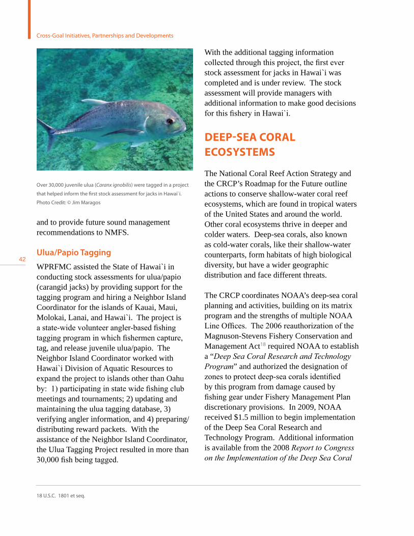
42
and to provide future sound management recommendations to NMFS.
Ulua/Papio Tagging
WPRFMC assisted the State of Hawai`i in conducting stock assessments for ulua/papio (carangid jacks) by providing support for the tagging program and hiring a Neighbor Island Coordinator for the islands of Kauai, Maui, Molokai, Lanai, and Hawai`i. The project is a state-wide volunteer angler-based fishing tagging program in which fishermen capture, tag, and release juvenile ulua/papio. The Neighbor Island Coordinator worked with Hawai`i Division of Aquatic Resources to expand the project to islands other than Oahu by: 1) participating in state wide fishing club meetings and tournaments; 2) updating and maintaining the ulua tagging database, 3) verifying angler information, and 4) preparing/distributing reward packets. With the assistance of the Neighbor Island Coordinator, the Ulua Tagging Project resulted in more than 30,000 fish being tagged.
Over 30,000 juvenile ulua (Caranx ignobilis) were tagged in a project
that helped inform the first stock assessment for jacks in Hawai`i.
Photo Credit: © Jim Maragos
With the additional tagging information collected through this project, the first ever stock assessment for jacks in Hawai`i was completed and is under review. The stock assessment will provide managers with additional information to make good decisions for this fishery in Hawai`i.
DEEP-SEA CORAL ECOSYSTEMS
The National Coral Reef Action Strategy and the CRCP’s Roadmap for the Future outline actions to conserve shallow-water coral reef ecosystems, which are found in tropical waters of the United States and around the world. Other coral ecosystems thrive in deeper and colder waters. Deep-sea corals, also known as cold-water corals, like their shallow-water counterparts, form habitats of high biological diversity, but have a wider geographic distribution and face different threats.
The CRCP coordinates NOAA’s deep-sea coral planning and activities, building on its matrix program and the strengths of multiple NOAA Line Offices. The 2006 reauthorization of the Magnuson-Stevens Fishery Conservation and Management Act18 required NOAA to establish a “DeepSeaCoralResearchandTechnologyProgram” and authorized the designation of zones to protect deep-sea corals identified by this program from damage caused by fishing gear under Fishery Management Plan discretionary provisions. In 2009, NOAA received $1.5 million to begin implementation of the Deep Sea Coral Research and Technology Program. Additional information is available from the 2008 ReporttoCongressontheImplementationoftheDeepSeaCoral
18 U.S.C. 1801 et seq.
Cross-Goal Initiatives, Partnerships and Developments

43
NO
AA
CR
CP
2007 - 2009 Report to C
ongress
ResearchandTechnologyProgram19 and the upcoming 2010 Second Report to Congress.
In October 2007, NOAA published the State of Deep Coral Ecosystems of the United States. Written by experts from seven regions around the country, the report provides the first peer-reviewed assessment of deep-sea coral ecosystems in U.S. waters, including: the biology of deep-sea corals and their associated species, their spatial distribution, the stressors that may threaten their survival, current management measures, and regional priorities for future research. The State of Deep Coral Ecosystems of the United States report shows that these habitats, found at depths ranging from 50 to 3,000 meters, are much more extensive and important to ocean ecosystems than previously thought. NOAA works with regional
fishery management councils, other federal partners, academia, the environmental and fishing communities, and other stakeholders to understand and protect these unique ecosystems.
Effective management of deep-sea coral ecosystems is constrained by significant gaps in knowledge about deep-sea corals, including most aspects of their biology and ecology. Only a small fraction of the U.S. Exclusive Economic Zone has been even cursorily surveyed for deep-sea coral habitats, despite evidence that they are threatened by an array of human-induced impacts, particularly physical disturbances. Activities that can directly impact deep-sea coral communities include fishing using bottom-tending fishing gear, deep-sea coral harvesting, fossil fuel and mineral exploration and extraction, and submarine cable/
A specimen of Keratoisis bamboo coral inside the collection box of
the Johnson-Sea-Link submersible, rising to the surface. Photo Credit:
Brooke et al, NOAA-OE, HBOI
Squat lobster (Eumunida picta) and blackbelly rosefish (Helicolenus
dactylopterus) on Lophelia pertusa thicket. Photo Credit: S. Ross et al.,
UNCW
19 Available at: http://www.nmfs.noaa.gov/habitat/rtc.pdf

44
pipeline deployment. Invasive species, climate change, and ocean acidification represent additional serious threats. Funding under the Deep Sea Coral Research and Technology Program in 2009 allowed NOAA to expand its efforts to organize existing information on the locations of deep-sea coral communities and the distribution and intensity of fishing practices known to impact them. NOAA also began new field research and mapping off southeast Florida that discovered rich new coral habitats, and is providing this new information to help inform the design of the South Atlantic Fishery Management Council’s proposed new Deepwater Coral Habitat Areas of Particular Concern – the largest proposed MPAs on the east Coast. Research and mapping of priority areas in this Council’s region are expected to take multiple years. Expansion of field research and mapping to other U.S. regions will depend on the availability of additional funds or the cessation of research in the U.S. Southeast.
AMERICAN RECOVERY AND REINVESTMENT ACT OF 2009
This report covers activities funded directly by the CRCP. One exception is made for five coral relevant projects, totaling $15 million, funded by the ARRA of 2009. The significant funding levels awarded will help advance coral reef conservation efforts that are central to the CRCP’s mission. In addition, the CRCP plans to support supplemental monitoring and research in these areas to evaluate the projects’ predicted benefits to coral reef ecosystems. The projects are:
U.S. Virgin Islands Watershed Stabilization (St. John and St. Croix, USVI) – $2.7 million, Virgin Islands Resource Conservation and Development Council. This project will reduce sediment loading to coral reef habitats
by implementing a variety of watershed management and stabilization techniques in three watersheds in St. John and St. Croix, USVI. It will improve roads and restore riparian habitats, helping watershed drainage across more than 700 acres and reducing the sediment load washing into nearshore habitats by approximately 130 tons per year. Between the sites on St. John and St. Croix, almost 125 acres of marine habitats (coral reef and seagrass) will be restored.
Threatened Coral Recovery and Restoration (Florida and USVI) –$3.3 million, The Nature Conservancy. This project is a large-scale, regional restoration effort aimed at aiding in the recovery of populations of threatened Acroporid coral on reefs in Florida and the USVI. This project is the first large-scale effort to propagate the ESA-listed species in open ocean nurseries. Coral fragments will be propagated in eight nursery sites for three years before out planting. These new corals will help increase abundance and combat the effects that low populations and low genetic diversity can have on reef recovery at 34 restoration sites. This project will result in the direct restoration of 8.4 acres, but more importantly will provide significant and tangible ecological impacts through an increase in local biodiversity as well as enhanced ecosystem services for various user groups. Maunalua Bay Reef Restoration (Maunalua Bay, Hawai`i) – $3.4 million, The Nature Conservancy. This project will work to restore coral reefs through manual removal of invasive alien algae from 22 acres of nearshore waters. The restored sand bottom and hard substrate habitat will enable seagrass expansion and coral recruitment. The project will provide significant ecological benefits, and transform existing small-scale community removal efforts already underway into a large-scale removal model.
Cross-Goal Initiatives, Partnerships and Developments

45
NO
AA
CR
CP
2007 - 2009 Report to C
ongress
Laolao Bay Coastal Restoration (Laolao Beach, Saipan, CNMI) – $2.9 million – In coordination with the CNMI’s Division of Environmental Quality, NOAA will directly invest Recovery Act funds to restore Saipan’s coral reefs by removing and addressing sources of upland sediment. Efforts to address sedimentation include restoring 15 acres of upland habitat, road upgrades, drainage improvements, and elimination of unsustainable beach activities.
Pelekane Bay Watershed Restoration (Pelekane Bay, Hawai`i) – $2.7 million, The Kohala Center. This project is a comprehensive approach to reducing land-based sediment inputs into Pelekane Bay coral reefs through erosion control, native revegetation, and limiting sediment transport. These activities aim to restore more than 1,463 acres of coastal and marine habitat.
DESIGNATION OF THREE NATIONAL MARINE MONUMENTS
In 2009, the President designated three areas as marine national monuments: Marianas Trench, the Pacific Remote Islands, and Rose Atoll, ensuring them a high level of environmental recognition and conservation. Destruction or extraction of protected resources within the boundaries of these monuments is now prohibited, as is commercial fishing in the coral reef ecosystem areas of the monuments. Combined, these designations represent the largest fully protected area in the world, with 195,274 square miles (505,757 km2) conserved. These three monuments joined the Papahānaumokuākea Marine National Monument, northwest of the main Hawaiian Islands, which was designated in 2006, and
A nursery was established as part of an ARRA project with the goal of
recovering threatened Acropora corals. The staghorn coral pictured is
26 months old. Photo Credit: Tom Moore, NOAA
set apart 139,793 square miles (362.062 km2) of federal lands and waters to protect the area’s significant natural, cultural, and historic resources.
The CRCP played a vital role in this major conservation achievement by funding most of the scientific data used to inform the designation process. The information supported efforts to implement strict conservation measures to protect these unique ecosystems. Without CRCP funded research and long-term involvement in the Pacific region, these measures to protect some of the world’s largest and healthiest coral ecosystems likely would not have been realized.
The Marianas Trench Marine National Monument consists of three components: the waters and submerged lands encompassing the coral reef ecosystem of the three northernmost islands (Farallon de Pajaros or Uracas, Maug, and Asuncion), representing some of the westernmost territory in the United States and
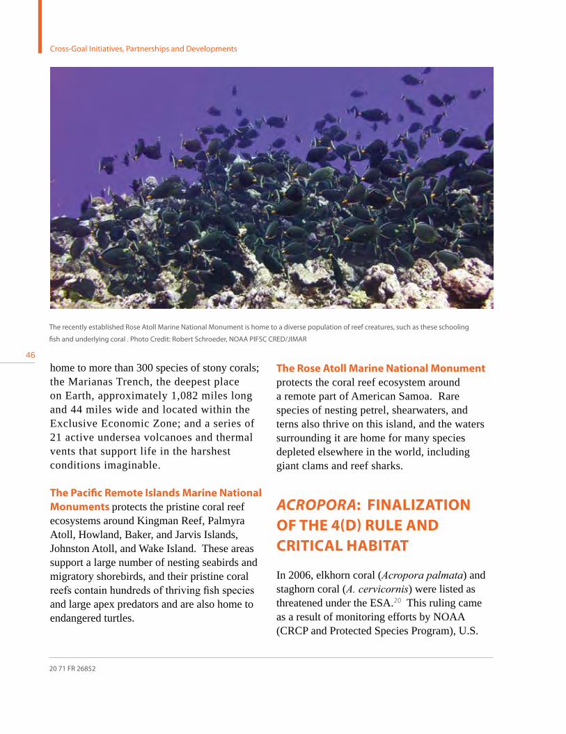
46home to more than 300 species of stony corals; the Marianas Trench, the deepest place on Earth, approximately 1,082 miles long and 44 miles wide and located within the Exclusive Economic Zone; and a series of 21 active undersea volcanoes and thermal vents that support life in the harshest conditions imaginable.
The Pacific Remote Islands Marine National Monuments protects the pristine coral reef ecosystems around Kingman Reef, Palmyra Atoll, Howland, Baker, and Jarvis Islands, Johnston Atoll, and Wake Island. These areas support a large number of nesting seabirds and migratory shorebirds, and their pristine coral reefs contain hundreds of thriving fish species and large apex predators and are also home to endangered turtles.
The Rose Atoll Marine National Monument protects the coral reef ecosystem around a remote part of American Samoa. Rare species of nesting petrel, shearwaters, and terns also thrive on this island, and the waters surrounding it are home for many species depleted elsewhere in the world, including giant clams and reef sharks.
AcroporA: FINALIzATION OF THE 4(D) RULE AND CRITICAL HABITAT
In 2006, elkhorn coral (Acropora palmata) and staghorn coral (A.cervicornis) were listed as threatened under the ESA.20 This ruling came as a result of monitoring efforts by NOAA (CRCP and Protected Species Program), U.S.
The recently established Rose Atoll Marine National Monument is home to a diverse population of reef creatures, such as these schooling
fish and underlying coral . Photo Credit: Robert Schroeder, NOAA PIFSC CRED/JIMAR
20 71 FR 26852
Cross-Goal Initiatives, Partnerships and Developments

47
NO
AA
CR
CP
2007 - 2009 Report to C
ongress
Geological Survey, National Park Service, and other academic partners which documented Acroporid population losses of 80 to 98 percent since the 1970s throughout the Caribbean region. In 2008, NOAA issued a Final ESA 4(d) Rule extending the prohibitions of the ESA given automatically to endangered species to the two threatened Acropora species.21 NOAA also issued a Final ESA Critical Habitat Designation on November 26, 2008.22 Critical habitat is designated in four Florida areas (Palm Beach, Broward, Miami-Dade, and Monroe counties), Puerto Rico, and the USVI, encompassing all hard substrate free from fleshy or turf macroalgae and sediment, generally in waters of up to 30 meters. To support NMFS Protected Resources in developing regulations, the CRCP supported workshops to gather information to assist in drafting the rules and outreach to
federal agencies, local governments (through the USCRTF) and the public. The CRCP also supports demographic monitoring and modeling for these species which will help predict and document the results of future recovery actions.
As part of its duties in listing elkhorn coral as threatened under the ESA, NOAA was responsible for setting prohibitions under the 4d rule
and designating critical habitat. Photo Credit: Dave Burdick
21 73 FR 64264
22 73 FR 72210

48
Credit: NOAA NCCOS

49
NO
AA
CR
CP
2007 - 2009 Report to C
ongress
3. Theme 1: Understanding Coral Reef Ecosystems

50
Goal 1: Map All U.S. Coral Reefs Goal 2: Assess, Monitor and Forecast Coral Reef HealthGoal 3: Conduct Strategic Research Goal 4: Understand Social and Economic Factors
The Program transitioned to addressing three threats in late 2009, which will affect funding decisions beginning in 2010. During the 2007 to 2009 time period covered by this report, CRCP operations were guided by the National Coral Reef Action Strategy of 2002, which included 13 goals, grouped under two main themes. Activities covered by this report are organized under this Action Strategy.
Recognizing the significant gaps in our knowledge of these complex ecosystems, the first theme developed by the USCRTF and adopted by the CRCP consisted of four major goals to assess the overall status of coral reefs, understand causes of reef decline, and elucidate links between coral reefs and associated human activities. To meet these needs, the following four goals were developed:
Next are some of the most significant accomplishments from projects funded or carried out by the CRCP in the past three years that advanced these four Theme One goals. Targeted allocation and strategic use of Program resources during this time period allowed significant gains in our knowledge of coral reef ecosystems and helped discern how they are linked to human activities.
3. Theme 1: Understanding Coral Reef Ecosystems

51
NO
AA
CR
CP
2007 - 2009 Report to C
ongress
GOAL 1: MAP ALL U.S. CORAL REEFS
Accurate and comprehensive maps of coral reef areas and habitat assessments facilitate effective management of these ecosystems. This goal guided the development of high-resolution, fine scale benthic maps using a range of technological approaches (including satellite, aircraft, and in-situ surveys), along with larger-scale, low-resolution broader mapping for general habitat characterization. The table below summarizes the cumulative progress made in generating air-based benthic habitat mapping and ship-based
bathymetric mapping in all of the U.S. coral jurisdictions:
When the National Action Plan to Conserve Coral Reefs mandate was established in 2000, fewer than 10 percent of all U.S. shallow reefs had been mapped and characterized. Through the use of visual interpretation and spectral analysis of aerial photography and satellite imagery, the CRCP has completed shallow-water benthic habitat maps for Guam, American Samoa, CNMI, the main Hawaiian Islands, the Republic of Palau, Puerto Rico, and USVI. To date, more than 3,550 square miles (9,200 km2) of U.S. coral reefs have been mapped; about 1,081 square miles (2,800 km2) were mapped between 2007 and 2009.
Jurisdiction
Benthic Habitat Map Products Bathymetric Products Status of Mapping Progress Ability to
apply map
products in
support of
research &
conservationShallow Water
(<30 m)
Moderate Depth
(30-1000 m)
Shallow Water
(<30 m)
Moderate Depth
(30-1000 m)Quantitative
Survey of
jurisdictions
USVI 75-100% 0-25% 25-50% 25-50% Fair Good Good
Puerto Rico 75-100% 0-25% 75-100% 0-25% Fair Good Good
Navassa Island 25-50% 0-25% 75-100% 75-100% Good Good Fair
Southeast Florida 75-100% 0-25% 0-25% 0-25% Poor Fair Good
Florida Keys 50-75% 0-25% 0-25% 0-25% Poor Fair Fair
Flower Garden
BanksN/A 0-25% N/A 75-100% Good Good Excellent
Main Hawaiian
Islands75-100% 0-25% 75-100% 75-100% Good Good Good
Northwestern
Hawaiian Islands 50-75% 0-25% 25-50% 25-50% Fair Fair Good
American Samoa 75-100% 0-25% 25-50% 75-100% Good Excellent Good
PRIA 0-25% 0-25% 0-25% 75-100% Poor Excellent Good
Marshall Islands 0-25% 0-25% 0-25% 0-25% Poor Poor Poor
Federated States
of Micronesia0-25% 0-25% 0-25% 0-25% Poor Poor Poor
CNMI 75-100% 0-25% 50-75% 75-100% Good Good Good
Guam 75-100% 0-25% 75-100% 75-100% Good Good Good
Palau 75-100% 0-25% 0-25% 0-25% Poor Fair Fair
Cumulative mapping of coral reefs in U.S. jurisdictions as of 2008

52
In water depths between 30 and 1,000 meters, bathymetric surveys using high-resolution multibeam sonar are nearly complete for CNMI, Guam, American Samoa, the Pacific Remote Island Areas (PRIA), and the main Hawaiian Islands, and partially complete in the NWHI. A suite of additional products that are derived from multibeam sonar data are now available, and these products meet a variety of management needs including: stratifying habitats for biological monitoring and assessments; locating coral resources to inform boundaries for marine protected areas, cable routes and anchorage areas; and updates for nautical charts. Mapping in the low light (“mesophotic”) regions in depths of 30 to 150 meters has highlighted the existence of unique and robust coral and fish communities in deeper waters. These mesophotic ecosystems may also represent refugia for shallower corals in areas where they sustain damage from storms or bleaching events.
Bathymetric data collection in the Atlantic/ Caribbean/ Gulf of Mexico is proceeding more slowly and focuses survey effort on priority areas such as existing or potential fishery closures, deep reef habitats, unique seafloor features, and National Marine Sanctuaries. The availability of habitat maps and high-resolution bathymetric data represents major progress towards the USCRTF mapping goals and provides a fundamental spatial structure that supports management, monitoring, and research objectives.
Collection of optical validation data is an equally important element in CRCP’s mapping program, needed to determine the character of the seafloor or the associated biological resources. Since the Program’s inception, a variety of tools have been assembled to provide this habitat characterization information. The techniques to collect optical validation data include: stationary and towed-diver surveys; use of tethered cameras and Remotely
St. John Biogeography Integrated Online Mapper (BIOMapper). BIOMapper lets users interactively view data, aerial imagery, dive photography,
underwater video, and related publications. Photo Credit: NOAA NCCOS
3. Theme 1: Understanding Coral Reef Ecosystems

53
NO
AA
CR
CP
2007 - 2009 Report to C
ongress
Operated Vehicles (ROVs); and, most recently, programmable terrain-following Autonomous Underwater Vehicles (AUVs) that can operate independently from the ship. Although optical validation data have been collected in much of the Pacific and Atlantic, there are only a few places where the data are sufficient to fully interpret the multibeam bathymetry and backscatter maps. Collaborative projects are also underway to better integrate a variety of different data types, such as satellite imagery, multibeam and LiDAR (Light Detection and Ranging) bathymetric data, and optical validation data; this work is critical for creation of seamless benthic habitat mapping and characterization product suites from the shoreline to 100 meters and beyond, which are needed to support effective decision making in all regions.
GOAL 2: ASSESS, MONITOR, AND FORECAST CORAL REEF HEALTH
In order to facilitate management responsiveness to perpetually changing coral reef ecosystem conditions, it is necessary to have a system that tracks and predicts these fluxes. This goal directs national coordination of a long-term effort to assess and monitor coral reef ecosystems in the United States, and requires the resulting data be made readily available to resource managers as well as the general public. The CRCP has made important strides towards this goal by implementing large “umbrella” programs that combine multi-method observations on present coral reef ecosystem functioning, and predict near-future coral reef ecosystem functioning. This and other coral reef information has also been made available to scientists, resource managers, and the public via a unified web-based system. In addition, the Program has conducted the first
large-scale ecosystem assessments for several Pacific islands whose reefs face unprecedented and immediate challenges.
Coral Reef Ecosystem Integrated Observing SystemThe CRCP has combined its mapping, monitoring, and assessment activities into the Coral Reef Ecosystem Integrated Observing System (CREIOS), which provides a diverse suite of long-term ecological and environmental observations over a broad range of spatial and temporal scales. CREIOS data and information products help coral reef scientists and managers understand coral reef ecosystem condition and processes, and assist managers in making improved and timely ecosystem-based management decisions to conserve coral reefs.
To more effectively provide data and information to coral reef managers, the CRCP conducted stakeholder workshops in Hawai`i (2008) and Puerto Rico (2009). The purpose of these was to discuss mapping, monitoring, and data dissemination efforts in the U.S. Pacific and Atlantic/Caribbean jurisdictions, as well as largely uninhabited U.S.-flagged areas, including the PRIA, Navassa Island, and Flower Garden Banks. The meetings brought together coral reef managers from federal, state, territory, and local agencies across the region, and representatives of NOAA’s mapping and monitoring efforts. The workshops gathered priority information needs from managers, and highlighted important issues of concern, including the need for: increased technical capacity; improved information and data dissemination; improved communication of scientific information to non-scientific audiences; and increased emphasis on mapping, monitoring, and assessing resources at finer scales in specific areas of importance to managers. Observing networks and warning systems that are part of the CREIOS program are described next.

54
Integrated Coral Observing Network and the Coral Reef Early Warning System
Since its beginning, the CRCP has provided support to NOAA’s Atlantic Oceanographic and Meteorological Laboratory (AOML) in Miami to develop specialized insitu monitoring instrumentation platforms and near real-time analysis software to develop long-term data sets against which to measure climate change. The Coral Reef Early Warning System (CREWS) software has evolved to produce assessments of coral reef conditions called “ecological forecasts,” such as those for coral bleaching, upwelling, and larval drift. The station platforms (nicknamed “CREWS stations” or “pylons”) measure environmental conditions such as sea temperature, salinity, air temperature, wind speed, wind direction, and ultraviolet radiation, parameters which are relayed via satellite to AOML. There, the data and ecological forecasts are presented on the Web for the public, resource managers, and
researchers, and are eventually archived (after careful quality control) with CRCP’s Coral Reef Information System (CoRIS). CREWS is part of the larger CREIOS program.
CREWS stations currently operational include those located in St. Croix, USVI; La Parguera, Puerto Rico; and Little Cayman, Cayman Islands. CREWS pylons have also been deployed at Lee Stocking Island, Bahamas, and Discovery Bay, Jamaica. Other areas for future consideration include St. Thomas, USVI; American Samoa, Guam, and Taiwan. In 2009, the CRCP funded more than $228,000 to build and install a CREWS station in Saipan, CNMI, due for completion in 2010. CREWS pylons for foreign governments are developed through Memoranda of Understanding under which NOAA supports site surveys for mutually acknowledged critical coral reef areas, while the instrumentation and other costs are supported by the requesting government or sponsoring organization.
Existing and Proposed Coral Reef Early Warning System Station Sites
3. Theme 1: Understanding Coral Reef Ecosystems
Credit: World Bank
55
NO
AA
CR
CP
2007 - 2009 Report to C
ongress
CREWS stations support novel instrumentation, as well as the usual meteorological and oceanographic instruments. The Pulse-Amplitude-Modulating (PAM) fluorometer was used to demonstrate the only near real-time monitoring of physiological stress during a coral bleaching episode and helped to show that light, as well as sea temperature, are part of the critical environmental factors involved in coral bleaching (see PAM section of Goal 3). The use of a pCO2 sensor for monitoring partial pressure of carbon dioxide over a coral reef area in the Bahamas was the second such attempt in the world.
The CREWS pylons are one component of the larger Integrated Coral Observing Network (ICON) that monitors environmental conditions via satellite at more than 120 virtual coral reef “stations” around the world. The ICON program integrates near real-time data from various insitu networks (e.g., the CREWS Network, SEAKEYS Network in the Florida Keys, the Australian Institute of Marine Science Weather Network along the Great Barrier Reef, etc.), several satellite data sources, and from a radar site at the University of Miami monitoring ocean current data over the northern half of the Florida Keys National Marine Sanctuary. The hallmarks of the ICON Project are near real-time multi-source data integration, the utilization of these integrated data into ecological forecasts, and the development of new instrumentation to answer pressing environmental and managerial questions.
Pacific Reef Assessment and Monitoring ProgramPacific Reef Assessment and Monitoring (RAMP) cruises are interdisciplinary operations that incorporate numerous scientific methods to study coral reef ecosystems, including biological and oceanographic observations, and benthic habitat mapping. Since 2000, the
CRCP has supported biennial integrated and interdisciplinary monitoring of spatial patterns and temporal changes of coral reef ecosystems throughout Hawai`i, Guam, American Samoa, CNMI, and the PRIA. Long-term ecosystem monitoring provides an unprecedented ability to understand and differentiate between natural and human-induced changes, thereby enabling more effective implementation of ecosystem approaches to management. The program is designed to map, monitor, and assess spatial and temporal patterns at island, regional, and basin-wide scales, and to work with local resource management agencies to complement their work at site or watershed-specific scales. Because Pacific RAMP surveys are done with consistent observational methods and a stable cadre of well-trained observers, island, regional, and basin-scale patterns and trends are discernible in the observations.
Biological observations of corals, algae, fish, and benthic invertebrates are conducted at selected fixed stations around each island or bank, and augmented with statistically chosen random sites at various depths and habitat types. Towed-diver surveys of benthic (seafloor) composition, levels of stress, and ecological and economically important fish and large invertebrate species are conducted to provide broader spatial coverage of significant ecosystem condition metrics. The mapping element of the program provides benthic habitat maps as base maps for the biological data. All of these data are now combined in a robust interdisciplinary relational database.
A variety of oceanographic and water-quality observations are collected during and between Pacific RAMP cruises to understand the critical physical and chemical processes influencing and supporting these coral reef ecosystems. Observations are made using: spatial surveys of vertical profiles of temperature, salinity,

56
nutrients, chlorophyll a, carbonate chemistry, and turbidity around each island/atoll system; moored instrument arrays high resolution time series measurement of temperature, salinity, wave energy and direction, currents, ambient sound, wind, light, and atmospheric pressure; and satellite observations of spatial patterns and temporal changes of surface temperature, ocean color, wind, and sea level height. A subset of the moored instruments telemeter information in near real-time via satellite. Collectively, this suite of observations provide information to better understand the dynamic processes controlling ecological responses to climate change, land-based sources of pollution, overfishing, and other threats. Specific outcomes of RAMP cruises are described next.
Comprehensive Assessment of American Samoa’s Coral Reefs The Coral Reef Ecosystem Monitoring Report for American Samoa: 2002-2006, produced by the Coral Reef Ecosystem Division of the
Pacific Islands Fisheries Science Center, is the most comprehensive interdisciplinary coral reef ecosystem assessment of American Samoa ever conducted. It reflects extensive analyses of the integrated ecosystem observations made during three American Samoa RAMP research cruises conducted by NOAA scientists and their local partners in 2002, 2004, and 2006. A 2007 presentation about this to government officials and resource managers from American Samoa influenced Governor Togiola Tulafono to commit the American Samoa government to begin the process of public hearings and consultations to protect the large, now rare, reef fish species that are at greatest risk from exploitation, including all species of sharks, giant trevally, giant groupers, bumphead parrotfish, and humphead wrasse. The comprehensive 500-page report is also being used as a marine sciences textbook at the American Samoa Community College. It is the first in the series of four major monitoring reports for the U.S. Pacific island areas
CRED diver conducting an Rapid Ecological Assessment coral disease survey. Photo Credit: NOAA PIFSC CRED
3. Theme 1: Understanding Coral Reef Ecosystems

57
NO
AA
CR
CP
2007 - 2009 Report to C
ongress
(American Samoa, the Mariana Archipelago, the Hawaiian Archipelago, and the remote islands).
Mariana Archipelago Assessment for U.S. Navy and Regional ManagersWith the movement of 8,000 Marines, and as many as 40,000 military and civilian support personnel to Guam in the next decade, data to support environmental assessments in the Mariana Archipelago are a critical management need. At the request of the U.S. Naval Facilities Engineering Command (NAVFAC), scientists from the Coral Reef Ecosystem Division of the Pacific Islands Fisheries Science Center accelerated data analyses for five islands (Guam, Tinian, Saipan, Aguijan, and Pagan) in the Mariana Archipelago and prepared preliminary figures and data assessments,
which were delivered to NAVFAC and all local resource management agency partners in October 2008. The data presented included: biological assessments of coral, fish, and algae; a variety of oceanographic measurements; and multibeam bathymetry that had been collected during Pacific RAMP ecosystem monitoring cruises in 2003, 2005, and 2007. All information provided to NAVFAC was also made available electronically to local and regional management agencies in CNMI and Guam. The CoralReefEcosystemMonitoringReportfortheMarianaArchipelago:2003-2007, which analyzes and discusses all islands of CNMI and Guam, is scheduled for completion and distribution in 2010.
Coral Reef Ecosystem Biodiversity AssessmentsAs part of the International Census of Marine Life’s Census of Coral Reef Ecosystems project, NOAA’s CRCP assisted in the development of standardized tools and protocols to assess and monitor the biodiversity of coral reefs around the globe. These efforts
Gridded bathymetry shelf, bank and slope environments of Saipan
Island, CNMI. The bathymetry was created via multibeam sonar
collected aboard the NOAA Ship Hi`ialakai between 2003 and
2007. Credit: NOAA PIFSC CRED Pacific Islands Benthic Habitat
Mapping Center

58
Through funding from CRCP’s State and Territorial Coral Reef Ecosystem Monitoring Grant Program, state and territorial agency partners in the jurisdictions collected and shared information about local coral reef ecosystems and their biological communities. These ecosystem monitoring activities form the backbone of comprehensive, periodic monitoring reports, The State of Coral Reef Ecosystems of the United States and Pacific Freely Associated States, published in 2002, 2005, and in 2008. In addition to these updates, a survey of contributors’ opinions on the state of local coral reef resources, and ability to monitor them was included. Results of the latest survey reveal that:
• ThemajorityofkeyresourcesintheCaribbean/Atlantic/Gulf of Mexico region were reported to be in poor or fair condition. Only six of the 24 responses (25 percent) reported conditions to be either good or excellent.
• InthePacific,themajority(69percent)ofkeyresources(for which condition was known) were reported to be in good or excellent condition.
• Livingcoralcoverwastheonlykeyresourceforwhichmonitoring ability was reported to be good or excellent by a majority of the jurisdictions. The ability to monitor three of the key threats, commercial fishing, subsistence and recreational fishing, and aquatic invasive species, was considered to be poor by nearly half of the jurisdictions.
• Theaverageconditionofmostkeyresourcesdeclinedoverboth the short- and long-term. Overall trends indicate that resource condition is declining, and threats are increasing.
For short-term trends regarding threat levels, results indicate that all threats but one increased over the past three years. During the 10-25 year time period, threats for which more than two thirds of jurisdictions reported increasing trends were climate change and coral bleaching, coral disease, tourism and recreation, subsistence and recreational fishing, and marine debris.
The survey also indicated rising concern about the effects of climate change on coral reef ecosystems. In addition to long-standing concerns about sea level rise, increases in sea surface temperatures, and mass coral bleaching and disease epidemics, predicted increases in CO2 saturation that may reduce calcification abilities of reef-building organisms is emerging as a specific threat.
REPORT: THE STATE OF CORAL REEF ECOSYSTEMS OF THE UNITED STATES AND THE PACIFIC FREELY ASSOCIATED STATES 2008
3. Theme 1: Understanding Coral Reef Ecosystems

59
NO
AA
CR
CP
2007 - 2009 Report to C
ongress
have led to the development, testing, and deployment of more than 360 Autonomous Reef Monitoring Structures across the Pacific Islands, Australia, Coral Triangle, Indian Ocean, Caribbean, and Brazil in 2008-2009. These structures are designed to systematically establish the first-ever global assessment of spatial patterns of the biodiversity of cryptic (small and poorly known) reef-associated species. This global assessment will serve as the baseline for determining the biodiversity impacts of climate change and ocean acidification on coral reef ecosystems.
NavassaContinuing reef and fishery assessment at Navassa Island has focused more effort on documenting status of recently ESA-listed Acropora spp. corals and quantifying actual fishery catch. Cruises in late 2006 and 2009 documented a mass coral bleaching event, the presence of invasive Pacific lionfish (Pteroisvolitans), trends of increased abundance for
listed elkhorn coral (Acroporapalmata) and keystone grazing urchins (Diademaantillarum), and continued rarity of listed staghorn coral (Acroporacervicornis). During the 2009 cruise, with fishers’ cooperation, the first measurements of daily catch/effort were made for two Haitian trap-fishing vessels.
Coral Reef Information SystemNOAA’S Coral Reef Information System (CoRIS) is a single point of access to NOAA coral ecosystem information and data, particularly those derived from the CRCP. CoRIS data discovery tools provide access to metadata, data, and information from NOAA CRCP and other coral reef projects. CoRIS includes coral reef mapping and monitoring data and products, coral bleaching nowcasts, satellite data and products, environmental sensitivity index maps, aerial photography, original essays, and a regularly updated Glossary. Users can search for data and information in three different ways: an interactive Google Map Search to
In collaboration with Fondation pour la Protection de la Biodiversité Marine, NOAA researchers obtained catch data from the Haitian fishers
who frequent Navassa waters. Two boat-days worth of catch were identified and measured, allowing researchers to gather information about
catch per unit effort. Photo Credits: NOAA Southeast Fisheries Science Center

60
locate available data by region, a text-based keyword search, and a series of browsable lists of data arranged by keywords.
CoRIS released a set of regional portals in July 2008, which include five portals for the Atlantic /Caribbean region, and nine for the Pacific region. Each regional portal allows a user to find a wide range of region specific data and information from a single page. The Regional Portal provides regionally-focused access to metadata, data, and information about coral reefs in a clear, concise, and integrated way. While the focus of the information is NOAA coral data, activities, information, and products, non-CRCP activities that fall under the USCRTF umbrella are also included. Interactive maps provide access to region-specific data and publications; regional chapters of TheStateofCoralReefEcosystemsoftheUnitedStatesandPacificFreelyAssociatedStates from 2002, 2005, and 2008; links to CoRIS metadata records; real-time and near-real-time data; education and outreach materials; information about Marine Protected Areas and Marine Managed Areas; and more.
GOAL 3: CONDUCT STRATEGIC RESEARCH
Corals form communities that are rich and diverse, but important knowledge gaps remain on many basic issues relating to these complex ecosystems. The NationalCoralReefActionStrategy calls for long-term regional research that will help improve our understanding of the many processes that govern the form, function, and health of the coral reef ecosystems; the CRCP took an important step towards fulfilling this charge with a comprehensive and long-term NOAA-wide research plan. TheNationalCoralReefActionStrategy also calls for the Program
to build capacity to address ecosystem-scale threats, including disease, bleaching, and other sources of mass coral mortality, an objective implemented via the creation of an active Coral Disease and Health Consortium. The CRCP allocates a significant portion of its budget to conduct strategic research in pressing coral reef issues, and has ongoing and sustained efforts to transfer technology and knowledge gained by this research to local resource managers via workshops and training, as called for in the NationalCoralReefActionPlan, with particular emphasis placed on climate change impacts and adaptation.
NOAA-wide Coral Reef Ecosystem Research Plan In 2007, NOAA published the CoralReefEcosystemResearchPlanforFiscalYears2007to2011 to identify priority research needs and guide coral reef research. Research is the cornerstone on which to build and improve ecosystem-based management and resource management decisions. The plan covers all shallow-water coral reef ecosystems under the jurisdiction of the United States and the Pacific
3. Theme 1: Understanding Coral Reef Ecosystems

61
NO
AA
CR
CP
2007 - 2009 Report to C
ongress
Freely Associated States, provides coastal and ocean managers, scientists, and policy makers with up-to-date scientific information to address the complex nature of the threats facing coral reef ecosystems, and identifies priority research needed to advance management action.
Coral Disease and Health ConsortiumThe Coral Disease and Health Consortium (CDHC), created in 2002 by the USCRTF to focus on coral health issues, emphasizes characterizing the causes of disease and bleaching. The CRCP has funded this consortium with $755,000 between 2007, and 2009. It is an official working group of the USCRTF and an international network of more than 150 scientists, managers, NGO, and industry representatives volunteering time and expertise to understand the effects of natural and anthropogenic stressors on corals to help protect and conserve coral reefs. The CDHC uses the principles and methods of public health and wildlife medicine to assess a coral population’s health, identify stressors, and link causes of disease to specific stressors. The center conducts strategic research to develop causal evidence (e.g., developing biomarkers, studying wetsuits as a possible vector, and fuel, and sunscreen toxicities) of coral disease, and has established and trained surveillance and response networks to detect change, and respond to, disease outbreaks. CDHC is building a systematic means to link disease and its extent on discrete, local populations with specific causal sources of damage so that resource managers and policy makers have the vital information to target mitigation for coral conservation at the local level. Bringing these activities together, the CDHC published in June 2009, CoralHealthandDiseaseinthePacific:VisionforAction, synthesizing state of knowledge of Pacific coral diseases, defining and managing disease in coral, and developing a strategic plan.
In July 2008, CDHC published TheFieldManualforInvestigatingCoralDiseaseOutbreaks, to serve as an operational guide to coordinate effective, informative responses by outbreak response teams to unusual incidents of coral disease or mortalities. It was developed as an aid to provide context and consistency for outbreak investigations, and to help train coral disease outbreak response teams so that coordinated response operations can be executed.
Atlantic Ocean Acidification Test-Bed A team of NOAA scientists, divers and engineers, together with colleagues from the University of Puerto Rico at Mayagüez, deployed a moored autonomous pCO2 (dissolved CO2) buoy at Cayo Enrique Reef near La Parguera, Puerto Rico in January 2009. This CRCP project seeks to:
1.Establishastandardizedapproachandmethodologyformonitoring,assessing,andmodelingtheoceanchemistrychangesandtheimpactsofoceanacidification(OA)oncoralreefecosystems;

62
2.Identifycriticalthresholds,impacts,andwaterchemistrytrendsnecessaryfordevelopingecologicalforecasts;
3.CharacterizethespatialandtemporalvariabilityincarbonatechemistryincoralreefenvironmentstobettercharacterizethethreatofOA;and
4.ProvidedataandinformationnecessarytofacilitateanearlyalertsystembasedonecologicalforecastingforOAstresstocoralreefecosystems.
The advanced mooring system is providing an important part of the geochemical observations necessary to meet these objectives. Together with weekly geochemical surveys and ancillary observations along Cayo Enrique Reef, the project will monitor community-scale metabolic performance along the forereef environment.
PAM Flourometry Pulse amplitude modulated (PAM) fluorometry measures the photosynthetic efficiency of the symbiotic algae within coral tissues, which may be used as a quantitative measure of coral bleaching. Deployment of a PAM fluorometer in coordination with NOAA’s ICON improves the early detection of bleaching stress, and leads to a better identification of threshold values for timely feedback of real-time conditions insitu.
The first and only successful hourly real-time report, sustained over months, from a PAM fluorometer occurred at Lee Stocking Island in the Bahamas, fortuitously coincident with the 2005 Caribbean-wide bleaching event. Results indicated precisely which environmental parameters were coincident with physiological stress and the probable role of irradiance (light intensity) in the bleaching response. Results of this cutting-edge research were published in the peer-reviewed scientific journal, CoralReefs, in 2009.
In January 2009, the installment of this moored autonomous pCO2
buoy initiated the establishment of an Atlantic ocean acidification
test bed. Photo Credit: Jim Hendee, NOAA Atlantic Oceanographic
and Meteorological Laboratory
PAM fluorometry can serve as a quantitative measurement of
coral bleaching. Results from the data collected during the 2005
Caribbean bleaching event at the ICON station at Lee Stocking Island
were published in 2009. Photo Credit: Jim Hendee, NOAA Atlantic
Oceanographic and Meteorological Laboratory
3. Theme 1: Understanding Coral Reef Ecosystems

63
NO
AA
CR
CP
2007 - 2009 Report to C
ongress
Tools for Addressing Climate ChangeThe CRCP has developed several customized tools to assist resource managers dealing with the effects of climate change in coral reef ecosystems. Three of these tools are described next.
Satellite Bleaching Alert (SBA) System
Abnormal sea surface temperatures (SST), in conjunction with natural and anthropogenic stressors, are disrupting the delicate balance of coral ecosystems, thus increasing the frequency of bleaching events. The NOAA Coral Reef Watch (CRW) suite of satellite SST-based products help coral resource managers plan for potential coral bleaching events in their jurisdictions. The Satellite Bleaching Alerts (SBA) system began in
In 2009, CRW introduced an experimental product suite that
enhanced the accuracy of its SST-based products. The new suite of
products are based upon more detailed 50 km resolution satellite
monitoring. The improved satellite bleaching alert is shown here in
comparison with the identical product at the old resolution for the
same day. Photo Credit: NOAA Coral Reef Watch
2005, distributing information on 24 “virtual stations” at reefs around the world. The virtual stations provide information on current conditions on the reefs based on satellite data. In 2008, CRW completed the expansion of the experimental “virtual stations” to include almost 200 sites globally. Automated alerts of potential bleaching conditions based upon the virtual stations go out to more than 400 subscribers who receive emails when the bleaching alert status changes at their location. For each virtual station, a time-series graph is available with SST, thermal stress information and bleaching alerts. There are also global and regional images of coral bleaching, Degree Heating Weeks, HotSpots, doldrum winds, SST, and SST anomaly. In response to alerts, resource managers know when thermal stress has reached the threshold to cause corals to bleach in their area, allowing them to deploy resources to monitor bleaching and mortality of corals, and potentially take action to further protect the corals during this time of high stress.
Experimental Bleaching Outlooks
Expanding beyond observing current conditions, CRW issued the first-ever seasonal coral bleaching outlook in 2009. This new prediction system uses NOAA experimental SST forecasts to develop maps of anticipated coral bleaching risk during the upcoming bleaching season. While CRW uses satellite SST data to alert managers and scientists around the world of the current risk of coral bleaching, the new prediction system provides outlooks of the bleaching potential for up to three months or more into the future. Graphical outlook models are issued weekly, with descriptions of bleaching potential issued monthly during the peak bleaching seasons for the northern and southern hemispheres. The outlook provides managers with a much greater lead-time to prepare for potential

64
bleaching during the summer months. This greatly improves the advanced warning time of the normal suite of products that provide only one to three weeks’ notice when conditions are conducive to bleaching. Because monitoring and acting to protect reefs from bleaching can be expensive and may require time for planning and implementation, an outlook of a high bleaching risk allows managers advance warning to prepare actions to respond to high temperatures if they materialize.
Ocean Acidification Product Suite
Research and developmental efforts are providing new experimental tools to help resource managers oversee ocean chemistry changes in their jurisdictions. Monthly estimates of ocean acidification parameters are modeled from SST, salinity, pressure, and atmospheric CO2, as shown in graph.
The new ocean acidification product suite offers monthly syntheses of satellite datasets and environmental model outputs providing
a synoptic estimate of sea surface carbonate chemistry in the Greater Caribbean region. This tool compliments on-going geochemical surveys and monitoring efforts in the region by providing estimates of changing ocean chemistry on a broader spatial and temporal scale than shipboard observations alone can permit. A website23 provides regional maps of a variety of parameters relevant to ocean acidification, including sea surface aragonite saturation state (a key factor indicating availability of calcium carbonate, sample graph shown above), as well as partial pressure of CO2 in seawater [pCO2(sw)], total alkalinity, carbonate ion, and bicarbonate ion. These products are available in multiple formats including .gif and Google Earth. Archived data are currently available from January 2008 in high-definition format. The website also hosts a series of additional features, including a regional time-series of aragonite saturation state over the past two decades, and an Introduction to Ocean Acidification discussion section.
Sample Coral Bleaching Thermal Stress Outlook (Jul-Oct 2009) Credit: NOAA Coral Reef Watch
3. Theme 1: Understanding Coral Reef Ecosystems
23 http://coralreefwatch.noaa.gov/satellite/oa/index.html

65
NO
AA
CR
CP
2007 - 2009 Report to C
ongress
The model is validated against insitu observations of pCO2(sw) obtained from the NOAA AOML Global Carbon Cycle Program partnership with the cruise ship Explorer of the Seas, which provides continuous underway measurements throughout the Caribbean.
Training for Managers The CRCP routinely conducts workshops and training with local resource managers to transfer products and data produced by the Program into useable, actionable information on which resource managers rely to make informed decisions on a number of coral-reef related issues.
Training Workshops to Help Managers Address Coral Bleaching
The CRCP worked with many partners to continue offering workshops for reef managers based on TheReefManager’sGuidetoCoralBleaching, published by NOAA and Australia’s
Great Barrier Reef Marine Park Authority (GBRMPA) and The Nature Conservancy’s Reef Resilience Toolkit: Resources for Reef Managers. These workshops, delivered to both domestic and international participants, provide managers with the tools they need to understand climate change and coral bleaching, know when bleaching is likely to occur, and take actions to protect their valuable coral reef resources based on bleaching response plans. The workshops also cover the topics of resilience in MPA design, monitoring, communications and socioeconomic monitoring, and social ecological resilience. Training includes both formal instruction on the guide, as well as hands-on experience with satellite tools, practice in the field, and informal discussion to exchange ideas and foster collaborations to increase coastal resource management capacity. Trainees also work together to examine appropriate marine zoning to protect their reefs against climate change, and to start developing bleaching response plans.
As part of its ocean acidification product suite, CRW offers monthly maps of aragonite saturation states for the Caribben.
Credit: NOAA Coral Reef Watch

66
In 2008, the Global Coral Reef Monitoring Network, with substantial support from and involvement of the CRCP, published a report detailing the effects of the 2005 bleaching and hurricane events in the Caribbean. That year was the hottest year in the northern hemisphere since 1880. Large areas of excessively warm surface water developed in the Caribbean and tropical Atlantic, which led to large scale thermal stress to Caribbean corals and subsequent mass bleaching. In addition, 2005 broke records with 26 named storms and 13 hurricanes (including hurricanes Dennis, Emily, Katrina, Rita, and Wilma). Many of these hurricanes caused considerable damage to reefs via wave action and runoff of muddy, polluted freshwater.
This report is the result of cumulative region-wide monitoring efforts to assess coral response to these events, and contains lessons for management and future options. Bleaching reports from Belize, Mexico, and the USVI indicated between 25 percent and 45 percent of coral colonies were bleached. Bleaching extended to Florida, Puerto Rico, the Cayman Islands, the northern Dutch Antilles (St. Maarten, Saba, St. Eustatius), the French West Indies (Guadeloupe, Martinique, St. Barthelemy), Barbados, and the north coasts of Jamaica and Cuba. Bleaching in these U.S. jurisdictions and neighboring Caribbean countries was generally severe, affecting 50 percent to 95 percent of coral colonies. The bleaching events, followed by disease outbreaks, resulted in mortality rates of up to 70 percent of colonies in some areas.
Lessons for management and future options indicated that effective management that reduces damage from direct human pressures can strengthen natural adaptation mechanisms to build reef resilience. These actions will promote more rapid recovery in the future, especially if bleaching becomes a regular event. Unfortunately, climate projections call for more frequent and intense warming in the Caribbean, with a high probability of increased bleaching and coral mortality in the future. Severe coral bleaching is predicted to become a more regular event by 2030, and an annual event by 2100, if the current rate of greenhouse emissions is not reversed.
REPORT: STATUS OF CARIBBEAN CORAL REEFS AFTER BLEACHING AND HURRICANES IN 2005
3. Theme 1: Understanding Coral Reef Ecosystems

67
NO
AA
CR
CP
2007 - 2009 Report to C
ongress
To date, more than 150 coral reef experts and managers have been trained to apply lessons learned to their local reefs in Jamaica, Honduras, Colombia, Bahamas, Bonaire, Mexico, Guatemala, Belize, Puerto Rico, USVI, American Samoa, Samoa, Guam, Hawai`i, Fiji, the mainland U.S., Indonesia, Thailand, the Philippines, Malaysia, Palau, Pohnpei, Yap, Chuuk, Kosrae, the Republic of the Marshall Islands, CNMI, New Zealand, and Australia.
Equipping the Western Pacific to Address Coral Disease Outbreaks
A five-day NOAA training in 2007 on coral disease identification and outbreak investigative techniques resulted in 15 new Coral Disease Outbreak Responders to assist in the event of a coral disease outbreak in the Western Pacific. Through classroom and field training exercises, participating resource managers and monitoring specialists from the Cook Islands, Guam, and Saipan were introduced to coral
Participants in CRW’s bleaching workshops are able to put their
newly acquired knowledge to the test in the field portion of each
workshop. Here, participants monitor bleaching in the Florida Keys.
Photo Credit: NOAA Coral Reef Watch
diseases found in the region and taught to distinguish signs of disease from other coral reef impacts. Participants also learned baseline assessment and monitoring techniques, along with protocols for coordinated response and investigation of disease outbreaks, which are an increasing threat to coral reef health in the region.
GOAL 4: UNDERSTAND SOCIAL AND ECONOMIC FACTORS
Coral reefs are inexorably linked to human activities, and in many areas of the world, coral reefs are intimately intertwined with the surrounding cultures. The CRCP has been leading NOAA’s efforts to assess the human dimension of coral reef resources during 2007 to 2009, studying and understanding social and economic factors associated with coral reef use, their impacts on the marine ecosystem, and the human value associated with coral reefs. The Program began developing a social science strategy in 2009, and expects to complete the comprehensive plan to engage local communities and better assess community impacts of management measures by 2010.
Global Socioeconomic Monitoring InitiativeThe CRCP provides support to the Global Socioeconomic Monitoring Initiative (SocMon), which aims to helping coastal managers better understand and incorporate the socioeconomic context into coastal management programs. This initiative is being implemented at the global and regional levels. SocMon facilitates community-based socioeconomic monitoring in six regions worldwide through the activities discussed below.

68
The world’s tropical coasts are home to more than two billion people, many of whom live in poverty and depend on coastal resources such as coral reef fish for their livelihood, sustenance, and cultural traditions. There are now six regions throughout the world which are successfully conducting Socioeconomic Monitoring Initiatives: wider Caribbean; Central America; Southeast Asia; Western Indian Ocean; Pacific Islands; and South Asia. This report includes socioeconomic data from 49 SocMon and Locally Managed Marine Areas network studies, representing close to 14,000 household surveys conducted in hundreds of communities in 27 countries. Results demonstrate clearly that declining quality of coral reefs negatively impacts those communities dependent on coral reefs for food, income, and revenue from tourism. Other key themes of the report include:
• Socioeconomicmonitoringisneededtounderstandthe positive and negative impacts of new conservation initiatives (e.g., Micronesia Challenge, Caribbean Challenge, Coral Triangle Initiative, and Indian Ocean Challenge) on people’s livelihoods.
• InCentralAmericaandtheCaribbeanregion,tourism is surpassing fishing as the main livelihood of many coastal communities. In many areas, reef-related dependence on average exceeds 50 percent of households in the coastal communities surveyed. Perceived threats to marine resources are very much linked to income-generating activities.
• SocMondatafromSoutheastAsiasitesindicateastrong dependence on fishery resources, particularly as a source of protein for coastal households living below the national poverty line.
SocMon data has been used to support development of new community-based MPAs, and to reduce tourist impacts on fragile coastal areas. To date, SocMon assessments have been undertaken by local NGOs; a stronger partnership between government and NGOs is recommended to ensure use of SocMon data to identify future MPA sites.
REPORT: SOCIOECONOMIC CONDITIONS ALONG THE WORLD’S TROPICAL COASTS: 2008
3. Theme 1: Understanding Coral Reef Ecosystems

69
NO
AA
CR
CP
2007 - 2009 Report to C
ongress
SEM-Pasifika Socioeconomic Monitoring Guidelines and Training In 2008, the CRCP published socioeconomic monitoring guidelines for coastal managers in the Pacific Region, titled SEM-Pasifika. These guidelines contain a prioritized list of socioeconomic variables useful for coastal managers and simplified methods for data collection, archiving and analysis, as well as case studies. These guidelines built upon previously developed SocMon guidelines for the Western Indian Ocean; Caribbean; and Southeast Asia. Guidelines for the South Asia, the last in the series, were also released in 2008. Recognizing that isolated training workshops are not the most effective way to build capacity for coastal management, the SEM-Pasifika training program was designed to address end-to-end needs for practitioners conducting socioeconomic assessments in the Pacific region. Selected participants received training in an intensive workshop, funds to conduct a socioeconomic assessment at their site, and follow-up consultations and a site visit from a technical adviser. Partner organizations provided funding, training expertise, logistical
support, regional coordination, and local contacts to help identify training needs and select the best applicants to the program. Each of the SEM trainers provides technical assistance to ensure successful completion of socioeconomic assessments by each jurisdiction. To date, assessments have been completed in American Samoa, CNMI, Federated States of Micronesia, Hawai`i, and the Republic of the Marshall Islands. Future training and assessments are planned for Guam and the Republic of Palau. Socioeconomic Profiles of Fishing Communities Efforts to monitor and understand fishers, their communities, and their responses to marine protection measures have been conducted in Puerto Rico and USVI. The development of the first comprehensive attempt to profile fishing communities in the U.S. Caribbean is an important step to understand how dependent these communities are on the goods and services that coral reefs yield. The data will serve to strengthen analyses of the impacts of current and future coral reef fish fishery regulations.
During the SEM-Pasifika training program in the Republic of the Marshall Islands, participants learned how to conduct a socioeconomic
assessment and had the opportunity to put their training in action by conducting household interviews. Photo Credit: Christy Loper, NOAA CRCP

70
Photo Credit: Tom Moore, NOAA Restoration Center

71
NO
AA
CR
CP
2007 - 2009 Report to C
ongress
4. Theme 2: Reducing the Adverse Impacts of Human Activities

72
The second theme in the NationalCoralReefActionStrategy of 2003 recognized that “the most severe of the growing number of threats to coral reefs stem directly from human activities,” and developed nine goals to address urgent threats, make better use of existing tools, and direct action to improve and protect coralreef ecosystems.
Goal 5: Improve the Use of Marine Protected AreasGoal 6: Reduce Impacts of FishingGoal 7: Reduce Impacts of Coastal UsesGoal 8: Reduce PollutionGoal 9: Restore Damaged ReefsGoal 10: Improve Outreach and EducationGoal 11: Reduce Threats to International Coral ReefsGoal 12: Reduce Impacts from International TradeGoal 13: Improve Coordination and Accountability
CRCP work has addressed threats that coral reefs are facing, both domestically and abroad, and helped advance the public’s awareness of these ecosystems. By restructuring the Program, CRCP’s efforts have become more coordinated, allowing for an increasingly efficient use of federal resources and partner/stakeholder match. The varied activities undertaken to advance the nine goals under Theme Two are described in this section.
4. Theme 2: Reducing the Adverse Impacts of Human Activities

73
NO
AA
CR
CP
2007 - 2009 Report to C
ongress
GOAL 5: IMPROVE THE USE OF MARINE PROTECTED AREAS
Effective MPAs can be powerful tools for conservation of coral reef ecosystems – jurisdictions, federal agencies, and the USCRTF recognize the need to provide special management of marine areas serving a particularly important ecological function. But regular monitoring and assessments of management initiatives in marine areas are necessary to help determine their success and effectiveness. Guided by this goal of the NationalCoralReefActionStrategy, the Program has conducted studies to assess effectiveness of current protected areas, and has actively assisted both federal and local initiatives to establish new and large MPAs in
Long-term annual monitoring inside and outside of MPAs, such
as depicted above in the Dry Tortugas Ecological Reserve, help
establish the efficacy of the MPA in protecting the species inside its
boundaries. Photo Credit: John Burke, NOAA NCCOS
the Pacific, as described earlier in this report. In addition, the Program has assisted capacity building to manage protected key coral regions in Micronesia and the wider Caribbean.
Coral Reef Habitat Assessment for U.S. Marine Protected AreasThe CRCP has supported efforts to assess current protection levels of coral reefs within MPAs, and to quantify the area of U.S. coral reef ecosystems protected in no-take reserves. As a part of the National MPA Center’s Inventory of Marine Managed Areas, federal and jurisdictional programs have submitted both descriptive information on their MPAs as well as geospatial information in the form of GIS files and maps. All seven of the U.S. States and Territories on the USCRTF participated in this inventory, taking place between August 2005 and August 2007, and compiled in the report CoralReefHabitatAssessmentforU.S.MarineProtectedAreas, published in February 2009.
The effort produced accurate digital boundaries for MPA sites in the five U.S. coral territories, the state of Hawai`i, and the state of Florida from the Dry Tortugas to Biscayne Bay, and

74
allows agencies to perform a quantitative analysis of the amount of coral reef habitat that is protected within the MPAs, and more specifically within no-take marine reserves. The assessment identified which MPAs are no-take reserves utilizing the MPA Classification System, used GIS software to identify area of spatial overlap between benthic habitat data and coral jurisdiction MPA boundaries, and calculated areal extent of benthic habitat data within these jurisdiction MPA GIS boundaries.
Monitoring Coral Reef Fish Utilization of Marine Protected Areas The CRCP funded several comprehensive studies of ecosystems’ responses to, and functioning within, MPAs. These data-intensive studies provide resource managers and scientists with the necessary feedback on how MPAs are utilized by mobile fish and invertebrates.
In Florida, thousands of data-collection dives were performed in the Florida Keys and the Dry Tortugas regions between 2007 -2009 to continue long-term monitoring of reef fish community composition, habitat composition, and abundance and size structure for more 300 reef fish species on Florida’s coral reef tract. Data are used to assess population and habitat trends (e.g., whether species are overfished) and ecosystem responses to fisheries management actions, including determining the effectiveness of no-take MPAs. The ten-year report on Florida Keys National Marine Sanctuary Preservation Areas found that sustained adult mutton snapper populations observed after 2001 are a combination result of Riley’s Hump protection, increased minimum fishing sizes, and sanctuary preservation areas protection leading to increased spawning, recruitment, and survival.
In the Pacific, the CRCP funded the 2007 report FishHabitatUtilizationPatternsand
EvaluationoftheEfficacyofMarineProtectedAreasinHawai`i. This comprehensive report examined the 11 Marine Life Conservation Districts established by the State of Hawai`i over the last four decades and surrounding areas for biodiversity and fisheries conservation effectiveness. Key study findings were that areas fully protected from fishing had higher fish biomass, larger overall fish size, and higher biodiversity than adjacent areas of similar habitat quality; habitat complexity, protected area size, and habitat diversity were the major factors in determining effectiveness among MPAs; and all of the protected areas were too small to provide any measurable positive influence on adjacent fished areas.
Hydroacoustic Biomass Assessment of Reef Fish Spawning AggregationsIn Mona Island, Puerto Rico, a 2007 project provided data that resulted in expansion of the protected area boundary to the 600 meter contour to protect deeper-water reef fish spawning aggregations. The CFMC is currently considering additional management actions for Bajo de Sico, one of the focal sites for this study. Based in part on output from previous years of this study which identified high densities of aggregating fishes at Bajo de Sico, a number of management actions were enacted to protect reef fish, including seasonal closures and the prohibition of bottom gear such as traps. The additional management actions being considered would limit fishing in the area to that targeting pelagic species (i.e., all bottom fishing would be prohibited), resulting in the protection of snapper and grouper stocks.
Support of Caribbean, Micronesian and Coral Triangle Conservation EffortsThe CRCP has supported marine conservation efforts in the Caribbean and the Pacific via existing local efforts to organize and effectively network resource managers.
4. Theme 2: Reducing the Adverse Impacts of Human Activities

75
NO
AA
CR
CP
2007 - 2009 Report to C
ongress
Caribbean MPA Managers Network and Forum
Inadequate capacity is one of the main problems preventing effective MPA management in the Caribbean. CRCP activities helped reactivate the Caribbean MPA Managers Network and Forum (CaMPAM), established in 1998, and envisioned as a learning network of MPA managers and practitioners. In 2007, CRCP funding for this project supported a series of training events which identified the need for a capacity-building network of MPA managers to set priorities for MPA assistance in the region and to help international entities, federal agencies, and NGO partners better target their resources and support at addressing critical needs in the region. CRCP funding for this project in 2009 supported a coordinator position, a small grants program, and a training event. The coordinator has
worked to implement several priority tasks including: developing a CaMPAM Leadership and Resource Team to increase institutional support for the network, identifying additional funding to support the position and capacity building activities, and the development and implementation of a Training of Trainers program on MPA management.
The Pacific Islands Managed and Protected Area Community
The Pacific Islands Managed and Protected Area Community (PIMPAC) provides continuous opportunities for the sharing of information, expertise, practice, and experience to develop and strengthen area-based management capacity throughout the Pacific Islands region. With funds from the CRCP, PIMPAC supports “on-the-ground” resource managers, and works to maintain good
In 2008, PIMPAC held a Traditional Ecological Knowledge Regional Workshop in Hawai`i. Interviews of individuals, such as this traditional
artisan, during the workshop were part of the CRCP’s ongoing effort to study and understand the human dimension of coral reef
ecosystems, including important cultural elements. Photo Credit: PIMPAC

76
communication with other organizations that focus support to the Micronesia Challenge. The Micronesia Challenge has set ambitious conservation goals for the region: to set aside at least 30 percent of the near-shore marine resources and 20 percent of terrestrial resources by the year 2020.
PIMPAC provides technical support to achieve these goals by building the local staff capacity to manage marine sites. Over the past three years, PIMPAC has assisted in creating management plans that set specific goals for marine areas, including strategies for engagement of the local communities, and supporting learning exchanges amongst resource managers. Over the next four years, PIMPAC will focus on supporting on-going training and technical assistance in management planning, socioeconomic monitoring, linking biological monitoring to management effectiveness, enforcement (including getting the community involved) and biological monitoring.
GOAL 6: REDUCE ADVERSE IMPACTS OF FISHING
Coral ecosystems are a collection of intrinsically linked elements that directly depend upon each other for survival. Reducing adverse impacts of fishing and other extractive uses is critical for the long-term survival of coral reefs. The Program has worked to increase the capacity of coral reef ecosystem fisheries management in the Pacific, and provides annual support for Councils to improve and amend coral reef fishery management plans (as described earlier in the report). The CRCP has worked to identify and protect spawning aggregations of critically important coral reef species; limit the use of non-discriminatory fishing gear, and has trained law-enforcement personnel to effectively apply local fishery regulations. The CRCP prioritized reducing adverse impacts of fishing in the RoadmapfortheFuture, and developed goals and objectives to implement this in 2009 (see Fishing Impacts section of this report).
Hawaii’s Fishery Extension Agent works with fishers, such as these two young fishers, to educate them about fishing regulations in the state.
These boys used the Measurement Guide for Nearshore Fishes in Hawai`i to ensure their catch was a legal size at the 2009 Lana’i Kekei Fishing
Tournament. Photo Credit: Michael Lameier, NOAA
4. Theme 2: Reducing the Adverse Impacts of Human Activities

77
NO
AA
CR
CP
2007 - 2009 Report to C
ongress
Increasing Coral Reef Fisheries Management Capacity in the PacificThe CRCP has supported three projects (Hawai`i Fisheries Management LAS, Hawai`i Fishery Extension Agent, and NMFS Pacific Islands Regional Coral Coordinators) to work cooperatively to increase fisheries management capacity in the Pacific Islands Region. The projects have added much needed capacity to the local resource agencies in Hawai`i, Guam, CNMI, and American Samoa. Local staff added in these jurisdictions work closely with scientists and managers in their respective jurisdictions to ensure that each fisheries LAS is a strategic, action-oriented document, and that projects within the LAS are successfully implemented. Another major accomplishment has been the planning and implementation of workshops designed to train and inform local managers and the general public on the principles of coral reef management. They are also responsible for coordinating the National Environmental Protection Act compliance and permit reviews for projects that could impact fisheries and coral reef habitat. In addition, they provide an information conduit between local management, the CRCP, and the various user groups in each jurisdiction.
Coral Reef Education for Law Enforcement Officers in U.S. CaribbeanThis project uses classroom and field training to educate officers on the biology and importance of marine resources in Puerto Rico, and USVI, how regulations protect these resources, and how these are created based on the biology of different species.
Another objective is to create educational materials that fill gaps identified by officers for reference materials and public education activities. The field activities to identify managed reef fishery species in fish houses in the San Juan area and western Puerto Rico led
Violations of reef fishery regulations are a significant problem in
Puerto Rico. For this reason, officers want to become more adept
at identifying managed species and ensuring violations result in
penalties to try and improve compliance with Puerto Rico’s fisheries
regulations. A CRCP-funded project is providing training for
enforcement officers in Puerto Rico and USVI. Photo Credit: Lisamarie
Carrubba, NOAA Fisheries Southeast Regional Office
to more collaboration between the local Ranger Corps, NOAA Office of Law Enforcement, and the Puerto Rico Police Department’s Maritime Unit of the Rapid Action Forces. Wetland trainings with Rangers in Puerto Rico led to collaboration with the U.S. Army Corps of Engineers to identify and process wetland violations, such as illegal fill. In USVI, posters of protected and managed fishery and coral species have been used to educate stakeholders during various outreach and education activities and in cooperation with the USVI Division of Fish and Wildlife.
Ecosystem-Scale Larval Reef Fish Connectivity Studies The CRCP supported studies to understand connectivity within/between Mesoamerican reefs and the Florida Keys; and within/between a series of banks and spawning aggregation sites in the U.S. Virgin Islands. These efforts are increasing our knowledge

78
of the biological and physical processes driving production and the long-term average circulation patterns connecting habitat types, such as inshore nursery habitats - coral reefs, mangroves and coral reef MPAS throughout USVI and the Mesoamerican-Florida Keys region. Combining larval reef fish assemblage data and maps of oceanographic regimes provides valuable tools to managers to understand the transport and retention of populations across ecosystems as related to the location and creation of networks of resilient, interconnected MPAs and fisheries management areas. In addition, such information is valuable to managers as quantifiable, defensible scientific information to support ecosystem-based fisheries management decisions (including MPA designations and temporary closures), and use fisheries-independent data to create indices of recruitment and predict the effectiveness of existing regulations or closures.
USVI Gill and Trammel Net BansThe ban on the use of most gill and trammel nets (with the exception of some surface nets used for bait fishing) is now in effect and being enforced. The majority of fishers have respected the ban and turned in their gear as part of the buy-back. Local NGOs report that sea turtle strandings as a result of entanglement in nets have not occurred since the ban has been enforced. In addition, more multi-species spawning aggregations are being observed, including around St. Croix; perhaps the elimination of a non-specific gear will contribute to the improved health of fisheries stocks in the area.
GOAL 7: REDUCE IMPACTS OF COASTAL USES
Human activity, including commercial, recreation, and construction, is
disproportionally concentrated in coastal areas; with resulting impacts to adjacent to coral reefs. As called for in the NationalCoralReefActionPlan, the CRCP has worked to reduce recreational impacts by installing mooring buoys, mitigate impacts from abandoned vessels, develop mitigation guidelines for coastal development projects and compile and disseminate Best Management Practices for coastal development projects.
Mooring Buoys The CRCP funded the creation of a self-sustaining program to install and maintain ropes, buoys, and public awareness signage at key recreational dive sites in the CNMI. Ropes help divers avoid damage to the reefs; dive buoys avoid the need for boats to drop anchors on the reefs; and signage help build public awareness. Program funds were used to inventory and assess all major dive sites, install or upgrade existing equipment, and develop a self-sustaining maintenance system with a public-private oversight board. In addition, several LAS projects funded by CRCP have installed buoys in areas of heavy recreational use, as described earlier.
Abandoned Vessel Inventory Project The Abandoned Vessel Program focuses on solutions to grounded and derelict vessels affecting coral habitats. This project worked on the broad issues of salvage, wreck removal, and vessel abandonment. It maintained the abandoned vessel database, and assisted in the development of a Grounded Vessel Contingency Plan for the NWHI.
In 2008, the project completed a feasibility study for two wrecks in American Samoa, assisted with final removal of the F/VNamSung in Rota, CNMI, and provided support for removal of grounded migrant smuggling vessel in Guam.
4. Theme 2: Reducing the Adverse Impacts of Human Activities

79
NO
AA
CR
CP
2007 - 2009 Report to C
ongress
Maritime Industry and Coastal Construction Impacts A focus team was formed by the State of Florida as part of the SEFCRI and the Florida LAS to address coastal construction and maritime industry activities that may impact southeast Florida coastal habitats and coral reefs. Activities such as vessel anchoring and groundings, infrastructure installation (e.g., cables, pipelines), beach nourishment, and dredge and fill operations in and around coral reefs and coastal habitats can adversely affect these sensitive ecosystems.
In cooperation and partnership with maritime and coastal construction industries, universities, regulatory agencies, governmental
The F/V Jui Man No. 3 was documented on a reef in American Samoa
during a 2008 abandonded vessel suvey. Abandoned vessels pose
a threat to reefs from toxins and chemicals that can leach into
the surrounding waters and from physical damage as the vessels
break apart over time. Photo Credit: Doug Helton, NOAA Office of
Response and Restoration
and non-governmental environmental agencies, this team aims to protects reef systems from impacts associated with maritime industry and coastal construction projects and activities; develop and encourage more environmentally protective coastal development and construction practices that better protect marine and estuarine habitats; develop and implement marine and estuarine habitat restoration; and encourage compliance with regulatory requirements by increasing monitoring during project construction and encouraging appropriate enforcement actions.
Avoidance and Minimization of Ecosystem Impacts to Coral Reef MPAs: A Guide for Coastal Developers A printed guide and a supplemental resources CD containing information on the location and importance of MPAs in the U.S. Caribbean (Puerto Rico and USVI), avoidance and minimization measures to be considered during project planning, and general information regarding the permitting process were produced in collaboration with federal, Puerto Rico, and USVI agency partners. The objective is to promote the wise use of coastal resources and reduce impacts of coastal development on nearby reef ecosystems. Half-day workshops with developers, engineers, and others associated with the construction and tourism industry are planned in USVI and Puerto Rico to present the guide and road shows sponsored by the U.S. Army Corps of Engineers have been used to promote the guide. This is the first document of its kind to address the permit process in conjunction with appropriate project design to conserve coastal and marine resources.
GOAL 8: REDUCE POLLUTION
Land-based sources of pollution have been identified as one of the major cause of coral

80
reef loss; objectives this goal addresses include watershed protection, reduction in sedimentation, nutrient and chemical pollution, removal of marine debris, and invasive species control. The CRCP has funded ambitious efforts to remove derelict fishing gear from remote locations in the Hawaiian Islands, and has entered into a strategic partnership with U.S. Department of Agriculture (USDA) to do a comprehensive and detailed study on a Puerto Rican watershed surrounded by agricultural areas and linked to a coral ecosystem downstream. In 2009, land-based sources of pollution became one of the top three threats addressed by the CRCP (see CRCP restructuring section) and is now a major focus of long-term national action.
Marine Debris RemovalMarine debris is a pervasive problem that affects not only coral reefs, where it breaks off coral pieces and stunts growth, but also associated marine life: large nets entangle and drown turtles and marine mammals, while smaller debris are ingested by albatrosses.During 2007-2009, the CRCP funded a total of $1,061,615 for the removal of more than 100 metric tons of marine debris from the NWHI. This large-scale, multi-agency effort has already removed more than 599 metric tons of marine debris and determined annual debris accumulation rates. The marine debris team keeps up with annual accumulation of marine debris while conducting research using new technologies to improve the location and removal of debris at sea.
Derelict nets removed from the Northwestern Hawaiian Islands are loaded onto the NOAA Ship Oscar Elton Sette, during a 2008 marine debris
removal operation. Nets can entangle and drown turtles and marine mammals. Photo Credit: NOAA PIFSC CRED
4. Theme 2: Reducing the Adverse Impacts of Human Activities

81
NO
AA
CR
CP
2007 - 2009 Report to C
ongress
Removing tons of debris from the reefs themselves has helped keep the reefs in this remote area among the healthiest in the United States. In addition, endangered species are also directly impacted: these cleanup efforts have rescued a few specimens of the endangered green sea turtles, and one critically endangered Hawaiian monk seal entangled in derelict fishing gear.
Watershed Restoration Project Evaluation in Guánica Watershed, Puerto Rico In response to a request from Puerto Rico to assist with implementation of the CRCP funded Guánica Watershed Management Plan, NOAA initiated a three-year project designed to strategically evaluate, design, and implement watershed restoration projects in Guánica to reduce the effects of land-based sources of pollution. The project initially focused on characterizing adjacent reef communities and stressors to inform decision-making as
well as to serve as a baseline to quantify the effectiveness of restoration actions; concurrently NOAA worked on a project feasibility analysis, building partnerships, and developing conceptual designs for priority watershed restoration projects.
The project is now using the information collected to date to leverage strategic implementation partnerships and to develop comprehensive restoration plans, environmental compliance, and engineering/design for one or more high priority activities, while continuing and expanding the baseline assessment. NOAA’s initial investment and continued attention to the watershed has helped leverage significant resource contributions from the USDA, as detailed next.
NOAA/USDA Partnership to Address Land-Based Impacts to Coral ReefsThe USDA and NOAA’s CRCP partnered to launch a new Conservation Effects Assessment
The CRCP is engaged in projects with several partners to help protect
the reefs in Guánica Bay from impacts of land-based sources of
pollution. Photo Credit: Tom Moore, NOAA Restoration Center
As part of the efforts to address land-based sources of pollution
in Guánica Bay, researchers gathered sediment samples from the
seafloor for analysis. Photo Credit: NOAA NCCOS

82
Project in the Jobos Bay Watershed, Puerto Rico. NOAA and USDA are joined by the Jobos Bay National Estuarine Research Reserve to complete a field mission initiated and supported by the USCRTF. Data collected in the field is used to assess the presence and spatial distribution of sediment contaminants within reserve boundaries and in surrounding environments. The sediment contaminant assessment contributes to a multi-agency partnership effort to evaluate the effectiveness of agricultural best management practices to reduce the flux of agrochemicals, among many additional organic and trace metal contaminants, into the bay. The Conservation Effects Assessment Project is led by USDA Natural Resources Conservation Service and includes contributions from USDA Agricultural Research Service, U.S. Geological Survey, U.S. Environmental Protection Agency, Puerto Rico Department of Natural and Environmental Resources and other local partners. The Jobos
Bay project initiates a collaborative partnership between USDA and NOAA to address natural resource issues in the coastal environments of U.S. coral reef areas.
GOAL 9: RESTORE DAMAGED REEFS
Coral reef ecosystems are often impacted by both human-caused and natural events that result in large-scale damages, including ship groundings, bleaching, and hurricanes. In concert with other stressors, these damages jeopardize a reef’s ability to function as habitat for other species. The CRCP has experimented with various innovative approaches to restore damaged reef habitats and studied their effectiveness, in addition to supporting basic emergency response and restoration in high priority areas.
This map depicts potential sediment deposition threats to Jobos Bay from the surrounding rivers, with the areas under highest threat in red.
Photo Credit: NOAA National Centers for Coastal Ocean Science Center for Coastal Monitoring and Assessment
4. Theme 2: Reducing the Adverse Impacts of Human Activities

83
NO
AA
CR
CP
2007 - 2009 Report to C
ongress
Caribbean Vessel Grounding ResponseThe year 2009 saw a marked increase of vessel groundings on coral reefs in the USVI and Puerto Rico. In response to this growing threat the CRCP, along with the NOAA Restoration Center and other NOAA offices, are providing startup funds to initiate a contract to support basic response and emergency restoration at high priority incidents. Rapid response has shown success in righting and re-anchoring large coral colonies in efforts to protect habitat and maintain coral reproductive capacity in these areas.
Ecological Approach to Coral Reef Restoration This ongoing project in Florida is developing tools for enhancing Caribbean and Atlantic coral populations via larval culture/seeding and investigations on early life history of corals, providing additional strategies to enhance coral recruitment. Evaluation of reef restoration structures in the Florida Keys National Marine Sanctuary has documented distinct benthic communities compared to adjacent natural substrates for up to 12 years. These distinct communities, particularly macroalgae and cyanobacteria, influence the coral recruitment
Ship groundings on coral reefs can cause significant damage. Reef recovery is more likely if emergency restoration is conducted soon after
the grounding. Left: The M/V Atlantique grounded on a reef in Puerto Rico. Middle: Ship hulls and propellers can topple, break, crush, or as in
the case of this brain coral, cut into, corals. Right: Restoration activities often include reattaching coral fragments at the grounding site. Photo
Credit: NOAA Restoration Center

84
potential of these artificial structures as coral larvae are deterred from settlement by algal/cyanobacterial exudates and sediment-binding algal turfs. Also, larval culture work has determined that early survivorship of settlers, which is a major bottleneck, is greatly enhanced on clean, artificial substrates versus natural reef rubble used for settlement in previous years. Another set of restoration experiments taking place within the same sanctuary, but in deeper waters using an undersea research station, is described next.
Aquarius Coral Restoration and Resilience ExperimentsAquarius is the world’s only operating undersea research laboratory, located in the Florida Keys National Marine Sanctuary off Key Largo, Florida, at a depth of 60 feet. This project uses the capabilities of Aquarius to establish a test seafloor area that addresses priority concerns and management needs for coral restoration approaches. In 2008, project staff transplanted more than 300 coral fragments of Acropora cervicornis (listed as threatened under the ESA) and Montastraeafaveolata from seven source populations to test the relative performance of corals transplanted from field nursery and lab-culture, to a “common garden” at Aquarius. The plan for the project over a three year period is to follow the fate of these corals over time to address the risk and benefits of coral transplantation, compare the performance and resilience of different source corals to local environmental conditions, and to focus on improving coral restoration techniques. Both organismal-level (e.g., growth and survivorship) and sub-organismal (e.g., photosynthetic yield, symbiont types, expression of stress genes) measures of performance are being assessed to lend insights on the biological mechanisms for detected performance differences.
GOAL 10: IMPROVE OUTREACH AND EDUCATION
Given the connection between cumulative human action and coral reef condition, it is imperative to have a citizenry informed about issues affecting coral reefs and knowledgeable on how their actions affect these ecosystems. Most grants awarded by the CRCP carry a built-in outreach and education component, resulting in a total of more than $5 million for educational efforts in the jurisdictions where corals are present. The CRCP also funds the Coral Reef Management Fellowship, placing fellows in coral localities who undertake conservation campaigns in their communities. The Program actively participates in national conferences targeting educators, and provides them with classroom-ready products and materials. In 2009, The CRCP started the development of a Communication, Education, and Outreach Strategy, to be completed in 2010, that will identify key areas of work at the national level, complementing and advancing the Program’s goals and objectives.
Educational EffortsThe CRCP has formed several partnerships with other groups and organizations to further its educational and outreach efforts. The CRCP has partnered with the National Science Teacher Association to conduct symposiums during its annual conference, along with additional presentation sessions and free web seminars on coral bleaching and ocean acidification. In increasing capacity of teachers nationwide to teach about coral reef ecosystems, particular emphasis is placed on how these ecosystems are affected by human activity and a changing climate.
The Program also developed and distributed materials for educators and general audiences
4. Theme 2: Reducing the Adverse Impacts of Human Activities

85
NO
AA
CR
CP
2007 - 2009 Report to C
ongress
nationwide, including a Coral Educational CD, which was done in partnership with the USCRTF in 2008 and contains K-12 educational resources relating to coral reefs. The CD contains more than 50 lesson plans and curricula, hundreds of student activities, plus videos, slideshows, and detailed guides and resources. More than 25,000 copies of this CD have been distributed to both formal and informal educators nationwide.
Coral Reef Management FellowshipThe NOAA Coral Reef Management Fellowship Program was established to respond to the need for additional coral reef management capacity in the U.S. Flag Pacific and Caribbean islands (and will expand to include Florida in 2010). The program provides the state and territorial coral reef management agencies with highly qualified candidates whose education and work experience meet each jurisdiction’s specific needs, while providing the individual fellows with professional experience in coastal and coral reef resources management. The CRCP has successfully funded ten fellows in six
jurisdictions: American Samoa, CNMI, Guam, Hawai`i, Puerto Rico, and USVI. In American Samoa, CNMI, Guam, and Puerto Rico, fellows were placed in 2005 and completed their work in 2007. In Hawai`i and USVI fellows were placed in November 2006, and will finish in December of 2009. Four additional fellows began working in CNMI, Guam, American Samoa, and Puerto Rico in January 2008, and will complete their work at the close of 2009.
The fellows tackled a diverse set of issues in the local jurisdictions: population pressure (American Samoa); sediment loading (CNMI); burning and soil erosion (Guam); outreach coordination (Hawai`i); watershed education (Puerto Rico); and community involvement (USVI) during the International Year of the Reef 2008 global campaign. This grass-roots year-long effort in the USVI received EPA’s Environmental Quality Award in 2009, recognizing the significant contributions for improving environmental quality of local natural resources and increasing public involvement in environmental action.
Left image: The 05-07 and 06-09 Fellows--Petra MacGowan, Maria del Mar Lopez Rivera, Sharon Gulick, Lihla Noori, Romina King, and
Karlyn Langjahr. Photo Credit: Dana Wusinich-Mendez, NOAA CRCP Right image: the 06-09 and 08-10 Fellows: Alyssa Edwards, Karlyn
Langjahr, Petra MacGowan, Marci Wulff (Fellowship Coordinator), Elaina Todd, Kathleen Herrmann, and Raimundo Espinoza. Photo Credit:
Marci Wulff, NOAA CRCP

86
Coral, Literature, Education and Outreach Program The Coral, Literature, Education and Outreach (CLEO) program is part of the larger ICON program. This project is actively involved in ‘data rescue’ for all sites that the ICON program actively monitors. Data rescue involves collation of all publications (both peer-reviewed and gray literature) for the location of CREWS station deployments. This background information is vital for anyone interested in monitoring and detecting environmental variability and change with time at these key coral reef sites.
CLEO also develops education modules for high-school students that utilize the ICON datasets to teach students about the threats posed to coral reefs by climate change and environmental cues that elicit ecological responses, such as mass coral spawning. To date, education modules have been developed for coral bleaching, mass coral spawning, and ocean acidification chemistry.
GOAL 11: REDUCE THREATS TO INTERNATIONAL CORAL REEFS
The majority of the coral reefs in the world are found outside the United States, scattered across a vast and diverse number of countries. These reefs form interconnected ecosystems, some of which are linked to U.S. coral reefs. To be truly effective, efforts to conserve coral reefs need to work beyond borders of a single country. The CRCP has taken a significant step towards addressing this goal by drafting its InternationalStrategy (section 1) in 2009, setting a long-term agenda for involving the Program abroad in a meaningful and effective way.
During 2007-2009, the Program showed global leadership in the international arena, becoming actively involved in the Coral Triangle Initiative, coordinating events for the International Year of the Reef 2008 and leading global socio-economic monitoring. The CRCP has partnered with several international organizations to conduct ongoing coral reef monitoring, as well as training coral reef managers worldwide, building human, technical and institutional capacity to conserve reef ecosystems and associated environments, and addressing effects of global climate change.
The Coral Triangle InitiativeThe Coral Triangle, where the Indian and Pacific oceans meet, encompasses the greatest center of marine biodiversity on the planet, with more than 600 species of coral (75 percent of all known to science) and more than 3,000 species of reef fish. The CRCP has supported efforts to protect coral reef resources in the Coral Triangle since 2002, and the Program’s International Strategy, released in June, 2009, identified the Coral Triangle as one of four geographic regions of emphasis. Between 2007 and 2009, the CRCP awarded $730,000 in competitive coral grants to the region, primarily to build local coral reef management capacity, including four grants to Indonesia, three grants each to the Philippines and Papua New Guinea, and two grants to Malaysia.
The Coral Triangle Initiative on Coral Reefs, Fisheries and Food Security (CTI), is a multilateral partnership led by the governments of Malaysia, the Philippines, Indonesia, Papua New Guinea, Solomon Islands, and Timor-Leste to safeguard the region’s marine and coastal resources from a host of threats, including overfishing, pollution, and climate change. The U.S. Agency for International Development (USAID) has pledged nearly $40 million to support implementation of
4. Theme 2: Reducing the Adverse Impacts of Human Activities

87
NO
AA
CR
CP
2007 - 2009 Report to C
ongress
the CTI. The CRCP has coordinated NOAA engagement with USAID and in June 2009, the two agencies signed an interagency agreement outlining a 5-year effort under which NOAA will assist the regional governments to build coastal and marine resource management capacity. Under the agreement, the CRCP will coordinate NOAA assessment, training, and capacity-building activities in Indonesia and the wider Coral Triangle region relating to fisheries enforcement capacity, including for the trade of live reef food fish, effective management of marine protected areas, and climate change impacts.
International Year of the Reef (IYOR) 2008 The launch of IYOR 2008 marked the beginning of a year-long campaign of events and activities hosted by a wide range of governments and NGOs around the world. The purpose of IYOR is to raise awareness of the importance of coral reef ecosystems, the threats they face, important conservation activities, and additional actions that are needed.
Highlights of IYOR 2008 included a decision-makers forum and reception at
Capitol Hill Oceans Week. The forum engaged congressional interest on coral reef conservation policy, and was designed to educate congressional staff, illustrate innovative, collaborative approaches, and deepen a dialog with Capitol Hill staff on potential congressional avenues that will impact decisions that affect coral reef ecosystems. Other IYOR activities included the tenth anniversary of the USCRTF, the unveiling and dedication of a painting by the artist Wyland to honor IYOR, the launch of a U.S. IYOR Messaging Campaign, $200,000 in internal mini grants distributed to NOAA CRCP line offices to develop and implement education and outreach activities, as well as many other high-visibility international, national, regional, and local events.
International Coral Reef SymposiumThe 11th International Coral Reef Symposium took place July 2008, in Ft. Lauderdale, Florida. This symposium is held every four years, and had not been hosted by the United States since 1977. More than 2,500 coral reef scientists from 114 countries participated. NOAA co-sponsored this major scientific event, and was widely represented. The CRCP
Wyland was designated the official U.S. artist of IYOR 2008 and his
painting “International Year of the Reef” was unveiled at the 19th U.S.
Coral Reef Task Force meeting in February of 2008. Photo Credit: Bill
Millhouser, NOAA
NOAA’s former Administrator, VADM Conrad Lautenbacher, provided
a keynote speech during one of the ICRS plenary sessions in July of
2008. Photo Credit: Gerlinde Photography-Michael Hopkins

88
REPORT: STATUS OF CORAL REEFS OF THE WORLD: 2008
The CRCP was a major sponsor of a global assessment of coral reefs in 2008. The Program provided funding to publish and distribute the book worldwide, and assisted in its coordination and editing. The estimates assembled through the expert opinions of 372 coral reef scientists and managers from 96 countries are that the world has effectively lost 19 percent of the original area of coral reefs; 15 percent are seriously threatened with loss within the next 10 to 20 years; and 20 percent are under threat of loss in 20 to 40 years (under a ‘business as usual’ scenario). However, 46 percent of the world’s reefs are regarded as being relatively healthy and not under any immediate threats of destruction, except for the currently unpredictable global climate threat.
There is increasing evidence that global climate change is having direct impacts on coral reefs and that rising ocean acidification will cause greater damage into the future. Problems for coral reef managers are increasing, as 50 percent the world’s population will live along coasts by 2015, putting unsustainable pressures on coastal resources. Rising food and fuel prices, commercialization of fishing activities, and the global financial crisis are resulting in overfishing and serial depletion of fish stocks in many poor countries.
There have also been, however, major positive developments that advanced coral reef conservation efforts. Two large marine protected areas focused on coral reefs have been established in the Pacific: the Papahānaumokuākea Marine National Monument, covering the Northwestern Hawaiian Islands (NWHI), and the Phoenix Islands Protected Area. Large areas of the coral reefs around New Caledonia have been given World Heritage listing, and more areas are under consideration elsewhere. Coral reefs in the Indian Ocean, especially in the Seychelles, Chagos and the Maldives, and Palau in the Western Pacific, have continued to recover from the devastating bleaching of 1998. Socioeconomic assessments are increasing on areas adjacent to coral reefs and are being used more in the decision-making process, strengthening and re-invigorating traditional management structures, especially in the Pacific where many traditional management regimes remain intact.
In addition, three large-scale regional initiatives have gone into effect: The CTI gained support and funding from world leaders in 2007 to conserve the coral reef resources of Southeast Asia. Palau instigated the Micronesia Challenge with other regional leaders who committed to conserve 20 percent of the land and 30 percent of the waters as protected areas in linked networks. This was followed by the Caribbean Challenge, which sees to conserve 30 percent of their coastal resources.
4. Theme 2: Reducing the Adverse Impacts of Human Activities

89
NO
AA
CR
CP
2007 - 2009 Report to C
ongress
staff contributed to over 80 oral and poster presentations, planned and led field trips, organized topical side sessions, and hosted a NOAA seminar and panel discussion on new directions of the CRCP.
Collaborations: CRCP, Australia, and the World Bank The global nature of NOAA CRW (part of the CRCP), satellite-based products has provided an opportunity for collaborations both domestically and internationally. Much of coral reef related science is conducted by researchers based in the United States and Australia, and collaboration with Australian research institutions and management agencies has provided a unique opportunity to advance coral reef science. Since 2004, the World Bank Global Environment Facility (GEF) has funded the Coral Reef Targeted Research program, which is executed by the University of Queensland in Brisbane, Australia. NOAA is represented on the Remote Sensing Working Group, one of six working groups of this effort. Funds from the project have facilitated a significant expansion of CRW products and NOAA participation in this program has spawned a number of collaborative efforts that promise to be of great benefit to the development of new and improved CRW satellite algorithms for monitoring coral reefs.
One of the new products under development is an improved satellite-based coral bleaching monitoring tool that includes light and temperature, which is being developed by NOAA CRW in collaboration with the University of Queensland, Australia, the Universidad Nacional Autonoma de Mexico, and the University of Exeter, United Kingdom. Another product is the first satellite-based coral disease algorithm, being developed by NOAA CRW in collaboration with Cornell University, James Cook University, Townsville,
Australia, and the Australian Institute of Marine Science. These products will provide managers with improved warnings of impending coral bleaching outbreaks and the first-ever global warnings for disease outbreaks. The GEF-funded work also initiated an international program to train coral reef managers on the problem of coral bleaching and how remote sensing can be used to help them prepare for bleaching events.
Integrated Coral Observing Network International Collaborations The ICON program, introduced in the Goal 2 section of this report, collects both in-water and satellite-derived environmental conditions around coral reef areas. While the primary focus of ICON is on U.S. coral reef areas, a multitude of international monitoring and collaboration exist.
In July 2009, a CREWS station was deployed in association with the Little Cayman Research Center in Little Cayman, Cayman Islands. CREWS stations have also been deployed at Lee Stocking Island, Bahamas and Discovery Bay, Jamaica. Recently, the Taiwanese government has requested CREWS stations at several coral reef areas, and a site survey will be conducted in January 2010 to help develop their initiative.
ICON also serves meteorological and oceanographic data from the Great Barrier Reef in coordination with international colleagues at the Australian Institute of Marine Science. Virtual stations (i.e., satellite-derived data) are maintained by ICON from coral reef areas in all areas of the globe.
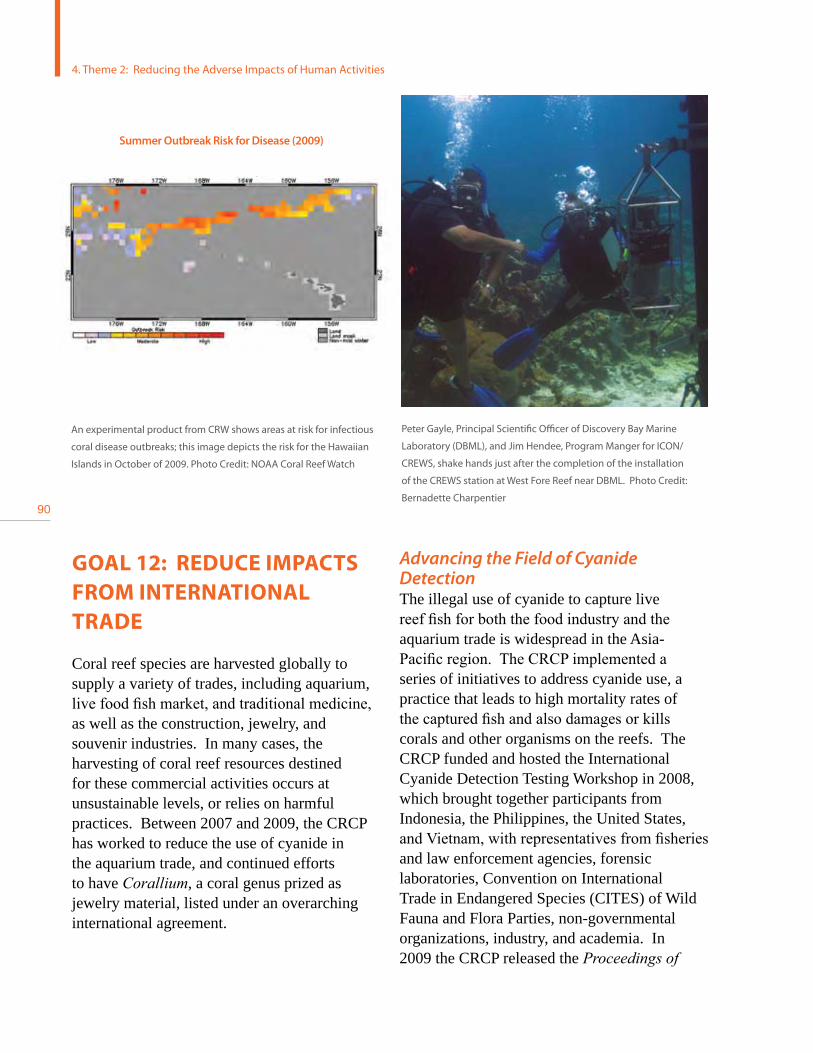
90
GOAL 12: REDUCE IMPACTS FROM INTERNATIONAL TRADE
Coral reef species are harvested globally to supply a variety of trades, including aquarium, live food fish market, and traditional medicine, as well as the construction, jewelry, and souvenir industries. In many cases, the harvesting of coral reef resources destined for these commercial activities occurs at unsustainable levels, or relies on harmful practices. Between 2007 and 2009, the CRCP has worked to reduce the use of cyanide in the aquarium trade, and continued efforts to have Corallium, a coral genus prized as jewelry material, listed under an overarching international agreement.
Advancing the Field of Cyanide Detection The illegal use of cyanide to capture live reef fish for both the food industry and the aquarium trade is widespread in the Asia-Pacific region. The CRCP implemented a series of initiatives to address cyanide use, a practice that leads to high mortality rates of the captured fish and also damages or kills corals and other organisms on the reefs. The CRCP funded and hosted the International Cyanide Detection Testing Workshop in 2008, which brought together participants from Indonesia, the Philippines, the United States, and Vietnam, with representatives from fisheries and law enforcement agencies, forensic laboratories, Convention on International Trade in Endangered Species (CITES) of Wild Fauna and Flora Parties, non-governmental organizations, industry, and academia. In 2009 the CRCP released the Proceedingsof
Peter Gayle, Principal Scientific Officer of Discovery Bay Marine
Laboratory (DBML), and Jim Hendee, Program Manger for ICON/
CREWS, shake hands just after the completion of the installation
of the CREWS station at West Fore Reef near DBML. Photo Credit:
Bernadette Charpentier
An experimental product from CRW shows areas at risk for infectious
coral disease outbreaks; this image depicts the risk for the Hawaiian
Islands in October of 2009. Photo Credit: NOAA Coral Reef Watch
4. Theme 2: Reducing the Adverse Impacts of Human Activities
Summer Outbreak Risk for Disease (2009)

91
NO
AA
CR
CP
2007 - 2009 Report to C
ongress
theInternationalCyanideDetectionTestingWorkshop, providing a framework to implement networks of detection laboratories to advance international efforts to enforce bans on this type of fishing.
Corallium CITES ListingIn 2007, the United States submitted a proposal to CITES Secretariat to list the entire genus of Corallium on Appendix II of CITES. Although the proposal was adopted in committee, during deliberations on the final day the listing was overturned. While the international community recognized the conservation needs of these species, the Parties requested two ad hoc events be organized in the Mediterranean Region and in the Pacific to address outstanding issues prior to resubmission of a proposal at the next CITES Conference of the parties.
Two workshops, funded by the CRCP, were convened to address challenges to implementing and enforcing a potential CITES Appendix-II
listing, and to assess available biological data to identify gaps, and determine whether these taxa meet the criteria for listing under CITES. The first workshop was held in March 2009, in Hong Kong, China, followed in September 2009 by the second workshop held in Naples, Italy.
The United States is currently in preparations to re-submit a revised proposal to CITES to list the entire family Coralliidae (genera Corallium and Paracorallium) on Appendix-II; the proposal will be voted on at the upcoming Conference of the Parties in March 2010.
GOAL 13: IMPROVE COORDINATION AND ACCOUNTABILITY
Given the immensity of the challenges facing coral reefs, the diverse set of agencies and programs involved in coral reef conservation, and the limited resources available, it is
Found mainly in the seas of the Mediterranean and Pacific, red and pink corals are primarily threatened by intensive harvesting to supply
international demand for jewelry and other products. Photo Credits: underwater shot by G. Tsounis, jewelry shot by: T. Montgomery, and dry
coral shot by: NOAA

92
imperative to have close coordination of the many activities undertaken, and to be accountable for producing tangible results. In 2009, the CRCP transitioned from addressing 13 threats to three to more efficiently plan and coordinate efforts to address these threats to coral reef ecosystems. This narrower focus improves the coordination and accountability of the Program. The first section of this report provides an overview of this process. The Program also works in close partnership with the USCRTF, a body that has helped coordinate work and initiatives across federal, state, and territorial entities.
The USCRTF was established in 1998 by Presidential Executive Order 13089 to lead U.S. efforts to preserve and protect coral reef ecosystems. Co-chaired by the Department of the Interior and the Department of Commerce though NOAA, the USCRTF includes leaders of 12 federal agencies, seven U.S. states, territories, commonwealths, and three Freely
Associated States. The USCRTF helps build partnerships, strategies, and support for on-the-ground action to conserve coral reefs.
Presidential Executive Order 13089: Coral Reef Protection, was issued to enhance the role of federal agencies in the preservation and restoration of coral reef ecosystems. The Executive Order establishes a policy framework to guide federal action and its impacts on coral reefs, and mandates that the federal agencies utilize their programs and authorities to protect and enhance the conditions of U.S. coral reef ecosystems, and, to the extent permitted by law, ensure that any actions they authorize, fund, or carry out will not degrade the conditions of such ecosystems. The Program also works in close partnership with the U.S. All Islands Coral Reef Committee, an initiative established in 1994 by the governors of each member jurisdiction.
The USCRTF is responsible for overseeing implementation of the Executive Order, and
Representatives of most of the agencies and territories that participate in the U.S. Coral Reef Task Force during the 20th meeting in Kona, Hawai`i.
Photo Credit: Bill Millhouser, NOAA
4. Theme 2: Reducing the Adverse Impacts of Human Activities

93
NO
AA
CR
CP
2007 - 2009 Report to C
ongress
developing and implementing coordinated efforts to map and monitor U.S. coral reefs; research the causes of, and solutions to coral reef decline; reduce and mitigate coral reef degradation from pollution, overfishing and other causes; and implement strategies to promote conservation and sustainable use of coral reefs internationally.
In 2000, the USCRTF adopted the NationalActionPlantoConserveCoralReefs, the first national blueprint for U.S. domestic and international action to address the growing coral reef crisis. To help implement this plan, the USCRTF launched a variety of initiatives, and provides a forum to support collaborative action of its members and partner organizations. In 2002, the USCRTF developed the U.S.CoralReefNationalActionStrategy to further implement the NationalActionPlan as called for in the CoralReefConservationActof2000. These documents provide the guiding
framework for the priorities, strategies, and actions of the USCRTF and its members.
In 2009, the USCRTF produced the FederalCoralProfiles,24 a document presenting an overview coral reef-related activities and programs of the federal agencies members of the Task Force.
At its meeting in Kona, Hawai`i, in August 2008, the USCRTF adopted the Kona Declaration, which acknowledged the urgency for action to conserve coral reefs:
“It is clear that the USCRTF, with partners, must significantly increase our collective effort to address the factors over which we can exercise control. The USCRTF must take immediate action to respond to these threats and, in turn, seek to sustain our coral reef ecosystems and the communities that depend upon them. Coral reefs are teetering on the edge of survival. Adverse effects of fishing, pollution, coastal development, and physical damage further undermine reef health, and consequently, that of the people and ecosystems depending upon them. High levels of greenhouse gases in the atmosphere have produced a lethal combination of hotter and more acidic seawater. Science has demonstrated that reef communities can recover when they are protected and stressors are removed. Urgent action is needed to reduce greenhouse gas emissions. In the meantime, precious time for coral reef ecosystems can be secured through increased protection from land and marine pollution, unsustainable fishing, development, and other stressors, all of which we know can damage coral health. The time to act is now.”25
24 Report available at http://coralreef.gov/intro/coralpupdated.pdf.
25 Resolution available at: http://coralreef.gov/meeting20/uscrtfstatement08.pdf

94
AOML Atlantic Oceanographic and Meteorological Laboratory
AUV Automated Underwater Vehicle
CaMPAM Caribbean MPA Managers Network and Forum
CDHC Coral Disease and Health Consortium
CFMC Caribbean Fishery Management Council
CITES Convention on the International Trade of Endangered Species
CLEO Coral Literature, Education and Outreach
CNMI Commonwealth of the Northern Mariana Islands
CoRIS Coral Reef Information System
CRCA Coral Reef Conservation Act
CRCP Coral Reef Conservation Program
CREIOS Coral Reef Ecosystem Integrated Observing System
CREWS Coral Reef Early Warning System
CRW Coral Reef Watch
ESA Endangered Species Act
GBRMPA Great Barrier Reef Marine Protected Area
GEF Global Environmental Facility (World Bank)
GMFMC Gulf of Mexico Fishery Management Council
ICON Integrated Coral Observation Network
IYOR International Year of the Reef
JIMAR Joint Institute for Marine and Atmospheric Research
LAS Local Action Strategy
MCD Marine Conservation District
MPA Marine Protected Area
NAVFAC Naval Facilities Engineering Command
NEPA National Environmental Protect ion Act
NFWF National Fish and Wildlife Fund
NMFS National Marine Fisheries Service
NOAA National Oceanic and Atmospheric Administration
Acronyms

95
NO
AA
CR
CP
2007 - 2009 Report to C
ongress
NWHI Northwestern Hawaiian Islands
OA Ocean Acidification
PAM Pulse-Altitude Modulating
PIFSC CRED Pacific Islands Fisheries Science Center Coral Reef Ecosystems Division
pCO2(sw) Partial Pressure of CO2 in Seawater
PIMPAC Pacific Islands Managed and Protected Areas Community
PRIA Pacific Remote Islands Area
RAMP Reef Assessment and Monitoring Program (Pacific)
SAFMC South Atlantic Fishery Management Council
SEFCRI South East Florida Coral Reef Initiative
SEM Socio-Economic Monitoring
SST Sea Surface Temperature
STXEEMP St. Croix East End Marine Park
USAID U.S.A. International Development
USCRTF U.S. Coral Reef Task Force
USDA U.S. Department of Agriculture
USVI U.S. Virgin Islands
WPRFMC Western Pacific Regional Fishery Management Council

96
ReferencesBellwood, D.R., T.P. Hughes, C. Folke, and M. Nystrom. 2004. Confronting the coral reef crisis. Nature 429: 827–833.
Bryant, D., L. Burke, J. McManus, and M. Spalding. 1998. Reefs at risk: A map-based indicator of threats to the world’s coral reefs. Washington, D.C.: World Resources Institute.
Caldeira, K., and M.E. Wickett. 2003. Anthropogenic carbon and ocean pH. Nature 425: 365.
De’ath, G., J.M. Lough, and K.E. Fabricius. 2009. Declining coral calcification on the Great Barrier Reef. Science 323: 116– 119.
Fabricius, K.E. 2005. Effects of terrestrial runoff on the ecology of corals and coral reefs; review and synthesis. Marine Pol-lution Bulletin 50: 125–146.
Field, M.E., S.A. Cochran, J.B. Logan, and C.D. Storlazzi (eds.). 2008. The coral reef of south Moloka`i, Hawai`i: Portrait of a sediment-threatened reef. U.S. Geological Survey Scientific Investigations Report 2007-5101.
Johns, G.M., V.R. Leeworthy, F.W. Bell, and M.A. Bonn. 2001. Socioeconomic study of reefs in southeast Florida. Final report. Hazen and Sawyer Environmental Engineers & Scientists.
Johns, G.M., J.W. Milon, and D. Sayers. 2004. Socioeconomic study of reefs in Martin County, Florida. Final report. Hazen and Sawyer Environmental Engineers & Scientists.
Hoegh-Guldberg, O., P.J. Mumby, A.J. Hooten, R.S. Steneck, P. Greenfield, E. Gomez, C.D. Harvell, P.F. Sale, A. J. Edwards, K. Caldeira, N. Knowlton, C.M. Eakin, R. Iglesias-Prieto, N. Muthiga, R.H. Bradbury, A. Dubi, and M.E. Hatziolos. 2007. Coral reefs under rapid climate change and ocean acidification. Science 318: 1737-1742.
Loper, C., R. Pomeroy, V. Hoon, P. McConney, M. Pena, A. Sanders, G. Sriskanthan, S. Vergara, M. Pido, R. Vave, C. Vieux, and I. Wanyoyi. 2008. Socioeconomic conditions along the world’s tropical coasts: 2008. NOAA Coral Reef Conservation Program, Silver Spring, MD.
Pandolfi, J.M., R.H. Bradbury, E. Sala, T.P. Hughes, K.A. Bjorndal, R.G. Cooke, D. McArdle, L. McClenachan, M. J.H. Newman, G. Paredes, R.R. Warner, and J.B.C. Jackson. 2003. Global trajectories of the long-term decline of coral reef ecosystems. Science 301: 955–958.
Richmond, R.H., T. Rongo, Y. Golbuu, S. Victor, N. Idechong, G. Davis, W. Kostka, L. Neth, M. Hamnett, and E. Wolanski. 2007. Watersheds and coral reefs; conservation science, policy, and implementation. Bioscience 57: 598–607.
Rogers, C.S. 1990. Responses of coral reefs and reef organisms to sedimentation. Marine Ecology Progress Series 62: 185–202.
Sabine, C.L., R.A. Feely, N. Gruber, R.M. Key, K. Lee, J.L. Bullister, R. Wanninkhof, C.S. Wong, D.W.R. Wallace, B. Tilbrook, F.J. Millero, T-H. Peng, A. Kozyr, T. Ono, and A.F. Rios. 2004. The oceanic sink for anthropogenic CO2. Science 305: 367-371.
U.S. Commission on Ocean Policy. 2004. An ocean blueprint for the 21st Century. Washington, D.C.
Waddell, J.E. 2005. The state of the coral reef ecosystems of the United States and Pacific Freely Associated States: 2005. NOAA Technical Memorandum NOS NCCOS 11. NOAA/NCCOS Center for Coastal Monitoring and Assessment’s Biogeography Team. Silver Spring, MD.

97
NO
AA
CR
CP
2007 - 2009 Report to C
ongress
Waddell, J., and A.M. Clarke (eds.). 2008. The state of the coral reef ecosystems of the United States and Pacific Freely As-sociated States: 2008. NOAA Technical Memorandum NOS NCCOS 73. NOAA/NCCOS Center for Coastal Monitoring and Assessment’s Biogeography Team. Silver Spring, MD.
Wilkinson, C. 2008. Status of the coral reefs of the world: 2008. Global Coral Reef Monitoring Network and Reef and Rain-forest Research Center. Townsville, Australia.
Wilkinson, C., and D. Souter. 2008. Status of Caribbean coral reefs after bleaching and hurricanes in 2005. Global Coral Reef Monitoring Network, and Reef and Rainforest Centre, Townsville, Australia.
Wusinich-Mendez, D., and C. Trappe (eds.). 2007. Report on the status of marine protected areas in coral reef ecosystems of the United States Volume 1: Marine protected areas managed by U.S. states, territories, and commonwealths: 2007. NOAA Technical Memorandum CRCP 2. NOAA Coral Reef Conservation Program, Silver Spring, MD.

98
Appendix: Spend Plan 2007, 2008, and 2009
GOAL FY07 FY08 FY09
1- Mapping U.S. Coral Reefs 2,155,500 2,343,608 2,532,968
2- Monitoring Coral Reef Health
4,917,500 5,606,705 5,741,977
3- Supporting Strategic Research
380,000 740,000 1,305,500
4- Understanding Socio-Economic Factors
30,000 100,000 70,000
5- Improving MPA use 2,484,153 1,089,705 1,023,600
6- Reducing Adverse Fishing Impacts
3,262,810 3,404,348 3,211,223
7- Reducing Impact of Coastal Use
1,994,750 2,147,750 2,539,031
8- Reducing Pollution 2,527,500 2,903,153 2,954,381
9- Restoring Damaged Reefs 1,612,500 1,867,750 1,940,223
10- Improving Outreach & Education
150,000 175,000 175,000
11- Reducing Threats to International Reefs
670,000 727,675 1,451,200
12- Reducing Impacts from Trade
62,000 145,000 120,000
13- Improving Coordination & Accountability 26 5,645,000 5,769,946 6,297,998
TOTAL $25,891,713 $27,020,640 $29,363,101
26 Includes CRCP headquarter program management and USCRTF support

100