north downtown mobility action program (nodo map)
TRANSCRIPT

1Department of TransportationKay YesuwanCommunity Coordination Committee (C3)12/05/19
North Downtown Mobility Action Program (NODO MAP)
Investments around North Downtown and the New Arena at Seattle Center

2Department of Transportation
Presentation Overview
• NODO Mobility Action Plan finalization• Scope• Schedule• Funding
• Highlights on project development process:• Broad Street Complete Streets• Protected Intersection at Dexter Ave N / Thomas St• Seattle Center to Waterfront Greenway
• Next Steps
• Websites

9Department of Transportation
NODO MAP Finalization and Execution Plan DevelopmentOct. 2018 to Dec. 2019 • Prioritize Tier 1 projects
• Assess how projects support guiding principals• Apply community input, agency support, system needs• Develop planning-level cost estimates for recommended projects• Leverage improvements by others• Determine schedule of projects based on anticipated new arena opening
date (mid-2021) and other projects’ schedules
• Refine project scope, assume project delivery method, identify team members, refine schedule and cost
• Update funding sources and partnerships to contribute to projects
• Finalization of NODO Mobility Action Plan (December 2019)
10Department of Transportation
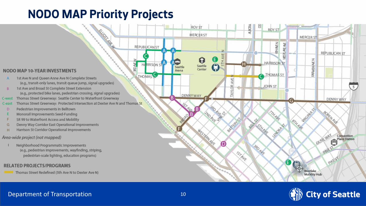
NODO MAP Priority Projects

11Department of Transportation
NODO MAP Funding Assumptions
•OVG will contribute $40 million over 39 years into a City Arena Transportation Fund → $1,025,000 per year
•Different ways to fund projects:• Leveraging existing SDOT projects and use OVG fund to augment existing funds
• Borrowing amount and then using OVG funding to service the debt over time
• Pay-as-you-go scenario, using OVG funding to closely match work completed per year
• Anticipate $9 million in improvements between now and 2021, and $28 million in the first 10 years when combined with existing programs, mitigation resources and other funding sources.

12Department of Transportation
NODO MAP Funding Assumptions

14Department of Transportation
NODO MAP Priority Projects
2018 2019 2020 2021 2022 2023 2024 2025 2026 2027 2028 2029
A: 1st Ave N and Queen Anne Ave N Complete
Streets
B: 1st Ave and Broad St Complete Street
Extension into Belltown
C-East: Thomas Street Greenway:
Thomas/Dexter Protected Intersection
C-West: Thomas Street Neighborhood
Greenway: Seattle Center to Waterfront
GreenwayD: Pedestrian improvements in Belltown (1st
Ave and Battery St signal)
E: Monorail Improvements Seed-Funding
F: Denny Way Corridor Signals⁺
G: Harrison St Corridor Signals⁺
H: SR 99 to Waterfront Access and Mobility
(Broad St) Signals⁺
I: Neighborhood Programmatic Improvements
Planning Design Construction Seed Funding
Project Year
18Department of Transportation
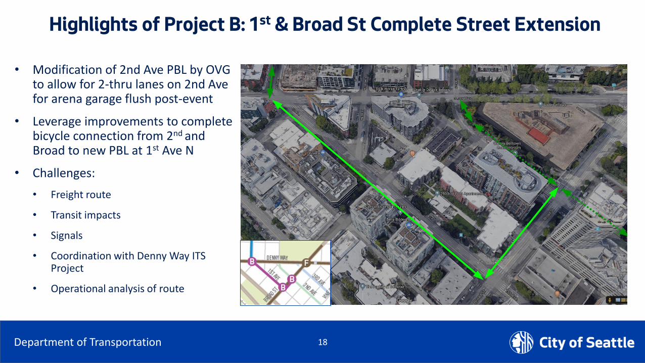
Highlights of Project B: 1st & Broad St Complete Street Extension
• Modification of 2nd Ave PBL by OVG to allow for 2-thru lanes on 2nd Ave for arena garage flush post-event
• Leverage improvements to complete bicycle connection from 2nd and Broad to new PBL at 1st Ave N
• Challenges:
• Freight route
• Transit impacts
• Signals
• Coordination with Denny Way ITS Project
• Operational analysis of route

19Department of Transportation
Thomas Street Redefined: 3 Key Transformative Elements• Plaza connecting Seattle Center
• Skate park connection• Half Block closure 5th to alley
• North Promenade Cross-Section• 36’ pedestrian and bicycle promenade• Multi-use pathway, sidewalk and
landscaping• 18’ roadway
• Dexter Ave Protected Intersection
• Bike facility connection
• Transit connection

20Department of Transportation
Highlights of Project C-East: Dexter/Thomas Protected Intersection
• Leverage the reconstruction of Thomas St across 7th Ave to facilitate east-west pedestrian and bicycle travel between South Lake Union and Uptown.
• Associated with Thomas Street Redefined
• Challenges:
• Active development in intersection
• Coordination with WSDOT construction, SCL design, private development
• Interim/early, permanent improvements
23Department of Transportation
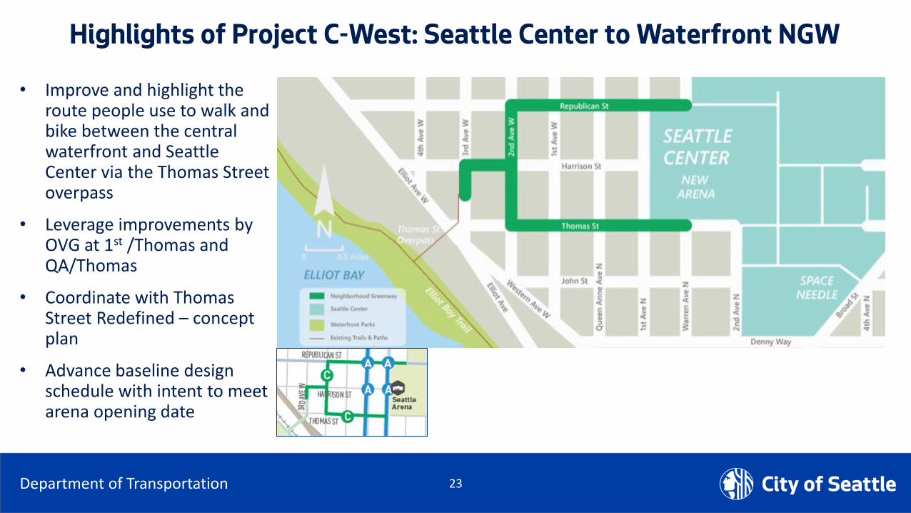
Highlights of Project C-West: Seattle Center to Waterfront NGW
• Improve and highlight the route people use to walk and bike between the central waterfront and Seattle Center via the Thomas Street overpass
• Leverage improvements by OVG at 1st /Thomas and QA/Thomas
• Coordinate with Thomas Street Redefined – concept plan
• Advance baseline design schedule with intent to meet arena opening date

24Department of Transportation
Highlights of Project C-West: Seattle Center to Waterfront NGW
THOMAS ST BETWEEN 1ST AVE N & QA AVE N –TRAFFIC, SIGNALS, AND PBL OPERATION REVIEW

25Department of Transportation
Highlights of Project C-West: Seattle Center to Waterfront NGW
• Collect existing speed and volume count
• Review existing locations of all-way stops
• Determine warrants for proposed all-way stops
• SDOT is also reviewing for all-way stops in between Denny Way and Mercer St, from Elliott Ave W to Seattle Center

26Department of Transportation
Highlights of Project C-West: Seattle Center to Waterfront NGW
REVIEWING OPTIONS FOR EASIER ACCESS ON AND OFF THOMAS ST OVERPASS

27Department of Transportation
Next Steps
Action Item
Continue stakeholder engagement Ongoing
Complete Thomas St Redefined Concept Plan from Elliott to Eastlake Q1 2020
Construct Interim Changes• 5th Ave N & Thomas St – Half Block Closure• Dexter Ave N & Thomas St – Right In/Right Out Diverter
Q1 2020
Advance Thomas St Redefined Design concepts at: • 5th Ave N to Taylor Ave N along Thomas• 6th Ave N to 7th Ave N along Thomas (adapt WSDOT work on northern block face)• Dexter to Terry
Design 2020
Advance design of Dexter & Thomas Protected Intersection Construction 2021
Advance design of Seattle Center to Waterfront Neighborhood Greenway Construction 2021
Advance design of Broad Street Complete Streets Construction 2021

28Department of Transportation
Websites
•NODO MAP• https://www.seattle.gov/transportation/NODOMAP
• Thomas Street Redefined• https://www.seattle.gov/transportation/projects-and-programs/programs/urban-design-program/street-design-concept-plans/thomas-street-redefined
•Seattle Center to Waterfront NGW• https://www.seattle.gov/transportation/projects-and-programs/programs/greenways-program/seattle-center-to-waterfront-greenway

29Department of Transportation
Comments/Questions?