north east lincolnshire employment land review · atkins north east lincolnshire employment land...
TRANSCRIPT

North East Lincolnshire Employment Land Review Cofely GDF-Suez & North East Lincolnshire Council
December 2014

Atkins North East Lincolnshire Employment Land Review December 2014
Notice
This document and its contents have been prepared and are intended solely for use by Cofely GDF-Suez and North East Lincolnshire Council in relation to issues of employment land need and supply.
Atkins Ltd assumes no responsibility to any other party in respect of or arising out of or in connection with this document and/or its contents.
This document has 130 pages including the cover.
Document history
Revision Purpose description Originated Checked Reviewed Authorised Date
Rev 1.0 Draft Final PB ID RC RC Dec 14
Rev 2.0 Final PB RA ID RC Jan 15

Atkins North East Lincolnshire Employment Land Review December 2014
Table of contents
Section
1. Introduction 5 Background and Objectives 5 Structure 5
2. Policy Context 6 Introduction 6 National Policy Context 6 Sub Regional Context 7
3. Socio-Economic Profile 16 Introduction 16 Population 16 Businesses 16 Employment 18 Labour Market 20 Unemployment 20 Skills 21 Deprivation 22
4. The Local Property Market 24 Introduction 24 4.5. Offices 24 Industrial 26
5. Future Employment Needs 29 Introduction 29 Future Growth Scenarios 31 Atkins Baseline Scenario 33 Policy Scenario 1: Moderate Growth 34 Policy Scenario 2: High Growth 36 Policy Led Scenario Considerations 37 Site and Location Preferences 39 Conclusions 40
6. Employment Land Supply 42 Introduction 42 Existing Employment Floorspace 42 Vacant Floorspace 44 Major Planning Consents 44 Land Supply 44 Constraints to Aggregate Supply 47 Sites reserved for long term owner use 47 Ecological Mitigation Areas 47 Constraints to Supply Summary 48 Suitability of Supply 49 Key Messages 52
7. Conclusions and Policy Implications 54 Policy Drivers 54 Playing a Strategic Economic Role in Key Sectors 54 Building a Balanced Economy 55

Atkins North East Lincolnshire Employment Land Review December 2014
Ensuring Quality of Supply Meets Future Needs 55 Integrated Economic Development Strategy 56
Appendix A. Employment Site Plan 57
Appendix B. Site Assessments 59
Appendix C. Overall Supply Assessment Conclusions Table 122
Tables Table 1: Proposed actions by theme in Humber SEP 9 Table 2: Actions proposed for sector support in Greater Lincolnshire SEP 10 Table 3: Development & Growth Plan 2012 – Sector Aims 14 Table 4: Population by local authority area (2008-2013) 16 Table 5: Distribution of businesses by size (2014) 17 Table 6: Distribution of businesses by sector (2014) 17 Table 7: Employment by sector (2012) 19 Table 8: Annual gross earnings of residents (2013) 22 Table 9 - Translating Employment SIC to B Use Class Categories (% employment by SIC) 30 Table 10: Employment Density and Plot Ratio Assumptions 30 Table 11 - Underlying Employment Growth Rates by Sector Group and Scenario 2013-2032 33 Table 12: Employment Forecast: Atkins Baseline Scenario 33 Table 13: Atkins Baseline Scenario: B-Use Job Growth 2013-2032 34 Table 14: Atkins Baseline Scenario: B-Use Floorspace and Land Demand 2013-2032 34 Table 15: Policy Scenario 1: Moderate Growth – Employment Change 2013-2032 35 Table 16: Policy Scenario 1: (Moderate Growth) B-Use Job Growth 2013-2032 35 Table 17: Policy Scenario 1: (Moderate Growth) B-Use Floorspace & Land Demand 2013-2032 36 Table 18: Policy Scenario 2: High Growth – Employment Change 2013-2032 36 Table 19: Policy Scenario 2: (High Growth) B-Use Job Growth 2013-2032 37 Table 20: Policy Scenario 2: (High Growth) B-Use Floorspace & Land Demand 2013-2032 37 Table 21: Indicative Employment Land Requirements by key sector 2013-2032 38 Table 22: Typical Site and Location Preferences by Sector 39 Table 23: Vacant Floorspace (sqm) and Vacancy rate by Use Class 42 Table 24: Total Assessed Land Supply 44 Table 25: Site Appraisal Assessment Methodology 45 Table 26: Constraints Evaluation Typology 46 Table 27: Land Supply Summary Table 48 Table 28: Summary Site Assessments 49
Figures Figure 1: Business density (number of enterprises per 10,000 population aged 16-64, 2013) 18 Figure 2: Change in employment by sector (2009-2012) 20 Figure 3: Unemployment rate, 2005-2013 21 Figure 4: % of Working Age Population (16-64) with Level 4 Qualifications 21 Figure 5: % of Working Age Population (16-64) with No Qualifications 22 Figure 6: Number of Office and Industrial Transaction 2009-2013 24 Figure 7: Total office floorspace availability in NEL 2009-2013 25 Figure 8: Office floor space, availability and enquiries (sq ft) 2009 - 2013 26 Figure 9: Total industrial floorspace availability in NEL 2009-2013 27 Figure 10: Industrial floor space (sq ft), availability and enquiries 2009 - 2013 28 Figure 11: B-Class Floorspace in North East Lincolnshire 2002-2012 43 Figure 12: B-Class occupied Floorspace by Sub Area 43 Figure 13: Ecological mitigation areas and Employment Sites 48 Figure 14: Constrained total Assessed Supply Land 49

1. Introduction
Background and Objectives 1.1. Atkins Ltd was commissioned in 2014 to undertake an Employment Land Review on
behalf of Cofely GDF-Suez and North East Lincolnshire Council (NEL). The purpose of the study was to provide a robust evidence base and associated policy recommendations to assist in the development of policies in the Council’s Emerging Local Plan. The report should be read in conjunction with three related strands of research:
North East Lincolnshire Local Economic Assessment, 2014.
North East Lincolnshire Key Sectors Study, 2014.
North East Lincolnshire Economic Futures Report, 2014.
1.2. This study is concerned specifically with employment land and premises that fall within the “B-class” of the Town and County Planning (Use Classes) Order 1987 (as amended) (the “UCO”). Specifically the UCO identifies the following categories for employment land within the “B-class”:
Class B1 – Business: Use for all or any of the following purposes:
(a) as an office other than a use within Class A2 (financial and professional services).
(b) for research and development of products and processes, or (c) for any industrial process, being a use which can be carried out in any
residential area without detriment to the amenity of that area by reason of noise, vibration, smell, fumes, smoke, soot, ash, dust or grit.
Class B2 – General Industrial: Use for carrying on of an industrial process other than one falling within Class B1 above.
Class B8 – Storage or Distribution: Use for storage or as a distribution centre.
1.3. The employment scenarios set out in section 5 mirror those provided in the Economic Futures report. These cover all sectors of the economy. The report also considers the role which mixed use development can play in meeting the demand for B-class activities in the Borough.
Structure 1.4. The structure of the report is as follows:
Chapter 2 provides an up-to-date review of the national and local policy context.
Chapter 3 sets out the socio-economic profile of North East Lincolnshire.
Chapter 4 reviews the distinguishing features of the local and sub-regional commercial and industrial property market.
Chapter 5 considers scenarios of future demand for employment land in North East Lincolnshire.
Chapter 6 assesses the existing and future potential supply of employment land in the Borough.
Chapter 7 sets out our conclusions and policy recommendations.
Atkins North East Lincolnshire Employment Land Review December 2014
2. Policy Context
Introduction 2.1. This section provides an updated policy context for the study and sets out
conclusions on the implications of the policy review for North East Lincolnshire. The review has included an assessment of the relevant local, regional and national policy context including the NPPF and emerging guidance. The Council’s existing policy approach has also been reviewed.
National Policy Context
National Planning Policy Framework (NPPF)
2.2. The National Planning Policy Framework (NPPF), paragraph 158, outlines the requirement for local planning authorities to ensure that their Local Plan is based on adequate, up-to-date and relevant evidence about the economic, social and environmental characteristics and prospects of their area. Local planning authorities are asked to ensure that their assessment of strategies for housing, employment and other uses are integrated, and that they take full account of relevant market and economic signals.
2.3. The NPPF states that local planning authorities should have a clear understanding of business needs. They should prepare and maintain a robust evidence base to understand both existing business needs and likely changes in the market and to work closely with the business community to understand their changing needs and identify and address barriers to investment, including a lack of housing infrastructure or viability.
2.4. Paragraph 161 of the NPPF asks local planning authorities to use this evidence base to assess:
The need for land or floorspace for economic development, including both the quantitative and qualitative needs for all foreseeable types of economic activity over the plan period, including for retail and leisure development; and
The existing and future supply of land available for economic development and its sufficiency and suitability to meet identified needs. Reviews of land available for economic development should be undertaken at the same time as, or combined with, strategic housing land availability assessments (SHLAAs) and should include a reappraisal of the suitability of previously allocated land.
Planning Practice Guidance
2.5. The Department for Communities and Local Government’s Planning Practice Guidance (PPG) is a web-based resource that brings together planning practice guidance for England in an accessible and usable way. The PPG guidance regarding housing and economic land availability assessments and housing and economic land availability assessments is of particular relevance to employment land studies.
2.6. PPG states that the assessment of economic development needs should take into consideration:
Recent patterns of employment land supply and loss to other uses (based on extant planning permissions and planning applications);

Atkins North East Lincolnshire Employment Land Review December 2014
Market intelligence (from local data and discussions with developers, property agents and local businesses) and market signals, such as levels and changes in rental values, and differentials between land values in different uses;
Potential infrastructure constraints;
The existing stock of employment land including recent statistics on take-up of sites;
Likely future business needs and future market requirements, including locational and premises requirements of particular types of business; and
Identification of oversupply and evidence of market failure.
2.7. In terms of forecasting future trends, PGG states that Plan makers should consider forecasts of both quantitative and qualitative need and future needs should be broken down by economic sectors. Plan makers should use a range of techniques to assess future employment land requirements including:
Sectoral and employment forecasts and projections (labour demand).
Demographically derived assessments of future employment needs (labour supply techniques).
Analyses based on the past take-up of employment land and property and/or future property market requirements.
Consultation with key stakeholders, studies of business trends, and monitoring of business, economic and employment statistics.
2.8. Projected demand should then be compared to the available stock of land so that any gaps in local employment land provision can be identified. Sites or broad locations should be assessed in terms of their suitability for development, availability and realistic likelihood of coming forward for development.
2.9. PPG also advises that local planning authorities should assess their development needs working with other local authorities in the relevant housing market area or functional economic market area in line with the duty cooperate. This is because such needs are rarely constrained precisely by local authority administrative boundaries. The duty to cooperate does not mean local authorities need to necessarily agree with their neighbouring local authorities but they should make every effort to secure the necessary cooperation on strategic cross boundary matters before they submit their Local Plans for examination.
Sub Regional Context 2.10. The government initiated the establishment of Local Enterprise Partnerships (LEPs)
in June 2010, based on functional economic areas. Local authorities and LEPs are charged with stimulating development that is aligned with broader government policy objectives regarding rebalancing the economy away from public sector employment and over-reliance on a narrow range of sectors, including financial services.
2.11. NEL forms part of two LEPs: the Humber LEP and the Greater Lincolnshire LEP (south of the Humber). Both LEPs have published strategic economic plans (SEPs), which provide direction for the future economic development of their respective areas. Though the areas have different economic and social characteristics, there is a degree of overlap between the actions proposed in the SEPs.
Humber LEP’s Strategic Economic Plan 2014-2020
2.12. The Humber SEP emphasises the Humber estuary as a national asset and the basis for economic opportunities in the region, particularly in regards to the expanding offshore wind sector. The plan states an ambition for the Humber ‘Energy Estuary’ to
Atkins North East Lincolnshire Employment Land Review December 2014
become “a renowned national and international centre for renewable energy and an area whose economy is resilient and competitive”, demonstrating the importance of this sector for the future of the regional economy.
2.13. Feeding into this ambition are three visions: economy - for a thriving renewable energy sector supported by access to finance and capital schemes; skills - a better-aligned skills system and reduction in the proportion of the population with no qualifications; and place – with a strong visitor economy, increased civic pride and improved infrastructure and housing, including addressing flooding and coastal erosion.
2.14. Barriers to growth identified in the SEP include:
A relatively low skills level amongst the workforce, particularly reflected by the high proportion of the population with no qualifications and a relatively low proportion with advanced qualifications. This is matched by a local economy with an over-reliance on low-skilled employment.
Relatively high levels of economic inactivity, unemployment and long-term sickness. Whilst economic activity in NEL is not far from the national average, the area does have high levels of unemployment and long-term sickness.
Poor business survival and growth complemented by relatively low take-up of national business support programmes. NEL has seen particularly low rates of business survival in recent years, almost half those of areas elsewhere in the Humber area.
Priority Sectors
2.15. Priority sectors identified in the SEP include renewable energy, ports and logistics, chemicals, food and the visitor economy. Given the overlap with NEL’s priority sectors, the relevance of the LEP’s aims in developing these sectors is clear.
For the ports and logistics sector, the SEP notes that the offshore renewable
sector represents the greatest opportunity for growth. Key activities proposed
to support the sector include developing the Grimsby Port Delivery Plan (to
include several infrastructure improvements), stimulating the expansion of
specialist businesses (including prioritising physical developments), business
and supply chain support and skills development programmes for local
residents.
For the chemicals sector, activities identified in the plan include fostering links
between employers and skills providers in order to ensure labour supply
meets demand and to promote innovation, skills development programmes
and improving business support.
Food is another key sector for both NEL and the Humber LEP. In particular,
the SEP highlights the potential for encouraging linkages between NEL’s
seafood cluster and the sector elsewhere in the region, including collaboration
with the Greater Lincolnshire LEP. Key support activities for the sector include
targeted supply chain support and support in accessing international markets,
cross-LEP projects and collaboration between local specialists, closer links
with training providers and support to companies in accessing higher
education expertise to facilitate innovation.
In terms of the visitor economy, the SEP notes the importance of heritage
coastline and seaside resorts in NEL, and that Cleethorpes has witnessed one
of the largest increases in coastal house prices in the past decade. Key
support activities include skills development programmes, promotion of the
Humber as a location for national and international events, development and
Atkins North East Lincolnshire Employment Land Review December 2014
promotion of the area’s natural and built environment, and supporting
businesses in taking advantage of opportunities presented by the sector.
Proposed actions and developments
2.16. Proposed actions and developments are organised across five themes. These are presented in
2.17. Table 1 along with selected projects.
Table 1: Proposed actions by theme in Humber SEP
Theme Direct relevance to NEL Indirect relevance
Creating an infrastructure that supports growth
A160/A180 Port of Immingham improvement
Improving connectivity between port facilities and renewables development sites
Encouragement of strategic employment sites, including Europarc
Address quality of place issues to attract and retain skilled workers, including Grimsby town centre
Reinstate services from Hull to Manchester Airport
Improving broadband connectivity
Supporting businesses to succeed
Humber LEP Growth Hub
SME Growth and Innovation Programme
Providing finance to support entrepreneurship
Promoting and supporting research collaboration in priority sectors
A great place to live and visit
Sustainable urban extension for Grimsby
Regeneration of Cleethorpes promenade
Support plan-led housing growth
Ensure schemes delivered under Affordable Homes Programme
Adapt existing homes in response to climate change, to improve energy efficiency and flood resilience
A skilled and productive workforce
Environmental Logistics Learning Hub (Grimsby Institute)
CATCH Energy Offshore to support O&M providers based in Port of Grimsby
Humber Skills Fund
Apprenticeship Hub
Humber Energy Campus/Humber University Technical College
Provide support to skills providers to introduce new courses
Flood risk and environmental management
Maximise benefits of flood defence schemes by linking them with other proposals such as the Grimsby Docks Flood Defence Scheme.
Support studies to inform flood defence schemes
Continue with the Humber Flood Risk Management Strategy
Promote sustainable development
Greater Lincolnshire LEP Strategic Economic Plan
Aims and vision
2.18. The Greater Lincolnshire SEP presents a range of actions projected to, on the basis of continued EU funding, increase the value of the area’s economy by £3.2 billion, assist 22,000 businesses and create 13,000 jobs. Taking actions across a range of

Atkins North East Lincolnshire Employment Land Review December 2014
themes including housing, infrastructure, business support and the environment, the plan aims to maintain local strengths in the agri-food, manufacturing and engineering and visitor economy sectors, whilst promoting growth in the low carbon, port and logistics and health and care sectors.
2.19. The plan identifies current challenges to growth in the area as including:
Under-developed road and rail infrastructure, constraining supply chains, labour markets and access to markets.
Investment in flood defences and water management is required to unlock economic and housing growth.
Housing growth and community services provision is required to support economic growth
Youth unemployment and low skills levels in parts of Greater Lincolnshire constrain growth and limit the economic opportunities available to young people.
Priority Sectors
2.20. Various actions are proposed in the SEP to support existing and expanding sectors, many of which overlap with NEL’s priority sectors. These are presented in Table 2
Table 2: Actions proposed for sector support in Greater Lincolnshire SEP
Sector Actions
Agri-food Drive product and process innovation through the development of innovation hubs, including Humber Seafood Institute
Invest in infrastructure, including at the Port of Immingham
Increase supply of high-quality food-grade industrial accommodation
Build capacity and competitiveness of supply chains to address issues around energy costs, water resource management and workforce skills
Develop skills base to facilitate access to apprenticeships and employment opportunities
Facilitating expansion of Europarc through infrastructure investment, in collaboration with Humber LEP
Manufacturing & engineering
Maintain supply of high-quality serviced employment sites and premises across Greater Lincolnshire, including promoting Enterprise Zones in NEL
Encourage employer engagement in apprenticeships and workforce developments through de-risking investment in training
Unlock development and housing land, including in Grimsby
Unlock development of key sites on the South Humber Bank to support the renewable and chemicals sectors
Rail gauge investment between Immingham and the East Coast mainline at Doncaster to enhance rail freight capacity
Visitor economy Work with public and private sector partners to extend network of visitor attractions across Greater Lincolnshire
Simplify and coordinate online presence in partnership with Visit England
Enhance quality of visitor experience through supporting the development of the visitor accommodation/hospitality sectors and delivering investment in local visitor infrastructure
Develop customer service and other skills of workforce
Resort renaissance programme for Cleethorpes, including providing a site for major hotel, conference and leisure developments and integrating public-realm improvements with upgrades to flood defences
Improve frequency of services between Doncaster and Cleethorpes

Atkins North East Lincolnshire Employment Land Review December 2014
Sector Actions
Development of Ice Factory in Grimsby as major new attraction
Low carbon Raise awareness of supply chain opportunities and build capacity and capability of local firms to secure contracts
Work with skills providers to deliver increased low carbon apprenticeships and training opportunities
Support research and development and technology transfer
Develop the Humber Energy Campus and CATCH facility
Deliver an integrated supply-chain development programme
Improve infrastructure at the Port of Grimsby Enterprise Zone
Ports & logistics Port of Grimsby access and employment programme
Rail gauge investment between Immingham and Doncaster
Humberside Airport surface access improvements
Proposed Cross-Sector Actions and Developments
2.21. The SEP proposes various infrastructure, housing and business support projects and initiatives to promote growth across sectors, with particular relevance for NEL.
2.22. In terms of improving the availability of housing and employment land, the SEP proposes:
The development of Freeman Street and West & East Marsh Road in Grimsby, to assist 166 businesses and create 280 housing units.
Creating 600 housing units and creating employment land elsewhere in key employment zones in North East Lincolnshire.
The Lincolnshire Lakes development in North Lincolnshire is also targeted to create employment land and provide 600 housing units.
2.23. Proposed infrastructure investment includes several growth corridors within NEL:
The M180/A180 Scunthorpe to Grimsby route.
The A16 Grimsby to Louth route.
As mentioned, rail routes between Doncaster and Cleethorpes will receive gauge improvements, allowing for greater freight transport.
2.24. The LEP also intends to support small businesses by improving the provision of information and support in accessing finance, to be implemented and coordinated through a one-stop Growth Hub.
Enterprise Zones
2.25. The Humber LEP was successful in having eight areas designated as Enterprise Zones, which enables accelerated planning procedures and discounted business rates as incentives to encourage key businesses to the areas. Of particular relevance to this study, Enterprise Zones in the area include:
Port of Grimsby; and
Able Marine Energy Park
Port of Grimsby East Enterprise Zone
2.26. The Port of Grimsby East Enterprise Zone specifically targets operations and maintenance (O&M) and associated supply chain activity for the offshore wind power industry. Enterprise zone status entails a business rate discount worth up to

Atkins North East Lincolnshire Employment Land Review December 2014
£275,000 per business over a five-year period1, which is intended to accelerate the development of supply chain and support service businesses.
2.27. This Enterprise Zone designation builds upon port owner Associated British Port’s (ABP) intentions for the Port of Grimsby to be “at the forefront of the developing offshore wind industry”2, particularly in operations and maintenance and associated supply chain activity.
Able Marine Energy Park Enterprise Zone
2.28. Although the ABLE Marine Energy Park is located outside of NEL in North Lincolnshire, it is expected to be a significant economic driver for growth in the renewables and ports sectors in the Humber area generally. Indeed, Immingham and Grimsby are the main urban areas in closest proximity to the Enterprise Zone. The park offers business rate discounts and enhanced capital allowances on plant and machinery. These are aimed at incentivising investment from large renewables manufacturing companies.
Regional Growth Fund
2.29. The Regional Growth Fund supports projects and programmes that use private sector investment to stimulate economic growth and sustainable employment. The government established the Regional Growth Fund with two objectives:
To encourage private-sector enterprise by providing support for projects with the significant potential for economic growth and additional sustainable private-sector employment; and
To support in particular those areas and communities that currently depend on the public sector to make the transition to sustainable private-sector-led growth and prosperity.
2.30. As an area which falls within two LEPs, businesses in NEL are able to access the Regional Growth Fund programmes for both the Humber and Greater Lincolnshire. Following a successful bid made by the Humber LEP and NELC, £30 million was awarded to the Humber area. Approximately £10 million is aimed at enabling further development of the renewable energy sector on the south Humber bank (within North East and North Lincolnshire). It is estimated that the £30 million of funding will unlock £120 million worth of private sector investment.
Local Planning Policy
2.31. The upcoming Local Plan will deliver the Council’s spatial strategy, setting out planning policies to guide development in NEL. This research document will feed into the evidence base for the new plan. Other evidence-gathering activities are planned and further consultation is being undertaken to contribute to the evidence base and vision. Once completed, the identified preferred options will be published for general consideration.
2.32. Currently, the economic priority for the area, as set out in the spatial objectives of the Core Strategy Revised Preferred Options Paper, is to “support the growth of the local economy in ways which are compatible with environmental objectives, creating conditions that sustain more and better jobs, remove the barriers to accessing jobs
1 At time of writing only a few enterprise zones have secured enhanced capital allowances for companies.
2 http://www.abports.co.uk/Our_Locations/Grimsby_Immingham/Grimsby/

Atkins North East Lincolnshire Employment Land Review December 2014
and raising skills including support for rural regeneration and diversification and strengthening of the tourism offer3.
2.33. A number of relevant issues were raised in the consultation undertaken in December 2012, including:
A need to effectively work on priorities across boundaries;
The consideration of sustainability in development;
A requirement for a strong and competitive economy which considers the local characteristics and distinctiveness;
Responses to environment challenges (e.g. waste water and flooding); and,
How developments could impact upon the area spatially.
2.34. The previous Local Plan was adopted over 10 years ago in 2003. The Plan identified key sector development policies and proposals including energy generation from renewable resources and wind turbine facilities. A number of policies have been saved from the previous plan which include:
Policy E1: Industrial Land.
Policy E2: Estuary Related Land.
Policy E3: Operational Port Area.
Policy E4: Land adj. Railway, Habrough.
Policy E5: Manby Hall Business Park, Immingham.
Policy E6: Europarc III
Policy E7: Convamore Road, Grimsby.
Policy E8: Station Road, Great Coates.
Policy E9: Former Bass Site, Birchin Way, Grimsby.
Policy E10: Macaulay Lane, Grimsby.
Policy E11: Grimsby District Hospital.
Policy E12: Peaks Lane, Grimsby.
Policy E14: Hewitts Avenue Business Park, New Waltham.
Policy E15: Wilton Road, Humberston.
Policy E16: Waltham Airfield.
Policy E17: Other Sites for Employment Sites.
Policy E19: Farm Diversification.
Policy E20: Strategic Employment Exceptions at Europarc IV. 2.35. The new Local Plan should support existing business sectors, taking account of
whether they are expanding or contracting and, where possible, identify and plan for emerging sectors likely to locate in the area.
Strategic Housing Market Assessment (SHMA) 2013
2.36. The SHMA (2013) provided an assessment of future population and household change under several scenarios. These ranged from growth of 5,490 to 9,375 additional households in the period up to 2030. However, the report did not include a strongly proactive policy scenario with the aim of capturing effects on housing demand and supply arising from investment in key sectors and including recent activity in the renewables sector.
Development and Growth Plan 2012
2.37. Produced by NELC in November 2012, the focus of the Development and Growth Plan was clearly targeted at several key sectors: ports and logistics; renewables; chemicals and process industries; food processing; and visitor economy, services
3 http://consult.nelincs.gov.uk/portal/localdevelopmentplans/cs/corestrategyrpo?pointId=1207924352226

Atkins North East Lincolnshire Employment Land Review December 2014
and retail (Table 2-3). The plan seeks “to strengthen the overall economy and ensuring that growth benefits all sectors, including inter-dependent supply chains which are integral to the area’s economic success” and “represents a shift of focus to our key economic growth sectors and their priorities, as detailed in the governance chart opposite”. Some of the key themes of the Plan are summarised in Table 3.
Table 3: Development & Growth Plan 2012 – Sector Aims
Sector Aim
Ports & Logistics Promote the Humber Port complex with a focus on Immingham and Grimsby together with developing the logistics offer.
Food Manufacturing Secure, sustain and grow this primary sector within North East Lincolnshire to become the UK’s leading food manufacturing cluster
Renewables & Energy Establish North East Lincolnshire as the leading operations and maintenance centre for offshore wind and to facilitate the provision of energy security to industry.
Chemicals Support our global and local partners to sustain and grow this established sector within North East Lincolnshire.
Visitor Economy, Service & Retail
Enhance the visitor economy and retail offer in North East Lincolnshire. This sector is essential for developing quality of life benefits for the community and businesses, making it a good place to live as well as offering excellent development opportunities.
Cross Sectoral Themes
Environment & Infrastructure
Create the environment & infrastructure for growth including improvements or modifications to the energy security, transport, highways, flooding, coastal defence and quality of life.
Employment & Skills Develop a workforce fit for industry with skills which complement the sectors above.
Investment & Trade Establish North East Lincolnshire as the location for investment.
SME Business Support Build a diverse and resilient SME population.
Retail and Hotel Studies
2.38. Retail studies conducted in 2005 and 2013 provide a detailed evidence base on the vitality of the local area, current floorspace and a future framework in planning for retail needs. The recommendations from the 2013 study identify the need for a borough hierarchy to identify Grimsby town centre as a sub-regional centre, followed by Cleethorpes and Immingham as town centres, and with Freeman Street downgraded in order to better reflect the type of retail and service uses now found in the existing area.
2.39. Hotel studies conducted for NEL include the updated 2014 hotel study which identifies the development of proposed new hotel schemes: Premier Inn; Holiday Inn Express; and a 40 room extension to the four-star Humber Royal Hotel to meet short-term demand. The need for another hotel is also identified with the requirement for an additional hotel of approximately 100 rooms to accommodate largely business demand.
Issues Papers
2.40. Several Issues Papers have been prepared to support the progression of the new Local Plan for NEL. The most relevant to this document are the issues papers on Town and Local Centres paper and Economy
2.41. The Town and Local Centre paper discusses the three town centres in NEL: Grimsby, Immingham and Cleethorpes and identifies the strengths, weaknesses and opportunities for each area. It suggests that the role of Grimsby’s as a sub-regional town centre and Cleethorpes and Immingham as town centres. Also identified are

Atkins North East Lincolnshire Employment Land Review December 2014
specific issues to be addressed at each town centre including development of clear strategies and town centre boundaries for each centre and promoting / clarifying roles of key streets and localities.
2.42. The Economy issues paper considers a number of issues including outlining the key strategies and plans, examining the potential growth in key sectors of the local economy, defining the type of land and premises required and the amount needed to accommodate identified economic growth. The paper also recognises the specific requirement to safeguard the integrity of the Humber Natura sites. It concludes by identifying key priorities including the need to provide sufficient sites in the right locations to meet future economic requirements and the needs of modern occupiers and investors (which will be developed through the ELR).

Atkins North East Lincolnshire Employment Land Review December 2014
3. Socio-Economic Profile
Introduction 3.1. This section sets out a socio-economic profile of North East Lincolnshire to provide
the socio-economic context which shapes employment land demand and supply factors in the study area. It provides an important context for understanding economic demand and needs, having regard to the wider regional and national economies.
3.2. More detailed socio-economic analysis is available in the Local Economic Assessment and Key Sector Study reports completed by Atkins for North East Lincolnshire Council (2014). These provide further detail on business, employment and labour market characteristics.
Population 3.3. The population of North East Lincolnshire, as estimated by ONS mid-year population
estimates, equalled 159,800 for 2013. The population has exhibited low rates of growth over recent years, with an annual growth rate (0.12%) lower than all the other comparator areas other than Hull (0.06%).
Table 4: Population by local authority area (2008-2013)
Area 2008 2009 2010 2011 2012 2013 Annual Growth
Rate
East Riding of Yorkshire 332,500 332,700 333,600 334,700 335,900 336,000 0.17%
Kingston upon Hull, City of 256,700 256,100 256,200 256,100 257,200 257,600 0.06%
North East Lincolnshire 158,700 158,700 159,000 159,700 159,700 159,800 0.12%
North Lincolnshire 164,500 165,600 166,500 167,500 168,400 168,800 0.43%
Greater Lincolnshire LEP 1,024,000 1,029,900 1,037,300 1,042,000 1,046,900 1,053,000 0.47%
Humber LEP 912,400 913,100 915,300 918,000 921,200 922,200 0.18%
Source: ONS MYPE 2013
3.4. The age profile of North East Lincolnshire is becoming increasingly distributed towards older age groups. This is part of a national ageing phenomenon and the population of North East Lincolnshire is expected to continue to age, in particular due to contraction in the number of individuals in the 16-24 age group (decline of 4,600 individuals of working age by 2021).
Businesses 3.5. There are 5,150 business units4 in North East Lincolnshire. Business structure is dominated (78%
of businesses) by micro businesses of 0 – 9 employees. The area has a relatively high proportion of small businesses with 10-24 employees, compared to the national profile.
4 Nomis business counts.

Atkins North East Lincolnshire Employment Land Review December 2014
Table 5: Distribution of businesses by size (2014)
North East Lincolnshire England
Employment Sizeband Count % Count %
Total 5,150 100.0% 2,322,375 100.0%
Micro (0 to 9) 4,045 78.5% 1,930,945 83.1%
Small (10 to 49) 885 17.2% 315,625 13.6%
Medium-sized (50 to 249) 190 3.7% 65,820 2.8%
Large (250+) 30 0.6% 9,985 0.4%
Source: ONS Enterprise Counts 2014. Note: It should be highlighted that the count of business units provided above may not be fully consistent with business unit data provided in the Sectors Study report. This is because the latter, for sampling purposes, sources data from the Inter-departmental business register (IDBR) which counts businesses registered for VAT and/or PAYE purposes. The ONS enterprise counts estimate all individual workplace sites which will include businesses not registered for VAT / PAYE.
3.6. The borough’s employment profile is skewed toward large businesses when compared to the national average. Relatively large employers include those in key sectors such as energy, chemicals and food processing
3.7. The area has a lower than average concentration of businesses in high value sectors including information and communication, financial and insurance, professional, scientific and technical and business administration and support services
Table 6: Distribution of businesses by sector (2014)
Industry North East Lincolnshire
England
1 : Agriculture, forestry & fishing (A) 1.4% 4.4%
2 : Mining, quarrying & utilities (B,D and E) 0.8% 0.6%
3 : Manufacturing (C) 7.3% 5.3%
4 : Construction (F) 12.5% 10.2%
5 : Motor trades (Part G) 4.5% 3.0%
6 : Wholesale (Part G) 5.5% 4.9%
7 : Retail (Part G) 16.2% 10.7%
8 : Transport & storage (inc postal) (H) 6.3% 3.2%
9 : Accommodation & food services (I) 7.1% 6.2%
10 : Information & communication (J) 2.1% 7.1%
11 : Financial & insurance (K) 1.8% 2.6%

Atkins North East Lincolnshire Employment Land Review December 2014
12 : Property (L) 2.7% 3.7%
13 : Professional, scientific & technical (M) 9.6% 15.3%
14 : Business administration & support services (N) 5.3% 7.0%
15 : Public administration & defence (O) 0.9% 0.9%
16 : Education (P) 2.5% 2.5%
17 : Health (Q) 6.5% 5.7%
18 : Arts, entertainment, recreation & other services (R,S,T & U)
6.7% 6.8%
Source: ONS Enterprise Counts 2014
3.8. North East Lincolnshire displays a relatively high business density when compared to England, as demonstrated by Figure 1. This may be attributable to the clustering of several key industries, particularly food processing.
Figure 1: Business density (number of enterprises per 10,000 population aged 16-64, 2013)
Source: Mid-Year Population Estimates and ONS Enterprise Counts, 2013.
Employment 3.9. BRES survey results show that total employment in the borough is approximately
64,0005. Manufacturing, retail, health and education are all significant employment sectors in North East Lincolnshire. Compared to the national distribution by sector, North East Lincolnshire has a relatively high concentration of employment in the manufacturing, motor trades, retail, transport and storage and health sectors. This in part reflects the significant role of manufacturing across the region, as well as the area’s particular strengths, for example in raw food product handling, transport and storage. Whilst the area has a relatively low proportion of employees in public administration and defence, the public sector still remains a significant source of employment, particularly in health.
5 Business Registrar and Employment Survey, Nomis, 2012
14.4
22.6
19.617.8
15.4
0
5
10
15
20
25
East Riding ofYorkshire
Kingston uponHull, City of
North EastLincolnshire
NorthLincolnshire
England
Bu
sin
ess u
nit
s:
po
pu
lati
on

Atkins North East Lincolnshire Employment Land Review December 2014
Table 7: Employment by sector (2012)
Industry
North East Lincs.
England
1 : Agriculture, forestry & fishing (A) 0.1% 1.4%
2 : Mining, quarrying & utilities (B,D and E) 1.2% 1.1%
3 : Manufacturing (C) 14.6% 8.4%
4 : Construction (F) 4.2% 4.6%
5 : Motor trades (Part G) 2.2% 1.8%
6 : Wholesale (Part G) 3.2% 4.2%
7 : Retail (Part G) 11.6% 10.2%
8 : Transport & storage (inc postal) (H) 8.8% 4.6%
9 : Accommodation & food services (I) 5.6% 6.8%
10 : Information & communication (J) 1.1% 4.0%
11 : Financial & insurance (K) 1.1% 3.8%
12 : Property (L) 1.0% 1.8%
13 : Professional, scientific & technical (M) 4.2% 8.0%
14 : Business administration & support services (N) 7.6% 8.3%
15 : Public administration & defence (O) 3.8% 4.6%
16 : Education (P) 9.6% 9.2%
17 : Health (Q) 16.1% 12.7%
18 : Arts, entertainment, recreation & other services (R,S,T & U)
4.0% 4.5%
Source BRES 2012
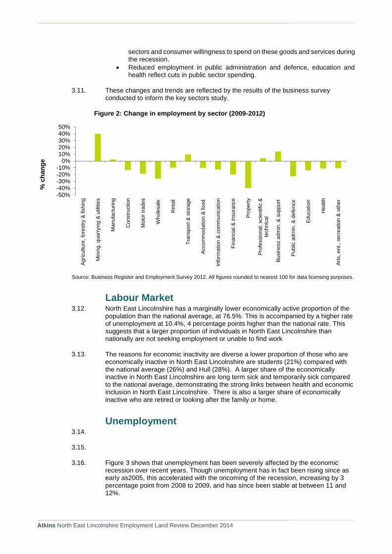
3.10. Since 2009, the structure of the NEL economy has changed as follows:
There has been an increase in employment over the period 2009-2012 in the mining, quarrying and utilities sector (by 40%). This likely reflects the expansion of the renewable energy sector in the area and elsewhere in the Humber estuary.
There has also been expansion in the transport, manufacturing, professional, scientific and technical and business administration and support sectors. This is likely to have been driven by growth and diversification in the key sectors.
Contraction in the motor trade, property, accommodation and food and construction sectors reflects both reduced business confidence in these
Atkins North East Lincolnshire Employment Land Review December 2014
sectors and consumer willingness to spend on these goods and services during the recession.
Reduced employment in public administration and defence, education and health reflect cuts in public sector spending.
3.11. These changes and trends are reflected by the results of the business survey conducted to inform the key sectors study.
Figure 2: Change in employment by sector (2009-2012)
Source: Business Register and Employment Survey 2012. All figures rounded to nearest 100 for data licensing purposes.
Labour Market 3.12. North East Lincolnshire has a marginally lower economically active proportion of the
population than the national average, at 76.5%. This is accompanied by a higher rate of unemployment at 10.4%, 4 percentage points higher than the national rate. This suggests that a larger proportion of individuals in North East Lincolnshire than nationally are not seeking employment or unable to find work
3.13. The reasons for economic inactivity are diverse a lower proportion of those who are economically inactive in North East Lincolnshire are students (21%) compared with the national average (26%) and Hull (28%). A larger share of the economically inactive in North East Lincolnshire are long term sick and temporarily sick compared to the national average, demonstrating the strong links between health and economic inclusion in North East Lincolnshire. There is also a larger share of economically inactive who are retired or looking after the family or home.
Unemployment 3.14.
3.15.
3.16. Figure 3 shows that unemployment has been severely affected by the economic recession over recent years. Though unemployment has in fact been rising since as early as2005, this accelerated with the oncoming of the recession, increasing by 3 percentage point from 2008 to 2009, and has since been stable at between 11 and 12%.
-50%-40%-30%-20%-10%
0%10%20%30%40%50%
Ag
riculture
, fo
restr
y &
fis
hin
g
Min
ing, q
uarr
yin
g &
utilit
ies
Ma
nufa
ctu
ring
Constr
uctio
n
Mo
tor
trades
Whole
sale
Reta
il
Tra
nsp
ort
& s
tora
ge
Accom
moda
tio
n &
food
Info
rma
tio
n &
co
mm
unic
ation
Fin
ancia
l &
in
sura
nce
Pro
pert
y
Pro
fessio
nal, s
cie
ntific &
technic
al
Bu
sin
ess a
dm
in. &
support
Pu
blic
adm
in. &
defe
nce
Ed
ucation
Health
Art
s, ent., re
cre
ation &
oth
er
% c
han
ge

Atkins North East Lincolnshire Employment Land Review December 2014
Figure 3: Unemployment rate, 2005-2013
Source: Annual Population Survey
Skills 3.17. Despite improvement over recent years, North East Lincolnshire has a lower
proportion of residents with NVQ Level 4 qualifications (degree level or equivalent) compared with the national average (Figure 4). Furthermore the gap between the borough’s and England’s proportion of the workforce with Level 4 qualifications has increased.
Figure 4: % of Working Age Population (16-64) with Level 4 Qualifications
Source: Annual Population Survey 2014
0.0
2.0
4.0
6.0
8.0
10.0
12.0
14.0
2005 2006 2007 2008 2009 2010 2011 2012 2013
% a
ged
16
-64
North East Lincs. UK
0%
5%
10%
15%
20%
25%
30%
35%
40%
2009 2010 2011 2012 2013
% o
f W
ork
ing
Ag
e P
op
ula
tio
n
North East Lincolnshire
England

Atkins North East Lincolnshire Employment Land Review December 2014
3.18. The share of residents with no qualifications has fallen since 2009 (by 2.6%) but not at the same rate as the national average (drop of 3%).
Figure 5: % of Working Age Population (16-64) with No Qualifications
Source: Annual Population Survey 2014
3.19. Average annual earnings in the borough (resident based) are higher than the Hull but lower than other neighbouring counties and the national average (Table 8).
Table 8: Annual gross earnings of residents (2013)
Area Median Mean
North East Lincolnshire £ 24,420 £ 27,530
East Riding of Yorkshire £ 26,690 £ 32,000
Kingston upon Hull, City of £ 22,780 £ 24,600
North Lincolnshire £ 27,350 £ 31,790
England £ 27,380 £ 33,980
Source: Annual Survey of Hours and Earnings 2013 (rounded)
Deprivation 1.5. Deprivation is a composite term used to measure economic welfare, health, income
and education. The Index of Multiple Deprivation (IMD) is the most commonly used measure of deprivation and provides a ranking of deprivation for areas across England. The IMD covers seven distinct domains; Income Deprivation, Employment Deprivation, Health Deprivation and Disability, Education Skills and Training
0%
2%
4%
6%
8%
10%
12%
14%
2009 2010 2011 2012 2013
% o
f W
ork
ing
Ag
e P
op
ula
tio
n
North East Lincolnshire
England

Atkins North East Lincolnshire Employment Land Review December 2014
Deprivation, Barriers to Housing and Services, Living Environment Deprivation, and Crime.
1.6. North East Lincolnshire is the 46th most deprived local authority area in England. Within North East Lincolnshire, there are 107 Lower Super Output Areas with 10 of these ranked in the top 4% of deprived areas in England.

Atkins North East Lincolnshire Employment Land Review December 2014
4. The Local Property Market
Introduction 4.1. This section sets out a review of the North East Lincolnshire market for commercial
and industrial property largely reflecting B-class uses. It draws on a variety of sources including the NEL commercial property database (Evolutive), Estates Gazette data (EGI) and discussions with local agents6 to identify market conditions such as vacancy rates, stock and rental levels by location and property type.
4.2. As seen in Figure 6, the volume of transactions across NEL has decreased since 2009. In terms of industrial units, this has decreased by over 50%, to just 24 transactions in 2013 compared to 51 in 2009.The decrease in office is also approximately 50% over the 5 year period, with 32 transactions in 2009 and 16 in 2013.
4.3. The decrease in transactions since 2009 and the effects of the economic downturn suggests NEL has a regressive market, where transactions have become stagnant due to lack of choice and suitability of suitable properties.
4.4. However, through discussions with local commercial agents and analysis of the first 6 months of 2014 property transaction data, there does appear to be increased market activity. This is particularly evident within the office sector, where the current 2014 transaction data show that 2014 has already exceeded 2013’s annual transaction data. Industrial properties show similar pattern, albeit not as strong growth.
Figure 6: Number of Office and Industrial Transactions 2009-2013
Source: Evolutive
4.5. Offices 4.6. The primary location for office space in the borough is within Grimsby town centre.
However, more recent office development has taken place outside the town at
6 PPH Commercial, Scotts Property
0
10
20
30
40
50
60
2009 2010 2011 2012 2013
Industrial Office

Atkins North East Lincolnshire Employment Land Review December 2014
Europarc which provides a modern out of town office accommodation providing competition to the traditional town centre office market.
4.7. As shown in Figure 7, there has been a steady availability of office space within NEL since 2009, averaging at approximately 263,000 sq ft per annum between 2009 and 2013.
Figure 7: Total office floorspace availability in NEL 2009-2013 (sq.ft)
Source: Evolutive
4.8. In terms of size, the most readily available units are those up to 5,000 sq ft with 66% of all total available units being within this category. In particular, units between 500 sq ft and 3,000 sq ft appear to dominate available supply.
4.9. Local agents indicate that the majority of the offices currently on the market have poor access often with no dedicated parking. Moreover, many are first floor units which do not cater the requirements of modern occupiers, suggesting purpose built office accommodation with parking facilities is more of what is in demand. Rental levels for office space vary but EGI data shows a low average rental level of £7.76 per sq. ft within Grimsby Town Centre although higher rates can be achieved at Europarc (£11-12.40 per sq. ft). Despite being higher than rental levels in Grimsby, the Europarc rates remain considerably lower than other areas in the region. These low rental rates mean that speculative development is unlikely to be achievable as development becomes commercially unviable, even at popular, good quality sites such as Europarc.
4.10. There is a need for high quality small office space within Grimsby. A majority of the office stock within Grimsby town is currently of poor quality 1960’s stock or converted residential units. These offices often don’t provide much needed car parking spaces which make them unattractive to many businesses and therefore tend to form the majority of the vacant properties. The higher quality office stock, such as Europarc is generally fully occupied.
4.11. As highlighted in Figure 6, there has been a declining take up of office space over the previous five years. In 2013 there were 16 transactions as opposed to 32 in 2009 and 30 in 2010. Agents have expressed that tenants are now looking for more flexible terms and shorter leases than previously requested and there still remains a severe
-00
50,000
100,000
150,000
200,000
250,000
300,000
350,000
2009 2010 2011 2012 2013

Atkins North East Lincolnshire Employment Land Review December 2014
shortfall in freehold office space, further suggesting the lack of suitable office accommodation and regressive market.
4.12. As seen in Figure 8, generally supply outweighs demand although transaction levels are low. Through discussions with local agents it is known that although there are a high number of speculative enquiries, often the right quality or sized stock is not available. This could very much be related to the need for businesses to require modern good quality office development, particularly with car parking and good accessibility. This points to out of town locations, such as Europarc as being more attractive to the market compared to those currently available in Grimsby town centre.
Figure 8: Office floor space, availability and enquiries (sq. ft) 2009 – 2013
Source: Evolutive
Industrial Within NEL, the industrial sector is much better provided for than offices. As seen in
4.13. Figure 9, the total floorspace availability between 2009 and 2013 has varied considerably, with a drop in the last 3 years, the availability averages at approximately 255,000 sq. ft over the 5 year period.
-00
50,000
100,000
150,000
200,000
250,000
300,000
350,000
400,000
450,000
2009 2010 2011 2012 2013
Available Enquiries Transacted

Atkins North East Lincolnshire Employment Land Review December 2014
Figure 9: Total industrial floorspace availability in NEL 2009-2013
1.7. In terms of sizes, the majority of properties in terms of unit numbers are 1,000 – 2,000 sq. ft (averaging 11 units per annum), 2,000 to 3,000 sq. ft (averaging at 14 units per annum) 5,000 – 10,000 sq. ft (18 units per annum) and 10,000 – 15,000 sq. ft categories (12 units per annum). On average units available in these size categories account for 54% of the total number of units over the five year period
1.8. There is little availability for small (less than 500 sq. ft), and large (over 100,000 sq. ft) properties, although in terms of smaller properties, EFactor’s enterprise village, has been set up to provide light industrial and workshop facilities for start-ups and SMEs, Efactor has proved widely popular and currently fully occupied. There are few properties available for large 100,000 to 200,000sq ft with no available properties over 200,000 sq. ft.
1.9. As with the office market, there has been a decrease in the take up of industrial units since the recession. However there is much variety in the rental performance of the industrial and warehousing property across the borough. Local agents report that the biggest demand is for mid-size properties, 5,000sq ft – 30,000 sq. ft, but there is not a high enough variety of quality units to offer a sufficient churn. There are few new build properties available on the market, and a severe lack of good quality industrial units, suggesting why the take up has been decreasing over recent years.
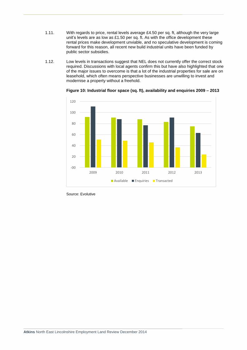
1.10. As shown in Figure 10 the availability of industrial floorspace has dropped, however enquiry levels on the last couple of years have exceeded supply, but transaction levels remain low. This could be due to much of the stock being of poor quality with very few modern industrial premises available, which businesses require. Some agents discussed the difficulties of a lot of leaseholds as opposed to freeholds for the majority of industrial properties in NEL, which means that businesses are reluctant to spend money investing and modernising properties when they may only have a short lease. This data shows that whilst enquiries are occurring, and there is a supply of properties, they are likely not to be suitable which explains the low transaction rates.
1,322,892
3,540,927 3,295,805
2,636,041
1,946,038
-00
500,000
1,000,000
1,500,000
2,000,000
2,500,000
3,000,000
3,500,000
4,000,000
2009 2010 2011 2012 2013
Atkins North East Lincolnshire Employment Land Review December 2014
1.11. With regards to price, rental levels average £4.50 per sq. ft, although the very large unit’s levels are as low as £1.50 per sq. ft. As with the office development these rental prices make development unviable, and no speculative development is coming forward for this reason, all recent new build industrial units have been funded by public sector subsidies.
1.12. Low levels in transactions suggest that NEL does not currently offer the correct stock required. Discussions with local agents confirm this but have also highlighted that one of the major issues to overcome is that a lot of the industrial properties for sale are on leasehold, which often means perspective businesses are unwilling to invest and modernise a property without a freehold.
Figure 10: Industrial floor space (sq. ft), availability and enquiries 2009 – 2013
Source: Evolutive
-00
20
40
60
80
100
120
2009 2010 2011 2012 2013
Available Enquiries Transacted

Atkins North East Lincolnshire Employment Land Review December 2014
5. Future Employment Needs
Introduction 5.1. This section provides a series of quantitative scenarios of employment change in
North East Lincolnshire up to 2032. It also provides our estimates of the future potential need for employment floorspace and employment land, which are derived from the employment growth scenarios.
5.2. The scenarios are taken directly from the economic futures study which is issued as a separate report. As explained in the Economic Futures report, the methodology used to generate estimates of potential future employment growth is driven largely by a ‘bottom-up’ approach. Consequently, the underlying assumptions contained within the methodology are policy-led. By their nature, such scenarios or forecasts take a positive outlook as to the future performance of the economy, albeit based on an objective analysis of evidence and opportunity. Indeed, the evidence provided by the key sectors study indicates that there is every reason to take an optimistic, strategically informed approach to planning for employment growth in North East Lincolnshire over the next two decades. The rationale behind each of the scenarios is explained later in this section.
5.3. The evidence on which the future scenarios have been developed includes:
A statistically significant sample survey of locally-established businesses (approximately 300 in total).
In-depth interviews with local employers and key stakeholders in the area (approximately 30).
Analysis of government and locally generated secondary data and other relevant information included other recent research.
An assessment of local, sub-regional and regional socio-economic conditions and prospects including a review of up-to-date policy drivers and priorities which have already been established to underpin the economic development objectives for North East Lincolnshire.
An appraisal of key planned and proposed investment and development projects in North East Lincolnshire which offer substantial, viable opportunities for significant job creation in the Borough and surrounding areas.
Translating Employment Change into Land Demand 5.4. Estimates of future change in employment by economic sector have been translated
to the core B-use type employment: B1a/b (offices and research and development), B1c/B2 (light and general industrial) and B8 (storage and distribution). Importantly, as shown in Table 9, estimates of non B-use employment by sector are also provided. These job change estimates are then converted to floorspace and land demand estimates by applying appropriate employment density and plot ratio assumptions. The employment densities used are in line with the HCA’s Employment Densities Guide 2nd Edition (2010) while the plot ratios used are in line with the ODPM’s Employment Land Reviews: Guidance Note (2004). Key density and plot ratio assumptions used in this study are set out in Table 10.

Atkins North East Lincolnshire Employment Land Review December 2014
Table 9 - Translating Employment SIC to B Use Class Categories (% employment by SIC)
Sector B1a/b B1c/B2 B8 NON-B
Accommodation and food service activities 20% 80%
Administrative and support service activities 40% 10% 50%
Agriculture, Forestry and Fishing 100%
Arts, entertainment and recreation 10% 90%
Construction 5% 10% 10% 75%
Education 10% 90%
Electricity, gas, steam and air conditioning supply 15% 15% 20% 50%
Financial and insurance activities 100%
Human health and social work activities 10% 90%
Information and communication 80% 20%
Manufacturing 15% 65% 20%
Other service activities 100%
Professional, scientific and technical activities 100%
Public administration and defence; compulsory social security 80% 20%
Real estate activities 10% 90%
Transportation and storage 30% 30% 40%
Water supply, sewerage, waste management & remediation activities 15% 15% 20% 50%
Wholesale and retail trade; repair of motor vehicles & motorcycles 15% 30% 55%
Source: Atkins 2014
Table 10: Employment Density and Plot Ratio Assumptions
Use class Employment
density Plot ratio
B1a/b 12 sqm per FTE 75% of site area
B1c/B2 50 sqm per FTE 30% of site area
B8 80 sqm per FTE 30% of site area
Source: Atkins / HCA
5.5. It should be noted that the application of standard employment density and plot ratio assumptions may potentially under-estimate gross future land demand in North East Lincolnshire given that some of the specialist activities likely to feature strongly in the Borough over the next 10 or 20 years are especially land hungry in nature. This includes many of the port, logistics, chemicals and energy activities. Consequently, the assumptions have been adjusted to account for the land requirements of many key industries in North East Lincolnshire.
5.6. In considering these forecasts, it will be important to build in flexibility and choice in the allocation of land identified as suitable to potentially meet future needs.
5.7. It should also be noted that the projections set out in this section are indicative and should not be considered prescriptive. Moreover, given the long-term nature of the projections and the continued economic uncertainty, any forecasting is highly sensitive to changes in the national and international economic climate. It should also be noted that all figures presented in this section have been rounded.
Atkins North East Lincolnshire Employment Land Review December 2014
Note on REM Model
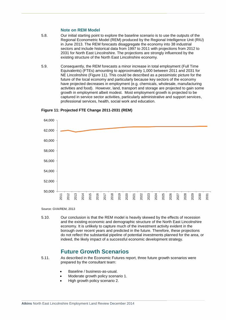
5.8. Our initial starting point to explore the baseline scenario is to use the outputs of the Regional Econometric Model (REM) produced by the Regional Intelligence Unit (RIU) in June 2013. The REM forecasts disaggregate the economy into 38 industrial sectors and include historical data from 1997 to 2011 with projections from 2012 to 2031 for North East Lincolnshire. The projections are strongly influenced by the existing structure of the North East Lincolnshire economy.
5.9. Consequently, the REM forecasts a minor increase in total employment (Full Time Equivalents) (FTEs) amounting to approximately 1,000 between 2011 and 2031 for NE Lincolnshire (Figure 11). This could be described as a pessimistic picture for the future of the local economy and particularly because key sectors of the economy have projected decreases in employment (e.g. chemicals, wholesale, manufacturing activities and food). However, land, transport and storage are projected to gain some growth in employment albeit modest. Most employment growth is projected to be captured in service sector activities, particularly administrative and support services, professional services, health, social work and education.
Figure 11: Projected FTE Change 2011-2031 (REM)
Source: GVA/REM, 2013
5.10. Our conclusion is that the REM model is heavily skewed by the effects of recession and the existing economic and demographic structure of the North East Lincolnshire economy. It is unlikely to capture much of the investment activity evident in the borough over recent years and predicted in the future. Therefore, these projections do not reflect the substantial pipeline of potential investments planned for the area, or indeed, the likely impact of a successful economic development strategy.
Future Growth Scenarios 5.11. As described in the Economic Futures report, three future growth scenarios were
prepared by the consultant team:
Baseline / business-as-usual.
Moderate growth policy scenario 1.
High growth policy scenario 2.
50,000
52,000
54,000
56,000
58,000
60,000
62,000
64,000
2011
2012
2013
2014
2015
2016
2017
2018
2019
2020
2021
2022
2023
2024
2025
2026
2027
2028
2029
2030
2031

Atkins North East Lincolnshire Employment Land Review December 2014
5.12. The rationale and key assumptions which underlie each of the scenarios are described below.
Baseline / business-as-usual. Drawing on a range of independent projections produced by external organisations, the baseline scenario reflects a trend-based methodology. By their nature, these projections reflect the existing structural composition of the local economy relative to that of the regional and national economies. Also embedded in these projections are trend-based interpretations of future demographic change including working age population and patterns of in and out-migration.
Moderate growth Policy Scenario 1. This scenario reflects implementation of an economic development and inward investment strategy which is steadily successful in the period up to 2032. It will see the delivery of important investment projects in key sectors, particularly renewable energy, chemicals and process industries and ports and logistics. However, other key sectors, such as business and financial services remain subdued with growth being diverted to more competitive locations where property market conditions are more viable. However, some growth in the service sector of the economy takes place as a result of increasing demand for producer services resulting from expansion of the key sectors mentioned above as well as enhanced competitiveness of Grimsby and Cleethorpes town centres. Retail and tourism employment increases as a result of investment in regeneration projects including the bus station redevelopment, Cartergate and new hotel developments in both Grimsby and Cleethorpes. Similarly, the food processing sector remains of particular importance to the economy of North East Lincolnshire although it becomes a challenge to expand as a result of global competition and the increasing success of proactive policies in other parts of the UK. Growth in the sector is also constrained by difficulties in getting access to readily available and suitable expansion land. Other parts of the economy, particularly the service sector, remain largely immature although some niche services and manufacturing activities have benefited from the downstream effects of growth in renewables and other key sectors. Employment growth under this scenario is significant by 2032 but notable delays to the implementation of some major projects means that the benefits of growth do not come on stream until later in the planning period.
High growth Policy Scenario 2. Under this scenario, North East Lincolnshire is identified as one of a few local authority areas in England demonstrating best-practice in terms of economic development and inward investment strategy. This reflects, in part, the ability of North East Lincolnshire to work in close partnership with neighbouring LEPs and authorities, most notably: North Lincolnshire, City of Hull, East Riding, West Lindsey and East Lindsey. Co-operation between the local authorities has enabled successful implementation of a sector-based strategy focus geographically on a functional economic area. Moreover, joint working and an objective assessment of functional housing market areas has facilitated the allocation of land for development in urban areas which reflects market need and demand. Affordable housing policy has also ensured that younger economically people have remained in the area and take up the new job opportunities that have been created locally. All five key sectors have attracted substantial investment with most planned projects been implemented and funded. The retail and visitor economy has witnessed a significant boost following the success of the regeneration strategy for Grimsby and Cleethorpes town centres. New regeneration projects implemented in the period up to 2020 have had the impact of stimulating significantly enhanced confidence in retail, tourism and leisure markets. The significantly enhanced quality of the town centres coupled with implementation of a targeted tourism strategy has resulted in steady employment growth in the local visitor economy. This has also resulted an uplift in property values which have stimulated sustainable, ongoing investment in the town centres. Modest speculative development activity is a characteristic of the

Atkins North East Lincolnshire Employment Land Review December 2014
new town centre economy with a small but healthy office market having been established. Occupier demand is strong given the growth in business and professional services which has emerged as a downstream effect of growth and diversification in the key sectors. Unemployment is substantially reduced and an enhancement in locally accrued disposable incomes also drives demand for services including retail, leisure and entertainment.
5.13. Table 11 summarises the average employment growth rates predicted under each of the scenarios for the period 2013-2032. This sets out growth rates for each of the five key sectors as well as manufacturing not captured by the priority sectors, the public sector, education, health and the remaining service sectors of the North East Lincolnshire economy. The subsequent tables summarises the outputs under each of the scenarios by standard industry groups.
Table 11 - Underlying Employment Growth Rates by Sector Group and Scenario 2013-2032
Sector Group Baseline Policy 1 Policy 2
Ports & Logistics 12% 18% 25%
Food Processing 8% 12% 19%
Renewables & Energy 15% 26% 40%
Chemicals & Processing Industries 9% 15% 20%
Other Manufacturing -7% 12% 25%
Visitor Economy 5% 14% 21%
Public Sector -4% 0% 1%
Education 4% 7% 11%
Health 5% 8% 13%
Other Service Sectors 4% 8% 16%
Source: Atkins.
Atkins Baseline Scenario 5.14. This baseline scenario is based largely on historical trend-based projections of
employment change across North East Lincolnshire.
5.15. As shown in Table 12, the baseline scenario indicates total job growth of around 7% between 2013 and 2031, rising from 64,500 to nearly 69,000. Key growth sectors include; administrative and supportive services; human health and transportation and storage while the most notable declines are forecast for manufacturing and public administration and defence.
Table 12: Employment Forecast: Atkins Baseline Scenario
Sector 2013 2032 Change % Change
Accommodation and food service activities 3,400 4,015 615 18.1%
Administrative and support service activities 6,000 6,662 662 11.0%
Agriculture, Forestry and Fishing 100 100 0 0.0%
Arts, entertainment and recreation 1,500 1,621 121 8.1%
Construction 2,400 2,971 571 23.8%
Education 6,300 6,696 396 6.3%
Electricity, gas, steam and air conditioning supply
300 300 0 0.0%
Financial and insurance activities 800 999 199 24.9%
Human health and social work activities 10,300 10,806 506 4.9%
Information and communication 700 818 118 16.9%
Manufacturing 9,500 8,768 -732 -7.7%

Atkins North East Lincolnshire Employment Land Review December 2014
Other service activities 800 909 109 13.6%
Professional, scientific and technical activities 2,900 3,294 394 13.6%
Public administration and defence; compulsory social security
2,400 2,248 -152 -6.3%
Real estate activities 600 699 99 16.6%
Transportation and storage 5,100 6,027 927 18.2%
Water supply, sewerage, waste management and remediation activities
500 563 63 12.7%
Wholesale and retail trade; repair of motor vehicles and motorcycles
10,900 11,435 535 4.9%
Total 64,500 68,933 4,433 6.9%
Source: Atkins, 2014.
5.16. Under the baseline scenario employment in B-use class sectors is forecast to increase by 4.5% between 2013 and 2032, resulting in 1,240 additional B-use class jobs by 2032 (see Table 13). Although employment growth will be observed in the B1a/b sectors, B1c/B2 (industrial) employment is forecast to drop by -4%.
Table 13: Atkins Baseline Scenario: B-Use Job Growth 2013-2032
Use Class 2013 2032 Change %
Change
B1a/b 13,737 14,867 1,130 8.2%
B1c/B2 6,634 6,348 -286 -4.3%
B8 7,157 7,553 396 5.5%
Total B Class FTE jobs 27,529 28,769 1,240 4.5%
Source: Atkins
5.17. Translating the above B-use jobs growth estimate to gross floorspace and land demand, Table 14 indicates need for an additional 31,000 sq.m. of employment floorspace, equivalent to approximately 8ha of additional land supply.
Table 14: Atkins Baseline Scenario: B-Use Floorspace and Land Demand 2013-2032
Use Class
Floorspace Land
Square Metres Hectares
B1a/b 13,560 1.8
B1c/B2 -14,301 -4.8
B8 31,702 10.6
Total floorspace 30,960 7.6
Source: Atkins
Policy Scenario 1: Moderate Growth 5.18. This scenario represents a more optimistic outlook in terms of the Borough’s
economic growth prospects driven largely by significant investment in key sector projects. However, growth in other sectors of the economy, including the services sector, remains slow albeit at rates which represent an improvement on historical performance. As indicated in Table 15, the moderate growth scenario sees an increase in total employment of around 8,800, representing growth of nearly 14% in the period up to 2032.

Atkins North East Lincolnshire Employment Land Review December 2014
Table 15: Policy Scenario 1: Moderate Growth – Employment Change 2013-2032
Sector 2013 2032 Change % Change
Accommodation and food service activities 3,400 4,231 831 24.4%
Administrative and support service activities 6,000 6,946 946 15.8%
Agriculture, Forestry and Fishing 100 100 0 0.0%
Arts, entertainment and recreation 1,500 1,692 192 12.8%
Construction 2,400 3,305 905 37.7%
Education 6,300 6,919 619 9.8%
Electricity, gas, steam & air conditioning supply 300 300 0 0.0%
Financial and insurance activities 800 1,053 253 31.7%
Health 10,300 10,969 669 6.5%
Information and communication 700 818 118 16.9%
Manufacturing 9,500 10,706 1,206 12.7%
Other service activities 800 1,084 284 35.5%
Professional, scientific and technical activities 2,900 3,381 481 16.6%
Public administration & defence; 2,400 2,400 0 0.0%
Real estate activities 600 699 99 16.6%
Transportation and storage 5,100 6,195 1,095 21.5%
Water supply, sewerage, waste management and remediation activities
500 582 82 16.4%
Wholesale and retail trade; repair of motor vehicles and motorcycles
10,900 11,912 1,012 9.3%
Total 64,500 73,292 8,792 13.6% Source: Atkins
5.19. Under Policy Scenario 1, employment in B-use class sectors is forecast to increase by 14.5% between 2013 and 2032, resulting in nearly 4,000 additional B-use class jobs by 2032 (see Table 16). Unlike the baseline scenario, the industrial sectors (B1c/B2) under this scenario are forecast to experience an increase in net demand. This reflects investment into key sector projects, many of which are industrial-led.
Table 16: Policy Scenario 1: (Moderate Growth) B-Use Job Growth 2013-2032
Use Class 2013 2032 Change %
Change
B1a/b 13,737 15,768 2,031 14.8%
B1c/B2 6,634 7,592 958 14.4%
B8 7,157 8,151 994 13.9%
Total B Class FTE jobs 27,529 31,511 3,983 14.5%
Source: Atkins
5.20. Translating the above B-use jobs growth estimate to gross floorspace and land demand, Table 17 indicates need for an additional 151,800 sq.m. of employment floorspace, equivalent to approximately 46ha of additional land supply.

Atkins North East Lincolnshire Employment Land Review December 2014
Table 17: Policy Scenario 1: (Moderate Growth) B-Use Floorspace & Land Demand 2013-2032
Use Class
Floorspace Land
Square Metres Hectares
B1a/b 24,374 3.2
B1c/B2 47,895 16.0
B8 79,504 26.5
Total floorspace 151,773 45.7
Policy Scenario 2: High Growth 5.21. This scenario represents the most optimistic economic outlook and highly ambitious
goals for the North East Lincolnshire economy (Table 18). It reflects successful implementation of an aggressive growth-oriented local economic development strategy which sees North East Lincolnshire perform a significant role in the regional and national economies particularly for the key sectors. It assumes that all key investment projects are realised and implemented within the forecasting period. Moreover, the workforce is assumed to adapt effectively to the demand for skills required to meet the needs of investors. This will need to be achieved through up-skilling of the resident workforce, maximising full labour force capacity and through the in-migration of skilled workers into the area. Under the higher growth scenarios, it is also assumed that sufficient land and premises is made available to accommodate the needs of investors and expanding businesses. Other major constraints to investment will also need to be addressed over time including road network improvements and the upgrading or replacement of poor quality premises. In addition, the availability of waterside sites for operations dependent on access to the sea will need to be addressed through the Local Plan and in partnership with land owners and existing operators in key locations.
Table 18: Policy Scenario 2: High Growth – Employment Change 2013-2032
Sector 2013 2032 Change % Change
Accommodation and food service activities 3,400 4,621 1,221 35.9%
Administrative and support service activities 6,000 7,392 1,392 23.2%
Agriculture, Forestry and Fishing 100 100 0 0.0%
Arts, entertainment and recreation 1,500 1,685 185 12.4%
Construction 2,400 3,891 1,491 62.1%
Education 6,300 7,128 828 13.1%
Electricity, gas, steam & air conditioning supply 300 365 65 21.8%
Financial and insurance activities 800 1,078 278 34.8%
Health 10,300 11,156 856 8.3%
Information and communication 700 980 280 40.1%
Manufacturing 9,500 12,457 2,957 31.1%
Other service activities 800 1,223 423 52.9%
Professional, scientific and technical activities 2,900 3,401 501 17.3%
Public administration & defence; 2,400 2,429 29 1.2%
Real estate activities 600 742 142 23.7%
Transportation and storage 5,100 6,543 1,443 28.3%
Water supply, sewerage, waste management and remediation activities
500 658 158 31.5%
Wholesale and retail trade; repair of motor vehicles and motorcycles
10,900 12,833 1,933 17.7%
Total 64,500 78,684 14,184 22.0% Source: Atkins
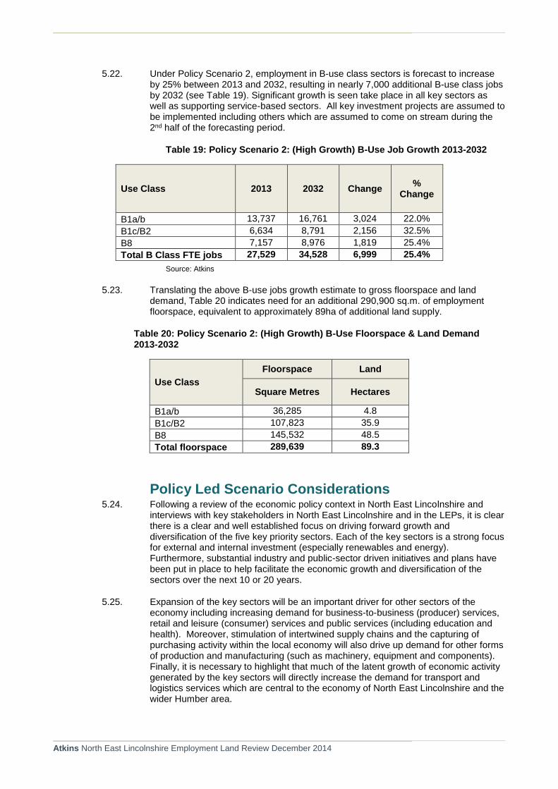
Atkins North East Lincolnshire Employment Land Review December 2014
5.22. Under Policy Scenario 2, employment in B-use class sectors is forecast to increase by 25% between 2013 and 2032, resulting in nearly 7,000 additional B-use class jobs by 2032 (see Table 19). Significant growth is seen take place in all key sectors as well as supporting service-based sectors. All key investment projects are assumed to be implemented including others which are assumed to come on stream during the 2nd half of the forecasting period.
Table 19: Policy Scenario 2: (High Growth) B-Use Job Growth 2013-2032
Use Class 2013 2032 Change %
Change
B1a/b 13,737 16,761 3,024 22.0%
B1c/B2 6,634 8,791 2,156 32.5%
B8 7,157 8,976 1,819 25.4%
Total B Class FTE jobs 27,529 34,528 6,999 25.4%
Source: Atkins
5.23. Translating the above B-use jobs growth estimate to gross floorspace and land demand, Table 20 indicates need for an additional 290,900 sq.m. of employment floorspace, equivalent to approximately 89ha of additional land supply.
Table 20: Policy Scenario 2: (High Growth) B-Use Floorspace & Land Demand 2013-2032
Use Class
Floorspace Land
Square Metres Hectares
B1a/b 36,285 4.8
B1c/B2 107,823 35.9
B8 145,532 48.5
Total floorspace 289,639 89.3
Policy Led Scenario Considerations 5.24. Following a review of the economic policy context in North East Lincolnshire and
interviews with key stakeholders in North East Lincolnshire and in the LEPs, it is clear there is a clear and well established focus on driving forward growth and diversification of the five key priority sectors. Each of the key sectors is a strong focus for external and internal investment (especially renewables and energy). Furthermore, substantial industry and public-sector driven initiatives and plans have been put in place to help facilitate the economic growth and diversification of the sectors over the next 10 or 20 years.
5.25. Expansion of the key sectors will be an important driver for other sectors of the economy including increasing demand for business-to-business (producer) services, retail and leisure (consumer) services and public services (including education and health). Moreover, stimulation of intertwined supply chains and the capturing of purchasing activity within the local economy will also drive up demand for other forms of production and manufacturing (such as machinery, equipment and components). Finally, it is necessary to highlight that much of the latent growth of economic activity generated by the key sectors will directly increase the demand for transport and logistics services which are central to the economy of North East Lincolnshire and the wider Humber area.

Atkins North East Lincolnshire Employment Land Review December 2014
5.26. In addition to well established policy drivers for the five priority sectors in enabling economic growth and diversification in North East Lincolnshire, the sectors are also characterised by substantial planned and potential investments which will be central to delivering growth.
5.27. Despite the notable importance of these key sectors and activity clusters, the future of the North East Lincolnshire economy will depend on the expansion and diversification of all aspects of the economy which should be reflected in the Local Plan and related strategies. This should include all forms of viable manufacturing, a wide range of private sector services activities and town centre uses including retail and leisure, and core public sector functions ranging from education and health to public administration.
5.28. Each of the key sectors is dynamic in nature and is a strong focus for external and internal investment (especially renewables and energy). Furthermore, substantial industry and public-sector driven initiatives and plans have been put in place to help facilitate the economic growth and diversification of the sectors over the next 10 or 20 years.
Land Demand for Key Sectors 5.29. For the purposes of illustration, Table 21 provides an estimate of modelled future
employment (B-use) land needs for each of the key sectors. These estimates are provided by applying standard, average employment density and plot ratios as described above. As highlighted at the end of this section, there are a range of critical factors which indicate that such quantitative indications of future need potentially may substantially under-estimate actual demand over the next two decades. These factors include the fact that the key sectors mostly have very specific land and property needs which often are particularly land-hungry in nature and generate uses for which standard employment density and plot ratio evidence is not readily available.
Table 21: Indicative Employment Land Requirements by key sector 2013-2032
Sector Group Policy Scenario 1 (Moderate Growth)
Policy Scenario 2 (High Growth)
Sector B1a/b B1cB2 B8 B1a/b B1cB2 B8
Ports & Logistics 0.1 0.6 8 0.1 1.2 15
Food Processing 0.1 4.9 2 0.2 12.6 6
Renewables & Energy (high)
0.1 4.9 2 0.1 9.1 4
Chemicals & Processing Industries
0.1 3.9 2 0.1 7.7 4
Other Manufacturing 0.0 1.4 1 0.1 5.6 3
Visitor Economy 0.1 0.0 0 0.1 0.0 0
Sub Total 0.3 15.7 14.6 0.7 36.2 31.4
Total 30.5 68.3

Atkins North East Lincolnshire Employment Land Review December 2014
Site and Location Preferences 5.30. Table 22 provides a summary of typical site and location requirements by broad
sector. This is based on feedback from face-to-face interviews with business representatives and findings from the empirical business survey.
Table 22: Typical Site and Location Preferences by Sector
Sector Sites Use Class
Food Manufacturing
Large and uncontaminated (often modern) premises with good access to the local and strategic road network.
Location: Grimsby Docks, Business Parks and older industrial clusters with good proximity to Grimsby town centre.
B2 and some B8.
Ports & Logistics
Large storage space, with good transport links which is positioned away from activities which may impact the goods or materials they are importing.
Location: Immingham & Grimsby Docks and immediate area.
B8
Chemicals and Process Industries
Land which is separate from urban areas (including a safety ‘buffer zone’ for some) and has accessible road linkages.
Location: Immingham Docks and South Humber Bank.
‘Sui Generis’ and some B8.
Renewable Energy
Different types of land depending on the renewable energy technology they are operating, managing or installing. We provide an overview here:
Hydropower – (wind, wave and tidal): Require proximity to docks and access to water (although may have arrangements with other firms).
Wind (onshore), Geothermal, Solar: Require accessible locations which can be accessed readily by road.
Bioenergy: Requirement for premises which are close to docks (for raw products) and other transport links (e.g. road or rail)
Location: Grimsby Docks, Business Parks, Central
B1 – for office functions.
B2 – for technical or manufacturing.
B8 – for storage of materials.
Visitor Economy, Services and Retail
Businesses in this sector have a range of activities:
Retail: Close to other retail firms and areas of high footfall.
Food/Drink: Close to urban areas and visitor attractions.
Visitor Economy: Proximity to natural, historical and cultural assets often in urban areas.
Location: Town centres and locations in good proximity to coastal, natural, historic and cultural assets.
A1, A3, A4, A5 and C1
Other Manufacturing
Variety of site and location requirements depending on scale, nature and viability of operation. Ranging from specialist business park locations to lower grade industrial estates and stand-alone premises.
Location: Various
B1c, B2 and ancillary B8.
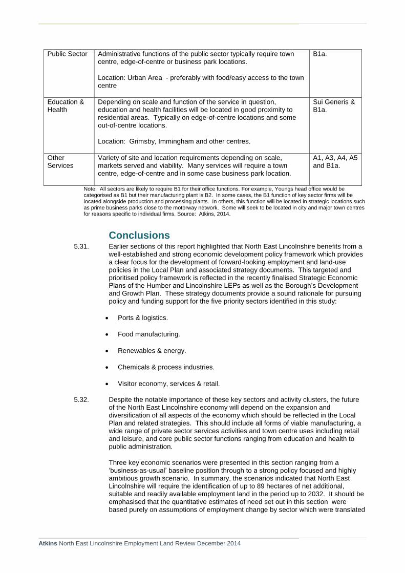
Atkins North East Lincolnshire Employment Land Review December 2014
Public Sector Administrative functions of the public sector typically require town centre, edge-of-centre or business park locations.
Location: Urban Area - preferably with food/easy access to the town centre
B1a.
Education & Health
Depending on scale and function of the service in question, education and health facilities will be located in good proximity to residential areas. Typically on edge-of-centre locations and some out-of-centre locations.
Location: Grimsby, Immingham and other centres.
Sui Generis & B1a.
Other Services
Variety of site and location requirements depending on scale, markets served and viability. Many services will require a town centre, edge-of-centre and in some case business park location.
A1, A3, A4, A5 and B1a.
Note: All sectors are likely to require B1 for their office functions. For example, Youngs head office would be categorised as B1 but their manufacturing plant is B2. In some cases, the B1 function of key sector firms will be located alongside production and processing plants. In others, this function will be located in strategic locations such as prime business parks close to the motorway network. Some will seek to be located in city and major town centres for reasons specific to individual firms. Source: Atkins, 2014.
Conclusions 5.31. Earlier sections of this report highlighted that North East Lincolnshire benefits from a
well-established and strong economic development policy framework which provides a clear focus for the development of forward-looking employment and land-use policies in the Local Plan and associated strategy documents. This targeted and prioritised policy framework is reflected in the recently finalised Strategic Economic Plans of the Humber and Lincolnshire LEPs as well as the Borough’s Development and Growth Plan. These strategy documents provide a sound rationale for pursuing policy and funding support for the five priority sectors identified in this study:
Ports & logistics.
Food manufacturing.
Renewables & energy.
Chemicals & process industries.
Visitor economy, services & retail.
5.32. Despite the notable importance of these key sectors and activity clusters, the future of the North East Lincolnshire economy will depend on the expansion and diversification of all aspects of the economy which should be reflected in the Local Plan and related strategies. This should include all forms of viable manufacturing, a wide range of private sector services activities and town centre uses including retail and leisure, and core public sector functions ranging from education and health to public administration.
Three key economic scenarios were presented in this section ranging from a ‘business-as-usual’ baseline position through to a strong policy focused and highly ambitious growth scenario. In summary, the scenarios indicated that North East Lincolnshire will require the identification of up to 89 hectares of net additional, suitable and readily available employment land in the period up to 2032. It should be emphasised that the quantitative estimates of need set out in this section were based purely on assumptions of employment change by sector which were translated
Atkins North East Lincolnshire Employment Land Review December 2014
into floorspace and land demand using standard, average employment density and plot ratios. In reality, it is likely that actual take-up of land in the future could be significantly higher than the ‘modelled’ estimates suggest. This can be explained by a number of key factors which should be considered during the plan development process:
As has been demonstrated in the Key Sectors Study, North East Lincolnshire increasingly performs a strategic economic role serving a geographical area which extends substantially beyond its own boundaries. Indeed, the area is of notable attraction to nationally and internationally significant inward investment, particularly in the key sectors of energy / renewable energy, food processing and process industries. To a large extent the competitive advantage of NEL as a magnet to these industrial clusters is reflected the area’s historical and contemporary role as an international seaport gateway location. It is important that the Local Plan economy policies and associated land allocations aim to facilitate economic growth and diversification by making sufficient land of the right size, location and quality available for future inward investment projects and expansion of existing enterprises in the area. Central to these policies will be a focus on providing choice and flexibility in the land and property market supported by public sector investment in core enabling infrastructure.
Linked to the strategic economic role of key industrial sectors in NEL, the area is increasingly characterised as having a unique economic structure whereby investors and occupiers have very specific land and property needs. Many of the industrial activities clustered in NEL (including energy, ports & logistics, chemicals and food processing) are land hungry in their land and property requirements. Indeed, given the operational nature and security needs of some activities, undeveloped land is required to act as a buffer zone and/or long-term expansion land between key facilities and the wider urban area. Consequently, the application of standard, average employment density and plot ratio assumptions have the potential to dangerously underestimate actual future employment land need in the area. Moreover, given the dynamic nature of the key sectors in NEL, it is difficult to predict with much accuracy the likely land and property needs of rapidly changing technology and market demand. This reinforces the need for the Local Plan to nurture sector-focused policies underpinned by the principles of flexibility, quality, choice and market responsiveness.
Despite the positive prospects for growth in key industrial sectors in NEL, the local economy remains underdeveloped in terms of its broader service sector. This includes business-to-business ‘producer’ services as well as consumer services. Undoubtedly, the expansion of key competitive sectors in the area will stimulate enhanced demand for downstream services. However, the Local Plan should actively promote investment in service-based activities for their own sake. This will be central to achieving a more balanced, diversified economy which will improve economic prospects for existing residents whilst appealing to skilled workers considering moving into the area to take up new employment opportunities.

Atkins North East Lincolnshire Employment Land Review December 2014
6. Employment Land Supply
Introduction 6.1. This section begins by providing an overview of the total stock of existing B-class employment
floorspace that currently exists in North East Lincolnshire. It then provides an analysis of land supply, where 36 existing and potential development sites are reviewed, setting out the current aggregate land supply of both existing Local Plan Allocations and potential new allocations which have been identified by Cofely / NELC and scheme promoters / land owners. Constraints to the aggregate supply are then identified, resulting in the identification of potentially available development sites for local and strategic use.
Existing Employment Floorspace 6.2. Valuation Office Agency (VOA) data provides the most recently available details of business units
in North East Lincolnshire that are subject to business rates. The VOA assesses the 1.8 million non-domestic properties in England and Wales that are liable for business rates and collects information on these properties, including the type of property, the location, the floorspace and rateable value.
6.3. The VOA data combined with the vacancy data available from Evolutive, shown in Table 23 identifies that North East Lincolnshire has approximately 172,227sqm of office space. For industrial uses, (B2 and B8) there is a total of 506,867sqm. It is important to note that data availability requires that 2010 VOA data is being compared to vacancy rates collected from 2013
Table 23: Vacant Floorspace (sqm) and Vacancy rate by Use Class
B1a/b (sqm)
B2 (sqm)
B8 (sqm)
Occupied Stock 147,800 793,600 4,154,100
Vacant Floorspace 24,400 170,000
Total 172,200 5,741,400
% Vacant 14% 3% Source: Atkins based on VOA and Evolutive 2013 data. Figures in table are rounded.
6.4. Figure 12 illustrates the total stock of B-class use floorspace in NEL between 2002 and 2012. Industrial floorspace includes B1c, B2 and B8 uses which have seen a very slight increase over the 10 year period. The supply of office space has remained fairly constant, with a slight drop occurring during the recession. It is important to note that the floorspace figures shown in Figure 12vary from those set out in Table 23. This is explained as follows: the classification of properties (VOA do not classify by use classes, and some uses are excluded for example any storage land at the port); timing and content of data extracts geography (VOA uses post code level data), rounding (the experimental data in is rounded to the nearest 1,000sqm).

Atkins North East Lincolnshire Employment Land Review December 2014
Figure 12: B-Class Floorspace in North East Lincolnshire 2002-2012
Source: Evolutive
6.5. Figure 13 illustrates the spatial distribution of occupied B-class floorspace within the key settlements within NEL (Immingham, Grimsby and Cleethorpes). It shows that B8 is the largest concentration of floorspace within each area, with B1 office use representing least in each area. In terms of the distribution of overall floorspace across the areas, the largest concentration of all uses if found in Grimsby, with Immingham representing the least. The little concentration within Immingham may be explained by the fact that uses, including vehicle storage, at Immingham may fall outside of the VOA classification system. Furthermore, the data may also be skewed by boundary issues with Stallingborough not being captured as part of Immingham.
Figure 13: Distribution of B-Class occupied Floorspace by Sub Area
Source: VOA
0
200
400
600
800
1,000
1,200
1,400
1,600
2002 2003 2004 2005 2006 2007 2008 2009 2010 2011 2012
Office Industrial Total
0%
10%
20%
30%
40%
50%
60%
70%
80%
Grimsby Cleethorpes Immingham
Distribution of B Class Use
B1 use B2 use B8 use

Atkins North East Lincolnshire Employment Land Review December 2014
Vacant Floorspace 6.6. Vacant floorspace refers to unoccupied premises which are being marketed (vacant land is
considered below). The Evolutive data has been analysed to give an indication of current availability of B-Class floorspace. The data is based on all properties identified as being available in the previous year to 30th June from 2009 to 2013. Table 23 above identifies the amount of vacant floorspace in the district. It should be noted that there may be other floorspace currently available that is not currently being actively marketed.
6.7. A certain level of vacant property is required for the property market to function effectively. Recent employment land studies carried out by Atkins indicates that a vacancy rate greater than 10% is not desirable. Within NEL, as seen in Table 9, there is a 14% rate for office which means that the office sector is potentially over supplied, or that the supply does not meet the current demand. The 3% vacant industrial floorspace is low and suggests that there is little flexibility and choice in the market at present.
Major Planning Consents 6.8. Within NEL there are valid, but as yet unimplemented planning permissions at:
Europarc for 1.13ha (ELR008).
Pelham Estate (ELR001) for 800,000 sq ft of B2 and B8.
4645sqm of B2/B8 and 1585sqm of B1a/B1b floorspace at Hewitts Avenue Business Park (ELR010).
There are also consents for Bio-Ethanol / Bio Fuel processing units at Land West and East of Hobson Way (ELR019 and ELR020) for a 65Mwe Biomass Power Station and a Bio-ethanol plant
6.9. All of these potentially will contribute towards meeting existing and future demand.
Land Supply 6.10. A total of 36 existing and potential B-class development sites have been identified in discussions
with NEL. These sites are identified on the map provided in Appendix A. For each site, a full desktop site assessment has been carried out and conducted in accordance with the criteria set out in the NPPF. These site assessments can be found in Appendix B.
6.11. Saved policies from the North East Lincolnshire Local Plan (2003) remain in place and form the basis for identification of allocated sites. Saved policy E1 allocates areas of land (as shown on the Proposals Map) for employment. However, the majority of these sites have not been developed but remain allocated. Table 24 shows that, of the 36 sites, 30 of these are previous allocations from the North East Lincolnshire Local Plan (2003) with 6 unallocated but with potential for employment related development. These have been identified by Cofely / NELC following advanced discussions with landowners and / or scheme promoters.
Table 24: Total Assessed Land Supply
Sites Net developable area (ha)
Existing supply (current local plan allocations) 490.19
Potential supply (additional new sites) 114.75
Total assessed supply 604.9

Atkins North East Lincolnshire Employment Land Review December 2014
6.1. The site assessment summaries are set out in Appendix B which identifies the suitability, viability and deliverability of each site. Collectively these ‘tests’ are helpful in defining the quality of individual sites. It should be pointed out that no amount of allocated employment land will meet future investment and occupier needs if the sites are of a poor quality, of insufficient scale, located in unsuitable areas or subject to prohibitive viability constraints.
6.2. Each site has been appraised using the criteria guidelines set out in Table 25 below. Importantly, our objective assessments have been complemented by discussion with locally active land and property agents.
Table 25: Site Appraisal Assessment Methodology
Suitability Criteria
Assessment components
Access to amenities
Amenities include facilities such as a bank, cafe, crèche, convenience shop, pub, gym, public open space. Excellent provision would be a location within or adjacent to a district, town or city centre Good provision would be over 3 facilities within 400 metres of the site Reasonable provision would be over 3 facilities within 800 metres. Poor provision: 3 or less facilities within 800 metres None: No facilities within 800 metres
Accessibility by public transport
Excellent: Choice of several high frequency public transport services Good: Services every 20 minutes between 7 am and 7 pm. Reasonable: Services between 20 to 40 minutes between 7 am and 7 pm Poor: Services over 40 minutes between 7 am and 7 pm None.
Accessibility to strategic transport network
This factor looks at the proximity of a site to motorways and ‘A’ class roads, as well as to rail access/ stations. Excellent provision would be access to a motorway or a dual carriageway ‘A’ road within 1 km of the site access or good access to an ‘A’ road and access to a rail station with regular services Good provision would be access to an ‘A’ road within 1 km of the site access Reasonable: between 1 and 2 km to an ‘A’ Road Poor: Over 2 km to ‘A’ road
Neighbouring Uses
What are neighbouring uses? What effect do they have on the attractiveness of the site – negative, neutral, positive? Businesses generally like to locate in clusters where suppliers and support services are available, so proximity to existing employment areas is usually a positive factor. Negative factors might include neighbouring uses which might constrain how an adjoining site is used e.g. the need to protect residential amenity.
Suitability of site for
Targeted growth sectors are:

Atkins North East Lincolnshire Employment Land Review December 2014
Suitability Criteria
Assessment components
targeted growth sectors
Food Processing
Renewable and Energy
Chemicals and Processing Industries
Other Manufacturing
Visitor Economy
Suitability of site for other employment use
Some judgement required here. Requirements will differ. Suitability of site for other employment uses outside of those identified for targeted growth sectors and whether planning permission has been granted. Alternative uses (non B-class) may be more suitable on some sites given higher returns in land values.
6.3. The assessment of deliverability and availability of sites have had regard to potentially significant constraints. Some of these factors (e.g. the presence of listed buildings on or near to a site, flooding or contamination) are more likely to be an issue where planning permission has not yet been granted and the relevant issue has not yet been considered in detail. Table 26 sets out the typology of delivery constraints considered during the site appraisal process.
Table 26: Constraints Evaluation Typology
Factors which may acts as a constraint on delivery
Explanation
Access Any need for off-site highway improvements
Contamination Whether there is known contamination which will need to be addressed
Environmental and Heritage Designations
For example: SSSIs, ancient monuments, ancient woodland, listed buildings, etc
Flooding Presence and extent of flood risk zones
Ownership A single and willing owner is desirable. A site which is in multiple ownership and which has yet to have an agreed basis for site promotion raises questions over early deliverability.
Pylons Presence of pylons recorded where known as may occasionally constrain development.
Topography Whether extensive regarding will be necessary

Atkins North East Lincolnshire Employment Land Review December 2014
Constraints to Aggregate Supply 6.12. Within the 604.9ha of total assessed supply, there are significant parcels of land which may not
be developed within the Local Plan timeframe, or come forward to the market for employment uses due to various constraints. Such constraints may rule out some sites from forming part of future supply through the emerging local plan. These sites are discussed below.
Sites reserved for long term owner use 6.13. Five of the assessed sites are identified as reserved for long term owner-occupier use, which
represents 260.59ha of land or 43% of the total assessed supply. These sites are singled out because they serve to act as a security or safety buffer zone between existing facilities and the wider area and/or put aside by owners for long-term, indefinite future need.
6.14. Of the long term owner-occupier sites, 122 hectares (site ELR025) is owned by Cristal, a titanium oxide manufacturer which relies on the estuary for its processes and who have confirmed that their land would only be available for their own expansion as and when such expansion may take place.
6.15. A further 56ha of land (land north of Moody Lane - Site ELR021) is owned by Novartis, a pharmaceutical company which currently has a chemical processing plant adjacent to the site. The site is held in single ownership to facilitate the future development of existing facilities, if required. Although expansion of Novartis would contribute to the growth of the chemical industry, one of the targeted growth sectors, the potential timescale for implementation of such expansion is currently unknown and will depend on market conditions. However, its development is considered to be restricted to that of the operator, and as a result it is unlikely that the site will be brought forward to the open market.
Ecological Mitigation Areas 6.16. The Humber Estuary is designated as a Special Area of Conservation (SPA) under the European
Habitats Regulation. Several bird species that use the South Humber bank for roosting and feeding are recognised as important habitats which are identified for protection.
As a result, NEL council are to implement a strategic approach to preserve the integrity of the Humber Estuary Natura 2000 sites, which will allow future economic development to take place. This will require the provision of a total gross area of 151.61ha of land within NEL to be safeguarded for mitigation land. These areas are identified in Figure 14 below.

Atkins North East Lincolnshire Employment Land Review December 2014
Figure 14: Ecological mitigation areas and Employment Sites
6.17. Of the total land allocated for mitigation areas, 67.27ha falls partially within five sites identified in the total assessed supply (ELR020, ELR011, ELR021, ELR0025 and ELR005). Once this mitigation approach is adopted these areas will be unable to be developed for employment use. Some of the 67.27ha mitigation land identified on the total assessed sites supply also falls on sites identified above for long term users. A total of 29.85ha of land falls on sites which are not identified as reserved for long term owner user (Site ELR005 and ELR011).
Constraints to Supply Summary 6.18. As shown in Table 27 and Figure 15, over 290ha of the assessed supply (existing allocated +
potential sites) is subject to potential ownership or ecological constraints. This represents 59% of existing allocated supply in NEL or 48% of the total assessed land supply (including potential new sites).
Table 27: Land Supply Summary Table
Constraint Land Affected (ha)
Sites reserved for long term owner usage 260.59
Sites restricted by ecological mitigation areas (excluding any land on sites reserved for occupational users)
29.85
TOTAL 290.44
% of existing allocations 59%
% of total assessed land supply 48%

Atkins North East Lincolnshire Employment Land Review December 2014
Figure 15: Potentially Constrained Land Supply (Existing Allocations + Potential Allocations)
6.19. Overall out of the 604.9ha of land assessed for potential land supply, only 290.44ha of the land has certain potential for development before other factors of deliverability, viability and suitability are considered.
Suitability of Supply 6.20. Each site has been assessed in terms of their deliverability, viability and suitability for future
employment use, having particular regard to the locational, land and property needs of key sector investors and occupiers. Individual site assessments are contained in Appendix B whilst an overall site supply assessment summary is provided in Appendix C.
6.21. As identified above, a significant proportion of the assessed supply land is unlikely to contribute to future supply because of ecological mitigation and ownership constraints. The residual land is therefore considered to form the focus for assessing how future employment need can be met in North East Lincolnshire.
6.22. North East Lincolnshire suffers chronically with being unable to bring forward development because of viability constraints and the lack of public funding to provide gap funding. A large proportion of demand in the area is for land hungry operations, which often require large strategic sites, making smaller sites less attractive to the type of investors and occupiers with a long-term interest in the area.
6.23. Table 28 sets out a summary of the site assessments and identifies a small number of key sites which warrant identification as strategic employment sites. Their strategic role reflects their respective qualitative strengths in terms of: location; size; deliverability and suitability; potential viability; and sector-specific attractiveness.
Table 28: Summary Site Assessments
43%
5%
52%
Land reserved for long term owner usage
Land restricted by ecological mitigation area (exc sites reserved for long term ownerusage)
Remaining total assessed supply of land

Atkins North East Lincolnshire Employment Land Review December 2014
Site Reference
Name of Site Size of Developable area (Ha)
Site reserved by single long term owner occupier
Is ecological mitigation proposed on site?
Proposed Economic Role
Sectoral Focus
ELR001
Pelham Estate, Kings Road 21.61 No
No
Strategic – planning consent for 800,000sq ft B-class development
Logistics and port related.
ELR002
Last west of Kiln Lane Industrial Estate
3.64
No
No
ELR003
Land south of Kiln Lane Industrial Estate
19.43
No
No
ELR004
Cleethorpes Road Sidings
6.85
No
No Exclude from supply, majority of site located within
ecological designation
ELR005
Land north of Moody Lane
44.50
No
Yes (5ha) Strategic site (minus the ecological
mitigation land – 39.5ha)
Energy / Ports and Logistics.
ELR006 Land south of Laporte Road
3.26 No
No
ELR007 Off Hall Park Road
0.66 No
No
ELR008 Europarc 13.77 No No
ELR009
Former Bass distrubtuion depot Birchin Way
1.74
No
No
ELR010
Hewitt’s Avenue Business Park
5.70 No
No
ELR011
Land north of A180 and east of Stallingborough Water Meadows
77.50
No
Yes (24.85ha)
Strategic
(site minus ecological
mitigation area is 52.65ha)
Food and office-based
uses.
ELR012 Victoria Street South
0.20 No
No
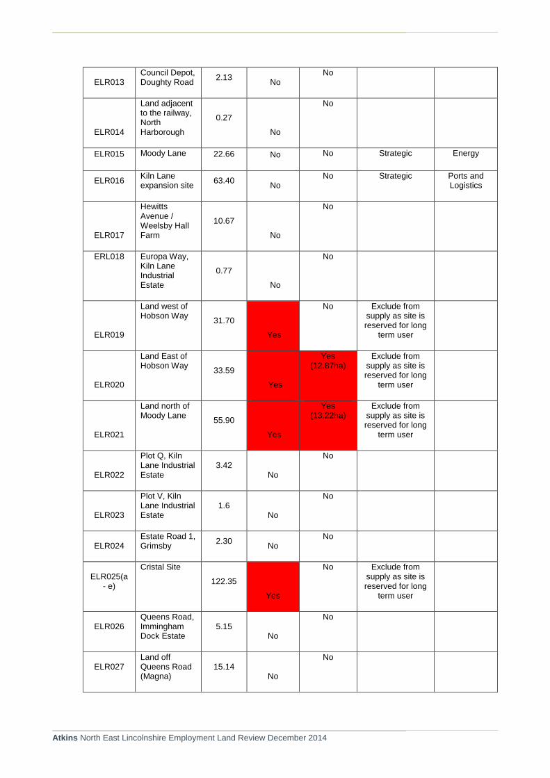
Atkins North East Lincolnshire Employment Land Review December 2014
ELR013 Council Depot, Doughty Road
2.13 No
No
ELR014
Land adjacent to the railway, North Harborough
0.27
No
No
ELR015 Moody Lane 22.66 No No Strategic Energy
ELR016 Kiln Lane expansion site
63.40 No
No Strategic Ports and Logistics
ELR017
Hewitts Avenue / Weelsby Hall Farm
10.67
No
No
ERL018 Europa Way, Kiln Lane Industrial Estate
0.77
No
No
ELR019
Land west of Hobson Way
31.70
Yes
No Exclude from supply as site is reserved for long
term user
ELR020
Land East of Hobson Way
33.59
Yes
Yes (12.87ha)
Exclude from supply as site is reserved for long
term user
ELR021
Land north of Moody Lane
55.90
Yes
Yes (13.22ha)
Exclude from supply as site is reserved for long
term user
ELR022
Plot Q, Kiln Lane Industrial Estate
3.42 No
No
ELR023
Plot V, Kiln Lane Industrial Estate
1.6 No
No
ELR024 Estate Road 1, Grimsby
2.30 No
No
ELR025(a - e)
Cristal Site
122.35
Yes
No Exclude from supply as site is reserved for long
term user
ELR026 Queens Road, Immingham Dock Estate
5.15 No
No
ELR027 Land off Queens Road (Magna)
15.14 No
No

Atkins North East Lincolnshire Employment Land Review December 2014
Key Messages
The following kKey messages arise from our assessment of existing and potential future employment land supply in North East Lincolnshire
In theory, there is a large quantum of land identified for employment use in NEL. However, at least 50% of this ‘supply’ is either subject to major ecological or ownership constraints or of a quality which deems sites unsuitable for employment-related development during the plan period. Consequently, in reality, much of the land supply identified in NEL is not ‘available’ for development as defined in the NPPF. This is reflected to the fact that a large proportion of supply has been allocated but undeveloped for 15 years or more. After the end of Local Plan period, land which is currently assessed as unsuitable or unavailable may come forward to serve future market needs in the long term. This will require significant investment in enabling infrastructure, removal of major constraints and/or a step change in demand from a variety of economic sectors.
ELR028 Land off Estate Road 5
4.0. No
No
ELR032 Cartergate 0.05 No No
ELR033 Waltham Airfield
12.50 No
No
ELR034
Wilton Road Industrial Estate/ Jackson Place
0.30
No
No
ELR035
Europa Way, Kiln Lane Industrial Estate
2.25
No
No
ELR036
Adj Westgate Park Armstrong Street
1.74
No
No
ELR037 Land to rear of Marlin House
1.137 No
No
ELR039
Adjacent Biffa Waste, Gilbey Road
17.05
Yes
No Exclude from supply as site is reserved for long
term user
ELR40
Land off Peaks Lane 1.396
No
No
Source: Atkins / Cofely

Atkins North East Lincolnshire Employment Land Review December 2014
Our assessment of quantitative and qualitative factors has result in our recommendation that six strategic sites are identified as follows: ELR001, ELR005, ELR011, ELR015 and ELR016. Collectively, these strategic sites offer approximately 200ha of good quality employment land. The rationale for identifying these sites as strategic reflects the following characteristics and the sites’ future economic role:
a. Offer strong sector-focused opportunities to potential international and national inward investors / occupiers. This in particular distinguishes the strategic sites from other employment sites which are more likely to concentrate on performing a local or sub-regional economic role.
b. Are at least 20ha in size.
c. Good access to the strategic road network, ports and other key transport hubs.
d. Provide excellent opportunities for support large-scale employment creation.
e. Demonstrate excellent strategic fit with LEP and local economic development policy.
f. Good scope for being deliverable and viable during the plan period.
Atkins North East Lincolnshire Employment Land Review December 2014
7. Conclusions and Policy Implications
7.1. This section highlights the conclusion of the employment land review for North East Lincolnshire and sets out our key policy recommendations for consideration in development of the Local Plan and related economic development strategies for the area.
Policy Drivers 7.2. North East Lincolnshire benefits from a well-established and strong economic development policy
framework which provides a clear focus for the development of forward-looking employment and land-use policies in the Local Plan and associated strategy documents. This targeted and prioritised policy framework is reflected in the recently finalised Strategic Economic Plans of the Humber and Lincolnshire LEPs as well as the Borough’s Development and Growth Plan. These strategy documents provide a sound rationale for pursuing policy and funding support for the five priority sectors identified in this study:
Ports & logistics.
Food manufacturing.
Renewables & energy.
Chemicals & process industries.
Visitor economy, services & retail.
Playing a Strategic Economic Role in Key Sectors 7.3. In accordance with NPPF guidance, this study has included the preparation of quantitative
estimates of future needs for employment land and floorspace. Three key economic scenarios were presented ranging from a ‘business-as-usual’ baseline position through to a strong policy focused and highly ambitious growth scenario. In summary, the scenarios indicated that North East Lincolnshire will require the identification of up to 89 hectares of net additional, suitable and readily available employment land in the period up to 2032. It should be emphasised that the quantitative estimates of need set out in this report were based purely on assumptions of employment change by sector which were translated into floorspace and land demand using standard, average employment density and plot ratios. In reality, it is likely that actual take-up of land in the future could be significantly higher than the ‘modelled’ estimates suggest. This can be explained by a number of key factors which should be considered during the plan development process:
i. As has been demonstrated in the Key Sectors Study, North East Lincolnshire increasingly performs a strategic economic role serving a geographical area which extends substantially beyond its own boundaries. Indeed, the area is of notable attraction to nationally and internationally significant inward investment, particularly in the key sectors of energy / renewable energy, food processing and process industries. To a large extent the competitive advantage of NEL as a magnet to these industrial clusters is reflected the area’s historical and contemporary role as an international seaport gateway location. It is important that the Local Plan economy policies and associated land allocations aim to facilitate economic growth and diversification by making sufficient land of the right size, location and quality available for future inward investment projects and expansion of existing enterprises in the area. Central to these policies will be a focus on providing choice and flexibility in the land and property market supported by public sector investment in core enabling infrastructure.

Atkins North East Lincolnshire Employment Land Review December 2014
ii. Linked to the strategic economic role of key industrial sectors in NEL, the area is increasingly characterised as having a unique economic structure whereby investors and occupiers have very specific land and property needs. Many of the industrial activities clustered in NEL (including energy, ports & logistics, chemicals and food processing) are land hungry in their land and property requirements. Indeed, given the operational nature and security needs of some activities, undeveloped land is required to act as a buffer zone and/or long-term expansion land between key facilities and the wider urban area. Consequently, the application of standard, average employment density and plot ratio assumptions have the potential to dangerously underestimate actual future employment land need in the area. Moreover, given the dynamic nature of the key sectors in NEL, it is difficult to predict with much accuracy the likely land and property needs of rapidly changing technology and market demand. This reinforces the need for the Local Plan to nurture sector-focused policies underpinned by the principles of flexibility, quality, choice and market responsiveness.
Building a Balanced Economy
7.4. Despite the notable importance and positive prospects of the five key sectors and activity clusters, the future of the North East Lincolnshire economy will depend on the expansion and diversification of all aspects of the economy which should be reflected in the Local Plan and related strategies. This should include all forms of viable manufacturing, a wide range of private sector services activities and town centre uses including retail and leisure, and core public sector functions ranging from education and health to public administration. Consequently, economic development, land-use and infrastructure policies should be strongly integrated to capture the spin-off benefits of growth in priority sectors and to create the conditions for the development of a sustainable service sector. This will be central to achieving a more balanced, diversified economy which will improve economic prospects for existing residents whilst appealing to skilled workers considering moving into the area to take up new employment opportunities.
7.5. In doing so, the Local Plan will need to allocate / support the development of suitable sites which can future-proof the NEL economy. This should include:
Office, retail and leisure uses for which demand will be stimulated through a growing primary economy and population.
Niche and general supply chain industries and services (including affordable production, storage and distribution space in key locations).
Active integration with Port owners and their development and diversification plans for the future.
Ensuring Quality of Supply Meets Future Needs 7.6. Our analysis of existing and future supply shows that, in theory, there is a large quantum of land
identified for employment use in NEL. However, at least 50% of this ‘supply’ is either subject to major ecological or ownership constraints or of a quality which deems sites unsuitable for employment-related development during the plan period. Consequently, in reality, much of the land supply identified in NEL is not ‘available’ for development as defined in the NPPF. This is reflected by the fact that a large proportion of supply has been allocated but undeveloped for 15 years or more. After the end of Local Plan period, land which is currently assessed as unsuitable or unavailable may come forward to serve future market needs in the long term. This will require significant investment in enabling infrastructure, removal of major constraints and/or a step change in demand from a variety of economic sectors.
7.7. Our assessment of quantitative and qualitative factors has result in our recommendation that six strategic sites are identified as follows: ELR001, ELR005, ELR011, ELR015 and ELR016. Collectively, these strategic sites offer approximately 200ha of good quality employment land with

Atkins North East Lincolnshire Employment Land Review December 2014
a strong sector-focused offer and excellent scope for being deliverable and viable during the plan period.
7.8. In order to meet the specific and often unique requirement of NEL’s key sectors, the following key principles should be reflected in the Local Plan’s approach to employment land policies and related allocations:
A funding strategy aimed at delivering critical enabling infrastructure investment will be essential in bridging short-term viability gaps and accelerating availability and deliverability of key sites for inward investment and strategic expansion (through Local Growth Fund and other sources).
Sites allocated for employment use should give consideration to the specific needs of key sectors and their supply chain. This is not to suggest that a prescriptive approach is taken to the users of specific sites but to ensure that clear consideration is given to particular needs of each sector and that all latent growth from the sectors can be captured.
The portfolio of sites to be allocated in the Local Plan should be prioritised in terms of their suitability to meet the needs of modern occupiers for all key sectors of the economy. Whilst the size of sites will be an important consideration for some businesses, suitability for employment use will in general be determined by qualitative factors including location, strategic and local access, availability and scope for overcoming physical, policy and ownership constraints.
Given the strategic nature of future potential demand in NEL, established economic development policy objectives and the specialised nature of land and property requirements of many occupiers, the Local Plan policies should nurture an approach of flexibility and choice. This may require the allocation of a wide range of sites to ensure that mobile investment can be secured for the area and wider Humber sub-region. The Plan should also look to reserve sites which may not attract demand until the period after 2032.
Integrated Economic Development Strategy 7.9. Taking the implementation of the Humber and Lincolnshire SEPs to the next stage, we
recommend that NEL prepares a comprehensive economic development strategy. This should provide a strong set of evidence-based priorities and must clearly integrate economic development with land-use and infrastructure objectives and priorities. Key components of the strategy would include:
Rationale and delivery strategy for each of the strategic employment and other priorities sites including the identification of key planning and development parameters.
A framework for integrating land supply policies with softer economic development policies including skills, business support and enterprise (supply chain) strategies.
Develop a targeted infrastructure investment strategy including assessment of economic viability and impact.
Provide a local platform for proactive integration of planning and economic development policy with other Humber and Lincolnshire authorities (through the LEPs).

Atkins North East Lincolnshire Employment Land Review December 2014
Appendix A. Employment Site Plan


Appendix B. Site Assessments

Atkins North East Lincolnshire Employment Land Review December 2014
Site Name and Unique ID ELR001 Pelham Est., Kings Road, Immingham
Background This greenfield site is situated south of Kings Road and East of A1173, west of Queens Road.
General Details
Location Immingham
Promoter Owners: Brocklesby Estates
Agent: Lincs Design Consultancy
Promoters intention to develop
Yes - Owner actively pursuing development opportunities
Planning Status Site is allocated for employment use in the North East Lincolnshire Local Plan (2003) under Policy E1/3.
Outline Planning Permission was granted in April 2014 for general industry (B2) storage and distribution (B8) and minor office development, research and development, light industry (B1) with associated access & landscaping
Application Ref DM/1037/13/OUT
Gross Area of Site 21.61ha
Vacant / Undeveloped Employment Land
21.61ha
Suitability
Access to amenities None: no facilities in local area, nearest facilities in Immingham over 1.5km away
Accessibility by public transport
Reasonable: Bus stop located immediately adjacent to the site on Queens Road, the bus runs to and from Grimsby Monday – Friday during peak hours. It is located over 3.5km away from the nearest train station.
Accessibility to strategic transport network
Good: The site is situated just off the A1173 and is approximately 1 mile from the A180
Neighbouring Uses Positive: The site is adjacent to the Knauf manufacturing factory to the north and Greenfield land to the south
Suitability of site for targeted growth sectors
High: The proximity of the site to the adjacent business uses and proximity to road network will provide a desirable location for businesses, particularly within logistics
Suitability of site for other employment use
High: Site well suited to B2 and B8 uses. Planning application details 74,320 sq. m. (indicative) of B2 and B8.
Constraints on delivery
Access Planning Application details access from either Kings Road or 3 points off Kings Road, Queens Road and the A1173. No traffic constraints identified with existing road network
No PRoWs traverse across or adjacent to the site
Contamination No known contamination issues
Environmental Designations The south eastern corner of the site is identified as being located in the outer land use planning zone as identified by HSE. No other known designations within immediate vicinity
Heritage Designations No Statutory designations within immediate vicinity
Potential for archaeological remains identified in EIA but appropriate mitigation can be implemented
Flooding / Ground Water Protection Zones
Located within Flood Zone 2/3a
Hazard: Extreme
Other On Site constraints Underground gas and water pipes along southern boundary

Atkins North East Lincolnshire Employment Land Review December 2014
Site Name and Unique ID ELR001 Pelham Est., Kings Road, Immingham
Overhead power cables across SE corner of the site
Electricity Substation in NW corner of site
Other Off Site Constraints Adjacent former landfill site (to south of site) separated by landscape buffer
Recent Planning Application for Gas Fuelled Electricity generators
Ownership Single land owner – Brocklesby Estates
Pylons Overhead power cables in se corner of site
Topography None
Overall Review
Conclusions Suitability Site has recently received planning consent for B1,B2 & B8. Potential to target logistics sector, specifically for off-port requirements
Deliverability Land owner currently in early discussions with strategic developer and seeking Regional Growth Fund
It is anticipated that subject to Growth Fund monies being made available, the site will be brought forward in the short to medium term.
Viability The application for Regional Growth Fund suggests that the site is not viable for development without some form of public grant aid support.

Atkins North East Lincolnshire Employment Land Review December 2014
Site Name and Unique ID ELR002 Land west of Kiln Lane Industrial Estate Stallingborough
Background This greenfield site is located west of Kiln Lane Industrial Estate
General Details
Location Stallingborough
Promoter Owners: Agent:
Promoters intention to develop
NELC are in negotiations to acquire the site for the development of a Flood Rescue training centre
Planning Status The site was originally allocated for employment use in the North East Lincolnshire Local Plan (2003) under Policy E1/4 , part of the site has now been built out but 3.64ha still remains available.
Gross Area of Site 8.42ha
Vacant / Undeveloped Employment Land
3.64
Suitability
Access to amenities None: no facilities in immediate local area, nearest facilities in Stallingborough over 3km away
Accessibility by public transport
Reasonable: Bus stop located immediately outside to the site on Kiln Lane, the bus runs to and from Grimsby, Monday – Friday during peak hours. It is located over 3.5km to the nearest train station.
Accessibility to strategic transport network
Good: The site lies approx. half a mile from the A180
Neighbouring Uses Positive: The CATCH training centre is adjacent
Suitability of site for targeted growth sectors
High: The proximity of the site to the adjacent business use and proximity to road network will provide a desirable location for business
Suitability of site for other employment use
High: Site well suited to B1 or B8 uses given the neighbouring facilities Approval to acquire indicates that the site will be developed by the Humber Fire and Rescue Service as a Flood Preparation and Training Centre.
Constraints on delivery
Access From Kiln Lane
No PRoWs traverse across or adjacent to the site
Land value and Contamination
Greenfield site, no known contamination issues
Environmental Designations The western part of the site is identified as being located within the middle and outer land use planning zones as identified by HSE PADHI.
Heritage Designations None within immediate vicinity
Flooding / Ground Water Protection Zones
Located within Flood Zone 2/3a
Hazard: Extreme
Ownership Single land owner
Pylons Yes – across south west of the site
Topography None
Overall Review
Conclusions Suitability Appropriate location for industrial use within an established employment area. Anticipated use for training centre, although acceptable as use for other employment uses.
Deliverability Council proposed acquisition improves certainty of delivery of the site for training centre purposes.

Atkins North East Lincolnshire Employment Land Review December 2014
Site Name and Unique ID ELR002 Land west of Kiln Lane Industrial Estate Stallingborough
Viability Delivery of training centre likely to be publicly funded as is land acquisition. NO viability concerns for proposed use. Confidence in delivery due to NELC involvement
Site Name and Unique ID ELR003 Land South of Kiln Lane Ind Est, Stallingborough
Background This greenfield site is located south of Kiln Lane Industrial Estate and has been partially built out with a car park for the industrial estate located in the northern area.
General Details
Location Stallingborough
Promoter Owners: ABP
Agent: ABP
Promoters intention to develop
Landowners are known to be willing to consider proposals for the site but are not currently actively pursuing development options. Immingham Port Masterplan identifies opportunities for development for car storage, energy related development and/or warehousing/logistics
Planning Status Site is allocated for employment use in the North East Lincolnshire Local Plan (2003) under Policy E1/5
Outline planning consent was granted in 2007 for a mix of B1, B2 and B8 uses across the undeveloped part of the site This application expired in 2010.
ABP submitted an application to renew the planning permission in 2010but this was withdrawn.
Planning Application Refs: DC/1258/06/IMM now expired
DC/511/10/IMM renewal of above but withdrawn
Gross Area of Site 20.64
Withdrawn application indicates 19.38ha developable. Immingham Port Masterplan indicates 19.43 ha (48 acres)
Vacant / Undeveloped Employment Land
19.43
Suitability
Access to amenities None: No facilities within immediate local area, nearest facilities in Stallingborough over 2km away
Accessibility by public transport
Poor: Bus stops located on Kiln Lane, approximately 1km north of the site. The bus runs to and from Grimsby Monday – Friday during peak hours. It is located approximately 2km to the nearest train station.
Accessibility to strategic transport network
Good: The site lies approximately 1km from the A180
Neighbouring Uses Positive: Surrounded by agricultural Greenfield land except to the north where Kiln Lane Industrial Estate is located
Suitability of site for targeted growth sectors
High: The proximity of the site to the adjacent business use and proximity to road network will provide a desirable location for business, site suited to logistics and energy sector proposals
Suitability of site for other employment use
High: Site well suited for storage and distribution, B8 given the neighbouring facilities and proximity to the existing Kiln Lane Industrial Estate and Operational Port Area. Planning applications proposed the establishment of an Employment Business Park for B1, B2 and B8 uses
Constraints on delivery

Atkins North East Lincolnshire Employment Land Review December 2014
Site Name and Unique ID ELR002 Land west of Kiln Lane Industrial Estate Stallingborough
Access Previous planning consent took access from North Moss Lane on the west of the site. No PRoWs traverse across or adjacent to the site
Land value and Contamination
No known contamination issues
Environmental Designations The entire site falls is identified as being located within the inner land use planning zone as identified by HSE PADHI
EIA prepared for planning application identified the need for protection of water voles from the Middle Drain to the north of the site. A 7m easement was proposed.
Heritage Designations None within immediate vicinity
Flooding / Ground Water Protection Zones
Located within Flood Zone 2/3a
Degree: Extreme
Ownership ABP, single land owner
Pylons Yes – across centre of site
Topography None
Overall Review
Conclusions Suitability Established employment zone suited to industrial use
B1, B2 and B8 suitable. Logistics sector primarily, particularly port related storage activity in the short to medium term. Earlier planning applications indicate a total floorspace of 52,028sq.m.
Deliverability Anticipated that the site will not be developed in the short term due to lack of landowner interest. Medium to long term delivery considered a possibility.
Viability Site unlikely to be brought forward until market conditions improve demand and viability, but may require public sector support
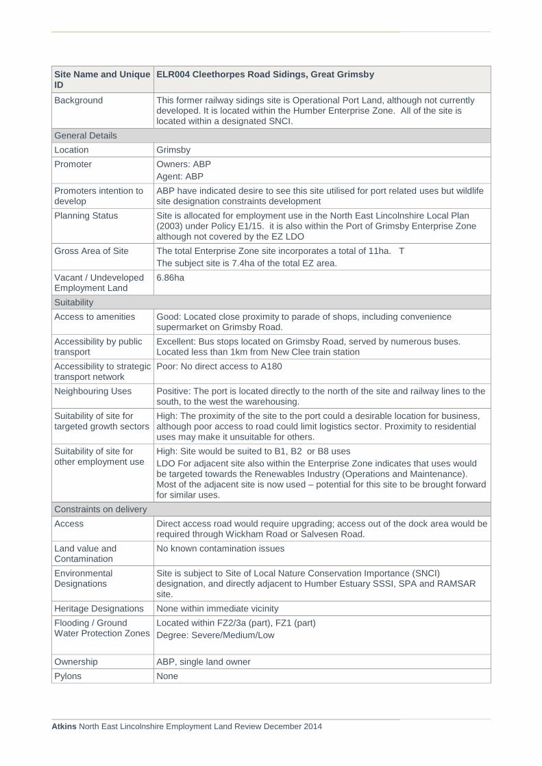
Atkins North East Lincolnshire Employment Land Review December 2014
Site Name and Unique ID
ELR004 Cleethorpes Road Sidings, Great Grimsby
Background This former railway sidings site is Operational Port Land, although not currently developed. It is located within the Humber Enterprise Zone. All of the site is located within a designated SNCI.
General Details
Location Grimsby
Promoter Owners: ABP
Agent: ABP
Promoters intention to develop
ABP have indicated desire to see this site utilised for port related uses but wildlife site designation constraints development
Planning Status Site is allocated for employment use in the North East Lincolnshire Local Plan (2003) under Policy E1/15. it is also within the Port of Grimsby Enterprise Zone although not covered by the EZ LDO
Gross Area of Site The total Enterprise Zone site incorporates a total of 11ha. T
The subject site is 7.4ha of the total EZ area.
Vacant / Undeveloped Employment Land
6.86ha
Suitability
Access to amenities Good: Located close proximity to parade of shops, including convenience supermarket on Grimsby Road.
Accessibility by public transport
Excellent: Bus stops located on Grimsby Road, served by numerous buses. Located less than 1km from New Clee train station
Accessibility to strategic transport network
Poor: No direct access to A180
Neighbouring Uses Positive: The port is located directly to the north of the site and railway lines to the south, to the west the warehousing.
Suitability of site for targeted growth sectors
High: The proximity of the site to the port could a desirable location for business, although poor access to road could limit logistics sector. Proximity to residential uses may make it unsuitable for others.
Suitability of site for other employment use
High: Site would be suited to B1, B2 or B8 uses
LDO For adjacent site also within the Enterprise Zone indicates that uses would be targeted towards the Renewables Industry (Operations and Maintenance). Most of the adjacent site is now used – potential for this site to be brought forward for similar uses.
Constraints on delivery
Access Direct access road would require upgrading; access out of the dock area would be required through Wickham Road or Salvesen Road.
Land value and Contamination
No known contamination issues
Environmental Designations
Site is subject to Site of Local Nature Conservation Importance (SNCI) designation, and directly adjacent to Humber Estuary SSSI, SPA and RAMSAR site.
Heritage Designations None within immediate vicinity
Flooding / Ground Water Protection Zones
Located within FZ2/3a (part), FZ1 (part)
Degree: Severe/Medium/Low
Ownership ABP, single land owner
Pylons None

Atkins North East Lincolnshire Employment Land Review December 2014
Site Name and Unique ID
ELR004 Cleethorpes Road Sidings, Great Grimsby
Topography None
Overall Review
Conclusions Suitability Yes subject to appropriate wildlife site mitigation strategy. Site has been subject to provision of improved flood defence works
Deliverability Enterprise Zone status will encourage investment in this site, as will portside location. Anticipated delivery within 0-3 years. Renewables and OandM operations specifically, otherwise portside activities (mainly B8)
Viability Attractive for Renewables industry due to Enterprise Zone status - Capital Allowances available

Atkins North East Lincolnshire Employment Land Review December 2014
Site Name and Unique ID ELR005 Land N of Moody Lane, Great Grimsby
Background The site is located adjacent to the port, north of Moody Lane. The majority of the site is previously developed land, with some Greenfield on site. The sports ground to the southern part of the site is disused and has been discounted through the Playing Pitch Strategy (2013)
General Details
Location Grimsby
Promoter Owners: RPM Tioxide
Agent: PPH Commercial
Promoters intention to develop
PPH Commercial have confirmed that they wish to promote the site for ELR. They indicate that the site is being marketed and enquiries have been received. They anticipate the site coming forward within 1-5 years.
Planning Status Site is partly allocated for employment use in the North East Lincolnshire Local Plan (2003) under Policy E2/5B
Gross Area of Site 45.25
Vacant / Undeveloped Employment Land
44.5ha Marketing particulars and submission show site is 44.5ha (110 acres)
Suitability
Access to amenities Poor: Not located within walking distance to any facilities
Accessibility by public transport
Good: This site is within walking distance (250m) of a pedalway to the south east that could offer employees the opportunity to commute on foot or by bicycle. In addition, there are three bus stops either within or immediately adjacent to the site that will offer opportunities for employees to access work by public transport
Accessibility to strategic transport network
The site has three road access point all of which provide good access to the A180. The site also has a direct rail spur into the site linking directly into Grimsby and Immingham Docks.
Neighbouring Uses Positive: The estuary is located directly to the north of the site and pharma chemical operation site directly to the west.
Suitability of site for targeted growth sectors
High: The proximity of the site to the estuary and adjacent pharma chemical operational could make the site particularly desirable for chemical and process related industries and good location could be beneficial for port related industries
Site has on site CHP plant, 33KV power to site and 11KV power within site, effluent discharge consent, water abstraction borehole and permits for chemical operations.
Site is marketed as being suitable for Renewable Energy, Waste recycling, power generation or logistics uses.
Suitability of site for other employment use
High: Site well suited to B2 or B8 uses
Agents confirm suitability for B1a, B1b, B1c, B2 and B8
Constraints on delivery
Access Direct access road would require upgrading; access out of the dock area would be required through Wickham Road or Salvesen Road. Access is onto Moody Lane.
No PRoW traverse the site
Land value and Contamination
The site has been remediated and is promoted by marketing by local agents. Enquiries are reported as being received.
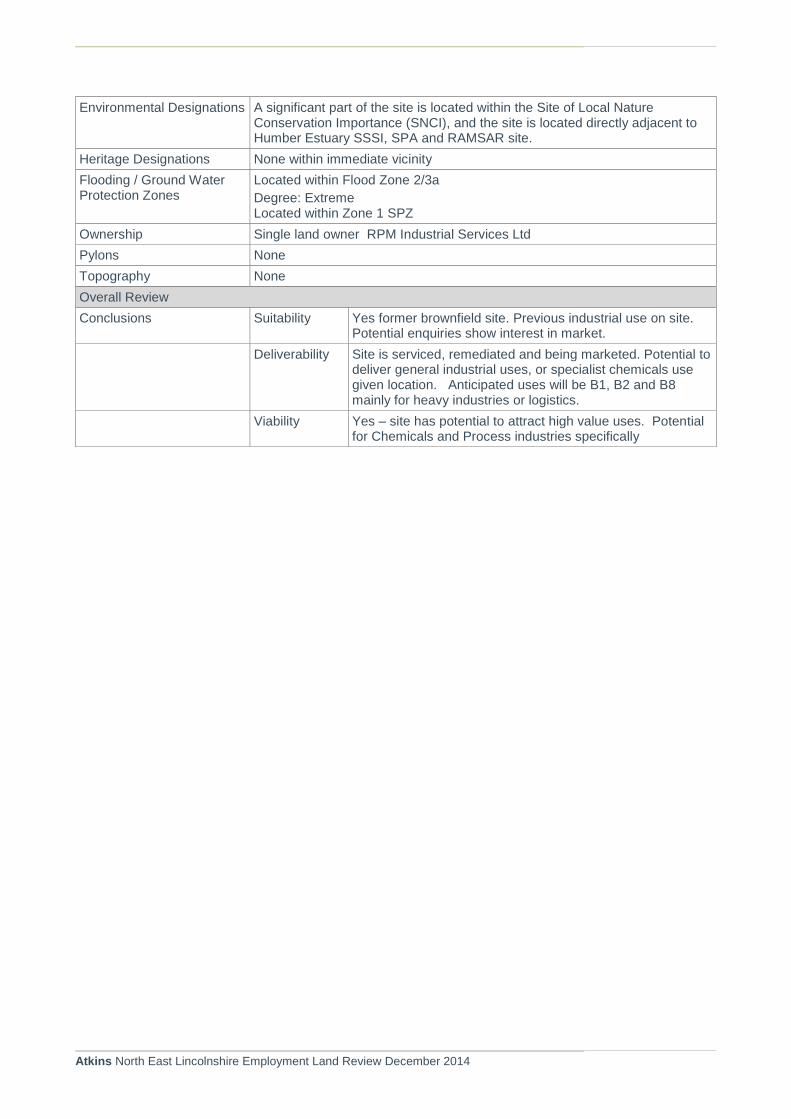
Atkins North East Lincolnshire Employment Land Review December 2014
Environmental Designations A significant part of the site is located within the Site of Local Nature Conservation Importance (SNCI), and the site is located directly adjacent to Humber Estuary SSSI, SPA and RAMSAR site.
Heritage Designations None within immediate vicinity
Flooding / Ground Water Protection Zones
Located within Flood Zone 2/3a
Degree: Extreme Located within Zone 1 SPZ
Ownership Single land owner RPM Industrial Services Ltd
Pylons None
Topography None
Overall Review
Conclusions Suitability Yes former brownfield site. Previous industrial use on site. Potential enquiries show interest in market.
Deliverability Site is serviced, remediated and being marketed. Potential to deliver general industrial uses, or specialist chemicals use given location. Anticipated uses will be B1, B2 and B8 mainly for heavy industries or logistics.
Viability Yes – site has potential to attract high value uses. Potential for Chemicals and Process industries specifically

Atkins North East Lincolnshire Employment Land Review December 2014
Site Name and Unique ID ELR006 Land S of Laporte Road, Stallingborough
Background The site is formed of two land parcels, located either side of Queens Road. The site is adjacent the secure East Gate entrance to the port. Land is currently outside the existing port operational area
General Details
Location Stallingborough
Promoter Owners: ABP
Agent: ABP
Promoters intention to develop
The Immingham Port masterplan (ABP 2012) identifies the two sites as the East Gate development area, and anticipates that the two sites will be brought forward for development as demand and growth aspirations for the port are realised. (Second site is ELR026)
Planning Status Site is allocated for employment use in the North East Lincolnshire Local Plan (2003) under Policy E3/6
Gross Area of Site 3.26ha
Vacant / Undeveloped Employment Land
3.26ha
Suitability
Access to amenities None: Not located within walking distance to any amenity facilities. The nearest facilities are available in Immingham
Accessibility by public transport
Reasonable: The site is located within 100m of a bus stop on Queens Road, the bus service runs to and from Grimsby Monday – Friday during peak hours. The site is located over 5km to the nearest train station.
Accessibility to strategic transport network
Good: The site is situated close to the A1173 and is approximately 4km from the A180 . Also has good access to port facilities being located adjacent to the east gate.
Neighbouring Uses Positive: Port related activities
Suitability of site for targeted growth sectors
High: The ABP masterplan indicates that the site is considered appropriate for open/specialist storage, automotive storage, bio-fuel development (to support IOT) and Wind Turbines for embedded generation
Suitability of site for other employment use
High: Site well suited to B2 and B8 uses
Constraints on delivery
Access Access would be off Laporte Road
No PRoW traverse the site
Land value and Contamination
No known contamination issues
Environmental Designations The south corner of the site is identified as being located in the outer land use planning zone as identified by HSE PADHI.
Heritage Designations None within immediate vicinity
Flooding / Ground Water Protection Zones
Located within Flood Zone 2/3a
Degree: Extreme
Ownership Single land owner
Pylons None
Topography None

Atkins North East Lincolnshire Employment Land Review December 2014
Site Name and Unique ID ELR006 Land S of Laporte Road, Stallingborough
Overall Review
Conclusions Suitability Yes -specifically for port related uses – e.g. storage or fuel/energy generation
Deliverability Site will be delivered as part of port growth strategy - -reliant upon ABP management strategy and consolidation of other uses
Viability Site development likely to be demand led. No restrictions on ability of ABP to seek public sector support

Atkins North East Lincolnshire Employment Land Review December 2014
Site Name and Unique ID ELR007 Off Hall Park Road, Immingham (formerly Manby Rd Business Park)
Background This Greenfield site located in an established industrial area close to Immingham
General Details
Location Immingham
Promoter Owners: Draper Retirement Fund
Agent: PPH Commercial
Site promoted by Agent
Promoters intention to develop
Site is currently being marketed for commercial opportunities specifically for B1, B2 and B8 uses. Marketing details indicate site is available on a freehold basis.
Planning Status Site is allocated for employment use in the North East Lincolnshire Local Plan (2003) under Policy E5/1
Gross Area of Site 2.82ha
Vacant / Undeveloped Employment Land
Two sites comprising Plot 1 0.43 ha and Plot 2 0.23 ha
Suitability
Access to amenities Good: Located within walking distance of facilities within Immingham, approximately 0.5km
Accessibility by public transport
Reasonable: 2 bus stops are located adjacent to the site on Pelham Road, with numerous bus services available, including buses to Grimsby. The site is approximately 5km to the nearest train station at Habrough
Accessibility to strategic transport network
Good: The site is situated close to the A1173
Neighbouring Uses Positive: Located within an established industrial area and would suit B2 or B8 use, residential houses back onto the site on Manby Road.
Suitability of site for targeted growth sectors
Low: Located on edge of Immingham therefore may not be appropriate for some of targeted growth areas
Suitability of site for other employment use
High: Site well suited to B1 or B2 industry
Plot 1 potentially subject to sale for development for B2 uses
Constraints on delivery
Access Access already exists from Half Park Road, this may hinder development but may be opportunities to take access from Kings Road
No PRoW traverse the site
Land value and Contamination
Greenfield site, no known contamination issues.
On site provision of mains electricity and sewers
Environmental Designations An Air Quality Management Area (AQMA) is located to the east of the site. Routing agreements may be necessary
Heritage Designations None within immediate vicinity
Flooding / Ground Water Protection Zones
Located within Flood Zone 2/3a
Degree: Extreme
Ownership Draper Retirement Fund
Pylons Telephone exchange located on southern part of site . Electricity available on site
Topography None
Overall Review

Atkins North East Lincolnshire Employment Land Review December 2014
Site Name and Unique ID ELR007 Off Hall Park Road, Immingham (formerly Manby Rd Business Park)
Conclusions Suitability Considered suitable for generic B1, B2 and B8 uses. Sites available on a freehold basis and being marketed
Deliverability Anticipated delivery Yrs 1-5. Economic Development advise of known interest in Plot 1 for development of industrial units
Viability Proposed scheme sought RGF funding but was not successful. Anticipated scheme will go ahead but potentially on phased basis.
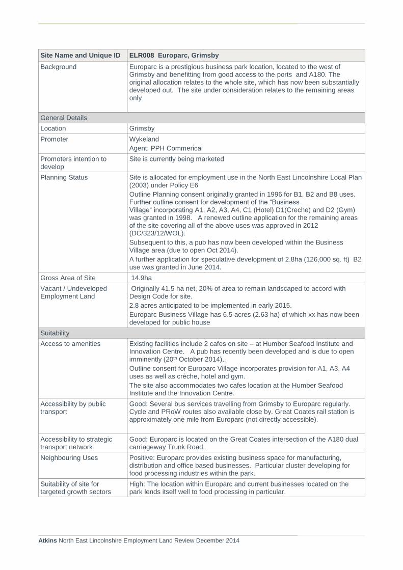
Atkins North East Lincolnshire Employment Land Review December 2014
Site Name and Unique ID ELR008 Europarc, Grimsby
Background Europarc is a prestigious business park location, located to the west of Grimsby and benefitting from good access to the ports and A180. The original allocation relates to the whole site, which has now been substantially developed out. The site under consideration relates to the remaining areas only
General Details
Location Grimsby
Promoter Wykeland
Agent: PPH Commerical
Promoters intention to develop
Site is currently being marketed
Planning Status Site is allocated for employment use in the North East Lincolnshire Local Plan (2003) under Policy E6
Outline Planning consent originally granted in 1996 for B1, B2 and B8 uses. Further outline consent for development of the “Business Village“ incorporating A1, A2, A3, A4, C1 (Hotel) D1(Creche) and D2 (Gym) was granted in 1998. A renewed outline application for the remaining areas of the site covering all of the above uses was approved in 2012 (DC/323/12/WOL).
Subsequent to this, a pub has now been developed within the Business Village area (due to open Oct 2014).
A further application for speculative development of 2.8ha (126,000 sq. ft) B2 use was granted in June 2014.
Gross Area of Site 14.9ha
Vacant / Undeveloped Employment Land
Originally 41.5 ha net, 20% of area to remain landscaped to accord with Design Code for site.
2.8 acres anticipated to be implemented in early 2015.
Europarc Business Village has 6.5 acres (2.63 ha) of which xx has now been developed for public house
Suitability
Access to amenities Existing facilities include 2 cafes on site – at Humber Seafood Institute and Innovation Centre. A pub has recently been developed and is due to open imminently (20th October 2014),.
Outline consent for Europarc Village incorporates provision for A1, A3, A4 uses as well as crèche, hotel and gym.
The site also accommodates two cafes location at the Humber Seafood Institute and the Innovation Centre.
Accessibility by public transport
Good: Several bus services travelling from Grimsby to Europarc regularly. Cycle and PRoW routes also available close by. Great Coates rail station is approximately one mile from Europarc (not directly accessible).
Accessibility to strategic transport network
Good: Europarc is located on the Great Coates intersection of the A180 dual carriageway Trunk Road.
Neighbouring Uses Positive: Europarc provides existing business space for manufacturing, distribution and office based businesses. Particular cluster developing for food processing industries within the park.
Suitability of site for targeted growth sectors
High: The location within Europarc and current businesses located on the park lends itself well to food processing in particular.

Atkins North East Lincolnshire Employment Land Review December 2014
Site Name and Unique ID ELR008 Europarc, Grimsby
Suitability of site for other employment use
High: Site well suited particularly to B1 or B2 uses.
Constraints on delivery
Access Good access as part of the existing Europarc development
Land value and Contamination
Greenfield site, no known contamination issues
Environmental Designations None within immediate vicinity
Heritage Designations None within immediate vicinity
Flooding / Ground Water Protection Zones
Located within Flood Zone 2/3a
Degree: Extreme/Severe
Not located within a SPZ.
Ownership Wykeland
Pylons None
Topography None
Overall Review
Conclusions Suitability Site is considered suitable for B1 and B2 uses with specific focus on the Food Processing sector. Renewed outline consent indicates industrial in size categories between 1300 sq. m. and 20,500 sq. m. It also suggests a further 3,000 sq. m. of office accommodation can be provided.
Deliverability Anticipated completion of the site within 1-5 years.
Viability To date, none of this park has been developed without public sector support. Anticipated that future development will also require appropriate support
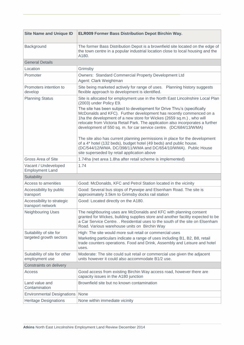
Atkins North East Lincolnshire Employment Land Review December 2014
Site Name and Unique ID ELR009 Former Bass Distribution Depot Birchin Way.
Background The former Bass Distribution Depot is a brownfield site located on the edge of the town centre in a popular industrial location close to local housing and the A180.
General Details
Location Grimsby
Promoter Owners: Standard Commercial Property Development Ltd
Agent: Clark Weightman
Promoters intention to develop
Site being marketed actively for range of uses. Planning history suggests flexible approach to development is identified.
Planning Status Site is allocated for employment use in the North East Lincolnshire Local Plan (2003) under Policy E9.
The site has been subject to development for Drive Thru’s (specifically McDonalds and KFC). Further development has recently commenced on a 1ha the development of a new store for Wickes (2659 sq.m.) , who will relocate from Victoria Retail Park. The application also incorporates a further development of 550 sq. m. for car service centre. (DC/684/13/WMA)
The site also has current planning permissions in place for the development of a 4* hotel (132 beds), budget hotel (49 beds) and public house. (DC/544/12/WMA. DC/398/11/WMA and DC/654/10/WMA). Public House site superseded by retail application above
Gross Area of Site 1.74ha (net area 1.8ha after retail scheme is implemented)
Vacant / Undeveloped Employment Land
1.74
Suitability
Access to amenities Good: McDonalds, KFC and Petrol Station located in the vicinity
Accessibility by public transport
Good: Several bus stops of Pyewipe and Elsenham Road. The site is approximately 3.5km to Grimsby docks rail station
Accessibility to strategic transport network
Good: Located directly on the A180.
Neighbouring Uses The neighbouring uses are McDonalds and KFC with planning consent granted for Wickes, building supplies store and another facility expected to be a Car Service Centre. . Residential uses to the south of the site on Elsenham Road. Various warehouse units on Birchin Way
Suitability of site for targeted growth sectors
High: The site would more suit retail or commercial uses
Marketing particulars indicate a range of uses including B1, B2, B8, retail trade counters operations. Food and Drink, Assembly and Leisure and hotel uses.
Suitability of site for other employment use
Moderate: The site could suit retail or commercial use given the adjacent units however it could also accommodate B1/2 use.
Constraints on delivery
Access Good access from existing Birchin Way access road, however there are capacity issues in the A180 junction
Land value and Contamination
Brownfield site but no known contamination
Environmental Designations None
Heritage Designations None within immediate vicinity

Atkins North East Lincolnshire Employment Land Review December 2014
Site Name and Unique ID ELR009 Former Bass Distribution Depot Birchin Way.
Flooding / Ground Water Protection Zones
Flood Zone 2/3a
Degree: Severe/Moderate/Low
None within immediate vicinity
Ownership Standard Commercial Property Devt Ltd
Pylons None
Topography None
Overall Review
Conclusions Suitability Potentially suitable for B1/B2 and B8 uses given access to A180. May also suit higher value retail/assembly and leisure/hotel uses
Deliverability Anticipated development of site within 1-5 years.
Viability Anticipated that site will be developed on a demand led basis. Potential requirement for public sector support for industrial uses needed
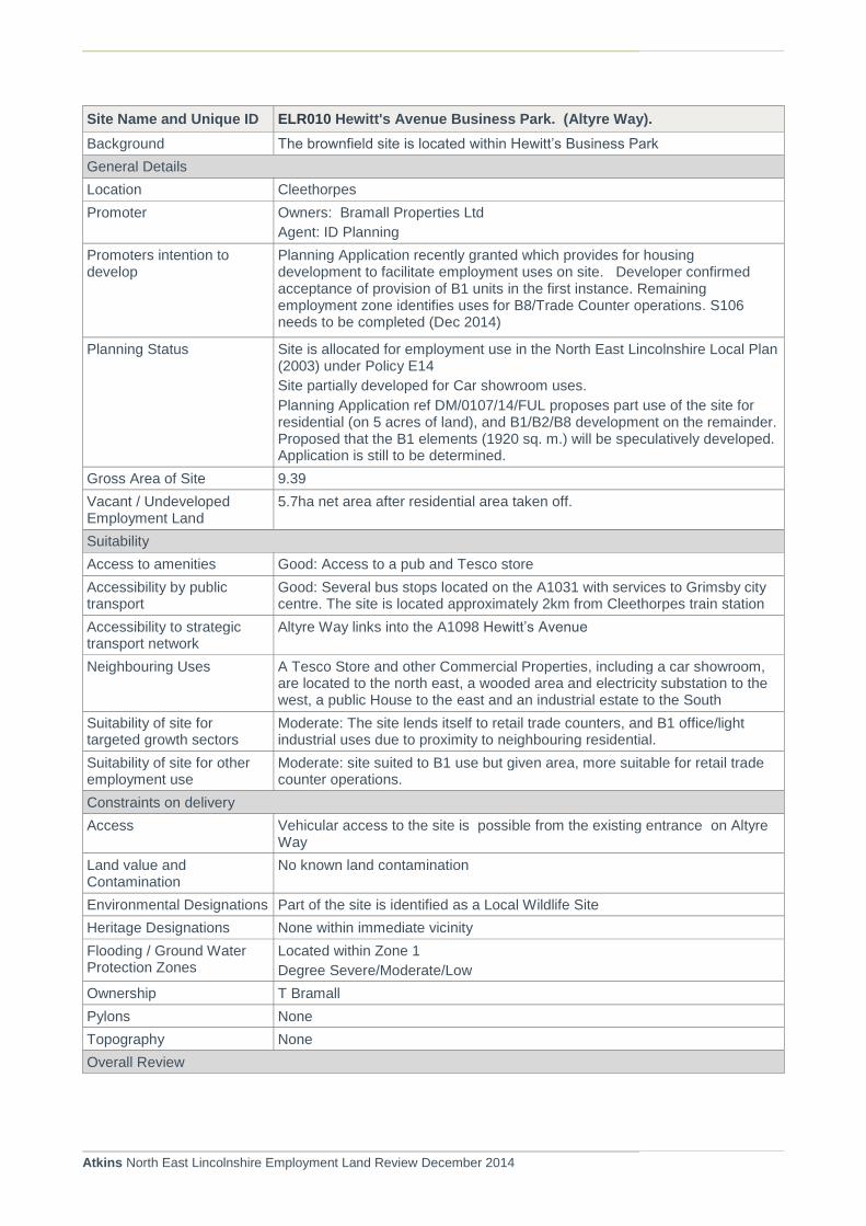
Atkins North East Lincolnshire Employment Land Review December 2014
Site Name and Unique ID ELR010 Hewitt's Avenue Business Park. (Altyre Way).
Background The brownfield site is located within Hewitt’s Business Park
General Details
Location Cleethorpes
Promoter Owners: Bramall Properties Ltd
Agent: ID Planning
Promoters intention to develop
Planning Application recently granted which provides for housing development to facilitate employment uses on site. Developer confirmed acceptance of provision of B1 units in the first instance. Remaining employment zone identifies uses for B8/Trade Counter operations. S106 needs to be completed (Dec 2014)
Planning Status Site is allocated for employment use in the North East Lincolnshire Local Plan (2003) under Policy E14
Site partially developed for Car showroom uses.
Planning Application ref DM/0107/14/FUL proposes part use of the site for residential (on 5 acres of land), and B1/B2/B8 development on the remainder. Proposed that the B1 elements (1920 sq. m.) will be speculatively developed. Application is still to be determined.
Gross Area of Site 9.39
Vacant / Undeveloped Employment Land
5.7ha net area after residential area taken off.
Suitability
Access to amenities Good: Access to a pub and Tesco store
Accessibility by public transport
Good: Several bus stops located on the A1031 with services to Grimsby city centre. The site is located approximately 2km from Cleethorpes train station
Accessibility to strategic transport network
Altyre Way links into the A1098 Hewitt’s Avenue
Neighbouring Uses A Tesco Store and other Commercial Properties, including a car showroom, are located to the north east, a wooded area and electricity substation to the west, a public House to the east and an industrial estate to the South
Suitability of site for targeted growth sectors
Moderate: The site lends itself to retail trade counters, and B1 office/light industrial uses due to proximity to neighbouring residential.
Suitability of site for other employment use
Moderate: site suited to B1 use but given area, more suitable for retail trade counter operations.
Constraints on delivery
Access Vehicular access to the site is possible from the existing entrance on Altyre Way
Land value and Contamination
No known land contamination
Environmental Designations Part of the site is identified as a Local Wildlife Site
Heritage Designations None within immediate vicinity
Flooding / Ground Water Protection Zones
Located within Zone 1
Degree Severe/Moderate/Low
Ownership T Bramall
Pylons None
Topography None
Overall Review

Atkins North East Lincolnshire Employment Land Review December 2014
Site Name and Unique ID ELR010 Hewitt's Avenue Business Park. (Altyre Way).
Conclusions Suitability Potential for site to be considered as B1 office/light industrial. Also one of the few sites within the south of the Borough deemed as suitable for employment use. Provide good location for small business operations
Delivery Applicant advises that B1 office development would be progressed speculatively in advance of any proposed residential (if approved). Anticipated timescale likely to be 1-5 years.
Viability The proposed housing development currently on site reduces the impact of any viability issues associated with developing the site.
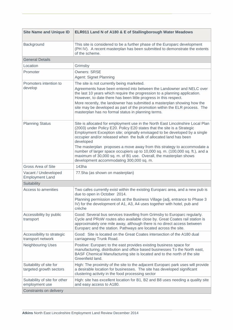
Atkins North East Lincolnshire Employment Land Review December 2014
Site Name and Unique ID ELR011 Land N of A180 & E of Stallingborough Water Meadows
Background This site is considered to be a further phase of the Europarc development (PH IV). A recent masterplan has been submitted to demonstrate the extents of the scheme.
General Details
Location Grimsby
Promoter Owners: SRSE
Agent: Signet Planning
Promoters intention to develop
The site is not currently being marketed.
Agreements have been entered into between the Landowner and NELC over the last 10 years which require the progression to a planning application. However, to date there has been little progress in this respect.
More recently, the landowner has submitted a masterplan showing how the site may be developed as part of the promotion within the ELR process. The masterplan has no formal status in planning terms.
Planning Status Site is allocated for employment use in the North East Lincolnshire Local Plan (2003) under Policy E20. Policy E20 states that the site is a Strategic Employment Exception site; originally envisaged to be developed by a single occupier and/or released when the bulk of allocated land has been developed
The masterplan proposes a move away from this strategy to accommodate a number of larger space occupiers up to 10,000 sq. m. (100,000 sq. ft.), and a maximum of 30,000 sq. m. of B1 use. Overall, the masterplan shows development accommodating 300,000 sq. m.
Gross Area of Site 143ha
Vacant / Undeveloped Employment Land
77.5ha (as shown on masterplan)
Suitability
Access to amenities Two cafes currently exist within the existing Europarc area, and a new pub is due to open in October 2014.
Planning permission exists at the Business Village (adj, entrance to Phase 3 IV) for the development of A1, A3, A4 uses together with hotel, pub and crèche
Accessibility by public transport
Good: Several bus services travelling from Grimsby to Europarc regularly. Cycle and PRoW routes also available close by. Great Coates rail station is approximately one mile away, although there is no direct access between Europarc and the station. Pathways are located across the site.
Accessibility to strategic transport network
Good: Site is located on the Great Coates intersection of the A180 dual carriageway Trunk Road.
Neighbouring Uses Positive: Europarc to the east provides existing business space for manufacturing, distribution and office based businesses To the North east, BASF Chemical Manufacturing site is located and to the north of the site Greenfield land.
Suitability of site for targeted growth sectors
High: The proximity of the site to the adjacent Europarc park uses will provide a desirable location for businesses. The site has developed significant clustering activity in the food processing sector
Suitability of site for other employment use
High: site has excellent location for B1, B2 and B8 uses needing a quality site and easy access to A180.
Constraints on delivery

Atkins North East Lincolnshire Employment Land Review December 2014
Site Name and Unique ID ELR011 Land N of A180 & E of Stallingborough Water Meadows
Access
Infrastructure requirements identified in the masterplan show that up to 20,000 sq.m. could be developed without any requirement to facilitate off-site highway improvement works, A further 70,000 sq. m can be provided within modest off-site highway improvements on the A1136 north of A180. .
Land value and Contamination
There are no known contamination issues associated with the site. However, drainage issues will need to be addressed. The masterplan proposes the provision of drainage detention basins and swales to accommodate 75,000 cubic metres .
Environmental Designations Eastern boundary is an identified LWS
However the north east of the site has been identified as a proposed area of Strategic Mitigation in relation the Humber Estuary SSSI, SPA and RAMSAR site. Measured area of SM = 24.85ha (masterplan suggests 23ha)
Heritage Designations None within immediate vicinity
Flooding / Ground Water Protection Zones
Located within Flood Zone 2/3a
Degree: Extreme
Not located within a SPZ.
Masterplan indicates the need to raise finished floor levels and an 8m stand off area from the top of each bank, together with multiple points of access.
Ownership
Pylons Electricity pylons across the southern part of the site
Topography None
Overall Review
Conclusions Suitability Yes, established area for industry with good location adjoining A180. Suitable for B1, B2 and B8 uses (subject to provision of highway and drainage infrastructure). Potential to attract further development of the existing cluster of food processing sector.
Deliverability Yes but needs a proactive approach that provides strategic infrastructure, and serviced plots. Owners are promoting the site proactively through the Local Plan process. The masterplan does not indicate any timescales for delivery, but anticipated to commence within the 5-10 year timescale
Viability No details of viability have been provided. However, it is unlikely that provision of infrastructure and delivery of speculative development will take place without some form of public sector support.
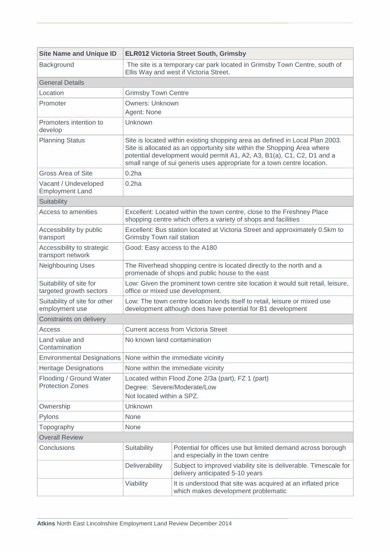
Atkins North East Lincolnshire Employment Land Review December 2014
Site Name and Unique ID ELR012 Victoria Street South, Grimsby
Background The site is a temporary car park located in Grimsby Town Centre, south of Ellis Way and west if Victoria Street.
General Details
Location Grimsby Town Centre
Promoter Owners: Unknown
Agent: None
Promoters intention to develop
Unknown
Planning Status Site is located within existing shopping area as defined in Local Plan 2003. Site is allocated as an opportunity site within the Shopping Area where potential development would permit A1, A2, A3, B1(a), C1, C2, D1 and a small range of sui generis uses appropriate for a town centre location.
Gross Area of Site 0.2ha
Vacant / Undeveloped Employment Land
0.2ha
Suitability
Access to amenities Excellent: Located within the town centre, close to the Freshney Place shopping centre which offers a variety of shops and facilities
Accessibility by public transport
Excellent: Bus station located at Victoria Street and approximately 0.5km to Grimsby Town rail station
Accessibility to strategic transport network
Good: Easy access to the A180
Neighbouring Uses The Riverhead shopping centre is located directly to the north and a promenade of shops and public house to the east
Suitability of site for targeted growth sectors
Low: Given the prominent town centre site location it would suit retail, leisure, office or mixed use development.
Suitability of site for other employment use
Low: The town centre location lends itself to retail, leisure or mixed use development although does have potential for B1 development
Constraints on delivery
Access Current access from Victoria Street
Land value and Contamination
No known land contamination
Environmental Designations None within the immediate vicinity
Heritage Designations None within the immediate vicinity
Flooding / Ground Water Protection Zones
Located within Flood Zone 2/3a (part), FZ 1 (part)
Degree: Severe/Moderate/Low
Not located within a SPZ.
Ownership Unknown
Pylons None
Topography None
Overall Review
Conclusions Suitability Potential for offices use but limited demand across borough and especially in the town centre
Deliverability Subject to improved viability site is deliverable. Timescale for delivery anticipated 5-10 years
Viability It is understood that site was acquired at an inflated price which makes development problematic

Atkins North East Lincolnshire Employment Land Review December 2014
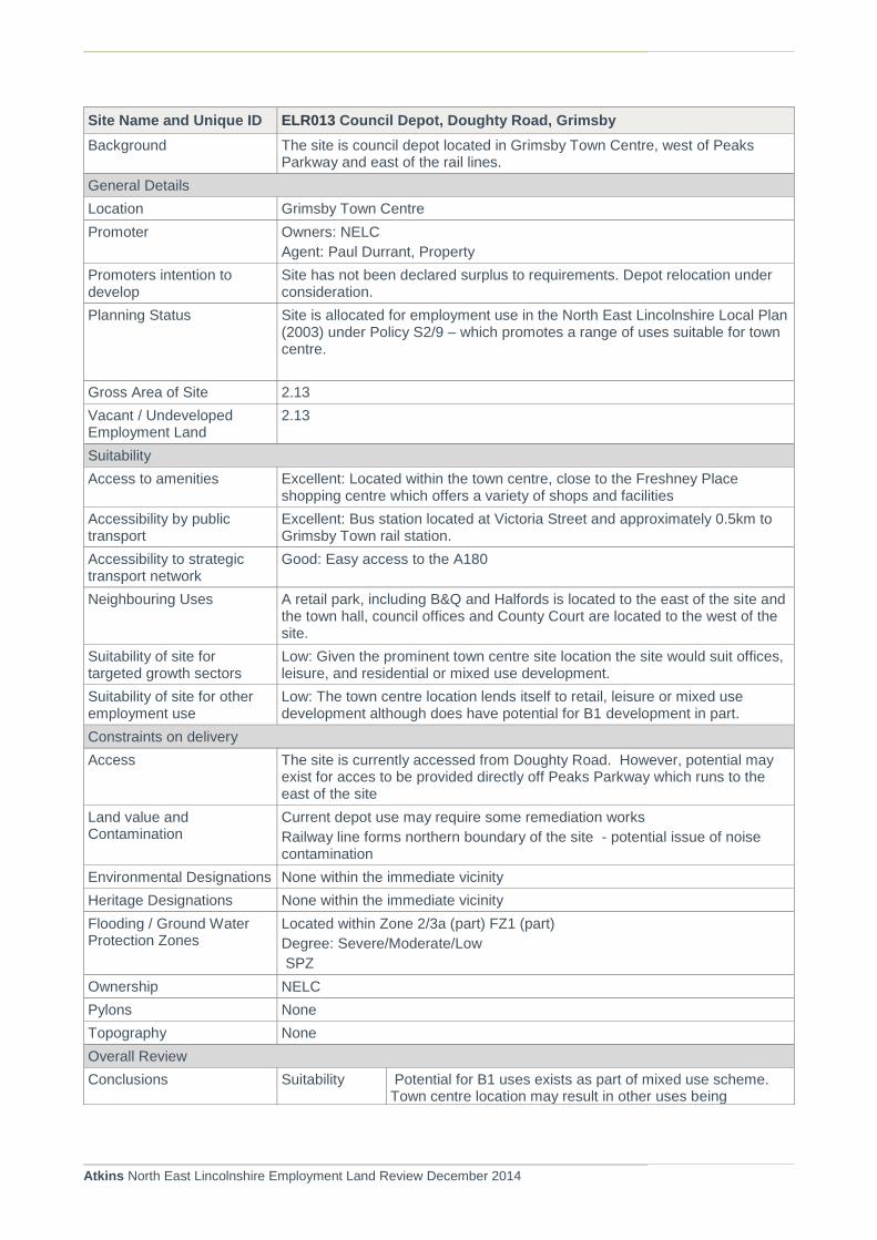
Atkins North East Lincolnshire Employment Land Review December 2014
Site Name and Unique ID ELR013 Council Depot, Doughty Road, Grimsby
Background The site is council depot located in Grimsby Town Centre, west of Peaks Parkway and east of the rail lines.
General Details
Location Grimsby Town Centre
Promoter Owners: NELC
Agent: Paul Durrant, Property
Promoters intention to develop
Site has not been declared surplus to requirements. Depot relocation under consideration.
Planning Status Site is allocated for employment use in the North East Lincolnshire Local Plan (2003) under Policy S2/9 – which promotes a range of uses suitable for town centre.
Gross Area of Site 2.13
Vacant / Undeveloped Employment Land
2.13
Suitability
Access to amenities Excellent: Located within the town centre, close to the Freshney Place shopping centre which offers a variety of shops and facilities
Accessibility by public transport
Excellent: Bus station located at Victoria Street and approximately 0.5km to Grimsby Town rail station.
Accessibility to strategic transport network
Good: Easy access to the A180
Neighbouring Uses A retail park, including B&Q and Halfords is located to the east of the site and the town hall, council offices and County Court are located to the west of the site.
Suitability of site for targeted growth sectors
Low: Given the prominent town centre site location the site would suit offices, leisure, and residential or mixed use development.
Suitability of site for other employment use
Low: The town centre location lends itself to retail, leisure or mixed use development although does have potential for B1 development in part.
Constraints on delivery
Access The site is currently accessed from Doughty Road. However, potential may exist for acces to be provided directly off Peaks Parkway which runs to the east of the site
Land value and Contamination
Current depot use may require some remediation works
Railway line forms northern boundary of the site - potential issue of noise contamination
Environmental Designations None within the immediate vicinity
Heritage Designations None within the immediate vicinity
Flooding / Ground Water Protection Zones
Located within Zone 2/3a (part) FZ1 (part)
Degree: Severe/Moderate/Low
SPZ
Ownership NELC
Pylons None
Topography None
Overall Review
Conclusions Suitability Potential for B1 uses exists as part of mixed use scheme. Town centre location may result in other uses being

Atkins North East Lincolnshire Employment Land Review December 2014
Site Name and Unique ID ELR013 Council Depot, Doughty Road, Grimsby
considered e.g. retail, housing. Site is also being considered for town centre housing provision.
Deliverability There is currently limited demand for office accommodation within the town centre. However, growth forecasts suggest that additional B1 floorspace will be required to support other growth in key sectors.
Viability Generally B1 schemes are considered unviable, so is likely to be delivered upon pre-let or with appropriate public sector subsidy.

Atkins North East Lincolnshire Employment Land Review December 2014
Site Name and Unique ID ELR014 Land Adjacent to the railway north, Habrough.
Background A hard standing area currently used for car parking located directly north of Habrough train station on Station Road/ B1210. Habrough is a rural village to the west of Immingham.
General Details
Location Habrough
Promoter Agent: Ross Davy Associates
Promoters intention to develop
Planning consent on site
Planning Status Site is allocated for employment use in the North East Lincolnshire Local Plan (2003) under Policy E4/1
Planning consent was granted in 2012 for eight industrial units (Planning ref: DC/197/11/IMM)
Gross Area of Site 0.27ha
Vacant / Undeveloped Employment Land
0.27ha
Suitability
Access to amenities Reasonable: There is a pub and post office adjacent to the site, but no other amenities within Habrough.
Accessibility by public transport
Excellent: Bus stops available on Station Road (B1210) and immediately adjacent to Habrough train station providing services to Grimsby Town. A PRoW routes around the site.
Accessibility to strategic transport network
Poor: Located approximately 5km to the A180 via the A160.
Neighbouring Uses To the west of the site, on the other side of Station Road there is a pub and post office, and residential area of the village. To the east of the site is agricultural land and to the south the railway line and rail related land.
Suitability of site for targeted growth sectors
Low: A small site, within a residential rural village, not well located to the strategic transport network
Suitability of site for other employment use
Reasonable: The site would suit B1 use given rural location and impacts upon residential amenity and its small size.
Constraints on delivery
Access Existing access from Station Road
Land value and Contamination
No know contamination
Environmental Designations None within the immediate vicinity
Heritage Designations None within the immediate vicinity
Flooding / Ground Water Protection Zones
FZ1
Located within Zone 2 (outer zone) SPZ.
Ownership Unknown
Pylons None
Topography None
Overall Review
Conclusions Suitability The site would suit B1 use given rural location and impacts upon residential amenity and its small size. Provides accommodation for small business operations within the rural area
Delivery No known interest in progressing site.

Atkins North East Lincolnshire Employment Land Review December 2014
Site Name and Unique ID ELR014 Land Adjacent to the railway north, Habrough.
Viability Considered site unlikely to be viable and reliant upon direct investors or public sector support
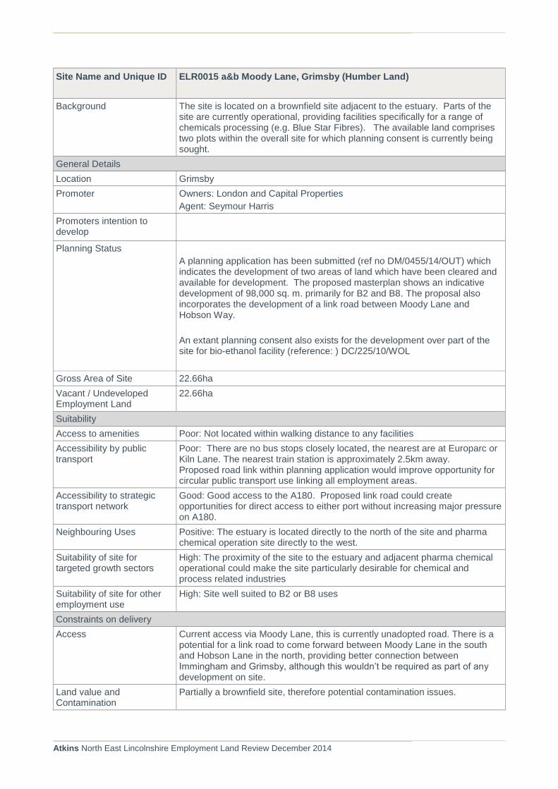
Atkins North East Lincolnshire Employment Land Review December 2014
Site Name and Unique ID ELR0015 a&b Moody Lane, Grimsby (Humber Land)
Background The site is located on a brownfield site adjacent to the estuary. Parts of the site are currently operational, providing facilities specifically for a range of chemicals processing (e.g. Blue Star Fibres). The available land comprises two plots within the overall site for which planning consent is currently being sought.
General Details
Location Grimsby
Promoter Owners: London and Capital Properties
Agent: Seymour Harris
Promoters intention to develop
Planning Status
A planning application has been submitted (ref no DM/0455/14/OUT) which indicates the development of two areas of land which have been cleared and available for development. The proposed masterplan shows an indicative development of 98,000 sq. m. primarily for B2 and B8. The proposal also incorporates the development of a link road between Moody Lane and Hobson Way.
An extant planning consent also exists for the development over part of the site for bio-ethanol facility (reference: ) DC/225/10/WOL
Gross Area of Site 22.66ha
Vacant / Undeveloped Employment Land
22.66ha
Suitability
Access to amenities Poor: Not located within walking distance to any facilities
Accessibility by public transport
Poor: There are no bus stops closely located, the nearest are at Europarc or Kiln Lane. The nearest train station is approximately 2.5km away. Proposed road link within planning application would improve opportunity for circular public transport use linking all employment areas.
Accessibility to strategic transport network
Good: Good access to the A180. Proposed link road could create opportunities for direct access to either port without increasing major pressure on A180.
Neighbouring Uses Positive: The estuary is located directly to the north of the site and pharma chemical operation site directly to the west.
Suitability of site for targeted growth sectors
High: The proximity of the site to the estuary and adjacent pharma chemical operational could make the site particularly desirable for chemical and process related industries
Suitability of site for other employment use
High: Site well suited to B2 or B8 uses
Constraints on delivery
Access Current access via Moody Lane, this is currently unadopted road. There is a potential for a link road to come forward between Moody Lane in the south and Hobson Lane in the north, providing better connection between Immingham and Grimsby, although this wouldn’t be required as part of any development on site.
Land value and Contamination
Partially a brownfield site, therefore potential contamination issues.
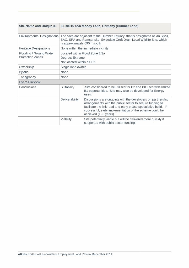
Atkins North East Lincolnshire Employment Land Review December 2014
Site Name and Unique ID ELR0015 a&b Moody Lane, Grimsby (Humber Land)
Environmental Designations The sites are adjacent to the Humber Estuary, that is designated as an SSSI, SAC, SPA and Ramsar site Sweedale Croft Drain Local Wildlife Site, which is approximately 690m south
Heritage Designations None within the immediate vicinity
Flooding / Ground Water Protection Zones
Located within Flood Zone 2/3a
Degree: Extreme
Not located within a SPZ.
Ownership Single land owner
Pylons None
Topography None
Overall Review
Conclusions Suitability Site considered to be utilised for B2 and B8 uses with limited B1 opportunities. Site may also be developed for Energy uses.
Deliverability Discussions are ongoing with the developers on partnership arrangements with the public sector to secure funding to facilitate the link road and early phase speculative build. IF successful, early implementation of the scheme could be achieved (1 -5 years)
Viability Site potentially viable but will be delivered more quickly if supported with public sector funding.
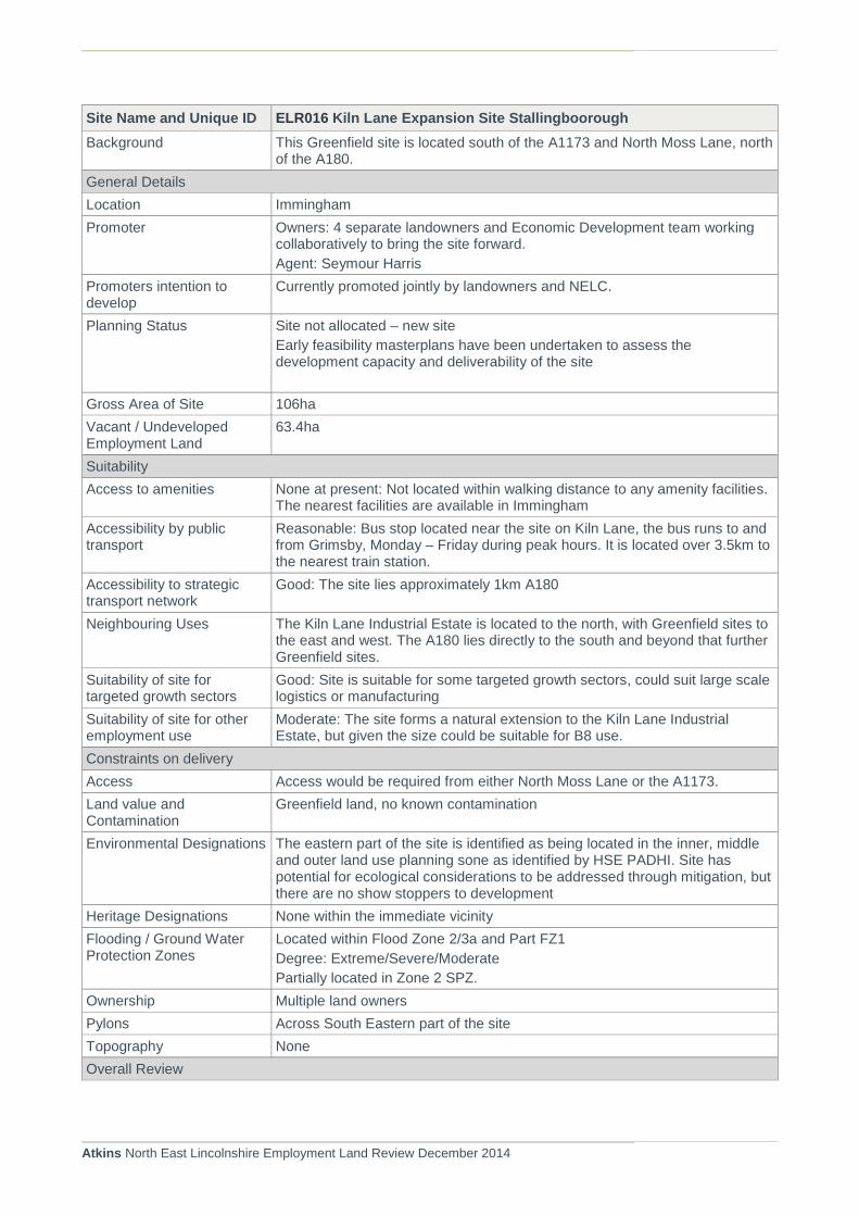
Atkins North East Lincolnshire Employment Land Review December 2014
Site Name and Unique ID ELR016 Kiln Lane Expansion Site Stallingboorough
Background This Greenfield site is located south of the A1173 and North Moss Lane, north of the A180.
General Details
Location Immingham
Promoter Owners: 4 separate landowners and Economic Development team working collaboratively to bring the site forward.
Agent: Seymour Harris
Promoters intention to develop
Currently promoted jointly by landowners and NELC.
Planning Status Site not allocated – new site
Early feasibility masterplans have been undertaken to assess the development capacity and deliverability of the site
Gross Area of Site 106ha
Vacant / Undeveloped Employment Land
63.4ha
Suitability
Access to amenities None at present: Not located within walking distance to any amenity facilities. The nearest facilities are available in Immingham
Accessibility by public transport
Reasonable: Bus stop located near the site on Kiln Lane, the bus runs to and from Grimsby, Monday – Friday during peak hours. It is located over 3.5km to the nearest train station.
Accessibility to strategic transport network
Good: The site lies approximately 1km A180
Neighbouring Uses The Kiln Lane Industrial Estate is located to the north, with Greenfield sites to the east and west. The A180 lies directly to the south and beyond that further Greenfield sites.
Suitability of site for targeted growth sectors
Good: Site is suitable for some targeted growth sectors, could suit large scale logistics or manufacturing
Suitability of site for other employment use
Moderate: The site forms a natural extension to the Kiln Lane Industrial Estate, but given the size could be suitable for B8 use.
Constraints on delivery
Access Access would be required from either North Moss Lane or the A1173.
Land value and Contamination
Greenfield land, no known contamination
Environmental Designations The eastern part of the site is identified as being located in the inner, middle and outer land use planning sone as identified by HSE PADHI. Site has potential for ecological considerations to be addressed through mitigation, but there are no show stoppers to development
Heritage Designations None within the immediate vicinity
Flooding / Ground Water Protection Zones
Located within Flood Zone 2/3a and Part FZ1
Degree: Extreme/Severe/Moderate
Partially located in Zone 2 SPZ.
Ownership Multiple land owners
Pylons Across South Eastern part of the site
Topography None
Overall Review

Atkins North East Lincolnshire Employment Land Review December 2014
Site Name and Unique ID ELR016 Kiln Lane Expansion Site Stallingboorough
Conclusions Suitability Yes established industrial zone, offers good location and scale adjoining the A180
Deliverability Agreement in principle to bring site forward by landowners. Joint arrangement between landowners and NELC to deliver strategic site infrastructure utilising public funding currently underway. No major barriers to implementation of the masterplan. Anticipated delivery expected to commence Yr 3.
Viability Subject to public intervention providing contribution to provision of strategic infrastructure, the development of the site offers a viable proposition primarily for the logistics sector.
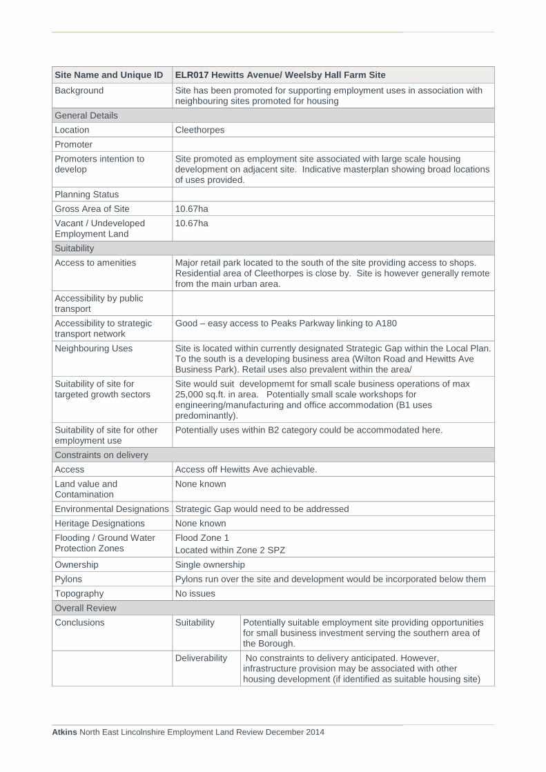
Atkins North East Lincolnshire Employment Land Review December 2014
Site Name and Unique ID ELR017 Hewitts Avenue/ Weelsby Hall Farm Site
Background Site has been promoted for supporting employment uses in association with neighbouring sites promoted for housing
General Details
Location Cleethorpes
Promoter
Promoters intention to develop
Site promoted as employment site associated with large scale housing development on adjacent site. Indicative masterplan showing broad locations of uses provided.
Planning Status
Gross Area of Site 10.67ha
Vacant / Undeveloped Employment Land
10.67ha
Suitability
Access to amenities Major retail park located to the south of the site providing access to shops. Residential area of Cleethorpes is close by. Site is however generally remote from the main urban area.
Accessibility by public transport
Accessibility to strategic transport network
Good – easy access to Peaks Parkway linking to A180
Neighbouring Uses Site is located within currently designated Strategic Gap within the Local Plan. To the south is a developing business area (Wilton Road and Hewitts Ave Business Park). Retail uses also prevalent within the area/
Suitability of site for targeted growth sectors
Site would suit developmemt for small scale business operations of max 25,000 sq.ft. in area. Potentially small scale workshops for engineering/manufacturing and office accommodation (B1 uses predominantly).
Suitability of site for other employment use
Potentially uses within B2 category could be accommodated here.
Constraints on delivery
Access Access off Hewitts Ave achievable.
Land value and Contamination
None known
Environmental Designations Strategic Gap would need to be addressed
Heritage Designations None known
Flooding / Ground Water Protection Zones
Flood Zone 1
Located within Zone 2 SPZ
Ownership Single ownership
Pylons Pylons run over the site and development would be incorporated below them
Topography No issues
Overall Review
Conclusions Suitability Potentially suitable employment site providing opportunities for small business investment serving the southern area of the Borough.
Deliverability No constraints to delivery anticipated. However, infrastructure provision may be associated with other housing development (if identified as suitable housing site)

Atkins North East Lincolnshire Employment Land Review December 2014
Site Name and Unique ID ELR017 Hewitts Avenue/ Weelsby Hall Farm Site
Viability Anticipated that viability issues would need to be overcome
Site Name and Unique ID ELR018 Europa Way, Kiln Lane Ind. Est., Stallingborough
Background Site located within established industrial area. Understood to be formerly used as part of Immingham rail freight terminal.
General Details
Location Stallingborough
Promoter Owners: Immingham Estates
Agent:
Promoters intention to develop
Pre application discussions currently being undertaken
Planning Status Site is allocated for employment use in the North East Lincolnshire Local Plan (2003) under E1/7A/B
Landowner interested in promoting the site for Waste To Energy facilities. Site currently not used.
Gross Area of Site 0.77ha
Vacant / Undeveloped Employment Land
0.77ha
Suitability
Access to amenities Poor: No access to local facilities within local vicinity
Accessibility by public transport
Reasonable: Bus stop located on Kiln Lane, the bus runs to and from Grimsby, Monday – Friday during peak hours. It is located over 4km to the nearest train station.
Accessibility to strategic transport network
Good: The site is situated close to the A180 and A1173.
Neighbouring Uses The site is located within the Kiln Lane industrial estate, the building to the west is an existing waste to energy facility
Suitability of site for targeted growth sectors
Excellent: If the site is to be marketed for an Energy to Waste facility this meets the renewable targeted growth sector
Suitability of site for other employment use
Excellent: The adjacent site already houses an energy to waste facility, the site is also suitable for other B2/B8 uses.
Constraints on delivery
Access Access would have to be taken from Europa Way
Land value and Contamination
No known contamination issues
Environmental Designations The entire site is identified as being located within the inner land use planning zone as identified by HSE PADHI. No other designations are known on site
Heritage Designations None within the immediate vicinity
Flooding / Ground Water Protection Zones
Located within Flood Zone 2/3a
Degree: Extreme
Partially located in Zone 2 SPZ.
Ownership Single Land Owner
Pylons None
Topography None
Overall Review

Atkins North East Lincolnshire Employment Land Review December 2014
Site Name and Unique ID ELR017 Hewitts Avenue/ Weelsby Hall Farm Site
Conclusions Suitability Site considered suitable for use as Waste to Energy facility and is being promoted as such, contributing to the renewable energy sector. Location within existing industrial area suggests limited barriers to any form of employment use.
Deliverability Site considered to be deliverable dependent upon market demand and willing investor. Unlikely to be brought forward on a speculative development basis
Viability Site anticipated to be delivered as a result of demand led activity not commercial development. Site therefore considered to be viable in planning terms.

Atkins North East Lincolnshire Employment Land Review December 2014
Site Name and Unique ID ELR019 Land W of Hobson Way, Stallingborough
Background The site is a mix of greenfield and hard surfacing within an area of Estuary Related Land, it is located west of Hobson Way and south of South Marsh Road.
General Details
Location Stallingborough
Promoter Owners: Abengoa Bioenergy UK
Agent: PPH Commercial
Promoters intention to develop
Site is currently being marketed with agents who have promoted the site
Owners have indicated that subject to overcoming legislative restrictions site may be progressed as proposed.
Planning Status Site is allocated for employment use in the North East Lincolnshire Local Plan (2003) under E2/3C
Planning permission was gained in 2011 for a bioethanol plant on site, (Ref: DC/1147/10/IMM) Consent expires 2015. Material start on site undertaken (site prep works) but has not progressed due to the impact of legislative constraints. If overcome site may be progressed for Bio-Energy development or sold on open market. Note that site is currently being marketed.
Gross Area of Site 32.6
Vacant / Undeveloped Employment Land
31.7
Suitability
Access to amenities None at present
Accessibility by public transport
Poor: There are no bus stops located within close proximity to the site, the train station at Stallingborough is approximately 3km west of the site. A public footpath runs along north and eastern boundaries.
Accessibility to strategic transport network
Good: The site connects to the wider strategic network via the A1173 and A180(T) in the west
Neighbouring Uses The site is bounded to the east by Hobson Way, to the west/southwest by the Grimsby Light Rail freight line and to the north by South Marsh Road. The South Humber Bank power station is immediately adjacent to the east of the site and an industrial estate to the west
Suitability of site for targeted growth sectors
High: The site is well suited to renewable, chemicals and food processing activities, in addition to logistics in relation to the estuary
Suitability of site for other employment use
High: the site is well suited to a bio ethanol plant as has access to all modes of surface transport and the infrastructures are already in place, it is also located in a wheat-growing region in the UK.
Agent seeks to promote the site for B1, B2 and B8 uses. The site would also suit other B2 or B8 uses.
Constraints on delivery
Access Existing access from Hobson Way which is presently a cul-de-sac terminating close to the site
Land value and Contamination
No known contamination which has been confirmed by agent.
Environmental Designations A small section of the north east corner of the site is identified as being located within the outer land use planning zone as identified by HSE PADHI. No other designations have been identified within the immediate vicinity.
Heritage Designations None within the immediate vicinity

Atkins North East Lincolnshire Employment Land Review December 2014
Site Name and Unique ID ELR019 Land W of Hobson Way, Stallingborough
Flooding / Ground Water Protection Zones
Located within Flood Zone 2/3a
Degree: Extreme
Not located within an SPZ.
A number of drainage ditches cross the site
Ownership Single Land Owner
Pylons Across very northern section of the site
Topography None
Overall Review
Conclusions Suitability Site located within existing industrial area, but has limited access from Hobson Way only. Previous consent would suggest site would suit renewable energy sector. Alternative use of site could be considered within Logistics or Engineering sectors. All forms of B use class may be appropriate
Deliverability Progress on Bio-Ethanol plant subject to legislative constraints. Site may be sold if not overcome. Agents report anticipated delivery on site within 1-5 years.
Viability Site may attract demand led investment rather than commercial speculative development, and therefore potential viability issues may not arise. If brought forward for speculative development anticipate that public sector support would be required.

Atkins North East Lincolnshire Employment Land Review December 2014
Site Name and Unique ID ELR020 Land E of Hobson Way, Stallingborough
Background The site is a Greenfield site located east of Hobson way and south of South Marsh Road, adjacent to the power station
General Details
Location Stallingborough
Promoter Owners: Helius (RWE)
Agent:
Promoters intention to develop
No current intentions to develop. Development of the site is largely dependent upon the requirements for strategic mitigation (12.87ha) being resolved in a manner which permits the implementation of the planning consent. Planning consent issued under s36 remains in force until May 2015.
Planning Status Site is allocated for employment use in the North East Lincolnshire Local Plan (2003) under E2/4C
Planning permission was granted in 2011 for a bioethanol and biomass plant (Planning ref: DC/303/07/IMM)
Gross Area of Site 33.59ha
Vacant / Undeveloped Employment Land
33.59ha
Suitability
Access to amenities None at present
Accessibility by public transport
Poor: There are no bus stops located within close proximity to the site, the train station at Stallingborough is over 3km west of the site.
Accessibility to strategic transport network
Good: The site connects to the wider strategic network via the A1173 and A180(T) in the west
Neighbouring Uses Site is located within the industrial area, adjacent chemical processing operations. However, these operations have significant land holdings that remain undeveloped.
Suitability of site for targeted growth sectors
High: The site is well suited to chemicals processing activities, in addition to logistics in relation to the estuary
Suitability of site for other employment use
High: the site is well suited to a bio ethanol plant as has access to all modes of surface transport and the infrastructures are already in place, it is also located in a wheat-growing region in the UK. The site would also suit other B2 or B8 uses.
Constraints on delivery
Access Existing access from Hobson Way
Land value and Contamination
No known contamination issues. Likely to be demand led use for the site for renewable energy production.
Environmental Designations None within the immediate vicinity.
A significant part of the site has been identified as being required as part of the Strategic Mitigation for birds associated with the continued development of the Humber Estuary. Landowner discussions regarding the potential impact of this are ongoing.
Heritage Designations None within the immediate vicinity
Flooding / Ground Water Protection Zones
Located within Flood Zone 3: High Probability. Not located within an SPZ
Ownership Single Land Owner
Pylons None
Topography None

Atkins North East Lincolnshire Employment Land Review December 2014
Site Name and Unique ID ELR020 Land E of Hobson Way, Stallingborough
Overall Review
Conclusions Suitability Site considered to be suitable for Chemicals Processing/Renewable Energy uses, as detailed in the existing planning consent. The need to address Strategic Mitigation and ecological constraints associated with development along the Estuary may result in site not being deemed suitable for such uses. Potential for other B1, B2 and B8 uses exist, potentially in logistics sector.
Deliverability Deliverability of site for Chemicals/Renewables is dependent upon the need to secure land for strategic mitigation purposes
Viability Site likely be demand driven rather than commercial development basis. Requirement for strategic mitigation will impact upon viability of the site.
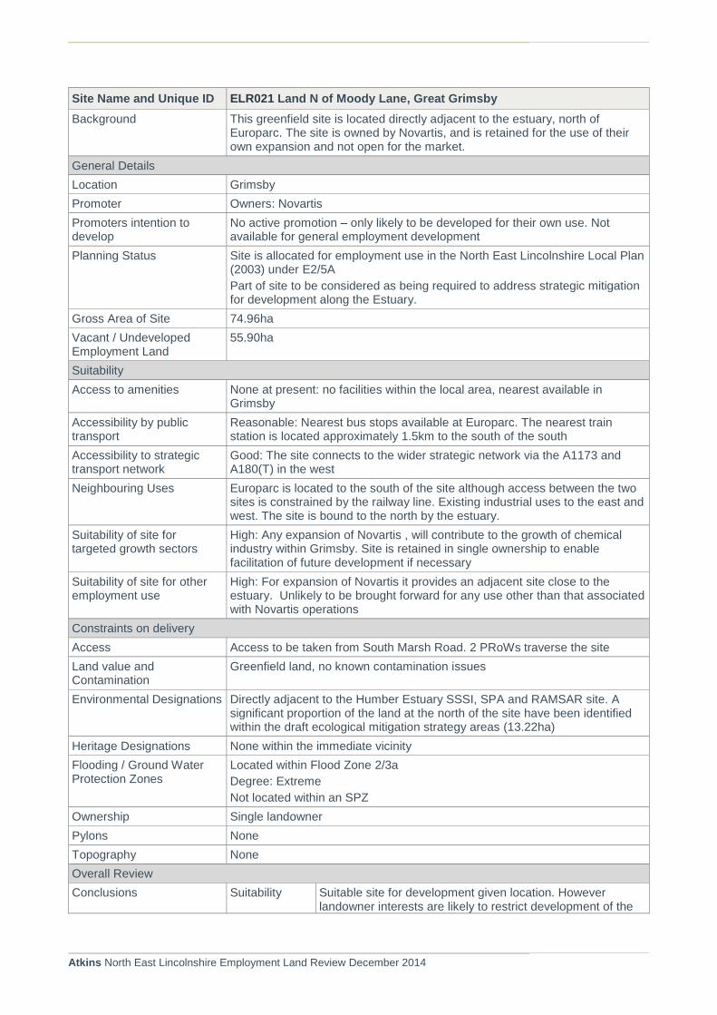
Atkins North East Lincolnshire Employment Land Review December 2014
Site Name and Unique ID ELR021 Land N of Moody Lane, Great Grimsby
Background This greenfield site is located directly adjacent to the estuary, north of Europarc. The site is owned by Novartis, and is retained for the use of their own expansion and not open for the market.
General Details
Location Grimsby
Promoter Owners: Novartis
Promoters intention to develop
No active promotion – only likely to be developed for their own use. Not available for general employment development
Planning Status Site is allocated for employment use in the North East Lincolnshire Local Plan (2003) under E2/5A
Part of site to be considered as being required to address strategic mitigation for development along the Estuary.
Gross Area of Site 74.96ha
Vacant / Undeveloped Employment Land
55.90ha
Suitability
Access to amenities None at present: no facilities within the local area, nearest available in Grimsby
Accessibility by public transport
Reasonable: Nearest bus stops available at Europarc. The nearest train station is located approximately 1.5km to the south of the south
Accessibility to strategic transport network
Good: The site connects to the wider strategic network via the A1173 and A180(T) in the west
Neighbouring Uses Europarc is located to the south of the site although access between the two sites is constrained by the railway line. Existing industrial uses to the east and west. The site is bound to the north by the estuary.
Suitability of site for targeted growth sectors
High: Any expansion of Novartis , will contribute to the growth of chemical industry within Grimsby. Site is retained in single ownership to enable facilitation of future development if necessary
Suitability of site for other employment use
High: For expansion of Novartis it provides an adjacent site close to the estuary. Unlikely to be brought forward for any use other than that associated with Novartis operations
Constraints on delivery
Access Access to be taken from South Marsh Road. 2 PRoWs traverse the site
Land value and Contamination
Greenfield land, no known contamination issues
Environmental Designations Directly adjacent to the Humber Estuary SSSI, SPA and RAMSAR site. A significant proportion of the land at the north of the site have been identified within the draft ecological mitigation strategy areas (13.22ha)
Heritage Designations None within the immediate vicinity
Flooding / Ground Water Protection Zones
Located within Flood Zone 2/3a
Degree: Extreme
Not located within an SPZ
Ownership Single landowner
Pylons None
Topography None
Overall Review
Conclusions Suitability Suitable site for development given location. However landowner interests are likely to restrict development of the

Atkins North East Lincolnshire Employment Land Review December 2014
Site Name and Unique ID ELR021 Land N of Moody Lane, Great Grimsby
site. Site therefore not considered to be available to meet general employment needs.
Delivery Site delivery likely to be generated from landowner interests only. No active promotion at this point in time.
Viability The site is retained by the owner for the development of the company only, and therefore unlikely to be available for market purposes

Atkins North East Lincolnshire Employment Land Review December 2014
Site Name and Unique ID ELR022 Plot Q, Kiln Lane Ind Est, Stallingborough
Background The site comprises of largely brownfield land, with a small area of greenfield to the north of the site.
General Details
Location Stallingborough
Promoter AD SOLUTIONS
Promoters intention to develop
Planning application received for the development of an Renewable Power plant (W2E) (1490 sq. m. floorspace)
Planning Status No specific site allocations made on this site.
Planning Application received for Renewable Power Plan (DM/0848/14/FUL) - anticipated decision early 2015.
Gross Area of Site 3.42ha
Vacant / Undeveloped Employment Land
3.42ha
Suitability
Access to amenities Poor: No amenities on the industrial estate and none within walking distance; around 3-4 miles to Immingham or 2-3 miles to Stallingborough.
Accessibility by public transport
Reasonable: Kiln Lane is served by the 45M service running from Grimsby to South Killingholme, nearest stop; around 0.2 miles from site. Site is within walking distance of a footpath, which may offer employees the opportunity to commute by foot.
Accessibility to strategic transport network
Good: Around 1.6 miles drive to the A180; 11 miles to the A15. Around 2-2.5 miles to Immingham docks.
Neighbouring Uses Industrial – particularly logistics.
Suitability of site for targeted growth sectors
High: close proximity to Immingham docks and A180, neighbouring logistics industry.
Suitability of site for other employment use
High: Well suited, appropriate site for general industry. Brownfield site means a more efficient land use than developing an entirely greenfield site.
Constraints on delivery
Access No immediate constraints
Land value and Contamination
No known contamination
Environmental Designations The entire site falls within the inner land use planning zone as identified by HSE PADHI , no other designations have been identified within the immediate vicinity
Heritage Designations None in immediate vicinity.
Flooding / Ground Water Protection Zones
Located within Flood Zone 2/3a
Degree: Extreme
Not located within an SPZ
Ownership Single landowner
Pylons None
Topography None
Overall Review
Conclusions Suitability Considered suitable specifically for Renewable Energy and process industries, although could be suited to Logistics also. Site location appropriate for B1, B2 and B8 uses

Atkins North East Lincolnshire Employment Land Review December 2014
Site Name and Unique ID ELR022 Plot Q, Kiln Lane Ind Est, Stallingborough
Deliverability Delivery of the site anticipated to be demand led – therefore speculative build not anticipated.
Viability Development of the site may require public sector support if developed.

Atkins North East Lincolnshire Employment Land Review December 2014
ELR023 Plot V, Kiln Lane Ind Est, Stallingborough
Background Vacant and cleared brownfield site located on the Kiln Lane industrial estate.
General Details
Location Stallingborough
Promoter Not known
Promoters intention to develop
Not known
Planning Status No site allocations or planning permissions in place.
Gross Area of Site 1.6
Vacant / Undeveloped Employment Land
1.6
Suitability
Access to amenities Poor: No amenities on the industrial estate or within walking distance; around 3-4 miles to Immingham or 2-3 miles to Stallingborough. The site is within 600m of a footpath, which may offer employees the opportunity to walk to work.
Accessibility by public transport
Reasonable: industrial estate served by the half hourly 45M service running between Grimsby and South Killingholme, nearest stop located adjacent to site.
Accessibility to strategic transport network
Good: Around 1.4 miles drive to the A180; 11 miles to the A15. Around 2-2.5 miles to Immingham docks.
Neighbouring Uses Industrial – particularly logistics.
Suitability of site for targeted growth sectors
Good: close proximity to Immingham docks and A180, neighbouring logistics industry.
Suitability of site for other employment use
Good: appropriate site for general industry. Would result in efficient land use due to brownfield status, but this is a fairly minor consideration given that the site is small.
Constraints on delivery
Access No immediate constraints
Land value and Contamination
No known contamination issues
Environmental Designations The entire site is identified as falling within the inner land use planning zone as identified by HSE PADHI zone, no other designations have been identified within the immediate vicinity
Heritage Designations None within immediate vicinity.
Flooding / Ground Water Protection Zones
Located within Flood Zone 2/3a
Degree: Extreme
Not located within an SPZ
Ownership Unknown
Pylons None
Topography None
Overall Review
Conclusions Suitability Site considered to be suitable for generic B1, B2 and B8 uses, specifically within the Logistics sector
Deliverability Site anticipated to be developed on a demand-led basis.
Viability Potential for public sector support may be required to support site development

Atkins North East Lincolnshire Employment Land Review December 2014
Site Name and Unique ID ELR024 Estate Road 1, Grimsby
Background Brownfield site located in the north of South Humberside Ind. Est., close to A180 and Europarc.
General Details
Location Grimsby
Promoter Owners: Seachill
Agent: Unknown
Promoters intention to develop
Site being marketed for employment uses .
Planning Status No specific planning status in terms of the Local Plan.
Gross Area of Site 2.3ha
Vacant / Undeveloped Employment Land
2.30 ha
Suitability
Access to amenities Poor: Close proximity to The Haven pub and Premier Inn Grimsby. Not within walking distance of open space.
Accessibility by public transport
Good: Nearest train station Great Coates, 0.8 mile walk. Buses 1, 2 and 20 run from Europarc site (around 500m away). Directly adjacent to Pedalway.
Accessibility to strategic transport network
Good: Close proximity to A180, within 2 miles of Grimsby Dock.
Neighbouring Uses Positive: Other industrial, including vehicle retail and seafood processing.
Suitability of site for targeted growth sectors
Good: Close proximity to dock area and Europarc site.
Suitability of site for other employment use
Good: located to other similar sites, and good access to transport network. Brownfield status means more efficient use of land than greenfield sites, but small size means this a minor benefit.
Constraints on delivery
Access No immediate constraints.
Land value and Contamination
No known contamination issues
Environmental Designations None of immediate relevance. Within 310 metres of the Tioxide West Field Local Wildlife Site and within 1km of the Humber Estuary.
Heritage Designations None of immediate relevance. The site is approximately 860m to the north east of the Great Coates Conservation Area, the impact on which will depend upon any future development .
Flooding / Ground Water Protection Zones
EA Flood Zone 2/3a
Degree: Extreme
Ownership Not known
Pylons None
Topography None
Overall Review
Conclusions Suitability Site considered to be suitable for a range of uses within B1, B2 and B8 classes. Potential to target general market provision for small business operations. Logistics/Engineering most appropriate given location

Atkins North East Lincolnshire Employment Land Review December 2014
Site Name and Unique ID ELR024 Estate Road 1, Grimsby
Delivery Anticipated that delivery is likely to be demand led. Popular location for business investment .
Viability The need for public sector support to assist delivery may be required.
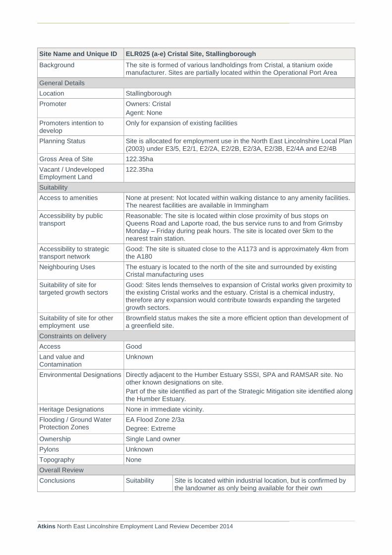
Atkins North East Lincolnshire Employment Land Review December 2014
Site Name and Unique ID ELR025 (a-e) Cristal Site, Stallingborough
Background The site is formed of various landholdings from Cristal, a titanium oxide manufacturer. Sites are partially located within the Operational Port Area
General Details
Location Stallingborough
Promoter Owners: Cristal
Agent: None
Promoters intention to develop
Only for expansion of existing facilities
Planning Status Site is allocated for employment use in the North East Lincolnshire Local Plan (2003) under E3/5, E2/1, E2/2A, E2/2B, E2/3A, E2/3B, E2/4A and E2/4B
Gross Area of Site 122.35ha
Vacant / Undeveloped Employment Land
122.35ha
Suitability
Access to amenities None at present: Not located within walking distance to any amenity facilities. The nearest facilities are available in Immingham
Accessibility by public transport
Reasonable: The site is located within close proximity of bus stops on Queens Road and Laporte road, the bus service runs to and from Grimsby Monday – Friday during peak hours. The site is located over 5km to the nearest train station.
Accessibility to strategic transport network
Good: The site is situated close to the A1173 and is approximately 4km from the A180
Neighbouring Uses The estuary is located to the north of the site and surrounded by existing Cristal manufacturing uses
Suitability of site for targeted growth sectors
Good: Sites lends themselves to expansion of Cristal works given proximity to the existing Cristal works and the estuary. Cristal is a chemical industry, therefore any expansion would contribute towards expanding the targeted growth sectors.
Suitability of site for other employment use
Brownfield status makes the site a more efficient option than development of a greenfield site.
Constraints on delivery
Access Good
Land value and Contamination
Unknown
Environmental Designations Directly adjacent to the Humber Estuary SSSI, SPA and RAMSAR site. No other known designations on site.
Part of the site identified as part of the Strategic Mitigation site identified along the Humber Estuary.
Heritage Designations None in immediate vicinity.
Flooding / Ground Water Protection Zones
EA Flood Zone 2/3a
Degree: Extreme
Ownership Single Land owner
Pylons Unknown
Topography None
Overall Review
Conclusions Suitability Site is located within industrial location, but is confirmed by the landowner as only being available for their own

Atkins North East Lincolnshire Employment Land Review December 2014
Site Name and Unique ID ELR025 (a-e) Cristal Site, Stallingborough
expansion. Site suits further development of the Chemicals/Processing industry.
Delivery Sites available for expansion of Cristal operation or for specific users within existing Cristal supply chain. Unlikely to be available for general employment use.
Viability Development of the site is likely to be generated by landowners direct business investment. Potential for public sector support to expand operations may be required.
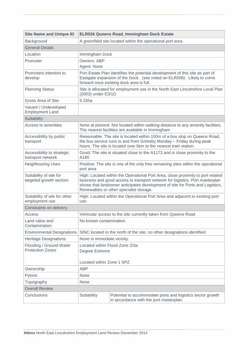
Atkins North East Lincolnshire Employment Land Review December 2014
Site Name and Unique ID ELR026 Queens Road, Immingham Dock Estate
Background A greenfield site located within the operational port area
General Details
Location Immingham Dock
Promoter Owners: ABP
Agent: None
Promoters intention to develop
Port Estate Plan identifies the potential development of this site as part of Eastgate expansion of the Dock. (see noted on ELR006) . Likely to come forward once existing dock area is full.
Planning Status Site is allocated for employment use in the North East Lincolnshire Local Plan (2003) under E3/1D
Gross Area of Site 5.15ha
Vacant / Undeveloped Employment Land
Suitability
Access to amenities None at present: Not located within walking distance to any amenity facilities. The nearest facilities are available in Immingham
Accessibility by public transport
Reasonable: The site is located within 100m of a bus stop on Queens Road, the bus service runs to and from Grimsby Monday – Friday during peak hours. The site is located over 5km to the nearest train station.
Accessibility to strategic transport network
Good: The site is situated close to the A1173 and is close proximity to the A180
Neighbouring Uses Positive: The site is one of the only free remaining sites within the operational port area
Suitability of site for targeted growth sectors
High: Located within the Operational Port Area, close proximity to port related business and good access to transport network for logistics. Port masterplan shows that landowner anticipates development of site for Ports and Logistics, Renewables or other specialist storage.
Suitability of site for other employment use
High: Located within the Operational Port Area and adjacent to existing port use
Constraints on delivery
Access Vehicular access to the site currently taken from Queens Road
Land value and Contamination
No known contamination
Environmental Designations SINC located to the north of the site, no other designations identified
Heritage Designations None in immediate vicinity.
Flooding / Ground Water Protection Zones
Located within Flood Zone 2/3a
Degree Extreme
Located within Zone 1 SPZ
Ownership ABP
Pylons None
Topography None
Overall Review
Conclusions Suitability Potential to accommodate ports and logistics sector growth in accordance with the port masterplan.

Atkins North East Lincolnshire Employment Land Review December 2014
Site Name and Unique ID ELR026 Queens Road, Immingham Dock Estate
Deliverability Delivery anticipated to be associated with the growth of the port and therefore demand led. Delivery will be reliant upon strategies adopted by landowner. Anticipated 5-10 years.
Viability Unlikely to be an issue as a result of the demand led nature of the proposed occupation of the site, and the fact that landowner investment will only be achieved when demand suggests that appropriate returns can be obtained.

Atkins North East Lincolnshire Employment Land Review December 2014
Site Name and Unique ID ELR027: Land off Queens Road, Immingham (Magna site)
Background Site considered to be suitable for employment uses. Landowner indicates that development is likely to be in medium term. Developable Site area needs confirmation (brownfield contamination on significant parts of the site).
General Details
Location Stallingborough/Immingham
Promoter Site Owner: ABLE UK
Promoters intention to develop
The owners have recently acquired the site and have indicated a willingness to progress the site for employment development. No timescales have been indicated
Planning Status Currently designated within Industrial Area (not site specific). No planning applications
Gross Area of Site 15.14
Vacant / Undeveloped Employment Land
15.14
Suitability
Access to amenities Limited
Accessibility by public transport
Accessibility to strategic transport network
Reasonable access to A1173 and A180
Neighbouring Uses Site is adjacent to a large brownfield site with known contamination issues to the west. To the south and north is industrial accommodation. The Port of Immingham is to the north and west
Suitability of site for targeted growth sectors
Excellent potential for the development of Ports and Logistics Sector. B1, B2 and B8 uses identified as appropriate. Could also suit activities in the Renewable Energy sector. Anticipated sector growth will be associated with the development of the ABLE MEP at South Killingholme.
Suitability of site for other employment use
General employment uses could also be accommodated on this site.
Constraints on delivery
Access Good
Land value and Contamination
Contamination of significant parts of the site
Environmental Designations None
Heritage Designations None
Flooding / Ground Water Protection Zones
FZ2/3a
Degree: Extreme
Ownership ABLE UK
Pylons
Topography
Overall Review
Conclusions Suitability Site is considered suitable as a site for development of Port related activities, specifically logistics and renewables associated with activities to be developed at AMEP. Range of B1, B2 and B8 uses considered appropriate in this location

Atkins North East Lincolnshire Employment Land Review December 2014
Site Name and Unique ID ELR027: Land off Queens Road, Immingham (Magna site)
Deliverability Willingness from landowners to bring the site forward exists. Demand led potentially, although option to support with pump priming also exists
Viability Anticipate that delivery will be primarily demand driven and therefore issues of viability are unlikely to arise. However, pump priming from public sector to stimulate business activity could also assist delivery in the medium term.

Atkins North East Lincolnshire Employment Land Review December 2014
Site Name and Unique ID ELR028 Land off Estate Road 5, Grimsby
Background Vacant brownfield site marketed for employment uses, located in South Humberside industrial estate. Former Paragon Motors site (car storage and pre-market assembly).
General Details
Location Grimsby
Promoter Agent: Potter Learoyd
Promoters intention to develop
Currently marketed for employment purposes
Planning Status No site specific allocations or historic planning applications. Site formerly used by Paragon Motors for production/storage.
Gross Area of Site 4ha
Vacant / Undeveloped Employment Land
4ha
Suitability
Access to amenities Poor: none in industrial estate. Freshney Place within 600m, but not clear that it is accessible on foot.
Accessibility by public transport
Reasonable: No bus stops on industrial estate; 0.8 mile walk to Great Coates railway station but not easily accessible on foot. . Nearest Pedalway is within 600m.
Accessibility to strategic transport network
Good: 0.3 miles to A180; around 1.7 miles to A16; around 2 miles to Grimsby Docks.
Neighbouring Uses Industrial
Suitability of site for targeted growth sectors
Good: close proximity to transport network for logistics.
Suitability of site for other employmet use
Good: existing facilities.
Constraints on delivery
Access No immediate constraints
Land value and Contamination
No known contamination
Environmental Designations None direct. The site is 580m from the Tioxide West Field Local Wildlife Site and 600m from the Freshney Parkway North Local Wildlife Site.
Heritage Designations None direct. The site is approximately 590m from the Great Coates Conservation Area.
Flooding / Ground Water Protection Zones
EA Flood Zone 3 – High Probability
Located within Zone 2c SPZ
Ownership Paragon Motors
Pylons None
Topography None
Overall Review
Conclusions Suitability Site is located within the existing employment zone and is a cleared brownfield site capable of redevelopment. Potential exists for the use of the site to be logistics related or for production/storage and distribution uses (potential food sector development).

Atkins North East Lincolnshire Employment Land Review December 2014
Site Name and Unique ID ELR028 Land off Estate Road 5, Grimsby
Deliverability Delivery anticipated to be demand led and reliant upon market conditions. Potential for site to be subdivided for smaller units also exists - delivery anticipated 3 -7 years
Viability Viability issues are not known at this stage. Potential to support with public sector funding exists
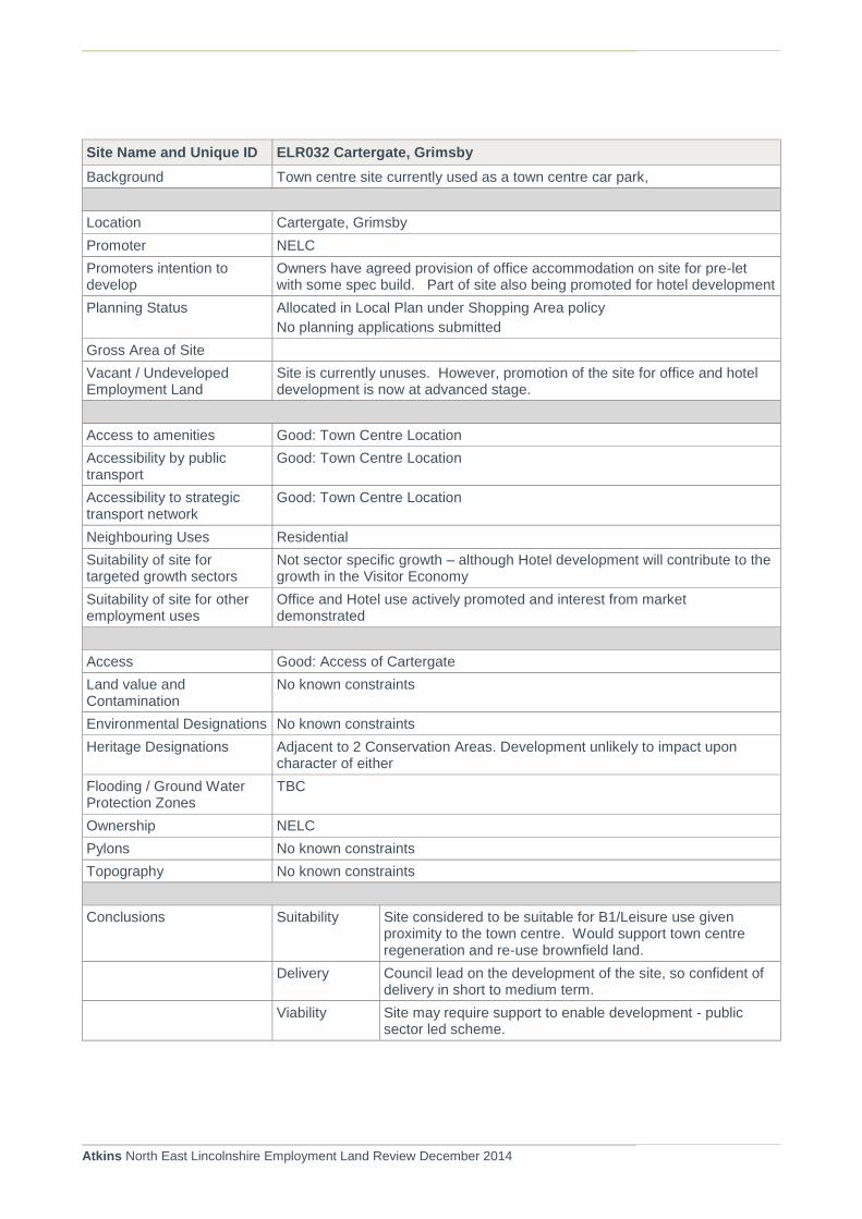
Atkins North East Lincolnshire Employment Land Review December 2014
Site Name and Unique ID ELR032 Cartergate, Grimsby
Background Town centre site currently used as a town centre car park,
Location Cartergate, Grimsby
Promoter NELC
Promoters intention to develop
Owners have agreed provision of office accommodation on site for pre-let with some spec build. Part of site also being promoted for hotel development
Planning Status Allocated in Local Plan under Shopping Area policy
No planning applications submitted
Gross Area of Site
Vacant / Undeveloped Employment Land
Site is currently unuses. However, promotion of the site for office and hotel development is now at advanced stage.
Access to amenities Good: Town Centre Location
Accessibility by public transport
Good: Town Centre Location
Accessibility to strategic transport network
Good: Town Centre Location
Neighbouring Uses Residential
Suitability of site for targeted growth sectors
Not sector specific growth – although Hotel development will contribute to the growth in the Visitor Economy
Suitability of site for other employment uses
Office and Hotel use actively promoted and interest from market demonstrated
Access Good: Access of Cartergate
Land value and Contamination
No known constraints
Environmental Designations No known constraints
Heritage Designations Adjacent to 2 Conservation Areas. Development unlikely to impact upon character of either
Flooding / Ground Water Protection Zones
TBC
Ownership NELC
Pylons No known constraints
Topography No known constraints
Conclusions Suitability Site considered to be suitable for B1/Leisure use given proximity to the town centre. Would support town centre regeneration and re-use brownfield land.
Delivery Council lead on the development of the site, so confident of delivery in short to medium term.
Viability Site may require support to enable development - public sector led scheme.

Atkins North East Lincolnshire Employment Land Review December 2014
Site Name and Unique ID ELR0033 Waltham Airfield
Background Located on the edge of Waltham in the south of the Borough. Site is located in a remote location and some distance from Waltham Village
Location Waltham
Promoter
Promoters intention to develop
Promoters have also put site forward for assessment in SHLAA 2014. All forms of development understood to be favourable
Planning Status Local Plan allocation Policy E16.
No planning history
Gross Area of Site 14.53ha
Vacant / Undeveloped Employment Land
Site has limited amount of use for employment purposes currently.
Access to amenities Poor : some distance from facilities within Waltham
Accessibility by public transport
Poor :
Accessibility to strategic transport network
Poor
Neighbouring Uses Golf Course
Suitability of site for targeted growth sectors
Not suitable for targeted growth sectors
Suitability of site for other employment uses
Potential for use of site for employment uses to accommodate employment provision in the south of the area.
Access Access off Cheapside via B1219 linking with the A16. Cheapside may required upgrading
Land value and Contamination
Potential for contamination considered to be high.
Environmental Designations None Known
Heritage Designations None Known, although buildings associated with the former RAF Grimsby still present on site
Flooding / Ground Water Protection Zones
Flood Zone: TBC
Ownership Not known
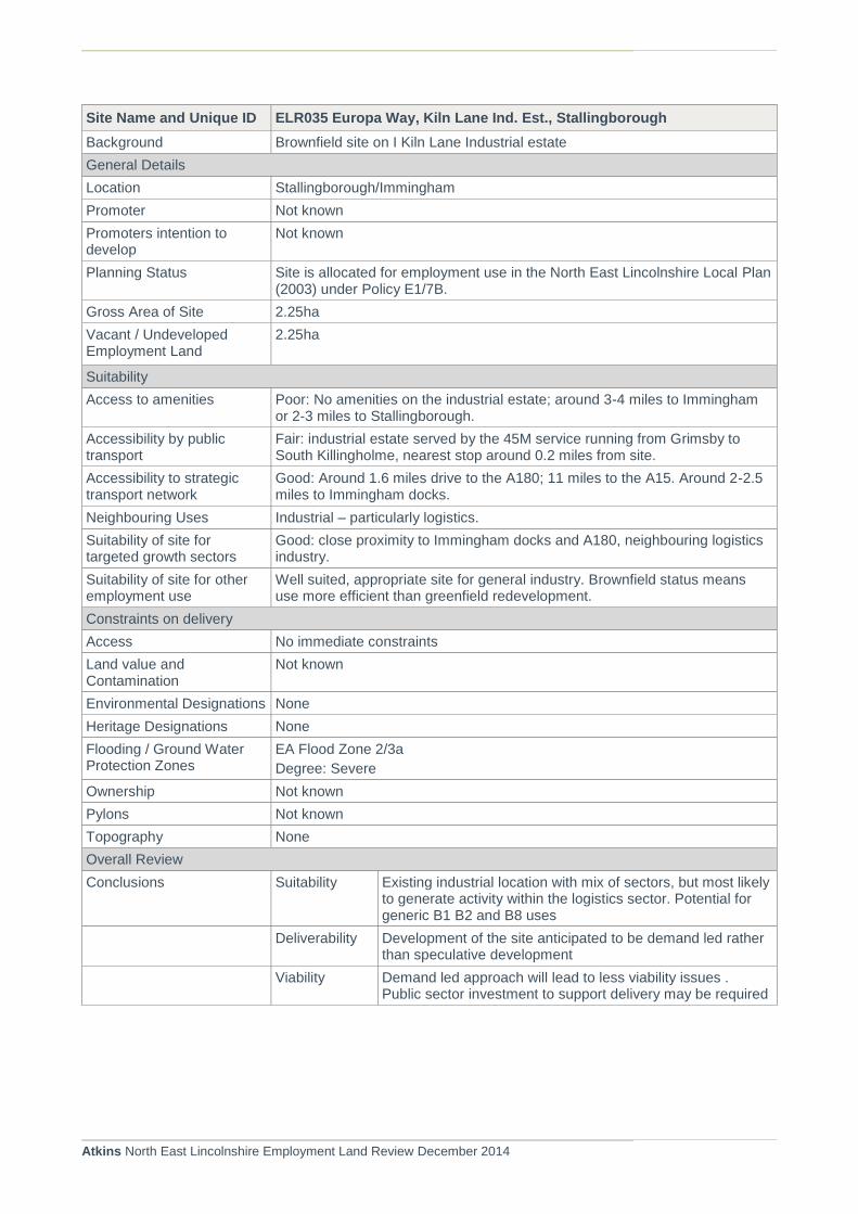
Atkins North East Lincolnshire Employment Land Review December 2014
Site Name and Unique ID ELR035 Europa Way, Kiln Lane Ind. Est., Stallingborough
Background Brownfield site on I Kiln Lane Industrial estate
General Details
Location Stallingborough/Immingham
Promoter Not known
Promoters intention to develop
Not known
Planning Status Site is allocated for employment use in the North East Lincolnshire Local Plan (2003) under Policy E1/7B.
Gross Area of Site 2.25ha
Vacant / Undeveloped Employment Land
2.25ha
Suitability
Access to amenities Poor: No amenities on the industrial estate; around 3-4 miles to Immingham or 2-3 miles to Stallingborough.
Accessibility by public transport
Fair: industrial estate served by the 45M service running from Grimsby to South Killingholme, nearest stop around 0.2 miles from site.
Accessibility to strategic transport network
Good: Around 1.6 miles drive to the A180; 11 miles to the A15. Around 2-2.5 miles to Immingham docks.
Neighbouring Uses Industrial – particularly logistics.
Suitability of site for targeted growth sectors
Good: close proximity to Immingham docks and A180, neighbouring logistics industry.
Suitability of site for other employment use
Well suited, appropriate site for general industry. Brownfield status means use more efficient than greenfield redevelopment.
Constraints on delivery
Access No immediate constraints
Land value and Contamination
Not known
Environmental Designations None
Heritage Designations None
Flooding / Ground Water Protection Zones
EA Flood Zone 2/3a
Degree: Severe
Ownership Not known
Pylons Not known
Topography None
Overall Review
Conclusions Suitability Existing industrial location with mix of sectors, but most likely to generate activity within the logistics sector. Potential for generic B1 B2 and B8 uses
Deliverability Development of the site anticipated to be demand led rather than speculative development
Viability Demand led approach will lead to less viability issues . Public sector investment to support delivery may be required

Atkins North East Lincolnshire Employment Land Review December 2014
Site Name and Unique ID ELR036 Adj Westgate Park, Armstrong Street
Background Greenfield site being marketed for employment uses
General Details
Location Grimsby
Promoter Agent PPH Commercial
Landowner: Belgrave Land
Promoters intention to develop
Site being actively marketed by agents. Promoted for range of uses including B1, Hotel, Leisure, Healthcare, Trade Centre
Planning Status Site has not been previously allocated in the Local Plan (2003).
No known extant planning applications on site. Recent development of office unit now occupied by Shoreline Housing
Gross Area of Site 1.74ha
Vacant / Undeveloped Employment Land
1.74ha
Suitability
Access to amenities Reasonable: Approximately 1km from Grimsby Town Centre facilities and approximately 500metres from supermarket
Accessibility by public transport
Good: Multiple bus stops located on Corporation Road with regular bus services to Europarc and Cleethropes
Accessibility to strategic transport network
Good: Direct access to the A180 from Pyewipe Road
Neighbouring Uses Residential/Industrial
Suitability of site for targeted growth sectors
Good: good access to strategic transport network and Immingham Dock.
Suitability of site for other employment uses
Not known. Greenfield status means brownfield sites may be preferable.
Constraints on delivery
Access Access is limited and restricted to residential streets in and around Armstrong St
Land value and Contamination
None
Environmental Designations None
Heritage Designations None
Flooding / Ground Water Protection Zones
EA Flood Zone 2/3a
Degree: Severe/Moderate/Low
Ownership Not known
Pylons None
Topography None
Overall Review
Conclusions Suitability Given adjacent residential areas consider site suitable for B1 uses which would complement recent development
Delivery Agent reports anticipated delivery on the site within 1 -5 years.
Viability Potential viability issues may restrict speculative development for B1 office. Public sector support may be required

Atkins North East Lincolnshire Employment Land Review December 2014
Site Name and Unique ID ELR037 Land to rear of Marlin House, Immingham
Background Greenfield site located to the rear of Marlin House, located off Kings Road
General Details
Location Immingham
Promoter Unknown
Promoters intention to develop
Unknown
Planning Status Site has not been previously allocated in the Local Plan (2003). No known extant planning applications on site.
Gross Area of Site 1.137ha
Vacant / Undeveloped Employment Land
1.137ha
Suitability
Access to amenities Reasonable: Facilities available in Immingham, however the majority lie over 1km away on Pelham Road
Accessibility by public transport
Good: Close proximity to bus stop at on Kings Road with a regular (every 30 minutes) bus service to Grimsby and Cleethorpes
Accessibility to strategic transport network
Good: Located directly on the A1173, approximately 2.5km from the A180.
Neighbouring Uses Residential units located to the north at Chestnut Avenue. Marlin House, a location for small industrial units is located to the east and Greenfield land to the south and west.
Suitability of site for targeted growth sectors
Low: Site would site small scale industry
Suitability of site for other employment uses
Medium: Proximity to residential uses may limit some employment uses, but is located in good strategic transport network and adjacent to existing small scale industrial uses at Marlin House
Constraints on delivery
Access Access would be required from Kings Road
Land value and Contamination
Greenfield site, no known contamination issues
Environmental Designations None in immediate vicinity
Heritage Designations None in immediate vicinity
Flooding / Ground Water Protection Zones
EA Flood Zone 2/3a
Degree: Severe
Located within Zone 2 SPZ
Ownership Unknown
Pylons None
Topography None
Overall Review
Conclusions Suitability Potential for small scale operations or storage/logistics. Proximity to adjacent business centre suggests office scheme may also be possible
Deliverability Delivery anticipated to be demand led – uncertain timescale
Viability Development of site is unlikely to be viable on a speculative basis and public sector funding is likely to be required

Atkins North East Lincolnshire Employment Land Review December 2014
Site Name and Unique ID ELR039 South of Laporte Road, Stallingborough
Background A Greenfield site located to the west of Hobson Way and south of Kiln Lane and east of Kiln Lane industrial estate, located on Estuary Related Land.
General Details
Location Stallingborough
Promoter BOC
Promoters intention to develop
None, the site is only known to be available for BOC/specific supply chains only and is therefore unlikely to be available for general market provision
Planning Status Site is allocated for employment use in the North East Lincolnshire Local Plan (2003) under Policy E2/3A
Gross Area of Site 17.05ha
Vacant / Undeveloped Employment Land
17.05ha
Suitability
Access to amenities None at present: Not located within walking distance to any amenity facilities. The nearest facilities are available in Stallingborough
Accessibility by public transport
Good: Bus stops available at Kiln Lane and Laporte Road. The bus runs to and from Grimsby . Monday – Friday during peak hours. It is located approximately 2km to the nearest train station.
Accessibility to strategic transport network
Good: Located approximately 3km to the A180, and located directly onto Kiln Lane / A1173
Neighbouring Uses To the west Kiln Lane industrial estate, and to the south existing BOC use with Greenfield land to the north and east.
Suitability of site for targeted growth sectors
High: Site is adjacent to existing BOC use , so any expansion of BOC would contribute towards development of chemicals industry.
Suitability of site for other employment uses
High: Greenfield site, no residential uses closeby and good access to strategic transport network
Constraints on delivery
Access Access could be taken from Hobson Way or Kiln Lane
Land value and Contamination
Greenfield site, no known contamination
Environmental Designations None in immediate vicinity
Heritage Designations None in immediate vicinity
Flooding / Ground Water Protection Zones
EA Flood Zone 2/3a –
Degree: Extreme
Not located within an SPZ
Ownership Single Land Owner
Pylons None
Topography None
Overall Review
Conclusions Suitability Considered suitable due to location within the Industrial area.
Delivery Sites known to be available for BOC/specific supply chains only and unlikely to be available for general market provision. Delivery will depend on BOC requirements.

Atkins North East Lincolnshire Employment Land Review December 2014
Site Name and Unique ID ELR039 South of Laporte Road, Stallingborough
Viability Unlikely to be brought forward unless for specific occupier.
Site Name and Unique ID ELR040 Land off Peaks Lane, Grimsby
Background A greenfield site located to the south of Grimsby’s residential edge, within the strategic gap.
General Details
Location Grimsby
Promoter Agent: PPH Commercial
Owner: Hospital Management Team
Promoters intention to develop
Currently being promoted by PPH Commercial for B1 office and R&D activities
Planning Status Site is allocated for employment use in the North East Lincolnshire Local Plan (2003) under Policy E12
Gross Area of Site 1.39ha
Vacant / Undeveloped Employment Land
1.39ha
Suitability
Access to amenities Located approximately 1.2 miles to Grimsby Town Centre
Accessibility by public transport
Located approximately 300m from nearest bus stop at Weelsby Road and 1.2 miles from Grimsby Town Station
Accessibility to strategic transport network
Located less than 500m to Peaks Parkway
Neighbouring Uses Surrounded by greenfield land, with a YMCA shelted to the south west of the site
Suitability of site for targeted growth sectors
Suitability of site for other employment uses
Constraints on delivery
Access Access to be taken from Peaks Lane
Land value and Contamination
Greenfield land, no known contamination issues
Environmental Designations None in immediate vicinity
Heritage Designations None in immediate vicinity
Flooding / Ground Water Protection Zones
Not located within Flood Zone 2/3. Located within Zone 2 SPZ
Ownership Hospital Management Team
Pylons None
Topography None
Overall Review
Conclusions Suitability Good access location but probably more suitable for C1, D1 or D2 uses. Not anticipated to be a desirable location for employment use

Atkins North East Lincolnshire Employment Land Review December 2014
Site Name and Unique ID ELR040 Land off Peaks Lane, Grimsby
Delivery Site has been previously allocated and is being marketed. No known interest has been identified and no discussions regarding planning consent have taken place.
Viability Unlikely to be brought forward unless for specific occupier.

Atkins North East Lincolnshire Employment Land Review December 2014

Atkins North East Lincolnshire Employment Land Review December 2014
Appendix C. Overall Supply Assessment Conclusions Table

ELR Ref SITE REF (Allocation ref)
Address Planning Status
Owners Site Area
Developable Area
Planning History
Approved uses by Planning Consent
Planning Allocation in 2003 Local Plan
Use Classes indicated by 2003 Local Plan Allocation
Current Position Probability of B class use
Potential Alternative Use (subject to planning)
Timescale for B Class Development Short (S) Medium (M) Long (L) Agent
Reserved for Long term owner use
Years of allocation with no significant development
ELR001 E1/3 Pelham Est., Kings Road, Immingham.
Allocated Brocklesby Estates
21.61 21.61 DM/1027/13/OUT
B2, B8 and minor B1
E1 - Industrial Area. Site specific allocation
B2, B8 and minor B1. Small provision of A2,A1,A3,D1,D2
Owner actively pursuing development opportunities, and pursing negotiations with support with LEP. Occupier Interest identified
H S Lincs Design Consultancy,
10+ - now being actively pursued buy no development on site yet.
ELR002 E1/4
Land west of Kiln Lane, Stallingborough
Allocated Unknown 8.42 3.64 None n/a
E1 - Industrial Area. Site specific allocation
B2, B8 and minor B1. Small provision of A2,A1,A3,D1,D2
Site partially developed for CATCH training centre. Recent disposal agreed for further development of flood rescue training centre. Negotiations are ongoing.
L Training Facility
S
Assets Team
10+ Allocation developed in part within last 5-10 yers
ELR003 E1/5
Land South of Kiln Lane Ind Est, Stallingborough
Allocated ABP 20.64 19.43
DC/1258/06/IMM (EXPIRED). Subsequent application to renew consent submitted but withdrawn
B1,B2, B8
E1 - Industrial Area. Site specific allocation
B2, B8 and minor B1. Small provision of A2,A1,A3,D1,D2
Part of original allocation now used for car storage. Remaining area identified in Port Masterplan as Satellite Terminal - anticipated to be brought forward as opportunities within the Port of Immingham become more limited
H M/L
ABP 15+
ELR004 E1/15
Cleethorpes Road Sidings, Great Grimsby (6.86ha).
Allocated ABP(?) 10.78 6.85 None n/a
E1 - Industrial Area. Site specific allocation. E3 designation - Operational Port Area. Site also affected by SLINC designation (NH2). Also designated as part of Port of Grimsby Enterprise Zone
B2, B8 and minor B1. Small provision of A2,A1,A3,D1,D2. Port designation B1,B2, B8
Part of Enterprise Zone designation. Nature conservation designation limits potential development opportunities
L Nature Conservation site
L
ABP 15+
ELR005 E2/5b Land N of Moody Lane, Great Grimsby
Allocated RPM Tioxide 45.15 44.50 None n/a
E1 - Industrial Area non specific designation on previous works. E2 (Estuary land) and
B2,B8 for estuary use (export/water extraction/discharge/other infrastructure) on undeveloped part of site,
Site remediated and currently available on the open market for development with PPH Commercial (joint agents). Agent promoted site for LP assessment. Occupier interest has been identified
H
Reduced area due to nature conservation impact
S/M
PPH Commercial
0 - 5 Site previously operational. Recently cleared. Development being pursued
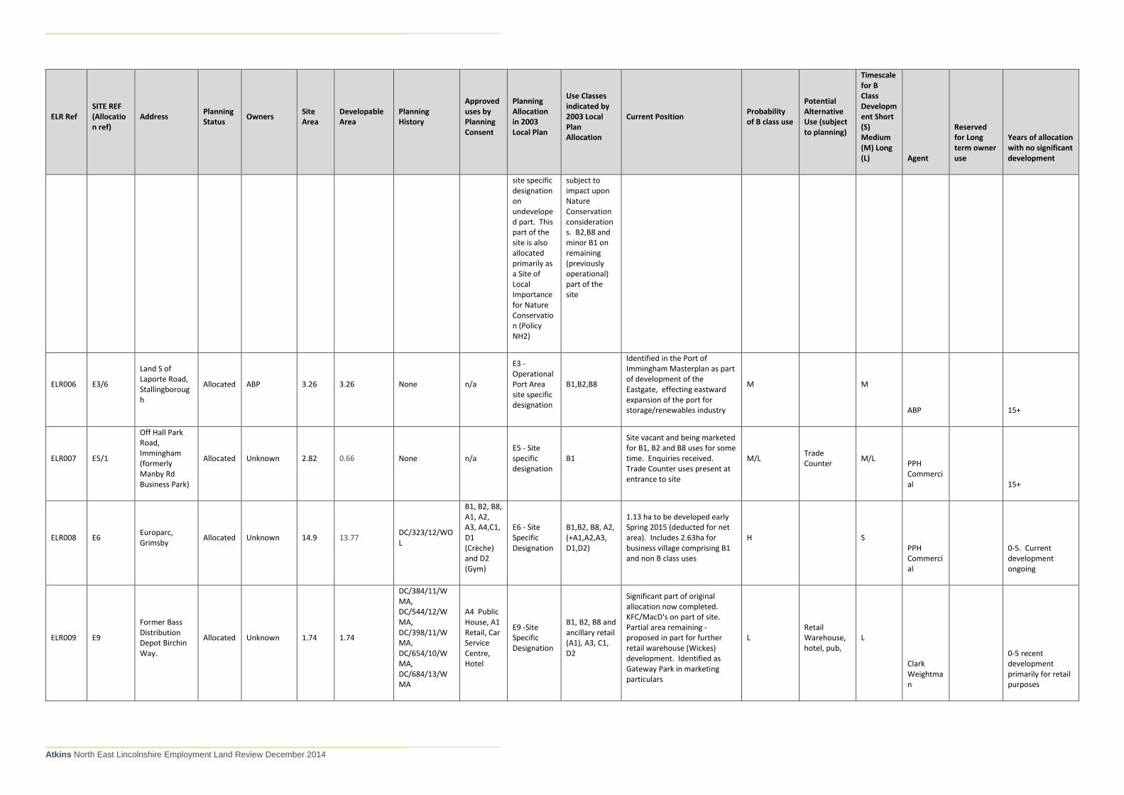
Atkins North East Lincolnshire Employment Land Review December 2014
ELR Ref SITE REF (Allocation ref)
Address Planning Status
Owners Site Area
Developable Area
Planning History
Approved uses by Planning Consent
Planning Allocation in 2003 Local Plan
Use Classes indicated by 2003 Local Plan Allocation
Current Position Probability of B class use
Potential Alternative Use (subject to planning)
Timescale for B Class Development Short (S) Medium (M) Long (L) Agent
Reserved for Long term owner use
Years of allocation with no significant development
site specific designation on undeveloped part. This part of the site is also allocated primarily as a Site of Local Importance for Nature Conservation (Policy NH2)
subject to impact upon Nature Conservation considerations. B2,B8 and minor B1 on remaining (previously operational) part of the site
ELR006 E3/6
Land S of Laporte Road, Stallingborough
Allocated ABP 3.26 3.26 None n/a
E3 - Operational Port Area site specific designation
B1,B2,B8
Identified in the Port of Immingham Masterplan as part of development of the Eastgate, effecting eastward expansion of the port for storage/renewables industry
M M
ABP 15+
ELR007 E5/1
Off Hall Park Road, Immingham (formerly Manby Rd Business Park)
Allocated Unknown 2.82 0.66 None n/a E5 - Site specific designation
B1
Site vacant and being marketed for B1, B2 and B8 uses for some time. Enquiries received. Trade Counter uses present at entrance to site
M/L Trade Counter
M/L PPH Commercial 15+
ELR008 E6 Europarc, Grimsby
Allocated Unknown 14.9 13.77 DC/323/12/WOL
B1, B2, B8, A1, A2, A3, A4,C1, D1 (Crèche) and D2 (Gym)
E6 - Site Specific Designation
B1,B2, B8, A2, (+A1,A2,A3, D1,D2)
1.13 ha to be developed early Spring 2015 (deducted for net area). Includes 2.63ha for business village comprising B1 and non B class uses
H S PPH Commercial
0-5. Current development ongoing
ELR009 E9
Former Bass Distribution Depot Birchin Way.
Allocated Unknown 1.74 1.74
DC/384/11/WMA, DC/544/12/WMA, DC/398/11/WMA, DC/654/10/WMA, DC/684/13/WMA
A4 Public House, A1 Retail, Car Service Centre, Hotel
E9 -Site Specific Designation
B1, B2, B8 and ancillary retail (A1), A3, C1, D2
Significant part of original allocation now completed. KFC/MacD's on part of site. Partial area remaining - proposed in part for further retail warehouse (Wickes) development. Identified as Gateway Park in marketing particulars
L Retail Warehouse, hotel, pub,
L
Clark Weightman
0-5 recent development primarily for retail purposes
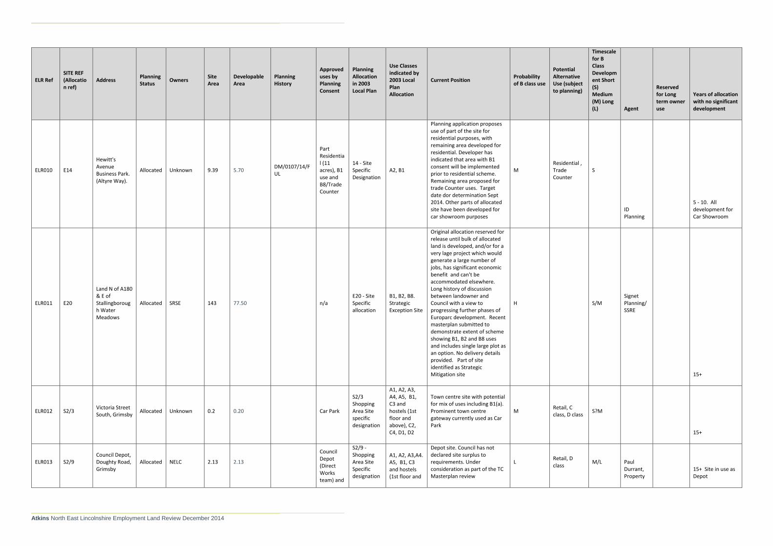
Atkins North East Lincolnshire Employment Land Review December 2014
ELR Ref SITE REF (Allocation ref)
Address Planning Status
Owners Site Area
Developable Area
Planning History
Approved uses by Planning Consent
Planning Allocation in 2003 Local Plan
Use Classes indicated by 2003 Local Plan Allocation
Current Position Probability of B class use
Potential Alternative Use (subject to planning)
Timescale for B Class Development Short (S) Medium (M) Long (L) Agent
Reserved for Long term owner use
Years of allocation with no significant development
ELR010 E14
Hewitt's Avenue Business Park. (Altyre Way).
Allocated Unknown 9.39 5.70 DM/0107/14/FUL
Part Residential (11 acres), B1 use and B8/Trade Counter
14 - Site Specific Designation
A2, B1
Planning application proposes use of part of the site for residential purposes, with remaining area developed for residential. Developer has indicated that area with B1 consent will be implemented prior to residential scheme. Remaining area proposed for trade Counter uses. Target date dor determination Sept 2014. Other parts of allocated site have been developed for car showroom purposes
M Residential , Trade Counter
S
ID Planning
5 - 10. All development for Car Showroom
ELR011 E20
Land N of A180 & E of Stallingborough Water Meadows
Allocated SRSE 143 77.50 n/a E20 - Site Specific allocation
B1, B2, B8. Strategic Exception Site
Original allocation reserved for release until bulk of allocated land is developed, and/or for a very lage project which would generate a large number of jobs, has significant economic benefit and can't be accommodated elsewhere. Long history of discussion between landowner and Council with a view to progressing further phases of Europarc development. Recent masterplan submitted to demonstrate extent of scheme showing B1, B2 and B8 uses and includes single large plot as an option. No delivery details provided. Part of site identified as Strategic Mitigation site
H S/M Signet Planning/SSRE
15+
ELR012 S2/3 Victoria Street South, Grimsby
Allocated Unknown 0.2 0.20 Car Park
S2/3 Shopping Area Site specific designation
A1, A2, A3, A4, A5, B1, C3 and hostels (1st floor and above), C2, C4, D1, D2
Town centre site with potential for mix of uses including B1(a). Prominent town centre gateway currently used as Car Park
M Retail, C class, D class
S?M
15+
ELR013 S2/9 Council Depot, Doughty Road, Grimsby
Allocated NELC 2.13 2.13
Council Depot (Direct Works team) and
S2/9 - Shopping Area Site Specific designation
A1, A2, A3,A4. A5, B1, C3 and hostels (1st floor and
Depot site. Council has not declared site surplus to requirements. Under consideration as part of the TC Masterplan review
L Retail, D class
M/L Paul Durrant, Property
15+ Site in use as Depot

Atkins North East Lincolnshire Employment Land Review December 2014
ELR Ref SITE REF (Allocation ref)
Address Planning Status
Owners Site Area
Developable Area
Planning History
Approved uses by Planning Consent
Planning Allocation in 2003 Local Plan
Use Classes indicated by 2003 Local Plan Allocation
Current Position Probability of B class use
Potential Alternative Use (subject to planning)
Timescale for B Class Development Short (S) Medium (M) Long (L) Agent
Reserved for Long term owner use
Years of allocation with no significant development
recycling centre
above), C2, C4, D1, D2
ELR014 E4/1
Land Adjacent to the railway north, Harborough.
Allocated
Mr Ian Lawson c/o Ross Davy Associates
0.27 0.27 DC/197/11/IMM
B2 units E4/1 B1 (inc Minor office development)
Not aware of any interest of site
L L
15+
ELR015 E1 Moody Lane, Grimsby (Humber Land)
New Site Humber Land
22.66 22.66 DM/0455/14/OUT
93,179 sq.m. B2 and B8. 5026 sq. m. B1 office associated with development.
E1 - Industrial Area (not site specific)
B1, B2, B8 and ancillary A1,A2,A3,D1, D2
Planning application details development of 98,295 sq, m, for B1, B2 and B8. Indicative proposal incorporates 5026 sq. m. B1. Within HSE Inner Zone for PADHI. Proposes Moody Lane/Hobson Way connection - dep. On adjacent landowners. Decision imminently due on planning application. Site actively marketed and initial interest from occupiers identified.
H/M S/M Seymour Harris
15+ - Site previously in use. Now cleared for re-development opportunity
ELR016
Kiln Lane Expansion Site Stallingborough
New Site Mixed 106 63.40 None n/a n/a n/a
Agreement in principle achieved with landowners to work collectively to deliver employment site. Feasibility undertaken which establishes no major obstacles to development subject to some drainage mitigation. Council working with landowners to progress site options
H S Kate Walker, Econ Dev
N/A
ELR017
Hewitts Avenue/ Weelsby Hall Farm Site
New Site Unknown 10.67 10.67 None n/a n/a n/a
Site actively promoted as part of wider strategic housing development on land to the north. Housing part assessed in SHLAA 2014 and considered suitable for development. Delivery of employment site will require residential scheme to ensure financial feasibility
H L
N/A
ERL018 E1/7A
Europa Way. Kiln Lane Industrial Estate, Stallingborough
Allocated Immingham Estates
0.77 0.77 n/a E1 - Site specific designation
B1, B2, B8 and ancillary A1, A2, A3, D1, D2
Pre-Application discussions being progressed for development of the site for Energy to Waste facility. Advanced contract discussions stage with occupier
H S/M
Immingham Estates 15+
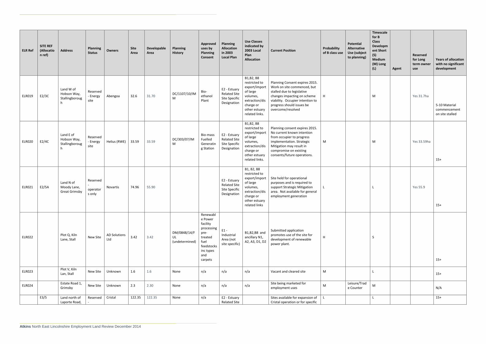
Atkins North East Lincolnshire Employment Land Review December 2014
ELR Ref SITE REF (Allocation ref)
Address Planning Status
Owners Site Area
Developable Area
Planning History
Approved uses by Planning Consent
Planning Allocation in 2003 Local Plan
Use Classes indicated by 2003 Local Plan Allocation
Current Position Probability of B class use
Potential Alternative Use (subject to planning)
Timescale for B Class Development Short (S) Medium (M) Long (L) Agent
Reserved for Long term owner use
Years of allocation with no significant development
ELR019 E2/3C
Land W of Hobson Way, Stallingborough
Reserved - Energy site
Abengoa 32.6 31.70 DC/1107/10/IMM
Bio-ethanol Plant
E2 - Estuary Related Site Site Specific Designation
B1,B2, B8 restricted to export/import of large volumes, extraction/discharge or other estuary related links.
Planning Consent expires 2015. Work on site commenced, but stalled due to legislative changes impacting on scheme viability. Occupier intention to progress should issues be overcome/resolved
H M
Yes 31.7ha
5-10 Material commencement on site stalled
ELR020 E2/4C
Land E of Hobson Way, Stallingborough
Reserved - Energy site
Helius (RWE) 33.59 33.59 DC/303/07/IMM
Bio-mass Fuelled Generating Station
E2 - Estuary Related Site Site Specific Designation
B1,B2, B8 restricted to export/import of large volumes, extraction/discharge or other estuary related links.
Planning consent expires 2015. No current known intention from occupier to progress implementation. Strategic Mitigation may result in compromise on existing consents/future operations.
M M
Yes 33.59ha
15+
ELR021 E2/5A Land N of Moody Lane, Great Grimsby
Reserved - operators only
Novartis 74.96 55.90
E2 - Estuary Related Site Site Specific Designation
B1, B2, B8 restricted to export/import of large volumes, extraction/discharge or other estuary related links
Site held for operational purposes and is required to support Strategic Mitigation area. Not available for general employment generation
L L
Yes 55.9
15+
ELR022 Plot Q, Kiln Lane, Stall
New Site AD Solutions Ltd
3.42 3.42 DM/0848/14/FUL (undetermined)
Renewable Power facility processing pre-treated fuel feedstocks inc types and carpets
E1 - Industrial Area (not site specific)
B1,B2,B8 and ancillary N1, A2, A3, D1, D2
Submitted application promotes use of the site for development of renewable power plant.
H S
15+
ELR023 Plot V, Kiln Lan, Stall
New Site Unknown 1.6 1.6 None n/a n/a n/a Vacant and cleared site M L 15+
ELR024 Estate Road 1, Grimsby
New Site Unknown 2.3 2.30 None n/a n/a n/a Site being marketed for employment uses
M Leisure/Trade Counter
M N/A
E3/5 Land north of Laporte Road,
Reserved -
Cristal 122.35 122.35 None n/a E2 - Estuary Related Site
Sites available for expansion of Cristal operation or for specific
L L 15+

Atkins North East Lincolnshire Employment Land Review December 2014
ELR Ref SITE REF (Allocation ref)
Address Planning Status
Owners Site Area
Developable Area
Planning History
Approved uses by Planning Consent
Planning Allocation in 2003 Local Plan
Use Classes indicated by 2003 Local Plan Allocation
Current Position Probability of B class use
Potential Alternative Use (subject to planning)
Timescale for B Class Development Short (S) Medium (M) Long (L) Agent
Reserved for Long term owner use
Years of allocation with no significant development
ELR025(a - e)
Stallingborough
operators only
Site Specific Designation
users within existing Cristal supply chain. Unlikely to be available for general employment use.
Yes 122.35ha
E2/1
Land N of Laporte Road, Stallingborough
E2/2A
Land S of Laporte Road, Stallingborough
E2/2B
Land S of Laporte Road, Stallingborough
E2/3A
Land W of Hobson Way, Stallingborough
E2/3B
Land W of Hobson Way, Stallingborough
E2/4A
Land E of Hobson Way, Stallingborough
E2/4B
Land E of Hobson Way, Stallingborough
ELR026 E3/1D Queens Road, Immingham Dock Estate
Allocated ABP 5.15 5.15 None n/a
E3 - Operational Port Area - Site Specific Designation
B1, B2, B8
Identified in the Port of Immingham Masterplan as part of development of the Eastgate, effecting eastward expansion of the port for storage/renewables industry. Part of Dock Estate
M M
15+
ELR027 Land off Queens Road,
New Site ABLE UK 15.14 15.14 None n/a E1 - Industrial
B1,B2,B8 and ancillary
Site considered to be suitable for employment uses. Landowner indicates that development is likely to be in
M M/L
15+ - recently acquisition by current owners

Atkins North East Lincolnshire Employment Land Review December 2014
ELR Ref SITE REF (Allocation ref)
Address Planning Status
Owners Site Area
Developable Area
Planning History
Approved uses by Planning Consent
Planning Allocation in 2003 Local Plan
Use Classes indicated by 2003 Local Plan Allocation
Current Position Probability of B class use
Potential Alternative Use (subject to planning)
Timescale for B Class Development Short (S) Medium (M) Long (L) Agent
Reserved for Long term owner use
Years of allocation with no significant development
Immingham (Magna site)
Area (not site specific)
A1,A2,A3,D1,D2
medium term. Site area needs confirmation (brownfield contamination on significant parts of the site).
ELR028 Land off Estate Road No 5, Grimsby
New Site Unknown 4 4.0. None n/a
E1 - Industrial Area (not site specific)
B1,B2, B8 and ancillary A1,A2,A3,D1,D2
Vacant site marketed for employment uses
H/M M Potter Learoyd N/A
ELR032
S2/6
Cartergate, Grimsby
NELC 0.05 0.05 None
Car Park
B1a
C1
S2/7 - Shopping Area - site specific
A1, A2, A3, A4, A5, B1, C3 and hostels (1st floor and above), C2, C4, D1, D2
Council is leading on proposed development of S2/7 for office accommodation. S2/9 being promoted for hotel use
H S
15+ - used as car park. Recent proposals to develop
S2/7
S2/8
ELR036
Adj Westgate Park, Armstrong Street
New Site Unknown 1.74 1.74 None n/a n/a Site being marketed for B1 uses, and range of non-employment uses.
L
Hotel, Leisure, Healthcare, Trade Counter
M PPH Commercial N/A
ELR037 Land to rear of Marlin House, Immingham
New Site Unknown 1.137 1.137 None n/a n/a Site promoted by agent. Adjacent SHLAA site.
L M/l N/A
ELR039 (A& b)
E2/3A and E2/3B
South of Laporte Road, Stallingborough
Reserved - operators only
BOC 17.05 17.05 None n/a
E2 - Estuary Related Site Specific Designation
B1, B2, B8 restricted to export/import of large volumes, extraction/discharge or other estuary related links
Sites known to be available for BOC/specific supply chains only and unlikely to be available for general market provision
L L
Yes 17.05ha
0-5 Recent expansion of BOC facility on part of site
ELR040 E12 Peaks Lane Allocated
Hospital Management Team
1.396ha
1.396ha None n/a E12 - Site Specific Designation
B1, C1,D1,D2 Site promoted by PPH Commercial for all uses identified in plan.
L C1,D1, D2 L PPH Commercial 15+

© Atkins Ltd except where stated otherwise. The Atkins logo, ‘Carbon Critical Design’ and the strapline ‘Plan Design Enable’ are trademarks of Atkins Ltd.
Richard Coburn Atkins
286 Euston Road Euston Tower London NW1 3AT