north pioneer fire salvage and reforestation project...
TRANSCRIPT

United States Department of Agriculture Forest Service
North Pioneer Fire Salvage and Reforestation Project Environmental Assessment Lowman Ranger District, Boise National Forest, Boise County, Idaho April 2017

For More Information Contact:
John Kidd, Lowman District Ranger
Phone: 208-259-3361 or
Clint VanZile, North Pioneer Team Leader Phone: 208-365-7618
7359 Highway 21
Lowman, ID 83637
Email: [email protected]
Fax: 208-259-3366
Photo: View of Pioneer Wildfire effects from National Forest System Road 594 in Rock Creek.
In accordance with Federal civil rights law and U.S. Department of Agriculture (USDA) civil rights regulations and policies, the USDA, its Agencies, offices, and employees, and institutions participating in or administering USDA programs are prohibited from discriminating based on race, color, national origin, religion, sex, gender identity (including gender expression), sexual orientation, disability, age, marital status, family/parental status, income derived from a public assistance program, political beliefs, or reprisal or retaliation for prior civil rights activity, in any program or activity conducted or funded by USDA (not all bases apply to all programs). Remedies and complaint filing deadlines vary by program or incident.
Persons with disabilities who require alternative means of communication for program information (e.g., Braille, large print, audiotape, American Sign Language, etc.) should contact the responsible Agency or USDA’s TARGET Center at (202) 720-2600 (voice and TTY) or contact USDA through the Federal Relay Service at (800) 877-8339. Additionally, program information may be made available in languages other than English.
To file a program discrimination complaint, complete the USDA Program Discrimination Complaint Form, AD-3027, found online at http://www.ascr.usda.gov/complaint_filing_cust.html and at any USDA office or write a letter addressed to USDA and provide in the letter all of the information requested in the form. To request a copy of the complaint form, call (866) 632-9992. Submit your completed form or letter to USDA by:
(1) mail: U.S. Department of Agriculture
Office of the Assistant Secretary for Civil Rights
1400 Independence Avenue, SW
Washington, D.C. 20250-9410;
(2) fax: (202) 690-7442; or
(3) email: [email protected].
USDA is an equal opportunity provider, employer, and lender.
North Pioneer Fire Salvage and Reforestation Project Environmental Assessment
i
Contents North Pioneer Fire Salvage and Reforestation Project ................................................................................. 1 Contents ......................................................................................................................................................... i Tables ........................................................................................................................................................... vi Figures ........................................................................................................................................................ vii Acronyms Used Within the Document ...................................................................................................... viii Chapter 1—Purpose and Need for the Proposal ........................................................................................... 1
Introduction ............................................................................................................................................... 1
What is the Purpose of this Environmental Assessment and How is it Organized? ............................. 1
Where is the Proposed Action Located? ............................................................................................... 2
Why Has the Project Been Proposed (Purpose and Need)? ...................................................................... 5
Purpose .................................................................................................................................................. 5
Need ...................................................................................................................................................... 5
What is the Proposed Action? ................................................................................................................... 6
What was the Planning Process used to develop the Proposed Action? ............................................... 7
Priority 1: Hazard Tree Removal .......................................................................................................... 7
Priority 2: Other Areas to be Considered for Salvage ........................................................................... 8
Determining Location to Remove Hazard and Dead Trees within the Pioneer Fire to Address Priorities 1 and 2 Above........................................................................................................................ 8
Hazard Tree and Salvage Treatments ................................................................................................... 9
Hazard Tree Removal ......................................................................................................................... 13
Riparian Conservation Area Hazard Tree Removal ........................................................................ 13
Activity Fuels Management ................................................................................................................ 14
Temporary Roads ................................................................................................................................ 15
National Forest System Road Management ........................................................................................ 15
Access and Public Health and Safety .................................................................................................. 15
Reforestation ....................................................................................................................................... 15
Project Design Features ...................................................................................................................... 19
Monitoring Activities .......................................................................................................................... 19
Adaptive Management ........................................................................................................................ 20
Emergency Situation Determination ................................................................................................... 21
Coordination with Research .................................................................................................................... 22
Boise State University and the College of Idaho ................................................................................ 22
Pacific Northwest Research Station, Pacific Wildland Fire Science Lab and University of Washington, School of Environmental and Forest Sciences............................................................... 22
Proposal 1: Evaluating the Effects of Salvage Logging and Developing Fire Resilient Forests .... 22

North Pioneer Fire Salvage and Reforestation Project Environmental Assessment
ii
Proposal 2: Historic Wildfire Effects on Forest Structure and Wildfire Behavior on the 2016 Pioneer Fire ..................................................................................................................................... 23
What is the Key Forest Plan Management Direction Used to Inform Development of the Proposed Action for this Area? ............................................................................................................................... 23
What Decisions are to be Made? ............................................................................................................. 24
Chapter 2—Issues and Alternatives ............................................................................................................ 25
What Public and Tribal Involvement Have Occurred to Date? .............................................................. 25
What Issues/Concerns were Identified through Scoping? ...................................................................... 26
Comments Concerning Salvage Logging ........................................................................................... 26
Issues Carried Forward into Alternative Consideration .................................................................. 27
What Would it Mean to Not Meet the Need? What is the “No Action” Alternative? ............................ 29
What Other Actions were Considered? ................................................................................................... 30
Alternative Considered but Not Analyzed in Detail ........................................................................... 30
Alternative 1 .................................................................................................................................... 30
Alternative 2 .................................................................................................................................... 32
Alternative 3 .................................................................................................................................... 33
Alternatives Analyzed in Detail .......................................................................................................... 34
Are Other Federal, State, or Local Approvals Applicable to the Proposed Action? ............................... 34
How do the Alternatives Compare to Each Other? ................................................................................. 35
Chapter 3—Effects of the Proposed Action and Alternatives .................................................................... 37
What are the Effects of the Proposed Action as Compared to the “No Action” Alternative? ................ 37
Incomplete and Unavailable Information............................................................................................ 37
Use of Best Available Science ............................................................................................................ 38
Analysis Calculations .......................................................................................................................... 39
Resources Assessed in this Chapter .................................................................................................... 39
Forested Vegetation ............................................................................................................................ 40
Indicators......................................................................................................................................... 41
Background ..................................................................................................................................... 42
What are the effects to tree composition and the resistance and resilience of the forest vegetation towards future disturbances and stressors? ..................................................................................... 42
What are the effects to snag numbers, size and species? ................................................................ 45
What are the effects to large tree (mature forest) or old forest habitat within the project area? ..... 50
Cumulative Effects .......................................................................................................................... 51
Fire and Fuels ...................................................................................................................................... 53
Indicators......................................................................................................................................... 53
Fuel Loading and Wildfire Response Concerns.............................................................................. 55

North Pioneer Fire Salvage and Reforestation Project Environmental Assessment
iii
Addressing Fire Fighter and Public Safety ..................................................................................... 58
Cumulative Effects .......................................................................................................................... 59
Wildlife ............................................................................................................................................... 60
Background ..................................................................................................................................... 61
Indicators......................................................................................................................................... 63
Summary of Environmental Effects ................................................................................................ 64
Effects to Low Elevation Old Forest Species ................................................................................. 66
Effects to Broad Elevation Old Forest Species ............................................................................... 69
Effects to Forest Mosaic Species .................................................................................................... 80
Effects to Riverine and Riparian Wetland Species ......................................................................... 94
Management Indicator Species ....................................................................................................... 96
Transportation System ........................................................................................................................ 99
Indicators....................................................................................................................................... 100
Road Maintenance During Salvage ............................................................................................... 101
Maintenance Level 1 Road Reopened for Salvage ....................................................................... 105
Temporary Road Construction ...................................................................................................... 106
Roads Maintenance for Safety ...................................................................................................... 108
Recreation Resources ........................................................................................................................ 109
Indicators....................................................................................................................................... 110
Disruption/Displacement of Recreation Users .............................................................................. 110
Motorized and Nonmotorized Recreational Access ...................................................................... 112
Dispersed Recreation .................................................................................................................... 114
Recreation Opportunity Spectrum ................................................................................................ 115
Hydrology Resources ........................................................................................................................ 116
Indicators....................................................................................................................................... 116
Summary of Effects ...................................................................................................................... 117
Stream Temperature ...................................................................................................................... 118
Sediment ....................................................................................................................................... 120
Water Yield ................................................................................................................................... 123
Chemical Contaminants ................................................................................................................ 125
Road Density ................................................................................................................................. 126
Fisheries ............................................................................................................................................ 128
Indicators....................................................................................................................................... 128
What are the effects to fish species and habitat? ........................................................................... 129
Affected Environment ................................................................................................................... 129

North Pioneer Fire Salvage and Reforestation Project Environmental Assessment
iv
Direct and Indirect Effects ............................................................................................................ 129
Cumulative Effects ........................................................................................................................ 131
Determination of Effects and Rationale for Bull Trout ................................................................ 131
Soils Resource ................................................................................................................................... 138
Indicators....................................................................................................................................... 138
Would proposed activities cause detrimental soil compaction and increase soil erosion above natural levels? ............................................................................................................................... 140
Would temporary road construction, skid trails and log landings cause long term degradation of the physical, biological and chemical soil properties and decrease the amount of area that can support desired vegetation? ........................................................................................................... 144
Would salvage harvest increase the potential for landslides, particularly in areas having inherently moderate or high instability?......................................................................................................... 146
Rare Plants ........................................................................................................................................ 150
Indicators....................................................................................................................................... 150
Would proposed activities affect rare plant resources and habitat, including whitebark pine? .... 151
Noxious Weeds/Invasive Plant Species ............................................................................................ 154
Indicators....................................................................................................................................... 154
Exposure Risk, and the Ability to Detect, Monitor and Treat Weed Infestations ......................... 154
Rangeland Resources ........................................................................................................................ 157
Indicators....................................................................................................................................... 157
Amount or Quality of Forage Available and Livestock Displacement ......................................... 157
Climate Change ................................................................................................................................. 161
Indicators....................................................................................................................................... 162
Affected Environment ................................................................................................................... 162
Alternative A (No Action) ............................................................................................................ 163
Alternative B (Proposed Action) ................................................................................................... 164
Mineral Resources ............................................................................................................................ 167
Indicators....................................................................................................................................... 167
Access to Mining Claims and/or Projects ..................................................................................... 168
Scenic Resource ................................................................................................................................ 170
Indicators....................................................................................................................................... 170
What is the degree of visual dominance and the duration of the effects related to the proposed activities? ...................................................................................................................................... 171
Will proposed activities be consistent with Forest Plan adopted Visual Quality Objectives (VQOs), standards and guidelines? ............................................................................................... 176
Socioeconomics ................................................................................................................................ 178

North Pioneer Fire Salvage and Reforestation Project Environmental Assessment
v
Background ................................................................................................................................... 178
Indicators....................................................................................................................................... 179
Volume in MMBF ......................................................................................................................... 180
Net Revenue .................................................................................................................................. 180
Jobs Created .................................................................................................................................. 183
Inventoried Roadless Areas .............................................................................................................. 184
Indicators....................................................................................................................................... 185
Background ................................................................................................................................... 185
Roadless Characteristics ............................................................................................................... 187
Wilderness Attributes .................................................................................................................... 192
Chapter 4—Agencies and Persons Consulted ........................................................................................... 199
What Agencies and Persons have been Consulted? .............................................................................. 199
Literature Cited ......................................................................................................................................... 201 Appendices ................................................................................................................................................ 211
Appendix A: Design Features ............................................................................................................... 211
Cultural Resources ........................................................................................................................ 211
Fire/Fuels ...................................................................................................................................... 211
Fisheries, Hydrology, and Soils .................................................................................................... 211
Minerals/Geology ......................................................................................................................... 215
Noxious Weeds ............................................................................................................................. 215
Traffic and Public Safety .............................................................................................................. 215
Recreation ..................................................................................................................................... 216
Range Management ...................................................................................................................... 216
Rare Plants .................................................................................................................................... 216
Timber Harvest ............................................................................................................................. 218
Engineering/Transportation .......................................................................................................... 219
Wildlife Resources ........................................................................................................................ 219
Vegetation Management ............................................................................................................... 221
Visual Quality ............................................................................................................................... 222
Appendix B: Cumulative Effects: Present, Ongoing, And Reasonably Foreseeable Activities .................. 223
North Pioneer Fire Salvage and Reforestation Project Environmental Assessment
vi
Tables Table 1. Salvage operations summary .................................................................................................. 9
Table 2. Reforestation/restoration summary ......................................................................................... 16
Table 3. Suggestions for ecologically based post-fire management from three major reviews ............ 27
Table 4. Summary of other permits and approvals that may be necessary ........................................... 34
Table 5. Comparison of alternatives by how well they address the purpose and need of the North Pioneer Project following implementation of all proposed treatments ................................................. 35
Table 6. Projected average snags per acre for the project area under the No Action Alternative ......... 46
Table 7. Projected average snags per acre for the project area under the Proposed Action .................. 46
Table 8. Projected average snags per acre within hazard tree and salvage treatment areas under the Proposed Action ....................................................................................................................... 47
Table 9. Average snags per acre by Potential Vegetation Group (PVG) and size class in 2017 in the salvage units for Alternatives A and B compared to the desired condition ............................. 48
Table 10. Fuel size classes .................................................................................................................... 54
Table 11. Modeled woody fuel accumulations in a middle-to-high elevation, subalpine fir forest type for the No Action Alternative, the Proposed Action (proposed dead roadside hazard tree fell and remove) and the Proposed Action (proposed felling but no removal) ..................................... 57
Table 12. Modeled woody fuel accumulations in a middle-to-high elevation, Douglas-fir/ponderosa pine forest type for the No Action Alternative and the Proposed Action (proposed dead tree salvage) ................................................................................................................................................. 57
Table 13. Wildlife species and status considered by source habitat family and family number, with focal species identified, and effects determinations for the North Pioneer Project Proposed Action ................................................................................................................................................. 65
Table 14. Summary of lynx habitat by Lynx Analysis Unit (LAU) for the North Pioneer Project ...... 81
Table 15. miles of National Forest System roads in the project area and those to be used during salvage operations under the Proposed Action ..................................................................................... 102
Table 16. miles of road maintenance proposed under the Proposed Action ......................................... 103
Table 17. Watershed resource indicators, concerns, and measures used in this analysis ..................... 117
Table 18. Summary of the effects of the Proposed Action to each of the watershed resource indicators ................................................................................................................................................. 117
Table 19. Proposed activities within Riparian Conservation Areas (RCAs) near Designated Critical Bull Trout Habitat ............................................................................................................................ 130
Table 20. Summary of effects to watershed condition indicators (WCIs) by timeframe for the Proposed Action Alternative .................................................................................................................... 132
Table 21. Summary of detrimental disturbance (DD) by alternative .................................................... 141
Table 22. Total Soil Resource Commitment (TSRC) by alternative (values in percent) ...................... 146
Table 23. SINMAP landslide hazard ratings (Pack et al. 1998) ........................................................... 147
Table 24. Summary of proposed salvage harvest on “Moderate” and “High” landslide prone lands ... 149
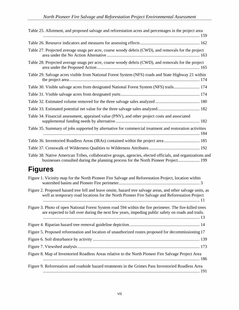
North Pioneer Fire Salvage and Reforestation Project Environmental Assessment
vii
Table 25. Allotment, and proposed salvage and reforestation acres and percentages in the project area ................................................................................................................................................. 159
Table 26. Resource indicators and measures for assessing effects ....................................................... 162
Table 27. Projected average snags per acre, coarse woody debris (CWD), and removals for the project area under the No Action Alternative ...................................................................................... 163
Table 28. Projected average snags per acre, coarse woody debris (CWD), and removals for the project area under the Proposed Action ............................................................................................... 165
Table 29. Salvage acres visible from National Forest System (NFS) roads and State Highway 21 within the project area ......................................................................................................................... 174
Table 30. Visible salvage acres from designated National Forest System (NFS) trails ........................ 174
Table 31. Visible salvage acres from designated yurts ......................................................................... 174
Table 32. Estimated volume removed for the three salvage sales analyzed ......................................... 180
Table 33. Estimated potential net value for the three salvage sales analyzed ....................................... 182
Table 34. Financial assessment, appraised value (PNV), and other project costs and associated supplemental funding needs by alternative .............................................................................. 182
Table 35. Summary of jobs supported by alternative for commercial treatment and restoration activities ................................................................................................................................................. 184
Table 36. Inventoried Roadless Areas (IRAs) contained within the project area ................................. 185
Table 37. Crosswalk of Wilderness Qualities to Wilderness Attributes ............................................... 192
Table 38. Native American Tribes, collaborative groups, agencies, elected officials, and organizations and businesses consulted during the planning process for the North Pioneer Project .................... 199
Figures Figure 1. Vicinity map for the North Pioneer Fire Salvage and Reforestation Project, location within
watershed basins and Pioneer Fire perimeter ........................................................................... 3
Figure 2. Proposed hazard tree fell and leave onsite, hazard tree salvage areas, and other salvage units, as well as temporary road locations for the North Pioneer Fire Salvage and Reforestation Project ................................................................................................................................................. 11
Figure 3. Photo of open National Forest System road 594 within the fire perimeter. The fire-killed trees are expected to fall over during the next few years, impeding public safety on roads and trails. ................................................................................................................................................. 13
Figure 4. Riparian hazard tree removal guideline depiction. ................................................................ 14
Figure 5. Proposed reforestation and location of unauthorized routes proposed for decommissioning 17
Figure 6. Soil disturbance by activity ................................................................................................... 139
Figure 7. Viewshed analysis ................................................................................................................. 173
Figure 8. Map of Inventoried Roadless Areas relative to the North Pioneer Fire Salvage Project Area ................................................................................................................................................. 186
Figure 9. Reforestation and roadside hazard treatments in the Grimes Pass Inventoried Roadless Area ................................................................................................................................................. 191
North Pioneer Fire Salvage and Reforestation Project Environmental Assessment
viii
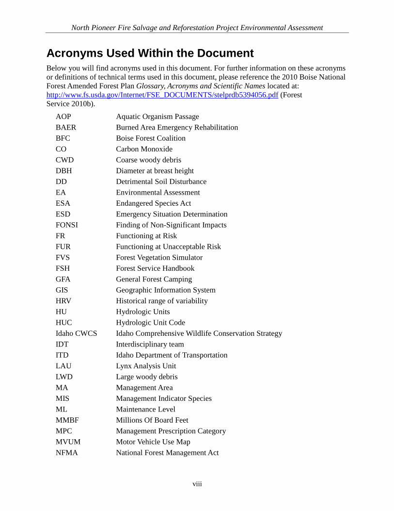
Acronyms Used Within the Document Below you will find acronyms used in this document. For further information on these acronyms or definitions of technical terms used in this document, please reference the 2010 Boise National Forest Amended Forest Plan Glossary, Acronyms and Scientific Names located at: http://www.fs.usda.gov/Internet/FSE_DOCUMENTS/stelprdb5394056.pdf (Forest Service 2010b).
AOP Aquatic Organism Passage BAER Burned Area Emergency Rehabilitation BFC Boise Forest Coalition CO Carbon Monoxide CWD Coarse woody debris DBH Diameter at breast height DD Detrimental Soil Disturbance EA Environmental Assessment ESA Endangered Species Act ESD Emergency Situation Determination FONSI Finding of Non-Significant Impacts FR Functioning at Risk FUR Functioning at Unacceptable Risk FVS Forest Vegetation Simulator FSH Forest Service Handbook GFA General Forest Camping GIS Geographic Information System HRV Historical range of variability HU Hydrologic Units HUC Hydrologic Unit Code Idaho CWCS Idaho Comprehensive Wildlife Conservation Strategy IDT Interdisciplinary team ITD Idaho Department of Transportation LAU Lynx Analysis Unit LWD Large woody debris MA Management Area MIS Management Indicator Species ML Maintenance Level MMBF Millions Of Board Feet MPC Management Prescription Category MVUM Motor Vehicle Use Map NFMA National Forest Management Act

North Pioneer Fire Salvage and Reforestation Project Environmental Assessment
ix
NEPA National Environmental Policy Act NFS National Forest System NMFS National Marine Fisheries Service NPDES National Pollutant Discharge Elimination System OHV Off-Highway Vehicle OM Organic Matter OSV Oversnow Vehicle PAR Proposed Action Report PFA Post-Fledging Areas PIBO Pacfish and InFish Biological Opinion PNV Potential Net Value PCT Pre-Commercial Thinning PVG Potential Vegetation Group RCAs Riparian Conservation Areas RNA Research Natural Area ROS Recreation Opportunity Spectrum ROW Right-of-Way SOPA Schedule of Proposed Actions SOI Species of Interest SPTH Site potential tree height SDI Stand Density Index SDImax Stand density index, measured as a percent of maximum SHPO Idaho State Historic Preservation Office SWRA Soil, Water, Riparian, and Aquatic TEA Transaction Evidence Appraisal TEPC Threatened, endangered, proposed, and candidate species TES Threatened and endangered species TSRC Total Soil Resource Commitment USDA U.S. Department of Agriculture USFWS U.S. Fish and Wildlife Service VQO Visual Quality Objective WCI Watershed condition indicator WUI Wildland-urban interface WSR Wild and Scenic Rivers

This page intentionally left blank

North Pioneer Fire Salvage and Reforestation Project Environmental Assessment
1
Chapter 1—Purpose and Need for the Proposal Introduction The Lowman Ranger District of the Boise National Forest (Forest) is proposing to mitigate threats from hazard trees, salvage merchantable dead trees, decommission unauthorized routes causing resource damage, and plant tree seedlings in portions of the area burned during the 2016 Pioneer Fire. The proposal has been identified as the North Pioneer Fire Salvage and Reforestation Project (North Pioneer Project). The Pioneer Fire began on July 18, 2016, when hot temperatures, strong winds, and dry conditions exacerbated by a lack of late-summer monsoonal moisture fueled the fire’s growth to more than 64,000 acres by August 9, 2016, and 190,000 acres by September 15, 2016. The fire affected 27 drainages within the Idaho City, Lowman, and Emmett Ranger Districts on the Forest. The Pioneer Fire burned with varying intensity and left a mosaic of burn patterns on the landscape, ranging from unburned islands to areas where tree crowns were completely consumed. The North Pioneer Project is being proposed in conjunction with the South Pioneer Fire Salvage and Reforestation Project (South Pioneer Project). Both projects have a similar purpose and similar need. The Forest’s objective in separating the northern portion of the fire area from the southern portion was to create a more straightforward environmental analysis based on differences related to ecological and management complexities. Ecologically, the project areas have been separated based on the watershed basin, with the southern project area flowing into the Boise River and this project, the northern project area, flowing into the Payette River (Figure 1). From a management perspective, the northern area includes a different mix of recreational, social, and economic needs than the southern area. The supporting National Environmental Policy Act (NEPA) documents, including this environmental assessment (EA), will discuss the cumulative effects resulting from implementing both actions.
What is the Purpose of this Environmental Assessment and How is it Organized? The Forest Service has prepared this EA in compliance with NEPA and other relevant federal and State laws and regulations. This EA discloses the direct, indirect, and cumulative environmental effects that would result from the Proposed Action and No Action alternatives for the North Pioneer Project on the Lowman Ranger District of the Forest. Chapter 1 identifies the purpose and need for the Proposed Action, the scope of the Proposed Action, and the decisions to be made. Chapter 2 identifies the public involvement leading to the
In Chapter 1, you will find:
• The purpose of this Environmental Assessment and how it is organized
• A description of the North Pioneer Fire Salvage and Reforestation Project Area
• Why we are proposing actions (the purpose and need for action)
• A description of our proposed action
• What Forest Service Management direction applies
• Criteria for making a decision
North Pioneer Fire Salvage and Reforestation Project Environmental Assessment
2
issues and alternatives of the project, Chapter 3 discloses the environmental effects of each alternative, and Chapter 4 shows with whom we consulted during our project’s development. This document is tiered to the final environmental impact statement (FEIS) (USDA Forest Service 2010b) and planning record supporting the 2003 revised Boise National Forest Land and Resource Management Plan (Forest Plan), as amended in 2010 (Forest Service 2010a), including monitoring reports. Detailed information supporting the analyses presented in this document is incorporated by reference, including specialist reports for each resource, and unless specifically noted otherwise, is contained in the project planning record.
Where is the Proposed Action Located? The North Pioneer Project is located immediately north and south of Lowman, Idaho, and about 74 miles northeast of Boise, Idaho, in Boise County. The Project Area covers approximately 28,007 acres in the Payette River watershed (Figure 1). The Project Area is located entirely on National Forest System (NFS) lands that fall within Boise County, Idaho.

North Pioneer Fire Salvage and Reforestation Project Environmental Assessment
3
Figure 1. Vicinity map for the North Pioneer Fire Salvage and Reforestation Project, location within watershed basins and
Pioneer Fire perimeter

This page intentionally left blank

South Pioneer Fire Salvage and Restoration Project Environmental Assessment
5
Why Has the Project Been Proposed (Purpose and Need)?
Purpose Consistent with the goals and objectives identified in the Forest Plan, the purpose of the North Pioneer Project is to remove hazard trees affecting public health and safety along travel routes and within developed sites; restore portions of the landscape burned by the wildfire by initiating reforestation; reduce watershed impacts resulting from unauthorized routes; and recover forest economic value and benefits through salvage, generating revenues to support the accomplishment of project objectives.
Need The following specific needs exist: 1. Mitigate the risks of hazard trees resulting from the Pioneer Fire along roads and trails open
to public motorized and non-motorized use, and within developed sites. Areas adjacent to many of the roads and trails open to the public and administrative motorized and non-motorized use (including groomed snowmobile routes), as well as within developed sites, within the project area were heavily forested prior to the 2016 Pioneer Fire. These areas now have high densities of fire-killed trees. If left standing, these trees pose a risk of striking parked or moving vehicles, recreationists, and Forest Service and contract personnel using these routes and developed sites. Fire-killed trees could also fall when vehicles/users are not present, creating a travelway hazard or potentially blocking individuals behind or between trees across the roadway. Commercially harvesting hazard trees, or felling and leaving them onsite where commercial harvest is not consistent with resource objectives, would proactively mitigate many of these risks, substantially reducing the time, energy, and funding otherwise needed to mitigate these risks over multiple years by Forest Service personnel or service contractors.
2. Reestablish forested conditions to trend the project area towards Forest Plan desired conditions; in particular, increase the representation of early seral conifer species such as ponderosa pine. A large portion of the project area, particularly within forest types classified to historically exhibit a nonlethal fire regime, burned at an uncharacteristically large scale with high intensity, creating patch sizes that are likely to take decades to naturally reestablish forested conditions. Strategically planting early seral species, including riparian vegetation, would create future seed sources and expedite recovery towards Forest Plan desired conditions.
3. Improve watershed conditions by decommissioning unauthorized roads currently degrading watershed conditions that fall within the project area. Unauthorized road segments that were stable and not accessible prior to the fire are now visible following vegetation removal by the fire. Where fire impacts have left these unauthorized road segments unstable, a need exists to decommission segments to reduce degrading effects to the watershed.

North Pioneer Fire Salvage and Reforestation Project Environmental Assessment
6
4. Recover the economic value of forest products in a timely manner to avoid loss of commodity value sufficient to jeopardize the Agency’s ability to accomplish project objectives directly related to public health and safety, resource protection, and restoration identified in Needs 1 through 3 above. Trees killed by this wildfire are losing value at an increased rate. Therefore, a need exists to salvage trees as quickly as possible. Expedited implementation allows the Forest to capture enough commodity value to market some of the trees. Often, if material proposed for removal cannot be sold, many of the project’s objectives associated with Needs 1–3 above cannot be met. Recovery of the economic value of forest products in a timely manner will also contribute to employment and income to local communities.
What is the Proposed Action? The Lowman Ranger District proposes cutting hazard trees along NFS roads and trails, reforesting areas, decommissioning unauthorized routes, and salvaging additional trees killed by the wildfire to recover economic value important to supporting restoration work. Proposed activities would begin in late spring or summer 2017. Salvage harvest activities are anticipated to be completed by the end of the 2018 operating season, while activities such as reforestation would continue for approximately 10 years. This project would remove hazard and dead trees from approximately 7,223 acres within the 28,007-acre project area. Specifically, to accomplish the purpose of the project and to address Need 1, this project proposes approximately 5,213 acres of hazard tree mitigation which includes 1,542 acres of hazard tree felling and leaving onsite and 3,671 acres of hazard tree salvage1. To address Need 4, approximately 2,010 acres of salvage to recover economic value to provide additional support for restoration and recovery efforts within the project area have been identified. Approximately 32 MMBF of wood products would likely be removed through salvage operations. Some acres proposed for treatment may eventually be eliminated during project layout and implementation. For example, additional small streams and springs in the project area could be discovered in areas proposed for salvage. Once these riparian conservation areas (RCAs) are identified, areas proposed for salvage may no longer be consistent with hazard tree removal or resource protection objectives. Other areas may be eliminated because they are too steep for safely operating ground-based machinery or they lack the necessary access for cable yarding.
1 Hazard tree salvage units would remove all hazard trees, as well as salvage any additional dead trees where consistent with design features in Appendix A.
What is Salvage Logging?
Salvage logging for the North Pioneer Project is the practice of logging trees in forested
areas that are hazard trees or have been killed by wildfire to recover economic value that
would otherwise be lost and use this revenue to fund resource protection and reforestation
activities.
North Pioneer Fire Salvage and Reforestation Project Environmental Assessment
7
What was the Planning Process used to develop the Proposed Action? The focus of project planning and design was to identify those priorities for which immediate implementation2 was necessary to achieve the purpose and need. Project planning and design addresses the following:
1. Relief from hazards threatening human health and safety 2. Mitigation of threats to natural resources on NFS or adjacent lands 3. Avoiding a loss of commodity value sufficient to jeopardize the Agency's ability
to accomplish project objectives directly related to resource protection or restoration
Priority 1: Hazard Tree Removal Forest Supervisors have a responsibility for the safe operation and management of roads and must “…to the extent permitted by funding levels, systematically provide for elimination of identified hazards” (FSM 7733.04c and FSM 2330.6a [guidance for developed sites risk assessment information]). Forest Service Handbook (FSH) direction (7709.59 Chapter 40) contains more specialized guidance pertaining to hazard trees along NFS roads open to public use. FSH 7709.59, section 41.6 states, “Road maintenance includes removing danger [hazard] trees that threaten safe use of the transportation system.” FSH 7709.59, section 41.7, provides guidance for hazard identification and correction. This section includes guidance that hazard trees along NFS roads should be evaluated, section by section, and hazard trees should be prioritized as high, medium, or low based on the risk to road users from potential tree failure. Removing high-priority hazards trees (failure could occur at any time) along travel routes and around developed sites to remain open during winter 2016/2017 were addressed through fire suppression and through ongoing post-fire actions initiated in fall 2016. The focus of the proposed action for the North Pioneer Project is to address the medium-to-low priority tree hazards that were not considered as time critical (i.e., likelihood of failing was not imminent, but assessed to be within the next 6 months to 2 years). In addition, high-priority hazard trees felled in 2016/2017 and left onsite may be salvaged to recover value where consistent with Forest Plan
2 “Immediate implementation” does not mean directly after the fire. It means the project will be implemented immediately after completing environmental review work when the Agency is ready to issue a decision. Review work includes public involvement. Often, decisions documented in an EA cannot be made until the next spring/early summer following the fire in order to complete field work, consultation requirements with other agencies, and public involvement. Expedited implementation allows the Forest to remove hazards safely, complete associated resource protection/restoration projects, and capture enough commodity value to market some of the trees. Often, if material proposed for removal cannot be sold, many of the project’s needs cannot be met. For these reasons, the Forest anticipates requesting an Emergency Situation Determination (ESD) which, if approved, would allow for implementation to begin in summer 2017. When salvage is involved, the timeline to implement a project associated with an ESD request should capture most of the normal timber operating season the year following the emergency event to capture wood product value important to accomplishing project needs (e.g., a May/June decision and June/July timber salvage offer to address a fire from the previous season).

North Pioneer Fire Salvage and Reforestation Project Environmental Assessment
8
resource direction and could contribute to the economic viability of a sale and/or provide revenues that could be used to support subsequent restoration work.
Priority 2: Other Areas to be Considered for Salvage The priority for using salvage is to remove hazard trees threatening human health and safety. Any additional areas considered for salvage that are not tied to these needs have only been considered where their inclusion does not exceed the Forest Service’s planning and implementation capacity to ensure the project will be implemented during summer 2017. Project implementation in summer 2017 is essential to minimize the loss of commodity value of salvageable wood products important to accomplishing project objectives for hazard tree removal; habitat and watershed improvement; and forest restoration, including reforestation.
Determining Location to Remove Hazard and Dead Trees within the Pioneer Fire to Address Priorities 1 and 2 Above Identifying trees appropriate for hazard tree removal or felling, as well as salvage to address priority 1, follows guidance developed by Smith and Gluck (2011). In addition, hazard trees (synonymously referred to as danger trees), would be identified using Filip and others (2016) who define a danger tree or hazard tree as, “any tree or it parts that will fail because of damage, defect, or disease and cause injury or death to people or damage to property.” To be a hazard, a tree must have (1) a potential to fail and (2) a target of value that the tree could strike. To identify salvage locations to address priority 2, emphasis was given to salvaging within units previously analyzed for harvest in the 2016 Becker Integrated Resource Project, 2013 Clear Creek Integrated Project, and 2004 Rock Creek Resource Management Project. Opportunities for salvage in previous project areas was emphasized because data collection, resource specialist knowledge and evaluations, due to recent analysis and assessment work, was more thorough and complete compared to other areas within the fire perimeter that had not been previously analyzed. The following screening process was developed using ecological considerations adopted from Lindenmayer and others (2006) and used to identify areas within these previous project areas that fell within workforce capacity considerations. The primary workforce capacity considerations emphasized remaining within the scope and scale of an environmental assessment that would be practicable to complete within the timeframe to support implementation in early summer 2017 and within guidelines supporting requests for an emergency situation determination (ESD—see Emergency Situation Determination section discussion): The screening process considered the following:
• Units should occur where site conditions, such as soils and aspect, are favorable for establishment and sustainability of early seral species.
• Units should occur on sites with enough merchantable wood product material that they are economically viable. Helicopter logging is not considered economically viable.
• Units should generally avoid areas of high soil burn severity to not increase detrimental impacts to soils and leave standing dead trees to provide shade for future revegetation efforts.

North Pioneer Fire Salvage and Reforestation Project Environmental Assessment
9
• Units should occur on suitable timber lands in Management Prescription Category (MPC 5.1).
• Salvage should occur within locations that predominately experienced high vegetation burn severity, as measured by >75% basal area loss.
• RCAs will be excluded except where treatments are needed to mitigate human health and safety concerns along roadsides and trails open to public use, as well as within developed sites.
• Sites with high landslide potential will be excluded, modifying as needed based on soil burn severity.
• Locations requiring new system road construction will be excluded.
• Construction of temporary roads should only occur on an existing road prism (i.e., unauthorized routes), included in previous decisions, or not exceed 0.5 miles per road segment and not enter RCAs or landslide prone areas.
Hazard Tree and Salvage Treatments As described above, salvage harvest to address hazard trees and recover economic value would occur on approximately 5,681 acres using ground-based and cable logging systems (Table 1, Figure 2). Dead trees, as well as hazard trees, would be cut and removed from within salvage units. The 2016 Pioneer Fire created extensive large patches where little-to-no live forest canopy remains. It is within these high-mortality areas—now considered openings due to the lack of live trees—that salvage units are being proposed. Locations where salvage of dead and hazard trees occurs would appear more open than areas not salvaged. Salvage units would maintain the number of snags per acre identified in Design Feature VM-1. Where large snags (>20 inches diameter at breast height [dbh]) are unavailable, additional smaller snags (≥10 inches dbh) shall be retained where available to meet at least the maximum total number of snags depicted in Table A-6 of Appendix A of the Forest Plan (USDA Forest Service 2010a). If substituting smaller snags for larger snags is necessary, the replacements would consist of snags from the largest diameters available within the unit. The average diameter of retention snags retained would be equal to or greater than the average diameter of the dead trees salvaged. That is, retained snags would be a representative sample of the range of snag diameters available pre-harvest. Ponderosa pine and Douglas-fir would be the preferred species retained as snags.
Table 1. Salvage operations summary Logging System Acres
Ground Based 4,141 Cable 1,540 Total 5,681

This page intentionally left blank

South Pioneer Fire Salvage and Restoration Project Environmental Assessment
11
Figure 2. Proposed hazard tree fell and leave onsite, hazard tree salvage areas, and other salvage units, as well as temporary
road locations for the North Pioneer Fire Salvage and Reforestation Project

This page intentionally left blank

North Pioneer Fire Salvage and Reforestation Project Environmental Assessment
13
Hazard Tree Removal Approximately 109.0 miles of open NFS roads and 9.0 miles of open motorized and non-motorized NFS trails occur within the project area (Figure 2). Within a 200-foot safety buffer along both sides of these roads and trails, trees classified as hazard trees that are likely to strike these routes would be felled on approximately 5,213 acres; trees from 3,671 of these acres would be removed to help pay for the treatment. Hazard trees would be identified based on their risk of falling and their likelihood of striking the established route or site infrastructure (see Figure 3). For example, more trees would likely be felled above a road (where a greater risk of the tree falling, sliding, or rolling down into the road exists) than below the road.
Figure 3. Photo of open National Forest System road 594 within the fire perimeter. The
fire-killed trees are expected to fall over during the next few years, impeding public safety on roads and trails.
Riparian Conservation Area Hazard Tree Removal In RCAs between the road and the water feature of salvage units and within the first site potential tree height (1st SPTH) in RCAs where the road intersects the stream perpendicularly, hazards trees would be dropped and left onsite (Figure 4). However, within RCAs on the side of the road opposite the water feature (uphill side of the road), and outside of the 1st SPTH in RCAs where the road intersects the stream perpendicularly, harvesting and removing hazard fire-killed and damaged trees would be allowed where consistent with Forest Plan standards3. Dead trees not identified as hazards would not be felled or removed within RCAs, regardless of whether a salvage unit overlaps with a hazard treatment area. Outside of hazard treatment areas, salvage units would be delineated to exclude the RCA. Within RCAs, hazard trees would be felled and removed on 179 acres and felled and left onsite across 1,216 acres.
3 TRST08: Salvage harvest in RCAs is allowed only where the wood products salvaged will not degrade or retard attainment of riparian, aquatic, hydrological, botanical, and terrestrial wildlife habitat desired conditions (USDA Forest Service 2010a)

North Pioneer Fire Salvage and Reforestation Project Environmental Assessment
14
Figure 4. Riparian hazard tree removal guideline depiction.
Exceptions to removing hazard trees between the road and the water feature or where the RCA intersects the road perpendicularly may be allowed for worker safety and/or to mitigate damage to road drainage infrastructure. Site-specific evaluation by resource specialists would be required prior to removing material in areas where the exception would be employed (Design Feature FH-1).
Felled roadside hazard trees would be sold as various wood products or left onsite consistent with Forest Plan direction. During salvage unit layout, if a unit is eliminated from implementation, hazard trees located within this unit would be felled, but no other salvage treatments would be implemented.
Hazard trees would be felled along motorized and non-motorized trails within RCAs. Where the trails fall within the salvage units, these trees would be removed for their commercial value. If the trails fall outside a salvage unit, the hazard trees would be removed from the trail and left onsite.
Activity Fuels Management Trees would be yarded whole to the landing to reduce compaction and aid in soil amelioration. The tops, limbs, and branches would be hauled back and slash material utilized to minimize soil and water movement and promote restoration of soil-hydrologic functions associated with the construction of temporary roads, landings, and skid trails. The piling and burning of slash could occur where needed to protect NFS improvements and facilities; address public safety; and maintain recreational access, use, and visual quality. No hand piling would occur below the road within RCAs, unless otherwise designated through site-specific evaluation. Refer to Design Features FF-1 and FH-8.

North Pioneer Fire Salvage and Reforestation Project Environmental Assessment
15
Temporary Roads Implementing this project would require constructing approximately 7.0 miles of temporary roads to facilitate salvage harvest activities (Figure 2). Temporary roads would be constructed to access landings and would be rehabilitated upon completion of all harvest activities. Temporary roads would be decommissioned after use by recontouring to the approximate shape of the surrounding terrain. In addition, the roads would have berms or debris placed near their entrance and along the first portion of the road to discourage use. These temporary road segments are generally located on dry ridgetops not within wet/moist areas. To minimize impacts to the environment and natural resources, 2.7 miles of unauthorized roads would be used as temporary roads (Figure 5). In addition, approximately 4.3 miles of new temporary roads are proposed to access landings where existing system roads and old alignments are not adequate for accessing strategic locations. Figure 2 shows the possible locations of the temporary roads for this project. The exact locations of temporary roads may change during the layout phase of this project, but the overall mileage would be the same or less.
National Forest System Road Management To support large trucks and equipment used to implement the proposed action, road maintenance is proposed on approximately 115 miles of existing NFS roads. However, motorized access would remain unchanged, and no new NFS road construction or decommissioning is proposed. Maintenance activities would include clearing brush from the road shoulders to improve sight distance, blading and shaping the road, cleaning ditches, maintaining or improving drainage structures, and improving the road surface. If a Maintenance Level (ML) 1 road (closed road) is opened and used for project implementation, it would only be open to administrative use, including timber haul. If a unit is eliminated from the project, the associated road work would be eliminated as well. Culverts damaged by the wildfire would also be replaced through road maintenance. To address Purpose and Need 3, 3.3 miles of unauthorized routes, 2.7 miles of which would be used as temporary roads to implement proposed activities (see discussion above), are proposed for decommissioning.
Access and Public Health and Safety To address public health and safety, area closures to motorized and non-motorized recreational uses will be in effect as needed through portions of the project area during implementation of proposed activities. To the maximum extent practicable, notice of closures will be provided at least 2 weeks in advance in local papers and nearby public facilities. The only exception to these closures will be to permittees operating within the project area, who will be provided limited access consistent with their permits as public health and safety concerns allow.
Reforestation Natural regeneration of coniferous trees is desired. To promote and capitalize on natural recovery where it aligns with trajectories for desired conditions, ecosystem response would be monitored, starting in summer 2017. In large, high-severity patches, where limited-to-no seed sources
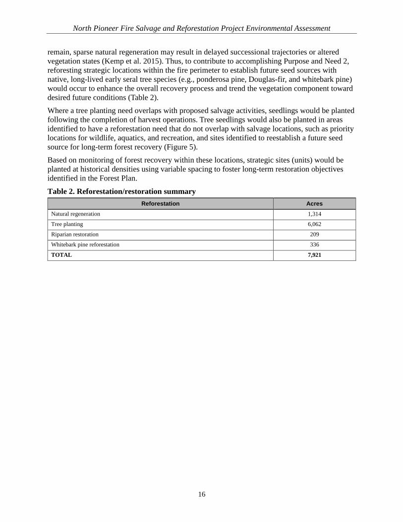
North Pioneer Fire Salvage and Reforestation Project Environmental Assessment
16
remain, sparse natural regeneration may result in delayed successional trajectories or altered vegetation states (Kemp et al. 2015). Thus, to contribute to accomplishing Purpose and Need 2, reforesting strategic locations within the fire perimeter to establish future seed sources with native, long-lived early seral tree species (e.g., ponderosa pine, Douglas-fir, and whitebark pine) would occur to enhance the overall recovery process and trend the vegetation component toward desired future conditions (Table 2). Where a tree planting need overlaps with proposed salvage activities, seedlings would be planted following the completion of harvest operations. Tree seedlings would also be planted in areas identified to have a reforestation need that do not overlap with salvage locations, such as priority locations for wildlife, aquatics, and recreation, and sites identified to reestablish a future seed source for long-term forest recovery (Figure 5). Based on monitoring of forest recovery within these locations, strategic sites (units) would be planted at historical densities using variable spacing to foster long-term restoration objectives identified in the Forest Plan.
Table 2. Reforestation/restoration summary Reforestation Acres
Natural regeneration 1,314
Tree planting 6,062
Riparian restoration 209
Whitebark pine reforestation 336
TOTAL 7,921

North Pioneer Fire Salvage and Reforestation Project Environmental Assessment
17
Figure 5. Proposed reforestation and location of unauthorized routes proposed for decommissioning

This page intentionally left blank

North Pioneer Fire Salvage and Restoration Project Environmental Assessment
19
Project Design Features The North Pioneer Project has been designed to avoid or minimize undesirable impacts to resources, to the maximum extent practicable4, and will comply with all applicable laws, regulations, and direction. The interdisciplinary team (IDT) developed the project design features to minimize or avoid potential adverse effects from the proposed action (refer to Appendix A). The design features are based on Forest Plan direction and policy, best available science, and site-specific effectiveness evaluations and would be applied (except where specifically stated) as an integral part of project implementation. Section 208 of the Clean Water Act authorizes and encourages State and local management of nonpoint pollution sources, which include forest practices. This project incorporates design features that reflect best management practices (BMPs) to help meet the requirements of the Clean Water Act. The National Best Management Practices for Water Quality Management on National Forest System Lands—Volume 1: National Core BMP Technical Guide states the following (USDA Forest Service 2012):
…site-specific BMP prescriptions are developed based on the proposed activity, water quality objectives, soils, topography, geology, vegetation, climate, and other site-specific factors and are designed to avoid, minimize, or mitigate potential adverse impacts to soil, water quality, and riparian resources. State BMPs, regional Forest Service guidance, land management plan standards and guidelines, monitoring results, and professional judgment are all used to develop site-specific BMP prescriptions.
Idaho Forest Practices Act rules includes mandatory BMPs that protect, maintain, and enhance Idaho’s forests and maintain high water quality. Design features included in Appendix A were developed to be consistent with applicable requirements. All applicable design features are reflective of BMPs and would be applied to activities proposed in the North Pioneer Project area. Contract provisions required in timber sales are the mechanism by which BMPs are implemented during activities. Additionally, monitoring of BMPs occurs during and after harvest to ensure correct implementation and effectiveness. Refer to supporting project record documentation concerning BMP/design feature effectiveness.
Monitoring Activities Monitoring is the process of periodically and systematically gathering and analyzing data to understand trends over time. The most common monitoring is related to implementation (did we do what we said we were going to do?) and effectiveness (did we achieve our desired results?). Project Level Monitoring: If the Proposed Action, Alternative 2, is selected for implementation, standard timber sale contract provisions would be used to direct how sale activities are conducted. Other activities performed under contract (such as road work), would be monitored by a contracting officer’s representative to ensure activities are implemented as designed. For example, sale administrators and other contracting representatives would monitor all timber sales to ensure activities are conducted in accordance with contract specifications (e.g., activities occur where and 4 Maximum Extent Practicable—Available and capable of being done after taking into consideration cost, existing technology, and logistics in light of overall project purposes (40 CFR 230.10(a)(2)).
North Pioneer Fire Salvage and Restoration Project Environmental Assessment
20
when they should per the project specific design features in Appendix A, which were developed to protect resources such as soils and wildlife, that yarding is accomplished as planned to protect soils, or that seedlings are planted at the appropriate spacing). In addition, to address visual quality objectives (VQOs) discussed below, viewsheds would be monitored at year 3 and 5 following completion of proposed activities to determine if the objective VQO identified in Forest Plan standard 1076 has been attained. If attainment has not been reached, as part of adaptive management, additional rehabilitation measures consistent with the design features identified in Appendix A would be implemented. See section below concerning variance in a Forest Plan Visual Quality Guideline for more detail. Regeneration monitoring (stocking surveys) would also be completed to assess reforestation needs and whether reforestation objectives were accomplished. Reforestation (plantation) survival surveys would be completed following the first and third growing season to determine mortality causes and to estimate seedling survival. Reforestation survival exams, as required by FSM 2472.4, FSM 2496.14, and FSH 2409.14 (Chapter 61.4 [draft]), would utilize national sampling methods and standards to promote consistency in reporting seedling survival data. Forest Plan Monitoring: The Forest Plan (USDA Forest Service 2010a, Chapter 4) documents a system to monitor and evaluate forest management activities, addressing the most critical components to inform management of the Forest’s resources within the financial and technical capability of the Agency. Monitoring is conducted across the entire national forest on a periodic basis, and the monitoring results are used to guide future projects. Forest Plan monitoring requirements related to the Pioneer Fire area, including the North Pioneer Project, will include remeasuring vegetation inventory plots impacted by the wildfire (e.g., forest inventory plots) and assessing watershed condition, which would be done jointly with the Regional Pacfish and InFish Biological Opinion (PIBO) monitoring group. Annual wildlife and fisheries surveys required in the Forest Plan (USDA Forest Service 2010a, Chapter 4) would continue, including remeasuring inventory locations within the burn perimeter.
Adaptive Management To address hazard trees created by the fire which are affecting human health and safety and to avoid a loss of commodity value sufficient to jeopardize the Agency's ability to accomplish project objectives, the decision for this project would be signed prior to completing all resource and engineering field surveys. Although survey work may not be completed, the effects to resources would be mitigated by implementing the project design features (Appendix A) and by using an adaptive management approach.
The FSH defines adaptive management as a structured, iterative process for decision-making to reduce uncertainty through structured hypothesis testing and monitoring of outcomes. This approach supports decision-making which meets resource management objectives while simultaneously accruing information to improve future management (FSH 1909.12, Chapter 40; refer to Figure 4).
Adaptive management includes the following key features: 1. Characterizing explicit uncertainty and assumptions 2. Testing assumptions and collecting data using appropriate temporal and spatial scales
North Pioneer Fire Salvage and Restoration Project Environmental Assessment
21
3. Analyzing new information obtained through monitoring and project experience 4. Learning from feedback between monitoring and decisions 5. Adapting assumptions and strategies to design better plans and management direction 6. Making iterative and responsive decisions, evaluating results, and adjusting actions on the
basis of what has been learned 7. Creating an open and transparent process that shares learning internally and with the public
If, at any point, monitoring surveys discover a site condition not adequately addressed by project design features and environmental analysis for this project, a changed condition analysis would be completed. The Forest Service Handbook (FSH 1909.15, Chapter 10, Section 18) provides direction on review and documentation of new information received after a decision has been made. Through this process, the responsible official must consider whether the new information or changed circumstances are within the scope and range of effects considered in the original analysis. If the responsible official determines that a correction, supplement, or revision to an environmental document is not necessary, implementation should continue. If the responsible official determines that a correction, supplement, or revision to this environmental assessment is necessary, the IDT would conduct the additional analysis and documentation needed as outlined in FSH 1909.15 (Chapter 10, Section 18.4, “Reconsideration of Decisions Based on Environmental Assessment and Finding of No Significant Impact”). All changed condition analyses, reports, and letters would be made available to the public via the project web site.
Emergency Situation Determination Immediate implementation is essential to successfully accomplish the project purpose and need (i.e., recover economic value from hazard trees that pose risks to public health and safety prior to next recreation season). Therefore, the Forest intends to request an Emergency Situation Determination (ESD) to facilitate immediate implementation of the proposed activities during the 2017 field season. Only the Chief and Associate Chief of the Forest Service may grant an ESD (36 CFR 218.21(a)). An emergency situation is defined at 36 CFR 218.21(b) as follows.
A situation on National Forest System (NFS) lands for which immediate implementation of a decision is necessary to achieve one or more of the following: 1. Relief from hazards threatening human health and safety 2. Mitigation of threats to natural resources on NFS or adjacent lands 3. Avoiding a loss of commodity value sufficient to jeopardize the agency’s ability to
accomplish project objectives directly related to resource protection or restoration. If the Chief decides this project qualifies for an ESD, the project will be exempt from the objection process (36 CFR 218). This exemption would allow us to implement the project as soon as the environmental analysis is completed and the decision is signed. Providing for immediate implementation following completion of the environmental review allows the Forest to remove hazards safely, complete associated resource protection and reforestation activities, and recover economic value from a portion of the dead trees. Fire damaged wood products are rapidly losing value. Timely recovery of economic value through salvage harvesting is critical

North Pioneer Fire Salvage and Restoration Project Environmental Assessment
22
for funding actions required to accomplish projects objectives. Even if an ESD is granted, many opportunities for the public to be involved in the planning for this project have been and will be provided, including attending open houses, working with local collaborative groups, and commenting on the environmental analysis. We recognize that if an ESD is approved, public involvement for this project will change as identified above. In order to receive public input and keep the public informed throughout the process, public involvement was started early this past fall with field trips and meetings, and we plan to continue meeting with interested groups and members of the public throughout the project, pre- and post-NEPA. These efforts include offering a public field trip to look at the project area in summer 2017. Additional field trips and meetings will be held, as needed or requested, to ensure stakeholders continue to be informed of upcoming project activities and the implementation of those activities.
Coordination with Research
Boise State University and the College of Idaho Recent studies have shown the size and severity of wildfires are increasing across the western United States (Westerling 2016), and over half of the acres burned in forests in the western United States are the result of human-induced changes in climate (Abatzaglou and Williams 2016). As these fires have grown, so too have their impacts on landscapes that must now recover. It is estimated that soil erosion resulting from wildfire may double by 2050 (Sankey 2015). Post-fire debris flow models developed by Cannon et al. (2010) offer the opportunity to identify debris flow-prone slopes in post-fire areas using data that are often publicly available. To further the understanding of the effects of the Pioneer Fire on post-fire erosion, Boise State University and the College of Idaho propose measuring and quantifying post-fire erosion in select basins in the Pioneer Fire burn area using remote sensing and geophysical techniques. They propose using geophysical methods to measure post-fire debris flow occurrence, and remote sensing methods to measure post-fire channel change and debris flow volumes of wood and sediment. They propose targeting basins that have already produced debris flows and are predicted to produce debris flows under 15-minute, 12-millimeter storm events. For these basins, they propose noninvasive surveying of basin-contributing areas and depositional areas, as well as surveying known debris flows (e.g., Blackadar, Hole in the Wall, and Monument). Implementing this proposal would include installing temporary geophysical equipment and game cameras to record events.
Pacific Northwest Research Station, Pacific Wildland Fire Science Lab and University of Washington, School of Environmental and Forest Sciences
Proposal 1: Evaluating the Effects of Salvage Logging and Developing Fire Resilient Forests This component of the research proposal would be designed to address questions such as the following: 1. Do treatments affect overall shrub and seedling regeneration?

North Pioneer Fire Salvage and Restoration Project Environmental Assessment
23
2. Do treatments promote invasion by nonnative species? 3. What are the effects of herbicide application on shrub regeneration? 4. How does different spacing of planted tree regeneration affect stand development
(i.e., tree survival and growth) and resilience to future fires? 5. What are the effects of salvage logging on fine and coarse woody fuels and stand
structure? 6. What are the effects of salvage logging on fuel succession and future fire behavior (rate of
spread, reaction intensity)? 7. What are the short- and long-term effects of post-fire salvage logging on soil biochemical
and biotic properties, including microbial biomass and decomposition rates? 8. What are the short- and long-term effects of post-fire salvage logging on RCA function and
processes as described in the Forest Plan (Forest Service 2010a, Appendix B)? 9. Are seedling performance and survivorship effects minimized since time of fire and
by different post-fire salvage logging planting and treatments? 10. Do post-fire salvage logging and planting in large, severe wildfires allow maintaining
productivity and create a forest more resilient to future severe fires and climate change? The proposal would evaluate three levels of salvage in a randomized complete block design: (1) unsalvaged (control); (2) intermediate salvage (e.g., approx. 1/3 of basal area removed); and (3) full salvage (e.g., retention of maximum snag numbers per Forest Plan guidance). Four to six replicate blocks, each containing three 5.4-acre salvage units, would be selected from among the areas set aside for salvage.
Proposal 2: Historic Wildfire Effects on Forest Structure and Wildfire Behavior on the 2016 Pioneer Fire In this study, researchers would use empirical data to quantify effects of the 2016 Pioneer Fire on burn severity within historic wildfire areas versus those where historic wildfires have not burned. Researchers would measure fire severity in the form of bole char and crown scorch near and within different fuel treatment units. They would fit nonlinear models to the two metrics as functions of distance to treatment edge. These nonlinear models provide statistical estimates of the distance into the treated area at which fire severity is reduced. Researchers would install linear transects extending across the treated and adjacent untreated areas burned on the Pioneer Fire. Linear transects would be oriented in the direction of fire spread and installed to avoid major roads, riparian buffers, reserve areas, and other wildlife habitat areas. Transect lengths and total number of plots would vary with the size of the treatment units.
What is the Key Forest Plan Management Direction Used to Inform Development of the Proposed Action for this Area? As defined within the 2010 Forest Plan, the project area falls entirely within Management Area (MA) 10, Upper South Fork Payette River, and Management Prescription Category (MPC) 5.1, Restoration and Maintenance Emphasis within Forested Landscapes (Forest Service 2010a).

North Pioneer Fire Salvage and Restoration Project Environmental Assessment
24
Consistent with this MPC, activities proposed as part of this project emphasize the restoration or maintenance of vegetation to provide a diversity of habitats over time, reduce risk of future disturbance events, and provide sustainable resources supporting human uses in the area (Forest Service 2010a). In addition, the Forest Plan emphasizes the need to integrate related multiple use objectives (e.g., aquatic resource restoration and recreation opportunity enhancement) with vegetative restoration projects where practicable and efficient to do so. Application of, and consistency with, Forest Plan standards and guidelines are addressed in resource technical reports and a Forest Plan consistency summary document provided in the project record.
What Decisions are to be Made? The Responsible Official for this project is Cecilia R. Seesholtz, Boise National Forest Supervisor. The Responsible Official will consider public comments, an internal analysis of this project, and the consequences of similar projects. The Responsible Official will assess the direct, indirect, and cumulative environmental effects, along with current policy, law, and regulation, and will determine the appropriate level of environmental analysis and documentation needed for this project. After such consideration and determination that an EA is the appropriate level of environmental analysis for this project, the Responsible Official may choose to:
• Select the proposed action and adopt the project as written;
• Modify the proposed action and/or adopt a modified version of the proposed action;
• Select the no action alternative.
In making this decision, the Forest Supervisor will consider such questions as:
• How well does the alternative meet the purpose and need described in this EA?
• How well does the alternative address the concerns generated from comments received from interested parties?
• Does the alternative mitigate potential adverse effects identified in the analysis as needed to support a finding of non-significant impacts (FONSI)?