norway-uk interconnector uk marine environmental...
TRANSCRIPT
National Grid NSN Link Limited Norway-UK InterconnectorUK Marine Environmental StatementAppendix Volume 1 - FiguresMarch 2014
Created ByReviewed By
Paula Daglish
Monday, November 11, 2013 10:41:16WGS_1984_UTM_Zone_31N
D_WGS_1984UKDEAL, UKHO, GEBCOJ:\P1 568\Mxd\Environment\Enviro nmental Report\No v_13\Fig01_1_Overview.mxd
WGS_1984
© Met oc Ltd, 2013.
DateProjection
DatumData Source
File Reference
Spheroid
All r ight s reserved .
NOT E: Not to be used for Navigation
© Crown Copy right and/or database r ights . Reproduced by permiss ion of the Contro ller o f Her M ajesty’s Stationery Office and the UK Hydrographic Offic e (www.ukho.gov.uk ). Licenc e No. 16893. NO T TO B E USE D FO R NAVIGATION.
Approved By
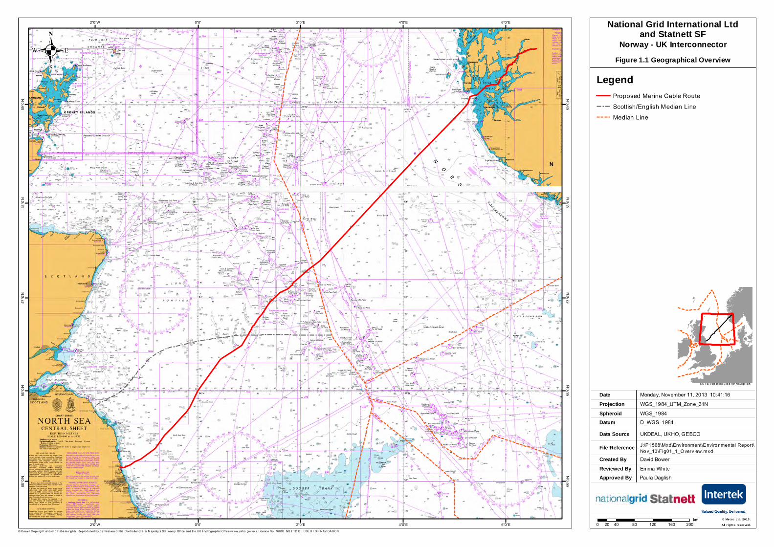
LegendProposed Marine Cable Route Scottish/English Median LineMedian Line
0 40 80 120 160 20020km
6°0'E
6°0'E
4°0'E
4°0'E
2°0'E
2°0'E
0°0'
0°0'
2°0'W
2°0'W59
°0'N
59°0
'N
58°0
'N
58°0
'N
57°0
'N
57°0
'N
56°0
'N
56°0
'N
55°0
'N
55°0
'N
.National Grid International Ltd
and Statnett SFNorway - UK Interconnector
Figure 1.1 Geographical Overview
David BowerEmma White
Created ByReviewed By
David Bower
Wednesday, November 13, 2013 09:06:03WGS_1984_UTM_Zone_31N
D_WGS_1984DECC, GEBCO, MMO, UKDEALJ:\P1568\Mxd\Environment\Environmental Report\Nov_13\Fig02_1_Study_Areas.mxd
WGS_1984
DateProjection
DatumData Source
File Reference
Spheroid
NOTE: Not to be used for Navigation
Contains Ordnance Survey data © Crown copyright and database right 2013
Approved By
Lochs Duich, Long and Alsh Reefs
4°0'E
4°0'E
2°0'E
2°0'E
0°0'
0°0'
2°0'W
2°0'W4°0'W57
°0'N
57°0'
N
56°0'
N
56°0'
N
55°0'
N
55°0'
N
54°0'
N
54°0'
N
53°0'
N
53°0'
N
© Metoc Ltd, 2013.All rights reserved.0 25 50 75 10012.5
km
.National Grid International Ltd
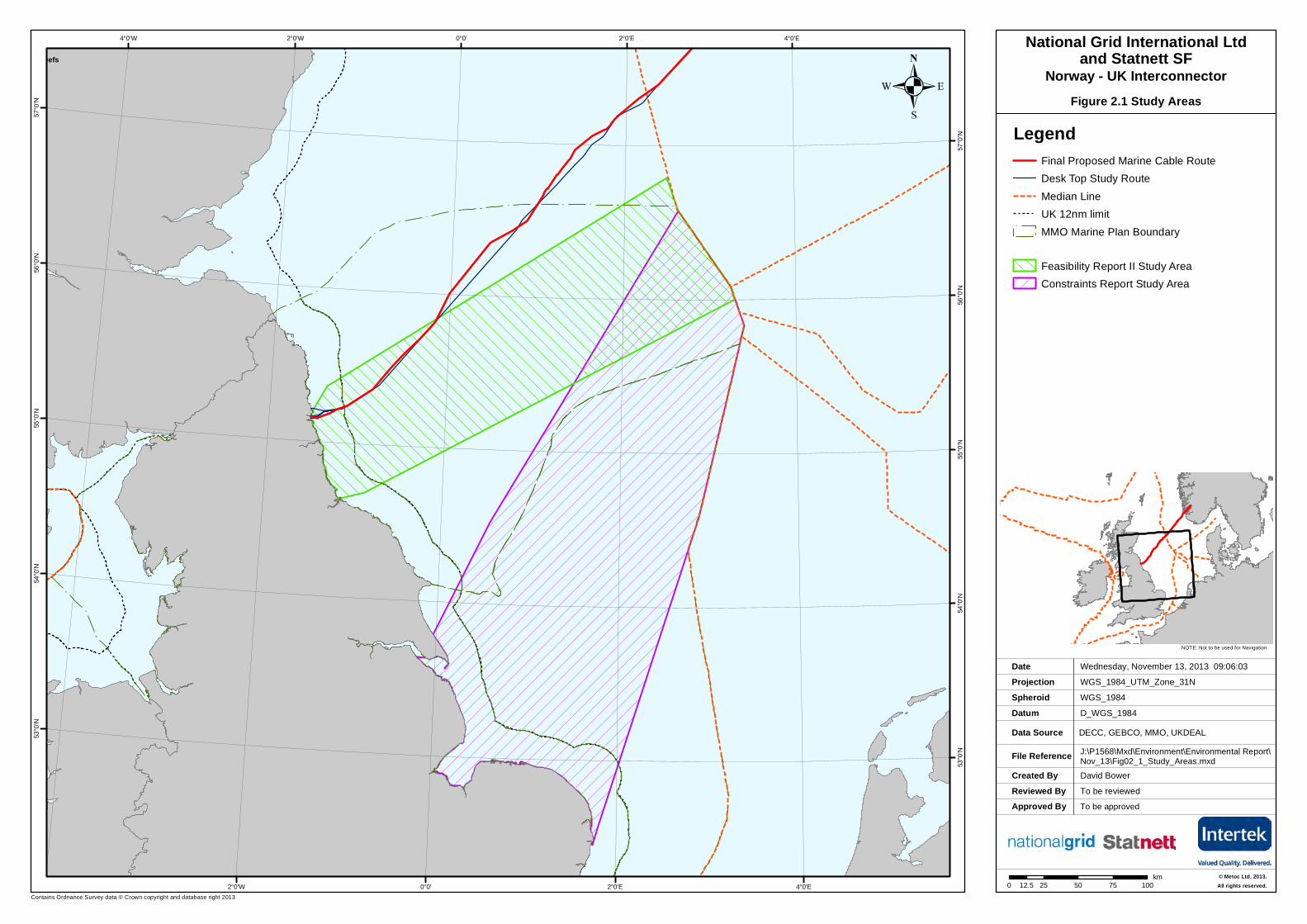
and Statnett SFNorway - UK Interconnector
Figure 2.1 Study Areas
LegendFinal Proposed Marine Cable Route Desk Top Study RouteMedian LineUK 12nm limitMMO Marine Plan Boundary
Feasibility Report II Study AreaConstraints Report Study Area
To be approvedTo be reviewed
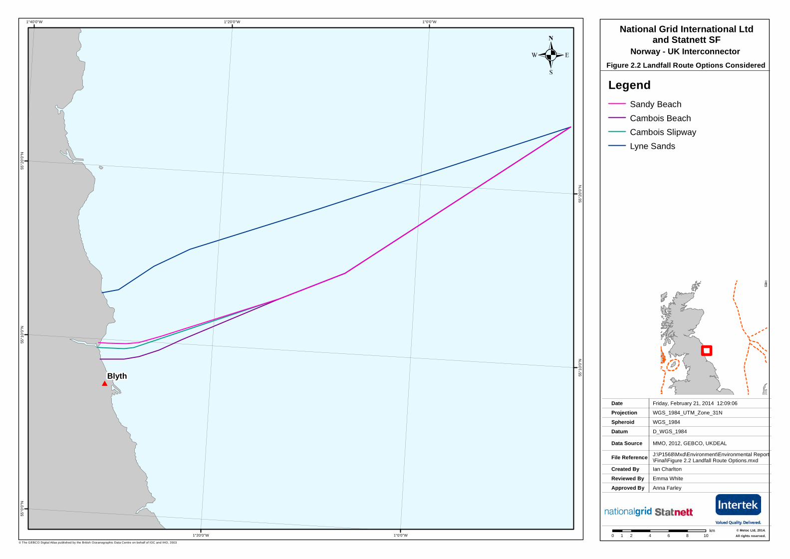
#Blyth
1°0'0"W
1°0'0"W
1°20'0"W
1°20'0"W1°40'0"W55
°20'0
"N
55°2
0'0"N
55°1
0'0"N
55°1
0'0"N
55°0
'0"N
.National Grid International Ltd
and Statnett SF
Figure 2.2 Landfall Route Options Considered
Created ByReviewed By
Ian CharltonEmma White
Friday, February 21, 2014 12:09:06WGS_1984_UTM_Zone_31N
D_WGS_1984MMO, 2012, GEBCO, UKDEALJ:\P1568\Mxd\Environment\Environmental Report\Final\Figure 2.2 Landfall Route Options.mxd
WGS_1984
© Metoc Ltd, 2014.
DateProjection
DatumData Source
File Reference
Spheroid
All rights reserved.0 2 4 6 8 101km
© The GEBCO Digital Atlas published by the British Oceanographic Data Centre on behalf of IOC and IHO, 2003
Approved By Anna Farley
LegendSandy BeachCambois BeachCambois SlipwayLyne Sands
Norway - UK Interconnector
Created ByReviewed By
Jill Hobbs
Thursday, August 8, 2013 09:13:20WGS_1984_UTM_Zone_31N
D_WGS_1984DECC, GEBCO, UKDEALJ:\P1568\Mxd\Environment\Environmental Report\Final\Figure_7_1_Bathymetry.mxd
WGS_1984
© Metoc Ltd, 2014.
DateProjection
DatumData Source
File Reference
Spheroid
All rights reserved.
NOTE: Not to be used for Navigation
Contains Ordnance Survey data © Crown copyright and database right 2013, © The GEBCO Digital Atlas published by the British Oceanographic Data Centre on behalf of IOC and IHO, 2003
Approved By
0 20 40 60 80 10010km
!
!
!
!
!
!
!
!
!
!
!
!
!!
!!
!!
!!
!! ! ! ! ! ! ! ! ! ! ! ! !
4°0'E
4°0'E
2°0'E
2°0'E
0°0'
0°0'
2°0'W
2°0'W4°0'W58
°0'N
58°0
'N
57°0
'N
57°0
'N
56°0
'N
56°0
'N
55°0
'N
55°0
'N
54°0
'N
.National Grid International Ltd
and Statnett SFNorway - UK Interconnector
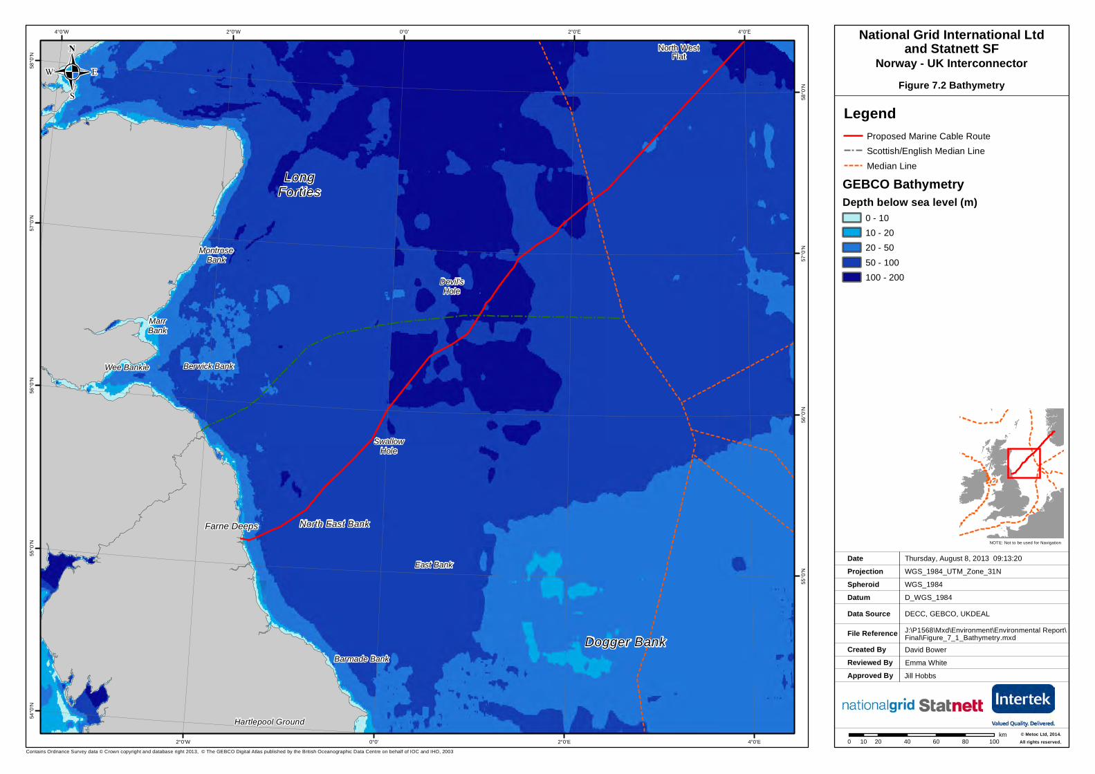
Figure 7.2 Bathymetry
David BowerEmma White
LegendProposed Marine Cable Route Scottish/English Median LineMedian Line
GEBCO BathymetryDepth below sea level (m)
0 - 1010 - 2020 - 5050 - 100100 - 200
Farne Deeps
SwallowHole
Dogger Bank
North East Bank
Devil'sHole
Berwick Bank
North WestFlat
Wee Bankie
Hartlepool Ground
MarrBank
MontroseBank
LongForties
Barmade Bank
East Bank
Created ByReviewed By
Ian CharltonEmma White
Monday, November 11, 2013 10:11:43WGS_1984_UTM_Zone_31N
D_WGS_1984GEBCO, JNCC, MS, NE, OSOD, SNH, UKDEALJ:\P1568\Mxd\Environment\Environmental Report\Final\Figure_9_1_Protected_Areas_v2.mxd
WGS_1984
DateProjection
DatumData Source
File Reference
Spheroid
NOTE: Not to be used for Navigation
Collated and published by JNCC © Contains public sector information licensed under the Open Government Licence v2.0. Contains derived data from BGS © NERC. Contains derived data from Ordnance Survey © Crown copyright. 100019741 (2013).. NOT TO BE USED FOR NAVIAGTIONContains Ordnance Survey and UK Hydrographic Office data © Crown copyright and database right 2012. Marine Management Organisation.
Approved By Paula Dalglish Northumbria Coast SPA
Northumbria CoastSPA & RAMSAR
Flamborough Head& Bempton Cliffs
SPA
Berwickshire & North Northumberland Coast
SAC
Tweed Estuary SAC
Isle of May SAC
Swallow Sand MCZ
Fulmar rMCZ
Farnes EastrMCZ
North EastOf
Farnes DeepMCZ
Coquet to St Mary's rMCZ
Compass RoserMCZ
Runswick BayrMCZ
Aln Estuary SPA & MCZ
Firth of ForthBanks ComplexMPA proposal
East of Gannet& Montrose Fields
MPA proposal
Turbot Bank MPA proposal
Southern TrenchMPA proposal
Lindisfarne SPA
Forth Islands SPA
St Abb's Headto Fast Castle
SPA
Firth of Forth SPA
Teesmouth and Cleveland Coast SPA
Farne Islands SPA
Coquet Island SPA
3°0'E
3°0'E
2°0'E
2°0'E
1°0'E
1°0'E
0°0'
0°0'
1°0'W
1°0'W
2°0'W
2°0'W57
°0'N
57°0
'N
56°0
'N
56°0
'N
55°0
'N
55°0
'N
LegendGrey Seal Haul Out Proposed Marine Cable Route
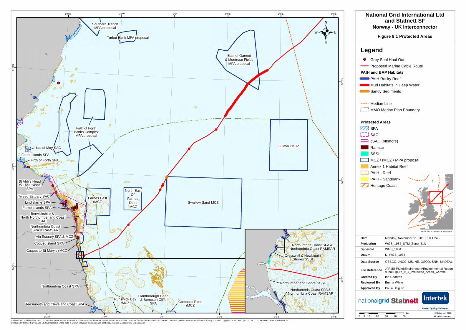
PAIH and BAP HabitatsPAIH Rocky ReefMud Habitats in Deep WaterSandy Sediments
Median LineMMO Marine Plan Boundary
Protected AreasSPASACcSAC (offshore)RamsarSSSIMCZ / rMCZ / MPA proposalAnnex 1 Habitat ReefPAIH - ReefPAIH - SandbankHeritage Coast
0 10 20 30 40 505km
.
Northumbria Coast SPA &Northumbria Coast RAMSAR
Northumberland Shore SSSINorthumbria Coast SPA &
Northumbria Coast RAMSAR
Cresswell & NewbigginShores SSSI
National Grid International Ltdand Statnett SF
Figure 9.1 Protected AreasNorway - UK Interconnector
© Metoc Ltd, 2014.All rights reserved.

.
Created ByReviewed By
Ian CharltonEmma White
Friday, February 21, 2014 16:23:17GCS_WGS_1984
D_WGS_1984OSOD, DECC, MMTJ:\P1568\Mxd\Environment\Environmental Report\Final\Figure_9_2_Detailed_BAP_Habitat.mxd
WGS_1984
DateProjection
DatumData Source
File Reference
Spheroid
NOTE: Not to be used for Navigation
Contains Ordnance Survey data © Crown copyright and database right 2013
Approved By Anna Farley
!
!
East of Gannet and Montrose Fields pMPA
KP 430
KP 420
1°40'E
1°40'E
1°30'E
1°30'E
1°20'E
1°20'E57
°2'30
"N
57°2
'30"N
57°0
'N
57°0
'N
56°5
7'30"N
56°5
7'30"N
0 2 4 6 81km
.
!
!
!
!
!
!
Swallow Sand MCZ
KP 578
KP 577
KP 576
KP 575
KP 574
0°2'E
0°2'E
0°0'
0°0'
0°2'W
0°2'W
0°4'W
0°4'W
56°0
'N
56°0
'N
55°5
9'N
55°5
9'N
!!
!
!
!!
Coquet to St Mary's rMCZ
KP 714 KP 713KP 712
KP 711KP 710 KP 709
1°28'W
1°28'W
1°30'W
1°30'W
1°32'W
1°32'W
55°1
0'N
55°1
0'N
55°9
'N
55°9
'N
.
.
0 0.5 1 1.5 20.25km
0 0.5 1 1.5 20.25km
National Grid International Ltdand Statnett SF
Figure 9.2 BAP HabitatsNorway - UK Interconnector
Legend! 10km KP
Proposed Marine Cable Route
Habitat Type
H-6-A5.45 Deep circalittoral mixed sediments
H-2-A5.15 Deep circalittoral coarse sediment
H-3-A5.27 Deep circalittoral sand
H-5-A5.361 Seapens and burrowing megafauna incircalittoral fine mud
H-1-A3.2 Atlantic and Mediterranean moderate energyinfralittoral rockH-1-A4.2 Atlantic and Mediterranean moderate energycircalittoral rockH-11-A4.2144 Brittlestars on faunal and algal encrustedH-2-A5.14 Circalittoral coarse sediment
H-3-A5.23 Infralittoral fine sandH-3-A5.24 Infralittoral muddy sand
H-4-A5.242 Fabulina fabula and Magelona mirabilis withvenerid bivalves and amphipods in infralittoralcompacted fine muddy sandH-4-A5.245 Turritella in muddy sandsH-4-A5.26 Circalittoral muddy sandH-5-A5.35 Circalittoral sandy mud
H-6-A5.44 Circalittoral mixed sediments
H-7-Annex I Stony reef - LowH-7-Annex I Stony reef - Medium
EE E
MCZ / rMCZ / MPA proposal
© Metoc Ltd, 2014.All rights reserved.
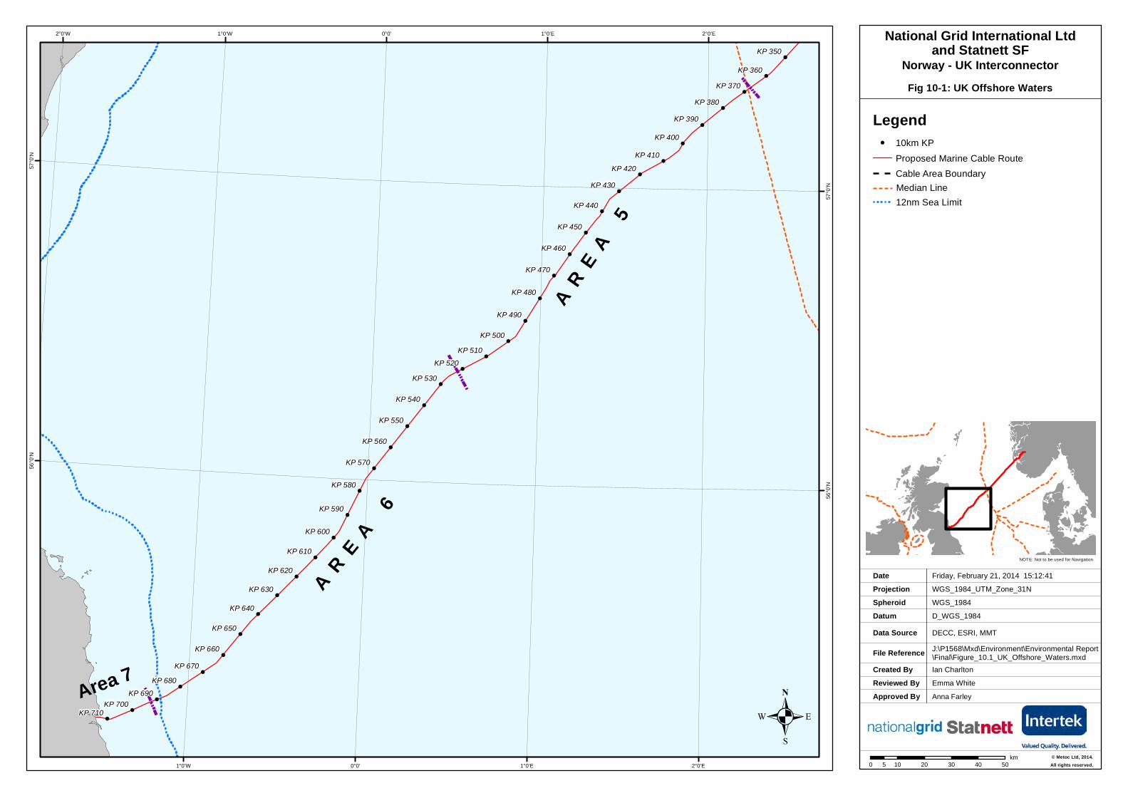
. Fig 10-1: UK Offshore Waters
Created ByReviewed By
Ian CharltonEmma White
Friday, February 21, 2014 15:12:41WGS_1984_UTM_Zone_31N
D_WGS_1984DECC, ESRI, MMTJ:\P1568\Mxd\Environment\Environmental Report\Final\Figure_10.1_UK_Offshore_Waters.mxd
WGS_1984
DateProjection
DatumData Source
File Reference
Spheroid
NOTE: Not to be used for Navigation
Approved By Anna Farley
!!
!
!
!
!
!
!!
!
!
!
!
!
!
!
!
!
!
!
!
!
!
!
!
!
!
!
!
!
!
!
!
!
!
!
!
!
!
!
!
!
!
!
!
!
!
!
!
!
!
!
!
!
!
!
!
!
!
!
!
!
!
!
!
!
!
!
!
!
!
!
A R E A 6
AR
E A 5
Area 7KP 710
KP 680KP 670
KP 660
KP 650
KP 640
KP 630
KP 620
KP 610
KP 600
KP 590
KP 580
KP 570
KP 560
KP 550
KP 540
KP 530KP 520
KP 510KP 500
KP 490
KP 480
KP 470
KP 460
KP 450
KP 440
KP 430KP 420
KP 410KP 400
KP 390KP 380
KP 370KP 360
KP 350
KP 700KP 690
2°0'E
2°0'E
1°0'E
1°0'E
0°0'
0°0'
1°0'W
1°0'W2°0'W57
°0'N
57°0
'N
56°0
'N
56°0
'N
0 10 20 30 40 505km
.
National Grid International Ltdand Statnett SF
Norway - UK Interconnector
Legend! 10km KP
Proposed Marine Cable RouteCable Area BoundaryMedian Line12nm Sea Limit
© Metoc Ltd, 2014.All rights reserved.
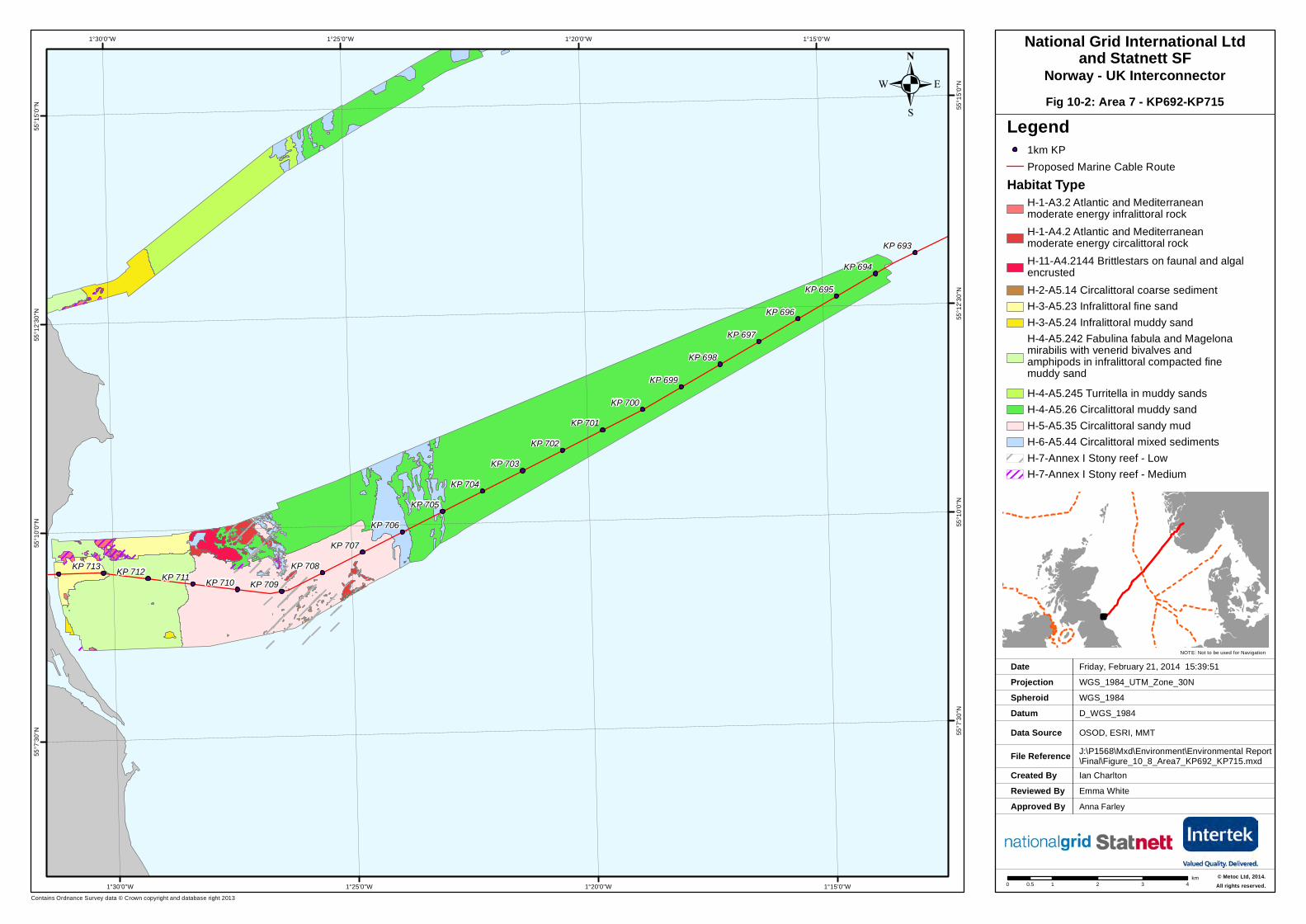
. Fig 10-2: Area 7 - KP692-KP715
Created ByReviewed By
Ian CharltonEmma White
Friday, February 21, 2014 15:39:51WGS_1984_UTM_Zone_30N
D_WGS_1984OSOD, ESRI, MMTJ:\P1568\Mxd\Environment\Environmental Report\Final\Figure_10_8_Area7_KP692_KP715.mxd
WGS_1984
DateProjection
DatumData Source
File Reference
Spheroid
NOTE: Not to be used for Navigation
Contains Ordnance Survey data © Crown copyright and database right 2013
Approved By Anna Farley
KP 713 KP 712 KP 711 KP 710 KP 709KP 708
KP 707KP 706
KP 705KP 704
KP 703KP 702
KP 701KP 700
KP 699
KP 698
KP 697
KP 696
KP 695
KP 694
KP 693
1°15'0"W
1°15'0"W
1°20'0"W
1°20'0"W
1°25'0"W
1°25'0"W
1°30'0"W
1°30'0"W55
°15'0
"N 55°1
5'0"N
55°1
2'30"N 55
°12'3
0"N
55°1
0'0"N 55
°10'0
"N
55°7
'30"N 55
°7'30
"N
.National Grid International Ltd
and Statnett SFNorway - UK Interconnector
Legend1km KPProposed Marine Cable Route
Habitat TypeH-1-A3.2 Atlantic and Mediterraneanmoderate energy infralittoral rockH-1-A4.2 Atlantic and Mediterraneanmoderate energy circalittoral rockH-11-A4.2144 Brittlestars on faunal and algalencrustedH-2-A5.14 Circalittoral coarse sedimentH-3-A5.23 Infralittoral fine sandH-3-A5.24 Infralittoral muddy sandH-4-A5.242 Fabulina fabula and Magelonamirabilis with venerid bivalves andamphipods in infralittoral compacted finemuddy sandH-4-A5.245 Turritella in muddy sandsH-4-A5.26 Circalittoral muddy sandH-5-A5.35 Circalittoral sandy mudH-6-A5.44 Circalittoral mixed sedimentsH-7-Annex I Stony reef - LowH-7-Annex I Stony reef - Medium
© Metoc Ltd, 2014.All rights reserved.0 1 2 3 40.5
km

Figure 10-6: Side Scan Sonar Imagery
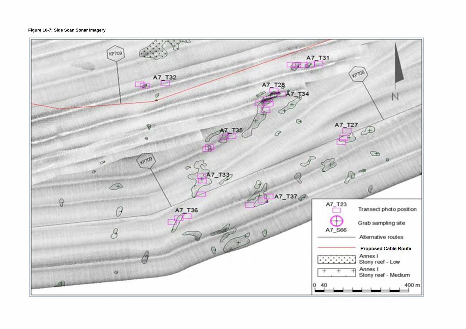
Figure 10-7: Side Scan Sonar Imagery

Figure 10-8: Side Scan Sonar Imagery
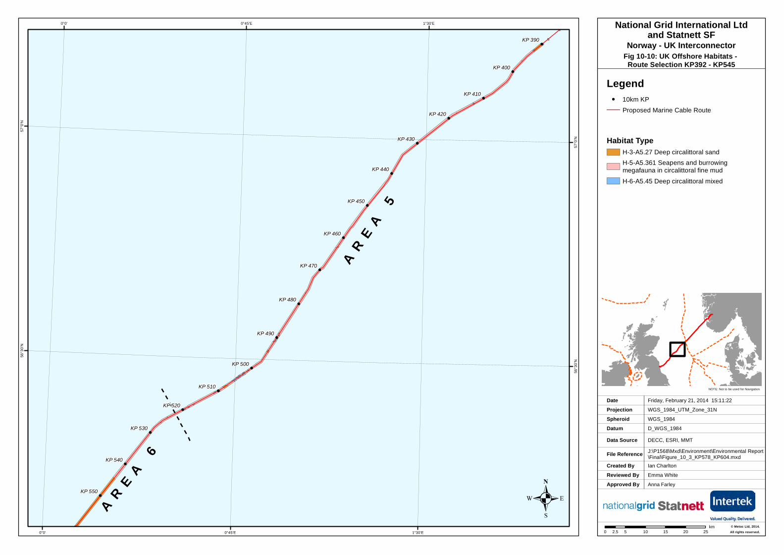
. Fig 10-10: UK Offshore Habitats - Route Selection KP392 - KP545
Created ByReviewed By
Ian CharltonEmma White
Friday, February 21, 2014 15:11:22WGS_1984_UTM_Zone_31N
D_WGS_1984DECC, ESRI, MMTJ:\P1568\Mxd\Environment\Environmental Report\Final\Figure_10_3_KP578_KP604.mxd
WGS_1984
DateProjection
DatumData Source
File Reference
Spheroid
NOTE: Not to be used for Navigation
Approved By Anna Farley
!
!
!
!
!
!
!
!
!
!
!
!
!
!
!
!
!
!
!
!
!
!
!
!
!
!
!
!
!
!
!
!
!
!
!
!
!
!
!
!
!
!
!
!
!
!
!
!
!
!
!
!
!
!
!
!
!
!
!
!
!
!
!
!
!
!
!
!
!
!
!
!
A R E A 6
AR
E A 5
KP 550
KP 540
KP 530
KP 520
KP 510
KP 500
KP 490
KP 480
KP 470
KP 460
KP 450
KP 440
KP 430
KP 420
KP 410
KP 400
KP 390
1°30'E
1°30'E
0°45'E
0°45'E
0°0'
0°0'57
°0'N
57°0
'N
56°3
0'N
56°3
0'N
0 5 10 15 20 252.5km
.
National Grid International Ltdand Statnett SF
Norway - UK Interconnector
Legend! 10km KP
Proposed Marine Cable Route
Habitat TypeH-3-A5.27 Deep circalittoral sandH-5-A5.361 Seapens and burrowingmegafauna in circalittoral fine mudH-6-A5.45 Deep circalittoral mixed
© Metoc Ltd, 2014.All rights reserved.

. Fig 10-11: UK Offshore Habitats - Route Selection KP578- KP604
Created ByReviewed By
Ian CharltonEmma White
Friday, February 21, 2014 15:11:22WGS_1984_UTM_Zone_31N
D_WGS_1984DECC, ESRI, MMTJ:\P1568\Mxd\Environment\Environmental Report\Final\Figure_10_3_KP578_KP604.mxd
WGS_1984
DateProjection
DatumData Source
File Reference
Spheroid
NOTE: Not to be used for Navigation
Approved By Anna Farley
!
!
!
!
!
!
!
!
!
!
!
!
!
!
!
!
!
!
!
!
!
!
!
!
!
!
!
!
!
!
!
!
!
!
!
!
!
!
!
!
!
!
!
!
!
!
!
!
!
!
!
!
!
!
!
!
!
!
!
!
!
!
!
!
!
!
!
!
!
!
!
!
KP 610
KP 600
KP 590
KP 580
KP 570
0°0'
0°0'
0°10'W
0°10'W
0°20'W
0°20'W
0°30'W
0°30'W56
°0'N
56°0
'N
55°5
5'N
55°5
5'N
55°5
0'N
55°5
0'N
55°4
5'N
55°4
5'N
0 1.5 3 4.5 6 7.50.75km
.
National Grid International Ltdand Statnett SF
Norway - UK Interconnector
Legend! 10km KP
Proposed Marine Cable Route
Habitat TypeH-3-A5.27 Deep circalittoral sandH-5-A5.361 Seapens and burrowingmegafauna in circalittoral fine mudH-6-A5.45 Deep circalittoral mixed
© Metoc Ltd, 2014.All rights reserved.
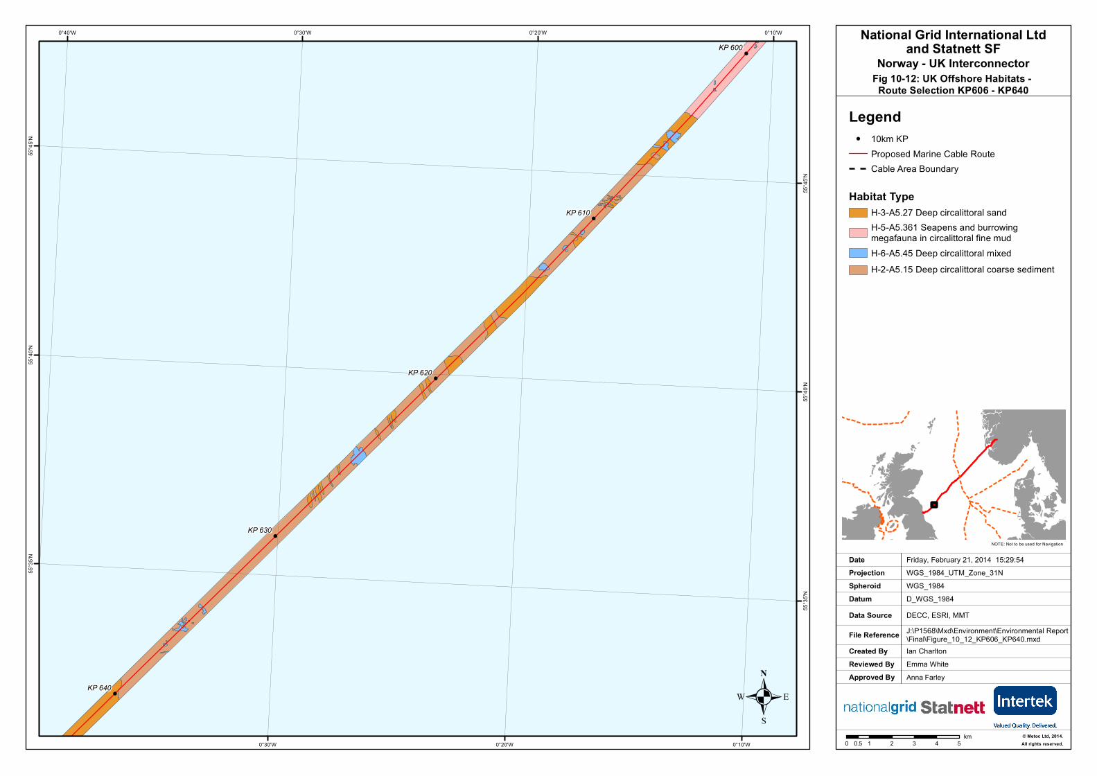
. Fig 10-12: UK Offshore Habitats - Route Selection KP606 - KP640
Created ByReviewed By
Ian CharltonEmma White
Friday, February 21, 2014 15:29:54WGS_1984_UTM_Zone_31N
D_WGS_1984DECC, ESRI, MMTJ:\P1568\Mxd\Environment\Environmental Report\Final\Figure_10_12_KP606_KP640.mxd
WGS_1984
DateProjection
DatumData Source
File Reference
Spheroid
NOTE: Not to be used for Navigation
Approved By Anna Farley
!
!
!
!
!
!
!
!
!
!
!
!
!
!
!
!
!
!
!
!
!
!
!
!
!
!
!
!
!
!
!
!
!
!
!
!
!
!
!
!
!
!
!
!
!
!
!
!
!
!
!
!
!
!
!
!
!
!
!
!
!
!
!
!
!
!
!
!
!
!
!
!
KP 640
KP 630
KP 620
KP 610
KP 600
0°10'W
0°10'W
0°20'W
0°20'W
0°30'W
0°30'W0°40'W55
°45'N
55°4
5'N
55°4
0'N
55°4
0'N
55°3
5'N
55°3
5'N
0 1 2 3 4 50.5km
.
National Grid International Ltdand Statnett SF
Norway - UK Interconnector
Legend! 10km KP
Proposed Marine Cable RouteCable Area Boundary
Habitat TypeH-3-A5.27 Deep circalittoral sandH-5-A5.361 Seapens and burrowingmegafauna in circalittoral fine mudH-6-A5.45 Deep circalittoral mixed
UKHO_P00000000_UK_12nm_Territorial_...
H-2-A5.15 Deep circalittoral coarse sediment
H-5-A5.361 Seapens and burrowingmegafauna in circalittoral fine mudH-6-A5.45 Deep circalittoral mixedsediments
© Metoc Ltd, 2014.All rights reserved.

. Fig 10-13: UK Offshore Habitats - Route Selection KP545 - KP578
Created ByReviewed By
Ian CharltonEmma White
Wednesday, March 19, 2014 13:21:23WGS_1984_UTM_Zone_31N
D_WGS_1984DECC, ESRI, MMTJ:\P1568\Mxd\Environment\Environmental Report\Final\Figure_10_13_KP545_KP578.mxd
WGS_1984
DateProjection
DatumData Source
File Reference
Spheroid
NOTE: Not to be used for Navigation
Approved By Anna Farley
!
!
!
!
!
!
!
!
!
!
!
!
!
!
!
!
!
!
!
!
!
!
!
!
!
!
!
!
!
!
!
!
!
!
!
!
!
!
!
!
!
!
!
!
!
!
!
!
!
!
!
!
!
!
!
!
!
!
!
!
!
!
!
!
!
!
!
!
!
!
!
!
A R E A 6
KP 580
KP 570
KP 560
KP 550
0°10'E
0°10'E
0°0'
0°0'0°10'W
0°20'E
56°1
0'N
56°1
0'N
56°5
'N
56°5
'N
56°0
'N
56°0
'N
0 1 2 3 4 50.5km
.
National Grid International Ltdand Statnett SF
Norway - UK Interconnector
Legend! 10km KP
Proposed Marine Cable Route
Habitat TypeH-3-A5.27 Deep circalittoral sandH-5-A5.361 Seapens and burrowingmegafauna in circalittoral fine mudH-6-A5.45 Deep circalittoral mixed
© Metoc Ltd, 2014.All rights reserved.
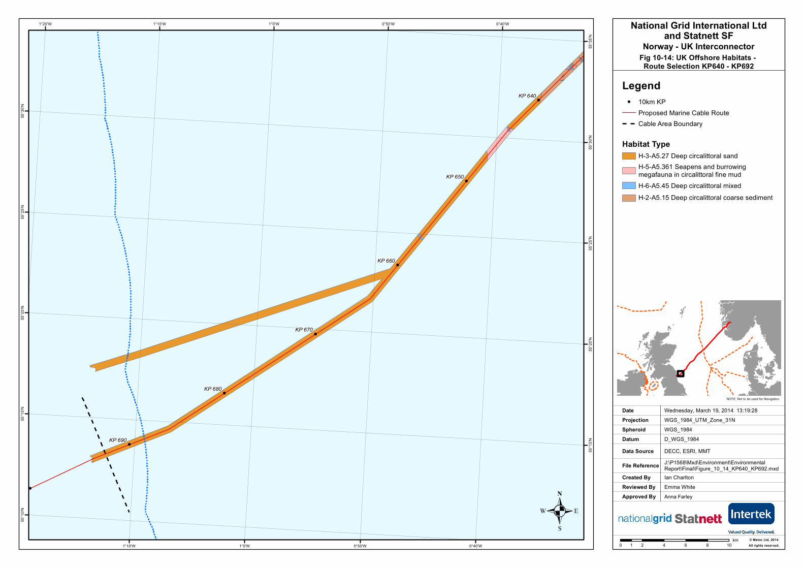
. Fig 10-14: UK Offshore Habitats - Route Selection KP640 - KP692
Created ByReviewed By
Ian CharltonEmma White
Wednesday, March 19, 2014 13:19:28WGS_1984_UTM_Zone_31N
D_WGS_1984DECC, ESRI, MMTJ:\P1568\Mxd\Environment\Environmental Report\Final\Figure_10_14_KP640_KP692.mxd
WGS_1984
DateProjection
DatumData Source
File Reference
Spheroid
NOTE: Not to be used for Navigation
Approved By Anna Farley
!
!
!
!
!
!
!
!
!
!
!
!
!
!
!
!
!
!
!
!
!
!
!
!
!
!
!
!
!
!
!
!
!
!
!
!
!
!
!
!
!
!
!
!
!
!
!
!
!
!
!
!
!
!
!
!
!
!
!
!
!
!
!
!
!
!
!
!
!
!
!
!
KP 690
KP 680
KP 670
KP 660
KP 650
KP 640
KP 700
0°40'W
0°40'W
0°50'W
0°50'W
1°0'W
1°0'W
1°10'W
1°10'W1°20'W
55°3
5'N
55°3
0'N
55°3
0'N
55°2
5'N
55°2
5'N
55°2
0'N
55°2
0'N
55°1
5'N
55°1
5'N
55°1
0'N
0 2 4 6 8 101km
.
National Grid International Ltdand Statnett SF
Norway - UK Interconnector
Legend! 10km KP
Proposed Marine Cable RouteCable Area Boundary
Habitat TypeH-3-A5.27 Deep circalittoral sandH-5-A5.361 Seapens and burrowingmegafauna in circalittoral fine mudH-6-A5.45 Deep circalittoral mixed
UKHO_P00000000_UK_12nm_Territorial_...
H-2-A5.15 Deep circalittoral coarse sediment
H-5-A5.361 Seapens and burrowingmegafauna in circalittoral fine mudH-6-A5.45 Deep circalittoral mixedsediments
© Metoc Ltd, 2014.All rights reserved.
LegendProposed Marine Cable Route Anglo-Scottish Median LineMedian Line
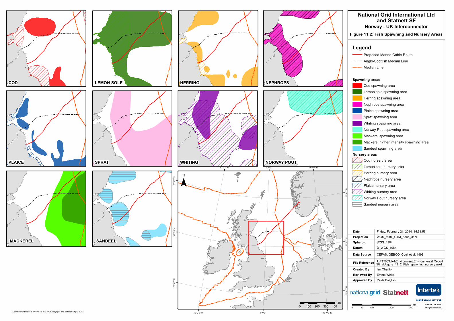
Spawning areasCod spawning areaLemon sole spawning areaHerring spawning areaNephrops spawning areaPlaice spawning areaSprat spawning areaWhiting spawning areaNorway Pout spawning areaMackerel spawning areaMackerel higher intensity spawning areaSandeel spawning area
Nursery areasCod nursery areaLemon sole nursery areaHerring nursery areaNephrops nursery areaPlaice nursery areaWhiting nursery areaNorway Pout nursery areaSandeel nursery area
10°0'0"E
10°0'0"E
0°0'0"
0°0'0"
10°0'0"W
10°0'0"W
60°0
'0"N
60°0
'0"N
55°0
'0"N
55°0
'0"N
50°0
'0"N
50°0
'0"N
¯
Created ByReviewed By
Ian CharltonEmma White
Friday, February 21, 2014 16:31:56WGS_1984_UTM_Zone_31N
D_WGS_1984CEFAS, GEBCO, Coull et al, 1998J:\P1568\Mxd\Environment\Environmental Report\Final\Figure_11_2_Fish_spawning_nursery.mxd
WGS_1984
DateProjection
DatumData Source
File Reference
Spheroid
Approved By Paula Dalglish
0 100 200 30050km
Figure 11.2: Fish Spawning and Nursery Areas
National Grid International Ltdand Statnett SF
Norway - UK Interconnector
Contains Ordnance Survey data © Crown copyright and database right 2013
COD LEMON SOLE
WHITINGSPRATPLAICE
HERRING NEPHROPS
SANDEELMACKEREL
NORWAY POUT
0 100 200 300 400km © Metoc Ltd, 2014.
All rights reserved.
Dogger Bank
Farne Deeps
North East Bank
Berwick Bank
2°0'E
2°0'E
0°0'
0°0'
2°0'W
2°0'W
56°3
0'N
56°3
0'N
56°0
'N
56°0
'N
55°3
0'N
55°3
0'N
55°0
'N
Dogger Bank
Berwick Bank
North East Bank
Farne Deeps
2°0'E
2°0'E
0°0'
0°0'
2°0'W
2°0'W
56°3
0'N
56°3
0'N
56°0
'N
56°0
'N
55°3
0'N
55°3
0'N
55°0
'N
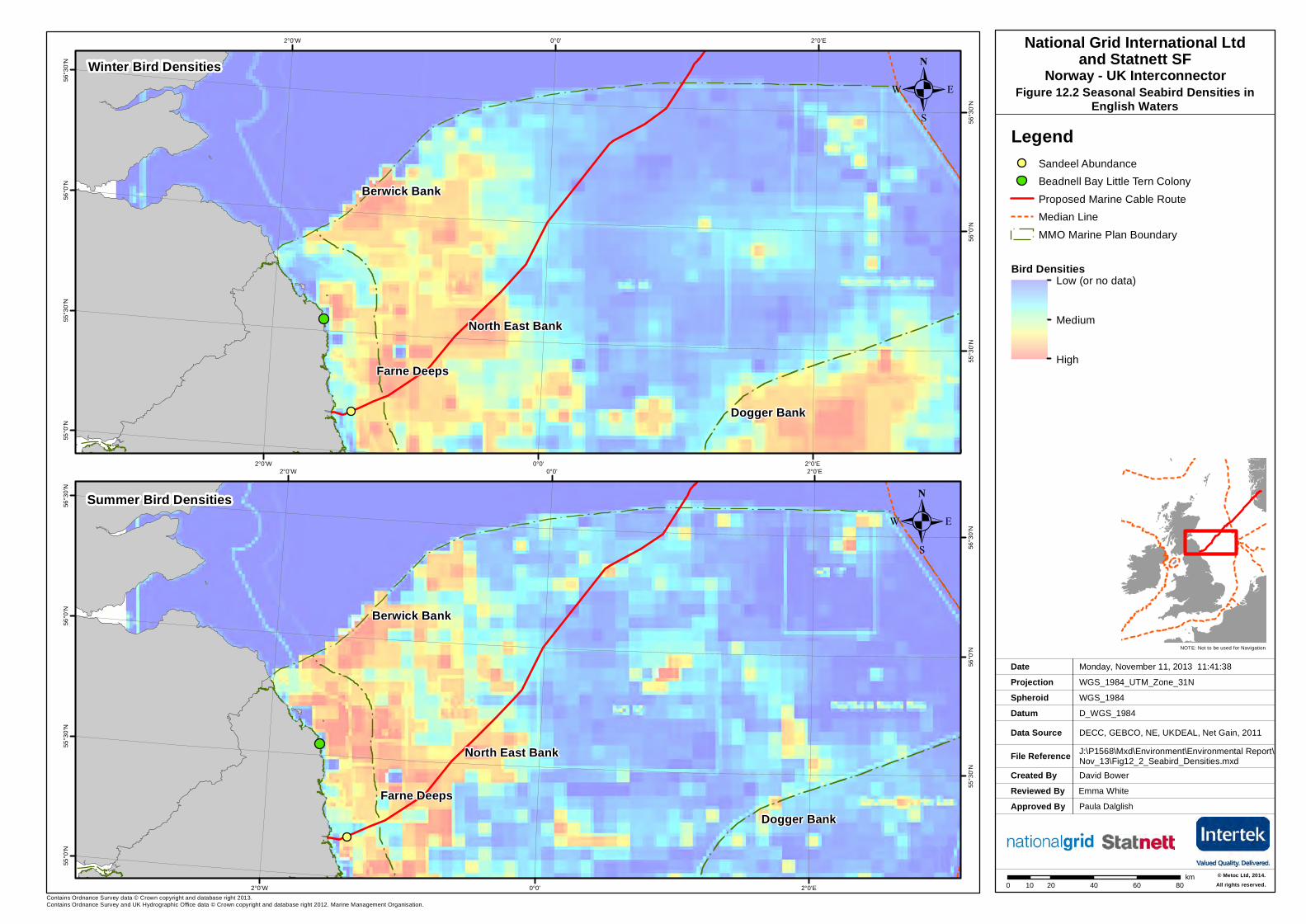
Summer Bird Densities
Winter Bird Densities
Created ByReviewed By
David BowerEmma White
Monday, November 11, 2013 11:41:38WGS_1984_UTM_Zone_31N
D_WGS_1984DECC, GEBCO, NE, UKDEAL, Net Gain, 2011J:\P1568\Mxd\Environment\Environmental Report\Nov_13\Fig12_2_Seabird_Densities.mxd
WGS_1984
DateProjection
DatumData Source
File Reference
Spheroid
NOTE: Not to be used for Navigation
Approved By Paula Dalglish
0 20 40 60 8010km
National Grid International Ltdand Statnett SF
Norway - UK InterconnectorFigure 12.2 Seasonal Seabird Densities in
English Waters
LegendSandeel AbundanceBeadnell Bay Little Tern ColonyProposed Marine Cable Route Median LineMMO Marine Plan Boundary
Bird DensitiesLow (or no data)
Medium
High
.
.
Contains Ordnance Survey data © Crown copyright and database right 2013.Contains Ordnance Survey and UK Hydrographic Office data © Crown copyright and database right 2012. Marine Management Organisation.
© Metoc Ltd, 2014.All rights reserved.
2°0'E
2°0'E
0°0'
0°0'
2°0'W
2°0'W57
°0'N
57°0
'N
56°0
'N
56°0
'N
55°0
'N
55°0
'N
.
Created ByReviewed By
David BowerEmma White
Monday, November 11, 2013 15:24:24WGS_1984_UTM_Zone_31N
D_WGS_1984ORBIS, OSOD, JNCC, GEBCO, UKDEALJ:\P1568\Mxd\Environment\Environmental Report\Nov_13\Fig12_3 Seabird Vulnerability.mxd
WGS_1984
DateProjection
DatumData Source
File Reference
Spheroid
NOTE: Not to be used for Navigation
Approved By Paula Dalglish
0 20 40 6010km
National Grid International Ltdand Statnett SF
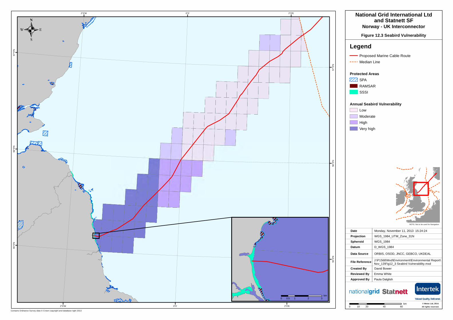
Norway - UK InterconnectorFigure 12.3 Seabird Vulnerability
LegendProposed Marine Cable Route Median Line
Protected AreasSPARAMSARSSSI
Annual Seabird VulnerabilityLowModerateHighVery high
Contains Ordnance Survey data © Crown copyright and database right 2013
0 1 2 30.5km
© Metoc Ltd, 2014.All rights reserved.
Created ByReviewed By
David BowerEmma White
Tuesday, November 12, 2013 14:26:10WGS_1984_UTM_Zone_31N
D_WGS_1984ORBIS, OSOD, JNCC, GEBCO, UKDEALJ:\P1568\Mxd\Environment\Environmental Report\Nov_13\Fig13_1_Harbour_Porpoise.mxd
WGS_1984
DateProjection
DatumData Source
File Reference
Spheroid
NOTE: Not to be used for Navigation
Contains Ordnance Survey data © Crown copyright and database right 2013.Contains Ordnance Survey and UK Hydrographic Office data © Crown copyright and database right 2012. Marine Management Organisation.
Approved By Paula Dalglish
Berwickshire andNorth Northumberland Coast
SAC
Firth of Tay& Eden Estuary
SAC
Isle of MaySAC
Tweed EstuarySAC
2°0'E
2°0'E
0°0'
0°0'
2°0'W
2°0'W57
°0'N
57°0
'N
56°0
'N
56°0
'N
55°0
'N
55°0
'N
0 10 20 30 40 505km
.National Grid International Ltd
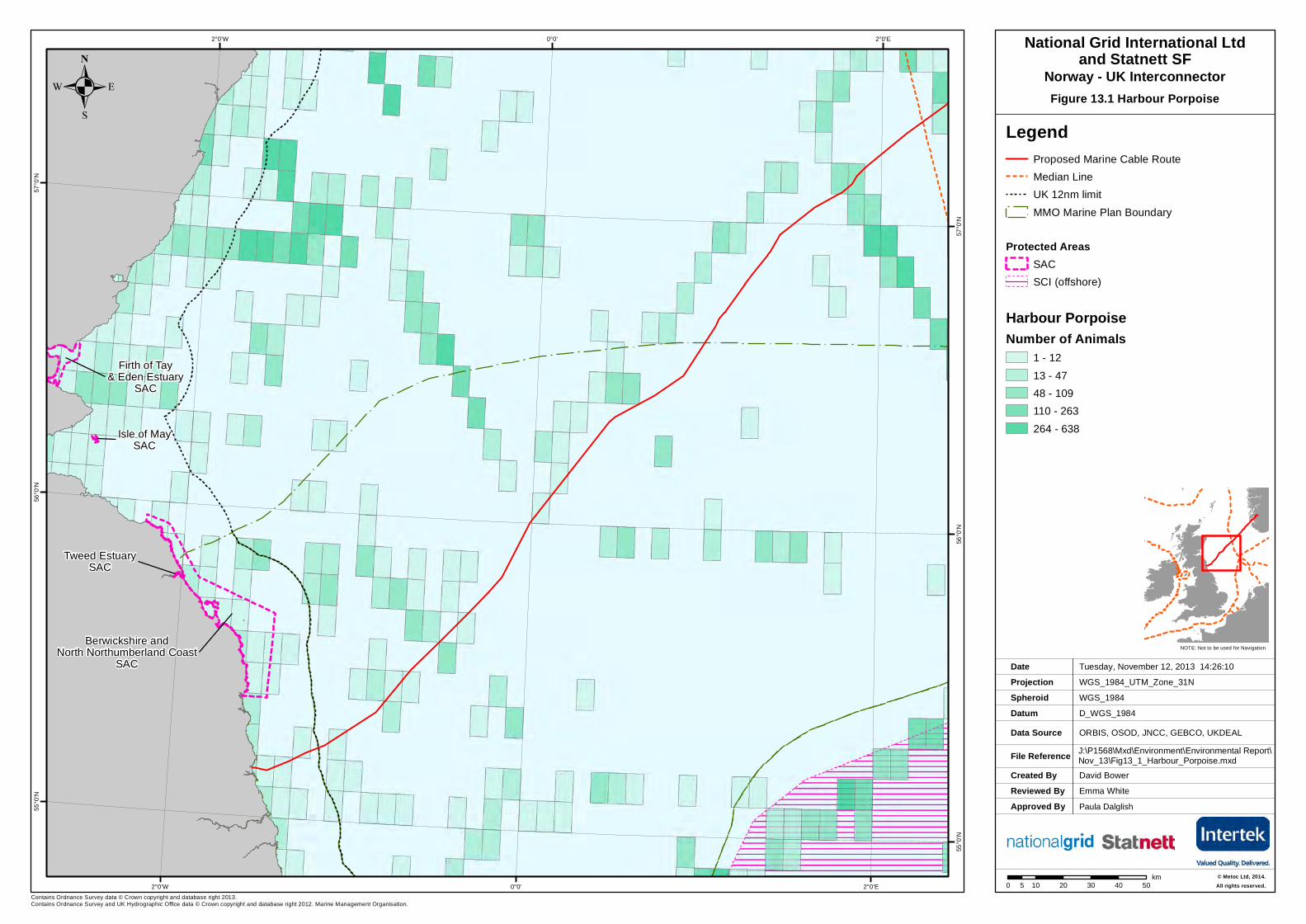
and Statnett SFNorway - UK InterconnectorFigure 13.1 Harbour Porpoise
LegendProposed Marine Cable Route Median LineUK 12nm limitMMO Marine Plan Boundary
Protected AreasSACSCI (offshore)
Harbour PorpoiseNumber of Animals
1 - 1213 - 4748 - 109110 - 263264 - 638
© Metoc Ltd, 2014.All rights reserved.
Created ByReviewed By
David BowerEmma White
Tuesday, November 12, 2013 14:26:07WGS_1984_UTM_Zone_31N
D_WGS_1984ORBIS, OSOD, JNCC, GEBCO, UKDEALJ:\P1568\Mxd\Environment\Environmental Report\Nov_13\Fig13_2_Bottlenose_Dolphin.mxd
WGS_1984
DateProjection
DatumData Source
File Reference
Spheroid
NOTE: Not to be used for Navigation
Contains Ordnance Survey data © Crown copyright and database right 2013Contains Ordnance Survey and UK Hydrographic Office data © Crown copyright and database right 2012. Marine Management Organisation.
Approved By Paula Dalglish
Berwickshire andNorth Northumberland Coast
SAC
Firth of Tay& Eden Estuary
SAC
Isle of MaySAC
Tweed EstuarySAC
2°0'E
2°0'E
0°0'
0°0'
2°0'W
2°0'W57
°0'N
57°0
'N
56°0
'N
56°0
'N
55°0
'N
55°0
'N
0 10 20 30 40 505km
.National Grid International Ltd
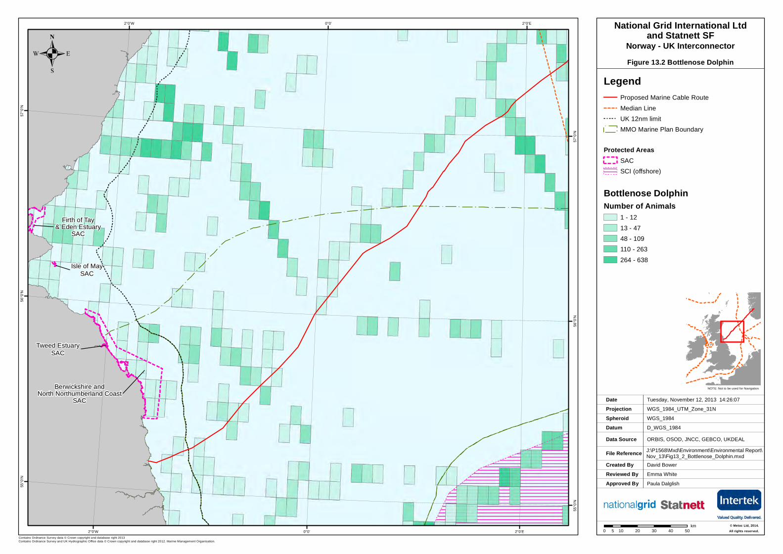
and Statnett SFNorway - UK InterconnectorFigure 13.2 Bottlenose Dolphin
LegendProposed Marine Cable Route Median LineUK 12nm limitMMO Marine Plan Boundary
Protected AreasSACSCI (offshore)
Bottlenose DolphinNumber of Animals
1 - 1213 - 4748 - 109110 - 263264 - 638
© Metoc Ltd, 2014.All rights reserved.

Created ByReviewed By
Friday, November 15, 2013 12:52:32WGS_1984_UTM_Zone_31N
D_WGS_1984ORBIS, OSOD, JNCC, GEBCO, UKDEAL, Scottish Government (2013)J:\P1568\Mxd\Environment\Environmental Report\Nov_13\Fig13_3_Harbour_Seal_Distr.mxd
WGS_1984
DateProjection
DatumData Source
File Reference
Spheroid
NOTE: Not to be used for Navigation
Contains Ordnance Survey data © Crown copyright and database right 2013Contains Ordnance Survey and UK Hydrographic Office data © Crown copyright and database right 2012. Marine Management Organisation.
Approved By
Firth of Tay& Eden Estuary
SAC
Berwickshire andNorth Northumberland Coast
SAC
Isle of MaySAC
Tweed EstuarySAC
2°0'E
2°0'E
0°0'
0°0'
2°0'W
2°0'W57
°0'N
57°0
'N
56°0
'N
56°0
'N
55°0
'N
55°0
'N
0 10 20 30 40 505km
.National Grid International Ltd
and Statnett SFNorway - UK Interconnector
Figure 13.3 Harbour Seal Distribution
LegendProposed Marine Cable Route Median Line
Protected AreasSACSCI (offshore)
UK 12nm limitMMO Marine Plan Boundary
Harbour seal Distribution0- 11 - 55 - 1010 - 5050 - 100100 - 150150+
David Bower
Paula DalglishEmma White
© Metoc Ltd, 2014.All rights reserved.
Created ByReviewed By
David Bower
Friday, November 15, 2013 12:53:09WGS_1984_UTM_Zone_31N
D_WGS_1984ORBIS, OSOD, JNCC, GEBCO, UKDEAL,Scottish Government(2013), Thompson etal(2010)J:\P1568\Mxd\Environment\Environmental Report\Nov_13\Fig13_4_Grey_Seal_Distr.mxd
WGS_1984
DateProjection
DatumData Source
File Reference
Spheroid
NOTE: Not to be used for Navigation
Contains Ordnance Survey data © Crown copyright and database right 2013Contains Ordnance Survey and UK Hydrographic Office data © Crown copyright and database right 2012. Marine Management Organisation.
Approved By
!(
!(!(!(!(
!(
!(
!(!(!(
!(!(!(!(!(!(!(!(!(
!(
!(
!(
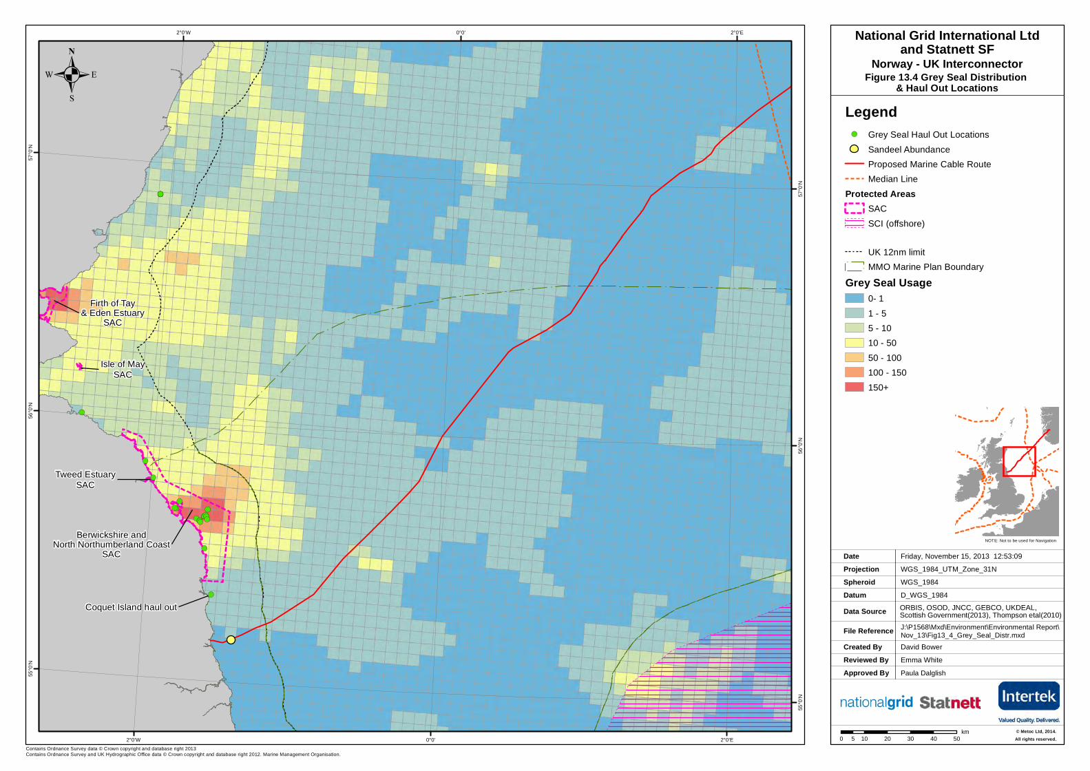
Coquet Island haul out
Berwickshire andNorth Northumberland Coast
SAC
Firth of Tay& Eden Estuary
SAC
Isle of MaySAC
Tweed EstuarySAC
2°0'E
2°0'E
0°0'
0°0'
2°0'W
2°0'W57
°0'N
57°0
'N
56°0
'N
56°0
'N
55°0
'N
55°0
'N
0 10 20 30 40 505km
.National Grid International Ltd
and Statnett SFNorway - UK Interconnector
Figure 13.4 Grey Seal Distribution & Haul Out Locations
Legend!( Grey Seal Haul Out Locations
Sandeel AbundanceProposed Marine Cable Route Median Line
Protected AreasSACSCI (offshore)
UK 12nm limitMMO Marine Plan Boundary
Grey Seal Usage0- 11 - 55 - 1010 - 5050 - 100100 - 150150+
Paula DalglishEmma White
© Metoc Ltd, 2014.All rights reserved.

.
Created ByReviewed By
Friday, February 21, 2014 16:46:25WGS_1984_UTM_Zone_31N
D_WGS_1984OSOD, DECC, ESRI, MMO, UKDeal, RSSJ:\P1568\Mxd\Environment\Environmental Report\Final\Fig15_2_Commercial_Fishing_Act.mxd
WGS_1984
DateProjection
DatumData Source
File Reference
Spheroid
NOTE: Not to be used for Navigation
Contains Ordnance Survey data © Crown copyright and database right 2013
Approved By Paula Dalglish
Farne DeepsTrawl Ground
The Holes
Devils Hole
Swallow Hole
Montrose Ground
2°0'E
2°0'E
0°0'
0°0'
2°0'W
2°0'W57
°0'N
57°0
'N
56°0
'N
56°0
'N
55°0
'N
55°0
'N
0 10 20 30 40 505km
. Figure 15.2: Location of commercial fishing activityalong the proposed NSN route
National Grid International Ltdand Statnett SF
Norway - UK Interconnector
Ian CharltonEmma White
LegendProposed Marine Cable Route UK Median LineUK 12nm limitMMO Marine Plan Boundary
Fishing Activity 2007-2010Mobile Vessel Activity (Hours)
< 500> 500> 1000> 2500> 5000> 7500> 10000> 15000
© Metoc Ltd, 2014.All rights reserved.
Created ByReviewed By
David BowerEmma White
Friday, November 15, 2013 14:09:39WGS_1984_UTM_Zone_30N
D_WGS_1984OSOD, NIFCAJ:\P1568\Mxd\Environment\Environmental Report\Nov_13\Fig15_3_Potting_Locations.mxd
WGS_1984
DateProjection
DatumData Source
File Reference
Spheroid
NOT E: Not to be used for Navigation
© Cro wn Cop yright a nd/or da taba se right s. Rep rod uced b y permission of th e Controlle r o f He r M ajesty’s Sta tio nery Office and t he UK Hyd rog rap hic Off ice (www.u kh o.go v.uk). Licence No. 1 7088 . NOT TO BE USED FOR NAVI GATION.Con tains Ord nance Survey d ata © Cro wn cop yright and d atab ase r ig ht 20 13
Approved By Paula Dalglish
! ! !!!!!
! !!! !
!!!!
!!!!!!!
!!!!! !!! !
!!!! ! !!!!
!!!! !
!!
!!
! !!!!
!!
!!
!!!!
!
!!!!
! !
!!!
!!!!
! !
!! !
!
!!! !
! !!!!
!!
!!!! !
!! !!!
!!! ! ! !!! !
!!!!
!! !
!!
!!
!! !
!
!!
! !
!
!
!!!!! !! !
!!!! !!
!!!
!! !!!
!! !!
!!!!
!!
!!!
!!!!! !! ! !
!!
!!!! !! !!!
!!
!!
!!!
!!
!!
!!!!
!!
!!
!!
!!
!!!
!!!!
!!
!!
!!!
!!
! !
!!!
!!!! !!
!!
!!
!!
! !!
!!!
!!
!!!
!!! !
!!! !
!!!
!
!
!! !!
! !!! !
!!!
!!!
!!!
!! !!!!!
!!
!
!
!!!
!!!
!
!!!! !
!! !
!!!!!
!
!!!!
!
!! ! !
!!
!!
!!!
! ! !!!
!!!! !!
!!!! !
!!!!
!!!
! !!
!!!!
!
!
! !!
!
!!
!!! !!! !! !!
! !!
!
!!!!
!! !!!!!!!!
!!!!! !!!!
! !!! !!
!!!
!! !!! !!! !
! !!!!
!! !!
!!!
!!!!!
! !!
!
! !!!!!
!!
!!!!
!!
!!!!!
!!! !!
!
!
!
!
!
!
!
!!
!!!
! !!!
! !
!!!! !
!!!
!! ! !
! !!!
!
! !! !
!!!!! !!
!!
! !! ! !!! ! !
!! !! !!!! !! !! !
!!!!! !!!!
!!!!!
!!
!!!!
!!! !! ! !
!! !
! !! !!!!
!!!! !!!
! !! !
!! !
!!
! !!!! !!
!!
!!!! !!
!!!
!!
!!
!!! !!
!!!
!!!!!! !!!
!!!
!!!! ! !!
!!!!
!! !
!!!! !
! !
!
!!
!!
! !
!
!
!!
! !!
!!
!!
!!
!!!
!!!!
! !! !!!
!! !!
!!!! !!!!
!! !! ! !
!!!!
!! ! !
!!!!!!! !
!!!
! !! !!! !
!!
!!! ! !!
!! ! !!!!
!!!!
!!!!!
!
!! !
! !
!
!! !
!!
!!!
!!
!!!
!!
!
!!
!!!
! !!!
!!
!!!!
!! !!
!! ! !!
!!
!!!
!!!
!
!!
! !!!
! !!
!
!! !!! !!
!! !! !!! !!
!!!!!
!! ! !
!
!!
!!!! !! !
!!
!!
!!
! !!
!!! !
!!
!!! !
!!! !
!! !!
!!!!
!! !!! !
!!!
!!!!!! ! !
!!!!! !
!!!
!
!!
!!!!
! !
! !!
! !!!
!
!
!!!!!
!
!!!!!
! !!
!!!!
!!
!!!
!
!!!
!
!!
! !
!
! !!!!
! !
!! !! !
!!!
!!
!!
!!
! !!
!!!
! !!! !
!!
!!!!
!! !!!! !!
!!!!!!! !
! !!!! !!! !
!!!
!
!!!! !
!!!!! !
!
!!!
!!! !
!!!
!!!
!! !
!
!!
!
!
!
!
!
!!!
!!
!!
!
!
!
!
!
!!
!
!
!
!!
!!! ! !! !
!!
!
!
!!! !
!!!!
!! !!! !! !!!!!!!
!! !! !!! !!!!!
!!!!
!!
!
!! !
!!
!!
!!!
! !!!!!!
!!
!!
!!!
!!!
!!!
!!
!
! !!
!!!
!!!
!!!!!
!!
!!!!!!
!!!
!! !!!! ! !!
!!!!
!!
! !!!
!!!!!
!!!!! !!
!! ! !! !
!!!!
!!!!
!!!
! !!!! !!
!!!
!!!!
!!
!
!!
!
! !!!!!! !!!
!! !
!
!!!
!! !!
!!! !
!
!
!!!!
!!
!!
!!! !! !
!
!!! !!
!!!
!
!!!
!!!
!!!!!
! !! ! !!!!
!!!
!!!!
!!
!!!!!
!!!
!
!
!
!!!
!!!!!
!!
!!
!!
!!!
!
!!!
!!!!
!!!
!!
!!!!
!!!
!!!!!!
!!!!
!! !
!!!
!!
!!
!!
!
!!
!!!!
!!
!!!!
!! ! !!!
! !! !!
!! !!!
!!
!!! !!
!!
!!
!!
!!
!
!!!
!!!!
!
!!
!
!!!
!
! !!! !
!
!
!!!
!! !!
!!!
! !
!!
! !! !!
!
!!!
!!!
!!
!!
!!! !
!!!! !! ! !
!!!!!!
! !!
!!!!!
!!
!!!
!
!!
!!
!!
!!!
!!! !
!
! !! !
!!!
!!!
!
!
!!!
!!!
!
!!
!
!
!
!! !! !
!
!!
!!! !
!!!
!!
!!!! !
!!!! !
!!
!!!! !!
!
!!
!!!!
! !!
!!!
! !!
!
!!
!!
!! !!
!!!
!
!
!!!
!!!!
!!!!!
!! !!! !
!!!!
!!
!
!!
!
!!
!!
!!!
!
!!!!
!! !
!!!
!! !
!!!
!!!!
!
!!
!
!!!! !
!
!
!
!
!!
!
!
!
!!
!!!!
!
!
!!!
!
!! !
!!
!!
!!
!! !
!!!! !!!
!! ! !!!
!!!!!
!!!! !!!
!
!!!
!!
!!!
! !
!!
!!
!!
! !!!
!!
!!!
!!
!!!
!
!!
!!!!!!
!!
!!
!!!
!! !!! !!
!!!!
!!
!!
!
!! !!
!!
!
!!
!!
!!! !
! !!!
!!
! !!
!!!
!!!!
!!
!!
!!
! !!!
!!!
!
!! !
!!!
! !
!
!
!!
!
!
!!
!
! !!
!!
!
!!
!!
!!!!
!!!!!
!!!
!! !
!!!
!
!!!! !!!
! !!! !! !!!!
!!!! !! !! !! !!!!
!!! !!!
!!!!!
!!!
!!!!!
!!! !
!!!
!!
!!!
!!!
!!
!!
!
!!
!
!! !
!!!
! !!!
!!!
!!!!
!!!
!!
!!!
!! !!!
!!! !
!!
!!
!!
!
!!!
!
!
!
!
!!
!!
!!
!!!
!
!
! !! !
!!!!
!!!
!!
!!!
!!
!!!
!!!
!!!!! !
!
! !
!
!!!
!
!!
!!!
!!!!!
!
!
!
!!!
!
!!!
!!!
! !!!!
!!! !
!!!
! !!
!!!
! !!! ! !!!
!
!! !!!!
!! !!!!
! !! !!!!
!!!!!!! !!
!!
!!!
!!
!!!
!!
!
!!! !! !
!!!
!
!
!
!!
!!!!
!
!
! !!!!! !
!!
!! !!
!!!!
!! !!!
!!!
!! !
!!!
!!!! !!
! !!!!!
!!! ! !
!!!
!!
!!!!
! !!
!!! !! !
!
!
!!
!!! !!
!!!
!!
! !!
!!! !! !!
!!
!
!!
!
!
!!!!!
!
!!
!
!
!
!!!!
!
!
!
!!
!!
!!
!!
!
! !!
!
!!
!!!
!
!
!!
!
!
!!
! !
! !!
! ! !! !! !!
!!!
!!
! !!
!!!!!
!! ! !!
!!! !!!
!! !
!!! ! !
!! !!
!!!!!
!!!
!!
!!!!
!!
!!
! !!
!!!!!
!!! !!!!
!!!!
! !!! !!! ! !!! !
!!!!!!
! !!!
!
!!!!
!
!!!!!
!!!
!
!
!
!
!!
!!
!! !!
!
!!!
!! !
! !!
!!!!!
!! !! !!!
!!!!
! !!!
!!
!
!
!!!
!!
!
!
!
!!
!!
!
!!!
!
!
! !!
!
!!
!
!!!!
!!
!!
!!
!
!
!!
!
!
!
!!
!
!!
!
!
!
!!
!
!
!
!!
!!
!!
! !!
!
!
!!
!!
! !!
!!!
!!!
!!
!
!!
!! !
!!
!!
!!
!!!
! !!
!! ! !
!!! !!
!!!!
!!
!
!!!
!!
! !!!
!!
!
!
!!
!
!
!
!
!!
!
!
!
!
!
!!
!
!
!
!!
!!
!!
!
! !
!
! !!
!
!!
!
!
!!
!!
!
!!
!
!
!
!!
!
!
!
!
!
!
!
!
!!
!!
!
!
!
!
!
!
!
!
!
!
!
!!
!
!
!
!
!
!
!
!
!
!
!!!!!
!
!
!
!
! !!
!
!!!
! !
!! !!
!!
!
!
!
!!
!
!
! !
!!
!
!!
!!!
!!!
!!!!
!
!
!
!!
!
!
!!!
!
!!
!
!!
!
!
!
!!!!
!
!!!
!
!
!
!
!
!
!
!
!
!
!!
!
!
!
!
!
!
!
!
!
1°10'W
1°10'W
1°20'W
1°20'W
1°30'W
1°30'W55
°15'N
55°1
5'N
55°1
0'N
55°1
0'N
55°5
'N
55°5
'N
© Met oc Ltd, 2013.All r ight s reserved .
LegendProposed Marine Cable Route UK 6nm limit
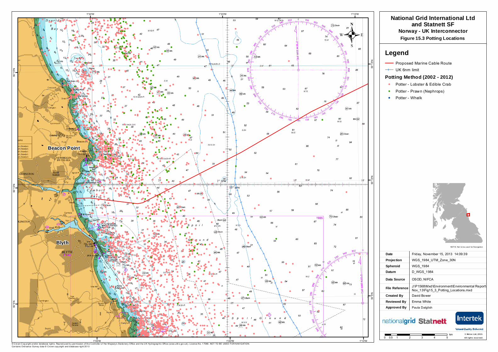
Potting Method (2002 - 2012)! Potter - Lobster & Edible Crab! Potter - Prawn (Nephrops)! Potter - Whelk
. Figure 15.3 Potting Locations
0 1 2 3 4 50.5km
National Grid International Ltdand Statnett SF
Norway - UK Interconnector
Blyth
Beacon Point
Created ByReviewed By
Ian CharltonEmma White
Friday, February 21, 2014 17:07:01WGS_1984_UTM_Zone_30N
D_WGS_1984OSOD, NIFCA, RSSJ:\P1568\Mxd\Environment\Environmental Report\Final\Fig15_5_Gill_Net_Activity.mxd
WGS_1984
DateProjection
DatumData Source
File Reference
Spheroid
NOTE: Not to be used for Navigation
© Crown Copyright and/or database rights. Reproduced by permission of the Controller of Her Majesty’s Stationery Office and the UK Hydrographic Office (www.ukho.gov.uk). Licence No. 17088. NOT TO BE USED FOR NAVIGATION.Contains Ordnance Survey data © Crown copyright and database right 2013
Approved By Paula Dalglish
!!
!! !! !! !!!!
! !! ! ! !!
!! !!! !! !! !!!! ! !!!
!!!! ! !
!! !! !!!
!!! ! !! ! !
!! !
!!
!!!! !!
!!
!!! !! ! !!!
!!! !
! ! ! !!!
!!! !!
! !! !!!! !!!
!!!!!
! ! !!!!! !!!
! !!!
!! !! !! !! !!!
!!! !! !! !! !! !
!! !! !
!!! !!
!!!! !
!
! !!!
!! !! !
!!
!!
!!!!!
!!!!!
! !
!!
! !!!!
!! !!
!! ! !!!! !!
!!! !!
!!
!!
!!!
! !!! !!
!! !
! !!! ! !!
!! !! !!!
!!!
! !!! !! !
!!!!
!!
!! ! !!!
!! !!
!!!!!
!!
!
!
!! !
!!
!!
!
!! !! ! !
! !!!
!
!!!
!!
!!
!!!
!!
! !
!!
!
!
!
!
!
!
!
!
!
!
!
!
!
!
!!
!!! !
! !!! !!
!!!! !!
!!!! !
!!! !!
! !!!! !
!!!!! !!
!!
! !!
!!!
!!
!!
!
!
!! !
!!
!!
!!!
!! !!
!!!
!!
!
! !!
!! !!!!
!!!!
!
!
!!
!
!
!!
!!
!
!
!!
!
!
!
!
!
!
!
!
!!
!!!
! !!! !!
!!!! !
!!!!
!!!
!
!!!
!
!
!
!!
!
!!
!
!!
!!
!!
!
!
!
!
!!
!!!
!!
!!
!
!
!!
!
!
!
!
!
!
!
!
!
!
!
!
!
!
!!
!
!
!
!!
!
!
!
! !
!
!
!!
!
!
!!
!!
!
!
!
!
!
!
!
!! !
!!
!
!!
! !!
!! !!!
!!! !! !
! !!
!!!!!!
!
!
!
!
!
!
!
!
!!! !
!! !!
!!!!! ! !! ! !! !!!! !! !!
!!! !!!
! ! !! !!!!!
!!
!!
! !
!!
!
!!
!!
!!
!!
!!
!!
!
!
!
!
!!
!
!
!!
!
!
!! !
! !!
! !!
!
!!!!
!
!
!
!
!
!
!
!
!
!! !!
!!
!!! !!!!
! !
! !!!
! !
!
!!!
!
!
!!
!! !
!!
!!
!!
!
!
!
!
!
!
!
!
!
!
!
!!
!
! !
!!!
!!
!!!
!!!
!!
! !
!
!!
!
!
!
!
!
!
!!
!!!
!
!
!
!!
!
!!
!
!
!
!
!
!
!
!!
!
!
! !!
!!!!! !
!!
!!!
!!!
!
!
!
!
!
!
! !!
!
!
!
!!!
! !
!
!
!!
!
!
!
1°10'W
1°10'W
1°20'W
1°20'W
1°30'W
1°30'W55
°15'N
55°15
'N
55°10
'N
55°10
'N
55°5'
N
55°5'
N
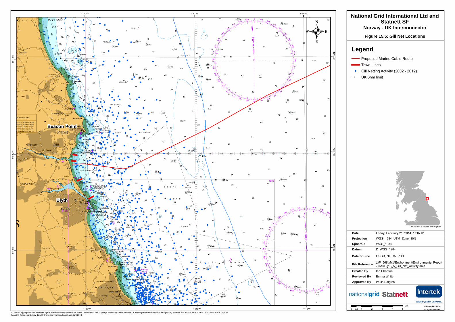
LegendProposed Marine Cable Route Trawl Lines
! Gill Netting Activity (2002 - 2012)UK 6nm limit
. Figure 15.5: Gill Net Locations
National Grid International Ltd andStatnett SF
Norway - UK Interconnector
Beacon Point
Blyth
0 1 2 3 4 50.5km © Metoc Ltd, 2014.
All rights reserved.
Created ByReviewed By
Ian CharltonEmma White
Friday, February 21, 2014 17:13:00WGS_1984_UTM_Zone_30N
D_WGS_1984OSOD, NIFCA, RSSJ:\P1568\Mxd\Environment\Environmental Report\Final\Fig15_7_Scallop_Dredging.mxd
WGS_1984
DateProjection
DatumData Source
File Reference
Spheroid
NOTE: Not to be used for Navigation
© Crown Copyright and/or database rights. Reproduced by permission of the Controller of Her Majesty’s Stationery Office and the UK Hydrographic Office (www.ukho.gov.uk). Licence No. 17088. NOT TO BE USED FOR NAVIGATION.Contains Ordnance Survey data © Crown copyright and database right 2013
Approved By Paula Dalglish
!(
!(
!( !(
!(
!(!(
!(
!(
!(
!(
!(
!(
1°10'W
1°10'W
1°20'W
1°20'W
1°30'W
1°30'W55
°15'N
55°15
'N
55°10
'N
55°10
'N
55°5'
N
55°5'
N
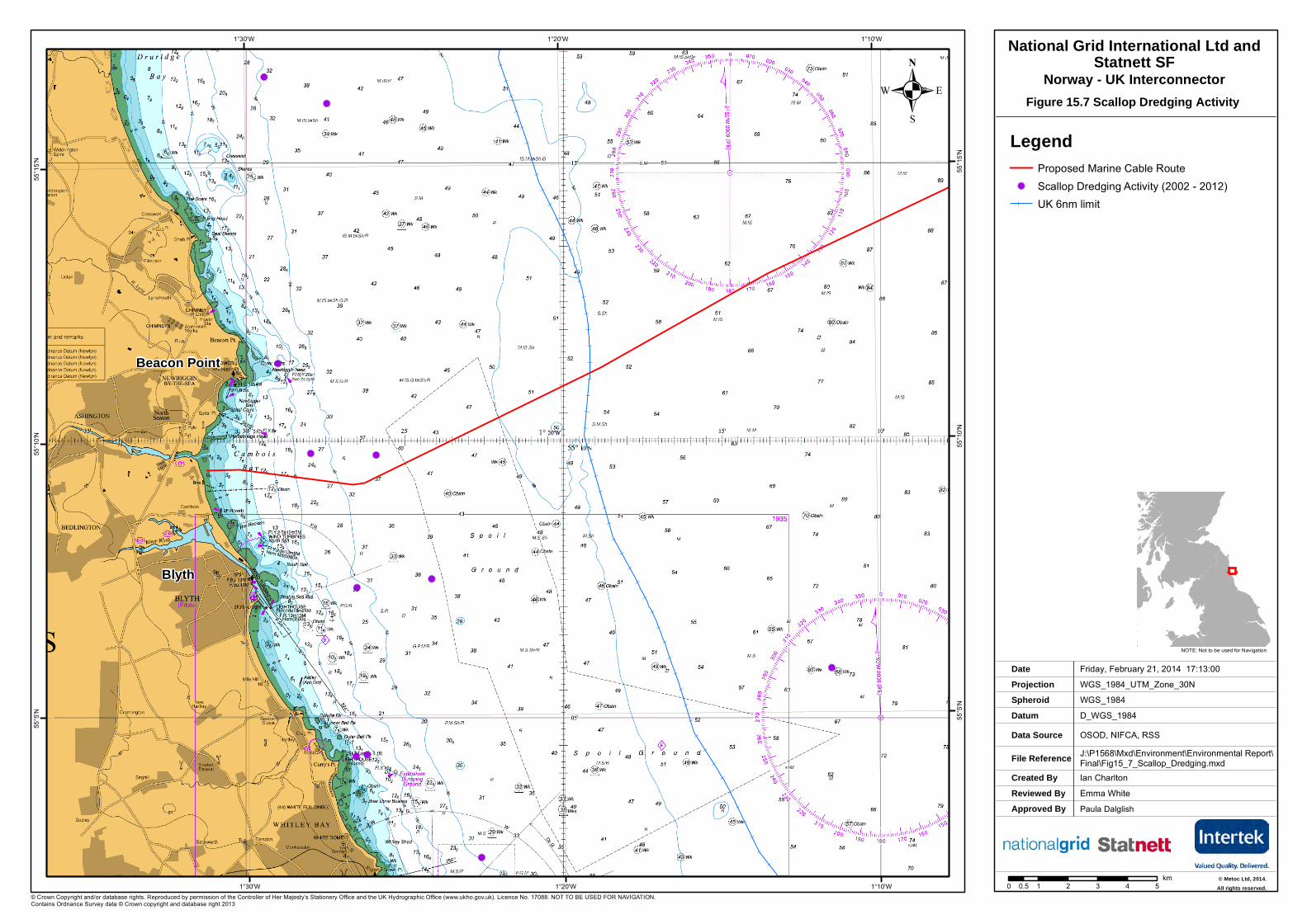
LegendProposed Marine Cable Route
!( Scallop Dredging Activity (2002 - 2012)UK 6nm limit
. Figure 15.7 Scallop Dredging Activity
National Grid International Ltd andStatnett SF
Norway - UK Interconnector
Beacon Point
Blyth
0 1 2 3 4 50.5km © Metoc Ltd, 2014.
All rights reserved.
. Figure 17.1 Offshore Infrastructure
Created ByReviewed By
Jill HobbsEmma White
Wednesday, July 3, 2013 11:39:48WGS_1984_UTM_Zone_31N
D_WGS_1984SeaZone, UKDEAL, KISCA, NAREC, ESRI, GEBCOJ:\P1568\Mxd\Environment\Environmental Report\Final\Figure_17.1_Offshore_infrastructure.mxd
WGS_1984
DateProjection
DatumData Source
File Reference
Spheroid
NOTE: Not to be used for Navigation
© British Crown and SeaZone Solutions Limited. All rights reserved. Products Licence No.112011.014. This product has been derived in part from material obtained from the UK Hydrographic Office with the permission of the Controller of Her Majesty s Stationery Office and UK Hydrographic Office (www.ukho.gov.uk). NOT TO BE USED FOR NAVIGATION
Approved By Name of Approver / Date
"/
"/
"/
"/
"/
"/
"/
"/
"/
"/
"/
"/
"/
"/
"/
"/
"/
"/
"/
"/
"/
"/
"/"/"/
"/
"/
"/
"/
"/
XY
XY
XY
XYXY
XY
XY
XY
!>
!>!>!>!>
!>!>!>!>!>!>!>!>!>!>!>!>!>!>!>!>!>!>!>!>!>!>!>!>!>!>!>!>!>!>!>!>!>!>!>!>!>!>!>!>!>!>!>!>!>!>!>!>!>!>!>!>
!>
!>!>!>
!>
!>!>!>!>!>!>!>!>!>!>!>!>!>!>!>
!>!>!>!>!>!>!>!>!>!>!>!>!>!>!>!>!>!>!>!>!>!>!>!>!>!>!>
!>
!>!>!>!>!>!>!>!>!>!>!>!>!>!>!>!>
!>!>!>!>!>!>!>!>!>!>!>!>!>!>!>!>!>!>!>!>!>!>!>!>
!>!> !>!>!>!>!>!>!>
!>!>!>!>!>!>!>
!>!>!>!>!>!>!>!>!>
!>!>!>!>
!>!>!>!>!>!>!>!>!>!>
!>!>
!>!>
!>
!>!>!>!>!>
!>
!>
!>!>!>!>!>!>!>!>!>!>
!>!>!>!>!>!>!>
!>
!>
!>!>!>
!>!>!>!>!>!>!>!>!>!>!>!>!>!>!>!>!>!>!>!>!>!>!>!>!>!>!>!>!>!>!>!>!>!>!>!>!>!>!>!>!>!>!>!>!>!>!>!>!>!>!>!>!>!>!>!>!>!>!>!>!>!>!>!>!>!>!>!>!>!>!>!>!>!>!>!>!>!>!>!>
!>!>!>!>!>!>!>
!>
!>
!>
!>
!>
!>!>!>
!>
!>
!>
!>
!>
!>
!>!>
!>
!>!>
!>!> !>
!>
!>!>
!>
!>
!>!>!>!>
!>!>!>
!>!>!>!>
!>
!>
!>!>!>
!>
!>
!>
!>
!>
!>
!>
!>
!>
!>
!>
!>
!>
!>
!>
!>
!>!>!>!>!>!>!>!>!>!>
!>
!>!>
!>!>
!>!>!>!>!>!>!>!>!>
!>
!>!>
!>
!>
!> !>!>
!>!>!>!>
!>
!>
!>!>!>
!>
!>
!>!>
!>
!>!>!>!>!>
!>!>!>!>
!>
!>
!>
!>!>!>
!>!>!>!>!>!>
!>!>!>
!>
!>!>
!>
!>
!>!>!>
!>
!>!>!>
!>
!>!>!>!>!>!>!>
!>!>!>!>
!>
!>!>
!>
!>!>
!>
!>!>!>
!>!>
!>
!>!>!>
!>
!>!>
!>
!>
!>!>
!>
!>!>
!>
!>!>!>!>!>!>!>!>!>!>!>!>!>!>
!>
!>
!>
!>
!>
!>
!>
!>
!>
!>
!>
!>
!>
!>
!>
!>
!>!>
!>
!>
!>
!>
!>!>
!>
!>
!>
!>
!>!>
!>
!>
!>
!>
!>
!>
!>
!>
!>
!>!>!>
!>
!>
!>
!>!>!>
!>
!>
!>!>
!>
!>
!>!>!>
!>
!>!>!> !>!>
!>
!>
!>
!>
!>!>!>!>!>!>
!>!>!>!>
!>
!>
!>
!>!>
!>!>
!>
!>
!>
!>
!>!> !>
!>
!>
!>!>
!>!>
!>
!>
!>
!>
!>!>
!>
!>
!>
!>!>!>
!>
!>
!>!>
!> !>
!>
!>
!>
!>
!>
!>
!>
!>
!>
!>
!>!>
!>
!>
!>!>
!>
!>
!>!>
!>
!>!>
!>
!>
!>
!>
!>
!>
!>!>
!>
!>
!>
!>
!>!>
!>
!>
!>
!>!>
!>!> !>!>!>!>!>
!>!>!>!>!>
!>
!>
!>
!>!>!>!>
!>!>!>!>!>
!>!>
!>
!>
!>!>
!>
!>
!>!>!>!>!>!>!>!>!>
!>!>
!>!>
!>!>!>!>
!>!>!>!>!>!>!>!>!>!>!>!>!>!>!>!>!>!>!>!>
!>!>
!>
!>!>!>!>!>!>
!>
!> !>
!>!>
!>
!>
!>!>!>!>!>
!>
!>
!>!>
!>!>!>!>!>!>
!>!>!>!>
!>!>!>!>!>!>!>
!>
!>!>!>!>!>
!>
!>
!>!>
!>
!>
!>
!>
!>
!>
!>
!>
!>
!>
!>
!>
!>
!>
!>
!>
!>
!>!> !>
!>
!>
!>
!>
!>
!>
!>
!>!>
!>
!>
!>!>
!>
!>
!>
!>
!>
!>
!>
!>
!>
!>
!>!>
!>
!>
!>
!>
!>
!>
!>
!>
!>
!>!>
!>
!>
!>
!>
!>
!>
!>!>
!>
!>
!>
!>
!>!>!>
!>
!> !> !>!>
!>
!> !>
!>!>
!>
!>!>
!>
!>
!>!>
!>
!>
!>
!>
!>
!>
!>
!>
!>
!>
!>
!>!>
!>!>!>!>
!>
!>!>
!>
!>
!>!> !>!>
!>
!>
!>
!>!>
!> !>
!>!>
!> !>
!> !>
!>!>!>
!>
!>
!>
!>
!>
!>
!>
!>
!>!>
!>
!>
!>
!>
!>!>
!>
!>
!>!>
!>
!>!>
!>!>
!>
!>
!>!>
!>
!>
!>!>!>!>
!>
!>
!>
!>
!>
!>
!>
!>
!>!>!>!>!>!>
!>
!>!>
!>!>
!>
!>
!>
!>
!>
!>
!>
!>
!>!>!>
!>!>!>!>!>!>!>!>!>!>!>
!>
!>
!>
!>
!>!>!>
!>!>!>
!>!>!>!>
!>!>!>!>!>
!>!>!>!>!>
!>!>!>!>!>
!>
!>
!>
!>
!>!>
!>
!>!>
!>
!>
!>
!>
!>
!>!>
!>
!>
!>
!>
!>
!>!>
!>
!>
!>
!>!>!>!>!>!>!>
!>!>!>!>
!>
!>
!>!>
!>!>
!>
!>
!>
!>
!>
!>
!>!>!>!>!>!>!> !>!>
!>
!>
!>!>!>!>
!>!>!>
!>
!>!>!>
!>
!>
!>
!>!>
!>
!>!>!>
!>!>!>
!>!>!>!>!>!>
!>
!>!>
!>!>
!>
!>
!>
!>
!>
!>
!>
!>!>!>
!>
!>
!>!>
!>
!>
!>!>!>!>
!> !>
!>!>!>
!>
!>!>
!>!>!>
!>
!>
!>
!>
!>!>
!>
!>!>!>!>!>
!>!>!>
!>
!>
!>
!>
!>!> !>
!>
!>!>
!>!>!>!>
!>
!>!>
!>
!>
!>!>
!>
!>!>
!>!>
!>!>
!>
!>!>
!>!>
!>!>!>!>
!>
!>!>!>!>!>
!>!>!>
!>
!>!>
!>
!>
!>!>!>
!>!>!>
!>!>
!>
!>
!>!>
!>
!>!>!>!>!>
!>
!>
!>
!>
!>
!>
!>
!>
!>
!>
!>
!>!>!>!>
!>
!>
!>
!>
!>
!>
!>
!>
!>!>
!>
!>
!>
!>
!>
!>!>
!>
!>
!>
!>
!>
!>
!>
!>
!>
!>
!>
!>
!>
!>
!>
!>!>
!>
!>
!>
!>
!>
!>
!>
!>
!>
!>
!>
!>
!>
!>!>
!>
!>!>
!>
!>!>
!>
!>
!>!>
!>
!>
!>
!>
!>
!>
!>
!>
!>!>!>
!>
!>
!>!>
!>
!>
!>
!>
!>!>
!>
!>
!>
!>
!>
!>
!>
!>
!>
!>
!>
!>
!>
!>
!>
!>
!>
!>
!>
!>
!>
!>
!> !>!>!>
!>
!>
!>
!>!>
!>!>!>!>
!>
!>
!>
!>
!>
!>
!>
!>
!>
!>
!>!>
!>
!>
!>
!>
!>
!>
!>
!>
!>
!>
!>
!>
!>
!>!>
!>
!>
!>!>
!>
!>!>
!>!>
!>
!>
!>!>
!>
!>!>
!>
!>!>!>
!>
!> !>
!>
!>
!>
!>!>
!>
!>
!>
!>
!>
!>
!>!>!>
!>
!>
!>
!>
!>
!>
!>
!>
!>
!>!>!>
!>
!>
!>!>
!>
!>!>
!>!>
!>!>!>
!>
!>
!>!>!>!>!>
!>!>
!>
!>!>!>!>!>!>!>!>!>!>
!>
!>!>!>!>
!>
!>
!>!>
!>!>!>!>!>
!>
!>!> !>!>!>
!>
!>
!>
!>!>!>
!>
!>
!>
!>
!>
!>!>
!>
!>!> !>
!>!>
!>
!>
!>
!>
!>
!>
!>
!>!>
!>
!>
!>!>
!>
!>
!>
!>
!>!>
!>
!>!>
!>!>!>!>!>
!>
!>!>!>!>
!>
!>
!> !>!>!>!>!>
!>
!>
!>
!>!>
!>!>
!>
!>!>
!>
!>
!>
!>
!>
!>
!>
!>
!>!>!>
!>!>!>!>!>!>
!>!>
!>!>
!>!>
!>!>
!>
!>
!>
!>!>
!>!>
!>!>
!>
!>!>!>
!>!>
!>!>!>
!>
!>!>!>
!>!>!>
!>!>!>!>!>!>
!>
!>!>
!>
!>
!>
!>
!>
!>!>
!>
!>!>
!>!>!>
!>
!>!>!>!>!>!>!>
!>!>!>!>
!>
!>
!>
!>
!>!>
!>!>
!>
!>!>
!>
!>
!>
!>
!>!>
!>
!>
!>
!>!>
!>
!>
!>
!>
!>
!>
!>
!>!>
!>
!>
!>
!>
!>!>!>
!>
!>
!>
!>
!>
!>!>!>!>!>
!>!>!>!>!>!>!>
!>
!>!>
!>
!>
!>
!>!>
!>
!>
!>
!>!>!>!>
!>
!>
!>!>
!>
!> !>
!>
!>
!>
!>
!> !>
!>
!>
!>
!>
!>
!>
!>
!>
!>
!>
!>
!>
!>
!>
!>
!>!>
!>
!>
!>!>
!>
!>
!>
!>!>
!>!>
!>
!>
!>
!>
!>
!> !>
!>!>
!>!>!>
!>
!>
!>
!>
!>
!>
!>
!>
!>
!>
!>
!>
!>!>!>!>!>
!>
!>
!>!>!>!>
!>!>
!>
!>
!>!>
!>
!>
!>!>
!>!>!>
!>
!>
!>
!>
!>
!>!>!>!>!>!>!>!>!>!>!>!>!>!>!>!>!>!>!>!>
!>!>
!>
!>
!>!>!>!>!>
!>!>
!>!>
!>
!>!>!>!>
!>!>
!>!>!>
!>
!>
!>
!>!>
!>
!>
!>!>
!>
!>
!>
!>
!>
!>
!>
!>
!>!>!>!>!>!>!>!>!>
!>
!>
!>!>!>!>!>!>!>!>
!>
!>
!>!>
!>
!>!>!>
!>!>
!>
!>
!>
!>
!>
!>!>!>!>!>
!>
!>!>!>
!>!>!>!>
!>
!>
!>
!>
!>
!>
!>!>
!>
!>
!>
!>
!>!>!>!>!>!>
!>!>!>!>!>!>!>
!>
!>
!>!>!>!>
!>!>
!>!>
!>
!>!>!>!>!>
!>
!>
!>
!>
!>!>!>!>!>!>
!>!>!>!>!>!>!>!>
!>
!>!>!>!>!>!>!>!>!>
!>
!>
!>
!>
!>!>!>!>!>!>
!>
!>
!>!>
!>!>!>!>!>
!>
!>
!>
!>
!>
!>
!>
!>
!>!>
!>
!>!>
!>!>!>!>
!>!>!>!>!>!>!>!>
!>!>
!>
!>
!>
!>
!>!>!>!>
!>
!>
!>
!>
!>
!>!>
!>!>
!>
!>!>!>!> !>
!>
!>
!>
!>
!>
!>
!>!>!>!>!>
!>
!>
!>
!>
!>
!>
!>
!>
!>
!>!>
!>
!>!>!>
!>!>
!>
!>
!>
!>
!>!>!>!>!>!>!>
!>
!>
!>!>!>!>!>
!>
!>
!>
!>
!>
!>
!>
!>!>
!>
!>!>
!>!>!>
!>
!>
!>
!>!>
!>!>!>!>!>!>!>
!>
!> !>!>!>!> !>
!>
!>!>
!>
!>
!>
!>
!>
!>!>
!>
!>
!>
!>!>
!>
!>
!>
!>
!>
!>!>!>
!> !>!>
!>
!>
!>!>!>
!>
!>
!>
!>
!>
!>
!>
!>
!>
!>!>
!>
!>!>
!>!>
!>
!>!>!>!>!>
!>
!>
!>
!>
!>!>
!>
!>
!>!>
!>
!>
!>
!>!>
!>
!>
!>
!>!>
!>
!>
!>
!>!>
!>
!>
!>!>!>!>!>
!>
!> !>!> !>!>!>
!>!>
!>
!>
!>
!>
!>
!>!>
!>
!>
!>
!>
!>
!>
!>
!>!>!>!>
!>
!>
!>
!>!>!>
!>
!>
!>!>!>
!>
!>!>
!>
!>
!>
!>
!>!>
!>
!>!>
!>!>
!>!>!>!>!>!>!>
!>
!>
!>!>!>!>!>!>!>!>!>!>!>
!>
!>
!>!>
!>!>!>!>
!>
!>
!>!>
!>
!>
!>
!>
!>
!>
!.!.!.!.
!.!.!.!.
!.!.DD
!.!.
!.!.
!.
2°0'E
2°0'E
0°0'
0°0'
2°0'W
2°0'W57
°0'N
57°0'
N
56°0'
N
56°0'
N
55°0'
N
© Metoc Ltd, 2013.All rights reserved.
LegendProposed Marine Cable Route Median LineScottish/English Median Line
D Wind Turbine!. Diffuser
Proposed Blyth Offshore Wind Demonstration Site
CablesPowerTelecom
Oil and Gas Infrastructure!> WellXY FPSO"/ Platform
PipelineHydrocarbon Field
Oil and Gas Operators within 1 kmBritoil Public LtdShell UK LtdBG International LtdTotal E&P UK LtdFirst Oil Expro LtdCNR International UK LtdMaersk Oil North Sea UK LtdTalisman Energy UK Ltd
0 10 20 30 40 505km
.
!
!
!.!.
DD Array 2
Array 3
Array 4
Blyth
Ashington
National Grid International Ltdand Statnett SF
Norway - UK Interconnector
Proposed Blyth Offshore Wind Farm Demonstration Project
!>
!>
!>!>!>
!>
!>!>!>!>
!>
!>!>!>
!>
!>
!>
!>
!>!>
!>!>
!>
!>!>!>!>!>!>!>!>!>!>!>
!>
!>
!>
!>
!>
!>
!>
!>
!>
!>!>!>!>!>!>!>
!>
!>!>!>
!>!>!>
!>!>!>!>!>
!>!>!>
!>!>!>!>!>!>!>!>!>
!>
!>
!>
!>!>!>!>
!>
!>!>
!>
!>
!>
!>!>
!>!>!>
!>
!>
!>
!>!>
!>
!>!>!>!>!>
!>
!>
!>
!>
!>!>!>!>!>
!>
!>
!>
!>
!>
!>
!>!>!>
!>!>
!>!>
!>!>
!>
!>
!>!>
!>
!>!>
!>
!>!>!>!>!>!>!>
!>!>
!>!>
!>!>!>!>
!>!>
!>!>!>!>
!>
!>
"/
"/
Lomond Platform
Proposed Blyth Offshore Wind Demonstration SiteExport Cable
0 2 4 61km
0 2 4 61km
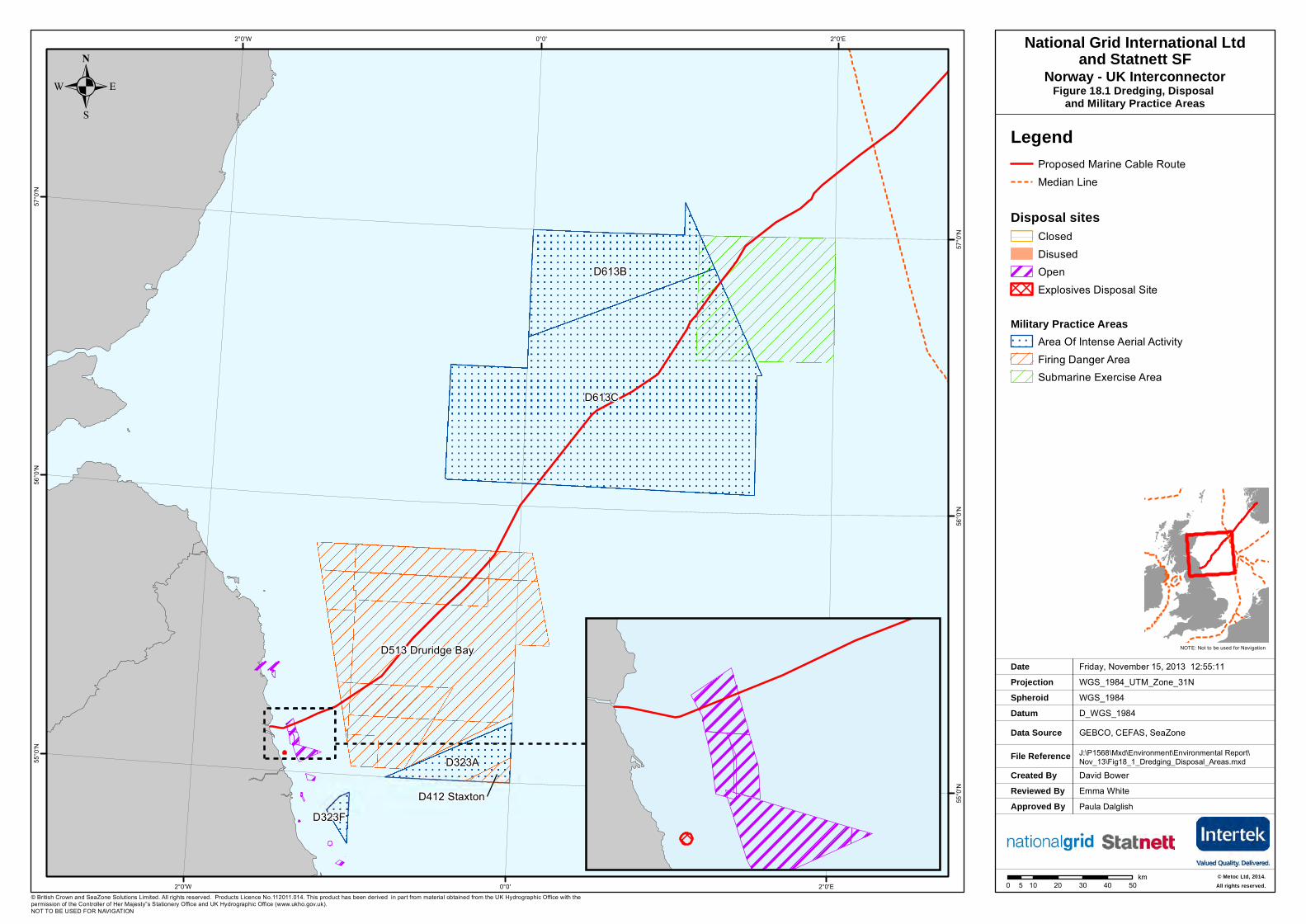
. Figure 18.1 Dredging, Disposal and Military Practice Areas
Created ByReviewed By
David BowerEmma White
Friday, November 15, 2013 12:55:11WGS_1984_UTM_Zone_31N
D_WGS_1984GEBCO, CEFAS, SeaZoneJ:\P1568\Mxd\Environment\Environmental Report\Nov_13\Fig18_1_Dredging_Disposal_Areas.mxd
WGS_1984
DateProjection
DatumData Source
File Reference
Spheroid
NOTE: Not to be used for Navigation
© British Crown and SeaZone Solutions Limited. All rights reserved. Products Licence No.112011.014. This product has been derived in part from material obtained from the UK Hydrographic Office with the permission of the Controller of Her Majesty‟s Stationery Office and UK Hydrographic Office (www.ukho.gov.uk). NOT TO BE USED FOR NAVIGATION
Approved By Paula Dalglish
D613C
D613B
D513 Druridge Bay
D323A
D323FD412 Staxton
2°0'E
2°0'E
0°0'
0°0'
2°0'W
2°0'W57
°0'N
57°0
'N
56°0
'N
56°0
'N
55°0
'N
55°0
'N
LegendProposed Marine Cable Route Median Line
Disposal sitesClosedDisusedOpenExplosives Disposal Site
Military Practice AreasArea Of Intense Aerial ActivityFiring Danger AreaSubmarine Exercise Area
0 10 20 30 40 505km
.National Grid International Ltd
and Statnett SFNorway - UK Interconnector
© Metoc Ltd, 2014.All rights reserved.