notice of preparation city dock no.1 marine research
TRANSCRIPT
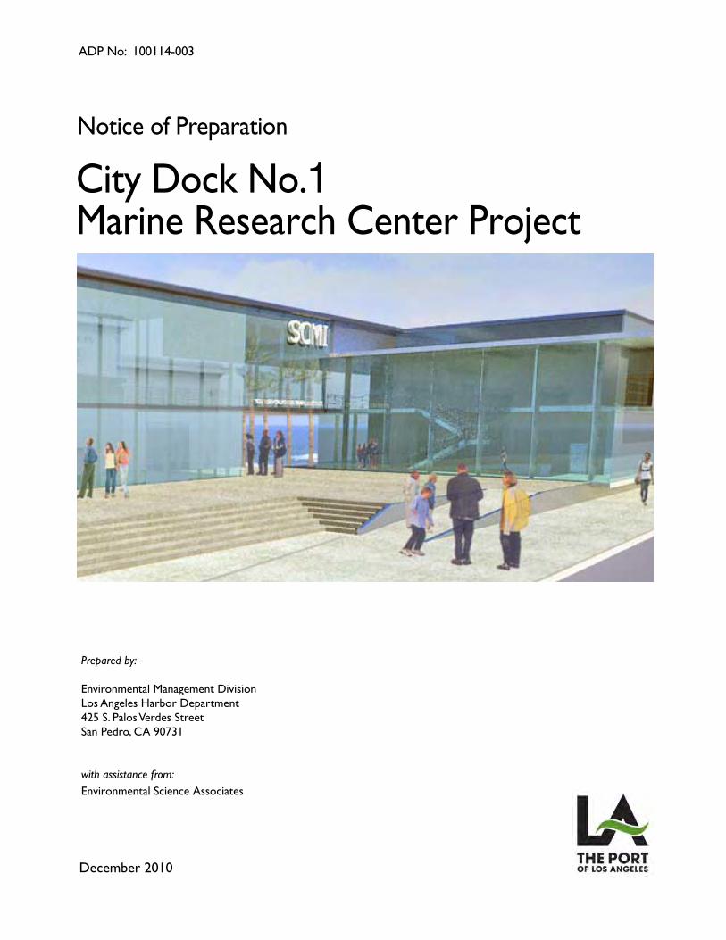
City Dock No.1Marine Research Center Project
Notice of Preparation
December 2010
Prepared by:
Environmental Management Division Los Angeles Harbor Department425 S. Palos Verdes StreetSan Pedro, CA 90731
with assistance from:Environmental Science Associates
ADP No: 100114-003
City Dock No.1Marine Research Center Project
Notice of Preparation
December 2010
Prepared by:
Environmental Management Division Los Angeles Harbor Department425 S. Palos Verdes StreetSan Pedro, CA 90731
with assistance from:Environmental Science Associates
ADP No: 100114-003
City Dock No. 1 Marine Research Center i December 2010
TABLE OF CONTENTS City Dock No. 1 Marine Research Center Notice of Preparation
Page 1.0 Project Overview and Background ............................................................................. 1
1.1 Project Overview ................................................................................................... 1 1.2 Project Background .............................................................................................. 2
2.0 Project Description ...................................................................................................... 2 2.1 Project Objectives ................................................................................................. 2 2.2 Project Location .................................................................................................... 3 2.3 Project Site ........................................................................................................... 3 2.4 Project Elements ................................................................................................. 10 2.5 Project Schedule ................................................................................................. 16
3.0 Project Alternatives ...................................................................................................... 16 3.1 Alternative 1 –No Project Alternative .................................................................. 16 3.2 Alternative 2 – Reduced Project Alternative ........................................................ 16 3.3 Alternative 3 – Building Demolition at Berths 57-60 ............................................ 17
4.0 CEQA Baseline .............................................................................................................. 18
Environmental Checklist .................................................................................................... 19 Aesthetics .................................................................................................................... 23 Agricultural and Forest Resources ............................................................................... 25 Air Quality .................................................................................................................... 28 Biological Resources ................................................................................................... 31 Cultural Resources ...................................................................................................... 35 Geology, Soils, and Seismicity ..................................................................................... 38 Greenhouse Gas Emissions ........................................................................................ 41 Hazards and Hazardous Materials ............................................................................... 42 Hydrology and Water Quality ....................................................................................... 45 Land Use and Land Use Planning ............................................................................... 50 Mineral Resources ....................................................................................................... 52 Noise ............................................................................................................................ 53 Population and Housing ............................................................................................... 56 Public Services ............................................................................................................ 57 Recreation ................................................................................................................... 59 Transportation and Traffic ............................................................................................ 60 Utilities and Service Systems ....................................................................................... 63 Mandatory Findings of Significance ............................................................................. 66
Notice of Preparation
City Dock No. 1 Marine Research Center ii December 2010
Page List of Figures Figure 1 Regional Location Map ...................................................................................... 5 Figure 2 Project Vicinity ................................................................................................... 6 Figure 3 Project Site ........................................................................................................ 7
List of Tables Table 1 Project Elements ............................................................................................. 11 Table 2 Alternative 2: Reduced Project Alternative ...................................................... 17 Table 3 Schools in the Vicinity of City Dock No. 1 Site ................................................. 30
City Dock No. 1 Marine Research Center 1 December 2010
CITY DOCK NO.1 MARINE RESEARCH CENTER Notice of Preparation
1.0 Project Overview and Background
1.1 Project Overview This Notice of Preparation (NOP) is to inform responsible and trustee agencies, public agencies, and the public that the Los Angeles Harbor Department (LAHD) is preparing an Environmental Impact Report (EIR) for the City Dock No. 1 Marine Research Center Project (proposed Project or City Dock No. 1 Project). The proposed Project site is located within the Port of Los Angeles (Port) boundaries at Berths 56-60 and 70-71. The City Dock No. 1 Marine Research Center Project EIR will be prepared pursuant to the California Environmental Quality Act (CEQA) and California Public Resources Code (PRC) Section 21000 et seq. LAHD seeks comments from agencies and the public regarding the scope and content of this EIR. For agencies, LAHD seeks comments regarding the scope and content of environmental information that is relevant to each agency’s statutory responsibilities in connection with the EIR and the various actions and activities to be evaluated in the EIR. The LAHD has prepared, as part of this NOP, an Environmental Checklist for the EIR determination in accordance with current City of Los Angeles Guidelines for the Implementation of the California Environmental Quality Act of 1970 (Article I): the State CEQA Guidelines (Title 14, California Code of Regulations); and the California Public Resources Code (Section 21000, et seq.). The Environmental Checklist is attached to this NOP for public review and comment.
LAHD is chartered to develop and operate the Port of Los Angeles (Port) under the California Tidelands Trust Act of 1911, the Los Angeles City Charter (Article VI, Section 601) and the California Coastal Act (Public Resources Code PRC Division 20, Section 30700, et seq.). LAHD leases Port property to over 300 tenants who operate their own facilities.
The Port encompasses 7,500 acres and 43 miles of waterfront and provides a major gateway for international goods and services. With 27 major cargo terminals, including dry and liquid bulk, container, breakbulk, automobile and omni facilities, the Port handles almost 190 million metric revenue tons of cargo per year. In addition to cargo business operations, the Port is home to commercial fishing operations, shipyards, and boat repair yards, as well as recreational, community, and educational facilities.
The City Dock No. 1 Project site lies within the San Pedro Waterfront Plan area which generally encompasses approximately 400 acres along the west side of the Los Angeles Harbor’s Main
Notice of Preparation
City Dock No. 1 Marine Research Center 2 December 2010
Channel, from the Vincent Thomas Bridge to Cabrillo Beach, adjacent to the City of Los Angeles community of San Pedro.
Specifically, the proposed Project is located at Berths 56 through 60 and Berths 70 and 71. Berth 56 currently hosts a field office and vessel berth for the California Department of Fish and Game. Berths 57 through 60 are currently or were formerly in use for warehouse operations, and Berths 70 and 71 are part of the Westway Terminal site, formerly used for liquid bulk storage.
The San Pedro Waterfront Project EIS/EIR (2009) certified by the Los Angeles Board of Harbor Commissioners on September 29, 2009 included a programmatic analysis of the potential impacts of the proposed Project. This EIR examines the project-specific impacts of the proposed Project. Selected information and analysis is utilized from the San Pedro Waterfront Project EIS/EIR.
1.2 Project Background With the creation of the San Pedro Waterfront Project, the Port demonstrated its commitment to improving the compatibility of its operations and activities with the neighboring communities of San Pedro and Wilmington and to place community concerns about the environment and quality of life at the forefront of its land use policy and development decisions. As part of this commitment, the Port is removing heavy industrial uses from the project area while increasing public access along the waterfront and enhancing connectivity between nearby communities and the Port. The proposed Project, which would convert the Project site to marine research, public education, and institutional and commercial uses, would further the Port’s mission in this regard.
Reuse of the City Dock No. 1 Project site for marine science research and development and related institutional uses was considered at a programmatic level in the certified San Pedro Waterfront Project EIS/EIR (2009). In 2007 the Port, with funding from the Annenberg Foundation, initiated a visioning process with the Southern California Marine Institute (SCMI) to explore the creation of a marine research center at City Dock No. 1. This work resulted in the preparation of a visioning study that was completed in March 2009. Since development of the visioning study, the Port and SCMI have been working together to develop a plan to create a marine research center that can provide facilities for a cluster of university researchers, educational programs, and spin-off marine science technology ventures. The proposed Project is a result of this joint effort.
2.0 Project Description
2.1 Project Objectives The proposed Project would provide a world-class marine research center to support the research needs of the region’s universities, research and educational institutions, and government agencies, as well as to provide an incubator for marine-related business venues. Specifically, the proposed Project would:
Provide a location at Berths 56-60 and 70-71 for marine researchers in Southern California with world-class facilities including laboratories, offices, classrooms, a lecture

Notice of Preparation
City Dock No. 1 Marine Research Center 3 December 2010
hall/auditorium and storage space to conduct marine research, including, the study of global climate change and its related phenomena, fisheries, marine resource conservation and management, and other related marine science applications.
Provide an opportunity for SCMI and its members, government and other institutional researchers and research organizations to berth research vessels that range in size from small vessels to large 250- to 300-foot vessels at the proposed Project site.
Provide public amenities, including public education classroom space and interpretive exhibits related to marine studies, along with a continuous waterfront promenade as approved in the San Pedro Waterfront Project.
Replace existing SCMI facilities now located at Berth 260 in Fish Harbor with a location that allows for an expanded and upgraded SCMI facility in the Los Angeles Harbor to address SCMI’s desire for increased research laboratory space with a sea water circulation system, access to deep draft docks to accommodate research vessels, and teaching space.
Construct the world’s largest wave tank using seawater to allow scientists from around the world to study tsunamis, rouge waves, and the generation of wave energy.
Provide a location for a marine-related business incubator park for synergy among research and commercial interests, such uses as aquaculture, sustainable energy production, and marine exploration.
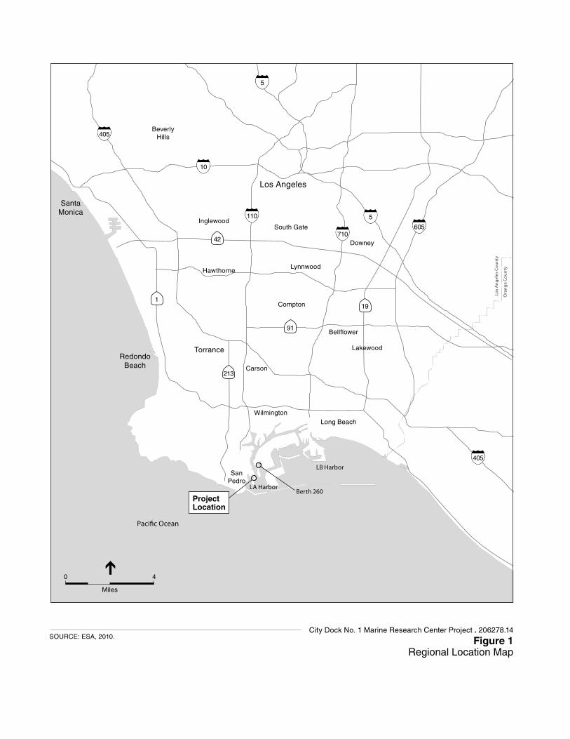
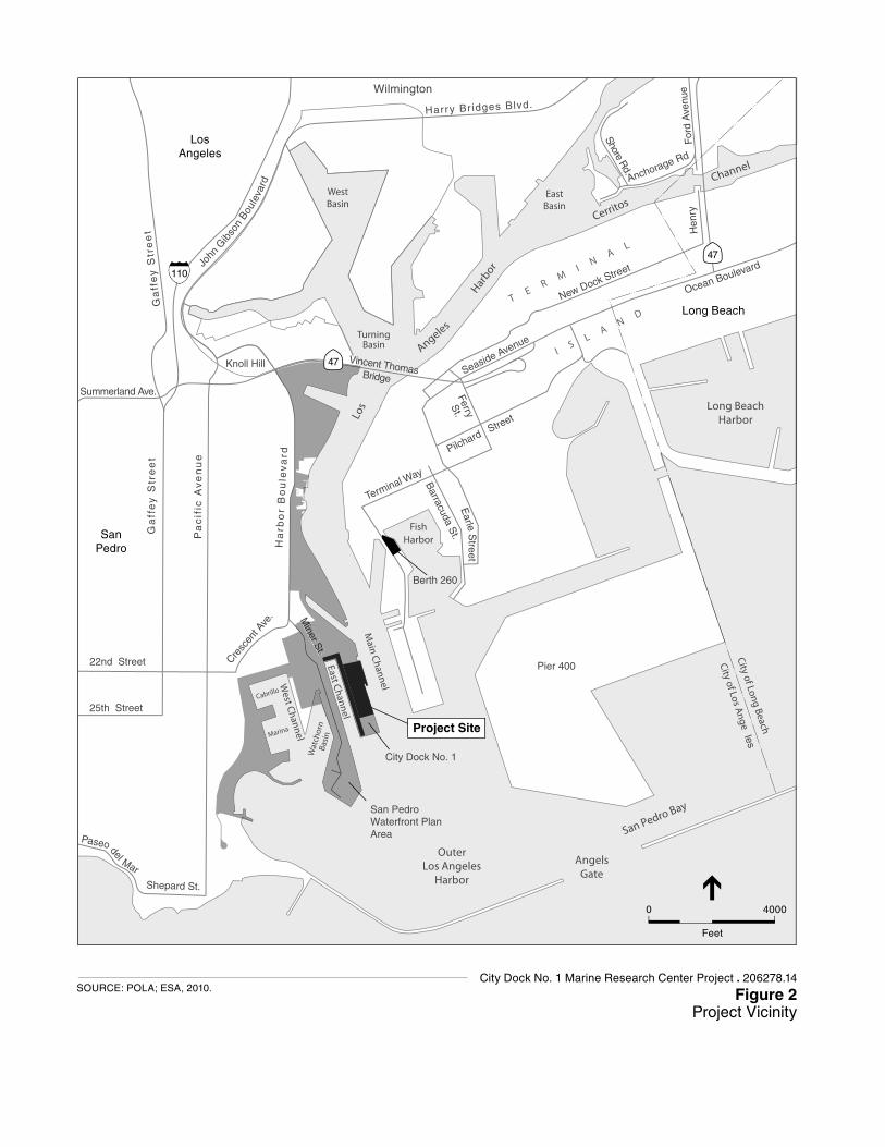
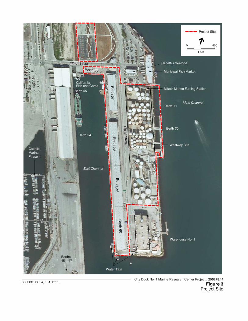
2.2 Project Location The proposed Project site is located within the San Pedro Waterfront Plan area, which encompasses approximately 400 acres along the western boundary of the Port, adjacent to the community of San Pedro. Project activity will be focused on City Dock No. 1, which encompasses approximately 28 acres and is bounded by the Main Channel on the east, the East Channel on the west, East 22nd Street to the north and Los Angeles Harbor to the south. The project site contains Berths 70 through 71 (the Westway Terminal site); Berth 56; Berth 57; Berths 58 through 60; and a water taxi service located beyond Berth 60 at the end of City Dock No. 1. Warehouse No. 1 is adjacent to the project site. See Figure 1 for the regional location, Figure 2 for a project vicinity map, and Figure 3 for the project site and surrounding features.
2.3 Project Site
Existing Conditions
Berth 56 contains a parking lot and a small building occupied by the California Department of Fish and Game (CDFG). Berth 57 and Berths 58 through 60 each contain a transit shed, which have been occupied by Crescent Warehouse Company (Crescent). Crescent, which has consolidated its operations into B.57, uses the warehouse space primarily to store hay and cotton that come from various locations throughout the western United States. Crescent then ships the materials to China and other primarily Asian countries. Berths 70 through 71 are occupied by defunct liquid bulk storage tanks that were formerly used by Westway Terminals, a historic pumping station, and an office building. The office building is currently in use by Crescent.

Notice of Preparation
City Dock No. 1 Marine Research Center 4 December 2010
Berths 56-60
Berth 56
Berth 56 has a 1,600 square foot building, currently occupied by the California Department of Fish and Game, with a parking lot of approximately 16 spaces. The remaining area on Berth 56, measuring approximately .65 acres is currently vacant.
Berth 56 Building Historic Resources Determination. The Pan-Am Terminal Facility Building at Berth 56, currently occupied by California Fish and Game, was built in 1930 and was moved to its current location in 1940. The building has been determined eligible for listing on the National Register of Historic Places (NRHP) under Criterion A, which states that sites that are associated with events that have made a significant contribution to the broad pattern of our history are eligible for NRHP listing (ICF Jones & Stokes, 2008). The building was also determined to be eligible for listing in the California Register of Historical Resources (CRHR).
Berth 57 Transit Shed
The transit shed at Berth 57 is a single-story steel-frame structure built in the mid-1920s. This 500 foot-long wood-framed rectangular building is approximately 93 feet wide and 25 feet in height. Clad in corrugated metal, this transit shed includes a loading dock that spans the full horizontal length of the north side of the building. The building also contains a 3,640-square foot wood frame facade on the north side of the building (facing East 22nd Street) that is not part of the original construction, but was added in 1933. A structural assessment conducted by the Port for the building concluded that the roof and siding appear to be in good condition with some corrosion (Port of Los Angeles, 2002). However, the steel rolling doors that provide access to the loading dock are unstable to lateral forces due to the absence of bracing elements. In addition, the building lacks solid connections between some of its columns and the roof trusses, and there is some evidence of corrosion in some of the steel columns. This transit shed is now used to store hay for Crescent.
Berth 57 Transit Shed Historic Resources Determination. Based on the results of an Architectural Survey and Evaluation commissioned by the Port, the transit shed at Berth 57 (Transit Shed 57) has been determined to meet the National Register of Historic Places (NRHP) Criterion A, which states that sites that are associated with events that have made a significant contribution to the broad pattern of our history are eligible for NRHP listing (ICF Jones & Stokes, 2008). Transit Shed 57 was also determined to be eligible for listing in the California Register of Historical Resources (CRHR) and the City of Los Angeles Historic-Cultural Monument database (ICF Jones & Stokes, 2008).
Berths 57 – 60 Wharf
Recent Port engineering studies have shown that the slope and wharf structure over which the transit sheds at Berth 57 and Berths 58-60 are built are badly deteriorated and require extensive stabilization, retrofitting, and replacement. The original wharf structure was built in 1913 and an apron wharf was added in 1938. Both structures are potentially historic and a historic resources assessment of the wharves will be conducted as part of the special studies performed to support the Draft EIR.
Pacific Ocean
5
5
405
10
110
710605
405
1
42
19
91
213
Project Location
Berth 260
Los Angeles
BeverlyHills
Inglewood
Hawthorne
Compton
Bellflower
Lakewood
Carson
Wilmington
SanPedro
LB Harbor
LA Harbor
South Gate
Lynnwood
Downey
SantaMonica
RedondoBeach
Torrance
Long Beach
Los
Ang
eles
Cou
nty
Ora
nge
Coun
ty
0 4
Miles
City Dock No. 1 Marine Research Center Project . 206278.14
Figure 1Regional Location Map
SOURCE: ESA, 2010.
Wilmington
TurningBasin
East Channel
West Channel
Main Channel
Harbor
Angeles
Los
Cerritos
Channel
FishHarbor
Wat
chor
nBa
sin
TE
RM
I NA
L
I SL
AN
D
City of Long Beach
City of Los Angeles
Terminal Way
Harry Br idges Blvd.
FerryS
t.
Cabrillo
Marina
New Dock Street
Earle
Barracuda S
t.
22nd Street Cresc
ent A
ve.
25th Street
Miner S
t.
Pilchard Street
del
Paseo
Mar
Shepard St.
Seaside Avenue
Ga
ffe
y S
tre
et
vel
uo
B ro
bra
Ha
rdeu
ne
vA
cific
aP
te
ertS
yeff
aG
Summerland Ave.
Hen
ryF
ord
Ave
nue
Anchorage Rd
John
Gib
son
Boule
vard
teer
tS
Ocean Boulevard
Knoll Hill
Shore Rd.
Pier 400
Long BeachHarbor
EastBasin
WestBasin
Miner S
t.
San Pedro Bay
AngelsGate
OuterLos Angeles
Harbor
47
47
110
Vincent ThomasBridge
Project Site
City Dock No. 1
San Pedro Waterfront Plan Area
Berth 260
SanPedro
LosAngeles
Long Beach
Figure 2Project Vicinity
SOURCE: POLA; ESA, 2010.
0 4000
Feet
City Dock No. 1 Marine Research Center Project . 206278.14
Berth 56
East Channel
Main Channel
22nd Street22nd Street
Signal S
treetS
ignal Street
Signal S
treet
Berth 57
Berth 58
Berth 59
Berth 60
Westway SiteCabrilloMarinaPhase II
Municipal Fish Market
Mike’s Marine Fueling Station
Canetti’s Seafood
California Fish and Game
Warehouse No. 1
Water Taxi
Project Site
Berth 56
Berths 45 – 47
Berth 55
Berth 54
Berth 71
Berth 70
Figure 3Project Site
SOURCE: POLA; ESA, 2010.
0 400
Feet
City Dock No. 1 Marine Research Center Project . 206278.14

Notice of Preparation
City Dock No. 1 Marine Research Center 8 December 2010
Berths 58-60 Transit Shed. The transit shed at Berths 58 through 60 (Transit Shed 58-60) is a single-story steel-frame structure built in the 1910s. This large rectangular building measures 1,800 feet long by 100 feet wide and is approximately 35 feet in height, and includes a loading dock that spans the full horizontal length of the building. The warehouse is sided with corrugated metal siding. A structural assessment for the building has concluded that it is in good to fair condition with signs of deterioration similar to those noted for the Transit Shed 57.
Berths 58 through 60 Historic Resources Determination. Based on the results of an Architectural Survey and Evaluation commissioned by the Port, the Transit Shed 58-60 has been determined to meet NRHP Criterion A, which states that sites that are associated with events that have made a significant contribution to the broad pattern of our history are eligible for NRHP listing (ICF Jones & Stokes, 2008). Transit Shed 58-60 also meets NRHP Criterion C for sites that embody distinctive characteristics of a type, period, or method of construction. Transit Shed 58- 60 was also determined to be eligible for listing in the CRHR and the City of Los Angeles Historic-Cultural Monument database (ICF Jones and Stokes, 2008).
Water Taxi. A water taxi service is located at the southwestern corner of Berth 60. The water taxi service maintains an office, a small maintenance shed, some storage areas for supplies, and a fleet of approximately five vessels. This service transports supplies and materials to ships anchored outside the Breakwater.
Berth 70-71 Liquid Bulk Storage Tanks (WestwayTerminal)
The Westway Terminal occupies a large portion of the south side of the dock at Berths 70–71 along the Main Channel (east) and along Signal Street (west), and occupies a total area of approximately 14.3 acres. The site includes liquid bulk storage tanks, associated pipelines and infrastructure, and the Westway Terminal Building, also known as the Pan American Petroleum Company Marine Loading Station Facility and the Pan American Oil Company Pump House. The Westway Terminal Building has been recommended eligible for the listing on the NRHP, and would be maintained as part of the proposed Project. In 1996, GATX sold the facility to Westway Terminal Company. The Westway Terminal has approximately 134 above ground storage tanks. When in operation, the terminal was served by rail, truck, and ship and handled oils, lubricant base, fuel additives, glycols, ketones, acetates, and phthalates. Considered a hazardous cargo facility under the Port’s Risk Management Plan (RMP), this facility closed in 2009. As a part of the approved San Pedro Waterfront Project (September 2009), LAHD will demolish the site infrastructure. Remediation activities will be conducted under the oversight of the Los Angeles Regional Water Quality Control Board. Demolition of this site is considered a related project for analysis purposes in this EIR.
Project Site Contamination at Berths 70 and 71
In 2003, an investigation was conducted by the Port to characterize the subsurface contamination and in 2008, an investigation was conducted to perform additional subsurface sampling, including sediment. There have been six (6) reported releases onsite between 1989 and 2007 involving the release of methanol, Neutral 100 Lube Oil, 1,1,1-trichloroethane (1,1,1-TCA), tetrahydrofuran, PCE, and caustic sodium hydroxide.
Notice of Preparation
City Dock No. 1 Marine Research Center 9 December 2010
The subsurface soil, soil vapor, groundwater, and sediment have been impacted by the historical operations of GATX and Westway. There are several plumes of petroleum hydrocarbons and volatile organic compounds in the subsurface, which have comingled over time. Primarily chemicals of concern onsite include: tetrachloroethene, trichloroethene, cis-1,2-dichloroethene, trans-1,2-dichloroethene, vinyl chloride, 1,4-dioxane, 1,1-dichloroethane, and gasoline-range petroleum hydrocarbons, and diesel range petroleum hydrocarbons. In addition, there are several areas with free phase product petroleum, light non-aqueous phase product, as well as free-phase chlorinated solvents, and dense-non-aqueous phase product. The sediment has been impacted by chlorinated solvents.
A remediation strategy will be developed under the oversight of the Regional Water Quality Control Board. Completion of a full site characterization study, remedial action design, and an evaluation of future land use restrictions will occur after demolition of the above ground storage tanks.
Existing SCMI Facility
SCMI is an organization with four major partners: the Ocean Studies Institute of the California State Universities (CSU), representing eight CSUs in Southern California; the University of Southern California (USC); the University of California Los Angeles (UCLA); and Occidental College. SCMI currently subleases and occupies a 1.32-acre site at 820 South Seaside Avenue on Terminal Island at Berth 260. The site consists of two noncontiguous parcels separated by a building operated by the Los Angeles Port Police. The northern side of the site includes a 19,000-square-foot building that was built in 1983 by USC (the building is still owned by USC), which contains offices, laboratories, classrooms, a circulating seawater system, storage, an inside water tank, meeting space and warehouse space. The site also includes a small parking lot and dock space at which approximately seven vessels dock. The southern side of the site is occupied by a machine shop, warehouse space, and an open storage yard.
SCMI has determined that this facility is inadequate to meet its needs. SCMI has indicated that the facility is too small, lacks sufficient parking, and the site abuts Fish Harbor, which at times exhibits water quality that is below research standards. In addition, the SCMI site is surrounded by industrial uses such as fish processing facilities.
The current SCMI facility accommodates approximately 25 researchers and staff, although this number was nearly 30 percent higher prior to the economic recession. SCMI operates as the shoreside support facility for USC’s Wrigley Marine Science Center on Catalina Island and experiences the constant flow of personnel and students traveling to and from that offshore facility. Once used by Los Angeles Unified School District students, visitation to the existing SCMI facility is currently generally limited to groups of 40 to 50 students passing through several times a semester on their way to attend 4- to 15-week teaching classes on Santa Catalina Island at the USC Wrigley Center.
Notice of Preparation
City Dock No. 1 Marine Research Center 10 December 2010
Surrounding Uses
As noted above, the proposed Project site is surrounded on the west by the East Channel and on the east by the Los Angeles Harbor. Just south of the Westway Terminal are the Port of Los Angeles Pilot Station and Warehouse No. 1, which provides warehouse space for the Port and Crescent and is occasionally used for filming. Warehouse No. 1 is considered a prominent visual resource for ships entering the deep water channel as well as for the residents of San Pedro. The massive six-story Warehouse No.1 was listed on the NRHP in April 2000, and is currently unoccupied.
Other adjacent businesses include Mike’s Marine Fueling Station, a municipal fish market, and Canetti’s Seafood Grotto. More warehouse space is located across the East Channel from City Dock No. 1 in transit sheds at Berths 54 and 55, including fruit storage space for Stevedoring Services of America (SSA), the Cabrillo Way Marina Phase II, future cruise facilities at Berths 45 through 47 and 49 through 50, and public park space.
2.4 Project Elements The proposed Project involves the following major project elements:
Relocation of SCMI from its existing location at B. 260 on Terminal Island to Berth 56 and 57.
Adaptive reuse of the transit sheds at Berths 57 - 60 to accommodate research, teaching, and meeting spaces within a collaborative environment to create research synergies among universities and colleges offering marine science programs. Wharf retrofits of Berths 57-60 and related infrastructure improvements would occur.
Establishment of a marine science business park/incubator space with offices and research lab space within Berths 59-60 Transit Sheds.
Remediation and development of Berths 70 and 71, following the demolition the existing Westway Terminal site. This development would include the construction of a new building for NOAA operations, the use of existing berthing space for research vessels, and the construction of a new building to host “the largest wave tank facility in the world.”
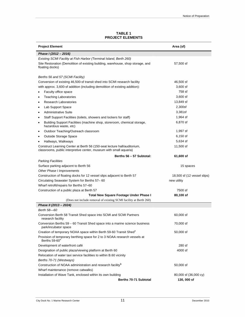
Table 1 provides a summary of the project components.
Notice of Preparation
City Dock No. 1 Marine Research Center 11 December 2010
TABLE 1PROJECT ELEMENTS
Project Element Area (sf)
Phase I (2012 – 2016)
Existing SCMI Facility at Fish Harbor (Terminal Island, Berth 260)
Site Restoration (Demolition of existing building, warehouse, shop storage, and floating docks)
57,500 sf
Berths 56 and 57 (SCMI Facility)
Conversion of existing 46,500-sf transit shed into SCMI research facility
with approx. 3,600-sf addition (including demolition of existing addition):
46,500 sf
3,600 sf
Faculty office space 758 sf
Teaching Laboratories 3,600 sf
Research Laboratories 13,849 sf
Lab Support Space 2,300sf
Administrative Suite 3,381sf
Staff Support Facilities (toilets, showers and lockers for staff) 1,964 sf
Building Support Facilities (machine shop, storeroom, chemical storage, hazardous waste, etc)
6,870 sf
Outdoor Teaching/Outreach classroom 1,997 sf
Outside Storage Space 6,150 sf
Hallways, Walkways 5,634 sf
Construct Learning Center at Berth 56 (150-seat lecture hall/auditorium, classrooms, public interpretive center, museum with small aquaria)
11,500 sf
Berths 56 – 57 Subtotal: 61,600 sf
Parking Facilities
Surface parking adjacent to Berth 56 15 spaces
Other Phase I Improvements
Construction of floating docks for 12 vessel slips adjacent to Berth 57 18,500 sf (12 vessel slips)
Circulating Seawater System for Berths 57– 60 new utility
Wharf retrofit/repairs for Berths 57–60
Construction of a public plaza at Berth 57 7500 sf
Total New Square Footage Under Phase I
(Does not include removal of existing SCMI facility at Berth 260)
80,100 sf
Phase II (2013 – 2024)
Berth 58—60
Conversion Berth 58 Transit Shed space into SCMI and SCMI Partners research facility
60,000 sf
Conversion Berths 59 – 60 Transit Shed space into a marine science business park/incubator space
70,000 sf
Creation of temporary NOAA space within Berth 59-60 Transit Sheda 50,000 sf
Provision of temporary berthing space for 2 to 3 NOAA research vessels at Berths 59-60a
Development of waterfront café 280 sf
Designation of public plaza/viewing platform at Berth 60 4000 sf
Relocation of water taxi service facilities to within B.60 vicinity
Berths 70-71 (Westways)
Construction of NOAA administration and research facilityb 50,000 sf
Wharf maintenance (remove catwalks)
Installation of Wave Tank, enclosed within its own building 80,000 sf (36,000 cy)
Berths 70-71 Subtotal 130, 000 sf

Notice of Preparation
City Dock No. 1 Marine Research Center 12 December 2010
TABLE 1PROJECT ELEMENTS
Project Element Area (sf)
Signal Street Improvementsc
Repaving and restriping
Diagonal parking 195 spaces
Removal of existing heavy rail line from street 8,000 square feet of disturbance
Total New Square Footage Under Phase II 314,280 sf
Total New Square Footage for Proposed Project 394,380 sf
Parking Facilities
Berth 56 Surface Parking 15 spaces
Minor Street Diagonal Parking 195 spaces
Sampson Way and 22nd Street Existing Parking Lot 409 spaces
Total Parking Spaces 619 spaces
a NOAA facilities, including office and research space within Berths 58-60 Transit Shed and berthing space at Berths 58-60 to be relocated to Berths 70-71 when remediation of those berths has been completed.
b Demolition of the Westways tanks, piping and related structures at Berths 70-71 has been analyzed under the San Pedro Waterfront EIS/EIR and is not considered a component of the proposed Project.
c Impacts associated with extension of Red Car Line construction and expansion of waterfront promenade were considered under the San Pedro Waterfront EIR and are not considered components of the proposed Project.
SOURCE: Port of Los Angeles, City Dock Marine Research Center Project Elements and Phasing, Draft September 15, 2010.
Phase I
Berths 56 and 57 Improvements
Phase I would include the conversion of Berths 56 and 57 into a new SCMI facility. In order to achieve this, construction would involve first upgrading the adjacent wharf to current seismic code. Upon completion of the wharf retrofit, work would begin on upgrading and expanding the existing 46,500-square-foot Berth 57 Transit Shed to current seismic and occupancy codes. Phase I would also include the demolition of an existing 1933 wood-frame structure to allow construction of a new 3,600-square-foot glazed entryway that would provide space for a public education facility to be operated by SCMI; thus, total square footage for programs at Berth 57 would equal approximately 51,600 square feet upon completion of the proposed Project. The new 3,600-square-foot structure would comprise a contemporary, neutral and visually prominent entrance into SCMI facility, distinct from the existing historic transit shed façade. This new façade may include large glass aquaria at the entrance way. The new 3,600-square-foot façade would reflect the same general shape and profile as the transit shed in height and massing and would include an area for public education and outreach. The remainder of Berth 57 would be utilized for research laboratories, lecture and classroom spaces, and storage for use by SCMI.
The existing Berth 57 Transit Shed would require extensive renovations for occupancy by SCMI to convert it from warehouse use to its proposed new uses for research, education, office and laboratory. In addition, all renovations would be required to conform to the Secretary of the Interior’s Standards for Rehabilitation (the Secretary’s Standards). Due to the minimal nature of the existing structure (without insulation), the existing transit sheds would primarily serve as an
Notice of Preparation
City Dock No. 1 Marine Research Center 13 December 2010
“outer shell building” to provide basic shelter from water, and wind and sun. The proposed SCMI facility would be in essence, a self-contained structure within the existing envelope of the transit shed. Therefore, maintenance of the historic integrity of Berth 57 would be maintained and at the same time adaptively re-used to integrate state of the art fire/ life safety protection, seismic resistance, security features and utility infrastructure that are required due to its change in use. Certain portions of the transit shed space would be left open and not included in the “building within a building” to allow for large-scale equipment and staging to be conducted within the warehouse but not within the interior building envelope. The exterior of the transit sheds would largely be maintained with the exception of necessary improvements to the siding, roof, cornices, etc.
Repair, retrofit, and rehabilitation of the transit shed to address structural deficiencies is expected to be additive and easily accessed since all structural elements are exposed. These include repair of rusted exterior corrugated metal siding with new panels, upgraded structural connections to meet established seismic and wind load resistance, retrofit large openings (east and west facades) to ensure stability, and water tight openings, sandblast and repaint corroded steel members and gusset plates, and replacing deteriorated and damaged steel members, as required. In addition, it is anticipated that new traverse and longitudinal frames would be added, interior steel columns repaired, and new concrete encasements around the base of each column constructed. Installation of a continuous perimeter foundation wall, limited to shallow (two to three feet maximum) excavations to inhibit water intrusion at the building perimeter and utility placement may be required.
Berth 56 improvements under Phase I would include construction of an 11,500 square-foot Learning Center. This center would include a 1,059 square-foot museum, two 30-seat classrooms and one 60-seat classroom, a 515 square-foot bathroom, and a 150-seat auditorium that would feature theater-style seating. A small 15-space surface parking area would be located adjacent to the auditorium. The existing building and associated parking operated by California Fish and Game would remain in place.
Upon completion of the conversion of Berth 57 into new SCMI space, the existing SCMI building and parking lot at Fish Harbor on Terminal Island would be vacated. The building would be demolished and the site graded as required by the LAHD’s agreement with USC. Any future development associated with this site would not be covered in the Draft EIR and would be subject to separate environmental review in accordance with CEQA.
It is anticipated that SCMI researchers and staff could increase to as much as 100 over the next few years. In addition, visitation to the facility by students and other interested parties would be expected to increase.
Also under Phase I, an 18,480-square-foot, 12-slip floating dock would be installed in the East Channel adjacent to Berth 57 to accommodate existing small SCMI research vessels and to allow sufficient capacity for additional small research vessels.

Notice of Preparation
City Dock No. 1 Marine Research Center 14 December 2010
Aquaculture
The research organizations that would occupy the proposed marine institution would require space for aquaculture and hatchery operations for their ongoing research, particularly research related to propagation of safe and sustainable seafood. This space would be accommodated through the use of water tanks housed within the laboratories. Aquaculture-related activities could include raising spotted sea bass, abalone, oysters, mussels, and kelp. Hatchery activities would begin in existing laboratories within the Berth 57 transit sheds. Grow out operations could occur in landside tanks as well or in the open ocean. The infrastructure for the aquaculture program would be constructed during Phase I and operations could commence after its completion. In all likelihood, more expansive aquaculture facilities would be planned for Phase II in Berths 58 and 60. Basic research as well as aquaculture operations would require constructing a large capacity, state of the art, circulating seawater system with both flow through and re-circulating capabilities to serve the entire dockside research complex (Berths 57, 58, 59, and 60 and Berths 70-71).
Support Structures
Ancillary support structures for SCMI operations would also be constructed during Phase I, including the circulating seawater system and berthing space. At first, the system would only serve Berth 57, but it would be designed with enough capacity to ultimately serve Berths 58 through 60 and Berths 70-71 once they are completed in Phase II (see below).
Waterfront Promenade
The San Pedro Waterfront Project EIS/EIR (POLA, 2009) assessed the construction of a continuous waterfront pedestrian promenade throughout the project site. Extending the promenade through a marine laboratory facility could pose special challenges because the waterfront would be utilized for vessel loading on a routine basis by forklifts, cranes, and other heavy equipment at unpredictable intervals. The promenade would be constructed along the edge of the wharf in such a manner as to maintain public access without creating a safety hazard or otherwise unduly impeding the work that is necessary at a marine laboratory. As such, as part of the proposed Project, the proposed location of the promenade would be located along E. 22nd Street, Signal Street, and along the existing wharf that runs the perimeter of City Dock No. 1.
Phase II
Berths 58 - 60
Under Phase II, Berth 58 would be converted into approximately 60,430 square feet of marine research/laboratory/office space for use by SCMI. Berths 59–60 would be retrofitted to accommodate up to 70,000 square feet of future research and/or marine-related business incubator space, or other similar institution, as well as a waterfront café and a public plaza. An additional 50,000 square feet of space would be constructed for temporary use by NOAA as well as temporary berthing space for two to three research vessels, which would be relocated to Berth 70 when docking space is available.
Notice of Preparation
City Dock No. 1 Marine Research Center 15 December 2010
In order to achieve the conversion of Berths 58 through 60, construction would first involve upgrading the wharf to current seismic code (see Section 2.4, above). Upon completion of the wharf, next steps would involve upgrading and expanding the existing 180,000 square-foot Transit Shed 58-60 to current seismic code, as well as renovating the building in conformance with the Secretary of the Interior’s standards for buildings eligible for or listed on the National Register of Historic Places. Conversion of Berths 58 through 60 would occur much as it would for Berth 57 in that tenant improvements would be constructed within the envelope of the existing warehouses. In addition, the south end of Berth 60 would be developed to accommodate a public viewing area due to the views it affords of the Main Channel and the harbor entrance, including development of a waterfront café and a viewing platform. Under the proposed Project, the water taxi service would remain but the maintenance operations would be relocated within the general vicinity of Berth 60 to better accommodate the public space.
Prior to commencement of the proposed project, the existing occupants, the Crescent Warehouse Company, would relocate their operations from this location to another site which is currently unknown at this time but will be further addressed in the Draft EIR.
Berths 70 and 71 (Westway Terminal)
Under the proposed Project, the Westway Terminal would be remediated under the oversight of the Los Angeles Regional Water Quality Control Board and would then be developed with a 50,000-square-foot facility for NOAA that would include office and laboratory space. The Westway Terminal Administration Building (also known as the Pan-American Oil Company Pump House) would be adaptively reused by a future occupant. In addition, Berths 70 and 71 along the Main Channel would be made available for up to three potential NOAA vessels ranging in size from approximately 170 feet to 250 feet. There are no plans to relocate current vessels in the NOAA fleet to the project site, but there is a possibility that future built vessels could be located at the Project Site, which therefore must be prepared to accommodate these or other non-NOAA vessels. Furthermore, full functioning of the site will include the regular docking of NOAA vessels home-ported in other locations but passing through Los Angeles as part of research expeditions.
Redevelopment of Berths 70 and 71 would also involve development of an 80,000-square-foot wave tank on the land side, which would be enclosed within its own building. The wave tank would use seawater pumped from the adjacent Main Channel and will measure 200 feet by 400 feet by 12 ft deep, totaling 36,000 cubic yards.
Signal Street Improvements
Signal Street would be repaved and realigned as part of the proposed Project. As part of the realignment of Signal Street, a total of approximately 195 diagonal parking spaces would be provided along one side of Signal Street. In addition, the existing heavy rail tracks that are embedded within Signal Street would be removed (approximately 8,000 lineal feet) and the area that is disturbed during the rail removal would be repaved. After removal of the heavy rail tracks, the Waterfront Red Car line would be extended along Signal Street to Warehouse No. 1.
Notice of Preparation
City Dock No. 1 Marine Research Center 16 December 2010
Waterfront Promenade
The public promenade extending around the Berths 58-60 transit sheds would be constructed during Phase II.
2.5 Project Schedule The proposed Project would be completed in two phases. The proposed Project is anticipated to commence construction in the third quarter of 2012. Phase I would be completed by 2016. Phase II would consist of the conversion of Berths 58 through 60 and Berths 70 through 71 and would be completed by 2024. Table 2.5-1 provides the anticipated timeline for each phase of the proposed Project and the Project components that would be completed in each phase.
3.0 Project Alternatives
The Draft EIR will include analysis of alternatives to the proposed Project. Among the alternatives being considered are:
3.1 Alternative 1 – No Project Alternative Under this alternative, the proposed Project would not be constructed. Berths 57 through 60 would continue to be used for warehousing space by Crescent; these berths would not be converted to a marine research center, and wharf repair and transit shed repairs would not occur. SCMI would continue to operate the 19,000-square-foot facility in Fish Harbor and continue to face the inadequate space and conditions required for their research. Berth 56 would continue to existing uses, which include the use of a small building by CDFG and surface parking.
As part of a related action (and not part of the proposed Project), the Westway Terminal liquid bulk storage tanks would be removed and Berths 70 and 71 would subsequently be remediated. With the exception of the existing historic Westway/Pan-American Oil Company Pump House, which would remain and the existing office building, Berths 70 and 71 would otherwise remain vacant indefinitely after remediation under this alternative until new development plans could be established. In addition, as part of implementation of the San Pedro Waterfront Project, the proposed waterfront promenade would also be constructed under this alternative.
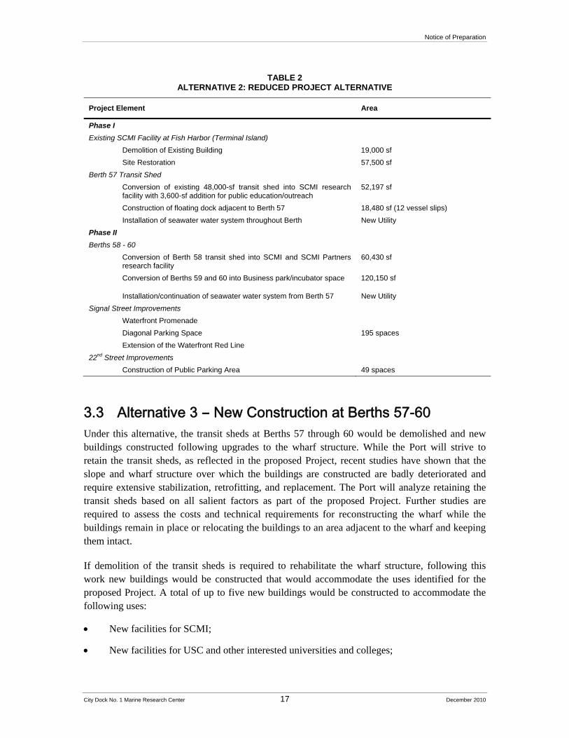
3.2 Alternative 2 – Reduced Project Alternative Under this alternative, only Berths 57-60 would be developed into marine research space to be occupied by SCMI, USC and their partner organizations, and repairs, rehabilitation and upgrades would be made to Berth 57 and Berths 58-60 as specified under Section 2.4, above. This alternative would not include the auditorium at Berth 56 . The Westway site (Berths 70 and 71) would still be demolished and remediated as a separate project, but development of Berths 70 and 71, including the NOAA facilities, the business park/incubator space, and installation of the wave tank, would not occur. The waterfront promenade would be constructed within City Dock No. 1 as part of implementation of the San Pedro Waterfront Plan. Table 2 summarizes development under this alternative.
Notice of Preparation
City Dock No. 1 Marine Research Center 17 December 2010
TABLE 2 ALTERNATIVE 2: REDUCED PROJECT ALTERNATIVE
Project Element Area
Phase I
Existing SCMI Facility at Fish Harbor (Terminal Island)
Demolition of Existing Building 19,000 sf
Site Restoration 57,500 sf
Berth 57 Transit Shed
Conversion of existing 48,000-sf transit shed into SCMI research facility with 3,600-sf addition for public education/outreach
52,197 sf
Construction of floating dock adjacent to Berth 57 18,480 sf (12 vessel slips)
Installation of seawater water system throughout Berth New Utility
Phase II
Berths 58 - 60
Conversion of Berth 58 transit shed into SCMI and SCMI Partners research facility
60,430 sf
Conversion of Berths 59 and 60 into Business park/incubator space 120,150 sf
Installation/continuation of seawater water system from Berth 57 New Utility
Signal Street Improvements
Waterfront Promenade
Diagonal Parking Space 195 spaces
Extension of the Waterfront Red Line
22nd Street Improvements
Construction of Public Parking Area 49 spaces
3.3 Alternative 3 – New Construction at Berths 57-60 Under this alternative, the transit sheds at Berths 57 through 60 would be demolished and new buildings constructed following upgrades to the wharf structure. While the Port will strive to retain the transit sheds, as reflected in the proposed Project, recent studies have shown that the slope and wharf structure over which the buildings are constructed are badly deteriorated and require extensive stabilization, retrofitting, and replacement. The Port will analyze retaining the transit sheds based on all salient factors as part of the proposed Project. Further studies are required to assess the costs and technical requirements for reconstructing the wharf while the buildings remain in place or relocating the buildings to an area adjacent to the wharf and keeping them intact.
If demolition of the transit sheds is required to rehabilitate the wharf structure, following this work new buildings would be constructed that would accommodate the uses identified for the proposed Project. A total of up to five new buildings would be constructed to accommodate the following uses:
New facilities for SCMI;
New facilities for USC and other interested universities and colleges;
Notice of Preparation
City Dock No. 1 Marine Research Center 18 December 2010
Dock-side facilities for storage and other related uses, such as structures related to infrastructure; and
Marine research business incubator park
The close proximity of these buildings would encourage the exchange of resources while ensuring privacy. This arrangement would allow a park-like environment that would include landscaping, cafes with outdoor access, and public access to the waterfront along the promenade and from viewing areas. The square footages and design of these buildings would be described in more detail in the Draft EIR. Under this alternative, the realignment of Signal Street and associated street parking, plans for the extension of the Red Car Line, removal of the existing heavy rail line from the street, and other elements of the proposed Project would be incorporated into this alternative without substantial change.
Uses identified for Berths 70 and 71 would remain unchanged from those described for the proposed Project.
4.0 CEQA Baseline
The CEQA baseline is the set of conditions that prevailed at the time this Notice of Preparation is circulated. CEQA Guidelines Section 15125 states “[a]n EIR must include a description of the physical environmental conditions in the vicinity of the project, as they exist at the time the notice of preparation is published…from both a local and regional perspective. The environmental setting will normally constitute the baseline physical conditions by which a Lead Agency determines whether an impact is significant. The description of the environmental setting shall be no longer than is necessary to an understanding of the significant effects of the proposed Project and its alternatives.”
To determine significance, impacts resulting from implementation of the proposed Project and Alternatives are compared to a baseline condition. The difference between the Project and the baseline impact levels is then compared to a threshold to determine if the difference between the two is significant.
For purposes of the EIR, the CEQA baseline will include the operational activity for the 12-month period preceding the NOP date (Dec 2009 – Nov 2010). This information is considered representative of the physical conditions at the time this NOP is published.
References
ICF, Jones & Stokes, Final Architectural Survey and Evaluation of Signal Street Properties, Port of Los Angeles, Los Angeles, California, July 2008.
Port of Los Angeles, San Pedro Waterfront Project EIS/EIR, September 2009.
Port of Los Angeles, Berths 57-60 Warehouse Structural Assessment Report, undated.
Southern California Marine Institute, City Dock #1 Marine Research Institute Opportunity Site, March 19, 2009.
City Dock No. 1 Marine Research Center 19 December 2010
ENVIRONMENTAL CHECKLIST Initial Study
1. Project Title: City Dock No. 1 Marine Research Center Project
2. Lead Agency Name and Address: Los Angeles Harbor Department Environmental Management Division 425 South Palos Verdes Street San Pedro, CA 90731
3. Contact Person and Phone Number: Jan Green Rebstock CEQA Environmental Project Manager Environmental Management Division Telephone: (310) 732-3949
4. Project Location: City Dock No. 1, Signal Way and 22nd Street, San Pedro, CA, Planning Area 2
5. Project Sponsor’s Name and Address: Los Angeles Harbor Department Engineering Division 425 South Palos Verdes Street San Pedro, CA 90731
6. General Plan Designation(s): Port of Los Angeles (Commercial, Industrial/Non-Hazardous, General/Bulk Cargo)
7. Zoning Designation(s): (Q)M2, (Q)M3
8. Description of Project: The Port of Los Angeles (Port) working with the Southern
California Marine Institute (SCMI) and other universities and institutions, proposes to create City Dock No. 1 Marine Research Center at a 28-acre site within the San Pedro Waterfront Plan area, that encompasses Berths 56 through 60, and Berths 70 and 71. To be constructed in two phases, the first phase of the proposed Project would include improvements to the historic Berth 57 Transit Shed and the wharf for use by the SCMI, as well as construction of a Learning Center at Berth 56 and construction of a 12-slip finger dock for SCMI and visiting small vessels. SCMI, which is a consortium of universities in Southern California, currently occupies a building in the fish harbor district that would be demolished upon SCMI’s relocation to the project site. The second phase of the proposed Project would consist of improvements to the Berth 58–60 transit shed for use by SCMI and SCMI partners, and of improvements to Berths 70 and 71 for use by the National Oceanic and Atmospheric Administration (NOAA), including docking for up to three NOAA vessels, and construction
Environmental Checklist
City Dock No. 1 Marine Research Center 20 December 2010
of an 80,000-square-foot wave tank within the current Westways footprint. A promenade would provide public access to the berths. The transit sheds at Berths 57 through 60 are eligible for the National Register of Historic Places and would be re-used and rehabilitated according to the Secretary of the Interior’s Standards for Rehabilitation. In addition, the Westway/Pan-American Oil Company Pump House is also eligible for the National Register, and Berth 56 is considered historic by the Port. The Port intends to retain the office building at Berths 70–71. Additional detail is provided in the Project Description, attached as part of the Notice of Preparation.
9. Surrounding Land Uses and Setting: The project site is bounded by East 22nd Street to the north, the Main Channel to the south, the Los Angeles Harbor to the east and the East Channel on the west. Adjacent land uses include the Port Pilot Station, Warehouse No. 1, and a water taxi service. Beyond these immediately adjacent land uses are the Ports O’Call shops and restaurants to the north and the San Pedro Breakwater to the south, Terminal Island to the east and Berths 49 through 55 across the East Channel to the west. The transit sheds at Berths 57–60 are currently in use as warehouses for cotton and hay to be shipped to Asian countries. Approximately five vessels operated by the Water Taxi Service are located near Berth 60. In addition, the Westway Terminal Administration Building/Pan-American Oil Company Pump House at Berth 70 is also eligible for the National Register. The Port intends to retain this building. The Fish and Game building at Berth 56 is also considered a historic resource by the Port. Additional detail is provided in the Project Description, which is attached as part of the Notice of Preparation.
10. Potential Responsible Agencies, Trustees, and City of Los Angeles Departments:
U.S. Army Corps of Engineers
U.S. Fish and Wildlife Service
National Marine Fisheries Service
U.S. Coast Guard
California Environmental Protection Agency
State Lands Commission
State Water Resources Control Board
California Coastal Commission
California Department of Toxic Substances Control
California State Historic Preservation Officer
California Department of Boating and Waterways
South Coast Air Quality Management District
Los Angeles Regional Water Quality Control Board
City of Los Angeles Department of Transportation
City of Los Angeles Planning Department
City of Los Angeles Department of Public Works
City of Los Angeles Fire Department
Environmental Checklist
City Dock No. 1 Marine Research Center 21 December 2010
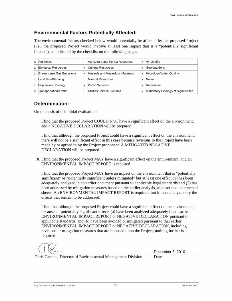
Environmental Factors Potentially Affected:
The environmental factors checked below would potentially be affected by the proposed Project (i.e., the proposed Project would involve at least one impact that is a “potentially significant impact”), as indicated by the checklist on the following pages.
x Aesthetics Agriculture and Forest Resources x Air Quality
x Biological Resources x Cultural Resources x Geology/Soils
x Greenhouse Gas Emissions x Hazards and Hazardous Materials x Hydrology/Water Quality
x Land Use/Planning Mineral Resources x Noise
x Population/Housing x Public Services x Recreation
x Transportation/Traffic Utilities/Service Systems x Mandatory Findings of Significance
Determination:
On the basis of this initial evaluation:
I find that the proposed Project COULD NOT have a significant effect on the environment, and a NEGATIVE DECLARATION will be prepared.
I find that although the proposed Project could have a significant effect on the environment, there will not be a significant effect in this case because revisions to the Project have been made by or agreed to by the Project proponent. A MITIGATED NEGATIVE DECLARATION will be prepared.
X I find that the proposed Project MAY have a significant effect on the environment, and an ENVIRONMENTAL IMPACT REPORT is required.
I find that the proposed Project MAY have an impact on the environment that is “potentially significant” or “potentially significant unless mitigated” but at least one effect (1) has been adequately analyzed in an earlier document pursuant to applicable legal standards and (2) has been addressed by mitigation measures based on the earlier analysis, as described on attached sheets. An ENVIRONMENTAL IMPACT REPORT is required, but it must analyze only the effects that remain to be addressed.
I find that although the proposed Project could have a significant effect on the environment, because all potentially significant effects (a) have been analyzed adequately in an earlier ENVIRONMENTAL IMPACT REPORT or NEGATIVE DECLARATION pursuant to applicable standards, and (b) have been avoided or mitigated pursuant to that earlier ENVIRONMENTAL IMPACT REPORT or NEGATIVE DECLARATION, including revisions or mitigation measures that are imposed upon the Project, nothing further is required.
December 6, 2010 Chris Cannon, Director of Environmental Management Division Date
Environmental Checklist
City Dock No. 1 Marine Research Center 22 December 2010
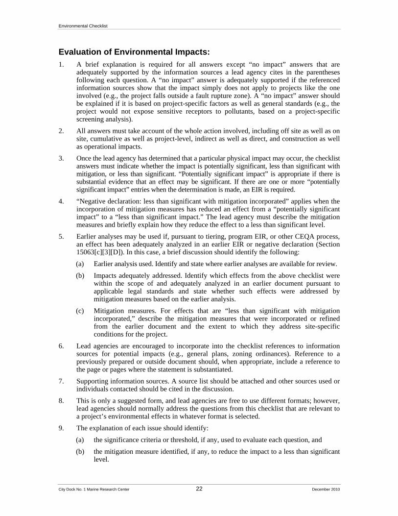
Evaluation of Environmental Impacts:
1. A brief explanation is required for all answers except “no impact” answers that are adequately supported by the information sources a lead agency cites in the parentheses following each question. A “no impact” answer is adequately supported if the referenced information sources show that the impact simply does not apply to projects like the one involved (e.g., the project falls outside a fault rupture zone). A “no impact” answer should be explained if it is based on project-specific factors as well as general standards (e.g., the project would not expose sensitive receptors to pollutants, based on a project-specific screening analysis).
2. All answers must take account of the whole action involved, including off site as well as on site, cumulative as well as project-level, indirect as well as direct, and construction as well as operational impacts.
3. Once the lead agency has determined that a particular physical impact may occur, the checklist answers must indicate whether the impact is potentially significant, less than significant with mitigation, or less than significant. “Potentially significant impact” is appropriate if there is substantial evidence that an effect may be significant. If there are one or more “potentially significant impact” entries when the determination is made, an EIR is required.
4. “Negative declaration: less than significant with mitigation incorporated” applies when the incorporation of mitigation measures has reduced an effect from a “potentially significant impact” to a “less than significant impact.” The lead agency must describe the mitigation measures and briefly explain how they reduce the effect to a less than significant level.
5. Earlier analyses may be used if, pursuant to tiering, program EIR, or other CEQA process, an effect has been adequately analyzed in an earlier EIR or negative declaration (Section 15063[c][3][D]). In this case, a brief discussion should identify the following:
(a) Earlier analysis used. Identify and state where earlier analyses are available for review.
(b) Impacts adequately addressed. Identify which effects from the above checklist were within the scope of and adequately analyzed in an earlier document pursuant to applicable legal standards and state whether such effects were addressed by mitigation measures based on the earlier analysis.
(c) Mitigation measures. For effects that are “less than significant with mitigation incorporated,” describe the mitigation measures that were incorporated or refined from the earlier document and the extent to which they address site-specific conditions for the project.
6. Lead agencies are encouraged to incorporate into the checklist references to information sources for potential impacts (e.g., general plans, zoning ordinances). Reference to a previously prepared or outside document should, when appropriate, include a reference to the page or pages where the statement is substantiated.
7. Supporting information sources. A source list should be attached and other sources used or individuals contacted should be cited in the discussion.
8. This is only a suggested form, and lead agencies are free to use different formats; however, lead agencies should normally address the questions from this checklist that are relevant to a project’s environmental effects in whatever format is selected.
9. The explanation of each issue should identify:
(a) the significance criteria or threshold, if any, used to evaluate each question, and
(b) the mitigation measure identified, if any, to reduce the impact to a less than significant level.

Environmental Checklist
City Dock No. 1 Marine Research Center 23 December 2010
Environmental Checklist
Aesthetics
Issues (and Supporting Information Sources):
Potentially Significant
Impact
Less Than Significant
with Mitigation
Incorporation
Less Than Significant
Impact No Impact
1. AESTHETICS — Would the project:
a) Have a substantial adverse effect on a scenic vista?
b) Substantially damage scenic resources, including, but not limited to, trees, rock outcroppings, and historic buildings within a state scenic highway?
c) Substantially degrade the existing visual character or quality of the site and its surroundings?
d) Create a new source of substantial light or glare which would adversely affect daytime or nighttime views in the area?
Discussion
a) Would the project have a substantial adverse effect on a scenic vista?
Potentially Significant Impact. The San Pedro Waterfront Project EIS/EIR identifies objectives, goals and policies from City of Los Angeles and Port plans that promote the conservation of views of the ocean, harbor and scenic coastal areas. These goals and policies are found in the Los Angeles General Plan Framework, Transportation, Conservation, Infrastructure and Public Service Elements, the Port of Los Angeles Plan, the San Pedro Community Plan, and the San Pedro Specific Plan/San Pedro Coastal Land Use Plan. The City of Los Angeles Community Plan for San Pedro identifies 10 scenic view sites in the San Pedro area (City of Los Angeles 1999). Of these, the proposed Project site is visible from Lookout Point, which is located on Gaffey Street approximately 2.4 miles from the project area, and Harbor Boulevard Bluff, north west of the site. Following development of the proposed Project, elements of the Project site will be visible from the foot of 22nd Street, Inner Cabrillo Beach, and public facilities such as the 22nd Street Park, Bloch Field Park along Harbor Boulevard, and other nearby development. In addition, the waterfront promenade would provide new views of harbor operations. Views would include the new buildings, such as the auditorium and wave tank structure, and the adaptively reused warehouse research facilities, landscaping, surface parking and docked vessels. As a result, the impact of the proposed Project on scenic vistas could be considered potentially significant and will be discussed further in the EIR.
b) Would the project substantially damage scenic resources, including, but not limited to, trees, rock outcroppings, and historic buildings within a state scenic highway?
Potentially Significant Impact. The California Department of Transportation (Caltrans) administers the state’s Scenic Highway Program. Caltrans maintains lists of both designated scenic highways and eligible scenic highways. The closest officially designated state scenic highway is approximately 33 miles north of the project site and consists of a segment of State Route 2,
Environmental Checklist
City Dock No. 1 Marine Research Center 24 December 2010
extending from La Canada to the San Bernardino County line, approximately three miles north of Interstate 210. The closest eligible state scenic highway is a segment of U.S. 1 approximately nine miles northwest of the project site. The project site is not located within the view corridors of either highway segment. However, Harbor Boulevard, locally identified in the San Pedro Community Plan as a major scenic highway, runs North/South along the West side of the Los Angeles Main Channel from the Vincent Thomas Bridge to Crescent Avenue and offers direct southeastern views of the proposed Project site. As a result, the impact of the proposed Project on scenic highways would be considered potentially significant and will be addressed further in the EIR.
c) Would the project substantially degrade the existing visual character or quality of the site and its surroundings?
Potentially Significant Impact. The proposed Project would result in the reuse of existing buildings, including the transit sheds at Berths 57 and 58–60, new buildings at Berths 70 and 71, the construction of a new auditorium at Berth 56 along 22nd Street, surface parking, a wave tank building, new boat slips, and associated structures. Overall, development of the site would improve the visual quality of the site and the site would visually be part of existing harbor operations. The project site is located within the Look Out Point key observation points (KOPs) identified in the San Pedro Waterfront Project EIS/EIR. The site is also visible from Inner Cabrillo Beach; from points along 22nd Street, including the 22nd Street Park and Crescent bike path; Bloch Field Park along Harbor Boulevard; and points along Sampson Way. People would also become part of the visual attributes of the site. Because the visual quality of the site would undergo substantial change—a change that was not fully analyzed in the San Pedro Waterfront Project EIS/EIR, the impact of the proposed Project on the visual quality of the site and surrounding public views will be considered potentially significant and will be addressed further in the EIR.
d) Would the project create a new source of substantial light or glare which would adversely affect daytime or nighttime views in the area?
Less than Significant Impact. According to the San Pedro Waterfront Project EIS/EIS (p. 3.1 41), all “lighting associated with project components would comply with the San Pedro Waterfront and Promenade Design Guidelines, which include lighting recommendations to minimize light pollution, spill light and glare, while promoting goals to create an attractive and safe daytime and nighttime waterfront that supports local economic growth.” Lighting would also conform to the Port Master Plan, which requires an analysis of design and operational effects on existing community areas. As a result, consistency with these guidelines and regulations would ensure that views in the project vicinity would not be adversely affected. Although impacts are considered to be less than significant, this issue will be addressed further in the EIR.
References
Port of Los Angeles, San Pedro Waterfront Project EIS/EIR, September 2009.
Environmental Checklist
City Dock No. 1 Marine Research Center 25 December 2010
Agricultural and Forest Resources
Issues (and Supporting Information Sources):
Potentially Significant
Impact
Less Than Significant
with Mitigation
Incorporation
Less Than Significant
Impact No Impact
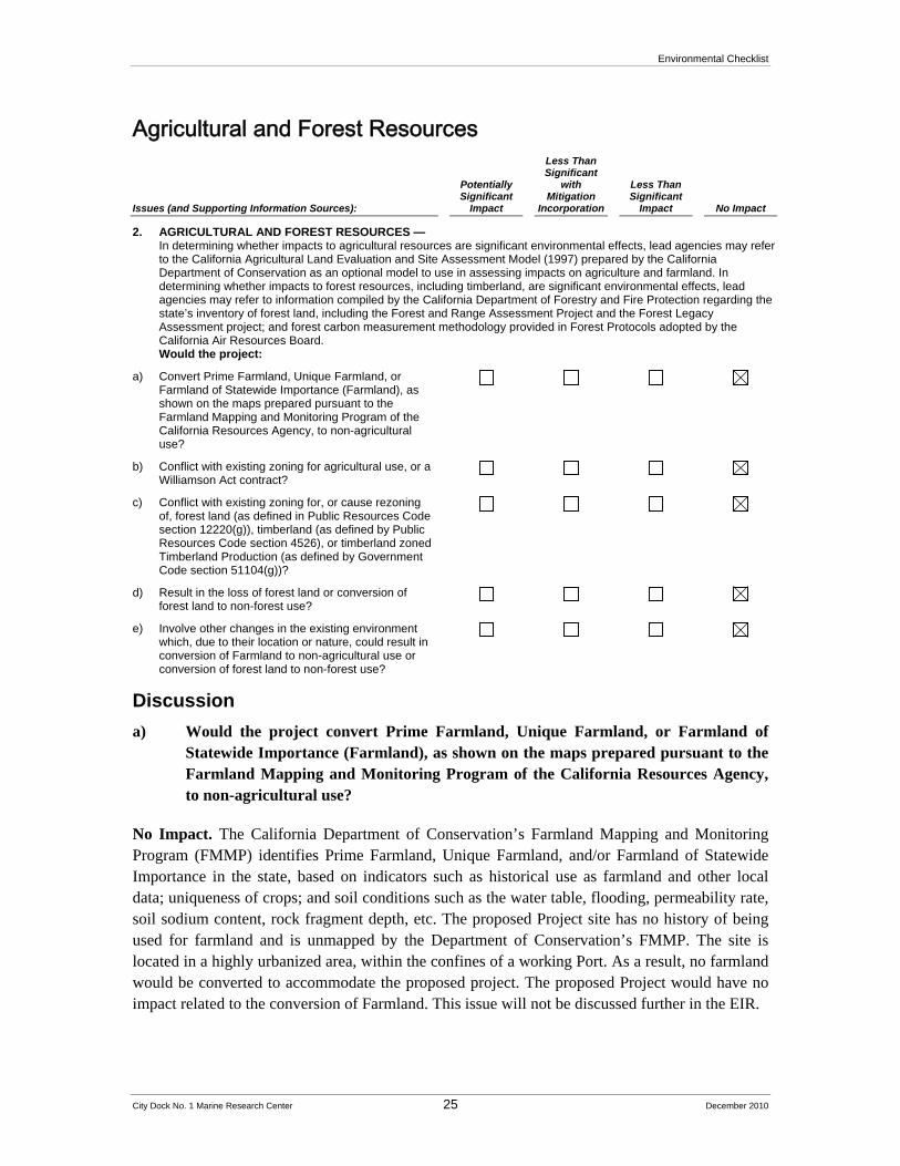
2. AGRICULTURAL AND FOREST RESOURCES — In determining whether impacts to agricultural resources are significant environmental effects, lead agencies may refer to the California Agricultural Land Evaluation and Site Assessment Model (1997) prepared by the California Department of Conservation as an optional model to use in assessing impacts on agriculture and farmland. In determining whether impacts to forest resources, including timberland, are significant environmental effects, lead agencies may refer to information compiled by the California Department of Forestry and Fire Protection regarding the state’s inventory of forest land, including the Forest and Range Assessment Project and the Forest Legacy Assessment project; and forest carbon measurement methodology provided in Forest Protocols adopted by the California Air Resources Board. Would the project:
a) Convert Prime Farmland, Unique Farmland, or Farmland of Statewide Importance (Farmland), as shown on the maps prepared pursuant to the Farmland Mapping and Monitoring Program of the California Resources Agency, to non-agricultural use?
b) Conflict with existing zoning for agricultural use, or a Williamson Act contract?
c) Conflict with existing zoning for, or cause rezoning of, forest land (as defined in Public Resources Code section 12220(g)), timberland (as defined by Public Resources Code section 4526), or timberland zoned Timberland Production (as defined by Government Code section 51104(g))?
d) Result in the loss of forest land or conversion of forest land to non-forest use?
e) Involve other changes in the existing environment which, due to their location or nature, could result in conversion of Farmland to non-agricultural use or conversion of forest land to non-forest use?
Discussion
a) Would the project convert Prime Farmland, Unique Farmland, or Farmland of Statewide Importance (Farmland), as shown on the maps prepared pursuant to the Farmland Mapping and Monitoring Program of the California Resources Agency, to non-agricultural use?
No Impact. The California Department of Conservation’s Farmland Mapping and Monitoring Program (FMMP) identifies Prime Farmland, Unique Farmland, and/or Farmland of Statewide Importance in the state, based on indicators such as historical use as farmland and other local data; uniqueness of crops; and soil conditions such as the water table, flooding, permeability rate, soil sodium content, rock fragment depth, etc. The proposed Project site has no history of being used for farmland and is unmapped by the Department of Conservation’s FMMP. The site is located in a highly urbanized area, within the confines of a working Port. As a result, no farmland would be converted to accommodate the proposed project. The proposed Project would have no impact related to the conversion of Farmland. This issue will not be discussed further in the EIR.
Environmental Checklist
City Dock No. 1 Marine Research Center 26 December 2010
b) Would the project conflict with existing zoning for agricultural use, or a Williamson Act contract?
No Impact. The proposed Project site does not contain land zoned for agricultural use, or land that is under a Williamson Act contract.1 The proposed Project site is part of a wharf, located in an urbanized area within the confines of the Port of Los Angeles, and therefore is not near land zoned for agricultural use or land subject to a Williamson Act contract. The proposed Project would therefore have no impact on land zoned for agricultural use or on land subject to a Williamson Act contract. This issue will not be discussed further in the EIR.
c) Would the project conflict with existing zoning for, or cause rezoning of, forest land (as defined in Public Resources Code section 12220(g)), timberland (as defined by Public Resources Code section 4526), or timberland zoned Timberland Production (as defined by Government Code section 51104(g))?
No Impact. The proposed Project site is part of an urbanized waterfront area that includes wharfs located within the confines of the Port of Los Angeles, and includes no trees. The project site would not be considered forest land,2 timberland,3 or timberland zoned Timberland Production.4 The proposed Project site would, therefore, have no impact on forest land, timberland or timberland zoned Timberland Production. This issue will not be discussed further in the EIR.
d) Would the project result in the loss of forest land or conversion of forest land to non-forest use?
No Impact. The proposed Project site is part of an urbanized waterfront area that consists of wharfs and waters, located within the confines of the Port of Los Angeles; and the site includes no trees. The proposed Project would have no impact on the loss of forest land or the conversion of non-farmland to non-forest use. This issue will not be discussed further in the EIR.
1 Under the California Land Conservation (Williamson) Act, private landowners can contract with cities and counties
to voluntarily restrict their land to agricultural and compatible open-space uses with a rolling term 10-year contract. In return, the restricted land is assessed at a property tax rate consistent with its actual use instead of potential market value (California Department of Conservation, 2010).
2 According to Public Resources Code Section 12220(g): “‘Forest land’ is land that can support 10-percent native tree cover of any species, including hardwoods, under natural conditions, and that allows for management of one or more forest resources, including timber, aesthetics, fish and wildlife, biodiversity, water quality, recreation, and other public benefits.”
3 According to Public Resources Code 4526: “‘Timberland’ means land, other than land owned by the federal government and land designated by the board as experimental forest land, which is available for, and capable of, growing a crop of trees of any commercial species used to produce lumber and other forest products, including Christmas trees. Commercial species shall be determined by the board on a district basis after consultation with the district committees and others.”
4 According to Government Code Section 51104(g): “‘Timberland production zone" or "TPZ" means an area which has been zoned pursuant to Section 51112 or 51113 and is devoted to and used for growing and harvesting timber, or for growing and harvesting timber and compatible uses, as defined in subdivision (h). With respect to the general plans of cities and counties,"timberland preserve zone" means "timberland production zone."
Environmental Checklist
City Dock No. 1 Marine Research Center 27 December 2010
e) Would the project involve other changes in the existing environment which, due to their location or nature, could result in conversion of Farmland to non-agricultural use or conversion of forest land to non-forest use?
No Impact. The proposed Project site does not contain any trees and consists of working wharfs in an urbanized area within the confines of the Port of Los Angeles. The proposed Project would therefore not result in the conversion of farmland to non-agricultural or forest land to non-forest use.
References
California Department of Conservation, Farmland Mapping and Monitoring Program, http://www.conservation.ca.gov/dlrp/fmmp/Pages/Index.aspx, accessed July 29, 2010.
California Department of Conservation, Williamson Act Program, http://www.conservation.ca.gov/dlrp/lca/Pages/Index.aspx, accessed July 29, 2010.
Port of Los Angeles, San Pedro Waterfront Project EIS/EIR, September 2009.
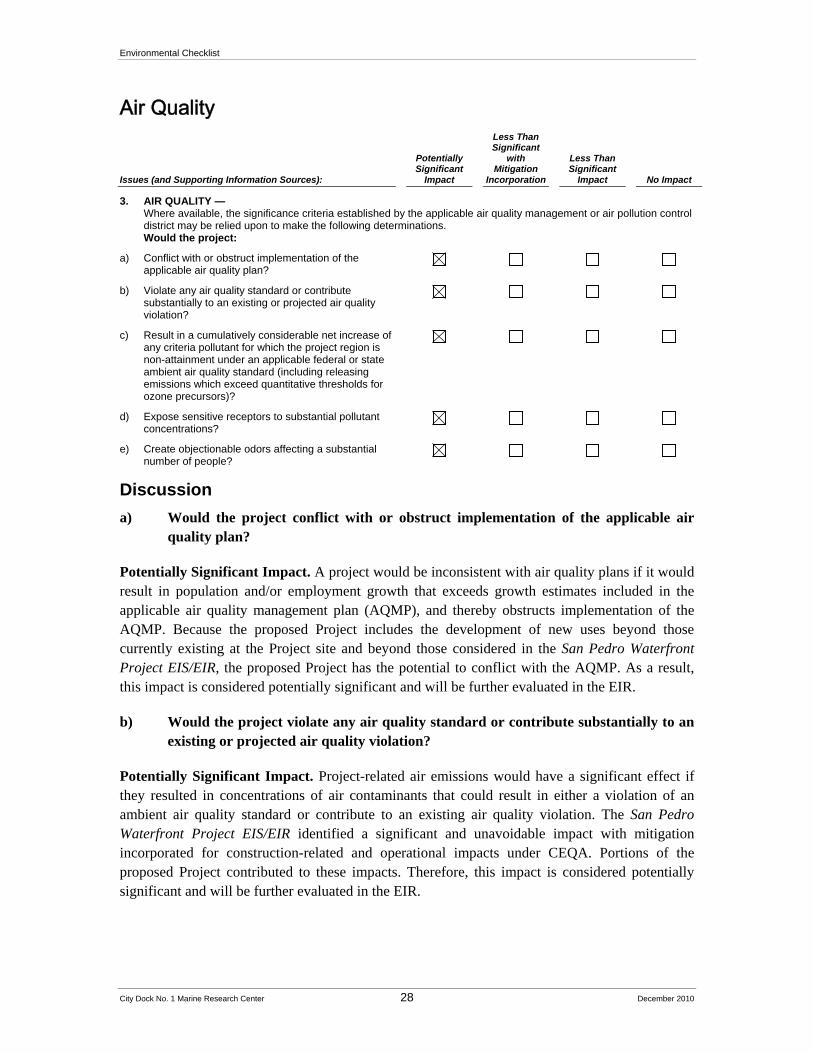
Environmental Checklist
City Dock No. 1 Marine Research Center 28 December 2010
Air Quality
Issues (and Supporting Information Sources):
Potentially Significant
Impact
Less Than Significant
with Mitigation
Incorporation
Less Than Significant
Impact No Impact
3. AIR QUALITY — Where available, the significance criteria established by the applicable air quality management or air pollution control district may be relied upon to make the following determinations. Would the project:
a) Conflict with or obstruct implementation of the applicable air quality plan?
b) Violate any air quality standard or contribute substantially to an existing or projected air quality violation?
c) Result in a cumulatively considerable net increase of any criteria pollutant for which the project region is non-attainment under an applicable federal or state ambient air quality standard (including releasing emissions which exceed quantitative thresholds for ozone precursors)?
d) Expose sensitive receptors to substantial pollutant concentrations?
e) Create objectionable odors affecting a substantial number of people?
Discussion
a) Would the project conflict with or obstruct implementation of the applicable air quality plan?
Potentially Significant Impact. A project would be inconsistent with air quality plans if it would result in population and/or employment growth that exceeds growth estimates included in the applicable air quality management plan (AQMP), and thereby obstructs implementation of the AQMP. Because the proposed Project includes the development of new uses beyond those currently existing at the Project site and beyond those considered in the San Pedro Waterfront Project EIS/EIR, the proposed Project has the potential to conflict with the AQMP. As a result, this impact is considered potentially significant and will be further evaluated in the EIR.
b) Would the project violate any air quality standard or contribute substantially to an existing or projected air quality violation?
Potentially Significant Impact. Project-related air emissions would have a significant effect if they resulted in concentrations of air contaminants that could result in either a violation of an ambient air quality standard or contribute to an existing air quality violation. The San Pedro Waterfront Project EIS/EIR identified a significant and unavoidable impact with mitigation incorporated for construction-related and operational impacts under CEQA. Portions of the proposed Project contributed to these impacts. Therefore, this impact is considered potentially significant and will be further evaluated in the EIR.
Environmental Checklist
City Dock No. 1 Marine Research Center 29 December 2010
c) Would the project result in a cumulatively considerable net increase of any criteria pollutant for which the project region is non-attainment under an applicable federal or state ambient air quality standard (including releasing emissions which exceed quantitative thresholds for ozone precursors)?
Potentially Significant Impact. As part of the cumulative analysis presented in the San Pedro Waterfront Project EIS/EIR, the proposed Project (without Berth 56) was part of a significant and unavoidable cumulative impact for a cumulatively considerable increase in criteria pollutant emissions for which the region was in nonattainment under a national or state ambient air quality standard or for which SCAQMD has set a daily emission threshold. Although the proposed Project’s individual contribution may be less than significant, this impact is considered potentially significant and will be further evaluated in the EIR.
d) Would the project expose sensitive receptors to substantial pollutant concentrations?
Potentially Significant Impact. Certain persons are particularly sensitive to air pollution emissions; these “sensitive receptors” include the very young, elderly, and those suffering from some illnesses or disabilities. Examples of land uses that can be sensitive to air pollution emissions include schools, daycare centers, parks, recreational areas, medical facilities, rest homes and convalescent care facilities. Nearby schools are listed in Table 3.
The east side of the proposed Project site is located within approximately 1,000 feet (across the Main Channel) of the Federal Correctional Institution (FCI) at Terminal Island near Reservation Point and the office and housing associated with the FCI facility located south of Reservation Point. The west side of the project site is located within 500 feet of the Cabrillo Marina (Phase II); within 1,000 feet of the 22nd Street Landing Park, the Yacht Club and the west end of the Cabrillo Marina (Phase I); and within 1,000 feet of the Municipal Fish Market, Bloch Field, Ports O’Call and residential areas of San Pedro. Sensitive users are located within these areas and may be affected by air emissions during construction and operation. This impact is therefore considered potentially significant and will be addressed in the EIR.5
e) Would the project create objectionable odors affecting a substantial number of people?
Potentially Significant Impact. Odors can be associated with industrial and institutional land uses. Odors related to the proposed Project could be released by the disturbance of former industrial areas and during the construction process from diesel-powered construction equipment, paving and asphalting. Odors could also be associated with aquaculture related research. During the project construction stage, any remediation could release odors as well. This impact is therefore considered potentially significant and will be addressed in the EIR.
5 The uses detailed in the San Pedro Waterfront Project EIS/EIR (see p. 3.2-19) are more than three miles from the
project site.
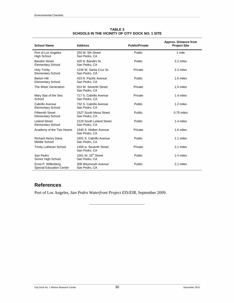
Environmental Checklist
City Dock No. 1 Marine Research Center 30 December 2010
TABLE 3 SCHOOLS IN THE VICINITY OF CITY DOCK NO. 1 SITE
School Name Address Public/Private Approx. Distance from
Project Site
Port of Los Angeles High School
250 W. 5th Street San Pedro, CA
Public 1 mile
Bandini Street Elementary School
425 N. Bandini St. San Pedro, CA
Public 2.2 miles
Holy Trinity Elementary School
1226 W. Santa Cruz St. San Pedro, CA
Private 2.2 miles
Barton Hill Elementary School
423 N. Pacific Avenue San Pedro, CA
Public 1.6 miles
The Wiser Generation 914 W. Seventh Street San Pedro, CA
Private 1.5 miles
Mary Star of the Sea School
717 S. Cabrillo Avenue San Pedro, CA
Private 1.4 miles
Cabrillo Avenue Elementary School
732 S. Cabrillo Avenue San Pedro, CA
Public 1.2 miles
Fifteenth Street Elementary School
1527 South Mesa Street San Pedro, CA
Public 0.75 miles
Leland Street Elementary School
2120 South Leland Street San Pedro, CA
Public 1.4 miles
Academy of the Two Hearts 1540 S. Walker Avenue San Pedro, CA
Private 1.6 miles
Richard Henry Dana Middle School
1501 S. Cabrillo Avenue San Pedro, CA
Public 1.1 miles
Trinity Lutheran School 1450 w. Seventh Street San Pedro, CA
Private 2.1 miles
San Pedro Senior High School
1001 W. 15th Street San Pedro, CA
Public 1.4 miles
Ernst P. Willenberg Special Education Center
308 Weymouth Avenue San Pedro, CA
Public 2.1 miles
References
Port of Los Angeles, San Pedro Waterfront Project EIS/EIR, September 2009.
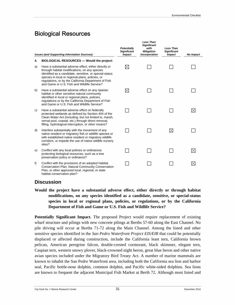
Environmental Checklist
City Dock No. 1 Marine Research Center 31 December 2010
Biological Resources
Issues (and Supporting Information Sources):
Potentially Significant
Impact
Less Than Significant
with Mitigation
Incorporation
Less Than Significant
Impact No Impact
4. BIOLOGICAL RESOURCES — Would the project:
a) Have a substantial adverse effect, either directly or through habitat modifications, on any species identified as a candidate, sensitive, or special-status species in local or regional plans, policies, or regulations, or by the California Department of Fish and Game or U.S. Fish and Wildlife Service?
b) Have a substantial adverse effect on any riparian habitat or other sensitive natural community identified in local or regional plans, policies, regulations or by the California Department of Fish and Game or U.S. Fish and Wildlife Service?
c) Have a substantial adverse effect on federally protected wetlands as defined by Section 404 of the Clean Water Act (including, but not limited to, marsh, vernal pool, coastal, etc.) through direct removal, filling, hydrological interruption, or other means?
d) Interfere substantially with the movement of any native resident or migratory fish or wildlife species or with established native resident or migratory wildlife corridors, or impede the use of native wildlife nursery sites?
e) Conflict with any local policies or ordinances protecting biological resources, such as a tree preservation policy or ordinance?
f) Conflict with the provisions of an adopted Habitat Conservation Plan, Natural Community Conservation Plan, or other approved local, regional, or state habitat conservation plan?
Discussion
Would the project have a substantial adverse effect, either directly or through habitat modifications, on any species identified as a candidate, sensitive, or special-status species in local or regional plans, policies, or regulations, or by the California Department of Fish and Game or U.S. Fish and Wildlife Service?
Potentially Significant Impact. The proposed Project would require replacement of existing wharf structure and pilings with new concrete pilings at Berths 57-60 along the East Channel. No pile driving will occur at Berths 71-72 along the Main Channel. Among the listed and other sensitive species identified in the San Pedro Waterfront Project EIS/EIR that could be potentially displaced or affected during construction, include the California least tern, California brown pelican, American peregrine falcon, double-crested cormorant, black skimmer, elegant tern, Caspian tern, western snowy plover, black-crowned night heron, great blue heron and other native avian species included under the Migratory Bird Treaty Act. A number of marine mammals are known to inhabit the San Pedro Waterfront area, including both the California sea lion and harbor seal, Pacific bottle-nose dolphin, common dolphin, and Pacific white-sided dolphins. Sea lions are known to frequent the adjacent Municipal Fish Market at Berth 72. Although most listed and
Environmental Checklist
City Dock No. 1 Marine Research Center 32 December 2010
other sensitive species have not specifically been identified as inhabiting the areas around or near Berths 56 through 60 and/or Berths 70 and 71, others are identified as using the entire harbor area. As a result, this potential impact will be studied in the EIR.
Natural habitats identified by the San Pedro Waterfront Project EIS/EIR in the general Project area include kelp beds, salt marsh, mudflats, and eelgrass, none of which except kelp have been identified in the East Channel. The proposed Project site is located in an area designated as Essential Fish Habitat for both coastal pelagic and groundfish species. With the implementation of mitigation measures required by the San Pedro Waterfront Project EIS/EIR, potential impacts from any contaminated sediment would be less than significant. Although only small amounts of benthic infauna and epibenthic macroinvertebrates would be lost within the footprint of the piles being driven and rock placed around the pilings, mitigation measures from the San Pedro Waterfront Project EIS/EIR would not be sufficient to reduce potential short-term construction impacts to less than significant levels under CEQA.
From an operations perspective, the greatest potential for operational impacts on sensitive species would be from accidental fuel spills and/or unauthorized discharges associated with increased vessel activity in the East Channel. The proposed Project includes the relocation of 12 vessels from Fish Harbor to the East Channel with the addition of possibly three more research vessels. The increase in the number of vessels to Port operations resulting from the proposed Project would be small. With the appropriate Port controls, compliance with permit requirements, regulations related to spill control, and mitigation measures included in the San Pedro Waterfront Project EIS/EIR, potential impacts to sensitive species would be considered less than significant. The increase in the number of vessels, as a result of the proposed Project, would be proportionally small compared to the existing number of vessels using the Port and the probability of research vessels new to the Port harming endangered, threatened or species of concern via collisions is low. As a result, risks to sensitive species related to sensitive species, would be less than significant. However, this impact will be studied further in the EIR to ensure that project-specific impacts would remain less than significant.
Would the project have a substantial adverse effect on any riparian habitat or other sensitive natural community identified in local or regional plans, policies, regulations or by the California Department of Fish and Game or U.S. Fish and Wildlife Service?
Potentially Significant Impact. The San Pedro Waterfront Project EIS/EIR indicates that scattered kelp outcrops along the Main Channel adjacent to Warehouse No. 1 (located near Berth 68) could be affected by the San Pedro Waterfront Project. Warehouse 1 is located in close proximity to the proposed Project at Berths 70 and 71. Kelp beds near Berths 70 and 71 could be temporarily affected by construction, such as construction of the promenade and/or potential wharf improvements. The project site is not in close proximity to the Youth Camp or the Salinas De San Pedro Salt Marsh area. Essential Fish Habitat would be affected by sound pressure waves in the water from pile driving, which would be required to replace wharf pilings at Berths 57-60. In addition, there have been no documented instances of fish mortality resulting from pile driving within the Port. Fish in the Coastal Pelagics Fish Management Plan are not generally abundant in
Environmental Checklist
City Dock No. 1 Marine Research Center 33 December 2010
the harbor. Construction effects would be short in duration and would occur in a small area, and with the implementation of applicable mitigation measures from the San Pedro Waterfront Project EIS/EIR, would be less than significant.
Although only small amounts of benthic infauna and epibenthic macroinvertebrates would be lost within the footprint of the piles being driven and rock placed around the pilings, mitigation measures from the San Pedro Waterfront Project EIS/EIR would not be sufficient to reduce potential short-term construction impacts to less than significant levels under CEQA. Short-term construction impacts could therefore be significant and unavoidable under CEQA and will be discussed in more detail in the EIR.
The San Pedro Waterfront Project EIS/EIR notes that operational effects, with the implementation of required mitigation measures would be less than significant.
c) Would the project have a substantial adverse effect on federally protected wetlands as defined by Section 404 of the Clean Water Act (including, but not limited to, marsh, vernal pool, coastal, etc.) through direct removal, filling, hydrological interruption, or other means?
No Impact. There are no wetlands located within the project area. The San Pedro Waterfront Project EIS/EIR identified a 0.30-acre coastal freshwater marsh adjacent to 22nd Street Park, which is approximately X feet from the project area. The San Pedro Waterfront Project EIS/EIR (p. 3.3-36) states: “The USACE [Corps] Regulatory Division staff preliminarily determined that this coastal freshwater marsh area would be considered an isolated wetland, and therefore would not be regulated pursuant to Section 404 of the CWA. Furthermore, this area would be avoided by the proposed Project [in this case, the Project is the Waterfront Project], and thus, it would not be included in the Section 404 permit for fill issued for the proposed Project even if it were included in the USACE’s geographic jurisdiction.” There is no impact and this issue will not be discussed further in the EIR.
d) Would the project interfere substantially with the movement of any native resident or migratory fish or wildlife species or with established native resident or migratory wildlife corridors, or impede the use of native wildlife nursery sites?
Less than Significant Impact. The San Pedro Waterfront Project EIS/EIR indicates that no known terrestrial wildlife migration corridors are present in the San Pedro Waterfront area and that the only defined migratory species in the harbor area are birds. As stated in the San Pedro Waterfront Project EIS/EIR, construction within the San Pedro Waterfront area would not “block or interfere with migration or movement of any of the species covered under the [Migratory Bird Treaty Act (MBTA)] because the work would be in a small portion of the harbor area where the birds occur and the birds could easily fly around or over the work.” Project operations would, as stated in the San Pedro Waterfront Project EIS/EIR, result in no barrier to wildlife passage and would have no effect on wildlife movement or migration within the harbor. Common fish habitat could be affected by dredging and/or the replacement of wharf pilings.
Environmental Checklist
City Dock No. 1 Marine Research Center 34 December 2010
This potential impact, although less than significant, will be discussed further in the EIR.
e) Would the project conflict with any local policies or ordinances protecting biological resources, such as a tree preservation policy or ordinance?
No Impact. The proposed Project site consists of developed wharfs and portions of the Main Channel and the East Channel. There are no trees, shrubs or grass on the project site. The proposed Project would include limited landscaping along the Signal Street frontage. Landscaping included as part of the proposed project would be required to conform to local ordinances and policies, and would not conflict with any local policies or ordinances implemented to protect biological resources. Therefore, there would be no impact and this issue will not be discussed further in the EIR.
f) Would the project conflict with the provisions of an adopted Habitat Conservation Plan, Natural Community Conservation Plan, or other approved local, regional, or state habitat conservation plan?
No Impact. Based on the findings in the San Pedro Waterfront Project EIS/EIR, the proposed Project would not be located within an adopted Natural Communities Conservation Plan (NCCP) or Habitat Conservation Plan (HCP). The NCCP program, which began in 1991 under California’s Natural Community Conservation Planning Act, is administered by the California Department of Fish and Game (CDFG), and is a cooperative effort between resource agencies and developers that takes a broad-based ecosystem approach to planning for the protection and perpetuation of biological diversity. As noted in the San Pedro Waterfront Project EIS/EIR, there is only one NCCP approved or under consideration near the Port and it was designed to protect coastal scrub (Palos Verdes Peninsula Sub-Regional Plan).
HCPs are administered by the U.S. Fish and Wildlife Service (USFWS) and are designed to identify how impacts would be mitigated when a project would impact endangered species. There are no HCPs in place for the Port. A Memorandum of Understanding (MOU) is in place for the Port, CDFG, USFWS, and the Corps to protect the California least tern and requires a 15-acres nesting site – outside of the project site boundaries – to be protected during the annual nesting season (May to October). The site is located across the Main Channel from the project site and is being considered for designation as a Significant Ecological Area (SEA) by the County of Los Angeles.
The proposed Project would have no impact on HCPs, NCCPs, the MOU regarding California least tern, or the SEA for least tern, and no further discussion will be provided in the EIR.
References
Port of Los Angeles, San Pedro Waterfront Project EIS/EIR, September 2009.
Environmental Checklist
City Dock No. 1 Marine Research Center 35 December 2010
Cultural Resources
Issues (and Supporting Information Sources):
Potentially Significant
Impact
Less Than Significant
with Mitigation
Incorporation
Less Than Significant
Impact No Impact
5. CULTURAL RESOURCES — Would the project:
a) Cause a substantial adverse change in the significance of a historical resource as defined in §15064.5?
b) Cause a substantial adverse change in the significance of an archaeological resource pursuant to §15064.5?
c) Directly or indirectly destroy a unique paleontological resource or site or unique geologic feature?
d) Disturb any human remains, including those interred outside of formal cemeteries?
Discussion
Would the project cause a substantial adverse change in the significance of a historical resource as defined in §15064.5?
Potentially Significant Impact. According to the San Pedro Waterfront Project EIS/EIR, in December 2007, the Corps determined and documented an Area of Potential Effects, an area that consists of “the geographic area or areas within which an undertaking may directly or indirectly cause alterations in the character or use of historic properties, if such properties exist.” Within the APE, the Corps determined that eight properties are listed on or eligible to be listed on the National Register of Historic Places (NRHP). Administered by the US Department of the Interior, the NRHP lists properties that under four criteria are used to determine eligibility for the NRHP:
Criterion A: The property must be associated with events that have made a significant contribution to the broad patterns of our history;
Criterion B: The property must be associated with the lives of persons significant in our past;
Criterion C: The property must embody the distinctive characteristics of a type, period, or method of construction, or represent the work of a master, or possess high artistic values, or represent a significant and distinguishable entity whose components may lack individual distinction; and/or
Criterion D: The property must have yielded, or may be likely to yield, information important in prehistory or history.
The project site contains no properties that are currently listed on the NRHP. However, one of the eight properties identified by the Corps as eligible for listing on the NRHP under Criteria A and B – the Westway/Pan-American Oil Company Pump House – is located at Berth 70, within the project site. In addition, the Transit Sheds at Berth 57 and Berths 58–60 are considered by the City of Los Angeles to be local historical resources and eligible for the NRHP under Criterion A. The transit shed at Berths 58–60 is also considered eligible by the City of Los Angeles for the
Environmental Checklist
City Dock No. 1 Marine Research Center 36 December 2010
NRHP under Criterion C “for its interesting and ambitious use of neoclassical treatments” (San Pedro Waterfront Project EIS/EIR, p. 3.4-31). Local historical resources surveys have identified the Westway/ Pan-American Oil Company Pump House at Berth 70 as historic. The Port has identified the Pan American Clipper Terminal (Berth 56) as eligible for listing on the NRHP under Criterion A and the California Register “as the last remaining portion of a complex that made a significant contribution to the transportation heritage of the region from 1935-1941 through its association with Pan American Airlines’ pioneering long distance and transoceanic flight to China via Manila and later to New Zealand” (San Pedro Waterfront Project EIS/EIR, p. 3.4-34). Berth 56 is also listed as eligible for the California Register.
Resources adjacent to the project site include the Municipal Warehouse No. 1, located across Signal Street from Berth 58; Municipal Warehouse No. 1 is listed on the NRHP and the California Register. The former U.S. Immigration Station (currently Cannetti’s Sea Food Restaurant), near Berth 56 was identified in a historic resources survey as potentially eligible for listing on the NRHP under Criterion A “as the only extant building at the Port designed and used for civilian federal purposes” (San Pedro Waterfront Project EIS/EIR, p. 3.4-30).
The San Pedro Waterfront Project EIS/EIR specifically identified Municipal Warehouse No. 1, the former U.S. Immigration Station, the Berth 57 Transit Shed, and the Pan American Terminal as buildings and structures that would not be altered in an adverse manner. The Pump House at Berth 70 is specifically identified as a structure that would be maintained. The project could result in changes to the entrance to the transit shed at Berth 57, including removal of a wood-frame entrance added to the building a few years after it was built. Alterations could also be made to other structures and/or the vicinity of these historic structures.
Because many of the existing structures within the project site are considered eligible for listing on the National Register, the proximity of the project to other historical resources, proposed changes to the entrance to Berth 57, and proposed reuse of historic Berths 57 and 58–60 Transit Sheds, and the potential historic nature of the wharf itself from B.57-60, the impact of the project on historic resources will be discussed further in the EIR.
b) Would the project cause a substantial adverse change in the significance of an archaeological resource pursuant to §15064.5?
Potentially Significant Impact. The San Pedro Waterfront Project EIS/EIR (p. 3.4-47) states that no known archaeological sites are located within the boundaries of the San Pedro Waterfront. However, 16 sites have previously been identified within one mile of the waterfront and these include three that are adjacent to the boundaries of the San Pedro Waterfront. None are, however, adjacent to the City Dock project site. The nearest, CA-LAN-1129H, which is in the Fort MacArthur area, is more than more than 2,000 feet north of the project site. In addition, no ship wrecks are known to have occurred in the proposed Project site or its immediate vicinity. The proposed Project site has been in use for over 80 years and as a result, potential resources could be found in the waters adjacent to the proposed Project site during piling driving or water quality testing. The proposed Project site was not specifically analyzed in the San Pedro Waterfront
Environmental Checklist
City Dock No. 1 Marine Research Center 37 December 2010
Project EIS/EIR with regard to potential archaeological resources. As a result, the potential impact of the proposed Project on archaeological resources will be discussed further in the EIR.
c) Would the project directly or indirectly destroy a unique paleontological resource or site or unique geologic feature?
Less than Significant Impact. The San Pedro Waterfront Project EIS/EIR (pp. 3.4-61 and 3.4-62) states that construction-related excavations in the East Channel would be limited to areas underlain by artificial fill materials and would therefore not affect potential paleontological resources. No other potential paleontological resources are identified within the proposed Project site or adjacent waters. The proposed Project includes the installation of structures that may require pilings beyond existing artificial fill materials. However, these areas have already been highly disturbed. Although impacts to paleontological resources are anticipated to be less than significant, this issue will be discussed further in the EIR.
d) Would the project disturb any human remains, including those interred outside of formal cemeteries?
No Impact. The proposed Project site consists of wharfs and associated structures, and adjacent waters of the Port, including portions of the East Channel and Main Channel. The proposed Project site is not part of the historic shoreline. Neither the East Channel nor the Main Channel is known to be a burial site. The proposed Project site waters are known to have been disturbed by previous dredging and are covered with artificial fill. As a result, the proposed Project would have no impact on human remains and no further discussion will be provided in the EIR.
References
Port of Los Angeles, San Pedro Waterfront Project EIS/EIR, September 2009.
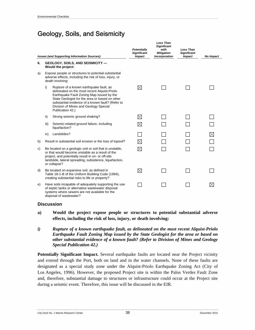
Environmental Checklist
City Dock No. 1 Marine Research Center 38 December 2010
Geology, Soils, and Seismicity
Issues (and Supporting Information Sources):
Potentially Significant
Impact
Less Than Significant
with Mitigation
Incorporation
Less Than Significant
Impact No Impact
6. GEOLOGY, SOILS, AND SEISMICITY — Would the project:
a) Expose people or structures to potential substantial adverse effects, including the risk of loss, injury, or death involving:
i) Rupture of a known earthquake fault, as delineated on the most recent Alquist-Priolo Earthquake Fault Zoning Map issued by the State Geologist for the area or based on other substantial evidence of a known fault? (Refer to Division of Mines and Geology Special Publication 42.)
ii) Strong seismic ground shaking?
iii) Seismic-related ground failure, including liquefaction?
iv) Landslides?
b) Result in substantial soil erosion or the loss of topsoil?
c) Be located on a geologic unit or soil that is unstable, or that would become unstable as a result of the project, and potentially result in on- or off-site landslide, lateral spreading, subsidence, liquefaction, or collapse?
d) Be located on expansive soil, as defined in Table 18-1-B of the Uniform Building Code (1994), creating substantial risks to life or property?
e) Have soils incapable of adequately supporting the use of septic tanks or alternative wastewater disposal systems where sewers are not available for the disposal of wastewater?
Discussion
a) Would the project expose people or structures to potential substantial adverse effects, including the risk of loss, injury, or death involving:
i) Rupture of a known earthquake fault, as delineated on the most recent Alquist-Priolo Earthquake Fault Zoning Map issued by the State Geologist for the area or based on other substantial evidence of a known fault? (Refer to Division of Mines and Geology Special Publication 42.)
Potentially Significant Impact. Several earthquake faults are located near the Project vicinity and extend through the Port, both on land and in the water channels. None of these faults are designated as a special study zone under the Alquist-Priolo Earthquake Zoning Act (City of Los Angeles, 1996). However, the proposed Project site is within the Palos Verdes Fault Zone and, therefore, substantial damage to structures or infrastructure could occur at the Project site during a seismic event. Therefore, this issue will be discussed in the EIR.
Environmental Checklist
City Dock No. 1 Marine Research Center 39 December 2010
ii) Strong seismic ground shaking?
Potentially Significant Impact. Several principal active faults lie within 25 miles of the proposed Project. These include the Palos Verdes, Newport-Inglewood, Elysian Park, Whittier-Elsinore, and Santa Monica-Raymond faults. These faults are capable of producing ground movements of a maximum moment magnitude 6.6 to 7.1. Faults such as these are typical of southern California and it is reasonable to expect a strong ground motion seismic event during the lifetime of any project in the region. This issue area will be discussed in the EIR.
iii) Seismic-related ground failure, including liquefaction?
Potentially Significant Impact. The proposed Project site lies within an area susceptible to liquefaction based on the historic occurrence of liquefaction, or local geological, geotechnical, and groundwater conditions, which indicate a potential for permanent ground displacements (City of Los Angeles, 1996). Therefore, this issue will be discussed in the EIR.
iv) Landslides?
No Impact. The topography of the site is flat. As identified in the Safety Element of the Los Angeles General Plan, the proposed Project site is not within the landslide inventory (City of Los Angeles, 1996). Therefore, no significant impacts are anticipated as a result of the proposed Project, and no further study is required. This issue does need require further analysis in the EIR.
b) Would the project result in substantial soil erosion or the loss of topsoil?
Potentially Significant Impact. During Project construction, there is potential for soil erosion. This would be of short duration and would be subject to fugitive dust and stormwater runoff management as required by regulatory agencies. During demolition and excavation, the site would be managed in accordance with the Los Angeles Regional Water Quality Control Board (LARWQCB) Permit No. CAS004001 for Municipal Storm Water and Urban Runoff Discharges within the County of Los Angeles and in accordance with South Coast Air Quality Management District (SCAQMD) rules and regulations (i.e., Rule 403 – Fugitive Dust).
The proposed Project would disturb more than one acre of soil, and therefore a Statewide General Construction (and National Pollutant Discharge Elimination System (NPDES)) permit would be required along with submittal of a notice of intent to the State Regional Water Quality Control Board (SRWCB) prior to commencement of demolition activities. As part of the NPDES permit requirements, development of a Storm Water Pollution Prevention Plan (SWPPP) for the proposed Project site will be required prior to construction, which includes stormwater control measures. The proposed Project is also subject to compliance with the applicable Standard Urban Storm Water Mitigation Plan (SUSMP). With development of a SWPPP, which is required for the proposed Project, and compliance with all applicable regulations during grading, soil erosion on the proposed Project site would be minimized. Still, the proposed Project has the potential for impacts resulting from substantial topsoil erosion, and, therefore, this issue area will be addressed in the EIR.

Environmental Checklist
City Dock No. 1 Marine Research Center 40 December 2010
c) Would the project be located on a geologic unit or soil that is unstable, or that would become unstable as a result of the project, and potentially result in on- or off-site landslide, lateral spreading, subsidence, liquefaction, or collapse?
Potentially Significant Impact. As described under response to Section 6(a)(iii), above, the proposed Project site is located in an area designated as a liquefiable area in the Safety Element of the Los Angeles General Plan (City of Los Angeles, 1996). This issue area will be discussed in the EIR.
d) Would the project be located on expansive soil, as defined in Table 18-1-B of the Uniform Building Code (1994), creating substantial risks to life or property?
Potentially Significant Impact. Expansive soil may be present in the proposed Project area. These soils can significantly impact building foundations and associated structures. The proposed Project could create substantial risks to life or property by building on this site. Therefore, further study is required and this issue will be addressed in the EIR.
e) Would the project have soils incapable of adequately supporting the use of septic tanks or alternative wastewater disposal systems where sewers are not available for the disposal of wastewater?
No Impact. The Los Angeles Department of Public Works Bureau of Sanitation provides sewer service to all areas within its jurisdiction, including the proposed Project site. The proposed Project would be connected to this system, and sewage would be sent to the Terminal Island Facility. There would be no use of septic tanks or alternative wastewater disposal systems; therefore, no impacts would occur. This issue does not require further analysis in the EIR.
References
City of Los Angeles, City of Los Angeles General Plan, Safety Element, approved August 8, 1996; adopted November 26, 1996.
Port of Los Angeles, San Pedro Waterfront Project EIS/EIR, September 2009.
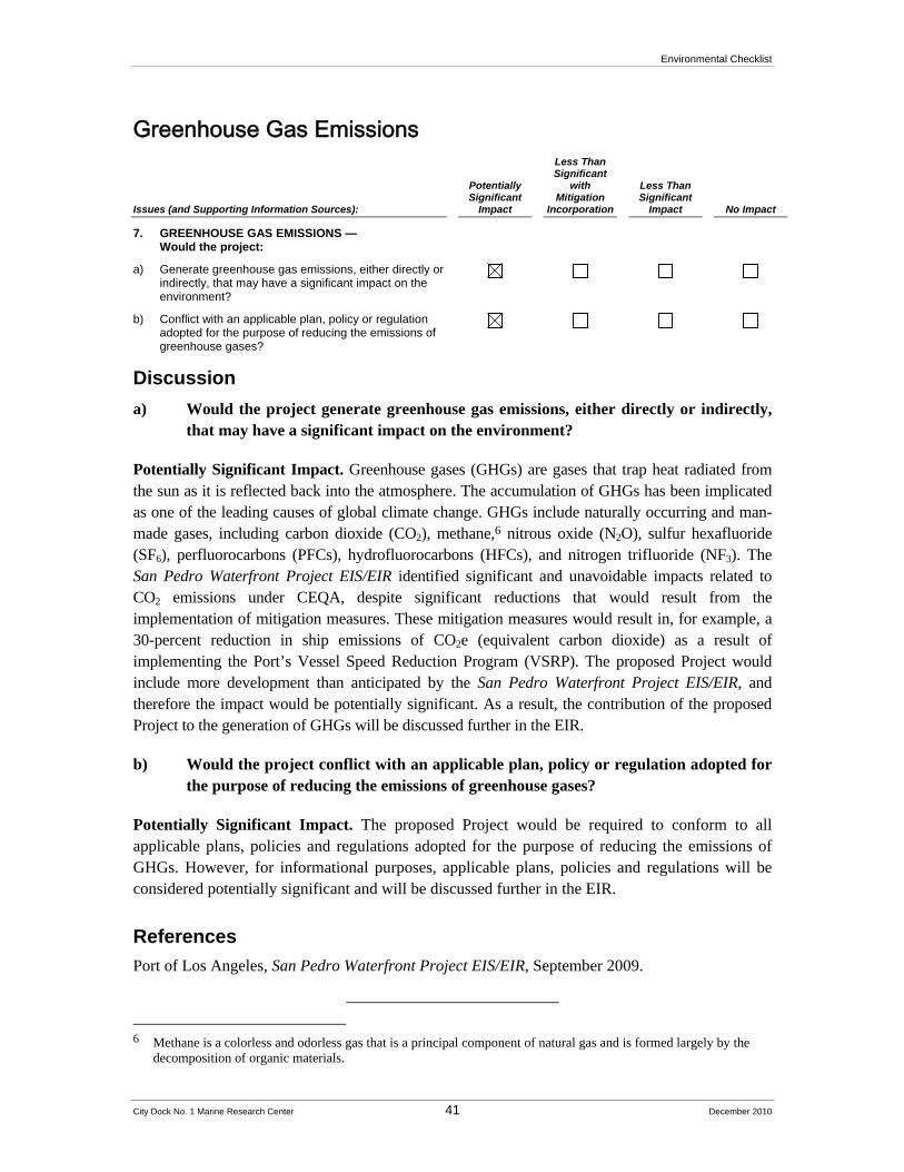
Environmental Checklist
City Dock No. 1 Marine Research Center 41 December 2010
Greenhouse Gas Emissions
Issues (and Supporting Information Sources):
Potentially Significant
Impact
Less Than Significant
with Mitigation
Incorporation
Less Than Significant
Impact No Impact
7. GREENHOUSE GAS EMISSIONS — Would the project:
a) Generate greenhouse gas emissions, either directly or indirectly, that may have a significant impact on the environment?
b) Conflict with an applicable plan, policy or regulation adopted for the purpose of reducing the emissions of greenhouse gases?
Discussion
a) Would the project generate greenhouse gas emissions, either directly or indirectly, that may have a significant impact on the environment?
Potentially Significant Impact. Greenhouse gases (GHGs) are gases that trap heat radiated from the sun as it is reflected back into the atmosphere. The accumulation of GHGs has been implicated as one of the leading causes of global climate change. GHGs include naturally occurring and man-made gases, including carbon dioxide (CO2), methane,6 nitrous oxide (N2O), sulfur hexafluoride (SF6), perfluorocarbons (PFCs), hydrofluorocarbons (HFCs), and nitrogen trifluoride (NF3). The San Pedro Waterfront Project EIS/EIR identified significant and unavoidable impacts related to CO2 emissions under CEQA, despite significant reductions that would result from the implementation of mitigation measures. These mitigation measures would result in, for example, a 30-percent reduction in ship emissions of CO2e (equivalent carbon dioxide) as a result of implementing the Port’s Vessel Speed Reduction Program (VSRP). The proposed Project would include more development than anticipated by the San Pedro Waterfront Project EIS/EIR, and therefore the impact would be potentially significant. As a result, the contribution of the proposed Project to the generation of GHGs will be discussed further in the EIR.
b) Would the project conflict with an applicable plan, policy or regulation adopted for the purpose of reducing the emissions of greenhouse gases?
Potentially Significant Impact. The proposed Project would be required to conform to all applicable plans, policies and regulations adopted for the purpose of reducing the emissions of GHGs. However, for informational purposes, applicable plans, policies and regulations will be considered potentially significant and will be discussed further in the EIR.
References
Port of Los Angeles, San Pedro Waterfront Project EIS/EIR, September 2009.
6 Methane is a colorless and odorless gas that is a principal component of natural gas and is formed largely by the
decomposition of organic materials.

Environmental Checklist
City Dock No. 1 Marine Research Center 42 December 2010
Hazards and Hazardous Materials
Issues (and Supporting Information Sources):
Potentially Significant
Impact
Less Than Significant
with Mitigation
Incorporation
Less Than Significant
Impact No Impact
8. HAZARDS AND HAZARDOUS MATERIALS — Would the project:
a) Create a significant hazard to the public or the environment through the routine transport, use, or disposal of hazardous materials?
b) Create a significant hazard to the public or the environment through reasonably foreseeable upset and accident conditions involving the release of hazardous materials into the environment?
c) Emit hazardous emissions or handle hazardous or acutely hazardous materials, substances, or waste within one-quarter mile of an existing or proposed school?
d) Be located on a site which is included on a list of hazardous materials sites compiled pursuant to Government Code Section 65962.5 and, as a result, would it create a significant hazard to the public or the environment?
e) For a project located within an airport land use plan or, where such a plan has not been adopted, within two miles of a public airport or public use airport, would the project result in a safety hazard for people residing or working in the project area?
f) For a project within the vicinity of a private airstrip, would the project result in a safety hazard for people residing or working in the project area?
g) Impair implementation of or physically interfere with an adopted emergency response plan or emergency evacuation plan?
h) Expose people or structures to a significant risk of loss, injury or death involving wildland fires, including where wildlands are adjacent to urbanized areas or where residences are intermixed with wildlands?
Discussion
a) Would the project create a significant hazard to the public or the environment through the routine transport, use, or disposal of hazardous materials?
Potentially Significant Impact. All hazardous materials are required to be stored, handled, and disposed of in accordance with local, county, and State laws that protect public safety. Removal and disposal of asbestos, lead and any other hazardous material, soil, and/or groundwater will adhere to all applicable local, State and federal regulations. Although adherence to these regulations would minimize the potential for hazardous materials impacts to the public and the environment, the proposed Project, specifically dredging activities related to retrofits and reparations to the existing berths and wharfs, would involve the handling and disposal of hazardous materials. In addition, the remediation of the Westways site, which is under the jurisdiction of the Los Angeles Regional Water Quality Control Board, will be occurring during
Environmental Checklist
City Dock No. 1 Marine Research Center 43 December 2010
implementation of the proposed Project and therefore will be considered in this analysis. Thus, this issue is considered potentially significant and will be further evaluated in the EIR.
b) Would the project create a significant hazard to the public or the environment through reasonably foreseeable upset and accident conditions involving the release of hazardous materials into the environment?
Potentially Significant Impact. As described in response to Section 7(a) above, although all hazardous materials are required to be stored, handled, and disposed of in accordance with local, county, and State laws that protect public safety, because the proposed Project would involve handling and disposal of hazardous materials, an unforeseeable upset or accident could occur. Therefore, this impact is considered potentially significant and will be further evaluated in the EIR.
c) Would the project emit hazardous emissions or handle hazardous or acutely hazardous materials, substances, or waste within one-quarter mile of an existing or proposed school?
No Impact. The closest school to the proposed Project site is the Fifteenth Street Elementary School, which is approximately 0.8 mile northwest from the proposed Project site. This school is not located within one-quarter mile of the proposed Project site. In addition, there are no planned schools located within one-quarter mile of the proposed Project site. Therefore, the proposed Project would not result in hazardous emissions or the handling of hazardous materials within one-quarter mile of an existing or planned school. This issue does not require further analysis in the EIR.
d) Is the project located on a site which is included on a list of hazardous materials sites compiled pursuant to Government Code Section 65962.5 and, as a result, would it create a significant hazard to the public or the environment?
Potentially Significant Impact. While none of the uses on the proposed Project site currently involve the storage, use or generation of hazardous materials, several of the site’s historic uses, which included liquid bulk storage and boat repair, involved the storage and/or use of hazardous materials and may be included on a list of hazardous materials sites compiled pursuant to Government Code Section 65962.5. The Westways site, particularly, has identified areas of contamination and will be undergoing remediation as a related project. Currently, there is monitoring and limited remediation under LARWQCB oversight. The activities generate small quantities of hazardous waste (55-gallon drums), which are temporarily stored onsite prior to offsite disposal. Impacts associated with worker and public exposure to this site is considered potentially significant; therefore, this issue will be evaluated in the EIR.
e) For a project located within an airport land use plan or, where such a plan has not been adopted, within two miles of a public airport or public use airport, would the project result in a safety hazard for people residing or working in the project area?
Environmental Checklist
City Dock No. 1 Marine Research Center 44 December 2010
No Impact. The proposed Project is not located within the vicinity of a public airstrip and is not within two miles of a public airport. The closest public airport, Long Beach Airport, is located approximately nine miles to the northeast of the proposed Project site. Therefore, no impact will occur, and no further study is required.
f) For a project within the vicinity of a private airstrip, would the project result in a safety hazard for people residing or working in the project area?
No Impact. The proposed Project is not located within the vicinity of a private airstrip. The closest private use airport is the Torrance Municipal Airfield located approximately 6.5 miles to the northeast. Therefore, the proposed Project would not result in a safety hazard to people working or residing in the proposed Project area and this issue requires no further analysis in the EIR.
g) Would the project impair implementation of or physically interfere with an adopted emergency response plan or emergency evacuation plan?
Potentially Significant Impact. The Los Angeles City Fire Department (LAFD) currently provides emergency medical and fire protection support, and the Port Police and the Los Angeles Police Department (LAPD) are responsible for coordinating law enforcement and traffic control operations in emergency situations. During construction activities, adequate vehicular access would be provided and maintained in accordance with LAFD requirements. LAFD would review all construction and design plans before development of the proposed Project to ensure that access is provided for emergency equipment. The proposed Project would not affect potential emergency response routes. The proposed Project’s proximity to the harbor may make it susceptible to impacts related to a tsunami and a seiche. Impacts to emergency evacuation should a tsunami or seiche occur could be significant and coordination with LAFD, LAPD, and Port Police would be required. In addition, the U.S. Coast Guard coordinates efforts related to homeland security at the Port. Because the proposed Project now includes docking NOAA vessels on the Main Channel, security for the proposed Project site will be addressed further in the EIR.
h) Would the project expose people or structures to a significant risk of loss, injury or death involving wildland fires, including where wildlands are adjacent to urbanized areas or where residences are intermixed with wildlands?
No Impact. The proposed Project site is in an urban area surrounded on all sides by industrial uses and by Port waters. No wildlands are adjacent to the proposed Project site and the proposed Project would not affect nor be affected by wildland fires. No impacts would occur and this issue does not require further analysis in the EIR.
References
Port of Los Angeles, San Pedro Waterfront Project EIS/EIR, September 2009.
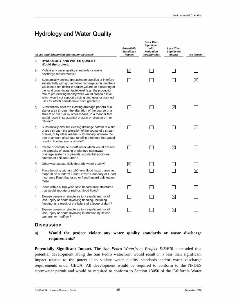
Environmental Checklist
City Dock No. 1 Marine Research Center 45 December 2010
Hydrology and Water Quality
Issues (and Supporting Information Sources):
Potentially Significant
Impact
Less Than Significant
with Mitigation
Incorporation
Less Than Significant
Impact No Impact
9. HYDROLOGY AND WATER QUALITY — Would the project:
a) Violate any water quality standards or waste discharge requirements?
b) Substantially deplete groundwater supplies or interfere substantially with groundwater recharge such that there would be a net deficit in aquifer volume or a lowering of the local groundwater table level (e.g., the production rate of pre-existing nearby wells would drop to a level which would not support existing land uses or planned uses for which permits have been granted)?
c) Substantially alter the existing drainage pattern of a site or area through the alteration of the course of a stream or river, or by other means, in a manner that would result in substantial erosion or siltation on- or off-site?
d) Substantially alter the existing drainage pattern of a site or area through the alteration of the course of a stream or river, or by other means, substantially increase the rate or amount of surface runoff in a manner that would result in flooding on- or off-site?
e) Create or contribute runoff water which would exceed the capacity of existing or planned stormwater drainage systems or provide substantial additional sources of polluted runoff?
f) Otherwise substantially degrade water quality?
g) Place housing within a 100-year flood hazard area as mapped on a federal Flood Hazard Boundary or Flood Insurance Rate Map or other flood hazard delineation map?
h) Place within a 100-year flood hazard area structures that would impede or redirect flood flows?
i) Expose people or structures to a significant risk of loss, injury or death involving flooding, including flooding as a result of the failure of a levee or dam?
j) Expose people or structures to a significant risk of loss, injury or death involving inundation by seiche, tsunami, or mudflow?
Discussion
a) Would the project violate any water quality standards or waste discharge requirements?
Potentially Significant Impact. The San Pedro Waterfront Project EIS/EIR concluded that potential development along the San Pedro waterfront would result in a less than significant impact related to the potential to violate water quality standards and/or waste discharge requirements under CEQA. All development would be required to conform to the NPDES stormwater permit and would be required to conform to Section 13050 of the California Water
Environmental Checklist
City Dock No. 1 Marine Research Center 46 December 2010
Code (CWC). Dredging, new wharf construction and wharf reconstruction and upgrades during the construction phases of development along the San Pedro waterfront “would not entail any direct or intentional discharges of wastes to waters of the harbor” (p. 3.14-39), and “[i]n-water dredged material disposal at the LA-2 and/or LA-3 sites would result in minor, transitory changes in turbidity that have previously been determined to be less than significant (EPA and USACE 2004)” (p. 3.14-39). However, in relationship to the proposed Project, only in-water work (installation of pilings) related to the proposed promenade was considered. Also, aquaculture operations, the wave tank, and the circulating seawater system could produce discharges that have an adverse effect on the surrounding area. Because the proposed Project site would include additional in-water work, this potential impact is, for the purposes of this analysis, considered potentially significant and will be discussed further in the EIR.
b) Would the project substantially deplete groundwater supplies or interfere substantially with groundwater recharge such that there would be a net deficit in aquifer volume or a lowering of the local groundwater table level (e.g., the production rate of pre-existing nearby wells would drop to a level which would not support existing land uses or planned uses for which permits have been granted)?
No Impact. According to the San Pedro Waterfront Project EIS/EIR, the City of Los Angeles area obtains water from the following three basic sources: the Owens Valley in the Sierras; groundwater wells in the Los Angeles Basin; and the Metropolitan Water District, which imports water from the Colorado and Feather Rivers. Depth to groundwater beneath the San Pedro Waterfront area is approximately six to ten feet below ground surface. No drinking wells are located within a two-mile radius of the San Pedro Waterfront area, which encompasses the project site. Although the proposed Project would include a seawater system throughout the project complex, the proposed Project would not result in the direct withdrawal of groundwater to provide water needed by the proposed Project. (Groundwater in the harbor area is non-potable because of salt water intrusion.)
The proposed Project would include development of new impervious surfaces. This development would not, however, prevent groundwater recharge. Development of the proposed project would have little or no effect on groundwater recharge capacity and no impact would occur. This issue will not be addressed further in the EIR.
c) Would the project substantially alter the existing drainage pattern of a site or area through the alteration of the course of a stream or river, or by other means, in a manner that would result in substantial erosion or siltation on- or off-site?
Less than Significant Impact. The proposed Project would involve the retrofit of existing wharfs and the adaptive re-use of most buildings on those wharfs. These wharfs are already largely impermeable and the proposed Project would not substantially alter drainage patterns. As stated in the San Pedro Waterfront Project EIS/EIR, development along the San Pedro waterfront area would not result in changes to the existing flows of surface water, or result in stagnation. The proposed Project would likely not result in substantial changes to the drainage patterns at the wharfs; however, this issue will be addressed further in the EIR.
Environmental Checklist
City Dock No. 1 Marine Research Center 47 December 2010
d) Would the project substantially alter the existing drainage pattern of a site or area through the alteration of the course of a stream or river, or by other means, substantially increase the rate or amount of surface runoff in a manner that would result in flooding on- or off-site?
No Impact. The proposed Project would include development of new impervious surfaces; however, any increases in flows would be similar to existing runoff, which is either the East or Main Channel of the Los Angeles Harbor. Considering the close proximity to the ocean, any potential increases in runoff would not result in flooding on- or off-site. This issue will not be addressed further in the EIR.
e) Would the project create or contribute runoff water which would exceed the capacity of existing or planned stormwater drainage systems or provide substantial additional sources of polluted runoff?
Less than Significant Impact. The proposed Project site is currently developed with considerable existing impervious surfaces. As stated above, the proposed Project would increase the total area of impervious surfaces. However, according to the San Pedro Waterfront Project EIS/EIR, development at the waterfront “would not increase the potential for flooding on site, due to the presence of existing and planned storm drains. Site elevations would remain generally the same subsequent to construction. In addition, proposed Project operations would not increase the runoff velocity.”
Regarding additional sources of polluted runoff, as discussed above, the proposed Project would be required to adhere to the NPDES stormwater permit and would be required to conform to Section 13050 of the California Water Code (CWC). Implementation of the water quality control measures of stormwater runoff under these regulatory requirements would minimize the potential for any polluted runoff being transported off site. Therefore, the proposed Project would likely have a less than significant impact related to capacity of existing or planned stormwater infrastructure or additional sources of polluted runoff. Still, this issue will be discussed in the EIR.
f) Would the project otherwise substantially degrade water quality?
Potentially Significant Impact. The proposed Project would result in increased ship docking at the proposed Project site. According to the San Pedro Waterfront Project EIS/EIR, “increases in vessel traffic related to the proposed Project could also result in higher mass loadings of contaminants such as copper that are leached from vessel hull anti-fouling paints. Portions of the Los Angeles Harbor are impaired with respect to copper; therefore, increased loadings associated with increases in vessel traffic relative to baseline conditions would likely exacerbate water and sediment quality conditions for copper.” Also, in-water research and/or aquaculture could have adverse effects on the area’s water quality. For the purposes of this analysis, this impact will be considered potentially significant and will be discussed further in the EIR.
Environmental Checklist
City Dock No. 1 Marine Research Center 48 December 2010
g) Would the project place housing within a 100-year flood hazard area as mapped on a federal Flood Hazard Boundary or Flood Insurance Rate Map or other flood hazard delineation map?
No Impact. The proposed Project would not include the construction of housing and therefore no housing would be placed within a 100-year flood hazard area. No impact would occur and this issue will not be addressed further in the EIR.
h) Would the project place within a 100-year flood hazard area structures that would impede or redirect flood flows?
No Impact. The proposed Project site is currently developed and although implementation of the proposed Project would include redevelopment of the proposed Project site, there would not be any structures that could impede or redirect flood flows. No impact would occur and this issue will not be addressed further in the EIR.
i) Would the project expose people or structures to a significant risk of loss, injury or death involving flooding, including flooding as a result of the failure of a levee or dam?
Less than Significant Impact. The proposed Project site is located along the shoreline and therefore could be subject to flooding effects as a result of sea level rise. While there is no current consensus on the actual magnitude of sea level rise that can be expected in the future, there is agreement that coastal areas are at risk and various models have produced a range of possibilities. However, flooding in the context of this issue area refers to situations such as the overabundance of water to a river during a rain storm that causes flooding to land along its banks. Sea level rise, on the other hand, is incremental and any “flooding” that would occur as a result would be over the course of decades and assumes that no actions would be taken to prevent the flooding from occurring. Thus, it is not likely that flooding poses a significant threat to the Project area; however; and this issue will be discussed further in the EIR
j) Would the project expose people or structures to a significant risk of loss, injury or death involving inundation by seiche, tsunami, or mudflow?
Less than Significant Impact. The San Pedro Waterfront Project EIS/EIR indicates that the proposed the San Pedro Waterfront is not subject to mudflows because the waterfront is relatively flat (see Appendix A, p. 49). Tsunamis are defined by the San Pedro Waterfront Project EIS/EIR as “gravity waves of long wavelengths generated by seismic activities that cause vertical motions of the earth’s crust” (p. 49). This vertical motion can cause displacement of overlying waters that trigger transoceanic waves of water containing large amounts of energy. The proposed Project site is located within an area that can potentially be impacted by a tsunami. A seiche could also affect the proposed Project site (seismically-induced waves in enclosed bodies of water). However, according to the San Pedro Waterfront Project EIS/EIR, a model has been developed to predict tsunami wave heights in the Long Beach and Los Angeles harbors. This model indicates that, under certain conditions, a tsunami could result in overtopping at between 1.5 meters above mean sea level to 3.41 meters above mean sea level, which could affect the proposed Project site.
Environmental Checklist
City Dock No. 1 Marine Research Center 49 December 2010
The conclusion is, however, that the potential is very low during the life of construction and operation of the proposed Project of being affected by a major tsunami. Still, this issue will be analyzed further in the EIR.
References
Port of Los Angeles, San Pedro Waterfront Project EIS/EIR, September 2009.
Environmental Checklist
City Dock No. 1 Marine Research Center 50 December 2010
Land Use and Land Use Planning
Issues (and Supporting Information Sources):
Potentially Significant
Impact
Less Than Significant
with Mitigation
Incorporation
Less Than Significant
Impact No Impact
10. LAND USE AND LAND USE PLANNING — Would the project:
a) Physically divide an established community?
b) Conflict with any applicable land use plan, policy, or regulation of an agency with jurisdiction over the project (including, but not limited to the general plan, specific plan, local coastal program, or zoning ordinance) adopted for the purpose of avoiding or mitigating an environmental effect?
c) Conflict with any applicable habitat conservation plan or natural community conservation plan?
Discussion
a) Would the project physically divide an established community?
No Impact. The proposed Project site is located entirely within the Port of Los Angeles on the City Dock No. 1 Project site, which is occupied by existing warehouses and liquid bulk storage facilities that would be redeveloped from warehouse and storage uses into marine research uses and accessory uses. The proposed Project site is surrounded by Port-related uses, such as shipping and warehousing operations. The closest established community is San Pedro, which is located less than 0.5 mile west of the proposed Project site. The proposed Project would be contained entirely within existing Port lands with no element of the proposed Project being constructed or requiring any improvements within the neighborhoods of San Pedro. The proposed Project would therefore not divide an established community, no impacts would occur related to this criterion, and this issue does not require further analysis in the EIR.
b) Would the project conflict with any applicable land use plan, policy, or regulation of an agency with jurisdiction over the project (including, but not limited to the general plan, specific plan, local coastal program, or zoning ordinance) adopted for the purpose of avoiding or mitigating an environmental effect?
Potentially Significant Impact. The applicable land use plans of agencies with jurisdiction over the proposed Project include the state Tidelands Trust, Port Master Plan, City of Los Angeles Zoning Code, City of Los Angeles General Plan, Port of Los Angeles Community Plan, and San Pedro Bay Clean Air Action Plan (CAAP). The Port of Los Angeles Master Plan is incorporated into the Local Coastal Program of the City of Los Angeles. Therefore, projects that are consistent with the Port of Los Angeles Master Plan are also consistent with the City of Los Angeles Local Coastal Program. The Port changed the land use designation of the proposed Project site from industrial uses to programmatic institutional uses, the impacts of which were analyzed in the San Pedro Waterfront Project EIS/EIR and were found to be less than significant with incorporation of mitigation. This issue will be analyzed in the EIR in order to ensure that the specific uses of the proposed Project remain consistent with the applicable land use plans and policies.
Environmental Checklist
City Dock No. 1 Marine Research Center 51 December 2010
c) Would the project conflict with any applicable habitat conservation plan or natural community conservation plan?
No Impact. The proposed Project site is within an industrialized area of the Port. As discussed in Section 4(f), the proposed Project is not located within any habitat conservation plan or natural communities conservation plan. Therefore, no impact will occur. This issue will not be addressed further in the EIR.
References
Port of Los Angeles, San Pedro Waterfront Project EIS/EIR, September 2009.

Environmental Checklist
City Dock No. 1 Marine Research Center 52 December 2010
Mineral Resources
Issues (and Supporting Information Sources):
Potentially Significant
Impact
Less Than Significant
with Mitigation
Incorporation
Less Than Significant
Impact No Impact
11. MINERAL RESOURCES — Would the project:
a) Result in the loss of availability of a known mineral resource that would be of value to the region and the residents of the state?
b) Result in the loss of availability of a locally important mineral resource recovery site delineated on a local general plan, specific plan or other land use plan?
Discussion
a) Would the project result in the loss of availability of a known mineral resource that would be of value to the region and the residents of the state?
No Impact. As described in the San Pedro Waterfront Notice of Preparation/Notice of Intent, most of the San Pedro Waterfront area is not in an aggregate resource zone or oil field drilling area. The San Pedro Waterfront area is classified as MRZ-1, which is defined as an area in which adequate information indicates that no significant mineral deposits are present or where it has been determined that there is little likelihood of their presence; or MRZ-3, which is an area containing mineral deposits, the significance of which cannot be evaluated from available data. The proposed Project site does not contain nor is it in close proximity to an oil, gas or geothermal well. In addition, the proposed Project site is not known to contain mineral resources that would be of value to the region or state. No quarrying operations are established in the vicinity of the proposed Project site and the nearest oil field and drilling areas include the Torrance Oil Field, located north of US 1, and the Wilmington Oil Field, located in the northern portion of the Port. The proposed Project site is located in an area that contains several recreational facilities and in which industrial operations would be limited or relocated, therefore reducing the potential for mining or drilling in the area. Therefore, no impacts to mineral resources would occur. This issue will not be addressed further in the EIR.
b) Would the project result in the loss of availability of a locally important mineral resource recovery site delineated on a local general plan, specific plan or other land use plan?
No Impact. The proposed Project site is not located in a mineral resource area. For the reasons stated above, no impacts to mineral resources would occur. This issue will not be addressed further in the EIR.
References
Port of Los Angeles, San Pedro Waterfront Project EIS/EIR, September 2009.
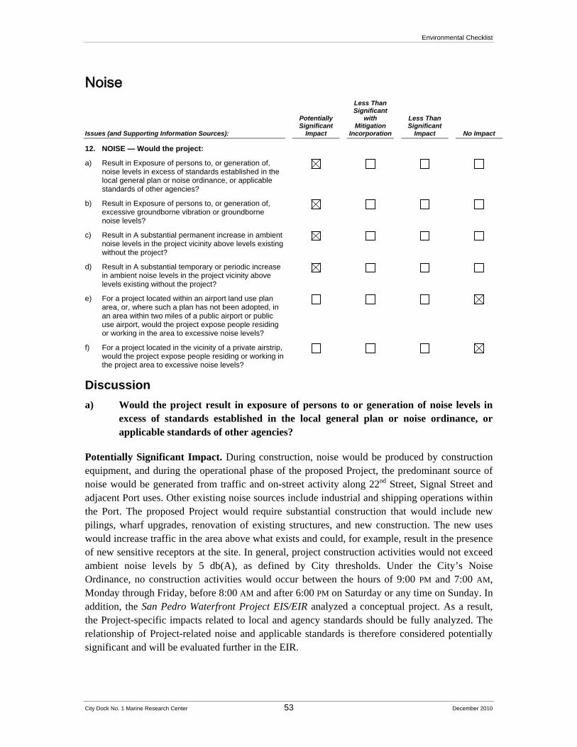
Environmental Checklist
City Dock No. 1 Marine Research Center 53 December 2010
Noise
Issues (and Supporting Information Sources):
Potentially Significant
Impact
Less Than Significant
with Mitigation
Incorporation
Less Than Significant
Impact No Impact
12. NOISE — Would the project:
a) Result in Exposure of persons to, or generation of, noise levels in excess of standards established in the local general plan or noise ordinance, or applicable standards of other agencies?
b) Result in Exposure of persons to, or generation of, excessive groundborne vibration or groundborne noise levels?
c) Result in A substantial permanent increase in ambient noise levels in the project vicinity above levels existing without the project?
d) Result in A substantial temporary or periodic increase in ambient noise levels in the project vicinity above levels existing without the project?
e) For a project located within an airport land use plan area, or, where such a plan has not been adopted, in an area within two miles of a public airport or public use airport, would the project expose people residing or working in the area to excessive noise levels?
f) For a project located in the vicinity of a private airstrip, would the project expose people residing or working in the project area to excessive noise levels?
Discussion
a) Would the project result in exposure of persons to or generation of noise levels in excess of standards established in the local general plan or noise ordinance, or applicable standards of other agencies?
Potentially Significant Impact. During construction, noise would be produced by construction equipment, and during the operational phase of the proposed Project, the predominant source of noise would be generated from traffic and on-street activity along 22nd Street, Signal Street and adjacent Port uses. Other existing noise sources include industrial and shipping operations within the Port. The proposed Project would require substantial construction that would include new pilings, wharf upgrades, renovation of existing structures, and new construction. The new uses would increase traffic in the area above what exists and could, for example, result in the presence of new sensitive receptors at the site. In general, project construction activities would not exceed ambient noise levels by 5 db(A), as defined by City thresholds. Under the City’s Noise Ordinance, no construction activities would occur between the hours of 9:00 PM and 7:00 AM, Monday through Friday, before 8:00 AM and after 6:00 PM on Saturday or any time on Sunday. In addition, the San Pedro Waterfront Project EIS/EIR analyzed a conceptual project. As a result, the Project-specific impacts related to local and agency standards should be fully analyzed. The relationship of Project-related noise and applicable standards is therefore considered potentially significant and will be evaluated further in the EIR.
Environmental Checklist
City Dock No. 1 Marine Research Center 54 December 2010
b) Would the project expose persons to or generate excessive groundborne vibration or groundborne noise?
Potentially Significant Impact. Although the San Pedro Waterfront Project EIS/EIR concluded that vibration-related impacts related to the San Pedro Waterfront Project would be less than significant (p. 3.10-24), the proposed Project is now more fully defined and could potentially result in some vibration-related impacts. As a result, potential impacts from vibration are considered potentially significant and will be evaluated further in the EIR.
c) Would the project result in a substantial permanent increase in ambient noise levels in the project vicinity above levels existing without the project?
Potentially Significant Impact. The San Pedro Waterfront Project EIR/EIS included ambient noise level measurements from the proposed Project site vicinity, including 15-minute measurements at 18th Street and Crescent Avenue, as well as at Cabrillo Marina (see Figure 3.10-1). None were taken at the proposed Project site. In addition, because the proposed Project is now more fully defined, the impacts related to increases in the ambient noise levels related to the proposed Project and in the vicinity could be understated. Therefore, potential impacts are considered potentially significant and will be evaluated further in the EIR.
d) Would the project result in a substantial temporary or periodic increase in ambient noise levels in the project vicinity above levels existing without the project?
Potentially Significant Impact. Construction of the proposed Project would increase ambient noise levels temporarily and periodically over several years. In addition, certain elements of the proposed Project, such as the proposed auditorium at Berth 56, outdoor events along the wharf, and docking vessels (large) could result in periodic increases in ambient noise levels. Although the San Pedro Waterfront Project EIR/EIS included ambient noise level measurements in the proposed Project site vicinity (see Figure 3.10-1), none were taken at the proposed Project site. In addition, because the proposed Project is now more fully defined, impacts related to temporary and periodic increase in ambient noise levels may differ from those in the San Pedro Waterfront Project EIR/EIS. As a result, potential impacts are considered potentially significant and will be further evaluated in the EIR.
e) For a project located within an airport land use plan area, or, where such a plan has not been adopted, in an area within two miles of a public airport or public use airport, would the project expose people residing or working in the area to excessive noise levels?
No Impact. The proposed Project would not be located within an airport land use plan area or within two miles of a public airport or public use airport. The closest public airport, Long Beach Airport, is located approximately nine miles northeast of the proposed Project site. Therefore, no impact would occur, and no further discussion will be provided in the EIR.
f) For a project located in the vicinity of a private airstrip, would the project expose people residing or working in the project area to excessive noise levels?
Environmental Checklist
City Dock No. 1 Marine Research Center 55 December 2010
No Impact. The proposed Project would not be located within the vicinity of a private airstrip. The closest private use airport is the Torrance Municipal Airfield located approximately 6.5 miles to the northeast. Therefore, the proposed Project would not result in a safety hazard to people working or residing in the proposed Project area and no further discussion will be provided in the EIR.
References
Port of Los Angeles, San Pedro Waterfront Project EIS/EIR, September 2009.
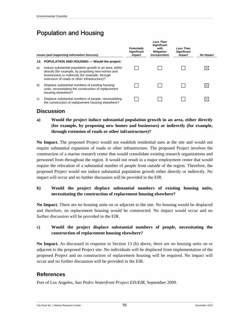
Environmental Checklist
City Dock No. 1 Marine Research Center 56 December 2010
Population and Housing
Issues (and Supporting Information Sources):
Potentially Significant
Impact
Less Than Significant
with Mitigation
Incorporation
Less Than Significant
Impact No Impact
13. POPULATION AND HOUSING — Would the project:
a) Induce substantial population growth in an area, either directly (for example, by proposing new homes and businesses) or indirectly (for example, through extension of roads or other infrastructure)?
b) Displace substantial numbers of existing housing units, necessitating the construction of replacement housing elsewhere?
c) Displace substantial numbers of people, necessitating the construction of replacement housing elsewhere?
Discussion
a) Would the project induce substantial population growth in an area, either directly (for example, by proposing new homes and businesses) or indirectly (for example, through extension of roads or other infrastructure)?
No Impact. The proposed Project would not establish residential uses at the site and would not require substantial expansion of roads or other infrastructure. The proposed Project involves the construction of a marine research center that would consolidate existing research organizations and personnel from throughout the region. It would not result in a major employment center that would require the relocation of a substantial number of people from outside of the region. Therefore, the proposed Project would not induce substantial population growth either directly or indirectly. No impact will occur and no further discussion will be provided in the EIR.
b) Would the project displace substantial numbers of existing housing units, necessitating the construction of replacement housing elsewhere?
No Impact. There are no housing units on or adjacent to the site. No housing would be displaced and therefore, no replacement housing would be constructed. No impact would occur and no further discussion will be provided in the EIR.
c) Would the project displace substantial numbers of people, necessitating the construction of replacement housing elsewhere?
No Impact. As discussed in response to Section 13 (b) above, there are no housing units on or adjacent to the proposed Project site. No individuals will be displaced from implementation of the proposed Project and no construction of replacement housing will be required. No impact will occur and no further discussion will be provided in the EIR.
References
Port of Los Angeles, San Pedro Waterfront Project EIS/EIR, September 2009.

Environmental Checklist
City Dock No. 1 Marine Research Center 57 December 2010
Public Services
Issues (and Supporting Information Sources):
Potentially Significant
Impact
Less Than Significant
with Mitigation
Incorporation
Less Than Significant
Impact No Impact
14. PUBLIC SERVICES — Would the project:
a) Result in substantial adverse physical impacts associated with the provision of, or the need for, new or physically altered governmental facilities, the construction of which could cause significant environmental impacts, in order to maintain acceptable service ratios, response times, or other performance objectives for any of the following public services:
i) Fire protection?
ii) Police protection?
iii) Schools?
iv) Parks?
v) Other public facilities?
Discussion
a) Would the project result in substantial adverse physical impacts associated with the provision of, or the need for, new or physically altered governmental facilities, the construction of which could cause significant environmental impacts, in order to maintain acceptable service ratios, response times, or other performance objectives for any of the following public services:
i, ii) Fire and police protection?
Potentially Significant Impact. The Los Angeles Fire Department (LAFD) currently provides fire protection and emergency services for the proposed Project area. LAFD facilities in the vicinity of the proposed Project site include land-based fire stations and fireboat companies. The Los Angeles Harbor Department Port Police (Port Police) and the Los Angeles Police Department (LAPD) both provide police services to the Port. The Port Police is the primary responding agency in the Port and is responsible for operations within the Port’s property boundaries. Port Police headquarters is located in the LAHD administration building at 425 South Palos Verdes Street in San Pedro.
The impacts of developing institutional uses at the proposed Project site were considered in the San Pedro Waterfront Project EIS/EIR, which determined that existing fire and police resources were adequate to serve the development that would be implemented under the San Pedro Waterfront project with the incorporation of mitigation. This issue will be analyzed in the EIR to ensure that Project-specific impacts would remain less than significant.
Environmental Checklist
City Dock No. 1 Marine Research Center 58 December 2010
iii) Schools?
No Impact. The proposed Project would not involve residential development that would increase the demand for additional or modified school facilities. Therefore, no impact will occur, and no further study is required.
iv) Parks?
Potentially Significant Impact. The proposed Project includes the creation of a waterfront promenade, a public plaza, and other public open space areas, which could potentially result in increased demand on Port services for maintenance and ongoing operation. Although some of the elements of the proposed Project were considered in the San Pedro Waterfront Project EIS/EIR, not all were considered. This impact is therefore considered potentially significant and will be evaluated in the EIR.
v) Other public facilities?
Potentially Significant Impact. The U.S. Coast Guard (USCG) is a federal agency responsible for a broad scope of regulatory, law-enforcement, humanitarian, and emergency-response duties. The USCG mission includes maritime safety, maritime law enforcement, protection of natural resources, maritime mobility, national defense, and homeland security. Within the Port area, the USCG’s primary responsibility is to ensure the safety of vessel traffic in the channels of the Port and in coastal waters. The 11th USCG District, which maintains a post within the Port on Terminal Island, would provide USCG support to the Port area and the proposed Project. USCG, in cooperation with the Marine Exchange, also operates Vessel Traffic Information Systems. This voluntary service is intended to enhance vessel safety in the main approaches to the Port. The proposed Project would involve vessel traffic, and, therefore, could result in impacts to USCG facilities or operations. Impacts could be potentially significant and will be evaluated in the EIR.
References
Port of Los Angeles, San Pedro Waterfront Project EIS/EIR, September 2009.
Environmental Checklist
City Dock No. 1 Marine Research Center 59 December 2010
Recreation
Issues (and Supporting Information Sources):
Potentially Significant
Impact
Less Than Significant
with Mitigation
Incorporation
Less Than Significant
Impact No Impact
15. RECREATION — Would the project:
a) Increase the use of existing neighborhood and regional parks or other recreational facilities such that substantial physical deterioration of the facilities would occur or be accelerated?
b) Include recreational facilities or require the construction or expansion of recreational facilities that might have an adverse physical effect on the environment?
Discussion
a) Would the project increase the use of existing neighborhood and regional parks or other recreational facilities such that substantial physical deterioration of the facilities would occur or be accelerated?
Less Than Significant Impact. The proposed Project would include new recreational amenities, including a waterfront promenade and public plaza, which would relieve the burden on existing community recreational facilities. The demand for parks is generally associated with the increase of housing or population into an area. The proposed Project consists of primarily institutional uses and would not include residential uses. However, visitors and workers at the proposed Project site could potentially add to visitors of the nearby 22nd Street Park and related recreational facilities. These potential impacts to recreation relative to increasing physical deterioration of existing parks and recreational facilities are considered less than significant but will be discussed further in the EIR
b) Would the project include recreational facilities or require the construction or expansion of recreational facilities that might have an adverse physical effect on the environment?
Potentially Significant Impact. The proposed Project would involve construction of a waterfront promenade and public plaza on or near sites that are known to have once experienced a hazardous material spill or to have handled substantial quantities of hazardous materials. Disturbance of these sites during construction activities could result in the release of potentially harmful chemicals or compounds. This impact is considered potentially significant and will be evaluated in the EIR.
References
Port of Los Angeles, San Pedro Waterfront Project EIS/EIR, September 2009.

Environmental Checklist
City Dock No. 1 Marine Research Center 60 December 2010
Transportation and Traffic
Issues (and Supporting Information Sources):
Potentially Significant
Impact
Less Than Significant
with Mitigation
Incorporation
Less Than Significant
Impact No Impact
16. TRANSPORTATION AND TRAFFIC — Would the project:
a) Conflict with an applicable plan, ordinance or policy establishing measures of effectiveness for the performance of the circulation system, taking into account all modes of transportation including mass transit and non-motorized travel and relevant components of the circulation system, including but not limited to intersections, streets, highways and freeways, pedestrian and bicycle paths, and mass transit?
b) Conflict with an applicable congestion management program, including, but not limited to, level of service standards and travel demand measures, or other standards established by the county congestion management agency for designated roads or highways?
c) Result in a change in air or water traffic patterns, including either an increase in traffic levels or a change in location, that results in substantial safety risks?
d) Substantially increase hazards due to a design feature (e.g., sharp curves or dangerous intersections) or incompatible uses (e.g., farm equipment)?
e) Result in inadequate emergency access?
f) Conflict with adopted policies, plans, or programs regarding public transit, bicycle, or pedestrian facilities, or otherwise decrease the performance or safety of such facilities?
g) Result in inadequate parking capacity?
Discussion
a) Would the project conflict with an applicable plan, ordinance or policy establishing measures of effectiveness for the performance of the circulation system, taking into account all modes of transportation including mass transit and non-motorized travel and relevant components of the circulation system, including but not limited to intersections, streets, highways and freeways, pedestrian and bicycle paths, and mass transit?
Potentially Significant Impact. The proposed Project would increase vehicular, pedestrian, and vessel traffic to the proposed Project site. The proposed Project would also involve improvements to the surrounding streets as well as the extension of the Red Car Line down Signal Street. The impacts associated with the increased traffic resulting from the various modes described above will be analyzed in the EIR to determine their consistency with applicable plans and policies contained in the Southern California Association of Governments (SCAG) 2008 Regional Comprehensive Plan, the Port of Los Angeles Master Plan, the Port of Los Angeles Strategic Plan 2006-2011, the City of Los Angeles General Plan, and any other applicable plan.
Environmental Checklist
City Dock No. 1 Marine Research Center 61 December 2010
b) Would the project conflict with an applicable congestion management program, including, but not limited to, level of service standards and travel demand measures, or other standards established by the county congestion management agency for designated roads or highways?
Potentially Significant Impact. As discussed above, the proposed Project would result in an increase in vehicular traffic on the roadways at and surrounding the proposed Project site. This increased traffic may conflict with the levels of service and/or traffic demand measures that have been established by the 2004 Congestion Management Program for Los Angeles County. This issue will be analyzed in the EIR.
c) Would the project result in a change in air or water traffic patterns, including either an increase in traffic levels or a change in location, that results in substantial safety risks?
Potentially Significant Impact. The proposed Project would not result in a change in air traffic patterns or result in a substantial safety risk surrounding air traffic. The closest public airport is the Long Beach Airport, which is approximately 9 miles to the north, and the closest private airstrip is located at the Torrance Municipal Airfield, which is approximately 6.5 miles to the northeast. However, the proposed Project will result in increased vessel traffic at the proposed Project site, which could result in significant impacts related to water traffic. Therefore, this issue will be analyzed in the EIR.
d) Would the project substantially increase hazards due to a design feature (e.g., sharp curves or dangerous intersections) or incompatible uses (e.g., farm equipment)?
Potentially Significant Impact. The proposed Project would result in an increase in vehicular and pedestrian traffic on the roadways surrounding the proposed Project site and vehicle/vehicle and pedestrian/vehicle conflicts would increase. These types of traffic hazards will be evaluated in the traffic study that will be prepared for the proposed Project and this issue will be evaluated in the EIR.
e) Would the project result in inadequate emergency access?
Less than Significant Impact. Emergency access to the proposed Project site would be provided via roads within the proposed Project area. As part of the proposed Project, fire and law enforcement services would have access to the proposed Project site. Also, as part of the Project approval process, the LAFD would review and approve all plans to ensure that they comply with applicable access requirements. This compliance would ensure that emergency access to, from, and within the proposed Project site is adequate. During construction, there would be potential for temporary traffic impacts requiring traffic control measures to insure adequate emergency access. These components of the proposed Project and the Project approval process would likely result in less than significant impacts; however, this will be further analyzed in the EIR.
Environmental Checklist
City Dock No. 1 Marine Research Center 62 December 2010
f) Would the project conflict with adopted policies, plans, or programs regarding public transit, bicycle, or pedestrian facilities, or otherwise decrease the performance or safety of such facilities?
Potentially Significant Impact. The proposed Project would involve the construction of new pedestrian facilities, including a waterfront promenade and public plazas that would be adjacent to a working waterfront. The proposed Project would also include the extension of the Red Car Line into the proposed Project site. The EIR will analyze the consistency of these proposed Project components with applicable plans and policies surrounding pedestrian facilities and public transit, and will analyze any safety concerns surrounding the implementation of these facilities near a working waterfront.
g) Would the project result in inadequate parking capacity?
Potentially Significant Impact. The proposed Project involves the development of a marine research center that would result in an intensification of uses at the proposed Project site and would result in a substantial increase in the number of users of the site, including SCMI staff, faculty and students from the region’s educational institutions, and tourists. The proposed Project would also include the development of parking areas to accommodate the increased number of visitors to the site. The adequacy of the planned parking areas to serve the proposed Project will be analyzed in the EIR.
References
Port of Los Angeles, San Pedro Waterfront Notice of Preparation/Notice of Intent, December 2006.
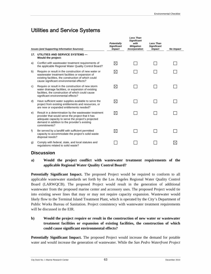
Environmental Checklist
City Dock No. 1 Marine Research Center 63 December 2010
Utilities and Service Systems
Issues (and Supporting Information Sources):
Potentially Significant
Impact
Less Than Significant
with Mitigation
Incorporation
Less Than Significant
Impact No Impact
17. UTILITIES AND SERVICE SYSTEMS — Would the project:
a) Conflict with wastewater treatment requirements of the applicable Regional Water Quality Control Board?
b) Require or result in the construction of new water or wastewater treatment facilities or expansion of existing facilities, the construction of which could cause significant environmental effects?
c) Require or result in the construction of new storm water drainage facilities, or expansion of existing facilities, the construction of which could cause significant environmental effects?
d) Have sufficient water supplies available to serve the project from existing entitlements and resources, or are new or expanded entitlements needed?
e) Result in a determination by the wastewater treatment provider that would serve the project that it has adequate capacity to serve the project’s projected demand in addition to the provider’s existing commitments?
f) Be served by a landfill with sufficient permitted capacity to accommodate the project’s solid waste disposal needs?
g) Comply with federal, state, and local statutes and regulations related to solid waste?
Discussion
a) Would the project conflict with wastewater treatment requirements of the applicable Regional Water Quality Control Board?
Potentially Significant Impact. The proposed Project would be required to conform to all applicable wastewater standards set forth by the Los Angeles Regional Water Quality Control Board (LARWQCB). The proposed Project would result in the generation of additional wastewater from the proposed marine center and accessory uses. The proposed Project would tie into existing sewer lines that may or may not require capacity expansion. Wastewater would likely flow to the Terminal Island Treatment Plant, which is operated by the City’s Department of Public Works Bureau of Sanitation. Project consistency with wastewater treatment requirements will be discussed in the EIR.
b) Would the project require or result in the construction of new water or wastewater treatment facilities or expansion of existing facilities, the construction of which could cause significant environmental effects?
Potentially Significant Impact. The proposed Project would increase the demand for potable water and would increase the generation of wastewater. While the San Pedro Waterfront Project
Environmental Checklist
City Dock No. 1 Marine Research Center 64 December 2010
EIS/EIR determined that sufficient water supplies exist to meet increased water demand and the existing wastewater treatment facilities are also adequate to accommodate the increased generation of wastewater (see pp. 3.13-25 through 3.13-29), the EIR will analyze the Project-specific impacts to ensure that they remain less than significant.
c) Would the project require or result in the construction of new storm water drainage facilities, or expansion of existing facilities, the construction of which could cause significant environmental effects?
Potentially Significant Impact. The proposed Project is expected to increase the amount of stormwater runoff because it would result in an increased area of impervious surfaces. The EIR will analyze the Project’s generation of stormwater to determine if the existing drainage facilities are adequate to accommodate the proposed Project.
d) Would the project have sufficient water supplies available to serve the project from existing entitlements and resources, or are new or expanded entitlements needed?
Potentially Significant Impact. As discussed above, it was determined in the San Pedro Waterfront Project EIS/EIR that sufficient water supplies exist to accommodate build out of the San Pedro Waterfront Project. The proposed Project includes a wave tank, but this feature will utilize seawater, not potable water. This issue will be discussed in the EIR to ensure that Project-specific impacts remain less than significant.
e) Has the wastewater treatment provider that serves or may serve the project determined that it has adequate capacity to serve the project’s projected demand in addition to the provider’s existing commitments?
Potentially Significant Impact. The analysis conducted for the San Pedro Waterfront Project EIS/EIR concluded that the existing wastewater treatment facilities could accommodate the increased generation of wastewater that would result from the San Pedro Waterfront Project. Project-specific impacts associated with the marine research center will be assessed in the EIR/EIS to ensure that impacts remain less than significant.
f) Would the project be served by a landfill with sufficient permitted capacity to accommodate the project’s solid waste disposal needs?
Potentially Significant Impact. As discussed above, it was concluded in the San Pedro Waterfront Project EIS/EIR that sufficient landfill capacity exists to accommodate build out of the San Pedro Waterfront Project. The proposed marine research center is not anticipated to exceed the demand estimated as part of that analysis. However, Project-specific impacts related to landfill capacity will be addressed in the EIR to ensure that they remain less than significant.
g) Would the project comply with federal, state, and local statutes and regulations related to solid waste?
Environmental Checklist
City Dock No. 1 Marine Research Center 65 December 2010
No Impact. As discussed in the Notice of Preparation/Notice of Intent prepared for the San Pedro Waterfront Project EIS/EIR, the proposed Project would comply with all applicable codes pertaining to solid waste disposal. No impacts would occur and this issue does not require further analysis in the EIR.
References
Port of Los Angeles, San Pedro Waterfront Project EIS/EIR, September 2009.
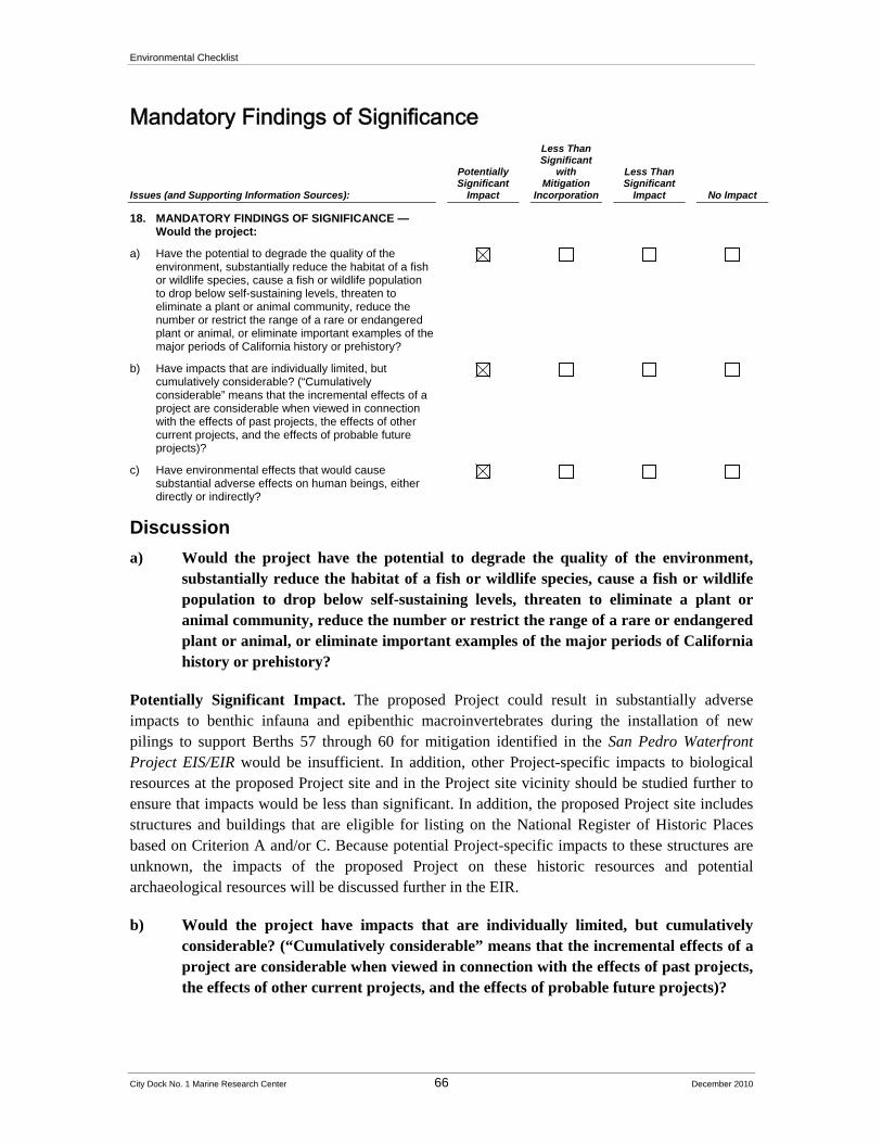
Environmental Checklist
City Dock No. 1 Marine Research Center 66 December 2010
Mandatory Findings of Significance
Issues (and Supporting Information Sources):
Potentially Significant
Impact
Less Than Significant
with Mitigation
Incorporation
Less Than Significant
Impact No Impact
18. MANDATORY FINDINGS OF SIGNIFICANCE — Would the project:
a) Have the potential to degrade the quality of the environment, substantially reduce the habitat of a fish or wildlife species, cause a fish or wildlife population to drop below self-sustaining levels, threaten to eliminate a plant or animal community, reduce the number or restrict the range of a rare or endangered plant or animal, or eliminate important examples of the major periods of California history or prehistory?
b) Have impacts that are individually limited, but cumulatively considerable? (“Cumulatively considerable” means that the incremental effects of a project are considerable when viewed in connection with the effects of past projects, the effects of other current projects, and the effects of probable future projects)?
c) Have environmental effects that would cause substantial adverse effects on human beings, either directly or indirectly?
Discussion
a) Would the project have the potential to degrade the quality of the environment, substantially reduce the habitat of a fish or wildlife species, cause a fish or wildlife population to drop below self-sustaining levels, threaten to eliminate a plant or animal community, reduce the number or restrict the range of a rare or endangered plant or animal, or eliminate important examples of the major periods of California history or prehistory?
Potentially Significant Impact. The proposed Project could result in substantially adverse impacts to benthic infauna and epibenthic macroinvertebrates during the installation of new pilings to support Berths 57 through 60 for mitigation identified in the San Pedro Waterfront Project EIS/EIR would be insufficient. In addition, other Project-specific impacts to biological resources at the proposed Project site and in the Project site vicinity should be studied further to ensure that impacts would be less than significant. In addition, the proposed Project site includes structures and buildings that are eligible for listing on the National Register of Historic Places based on Criterion A and/or C. Because potential Project-specific impacts to these structures are unknown, the impacts of the proposed Project on these historic resources and potential archaeological resources will be discussed further in the EIR.
b) Would the project have impacts that are individually limited, but cumulatively considerable? (“Cumulatively considerable” means that the incremental effects of a project are considerable when viewed in connection with the effects of past projects, the effects of other current projects, and the effects of probable future projects)?

Environmental Checklist
City Dock No. 1 Marine Research Center 67 December 2010
Potentially Significant Impact. Because the proposed Project would comprise more development than anticipated by the San Pedro Waterfront Project EIS/EIR, the proposed Project could result in a cumulatively considerable contribution to greenhouse gas emissions, as well as a cumulatively considerable contribution to poor air quality during construction. Because the Project-specific impacts to greenhouse gas emissions and air quality are unknown, cumulative impacts will be discussed further in the EIR.
c) Would the project have environmental effects that would cause substantial adverse effects on human beings, either directly or indirectly?
Potentially Significant Impact. The proposed Project could result in environmental effects that could cause substantial affects on human beings, either directly or indirectly. These potentially significant impacts will be discussed further in the EIR.
References
Port of Los Angeles, San Pedro Waterfront Project EIS/EIR, September 2009.