notification of the final master plan of dergaon. notification for publication of thetownmaster plan...
TRANSCRIPT

GOVERNMENT OF ASSAM
ORDERS BY THE GOVERNOR
URBAN DEVELOPMENT DEPARTMENT
NOTIFICATION
The 24th February, 2006
No. UDD. (T) 2/2005/41. - In exercise of the power conferred by section of Assam Town and Country Planning (Amended) Act, 1954 (Assam Act XXIII of 1994) read with sub-rule (1) and (2) of Rule 3 of the Assam Town and Country Planning [Publication of Master Plan (Amendment) Rules, 1995] the Governor of Assam is pleased to publish the following Notification regarding the publication of the Final Master Plan of Dergaon.
Notification for Publication of the Master Plan
1. It is notified that the Final Master Plan and Zoning Regulations for Dergaon is prepared by the Director, Town & Country Planning, Government of Assam and adopted by the State Government under Section 10 (2) of the Assam Town & Country Planning (Amendment) Act, 1959 read with 3 (2) of the Assam Town & Country Planning (Amendment) Act, 1962 for the areas described in the schedule below is hereby published.

1802 THE ASSAM GAZETTE EXTRAORDINARY, DECEMBER 1, 2006
2. The Final Master Plan and Zoning Regulation for Dergaon together with all relevant papers and
maps may be inspected free of cost during the office hours at the office of the Director, Town and
Country Planning, Govt. of Assam, Dispur, Guwahati-6, Deputy Director, Town and Country
Planning, District Office- Jorhat, Office of the Chairman, Dergaon Town Committee and Dergaon
Circle office, Copies of Final Master Plan also available at the office of the Director, Town and
Country Planning, Govt. of Assam, Dispur, Guwahati-6 and Deputy Director, Town and Country
Planning, Dist. office Jorhat for sale on payment.
SCHEDULE
A. SITUATION AND AREA :-
District --- GolaghatSub- Division --- GolaghatRevenue Circle --- DergaonThana --- DergaonState --- Assam
Approximate Master Plan Area = 96.659 KM2
B. DESCRIPTION OF BOUNDARY :-
North : Negherial Kaibartta gaon, Gelebil river, Part of Dighalipam Gaon, part of Dhemaji Kaibartta gaon, Hansowa gaon.
South : Dulia gaon, Teliasonari gaon, Jugonia gaon, Batiparia garia gaon, Mojiu gaon, Dubial gaon.
East : Kakodonga River
West : Mamoroni gaon, Rangaliting gaon, Habigaon, Missamora bagicha.
Revenue Areas included in the Master Plan of Dergaon :
1. Dergaon Municipal Area
2. Other Revenue Area included in the Master Plan of Dergaon.

THE ASSAM GAZETTE EXTRAORDINARY, DECEMBER 1, 2006 1803
MOUZA VILLAGE
Dergaon : All revenue blocks of Dergaon Town from Block No. 1 to Block No. 18. Dergaon : Baruabamun Gaon
Khangia gaonHanpani gaon129 No. Nahar Donga grantKamar gaonDergaonJelehua gaonFeta gaon7 No. Naharani grant215 No. Negheriting grantKumar gaon1 No. Negheriting grantSital patharPart of Dighalipam gaonDag No. :- 441,442,443,444,445,446,447,448,449,450,452,453,454,455,456,457,458,459,461,462,463,465,466,467,468,469,470,471,472,473,475,476,477,478,481,483,484,485,487,488,489,490,491,506,260.
Part of Dhemaji Kaibarta gaon
Dag No. 303,304,305,320,322-359.
Gurjogonia Habigaon Mudoi gaon
MalaikumarBhabali gaonBarichoa gaonDoingial gual gaonBongal gaonDadhara Ahom gaonRajabahorEkorani patharDakhin Dolijalia
****************

1804 THE ASSAM GAZETTE EXTRAORDINARY, DECEMBER 1, 2006
CHAPTER – 1
1.1 INTRODUCTION :
Dergaon Town having the status of Municipal Board is situated on N.H. 37 at a distance of 26 km from Jorhat Town and 25 km from District of head quarter Golaghat on the south bank of the river Brahmaputra.
Dergaon is well connected through the National Highway-37 with all other important towns in the State. A branch railway line of N.F. Railway from Furkating to Jorhat is passing through the Baruabamun gaon railway station situated on the southern side at an approx. distance of 5.0 km from the Dergaon Charilai. The nearest airport Rowriah is situated at Jorhat in the East at a distance of 22.0 km from the town. .
Dergaon Town was upgraded to a Municipal town with the establishment of town committee in 1960 with four Ward with a population of 7802. The town committee is upgraded to Municipal Board in 2004 with 10 ward nos. with its geographical area from area 12.691 km2 to 23.958 km2. The population of the town has increased from 7802 in 1961 to 13,426 in 2001. After the extension of the Municipal area the population is estimated to be about 27,791 in 2004.
It is process of urbanization a number of development of economic activities of many fold has taken place in new areas without consideration for future and overall development strategy of the town which have brought many infrastructure related problems to the town such as traffic & transportation, lack of sanitation and other civic amenities.
Taking in to consideration of the trend of development and future expansion of the town together with the availability of the Government land in extensive pockets lying vacant in and around the town covering an area of 96.649 sq.km. the Master Plan of Dergaon has been prepared.
1.2 HISTORY :
Historian area of the opinion that the name “DERGAON” came into existence during the Ahom period from the word “Devagram” means the village of God (Siva) as at that time the place was full of Temples and Holy places. Still some others believe that the name Dergaon was derived from Deori gaon, once rules by the Kacharis. In the 19th Century the kingdom of Ahom King Purander Singh was seized by the British, and the area between 26040’ – 26045’ North latitude and 93055’ – 9400’ East longitude of Golaghat Sub-division under the then Sivasagar district which was the known as Dergaon.

THE ASSAM GAZETTE EXTRAORDINARY, DECEMBER 1, 2006 1805
CHAPTER – 2 PHYSIOGRAPHY AND CLIMATE
2.1 PHYSICAL CHARACTERISTICS :
Dergaon is situated in the south bank of River Brahmaputra at a distance of 26 km from Jorhat town on N.H. 37. It is solemnized by agricultural fields and villages. The town is bounded by the river Kakodonga on the east, Gelabil on the north, agricultural fields on both the west and south side. The town lies at an altitude of 54.70m above the mean sea-level with the cardinal points of 26040’ - 26045’ North and 93055’ - 9400’ East latitude and longitude respectively. It lies on a flat plain with high and low lying areas in topography. The general slope of the area is towards the north-west towards Gelabil. The river Gelabil and Disoi in the northern side of the town acts as a natural barrier for the development which falls under active flood plain area. However there is vast scope for river front development to make a place of tourist interest as the river has beautiful natural scenery of itself.
2.2 CLIMATE :
The climate condition of Dergaon is highly humid atmosphere with abundant rains during the monsoon seasons. May to July are the months having maximum rainfall from 218.80 – 417.40mm. The maximum temperature during summer varies from 30.90 – 33.80 C and minimum is 8.70 C during winter in the December, January month.
CHAPTER – 3DEMOGRAPHIC FEATURE
3.1 GROWTH OF POPULATION :
The growth of Population in the Planning area has experienced a gradual change after British annexure of Assam in 1826. Consistently high rate of growth of population after the independence of the country may be attributed to the high rate of immigration due to the partition of the country and the availability of other social and economic pursuits in the area. The population of the town has increased from 7,802 in 1961 to 9,972 in 1971, 12,994 in 1991 and 13,426 in 2001. The municipal area has been extended from 12,691 sq km to 23,958 sq. km. in 2004. Accordingly the population of the town as per Municipal record is 27,791 in 2004. The Table No. 1 shows the population growth of the municipal area as well as the planning area.

1806 THE ASSAM GAZETTE EXTRAORDINARY, DECEMBER 1, 2006
Table No. I
GROWTH OF POPULATION IN THE DERGAON MASTER PLAN AREA 1961-2004
Dergaon Municipal Area Planning Area Master Plan AreaYear Population P.C.
increasePopulation P.C.
increasePopulation P.C.
increase1961 7,802 -- 32,651 -- 40,453 --
1971 9,972 27.81 38,145 16.83 48,117 178.95
1981 12,742 27.78 44,491 16.64 57,233 18.95
1991 12,994 19.78 47,329 6.38 60,323 5.40
2001 13,426 3.33 52,068 10.01 65,494 8.57
2004 27,791 -- 52,593 10.08 68,284 4.58
Source : 1961, 1971, 1991, 2001 Census of India and figure in 1981 and 2004 Town & Country Planning estimation.
The Population of Master Plan area has increased from 40,453 in 1961 to 65,494 in 2001. The average rate of growth is estimated to be 1.55% per annum. The population average growth rate in the Municipal area is 1.80% per annum during the period from 1961 to 2001. The rate of population growth in the Municipal area is about 0.25% higher than the total Master Plan area. No significant population growth is marked in the Municipal area this natural growth is only due to the growth of economic activities in the Municipal area.
3.2 POPULATION DENSITY :
The population density of Dergaon town area was 1024 person per sq. km in 1991 and 1058 person per sq. km in 2001. The rate of increase of population density of Dergaon town is not significant and population density of the town is much lower in comparison to the other town of the state. It shows that the process of urbanization is very slow in the area and growth is natural.
3.3 AGE-SEX COMPOSITION :
The sex ratio of a settlement is expressed as the number of females per 1000 males. The analysis of sex ratio of Municipal area, Master Plan area and the urban population of undivided Sivasagar district revealed that the planning area has balance population of sex ratio 951 as compared to the district. This may be attributed to the population exploration in the town in which is largely due to the natural growth and there is very less percentage of immigration to the area by means of shifting of families rather than individuals.

THE ASSAM GAZETTE EXTRAORDINARY, DECEMBER 1, 2006 1807
Percentage of age distribution of existing population in Municipal area & Master Plan area of Dergaon by broad age group is shown in table No. II. It reveals that percentage distribution of young aged male and female are less than the working age group. The composition of working age group of male & female population reveals that there is no immigration to the town and is of due to natural growth only.
Table No. II
PERCENTAGE DISTRIBUTION OF BROAD AGE GROUPDERGAON MASTER PLAN AREA
AGE GROUP P.C. OF MALE P.C. OF FEMALE TOTAL
0-16 6.27 2.79 9.06
6-18 10.45 10.11 20.56
18-60 34.15 30.66 64.81
Above 60 4.53 1.04 5.57
55.40 44.60 100.00
Source : Town & Country Planning survey, 2004.
CHAPTER – 4ECONOMIC DEVELOPMENT & OCCUPATIONAL PATTERN
4.1 ECONOMIC DEVELOPMENT :
Sound economic with optimum use of local and regional resources is a basic requirement for all-round development. A town like Dergaon acts a powerful link between rural settlement and urbanized centers with regards to collection and distribution of economic inputs of the region and their influence of the physical development of the region. Economically Dergaon occupies a fairly good position being rich in agriculture and forest with a view to assessing the scope of the urbanization as well as local cum regional potentiality it is also necessary to examine the occupational pattern of Dergaon Master Plan Area.

1808 THE ASSAM GAZETTE EXTRAORDINARY, DECEMBER 1, 2006
4.2 OCCUPATIONAL PATTERN IN MASTER PLAN AREA :
The Table-III shows the occupational pattern of Dergaon Master Plan Area.
Table No. III
PERCENTAGE DISTRIBUTION OF WORKERSIN DERGAON MASTER PLAN AREA, 2004
SL. NO. CATEGORY P.C.
1 Cultivation 30.30
2 Agricultural Labour 3.76
3 Live stock and Forestry 1.43
4 Mining and Quarrying 0.07
5 Manufacturing etc. 8.96
6 Construction 1.04
7 Trade and Commerce 25.43
8 Transport and Communication 0.78
9 Other/ Service 28.23
Total 100.00
Source : Town & Country Planning survey, 2004.
The above table shows that high percentage of workers prevails in the tertiary sector and it clearly indicates that Dergaon is a Service cum Trade & Commerce oriented Town.
CHAPTER – 5HOUSING
5.1 HOUSING ENVIRONMENT :
Housing in one of the vital sectors of human settlement. The quantity & quality of house reveals the overall economic profile of the settlement. A house to house survey was conducted to understand the type and condition of house in 2004.
There is 4094 holding within Municipal limit. The survey depicted the prevalence of 39% Kutcha type latrines with unhygienic surroundings.

THE ASSAM GAZETTE EXTRAORDINARY, DECEMBER 1, 2006 1809
About 60% of total house within the Municipal area are of Assam Type and nearby 21% of the houses are temporary type. About 16% of the houses are in dilapidated condition. Except few percentages in commercial areas all houses are of single storeyed. 88% of the houses are electrified. 81% of the household have own tube well for water supply. Though to meet the need for safe drinking water in the town area pipe water supply scheme is available the demand for the same is not significant.
5.2 RESIDENTIAL DENSITY :
Residential density is a measure of housing space and helps in assessing the efficient use of urban land. There are 5,591 housing units in the Municipal area to accommodate 27,791 population in 2004. The average occupancy is calculated to be 4.96 persons per household. The net density of Dergaon Municipal area is calculated to be 29 persons per hectare.
5.3 STRUCTURAL TYPE & CONDITION OF HOUSES :
The Table No. IV presents the Ward wise structural condition & type of Houses within the Municipal area.
Table No. IV
STRUCTURAL TYPE & CONDITION OF THE HOUSEIN DERGAON MUNICIPAL AREA, 2004
Housing Type Condition Ward No. R.C.C. Semi
R.C.C. Assam Type
Kutcha Total
Good Fair Bad Total
1 0 28.57 28.57 42.86 100.00 28.57 71.43 100.002 50.00 25.00 25.00 100.00 50.00 50.00 100.003 25.00 40.00 40.00 100.00 20.00 40.00 40.00 100.004 60.00 -- 40.00 -- 100.00 100.00 100.005 PTC area -- 65.00 35.00 100.00 56.00 27.00 17.00 100.006 40.00 -- 60.00 -- 100.00 60.00 40.00 100.007 37.50 37.50 25.00 -- 100.00 62.50 25.00 12.50 100.008 33.33 50.00 16.67 100.00 50.00 50.00 100.009 22.22 44.45 33.33 100.00 44.44 22.23 33.33 100.0010 14.29 71.42 14.29 100.00 85.71 14.29 100.00Total 18.31 16.14 44.84 20.71 100.00 55% 29% 16% 100.00Source : Town & Country Planning survey, 2004.

1810 THE ASSAM GAZETTE EXTRAORDINARY, DECEMBER 1, 2006
CHAPTER – 6EXISTING PHYSICAL CONDITION
6.1 LAND USE ANALYSIS :
The existing land use pattern study is inevitable in order to understand and systematic analysis of the functional relationship among various uses particularly the places of working, living, marketing and recreation. This also helps in identifying the various activities influencing the quality of life in the town. A detailed land use survey of the area was conducted in 2004. The existing land use in the Master Plan area has been broadly grouped into the following categories and is prepared in the Table No. VI.
Table No. VI
EXISTING LAND USE PATTERN OF DERGAON MASTER PLAN & MUNICIPAL AREA, 2004
Master Plan Area Municipal AreaSl. No. Land use Category Area in
HectareP.C. of
total areaArea in Hectare
P.C. of total area
1 Residential 2354.39 24.36 975.00 40.70
2 Commercial 218.43 2.26 167.63 6.70
3 Public & semi Public 152.87 1.58 51.00 2.13
4 Industrial 85.92 0.89 104.00 4.34
5 Defense 267.20 2.76 267.20 11.15
6 Paddy 3257.39 33.70 179.97 7.51
7 Tea 894.96 9.26 106.00 4.42
8 Jungle 43.29 0.45 -- --
9 Cremation Utilities & services 16.09 0.17 30.40 1.27
10 Water bodies 307.18 3.18 20.17 0.84
11 Park & Play ground 52.63 0.55 22.43 0.94
12 Vacant land 966.35 10.00 -- --
13 Roads & railway (Transportation & Communication)
1048.21 10.84 472.00 19.70
Total 9664.91 100.00 2395.80 100.00
Source : Town & Country Planning survey, 2004.

THE ASSAM GAZETTE EXTRAORDINARY, DECEMBER 1, 2006 1811
6.2 LAND USE PATTREN :
The above table depicts the land use distribution in the Dergaon Master Plan area and the percentage area covered by each type of land use. The residential use occupies the major land use within the town and its immediate out skirts, while the rural gone is predominantly covered by the tea gardens, paddy fields and low lying areas. The residential areas in this belt are in isolated pockets developed whenever high lands are available.
The existence of adequate transportation facilities is the prime factor for social and economic development of a region. So, despite the availability of ample resources low level of development in this region is mainly due to inadequacy of transport facilities.
6.3 PUBLIC UTILITIES AND SERVICES
6.3 (a) WATER SUPPLY :
At present, Dergaon Municipal Board has no Water Supply Scheme. The resident of the town is mainly dependent on under ground water supply by using tube well for pipe water supply in the Municipal area. The Assam Urban Water Supply & Sewerage Board has recently introduced pipe water supply in Dergaon. The town area has been divided into two zones with three nos of tube well in each zone. The Zone No. 1 water supply scheme near Dergaon Block with capacity 2.35 MLD boring has been completed and it covers approx. 14km road length. The zone No. 2 water scheme which is situated in front of A.S.E.B. Sub-station has been partially commissioned. It will cover total road length of 26 km and 4.5 km of P.T.C. area. The rural area is covered under P.H.E. water supply scheme with underground tank and Tube wells.
6.3 (b) POWER :
The town is served by one electric substation having installed capacity of two nos 2.5 MVA transformer. The source of power is Jorhat i.e. Garmur 132 KVA Sub-station. There are 213 street light posts in the town. The number of domestic connection is 5745 and unmetered rural domestic connection is 343. Commercial connection including unmetered is 644. Water supply including one urban sewerage water supply connection is 7. Irrigation connection is 29. Tea garden connection is 4 with consumption of 263 kw. Industry below 20 KW consumption is 21 and between 20 to 21 kw are 12. The average demand of power during peak hour is 4.3 MVA.

1812 THE ASSAM GAZETTE EXTRAORDINARY, DECEMBER 1, 2006
6.3 (c) PARKS AND PLAY GROUND :
The whole planning area is lacking organized parks and playgrounds in spite of the extensive pockets of Government lands. The social and cultural institutions in the town are one cinema hall, one public hall, one public library, some community halls, town club, sports club & Dergaon Sahitya Sabha Bhawan. There is one park on the bank of Historical pond digged at the time of Ahom king Suhung Muhung.
One multipurpose auditorium in the N.S.S. Field and another Multipurpose Stadium at Sital Pathar under North development Block field are under construction. In addition to these there are play grounds in Police Training College, Basic Training centre near Gelabil, College Field & Town Field and few Religious buildings in the town.
6.3 (d) HEALTH :
There is 30 bedded community health center (Civil Hospital) and a subsidiary Health center in the town with 8 doctors and 11 Para medical staffs in the town. There is 1 (One) number of private Nursing Home and few private medical practitioners in the town. The facilities available in the Civil Hospital as well as in the private Nursing home are not sufficient to fulfill the requirement of patients. Due to the absence of specialist medical practitioner with check up center at Dergaon town the people of the town has to depend on Jorhat & Golaghat town. The rural areas covered under Master Plan areas of Dergaon have 4 PHC and 6 Medical sub centers.
6.3 (e) EDUCATION :
The town is has a higher level of educational facilities for general education. The literacy rate of Municipal area is 92% and that of Master Plan area is 82.05%. The town has General College, Junior College, Girl’s Higher Secondary School near the town. The number of educational institution is presented in the Table No. VII.
Table No. VII
DISTRIBUTION OF EDUCATIONAL INSTITUTION
Level of Education No.1. Primary 32
2. Middle English School 17
3. High School 9
4. Higher Secondary School 4
5. College 1

THE ASSAM GAZETTE EXTRAORDINARY, DECEMBER 1, 2006 1813
6.3 (f) DRAINAGE :
Dergaon has practically no Drainage and Sewerage System at present. During rainy season low lying areas becomes water logged due to absence of any classified drainage system and reduction of the water retention capacity of the low lying areas developed for residential uses. The existing drainage system comprises of open road side drain which carries water to small natural nallas and ultimately to the only drain Loa Dong flowing towards north meets the Gelabil river flowing on the northern side of the town. To save the town from the threat of water logging problem by providing scientific drainage system a Drainage Master Plan for Dergaon has been prepared by the Drainage & Sewerage Division of Town and Country Planning, Tinsukia, Assam.
6.3 (g) REGIONAL TRANSPORTATION SYSTEM :
The N.H. 37 passes east-west through the center of the town. The N.H. 39 which connects the N.H. 37 at Numaligarh at a distance of 26 km from Dergaon town serves for better regional connectivity with the neighbouring state Nagaland and other Northern Eastern States. The PWD road which passes through the town from North towards South divides the town into four parts & connects the railway station at Baruabamun Gaon, district town Golaghat and Dimapur Road. Due to the present bad condition of this single lane road the economic development of the area is lagging. There are many other small roads in the town. The total length of the roads within the Municipal limit is approx. 164.50 km. Out of which 100.00 km is Gravel & 40.00 km is Kutcha. The roads within the Municipal area are managed by P.W.D. ® & Municipal Board Dergaon. The responsibility of development & maintenance of about 78% of the total road length within Municipal area lies with Dergaon Municipal Board.
6.3 (h) TRADE & COMERCE :
It has been observed that in the Dergaon town population is associated with Trade & Commerce activities retail in nature to meet the need of the town with nearby villages. The Trade & Commerce activities of Dergaon town is mainly of ribbon development along the both sides of NH 37 & the P.H.G. path from the Chariali to Narikalguri Chariali and few pockets out side the town limit.
Due to location of the town there is scope for construction of Super market to tap customer from NRL or even from Golaghat & passengers passing through the N.H.

1814 THE ASSAM GAZETTE EXTRAORDINARY, DECEMBER 1, 2006
6.3 (i) INDUSTRY :
Except a few Tea packaging Industry, Rice Mill, Oil Mill, Saw mill the industries of Dergaon are all of S.S.I. category. Recently at Dergaon some food & beverage and spice industries have come up with one cold storage. The region is rich in sugar cane, agriculture produce. The scope for establishment of agro based and aromatic industries is wide, which is till now a family business only. After the closure of the Co-operative Sugar Mill at Barua-bamun gaon has weaken the economic condition of the town. The scope for sugar cane based industry at Dergaon is wide.
6.3 (j) SOLID WASTE :
At present there is no scientific solid wastes management system in the town. The total solid waste generated in the household & commercial area of Dergaon town is 12 cum/day. The garbage at present without segregation is dumped at the unprotected low-land near river Gelabil. Out of the 12 cum Solid waste generated 7 cum is cleared by using tractor trolley & 3 cum by hand cart.
CHAPTER – 7POPULATION PROJECTION
7.1 IMPACT OF POPULATIOON GROWTH :
The future rate of growth of population primarily influenced by the degree of Industrialization of the area because over and above the natural increase of force of urbanization pull people from outside the area resulting in increasing in commercial and allied activities.
The population projection provides a means of estimating the magnitude of the development problems the resource that will be required and identity or land use that will be required to serve the future community.
7.2 FACTORS CONSIDERED FOR POPULATION PROJECTION OF PLANNING AREA :
In projection the future growth of population upto 2025 the following factors have been taken into consideration.
1) During 1st part of the plan period upto 2011 the population growth will be determined by the natural growth rate.
THE ASSAM GAZETTE EXTRAORDINARY, DECEMBER 1, 2006 1815
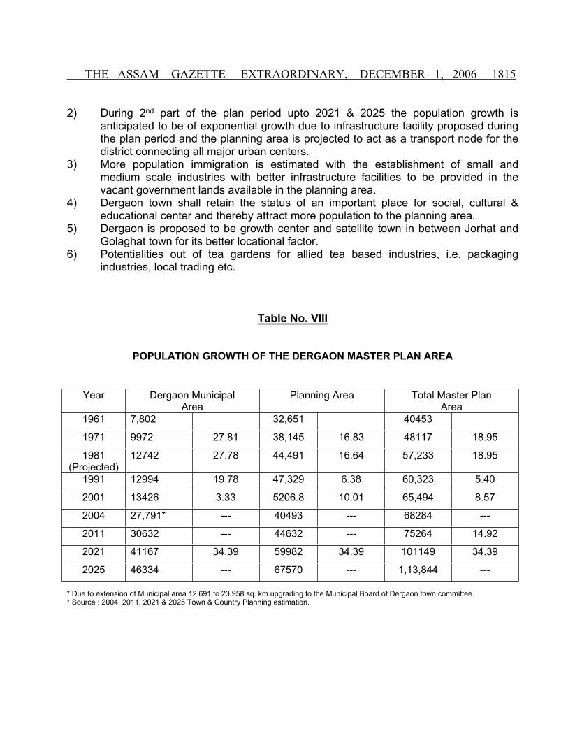
2) During 2nd part of the plan period upto 2021 & 2025 the population growth is anticipated to be of exponential growth due to infrastructure facility proposed during the plan period and the planning area is projected to act as a transport node for the district connecting all major urban centers.
3) More population immigration is estimated with the establishment of small and medium scale industries with better infrastructure facilities to be provided in the vacant government lands available in the planning area.
4) Dergaon town shall retain the status of an important place for social, cultural & educational center and thereby attract more population to the planning area.
5) Dergaon is proposed to be growth center and satellite town in between Jorhat and Golaghat town for its better locational factor.
6) Potentialities out of tea gardens for allied tea based industries, i.e. packaging industries, local trading etc.
Table No. VIII
POPULATION GROWTH OF THE DERGAON MASTER PLAN AREA
Year Dergaon Municipal Area
Planning Area Total Master Plan Area
1961 7,802 32,651 40453
1971 9972 27.81 38,145 16.83 48117 18.95
1981(Projected)
12742 27.78 44,491 16.64 57,233 18.95
1991 12994 19.78 47,329 6.38 60,323 5.40
2001 13426 3.33 5206.8 10.01 65,494 8.57
2004 27,791* --- 40493 --- 68284 ---
2011 30632 --- 44632 --- 75264 14.92
2021 41167 34.39 59982 34.39 101149 34.39
2025 46334 --- 67570 --- 1,13,844 ---
* Due to extension of Municipal area 12.691 to 23.958 sq. km upgrading to the Municipal Board of Dergaon town committee.* Source : 2004, 2011, 2021 & 2025 Town & Country Planning estimation.
1816 THE ASSAM GAZETTE EXTRAORDINARY, DECEMBER 1, 2006
CHAPTER – 8
8.1 PHYSICAL PLAN CONCEPT :
The Master Plan is conceived taking into account of the followings Concepts/Issues :
1. Considering the present trend as well as regional setting of Jorhat and Golaghat and its location factor Dergaon shall enjoy the status of transportation node and shall become an important growth center.
2. Dergaon town shall retain the status of an important social, cultural and educational center in the district.
3. The predominating function of the surroundings shall remain mainly agricultural followed by tea garden during plan period.
4. Neighbourhood concept is applied in the plan and is found to be ideal in view of existing trend of development of residential areas as well as commercial activities and few new neighbourhood centres have been conceived at convenient locations on the south and south-east part of the planning area.
5. In course of its development process as a growth center it will behest the socio-economic development of its hinterland land of its own size and function as an urban center having own entity in the context of regional development.
6. The physical constraints i.e. proneness to flood, and low lying areas have been considered to play in guiding the growth of the town and therefore development in such areas are discouraged
8.2 PLAN PERIOD :
Planning is a continuous process and so is the process of growth of urban settlement. However, for the purpose of preparation of Master Plan, a time span for the plan has been adopted to facilitate estimation of various requirements of the town and get between services out of it. The Plan period for Dergaon Master Plan is therefore proposed up to 2025. It is true that in any case the proposals incorporated in the plan can not be treated as the requirement period alone nor absolute. The city town has to function to meet the functional needs including aesthetic & emotional aspirations of the citizens beyond the Plan period.
8.3 PHYSICAL PLAN PROPOSALS :
With the planning concept in mind proposals have been worked out in consideration of various physical, land use and socio-economic surveys conducted and analysis made by Town & Country Planning department, Dist Office, Jorhat.

THE ASSAM GAZETTE EXTRAORDINARY, DECEMBER 1, 2006 1817
The same objective of this comprehensive Master Plan is to attain sustainable and balanced integrated urban development in the area proposed for its population of 1,13,844 by 2025 keeping in view of cultural milieu and all predictable factors as well as environment.
8.4 AIMS AND OBJECTIVES :
The main aims & objectives which are attempted to be achieved in the Master Plan for Dergaon are as follows :-
i) To give impetus to the town to act as a growth center for its surrounding region;ii) To give shape to the urban structure with the city functions for better Urban
services.iii) Functional disposition by land use so as to achieve :
- harmonious and co-herent inter-relationship among various uses and activities.
- functional distribution of work centers and living areas, minimize travel distance and increase efficient functional activities.
iv) Development of inter-district and regional transportation and communication network to discharge functions as a growth center in regional entity/perspective.
v) Hierachial structure in terms of self contained planning units and ensure disposition of services and amenities on the basis of hierarchy of Planning entities.
Based on the studies in respect of land use pattern, problems and opportunities available for proper development of the town and its surrounding the following points have been envisaged in the Master Plan :
(a) Development of neighbourhood shopping centres to relieve congestion in the town center and to provide opportunities for growth of commercial activities.
(b) Development of civic center for socio-cultural activities and to provide facilities for cultural and emotional integration among the people.
(c) Encouragement of Small & Medium Scale industrial units allocating land to prevent conflict in land-use pattern.
(d) Provision of proper circulation pattern for easy and safe movement of traffic. (e) Rational distribution of residential areas and linkage between
neighbourhoods. (f) Ensure eco-friendly urban environment.
- Through conservation of historical and heritage sites; - Maintaining ecological balance by preserving rivers, ponds, water bodies and
other proneness to ecological imbalance, and - Improvement and clearance of slum areas by providing environmental
improvement schemes.

1818 THE ASSAM GAZETTE EXTRAORDINARY, DECEMBER 1, 2006
CHAPTER – 9
9.1 PROPOSED LAND USE PATTERN :
In consonance with the plan concept and objectives, in general, the land use pattern for Dergaon Master Plan area has been evolved and proposed to achieve the following :
1. Mixed land use particularly in the town center to maximize use of service and minimize movements.
2. Minimum dislocation of present land use.
3. Inter-relationship of various land use classifications.
4. Heirarchial relationship of activity areas.
5. Decentralisation of work places/centers.
6. Best utilization of natural forms & beauty of the area enriching the aesthetic value of the urban form.
9.2 LAND USE DISTRIBUTION :
Recommendations and proposals for the future growth of Dergaon town have been formulated after examining the prospect of development in relatively inexpensive areas and on the basis of site suitability with the scope of providing necessary infrastructure. The recommendation and proposals then so far as possible been translated into land use plan to give them spatial dimension. The land use shown in Map No. 2 broadly indicates the functional relationship between various urban activities visualized upto 2025 and aims at providing the optimum utilization of land in Dergaon Master Plan area.
Further the distribution of the land area into various broad categories of land use have been drawn keeping in view of the minimum desirable standards as per the Govt. of India’s UDPFI Guidelines for Urban Planning. The following Table No. – IX shows the land use distribution under various major uses for 2025 of Dergaon Master Plan Area.

THE ASSAM GAZETTE EXTRAORDINARY, DECEMBER 1, 2006 1819
Proposed Land Use Distribution, 2025 : Dergaon Master Plan Area
Master Plan AreaSl.No.
Land use CategoryArea in Hectare
Percent of total development
area
Percent of total area
1 Residential 3092.77 56.69 32
2 Commercial 265.78 4.87 2.75
3 Public and Semi Public 241.62 4.43 2.5
4 Industrial 125.64 2.31 1.3
5 Defence 270.63 4.96 2.8
6 Cremation, Utilities and Services 106.31 1.94 1.10
7 Park and Play ground 217.46 3.98 2.25
8 Roads and Railway (Transportation & communication)
1135.63 20.82 11.75
Total development area 5455.84 100
9 Agriculture 2676.22 63.57 27.69
10 Tea (Greenbelt zone) 894.01 21.24 9.25
11 Jungle (Green belt zone) 44.46 1.06 0.46
12 Water bodies 304.44 7.27 3.15
13 Vacant land 289.94 6.89 3.00
Total area 9664.91 100 100

1820 THE ASSAM GAZETTE EXTRAORDINARY, DECEMBER 1, 2006
9.2.1 RESIDENTIAL LAND USE :
The Master Plan envisages distribution of residential areas in terms of self contained residential entities. In order to meet the additional population growth during the plan period by 2025 additional area of 738.38 hectare has been proposed to be added with the existing residential areas. Thus the total area of 3092.77 hectares has been provided which constitute 32 p.c. of the total Master Plan area. The gross residential density works out to be 37 pph approximately.
Out of the total land under residential land use 25 pc will be under high density. 35pc will be under medium density and 40pc will be under low density residential zone. The residential density in each zone is given below :
Low density :- below 25 person per acre (below 37 person per Hectare)
Medium density :- 25-40 person per acre (37.99 person per Hectare)
High density :- Above 40 person per acre (above 99 person per Hectare)
As per the proposal of the plan the units of residential use would be self sufficient regarding service facilities like primary education, secondary education, play ground, shopping etc.
A. HOUSING REQUIREMENT :
The survey conducted by the Town & Country Planning, District Office, Jorhat reveals that there is shortage of good quality housing units both in quantitative and qualitative terms. To improve the situation new housing units as well as environmental standard must be improved. Provision and access to the basic minimum infrastructure such as water supply, drainage, road, and community facilities can be of great help in this regard.
Considering the present condition and projected population by 2025, the housing requirement has been estimated.
2004 - Total number of households … … … 13637 - Total number of dwelling units … … … 13528 - Quantitative need (housing shortage) … … 109 - Units required for obsolete clearance (30% of
the existing bad and fair housing condition … 4058- Immediate need … … … 4167

THE ASSAM GAZETTE EXTRAORDINARY, DECEMBER 1, 2006 1821
2005 - Projected Population … … … 1,13,844 - Projected household … … … 22767 - Increase in household need … … … 9130 - Total housing /dwelling units required … … 13312
9.2.2 COMMERCIAL LAND USE :
Most of the commercial activities are at present concentrated along the N.H. and Pandit Hem Chandra Goswami Road which forms the C.B.D. of the town. Both the retail and whole sale activities are functioning in the area leading to traffic congestion in the main road. The C.B.D. area is demarcated and bounded by Municipal market on the north and the pool near Dergaon Municipality Office on the south; the RCC pool at the N.H.-37 on the east and the ASTC bus stop on the west. The weekly market near Police Training Center, Kuralguri market, daily informal evening market at Negheriting can be developed as neighbourhood market to cater the need of the locality/neighbourhood.
The Master Plan envisages a hierarchical set up for the commercial requirement in the planning area. It is proposed to set up a shopping centre in the weekly market near PTC apart from the proposal at the Chowk bazaar. Similarly, a corridor type commercial development for general commercial activities is anticipated along the N.H. 37 and Pandit Hem. Ch. Goswami Path. Other commercial areas have been proposed Mahbandha Road-PMGY road on the south east corner of the Master Plan area.
Thus the commercial use covers an area of 265.78 hectare which constitute 2.75% of the total Master Plan area.
9.2.3 INDUSTRIAL LAND USE :
The possibility of development of large scale industry in Dergaon is very limited. However, there is sufficient scope for development of small scale industries. The co-operative sugar mill at Baruah Bamun gaon has now become sick industry only due to poor management. New sites at two locations for Industrial Estates have been proposed one on the south-east corner of the planning area at Mahbandha Road and the other near PMGY Road and by pass junction at Naharani Grant have been proposed.
The existing co-operative sugar mill is proposed to be augmented and other food processing units are proposed to be given due incentives. Proposed industrial land use covers an area of 125.64 hectares and constitutes 1.3% of the total area.

1822 THE ASSAM GAZETTE EXTRAORDINARY, DECEMBER 1, 2006
9.2.4 PUBLIC & SEMI PUBLIC USE :
The total land allotted for public & semi public use come to 347.93 hectares which constitute approximately 3.6% of the total Master Plan area. Public & semi Public use includes land used for Government and Semi Government offices, educational institutions, hospitals, historical monuments, cremation and burial ground etc.
Government Offices:
The Government offices which are now accommodated in rented houses are proposed to be shifted to administrative complex at Sital Pathar near the existing Community Information Centre. It is proposed that Government offices to the level of Sub-Divisional Officers will be set up in Dergaon during the plan period till 2025. It is estimated that about 10,000 sq. mtr. office floor space will be required to accommodate approximately 35 nos of govt. offices of SDO level with provision of staff quarter.
Education :
Considering the standard as for every 1500-2000 population one primary school, Middle School for every up to the population of 35000 and Secondary School for population upto 6000 the requirement of Primary, Middle and Secondary School in the Master Plan area shall be 57,32 and 20 nos. respectively. Again there shall be requirement of Junior and Degree colleges of 11 and 3 nos respectively considering the standard that there shall be one junior college for every 10,000 population and one degree college for every 20,000 population. Further, to facilitate undergoing technical and specialized course it is anticipated that some technical institutions will come up within the Master Plan area.
Health :
It is proposed that the residential units having population of 3000 to 5000 should have one Dispensary and a Maternity Centre and where the neighbourhood units with a population of 10000 – 12000 population should have one Health Centre. The existing 30-beded hospital is proposed to be upgraded to the status of civil hospital with adequate facilities.
THE ASSAM GAZETTE EXTRAORDINARY, DECEMBER 1, 2006 1823
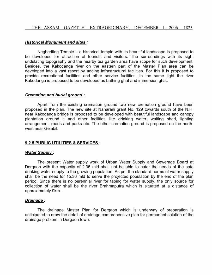
Historical Monument and sites :
Negheriting Temple – a historical temple with its beautiful landscape is proposed to be developed for attraction of tourists and visitors. The surroundings with its sight undulating topography and the nearby tea garden area have scope for such development. Besides, the Kakodanga river on the eastern part of the Master Plan area can be developed into a vast resort by adding infrastructural facilities. For this it is proposed to provide recreational facilities and other service facilities. In the same light the river Kakodanga is proposed to be developed as bathing ghat and immersion ghat.
Cremation and burial ground :
Apart from the existing cremation ground two new cremation ground have been proposed in the plan. The new site at Naharani grant No. 129 towards south of the N.H. near Kakodanga bridge is proposed to be developed with beautiful landscape and canopy plantation around it and other facilities like drinking water, waiting shed, lighting arrangement, roads and parks etc. The other cremation ground is proposed on the north-west near Gelabil.
9.2.5 PUBLIC UTILITIES & SERVICES :
Water Supply :
The present Water supply work of Urban Water Supply and Sewerage Board at Dergaon with the capacity of 2.35 mld shall not be able to cater the needs of the safe drinking water supply to the growing population. As per the standard norms of water supply shall be the need for 15.36 mld to serve the projected population by the end of the plan period. Since there is no perennial river for taping for water supply, the only source for collection of water shall be the river Brahmaputra which is situated at a distance of approximately 9km.
Drainage :
The drainage Master Plan for Dergaon which is underway of preparation is anticipated to draw the detail of drainage comprehensive plan for permanent solution of the drainage problem in Dergaon town.

1824 THE ASSAM GAZETTE EXTRAORDINARY, DECEMBER 1, 2006
Solid-Waster Disposal :
A new site for solid-waste management has been selected and earmarked on the eastern side of the plan area. It is proposed that the solid-waste generated from the town will be disposed of in a scientific manner. Total area of 106.31 hectares has been earmarked for this purpose for cremation, utilities and services.
The existing open garbage dumping ground should be discontinued immediately which is situated near the residential area and which does not conform the prescribed norms of Solid-Waster disposal.
Recreation and Open space :
The Master Plan also envisages the need of growing social and cultural aspirations of the people living in urban areas. The town does not have any major town and recreational club. Considering the population growth by 2025 two such clubs have been proposed one near the Dergaon Municipal office and the other in Bhabolgaon near co-operative sugar mill. In addition to the above the centre will have good auditorium-cum-community hall and libraries.
Complexities in urban life necessitate more and more diversified and specialized recreational activities. To provide more recreational spaces for specialized needs as well, the Master Plan area is endowed with interesting natural landscape on the bank of river Kakodanga which could be developed into a beautiful recreation centre enhancing tourist interest not only to the town but also to the State.
9.2.6 TRAFFIC & TRANSPORTATION :
Transportation is the basic infrastructure for promoting and guiding the future development. Efficient road network is very much essential for safe, easy and quick movement of people and goods from one place to another. With the growth of population and development of new areas there will be corresponding increase of vehicular traffic. Considering this and to achieve higher efficiency in circulation system, a hierarchy of road network has been proposed in four categories according to their functional importance as under :
Sl. No. Type of Road Right of way1 Primary Road 20m to 24.5m (65ft to 80 ft)
2 Secondary Road 15m to 18m (50ft to 60 ft)
3 Tertiary Road 11m to 14m (36ft to 45 ft)
4 Access Road 6m to 9m (20ft to 30 ft)

THE ASSAM GAZETTE EXTRAORDINARY, DECEMBER 1, 2006 1825
The recent announcement of the proposal for making the N.H.-37 into four lane provision has been taken into account and in the traffic circulation plan, a new loop road on the south has been proposed as bye pass to reduce gravitation of traffic towards the busy central business area. In most cases existing road could be improved without acquiring substantial land. Further, the existing Mahbandha road connecting Mahbandha and Kuralguri has been proposed to be developed as an alternative road to the N.H.-37 which would rather give impetus for development of south east area of the Master Plan.
Proposal for improvement of road network of Dergaon Master Plan area are given in the following list:
PROPOSED ROAD IMPROVEMENT SCHEME
Sl. No.
Name of Road Category Proposed Right to way
(in Mtr.)
Remarks
1 New road linking N.H. near Dadhara Ahomgaon College Road – PHCG Road – PMGSY road and then again N.H. 37 loop road (bye pass)
Extension of N.H.
36.5 Mtr(120 ft.)
Portion from Dadhara to PHG to be constructed newly and rest to be realigned and widened.
2 PHG Path from Dergaon Chariali towards Golaghat.
Primary 24.5 Mtr To be widened and constructed.
3 Mahbandha Road connecting Kuralguri to Mahbandha.
Primary 24.5 Mtr With reconstruction of bridge on Kakadanga river
4 Connecting Mahbandha road and N.H. 37 Damjaria Kachanial and Naharani grant 129.
Primary 24.5 Mtr To be widened.
5 Naharani road from Primary 24.5 Mtr To be widened.
Bus Terminal :
There is no organized bus terminus within Dergaon Master Plan area. The existing ASTC bus stand can hardly accommodate few buses. Therefore, a bus terminal proposed near the existing ASTC bus stand at A.T. Road.

1826 THE ASSAM GAZETTE EXTRAORDINARY, DECEMBER 1, 2006
Truck Terminals :
There is no truck terminal in Dergaon. The road sides are being used for parking, loading and unloading of goods. It is anticipated that with the growing urban activities within the Master Plan area organized truck terminals will also be needed. Therefore, it is proposed to help truck terminals at two points- One near the A..T Road (where the warehouse) and the other near the proposed industrial area at Mahbandha road.
Car Parking :
At present the road sides are being used for parking of cars. Considering the future need three numbers of car parking areas have been proposed.
(i) The present car parking site near ASTC Bus station will be developed to the new site proposed near the Bus terminal and taxi stand shall be operated from the area.
(ii) Provision of no-street parking is proposed on the PHG Path near the Naren Sarma Smriti Pathar.
(iii) Another parking area is proposed to be developed on the road side of A.T. Road near P.T.C. where shopping complex has been proposed.
9.2.7 GREEN BELTS :
Agriculture is one of the major land use proposed to develop as Green belt. The total area under this use is about 2676.22 hectare which constitutes 27.69% of the total Master Plan area. These green belt area will protect the rural characteristics of the peripheral area of the Master Plan.
CHAPTER – 10
10.1 PLAN IMPLEMENTATION :
The Master Plan is continuous process. It is a long range programme and it must be kept constantly reviewed with the tune of changing condition. The zoning Regulation is the guiding force for implementation of the provisions of the Master Plan. Further in building up or rebuilding of the town, major role is played by its citizen individually or collectively by undertaking construction, reconstruction or development of land for various uses and activities. Therefore, citizens’ participation in the planning implementation process is indispensable.

THE ASSAM GAZETTE EXTRAORDINARY, DECEMBER 1, 2006 1827
10.2 PLAN PERIOD :
The proposal contained in the Master Plan will be implemented by preparing detailed scheme for execution in phase manner. The Master Plan prepared here is merely the first stage of the total programme. It contains the plans and policies for the improvement and development of Dergaon Master Plan upto 2025. The complete work of plan since initiating to realization will be carried out within the frame work of the Assam Town & Country Planning Act, 1959 and as amended from time to time.
Experience has shown that carrying out of major public improvement project can be accomplished soundly and consistently only through long range programming of capital investment. Each project should be co-ordinated with the proposal of development plan and should be within the spending capacity of the agency to enforce.
The most important tools of planning administration with private development are zoning regulation, Sub-division control and mapped street lines. Zoning is a very effective tool of the development Plan and therefore should be conformity with the goals and principles set forth in the plan. Though subdivision control quality of new residential developments including the proper location of streets and public facilities may be determined.
10.3 PLAN ADMINISTRATION :
Section 8 of the Assam Town & Country Planning Act., 1959 empowers the Government of Assam to constitute Development Authority for enforcement, control, regulate implementation of the development proposals of the Dergaon Master Plan.
It is however necessary that inter-departmental coordination in regard to the implementation of the proposals.
10.4 PUBLIC PARTICIPATION :
Development of a town in the ultimate analysis depends on the hope and aspirations of the people for the speedy realization of the Master Plan objectives. It is important to have fullest co-operation of the citizens. Public consciousness is thus necessary to ensure clean administration and development of healthy traditions of Public conduct such as house costruction, their maintenance, the preservation of public properties and cultivation of good habits etc. This alone may ensure healthy neighbourhood and social and cultural life of the town.

1828 THE ASSAM GAZETTE EXTRAORDINARY, DECEMBER 1, 2006
10.5 ZONING PLAN :
A zoning plan as been prepared for the entire planning area of the Dergaon for smooth, integrated development among the different zones, when preparing the zoning plan the following basic factor are taken in to considerations. .
1. Locational advantage.2. Availability of Govt. land.3. Existing infrastructure.4. Trend of development.5. Accessibility.
10.6 CONCLUSION :
The Master Plan for Dergaon has been developed after considering the towns current problems & needs. And effort has been made to draw up a list of priorities and opportunities for future needs and requirement of Dergaon Master Plan Area so that a moderate level of facilities and services is provided for the planning area.
However the successful implementation of this Master Plan lies on the active participation of the citizen in all phases on the planning process and implementation. To attain the sustained development and to build Dergaon worthwhile place to live, work and play as set in the Master Plan should form the common goal of the citizens in implementation process.

THE ASSAM GAZETTE EXTRAORDINARY, DECEMBER 1, 2006 1829
ZONING REGULATION
Zoning Regulation play a very important role in controlling and promoting urban development on rational lines. They are also useful in limiting urban growth and in a broader sense can also be useful for lying down broad directions of growth in a regional plan. Zoning Regulation form an integral part of any Master Plan. These have been used extensively to control development of urban areas.
Zoning Regulation also help in controlling density of development and land use in ensuring light and ventilation standards and in providing scope for future development in each zone in an orderly manner.
ZONING REGULATIONS FOR DERGAON MASTER PLAN AREA
1. SCOPE :1.1 The Schedule lays down regulations for the use of land and building built thereon, consistent with maintaining minimum ‘standards of density of building’ protection of open space, sanitation and environmental hygiene.1.2 The Zoning regulations should be read in conjunction with zones proposed in the Master Plan.
2. DEFINITIONS: For the purpose of these regulations the following definitions shall apply.
2.1 Words used in the present tense shall include the future, the singular number also include the plural and the plural also singular.
2.2 “Agriculture” includes horticulture, farming, growing of crops, fruits, vegetables, flowers, grass, fodder, trees of any kind of cultivation of soil, breeding and keeping of livestocks including cattle, horses, donkey, mules pigs, fish, poultry and bees, the use of land which is ancillary to the farming of land or any other agricultural purposes, but shall not include the use of any land attached to the building or the purpose of a garden to be used along with such building and Agricultural purposes, but shall not include the use of any land attached to the building of the purpose of a garden to be used along with such building and “Agriculture” shall be construed accordingly.
2.3 “Authority” shall mean local regional or any other authority appointed by the State Government for the purpose of Administering the Act. Unless otherwise appointed by the State Government, the Authority in case of Municipal area constituted under the Assam Municipal Act. 1956 (Assam Act, XV of 1957).

1830 THE ASSAM GAZETTE EXTRAORDINARY, DECEMBER 1, 2006
2.4 “Basement” shall mean the lowest floor of a building with maximum ceiling height of 2.50 mtr with a maximum height of 1.50 mtr from ground level. Basement can be used for parking and such other use of the building for installation of electrical equipments, pump house etc. but not for habitation or any commercial/industrial use.
2.5 “Boarding House” means a building or part of a building in which, carried on wholly or partially the business of supply of meals to the public or a class of the public for consumption on the premises.
2.6 “Building” means any construction for whatsoever purpose and of whatsoever materials constructed and every part thereof whether used as human habitation or not and include foundation, plinth walls, chimneys, drainage work fixed platform, verandah, balcony cornice or projection, part of a building or anything affixed thereto or any wall enclosing or intended to enclose any land or space.
2.7 “Building of Accessory Use” means a subordinate building, use of which is incidental to that of a principal building on the same plot such as garage, coal or woodshed, guard room, power installation, pump house etc.
2.8 “Building, Height of” means the vertical distance measured in the case of flat roof from the average level of the center line of the adjoining street to the highest point of the building adjacent to the wall and in the case of pitched roof up to the point where the external surface of the outer wall intersects the finished surface of the slopping roof and in the case of cable facing the road, the mid point between the caves level and the ridge. Architectural features serving no other function except that of decoration shall be excluded for the purpose of taking excluded heights, if the building does not above on a street the height shall be measured above the level on ground and contiguous to the building.
2.9 “Building Set Back” means the distance by which any building or structure shall be separated from the boundary lines of the plot.
2.10 “Commerce” means carrying on any trade, business or profession, sale exchange of goods of any type whatsoever and includes the running of with a view to make profit, nursing homes, vocational educational institutions and also includes hostels, restaurants boarding house not attached to any educational institutions and “Commercial” shall be constructed accordingly.
2.11 “Commercial Use” includes the use of any land or building or part thereof, for purpose of commerce as defined or for shortage of goods, or as an office, where attached to industry or otherwise.

THE ASSAM GAZETTE EXTRAORDINARY, DECEMBER 1, 2006 1831
2.12 “Coverage” is the percentage ratio of the plinth area of the main and accessory building to the total area of plot.
2.13 “Customary home occupation” means occupation other than that on an eating or drinking place offering services to the general public carried on by a member of the family residing on the premises and in accordance with which there is no display that will indicate from the exterior that the building is being utilized in whole or in part of any purpose other than that as a dwelling and in connection with which no article or service is sold of held up for sale except that produced by a member of the family residing on the premises and no mechanical equipment is used as it customary for purely domestic or household purpose.
2.14 “Development” means the carrying out of building, engineering, mining or other operation in, on or over the level, making any material change in the use of any building or of land. Provided that following operations or used of land shall not be deemed for the purposes of this regulation to mean development of the land that is to say.
a). The carrying out of works for maintenance, improvement or other alternative of any building which effect only the interior of the building or which do not materially effect the use and the external appearance of the building.
b). The carrying out by a Local Authority any works required for the maintenance improvement or roads works carried out on land within the boundaries of the road.
c). The carrying out by a Local Authority any works for the purpose of inspecting renewing any sewers, main pipes or cables or other apparatus including the breaking open of any street or other land for that purposes.
d). The use of any building or other land within the cartilage of a dwelling house for any purpose incidental to the enjoyment of the dwelling house as such.
2.15 “Development of scheme” means a development scheme and include a plan together with the descriptive matter if any relating to such a scheme.
2.16 “Dwelling” means a building or a portion thereof, which is designed or used wholly or principally for residential purposes. This shall not include boarding or rooming houses, tents, tourist’s camps, hostels, or other structure designed or used primarily for transit residents.
2.17 “Floor Area Ratio (FAR)” means the quotient obtained by dividing the total covered area (plinth area) of all floors and 100 by the area of the plot. FAR = Total covered area all floor x 100 total plot area.

1832 THE ASSAM GAZETTE EXTRAORDINARY, DECEMBER 1, 2006
2.18 “Green Belt Zone” means the area in the periphery of the Master Plan area to restrict normal urban expansion.
2.19 “Ground Level” means the height of the central line of the adjoining developed road.
2.20 “Hotel” means a building or part of a building used for boarding and lodging purpose.
2.21 “Industry” includes the carrying of any manufacturing process as defined in Factories Act, 1948 and “Industrial” shall be construed accordingly.
(i) “Industrial Use” includes the use of any land or building or part thereof for industry as defined.
(ii) “Industry clean” means industries, which do not throw out any smoke, noise, offensive odour or harmful wastes and employing not more than 25 workers with or without power. However, subcommittee may consider such industries employees up to 40 workers considering the performance of the industry.
(iii) “Industry Light” means industries which do not throw excessive smoke, offensive odour or harmful wastes, employing not more than 100 workers and using power of not more than 100 HP. Such industries except in the case of foundries and smithies do not consume any solid fuel.
(iv) “Industries medium” includes industries, which employ more than 100 workers and may use any kind of motive powers or fuel subject of course to noxious features, factories which are classified as heavy industries under the Factories Act, 1948 do not come under this category.
(v) “Industry Service” means industries which are not engaged in the manufacture of goods or articles, but are mainly concerned with repairs, maintenance, servicing and for other jobbing work.
(vi) “Industry Obnoxious” are those industries, which are associated with such feature as excessive smoke, noise, vibration stench, unpleasant or injurious fumes, effluents, explosives, inflammable industries etc. and not such other which are hazardous to health and safely of the community.
2.22 “Mezzanine” means an intermediate floor above ground level having maximum height of 2.20 Mtr and minimum height of 180 Mtr. From the floor and having proper access to it from the lower floor. A mezzanine floor must not cover more than one-third floor area of the Ground Floor.
2.23 “Non conforming building or use” includes a building, structure or use of any land existing at the time of commencement of those regulations and which do not conform to the regulations pertaining to the zone in which it is situated.

THE ASSAM GAZETTE EXTRAORDINARY, DECEMBER 1, 2006 1833
2.24 “Occupier” includes :- a) a tenant.b) an owner in occupation of or otherwise using his land.c) a rent free tenant of any land.d) a license in occupation of any land, and e) any person who is liable to pay to the owner damages for the use and occupation of any land.
2.25 “Open space” means any land whether enclose or not of which not more than one twentieth part is covered with building and whole of the remainder has been laid out as public garden or used for purpose of recreation or lies waste and unoccupied.
2.26 “Owner” includes a mortgage in possession a person who for the time being is receiving or is entitled to receive, the rent or premium for any land whether on his own account of or on behalf or for the benefit to any other person or as an agent, guardian or for any other person or for any religious or charitable institution, or who would so receive the rent or premium it the land where let to a tenant; and includes the head of a Government department, General Manager of Railway, the Secretary or other Principal Officer of a Local Authority, Statutory Authority or Company, in respect of properties under their respective control.
2.27 “Parking Space” means an area enclosed or unenclosed sufficient in size to store an automobile or any other conveyance together with a drive way connecting the parking space with a street or alley and permitting ingress or egress to all such conveyances.
2.28 “Plinth” means the portion of a structure between the surface of the surrounding ground and surface of the floor, immediately above the ground.
2.29 “Plot” means a piece of land occupied or intended to occupy by a main building or use together with its accessory building and use customary and incidental to it, including the open space required by those regulations and having frontage upon a private way that has officially being approved by competent Authority.
2.30 “Prescribed” means prescribed by rules and regulations under the Assam Town and Country Planning Act, 1959 (as amended).
2.31 “Prescribed Street Line” means the line on one or both sides of any road or street prescribed in the Master Plan or by the Authority showing the proposed site limits of the road or street.
2.32 “Public and Semi Public Place” means any place or building which is opened to use and enjoyment of the public, whether it is actually used or enjoyed by the public or not, and whether the entry is regulated by any charge or not.

1834 THE ASSAM GAZETTE EXTRAORDINARY, DECEMBER 1, 2006
2.33 “Repairs” means any renovation applied to any structure which does not in anyway change the specification of the structure but saves the structure from the further deterioration.
2.34 “Residence” includes the use for habitation of any land or building or part thereof, includes garden, grounds, garage stables and out houses, if any appertaining to such building and residential shall be construed accordingly.
2.35 “Road and Street” means any highway, street, pathway, alley, stairway, passageway, carriageway, footway, square place or bridge, whether a thoroughfare or not over which the public have a right or passage or access or have passed and had access uninterruptedly for a specified period, whether existing or proposed in any scheme and includes all bunds, channels, ditches, storm water drains, culverts sidewalk, traffic, island, roadside tree and hedges, retaining walls, trenches, barriers and railway, within the road line. 2.36 “Shop Line” means shops when allowed irrespective of any zone in between the space of the prescribed street line and line drawn paralleled to the street, which is demarcated as shop line. The maximum depth of shop line should not be more than 6 meter.
2.37 “Site” of a building includes not only the land actually covered by building but also the spaces around the building required under this rules.
2.38 “Storey” the portion of a building included between the surface of a floor and the surface of the floor next above it or if there is no floor above it then the space between any floor and ceiling next above it, when measured, the height of a habitable basement extending at least 5 feet above ground level or a habitable attic shall be counted as storey.
2.39 “Structure” means any combination of material including building constructed or erected, the use of which requires location the ground including among other things, signboards, fences and wall that are more than three feet high.
2.40 “To Abut” means to abut on a road such that any portion of the building is on the road boundary.
2.41 “To construct” means to create, re-create make material alternation.
2.42 “To create” means to construct a building for the first time or to reconstruct existing building after demolishing it according to some fresh or revised plans.
2.43 “Total Floor Area” means the area of all Floors of a building including habitable attics.
THE ASSAM GAZETTE EXTRAORDINARY, DECEMBER 1, 2006 1835
2.44 “To make material alternation” means to make any modification in any existing building by way of an addition or alternation or any other change in the roof, window and door, compound, sanitary and drainage system in any respect whatsoever. Opening of a window and providing inter communication door shall not be considered as materials alteration. Similarly modification in respect of gardening and white washing, painting, retailing and other decorative works shall not be deemed to be materials (it further includes):
(a) Conversion of a building or a part thereof for human habitation as one dwelling house into more than one dwelling house and vice versa. (b) Conversion of building or a part thereof suitable for human habitation into dwelling house or vice versa. (c) Conversion of dwelling house or a part into a shop warehouse or factory or vice versa; and (d) Conversion of building used or intended to be used for one purpose such as shop warehouse, or factory etc. into one or another purpose.
2.45 “To re-erect” means to construct for a second time or subsequent times a building or a part of building after demolishing it on the same plan as has been previously mentioned.
2.46 “Water Course” means a natural channel or an artificial one formed by draining or diversion of a natural channel means for carrying storm water either from a single property or several properties draining thereto in combination.
2.47 “Warehouse” means a building, the whole or substantial part of which is used or intended to use storage of goods whether for keeping or for sale for any similar purpose but does not include storeroom attached to and used for the proper functioning of a shop.
2.48 “Yard” means an open space on ground level between a building and the adjoining boundary line of the plot unoccupied and unobstructed except by encroachments or structure specifically permitted by those bye laws on the same plot with building. All yards measurements shall be the minimum distance between the front, rear and side yard and plot boundaries, as the case may be and the nearest point of the building including enclosed and covered porches. Every part of the every yard shall be accessible from every other part of the same yard.
2.49 “Yard Front” means a yard extending across a front of a plot between the side yards lines and being the minimum horizontal distance between the street line and the main building and any projection thereof other than steps, unenclosed balconies and unenclosed porches.

1836 THE ASSAM GAZETTE EXTRAORDINARY, DECEMBER 1, 2006
2.50 “Yard rear” means a yard extending across the rear of a plot boundary and being the minimum horizontal distance between the rear plot boundaries and the rear of the building or any other projection, other than steps, unenclosed balconies and unenclosed porches. In a corner plot rear yard shall be considered as paralleled to the street upon which the plot faces and the rear yard shall be at the opposite and of the plot from the front yard.
2.51 “Yard side” means a yard between the building and the side line of the plot and extending from the front line to the rear line of the plot and being the minimum horizontal distance between the said boundary line and the side of a building or any other projection other then steps.
2.52 The definition of the term, which are not covered by this regulation, shall be covered by the definition prescribed by the Assam Town and Country Planning Act and the rules framed there under.
3. GENERAL REGULATIONS :
3.1 The requirements of these Regulation within each zone shall be the minimum requirement and shall apply uniformly to each class and each kind or structure or land except as herein and after provided.
3.2 No building, structure and land shall hereinafter be used or occupied and no building or structure or part of the building shall hereinafter be erected, re-erected or materially altered unless in conformity with all of the regulations herein specified for the zone in which it is located.
3.3 No building or any other structure shall hereinafter be erected or materially altered; (a) to exceed the height: (b) to accommodate or a house a greater number of families : (c) to occupy a greater percentage of lot area : (d) to have narrower or smaller rear yard, front, yards, side yards, other open space
than herein required or in any other manner contrary to provision of, this regulations.
3.4 Non conforming plots non-conforming use of land non-conforming structure and non-conforming use of structure and premises.
3.4.1 Within the zones established by these regulations or amendments that may later be adopted therein, existing plot structure and use of land and structure which were lawful before these regulations came in force or were amended, but which would be prohibited, regulated, or restricted, under the terms of these regulations or future amendments, shall be permitted to continue until they are removed, Such uses are declared by these regulations to be incompatible with permitted uses in zone.

THE ASSAM GAZETTE EXTRAORDINARY, DECEMBER 1, 2006 1837
3.4.2 A non conforming use of a structure, non conforming use of land or of a non conforming use of a structure and land shall not be extended or enlarged after coming in the force of this regulations by attachment on a building premises, of additional sign intended to be seen from the premises or by the addition of the other uses of a nature which would be prohibited generally in the zone involved.
3.4.3 Nothing in those regulations shall be deemed to require a change in the plan, construction, or designated use of any building on which actual construction was lawfully began prior to the coming in to the force of this regulation has been differently carried on. Actual construction hereby defined to include the placing of construction materials in permanent position and fastened in a permanent manner; except that where demolition or removal shall be deemed to be actual construction provided that work shall be diligently carried on until completion of the building involved.
3.4.4 Non conforming uses of a land where, on the date of coming into force of these regulation or amendments, thereto lawful use of land exists that is made no longer permissible under the terms of this regulations as enacted or amended, such use may be continued, so long as it remains otherwise lawful, subject to the following provisions:
(a) No such non conforming use shall be enlarged, or extended to occupy a greater area of land than was occupied on the date of coming into force of those regulation or amendments thereto.(b) No such conforming use shall be moved in whole or in part to any other portion of the lot or parcel occupied by such use on the date of coming in to force of these regulations or amendments thereto. (c) If any non-conforming use of land ceases for any reason for a period of more than 30 days, any subsequent use of such land shall conform to the requirements specified by these regulations for the zone in which such land is located.
3.4.5 Non conforming structure where a lawful structure exists on the date of coming in to force of these regulations or amendments thereto, that could not be built under the terms of these regulations by reasons of restrictions on area, plot coverage, height, yards or other characteristics of structure of its location on the plot, such structure may be continued so long as it remains otherwise lawful, subjects to the following provisions.
(a) No such structure may be enlarged or altered in a way in which it is non-conforming.(b) Should such structure be destroyed by any means to an extent of more than 50 percent of its replacement cost at the time of destruction, it shall not be reconstructed except in conformity with the provisions of these regulations. (c) Should such a structure be move for any reason any distance whatsoever, it small thereafter conform to the requirements for the zones in which it is located after it is moved.

1838 THE ASSAM GAZETTE EXTRAORDINARY, DECEMBER 1, 2006
3.4.6 Non conforming uses of structure if a lawful use of a structure, or of structure and premises in combination, exist on the date thereto, of coming in to force of these regulations or amendments that would not be allowed in the zone under the terms of these regulations, the lawful use may be continued so long as it remains otherwise lawful, subject to the following provisions.
(a) No existing structure devoted to a use not permitted by these regulations to the zone in which it is located shall be enlarged, extended, constructed, reconstructed moved or structurally altered except in changing the use of the structure to the use permitted in the zone in which it is located; (b) No such non-conforming use shall be enlarged or increased or extended to occupy a greater area of the building than occupied by use such at the time of the coming in the force of those regulations of amendments to. (c) Any structure, or structure and land in combination, in which a non-conforming use is superseded by, a permitted use, shall thereafter conforms to the requirements of these regulations for the zone in which such structure is located, and the non conforming use may not thereafter be resumed; when a conforming use of structure, or structure and premises in combination, is discontinued or abandoned for a six consecutive months or for a 18 months during any three years period, the structure and premises in combination, shall not thereafter be used except in conformance with the regulations of the zone in which it is located.(d) Where non conforming use status applies to a structure and premises in combination, removal and destruction of the structure shall eliminate the non-conforming status of the land.
3.4.7 Repairs and maintenance of any building devoted in whole or in part to any non conforming use, work may be done in any period of 12 consecutive months for ordinary repairs, or on repairs or replacement of on load bearing walls, fixtures wiring or plumbing , to an extent for exceeding 10 per cent of current replacement value of the building., provided that the cubic contents of the building as it existed at the time of coming into force of these regulations or amendments thereto shall not be increased. Nothing in these shall be deemed or prevent of strengthening or rescuing to a safe condition of any building or part thereof declared to be unsafe by any official charged with protecting the public safety upon order of such official.
3.4.8 Uses under exception provisions not non-conforming uses, any use for which a special exception is permitted as provided in this regulations shall not be deemed a non-conforming use, but shall without further action be deemed a conforming use, in the zones which it is permitted.

THE ASSAM GAZETTE EXTRAORDINARY, DECEMBER 1, 2006 1839
3.5 “Accessory Use” the term accessory use shall not include : (a) Any use on the same plot, with the use to which it is accessory, unless authorized by the Authority. (b) Any use not customarily incident to a permitted use,(c ) Any use detrimental to the neighbourhood by reason of emission of smoke, noise, odour, vibration, dust or fume. (d) Storage of more than two automobiles except on an agricultural piece of land. (e) A secondary dwelling on the same plot with a main dwelling, unless each building shall have at least open space and plot size as required under these regulations, (f) Advertising sign excepting signs not more than 10 sq. ft. or 0.9 sq. mtr. In total area pertaining to the lease, sale or use of a plot or building on which they are placed. On the plot occupied by a dwelling there shall not be more than two sign with a total area of 2 square feet or 0.18 meter per sign for each family house. (g) Electric transformer room and security / sentry room. (h) 30% of the front and rear open yard may be used for accessory use of single storey construction.
3.6 Yards and open spaces: (a) Each structure hereafter erected, re-erected or materially altered shall be provided with the front side or rear yard as specified with zoning regulations. (b) No open space of plot required for building of structure shall during its life be occupied or counted as open space for another building of structure.(c ) On plot occupied by building only not exceeding 30 percent of the rear yard may be occupied by one storeyed building as accessory use.(d) Special type of buildings, subject to the requirement of the set back from prescribed street lines and side and rear yards under the respective rules no building used for theatres, cinema hall, concert or assembly halls, stadium, building intended for religious worship, hospital, dispensary building, market, exhibition halls or museum and other such building shall have an open space of hot less than 25 ft or (7.5m) from the front boundary and 15 ft (4.5 mtr) from the side and rear boundaries of the plot on which such are constructed.
3.7 Visibility at Intersection in residential Zone :
On a corner plot in any residential zone, nothing shall be erected placed, planted or allowed to grow in such a manner as materially to improved vision between height two and half feet and 10 feet (0.75M and 3M) above the center lines of such plot and the joining points along the said lines 20 ft or 6.0 meter minimum from the point of the intersection.
3.8 Building abutting two or more streets : When a building abuts two or more streets the setback from the street shall be such as if the building was fronting each such street.

1840 THE ASSAM GAZETTE EXTRAORDINARY, DECEMBER 1, 2006
3.9 Means of access: (a) No building shall be constructed on any plot for any use where there is no means of access to such plot. (b) Notwithstanding anything prescribed in the Master Plan, the width of such access or lanes, road etc to one individual plot or plots whether private or public shall be prescribed by the Authority.
3.10 The Authority may prescribed a line on one or both sides of any public or private road or street and no person shall construct, re-construct or materially alter any portion or any portion of any building or any structure on land within such prescribed street line.
3.11 If any building or structure or part of a building or structure abutting on a public or private road or street is within such line “ of the street, the authority may require such building or structure to be set back beyond such prescribed line to a distance as prescribed in these regulations whenever it is proposed.
(a) To build such building or structure or to take down such building or structure.(b) To re-construct or to make any addition to or structural alteration in any portion of such building or structure which is within such regular prescribed line of the street.
3.12 When any building or structure or any part thereof within such prescribed line of the street fall down or is burnt or is taken down, the authority may at once take possession of portion of land within the prescribed line of the street previously occupied by the said building or structure and if necessary clear the same under the provision of the Assam Town and Country Planning Act, 1959 (as amended).
3.13 Land sub division and layout except as otherwise provided, no land will be developed or sub divided and no layout of the land shall be prepared, altered and executed unless in conformity with this regulation therein specified for the zones in which the land is located.
3.14 Fences, Walls and Hedges : (a) Notwithstanding and other provisions in this regulations, fences, walls and hedges may be permitted in any required yard or along the edge of any yard provided that no fence, walls or hedge along side or front edge of any front yard shall not be over 1.5m in height from the central line of the nearest developed road. (b) Provided in Commercial Zone the height of the fences, walls hedges along the front boundary and up to 3 meter along the side boundary from the edge of the road or from the prescribed street line shall not exceed 3’.0” or 0.9m.
3.15 Off-street parking space for motor vehicles, scooter cycle etc. (a) Off street parking shall be provided on any plot on which any structure is proposed as specified in the table-I and hereafter established and such parking space shall be provided with the adequate vehicular access to a street.

THE ASSAM GAZETTE EXTRAORDINARY, DECEMBER 1, 2006 1841
(b) Each off-street parking space provided shall not be less than of (2.7m x 5.4m), (2.5mx1.0m) and (2.0m x 0.5m) for car, scooter and cycle respectively. The area of drivers, aisles and such other provisions required for adequate access shall not be counted as part of the parking space. (c) Off street parking space provided shall be not less than requirement specified in the Table-I for each type of use. (d) If a vehicle parking space required by these regulations is provided in parking areas by a group of property owners by their mutual benefit, the Board of zoning appeal may construe such use of this space as meeting the off street parking requirement of these regulations. (e) If off-street vehicle parking space can not be reasonably provided in the same plot on which the principal use is conducted, the Authority may permit such space to be provided on their off street property, provided such space lies within 400 feet or 120 meters of the main entrance to such principal use. Such vehicle parking space shall be deemed to be required open space associated with the permitted use and shall not therefore be reduced or encroached upon in any manner.
4. PERMISSION 4.1 Written permission for development works and sub division of land.
No person shall use any land, sub divide any land or develop any land or set up any new structure on any land or create, or materially alter or change the existing structure of any building or land within the limit of the Master Plan area without the written permission of the Authority, as defined in the section 13 of the Assam Town and Country Planning Act., 1959 (as amended).
4.2 Manner of obtaining permission : 4.2.1 For the purpose of obtaining permission for the erection, re-erection, renovation and material alteration of any building or structure the applicant shall submit the following plans, in triplicate and documents together with an application as prescribed by the Authority.
(a) A block plan of such building or structure and site, which shall be drawn to the scale of largest revenue survey maps at the time in existence for the locality and shall be shown the position and appurtenances of properties, if any immediate adjoining streets and the means of access, Dag No, Patta No., Name of village.
(b) (i) a site plan of 1 inch to 16 ft (1 cm to 2 mtr) scale indicating the plot boundaries, and position of the existing structure if any, line plan of the proposed structure with its location, set back, side yard projection dimensions.

1842 THE ASSAM GAZETTE EXTRAORDINARY, DECEMBER 1, 2006
(ii) For special type of building such as Cinema Hall, Apartment Buildings, Nursing Home, Market, Commercial Building etc. parking layout plan and service plan in detail must be submitted.
(c) The detail floor plans for each floor on 1 inch to 8ft or 1 cm to 1 mtr scale with projection if any, showing the use of every room or portion of the building or structure and full and detail dimensions of the structure, height, plinth above and below the ground level and each floor and or roof over the staircase.
(d) All the plans and sections shall be signed by the applicant.
(e) Any other information’s, documents, required by the Authority.
4.2.2 In case of plans pertaining erection, re-erection, renovation and material alteration of any building or structure the Authority may either grant or refuse the approvals of the plans if it is not conformity with the Master Plan or zoning Regulations and shall communicate its decision to the applicant giving the notice within a period of one month from the receipt of the applicant or such other information as may be called for by the Authority.
4.2.3 For the purpose of obtaining permission for sub-division of any plot of land, the applicant shall submit following plans in triplicate together with necessary statement to the Authority. (a) A block plan of such land which shall be drawn to the scale of largest revenue survey map at the time of existence for the locality showing location of land, boundaries of the proposed land, shown on the map and sufficient description to define the same location, name and present width of the adjacent road and lanes and major physical characteristics of the land proposed to be sub divided, including topography, the location and width of any water course and location of any areas subject to inundation or floor and north line. (b) A plan such land which shall be drawn to suitable scale showing the complete layout of the proposed subdivision including location and width of all the proposed streets, dimensions, uses of all plot, location of all drains, sewers and other utilities, building line permissible and north line. (c) A key plan drawn on a suitable scale including north line.(d) Any other items or information, which may be required by the Authority from time to time. (e) All the plans shall be signed by the applicant (the seller) and the buyer.
4.2.4 In case of plans pertaining to sub division of land, the Authority may either grant or refuse the approval of plans or may approve them with such modifications as it may deem fit and thereupon, shall communicate its decision to the applicant giving the notice within two months from the date of submission of the plans to the Authority.

THE ASSAM GAZETTE EXTRAORDINARY, DECEMBER 1, 2006 1843
5. CLASSIFICATIONS AND ESTABLISHMENT OF ZONES : 5.1 The following land use zones have been prescribed for the Dergaon Master Plan Area.
(i) Residential Zone (a) Low density(b) Medium density(c) High density
(ii) Commercial Zone (a) Retail commercial(b) Wholesale commercial
(iii) Industrial Zone (a) Light industry(b) Medium industry(c) Obnoxious industry
(iv) Public and Semi Public Zone (v) Recreational and open space zone(vi) Green belt zone(vii) Circulation(viii) Government land Note – No regulation is required to be
specify in these zones, only in land use and zoning maps, these zones be specify.
5.2 The zone designed under 6.1 above may be further divided into sub-zones by the Authority where it deems it expedient, the designation of such sub-zones being dependant on the special use to which each such sub-zones is being utilized.
5.3 Boundaries of zones : The boundaries of each zone shall be as established in the Master Plan and a copy of the plan shall be kept on record at the official premises of the Authority. Unless otherwise shown on the master plan, the boundary line of the zone shall be plot lines, the centre line of the streets or such lines extended, the Railway right of way lines or corporate limit lines, at it exists at the time of enactments of the regulations.
5.3.1 All disputes and differences with respect of the exact boundaries of the zone shall be referred to the Director of Town and Country Planning, whose decision shall be final and binding.
6. REGULATION FOR DIFFERENT ZONES :
6.1 Regulations for different zones regarding size of plot, minimum set back of the building or structure from the prescribed street line, minimum yard width, maximum height and maximum coverage shall be according to the Table-II.

1844 THE ASSAM GAZETTE EXTRAORDINARY, DECEMBER 1, 2006
6.2 Regulations for different zones regarding size prohibited shall be as following. All other use not specifically mentioned herein shall be permissible in respective zones.
6.2.1 Regulations for Residential zones :
Use prohibited : (a) Cinema Theatre.(b) All Industries not covered by Annexure-I.(c) Sanatoria treating contagious diseases or mental patients.(d) Petrol filling station having a plot area less than 1340 sq. mtr ( 1 bigha). (e) ‘Show room’ for motor vehicles and machineries.(f) Coal, wood and timber depots.(g) Motor repairing garage. (h) Manufacturing unit using more than 5 HP and employing more than 5 persons. (i) Godowns and warehouses.(j) Bus/truck parking area.(k) Wholesale shop.(l) Mechanical workshop/ welding shop.(m) Industries creating noise, smoke, odour, vibration and pollution.(n) Saw mills.(o) Dairy farming and milk processing.(p) Printing press (However, modern offset printing press etc using less than 5 HP may be allowed). (q) Storage of petroleum and other inflammable materials.(r) Bakeries and confectioneries using power other than electricity.(s) Stone crusher and quarrying.(t) Storage and drying of fertilizers and pesticides.(u) Burial ground and cemetery.(v) Junk yards.
6.2.2 Regulations for General commercial zones :
Use prohibited : (a) Sanatoria treating contagious diseases or mental patients.(b) Coal, wood and other timber depot.(c) Manufacturing unit using more than 5 HP and employing more than 5 persons. (d) Wholesale godowns and warehouses.(e) Bus and truck parking area.(f) Wholesale shop.(g) Mechanical workshop/ welding shop with motive power more than 15 HP.(h) Industries creating noise, smoke, odour, vibration and pollution.(i) Saw mills.

THE ASSAM GAZETTE EXTRAORDINARY, DECEMBER 1, 2006 1845
(j) Dairy farming and milk processing.(k) Printing press (however, modern offset printing press etc using less than 5 HP may be allowed). (l) Storage of petroleum and other inflammable materials.(m) Bakeries and confectioneries using power other than electricity.(n) Stone crusher and quarrying.(o) Storage and drying of fertilizers and pesticides.(p) Burial ground and cemetery.(q) Junk yards.
6.2.3 Regulations for Wholesale commercial zones :
Use prohibited : (a) Hospital and Sanatoria treating contagious diseases or mental patients.(b) Manufacturing unit using more than 15 HP and employing more than 15 persons. (c) Bus parking area.(d) Mechanical workshop/ welding shop with motive power more than 15 HP.(e) Industries creating noise, smoke, odour, vibration and pollution.(f) Saw mills.(g) Dairy farming and milk processing.(h) Stone crusher and quarrying.(i) Burial ground and cemetery.(j) Junk yards.
6.2.4 Regulations for Light Industrial zones :
Use prohibited : (a) Sanatoria treating contagious diseases or mental patients.(d) Mechanical workshop/ welding shop with motive power more than 75 HP.(c) Industries creating pollution.(d) Burial ground and cemetery.
6.2.5 Regulations for Medium Industrial zones :
Use prohibited : (a) Sanatoria treating contagious diseases or mental patients.(b) Industries creating noise, smoke, odour, vibration and pollution.(c) Burial ground and cemetery.Note :- Industry Department norms may be followed.

1846 THE ASSAM GAZETTE EXTRAORDINARY, DECEMBER 1, 2006
6.2.6 Regulations for Public and Semi Public zones :
Use prohibited : (a) Cinema Theatre.(b) All Industries not covered by Annexure-I.(c) Sanatoria treating contagious diseases or mental patients.(d) Petrol filling station having a plot area less than 1340 sq. mtr ( 1 bigha). (e) ‘Show room’ for motor vehicles and machineries.(f) Coal, wood and timber depots.(g) Motor repairing garage. (h) Manufacturing unit using more than 5 HP and employing more than 5 persons. (i) Godowns and warehouses.(j) Wholesale shop.(k) storage of building materials.(l) Mechanical workshop/ welding shop with motive power more than 5 HP.(m) Industries creating noise, smoke, odour, vibration and pollution.(n) Saw mills.(o) Dairy farming and milk processing.(p) Printing press (However, modern offset printing press etc using less than 5 HP may be allowed). (q) Storage of petroleum and other inflammable materials.(r) Bakeries and confectioneries using power other than electricity.(s) Stone crusher and quarrying.(t) Storage and drying of fertilizers and pesticides.(u) Burial ground and cemetery.(v) Junk yards.
6.2.7 Regulations for Recreational and open space zones :
Use prohibited : (a) All Industries not covered by Annexure-I.(b) Hospital, Nursing Homes, and Sanatoria treating contagious diseases or mental patients.(c) ‘Show room’ for motor vehicles and machineries.(d) Coal, wood and timber depots.(e) Motor repairing garage. (f) Manufacturing unit using more than 5 HP and employing more than 5 persons. (g) Godowns and warehouses.(h) Wholesale shop.(i) storage of building materials.(j) Mechanical workshop/ welding shop with motive power more than 5 HP.(k) Industries creating noise, smoke, odour, vibration and pollution.
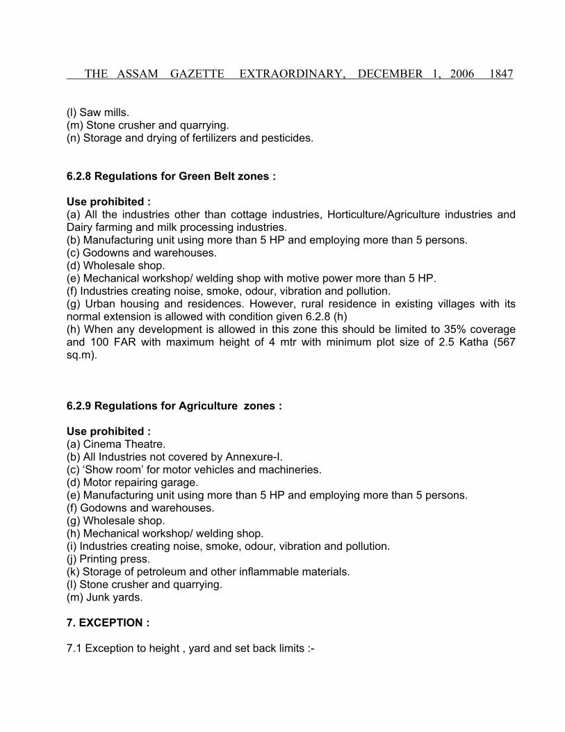
THE ASSAM GAZETTE EXTRAORDINARY, DECEMBER 1, 2006 1847
(l) Saw mills.(m) Stone crusher and quarrying.(n) Storage and drying of fertilizers and pesticides.
6.2.8 Regulations for Green Belt zones :
Use prohibited : (a) All the industries other than cottage industries, Horticulture/Agriculture industries and Dairy farming and milk processing industries. (b) Manufacturing unit using more than 5 HP and employing more than 5 persons. (c) Godowns and warehouses.(d) Wholesale shop.(e) Mechanical workshop/ welding shop with motive power more than 5 HP.(f) Industries creating noise, smoke, odour, vibration and pollution.(g) Urban housing and residences. However, rural residence in existing villages with its normal extension is allowed with condition given 6.2.8 (h)(h) When any development is allowed in this zone this should be limited to 35% coverage and 100 FAR with maximum height of 4 mtr with minimum plot size of 2.5 Katha (567 sq.m).
6.2.9 Regulations for Agriculture zones :
Use prohibited : (a) Cinema Theatre.(b) All Industries not covered by Annexure-I.(c) ‘Show room’ for motor vehicles and machineries.(d) Motor repairing garage. (e) Manufacturing unit using more than 5 HP and employing more than 5 persons. (f) Godowns and warehouses.(g) Wholesale shop.(h) Mechanical workshop/ welding shop.(i) Industries creating noise, smoke, odour, vibration and pollution.(j) Printing press.(k) Storage of petroleum and other inflammable materials.(l) Stone crusher and quarrying.(m) Junk yards.
7. EXCEPTION :
7.1 Exception to height , yard and set back limits :-

1848 THE ASSAM GAZETTE EXTRAORDINARY, DECEMBER 1, 2006
7.1.1 The height limitations of these regulations should not apply to churches, schools, hospitals and other public and semi public buildings provided that the minimum depth of font and rear yards and minimum width of the side yard required in the zone are increased by one ft. or 304.8 mm per feet or meter by which the height of such public and semi public structure exceeds the height limits in the feet or meter prescribed for the structure, other structure in the zone.
7.1.2 Chimneys, elevators, poles, spires, overhead water tanks and other such projections not used for human occupations are allowed to a height not more than 1.5 meter from the minimum permissible height of a building in a particular zone.
7.1.3 Steps, gallery or balcony, weather frame, sun breaker cornice, eaves, windowsills, or other ornamental projections may project into any yard provided such projections are not more than 0.6 meter from plinth of a building.
7.1.4 In any zone, on plot less than 60 ft. or 18 meter deep, the rear yard may be reduced by 1% for each feet or 304.8 mm. if the plot depth is less than 60 ft. or 18 meter.
7.1.5 Notwithstanding anything contained in this regulation, the front set back in any zone can be prescribed by the Authority in pursuance of any street schemes.
7.1.6 Height of compound wall of any zone modified in these regulations shall not exceed 5.6 ft. or 1.65 meter from the ground level.
7. 2 Group Projects : 7.2.1 In case group housing projects containing of a group of twenty or more buildings, notwithstanding anything contained in the regulations, the Authority may prescribed special requirements in harmony with the character of zone.
7.3 Plinth height and finished Ground level : 7.3.1 The maximum and minimum height of plinth of any structure shall be 2’-6” or 0.75 mtr and 1’6” or 0.45 mtr respectively from the nearest developed road.
7.3.2 The maximum height of finished ground level must not exceed 9” or 0.23 mtr from the nearest developed road.
7.4 Boundary wall / compound wall : (a) Except with the special permission of the Authority the maximum height of the compound wall shall be 1.5 m above the center line of the front street compound wall up to 2.4 m height may be permitted if the top 0.9m is of open type construction of a design to be approved by the Authority.

THE ASSAM GAZETTE EXTRAORDINARY, DECEMBER 1, 2006 1849
(b) In case of a corner plot the height of the boundary wall shall be restricted to 0.75m for a length of 10m on the front and side of the intersections and balance height of 0.75m if required in accordance with (a) may be made up of open type construction (through railing) and of design to be approved by the Authority.
(c) The provisions of (a) are not applicable to boundary walls of jails, in industrial buildings, electric sub-stations, transformer stations, institutional buildings like Sanitaria, hospital, industrial buildings like workshop, factories and educational buildings like school, colleges, including the hostels and other uses of public utility undertakings and height up to 2.4m may be permitted by the Authority.
(d) Compound gate should open entirely inside the property and shall not open any access / pathways / roads/ street.
8. SUB COMMITTEE ON ZONING APPEALS :
8.1 Sub Committee shall be constituted from out of the members of the Authority by the Chairman, and if no Authority is constituted, in such cases by the Director of Town and Country Planning, which shall be called the “Sub Committee on Zoning Appeals”.
8.2 The Sub Committee shall consists of a least five members. The Chairman of the Authority, Director of Town and Country Planning or his nominee, the Town Planning Officer and two other members of whom one representing the local Authority and other member representing Commerce and Industry (private sector) shall be the members subject to the approval of the Government, when the authority is superseded, the Administrator, or when no Authority is constituted the Deputy Commissioner / Sub-Divisional Officer or his nominee, and the Director of Town and Country Planning or his nominee, the Town Planning Officer of the Authority and two other member one of whom representing the Local Authority and the other presenting commerce and industry (private sector) to be nominated by the State Government shall be the members.
8.3 The Chairman, Administrator, Deputy Commissioner/Sub-Divisional Officer or his nominee or in his absence, Director of the Town and Country Planning or his nominee shall preside over such meeting and the quorum shall consists of at least three members.
8.4 The Chairman of the Administrator or when no Authority is constituted the Director of the Town and Country Planning or his nominee shall convene such meetings or the Sub Committee of zoning which will normally meet once in a month to consider any cases of zoning Appeals.
8.5 The Sub-Committee shall have the power to grant variance with respect to front rear or side yard or building height and area requirements. If at the time of adoption of these regulations a plot of land is smaller than the minimum size specified for the land in which it
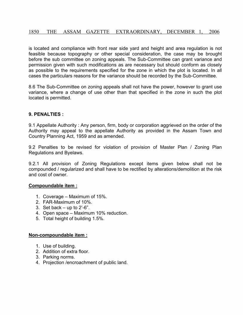
1850 THE ASSAM GAZETTE EXTRAORDINARY, DECEMBER 1, 2006
is located and compliance with front rear side yard and height and area regulation is not feasible because topography or other special consideration, the case may be brought before the sub committee on zoning appeals. The Sub-Committee can grant variance and permission given with such modifications as are necessary but should conform as closely as possible to the requirements specified for the zone in which the plot is located. In all cases the particulars reasons for the variance should be recorded by the Sub-Committee.
8.6 The Sub-Committee on zoning appeals shall not have the power, however to grant use variance, where a change of use other than that specified in the zone in such the plot located is permitted.
9. PENALTIES :
9.1 Appellate Authority : Any person, firm, body or corporation aggrieved on the order of the Authority may appeal to the appellate Authority as provided in the Assam Town and Country Planning Act, 1959 and as amended.
9.2 Penalties to be revised for violation of provision of Master Plan / Zoning Plan Regulations and Byelaws.
9.2.1 All provision of Zoning Regulations except items given below shall not be compounded / regularized and shall have to be rectified by alterations/demolition at the risk and cost of owner.
Compoundable item :
1. Coverage – Maximum of 15%.2. FAR-Maximum of 10%.3. Set back – up to 2’-6”.4. Open space – Maximum 10% reduction.5. Total height of building 1.5%.
Non-compoundable item :
1. Use of building.2. Addition of extra floor.3. Parking norms.4. Projection /encroachment of public land.

THE ASSAM GAZETTE EXTRAORDINARY, DECEMBER 1, 2006 1851
9.2.2 Rate for building constructed prior to approval of this regulation
1. Rs. 25.00 per sq. mtrs. of area constructed unauthorisedly for residential building up to 110 sq. mtrs. Also for all public and semi public and utility building religious institution and educational building
2. Rs. 100.00 per sw. mtr. of area constructed unauthorisedly for residential building above 110 sq. mtr Group housing and apartment building etc.
3. Rs. 500.00 per sq. mtr. of area constructed unauthorisedly for commercial building (Office, Hotel, Shop etc) Industrial, Cinema, Petrol Pumps etc The building not specially covered under above categories shall be compounded as decided by the Authority considering the merit of each case individually.
9.2.3 For building constructed after the approval date of this regulation the rates will be double the rates given 9.2.2
9.2.4 Additional penalties will be levied for infringe of set backs as per the rates in addition to the penalties proposed in CL (ii) & (iii). Residential & Non residential buildings.
(i) Up to 0.15 mtr – No penalty.(ii) Above 0.15 mtr – to 0.30 mtr Rs. 10.00 per sq. mtr.(iii) Above 0.30 mtr – to 0.75 mtr Rs. 20.00 per sq. mtr.
Note : Considering the local of the towns the fines proposal in the zoning Regulations may be suitably adjusted & modify by the sub-committee on zoning Appeals with approval of the Authority concerned who will be implementing the zoning Regulations.
10. The minimum floor area ratio (FAR) for residential, commercial, institutional and other industrial building according to plot size abutting road width from 12m and above and special norms for plotted development for minimum size of residential plots will be governed by the local condition of the town. And accordingly the Zoning regulation for the particular town should incorporate their provision over and above the requirement given in this Regulations it is deemed required by local Authority.

1852 THE ASSAM GAZETTE EXTRAORDINARY, DECEMBER 1, 2006
TABLE – IMINIMUM OFF STREET PARKING SPACE
One parking space shall be provided for everyType of Use Car
(Sq. Mtr/Sq. Ft.)Scooter
(Sq. Mtr/Sq. Ft.)Bicycle
(Sq. Mtr/Sq. Ft.)
(a) Residential building 93 sq. mtr (1000 Sq. ft.) of Floor Area
-- --
(b) Group Housing Each dwelling unit or Part thereof
-- --
(c) Theatres & Auditoriumand Marriage Hall
40 seats of Accommodation
25 seats of Accommodation
25 seats of Accommodation
(d) Retail Business 93 sq. mtr (1000 Sq. ft.) of Floor Area
46 sq. mtr (500 Sq. ft.) of Floor Area
9 sq. mtr (100 Sq. ft.) of Floor Area
(e) Office Building 93 sq. mtr (1000 Sq. ft.) of Floor Area
46 sq. mtr (500 Sq. ft.) of Floor Area
9 sq. mtr (100 Sq. ft.) of Floor Area
(f) Hospital 30 beds ofAccommodation
20 beds ofAccommodation
10 beds of Accommodation
(g) Hotel 93 sq. mtr (1000 Sq. ft.) of Floor Area
46 sq. mtr (500 Sq. ft.) of Floor Area
9 sq. mtr (100 Sq. ft.) of Floor Area
(h) Restaurant 30 seats of Accommodation
10 seats of Accommodation
--
(i) Industrial Building Considering the type of Industry the parking space requirement will be determined by the Authority.
(j) Wholesale & Warehouses
93 sq. mtr (1000 Sq. ft.) of Floor Area (On car parking space shall mean 3.6M x 7.5M or (12’.0 x 25’.0”).
46 sq. mtr (500 Sq. ft.) of Floor Area
9 sq. mtr (100 Sq. ft.) of Floor Area
(k) Nursing Homes 46 sq. mtr (500 Sq. ft.) of Floor Area
46 sq. mtr (500 Sq. ft.) of Floor Area
9 sq. mtr (100 Sq. ft.) of Floor Area
(l) Any other special type of building to be determined by the Authority.
Note : One car parking space shall normally mean 3.0 x 6.0m (10’.0” x 20’.0”)

THE ASSAM GAZETTE EXTRAORDINARY, DECEMBER 1, 2006 1853
The parking space to be provided in the Building shall be as per the details given in the Table-I. In providing the car parking it has to be taken that 50% of the open space is left for landscaping and not counted for the parking calculations. At least 25% of the open space reserved as organized open space, which should be clearly shown in the service plan.
For calculation of car space the following shall be considered.
Area of each Car space.
(i) Basement parking - 30 sq. mtr.(ii) Stilt - 25 sq. mtr.(iii) Open parking - 20 sq. mtr.
TABLE – IIREGULATIONS FOR DIFFERENT ZONES
Requirement Residential Zone (Dimension are indicated as M/F)
Wholesale, commercial zone
Commercial Zone
1. Minimum set back of the Building or structure from the edge of the road/prescribed street line for plots with minimum size.
Low density -3.70/12’.0”Medium density – 3.00/10’.0”High density – 3.00/10.’0”
6.00/20’.0” cantilever projection of the ground floor & upper floors may be allowed leaving 45M. (15’.0”) clear to sky over front open yard.
No posts, walls or any other projections of the building or structure shall be allowed within the set back line, for Ground floor of a building or structure which is permitted for shop, any projection or canopy from it may however be allowed up to 1.50M (5’.0”) from the edge of the road/prescribed street line.
3.00/10’.0” for corner plots plinth set back on both roads. Cantilever projection of ground floor may be allowed leaving 1.50 mtr (5’.0”) clear to sky over front open yard. For construction of buildings meant for residential uses in the commercial zone, the requirements shall be same as that of High density Residential Zone.

1854 THE ASSAM GAZETTE EXTRAORDINARY, DECEMBER 1, 2006
But for all upper floors the minimum set back prescribed must be maintained.
The range of density may be as follows : Low density-below 75 P.P.H.Medium density -75-150 P.P.H.High density – above 150 P.P.H.
2. Minimum yard Low density : Rear 3.0 Mtr (10’.0”)
Side 1.8 m (6’.0”)Side 2.4 m (8’.0”)
Rear 3.0 Mtr (10’.0”)Side 1 mtr
Med. density : Rear 3.0 Mtr (10’.0”) Side 1.5 m (10’.0”)
High density : Rear 3.0 Mtr (10’.0”) Side 1.5 m (10’.0”)
In low Density Zone minimum yard on one side may be 1.5 mtr. (5’.0”) provided the yard width on other side shall be 2.1 mtr (7’.0”).
If minimum side yard is 1.5 mtr on one side than the side yard on the other side shall be 3.6 mtr (12’.0”).
If any part of the upper floor is used for residential purposes or for human habitation the side yard shall be as per the high-density residential zone.
3. FAR & Coverage FAR Max Coverage FAR Max Coverage FAR Max CoverageLow density : 125 55% 240 60% 320 80%
321
Med. Density : 175 60% A. Mezzanine to the extent of 33% of plinth Area shall not be counted for FAR calculation
High Density : 225 60%
B. Basement not used for human habitation shall not be counted for FAR calculation
Green belt : 100 35%
Note : Maximum Height of Building

THE ASSAM GAZETTE EXTRAORDINARY, DECEMBER 1, 2006 1855
Building shall not exceed three storey or a height of 10.70 mtr (35’.0”) without the following additional provisions for open spaces all around the building. (a) The side and rear set back should be increased by 0.30 mtr (1’.0”) for every 1.50 mtr (5’.0”) of additional height of the building in addition to the set back already prescribed in these rules. (b) Building shall not exceed 1.5 times the width of the road plus front open space.
Special requirements of High Buildings :
(a) When a building is erected or raised to a height greater than four storey (Maximum height of 16.0 mtr or 52’.6”) at least one lift should be made available. (b) When a building is erected or raised to a height greater than four storey (Maximum height of 16.0 mtr or 52’.6”) the following requirements shall be completed with: (1) The requirement for fire prevention and fire fighting shall be carried out a No Objection certificate from Fire Services to be furnished with the application. (2) Water storage tanks and pumps of approved size shall be provided and maintained in working condition. (3) A service plan indicating the following shall have to be furnished with the application. (i) Solid waste / waste water disposal system and internal drainage. (ii) Source of water.(iii) Location of septic tank, soak pit etc.
Requirement for special types of buildings :
(a) The following shall apply for special types of building viz Cinema House, Nursing Homes etc. (1) The requirement for fire prevention and fire fighting shall be carried out a No Objection certificate from Fire services to be furnished with the application. (2) Water storage tanks and pumps of approved size shall be provided and maintained in working condition. (3) A service plan indicating the following shall have to be furnished with the application. (i) Solid waste / waste water disposal system and internal drainage. (ii) Source of water.(iii) Location of Septic Tank, Soak pit etc.
(b) For Petrol filling station : (1) The minimum area of plot shall be 2K 10 L. (2) The minimum distance between underground tank and outlet point must not be less than 10 mtrs. and yard requirements shall be as per the requirements for Light Industrial Zone.
(c) Electric High tension Line : For areas over which electric high tension line passes the norms specified by ASEB from to time to be followed.

1856 THE ASSAM GAZETTE EXTRAORDINARY, DECEMBER 1, 2006
(d) Special regulations for construction in hilly areas.
(i) The authority may ask for detailed topographic survey map of the site, showing the proposed ground levels of the plot and the remedial conservation measures to check the un-desired erosion that may effect the adjoining area. The Authority may also give special direction for farming the proposal in such a way, which involves least disturbance to the natural terrain and keeping of bare land, which is not allowed.
(ii) If Terrace cutting is done for Building constructed on hill the depth and slope of the cut should be restricted according to the soil characteristics of the area.
(iii) Adequate drainage provision should be kept to the satisfaction of authority so that rainwater and waste water can drain out from the plot without causing soil erosion.
(e) Set back line, yard width, coverage and other particulars will be according to the standards as below :-
E. 1 MINIMUM PLOT SIZE FOR RESIDENTIAL USE :
Density Plot Size Far Coverage
(a) High 15 Lessa i.e. 200 sq. ft. 225 60%
(b) Medium 01 Katha i.e. 268 sq. ft. 175 60%
(c) Low 01 K-05L i.e. 335 sq. mt. 125 55%
E. 2 MINIMUM WIDTH OF PLOT :
(a) Up to 15 Lessa i.e. 200 sq. mt. - 7.5 mtr.(b) 15 Lessa to 1 L-10L i.e. 400 sq. m. - 10 mtr.(c) 1 K-11L to 2 K-10 L i.e. 600 sq. m. - 11.5 mtr.(d) More than 2K-10L i.e. 670 sq. m. - 12 mtr.
E. 3 SET BACK REGULATIONS : (a) Minimum set back of the building or the structure from the prescribed street line.
(i) Front set back
Every building fronting a street shall have a front space from the prescribed street line forming an integral part of the site as below :-

THE ASSAM GAZETTE EXTRAORDINARY, DECEMBER 1, 2006 1857
Minimum front open space for building Width of street fronting the plot Below height of 11.5 M Above height of 11.5 M or
three storeyedUp to 6.6 meters 3.0 mtrs 3.0 mtrs
Up to 15 meters 3.0 mtrs 4.5 mtrs
Above 15 meters 3.0 mtrs 6.0 mtrs
The proposed width of the street will be taken as street width for consideration of these set backs. In case of building abutting two or more streets the wider street shall be considered for determining front set back.
(ii) Side set backFor high density zones side setbacks shall be 1.5 meters.For medium density zones side setbacks shall be 1.5 meters.
(iii) Rear setback for all density zones shall be 3.0 meters.
E.4 REGULATIONS FOR APARTMENT BUILDINGS :
Minimum plot size 803 sq. mtr - 3 Katha in high & medium density zone and 1338 sq. mt 1 bigha for low density zone.
Maximum coverage - 35%Minimum front set back - 4.5 metersMinimum rear set back - 4.5 metersMinimum side set back - 2.4 meters
A plot abutting a street with a width of above 15 meters, the front set back shall be calculated according to the width of the abutting street as given in the clause No. E.3.
E.5 REGULATIONS FOR COMMERCIAL USE IN COMMERCIAL ZONE :
Minimum plot size - 167.4 sq. mtr Set back upto the height of 11.5 mtr Minimum width of the plot - 5.0 mtrMinimum front set back - 1.5 metersSide set back - A minimum of 1.0 mtr has to be maintained in each side
which can be relaxed to only one side if the adjoining plot owner agrees to have a common wall with his buildings.
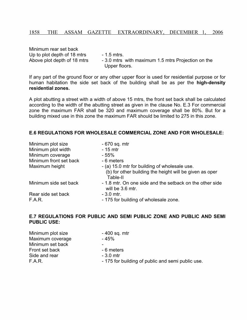
1858 THE ASSAM GAZETTE EXTRAORDINARY, DECEMBER 1, 2006
Minimum rear set back Up to plot depth of 18 mtrs - 1.5 mtrs. Above plot depth of 18 mtrs - 3.0 mtrs with maximum 1.5 mtrs Projection on the
Upper floors.
If any part of the ground floor or any other upper floor is used for residential purpose or for human habitation the side set back of the building shall be as per the high-density residential zones.
A plot abutting a street with a width of above 15 mtrs, the front set back shall be calculated according to the width of the abutting street as given in the clause No. E.3 For commercial zone the maximum FAR shall be 320 and maximum coverage shall be 80%. But for a building mixed use in this zone the maximum FAR should be limited to 275 in this zone.
E.6 REGULATIONS FOR WHOLESALE COMMERCIAL ZONE AND FOR WHOLESALE:
Minimum plot size - 670 sq. mtr Minimum plot width - 15 mtrMinimum coverage - 55%Minimum front set back - 6 metersMaximum height - (a) 15.0 mtr for building of wholesale use.
(b) for other building the height will be given as oper Table-IIMinimum side set back - 1.8 mtr. On one side and the setback on the other side
will be 3.6 mtr.Rear side set back - 3.0 mtr.F.A.R. - 175 for building of wholesale zone.
E.7 REGULATIONS FOR PUBLIC AND SEMI PUBLIC ZONE AND PUBLIC AND SEMI PUBLIC USE:
Minimum plot size - 400 sq. mtr Maximum coverage - 45%Minimum set back - Front set back - 6 metersSide and rear - 3.0 mtrF.A.R. - 175 for building of public and semi public use.

THE ASSAM GAZETTE EXTRAORDINARY, DECEMBER 1, 2006 1859
E.8 REGULATIONS FOR INDUSTRIAL ZONE:
Requirements Light Industry are in Sq. mtr.
Width in mtrs. Medium Industry Area in
sq. mtrs.
Width in mtrs.
1. Minimum size of plot
744.00 15.50 1800.00 27.5
2. Minimum setback of the building or the structure from the prescribed street line.
All structure 6.00 All structure 9.0
3. Minimum width Rear …. 6.0 Rear …. 6.0Side …. 3.0 Side …. 6.0If any structure or building is permitted for human habitation under the provisions of these rules the yard conditions shall be same as prescribed for medium density residential zone.
If any structure or building is permitted for human habitation under the provisions of these rules the yard conditions shall be same as prescribed for medium density residential zone.
4. maximum height 15 15 mtrs.
5. Maximum coverage 50% 50%
E.9 REGULATIONS FOR SPECIAL TYPES OF BUILDINGS :
(To be applicable for all zones where the particular use is permissible)
(A) NURSING HOMES/HOSPITALS : (in all zones where it is permitted/permissible on appeal)Minimum plot size - 1000 sq. mtr i.e. 0.75 BighaMaximum coverage - 45%Minimum set back - (a) Front set back - 7.5 meters(b) Rear and Side - 4.5 mtr(c) F.A.R. - 200
(B) PLACE OF WORSHIP : (applicable for new proposals)Minimum plot size - 804 sq. mtr i.e. 3K Maximum coverage - 50%Minimum set back - (a) Front set back - 7.5 meters(b) Rear and Side - 5.0 mtr(c) F.A.R. - 3.0

1860 THE ASSAM GAZETTE EXTRAORDINARY, DECEMBER 1, 2006
(C) CINEMA HAL AND AUDITORIUM : Minimum plot size - 1860 sq. mtr i.e. 1B-3K-9L Maximum coverage - 40%Minimum set back - (a) Front set back - 9.0 meters(b) Rear and Side - 4.5 mtr(c) F.A.R. - 125
(D) FILLING STATION : (a) Minimum plot size - 31 mtr x 17 mtrs (b) Petrol filling station with servicing bedMinimum plot size - 37 mtr x 31 mtrs
E. SCHOOL BUILDING :
Minimum Plot size Maximum coverage
Minimum front
setback
Minimum side
setback
Minimum rear setback
(a) Pre nursery/ Nursery
535 sq. mtr02 Katha
50% 6.0 mtr 3.0 mtr 3.0 mtr
(b) Primary 804 sq. mtr03 Katha
50% 7.5 mtr 3.0 mtr 3.0 mtr
(c) High School 2677 sq. mtr02 Bigha
50% 7.5 mtr 3.0 mtr 3.0 mtr
(d) College 4015 sq. mtr03 Bigha
50% 7.5 mtr 3.0 mtr 3.0 mtr
Organized parking – 20% of the total plot area.
Organized recreation – 20% of the total plot area of open space.
For Government institutions regulations adopted by education Department will be followed.
E.10.1 Mezzanine to the extent of 33% of plinth area shall not be counted for F.A.R. calculation.
The height of the mezzanine shall not be less than 2.2 mtr and not more than 2.7 mtr.
E.10.2 Basement shall not be counted for F.A.R. calculation for following uses. (i) Storage of household goods of non-inflammable materials. (ii) dark rooms, strong rooms and bank cellars etc. (iii) Air conditioning and other machines used for services and utilities of the building. (iv) Parking places and garages.(v) Stock rooms and libraries.

THE ASSAM GAZETTE EXTRAORDINARY, DECEMBER 1, 2006 1861
If the basement is used for office or commercial purpose it shall be counted in F.A.R.
E.10.3 (a) Partial unenclosed balcony projections for a length 1/4th of the building Length/breadth in upper floors up to a minimum setback line of 1.5 mtr from plot boundary will be allowed subject to a maximum width of 1.5 mtr.
(b) The projection of cantilever of cupboard or shelve up to 0.75 mtr in depth shall be permitted and exempted from covered area calculation. This will be allowed only from the first floor and shall not exceed 20 mtr per habitable room and cupboard under windows.
(c) A canopy not exceeding 4.5 mtr in length and 2.5 mtr in width in the form of unenclosed cantilever over the main entrance with a clear height of 2.2 mtr below the canopy shall be allowed.
(d) Light and Ventilation :- When any habitable room exception bath, W.C. store room Kitchen and dining are not abutting on either the front side or rear open space it shall about in an interior open space where minimum width will be 3 mtr. For ventilation the spaces for W.C. bath store, kitchen and dining if not opening or any open space shall open on the ventilation shaft the size which is given below:
Height of Building
Minimum area of shaft
Minimum width of shaft
(1) W.C. & Bath & Store
(a) Upto (b) Above
18 m18 m
4.6 sq.m6.25 sq.m
2m2.5 m
(2) Kitchen & Dining
(a) Upto (b) Above
18 m18 m
6.25 sq.m9 sq.m
2.5 m3 m
E.10.4 The parking space to be provided in the building shall be as per the details given in the appendix-I in providing the parking, care has to be taken that 50% of the open space is left for landscaping and not counted for in the parking calculations. At least 25% of the open space reserved as organized open space which should be clearly shown in the service plan.
For calculation of car space the following shall be considered :
Area of each car space –
(i) Basement Parking - 30 sq. mtr.(ii) Stilt - 25 sq. mtr.(iii) Open parking - 20 sq. mtr.

1862 THE ASSAM GAZETTE EXTRAORDINARY, DECEMBER 1, 2006
E.11. ADDITIONAL REQUIREMENTS FOR MULTISTOREYED AND SPECIAL TYPE OF BUILDING :
(A) Service plan showing the following details private water sewerage disposal system and detail of building services where required by the Authority shall be made available on a scale not less than 1:100 and it should also include the following : (a) For outlet from the soak pit to municipal drain if provided an intermediate treatment chamber should be installed, details of which is to be shown in service plan subject to approval of authority.(b) Garbage vet.(c) Organised open space as specified by clause 2.25 Details of building services include – (i) Air conditioning system, if any(ii) details of exists including provisions of raps etc for hospital and special risk building.(iii) location of generator, transformer and switchgear.(iv) Smoke exhauster system and fire alarm system, if any.(v) Location of centralized control of al fire alarm system, if any.(vi) Location and dimension of static water storage and pump house.(vii) Location of fire protection installation sprinklers, wet risers, etc if any.
N.B. These should generally be as per specifications of national building code.
(viii) Size (Width) of main and alternate staircase along with balcony approach, corridor and ventilated lobby approach.(ix) In case of nursing homes and hospitals detail of incinerator for treatment of hospital waste is to be submitted and clearance from appropriate Authority under Assam Health Establishment Act 1993 and 1995 will be required before its clearance by Dev. Authority.(x) The height of the ground level and the plinth level from the nearest developed road level.
(B) NOC from the State Fire service shall be required for building above the height of 15.8M.(C) Specifications :- General specifications of the proposed construction giving type and grade of materials for public use along with soil testing report and structural details duly signed by architect/engineer/supervisor/group should accompany the application for building above three storey.(D) Supervision :- Application shall be further accompanied by a certificate of supervision by the licensed architect engineer groups as the case may be. E.12 For the hazardous and industrial building Authority may ask for NOC from the State Pollution Control Board.E.13 All other regulations not specifically mentioned here will be applicable as per the provision of zoning regulations.

THE ASSAM GAZETTE EXTRAORDINARY, DECEMBER 1, 2006 1863
E.14 Authority may ask for any other information considering specials nature of building and location of the plot.E.15 Penal action for violation of Master Plan & its zoning regulations and Bye Laws. The Authority under provision of T & C.P. Act, 1959 shall take panel action for violations of Master Plan / Zoning Regulations or Bye laws which may include stoppage of construction activity, demolition/alteration and in paying fine and by having penalties as given in the Act. E.16 The structural design, construction standard etc. of all multi storeyed buildings are required to be supervised during construction at three stages at (1) foundation, (2) Plinth / Ground floor, (3) Upper floor in the manner described below. (i) The individual promoter so required to get their construction checked as mentioned in three stages of constrcuction through licensed technical firms of Authority before proceeding with next stage of construction failing which the Authority may revoke the permission.E.17 Any dispute arises about the interpretation of any definitions of provisions of these rules, the decision of the Authority shall be final, However, aggrieved persons may appeal to the Appellate Authority against such decisions and the decisions of the Appellate Authority shall be final and binding to all concerned.

1864 THE ASSAM GAZETTE EXTRAORDINARY, DECEMBER 1, 2006
ANNEXURE-I
AN INDICATIVE LIST OF INDUSTRIES WHICH COULD BE PERMITTED INRESIDENTIAL AREA AS STATED IN ARTICLE 7.2.1
01. Cosmetic Products 02. Agarbati03. Writing ink 04. Sealing wax05.watch, pen and spectacles repairing 06. Acrylic sheet button07. Plastic covers (Dairy and Files etc.) 08. Knitted plastic bags 09. Shoe repairing and manufacturing 10. Rubber stamps11. Rubber moulded goods 12. Food products13. Creamery & Dairy product 14. Atta chakki & Masala grinding 15. repacking of Medicines 16. Paper products 17. Card board boxes 18. Book binding 19. Assembly of Furniture units 20. Readymade garments 21. Making of Lac Bangles 22. Batik painting 23. Ivory carrying 24. Embroidery 25. Watch straps (Nylon) 26. Canvas bags& products 27. Hosiery items 28. Surgical bandages29. Shoe laces etc 30. Thread rolls 31. Tailor labels 32. Mirror & Frame making 33. Decorative Glass articles 34. Chalk sticks 35. Tailors shop 36. Cycle repairing shop. 37. Basket making 38. Wire brushes39. Umbrella assembly 40. Wooden toys 41. Paper pins, Gem clips 42. Hair pins 43. Wire staples 44. Wire stands for kitchen 45. Wire for curtains 46. Wire loops47. Decorative key rings 48. Link clips 49. File clips 50. Shoe & tent eyelets 51. Brass jewelry 52. File cover Accessories 53. Garments Hooks & eyes 54. Link chain 55. Heating elements (for domestic appl). 56. Decoration lighting series57. Transistor Radio covers 58. Decorative Leather goods 59. Industrial Leather hand gloves 60. Manufacture of Bidis. 61. Processing of suparis 62. Laundry, Dry cleaning & cleaning 63. Cotton cloth weaving in handlooms 64. Metal polishing 65. Repairing of Electronic Instruments 66. Gold & Silver thread, Zari work, jewellery,
Gold ornaments. 67. Manufacture, repairing & tuning of Musical instruments.
B. DUTTACommissioner & Secretary to the Government of Assam
Urban Development Department, Dispur
GUWAHATI – Printed and Published by the Dy. Director (P&S), Directorate of Ptg. & Sty, Assam, Guwahati-21 (Ex-Gazette) No. 583-500-200-1-12-2006