november, 2009 management report on ksk cow … · the prospect has had insufficient exploration to...
TRANSCRIPT

1
November, 2009
Management Report on KSK CoW Magnetic Data reprocessed using advanced 3D Inversion Technology
Central Kalimantan, Indonesia
For further information please visit www.kalimantan.com or contact: Rahman Connelly Chief Executive Officer +61 418116955 Gerald Cheyne Corporate Development +44 (0) 207 731 1806

2
SUMMARY Kalimantan Gold Corporation Limited’s (“KGC”) Contract of Work (CoW) is located in Central Kalimantan, Indonesia within the Central Kalimantan magmatic arc which hosts the Kelian (5.1M oz Au) and Mt Muro (2.2M oz Au) low-sulphidation gold deposits. This area contains Oligocene-Miocene Sintang Intrusions, which in 1995-98 were the focus of intense exploration by junior and major mining companies. This is a management prepared summary of exploration work done on the CoW. All data, as disclosed in this summary, have been verified by the Company's Qualified Person for the KSK CoW project, Dr. Peter Pollard. Preliminary work at the Mansur and Beruang prospects has confirmed the presence of porphyry Cu-Au-Mo style mineralization and alteration, while a high sulphidation system is present at Beruang Kanan. Grid soil samples have defined numerous copper in soil anomalies at the Beruang prospects and at Mansur. Chalcopyrite, covellite and minor malachite are present as disseminations and within fracture fillings of quartz stockworks and sheeted veins. A recent inversion of the geophysical data over the KSK CoW shows numerous magnetic anomalies coincident with Cu in stream sediment, soil and rock chip anomalies. High-sulphidation alteration and Cu mineralisation at the Beruang Kanan prospect are localised by structurally controlled breccia/shear zones within steeply dipping dacitic and andesitic volcanics and volcaniclastics. Surface sampling has defined a 1,100m long by 400-600m wide zone of >0.1% Cu and broad spaced drilling has delineated 80-90Mt @ 0.5 – 0.6% Cu to a depth of about 200m. The prospect has had insufficient exploration to define a mineral resource compliant with National Instrument 43-101 and it is uncertain if further exploration will result in the target being delineated as a mineral resource. Although the geology, structural evolution and the hydrothermal processes at both porphyry prospects are not well understood, preliminary work suggests that these are significant copper mineralizing systems. Testing the deeper levels of the Beruang and Mansur prospects is considered a top priority. This is a 6th generation CoW in good standing and with still 2 years of exploration remaining, very few CoW’s remain with such favourable conditions. There are some forestry issues, but Kalimantan Gold has an excellent relationship with the local government.

3
1. INTRODUCTION The following report summaries the findings of a management assessment of the porphyry Cu-Au potential of KGC’s “KSK Contract of Work” and the surrounding areas. KGC is an AIM and TSX-V listed mining junior, focused on coal, gold and copper prospects in Kalimantan, Indonesia.
2. LOCATION AND TENEMENT DETAILS The areas are located in south-central Kalimantan, near to the capital city of Palangkaraya (Figure 1). Access to Palangkaraya is by a 1 hour 30 minute flight from Jakarta, and three airlines provide daily flights (Garuda, Batavia and Sriwijaya). Flight schedules are unreliable at this time of year, due to a thick blanket of smoke and ash from hundreds of land-clearing fires. Road access to KGC’s main office and core storage area is via paved roads that are well maintained. The area of KGC’s KSK CoW, located 180km NNW of Palangkaraya in central Kalimantan. The KSK CoW is a 6th generation CoW of 941 hectares that is currently under suspension and is in the 4th year of the Exploration Phase. KSK CoW falls within three Kabupatens and is in good standing with the local and central governments. KGC Acquired 100% Ownership of KSK Contract of Work in 2008.
Figure 1: Location Map showing KGC CoW, Office and core storage area.
3. REGIONAL GEOLOGY & STRUCTURE
KGC’s KSK CoW is located in the central region of the Central Kalimantan magmatic arc, which hosts the Kelian (5.1M oz Au) and Mt Muro (2.2M oz Au) low-sulphidation gold deposits and also the highly prospective Masupa Ria CoW (60km east of KSK CoW). The Central Kalimantan magmatic arc contains a suite of Oligocene-Miocene high level intermediate to felsic calc-alkaline intrusive rocks that intrude late Eocene sediments and tuffs (Figure 1). These intrusive rocks are collectively referred to as the Sintang Intrusives and become progressively more acidic with age,

4
with the younger events dominated by dacite domes and dykes. Intrusive rocks collected within the KSK CoW have been dated at approximately 30Ma.
Figure 2: Regional geology of the KSK CoW and the main mineral prospect areas
NE to NNE and NW to NNW trending arc normal or transfer features are the most prominent structures in the region. There are major NS to NNW structure splays or horsetails into subsidiary NE and NNE to NE fault system (Figure 3). The NE trending faults are truncated by latter NW, NS and EW faults that form the loci for intrusive activity. Numerous prospects including the Beruang Kanan and Beruang Tengah lie along the NE structures. A large circular feature is evident in the Landsat and Radar imagery. The Beruang Kanan high-sulphidation prospect is located within a smaller circular feature on the southern margin of this larger circular feature, where it is intersected by NE striking transfer faults.

5
Figure 3: KSK CoW area, showing a Global, 1 arc-second (approximately 30-m) Digital Elevation Model (GDEM) derived from advanced Spaceborne Thermal Emission and Reflection Radiometer (ASTER). Major structures in dashed white.
4. PORPHYRY Cu-Au PROSPECTS KGC have identified a total 38 mineral prospects in the KSK CoW, the main prospects are listed in Table 1. The most advanced porphyry Cu-Au prospects include Beruang Tengah and Mansur, along with a deeply eroded high sulphidation system at Beruang Kanan (interpreted porphyry at depth). Previous Work Exploration over the KSK CoW has been locally extensive, but of a preliminary nature and until very recently focussed on defining the high-sulphidation Cu system at Beruang Kanan. Work programs by KGC have included regional minus 80-mesh stream sediment sampling, rock channel sampling, ridge and spur auger soil sampling and geological mapping, drilling and extensive petrological, XRD and mineragraphic investigations. The prospect was included in a regional airborne geophysical survey (8,000 line kilometres) flown in 1996. A joint venture program between KGC and Cyprus Amax was undertaken in 1996 when Cyprus spent US $860,000 on re-evaluating and drilling the Mansur porphyry Cu-Au prospect. Cyprus withdrew after 6 months and unfortunately their drillholes were short and did not fully test the Mansur porphyry. A second joint venture program between KGC and Oxiana was undertaken in 2006. Oxiana spent US $2,500,000 on re-evaluating and drilling at the Beruang Tengah, Beruang Kanan and Mansur prospects and withdrew after expenditure commitments were met. Oxiana’s drill holes were designed to test conceptual targets and did not focus on testing the deeper levels of the porphyry systems (where large magnetic anomalies remain untested). A total of US$ 16.4 million has been spent on exploration.

6
Table 1: KGC’s Main Prospect Areas in the KSK CoW, description and work completed. Prospect
Name Style of Mineralization
Exploration completed
1 Mansur Porphyry Cu-Au system classic geophysical signatures and alteration patterns.
drill holes, detailed mapping, rockchip sampling, stream sediment sampling, soil grid
2 Beruang Tengah Porphyry Cu-Mo-Au system Surface grades to 0.2% Cu, peripherally up to 1ppm Au
drill holes, detailed mapping, rockchip sampling, stream sediment sampling
3 Beruang Kanan High sulphidation Cu no Au Area of mineralization approximately 950m x 100 m.
drill holes, detailed mapping, rockchip sampling, stream sediment sampling, soil grid
4 Tumbang Huoi Cu-Au porphyry style mineralization
drill holes, detailed mapping, rockchip sampling, stream sediment sampling, soil grid
5 Mamuring Skarn style Cu-Au mineralization Stream sediment sampling, 1 drill hole, rock chip sampling
6 Kalang Broad area of alteration with Cu minerals in outcrop
reconnaissance mapping and sampling
7 Mansur North Geophysical anomaly, Au in stream sediment anomaly
reconnaissance mapping and sampling
8 Baroi Ring structure with Au-Cu-base metal mineralization. Massive sulphide veins in volcanics
reconnaissance mapping and sampling
Mansur Porphyry Cu-Au Prospect A total 21 holes have been drilled at the Mansur Prospect, with 13 holes drilled to an average depth of 100m and 8 holes to an average depth of 325m (Figure 4). A large Cu in soil anomaly measuring 1400m in a N-S direction by 1000m in an E-W direction (see figure 4) has been defined by grid soil sampling. The Cu in soil anomaly was tested by shallow drill holes which intersected weak (0.2% Cu) porphyry-style mineralization. Drill core observations indicate moderate clay, sericite and silica alteration of a feldspar porphyritic host was intersected at the top of each hole, passing into a moderately magnetic and potassic (shreddy biotite replacing hornblende and K-feldspar) altered diorite at depth (Figure 5). A number of chalcopyrite-bearing quartz stockwork zones (1-2% density) were intersected in each hole. Minor molybdenite was also noted, occurring along the selvages of some porphyry style veins. It should be noted that there is a significant increase in magnetite alteration with depth, which correlates well with the 3-D magnetic inversion model. The model shows a large (800m wide X 1000m vertical) magnetic body directly below the Mansur drill holes and remains untested (Fig. 6). The potential for better grades appears to be significant, as stronger magnetite alteration is commonly associated with stronger Cu-Au grades. The style and zonation of hydrothermal alteration assemblages at this prospect is consistent with other porphyry style systems in Indonesia and other parts of Southeast Asia. A review of prospects in the immediate area suggests the present level of erosion has exposed the upper levels of the Mansur porphyry system. The deeper seated magnetic anomaly represents a valid porphyry Cu target.

7
Figure 4: Mansur porphyry prospect, showing Cu in soils and DDH’s. The drill holes in yellow were drilled to an average depth of 100m, those in white to a depth of 325m.
Figure 5: Mansur porphyry prospect (Top Left) SMH-05_82.07m, potassic altered diorite cut by mm scale qtz-cpy veins with sericite selvages (Top Right) SMH-08_87.45m, mm-scale magnetite vein cutting potassic altered diorite (Bottom Left) SMH-03_85.80m, potassic altered diorite cut by

8
hairline to mm scale qtz-cpy veins (Bottom Right) SMH-03_89.50m, potassic altered diorite cut by quartz vein with cpy as centreline fill, sericite selvage.
Figure 6: Mansur porphyry prospect, showing Cu in drilling and a prominent magnetic anomaly situated at depth below the current drill coverage Beruang Kanan The style and zonation of hydrothermal alteration assemblages at this prospect seem consistent with the high-sulphidation system and is characterized by strong chalcopyrite, covellite and enargite mineralization associated with argillic and advanced argillic style alteration. This indicates that hot acidic fluids probably flowed vertically/laterally from a degassing intrusion, interpreted to be east of and below the current drilling. The drilling program has outlined an exploration target of about 80-90 Mt @ 0.5 – 0.6% Cu to a depth of 200m and the system appears to dip steeply to the east. The exploration target to date has insufficient exploration to define a mineral resource compliant with National Instrument 43-101. It is uncertain if further exploration will result in the exploration target being delineated as a mineral resource.
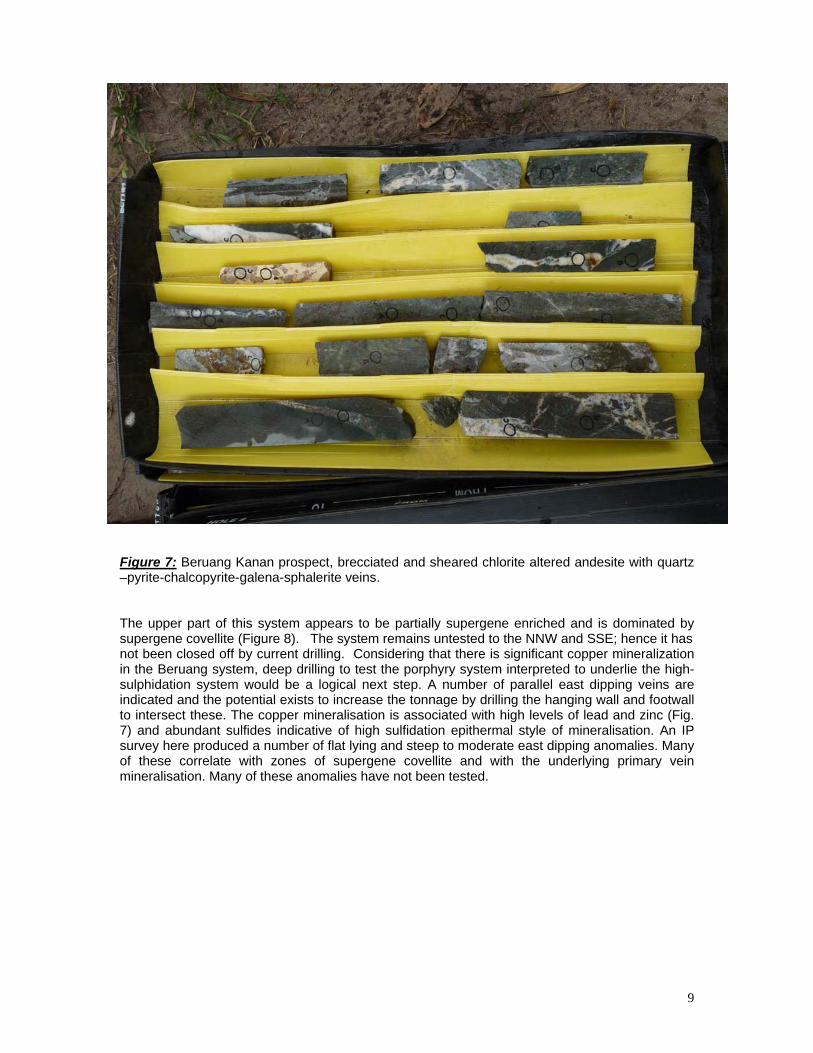
9
Figure 7: Beruang Kanan prospect, brecciated and sheared chlorite altered andesite with quartz –pyrite-chalcopyrite-galena-sphalerite veins. The upper part of this system appears to be partially supergene enriched and is dominated by supergene covellite (Figure 8). The system remains untested to the NNW and SSE; hence it has not been closed off by current drilling. Considering that there is significant copper mineralization in the Beruang system, deep drilling to test the porphyry system interpreted to underlie the high-sulphidation system would be a logical next step. A number of parallel east dipping veins are indicated and the potential exists to increase the tonnage by drilling the hanging wall and footwall to intersect these. The copper mineralisation is associated with high levels of lead and zinc (Fig. 7) and abundant sulfides indicative of high sulfidation epithermal style of mineralisation. An IP survey here produced a number of flat lying and steep to moderate east dipping anomalies. Many of these correlate with zones of supergene covellite and with the underlying primary vein mineralisation. Many of these anomalies have not been tested.

10
Figure 8: Rock chip sample from the Beruang Kanan Prospect, showing almost massive covellite. Beruang Tengah Prospect The Beruang Tengah Prospect is located in steep rainforest covered hills at the headwaters of Beruang Tengah Creek about 2.5km due east of the Beruang Kanan high-sulphidation prospect. Exploration by KGC has defined significant zones of anomalous Cu, Mo and Au geochemistry in soils (Fig. 9) associated with areas of porphyry style alteration and quartz stockwork and sheeted veining (Figure 10). Based on drill core observations, the intrusions in the central part of this prospect show evidence of pervasive and intense phyllic alteration (Figure 10). Drilling and previous reports indicate this alteration grades outward from a zone of quartz-sericite-pyrite to quartz-sericite-chlorite-pyrite to the SE and NE. Geological mapping has confirmed an early biotite (potassic) alteration phase in the upper reaches of the Beruang Tengah Creek, near the SE corner of the prospect. This potassic zone is 500m long and is partly associated with elevated Cu-sulphide and Au mineralisation. The ridge to the southwest is unexplored but hosts a zone of distinctly “stressed” vegetation, an anomaly worth further investigation. Further to the west, a zone of Pb-Zn (high graded to give combined 6% metal) stockworks is exposed for 1km on the Domas Road. The broad elements of a porphyry system are clearly present at Beruang Tengah prospect, but grades encountered in the shallow drilling to date are not economic. However, the 3-D magnetic inversion model shows a deeper seated magnetic body below the current level of drilling. The porphyry potential of this prospect may only be realised once this deeper seated magnetic target has been tested and the other prospective areas are explored. Only limited drilling has been

11
completed here. The best holes were only drilled to 220m and ended in porphyry style copper mineralisation with intense phyllic alteration. These holes are situated directly above the deep seated magnetic anomaly. The Beruang Kanan and Tengah prospects combined represent a large 8km by 5km area of copper mineralisation. A major NNW structure appears to separate the high sulfidation Kanan prospect from the porphyry style Tengah prospect. This structure is seen in the topography and controls the high sulfidation veins. The two prospects appear to be part of a single large mineralising system. Several magnetic anomalies are developed below this system and deep drilling of this area is seen as a future priority.
Figure 9: Beruang Kanan and Tengah porphyry prospects, showing Cu in soils and diamond drill holes.

12
Figure 10: Core samples from the Beruang Tengah Prospect showing moderate to strong quartz stockwork veining in phyllic to potassic altered diorite.

13
Appendix 1
Community & Government Relations Summary Main Aim For the past 10 years, KGC has been closely involved in community and social development in Central Kalimantan. To this end, the company set up a foundation, Yayasan Tambuhak Sinta (YTS) in 1997 and has provided management, staffing and support for its work ever since. YTS's main objective is to improve the social and institutional environment in the areas where current exploration is going on, in order to ensure that conditions are favourable and conducive for establishing a viable mining operation. Main Focus YTS has developed an approach and methodology that brings together the interests of communities, government, and the company in improving the quality of life and well-being in the areas close to exploration activities. The focus is on community-based participatory planning, directly linked to the formal government planning mechanism called Musrenbang. The annual Village Development Plan provides the focus for both government and company support. Main Activities 1. Facilitate planning process and interaction with Musrenbang - Facilitate four-day intensive participatory planning process - Assist village management team to conduct household planning - Assist in consolidation of plans and creation of annual Village Development Plan - Assist in preparation of village Musrenbang, and interaction in sub district and district Musrenbang 2. Facilitate government support to annual Village Development Plans - Link department programs and services to needs in villages - Assist villages in making formal requests for government support - Facilitate delivery of government support to villages 3. Capacity and institutional development in villages - Facilitate formation of Village Management Group and Economic Livelihood Groups - Provide training and support to Village Management Group - Provide funding and technical support for Economic Livelihood Groups 4. Mercury use in artisanal mining - Survey and analysis of mercury use in artisanal mining - Raise awareness of dangers of exposure to mercury - Provide technical support to capture and recycle mercury - Provide equipment to capture and recycle mercury 5. Media Production - Campaigns and media on mining issues - Media for development communications - Media for training and technical support