npoess preparatory project overview kenneth schwer nasa npp project manager & james valenti ipo...
TRANSCRIPT
NPOESS Preparatory Project Overview
Kenneth SchwerNASA NPP Project Manager
&James Valenti
IPO NPP Project Manager (Acting)
October, 2005
MSO - 2
Agenda
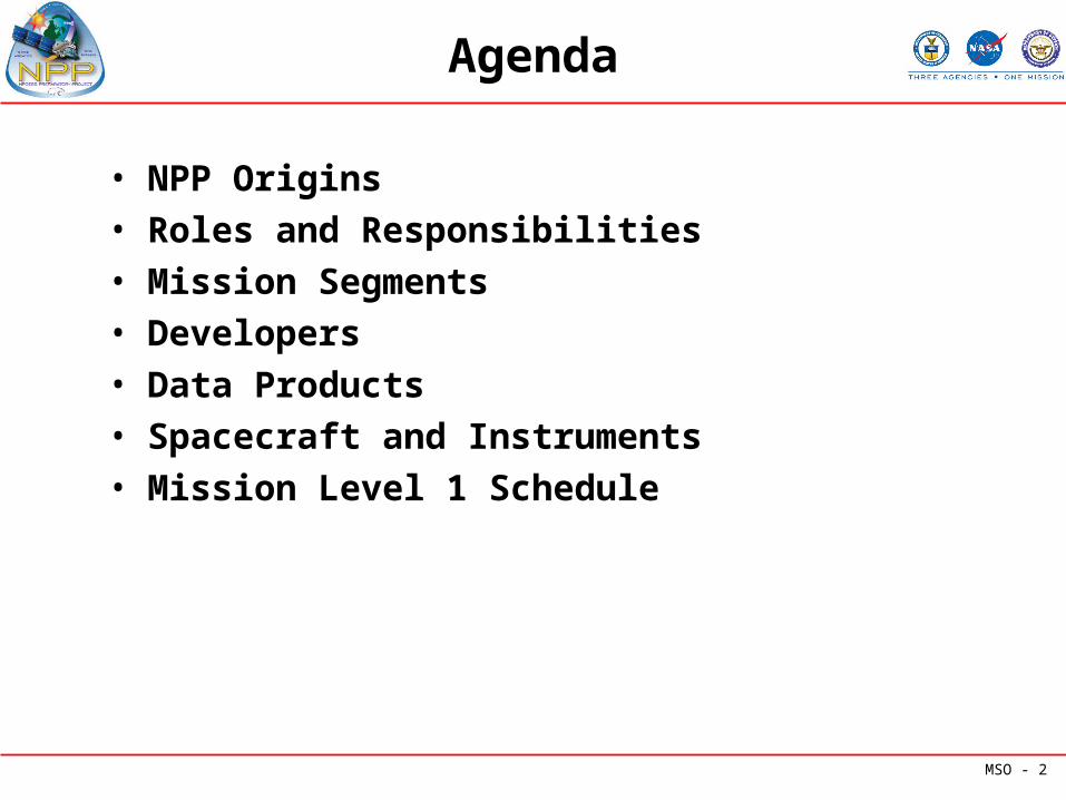
• NPP Origins• Roles and Responsibilities• Mission Segments• Developers• Data Products• Spacecraft and Instruments• Mission Level 1 Schedule
MSO - 3
NPP Origins
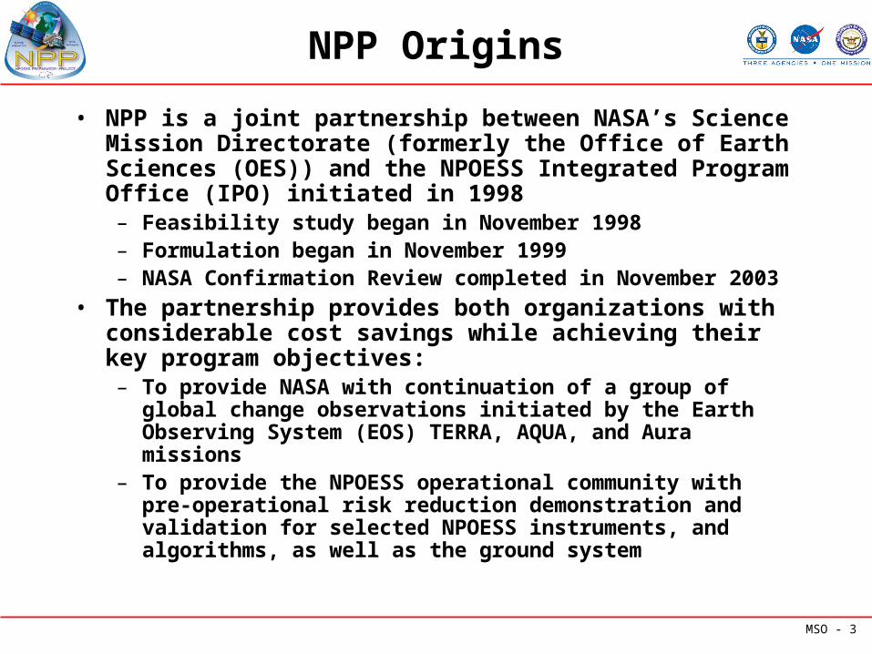
• NPP is a joint partnership between NASA’s Science Mission Directorate (formerly the Office of Earth Sciences (OES)) and the NPOESS Integrated Program Office (IPO) initiated in 1998– Feasibility study began in November 1998– Formulation began in November 1999– NASA Confirmation Review completed in November 2003
• The partnership provides both organizations with considerable cost savings while achieving their key program objectives: – To provide NASA with continuation of a group of global
change observations initiated by the Earth Observing System (EOS) TERRA, AQUA, and Aura missions
– To provide the NPOESS operational community with pre-operational risk reduction demonstration and validation for selected NPOESS instruments, and algorithms, as well as the ground system
MSO - 4
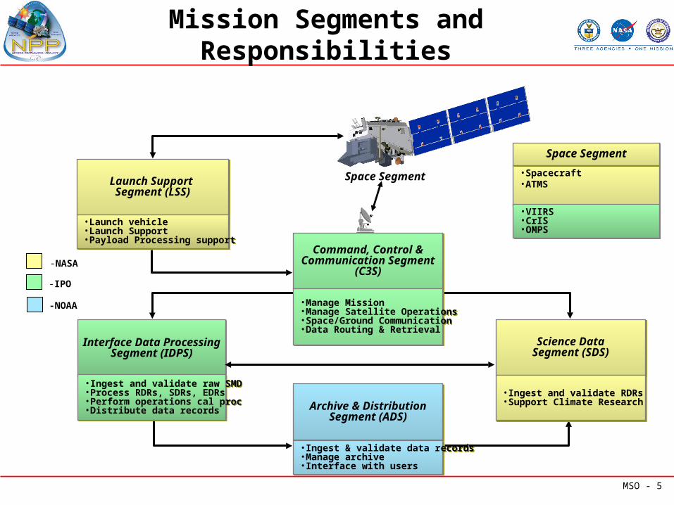
NPP Roles / Responsibilities
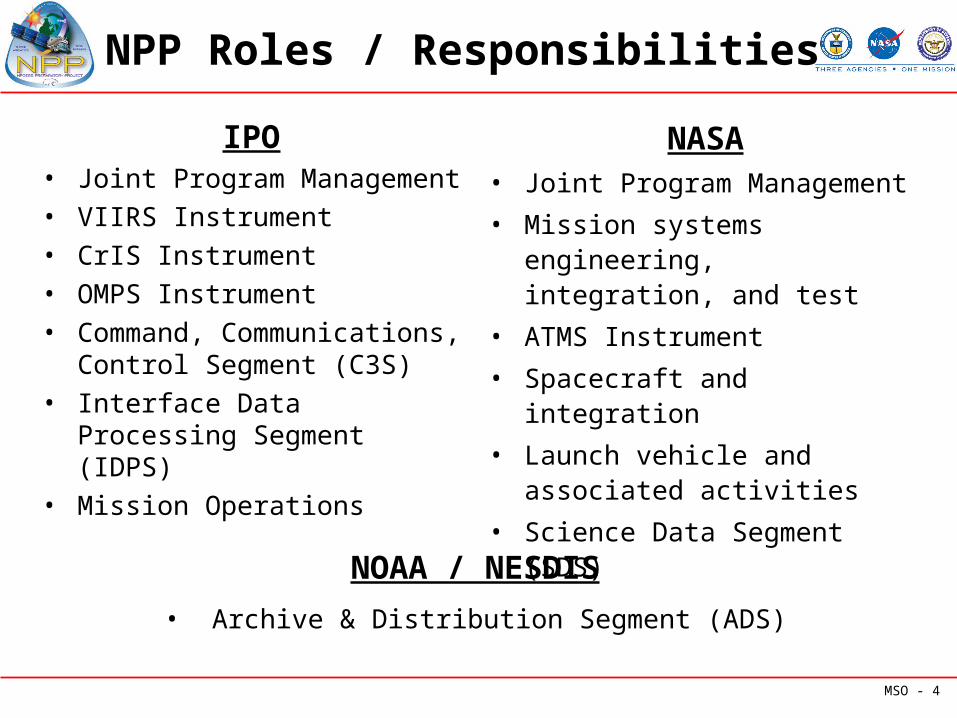
IPO• Joint Program Management• VIIRS Instrument• CrIS Instrument• OMPS Instrument• Command, Communications,
Control Segment (C3S)• Interface Data Processing
Segment (IDPS)• Mission Operations
NASA• Joint Program Management
• Mission systems engineering, integration, and test
• ATMS Instrument
• Spacecraft and integration
• Launch vehicle and associated activities
• Science Data Segment (SDS)
NOAA / NESDIS
• Archive & Distribution Segment (ADS)
MSO - 5
Mission Segments and Responsibilities
Space Segment
-NASA
-IPO
-NOAA
Command, Control &Communication Segment
(C3S)
Command, Control &Communication Segment
(C3S)
•Manage Mission •Manage Satellite Operations•Space/Ground Communication•Data Routing & Retrieval
•Manage Mission •Manage Satellite Operations•Space/Ground Communication•Data Routing & Retrieval
Launch Support Segment (LSS)
Launch Support Segment (LSS)
•Launch vehicle•Launch Support•Payload Processing support
•Launch vehicle•Launch Support•Payload Processing support
Space SegmentSpace Segment
•Spacecraft •ATMS
•VIIRS•CrIS•OMPS
•VIIRS•CrIS•OMPS
Interface Data ProcessingSegment (IDPS)
Interface Data ProcessingSegment (IDPS)
•Ingest and validate raw SMD•Process RDRs, SDRs, EDRs•Perform operations cal proc•Distribute data records
•Ingest and validate raw SMD•Process RDRs, SDRs, EDRs•Perform operations cal proc•Distribute data records Archive & Distribution
Segment (ADS)Archive & Distribution
Segment (ADS)
•Ingest & validate data records•Manage archive•Interface with users
•Ingest & validate data records•Manage archive•Interface with users
Science DataSegment (SDS)Science Data
Segment (SDS)
•Ingest and validate RDRs•Support Climate Research•Ingest and validate RDRs•Support Climate Research
NPP
ExternalInterface
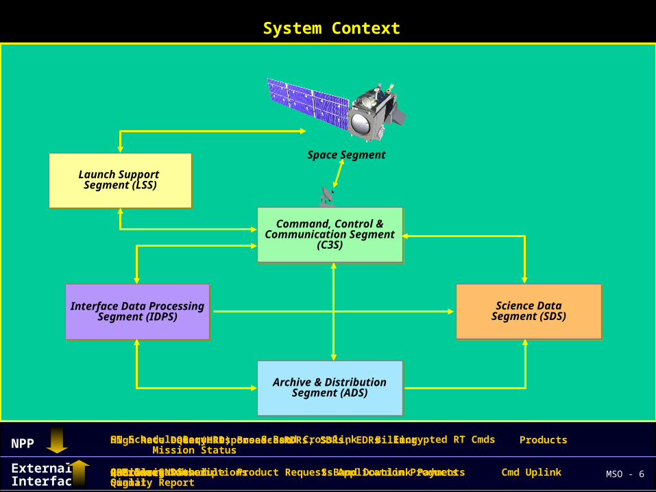
NPP Mission System
System Context
Application ProcessingSystems (Centrals)
Space Network (SN)
Direct BroadcastUser
Environment
User Community
Ancillary DataSystems
RadiancesGPS Navigational Signal SN Schedule S-Band Downlink Cmd Uplink Quality Report
SN Schedule Request S-Band Crosslink Encrypted RT Cmds
High Rate Data (HRD) Broadcast
Ancillary DataProduct Subscriptions Application Products
RDRs, SDRs, EDRs
Queries Product Requests Payments
Query Responses Billing Products Mission Status
Global PositioningSystem (GPS)
MSO - 6
Command, Control &Communication Segment
(C3S)
Command, Control &Communication Segment
(C3S)
Interface Data ProcessingSegment (IDPS)
Interface Data ProcessingSegment (IDPS)
Launch Support Segment (LSS)
Launch Support Segment (LSS)
Archive & DistributionSegment (ADS)
Archive & DistributionSegment (ADS)
Science DataSegment (SDS)Science Data
Segment (SDS)
Space Segment
Space Segment
Command, Control &Communication Segment
(C3S)
Command, Control &Communication Segment
(C3S)
Interface Data ProcessingSegment (IDPS)
Interface Data ProcessingSegment (IDPS)
Launch Support Segment (LSS)
Launch Support Segment (LSS)
Archive & DistributionSegment (ADS)
Archive & DistributionSegment (ADS)
Science DataSegment (SDS)Science Data
Segment (SDS)
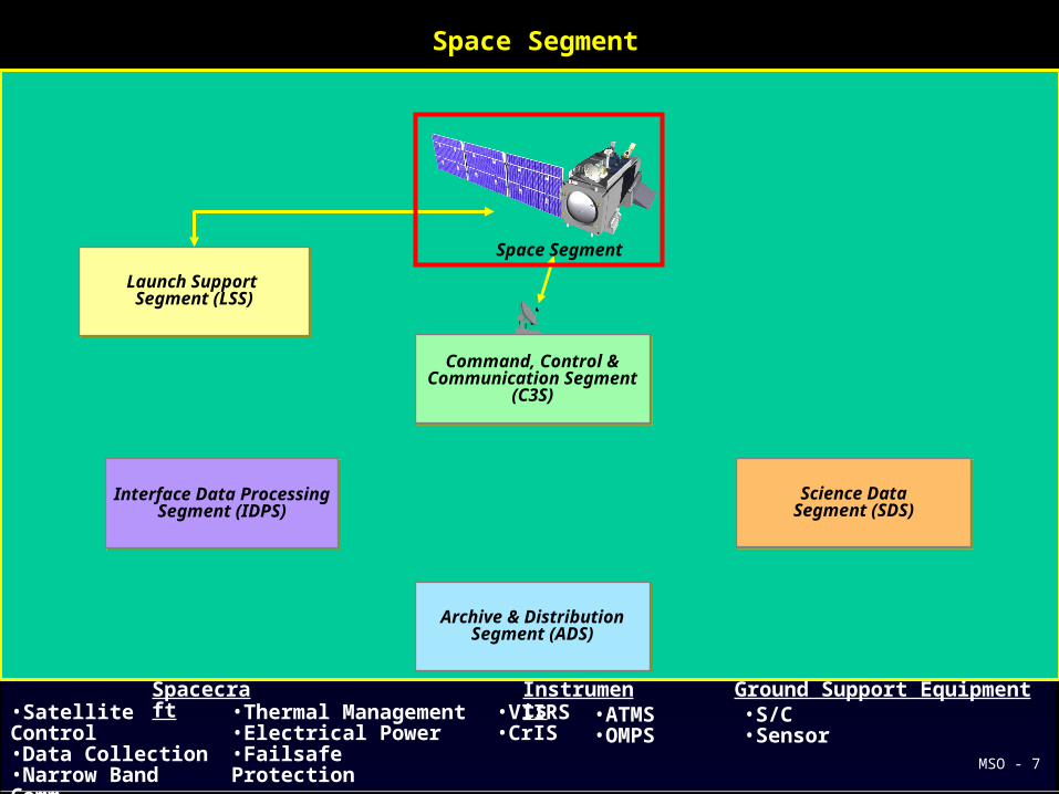
•Satellite Control•Data Collection•Narrow Band Comm•Wide Band Comm
•Thermal Management•Electrical Power•Failsafe Protection
•VIIRS•CrIS
Spacecraft
Instruments
Space Segment
Ground Support Equipment•ATMS
•OMPS•S/C•Sensor
MSO - 7
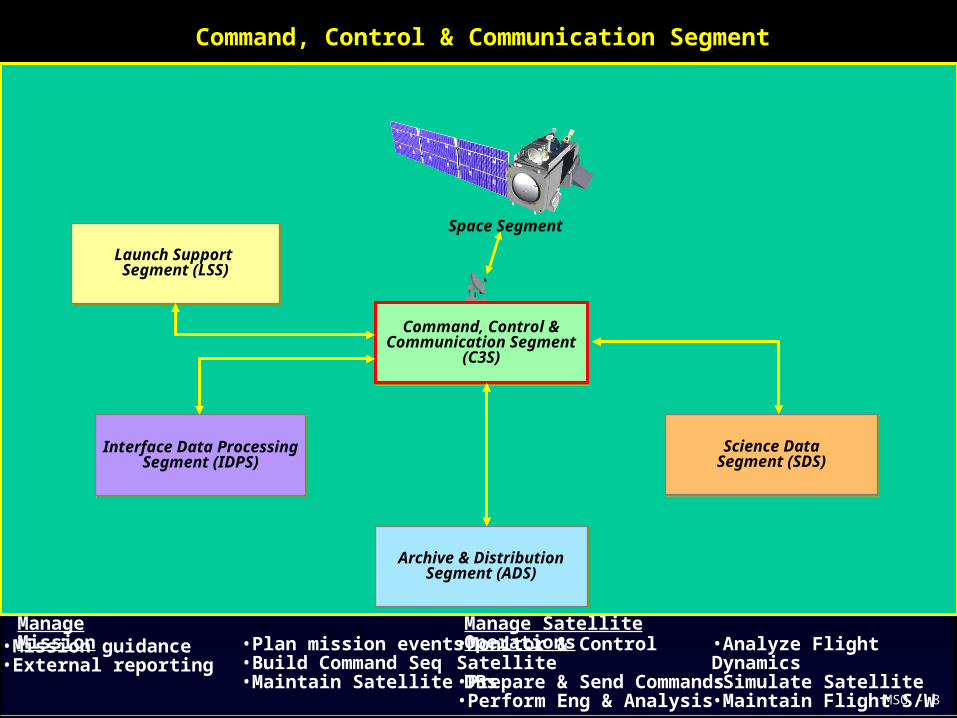
Command, Control & Communication Segment
•Mission guidance•External reporting
•Plan mission events•Build Command Seq•Maintain Satellite DBs
Manage Mission
Manage Satellite Operations•Monitor & Control
Satellite•Prepare & Send Commands•Perform Eng & Analysis
•Analyze Flight Dynamics•Simulate Satellite•Maintain Flight S/W
Command, Control &Communication Segment
(C3S)
Command, Control &Communication Segment
(C3S)
Interface Data ProcessingSegment (IDPS)
Interface Data ProcessingSegment (IDPS)
Launch Support Segment (LSS)
Launch Support Segment (LSS)
Archive & DistributionSegment (ADS)
Archive & DistributionSegment (ADS)
Science DataSegment (SDS)Science Data
Segment (SDS)
Space Segment
MSO - 8

•Control ground comm•Position antenna•Uplink satellite loads•Receive telemetry
•Receive SMD•Preprocess Downlinked data•Rate buffer pre-processed data•Compare received vs. transferred
Space / Ground Comm
Data Routing & Retrieval•Provide inter-segment
comm•Provide intra-segment comm for C3S and IDPS
Command, Control &Communication Segment
(C3S)
Command, Control &Communication Segment
(C3S)
Interface Data ProcessingSegment (IDPS)
Interface Data ProcessingSegment (IDPS)
Launch Support Segment (LSS)
Launch Support Segment (LSS)
Archive & DistributionSegment (ADS)
Archive & DistributionSegment (ADS)
Science DataSegment (SDS)Science Data
Segment (SDS)
Space Segment
Command, Control & Communication Segment
MSO - 9
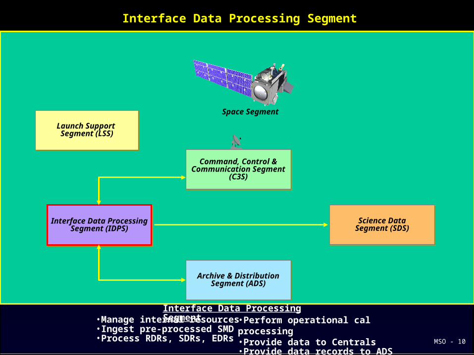
Interface Data Processing Segment
•Manage internal resources•Ingest pre-processed SMD•Process RDRs, SDRs, EDRs
•Perform operational cal processing•Provide data to Centrals•Provide data records to ADS & SDS
Interface Data Processing Segment
Command, Control &Communication Segment
(C3S)
Command, Control &Communication Segment
(C3S)
Interface Data ProcessingSegment (IDPS)
Interface Data ProcessingSegment (IDPS)
Launch Support Segment (LSS)
Launch Support Segment (LSS)
Archive & DistributionSegment (ADS)
Archive & DistributionSegment (ADS)
Science DataSegment (SDS)Science Data
Segment (SDS)
Space Segment
MSO - 10
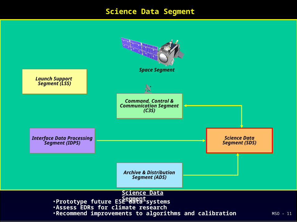
Science Data Segment
•Prototype future ESE data systems•Assess EDRs for climate research•Recommend improvements to algorithms and calibration
Science Data Segment
Command, Control &Communication Segment
(C3S)
Command, Control &Communication Segment
(C3S)
Interface Data ProcessingSegment (IDPS)
Interface Data ProcessingSegment (IDPS)
Launch Support Segment (LSS)
Launch Support Segment (LSS)
Archive & DistributionSegment (ADS)
Archive & DistributionSegment (ADS)
Science DataSegment (SDS)Science Data
Segment (SDS)
Space Segment
MSO - 11
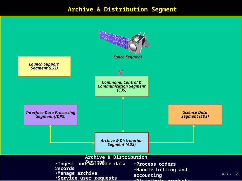
Archive & Distribution Segment
•Ingest and validate data records•Manage archive•Service user requests
•Process orders•Handle billing and accounting•Distribute products
Archive & Distribution Segment
Command, Control &Communication Segment
(C3S)
Command, Control &Communication Segment
(C3S)
Interface Data ProcessingSegment (IDPS)
Interface Data ProcessingSegment (IDPS)
Launch Support Segment (LSS)
Launch Support Segment (LSS)
Archive & DistributionSegment (ADS)
Archive & DistributionSegment (ADS)
Science DataSegment (SDS)Science Data
Segment (SDS)
Space Segment
MSO - 12

Launch Support Segment
•Launch Vehicle (Delta II 7920)•Launch Pad•Launch Support•Payload Processing
Launch Support Segment
Command, Control &Communication Segment
(C3S)
Command, Control &Communication Segment
(C3S)
Interface Data ProcessingSegment (IDPS)
Interface Data ProcessingSegment (IDPS)
Launch Support Segment (LSS)
Launch Support Segment (LSS)
Archive & DistributionSegment (ADS)
Archive & DistributionSegment (ADS)
Science DataSegment (SDS)Science Data
Segment (SDS)
Space Segment
MSO - 13
MSO - 14
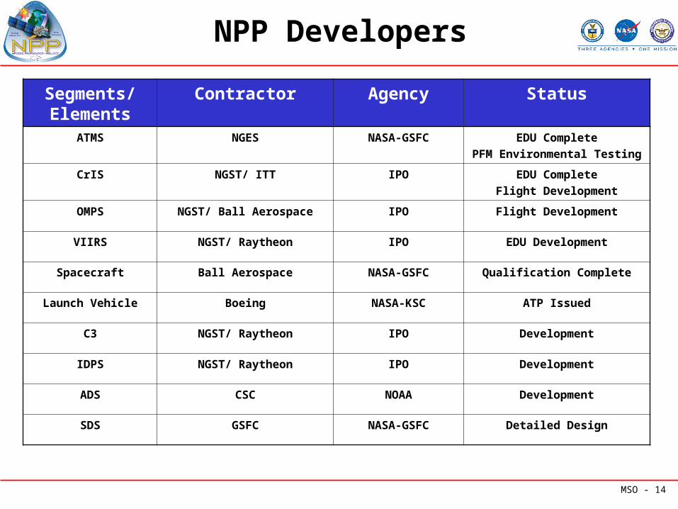
NPP Developers
Segments/ Elements
Contractor Agency Status
ATMS NGES NASA-GSFC EDU Complete
PFM Environmental Testing
CrIS NGST/ ITT IPO EDU Complete
Flight Development
OMPS NGST/ Ball Aerospace IPO Flight Development
VIIRS NGST/ Raytheon IPO EDU Development
Spacecraft Ball Aerospace NASA-GSFC Qualification Complete
Launch Vehicle Boeing NASA-KSC ATP Issued
C3 NGST/ Raytheon IPO Development
IDPS NGST/ Raytheon IPO Development
ADS CSC NOAA Development
SDS GSFC NASA-GSFC Detailed Design
MSO - 15
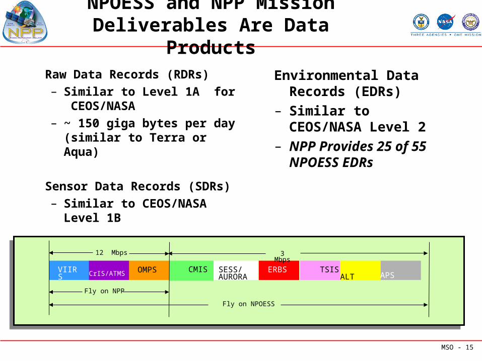
NPOESS and NPP Mission Deliverables Are Data Products
Raw Data Records (RDRs)– Similar to Level 1A for
CEOS/NASA– ~ 150 giga bytes per day
(similar to Terra or Aqua)
Sensor Data Records (SDRs)– Similar to CEOS/NASA
Level 1B
Environmental Data Records (EDRs)
– Similar to CEOS/NASA Level 2
– NPP Provides 25 of 55 NPOESS EDRs
VIIRS OMPS CrIS/ATMS CMIS SESS/ AURORA
ERBS TSIS ALT
Fly on NPP
Fly on NPOESS
12 Mbps 3 Mbps
APS
MSO - 16
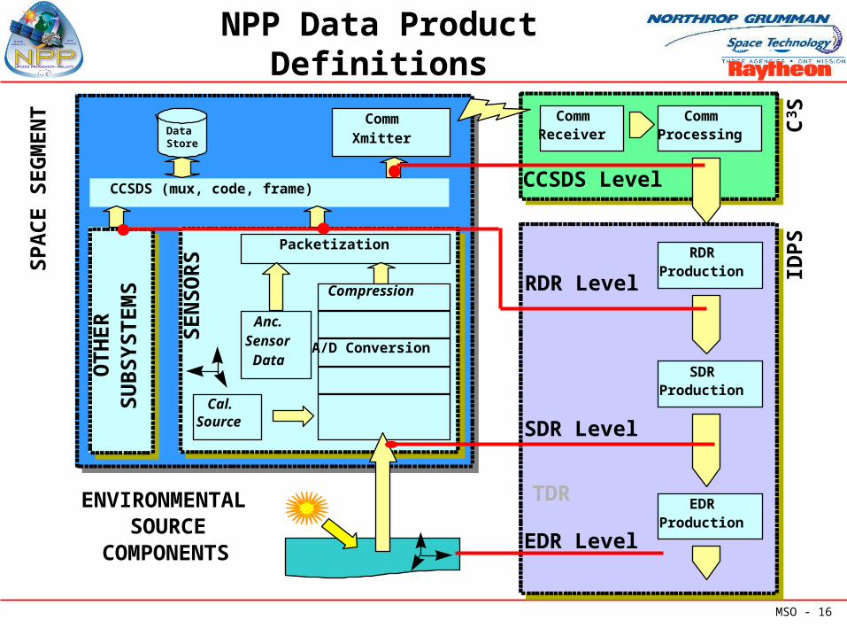
NPP Data Product Definitions
A/D Conversion
Packetization
Compression
Anc.SensorData
CCSDS (mux, code, frame)
CommXmitter
SEN
SOR
S
OT
HE
RSU
BSY
ST
EM
S
Cal.Source
\ Data Store
ENVIRONMENTALSOURCE
COMPONENTS
SPA
CE
SE
GM
EN
T
RDRProduction
EDRProduction
SDRProduction
EDR Level
SDR Level
RDR Level IDP
S
CommReceiver
CommProcessing
CCSDS Level
C3 S
TDR
MSO - 17
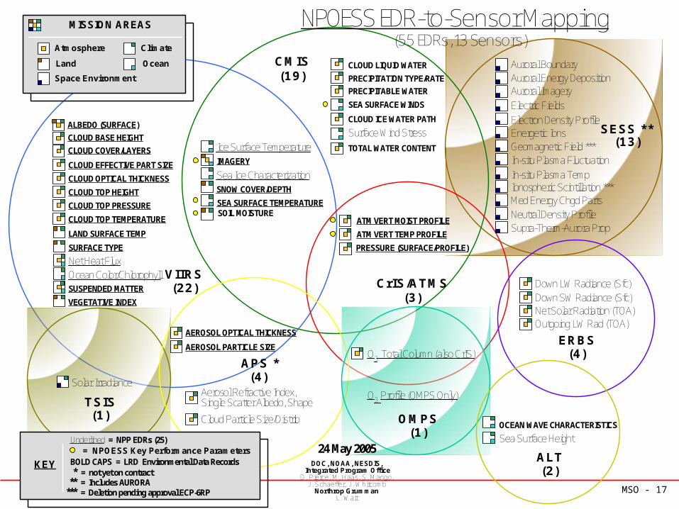
NPOESS EDR-to-Sensor Mapping
VIIRS(22)
CMIS(19)
Solar Irradiance
TSIS(1)
AEROSOL OPTICAL THICKNESS
AEROSOL PARTICLE SIZE
Cloud Particle Size/Distrib
Aerosol Refractive Index,Single Scatter Albedo, Shape
OCEAN WAVE CHARACTERISTICS
Sea Surface Height
Down LW Radiance (Sfc)Down SW Radiance (Sfc)Net Solar Radiation (TOA)Outgoing LW Rad (TOA)
Auroral BoundaryAuroral Energy Deposition
Electric FieldsElectron Density Profile
Auroral Imagery
Energetic IonsGeomagnetic Field ***In-situ Plasma Fluctuation
Ionospheric Scintillation ***Med Energy Chgd PartsNeutral Density ProfileSupra-Therm-Aurora Prop
In-situ Plasma Temp
CrIS/ATMS(3)
OMPS(1)
ALT(2)
APS *(4)
O3 Total Column (also CrIS)
O3 Profile (OMPS Only)
CLOUD LIQUID WATER
CLOUD ICE WATER PATH
PRECIPITATION TYPE/RATE
PRECIPITABLE WATER
Surface Wind StressTOTAL WATER CONTENT
SEA SURFACE WINDS
24 May 2005DOC, NOAA, NESDIS,
Integrated Program OfficeD. Pierce, M. Haas, S. Mango,
J. Schaeffer, J. WhitcombNorthrop Grumman
L. Wait
PRESSURE (SURFACE/PROFILE)
ATM VERT MOIST PROFILE
ATM VERT TEMP PROFILE
ERBS(4)
KEY BOLD CAPS = LRD Environmental Data Records* = not yet on contract
Underlined = NPP EDRs (25)
Climate
Ocean
Atmosphere
Space Environment
Land
MISSION AREAS
(55 EDRs, 13 Sensors)
= NPOESS Key Performance Parameters
** = Includes AURORA*** = Deletion pending approval ECP-6RP
Ice Surface Temperature
SOIL MOISTURESEA SURFACE TEMPERATURE
IMAGERY
SNOW COVER/DEPTH
Sea Ice Characterization
SESS **(13)
Net Heat Flux
CLOUD EFFECTIVE PART SIZE
CLOUD OPTICAL THICKNESS
CLOUD TOP HEIGHT
CLOUD TOP PRESSURE
CLOUD TOP TEMPERATURE
Ocean Color/ChlorophyllSUSPENDED MATTER
VEGETATIVE INDEX
LAND SURFACE TEMP
SURFACE TYPE
CLOUD COVER/LAYERS
ALBEDO (SURFACE)
CLOUD BASE HEIGHT
MSO - 18
NPP EDR-to-Sensor Mapping
VIIRS(22)
AEROSOL OPTICAL THICKNESS
AEROSOL PARTICLE SIZE
CrIS/ATMS(3)
OMPS(1)
O3 Total Column (also CrIS)
O3 Profile (OMPS Only)
24 May 2005DOC, NOAA, NESDIS,
Integrated Program OfficeD. Pierce, M. Haas, S. Mango,
J. Schaeffer, J. WhitcombNorthrop Grumman
L. Wait
PRESSURE (SURFACE/PROFILE)
ATM VERT MOIST PROFILE
ATM VERT TEMP PROFILE
KEY BOLD CAPS = LRD Environmental Data Records* = not yet on contract
Underlined = NPP EDRs (25)
Climate
Ocean
Atmosphere
Space Environment
Land
MISSION AREAS
(25 EDRs, 4 Sensors)
= NPOESS Key Performance Parameters
** = Includes AURORA*** = Deletion pending approval ECP-6RP
Ice Surface Temperature
SEA SURFACE TEMPERATURE
IMAGERY
SNOW COVER/DEPTH
Sea Ice Characterization
Net Heat Flux
CLOUD EFFECTIVE PART SIZE
CLOUD OPTICAL THICKNESS
CLOUD TOP HEIGHT
CLOUD TOP PRESSURE
CLOUD TOP TEMPERATURE
Ocean Color/ChlorophyllSUSPENDED MATTER
VEGETATIVE INDEX
LAND SURFACE TEMP
SURFACE TYPE
CLOUD COVER/LAYERS
ALBEDO (SURFACE)
CLOUD BASE HEIGHT
MSO - 19
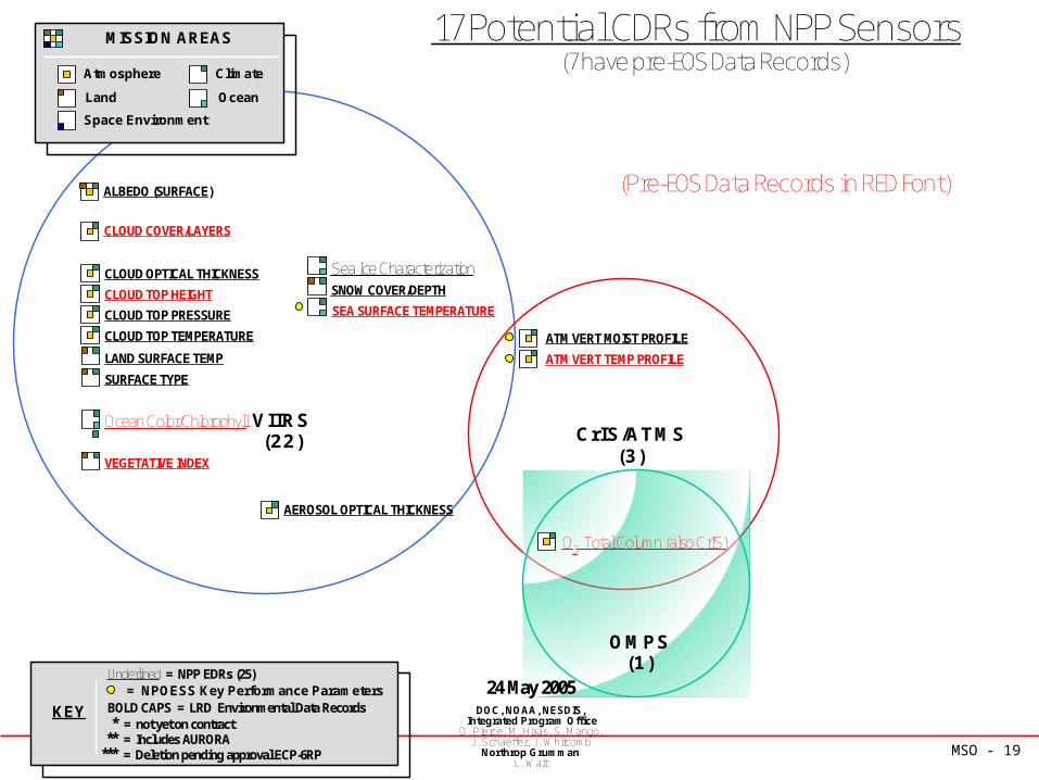
17 Potential CDRs from NPP Sensors
VIIRS(22)
AEROSOL OPTICAL THICKNESS
CrIS/ATMS(3)
OMPS(1)
O3 Total Column (also CrIS)
24 May 2005DOC, NOAA, NESDIS,
Integrated Program OfficeD. Pierce, M. Haas, S. Mango,
J. Schaeffer, J. WhitcombNorthrop Grumman
L. Wait
ATM VERT MOIST PROFILE
ATM VERT TEMP PROFILE
KEY BOLD CAPS = LRD Environmental Data Records* = not yet on contract
Underlined = NPP EDRs (25)
Climate
Ocean
Atmosphere
Space Environment
Land
MISSION AREAS
(7 have pre-EOS Data Records)
= NPOESS Key Performance Parameters
** = Includes AURORA*** = Deletion pending approval ECP-6RP
SEA SURFACE TEMPERATURE
SNOW COVER/DEPTH
Sea Ice CharacterizationCLOUD OPTICAL THICKNESS
CLOUD TOP HEIGHT
CLOUD TOP PRESSURE
CLOUD TOP TEMPERATURE
Ocean Color/Chlorophyll
VEGETATIVE INDEX
LAND SURFACE TEMP
SURFACE TYPE
CLOUD COVER/LAYERS
ALBEDO (SURFACE) (Pre-EOS Data Records in RED Font)
MSO - 20
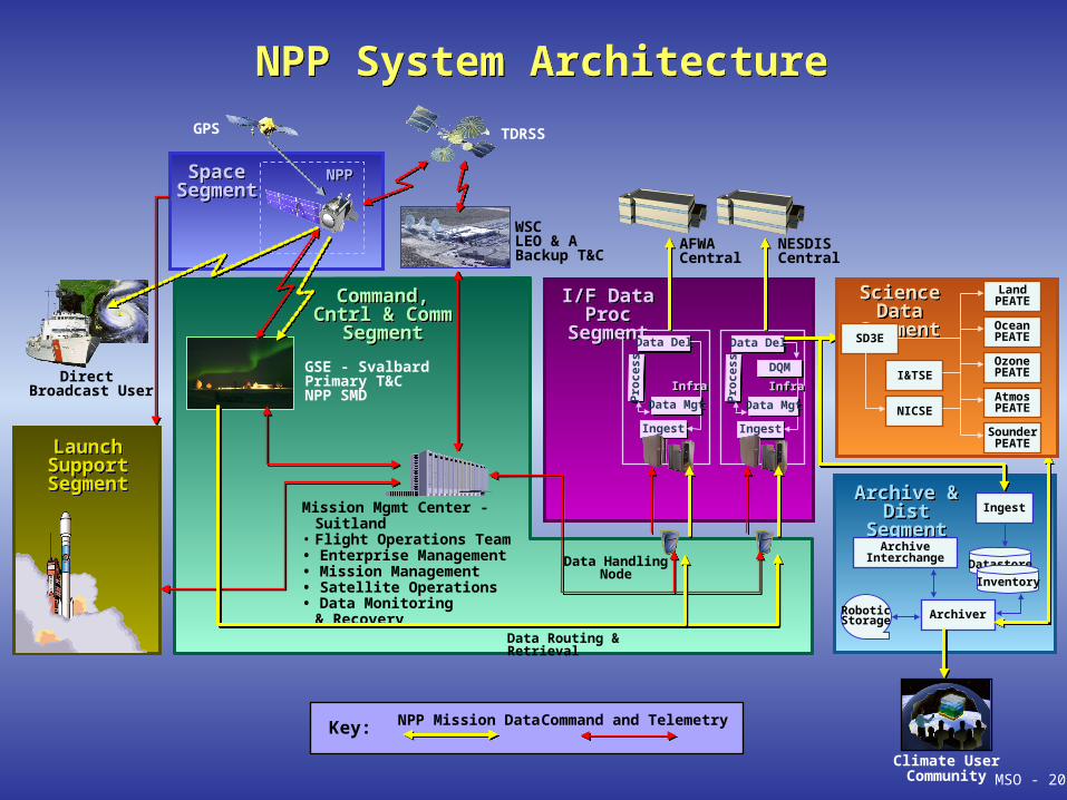
NPP NPP SpaceSegment
SpaceSegment
NESDISCentral
AFWACentral
NPP System Architecture NPP System Architecture GPS
WSCLEO & A Backup T&C
TDRSS
LaunchSupportSegment
LaunchSupportSegment
Direct Broadcast User
Climate UserCommunity
I/F Data Proc
Segment
I/F Data Proc
Segment
InfraInfra
IngestIngest
Pro
cess
Pro
cess
Data DelData Del
InfraInfra
IngestIngest
DQMDQM
Pro
cess
Pro
cess
Data DelData Del
NPP Mission Data Command and TelemetryKey:
Archive & Dist
Segment
Archive & Dist
SegmentIngest
ArchiveInterchange
ArchiverRoboticStorage
Datastore
Inventory
Command,Cntrl & Comm
Segment
Command,Cntrl & Comm
Segment
GSE - SvalbardPrimary T&CNPP SMD
Mission Mgmt Center - Suitland
• Flight Operations Team• Enterprise Management• Mission Management• Satellite Operations• Data Monitoring
& Recovery
Data HandlingNode
Data Routing & Retrieval
MSO - 20
Science Data
Segment
Science Data
SegmentSD3E
LandPEATE
OceanPEATE
OzonePEATE
AtmosPEATENICSE
SounderPEATE
I&TSE
Data MgtData Mgt Data MgtData Mgt
MSO - 21
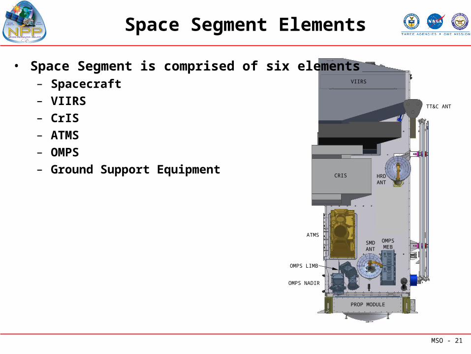
Space Segment Elements
VIIRS
ATMS
CRIS
SMDANT
CERES
HRDANT
TT&C ANT
PROP MODULE
OMPSMEB
OMPS NADIR
OMPS LIMB
• Space Segment is comprised of six elements– Spacecraft
– VIIRS
– CrIS
– ATMS
– OMPS
– Ground Support Equipment
MSO - 22
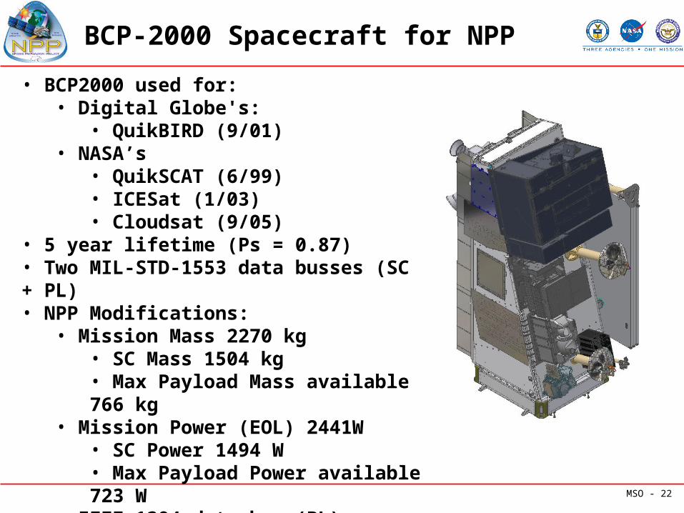
BCP-2000 Spacecraft for NPP
• BCP2000 used for:• Digital Globe's:
• QuikBIRD (9/01)• NASA’s
• QuikSCAT (6/99)• ICESat (1/03)• Cloudsat (9/05)
• 5 year lifetime (Ps = 0.87)• Two MIL-STD-1553 data busses (SC + PL)• NPP Modifications:
• Mission Mass 2270 kg• SC Mass 1504 kg• Max Payload Mass available 766 kg
• Mission Power (EOL) 2441W• SC Power 1494 W• Max Payload Power available 723 W
• IEEE-1394 data bus (PL)• Two-battery power system
MSO - 23
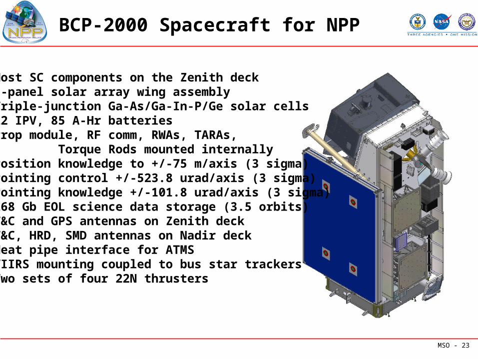
BCP-2000 Spacecraft for NPP
• Most SC components on the Zenith deck• 3-panel solar array wing assembly• Triple-junction Ga-As/Ga-In-P/Ge solar cells• 22 IPV, 85 A-Hr batteries• Prop module, RF comm, RWAs, TARAs, Torque Rods mounted internally• Position knowledge to +/-75 m/axis (3 sigma)• Pointing control +/-523.8 urad/axis (3 sigma)• Pointing knowledge +/-101.8 urad/axis (3 sigma)• 268 Gb EOL science data storage (3.5 orbits)• T&C and GPS antennas on Zenith deck• T&C, HRD, SMD antennas on Nadir deck• Heat pipe interface for ATMS• VIIRS mounting coupled to bus star trackers• Two sets of four 22N thrusters
MSO - 24
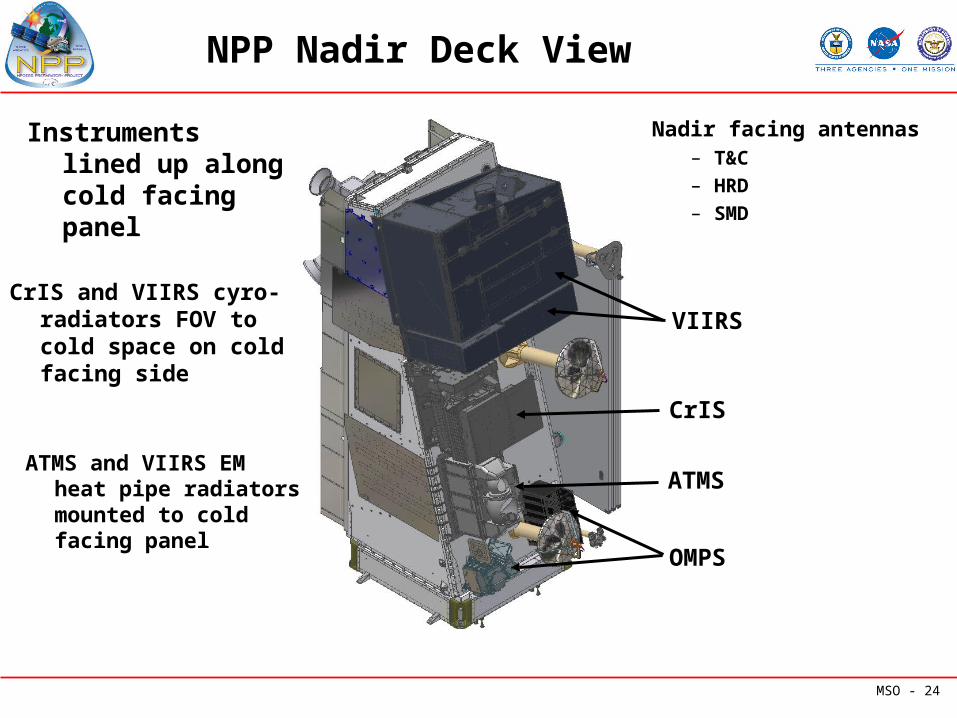
NPP Nadir Deck View
Instruments lined up along cold facing panel
ATMS and VIIRS EM heat pipe radiators mounted to cold facing panel
CrIS and VIIRS cyro-radiators FOV to cold space on cold facing side
Nadir facing antennas– T&C– HRD– SMD
VIIRS
CrIS
ATMS
OMPS

MSO - 25
NPP Zenith Deck View
Majority of S/C components are mounted on zenith deck
Propulsion moduleLaunch vehicle interface
3-panel solar array wing assembly
Zenith facing antennas– T&C to TDRSS
– GPS
RF Comm boxes, RWAs, TARAS and Torquerods are mounted internally
MSO - 26
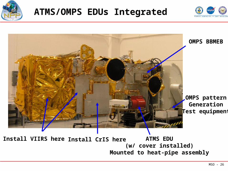
ATMS/OMPS EDUs Integrated
ATMS EDU(w/ cover installed)
Mounted to heat-pipe assembly
OMPS BBMEB
OMPS patternGeneration
Test equipment
Install CrIS hereInstall VIIRS here
MSO - 27
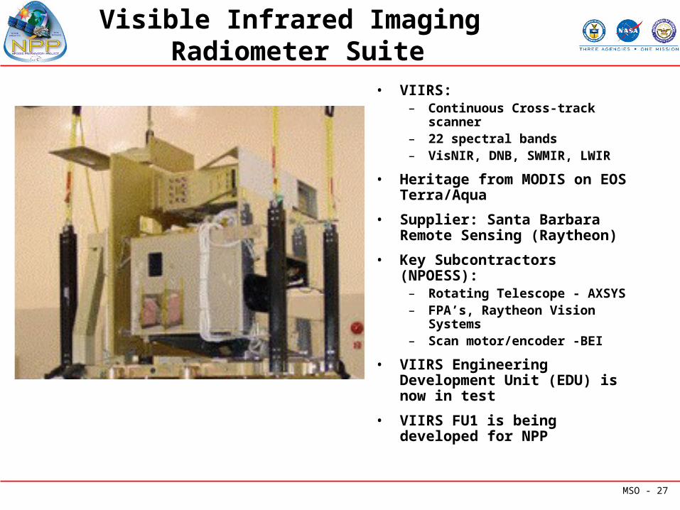
Visible Infrared Imaging Radiometer Suite
• VIIRS:– Continuous Cross-track
scanner– 22 spectral bands– VisNIR, DNB, SWMIR, LWIR
• Heritage from MODIS on EOS Terra/Aqua
• Supplier: Santa Barbara Remote Sensing (Raytheon)
• Key Subcontractors (NPOESS):– Rotating Telescope - AXSYS– FPA’s, Raytheon Vision
Systems– Scan motor/encoder -BEI
• VIIRS Engineering Development Unit (EDU) is now in test
• VIIRS FU1 is being developed for NPP
MSO - 28
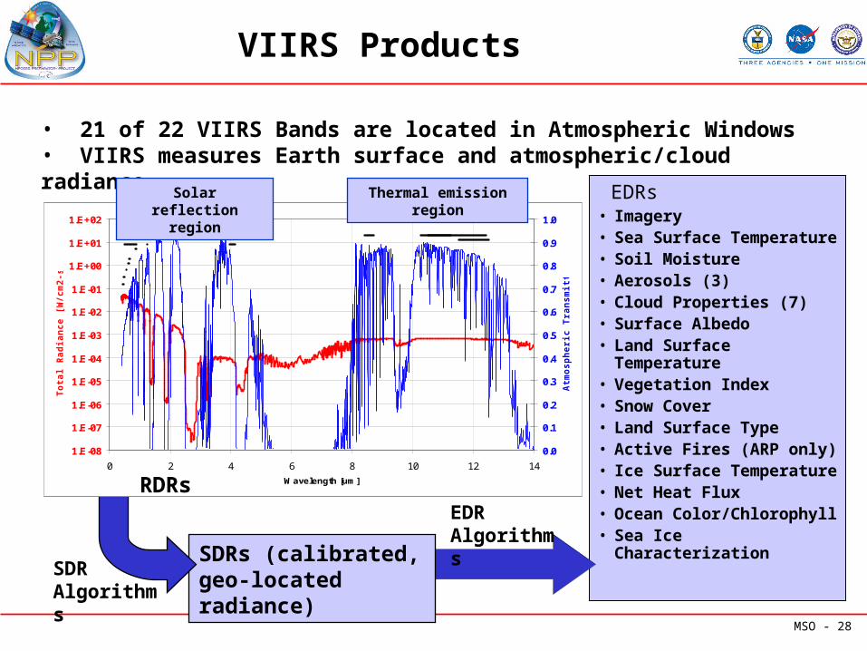
VIIRS Products
EDRs • Imagery• Sea Surface Temperature• Soil Moisture• Aerosols (3)• Cloud Properties (7)• Surface Albedo• Land Surface
Temperature• Vegetation Index• Snow Cover• Land Surface Type• Active Fires (ARP only)• Ice Surface Temperature• Net Heat Flux• Ocean Color/Chlorophyll• Sea Ice Characterization
SDRs (calibrated, geo-located radiance)
1.E-08
1.E-07
1.E-06
1.E-05
1.E-04
1.E-03
1.E-02
1.E-01
1.E+00
1.E+01
1.E+02
0 2 4 6 8 10 12 14
Wavelength [um]
To
tal
Rad
ian
ce [
W/c
m2-s
r-u
m]
0.0
0.1
0.2
0.3
0.4
0.5
0.6
0.7
0.8
0.9
1.0
Atm
osp
heri
c T
ran
sm
itta
nce
• 21 of 22 VIIRS Bands are located in Atmospheric Windows• VIIRS measures Earth surface and atmospheric/cloud radiance
SDR Algorithms
EDRAlgorithms
Thermal emission region
Solar reflection region
RDRs
MSO - 29
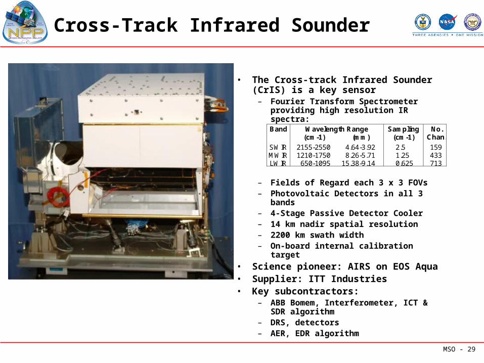
Cross-Track Infrared Sounder
• The Cross-track Infrared Sounder (CrIS) is a key sensor
– Fourier Transform Spectrometer providing high resolution IR spectra:
– Fields of Regard each 3 x 3 FOVs– Photovoltaic Detectors in all 3 bands– 4-Stage Passive Detector Cooler– 14 km nadir spatial resolution– 2200 km swath width– On-board internal calibration target
• Science pioneer: AIRS on EOS Aqua• Supplier: ITT Industries• Key subcontractors:
– ABB Bomem, Interferometer, ICT & SDR algorithm
– DRS, detectors– AER, EDR algorithm
Wavelength Range Sampling Band (cm-1) (mm) (cm-1)
No. Chan.
SWIR 2155-2550 4.64-3.92 2.5 159 MWIR 1210-1750 8.26-5.71 1.25 433 LWIR 650-1095 15.38-9.14 0.625 713
MSO - 30
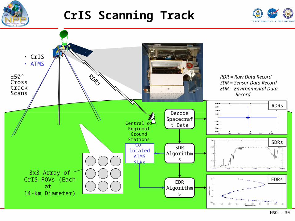
CrIS Scanning Track
RDRs
EDR Algorithms
Decode Spacecraft
Data
SDR Algorithms
±50° Cross track
Scans
• CrIS • ATMS
3x3 Array of CrIS FOVs (Each at
14-km Diameter)
Central or Regional Ground
Stations
RDR = Raw Data RecordSDR = Sensor Data RecordEDR = Environmental Data Record
SDRs
RDRs
0.1
1
10
100
1000
200 210 220 230 240 250 260 270 280 290Temperature (K)
Pre
ssu
re (
mb
)
EDRs
Co-located ATMS SDRs
MSO - 31
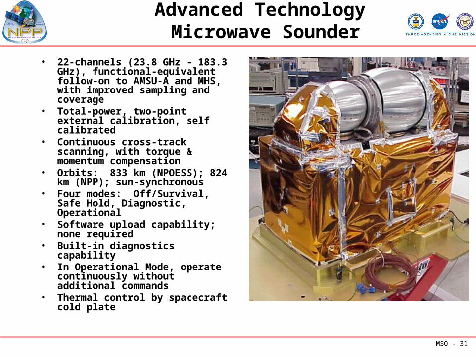
Advanced Technology Microwave Sounder
• 22-channels (23.8 GHz – 183.3 GHz), functional-equivalent follow-on to AMSU-A and MHS, with improved sampling and coverage
• Total-power, two-point external calibration, self calibrated
• Continuous cross-track scanning, with torque & momentum compensation
• Orbits: 833 km (NPOESS); 824 km (NPP); sun-synchronous
• Four modes: Off/Survival, Safe Hold, Diagnostic, Operational
• Software upload capability; none required
• Built-in diagnostics capability• In Operational Mode, operate
continuously without additional commands
• Thermal control by spacecraft cold plate
MSO - 32
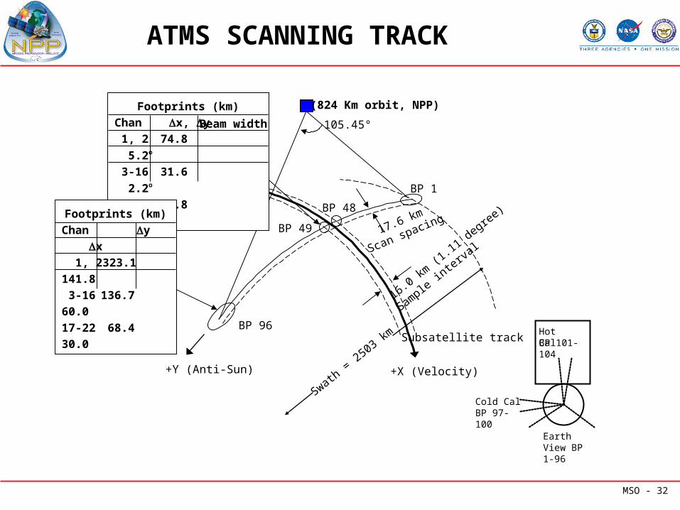
ATMS SCANNING TRACK
17.6 km
Scan spacing
Swath = 2503 km
16.0 km (1
.11 degree)
Subsatellite track
Sample in
terval
(824 Km orbit, NPP)Footprints (km)
Chan x, y
1, 2 74.8 5.2o
3-16 31.6 2.2o
17-22 15.8 1.1o
Beam width 105.45°
Footprints (km)
Chan y x
1, 2 323.1 141.8
3-16 136.7 60.0
17-22 68.4 30.0
+X (Velocity)+Y (Anti-Sun)
BP 1
BP 48
BP 49
BP 96
Earth View BP 1-96
Cold Cal BP 97-100
Hot CalBP 101-104
MSO - 33
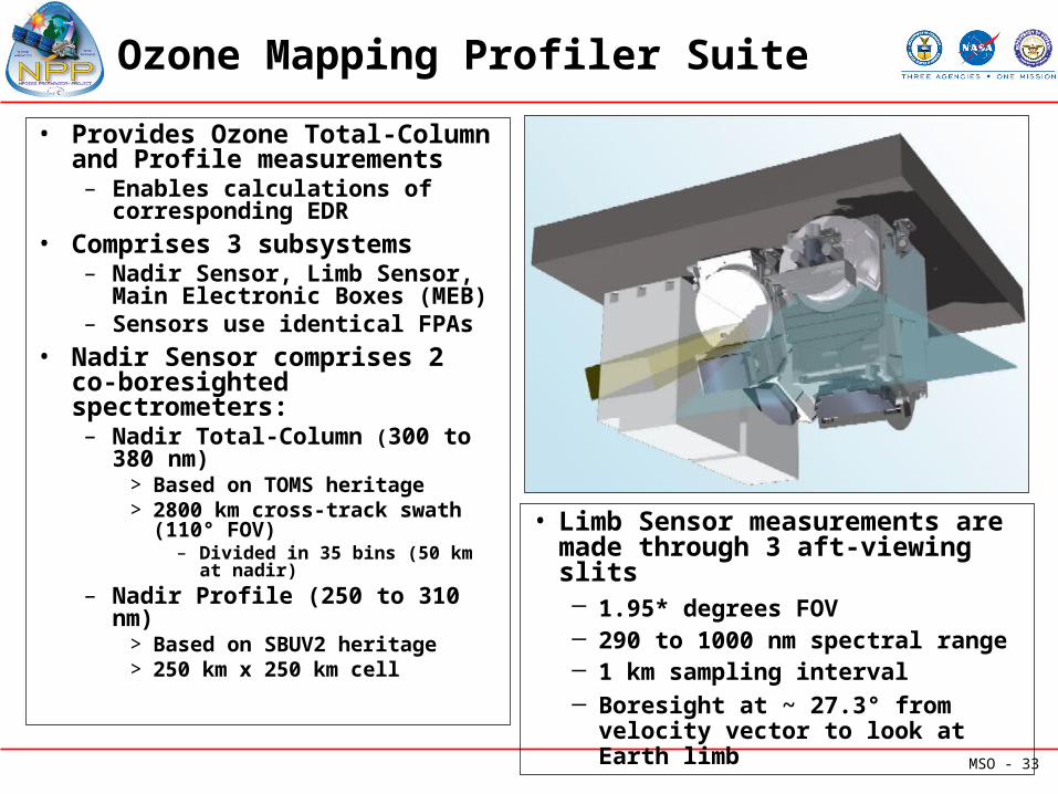
Ozone Mapping Profiler Suite
• Provides Ozone Total-Column and Profile measurements– Enables calculations of
corresponding EDR• Comprises 3 subsystems
– Nadir Sensor, Limb Sensor, Main Electronic Boxes (MEB)
– Sensors use identical FPAs• Nadir Sensor comprises 2 co-
boresighted spectrometers:– Nadir Total-Column (300 to
380 nm)> Based on TOMS heritage> 2800 km cross-track swath
(110° FOV)– Divided in 35 bins (50 km at
nadir)
– Nadir Profile (250 to 310 nm)> Based on SBUV2 heritage> 250 km x 250 km cell
• Limb Sensor measurements are made through 3 aft-viewing slits
─ 1.95* degrees FOV ─ 290 to 1000 nm spectral range─ 1 km sampling interval─ Boresight at ~ 27.3° from velocity
vector to look at Earth limb
MSO - 34
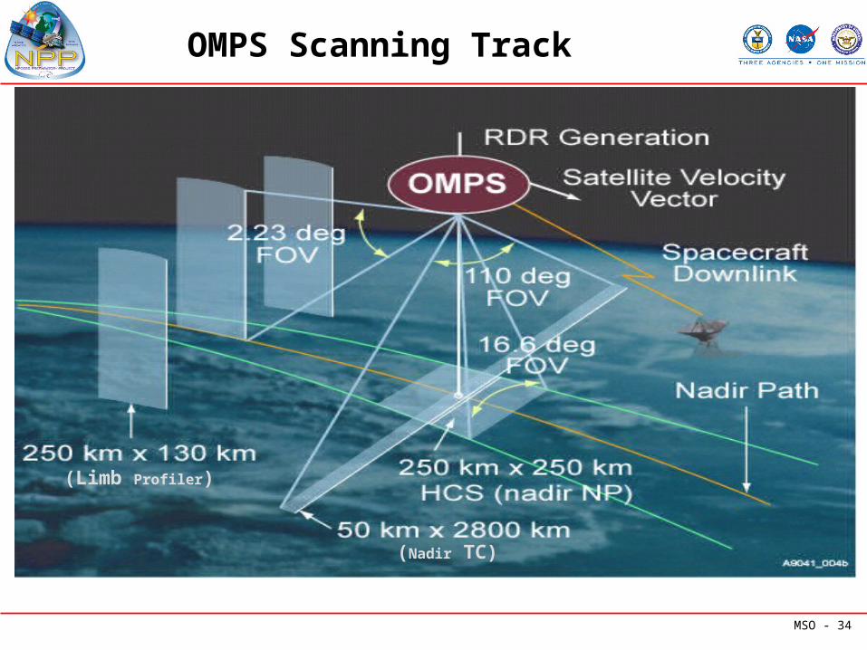
OMPS Scanning Track
(Nadir TC)
(Limb Profiler)
MSO - 35
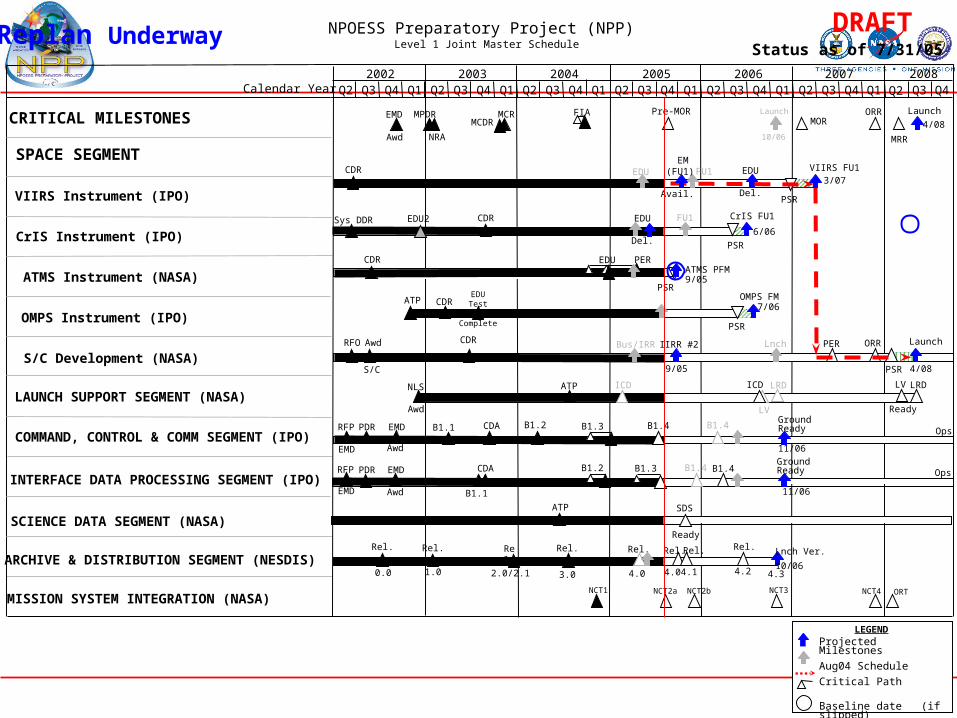
LRD
NPOESS Preparatory Project (NPP) Level 1 Joint Master Schedule Status as of 7/31/05
Replan Underway
Projected Milestones
Aug04 Schedule
Critical Path
Baseline date (if slipped)
Revised from last month
LEGEND
DRAFT
Calendar Year
CRITICAL MILESTONES
SPACE SEGMENT
VIIRS Instrument (IPO)
CrIS Instrument (IPO)
ATMS Instrument (NASA)
S/C Development (NASA)
LAUNCH SUPPORT SEGMENT (NASA)
COMMAND, CONTROL & COMM SEGMENT (IPO)
INTERFACE DATA PROCESSING SEGMENT (IPO)
SCIENCE DATA SEGMENT (NASA)
ARCHIVE & DISTRIBUTION SEGMENT (NESDIS)
OMPS Instrument (IPO)
MISSION SYSTEM INTEGRATION (NASA)
Q4Q2 Q3 Q4 Q1 Q2 Q3 Q4 Q1 Q2 Q3 Q4 Q1 Q2 Q3 Q4 Q1 Q2 Q3 Q4 Q1 Q2 Q3 Q4 Q1 Q2 Q32007 20082002 2003 2004 2005 2006
EDU
MPDR
OpsEMD
Awd
GroundReady
11/06
PDRRFP
EMD
OpsEMD
Awd
GroundReady
11/06
PDRRFP
EMD
Rel.
0.0
ORR Lnch
PSR
RFO Awd
S/C
Bus/IRR
NLS
Awd
LRD
Awd 10/06
LaunchPre-MOR ORR
MRR
EMD
PSR
3/07VIIRS FU1CDR
CDR EDU
Del.
Sys DDR
EDU PER
PSR
CDRATMS PFM9/05
LV
Ready
Rel.
1.0
B1.4
ATP7/06
B1.3
CDR
2.0/2.1
Rel.
3.0 4.0
EDU2
PSR
PSR
B1.1 B1.2 B1.4B1.3
MCR
NRA
Rel.
EDUTest
Complete
CDR PER
CDA
CDA
B1.1
MCDR
6/06
Rel.
NCT1 NCT3 NCT4 ORTNCT2a
ATP
ATP SDS
Ready
NCT2b
CrIS FU1
FIA
B1.2
OMPS FM
ICD
EDU
Del.
EM (FU1)
Avail.
FU1
4/08
Launch
4/08
Launch
FU1
MOR
ICD
LV
B1.4
B1.4
4.0
Rel.
4.1 4.2
Rel.
4.3
Lnch Ver.
10/06
Rel.
IIRR #2
9/05