nv county washoe
TRANSCRIPT
s OMB No. 1024-0018NPS Form 10-900
(Rev. 10-90) >
United States Department of the Interior National Park Service
NATIONAL REGISTER OF HISTORIC PLACES
REGISTRATION FORM
This form is for use in nominating or requesting determinations for individual properties and districts. See instructions in How to Complete the National Register of Historic Places Registration Form (National Register Bulletin 16A). Complete each item by marking "x" in the appropriate box or by entering the information requested. If any item does not apply to the property being documented, enter "N/A" for "not applicable." For functions, architectural classification, materials, and areas of significance, enter only categories and subcategories from the instructions. Place additional entries and narrative items on continuation sheets (NPS Form 10-900a). Use a typewriter, word processor, or computer, to complete all items.
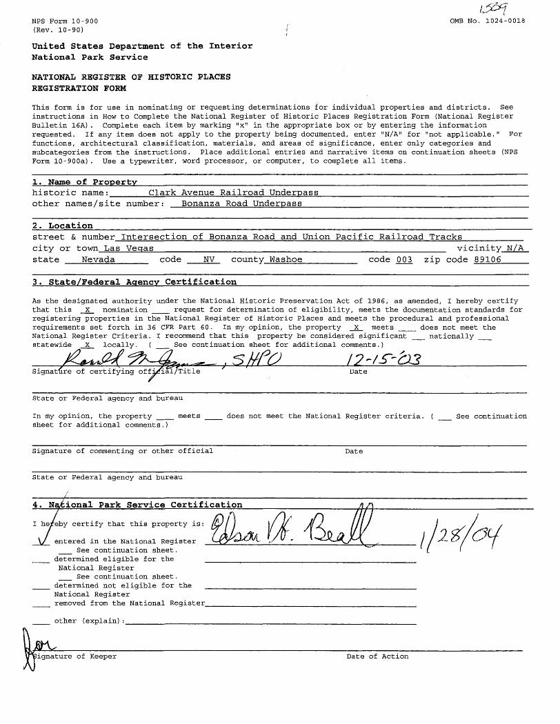
1. Name of PropertyClark Avenue Railroad Underpasshistoric name:___
other names/site number: Bonanza Road Underpass
2. Locationstreet & number Intersection of Bonanza Road and Union Pacific Railroad Trackscity or town Las Vegas______state Nevada code
vicinity N/ANV county Washoe code 003 zip code 89106
3. State/Federal Agency Certification
As the designated authority under the National Historic Preservation Act of 1986, as amended, I hereby certify that this X nomination ___ request for determination of eligibility, meets the documentation standards for registering properties in the National Register of Historic Places and meets the procedural and professional requirements set forth in 36 CFR Part 60. In my opinion, the property X meets ___ does not meet the National Register Criteria. I recommend that this property be considered significant __ nationally __ statewide X locally. ( __ See continuation sheet for additional comments.)
Signature of certifying official/Title Date
In my opinion, the property __ sheet for additional comments.)
meets does not meet the National Register criteria. ( See continuation
Signature of commenting or other official Date
State or Federal agency and bureau
4. National Park Service Certification
I he/eby certify that this property is:
entered in the National Register __ See continuation sheet.determined eligible for the National Register __ See continuation sheet.determined not eligible for theNational Registerremoved from the National Register_
other (explain):_______________
ignature of Keeper Date of Action
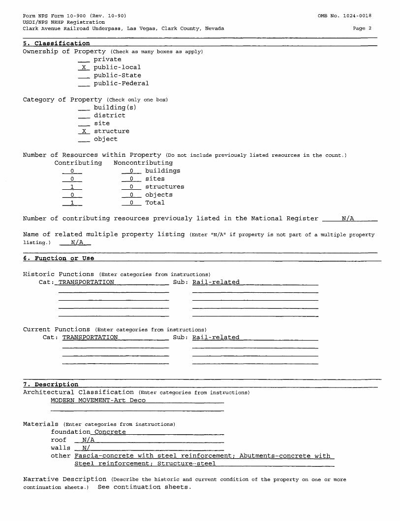
Form NFS Form 10-900 (Rev. 10-90) OMB No. 1024-0018USDI/NPS NRHP RegistrationClark Avenue Railroad Underpass, Las Vegas, Clark County, Nevada Page 2
5. Classification_____________________________________________________________ Ownership of Property (Check as many boxes as apply)
__ privateX public-local __ public-State __ public-Federal
Category of Property (check only one box) __ building(s) __ district __ siteX structure __ object
Number of Resources within Property (DO not include previously listed resources in the count.) Contributing Noncontributing
0 0 buildings0 0 sites1 0 structures0 0 objects1 0 Total
Number of contributing resources previously listed in the National Register ____N/A______
Name of related multiple property listing (Enter "N/A" if property is not part of a multiple property
listing.) N/A
6. Function or Use___________________________________________________________
Historic Functions (Enter categories from instructions)
Cat; TRANSPORTATION____________ Sub: Rail-related_______
Current Functions (Enter categories from instructions)Cat: TRANSPORTATION___________ Sub: Rail-related
7. DescriptionArchitectural Classification (Enter categories from instructions)
MODERN MOVEMENT-Art Deco
Materials (Enter categories from instructions)
foundation Concrete
roof N/Awalls N/other Fascia-concrete with steel reinforcement; Abutments-concrete with
Steel reinforcement; Structure-steel_____________________________________
Narrative Description (Describe the historic and current condition of the property on one or more continuation sheets.) See continuation sheets.
Form NFS Form 10-900 (Rev. 10-90) OMB No. 1024-0018USDI/NPS NRHP RegistrationClark Avenue Railroad Underpass, Las Vegas, Clark County, Nevada Page 3
8. Statement of Significance___________________________________________________Applicable National Register Criteria (Mark "x" in one or more boxes for the criteria qualifying the property for National Register listing)
X A Property is associated with events that have made a significant contributionto the broad patterns of our history.
___ B Property is associated with the lives of persons significant in our past. ___ C Property embodies the distinctive characteristics of a type, period, or
method of construction or represents the work of a master, or possesses high artistic values, or represents a significant and distinguishable entity whose components lack individual distinction.
___ D Property has yielded, or is likely to yield information important in prehistory or history.
Criteria Considerations (Mark "X" in all the boxes that apply.) Property is:
___ A owned by a religious institution or used for religious purposes.___ B removed from its original location.___ C a birthplace or a grave.___ D a cemetery.___ E a reconstructed building, object, or structure.___ F a commemorative property._____ G less than 50 years of age or achieved significance within the
past 50 years.
Areas of Significance (Enter categories from instructions)
Social History_____________________Ethnic Heritage-BlackCommunity Planning and Development Transportation_________________
Period of Significance 1936-1954Significant Dates 1936Significant Person (Complete if Criterion B is marked above). Cultural Affiliation N/A______________Architect/Builder Nevada Department of Highways; Union Pacific Engineers
Narrative Statement Of Significance (Explain the significance of the property on one or more
continuation sheets.) See continuation sheets.
9. Major Bibliographical References__________________________________________________ Bibliography (Cite books, articles, and other sources used in preparing this form on one or more continuation sheets
Previous documentation on file (NPS):__ preliminary determination of individual listing (36 CFR 67) has been requested.__ previously listed in the National Register__ previously determined eligible by the National Register__ designated a National Historic Landmark__ recorded by Historic American Buildings Survey # __________ recorded by Historic American Engineering Record # ________
Primary location of additional dataX State Historic Preservation Office __ Other State agency __ Federal agency __ Local government __ UniversityX OtherName of repository; City of Las Vegas Planning and Development Department
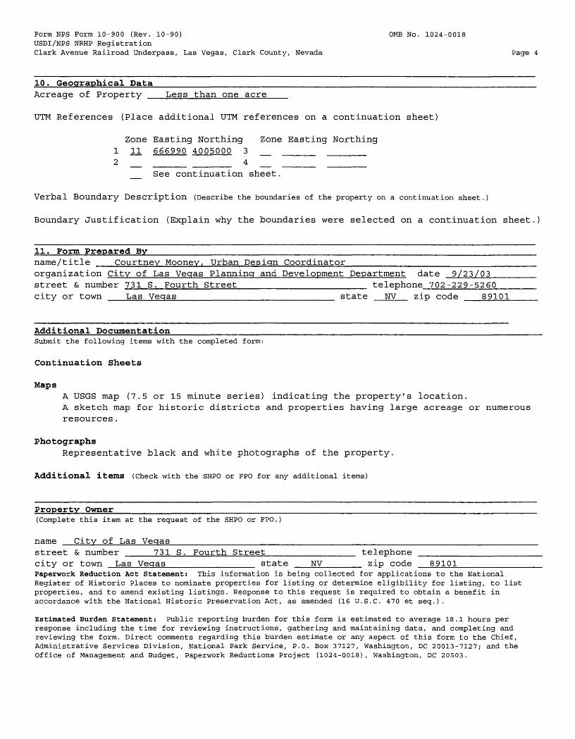
Form NFS Form 10-900 (Rev. 10-90) 0MB No. 1024-0018USDI/NPS NRHP RegistrationClark Avenue Railroad Underpass, Las Vegas, Clark County, Nevada Page 4
10. Geographical Data________________________________________________________ Acreage of Property Less than one acre
UTM References (Place additional UTM references on a continuation sheet)
Zone Easting Northing Zone Easting Northing1 11 666990 4005000 3 _ _____ ______
2 __ _____ _____ 4 __ _____ _______ See continuation sheet.
Verbal Boundary Description (Describe the boundaries of the property on a continuation sheet.)
Boundary Justification (Explain why the boundaries were selected on a continuation sheet.)
11. Form Prepared By___________________________________________________________name/title Courtney Moonev, Urban Design Coordinator_____________________________ organization City of Las Veqas Planning and Development Department date 9/23/03_________street & number 731 S. Fourth Street____________________ telephone 702-229-5260________city or town Las Veqas________________________ state NV zip code 89101______
Additional Documentation__________________________________________________________Submit the following items with the completed form:
Continuation Sheets
MapsA USGS map (7.5 or 15 minute series) indicating the property's location.A sketch map for historic districts and properties having large acreage or numerousresources.
PhotographsRepresentative black and white photographs of the property.
Additional items (Check with the SHPO or FPO for any additional items)
Property Owner_________________________________________________________________(Complete this item at the request of the SHPO or FPO.)
name City of Las Veqas______________________________________________________________street & number ____731 S. Fourth Street______________ telephone __________________ city or town Las Veqas_____________ state NV______ zip code 89101_____________Paperwork Reduction Act Statement: This information is being collected for applications to the National Register of Historic Places to nominate properties for listing or determine eligibility for listing, to list properties, and to amend existing listings. Response to this request is required to obtain a benefit in accordance with the National Historic Preservation Act, as amended (16 U.S.C. 470 et seq.).
Estimated Burden Statement: Public reporting burden for this form is estimated to average 18.1 hours per response including the time for reviewing instructions, gathering and maintaining data, and completing and reviewing the form. Direct comments regarding this burden estimate or any aspect of this form to the Chief, Administrative Services Division, National Park Service, P.O. Box 37127, Washington, DC 20013-7127; and the Office of Management and Budget, Paperwork Reductions Project (1024-0018), Washington, DC 20503.
NFS Form 10-900-a 0MB No. 1024-0018 (8-86)
United States Department of the Interior National Park Service
NATIONAL REGISTER OF HISTORIC PLACES CONTINUATION SHEET
Section 7 Page 1
Clark Avenue Railroad Underpass, Las Vegas, Clark County, Nevada
7. Description
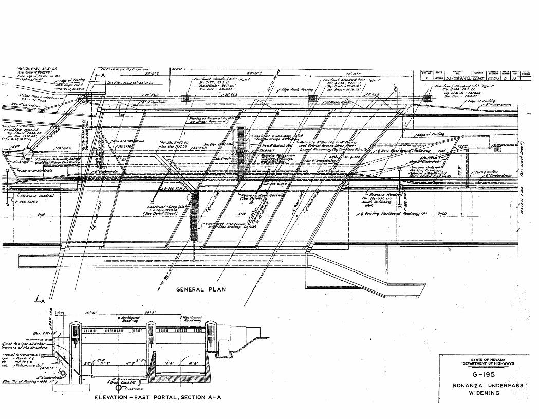
The Clark Avenue railroad underpass is located near downtown Las Vegas, approximately three- fifths of a mile northeast of the intersection of US Highways 95 and 15. 1 The underpass is bordered on the northwest by industrial development, commercial and residential development on the northeast and southeast, and several acres of undeveloped land on the southwest (Section 12 Additional Documentation). The structure straddles two east-bound and two west-bound lanes of Bonanza Road, formerly Clark Avenue until the 1940s.
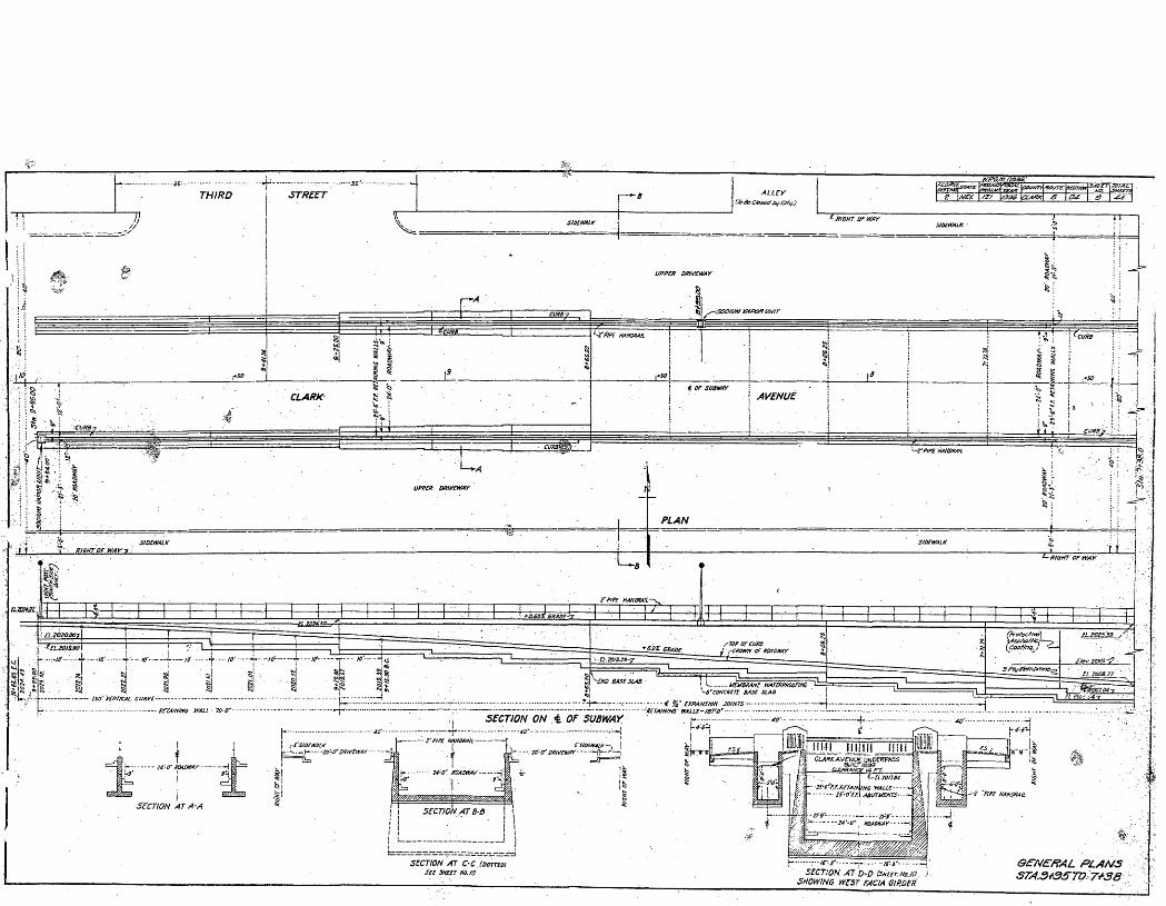
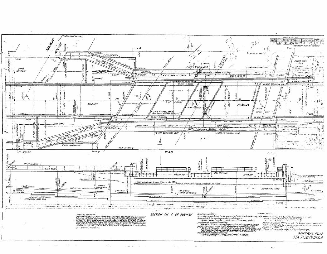
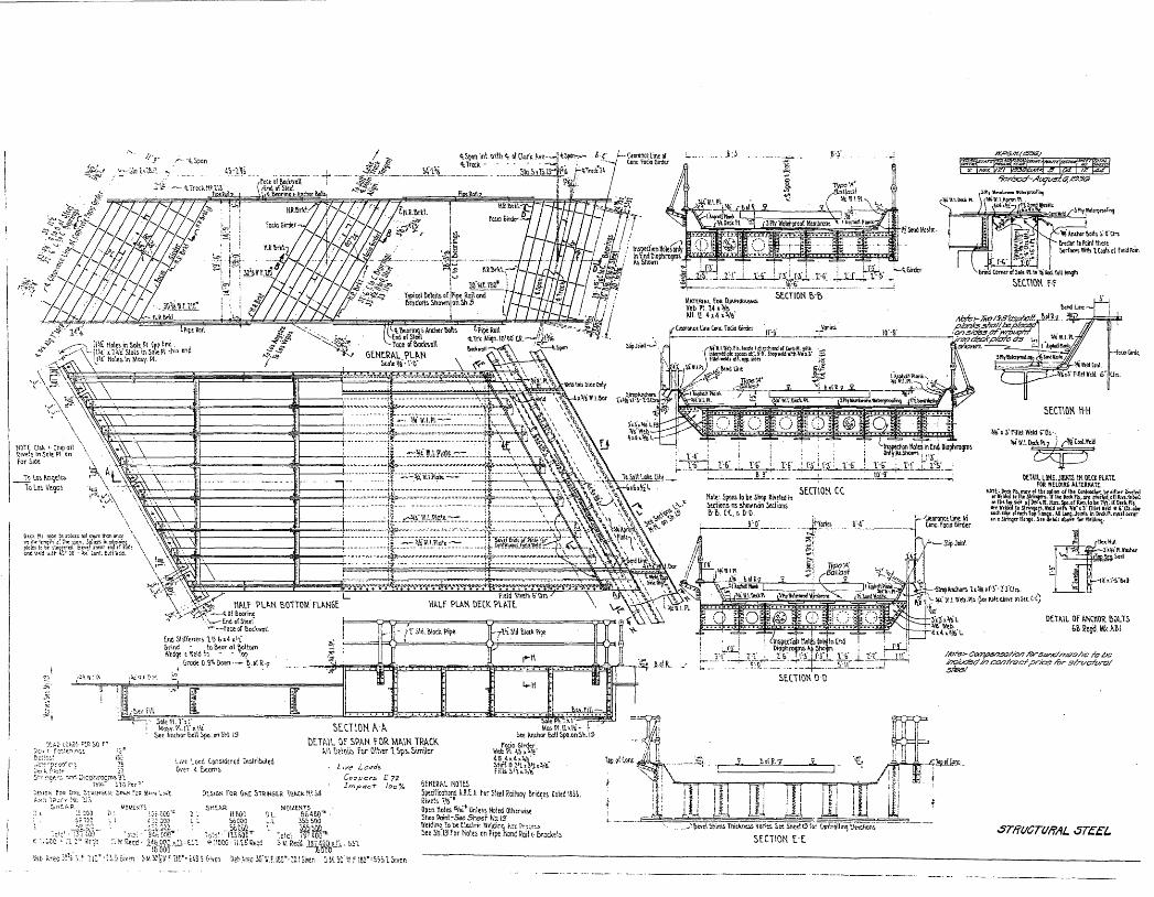
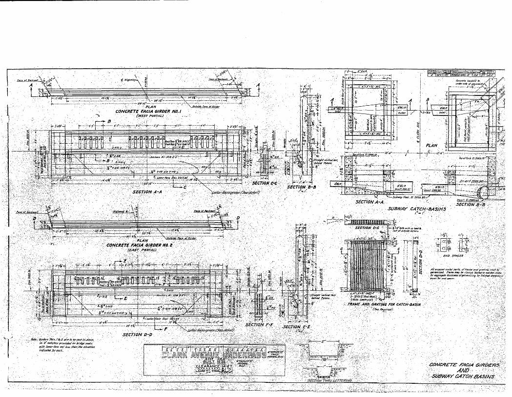
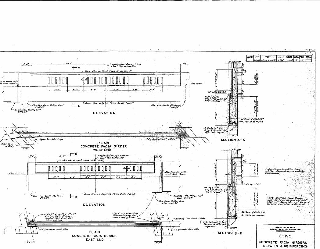
When constructed in 1936, the underpass consisted of three separate underpass structures spanning two sub-grade lanes of Clark Avenue, one east-bound and one west-bound lane. The east and west elevations consisted of identical concrete fascia girders connected at either end to concrete retaining walls with concrete abutments. The fascias were inscribed with "Clark Avenue Underpass, Built 1936, Clearance 14 Ft." The original fascias and abutments contained rusticated decoration in a simple Art Deco design. Two pedestrian subways were constructed on either side of the underpass, reached by sidewalks and lined with metal pipe railings (1936 sheets#9 and #21).
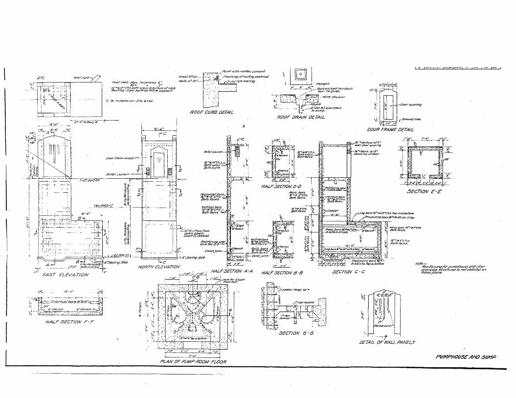
A Victor-Kimball-Krogh drainage pump and pump house was located east of the structure along the south concrete embankment. The pump house was a concrete structure that measured 8'8" x 9'4" and rose approximately 11 '9" above grade. The design retained the Art Deco elements of the underpass, but in a much simpler version (1936 sheet #14). The pump house housed the pump that carried the water drained below the street surface, through grates embedded into the roadway, away from the depressed street surface through a system of pipes (1936 sheet #10).
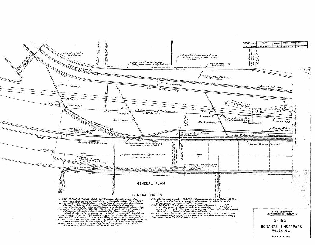
In 1964 Bonanza Road was widened by two lanes constructed to the south of the original roadway. The underpass structure was widened accordingly, however the additional spans retain the original dimensions and Art Deco design elements. Two unfortunate losses are the north abutment on the west elevation, and the lettering on the east and west fascias, which was "chipped out and filled with Epoxy cement, [and] all exposed surfaces refinished" (1964, sheet#8). The south pedestrian subway was removed, as that location became the center divider wall for the east- and west-bound lanes of traffic. Due to heightened crime in the area, the remaining north pedestrian subway was sealed. The outline of the east entrance to the north
1 For the purposes of this report "underpass" refers to the Bonanza Road railroad underpass.
NFS Form 10-900-a OMB No. 1024-0018 (8-86)
United States Department of the Interior National Park Service
Section 7 Page
Clark Avenue Railroad Underpass, Las Vegas, Clark County, Nevada
7. Description, continued
subway is still visible, however, and the original pipe railings remain, descending into the dirt used to fill the sub-grade to the entrance. The west entrance to the north subway is no longer visible, as the walkway has been replaced with a concrete block retaining wall. The pipe railing remains, however. And finally, the pumphouse was removed, no longer necessary as the water now drains from grates embedded in the roadway into the city sewer system.
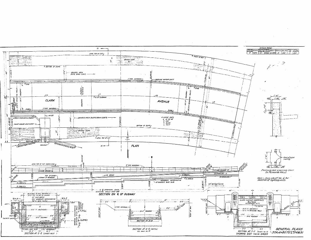
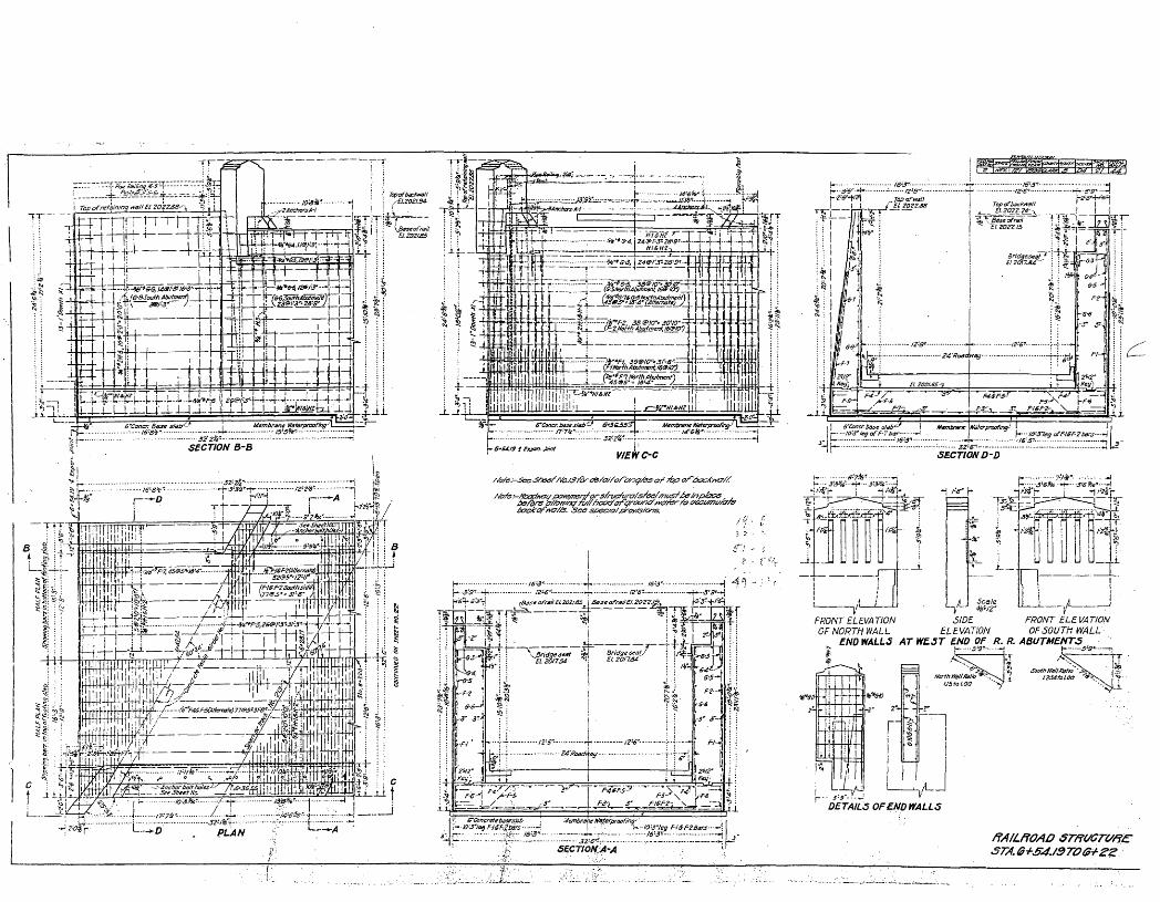
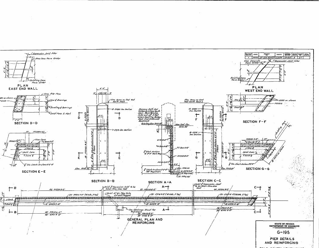
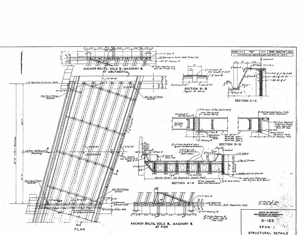
Currently, the underpass structure consists of three separate underpass structures spanning four lanes of Bonanza Road. The spans are constructed of steel I-beams and trusses, with steel- reinforced concrete fascia girders and abutments (1936 sheet #12, 1964 sheet #29). The spans connect to concrete retaining walls at either end, and are supported in the center by a concrete divider wall that separates the east- and west-bound traffic lanes. The concrete divider becomes a low dividing wall along the center island of the east side, extending several feet beyond the underpass. Two twin arm luminaries are set into widened areas of the low wall. The height of the west side divider wall remains constant as the street ascends. Four identical luminaries are set into this wall. Pipe railing runs along the top of the north and south retaining walls. The top surface of the center and west spans each contain a railroad track, and the east span is unpaved and used for Union Pacific maintenance vehicles.
The east elevation consists of three concrete abutments with two concrete fascia girders, one for each side of Bonanza Road, connected in the center and attached behind the abutments.2 The west elevation consists of a center and south concrete abutment with two concrete fascia girders, one for each side of Bonanza Road, connected in the center and attached behind the abutments. The north end of the fascia is attached to a concrete retaining wall, as there is no north abutment on the west elevation. A sidewalk lines the south side of the east-bound lanes.
The east abutments, like those on the west elevation, are typically 25' tall from road surface to top of abutment. Each abutment has a rectangular cross-section, with the north and south abutments measuring 5' 11" across, and 24" deep. The center abutment is narrower, measuring
2 For the purpose of this report, east or west "elevation" refers to the east elevation of the east span, or the west elevation of the west span.
NFS Form 10-900-a 0MB No. 1024-0018 (8-86)
United States Department of the Interior National Park Service
NATIONAL REGISTER OF HISTORIC PLACES CONTINUATION SHEET
Section 7 Page 3
Clark Avenue Railroad Underpass, Las Vegas, Clark County, Nevada
7. Description, continued
4'9" across. The west elevation only has center and south abutments, with dimensions equal to the corresponding abutments on the east elevation.
The abutments are designed with simple Art Deco decorative elements, with the east elevation receiving more detail. Each abutment has a peaked top and a rusticated design; however, the east abutments have a slightly projecting panel centered on the abutment, offset from the outer edge by 12" and following the peaked outline of the top edge. Rustication, in the form of two vertical rows of recessed lines inset 3A", is set into the projecting panel 12" from the outer edges. Each row has five recessed lines 2" wide, with the top row having equal lengths of 4'9", and the bottom row set in a "fall" pattern with the center line the longest at 4'9", and the shortest outer two at 1 '7". Unlike the east elevation, the west elevation does not have the projecting panels, nor does it have two rows of recessed lines. The west abutments simply have one row of five recessed lines having equal lengths of 3'6" (1964 sheet #19).
The concrete fascia girders have consistent cross sections and height dimensions for each span and elevation, but vary in span length and rustication pattern (1936 sheet #27). The north girder of the west fa9ade is approximately 33'10" in length, from connection to north wall to south girder. The rustication pattern consists of three groups of vertical recessed lines inset 3/4" in a row across the fascia. A group of seven recessed lines is centered with two groups of five to the right and left. The recessed lines are two feet in length, and four inches wide. The north girder of the east facade is 30'6" in length and has a similar rustication pattern, however the recessed lines are 1 '3" in length (1936 sheet #27).
The south girder of the west elevation is 47' in length from connection to north girder to south wall. The rustication is consistent with the north girder, however there are thirteen recessed lines in the center group, flanked by two groups of six recessed lines. The south girder of the east elevation is 37'6" in length from connection to north girder to south wall. Again, the rustication is consistent with the north girder, however, there are nine recessed lines in the center group, flanked by two groups of five recessed lines.
Currently the structure has suffered vandalism in the form of "tagging" with spray paint, clearly visible in the attached photographs. A leak in the original structure was reported in the Las
NFS Form 10-900-a 0MB No. 1024-0018 (8-86)
United States Department of the Interior National Park Service
NATIONAL REGISTER OF HISTORIC PLACES CONTINUATION SHEET
Section 7,8 Page 4
Clark Avenue Railroad Underpass, Las Vegas, Clark County, Nevada
7. Description, continued
Vegas Review Journal approximately one year after opening. August Berning, an assistant state highway engineer, reported that the leak was due to the extremes in temperature, resulting in a cracked section of the water-proofing in an expansion joist. The crack was subsequently repaired and traffic was "not hampered in any way by the trouble".3 The Nevada Department of Transportation has not reported any serious maintenance troubles with the structure in recent years.
8. Statement of Significance
The Clark Avenue Railroad Underpass is considered eligible for nomination to the National Register of Historic Places under criterion A. The underpass represents the symbolic "opening up" of the Westside, now called West Las Vegas, after 31 years of being physically separated from the east side of Las Vegas by the Union Pacific railroad tracks.4 Since 1905, when the Westside was settled, then called the Me Williams Townsite, relations between the two communities had been hindered by dangerous crossings over the railroad tracks, delaying water and sewer services, electric lighting and commercial trade. The Westside was also slowly becoming more and more segregated, as residents of thriving black Las Vegas neighborhoods were forced to relocate their homes and businesses to the Westside. Overcrowding resulted in the construction of substandard housing, exacerbating the already noxious conditions created by the lack of clean running water. The construction of the underpass was a civic attempt to ease the straining relationship between the white and black communities, as well as a means to facilitate infrastructure improvement on the Westside.
Furthermore, the construction of the underpass was made possible through federal funding under the Works Progress Administration (WPA), a program under the "New Deal" introduced by President Roosevelt in 1935 to bring relief to the millions of people left without jobs after the Great Depression. The Clark Avenue Underpass was one of 78,000 bridges constructed under this program. The spirit of the New Deal program and WPA befitted the construction of the
3 ____ "Leak in Westside Underpass is Not Serious Berning Explains." Las Vegas Review-Journal. October 13,1937.4 For the purposes of this report "Las Vegas" refers to the Clark's Las Vegas Townsite area located to the east sideof the railroad tracks. "Westside" and "Old Town" refers to the Me Williams Townsite, located to the west of therailroad tracks (Section 12 Maps/Aerials).
NFS Form 10-900-a 0MB No. 1024-0018 (8-86)
United States Department of the Interior National Park Service
NATIONAL REGISTER OF HISTORIC PLACES CONTINUATION SHEET
Section 8 Page 5
Clark Avenue Railroad Underpass, Las Vegas, Clark County, Nevada
8. Significance, continued
underpass and what it stood for, and although the underpass directly and indirectly improved the quality of life for many Westside residents, it did not stimulate economic redevelopment of the Westside as it had hoped to.
The underpass structure retains integrity of location, setting, feeling and association. The structure has not been moved, and the surrounding neighborhood has changed little, with the exception of additional industrial development. The structure continues to serve the community as a convenient way to traverse the railroad tracks, and is heavily used as one of a very few of these structures in the city. The simple design details and elegant structural aesthetic belies not only the use of the structure, but its status as a federally funded project, continuing to associate it with the time in which it was built when trains were moving supplies and workmen, and highways were the post-Depression American's ticket to freedom and relief from drudgery.
Although not as strong as the other qualities, the underpass retains integrity of materials, workmanship and design. The underpass has been widened, however, the additions were thoughtfully executed, continuing the original design elements, materials and dimensions. It should be noted that the structure is not being submitted for nomination based on its retention of these qualities, so much as its significant social importance and association with significant national and local events.
The period of significance has been defined as 1936, the year of construction, to 1954, the 50- year mark.
Criterion A
Early History
The Clark Avenue railroad underpass is located north of present downtown Las Vegas, and west of the site of the first settlement in the Las Vegas valley, commonly referred to as the Mormon Fort, established in 1855.5 The Mormons had traveled from Salt Lake City, Utah to the Las Vegas valley in order to establish a mission and a rest stop on the existing trade route to Southern
The Mormon Fort was listed on the National Register of Historic Places in March 1981.
NFS Form 10-900-a 0MB No. 1024-0018 (8-86)
United States Department of the Interior National Park Service
NATIONAL REGISTER OF HISTORIC PLACES CONTINUATION SHEET
Section 8 Page 6
Clark Avenue Railroad Underpass, Las Vegas, Clark County, Nevada
8. Significance, continued
California. The settlers constructed a fort located at the southeast corner of present Las Vegas Boulevard and Washington Avenue. However, the mission was not as successful as the settlers hoped, and the Indians frequently raided their fields to steal the crops. In 1857, the Mormons abandoned the fort due to internal dissension regarding leadership and failed attempts to mine useable lead from Mt. Potosi, 35 miles to the southwest.
The Mormon fort lay abandoned and at the mercy of passing travelers and Indians who stole lumber and supplies until 1860 when a California party of prospectors rediscovered the Potosi mining area. The miners formed the Colorado Mining Company and used the fort until the outbreak of the Civil War in 1861. The fort remained largely unused until a former miner named Octavius Decatur Gass and two partners took over the site to raise cattle and recultivate the deserted fields. As the fort was largely in ruins, Gass and his partners rebuilt the original adobe building and constructed another, which Gass eventually lived in with his wife and family. In the 1870s Gass bought out his two partners and continued to farm and raise cattle on the 640 acres. The fort was eventually named the "Las Vegas Ranch," and became a rest stop for weary travelers where they could camp and obtain a decent meal for a nominal fee.
Archibald Stewart and his wife, Helen, moved to the Las Vegas Ranch in 1882 and began a prosperous ranching operation until 1884 when Stewart was killed under suspicious circumstances at the neighboring Kiel ranch.6 As a widow with five children, a member of the School Board and women's club leader, Helen Stewart continued operating the now 2,000-acre ranch and farm for another 18 years, becoming the largest landowner in Lincoln County. In 1902, the newly formed San Pedro, Los Angeles and Salt Lake Railroad became interested in a portion of the Stewart land and began searching for a qualified surveyor.
John T. Me Williams
John T. Me Williams was born on December 10, 1863 at Owen Sound, Ontario, Canada. His father, an Irish immigrant named John Me Williams, was a building contractor who taught John surveying skills. Aspiring to be an engineer, young John moved to the United States in 1879 to
6 Kiel Ranch was listed in the National Register of Historic Places on October 6, 1975. The main house burned down in 1992.
NFS Form 10-900-a 0MB No. 1024-0018 (8-86)
United States Department of the Interior National Park Service
NATIONAL REGISTER OF HISTORIC PLACES CONTINUATION SHEET
Section 8 Page 7
Clark Avenue Railroad Underpass, Las Vegas, Clark County, Nevada
8. Significance, continued
attend University of Chicago. Within a year, he was employed by the Northern Pacific Railroad in its engineering corps. In 1879, the governor of South Dakota appointed him a delegate to the National Irrigation Congress in Los Angeles, which introduced him to the western United States. When the conference concluded, Me Williams decided to tour the region where he found plenty of work as a surveyor. His work brought him to Needles, California, where he met his future wife, lona, eventually moving to Goodsprings, Nevada in 1901 with their newborn baby girl. It was here that Me Williams was living when summoned by William McDermott, a representative of the San Pedro, Los Angeles and Salt Lake Railroad, to survey Helen J. Stewart's 1,840 acre Las Vegas Ranch in 1902.
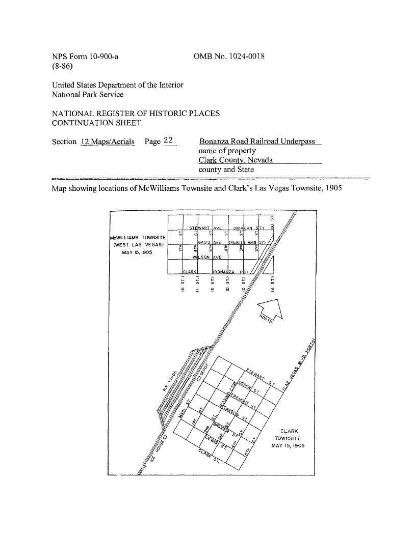
The railroad was financed by Montana Senator William Clark, for whom Clark County is named, with ownership held by Clark's Las Vegas Land and Water Company. The railroad was considering the Stewart land for a new townsite and railroad division point, eventually purchasing much of the ranch from the Stewarts in 1902. Me Williams had been to the area previously, when in 1894 he surveyed and made claim to approximately 1,300 acres of heavily forested land at the Spring Mountains, specifically Lee Canyon, located northwest of present Las Vegas. 7 He was well aware of the valley's huge artesian water belt, and seeing opportunity, purchased 80 acres of land from the Stewarts. In 1904, he began laying out an orderly townsite, which he called the "Original Las Vegas Townsite," and selling lots.
When the railroad was completed through Las Vegas that same year, Me Williams' land was on the west side of the tracks. Not willing to share the profits of a new town, the Las Vegas Land and Water Company began to lay out a townsite of its own on the opposite side of the tracks from Me Williams' land and auctioned off the lots that same year. The townsite, called "Clark's Las Vegas Townsite," boomed almost overnight with lots selling at the May 1905 auction for as much as $1,200. Almost half of the 1,200 lots sold in one day, purchased mostly by speculators from Los Angeles and Salt Lake City. The most valuable lots were closest to the train depot located at the intersection of Main and Fremont Streets. The depot, and consequently the freight loading and unloading ramps, were located on the east side of the tracks, making it difficult for
7 Me Williams spent the next forty years battling to preserve the canyon and open it to public recreational use. His opponents in the government were never officially named, but Senator Clark was suspected as he had a practice of exploiting public lands for timber without compensation, ostensibly for mining development.
NFS Form 10-900-a 0MB No. 1024-0018 (8-86)
United States Department of the Interior National Park Service
NATIONAL REGISTER OF HISTORIC PLACES CONTINUATION SHEET
Section 8 Page 8
Clark Avenue Railroad Underpass, Las Vegas, Clark County, Nevada
8. Significance, continued
carts to cross over the embankment. Most importantly, the railroad owned nearly all the water from Big Springs, the source of Las Vegas Creek. Clark's Las Vegas Townsite came with the promise of water, eventually forcing many of the early residents of the Me Williams' townsite, which was served by several small shared wells, to place their buildings on skids and move across the tracks to Clark's Las Vegas Townsite.
Me Williams' Townsite
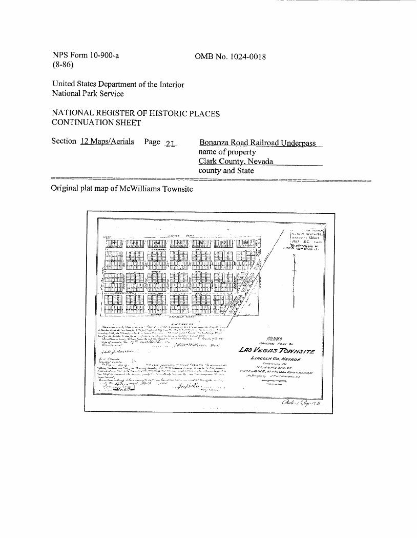
The first plat for the Original Las Vegas Townsite was filed with then Lincoln County, Nevada on January 13, 1905. The boundaries were First Street and Eighth Street on the west and east, respectively (now A Street and H Street), and Clark Avenue and the north side of Stewart Avenue on the south and north, respectively (now Bonanza Road and Morgan Street.) The site was located northwest of Clark's Las Vegas Townsite, with the railroad running through the lower southeast corner at A Street and Clark Avenue (Section 12 Maps/Aerials). Each block had 24 lots, with 12 running north/south and 12 running east/west. A 20-foot-wide T-shaped alley separated the lots into three groups. The north/south lots were typically 25 feet wide, and 125 feet long. The east/west lots were typically 25 feet wide, and 140 feet long.8
By all rights, Me Williams' Townsite should have been a huge success. It was close to Las Vegas Creek, and accessible to roads to the surrounding mining communities of Rhyolite, Goldfield and Tonopah. For some time the townsite prospered, with lots selling well through the winter of 1904-1905, reaching a peak of 2,000-3,000 residents. It served as a transportation hub for mining supplies and goods brought by the railroad, with dozens of freight wagons leaving daily for the outlying mining districts. Me Williams built his house there, and by May of 1905, it had the valley's first bank, blacksmiths, wholesale houses, a bottling works, drug and general stores, and several good restaurants. Disaster struck in September 1905 with a series of fires that destroyed almost all of the wooden structures in town. Until the 1930s, the townsite consisted of little more than tents and shacks. When Me Williams was appointed State Water Rights Surveyor
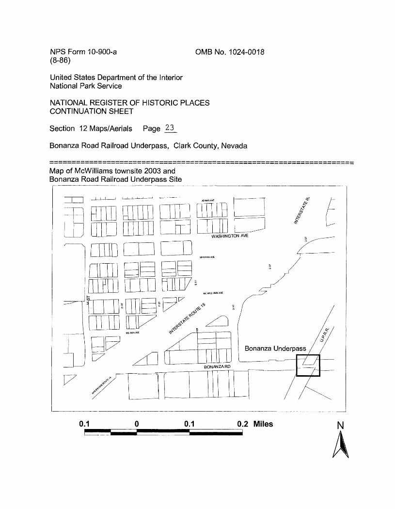
8 Today, this pattern can be seen in a few of the remaining blocks, although some of the alleys have been closed and some of the east/west lots now run north/south (Section 12 Maps/Aerials). A large swath through the center of the neighborhood has been cleared for the construction of Interstate 15, and the lower right corner is now a large industrial complex (Section 12 Maps/Aerials).
NFS Form 10-900-a 0MB No. 1024-0018 (8-86)
United States Department of the Interior National Park Service
NATIONAL REGISTER OF HISTORIC PLACES CONTINUATION SHEET
Section 8 Page 9
Clark Avenue Railroad Underpass, Las Vegas, Clark County, Nevada
8. Significance, continued
for the region in 1906, the residents of Clark's Las Vegas Townsite were already referring to it as "Ragtown."
Clark County was carved from Lincoln County in 1909, and Clark's Las Vegas Townsite became an incorporated city, Las Vegas, adopting its first charter on March 16, 1911. At the time of incorporation, the city encompassed 19.18 square miles, and had approximately 1,000 inhabitants, less than 1 percent of the state's total population. Fremont and Main Streets developed as the main commercial arteries of Las Vegas. Main Street ran parallel along the east side of the railroad tracks and the majority of the businesses were dedicated to the railroad. Fremont Street became the town center with a bank, post office, and retail shops. Nightclubs and speakeasies flourished, even during Prohibition, on the infamous Block 16 located one block north of Fremont Street.
Me Williams' Townsite became a subdivision of Las Vegas and in 1916 began to demand water services from the railroad's land and water subsidiary. The Las Vegas City Commission passed a resolution that year asking for compliance from the railroad. At the time, the Westside was developing slowly, with little more than tents and a few permanent homes. There was no protection from fire because with no water lines, there were no fire hydrants, forcing firemen to run a hose from Las Vegas. Several homes would be lost if one home were to catch on fire due to the amount of time it would take for the firemen to fight the fire. There were also other factors, which are discussed later. In addition to the fire hazard, the lack of a water system contributed to noxious living conditions that were repeatedly reported in the Las Vegas Age and Las Vegas Review-Journal. "Old Town has suffered heavily from sickness due entirely to the contaminated water supply from surface wells, and the condition is a menace to the entire city."9
Las Vegas had recently received ten acres of land from the Las Vegas Land and Water Co. for the creation of a cemetery. 10 The city did not want to spend "large amounts of money for the purpose" of bringing water to the Westside, and was considering the project as an addition to securing water for the new cemetery. 11 It is not known if this plan was ever realized, but the
9 Squires, Charles "Pop". Editorial, Las Vegas Age, April 29,1916.10 Rinella, Heidi Knapp. "Living in the Past." Las Vegas Review-Journal, May 28, 2000.11 Squires, Charles "Pop". Editorial, Las Vegas Age, April 29, 1916.
NFS Form 10-900-a 0MB No. 1024-0018 (8-86)
United States Department of the Interior National Park Service
NATIONAL REGISTER OF HISTORIC PLACES CONTINUATION SHEET
Section 8 Page 10
Clark Avenue Railroad Underpass, Las Vegas, Clark County, Nevada
8. Significance, continued
battle for water continued for ten years until the residents of "Old Town" began petitioning the Nevada Public Service Commission for service. After another year of long, complicated negotiations it was decided that the Westside would receive city water, and John T. Me Williams would lay out the system. However, the Westside did not receive the promised water at this time. This was only the beginning of a series of battles the townsite would fight with the Las Vegas city leaders for basic services.
In 1927, a meeting was held on the Westside concerning municipal improvements and a possible bond issue proposal. Present were then Mayor Fred Hesse, City Attorney Frank Stevens, and prominent developer and newsman Al Cahlen. It was stated that the population of the Westside was approximately 1,200 and without sufficient water for fire protection, sewers, or domestic use, the situation endangered the health of the entire city and stifled the Westside in its growth and development. 12 Three years prior to this meeting, two new tracts had been laid to the north of Me Williams Townsite, and were beginning to be developed. The first were the Valley View Tract with boundaries of N. First St. to N. Fourth St. (A St. to D St.), and Washington Ave. to Harrison Ave. on the north, and the H.F.M.&M. Tract, with boundaries of N. Fourth St. to N. Eighth St. (D St. to H St.), and Washington Ave. to Harrison Ave. Together, there were thirty- two blocks that would quickly fill up with families coming to work as laborers for the construction of Hoover Dam. Clearly the increased development called for these services.
At the meeting, Attorney Frank Stevens explained that the City Commissioners had the power to issue a bond to construct a municipal plant. The Westside emergency will "form the basis for a municipally owned water system to cover the entire city."13 A few days after the meeting, Stevens reported to the Las Vegas Age that an amendment to the city charter was required before a municipal water system could be established. 14 The bond was finally issued in 1930 for $82,000, which, among other improvements, provided for the purchase of 240 acres of water- rich land west of the city. In a public notice in the Las Vegas Review-Journal, the bond details were revealed, stating that the bond also covered the costs of drilling the Artesian well, which it was believed had ample water to supply the whole city. In order to "save the city from a bond
12 ___ "New Water System Under Discussion", Las Vegas Age, July 2, 1927.13 ___ "New Water System Under Discussion", Las Vegas Age, July 2, 1927.14 ___ "Must Amend Charter for Water System", Las Vegas Age, July 16, 1927.
NFS Form 10-900-a 0MB No. 1024-0018 (8-86)
United States Department of the Interior National Park Service
NATIONAL REGISTER OF HISTORIC PLACES CONTINUATION SHEET
Section 8 Page 11
Clark Avenue Railroad Underpass, Las Vegas, Clark County, Nevada
8. Significance, continued
issue for delivering this water to the West Side," Mayor Hesse convinced the local water company to extend its water mains for the service of the Westside residents. 15 The majority of this project was not completed until the city received federal aid from the Roosevelt administration in the early 1930s, and even then, the entire Westside community did not receive complete municipal water and sewer systems until the 1940s.
Water was not the only bone of contention, as the Westside did not have paved or even graveled streets, nor did they have streetlights or markers. When Me Williams Townsite was first platted, the north-south streets were named First, Second, Third and so on. This caused confusion with the fire and police departments because the streets of Las Vegas had the same names. When responding to calls, the fire and policemen would always rush to the Las Vegas streets first, allowing many Westside fires to consume several properties before it could be put out. The Westside street names were changed to letter names in the 1930s to eliminate this hazardous situation. Also hampering rescue response time was the actual street conditions. After every rain, the streets became so muddy it prevented children from attending school. 16 Petitions were circulated in early February 1931 and handed to the City Commissioners, but rejected based on property valuations. If the Westside residents wanted to foot the bill, the improvements would be made. However by late February 1931 an editorial in the Las Vegas Review-Journal reported that the Westside streets were finally being graveled. It further noted that the city elections were only two months away. 17
It is obvious that leaders in Las Vegas were reticent to supply water and other basic services to Westside residents due to low land valuations, and the low-income population lacked the necessary political influence to make demands. The population of the Westside during that time was comprised of mainly low-income whites and some Chinese, Mexicans, and blacks who had come to the area to work for the railroad and the dam. In 1922, the black population of Las Vegas and the Westside numbered only about 50, increasing to 75 during the early 1930s. 18
15 ___ Public Notice, Las Vegas Review-Journal, April 19, 1930.16 ___ Editorial, "Should Be Successful", Las Vegas Review-Journal, February 7, 1931.17 ___ Cahlan, A.E. "From Where I Sit", Las Vegas Review-Journal, February 20, 1931.18 Tackett, Karen. Me Williams Townsite: 1905-1980. Las Vegas: Department of Funds Coordination, City of Las Vegas, 1980.
NFS Form 10-900-a 0MB No. 1024-0018 (8-86)
United States Department of the Interior National Park Service
NATIONAL REGISTER OF HISTORIC PLACES CONTINUATION SHEET
Section 8 Page 12
Clark Avenue Railroad Underpass, Las Vegas, Clark County, Nevada
8. Significance, continued
Because land was so inexpensive on the Westside, with lots selling from $50 to $100 each in 1925, 19 many of the new immigrants to the area were forced to move there, as they could not afford the $1,000 lots selling in Las Vegas. It was a vicious circle: Low land value, no water, no significant middle- to high-income residents, low land value, no water, and so forth.
As early as 1917, the Las Vegas Land and Water Company Vice President Walter Bracken tried to confine blacks to Block 17 (next to the brothels and taverns at Block 16), in fear that integrated housing would encourage more minority residence or discourage white financial
onsupport in the new town. His efforts failed, and when rumors of the construction of Hoover Dam began to circulate in the early 1920s, the black population increased as several black men and families arrived to find work at the dam. A small black community began to develop north of Fremont Street between Ogden and Stewart Avenues, and First and Fourth Streets. However many more were forced to live in tents and shacks on the Westside, as the sudden influx of unemployed caught Las Vegas unprepared and unable to provide housing or jobs. To make matters worse, Six Companies, the organization building the dam, refused at first to hire any blacks until 1932.21
The largest blow came in 1931 when the established black community north of Fremont Street was asked to relocate for the construction of the Federal Post Office on Stewart Street. An article in the Las Vegas Review-Journal from February 1931 states that the "colored residents" are making plans to move to the Westside.22 By May 1932, the "removal of the colored district" to the Westside in preparation for the Post Office had begun.23 As blacks were not allowed in other areas of the city, the Westside was the most logical place to go. Many new subdivisions, such as Williams Addition No. 2, advertised, "Caucasion Race Only."24 Las Vegas had begun to unofficially institute Jim Crow laws, confining the black population to live in one area.
19 Advertisement for the H. F. M. and M. tract, Las Vegas Age, November 21, 1925.20 Moehring, Eugene P. Resort City in the Sunbelt: Las Vegas 1930-2000. 2nd ed. Las Vegas: University of Nevada Press, 2000.21 Tackett, Karen. McWilliams Townsite: 1905-1980. Las Vegas: Department of Funds Coordination, City of Las Vegas, 1980.22 ___ "U. S. Building Survey Finished", Las Vegas Review-Journal, February 14, 1931.23 ___ "Colored Section in Vegas Will Move", Las Vegas Review-Journal, May 24, 1932.24 ___ Advertisement, "Grand Opening Williams Addition No. 2", Las Vegas Review-Journal. August 8, 1931.
NFS Form 10-900-a . 0MB No. 1024-0018 (8-86)
United States Department of the Interior National Park Service
NATIONAL REGISTER OF HISTORIC PLACES CONTINUATION SHEET
Section 8 Page 13
Clark Avenue Railroad Underpass, Las Vegas, Clark County, Nevada
8. Significance, continued
Unfortunately the segregation was not limited to housing, as most of the casinos and other business establishments did not allow black patrons, or charged them higher prices for the same product or service.25 Black club owners were often not able to obtain liquor and gambling licenses or were restricted to certain areas of town,26 and the black-owned business
97establishments were constantly raided during this time.
Conditions on the Westside worsened as the population increased. In 1931, crowded sub standard housing and tents were the norm, the streets were still ungraveled and there was still no sewer system. A bond issue went before the city in April 1931 for the installation of a sewer mains and laterals, but was not passed. The Westside was not served by a city sewer system, nor were the streets improved until 1934 when Las Vegas was able to receive federal assistance after long negotiations with the Civil Works Administration (CWA) office in Salt Lake City. The CWA was one of the New Deal programs initiated by President Franklin D. Roosevelt in 1933 to promote relief and recovery from the Great Depression. This federally-funded program provided assistance for the installation of a sewer system for the entire city of Las Vegas, including parts of the Westside and all new subdivisions built during the boom created by the construction of Boulder Dam. The CWA and Federal Emergency Relief Administration (FERA) workers paved over fifty-eight blocks in Las Vegas and graveled many Westside streets.
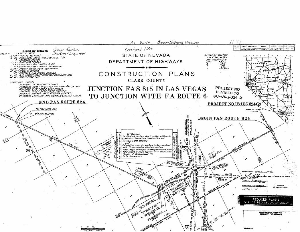
The New Deal programs funded many projects in Las Vegas, including new parks and buildings such as the War Memorial Building (no longer extant), and street improvements such as the paving and widening of the Los Angeles Highway. In 1935, it was realized that an easier and safer route across the Union Pacific railroad tracks was needed. The route chosen was Clark Avenue, which was part of the Tonopah-Reno Highway and the major link between the Las Vegas business district and the Westside. Under direction of the State of Nevada Department of Highways, the underpass structure was designed by the Union Pacific company engineers and
25 Moehring, Eugene P. Resort City in the Sunbelt: Las Vegas 1930-2000. 2nd ed. Las Vegas: University of Nevada Press, 2000.26
2726 "Colored Annex to Restricted District", Las Vegas Review-Journal, October 9, 1934.
"Clean-up of Colored Area Ordered Here", Las Vegas Review-Journal, July 20, 1931.
NFS Form 10-900-a 0MB No. 1024-0018 (8-86)
United States Department of the Interior National Park Service
NATIONAL REGISTER OF HISTORIC PLACES CONTINUATION SHEET
Section 8 Page 14
Clark Avenue Railroad Underpass, Las Vegas, Clark County, Nevada
8. Significance, continued
construction began in 1935. The total cost of the underpass came to $200,000, all of which wasOS?covered using Works Progress Administration (WPA) funds.
The Clark Avenue Railroad Underpass Opening Event
The opening fete for the Clark Avenue underpass structure was scheduled for Friday, August 6, 1937. It was to be a huge event, attended by many community and political leaders from both the Westside and Las Vegas. According to an article in the Las Vegas Review-Journal., dated July 30,1937, C.D. Baker was the head of the committee organizing the celebration with C.P. Squires as the Master of Ceremonies.29 Both men were Las Vegas pioneers who were highly respected in the community, and actively involved with local and state level politics.
Las Vegas Mayor Leonard Arnett opened the meeting saying, "A short time ago the ribbons of steel of the Union Pacific separated the Westside and the east side of town. Today that barrier has been removed thanks to President Roosevelt for his program in making this underpass possible, to the state officials for their foresight, and to the workmen who constructed the project." He then predicted an increase in valuation for Westside property with the advent of the underpass. Ed W. Clark, a prominent political leader and pioneer resident, who was equally as respected a community leader, and involved in many of the same development activities as Pop Squires, gave the address. The speech focused on the future of Las Vegas and how growth and industrial development would continue unhampered due to the availability of cheap power from Boulder Dam. Also in attendance were Lieutenant Governor Fred S. Alward, General Manager of the Union Pacific Railroad system HJ. Plumhoff, prominent attorney Harley Harmon, President of the Las Vegas Chamber of Commerce O.A. Kimball, as well as a number of representatives from the Nevada Department of Highways, and the contractor and builder of the underpass, Jack Casson.
28 ___ "Underpass Fete Staged Friday is a Big Success", Las Vegas Review-Journal, August 7,1937.29 ___ "Vegas and Westside to Join in Observing Underpass Opening", Las Vegas Review-Journal, July 30,1937.
NFS Form 10-900-a 0MB No. 1024-0018 (8-86)
United States Department of the Interior National Park Service
NATIONAL REGISTER OF HISTORIC PLACES CONTINUATION SHEET
Section 8 Page 15
Clark Avenue Railroad Underpass, Las Vegas, Clark County, Nevada
8. Significance, continued
The celebration for the underpass opening also included speeches by several other community leaders. It was to be the "most historic civic celebration ever held.. .marking an era in traffic safety" in Las Vegas. 30 The dedication speech was given by Nevada Governor Richard Kirman, and a large delegation of state officials from the Capital was present. A parade with the Color Guard, band, Las Vegas Horsemen's Association and the city fire and police departments started at Sixth and Fremont Streets, passed under the underpass and ended on the west side at the speaker's podium where refreshments were served.
Conclusion
The underpass was seen as not only a huge achievement for the Nevada Department of Highways, but it also represented a successful state, federal, and private collaboration. It was touted as the most spectacular event since the beginning of the city, and a tremendous success story for President Roosevelt's New Deal programs. Indeed, it increased the safety of travelers who had previously had to dodge swiftly oncoming trains and risk getting carts and wagons stuck on railroad tracks. The underpass also facilitated infrastructure improvement for the Westside neighborhoods, which had been sorely neglected for too long.
Although the Bonanza Underpass was not the catalyst for a complete economic redevelopment for the Westside, nor did it end the bitter racial contention that existed "unofficially" the early 1970s, it has valuable historical significance in its symbolism as the long-awaited first step to improved relations between the west and east side of the railroad tracks. This is obvious when reading the list of important community and government leaders who spoke and were present at the opening. Despite the facts that the Westside community leaders' names who were present at the opening were not being mentioned in any article, and that the west elevation of the structure received less design detail than the east side, the celebratory atmosphere that embraced such post-Depression civic projects rendered the structure a positive and hopeful symbol of city investment in the long-oppressed Westside.
The Clark Avenue Railroad Underpass is significant as the symbolic gateway between long- severed communities, facilitating desperately needed infrastructure improvements on the
30 ___ "Underpass Fete is Ready for Friday Evening", Las Vegas Review-Journal, August 5, 1937,
NFS Form 10-900-a 0MB No. 1024-0018 (8-86)
United States Department of the Interior National Park Service
NATIONAL REGISTER OF HISTORIC PLACES . CONTINUATION SHEET
Section 8, 9 Page 16
Clark Avenue Railroad Underpass, Las Vegas, Clark County, Nevada
8. Significance, continued
Westside. More importantly, as a federally funded project under the New Deal programs, the underpass is an excellent example as a representation of the New Deal values of economic relief and improvement to quality of life for those who were out of work and otherwise destitute.
9. Bibliography
Books
Evans, K.J., and Hopkins, A.D., eds. The First 100: Portraits of Men and Women Who Shaped Las Vegas. Las Vegas: Huntington Press, 1999.
Kaufman, Perry B. "The Best City of Them All: A History of Las Vegas 1930-1960." Diss. U of California-Santa Barbara, 1974.
Moehring, Eugene P. Resort City in the Sunbelt: Las Vegas 1930-2000. 2nd ed. Las Vegas: University of Nevada Press, 2000.
Tackett, Karen. Me Williams Townsite: 1905-1980. Las Vegas: Department of Funds Coordination, City of Las Vegas, 1980.
Reports
____ West Las Vegas Plan. City of Las Vegas. On File City of Las Vegas.
Periodicals
Rinella, Heidi Knapp. "Living in the Past." Las Vegas Review-Journal, May 28, 2000.
____ "New Water System Under Discussion", Las Vegas Age, July 2, 1927.
____ "Must Amend Charter for Water System", Las Vegas Age, July 16,1927.
NFS Form 10-900-a 0MB No. 1024-0018 (8-86)
United States Department of the Interior National Park Service
NATIONAL REGISTER OF HISTORIC PLACES CONTINUATION SHEET
Section 9 Page 17
Clark Avenue Railroad Underpass, Las Vegas, Clark County, Nevada
9. Bibliography, continued
____ Public Notice, Las Vegas Review-Journal, April 19, 1930.
____ Editorial, "Should Be Successful", Las Vegas Review-Journal, February 7, 1931.
____ "U. S. Building Survey Finished", Las Vegas Review-Journal, February 14,1931.
____ Cahlan, A.E. "From Where I Sit", Las Vegas Review-Journal, February 20, 1931.
____ "Clean-up of Colored Area Ordered Here", Las Vegas Review-Journal, July 20, 1931.
____ Advertisement, "Grand Opening Williams Addition No. 2", Las Vegas Review- Journal. August 8, 1931.
____ "Colored Section in Vegas Will Move", Las Vegas Review-Journal, May 24, 1932.
____ "Colored Annex to Restricted District", Las Vegas Review-Journal, October 9, 1934.
____ "Vegas and Westside to Join in Observing Underpass Opening", Las Vegas Review-Journal, July 30, 1937.
___ "Underpass Fete is Ready for Friday Evening", Las Vegas Review-Journal, Augusts, 1937.
____ "Underpass Fete Staged Friday is a Big Success", Las Vegas Review-Journal, August 7, 1937.
Internet Sources
Clark County. WeblnfoMapper. Clark County Assessor's Office: <http://www.co.clark.nv.us> June 2002.
NFS Form 10-900-a 0MB No. 1024-0018 (8-86)
United States Department of the Interior National Park Service
NATIONAL REGISTER OF HISTORIC PLACES CONTINUATION SHEET
Section 9, 10 Page 18
Clark Avenue Railroad Underpass, Las Vegas, Clark County, Nevada
9. Bibliography, continued
Maps
___ Geographic Information System, (GIS). City of Las Vegas, Planning and Development Department, 2002.
____ Greater Las Vegas Street Map and Directory, Spring 2002. Metro Maps, 2002.
Blueprints
State of Nevada Department of Highways. Plan and Profile of Proposed State HighwayFederally Funded Project: Clark Avenue Underpass. Prepared by Engineer Jack Casson under direction of Union Pacific Railroad, 1936.
State of Nevada Department of Highways. Construction Plans: Bonanza Road Underpass. 1964.
10. Geographical Data
Boundary Description
The National Register boundary of the Clark Avenue Railroad Underpass comprises the physical limits of the resource located at the intersection of Bonanza Road (formerly Clark Avenue) and the Union Pacific Railroad Tracks in Section 27 T. 20S R. 61E, UTM Zone 11, 666990E 4005000N.
Boundary Justification
The boundary is limited to the physical limits of the resource located at the intersection of Bonanza Road (formerly Clark Avenue) and the Union Pacific Railroad Tracks in Section 27 T. 20S R. 61E, UTM Zone 11, 666990E, 4005000N.
NFS Form 10-900-a (8-86)
OMBNo. 1024-0018
United States Department of the Interior National Park Service
NATIONAL REGISTER OF HISTORIC PLACES CONTINUATION SHEET
Section 12 Maps/Aerials Page 21 Bonanza Road Railroad Underpassname of property Clark County. Nevada_______county and State
Original plat map of McWilliams Townsite
BHBBffl
NFS Form 10-900-a (8-86)
United States Department of the Interior National Park Service
OMBNo. 1024-0018
NATIONAL REGISTER OF HISTORIC PLACES CONTINUATION SHEET
Section 12 Maps/Aerials Page 22_ Bonanza Road Railroad Underpass name of propertyClark County, Nevada_______ county and State
Map showing locations of Me Williams Townsite and Clark's Las Vegas Townsite, 1905
McWILLIAMS TOWNSITE
(WEST LAS VEGAS)
MAY 15,1905
CLARK
TOWNSITE
MAY 15, 1905
NPS Form 10-900-a OMB No. 1024-0018 (8-86)
United States Department of the Interior National Park Service
NATIONAL REGISTER OF HISTORIC PLACES CONTINUATION SHEET
Section 12 Maps/Aerials Page 23
Bonanza Road Railroad Underpass, Clark County, Nevada
Map of McWilliams townsite 2003 and Bonanza Road Railroad Underpass Site
0.1 0.1 0.2 Miles

INDEX OF SHEETS
OF
37-44- Cff05S 5FC77CWS
DEPARTMENT OF HIGHWAYS v
PLAN AJSTD PROFILE OF PROPOSED STATE HIGHWAY
GP i^
; \ CLARK COUNTY 5
FROM LAS VEGAS TO CHARLES TON PARK ROAD<;r«i re I PLAN.I IN.- scfa. too'OI>A LLO
.PROFILE. HOR. I IM.-504 BO. VERT. I IN.- 1 0 FT.
. #/£/6O'&ZG'/?ocrtfaay fO'&eo'/lsabarmc/vaa'sn/jf surface.
73.5O/.F4' - /4.S67M'/es. f- //o. 36O. Co/ftofe/ec/^Iv., /S34.—— LEVEE.....
—— CULVERTS—— RETAINING \fAi&
- DROP INLET. ... TROLLEY POLE.. POWER POLE
? -',. -CINCOEP-D CITY OR TOWN .-- - —.- — re.-... .....^SEXZTION LINT RESERVATION LIN£
.FENCE LINE... ....... ...UXFENCED PROPERTY"
OP WAY LINE.. TRAVELED WAY
TEIJEPHONE OR TELEGRAPH POLES tMARSH ... . ..TREES. . »:i-eeaeo
1"
_-»
-W.
-pmi —
i — r
4t7O
.dO
_U
NIT
• •
tS-S
'f.f.
RtT
AIH
-•-
— ---
14
'-0'\
1 N,
S
^
; s
§ ^
i *
j KU
AT/
ON
r» >n ^ 1 Q) X
1 -
^ 11
*l
——
>} —
/MT
H
HU
S-—
-
ROAD
WAY
••-•
••-
»'• 1
^
4-/
7S
5-
•i'j't
4.je
"
"to
... I — -(1
^
1i
n—
-4—- i
1 Til
' -—
f.S. f
01l.il
—'' * 1 Jj ^
...-
--. ./
3'-g
:...
.~*
•"••
•••%
•••
"""
Ss §5 ^0 §s !| »« * s i 1 ^ •j _g
%5
a^
5
ilMi!
i!i^yj-
i!1
I '
M
illi-
1 ii
|:iiii
i.;; 'i
hi
i:!^
1!! 1 i 1 '
i _ U
P.._
i i:i:,
!i|
..-^ 1 i 1 1 1 1 1 I-n § -'
PT
:!i,|:h
•ijii
i. • i ^*j
i ;
s|c?i
!:.'!#
i! ;
•:( 1 1
1 1
1$
II
^ 1
•*4
' 1
/ /
rr.ffe.m.(/s>3(s;
TTsj...it-i; r-f.,i'-jr:i'.Ji:-£ .' " "i 10J__1BO
Typicol Details of |Pipe Rail one! own on Sh.S
BSECTION H-H
IruMdion KotelnEni Diaphreqmir '
r-6' .;r-i-_!.v-ij. i-s ,;, v-&- .:. r-r ,r rs- _ :MTAIL LOHEJOiKTS IK KO! PLATE
FOR KELDIK6 ALTCRKATLHOTE-. leek Ply moy ol tht gilim of (he twltoclor. bf cHhtr titled
ir Krldai It Iht Slrmqm. If the »ttkUs. are rivried oil Rjn.1iieC .n the bp. tide of iMl PJ. Max. Soo.ot Rin.to be 7W. It Deck PI.
-----I--------4VtldtJ to Slrin.trs.wdd vrilh Wi3~fillet tM t CCtl.dir
edge it eoch Up flmie. Ml long Joints in Deck PI. m»t Slrinjer (longe. Se« detail ab»« for WeWinj.
in'.he l(nniH«!ihe spcn. Spilees in 3dninine \ \V-\\ N sides to be :to»._-eo. Eeve! shesr en3 .f P olt \ \Y«&
5«' lY.l.Web-Pls.(5te Kott abovt on Sit. C-c)
6rini! " to Bear at Bottom Wedge tHeWSo - - Top
6rodt 0.3% Down— 6.0! R-?
""T"';-- Sole PI. Ti 1."
%'&
I
—— iJJ-s1T
f*"H
So
... *".f Jl|
pv.iVr — p=
i1"
^8
ffi cinspectiohHolfc«nl.ilntn<i
Lt'-i". | j Oiaphro 4TO ^ Shoyn !_" i l'-T_ i _TL_t ' 1 :3 i l''3 ! 1'&'
StCTlOH D-D
More:- Com/xssrsarto/? /ersarx/srxraf/c fo £>e jffc/tsoiscf//7 canfracfpr/'ce for sf sfee/
. ' See Ahchar bolt ipo.cn Shi 13
. ,_.,... 'Vj i.,ve Locd Considereii Oisti Sec k *',D|F " 37 Over 4 &ecmi Stnr-.cjp.ri inri Oiophrejmsai
;;etiGs foa OKI. i-!giN5Ep.-SPu< fcR MUN L^F DiSies FOR ONE .' A.:<r, IPirx Mt ":';i
iMlt.P. UOWtSTS SHtARs L ::DGO LV. !D..soa'- D-. ILBOO: . i;-!SS - 1. r;;2;0 i- '- S6300
:o!c'-TitlOO"" 'o'.:;-""S'if.OO?*' ' lo!s! "ilJo'oC""
DF.TWL OF SPAM FOR MWM TRA.CK Wl Oelsiis For Oiher ISpi.Similor
MosPUtil'A- I beetachorEoliSpo.onSh.13
.Focio 6ird«r_
MOMENTS5&AQO"
155500
SKBeq'd.
6EN18XL NOTESSpecifications MU, for Steel Roilwoy bridqts Dotei! !81iBivets 1/8"*Open Holes !5Aei* Unless Noted OtherwiseShopPoinl-SssShasf te.13IVeWintj To t* Electric \YeWinc Krc P'orewSee Sh.13 for Motes en Pipe fend Roil r- brocke'.i
el Shims Thickntss Vorits See Sheet 13 for Cjnlrollmq titvolions
5ECTIOK E-E-STRUCTURAL <5TE£L
Ill0III (
—1 -fS
-diMin]i
!i^ 1i
mnj
rtqH &
ii
i
j.1 r*
_O_
rJ_
—
—
II' •1:E
:,_:.;: ::::
;
««W
*,
ff
- —
—
. --. ._
.58
|
r^ U
_;.,"'J
"!1J.rr») I
0UQ
J(/UJ£l{.tr /1
/c/ ff
• ^ !
T
N
*
J-|
S M
fc: l\
T<
J^
-1J ^
-J
,V|
*<!^J
^
1 &-
\•5
§
r.. ..:. ..---..,/___; _
__
_ . _
__
__
__
X| i
§K ^
1
y!• - l
- —
- "• " ': '
I •
1V\r'If 'i
1 .(.1
-— --£
js* • -
i ^.---U-l^l-.l-
!P
- 1 — f -" J :~:-~ -:j: t 1
; i
1 '
~L~
. j V1
"* ' '
' !
1 :~
JT
j
j ,
1 ;
ill.. ,...;.;
^4
:-!^^::
j&iirizh-lt^
I
I*!dk^ s
T? —
_-:_ . .-----T- Pipe Xait.n,.«:s^- — - -- — ;-gT" f i fijftSsS'-a'c.c. ' •!-•-!
i Tnnr,frefaininqrtallEJ.?O22£S-'-: ^',\
^1t
—— ————— _T TT!~i •; 6 S1 gl§
•?c§ 1='f^fej;.,.8fffi fz"i?-; If i.L_Jfe£
j |"^ = 5 |i , j;,.5^.^...........i-./54^...................jE^v....^-.-J...t:\..v.v.::::;:v^yiT;..:.'.'.'H }/-^ i-?*'^ ... r 0f,isr-7--^ --.r^T.:.:;:.r^»l, «&*\ i I > > . _/ «^? t .. —........... . /Z:g*~............... ..3:g,...^
r-^'+f^ I Top cftacKirall ' I 'i .1_ IL?—2 ?'-! . . . !_ -!__!-
SJ&BBI^:- •----1---—*»-»ff4 j Z4<fl&&S^t3&\flPiiitinl" ~"i" nti"1
flri^^rztnoi.*/-. |
l————-ffl-IJfh—
-'—-^ -; ~
.basestab'-* 6'3S£S3\ /7-7V-—--'————--+• 'r——IO:3"legofF-7tiar-----~^ • I (»— l&3'!eg off
K»'tir-.--.|»^-........-........--^..-....^_|.^>^26ffy^j/-j^.. /.-.X"l-J
END WALLS ATWE.5T END OF R. R. ABUTMENTS
...i;^l......,,:...:j_.._i
^SifeWti^^^-----^>^:^/-3v/^frjt
liit 1 '! /£iyju ; ; '•i—U4—4-4—(._t'iUi**; : : •> i rttt isGlaai* i
FRONT ELEVATION OF30UTH WALL
FRONT ELEVATION OF NORTH WALL
R. ABUTMENTSEND WALLS AT EAST END OF RScale: *'-/2"
Membrane ffaferproofirjo-'
VIEW c-c %!
afe' W35 tot. 00DETAILS OF END WALLS
•nors i . - - , -_ -+.--•-. rft+2-f^ Basesfreil a. fOfl.se
^:^ jjr;.?:^.•••• jZ-5*---—-
SECTION.A-A
'-^:;:
^:;'i
:J'V
,.^'
/t.
^-^f
fiif
M-.
'*£
%•'
"!,"
'• - u
'T-''
'!,'
''I' "
'"•'-'•
'- *'
•A'-.^
i.'i'sii
.U
jU.'
^1•:>
*-:-!
i4Jv
^?^
^-
- rih'i
•• •'
:,•;
";•
'*=
•'- f-
.^^.
•'O-'S
> . '
."- . i
'l-r
-*:*
•**
3* C
ounte
rjurik
rlre
fs .
' :
' •**
> •'
'jfe H
' '
'. *
' *j."
' :
i.' t
'
•
fyionzQLh/eiwss kfden/na
INDEX OF SHEETSsot-frit* / ~ rtne smcrZ-2A~ TVPKAL SfCTfONS3 - 3D "SUMMAXt£S AND ESTIMATE : Of QlMffT/T/fS
4 " LOCATION SKfTCH S- 6-> PLAN J NO PROFILE 7-9 ~ CONSTRUCTION CONTt?O£ WAN
/O ~ COffSTKUCr/OM CONTROL El£MT/ONS f/-f3 - STOtfM OJ?A/N, PtAf/ 4N0 PKOf/if
<IS-IB£S?4(Z) CLARK Q3-O/5\ 5 /
STATE OF NEVADA DEPARTMENT OF HIGHWAYS
. /7~ U6HTMG AND SfSMAi afTAlLS tS- 43~/f.& LWD£KPASS,S-44-46 ~ srxvcrt/xe t/srSTANDARD
STANDAKO
CONSTRUCTION PLANSCLARK COUNTY
DSS/GN SfSIGNATJON ADT C/SeS) -25001 ADT (/SSS) -J&OO 0M -3.6 7. D -537. T -$'/. V "30M.PH.
STANDARD TVff/AA/ffe OffOP INLETS STANDARD TVPE 3 DROP XNLZT CSff££TS) STAHDAKD METHODS Of ' ZXTCND1NG CULV£KTS STANDARD L/GHT/NG AND SIGNALS (SH££TS / *NO ^')
JUNCTION FAS 815 IN LAS VEGAS TO JUNCTION WITH FA ROUTE 6
PROJECTTO
END FAS ROUTE 824 PROJECT NO.US-USG824(2)'
k-^~\
4"CfossA Concrete—• \ 4" Type £ Grovel Sase—^
NOTE: "p£"e+6fff*o.T. to "Pe* 9 tss.eo nar__ Paved Median fo Existing Retaining ' Wo// on if. as sAown on Section &f/otv
A f/kfS'JU£0J
ii'-o"
i' Open Graded Plan (mix Surface 4 ' P/anffnir Sar/ac
(S\Courses)"
SECTION OF IMPROVEMENT'Pc'S+30.50 f>0.r fo "Pf'IOfOO.OOKO.T
CONSTRUCT/ON Tff£ COOE 6£OI
t Existing "P'iine
ci ease—> /_____ r t * /-————————————— ———————————r^ » v_ fyoe /lP;'Mfr 7 S0:l'^ // t—3'Type t BrmeJ Sase with Prime Coaf—^ \\ Cur & Sutfer iro £ Suffer-/ / L—————*^-.s. Type j Sroye/ £ase————————^ \
'———Se/ecfed Sorrow~24'Mar. "S'Min. in ffoc/c———*
Selected Borrow
SECTION AS CONSTRUCTEDv e+a'o.af /?r A "p"$s95.oo/?a.T
O3-O/S S
"Pi'Line 'Pu'LlneVaries-30'-3'/a 4f'-O'
ffefa/nina Mi// and S/q .srProfecfionCSee Bridge
^^ Varies
X S'-O'
Stdetralk~^~
Of•Sfieefs
6'
s-Type / \ . fCt/rb £ Suffer \
/f-0"
\ ———— 4" Plan f mix \ (f Courses)
/ / /
/ ^ —— 4'C/ass /* Concrete * / ' ———— 4* Tyat 2 Gruff/ fiast /
a'-o"
^ tf'-O'
Surface ——— j /
\ \ \
/ i~3'Tyf>e <? 6rai*e/ Base ivifh Prime Coaf-^ \
Profile
Krr/es~/-0"/o/0-o'
Typel Curb if Suffer^
_, Vaties~4'-0'fo S'-&*
•See Bridge •SA&j fbr/feawra/of > Ex/sfina Wai/~~ *<
1 I"*"' '' n
————————————— / ..... *--r.. — 5 a-
\.
_, - S'-O*
t "Of en Graded / V over Existing Co/.
"*• — " ^——Sx/sfiny Concrete &t
K'-3' ^
, /f-0' ,
/an f mix Sur/ace crefs Surface ~~~ 7
[Existing Concreff f/ai (Do Nof~Bisfuri>) \^_Waff H!th Seal Coo~t~ . 5?/ce>e</ Bar-row ———————— life/ Bast
SECTION OF IMPROVEMENT
Existina S'-o' S/desird7fr-~.
SECTION OF IMPROVEMENT"ft" f+ZOt f?O.T to "Pe"S+30.50 P.O.T.
CONSTRUCTION TYPE CODE G^0l
fo "f>" 9 1 9S.OO P.0.T
t "Pc'iine J3'-O~ Pro'fi/e Grade —
K'-O* ^
\ v— 4 'P/onfmix Surface \ \ (f Courses) \ ,\\ 1 .'
tea
A
ieft Turn Sforage iane ~ /O'-Of ^
P/animix •Surface —— j
Jfemove Existing / fCarb £. Suffer /
-. 4'-°" t
Median IsIandfSte Mfef/P/S for at -fails)ejrrrrmpl
\' y — L__J —— : — 1 '-r-txisting Concrete J • \\ |^ti 1 i ———— ——Selectee
\\\ '/ •'. Exit f in y Concrete 3*
\Exisfiny "P'Line Varies ~O 'to /7'~S'
Varies- /l'-0' fo /4'-0'
\- ———— *£-b'Opin
urfoceCDortoi DisfufO) — ? Sorrow —————————— * 7&C&0 //of Disturb}
' "PH'Line
K'-O- ,_
^ —— 4"P/onfmiir Surface (? Covi\ rffemore Existing Curt £ Gaffer on \>^>s^ i i _ * \\*~*&.~\ fff&wsffl&iffffjsffts&j**. ~~
Varies ~ O' fo 1034'
res) / 1 S'Sidewg/Jb "• '^- S^j/ifmar
Varies ~0' fa 7-3"
1aJ=T,// •€'
|..
L s'-om
&de*ra/*-j'•'-•^•^
• —— Type I Curb / L—4*C/afs A Concrefe & Gutter L ——— 4' Type f Srave/ Sase
——————3'Type ZGrorel Sase w'f/> Prime Coat———^ \
S'Tyae / Grave/ £ase———^ ^ffemore ffefainina Wo// CSee Bridge Mee/sJ
fie/norf tfefaining Wolf (Set Bridge f/>eefsj
SECTION OF IMPROVEMENT'fir*/f77.00 f?O.C. fo "fir"2+ S&56 ffO.T
CONSTRUCT/OH rff>£ CODE 6201
—J'Tyee e Grove I Base with Prime Coat-S" Type / Grave/ Sase
-&"St/ecfed Sorrow
* "%*OW.OO RO.C. to .ftoadtvay Ejrcorafion and Mar Consfrucfion '' tr/dM of ffoadtvay. CSee S/ieehfjfi'ena's
** /"Open Graded P/onfmix Surface over existing concrete surface. TransMon /"Open Graded fo tz'tfpfn tSraoffa' omr n?tv S*/anfmix Surface.
{$
^h*)
-SM
4"l
V §i 5'N.*
H
Z Socfrj/'dtz of /?efa/ning Wo// To Ss CaraSrvc/ed oft &'ghf-oS- Wou
£.'*c * y
'ga'ss."i "%
^.^\/^~^?c 0£/n?ng ''u/B/T "£%?£sd PbSL \( X/j Concrete. \1 *i
) f M'll'Faofln^"'"9 |l
™NCVA
^^=S-S
*J ^•^
c «o. COUNTY «ecno« iraun 'iiof7 MUTT*
* US-ilS68?4(?) CiA/?K 03-0/5 S /S
*JS_,v^1f!
»-___ ~~— — __ ____ •*- . t<^J
^Z1 x" 'GensJracr Cone. BuVnase. \—————— I———— ^^__ __ ) ffe BeO&serted) ____ __ - x /• Wcw &' Vna/ercJrain
: ,4/nertcao/t /9&3, oic/ *4fnet-/can Wc/d/ha Soc/c/y - •"->->—' .".:-£,.._.. ——< a-.*.yyec/f/ca/Son^f r^or Wc/ded/^/gfitvoy anct f?ai/M/atf Br/dycs, /9&3.
TKeJCT/QtJ ^PeciFICAT/OMS^I fjfatc o/ AlevadOj £>efX7rtsne.rjr oX y/ar>yv&ys / J/fayvob/T/ *5&cc*//c&t/o/*s /=iorr ^oact o/io* &~Sdoc.
: IVrian the reptstrcaf Sear->'r>y fa/us, exceeds Jf Tons riammer jAa//c/er&/a£> arr /
/rucf • Standard /n/cr - Tape S fr. rfi-Jtf,
TZjp eraJc-
——i—_—————•- — —————H"r*'-- /———————— — — —— —•- —/ S&'jJrxJcr&em _ *—J-* / __ .. __ r __.
"' C"ffls 4 A/flv ff>*l!&°tJV*C&1i<ftvoy 7*t\ A^g^'W' fff/^,-^, - ; : ~^_~S*^ Hr~
Jl s <?<*"*> fGu/ftr • ' I/ ' SiTtSndcrdroin
r Ate-fJC o^ I I *i<-//> Xbtening. I I fi«*« » *?
rafag lVe*J6o<Jnd ftntStvay'/''
rrrxzz^z^i^r:
ELEVATION-EAST PORTAL, SECTION A-A
STATE OF NEVADA DEPARTMENT OF HIGHWAYS
G-195BONANZA UNDERPASS
WIDENING
SECTION D-O
SECTION E-E
' joD •)-
ON
!j
fe
IE *
fjev. J993.
//ySfaced
iHi
5
^06' i**
\
9-
f Rows
4'-
M
f-T
f\
9'
,:,.-
~-V
];r ~~
1
9-
/•£lrv. Same as fnd Waft
' —— &-fO8O Oce Sfc/ien
D
—— 7-SZIO Jcc Jccfion
E
„''VIA. tJxh Jncturj PS'-O" '
'•<*»' SECTION G-G
.^
rBi/^.JJyF
i-B
SECTION B-B SECTION A-A
' 46- pseaee/z' ' ?"**" Mm //at* Wa/f sz- ffeooe'/e' •
-./ ,-.. -..- .... ,-. . /.*?! ******.'. '*J'. "-' fT°f '- . .;
j(__.. —————— / ——— -t-*.4!i£6*M'' " " ——— -• '
/
<^x^^ /.s* ****,«**** ;„ _ . . x^_ . ——— ...^ . ^r_5il5_ — . — ___. _. —
'TT — *l^-Ag £fc,,hogc. OMee/ /w- A -4- '
1 / Si- 4/40 £ K* . <
SECTION C-C•/e Ac taken JArtrJJciv f
Wolf . /i 34- pS'Zoo esz* //•so - ssfy <r /eY/ffsxJc.. e TOJ>)f '••'•' '•
&¥ ^
jaf- 4/4a a /*•
——— *
j
>«
c-l \GENERAL PLAN AMD / REINFORCING STATE OF NEVADA
DEPARTMEKT OF HIGHWAYS
GH95
^fw^
V
rA
JIDflfllj-^-
^
4<-*"
' -Saf/ne. £/fv. tys £xs
HI fill#-S-
-1 —— %! •' ' . £jame f/SK as £*i '-'• • ^-~ f/c* A/eiv Cane. Bnc/ge CJco/ J __ »
H^ a&ov't M/3 tcefiSrr/tne
rd fiacia Girder ficve!)
IIJIISS: *•<*. .' - 4'-t,"
Pill' ' .#V>
J
t£ SZic/a Sirx/cr (2e*c/J . / ffefi /</c:jv 3ott/h ^Auf/ncn^/
rf/feK iW?/^/ '
<
^
&f/j£ Cane. Br/c/yc. Scat'ELEVATION
^^\"-- /^SxBanstof} <J0fhf F/tfer ' /'^jfiD&^foft-'C/ffMJr .//$?>* •'-r •\ *\ . '.-'-• ••"''."' '•'.*•"•'•• •'-•••" - ' ' . ;
\ CONCRETE FACIA GIRDER
•wtmiik^ '.' " \-
x-YXX"\ •WEST END
flO'
- —— _
V
_ — — •
*19- J
.^-J^V^ar^X^-rtrbt
Q.DDOB DflBil\_^^i _ i. ^ ,|-^. t~^^
.<Seww<r ^/*>
•S-ffufi'i'A&fan &mme4r;ca/ I^^J>^ abovt Mfr fta/cr/tne . r*'' -: "~
IDOflO -^•ill 1• -j . | . | i
< oj £x/ajh9 fvc/a (fidcr/'te*,/) /f .
~.-&ffir. TO fyyancf.: -Cfjt^f'^pe/a.:^.
• J(
>
' 'V • . I*
/r.jD/0f} 'OtffJSt
133-4030 e/f f.f
CONCRETE FACIA GJRDERS OETA 1 LS & RE INFORCI NG
s4Sear/ngs £ Anchor Sorts (fixed fnd)
I ~/j t»oANCHOR BOLTS, SOLE IL, MASONRY ffi. •»
AT ABUTMENTQ
I J I -£ I .
*> fxts&na SCfHF' <-inrmWSHH.•/"Safe H t
""' 33VFJSZ Span/
33YffiO Span 3
SECTION D-D"/// Ittt^fif**' I HI a/ Y// //L/c
'iff I /*TS5i>- I III )hi i i 7W^4^ /// ///// 1 fi Jfrml il i '/ H i //I'/fi1 I! li III II II IIMjli I ill
ANCHOR BOLTS, SOLE IL, MASONRY E. AT PIER SPAM- j
STRUCTURAL DETAILS
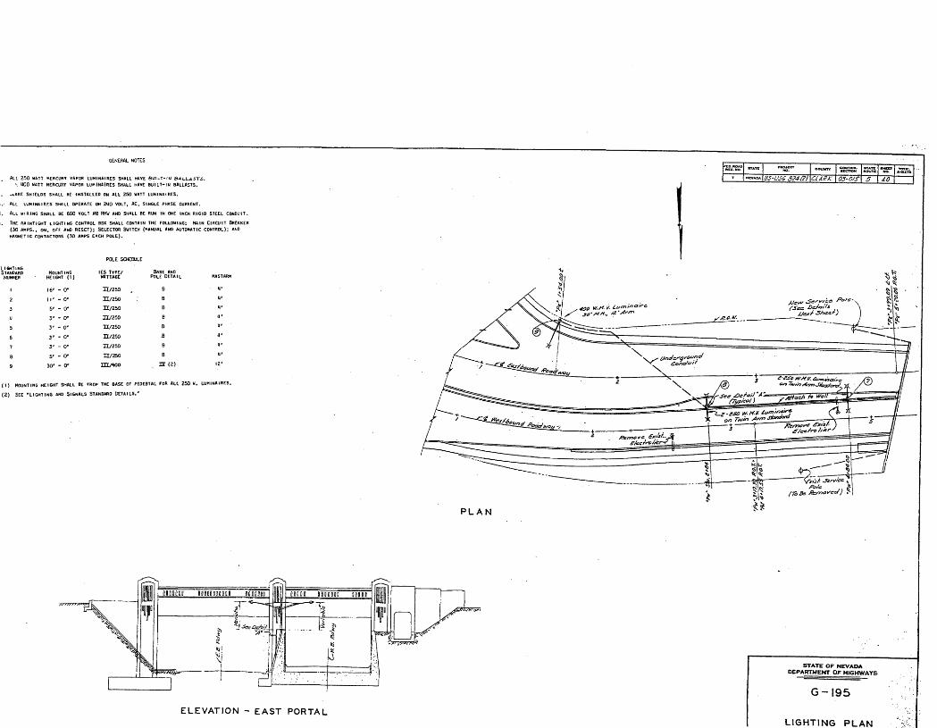
GENERAL NOTES
ALL LUMINAIRES SHALL OPERATE ON 2MO VOLT. AC, SINGLE PHASE CURRENT.
ALL HIKING SHALL BE 600 VOLT HB RHH AND SHALL BE RUN IN ONE INCH RIGID STEEL CONDUIT.
THE RAINTIGHT LIGHTING CONTROL BOX SHALL CONTAIN THE FOLLOWING: MAIN CIRCUIT BREAKER
(30 AMPS., ON, OFF AND RESET); SELECTOR SWITCH (HANUAl AND AUTOMATIC CONTROL); AND
LIGHTING STANDARD
NUMBER
1
2
3
.u
°>
6
7
a9
MOUNTING HEIGHT (1)
16'
II'
5'
V3'
3'
3 1
5'
30'
- o-- o-- 0"
- or-.or- 0'
- 0"
- or- o-
POLL SCHEDULE
IES TYPE/ WATTAGE
H/250
H/250
H/250
H/25D
H/250
n/250
H/250
H/250
ro/wo
(1) MOUNTING HEIGHT SHALL BE FRO* THE BASE OF PEDESTAL TOR ALL 250 «. LUHINAIRES.
(2) SEE 'LIGHTING AND SIGNALS STANDARD DETAILS.'
""'" US-USG £^•f&l CiAZK 03-OtS 5
PLAN
ELEVATION - EAST PORTAL
STATE OF NEVADA DEPARTMENT OF HIGHWAYS
G-195
LIGHTING PLAN
NFS Form 10-900-a (8-86)
0MB No. 1024-0018
United States Department of the Interior National Park Service
NATIONAL REGISTER OF HISTORIC PLACES CONTINUATION SHEET
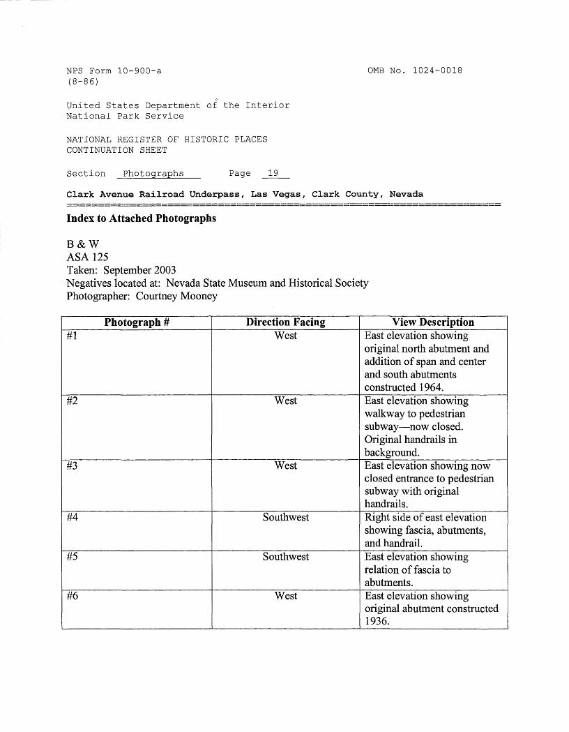
Section Photographs Page 19
Clark Avenue Railroad Underpass, Las Vegas, Clark County, Nevada
Index to Attached Photographs
B&WASA 125Taken: September 2003Negatives located at: Nevada State Museum and Historical SocietyPhotographer: Courtney Mooney
Photograph # Direction Facing View Description#1 West East elevation showing
original north abutment and addition of span and center and south abutments constructed 1964.
#2 West East elevation showing walkway to pedestrian subway—now closed. Original handrails in background.
#3 West East elevation showing now closed entrance to pedestrian subway with original handrails.
#4 Southwest Right side of east elevation showing fascia, abutments, and handrail.
#5 Southwest East elevation showing relation of fascia to abutments.
#6 West East elevation showing original abutment constructed 1936.
NFS Form 10-900-a (8-86)
0MB No. 1024-0018
United States Department of the Interior National Park Service
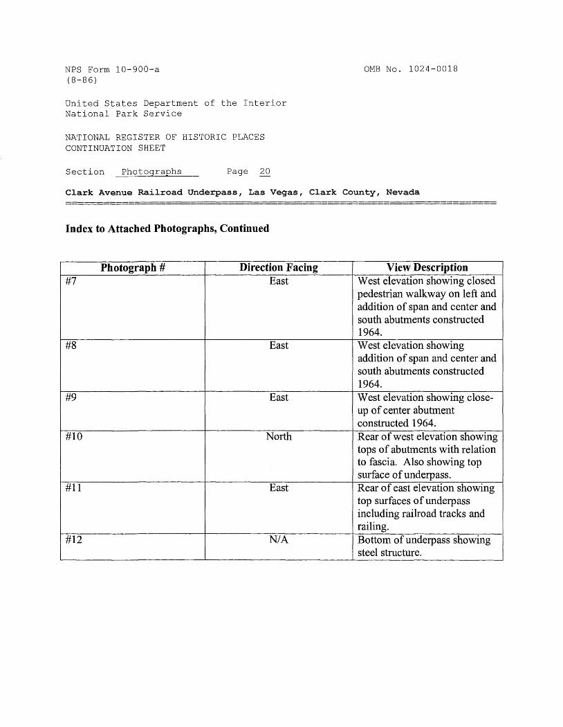
NATIONAL REGISTER OF HISTORIC PLACES CONTINUATION SHEET
Section Photographs Page 20
Clark Avenue Railroad Underpass, Las Vegas, Clark County, Nevada
Index to Attached Photographs, Continued
Photograph ##1
m
#9
#10
#11
#12
Direction FacingEast
East
East
North
East
N/A
View DescriptionWest elevation showing closed pedestrian walkway on left and addition of span and center and south abutments constructed 1964.West elevation showing addition of span and center and south abutments constructed 1964.West elevation showing close- up of center abutment constructed 1964.Rear of west elevation showing tops of abutments with relation to fascia. Also showing top surface of underpass.Rear of east elevation showing top surfaces of underpass including railroad tracks and railing.Bottom of underpass showing steel structure.