nvis fact sheet mvg 9 – melaleuca forests and woodlands · nvis fact sheet mvg 9 – melaleuca...
TRANSCRIPT

environment.gov.au
SSD
18I.0
117
NVIS Fact sheetMVG 9 – Melaleuca forests and woodlandsAustralia’s native vegetation is a rich and fundamental element of our natural heritage. It binds and nourishes our ancient soils; shelters and sustains wildlife, protects streams, wetlands, estuaries, and coastlines; and absorbs carbon dioxide while emitting oxygen. The National Vegetation Information System (NVIS) has been developed and maintained by all Australian governments to provide a national picture that captures and explains the broad diversity of our native vegetation.
This is part of a series of fact sheets which the Australian Government developed based on NVIS Version 4.2 data to provide detailed descriptions of the major vegetation groups (MVGs) and other MVG types. The series is comprised of a fact sheet for each of the 25 MVGs to inform their use by planners and policy makers. An additional eight MVGs are available outlining other MVG types.
For more information on these fact sheets, including its limitations and caveats related to its use, please see: ‘Introduction to the Major Vegetation Group (MVG) fact sheets’.
OverviewTypically, vegetation areas classified under MVG 9 – Melaleuca forests and woodlands:
• feature canopy dominated by Melaleuca species with a forest or woodland habitat
• its preferred common name for the larger species with the appropriate bark character is “paperbark” with some qualifying adjective
• its common species include the broad-leaved paperbark (Melaleuca viridiflora), weeping paperbark (M. leucadendra), blue paperbark (M. dealbata), swamp paperbark (M. rhaphiophylla), paperbarked tea-tree (M. quinquenervia), and moonah (M. lanceolata)
• are distributed in tropical northern Australia extending to warm temperate latitudes on sandplains or depositional plains and along eastern coastal and near coastal Australia in inundated areas e.g. along watercourses, in dune swales and swamps
• occupy a range of wetland and riparian habitats
• often occurs as small areas in mosaics of wetland vegetation types or as narrow bands fringing watercourses
• features fire-prone ecosystems in dry seasons.
(Banner Photo) Melaleuca forest, north of Grafton, NSW (Photo: M. Fagg)

environment.gov.au
Facts and figures
Major Vegetation Group MVG 9 - Melaleuca forests and woodlands
Major Vegetation Subgroups 15. Melaleuca open forests and woodlands
Typical NVIS structural formations
Closed forest (mid, low)
Open forest (mid, low)
Woodland (mid, low)
Number of IBRA regions 45
Most extensive in IBRA region
(Est. pre-1750 and present)
Gulf Plains (Qld, NT)
Estimated pre-1750 extent (km2)
84 917
Present extent (km2) 81 422
Area protected (km2) 11 277
Structure and physiognomy• The tree canopy varies with hydrological conditions from
five m to 20 m tall. Canopy cover also varies from sparse in some savanna wetlands to dense in forested wetlands, where projective foliage cover may exceed 70 per cent.
• Leaves in the canopy are sclerophyllous, vertically or obliquely oriented and range in size from nanophyll (0.25 – 2.5 cm2) to microphyll (2.5 – 20 cm2).
• In tropical areas Eucalyptus, Corymbia or Terminalia species may occur as emergents or subdominants within the lower canopy.
• In temperate areas, sclerophyllous shrubs may occur in the understorey, depending on hydrological conditions and the density of the tree canopy.
• The shrub layer in most forms of this MVG is sparse.
• The ground layer can be dense to sparse and dominated by graminoids with forbs and ferns less frequent.
Litchfield National Park, NT (Photo: NT, P&WC)
environment.gov.au
Indicative flora• Dominance by species of Melaleuca is the uniting
feature of this group, with a few such as Melaleuca quinquenervia, M. leucadendra and M. viridiflora widespread. However, species composition varies geographically.
• The northern Australian melaleucas are dominated by broad-leaved paperbark (Melaleuca viridiflora), weeping paperbark (M. leucadendra), silver paperbark (M. argentea), blue paperbark (M. dealbata) and yellow-barked paperbark (M. nervosa) with forb and grassy understoreys. Other species in the Northern Territory include M. citrolens, M. cajuputi, M. stenostachya, M. minutifolia, M. acacioides and in Queensland, M. tamariscina, M. bracteata, M. stenostachya, M. saligna, M. arcana, M. clarksonii, M. citrolens, M. foliolosa and M. fluviatilis.
• In southern and eastern Australia the melaleucas are confined mainly to the wetter watercourses and swamps with the paperbarked tea-tree (M. quinquenervia), the most widespread coastal species. In New South Wales additional coastal woodland and forest species include M. decora, M. sieberi, M. nodosa and M. linariifolia.
• In Western Australia, Melaleuca forests and woodlands are restricted to pockets in specific sites, such as the swamp paperbark (M. preissiana) on sub-coastal swamp areas and M. rhaphiophylla on creek lines and watercourses.
• Very small coastal areas in South Australia and Victoria include M. lanceolata (moonah), M. halmaturorum subsp. halmaturorum, M. brevifolia, and M. lanceolata subsp. Lanceolata.
• Associated species vary throughout Australia, depending on the underlying site conditions. In drier areas of Australia, emu bushes (Eremophila spp.) and other shrubs dominate the understorey, whilst in damper and wetter areas in the east and south the understorey is dominated by sedges and aquatics.
Environment• In seasonally inundated wetlands, depositional
plains, sandplain depressions and riparian zones of lowland landscapes.
• Climatic conditions vary from tropical monsoonal to warm temperate with summer maximum rainfall, on average 800 - 2000 mm per annum.
• Typically with deep sandy, organic soils, with low clay content.
• Generally coastal or sub-coastal landscapes.
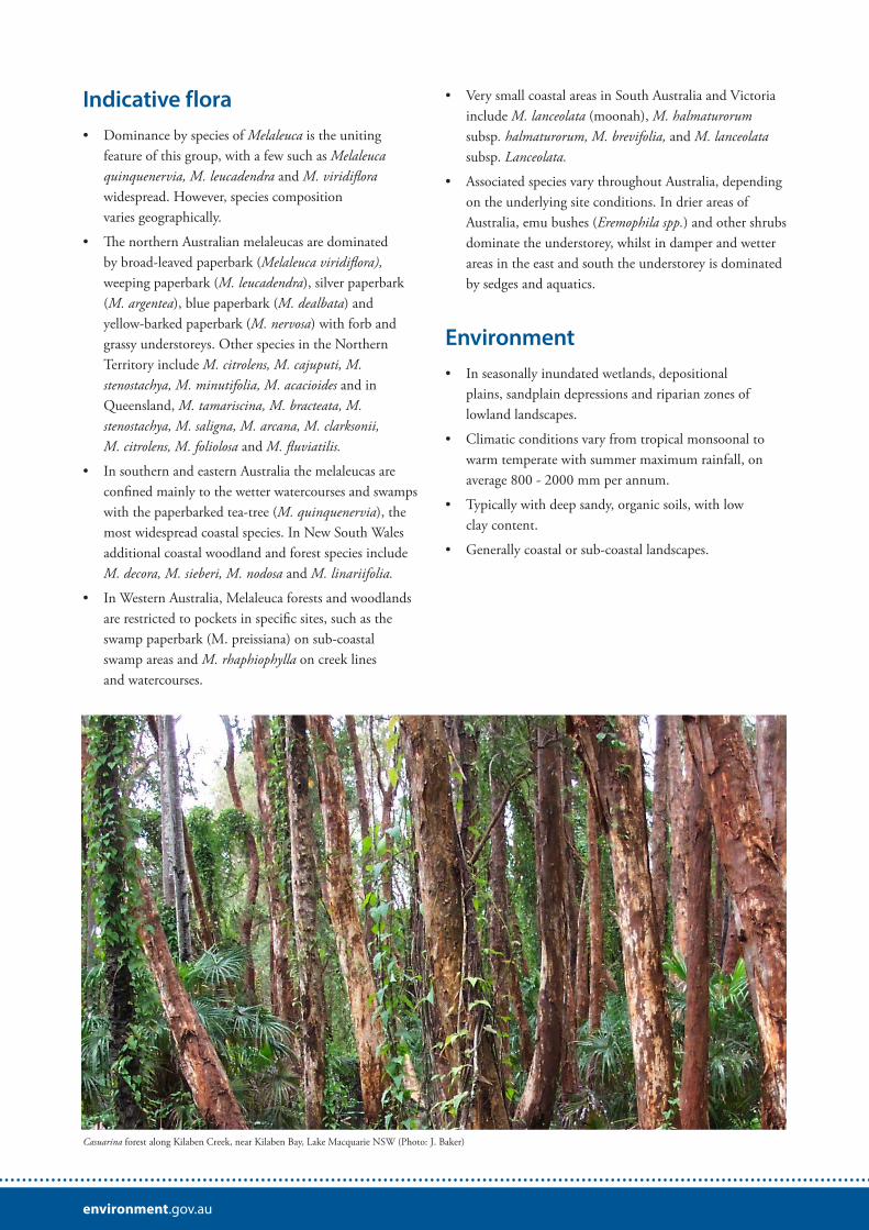
Casuarina forest along Kilaben Creek, near Kilaben Bay, Lake Macquarie NSW (Photo: J. Baker)

environment.gov.au
Geography• Largely restricted to higher rainfall areas of tropical
Australia, but extending down the east coast to warm temperate latitudes where it becomes increasingly restricted.
• Tropical (northern) Melaleuca forests and woodlands can occur on sandplains, riparian zones and floodplains:
– On sandplains - extend across the tropics through Western Australia and Northern Territory but are most extensive in north Queensland on southern Cape York;
– In riparian zones - occur along streams from the north-western Kimberley in Western Australia to Cape York in Queensland;
– On floodplains - occur primarily in the Top End of the Northern Territory and around Cape York. There may be small occurrences in the northern Kimberley region.
• In the south, Melaleuca forests and woodlands typically occur on seasonally inundated sandplains extending from north-east Queensland to central New South Wales coast, becoming more restricted south from the Morton Bay region of south-east Queensland. These may occur in brackish as well as freshwater conditions.
• Largest area occurs in Queensland (59 143 km2).
The image below outlines the location of this MVG group in Australia.
Change• Approximately four per cent (>3 500 km2) of the
estimated pre-1750 extent cleared accounting for 0.3 per cent of total clearing in Australia.
• In coastal areas in the subtropical and temperate portions of its distribution, MVG 9 has been extensively cleared and in-filled for coastal development, intensive agricultural development or urban expansion.
• Coastal floodplains and associated sandplains have been the most targeted areas for intensive agriculture (cropping and grazing), particularly where the soils are rich in humus.
• Many of the early settlers grew potatoes in the seasonally drier parts of melaleuca swamps to sustain their small settlements, but recent agricultural production is focussed on sugar cane, dairy and beef.
• Urban expansion has occurred most rapidly on the coasts of south-east Queensland and north-east New South Wales.
• Selected swamps have also been mined for peat and other materials used in horticulture.
• Drainage of these systems has a high likelihood of disturbing acid sulphate soils, resulting in the liberation of organic acid compounds into waterways.
• Areas have been cleared for grazing and cropping (e.g. for sugar cane on the Herbert floodplain).

environment.gov.au
• Many melaleuca wetlands in coastal Queensland and northern New South Wales have been altered by changes to natural drainage patterns and waterway flows (e.g. construction of floodgates as part of floodplain management programs of the 1970s and 1980s).
Key values• Biodiversity including locally unique ecological
communities and threatened species such as swamp orchids.
• Ecosystem functions including primary production for aquatic food webs.
• Drought refuges for water-dependent fauna.
• Mitigation of acid sulphate soils.
• Maintenance of water quality in streams and estuaries.
• Flood mitigation and nutrient sinks—a key part of floodplain systems.
• Honey and florist products—flowers and foliage.
List of key management issues• Maintenance of hydrological conditions that support
these communities.
• Clearing and edge effects from adjoining land uses in fragmented landscapes.
• Isolation of fauna populations by barriers such as roads or powerlines.
• Weed control (e.g. aggressive weeds such as arum lily).
• Rehabilitation as part of improved floodplain management.
• Long term monitoring to inform future management-strategies.
ReferencesAustralian Surveying and Land Information Group (1990) Atlas of Australian Resources. Volume 6 Vegetation. AUSMAP, Department of Administrative Services, Canberra, 64pp. & 2 maps.
Beadle N.C.W. (1981) The Vegetation of Australia. Cambridge Univ. Press, Cambridge, 690pp.
Boland D.J., Brooker M.I.H., Chippendale G.M., Hall N., Hyland B.P.M., Johnston R.D., Kleinig D.A. and Turner J.D. (1994) Forest Trees of Australia. CSIRO Publishing, Collingwood, Australia
Brock J (2001) Native Plants of Northern Australia pp. 21 – 23. Reed New Holland, Sydney.
Keith D. (2004) Ocean Shores to Desert Dunes. The native vegetation of New South Wales and the ACT. Department of Environment and Conservation (NSW), Hurstville.
Neldner, V.J., Niehus, R.E., Wilson, B.A., McDonald, W.J.F. and Ford, A.J. (2014) The Vegetation of Queensland. Descriptions of Broad Vegetation Groups. Version 1.1. Queensland Herbarium, Department of Science, Information Technology, Innovation and the Arts
National Land and Water Resources Audit (2001) Australian Native Vegetation Assessment 2001. National Land and Water Resources Audit, Canberra, 332pp.
Data sourcesInterim Biogeographic Regionalisation for Australia (IBRA), Version 7.
National Vegetation Information System, Version 4.2.
Collaborative Australian Protected Areas Database – CAPAD 2014 – Terrestrial.
© Commonwealth of Australia, 2017.
This fact sheet is licensed by Commonwealth of Australia under a Creative Commons Attribution 4.0 International licence.
The views and opinions expressed in this publication are those of the authors and do not necessarily reflect those of the Australian Government or the Minister for the Environment and Energy.