nyora residential development plan (dpo5)
TRANSCRIPT

Nyora Residential Development Plan (DPO5) 18a Davis Street & 32 Grundy Avenue, Nyora
July 2018

Beveridge Williams
DOCUMENT CONTROL DATA
Beveridge Williams
Melbourne Office
1 Glenferrie Road
Malvern Vic 3144
PO Box 61
Malvern Vic 3144
Tel: (03) 9524 8888
Fax: (03) 9524 8899
www.beveridgewilliams.com.au
Title Nyora Residential Development Plan (DPO5)
Author AB / PD
Checked AB
Project Manager
AB
Synopsis Development plan in accordance with South Gippsland Planning Scheme Development Plan Overlay Schedule 5.
Reference: 1601444
Client: Kufner Textiles (Australia) P/L
Revision Table
Rev Description Date Authorised
A Internal 5.7.18 AB
B Final
Distribution Table
Date Revision Distribution
Copyright Notice
© Copyright – Beveridge Williams & Co P/L
Users of this document are reminded that it is subject to copyright. This document should not be reproduced, except in full and with the permission of Beveridge Williams & Co Pty Ltd

Beveridge Williams 1
CONTENTS
1 INTRODUCTION ................................................................................................. 3
2 BACKGROUND ................................................................................................... 4
2.1 STRATEGIC CONTEXT ................................................................................................ 4
2.2 SITE CONTEXT ........................................................................................................... 5
SUBJECT SITE .................................................................................................................... 5
SURROUNDING AREA ......................................................................................................... 8
3 STRATEGIC PLANNING CONTEXT ...................................................................... 10
3.1 NYORA STRUCTURE PLAN ....................................................................................... 10
3.2 NYORA DEVELOPMENT STRATEGY ......................................................................... 10
3.3 CLAUSE 21.15-5 LOCAL AREAS – NYORA ................................................................ 11
4 THE PROPOSED DEVELOPMENT PLAN .............................................................. 13
4.1 LAND USE AND SUBDIVISION ................................................................................. 13
4.2 LOT YIELD ................................................................................................................ 13
4.3 LOT DIVERSITY ........................................................................................................ 13
4.4 ROAD INFRASTRUCTURE ........................................................................................ 14
4.5 STORMWATER MANAGEMENT .............................................................................. 14
4.6 OPEN SPACE ............................................................................................................ 14
4.7 STAGING ................................................................................................................. 15
4.8 ABORIGINAL CULTURAL HERITAGE......................................................................... 15
4.9 TRAFFIC IMPACT ASSESSMENT REPORT ................................................................. 16
4.10 FLORA AND FAUNA ASSESSMENT .......................................................................... 16
4.11 GIANT GIPPSLAND EARTHWORM TARGETED SURVEY ........................................... 17
4.12 STORMWATER MANAGEMENT STRATEGY ............................................................. 18
5 DEVELOPMENT PLAN OVERLAY SCHEDULE 5 (DPO-5) ....................................... 19
SITE ANALYSIS AND DESIGN RESPONSE ................................................................................. 19
ROAD AND PEDESTRIAN NETWORK ..................................................................................... 19
STORMWATER / DRAINAGE .............................................................................................. 20
OFF-SITE INFRASTRUCTURE PROVISION / DEVELOPER CONTRIBUTION ....................................... 21
ENVIRONMENT ............................................................................................................... 21
URBAN DESIGN .............................................................................................................. 21
GENERAL....................................................................................................................... 22
6 CONCLUSION ................................................................................................... 23
Beveridge Williams 2
APPENDICES
APPENDIX A. CERTIFICATE OF TITLE
APPENDIX B. DEVELOPMENT PLAN LAYOUT
APPENDIX C. SITE CONTEXT PLAN
APPENDIX D. SITE ANALYSIS PLAN
APPENDIX E. DESIGN RESPONSE PLAN
APPENDIX F. TRAFFIC IMPACT ASSESSMENT REPORT
APPENDIX G. STORMWATER MANAGEMENT STRATEGY
APPENDIX H. ABORIGINAL CULTURAL HERITAGE ADVICE
APPENDIX I FLORA AND FAUNA ASSESSMENT

Beveridge Williams 3
1 INTRODUCTION
The Development Plan Schedule 5 applies to land comprising 7 lots within the Nyora township. This Plan has been prepared on behalf of two owners with consideration of four titles, 18A Davis Street (comprising 3 lots) and 32 Grundy Avenue, which are to be the subject of future subdivision applications. The balance lots, five in total, which address Cornish’s Road are more recently developed, and in agreement with Council were considered not relevant to include in any future development strategy for this precinct, thus have not been included within this Development Plan.
The Development Plan (DP) has been prepared in accordance with the relevant provisions of the South Gippsland Planning Scheme including Schedule 5 of the Development Plan Overlay and is informed by the site’s key features and the characteristics of the surrounding environment. The Plan is generally in accordance with the Nyora Structure Plan (2013) and the Nyora Development Strategy (2016). The Development Plan provides the guidance to create a new residential area that will feature varied lot sizes, a safe movement network with access onto Davis Street and Grundy Avenue, together with pedestrian walkways and public open space to facilitate pedestrian movement between the existing and proposed residential areas.
This Development Plan includes the following:
• Project background;
• Context: the policy and physical site context;
• A detailed site analysis;
• A detailed design response;
• An overview of the Development Plan, including the key development features, primary infrastructure, stormwater management, environment and design considerations.
Future planning applications to subdivide or develop the land must be prepared generally in accordance with this Development Plan.

Beveridge Williams 4
2 BACKGROUND
2.1 Strategic Context
The site is subject to the provisions of the South Gippsland Planning Scheme (the planning scheme) and other strategic planning documents. The land was previously zoned Township Zone, an urban zone for residential uses, but has more recently been updated to the General Residential Zone - Schedule 1 with application of the Development Plan Overlay Schedule 5 to reflect the land use framework plan contained within the Nyora Structure Plan. With consideration of the design matters outlined in Schedule 5 we submit the resultant Development Plan presents an urban design that ensures that future development of the site is sympathetic to the surrounding environment and the existing rural character of the area. State policy Clause 15: Building Environment and Heritage and local policy Clause 21.15-5: Local areas - Nyora are particularly relevant to this Development Plan and have informed the design.
Clause 15 seeks to ensure all new land use and development appropriately responds to its landscape, valued built form and cultural contexts. The clause broadly aims to ensure planning achieves a high quality urban design and architecture that:
• Contributes positively to local urban character and sense of place.
• Reflects the particular characteristics, aspirations and cultural identity of the community.
• Enhances liveability, diversity, amenity and safety of the public realm.
• Promotes attractiveness of towns and cities within broader strategic contexts.
• Minimises detrimental impact on neighbouring properties.
Clause 21.15-5 establishes the future role and character direction for Nyora, and notes the following:
Nyora is a small rural township that is the closest South Gippsland Shire town to metropolitan Melbourne. Nyora is seen as a desirable lifestyle location due to its rural character and proximity to major urban centres. It is experiencing strengthening levels of population growth. Planning for the town and new residential areas needs to accommodate new infrastructure and commercial and community services that support the community’s social and employment needs whilst respecting the town’s rural character.
Key objectives of this Clause, relevant to this Development Plan include:
• Ensure the use and development of land is in accordance with the strategic directions in the Nyora Framework Plan.
• Promote residential development that complements the small rural township of the area.
• Protect the natural environmental qualities and landscape values of the Future Residential Areas and the Long Term Residential Areas.
• Pedestrian access and amenity will be facilitated by the development of footpaths, shared paths, continuous weather protection, active frontages and articulated facades along pedestrian connections.
• Development will provide for physical and visual linkages to and from the surrounding residential areas.
Beveridge Williams 5
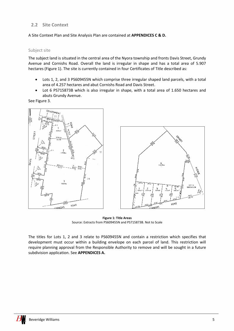
2.2 Site Context
A Site Context Plan and Site Analysis Plan are contained at APPENDICES C & D.
Subject site
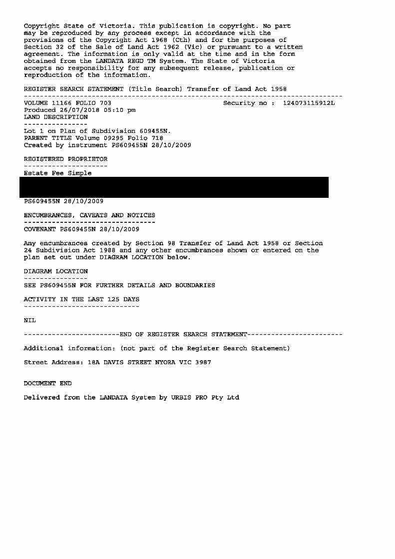
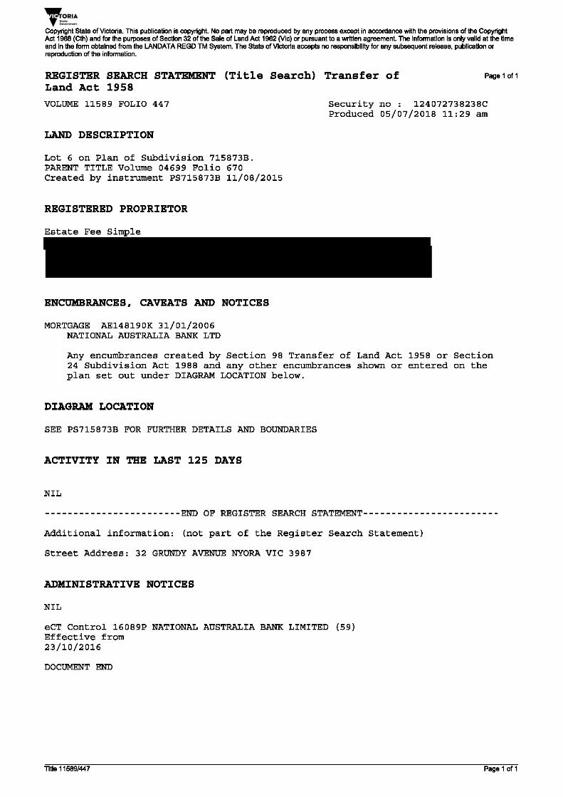
The subject land is situated in the central area of the Nyora township and fronts Davis Street, Grundy Avenue and Cornishs Road. Overall the land is irregular in shape and has a total area of 5.907 hectares (Figure 1). The site is currently contained in four Certificates of Title described as:
• Lots 1, 2, and 3 PS609455N which comprise three irregular shaped land parcels, with a total area of 4.257 hectares and abut Cornishs Road and Davis Street.
• Lot 6 PS715873B which is also irregular in shape, with a total area of 1.650 hectares and abuts Grundy Avenue.
See Figure 3.
Figure 1: Title Areas Source: Extracts from PS609455N and PS715873B. Not to Scale
The titles for Lots 1, 2 and 3 relate to PS609455N and contain a restriction which specifies that development must occur within a building envelope on each parcel of land. This restriction will require planning approval from the Responsible Authority to remove and will be sought in a future subdivision application. See APPENDICES A.

Beveridge Williams 6
Figure 2: Building Envelope Restriction & Government Road Source: excerpt from PS609455N. Not to Scale
Lots 1 and 2 on PS609455N adjoin an unmade Government Road located along the eastern boundary of Lot 1 and traversing the central part of Lot 2. The Landowners had previously commenced negotiations with the Crown to close and subsequently purchase the superfluous road reserve and consolidate it within the subject site. The closure has not been effected and the opportunity exists to resolve an appropriate design outcome with the resubdivision of the land. See Figure 2. Cornishs Road abuts the southern boundary of the site for a length of approximately 110 metres and is categorised as a local road. Davis Street located to the west of the site currently provides three points of access into the land. Davis Street is a designated Road Zone Category 1 road comprising a sealed carriageway width of approximately 8 metres within an overall reservation of 30 metres. Grundy Avenue adjoins the north eastern boundary of the site for a length of approximately 113 metres and is a local road with a sealed carriageway of approximately 7 metres within the vicinity of the site.

Beveridge Williams 7
Figure 3: Title description Source: NearMap. Not to Scale
LOTS 1, 2 & 3 PS609455N The site is vacant and predominantly cleared. There are a number of mature remnant trees on the site in addition to planted exotic windbreaks and some specimen trees (Figure 4). The site also comprises sheds and a small dam on the land. A portion of the site is used as a small vegetable garden and there are cattle grazing on the balance of the land. The land generally falls from east to west with an approximate 1 in 15 grade constant throughout the whole site. The site slopes in two directions, from east to north-west and south-west. The boundaries of the site and individual paddocks are generally delineated with rural post and wire, or typical paling fencing. LOT 6 PS715873B The site contains an existing dwelling, which is located on the high point, and multiple outbuildings (Figure 2). A row of trees form an avenue along both sides of the driveway and there are existing trees and established garden surrounding the dwelling. As well as trees situated along the boundary of the site abutting Grundy Avenue. The land falls in both a southerly and northerly direction towards the abutting road ways.
Beveridge Williams 8
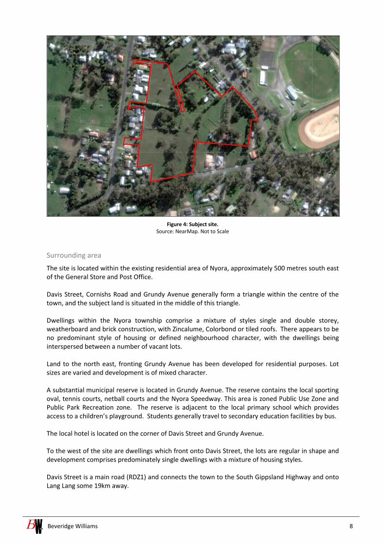
Figure 4: Subject site. Source: NearMap. Not to Scale
Surrounding area
The site is located within the existing residential area of Nyora, approximately 500 metres south east of the General Store and Post Office. Davis Street, Cornishs Road and Grundy Avenue generally form a triangle within the centre of the town, and the subject land is situated in the middle of this triangle. Dwellings within the Nyora township comprise a mixture of styles single and double storey, weatherboard and brick construction, with Zincalume, Colorbond or tiled roofs. There appears to be no predominant style of housing or defined neighbourhood character, with the dwellings being interspersed between a number of vacant lots. Land to the north east, fronting Grundy Avenue has been developed for residential purposes. Lot sizes are varied and development is of mixed character. A substantial municipal reserve is located in Grundy Avenue. The reserve contains the local sporting oval, tennis courts, netball courts and the Nyora Speedway. This area is zoned Public Use Zone and Public Park Recreation zone. The reserve is adjacent to the local primary school which provides access to a children’s playground. Students generally travel to secondary education facilities by bus. The local hotel is located on the corner of Davis Street and Grundy Avenue. To the west of the site are dwellings which front onto Davis Street, the lots are regular in shape and development comprises predominately single dwellings with a mixture of housing styles. Davis Street is a main road (RDZ1) and connects the town to the South Gippsland Highway and onto Lang Lang some 19km away.

Beveridge Williams 9
Immediately south of the subject land is Cornishs Road which is partially constructed with a sealed carriageway and court bowl access from Grundy Avenue and an unsealed carriageway from Davis Street. There is no through road access.

Beveridge Williams 10
3 STRATEGIC PLANNING CONTEXT
3.1 Nyora Structure Plan
The Nyora Structure Plan (2013) sets the direction for the town’s growth and development to the year 2025 and beyond.
The Structure Plan identifies the site as residential land and seeks to ensure that residential development in proximity to the town centre can accommodate a range of housing types to complement the existing predominately single detached dwellings on larger sites.
Figure 5: Nyora Land Use Framework Source: Nyora Structure Plan, Not to Scale.
3.2 Nyora Development Strategy
The Nyora Development Strategy (2016) builds on the key recommendations of the Nyora Structure Plan June 2013. The Nyora Development Strategy looks in more detail at the infrastructure needed (drainage, traffic and community facilities) and how development should occur.
Within the Nyora Development Strategy (2016) the subject site is entirely located within Precinct B and identifies key vehicular and pedestrian linkages through the site and indicative timeframes for the provision of infrastructure (Figure 6).
Figure 6: Precint B Source: Nyora Development Strategy, 2016

Beveridge Williams 11
Discussions with Council have resulted in a variation to the key east -west connections through the site. This is discussed further in Section 4.9 – Road Infrastructure.
3.3 Clause 21.15-5 Local Areas – Nyora
Clause 21.15-5 of the South Gippsland Planning Scheme implements the objectives and strategies for Nyora. The proposed development plan accords with the following key objectives and strategies: Local area implementation
• Ensure that any proposed use and development of land in Nyora is generally in accordance with the Nyora Framework Plan. See Figure 7.
Settlement
• Ensure that any subdivision in the Future Residential Areas or Long Term Residential Areas identified in the Nyora Framework Plan does not occur until:
o Reticulated sewerage can be provided to the land o A Development Plan Overlay has been prepared which provides for the integrated
development of the entire land having regard to environmental and landscape constraints and opportunities and the town’s existing and preferred rural township character.
• Encourage infill development in the residential zoned land adjoining the Town Centre in a coordinated and integrated manner.
• Discourage low density and rural residential development close to the township, unless the land has constraints that make it inappropriate for higher density development.
Landscape and built form
• Promote residential development that complements the small rural township character of the area.
• Ensure vegetation continues as the dominant landscape feature. Infrastructure
• Create an integrated network of pedestrian and bicycle paths linking features and facilities in and around the township in accordance with the directions of Council’s Paths and Trails Strategy 2010 (or as amended) and Melbourne Water’s Shared Pathway Guidelines (January 2009) as amended.
• Where residential development intensification is to occur in established areas (particularly land bounded by Hewson St, Davis St, Walters Rd and Lang Lang Poowong Road), promote development that integrates roads, pathways and utility infrastructure with adjoining areas.

Beveridge Williams 12
Figure 7: Nyora Framework Plan
Source: South Gippsland Planning Scheme, Not to Scale

Beveridge Williams 13
4 THE PROPOSED DEVELOPMENT PLAN
The Development Plan (DP) identifies the form and conditions for subdivision and future development of the site. The plan has been informed by a variety of technical assessments which provide guidance in regard to the extent and form of development suitable for the subject land. This plan is generally in accordance with the Nyora Structure Plan (2013) and the Nyora Development Strategy (2016).
Following approval of this Development Plan, planning permit applications will be lodged for each of the two sites seeking approval for multi lot subdivision and associated works and will need to be generally consistent with this Development Plan.
4.1 Land Use and Subdivision
The proposed Development Plan layout (DP) is contained in APPENDIX B. The plan provides 56 residential lots with a variety of sizing and identifies the proposed internal road network, linkages to the existing road network, a future medium density site and the location and size of open space reserves.
This Development Plan has been informed by the site context and existing features. A Design Response Plan is contained at APPENDIX E. detailing this information.
4.2 Lot Yield
The DP and Indicative Subdivision Plan will provide for 56 residential allotments that range in size from 510m² -1495m². The proposed density equates to 10.4 lots per net developable hectare with an average lot size across the site of 802m². This is exclusive of the future medium density site.
The subject land is located centrally within the Nyora township. The proposed lot yield is generally consistent with conventional lot sizes in non-metropolitan areas and will provide for residential sized lots that are in keeping with the character of the existing Nyora township. Furthermore, the lot yield is generally consistent with the density outlined in the Nyora Development Strategy for precinct B. The future development of the medium density site will achieve further variety of product and ultimately increase the overall yield and reduce the average lot size ensuring the site is achieving the best urban outcome whilst still keeping consistency with the general characteristics of the Township.
4.3 Lot Diversity
As detailed above, the proposed DP will provide for 56 residential allotments that range in size from 510m² -1495m² with an average lot size of 802m². The proposal identifies a super-lot in the north west portion of the site. This lot requires a site specific design response and will be the subject of a future permit request for residential development. It is not included in the summary of the proposed lot sizes provided below:
Table 1: Summary of overall residential lots
Lot size Number of lots
500-599 m² 4
600 – 699m² 12
700 – 799m² 16
800 – 899m² 10

Beveridge Williams 14
900 – 999m² 8
>1000m² 6
Total 56
4.4 Road Infrastructure
A traffic and transport assessment has informed the Development Plan layout. The internal road layout provides a series of roads designed in accordance with their function. The cross sections are of sufficient width to facilitate the provision of on street parking, pedestrian paths, bicycle paths and public transport. The street network ensures safe movement and ease of access both internally and with surrounding uses.
The proposed internal road network will consist of 3 separate Access Streets of 16m in width (in accordance with the IDM) with court bowl treatments to allow for vehicle turning movements. Two of these streets will be accessed from Davis Street and the third from Grundy Avenue. The internal road network will provide access to the majority of the lots activating all frontages. A small number (five) of lots will address Cornishs Road along the southern boundary, with their access provided from this frontage. Additionally, two lots will obtain access of Grundy Avenue along the eastern boundary of the site.
Development of the Superlot will form the subject of a future application, the access to this site is afforded from Davis Street.
Further detail regarding traffic and access is contained in section 4.9 of this report and is provided at APPENDIX F.
4.5 Stormwater Management
A Stormwater Management Strategy (SWMS) has been prepared in support of the Development Plan. The SWMS demonstrates how the proposed development can meet the Urban Stormwater Best Practice Environmental Management Guidelines (BPEMG). Stormwater discharges from the proposed subdivision shall be to the satisfaction of South Gippsland CMA, South Gippsland Shire Council and other relevant authorities.
This SWMS has been proposed to follow the existing natural features of the pre-developed site.
For stormwater quantity management, it is proposed to provide separate detention storage to cater for the flow from the development site. The strategy is to provide stormwater detention boxes under the main roads to detain the Q10 post development site flow to pre-development level. The flow from the Superlot will be managed by its future developer.
For stormwater quality management, it is proposed a Humeceptor unit within road reserve to provide the stormwater treatment for the development site. The treatment system consisting of rainwater tanks in each individual lot is also provided
Further detail regarding the SWMS is contained in Section 4 of this report. A copy of the Stormwater Management Strategy is provided at APPENDIX G.
4.6 Open Space
The Development Plan proposes a centrally located open space reservation which comprises an area of 1326m2.. This parcel is partly located on each site with 550m2 being contributed from 18A Davis

Beveridge Williams 15
Street and 776m2 from 32 Grundy Avenue. The proposed public open space would provide a reservation for both the future residents and existing nearby residents to access a new local park and would improve connectivity and permeability through the site. It has been located on the highpoint of the sites to take advantage of the viewlines to the west and south. The street network will facilitate movement between Davis Street and Grundy Avenue for pedestrians and cyclists only, and specifically has been resolved to restrict vehicle movements.
4.7 Staging
No staging of the subdivision is proposed within this Development Plan given the relatively small size of the site it is assumed it will be developed in its entirety in one stage. It is noted that both land owners intend to apply for their subdivision permits separately so effectively there will be two stages and a third stage with the development of the Superlot as outlined below.
The medium density site/superlot set aside will form the subject of a separate permit application. It is assumed this will be developed independently of the balance lots.
Technical investigations
A series of reports were prepared in support of the proposed Development Plan and to help inform the design response for the subject site, including:
• Cultural Heritage – an assessment of the site’s cultural heritage sensitivity informed a Management Plan resolved for each site.
• Traffic Impact Assessment – an assessment of the traffic impacts resulting from the proposed development of overall site.
• Flora and Fauna Assessment identifying vegetation within and abutting the overall site (in adjoining roadways) which informed any regulatory implications.
• Giant Gippsland Earthworm Targeted Survey - an assessment of the subject land to identify any GGE populations and potential habitat is provided in the Flora and Fauna Assessment.
• Stormwater Management Plan for 18A Davis Street. A strategy for 32 Grundy Avenue will be prepared separately.
A summary of findings and implications for the site design are detailed below.
4.8 Aboriginal Cultural Heritage
Unearthed Heritage were engaged to provide an Aboriginal Cultural Heritage Management Plan for the subject site at 18A Davis Street and 32 Grundy Avenue, Nyora. Separate plans were prepared and approved for each site.
Three assessment types were undertaken as part of the Cultural Heritage Management Plan (CHMP) being:
• Desktop assessment
• Standard assessment (archaeological field survey)
• Complex Assessment (archaeological hand excavation)
Based on these assessments the subject site was identified as being of low scientific significance. One Aboriginal artefact site (VAHR 8021-0417) was located on the land. Three (3) management conditions and six (6) contingencies regarding Aboriginal Heritage are included in Part II of the CHMP. In summary they outlined the following:

Beveridge Williams 16
• VAHR 8021-0417
Other than management of the artefacts there is no further management of VAHR 8021-0417 required.
• Cultural heritage inductions
Aboriginal cultural heritage will be included within the project induction for staff responsible for, and for staff undertaking ground-disturbing works associated with this activity.
• Scheduled Compliance Reviews
Compliance reviews must be undertaken at the following times:
- Once prior to ground works disturbing
- Once during ground disturbing works
- Once at completion of activity
A Copy of the approved Cultural Heritage Management Plans are contained at APPENDIX H.
4.9 Traffic Impact Assessment Report
Beveridge Williams has prepared a Traffic Impact Assessment Report for the subject site at 18A Davis Street, Nyora & 32 Grundy Avenue and the proposal is considered appropriate from a Traffic Engineering Opinion for the following reasons:
• It is proposed to develop the subject site for the purposes of a residential subdivision comprising 56 dwellings and a 3,905m² superlot;
• Internal access roads will provide access to 49 of the dwellings via two access streets to Davis Street and one to Grundy Avenue;
• Of the remaining dwellings, 5 are proposed to gain access from Cornishs Road and 2 via Grundy Avenue;
• It is anticipated that the subject site will generate traffic at a rate of 9 vehicle movements per lot per day, equivalent to 504 vehicle movements per day;
• The anticipated daily traffic volumes within the internal road network are within the capacity of an Access Street and as such the proposed internal road network hierarchy is considered adequate:
• Anticipated increases in traffic volumes along Davis Street, Grundy Avenue and Cornishs Road are considered negligible and are unlikely to have a material impact on road network operations;
• The sight distances for the proposed intersections of the access roads with Davis Street and Grundy Avenue are acceptable.
• Two parcels of unencumbered passive open space will be provided centrally to the site and which will ultimately provide a pedestrian/cycling connection between Grundy Avenue and Davis Street.
A Copy of Traffic Impact Assessment Report is contained at APPENDIX F.
4.10 Flora and Fauna Assessment
Brett Lane & Associates undertook a flora and fauna assessment to determine whether any native vegetation occurred on the site or within abutting roadways where works may be required. The investigation was to provide information on the extent and condition of native vegetation in the

Beveridge Williams 17
study area according to Victoria’s Biodiversity assessment guidelines (DEPI 2013), as well as any potential impacts on flora and fauna matters listed under the state Flora and Fauna Guarantee Act 1988 and the Commonwealth Environment Protection and Biodiversity Conservation Act 1999. The report details the implications under the relevant national, state and local legislation and policy frameworks.
The study area was identified to support well-draining sedimentary soil on a gently undulating slope. A small dam was present within the Davis Street property and the closest major watercourse was the Bass River, located some 2.3 kilometres south of the site. Both properties would have supported horses and or livestock in the past and it was established that the majority of the vegetation consisted of planted and self-introduced recruited vegetation. Fauna habitat within the study area comprises of trees and shrubs , grazing paddocks and a farm dam. The habitat has been highly modified form its original state and it was considered suitable for common occurring native fauna and introduced fauna. The study area is fragmented from natural occurring reserves in the region.
The investigations addressed the policy matters outlined above matters and the 4 specific controls listed in the DPO5 and results identified one small patch of native remnant vegetation and three scattered trees were located within the boundaries of the subject land. Two of the scattered trees and the small patch of native remnant vegetation are located centrally within Lot 1 on PS609455. One scattered tree is located on Lot 6 PS715873.
It was resolved no listed flora or fauna species, or ecological communities will be impacted by the proposed development.
The proposed development will result in the following impacts:
• The removal of 0.017 hectares of native remnant patch vegetation in the form of Lowland Forest (EVC 16);
• The removal of three scattered trees; and
• A loss of a total extent of 0.228 hectares of native vegetation (equating to 0.044 Habitat Hectares and 0.007 General Biodiversity Equivalence Units).
The proposed development will incur the following regulatory implications:
• A planning permit under Clause 52.17 of the South Gippsland Planning Scheme will be required for the removal of native vegetation;
• A general offset of 0.010 general biodiversity equivalence units will be required to compensate for the removal of native vegetation. General offsets must be located within the Port Phillip and Westernport Catchment Management Area or the South Gippsland Shire and have a minimum strategic biodiversity score of 0.123; and
• Offsets must be secured before any native vegetation is removed.
The guidelines stipulate that the proposal will assessed under the low risk assessment pathway and would not trigger a referral to DELWP.
A Copy of the Flora and Fauna report is contained at APPENDIX I.
4.11 Giant Gippsland Earthworm Targeted Survey
The Flora and Fauna assessment undertaken by Brett Lane & Associates outlines the listed fauna species from the search region and the likelihood of the occurrence at the subject site at 18A Davis Street and 32 Grundy Avenue, Nyora.

Beveridge Williams 18
This report outlined that Giant Gippsland Earthworm are generally found in the deep blue-grey-clay like soils over cretaceous rocks in the western Strezlecki Ranges and in the alluvial soils in depositional zones to the north and south-west.
Considering different soil types occur at the subject site to where the Giant Gippsland Earthworm has been recorded in the surrounding region, it is concluded that there is no suitable habitat on the subject site and is unlikely to occur.
A Copy of the Flora and Fauna report is contained at APPENDIX I.
4.12 Stormwater Management Strategy
Beveridge Williams has prepared a Stormwater Management Plan (SWMP) for the subject site at 18A Davis Street, Nyora. This Strategy is preliminary only and subject to further changes dependant on the final size of the proposed lots and drainage reserve area. A separate strategy for the development at 32 Grundy Avenue will be prepared.
The strategy provides a methodology for the management of stormwater on the subject site which would result in:
• Volumes of stormwater detention requirements of 639 m3 for the development site will be
required to detain 1 in 10-year peak post development flow to pre-development level. This
volume will be catered by detention boxes located under the main road reserves of the
development site; and
• Stormwater quality treatment system required to meet BPMEG standard will be a Humeceptor unit located in the road reserve of the site and rainwater tanks within residential lots.
The above strategy can be implemented, and all of the South Gippsland CMA and Council’s development requirements can be achieved, with no net effect on the downstream properties.
A copy of the Stormwater Management Strategy is contained at APPENDIX G.

Beveridge Williams 19
5 DEVELOPMENT PLAN OVERLAY SCHEDULE 5 (DPO-5)
Development Plan Overlay Schedule 5 (DPO5) refers to the Nyora Residential Transition Area.
The purpose of the Development Plan Overlay is:
• To implement the State Planning Policy Framework and the Local Planning Policy Framework, including the Municipal Strategic Statement and local planning policies.
• To identify areas which require the form and conditions of future use and development to be shown on a development plan before a permit can be granted to use or develop the land.
• To exempt an application from notice and review if it is generally in accordance with a development plan.
The following section provides a response to the specific requirements of DPO-5.
Site analysis and design response
A site analysis and design response for the subject land (including details of the adjoining land, including land outside of the development plan area) displaying the existing lot configuration, the location and use of buildings on each lot, vegetation, drainage waterways and related infrastructure, environmental features, roads, paths and other public infrastructure.
The Development Plan (DP) contains four parcels of land in dual ownership and which form a cohesive parcel of land. A site context, site analysis and design response is described in detail at sections 2 and 3 of this Development Plan and supporting plans are provided in APPENDICES B, C & D.
The development is not proposed to be staged due to the size of the site, however Superlot A in the north western potion of the site will be subject to future planning approval for development and it is envisaged will be undertaken separately to the balance lots.
The Design Response Plan at APPENDIX E displays:
- Existing lot configuration
- The location and use of each lot
- Vegetation
- Public open space
- An integrated street and path network for motor vehicles, cyclists and pedestrians
Road and Pedestrian Network
A subdivision layout pattern that provides a safe and efficient road network appropriately integrated with the existing road network. The layout should provide for the creation of an east/west road connection between Walters Road, Henley Street and Davis Street. Road access must be provided west from Walters Road into the Future Residential Area identified in the Nyora Framework Plan
Road access is provided through the site to allow for local traffic access to the lots. The design does not allow for vehicle movements through the site between Grundy Avenue and Davis Street as this would create a poor urban design outcome and promote an unwanted non-local thoroughfare. This varies from the Nyora Development Strategy in its approach to the thoroughfare but was resolved in agreement with Council on the most appropriate road network and informed the ultimate layout plan. The Traffic report (APPENDIX F) demonstrates that the proposed residential subdivision is considered appropriate from a traffic engineering perspective.

Beveridge Williams 20
A safe and convenient pedestrian and cycling network along main internal and external roads that creates appropriate links with the surrounding residential areas and open space. Continuous pathway connectivity must be provided between Grundy Avenue and the Future Residential Area west of Walters Roads.
Pedestrian and bicycle connectivity is significantly improved through the DP and the internal access roads and open space will facilitate movements for pedestrians and cyclists between Davis Street and Grundy Avenue. The internal road layout supports local traffic only and will restrict vehicle movements through the site therefore increasing safety and promoting pedestrian and cycle movement.
The road and pedestrian network plan must be supported by a Traffic Impact Assessment and Management Plan prepared by a suitably qualified person. The Plan must respond to Council’s Infrastructure Design Manual and provide detailed costings for all infrastructure to be provided on public land.
A traffic Impact assessment report has been prepared by Beveridge Williams and provides all relevant details. The proposed internal road network will adequately support the traffic expected to be generated by the development and the sight distances for the proposed intersections with Davis Street and Grundy Avenue are acceptable. A copy of the Traffic Impact Assessment Plan is contained at APPENDIX F.
Stormwater / Drainage
A stormwater and drainage management plan prepared by a suitably qualified person that demonstrates/provides:
• Integrated stormwater management planning across the subject land, including consideration of impacts outside of the subject area likely to occur as a result of development. For land adjoining or creating connections to Walters Road and Henley Street, the Plan must specifically address improvements to stormwater management in the Walters Road and Henley Street road reserves.
The storm water management plan takes into consideration surrounding land and the subject area. A copy of the Integrated Stormwater Management Plan (SWMP) is contained at APPENDIX G.
• Water Sensitive Urban Design principles (in accordance with Melbourne Water requirements) where appropriate.
Where appropriate Water Sensitive Urban Design will be implemented through detailed design.
• A response that meets or exceeds the requirements of the State Environment Protection Policy (Waters of Victoria) objectives for environmental management of stormwater as set out in the Urban Stormwater Best Practice Environmental Management Guidelines (CSIRO 1999) as amended.
As outlined in the SWMP, the results show that the best practice BPEMG target is achieved for all pollutant types with the proposed treatment assets.
• Identification of waterlogged areas not suited to development.
No lots are positioned on waterlogged areas.
• A response to the infrastructure and payment levy requirements of Melbourne Water.
The assets are Council owned, and we will follow the Storm Water Strategy as Per Council’s requirements.
• A response to Council’s Infrastructure Design Manual and detailed costings for all works to occur on public land.
No works are proposed to occur on public land therefore detailed documents are not applicable.

Beveridge Williams 21
Off-site Infrastructure Provision / Developer Contribution
Significant development and community public infrastructure upgrades are required to support new development in Nyora. In consultation with the Responsible Authority the development plan must include a clear commitment by the landowner / developer to provide contributions to improving development and community infrastructure on public land in Nyora. The development plan must include a report specifying details and costings for the provision of off-site infrastructure resulting from the subdivision of the land. The report will form the basis for a section 173 Agreement, or other development contributions mechanism, to be executed before a permit is issued for the subdivision of land. Council through the Nyora Development Strategy identified this land to be within Precinct B where it was envisaged development contributions would be required. Through previous discussions and agreement with Council it was resolved no Section 173 Agreement would be required to be entered into in relation to this site.
Environment
A flora and fauna report prepared by a suitably qualified person that:
• Identifies vegetation on the land, its health and significance to the locality, measures required to protect vegetation and the identification of any vegetation to be removed.
• Provides a landscape plan for new subdivisions.
• Identifies the location / habitat of the Giant Gippsland Earthworm and any other significant species in the locality, including details of measures to protect significant fauna.
A Flora and Fauna report has been prepared by Brett Lane & Associates. This report identifies the native vegetation which is to be removed and accordingly the applicable offsets to be secured. A small patch and three scattered trees were identified and were not in a suitable location to be able to incorporate within the open space reserve. A Landscape Master Plan will be prepared covering the proposed road networks and open space reservation and which will incorporate species as identified by Council as being appropriate within the proposed environment.
A copy of the Flora and Fauna report is contained at APPENDIX I.
Appropriate development separation to declared waterways and natural drainage lines.
No declared waterways or natural drainage lines are present on the subject site at 18a Davis Street and 32 Grundy Avenue.
Urban Design
A subdivision layout and design that seeks to protect the small rural township character of Nyora by incorporating design measures including, but not limited to:
• The creation of larger lots on land fronting main roads and connector roads. The lots should allow for generous development setbacks and side boundary separation between adjoining dwellings.
Lot sizes range from 510m2 – 1495m2 with the average lot size being 802m2. The shape and dimensions of lots allow for larger setbacks and to create separation between dwellings.
• Active frontage to main roads and connector roads and the avoidance of internally facing subdivisions resulting in rear fence lines adjoining roads.

Beveridge Williams 22
No rear fences adjoin roadways, and active frontages are provided to all roads, both internally within the subdivision and to external existing roads.
The creation of areas within road reserves and public spaces that allow for the planting of canopy trees.
A centrally located passive open space reservation is proposed and will allow for the planting of canopy trees in accordance with Council’s preferred species list.
General
The provision of open space.
Public open space has been included in the Development Plan with the provision of an area of 1326m2 which is centrally located to take advantage of the views.
Staging of subdivision – if intended.
No staging of subdivision is specified within this Development Plan given the relatively small size of the site, however Superlot A will be subject to further planning approval and it is intended both sites will be the subject of separate permit applications for subdivision.
Identification of infrastructure servicing constraints and opportunities.
Infrastructure will be provided in accordance with the requirements of the relevant authority. The servicing authorities which apply to the subject site are outlined in the table below.
Table 2: Service authorities
Service Responsible Authority
Sewerage Westernport Region Water
Portable Water Westernport Region Water
Recycled Water Westernport Region Water
Electricity Ausnet
Telecommunications Telstra
Initial feedback from the relevant referral authorities confirms that electricity, water, recycled water, sewerage, gas and telecommunications can be provided to the subject land.
A Servicing Feasibility Report will be submitted to Council as part of a future planning application for subdivision.

Beveridge Williams 23
6 CONCLUSION
In summary, the Development Plan shows strong compliance with the requirements of the Development Plan Overlay Schedule 5 and achieves a high level of consistency with the objectives and policy guidelines within the South Gippsland Planning Scheme.
The Development Plan is in keeping with the character of the Nyora Township and creates a layout plan that integrates with the surrounding residential area. The lot layout improves connectivity and permeability for pedestrian and cycle movement via a new access route through Davis Street and Grundy Avenue. The proposed internal road network provides for local traffic only and restricts vehicle movements through the subject site.
One small patch of native remnant vegetation and three scattered trees will be removed to facilitate the orderly delivery of the site. Appropriate offsets will be secured and a Landscape Master Plan prepared to implement an appropriate landscape theme in accordance with Council’s preferred species list. An open space reserve comprising some 1326m2 is proposed which will provide amenity both within the subdivision and to the surrounding area.
It is anticipated that any planning permit applications for subdivision will satisfy the objectives and standards of Clause 56 (i.e. ResCode) and address other matters as identified throughout the Development Plan.
Beveridge Williams
July 2018

Beveridge Williams 24
APPENDIX A. Certificates of Title

Beveridge Williams 25
APPENDIX B. Development Plan Layout

Beveridge Williams 26
APPENDIX C. Site Context Plan

Beveridge Williams 27
APPENDIX D. Site Analysis Plan

Beveridge Williams 28
APPENDIX E. Design Response Plan

Beveridge Williams 29
APPENDIX F. Traffic Impact Assessment Report

Beveridge Williams 30
APPENDIX G. Stormwater Management Strategy

Beveridge Williams 31
APPENDIX H. Aboriginal Cultural Heritage Advice

Beveridge Williams Melbourne Office 1 Glenferrie Road Malvern Vic 3144
PO Box 61 Malvern Vic 3144
Tel: (03) 9524 8888 Fax: (03) 9524 8899
www.beveridgewilliams.com.au