oakajee narngulu infrastructure · pdf filethis document has been published by the department...
TRANSCRIPT

Oakajee Narngulu Infrastructure Corridor Draft Alignment Definition Report
February 2014
II
Oakajee Narngulu Infrastructure CorridorDraft Alignment Definition Report
Disclaimer
This document has been published by the Department of Planning. Any representation, statement, opinion or advice expressed or implied in this publication is made in good faith and on the basis that the government, its employees and agents are not liable for any damage or loss whatsoever which may occur as a result of action taken or not taken, as the case may be, in respect of any representation, statement, opinion or advice referred to herein. Professional advice should be obtained before applying the information contained in this document to particular circumstances.
© State of Western Australia
Published by theDepartment of Planning140 William StreetPerth WA 6000
Locked Bag 2506Perth WA 6001
Published February 2014
internet: www.planning.wa.gov.auemail: [email protected]
tel: 08 655 19000fax: 08 655 19001National Relay Service: 13 36 77infoline: 1800 626 477
Photography provided by the Department of State Development and Main Roads WA. This document is available in alternative formats on application to Communication Services.

III
Oakajee Narngulu Infrastructure CorridorDraft Alignment Definition Report
Table of contents1. Summary 1
2. Introduction and purpose 4
3. Study area 6
4. Background 6
5. Project process 75.1 Literature review 7
5.2 Options and design assessment 7
5.3 Further refinement of alignment 75.3.1 Wokatherra Gap analysis 7
5.3.2 Alignment definition 8
5.3.3 Technical studies 8
5.4 Project governance 9
5.5 Draft and final Alignment Definition Report 9
5.6 Future processes 9
6. Consultation process and results to date 106.1 1998 Westrail Alignment 10
6.2 ONIC project consultation 10
6.3 Consultation results to date 116.3.1 Agency consultation 11
6.3.2 Landowner consultation 11
7. Literature review and studies completed to date 147.1 Literature review 2007 and 2009 14
7.2 Literature review / studies completed since 2009 15
8. Strategic and regional planning context 16
9. Design standards 179.1 General 17
9.2 Road design criteria 18
9.3 Service roads 18

IV
Oakajee Narngulu Infrastructure CorridorDraft Alignment Definition Report
9.4 Rail standards 19
9.4.1 Grade separation 21
9.4.2 Oakajee Port and Rail (OPR) 21
9.5 Utility requirements and standards 229.5.1 Power transmission 22
9.5.2 High pressure gas 23
9.5.3 Water 23
9.5.4 Slurry pipeline 23
9.5.5 Other minor services 23
10. Opportunities and constraints in the study area 2610.1 Policy objectives 2610.2 Land use planning 26
10.2.1 Local Planning Schemes 26
10.2.2 The Greater Geraldton Structure Plan 27
10.2.3 Moresby Range Management Plan 27
10.2.4 Oakajee Industrial Estate Structure Plan and Port Master Plan 27
10.2.5 Narngulu Industrial Estate 27
10.3 Private residences 27
10.4 European heritage: 2810.4.1 Places on the State register 28
10.4.2 Sites identified through local government municipal inventories 29
10.5 Native Title 35
10.6 Indigenous heritage 35
10.7 Environmental 3510.7.1 Nature reserves 36
10.7.2 Flora and vegetation 36
10.7.3 Fauna 38
10.7.4 Wokatherra Gap 38
10.7.5 Acoustic and vibration impacts: 39
10.7.6 Waterways 39
10.7.7 Unexploded ordinance 40
10.8 Engineering and infrastructure assessment 4010.8.1 Oakajee Port and Rail Railway 40
10.8.2 Geraldton Airport and expansion plans 40
10.8.3 Broadcast Australia 41

V
Oakajee Narngulu Infrastructure CorridorDraft Alignment Definition Report
10.9 Other issues to be considered in detailed design and construction 41
10.9.1 Geotechnical / Earthworks 41
10.9.2 Acid sulphate soils 41
10.9.3 Contaminated sites 41
11. Freight, transport and utilities assessment 4211.1 Oakajee Narngulu Infrastructure Corridor capacity analysis 42
11.1.1 Road 42
11.1.2 Rail 43
11.1.3 Utilities 44
11.2 Strategic road network 45
11.3 Strategic rail network 45
12. Alignment options considered 4612.1 Foundation alignment 47
12.2 Current investigations 48
12.3 Segment 1 – Geraldton-Mullewa rail line through to the southern cadastral boundary of Lot 61 48
12.3.1 Southern rail connection to existing network 51
12.3.2 Southern road connection to existing network 51
12.3.3 Cutubury Nature Reserve 56
12.4 Segment 2 – Southern cadastral boundary of Lot 61 through to third crossing of Chapman River 58
12.4.1 Co-location of Oakajee Narngulu Infrastructure Corridor with OPR Rail and proximity to existing roads 60
12.4.2 Broadcast Australia site 61
12.5 Segment 3 – Northern Chapman River boundary to west of the Wokatherra Gap (terminating at Carey Road) 64
12.6 Segment 4 – Within the Oakajee Industrial Estate and buffer 69
13. Preferred alignment 7214. Reservation requirements 7315. Future process 73
References 74
Submission form 75
VI
Oakajee Narngulu Infrastructure CorridorDraft Alignment Definition Report
Figures and tables
Figure 1: Oakajee Narngulu Infrastructure Corridor preferred alignment 3
Figure 2: Oakajee Narngulu Infrastructure Corridor regional location 5
Figure 3: Indicative ONIC cross section 17
Figure 4: Indicative Oakajee Narngulu Infrastructure Corridor road cross section 18
Figure 5: Indicative Oakajee Narngulu Infrastructure Corridor rail cross section 19
Figure 6: Indicative cross section - Oakajee Narngulu Infrastructure Corridor rail and proposed OPR rail 21
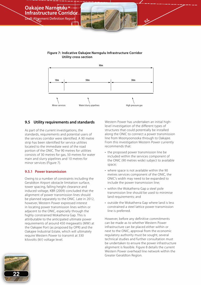
Figure 7: Indicative Oakajee Narngulu Infrastructure Corridor Utility cross section 22
Figure 8: Infrastructure and utilities network 25
Figure 9: Opportunities and constraints – European heritage 31
Figure 10: Opportunities and constraints – Affected tenure 32
Figure 11: Opportunities and constraints – Aboriginal heritage 33
Figure 12: Opportunities and constraints – Environmental 34
Figure 13: Study segments and options considered to date 49
Figure 14: Planning considerations – Segment 1 50
Figure 15a: Geraldton-Mount Magnet Road intersection options 53
Figure 15b: Geraldton-Mount Magnet Road preferred intersection option 55
Figure 16: Planning considerations – Segment 2 59
Figure 17: Planning considerations – Broadcast Australia site, Segment 2 62
Figure 18: Planning considerations – Segment 3 65
Figure 19: Planning considerations – Wokatherra Gap options, Segment 3 67
Figure 20: Planning considerations – Segment 4 71

VII
Oakajee Narngulu Infrastructure CorridorDraft Alignment Definition Report
Table 1: Landowner comments with Department of Planning response 12
Table 2: Railway Design Criteria – Proposed OPR Rail to be included within
Oakajee Narngulu Infrastructure Corridor 21
Table 3: Places on the State Register near or within the Oakajee Narngulu Infrastructure Corridor 29
Table 4: Places on the Heritage Council’s assessment program 29
Table 5: Further European heritage sites within close proximity to the
Oakajee Narngulu Infrastructure Corridor 30
Table 6: Conservation significant species recorded from study area 37
Table 7: Impacts of the three regional land use and industry development
projections up to 2031 42

1
Oakajee Narngulu Infrastructure CorridorDraft Alignment Definition Report
1. Summary
The Department of Planning has been responsible for coordinating the planning of the Oakajee-Narngulu Infrastructure Corridor (ONIC) since 2009.
The ONIC is one component of the broader Oakajee Mid West Development Project which is coordinated by the Department of State Development, with the aim to establish an integrated port and industrial estate at Oakajee; supporting rail and infrastructure corridors to facilitate the development of the resources sector in the Mid West; and ensure the long-term prosperity of the region.
The need for a multi-use corridor linking the proposed Oakajee Port and Industrial Estate to existing infrastructure in the greater Geraldton area has been identified in various planning strategies and studies since the 1990s, which built upon work undertaken for a rail route dating back to the 1970s.
The Department of Planning has prepared an alignment definition report for the Oakajee Narngulu Infrastructure Corridor, which collates existing information; identifies opportunities and constraints; sets out design criteria and standards; informs consultation with stakeholders; and defines a preferred alignment for the ONIC.
The key planning objective for the ONIC is to co-locate road and rail infrastructure within one corridor between Oakajee and Narngulu to minimise impact on landowners. It would also be advantageous to provide capacity within the corridor to accommodate utilities infrastructure.
Through this draft Alignment Definition Report it is proposed that the ONIC will be approximately 34 kilometres in length, providing strategic linkages between Oakajee (proposed port and industrial estate), Narngulu, Geraldton Port and iron ore mines. To accommodate road, rail and service utilities infrastructure the ONIC is required to be at least 230 metres wide, however, it may be wider in some locations to accommodate engineering requirements of the road and rail alignments.
The ONIC rail component is approximately 60 metres wide and will have capacity to accommodate a dual gauge, dual track rail from the existing Geraldton-Mullewa rail line (near Narngulu) through to Oakajee. From just south east of the Broadcast Australia site through until Oakajee, the ONIC rail component reserve has been widened to accommodate a dual gauge, dual track rail alignment consistent with that proposed by Oakajee Port and Rail. The rail component of the ONIC has strategic importance to the State as it is likely to form an important part of the supporting rail infrastructure for the Oakajee Port through providing possible rail connections to iron ore mines to the south-east and north-east of Geraldton.
The road component of the ONIC is approximately 80 metres wide and is located immediately to the west of the ONIC rail component. The ONIC road, which connects into the Geraldton-Mt Magnet Road (near Moonyoonooka) and continues through to the North West Coastal Highway (near Oakajee), will ultimately be a four-lane, controlled access, rural highway that will form part of the Geraldton Outer Bypass. The Geraldton Outer Bypass will include a connection from Brand Highway through to the ONIC road and allow heavy freight vehicles to bypass the built up areas of Geraldton.
The services corridor portion of the ONIC is approximately 90 metres wide and is located immediately to the west of the road component. The services corridor commences immediately north of the existing road reserve for the Geraldton-Mt Magnet Road and continues through to Oakajee. The services corridor may accommodate future service and utilities requirements such as water, gas, slurry pipelines and telecommunications. Depending on the timing and demand for locating utilities within the ONIC, there may also be a need to locate power infrastructure either within, or next to it. The location of power infrastructure within the ONIC or an expanded corridor would require further technical studies and regulatory approvals.

2
Oakajee Narngulu Infrastructure CorridorDraft Alignment Definition Report
The 40 metre-wide 1998 Westrail alignment was used as the initial alignment upon which planning for the ONIC is based. The preferred ONIC alignment is largely the result of maximising co-location both within the ONIC and with the proposed Oakajee Port & Rail (OPR) rail; and minimising impacts on key infrastructure, environmental and heritage assets, land severance impacts on private landowners, topography and the engineering design standards for road and rail design.
Based on these considerations, the preferred alignment of the Oakajee Narngulu Infrastructure Corridor is illustrated in Figure 1. Key features of the preferred alignment include the:
• rail component has both eastern and western tie-ins to the existing Geraldton-Mullewa rail line;
• rail component passes under the Geraldton Mount-Magnet Road;
• road component connects into the Geraldton-Mount Magnet Road with a reservation requirement that includes both ‘at grade’ and ‘grade separated’ options (intersection 1, options 4 and 5);
• ONIC avoids the Cutubury Nature Reserve (segment 1, option 1);
• ONIC avoids impacting on the Broadcast Australia site by locating the services corridor to the west of the site and co-locating the ONIC road and rail components with the proposed OPR rail alignment to the east of the site (segment 2 GHD, option A);
• ONIC is widened from just south east of the Broadcast Australia site through to Oakajee to accommodate the rail alignment proposed by OPR; and
• ONIC alignment through the Wokatherra Gap has been designed to co-locate road, rail and utilities infrastructure, minimise impacts on vegetation and watercourses and reduce the amount of earthworks (segment 3 option 4).
The land requirement of the preferred ONIC alignment as defined in this report is approximately 1,022 hectares, with 664 hectares occurring across 59 privately-owned lots (34
individual landowners). The remaining 358 hectares occur on Government-owned and publically reserved land.
Following consultation with landowners and other stakeholders, the draft Alignment Definition report will be updated to reflect comments received and then submitted to Government for approval of the preferred alignment.
The draft Alignment Definition Report only involves planning for the Oakajee Narngulu Infrastructure Corridor to a sufficient level of detail to define a corridor suitable for possible future reservation. There is currently no commitment or funding allocated to acquisition of the land or construction of infrastructure within the ONIC. It is anticipated that a business case for funding the acquisition of the ONIC and an implementation strategy for the acquisition and management of the ONIC will need to be further considered by Government.
To ascertain the possible timing for construction of infrastructure within the ONIC, the Oakajee Narngulu Infrastructure Corridor Capacity Analysis Study (GHD 2013) was undertaken. The ONIC Capacity Analysis predicted that there is likely to be an unacceptably high number of heavy vehicles travelling on Brand Highway and North West Coastal Highway through Geraldton by around 2018 (based on a low growth projection). This could be considered as a trigger point for the ONIC road to form part of a high standard outer heavy vehicle bypass of the Geraldton City Centre and surrounding residential areas.
For the ONIC rail component the capacity analysis acknowledged that it is unlikely that rail within the ONIC would be required until such time as it is needed to complement the capacity, or form an integral part of the iron ore rail network. Further, in the longer term the ONIC rail will also be required to address the needs of transporting break-bulk between the Narngulu and Oakajee industrial estates.
Construction of utilities infrastructure within the ONIC will be dependent on the timing of development and the needs of the Oakajee port and industrial estate.

Oakajee Narngulu Infrastructure CorridorDraft Alignment Definition Report
OA
KA
JEE
IND
UST
RIA
LA
REA
WEL
LS R
D
REW
ELL
RDKE
NNED
Y RD
CAREY RD
RD
WHI
TE
PEAK
MORRELL
RD
CHAP
MAN
EAST
RD
ANGELS
RD
CHAP
MAN
VALLEYRD
MOONYOONOOKA
RD
HORW
OOD
RD
GERA
LDTO
N-MO
UNT M
AGNE
TRD
RD
MOONYOONOOKA-NARNGULU
ARTHUR
RD
GERA
LDTO
N-MU
LLEW
A
RAI
L
NORTH
WESTCOASTAL
HWY
NA
RN
GU
LUIN
DU
STR
IAL
AR
EA
GOULDSRD
RUDDS
RD
GULLY
BRAND
HWY
-YUNA
GER
ALD
TONOC
EAN
IND
IAN
NORTH WEST COASTAL HWY RE-ALIGNMENT
GERALDTON
NORTH
SOUTH
HWY
JOHN
WIL
LCOC
KLI
NK
Figu
re 1
: Pre
ferr
ed a
lignm
ent
N
01.7
53.5
kilom
etres
Prod
uced
by:
Map
ping
& Ge
oSpa
tial D
ata
Bran
chDe
partm
ent o
f Plan
ning,
WA
Copy
right
© D
ecem
ber 2
013
Z:\P
rojec
ts\po
l\sta
t_pla
n\co
untry
\Oak
ajee
Narn
gulu
Infra
struc
ture
Cor
ridor
Pro
ject\
Arc.m
xd\A
lignm
ent D
efini
tion
Repo
rt Pl
ans
\Fig
1 - P
refe
rred
align
men
t A3.
mxd
Base
info
rmat
ion su
pplie
d by
:W
este
rn A
ustra
lian
Land
Info
rmat
ion A
utho
rity
LI 4
30-2
009-
6
Prop
osed
ONI
C ali
gnm
ent s
uppli
ed b
y: De
partm
ent o
f Plan
ning
(201
3) b
ased
on
GHD
ONIC
road
and
rail d
esign
s (20
13)
OPR
prop
osed
rail s
uppli
ed b
y: Oa
kajee
Por
tan
d Ra
il (20
12)
Aeria
l pho
togr
aphy
(July
201
0) su
pplie
d by
: Lan
dgat
e
Lege
nd
Prefe
rred
ONIC
alig
nmen
t
Prop
osed
majo
r roa
ds
ONIC
road
com
pone
nt
ONIC
rail c
ompo
nent
Major
road
s
Railw
ay
Lots
affec
ted
by O
NIC
align
men
t
ONIC
serv
ices c
ompo
nent
ONIC
serv
ice ro
ad co
mpon
ent
Oaka
jee a
nd N
arng
uluind
ustri
al es
tate
bou
ndar
ies
Prop
osed
OPR
rail
Cada
stre
Figure 1: Oakajee Narngulu Infrastructure Corridor Preferred Alignment3
4
Oakajee Narngulu Infrastructure CorridorDraft Alignment Definition Report
2. Introduction and Purpose
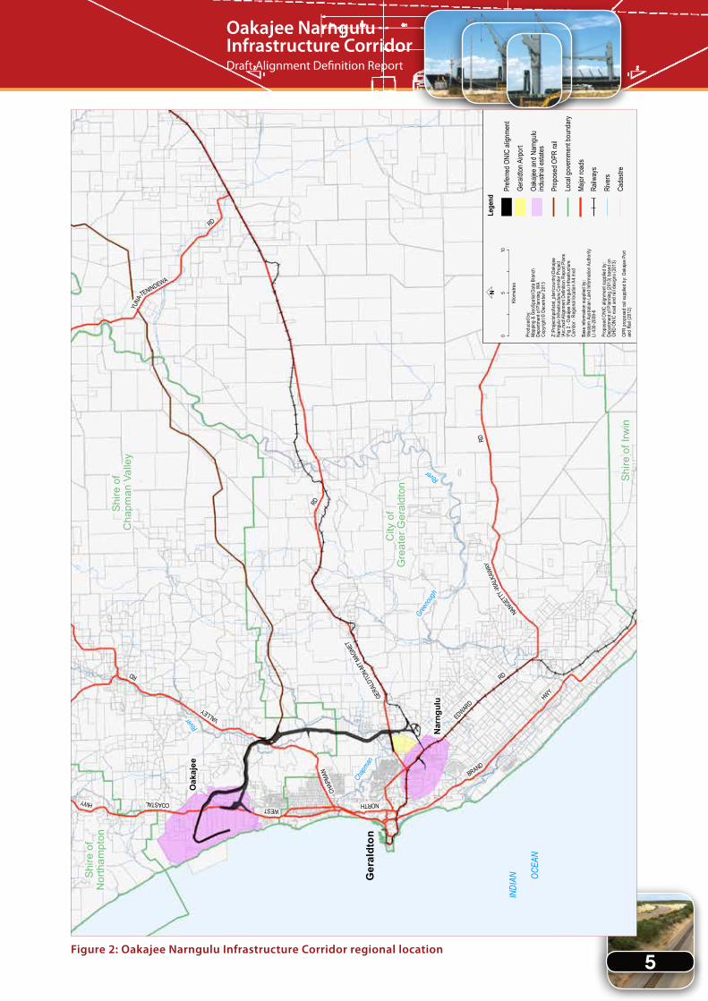
The Department of Planning has undertaken an alignment definition study to determine a preferred alignment and land requirement plan for the Oakajee–Narngulu Infrastructure Corridor (ONIC).
The ONIC is intended to be a multi-purpose road, rail and utilities infrastructure corridor that runs from the Geraldton-Mount-Magnet road and Geraldton–Mullewa rail line in the south, to the proposed Oakajee Port and Industrial Estate in the north. Importantly, the ONIC will connect into the existing State road and freight rail networks, which will in turn increase the capacity of the Mid West region’s transport network to support the resources sector (Figure 2).
The Oakajee Narngulu Infrastructure Corridor is needed to:
1. provide a co-located strategic infrastructure linkage between the Oakajee and Geraldton ports, Narngulu and Oakajee industrial estates, and the broader regional transport network;
2. provide a bypass route to remove the increasing number of heavy vehicles and freight from the Geraldton city centre, which will improve the safety and utility of roads within the Geraldton city centre and provide a more efficient route for freight travelling within and through the region;
3. avoid duplication and minimise impacts associated with planning for individual infrastructure corridors;
4. ensure multiple rail connections to meet the long-term requirements of the Oakajee Port and Industrial Estate and Geraldton Port and Narngulu Industrial Estate; and
5. accommodate the delivery of utility services as and when required.
Using the 1998 Westrail alignment as a basis, several reviews and environmental, engineering and technical investigations have been undertaken to define a preferred alignment that best addresses the current and future needs of the Greater Geraldton and Chapman Valley areas.
The purpose of the Alignment Definition Report is to:
• collate and provide information on all studies completed to date;
• provide details on the constraints, opportunities and considerations for planning the ONIC;
• concisely inform and facilitate consultation with landowners and other stakeholders;
• identify a preferred corridor route;
• identify the land requirements for the preferred route; and
• seek State Government approval of the preferred route.
This draft Alignment Definition Report is the culmination of considerable technical investigations, public and stakeholder consultation and deliberation by the Department of Planning and other State agencies. It only involves planning for the ONIC to a sufficient level of detail to define a corridor suitable for possible future reservation and construction. There is currently no commitment or funding allocated to acquisition of the land or construction of infrastructure within the ONIC. It is anticipated that a business case for funding the acquisition of the ONIC and an implementation strategy for the acquisition and management of the ONIC will need to be further considered by Government.
5
Oakajee Narngulu Infrastructure CorridorDraft Alignment Definition Report
Figure 2: Oakajee Narngulu Infrastructure Corridor regional location
BRAND
Shire
of
Nor
tham
pton
Shire
of
Cha
pman
Val
ley
City
of
Gre
ater
Ger
aldt
on
Shire
of I
rwin
Greeno
ugh
River
Chap
man
River
Oak
ajee
Ger
aldt
on
Nar
ngul
u HWYGERA
LDTO
N-MT M
AGNE
T
RD
COASTALHWYWEST
NORTH
INDI
AN
OCE
AN
EDWARD
RD
NANGET
TY
RD
-WAL
KAWA
Y
CHAP
MAN
VALLEY
RD
YUNA
-
RD
TENINDEWA
Lege
nd
Prefe
rred O
NIC
align
ment
Prop
osed
OPR
rail
Loca
l gov
ernm
ent b
ound
ary
Figu
re 2
: Oak
ajee
Nar
ngul
u In
fras
truc
ture
Cor
ridor
- R
egio
nal l
ocat
ion
05
10
Kilom
etre
s
Prod
uced
by:
Map
ping
& Ge
oSpa
tial D
ata
Bran
chDe
partm
ent o
f Plan
ning,
WA
Copy
right
© D
ecem
ber 2
013
Z:\P
rojec
ts\po
l\sta
t_pl
an\co
untry
\Oak
ajee
Narn
gulu
Infra
struc
ture
Cor
ridor
Pro
ject
\Arc
.mxd
\Alig
nmen
t Def
initio
n Re
port
Plan
s\F
ig 2
- Oak
ajee
Narn
gulu
Infra
struc
ture
Corri
dor -
Reg
ional
loca
tion A
4.m
xd
Base
info
rmat
ion su
pplie
d by
:W
este
rn A
ustra
lian
Land
Info
rmat
ion A
utho
rity
LI 4
30-2
009-
6
Prop
osed
ONI
C ali
gnm
ent s
uppli
ed b
y:
Depa
rtmen
t of P
lannin
g (2
013)
bas
ed o
n GH
D ON
IC ro
ad a
nd ra
il des
igns (
2013
)
OPR
prop
osed
rail s
uppl
ied b
y: Oa
kaje
e Po
rtan
d Ra
il (20
12)
N
Rive
rs
Oaka
jee an
d Nar
ngulu
ind
ustria
l esta
tes
Major
road
s
Cada
stre
Railw
ays
Gera
ldton
Airp
ort
6
Oakajee Narngulu Infrastructure CorridorDraft Alignment Definition Report
3. Study area
The Oakajee Narngulu Infrastructure Corridor is approximately 34 kilometres long and at least 230 metres wide. It may, however, be wider in some locations to accommodate engineering requirements of the road and rail alignments. It traverses largely privately held rural landholdings as well as parcels of State-owned or unallocated Crown lands within the City of Greater Geraldton and Shire of Chapman Valley, bypassing the Geraldton city centre.
4. Background
The Oakajee Narngulu Infrastructure Corridor project first emerged as the Narngulu to Oakajee Rail and Services Corridor project in the late 1990s, which built upon previous work on a rail route dating back to the 1970s. A number of studies were undertaken in the 1990s to identify and assess a suitable railway corridor from the Narngulu Industrial Estate to the proposed Oakajee Industrial Estate and to service the then An Feng Kingstream Steel Project.
The alignment, completed by Westrail in 1998 (refer Section 12) was based on a narrow gauge railway link with an identified 40 metre corridor and received approval from the Environmental Protection Authority (EPA), subject to conditions. A wider area was also considered for utilities but no formal design or concept planning was undertaken so it was not formally recognised at the time.
The Geraldton Region Plan 1999 adopted the 1998Westrail alignment with the possible inclusion of a utilities and road corridor. However, as the Kingstream project did not proceed neither did the planning and development of this alignment and the EPA approval subsequently lapsed.
Planning for the ONIC recommenced in 2009 following commencement of the Oakajee Mid West Development project. The Oakajee Mid West Development project, which is coordinated by the Department of State Development, aims to establish an integrated port and industrial estate at Oakajee, supporting rail and infrastructure corridors to facilitate the development of the resources sector in the Mid West and ensure the long-term prosperity of the region.
The ONIC is one component of the broader Oakajee Mid West Development Project and as well as connecting the Oakajee port and industrial estate to the State’s infrastructure network, it will form an important strategic infrastructure link between the existing Geraldton Port and Narngulu Industrial Estate and the proposed Oakajee Port and industrial estate in the north.
The Department of Planning is responsible for identifying and recommending a preferred alignment for the ONIC, to Government.
7
Oakajee Narngulu Infrastructure CorridorDraft Alignment Definition Report
5. Project process
The proposed 1998 Westrail alignment was used as the foundation route for the Oakajee-Narngulu Infrastructure Corridor project as it had previously undergone environmental approval, landowner consultation and is included within numerous strategic plans and documents.
The 1998 Westrail alignment has since been reviewed and alternatives considered, ensuring that an alignment is defined that best fulfils its function as a multi-purpose, multi-user, public-purpose infrastructure corridor linking Oakajee and Narngulu. The process of review and refinement of the 1998 Westrail alignment is outlined below.
5.1 Literature review
The Department of Planning engaged Kellogg Brown and Root (KBR) to conduct a literature review and report based on an assessment of the proposed ONIC to accommodate current and future service requirements for the Mid West region.
This involved consultation with a number of service and infrastructure providers and government agencies to establish issues relating to buffer width, prioritisation of services, environment, social and planning implications.
The resulting Oakajee Narngulu Infrastructure Corridor Study Final Report (KBR, 2007) provided a summary of issues and recommendations, a cross section of the proposed 300 metre corridor and GIS (Geospatial Information Systems) data for the area.
5.2 Options and design assessment
Options and design for the ONIC alignment were investigated by KBR in 2009. The key objectives for the study were to conduct an objective comparison of the various corridor options using a range of planning, engineering, social and environmental criteria and test the outcomes of the criteria through liaison with key stakeholders.
In order to complete this task infrastructure access requirements and specifications were established; rail alignment proposals reviewed (i.e. Oakajee Port & Rail); options for the Geraldton outer bypass road and connections to the existing rail system were assessed; and constraints mapping and multi-criteria assessment of options were undertaken to recommend a revised route.
The final assessment report Options and Design of the Oakajee Narngulu Infrastructure Corridor (KBR, 2009) identified nominal reserve widths for rail (60 metres), road (80 metres) and utilities (90 metres) but recognised that these may need to be increased at high cuts and fills in accordance with concept design. The study recommended an alignment for the ONIC and also provided concept plans and profiles for the road and rail components.
5.3 Further refinement of alignment
5.3.1 Wokatherra Gap analysis
In order to reach the Oakajee Industrial Estate and port area, the Oakajee Narngulu Infrastructure Corridor infrastructure components and the Oakajee Port & Rail (OPR) rail must pass through the Moresby Ranges at a point known as the Wokatherra Gap. This is a saddle in the Ranges that is significantly lower than any other crossing point and includes a narrow corridor where limited stands of native vegetation remain, therefore providing an opportune location for which the ONIC and OPR rail line can enter the Oakajee Industrial Estate and port.
The northern section of the ONIC alignment − where it passes through the Wokatherra Gap − is highly constrained (refer Sections 10.7.4 and 12.5). As both the proposed OPR rail line and ONIC enter the Oakajee Industrial Estate via the Wokatherra Gap, further refinement of the route established by KBR in 2009 was required to ensure that both corridor alignments can be effectively co-located in this highly constrained
8
Oakajee Narngulu Infrastructure CorridorDraft Alignment Definition Report
location. The criticality of rail grade requirements to allow loaded and unloaded trains to safely enter and exit the Oakajee Port means that this is the only viable location identified for rail to cross the Moresby Ranges.
KBR subsequently completed engineering, Aboriginal and European heritage, biological, and visual impact assessment studies and multi-criteria analysis for alignment options through the Wokatherra Gap, presenting the key findings in Analysis of the Oakajee Narngulu Infrastructure Corridor through the Wokatherra Gap (KBR, 2010). A final alignment through the Wokatherra Gap was then nominated and agreed to by relevant State agencies and OPR.
5.3.2 Route definition
A further route definition study Oakajee Narngulu Infrastructure Corridor Route Investigation Report was completed by GHD in 2013. The purpose of this study was to review the entire alignment of the ONIC, including intersection options for connecting it into the Geraldton-Mt Magnet Road; alignment options in the vicinity of the Cutubury Nature Reserve and Broadcast Australia site; and capacity to accommodate the proposed OPR alignment (from south east of the Broadcast Australia site through to Oakajee) within the Corridor.
Following consideration of the advantages and disadvantages of each option, the report concluded that the recommended ONIC alignment include the following alignment options:
• ONIC rail component has both eastern and western tie-ins to the existing Geraldton-Mullewa rail line (refer Section 12.3.1);
• ONIC rail component passes under the Geraldton Mount-Magnet Road (refer Section 9.4.1);
• ONIC road component connects into the Geraldton-Mount Magnet Road using a free flowing sweeping intersection with a reservation requirement that includes both ‘at grade’ and ‘grade separated’ options (intersection 1, option 5 was the optimal solution refer Section 12.3.2);
• ONIC avoids the Cutubury Nature Reserve (segment 1, option 1 was the optimal solution – refer Section 12.3.3);
• ONIC avoids impacting on the Broadcast Australia site, which consists of ABC radio transmission towers and an underground earthmat antenna system, by locating the services corridor to the west of the site and the ONIC road and rail components and the proposed OPR rail alignment to the east of the site (segment 2 GHD option A was the optimal solution - refer sections 10.8.3 and 12.4.2);
• ONIC is widened from just south-east of the Broadcast Australia site through to Oakajee to accommodate the rail alignment proposed by OPR (refer Section 10.8.1); and
• ONIC alignment through the Wokatherra Gap been designed to co-locate road, rail and utilities infrastructure, minimise impacts on vegetation and watercourses and reduce amount of earthworks (Section 3, option 4 was the optimal solution, see section 12.5).
5.3.3 Technical studies
Further technical studies of the Oakajee Narngulu Infrastructure Corridor have been initiated to understand the environmental, social, and economic constraints of the area and impacts of the corridor, with the aim of avoiding and minimising negative impacts wherever possible. Some of the studies below will also be used in the completion of other statutory approvals processes such as environmental and Aboriginal heritage.
Other studies that have been completed include:
• Aboriginal heritage surveys;
• flora, vegetation and fauna surveys;
• acoustic and vibration impact assessment; and
• road, rail and utilities capacity analysis.
Section 12 provides further details on the results of these technical studies.
9
Oakajee Narngulu Infrastructure CorridorDraft Alignment Definition Report
5.4 Project governance
To assist delivery of the Oakajee Narngulu Infrastructure Corridor project, representatives from the following agencies formed a technical reference group to provide technical advice and assistance to the Department of Planning:
• Department of Lands
• Department of State Development
• Department of Transport
• Landcorp
• Main Roads WA
• Public Transport Authority.
Following establishment of a project governance structure for the Oakajee Mid West Development Project, the ONIC technical reference group was replaced with the Services Corridor Group, which consisted of representatives from these agencies.
5.5 Draft and final alignment definition report
This draft report has been prepared to outline the results of the studies to date and the recommended alignment. It is to be provided to landowners and stakeholders for review and comment prior to being finalised for consideration by Government for approval of the recommended alignment.
5.6 Future processes
The draft Alignment Definition Report only involves planning for the Oakajee Narngulu Infrastructure Corridor to a sufficient level of detail to define a corridor suitable for possible future reservation. There is currently no commitment or funding allocated to acquisition of the land or construction of infrastructure within the ONIC. It is anticipated that a business case for funding the acquisition of the ONIC and an implementation strategy for the acquisition and management of the ONIC will need to be further considered by Government.
While information to support preparation of an environmental referral (under part IV of the Environmental Protection Act 1986), as well as a Section 18 referral (under the Aboriginal Heritage Act 1972) have been prepared as part of the planning for the preferred alignment, the timing for submission of these referrals will be determined by the Government’s implementation strategy for the acquisition and management of the ONIC.

10
Oakajee Narngulu Infrastructure CorridorDraft Alignment Definition Report
• raise awareness and understanding of the benefits of the ONIC, the process to determine its alignment and timelines and methodology for its implementation.
A consistent process of consultation throughout the ONIC project has been invaluable in producing and influencing the preferred alignment recommended in this report.
Outline of the consultation program
• Consultation with the Services Corridor Group (as required), Department of State Development Oakajee Mid West Development Project governance groups (monthly) and Mid West Strategic Infrastructure Group meetings (bimonthly) throughout delivery of the project.
• Consultation with Native Title claim groups as part of the Aboriginal Heritage survey, to help in the identification of Aboriginal Heritage issues.
• Written communication to landowners including brochure (April 2010), project update and clarification of Karara’s miscellaneous mining licence application (October 2011).
• Meetings with individual landowners December 2011 (met with 11 of 36 landowners directly impacted by potential land acquisition) to update them on project.
• Meetings, liaison, advice, and presentations to the Shire of Chapman Valley and City of Greater Geraldton throughout the life of the project, during the completion of technical studies and at project milestones.
• General communication with members of the public via telephone, email, correspondence and meetings.
• Consultation with the Department of Environment Regulation and the Department of Parks and Wildlife (formerly Department of Environment and Conservation), Department of Premier and Cabinet and Department of
6. Consultation process and results to date
6.1 1998 Westrail Alignment
The 1998 Westrail alignment completed extensive community consultation to identify the issues of particular concern to the community, with a specific focus on those landowners who were within the vicinity of the proposed rail alignment. Consultation for the project included face-to-face interviews, phone interviews, mail-outs and contributions through publicly available documentation.
Consultation was undertaken both prior to a final decision on the preferred alignment and at the completion of the alignment definition phase to ensure that all issues and concerns raised would be considered. Further consultation also occurred during the environmental approvals stage of the project.
The most prominent issues of concern were disruption to farm management practices and water supply, loss of property values, noise and loss of amenity.
6.2 Project consultation
Consultation during the Oakajee-Narngulu Infrastructure Corridor project has focussed on Government departments, local governments, directly impacted landowners, Native Title claim groups, the broader community and other stakeholders such as Oakajee Port and Rail and infrastructure providers.
The key objectives of the Oakajee Narngulu Infrastructure Corridor consultation program were to:
• facilitate communication between the Department, affected landholders, key stakeholders and the general community;
• provide opportunity for stakeholders, including landowners and the wider community, to contribute to the project and raise any concerns and issues for consideration; and
11
Oakajee Narngulu Infrastructure CorridorDraft Alignment Definition Report
Aboriginal Affairs prior to and throughout the completion of technical studies requiring their advice and approvals.
• Consultation with landowners to access land to undertake environmental, heritage and geotechnical studies.
• Consultation with landowners and stakeholders via request for comment and input on the draft alignment definition study prior to finalisation (in progress).
6.3 Consultation results to date
6.3.1 Agency consultation
The following agencies and organisations were consulted throughout the life of the project to communicate project updates, issues and gain input on related projects and programs affected by, and that affect, the Oakajee Narngulu Infrastructure Corridor project.
Local government:
• Shire of Chapman Valley
• City of Greater Geraldton
State Government:
• Department of Planning
• Department of Lands (formerly Department of Regional Development and Lands)
• Department of State Development
• Department of Transport
• Landcorp
• Main Roads WA
• Public Transport Authority
• Department of Premier and Cabinet
• Department of Aboriginal Affairs
• Department of Environment Regulation and the Department of Parks and Wildlife ( formerly Department of Environment and Conservation)
• Geraldton Port Authority
• Mid West Development Commission
Infrastructure providers:
• Brookfield Rail
• Oakajee Port and Rail
• Watercorp
• Western Power
6.3.2 Landowner consultation
Landowner consultation commenced at the completion of the KBR 2009 and 2010 route alignment studies. In April 2010, a stakeholder information brochure and comment sheet was mailed to landowners who would be impacted directly and indirectly by the Oakajee Narngulu Infrastructure Corridor. These were also provided online.
The brochure provided a project overview and outline of future planning activities and investigations to be undertaken. It was felt this approach would provide the best opportunity for landowners to provide initial input early in the planning phase of the project.
Difficulties were experienced from this approach because the Department of Planning was not always able to answer queries and concerns at the time they were raised. This was further compounded by a lack of commitment to the project beyond the planning phase, which created an inability to provide certainty of timeframes for acquisition and development of infrastructure.
The majority of landowners directly impacted by the preferred 2013 ONIC alignment have previously been contacted by the Department and will also be provided with a copy of this draft alignment definition report for further comment and input.
A summary of comments received via landowner consultation to date, along with the Department’s response is provided in Table 1.
12
Oakajee Narngulu Infrastructure CorridorDraft Alignment Definition Report
Table 1: Landowner comments and Department of Planning response
Landowner comment Department of Planning response
Concerns raised regarding impacts to property, infrastructure and agricultural practices both by the acquisition and potential severance to land, and the impacts of the infrastructure once built and operational.
Impacts to be considered through the land acquisition and compensation process, once initiated by Government.
Oakajee Narngulu Infrastructure Corridor impacts on the future development and subdivision potential of landholdings.
Future land use and development either side of the ONIC has been noted with the Greater Geraldton Structure Plan (2011) where three (Area 1 – White Peak, Area 2 Yetna and Area 8 Moonyoonooka) development investigation areas are already identified in close proximity. It should also be noted that the ONIC eventually could address the issue of service constraints in the area.
Concern regarding impacts on access to property and between lots, as well impacts to amenity including both visual and noise as a result of the Oakajee Narngulu Infrastructure Corridor, particularly the rail line.
Each lot that previously had legal road access and will be severed by the ONIC is to be provided with legal road access. The service roads either connect to an existing made road or in some instances will connect to the ONIC road via a link across the service corridor.
The Department of Planning is currently undertaking environmental assessments of the ONIC that will address environmental impacts such as noise and visual amenity, ensuring that any impacts are minimised through appropriate mitigation measures and strategies.
Largely supportive of the Oakajee Narngulu Infrastructure Corridor road and the need for the Geraldton Outer Bypass Road to remove the heavy vehicles from the town centre.
Noted.
Need for certainty on timeframes for ultimate delivery of the infrastructure as landowners need to make investment decisions now for their properties/business.
Timeframes depend on a whole-of-Government decision on the preferred alignment, taking into account many variables including, but not limited to, a decision on Oakajee Port; capacity requirements of the Geraldton region; and when funding for acquisition becomes available.
Studies have been undertaken to identify the possible drivers and timing for construction of infrastructure within the ONIC, however undertaking acquisition at the earliest possible stage (before construction of infrastructure) will be the most desirable as it creates certainty to landowners and investors as well as potential cost savings to Government.
Concern the Oakajee Narngulu Infrastructure Corridor would limit the future development potential of the City of Geraldton as it provides a physical barrier to the expansion of urban land.
The Greater Geraldton Structure Plan Update (2011) estimated that land (urban and future urban) within the structure plan boundary (depending upon density at which it is developed) could potentially accommodate a population of up to 229,692 (WAPC, 2011). It should also be noted that the Greater Geraldton Structure Plan Update 2011 has already earmarked development investigation area extending past the ONIC corridor for development potential.

13
Oakajee Narngulu Infrastructure CorridorDraft Alignment Definition Report
Landowner comment Department of Planning response
Acquisition concerns regarding timing, compensation for the impacts of the Oakajee Narngulu Infrastructure Corridor, and also the limited viable land replacements within the Greater Geraldton Region.
Noted, however the Department of Planning (and its officers) are unable/unqualified to answer specific questions in regards to acquisition and compensation during the planning phase of the project. Timing of acquisition (and the chosen acquisition process) will become clearer once a decision has been made by Government on the preferred alignment and implementation strategy.
An alignment that avoids the Cutubury nature reserve presents significant impacts to adjacent properties and businesses and an alternative alignment with less impact is required.
Three alignment options within the vicinity of the Cutubury Nature Reserve have been considered and are discussed further in Section 12.3.3.
While the road portion of the Oakajee Narngulu Infrastructure Corridor is largely supported, its rail connection, particularly in the south near Geraldton-Mt Magnet Road is not supported and should be located further east.
Noted. However, one of the primary criterion for the alignment is to link the Narngulu Industrial Estate with the Oakajee Port and Industrial Estate and Geraldton Port. Another important criterion is to be able to co-locate all infrastructure together, reducing land severance and the ONIC’s overall impact.
14
Oakajee Narngulu Infrastructure CorridorDraft Alignment Definition Report
7. Literature review and studies completed to date
Prior to undertaking further planning and design of the Oakajee Narngulu Infrastructure Corridor alignment, literature reviews and consultation were undertaken by KBR (2007 and 2009) to identify all previous engineering, environmental, social and planning activities relevant to the ONIC. Further studies and investigations were then completed to define the ONIC alignment and any associated impacts.
A list of key literature reviewed and studies completed is provided below.
7.1 Literature review 2007 and 2009
• City of Geraldton-Greenough (2008) Greenough Town Planning Scheme No. 4.
• Environmental Protection Authority (1997) Mid West Iron and Steel Project- Geraldton Steel Plant, Oakajee, Shire of Chapman Valley: Kingstream Resources NL. Report and recommendations of the Environmental Protection Authority: Bulletin 860.
• Environmental Protection Authority (1998) Narngulu to Oakajee rail route and services corridor: Westrail. Report and recommendations of the Environmental Protection Authority: Bulletin 915.
• Environmental Protection Authority (1997) Oakajee Deepwater Port, Oakajee, Shire of Chapman Valley: Minister for Resources Development. Report and recommendations of the Environmental Protection Authority: Bulletin 866.
• GHD Consultants (1998) Oakajee Structure Planning Study: Report prepared for LandCorp.
• Halpern Glick Maunsell & Anne Reid (1996) Narngulu Industrial Estate Study.
• Kellogg Brown and Root (2007) Oakajee-Narngulu Infrastructure Corridor Study.
• Ministry for the Environment and Labour Relations (1999) Statement that a proposal may be implemented (pursuant to the provisions of the Environmental Protection Act 1986).
• Muir Environmental (1997) Re-evaluation of flora and fauna: Oakajee proposed industrial estate and quarries, for Department of Resources Development, August 1997.
• Muir Environmental (1997) Biological and viewscape impact evaluation proposed Narngulu to Oakajee Railway.
• Nicole Siemon and Assoc Pty Ltd (2007) Upper Chapman River: Draft Catchment Action Plan, Shire of Chapman Valley, Northern Agricultural Catchment Council.
• Quartermaine Consultants (2002) Report on an archaeological survey for aboriginal sites, Geraldton Oakajee rail line.
• Rory O’Connor (1997) Report on an ethnographic survey of the proposed Narngulu Industrial Estate to Oakajee industrial estate railway line.
• Shire of Chapman Valley (2007) Draft Town Planning Scheme No. 2.
• Shire of Chapman Valley (2008) Local Planning Strategy.
• Shire of Greenough (2006) Local Planning Strategy.
• SMEC/DoIR (2004) Northern Strategic Industry Areas Environmental, Social and Economic study: Executive summary.
• Unknown author (2001) Narngulu to Oakajee rail and services corridor: Affected land and landowners statutory planning implications.
• WAPC/DPI (2009) Final Moresby Range Management Strategy.
• Water and Rivers Commission (2001) Chapman River Foreshore Assessment.
• Welker Environmental Consultancy (1997) Narngulu to Oakajee rail route and services corridor: Consultative Environmental Review.

15
Oakajee Narngulu Infrastructure CorridorDraft Alignment Definition Report
• Welker Environmental Consultancy (1997) Narngulu to Oakajee rail route and services corridor: Project Definition Study. Prepared for LandCorp, Department of Resources Development and Westrail.
• Western Australian Planning Commission (1999) Geraldton Region Plan. Available www.wapc.wa.gov.au/Publications/79.aspx.
• Western Infrastructure (2002) Geraldton Primary north-south road alignment selection study: Final Report. Prepared for Western Australian Planning Commission and Main Roads Western Australia.
7.2 Literature review / studies completed since 2009
• BG&E (2012) Oakajee Narngulu Infrastructure Corridor (ONIC) Waterways Investigation.
• Ecoscape (2010a) ONIC Fauna Survey.
• Ecoscape (2010b) ONIC Flora and Vegetation Survey.
• Ecoscape (2011) Cutubury Nature Reserve Flora and Vegetation Survey.
• ERM (2012) ONIC Aboriginal Heritage Survey: Draft Background Report.
• Geraldton Port Authority (2011) Oakajee Port Master Plan.
• GHD (2010) Comparison of Options for the Mid North Section.
• GHD (2013) Oakajee Narngulu Infrastructure Corridor Route Investigation Report.
• GHD (2013) ONIC Road, Rail and Utilities Infrastructure Capacity Analysis
• GHD (2013) Oakajee-Narngulu Infrastructure Corridor: Uncaptured Vegetation Biological Survey.
• Kellogg Brown and Root (2009) Options and Design for the Oakajee Narngulu Infrastructure Corridor.
• Kellogg Brown and Root (2010) Analysis of the Oakajee Narngulu Infrastructure Corridor through the Wokatherra Gap.
• Landcorp (2012) Oakajee Industrial Estate Structure Plan.
• Lloyd George Acoustics (2013) Transportation Noise Assessment – Oakajee Narngulu Infrastructure Corridor.
• Lloyd George Acoustics (2013) Draft Noise & Vibration Management Plan – Oakajee Narngulu Infrastructure Corridor
• Main Roads WA (2010) Geraldton Locality Plan.
• Planning Consultants Australia (2012) Implementation Mechanisms Assessment.
• Terra Rosa Cultural Resource Management (2013) report of the archaeological and Ethnographic Site Identification Heritage Survey of the Oakajee Narngulu Infrastructure Corridor.
• WAPC (2010) Narngulu Industrial Area Strategic Land Use Directions.
• WAPC (2011) Greater Geraldton Structure Plan.
• WAPC (2011) Draft Mid West Regional Planning and Infrastructure Framework.

16
Oakajee Narngulu Infrastructure CorridorDraft Alignment Definition Report
8. Strategic and regional planning context
The strategic need for a road, rail and utilities corridor between Oakajee and Narngulu has been established within strategic planning documents since the 1990s. The Geraldton Region Plan 1999 identified the previous 1998 Westrail alignment as a possible multi-use railway and services corridor between Oakajee and Narngulu. It was recognised that a multi-use corridor would assist in minimising the number of service corridors (and associated impacts on landowners) required to improve infrastructure links between the Oakajee and Geraldton ports and the Oakajee and Narngulu industrial estates. This message was subsequently reflected in the Geraldton Region Plan 1999. Importantly, the Oakajee Narngulu Infrastructure Corridor will provide an opportunity to connect into the State’s road and freight rail network. This will help in increasing the capacity of the regions transport network to support the resources sector.
The potential role and function of an infrastructure corridor linking Oakajee and Narngulu was reiterated in the Greater Geraldton Region Structure Plan 2011 update. The 2011 structure plan map includes the indicative ONIC alignment, as produced by KBR on behalf of Department of Planning in 2010. The 2011 update further stated that uptake and demand for industrial land and the viability of strategic industry within the region may be stimulated by the development of proposed transport networks (including the Oakajee deep water port and rail and the road and rail components of the Oakajee Narngulu Infrastructure Corridor).
The draft Mid West Regional Planning and Infrastructure Framework 2011 further notes the importance of the ONIC for enabling the coordinated delivery of critical transport and service infrastructure to stimulate the development of the Oakajee Port and Industrial Estate and the Narngulu Industrial Estate.
The definition of the ONIC and construction of the ONIC road is identified as a flagship project within the Mid West Regional Planning and Infrastructure Framework. The development of the rail line within the ONIC, to link the Oakajee Port to the existing Geraldton-Mullewa railway is listed as a high priority.
A number of other State and local planning documents include reference to the proposed ONIC or the previous 1998 Westrail alignment, including:
• AECOM on behalf of Main Roads WA (2011) Perth to Pilbara Coastal Road Route Strategy.
• City of Geraldton-Greenough (2008) Local Planning Strategy.
• Main Roads WA (2007) Roads 2025 Mid West.
• Main Roads WA (2011) Geraldton Locality Plan.
• Mid West Development Commission (2011) Mid West Investment Plan 2011–2021.
• RPS on behalf of Landcorp (2012) Oakajee Industrial Estate Structure Plan.
• Shire of Chapman Valley (2008) Local Planning Strategy.
• Shire of Chapman Valley (2010) Moresby Range Management Plan.
• Western Australian Planning Commission (1999) Geraldton Region Plan.
• Western Australian Planning Commission (2011) Greater Geraldton Structure Plan.
• Western Australian Planning Commission (2010) Narngulu Industrial Area Strategic Land Use Directions.
• Western Australian Planning Commission (2008) Mid West Infrastructure Analysis.
• Western Australian Planning Commission (2011) draft Mid West Regional Planning and Infrastructure Framework.

17
Oakajee Narngulu Infrastructure CorridorDraft Alignment Definition Report
To date, the Oakajee Narngulu Infrastructure Corridor has not been included within the local planning schemes for the Shire of Chapman Valley or City of Greater Geraldton. The reservation and inclusion of the ONIC within both planning schemes may be required at a future date. The Department of Planning will be preparing a business case and implementation strategy that will further outline the processes and mechanisms that will be utilised to secure the land required for the ONIC.
9. Design standards
9.1 General
The Oakajee Narngulu Infrastructure Corridor width is a balance between provision for future needs whilst minimising land impacts. This has been achieved by extensive consultation with agencies and stakeholders since 2009. The nominal road and rail reserve widths are only increased where necessary for earthworks and associated batters.
The ONIC alignment has been planned to conform to design standards and requirements for road, rail and utilities. Based on a study completed by KBR (2009) the following allowances have been established within the corridor:
• Rail – 60 metres
• Road – 80 metres
• Utilities services – 90 metres, including:
- gas – 30 metres
- water main and slurry pipelines – 50 metres
- minor services – 10 metres
From south-east of the Broadcast Australia site through to the Oakajee Industrial Estate the width of the ONIC rail component has been expanded to accommodate the rail alignment proposed by OPR. This ensures that within the vicinity of the highly constrained Wokatherra Gap the proposed OPR rail alignment, which could potentially connect the Oakajee Port to the iron ore mines in the north-east of the Mid West, is strategically defined for the future.
Figure 3 shows the typical ONIC cross section from its co-location point in the south until the Wokatherra Gap (Segment 3, northern section).
Figure 3: Indicative ONIC cross section
Source: KBR 2009
GAS RESERVE ROAD RESERVE RAIL RESERVESERVICES RESERVE SERVICESEASEMENT
INFRASTRUCTURE CORRIDOR WIDTH
230m
80m 60m30m50m 10m

18
Oakajee Narngulu Infrastructure CorridorDraft Alignment Definition Report
9.2 Road design criteria
The ultimate ONIC Road will provide a high standard four lane divided, controlled access road and will form an important component of the Geraldton outer bypass for heavy vehicles and freight, as well as local traffic (Figure 4).
Key design criteria for the Oakajee Narngulu Infrastructure Corridor road:
Design vehicle: 36.5m Restricted Access Vehicle
High wide load vehicle: 10m high x 10m wide clearance envelope
Design speed: 110km/h
Maximum grade: desirable 3%
Minimum grade: 0% if unkerbed
Cross section: refer Figure 4
Minimum radius: absolute 600m, desirable 800m
Figure 4: Indicative Oakajee Narngulu Infrastructure Corridor road cross section
Source: GHD 2013
9.3 Service roads
Every lot that previously had legal road access and will be severed by the Oakajee-Narngulu Infrastructure Corridor, is to be provided with legal road access. In some cases there is an alternative road reserve (though not necessarily a made road). If there is no alternative road reserve then a service road has been provided. The service roads either connect to an existing made road or in some instances will connect to the ONIC road via a link across the service corridor.
There is a number of existing land-locked lots with no road frontage. This is a legacy situation dating back to the original subdivision of the area and such lots generally do not abut the ONIC. Provision has not been made for road access for these lots.
Service roads will be single carriageway access roads, typically sealed six or seven metres wide in a nominal 20 metre road reserve.
The service roads have been located on the outside of the ONIC service corridor and are therefore some distance from the ONIC road reserve boundary. This location is recommended in the absence of detailed knowledge of what services will ultimately go into the corridor. To reduce land take, it would be possible to locate the service roads within the corridor, adjacent to the ONIC road. That would then, however, constrain future use of the service corridor.
MEDIAN 2x3.5m LANES2x3.5m LANESSHLD SHLDVARIES VARIES
DRAINEXISTING SURFACE LEVEL
12.07.0
CUT FILL
7.02.2 2.22.52.5 1.51.5
LL
3% 3%
1:21:41:4
1:101:10

19
Oakajee Narngulu Infrastructure CorridorDraft Alignment Definition Report
Possible solutions for the treatment for side roads intersected or affected by the corridor are proposed; however, finalisation of these will need to be resolved at the detailed design stage by Main Roads WA in consultation with the local governments.
9.4 Rail standards
Following discussion with rail operators and users, it is understood that the rail must be functional for and/or integrate with the following possible key scenarios:
• connection into the existing Geraldton-Mullewa rail line;
• general goods transport between the Oakajee and Geraldton ports and the Oakajee and Narngulu industrial estates;
• iron ore transport from mine sites to Oakajee Port; and
• overflow iron ore transport from Oakajee to Geraldton.
It is envisaged that the ONIC rail will ultimately be a dual-gauge, dual-track rail with both east and west connections into the existing Geraldton-Mullewa rail line. The tie-ins of the ONIC rail into the Geraldton-Mullewa line will facilitate rail connections between Oakajee, Narngulu, Geraldton Port and mines to the south east of Geraldton. The ONIC rail is also designed with the ability to tie into the proposed OPR line if necessary.
To estimate the likely land requirement for the rail component during design development key design criteria for the ONIC rail based on the Westnet Standard Gauge Mainline Code of Practice.
The assumed railway design criteria included:
Train length: 1300m – 112 wagons
Average speed: 80 km/h loaded or 90 km/h unloaded
Maximum grade: 150 preferred, 1:100 absolute maximum
Cross section: refer Figure 5
Minimum radius: 320m but 700m for tie-ins to the Geraldton Mullewa railway
The formation allows for a double track arrangement. The decision to construct double track or single track (with or without passing loops) will be taken at the time of construction, based on anticipated train volumes.
No assumptions have been made in relation to axle loads or rail weight.
Figure 5: Indicative Oakajee Narngulu Infrastructure Corridor rail cross section
Source: GHD 2013
CLCL
REFERENCE LINE
VARIES VARIES6.56.52.54.01.5
CUT FILL5.6
-3% -2% -2%
1:3
1:3
TRAC
K
TRAC
K
SERV
ICE R
OAD

20
Oakajee Narngulu Infrastructure CorridorDraft Alignment Definition Report
A geometrical analysis of the ONIC rail alignment and benchmarking other rail standards (particularly Queensland Rail), found that the alignment is geometrically feasible to support iron ore freight tasks of up to 50 train movements a day.
The rail portion of the ONIC requires further specifications (Figure 6 and Table 2) in Segment 3, the northern section through the Wokatherra Gap. This is because the ONIC width expands to accommodate the proposed OPR rail line, which is to be co-located with the ONIC rail line in this highly constrained (topography, environment, heritage) location.
Based on OPR’s rail design (as proposed below) and alignment, GHD investigated the expansion of the ONIC to include the rail alignment and design proposed by OPR from south east of the Broadcast Australia site through to Oakajee. GHD also investigated the implications for land requirements of achieving a grade consistent
with that preferred by OPR (1:275) or a grade consistent with the assumed ONIC grades (1:150 preferred, 1:100 absolute maximum). It was concluded that the difference in land requirements between using the ONIC grade or the OPR preferred grade for the second rail component would be only marginal. Furthermore, accommodating the OPR preferred grade allows it to remain compatible with the rail marshalling yard proposed by OPR at the west of the Wokatherra Gap. Based on these reasons it was recommended that the land requirements of the second rail component be based on the OPR preferred grade.
Figure 6: Indicative cross section – Oakajee Narngulu Infrastructure Corridor rail and proposed OPR rail
CL
CL
EXISTING SURFACE
TRAC
K
VARIES
6.50
ONIC RAIL COMPONENT 1REFERENCE LINE MCGA
CLCL CL
ONIC RAIL COMPONENT 2REFERENCE LINE MCGA
(proposed OPR rail)
VARIES
TRAC
K
TRAC
K
TRAC
K
6.502.504.00
3.078.643.07
1.50 5.60

21
Oakajee Narngulu Infrastructure CorridorDraft Alignment Definition Report
9.4.1 Grade separation
Major road intersections with the ONIC rail, including North West Coastal Highway and the Geraldton-Mt Magnet Road are intended to be grade-separated with the ONIC rail passing under those roads. Similarly, local road intersections with the ONIC will be grade-separated by having those roads passing under the ONIC.
9.4.2 Oakajee Port and Rail (OPR)
On 20 March 2009, the State Government and OPR signed the Oakajee Port and Rail State Development Agreement, which appointed OPR on an exclusive basis as the infrastructure provider for the port and an open access rail line servicing northern Mid West iron ore mines. OPR’s exclusivity to develop the Oakajee Port and Rail project expired 31 December 2011; and in June 2013, Mitsubishi announced suspension of work on the Oakajee Port and Rail Project.
The OPR alignment was, however, granted Preferred Rail Corridor status by the Minister for Transport, as recognition of an alignment which satisfied various State requirements under the State Development Agreement, and could have proceeded to inclusion in legislation. It also remains on the Department of Mines and Petroleum TENGRAPH system as a significant proposal, which is afforded protection from competing development proposals. These provisions however, cannot provide a complete level of strategic security for the alignment at this time. It has therefore been seen as prudent to widen the ONIC from south-east of the
Broadcast Australia site through the Wokatherra Gap to Oakajee, to strategically accommodate the proposed OPR rail line. This will ensure the potential link from Oakajee to mines in the north-east is not compromised.
There has also been a significant focus on ensuring that the ONIC − specifically the ONIC rail − is compatible with the proposed OPR rail design. The ONIC rail has been designed to complement OPR designs and the alignment of the two rail components are co-located from the intersection point, just north of the Broadcast Australia site, to the Oakajee Industrial Estate.
The OPR heavy railway is designed to be a single track initially, with a maintenance road running parallel to it, but not necessarily at the same level. The ruling grade in the loaded directions towards the port is one in 275 (0.362 per cent), and in the unloaded direction (away from the port) one in 66.7 (1.5 per cent) (OPR, 2011).
Further, a train marshalling yard (to break down trains into shorter consists, before entry to the Port train dumper) is proposed to be located between the Wokatherra Gap and North West Coastal Highway where a maximum grade of 500H:1V is required for stationary wagons. This area may be used in the future to split trains in order to access the car dumpers. Two tracks are initially to be constructed but ultimately, up to five tracks may be needed.
Table 2: Railway Design Criteria – Proposed OPR Rail to be included within Oakajee Narngulu Infrastructure Corridor
Train length 180 wagons
Average speed Initially 70km/h with wagons designed for 80km/h
Maximum grade 1:275 loaded direction
Cross section Refer Figure 6
Minimum radius 1,000m
22
Oakajee Narngulu Infrastructure CorridorDraft Alignment Definition Report
Figure 7: Indicative Oakajee Narngulu Infrastructure Corridor Utility cross section
High pressure gasWater/slurry pipelinesMinor services
90m
10m 50m 30m
9.5 Utility requirements and standards
As part of the current investigations, the standards, requirements and potential users of the services corridor were identified. A 90 metre strip has been identified for service utilities located to the immediate west of the road portion of the ONIC. The 90 metres for utilities consists of 30 metres for gas, 50 metres for water main and slurry pipelines and 10 metres for minor services (Figure 7).
9.5.1 Power transmission
Owing to a number of constraints including the Geraldton Airport obstacle limitation surface, tower spacing, falling height clearance and induced voltage, KBR (2009) concluded that the alignment of power transmission lines should be planned separately to the ONIC. Late in 2012, however, Western Power expressed interest in locating power transmission lines within or adjacent to the ONIC, especially through the highly constrained Wokatherra Gap. This is attributable to the anticipated ultimate power requirements of around 450 megawatts (MW) at the Oakajee Port (as proposed by OPR) and the Oakajee Industrial Estate, which will ultimately require Western Power to transmit at 330 kilovolts (kV) voltage level.
Western Power has undertaken an initial high-level investigation of the different types of structures that could potentially be installed along the ONIC to connect a power transmission line from Moonyoonooka through to Oakajee. From this investigation Western Power currently recommends that:
• the proposed power transmission line be included within the services component of the ONIC (90 metres wide) subject to available space;
• where space is not available within the 90 metres services component of the ONIC, the ONIC’s width may need to be expanded to include the power transmission line;
• within the Wokatherra Gap a steel pole transmission line should be used to minimise land requirements; and
• outside the Wokatherra Gap where land is less constrained a steel lattice power transmission line is preferred.
However, before any definitive commitments can be made as to whether Western Power infrastructure can be placed either within or next to the ONIC, approval from the economic regulatory authority must be sought, several technical studies and further consultation must be undertaken to ensure the power infrastructure alignment is feasible. Figure 8 details the current Western Power overhead line network within the Greater Geraldton Region.
23
Oakajee Narngulu Infrastructure CorridorDraft Alignment Definition Report
9.5.2 High pressure gas
While gas needs for Oakajee Industrial Estate and Port are likely to be met by a proposed Oakajee Gas Lateral from the Dampier-Bunbury Natural Gas Pipeline, provision is made for inclusion of a gas pipeline to potentially service future development near the ONIC. Figure 8 details the current gas network within the Greater Geraldton Region.
9.5.3 Water
Allowance is made within the ONIC for water pipelines, which could possibly be used to source water from the Allanooka bore field (South East of Geraldton) for future development areas adjacent to the corridor. Figure 8 details the current Water Corporation network within the Greater Geraldton Region.
9.5.4 Slurry pipeline
Provision for slurry pipelines within the ONIC is provided for, possibly for the transport of mineral concentrate from the iron ore mine sites to the South East of Geraldton to the Oakajee Port.
9.5.5 Other minor services
Provision has also been made to allow space for telecommunications cabling and sewer rising main. Again, provision is made for minor services to meet the requirements of future development near or adjacent to the ONIC.

Oakajee Narngulu Infrastructure CorridorDraft Alignment Definition Report
25Figure 8: Infrastructure and utilities network
OC
EAN
GE
RA
LDTO
N
IND
IAN
Wok
ather
ra G
ap
GE
RA
LDTO
NPO
RT
OA
KA
JEE
PO
RT
Broa
dcas
t Aus
tralia
site
WEL
LS R
D
REWE
LL RD
KENN
EDY
RD
CAREY RD
RD
WHI
TE
PEAK
MORRELLRD
CHAP
MAN
EAST
RD
ANGELS
RD
CHAP
MAN
VALLEY
RD
MOONYOO
HORW
OOD
RD
GERALD
TON-M
OUNT M
AGNET
RD
RD
MOONYOONOOKA-NARNGULU
ARTHUR
RD
GERA
LDTO
N-MU
LLEW
A
R
AIL
NORTH
WESTCOASTAL
HWY
GOULDSRD
RD
RUDDS GULL
Y
Prop
osed
Mor
seby
Ran
geC
onse
rvat
ion
Par
k
OA
KA
JEE
IND
UST
RIA
LA
REA
NA
RN
GU
LUIN
DU
STR
IAL
AR
EA
GERA
LDTO
NAI
RPOR
T
RD
NOOKA-YUNA
Figu
re 8
: Inf
rast
ruct
ure
and
utili
ties
netw
ork
Prod
uced
by:
Map
ping
& Ge
oSpa
tial D
ata
Bran
chDe
partm
ent o
f Plan
ning,
WA
Copy
right
© D
ecem
ber 2
013
Z:\P
rojec
ts\po
l\sta
t_pla
n\co
untry
\Oak
ajee
Narn
gulu
Infra
struc
ture
Cor
ridor
Pro
ject\
Arc.m
xd\A
lignm
ent D
efini
tion
Repo
rt Pl
ans
\Fig
8 - I
nfra
struc
ture
and
utili
ties n
etwo
rkA3
.mxd
Base
info
rmat
ion su
pplie
d by
:W
este
rn A
ustra
lian
Land
Info
rmat
ion A
utho
rity
LI 4
30-2
009-
6
Prop
osed
ONI
C ali
gnm
ent s
uppli
ed b
y: De
partm
ent o
f Plan
ning
(201
3) b
ased
on
GHD
ONIC
road
and
rail d
esign
s (20
13)
OPR
prop
osed
rail s
uppli
ed b
y: Oa
kajee
Por
t and
Rail
(201
2)
Aeria
l pho
togr
aphy
(July
201
0) su
pplie
d by
: Lan
dgat
e
Gera
ldton
Airp
ort u
ltimat
e de
velop
men
t - o
bsta
clelim
itatio
n su
rface
supp
lied
by: t
he C
ity o
f Gre
ater
Gera
ldton
(Jan
uary
201
3)N0
1.53
kilom
etres
Lege
nd
Prefe
rred
ONIC
alig
nmen
t
Gera
ldton
Airp
ort u
ltimat
e de
velop
ment
- obs
tacle
limita
tion
surfa
ce
Railw
ay
Mine
site
Cada
stre
Wes
tern P
ower
ove
rhea
d lin
e
Gas n
etwo
rk p
ipelin
e
Wat
er C
orpo
ratio
n wa
ter l
ine
Infra
stuc
ture
Utilit
y
Prop
osed
OPR
rail