oakland city station engagement report - … · market study summary 16 ... access and...
TRANSCRIPT

OAKLAND CITY STATION ENGAGEMENT REPORT
1

EXECUTIVE SUMMARY 1 + Engagement process goals + What makes this process special? + What stands out about the results? + Design concepts + Implementation
CHARRETTE + DESIGN TEAM 2 + Atlanta Regional Commission + City of Atlanta: Office of Planning + MARTA + TransFormation Alliance
OAKLAND CITY NEIGHBORHOOD 3 + Location + History + Current Neighborhood Demographics + Land Use and Zoning + Historic Aesthetic + Transit + Market Overview
TRANSIT ORIENTED DEVELOPMENT (TOD): 7WHY OAKLAND CITY? + Overview + MARTA TOD Guidelines + MARTA’S Core Principles of TOD + Why Oakland City? + Affordable Housing + Neighborhood Station Guidelines
TABL
E O
F C
ON
TEN
TS PAST AREA PLANS 9 + A Common Vision + Oakland City / Lakewood LCI (2004) + Atlanta BeltLine Master Plan: Subarea 1 (2010) + A Revitalization Plan for Atlanta’s Oakland City Neighborhood (2012)
THE PROCESS 11 + Overview + Survey + Workshop
ENGAGEMENT CONCLUSIONS 13 + Challenges and Strengths + Vision + Housing and Affordability + Economic Prosperity + Access and Connectivity + Land Use + Initial Design Concepts
MARKET STUDY SUMMARY 16
TOUR OF FINAL PLANS 18
IMPLEMENTATION NEXT STEPS 23
APPENDIX 24 + Feedback on Preliminary Design + Visual Preferences + Survey Results + Station TOD conditions
2
EXEC
UTIV
E SUM
MA
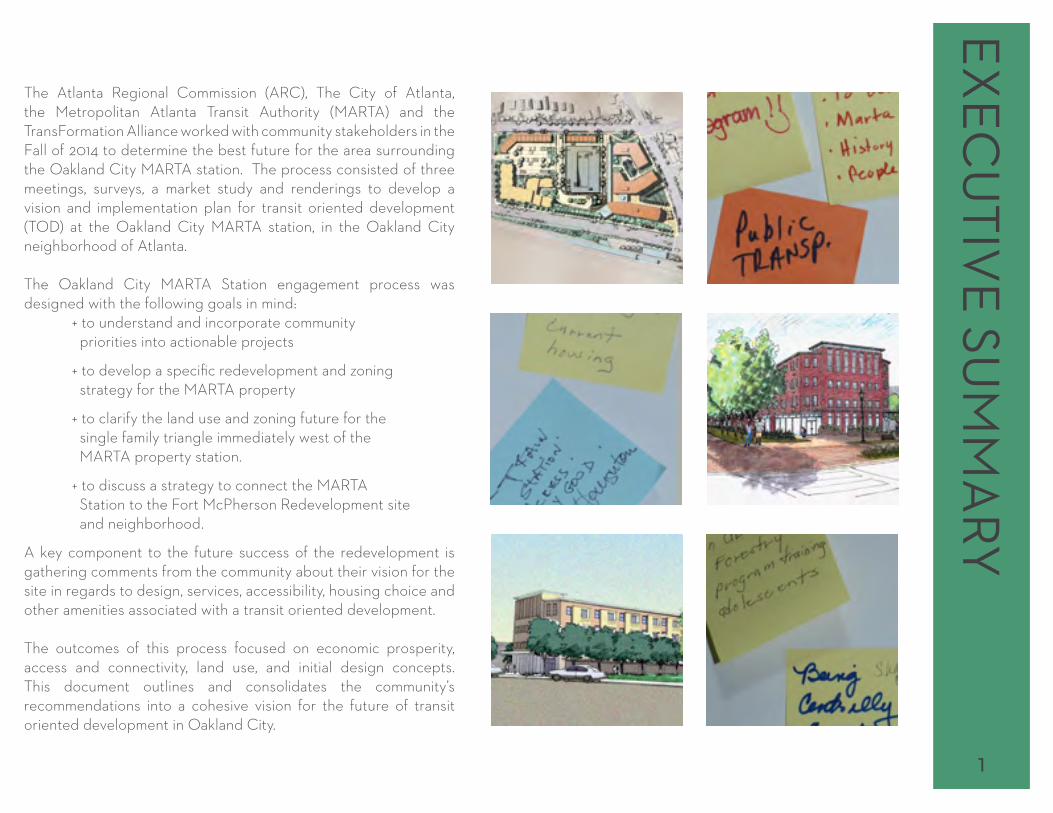
RYThe Atlanta Regional Commission (ARC), The City of Atlanta, the Metropolitan Atlanta Transit Authority (MARTA) and the TransFormation Alliance worked with community stakeholders in the Fall of 2014 to determine the best future for the area surrounding the Oakland City MARTA station. The process consisted of three meetings, surveys, a market study and renderings to develop a vision and implementation plan for transit oriented development (TOD) at the Oakland City MARTA station, in the Oakland City neighborhood of Atlanta.
The Oakland City MARTA Station engagement process was designed with the following goals in mind: + to understand and incorporate community priorities into actionable projects
+ to develop a specific redevelopment and zoning strategy for the MARTA property
+ to clarify the land use and zoning future for the single family triangle immediately west of the MARTA property station.
+ to discuss a strategy to connect the MARTA Station to the Fort McPherson Redevelopment site and neighborhood.
A key component to the future success of the redevelopment is gathering comments from the community about their vision for the site in regards to design, services, accessibility, housing choice and other amenities associated with a transit oriented development.
The outcomes of this process focused on economic prosperity, access and connectivity, land use, and initial design concepts. This document outlines and consolidates the community’s recommendations into a cohesive vision for the future of transit oriented development in Oakland City.
1

CH
ARR
ETTE
+ D
ESIG
N T
EAM
ATLANTA REGIONAL
COMMISSION ARC was created in 1947 by the Georgia General Assembly as a regional planning
and intergovernmental coordination agency for the Atlanta metropolitan area. For 60 years, ARC has focused the region’s leadership, attention, and resources on key issues of regional consequence such as aging services, governmental services, leadership development, research and mapping, workforce development, environmental planning, land use planning, mobility and air quality issues. The 39 member Board made up of local officials and citizen members govern and advises the work of ARC.
CITY OF ATLANTA: OFFICE OF PLANNING The Department of Planning and Community Development creates opportunities for the City of Atlanta to maintain a pattern of sustainable growth. The Department’s vision is to transform the future through the
implementation of the highest quality planning, building code compliance, housing services and programs to enhance the level of service provided to all citizens of Atlanta. This vision is implemented through the work and initiatives of the Commissioner’s Office, the Office of Buildings, Office of Housing and Office of Planning.
The Office of Planning is the City’s source for establishing an action plan for the integration of land use with housing, transportation, historic preservation and community and economic development. The Office is responsible for administering land development regulations inclusive of zoning, subdivision and historic designations. The Office is also responsible for the development of the Comprehensive Development Plan, the Capital Improvement Plan, the management of the ATL GIS system and the Neighborhood Planning Unit system.
A special thanks to District 4 City Council Member Cleta Winslow, who represents the Oakland City neighborhood, and her staff for their leadership and support in the development of this planning process and adoption of the plan.
D+E=DESIGN+ENVIRONMENTd+e=design+environment an inter-disciplinary team of architects, landscape architects and urban designers dedicated to enhancing both the user’s experience and the project’s performance and value, while respecting and responding to the natural systems upon which built places depend. d+e designs are envisioned as creative, ecological and evolving components of the landscape.
MARTA The Metropolitan Atlanta Rapid Transit Authority is the largest transit
system in the Atlanta region and the ninth largest transit system in the nation. MARTA operates a network of bus routes linked to a rapid transit system consisting of forty-eight miles of rail track with thirty-eight train stations. MARTA operates almost exclusively in Fulton, DeKalb, and Clayton counties, with the exception of bus service to two destinations in Cobb County (Six Flags over Georgia and the Cumberland Transfer Center next to the Cumberland Mall) and a single rail station in Clayton County at Hartsfield-Jackson Atlanta International Airport.
TRANSFORMATION ALLIANCEThe TransFormation Alliance envisions generating thriving mixed-income communities anchored by transit and linked to the opportunities and amenities that make Atlanta great. The partnerships created through the Alliance leverages organizations existing work, relationships and resources to find financial solutions, push policies and build civic infrastructure focused on transit and the communities that surround it. The Alliance will coordinate closely with the region’s transit authority, Metro Atlanta Rapid Transit Administration (MARTA), BeltLine, and other transit-supportive organizations to support and offer partnership in achieving their objectives and to enable success in accomplishing like goals.
2

LOCATIONOakland City is located in the southwest quadrant of the City of Atlanta, in Fulton County just north of Fort McPherson in Council District 4 and in Neighborhood Planning Unit (NPU) S. This study centers on the Oakland City MARTA station and the surrounding 1/2 mile.
With Fort McPherson located to the South and the BeltLine Corridor located to the North, Oakland City is located between two of Atlanta’s largest development projects. Additionally, the Oakland City station represents a unique opportunity as it is one of the few MARTA stations that will be linked to the BeltLine.
HISTORYThe land surrounding Oakland City was acquired from the Creek Indians in 1821 and remained rural farmland for decades because, although railroads passed through, no terminals were constructed. Significant development began along a trolley line in the 1890s after the completion of Fort McPherson, and Oakland City incorporated as a municipality in 1894. The City of Atlanta annexed Oakland City in 1910, and industrial jobs and a new rail line fueled heavy
OA
KLAN
D C
ITY NEIG
HBO
RHO
OD
suburban development in the 1920s. The area remained primarily white working-class until WWII, when large numbers of African Americans moved to the city in search of employment.
The Oakland City neighborhood encompasses the intact and contiguous historic residential, commercial, and community landmark resources of the Oakland City neighborhood that developed from the 1890s to the mid-1950s.
Oakland City has remained primarily residential since the early twentieth century. The fact that the business district is relatively small can be attributed to the trolley lines, which were first in operation in the area in the 1890s. The trolley served to connect the neighborhood to Atlanta and other suburbs, thus allowing people to live in Oakland City and easily access shopping in nearby Atlanta.
STUDY AREA + NEIGHBORHOOD DEMOGRAPHICS
Population in fluxThe study area (1/2 mile around the Oakland City MARTA station) saw a population decline of 23% from 2000 to 2010, but since 2010, population has increased by 6%. The area is gradually recovering from its population loss, with a 1.8% annual growth rate forecast over the next five years. Despite this recent growth, the area’s current population is still just 82% of 2000 levels. Meanwhile the city-wide population is up 9% since 2000. According to the 2010 Census, the Oakland City neighborhood as a whole has a population of 3,672. This represents a decrease of 20% or 913 people from a 2000 population of 4,585.
Who lives here?The study area is predominantly African-American, 91% vs. 51% city-wide. The area has an equal mix of Millennials, Gen Xers, and Boomers and is a multi-generational neighborhood. Households tend to be larger, 2.65 persons/household, compared to 2.06 city-wide.
Oakland City Station
3

OA
KLA
ND
CIT
Y N
EIG
HBO
RHO
OD According to the 2010 Census, the Oakland City neighborhood is
96% African American and the median age is 36.2. There are 1,323 households and the average household size is 2.78 persons.
Housing StockNine out of ten area homes were built prior to 1980, with a median age of 59 years, compared to 40 years city-wide. Home values are low. Most area owner-occupied housing units, 65%, are valued less than $100,000, compared to 23% city-wide. Still, more area-households rent their homes, 66% compared to 56% city-wide. Even with such a high incidence of renting large apartment buildings are rare. Just 15% of area residents live in large multi-family buildings, compared to 49% city-wide. Oakland City‐area apartments tend to be very old, the average apartment age is 54 years.
According to the 2010 Census, the Oakland City Neighborhood has 1,899 housing units. While 70% are occupied 30% are vacant. Of the occupied units, 44% are owner occupied and 56% are renter occupied.
Low incomes predominateThe Oakland City neighborhood has a median household income of $22,857 while the 1/2 station-area has a median household income of $19,035, less than half of city-wide median of $41,605; 73% ofhouseholds have incomes below $35,000. In the study area, nearlyfour in ten area families live in poverty vs. 22% city-wide.
A full demographic report for the 1/2 mile study area and 2010 census information for the Oakland City neighborhood can be found in the appendix within the market overview.
LAND USE + ZONINGThe Oakland City MARTA station is located amidst low-to-medium density housing, primarily single-family. An active industrial area lies to the east of the rail corridor. The west side of Lee Street, north of the station area, includes a low-intensity commercial strip. Fort McPherson lies to the southwest of the station.
The Oakland City MARTA station has a Mixed-Use Land use designation, as recommended in the Oakland City/Lakewood LCI. Parcels fronting on the west side of Lee Street have a Low Density Commercial Land Use while many of the parcels on the east side have an Industrial Land Use designation. The residential area adjacent to the station has a Low Density Residential land use while the residential areas further away have a Single Family Residential land use designation.
Population MARTA 1/2 Mile
MARTA 3 Mile
City of Atlanta
2010 Census 2,499 93,934 420,003
2014 Estimate 2,642 100,000 455,895
2019 Projection 2,827 106,433 494,612
CAGR Growth 2000-2014 -1.4% -0.6% 0.6%
CAGR (Fcst) 2014 - 2019 1.4% 1.3% 1.6%
Age + Generational Cohort
Digitals (0-9) 16% 14% 12%
Millennials (10-29) 27% 30% 28%
Generation X (30-49) 26% 27% 33%
Boomers (50-68) 23% 20% 19%
Silent (69-84) 7% 8% 7%
Greatest (85+) 1% 1% 1%
Children (0-17) 745 28% 23,670 24% 89,601 20%
Seniors (65+) 281 11% 11,677 12% 49,143 11%
2014 Est. Median Age 34 33 34
2014 Est. Pop by Single Race Class
White Alone 6% 9% 41%
Black or African American Alone 91% 86% 51%
Asian Alone 0% 1% 3%
Some Other Race Alone 0% 2% 2%
Two or More Races 2% 2% 2%
Household Income
2014 Est. Median Household Income, % of MSA Median Income
$19,035 46%
$22,414 54%
$41,605 100%
2014 Families at or Above Poverty 373 61% 13,166 65% 68,211 78%
2014 Families Below Poverty 238 39% 7,145 35% 19,138 22%
4

HISTORIC AESTHETICThis study area is in the Oakland City Neighborhood, a National Register Historic District. Residents take pride in this designation and the historic buildings and historic elements of the neighborhood.
The residences constructed within the neighborhood are one-and two-story, frame buildings constructed of wood and brick. The residences are located close together and share uniform setbacks. The majority of the houses in Oakland City were constructed between the 1890s and the 1930s. This time period is the most important in Oakland City in regards to mass settlement and population increases.
The bungalow is the most common house type represented in the district. The Craftsman-style bungalow was the most popular early 20th-century house in Georgia and was built across the state in rural, small town, and urban settings from the 1910s to the 1930s. Characteristics of this style are the large gables with decorative brackets, widely overhanging eaves, porches with short square columns over heavy masonry piers extending to the ground, and windows with multi-paned sashes over one large sash.
Also present in the district are several English Vernacular Revival style houses, which followed and filled in vacant lots after the bungalow era.
The commercial buildings in the Oakland City Historic District are located on Cascade Avenue and Lee Street along the trolley lines that came to the area from Atlanta. The buildings are one-story brick buildings and represent the Commercial style with decorative brickwork. There are remnants of older, historic commercial and
retail structures in the business district. Modern commercial development now occupies much of the original commercial areas.
Also located within the district boundaries is Oakland City Park, established shortly after Oakland City incorporated in 1894, a large recreational space consisting of rolling hills and mature trees. Oakland City Park possesses historic and non-historic features and houses basketball courts, playgrounds, pool, picnic areas, sandboxes, and tennis courts.
The west central portion of the district boasts a recreational area known as the Outdoor Activities Center. It encompasses 26 acres of preserved woodlands. The Outdoor Activities Center has been maintained as a wooded, natural environment with residential development encircling the recreation area since the 1970s.
Landscaping in the district includes mature hardwood trees, foundation plantings, sidewalks, and retaining walls. Some historic granite curbing is visible. Mature specimens such as Oak, Magnolia,Pecan, Dogwood, and other hardwood trees form dense tree canopies over several of the streets in the Oakland City Historic District. Vacant lots are overgrown, many having never been cleared for development.
The areas surrounding the Oakland City Historic District consist of post-World War II and late-1950s era developments, non-historic apartment complexes, some subsidized housing, and Habitat forHumanity infill houses that share the same setback, scale, and massing as the historic residences.
OA
KLAN
D C
ITY NEIG
HBO
RHO
OD
5

OA
KLA
ND
CIT
Y N
EIG
HBO
RHO
OD TRANSIT
The Oakland City MARTA Station, which is on the Red/Yellow rail line, has an average weekday ridership of approximately 4,326 people, an average Saturday ridership of 3,185, and an average Sunday ridership of 2,556. This station ranks 15th out of 38 total rail stations in weekday ridership. The station is served by four bus routes: 83, 162, 172 and 193. Most patrons arrive to the station via bus, as shown in the chart below.
The station area has three excellent opportunities to improve ridership and enhance the station area through major development. Just southwest of the station lays the Fort McPherson historic district and Veterans’ Administration Hospital. The base master plan includes an extension of the Oakland City street grid into the station and a pedestrian connection through the open air market directly to the station. The Murphy Triangle district is the second opportunity with over 100 acres of redevelopment area in close proximity to the station. This process concentrates on the development opportunity on the underutilized surface parking lot around the station, an additional eight acre redevelopment site.
9%
9%
11%
71%
HOW TO PEOPLE GET TO THE OAKLAND CITY STATION?
Drive, Carpool
Dropped Off
Walk and Bike
Trasferred (4 BusRoutes)
6

TRAN
SIT ORIEN
TED D
EVELO
PMEN
T (TOD
):W
HY
OA
KLAN
D C
ITY?
OverviewA well-planned, successful Transit Oriented Development (TOD) increases access and opportunities, attracts amenities and services and ultimately has the potential to improve quality of life in a community. Where developments contain a mixture of uses, comfortable and safe pedestrian environments, and properly placed buildings and improvements, transit ridership tends to increase, services and amenities increase and automobile congestion decreases. For neighborhood residents, a development that incorporates the communities needs and vision, integrates into the existing community fabric and provides access to new amenities, services, and jobs in just a few short blocks can significantly improve quality of life.
In addition, TODs play an important role in economic development, bolstering property values, providing an opportunity for desired services to move into the community, and being leveraged as a tool to help revitalize declining neighborhoods.
MARTA TOD GuidelinesIn 2010, MARTA officially adopted Transit Oriented Development (TOD) Guidelines. These TOD Guidelines are meant to provide the entire community of TOD stakeholders with a common vocabulary and frame of reference. The MARTA TOD Guidelines are built around four core principles of TOD (Station-area development that is compact and dense relative to its surrounding, a rich mix of land uses, a great public realm, and a new approach to parking). For MARTA itself, these Guidelines were created to:
+ help guide its role as a TOD sponsor for joint development built on MARTA property or connected physically or functionally to MARTA stations
+ help guide TOD stakeholders - for any development that occurs within the “zone of influence” of current or future stations (roughly a half-mile around rail stations and a quarter-mile around local streetcar and bus stops)
+ help guide TOD advocates - for sustainable land use decisions along all of Metro Atlanta’s transit corridors.
MARTA’S CORE PRINCIPLES OF TOD + Station-area development that is compact and dense relative to its surroundings. Compared to its surroundings, TOD seeks greater density for a simple reason—so that more people can live, work, shop, or go to school within walking distance of the station In so doing, they not only generate revenue for MAR TA and other transit providers; they also drive less, use less gasoline, and save money.
+ A rich mix of land uses. TOD is often referred to as “place-making” or the creation of “transit villages”—livable places where the clustering of uses allows people to do what they need and want to do— live, work, shop, obtain services, go to school, use the library, have fun—more conveniently. The full menu of activities need not be found at every station. But a lively mix of uses strengthens the link between transit and development and allows transit to function more cost-effectively.
+ A great public realm. Transit-oriented development is pedestrian-oriented 7

TRA
NSI
T O
RIEN
TED
DEV
ELO
PMEN
T (T
OD
): W
HY
OA
KLA
ND
CIT
Y? development, especially within the quarter-mile radius that most people will walk as part of a daily commute. In a TOD environment, a grid of small, navigable blocks has sidewalks throughout, with attractive amenities, lighting, and way-finding. The streets, sidewalks, plazas, and stations are safe, active, and accessible. There are no blank walls, and at street level there are shops, restaurants, and other active uses that bring the public realm indoors.
+ A new approach to parking Parking is shared as much as possible, taking advantage of dove-tailing uses and reducing the actual number of spaces provided. And that parking which is required is designed so as not to dominate the visual or pedestrian environment. TOD does not mean “no cars”. Even with high transit utilization, many people will come and go by automobile and need a place to park. But a defining characteristic of TOD is that it requires less parking than similar development in non-transit locations.
WHY OAKLAND CITY?Oakland City had its start as a transit oriented development when it sprung up along a trolley line in the late 1890s. Continuing this history is the key to a prosperous future.
The Oakland City MARTA station is situated between two projects that have the potential to transform southwest Atlanta, namely the Atlanta BeltLine and the redevelopment of Fort McPherson. MARTA believes that the availability of quality workforce housing and amenities at this TOD will be essential to the overall transformational success of this area.
AFFORDABLE HOUSINGAffordable housing was given considerable attention throughout the workshop design process. MARTA has a goal that on average
at least 20% of the units in residential or mixed-use TOD projects should be affordable to workforce households, seniors with low, moderate, or fixed incomes, and persons with disabilities. MARTA recognizes that delivering affordable housing as part of TOD will require a collaborative effort among multiple stakeholders - the municipal and county zoning jurisdictions in the MARTA service area, their housing authorities, the state of Georgia, the Department of Housing and Urban Development, for-profit and non-profit developers, lenders, community groups, and MARTA itself. This collaborative effort was an important component that was crucial in coming together around the Oakland City site.
NEIGHBORHOOD STATION GUIDELINESThe Oakland City station is considered a neighborhood station under MARTA TOD Guidelines. Under MARTA Guidelines, neighborhood stations are “line stops”—local stations where most people arrive on foot. Neighborhood rail stations attract passengers from a large residential “walk shed” and are fed by bus routes operating on nearby streets. MARTA Guidelines also state that neighborhood stations should have little or no park-and-ride. Neighborhood streetcar or bus stops are more closely spaced along a linear corridor and draw their passengers from a closer radius.
Land Use The ideal land use mix for neighborhood stations, according to MARTA Guidelines: Multi-family residential and/or neighborhood scale mixed-use with retail, restaurant, and service-oriented offices, transitioning to lower density single- or multi-family away from the “main street”.
8

PAST A
REA PLA
NS
A COMMON VISIONThere is a common thread between all recent plans in the Oakland City area. These plans all identify the desire for higher-density and mixed-use near transit. They also all identify a strong desire for a more walkable environment with quality, mixed-income housing options and accessible stores and restaurants. OAKLAND CITY / LAKEWOOD LCI (2004)The Oakland City/Lakewood LCI plan, adopted by the City of Altanta in 2004, identified goals and a vision statement for the Oakland City MARTA station and the surrounding area. Through this planning process, community members identified a commitment to quality community gathering spaces, pedestrian friendly environments, a healthy mix of land use, and excellent access to transit facilities.
Plan Recommendations for Station Site + Campbellton: Medium density, multi-family residential development (rent or own) + Oakland City Transit Village: Mixed-use development on MARTA property with apartments, condos, retail, office, and a bus loop + Dill: Medium density, mixed-use development, lofts (rent or own), townhomes, and live-work studios + A new transit plaza + Shared parking deck with dedicated parking for MARTA patrons + Reconfiguring the bus turn around.
CONNECT ATLANTA PLAN (2008)The Connect Atlanta Plan sets the vision and framework for major public investments in transportation improvements over the next 25 years in the City of Atlanta. Its goals are to increase mobility, meet demands of population growth, and to balance transportation system among all of its travel modes.
Plan Recommendations for Station Site + New streets around the Oakland City MARTA station + Complete streets at Oakland Drive, Avon Avenue and Venetian Street + Core bicycle connections on Campbellton Road and Lee Street
FORT MCPHERSON RESEARCH PARK MASTERPLAN + DISTRICT CONCEPTUAL PLAN (2010)This plan, developed by the McPherson Local Redevelopment Authority, envisions the redeveloped base re-integrated into the surrounding community, including Oakland City. The corner of the bases closest to the Oakland City station has been designated as an “open air market”, which “takes advantage of the open space created by existing buildings as well as its proximity to MARTA. The market helps activate the northeast corner of the redevelopment and draws in visitors via MARTA into the Village.”
9

PAST
ARE
A P
LAN
S ATLANTA BELTLINE MASTER PLAN: SUBAREA 1 (2010) This plan, developed by Atlanta BeltLine Inc and adopted by the City of Atlanta in 2010, focuses on encouraging economic development and redevelopment, diversifying housing options and public spaces, increasing public safety through appropriate design, and preserving the neighborhood fabric through incremental change.
Plan Recommendations for Station Site + Oakland City Node: this area has been designated as a redevelopment node, envisioned as a mixed-use infill development in the existing MARTA station parking lot + Multifamily residential buildings should be used north of the Oakland City MARTA station to transition to existing single family homes + Proposed trail connecting the BeltLine with Fort McPherson + Medium-density mixed-use development in order to increase the amount of housing within walking distance of transit + Re-zone to MRC-3 + Improve sidewalks to increase access to the MARTA station
COMPREHENSIVE DEVELOPMENT PLAN (CDP)(2011) The Oakland City MARTA station, like other transit stations areas, are designated Transit Oriented Development Character Areas in the 2011 CDP. Some of policies for TOD Character areas are listed below.10
+ Encourage a mixture of transit-supportive housing types and prices. + Encourage development and preservation of workforce and affordable housing and a mixture of income levels within each station area. + Work with MARTA to redevelop excess surface parking around MARTA stations.
A REVITALIZATION PLAN FOR ATLANTA’S OAKLAND CITY NEIGHBORHOOD (2012)This plan focused on a process in which the Southwest Atlanta Neighborhood Collaborative, West Atlanta Watershed Alliance, and the Atlanta BeltLine could work together to implement earlier plans for the neighborhood
Plan Recommendations for Station Site + assign implementation steps to organizations + identify funding sources + plan identified the following goals: Neighborhood Stabilization Affordable Homeownership Displacement Prevention Local Economic Development Conservation of Natural Resources Connection to the Beltline Stream Restoration Urban Agriculture
ATLANTA BELTLINE MASTER PLAN • December 6, 2010 SUBAREA 1
Land Use Recommendations
The following land use recommendations apply to those portions of Subarea 1 within the BeltLine tax allocation district but not along the BeltLine itself. While these areas are not immediately connected to the BeltLine, proposed multi-use trails and other improvements will link them to the corridor. In addition, the health and redevelopment of these areas will have an impact on the BeltLine because of their inclusion in the tax allocation district.
West End Station Area
Please note that recommendations in West End reflect several previous planning efforts, including the West End LCI Study and Special Public Interest District (SPI) zoning.
A proposed high-density mixed-use node centers on the West End MARTA station. This would allow new convenient options for residences and shops within steps of existing transit service.
In addition, during the long term, much of the automobile-oriented development on both sides of the railroad tracks, including the West End mall, is envisioned as redeveloping with 5-9 story mixed-use buildings. A new public plaza is to be provided at the northeast corner of RDA Boulevard and Lee Street. A number of new privately constructed street connections would help reduce the traffic impacts of new development.
Oakland City Node
Please note that recommendations in Oakland City reflect the 2004 Oakland City LCI study.
The block south of Oakland Lane and immediately adjacent to the MARTA station is envisioned as a 5-9 story mixed-use transit-oriented development. New buildings should step down to 1-4 stories when facing existing single-family residences.
Medium-density residential redevelopment is proposed north of Oakland Lane, including a new street connection. Redevelopment in this area, assuming willing property owners, could significantly increase the amount of housing within walking distance of services and transit.
The West End commercial district is reenvisioned as a mixed use, urban district
New mixed-use infill development is envisioned around the West End MARTA station
Medium-density mixed-use development in Oakland City will provide neighborhood retail and form a node around
the existing MARTA station
INVENTORY AND ASSESSMENT REPORTSUBAREA 1
2
Overv�ewSubarea 1 is located along the southwest portion of the Atlanta BeltLine, which is within two to three miles of Downtown Atlanta. As with all BeltLine subareas, it incorporates several Neighborhood Planning Units (NPUs), City Council Districts, and neighborhoods, including portions of:
NPUs I, S, T, and V;
City Council Districts 4, 10, and 11; and
Neighborhoods of Adair Park, Bush Mountain, Cascade Avenue/Road, Mechanicsville, Oakland City, Pittsburgh, West End, and Westview.
The subarea centers on the BeltLine right-of-way between I-20 and Lee Street. Generally, the Atlanta BeltLine runs south from I-20 parallel to Langhorn Street, crosses under Ralph David Abernathy (RDA) Boulevard, and runs between and parallel to White Street and Donnelly Avenue southeast to Lee Street.
Subarea 1 incorporates 1,856 acres of land, including 1,050 acres of land within the BeltLine Tax Allocation District (TAD). It includes most of the West End and Westview neighborhoods and a large industrial and mixed-use area around Metropolitan Parkway. Subarea boundaries also extend to include part of the Oakland City neighborhood, Johnson Park on Northside Drive, McCoy Park on Avon Avenue, and John A. White Park and the Greenwood Cemetery. Please see the map opposite for details.
The West End and Oakland City MARTA stations lie within Subarea 1, along with a number of major streets. Among these are Ralph David Abernathy Boulevard (which runs east to west through the subarea) and Lee Street, Cascade Avenue, and Langhorn Street (which run north to south). Portions of Metropolitan Parkway, Joseph E. Lowery Boulevard, Oakland Drive, and Northside Drive are also within the subarea.
The subarea contains a wealth of historic residential and
commercial buildings
Active and abandoned industrial buildings line much of the Atlanta BeltLine corridor
A variety of high-capacity streets cross the subarea
SUBAREA 1
PLAN RECOMMENDATIONS REPORTPrepared for
Atlanta BeltLine, Inc.by Tunnell-Spangler-Walsh & Associates
with Grice & Associates, Inc. and Smith Dalia Architects
Adopted by the Atlanta City Council on December 6, 2010
Atlanta BeltLine Master Plan

THE PRO
CESS
OVERVIEWThe Oakland City MARTA station community engagement process concentrated on the vision and development potential of the underutilized 8 acres of MARTA parking lots located at the Oakland City MARTA station. Throughout the process, a strong effort was made to provide multiple opportunities for community members to give feedback and incorporate their desires into the vision. The process included three work sessions, organized to provide community members information and build on feedback from participants through the use of interactive exercises and a community survey. The meetings were held, September 30th , November 13th and December 11th, 2014. All were hosted at The James Orange Park Recreation Center. The survey became available in paper and online formats before the first meeting and was available throughout the process. In addition, MARTA staff presented at the Oakland City neighborhood meeting on November 15th and the NPU S meeting on November 20th. The engagement process was designed with the following goals in mind: + to understand and incorporate community priorities into actionable projects
+ to develop a specific redevelopment and zoning strategy for the MARTA property
+ to clarify the land use and zoning future for the single family triangle immediately west of the MARTA property station.
+ to discuss a strategy to connect the MARTA Station to the Fort McPherson Redevelopment site and neighborhood.
PUBLIC ENGAGEMENT SCHEDULEDATE TOPICS PARTICIPANTS
TuesdaySept 306-8 pm
Presentation of Process SchedulePresentation of Existing ConditionsBreakout Tables discussing topics of housing choice, transportation improvemtns and access, economic prosperity, and large scale development opportunities
75
ThursdayNov 136-8 pm
Reveiw of First Meeting ResultsPresentation of Market StudyInteractive Land Use ExerciseInteractive Visual Preference Survey
45
ThursdayDec 116-8 pm
Presentation of Survey ResultsInteractive Feedback on RenderingsNext Steps
30
A survey was open throughout this process. This survey focused on housing, the community’s greatest needs and assets, transportation usage, and accessibility to resources
107
SURVEY A survey was created and distributed to area residents electronically prior to the Oakland City Workshops. In addition, hard copies of the survey were distributed at venues such as the Neighborhood Planning Unit-S, Oakland City Community Organization, and at the station. A total of 107 surveys were gathered. The survey contained a total of 15 questions, with a total of five being open ended. Survey results were reported to community members at community outreach events in order to give participants a chance to point out discrepencies with thier own opinions. The survey questions focused
11

THE
PRO
CES
S on housing in Oakland City, the community’s greatest needs and assets, transportation usage, and accessibility to resources. A full report of the final survey results can be found in the appendix.
CHARRETTE OR WORKSHOPA charrette is an intensive planning session where citizens, designers, stakeholder and others collaborate on a community vision or a specific vision for a development. Charrettes are organized to encourage the participation and ideas of all involved, and offers the unique advantage of giving immediate feedback to the designers. More importantly, it allows everyone who participates to be a mutual author of the plan.
The meetings for this process were marketed as charrettes but, though they had many of the same goals as charettes, the meeting formats did not match a traditional charrette. As such, this process will be refered to as a workshop.
Throughout this process, approximately 150 people participated in the workshops. The results of this process can be seen in the engagement conclusions section below.
12

ENG
AGEM
ENT C
ON
CLU
SION
SCHALLENGES + STRENGTHSAt the first community meeting, participants were asked to share what they love about their neighborhood and what they would change. The replies fit into five categories: Transportation, Safety/Crime, Neighborhood/Housing, Services, and Youth. This was the jumping off point for the Oakland City TOD plan.
TransportationParticipants appreciate Oakland City’s proximity to public trasportation and the interstate and the area’s walkable nature. At the same time, participants hope to add street lights, slow down traffic, repave roads, add bus shelters with good seating, improve bicycle infrastructure, and repair sidewalks. Fixing these issues will only serve to highlight the transportation aspects of Oakland City that residents love.
Safety + YouthIn two categories, participants only made mention of things they would want to change. They saw the need for more police and a faster police response inorder to deal with issues of gangs, drugs, and crime. Participants also saw the need to keep youth active in a positive way, playing in the parks instead of the streets.
Housing + NeighborhoodOne of the most talked about topics was housing and the state of the neighborhood, both in a positive and a negative light. Participants appreciated Oakland City’s central location and its strong history. At the same time, much of the historic fabric they love is in need of care. Many properties are vacant or abandoned and houses need to be rehabilitated to their former charm. Along these lines, there is also a need for yards to be kept up and litter to be picked up. According to participants, this loved historic neighborhood is in need of more upkeep.
ServicesParticipants have strong ties to this neighborhood. They love their neighbors, their schools, and the strong amenities for an
aging population. Many participants noted their appreciation for the existing after school programing, including an urban forestry training program. One of the most agreed upon points in this engagement process was that this area wants and needs a grocery store and better access to quality food.
Word Maps of Community Strengths and Challenges
13

ENG
AGEM
ENT
CO
NC
LUSI
ON
S The following themes and ideas came out of this engagement process. Below, the community’s ideas are summarized and then split into four major topics: housing and affordability, economic prosperity, access and connectivity, and land use. By engaging people in both large and small groups, in person and online, a wide variety of people felt comfortable expressing their opinions. This is reflected in the diverse group of ideas that came out of this engagement process.
WE ENVISION...
The Oakland City MARTA Station TOD will be a safe, inviting place with diverse housing choices, services and public spaces and will connect residents to Fort McPherson, the Atlanta BeltLine and economic opportunity throughout the region.
HOUSING + AFFORDABILITY + More senior and veteran housing (this was echoed many times)
+ Resources for people to stay in their homes as prices rise: Provide tax abetments Equitable property tax systems Mandatory inclusionary zoning
+ Resources to support home ownership
+ Vacancies need to be addressed
+ 59.73 % of survey respondents said that housing stock is poor or needs improvement.
+ Requirements for new housing: Gentrification without displacement $700-$1000/month in rent is affordable
+ 59.43% of survey respondents wanted to see more mixed-use buildings in the community
+41.51% of survey respondents wanted to see more single family
+ A demand for housing education: Opportunities on housing (how the system works: i.e. taxes, homestead exemption, subsidies, funding for affordability) Housing counseling
ECONOMIC PROSPERITY + There are a number of services that are not available in Oakland City and too many of other services. Not available: quality grocery stores, MARTA mobility, fresh food options, dry cleaners, boutiques, youth services/seniors, sit down restaurants Too many of: beauty shops, corner stores, liquor stores, fast food restaurants, empty buildings, auto repair shops
+ A demand for job opportunities: Workforce development and training Tech firms, construction Green jobs in solar energy and sustainable technologies Local hiring for construction of TOD
+ Socially conscious employers to invest in people of the community, not just the land
+Barriers to job opportunities Training Education (schools and technical skills)Crime
14

ACCESS + CONNECTIVITY + A demand for better sidewalks and road crossing ADA ramps, bus shelters, and benches for seniors Need sidewalks along bus routes Larger sidewalks for vendors and sidewalk cafes Safer street crossings (especially Campbellton Rd.), possible pedestrian bridge or median signal Road diet to reduce Campbellton Rd. and/or Lee St. + Address Crime Safety through design, activate spaces, lighting, and coordination with APD/ Zone 4 – MARTA precinct Improve safety at MARTA station Need street lights throughout the neighborhood
+ A demand for improved access to station Make Sylvan Hills side entrance to MARTA more attractive— move turnstiles inside to create better access Public access to station through underground tunnel from new development Improved entrance signage
+ Improve Bus Service: the bus stops too much, takes too long
LAND USE + INITIAL DESIGN CONCEPTS + Need more senior housing
+ Help cleanup existing houses and coordination—keep manageable
+ Mixed review on development height Higher density — 5 to 8 stories with a stepdown on Campbellton Rd
Development is exciting, but 5-8 stories is too high
+ Greenspace is nice: don’t just build a building — need landscape, streetscape, art
+ Who benefits—how can the people who live here benefit from the development?
+ Mixed-use
+ Mixed-income
+ More retail
+ More rental options
+ More townhomes
+ Make sure development blends in and incorporates historic feel Make sure new development is compatible with existing development (ie. Sylvan Hills and Lakewood Ft. McPherson Station) First floor should have same façade with historic feel Blend with historic and well-built housing
ENG
AGEM
ENT C
ON
CLU
SION
S
15

MA
RKET
STU
DY
SUM
MA
RYAs part of the planning and visioning process for the MARTA Oakland City station and its surrounding community, the Atlanta Regional Commission and MARTA have contracted with the Bleakly Advisory Group to conduct a market overview of MARTA-owned properties at the MARTA Oakland City station.
The commercial real-estate market in the Oakland City area is limited. No new major office or retail inventory has been added in the past 10 years, and the existing inventory of commercial space is aging, mid-century retail architecture, generally in poor repair.
The challenging economic and demographic conditions in the Oakland City area suggest that real estate demand in the area will remain very modest without some sort of catalytic investment to change existing patterns. Currently, the combination of low real-estate values, low development activity, high vacancy, and population loss do not point to positive demand for housing or commercial space within the short-ter. However, momentum at two key nearby projects, Fort MacPherson and the BeltLine’s Murphy Triangle, can provide the catalyst for binging new reinvestment in the area.
Because of the prevalence of aging multi-family housing, and the lack of newer options, new, quality transit-adjacent apartment inventory in the area could induce rental demand in the area by providing an alternative to the existing pool of rental housing options, and offering direct transit access to the network of employment and activities serviced by MARTA. This would likely be contingent upon the creation of mixed-income development, with a mix of both market-rate and affordable units that are price-competitive with existing rental housing options.
Parking requirements are one of the driving factors defining the layout and economic viability of any redevelopment of the MARTA Park & Ride site. The 8.21 acre site is the current location of two MARTA Park & Ride lots with 762 parking spaces, of which 150-16
200 are used on a regular basis. MARTA Staff has indicated that approximately 200 spaces will need to be preserved for MARTA passenger usage in any redevelopment scenario, in addition to any parking spaces needed to support new residential or commercial development. Based on recommended parking ratios in MARTA’s TOD Guidelines, potential redevelopment scenarios include 200 dedicated parking spaces for MARTA passengers, along with 1.25 units per residential unit and 2 parking spaces per 10,000 SF of commercial space.
Real Estate Demand Forecast, 2015-2020Category 5-Year Demand
Single-Family Units 0 unitsTownhomes 60-100 units
Rental Apartments (Market)
150-200 units
Rental Apartments (Affordable)
150-200 units
Retail 20,000 - 20,000 square feet
Office 5,000 - 7,500 square feet
The site is well positioned for redevelopment in terms of site condition, access to transit, visibility and access. Based on the existing conditions, over the next five years, the MARTA Oakland City station area could absorb 300 to 400 apartment units, (assuming that up to half of the units are affordable) and a small amount, up to 37,500 SF, of commercial space. Once a major development became established on the MARTA Park & Ride site, it would likely trigger additional demand for up to 100 additional units, most likely apartments or townhomes, on adjacent development sites.
Market Study Recommendations + Rental housing, either as a single land use, or as part of a mixed-use development, is the best redevelopment

option for the MARTA Oakland City Station Park & Ride site. The development should be mixed-income, containing both market-rate and affordable units.
+ Two redevelopment options nave been proposed: a moderate density (35 units/acre) apartment community with integrated surface parking and a higher density (45 units/acre) structured parking.
+ A limited amount of commercial development could be incorporated into the redevelopment, creating the opportunity for a small grocery store, or other retail uses. Limited office or community space could also be included, such as a day-care center or medical clinic.
+ Due to low potential commercial rents, subsidies would likely be needed to incentivize commercial or community uses at the site.
+ It is likely that any redevelopment scenario at the MARTA Oakland City station site will require financial assistance from the BeltLine TAD, the BeltLine Affordable Housing Trust Fund, or other sources, to support the affordable housing component and parking deck costs.
+ MARTA and/or city staff should address land, title, land use and zoning issues at any potential redevelopment site prior to proceeding with redevelopment.
+ The market will likely be more favorable to support redevelopment of this site 18-24 months from now, once economic conditions have improved, redevelopment momentum picks up along the southwest BeltLine and Fort MacPherson is further along in its redevelopment process.
+ Redevelopment of the MARTA Park & Ride site will potentially catalyze additional development in the immediate station area, most likely apartments or townhomes on neighboring sites.
MA
RKET STUD
Y SUM
MA
RY
17

INTRODUCTION TO TOUR OF PLANSBased on community input from the meetings and surveys, previous plans and the market study, a concept plan was developed for the Oakland City MARTA parking lot by Peter Drey of d+e=design+environment assisted by Jake Henderson of Jake Henderson Planning and Design. As recommended by the Market Study, the concept plan shows redevelopment of the parking lot in two phases.
Phase One is on the on the south lot with remaining surface parking kept in place. Phase One consists of 74 apartments, 13 townhomes and 105 surface parking spaces. As the market improves with the redevelopment of Fort McPherson, the BeltLine and State Farmer’s Market, the rest of the parking lot can be developed in Phase Two.
Phase Two consists of 175 residential units, 32,000 sq. ft. of retail/office and 300 spaces in a three level parking deck and open space fronting retail and the MARTA entrance. The bus bays and kiss-and-ride are relocated to the area between the parking deck and the station entrance. Wide sidewalks, street trees and on-street parking are present along road frontages. The concept plan is illustrated in the drawings and explained in the accompanying text.
RESIDENTIAL UNITSThe engagement results clearly called for townhomes and more rental housing options near the Oakland City station. Above, this need has been met with the addition of townhomes and apartment buildings with retail and/or office space on the ground floor. The concept plan shows approximately 262 residential units - 13 townhomes and 249 multi-family residential units.
OFFICE SPACEBy providing new office space close to new and exising homes, this design opens the doors to new employment opportunities for Oakland City residents and people throughout the Atlanta region who have access to the MARTA system. Through this engagement process we learned that there is a demand for new jobs, particularly in technology, sustainability, and construction.
COMMERCIALThis design provides space for new businesses to come to Oakland City. The market study identified a demand of 20,000 to 30,000 sq ft of retail. The renderings show 32,000 sq ft of retail including out door dining and retail fronting on Campbellton Road. The services that residents are particularly interested in seeing are as follows: + access to healthy food + dry cleaner + boutiques + youth and/or senior services + sit down restaurants
TOU
R O
F FI
NA
L PL
AN
S
18

BUILDING HEIGHTDuring the planning process, there was discussion regarding the appropriate number of floors for new development. New development should step down in height as it gets closer to existing single family housing. The height of buildings in the concept plan varies. The apartments on the fronting on Lee Street and Van Buren Street and the townhomes fronting on Oakland Drive will be 2 to 3 stories. The mixed-use buildings fronting on Campbellton and Lee Street will be 4 to 5 stories.
OUTDOOR GATHERING SPACEThe addition of outdoor gathering spaces will fulfill a number of the community’s needs. First, there will be communal spaces for the Oakland City residents to relax and spend time enjoying each other’s company. Secondly, having more people out of their homes
TOU
R OF FIN
AL PLA
NS
and in open, public spaces will provide security by adding more ‘eyes on the street.’
PUBLIC + PRIVATE SPACEOpen spaces need to be programmed so that residents have a space for their own use separate from the “wide open” public spaces where everyone is welcome. This is provided through “semi-public” interior courtyards in the residential buildings. Residents can enjoy being part of a larger city-scaled urban development and, at the same time, benefit from spaces set aside for their exclusive use. This mimics the pattern found all over the city in traditional courtyard apartment buildings.
19

TOU
R O
F FI
NA
L PL
AN
SSAFER SIDEWALKSSeveral recommendations are included to make these sidewalks safer. The sidewalks are wide and protected from traffic by on street parking. In addition, street trees in the supplemental zone provide additional buffer to the sidewalks. Internal sidewalks and crosswalks improve safety and mobility within the site.
Improved sidewalks and the addition of new walkways (see point A in the image to the left) will connect the neighborhood to the new development, to the MARTA station, and to Fort McPherson making it easier and safer to access these ameneties on foot.
LINK TO FORT MCPHERSONThe link to Fort McPherson is an important plan element because the Fort’s rebound will likely impact this project’s viability. Fort residents and visitors will use Oakland City MARTA for regional travel, so the sidewalks connecting the fort to our proposed new retail need to be well designed as a positive urban experience.
LINK TO THE BELTLINELinkage to the Beltline is also important. The Oakland City TOD will be an important node on the city-sponsored bike trails in the Lee Street right of way. The new generation of bike users will view the project’s pedestrian/bike-friendly characteristics positively for this reason, boosting enthusiasm for the project as part of the larger Atlanta “quality of life” evolution.
TRANSIT PLAZAA transit plaza and covered pavilion (see point B in the image to the left) will add focus to the development’s primary element -- the MARTA station.
20
B
A

TOU
R OF FIN
AL PLA
NS
HISTORIC CHARACTERIt is important to Oakland City residents that any new development in this area fits with the strong historic fabric of the neighborhood. This is especially essential on the first floor of buildings, as this is what people will see most when they are walking down the street. This design represents this aesthetic.
PRESERVE THE COMMUNITYOne of the most referenced strengths of Oakland City is its people. Residents want to see their neighbors stay in their homes, protecting the neighborly character. A new development that follows the needs, aspirations, and vaues of existing residents will protect this neighborly character. At the same time, such a devel-opment will draw new people to the area and be a source of pride for current residents.
COMPLEMENTING THE NEIGHBORHOOD PATTERNOakland City is characterized by single family houses set on large, tree-shaded lots. The new project will be very different -- much more intensive and dense. In exchange for the new amenities that it brings, the neighborhood therefore will see a transformation on it’s eastern edge. The plan softens this contrast by matching the neighborhood street cross-section: House, semi-private space (lawn) between the facade and the sidewalk, and the public space of the street. This same pattern is found in front of the townhouses on Oakland Drive. In effect, the balance of buildings and green space shifts more toward landscape as the development approaches the neighborhood.
21

TOU
R O
F FI
NA
L PL
AN
S
22
ENERGY + ENVIRONMENTAlthough not readily apparent in the plan drawings, the project was laid out with an eye toward achieving energy and environmental goals that are often expected in new urban development. There are opportunities for: + Rainwater harvesting - reducing water demand in a metro area among the nation’s most costly
+ Onsite energy generation - especially possible using the frame of the parking deck to support a pv array
+ Conservation of resources - the existing streets and curb lines aren’t changed, allowing for subsurface utilities to remain undisturbed, and the new structures are organized around the site’s existing internal streets so that utilities can remain in place inside the site as well
+ Walkability to parks, the new retail amenities on site, and the availability of MARTA to travel to work or recreation substantially reduces the generation of car trips.
IDENTITYWe’ve included identity elements that will differentiate Oakland City and help boost its profile in the larger metro area. These identity elements include: + Distinctive Monument Sign - This sign should not only be identifiable with the MARTA brand but also display a prominent neighborhood orientation.
+ Broad grassed open space
+ MARTA “hall” outside the fare gate
+ A parking deck wrapped in living walls (green-wrapped)
+ Small Campbellton/Oakland Drive parklet
+ Spacious sidewalks
+ Nearby park - If a tangible link connecting the new development to James Orange Park is created, then the awareness of this amenity, and its association with Oakland City’s new development, will be heightened.
The hurdle facing Oakland City is greater than at other MARTA TOD sites because of Oakland City’s association with poverty and social stress. This is an issue with subtlties. The new development presents an opportunity to redefine its image as a liveable, high quality, progressive neighborhood through the design of the project’s architecture and urbanism. This “repositioning” has happened with other projects elsewhere in the City, so there’s reason for confidence that it can be successfully accomplished here.

IMPLEM
ENTATIO
N: N
EXT STEPS
Project Description Type of Project
Year Cost Responsible Party
Adoption of Oakland City Sta-tion Engagement Report
The Oakland City MARTA TOD should be adopted into the Oakland City/Lakewood LCI and the 2011 CDP
Land Use
2015 NA City of Atlanta – Council District 4 and DPCD
Rezoining of Oakland City MARTA parking lot
Rezoning parking lot from C-1 and R-5 to a Mixed Residential Commer-cial (MRC-3) zoning category
Land Use
2015-2016
NA City of AtlantaDistrict 4 and DPCD, MARTA
MARTA release of Oakland City parking parcel
MARTA Board to authorize the re-lease of a parcel for the Phase I TOD.
2015 MARTA
MARTA release of RFQ/RFP Release RFQ/RFP for development in the 2nd or 3rd Quarter of 2015.
2015-2016
MARTA
Oakland City/Lakewood LCI 10 year update
The Oakland City/Lakewood LCI was adopted in 2004 and a 10 year update is needed
Land Use
2015-2016
$100,000 City of Atlanta, DPCD
Lee Street land use and zoning Study redevelopment of key nodes on Lee street. Make land use and zoning recommendations
Land Use
2016 City of Atlanta – Council District 4 and DPCD
23

APP
END
IX: S
TATI
ON
TO
D C
ON
DIT
ION
S OAKLAND CITY STATION TOD CONDITIONS MATRIX
MARTA STATION CONDITIONS RANKING
STATION AREA CONDITIONS INDEX
Data Sources: CoStar, Nielsen, REIS, SmartNumbers, MARTA, US Census
Commercial 0.15 Residential 0.13 TOD Demographics 0.26 Employment 0.50 Physical 0.79 AVERAGE 0.36
Rank Station Score26 Vine City 0.3927 West End 0.3828 Oakland City 0.3629 East Point 0.3630 Doraville 0.36
STATION AREA MAPSTATION AREA CONDITIONS - 1/2 MILE RADIUS REAL ESTATE CONDITIONS
Oakland City Station
37 Station Average
Commercial Office - Inventory (SF) 16,390 3,964,869 Office -Vacancy 0.0% 11.9% Office - Average Rent $0.00 $14.86 Office - 10 Year Growth 0% 3% Retail - Inventory (SF) 47,430 1,474,105 Retail - Average Rent $10.00 $15.47 Retail - 10 Year Growth 3% 16% Industrial - Inventory (SF) 727,785 343,854 Industrial - Average Rent $4.08 $2.26 Industrial - 10 Year Growth -18% -13% Residential Housing - Inventory (Units) 1,397 2,218 Housing Density / Acre 2.8 4.4 Housing - % Renter 55% 56% Housing - % Multifamily 5+ Units 20% 53% Housing - % Built Since 2000 12% 19% Housing - Average Apartment Rents (1 Mile) $563 $956 Housing - Average Apartment Vacancy Rate (1 Mile) 13.2% 7.3% Housing - 2012 New Homes Sold (1 Mile) - 20 Housing - 2012 New Avg. Sales Price (1 Mile) N/A $252,596 TRANSIT STATION CHARACTERISTICS MARTA total acreage 12.0 12.0 MARTA TOD acreage 8.0 3.4 MARTA parking spaces 443 688 MARTA parking utilization 50% 51% MARTA daily entries 5,091 4,717 MARTA station typology designation Neighborhood RESIDENT DEMOGRAPHICS Population 2012 2,464 3,930 % Change 2000-2012 -18% 10% % Change 2012-2017 -6% 4% % Generation Y (18-34) 28% 35% % Singles 77% 75% Median Household Income $24,018 $44,720 % Employed 39% 62% % Use Public Transit 32% 17% Travel Time to Work (minutes) 32.2 27.9 EMPLOYMENT BASE Number of employees 822 17,075 Employment Density / Acre 1.6 34.0 % Employees Earning More than $3,333 per month 66% 54% Jobs to Housing Ratio 0.6 7.1 % Manufacturing 58% 20% % Retail 7% 5% % FIRE 3% 9% % Management & Professional Services 3% 16% % Health Services 5% 13%
24

APP
END
IX: V
ISU
AL
PREF
EREN
CES
O a k l a n d C i t y I m a g e P r e f e r e n c e S u r v e y R e s u l t s
RESIDENTIAL DE VELOPMENT
P i c t u r e 1 : 6 V o t e s P i c t u r e 2 : 8 V o t e s
P i c t u r e 3 : 6 V o t e s P i c t u r e 4 : 5 V o t e s
P i c t u r e 5 : 2 V o t e s P i c t u r e 6 : 2 V o t e s
O a k l a n d C i t y I m a g e P r e f e r e n c e S u r v e y R e s u l t s
MIXED USE DE VELOPMENT
P i c t u r e 1 : 4 V o t e s P i c t u r e 2 : 1 2 V o t e s
P i c t u r e 3 : 4 V o t e s P i c t u r e 4 : 8 V o t e s
P i c t u r e 5 : 3 V o t e s P i c t u r e 6 : 2 V o t e s
Written Comments:Yes to mixed use but with bedroom community use, support business, grocery, shoe repair, boutiques
25

O a k l a n d C i t y I m a g e P r e f e r e n c e S u r v e y R e s u l t s
OFFICE/ RE TAIL DE VELOPMENT
P i c t u r e 1 : 1 V o t e P i c t u r e 2 : 3 V o t e s
P i c t u r e 3 : 8 V o t e s P i c t u r e 4 : 8 V o t e s
P i c t u r e 5 : 9 V o t e s P i c t u r e 6 : 1 V o t eWritten Comments:Picture 5: Needs wider sidewalks - more walkability encouragedPicture 6: Not much different than what is here and deteriorating; not accessible on people scale
O a k l a n d C i t y I m a g e P r e f e r e n c e S u r v e y R e s u l t s
STREE TSC APE
P i c t u r e 1 : 9 V o t e s P i c t u r e 2 : 6 V o t e s
P i c t u r e 3 : 2 V o t e s P i c t u r e 4 : 1 V o t e
P i c t u r e 5 : 6 V o t e s P i c t u r e 6 : 1 0 V o t e s
APP
END
IX: V
ISU
AL
PREF
EREN
CES
26

O a k l a n d C i t y I m a g e P r e f e r e n c e S u r v e y R e s u l t s
GATHERING SPACES
P i c t u r e 1 : 6 V o t e s P i c t u r e 2 : 8 V o t e s
P i c t u r e 3 : 9 V o t e s P i c t u r e 4 : 7 V o t e s
P i c t u r e 5 : 3 V o t e s P i c t u r e 6 : 4 V o t e s
Written Comments:Picture 1: Want a gym, but not looking like this
O a k l a n d C i t y I m a g e P r e f e r e n c e S u r v e y R e s u l t s
PUBLIC ART
P i c t u r e 1 : 1 1 V o t e s P i c t u r e 2 : 4 V o t e s
P i c t u r e 3 : 1 V o t e P i c t u r e 4 : 5 V o t e s
P i c t u r e 5 : 4 V o t e s P i c t u r e 6 : 6 V o t e s
APPEN
DIX
: VISU
AL PREFEREN
CES
27

APP
END
IX:
FEED
BAC
K O
N P
RELI
MIN
ARY
DES
IGN
2 Likes - shaded sidewalk
1 Like building
1 Like Townhomes
1 Like MARTA atrium
1 Dislikeparking deck 1 Like - living wall
1 DislikeBuilding
2 Likescourtyard
1 Like - planted barrier to street
2 Likes courtyard
Sticky Notes
I absolutely love this design.
Like the Green @ Lee / layout
Would like futuristic look of building and windows = what would attract 20-30 year
olds long-term residence/investment (1 Dislike for this comment)
International theme
colors/light
28

1 Dislike - Building is to similar
4 Likes - green space, plaza,
2 Likes - outdoor seating
1 Unsure
1 Like - wide sidewalk
1 Like - shaded walkway
2 Likes - MARTA atrium
1 Like - wide sidewalk
1 Like - courtyard
Sticky Notes
I love everything I see.
I love outdoor seating.
APPEN
DIX
: FEED
BACK O
N PRELIM
INA
RY DESIG
N
29

1 Like - entry from
community
1 Dislike surface
parking
2 Likes green barier from street
2 Likes - building
1 Like - plaza
2 Likes, 1 Dislike - courtyard
1 Like - path1 Dislike - garden1 Like, 2 Dislikes
parking garage
Sticky Notes Mixed Use / townhouse at Oakland
Put the parking deck under retail. It cuts the site in half.
Remove residential parking lot and put it on podium.
Replace residential parking lot with some open space.
Sticky Notes
Are residents going to walk through the bus bay to get to their building?
Go light on concrete.
Would like to see minimum 3 story residential and mixed use
Sticky Notes
A theater of some sort. Movie theater tie-in to Tyler Perry Studio?
Mimic the ‘look’ of historic buildings on Epworth St.
(1278 Epworth)
I love everything I see.
APP
END
IX:
FEED
BAC
K O
N P
RELI
MIN
ARY
DES
IGN
30

MARTA Research & Analysis 2013
OAKLAND CITY STATION TOD SURVEY RESULTS
The following is a look at the results of the MARTA Oakland City Station TOD Survey. The survey is an important tool that will help guide the redevelopment of the station. We received up to 107 responses from the community. We sincerely thank all that participated is this important endeavor.
Question 1: What neighborhood do you live in?
Question 2: How old are you?
Question 3: What is your community’s greatest asset?
Question 4: How would you describe the condition of the existing housing stock in your community?
Question 5: What additional types of housing would you like to see in this community?
Question 6: How much are you able to pay for housing on a monthly basis?
PAGE 1 OF 3
19.63%
21.5%
15.89%4.67%
9.35%
28.97%
Oakland City
Capital View
Adair Park
Venetian Hills
Sylvan Hills
Other
Neighborhood
1%
29.25%
28.3%
12.26%
16.04%
13.21%
Under 25
25 to 34
35 to 44
45 to 54
55 to 64
Over 65
Age Group
1%2%
3.1%4%
20.3%17.1%
6.1%10%
31.2%1%1.2%
3%
0 5 10 15 20 25 30 35
Access to restaurantsAvailable Inexpensive Land
Historical AssetsHousing Stock
Strategically LocatedAvailability of Parks
Proximity to BeltLineMARTA
The PeopleSafety
Neighborhood PotentialNone
3.92%
32.35%
45.10%
18.63%
Great
Good
Needs Improvement
Poor
Housing Conditions
41.51%
28.30%
25.47%
23.58%
10.38%
18.87%
59.43%
16.98%
0 10 20 30 40 50 60 70
Single Family
Townhomes
Senior Housing
Veterans Housing
Multi-family for Rent
Multi-family for Sale
Mixed-Use Buildings
Other
15.09%
20.75%
29.25%
16.98%
16.67%
2.83%
Less than $500
$500 to $750
$750 to $1,000
$1,000 o $1,250
More than $1,250
Other
0 5 10 15 20 25 30 35
APPEN
DIX
: SURV
EY RESULTS
31

LAND USAGE WITHIN 1/2 MILE
URBAN CORE TYPOLOGY DESIGN ELEMENTS
Pedestrian Mall Area
OAKLAND CITY STATION TOD SURVEY RESULTS Question 7: What types of services & amenities are missing from your community?
Question 8: How far do you travel to get to the grocery store?
Question 9: What modes of transportation do you use on a regular basis?
Question 10: What modes of transportation do you use to access the Oakland City Station?
Question 11: How can access to the Oakland City Station be improved?
Question 12: What daily activity is least accessible?
PAGE 2 OF 3
66.67%
40.95%37.14%
37.14%62.86%
77.14%80.95%
42.86%23.81%
43.81%
19.05%21.90%
0 20 40 60 80 100
Grocery StorePharmacy
BankMedical Services
GymRestaurant
Coffee ShopBusiness Center
ChildcareDry Cleaner
Parks & GreenspaceOther
60%
30.48%
3.81%5.71%
1-5 miles
5-10 miles
More than 10 Miles
other
Travel Distance to Grocery Store
87.85%
17.76%
13.08%
42.06%
42.06%
27.10%
4.67%
0 20 40 60 80 100
Drive Alone
Carpool
Bus
Train
Walk
Bike
Other
61.39%
3.96%
9.9%
40.59%
19.8%
9.9%
0 10 20 30 40 50 60 70
Drive Alone
Carpool
Bus
Walk
Bike
Other
4.8%
32.1%
11.7%
13.1%
3.7%
5.7%
8.3%
13.8%
5.8%
1%
0 5 10 15 20 25 30 35
More Bike Facilities
Pedestrian Improvements
Station Lighting and Wayfinding
Safety and Security Improvements
Its About Right
Not Sure
More Shuttle Service
Increased Transit Service
More Open Access Points
Parking on Murphy Street Side
18%
45.1%
7.2%
10.3%
4.2%
2.2%
4.7%
6.5%
1.8%
0 10 20 30 40 50
Not sure
Grocery/Retail/Restaurants
Execise Facilities
Walking/Pedestrian Facilities
Available Park Facilities
Secured Parking
Entertainment Facilities
Everything
Jobs
APPEN
DIX
: SURV
EY RESULTS
32

OAKLAND CITY STATION TOD SURVEY RESULTS
Question 14: What benefits to the community would you like to see from planned projects such as the Atlanta BeltLine and Ft. McPherson redevelopment?
Question 13: How would you like to use public space that would be created as part of the new development?
Question 15: What are you most hoping comes out of the Oak-land City Station TOD for you as an individual and for your community?
PAGE 3 OF 3
4.81%
1.92%
21.15%
13.46%
9.62%
4.81%
31.73%
12.50%
0 5 10 15 20 25 30 35
Playground
Relaxation
Community Gathering Space
Exercise
Socialize
Public Art
Market
Other
6.8%
17.3%7.8%
18.3%15.8%
8.1%
7%2.1%
4.5%
10.2%2.1%
0 5 10 15 20
Improved Bike & Ped Connectivity
Grocery/Retail/Restaurants
Safety & Security Improvements
Employment Opportunities
Better Housing & Increased Prop. Values
Reduced Crime
Local Business Investment
Transit Improvements
Greenspace/Parks
Stimulate Community Redevelopment
Community Diversity/Pride
7.1%
7.2%
15.3%
25.3%
10.1%
7.3%
11.3%
13.6%
1.2%
1.6%
0 5 10 15 20 25 30
Better Bike & Pedestrian Connectivity
Increased Property Values
Grocery/Retail/Restaurants
Business Investment
Neighborhood Revitalization
Mixed Use Dev. & Housing Choices
Safety Improvements at the Station
Community Pride & Quality of Life
Jobs
Greenspace
APPEN
DIX
: SURV
EY RESULTS
33