october 2013 gnss market report – issue 3 -market report... · gnss market report issue 3, 2013...
TRANSCRIPT

October 2013 GNSS Market Report – Issue 3


October 2013 GNSS Market Report – Issue 3

GNSS Market Report issue 3, 2013
TABLE OF CONTENTS2
FOReWORD 3
MARKeT DeFINITIONS 4
eXeCUTIVe SUMMARY 5
GNSS MARKeT 11
LOCATION-BASeD SeRVICeS (LBS) 11
ROAD 19
AVIATION 27
RAIL 35
MARITIMe 43
AGRICULTURe 51
SURVeYING 59
ANNeXeS 66 MeTHODOLOGY 66 ACRONYMS 67
ABOUT THe AUTHORS 68

GNSS Market Report issue 3, 2013
FOrEwOrd 3
Dear Reader,
I am pleased to present the 3rd edition of the GSA GNSS Market Report. The Market Development team has travelled a long way
to build this comprehensive market knowledge source. We are glad to know that companies and organisations use GSA forecasts
to assist in building their strategies.
Over the years, the report has grown in size, presenting the complexity of the dynamic GNSS market. The previous edition of the
report presented segments such as: Location Based Services, Road, Aviation, Maritime, Agriculture and Surveying. This release
will also guide you through the use of GNSS in Rail. In order to allow the reader to have an overview of each market segment,
we have introduced a reference page with four key graphs at the end of each section.
To produce this report we used advanced forecasting techniques together with a validation process with market experts and estimated
the size of the GNSS market in terms of shipments, revenues and installed base of receivers.
The GNSS market is experiencing rapid developments and the global installed base of GNSS devices has surpassed 2 billion units,
despite the economic slowdown.
Mindful of recent milestones and the fact that multi-constellation GNSS is becoming a reality, the prospects for the future are highly
promising.
I look forward to receiving your feedback and comments.
Carlo des Dorides
Executive Director
The European GNSS Agency (GSA)
Prague, October 2013

GNSS Market Report issue 3, 2013
MArKET dEFINITIONS4
Market segments
Location-Based Services (LBS): smartphones, tablets, digital cameras, laptops, fitness and
people tracking devices, and mobile data revenues.
Road: Personal Navigation Devices (PNDs) and In-Vehicle Systems (IVS) used for navigation;
devices used for Road User Charging (RUC), Pay-Per-Use-Insurance (PPUI), eCall, and Advanced
Driver Assistance Systems (ADAS); and other devices supporting Intelligent Transport Systems
(ITS) applications and data revenues for traffic information services.
Aviation: GNSS-certified devices for commercial, regional, general & business aviation, and
uncertified devices aiding pilots flying under Visual Flight Rules (VFR).
Rail: GNSS usage in safety-critical devices supporting signalling (high and low density lines)
and non-safety devices supporting other applications (asset management and passenger
information).
Maritime: GNSS devices to support general navigation, the Automatic Identification System
(AIS), the Long Range Identification and Tracking (LRIT) System, port operations (including
portable pilot units), dredging, and search & rescue beacons.
Agriculture: GNSS devices used for tractor guidance, automatic steering, asset management,
and Variable Rate Technology (VRT).
Surveying: GNSS devices to support land surveying (including cadastral, mining, construction,
and mapping) and marine surveying (including hydrographic and off-shore surveys).
Terminology used in charts
Shipments: the number of devices sold in a given year
Installed base: the number of devices currently in use
revenue: the revenue from device/service sales in a given year
GNSS market
The Global Navigation Satellite System (GNSS) market comprises products (receivers and devices)
and services using GNSS-based positioning as a significant enabler.
Core and enabled markets
This market report primarily considers the core GNSS market. For multi-function devices, such
as smartphones, the core market includes the value of GNSS functionality only (rather than
the full device price) and service revenues directly attributable to GNSS functionality (e.g. data
downloaded by smartphones to use Location-Based Services).
For multi-function devices, a correction factor is taken into account, for example:
GNSS-enabled smartphone: only the value of GNSS chipsets is counted, estimated at 1% of
the price.
Personal Navigation Devices (PNDs): 100% of retail value since GNSS is the key enabler.
Aviation: the value of the GNSS receiver inside the Flight Management System is taken into
account.
Precision agriculture system: the retail value of the GNSS receivers, maps, and navigation
software is counted.
The Executive Summary also presents results for the enabled market. The enabled market repre-
sents the services and devices enabled by GNSS, and includes the core market. For the enabled
market, the entire retail value of the smartphone is included.
Geographic Coverage
European Union (EU27)*
North America (USA, Canada, Mexico)
Rest of the World (including non-EU European countries)
* Croatia is counted within Rest of the World for this issue of the report. It will be included in the EU28 in the next edition of the Market Report.
GNSS Market Report issue 3, 2013
EXECUTIVE SUMMArY 5
* CAGR refers to the Compound Annual Growth Rate.
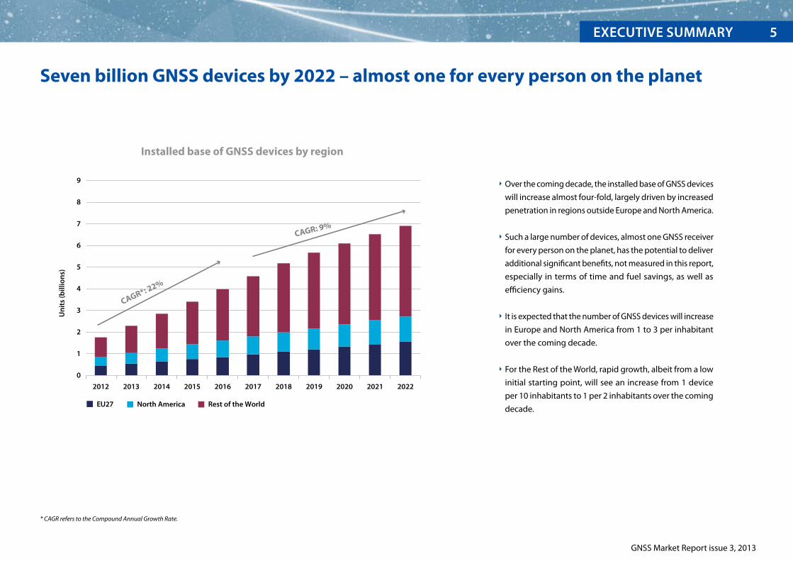
Seven billion GNSS devices by 2022 – almost one for every person on the planet
Installed base of GNSS devices by region
0
1
2
3
4
5
6
7
8
9
2012 2013 2014 2015 2016 2017 2018 2019 2020 2021 2022
Un
its
(bill
ion
s)
CAGR*: 22%
CAGR: 9%
EU27 North America Rest of the World
Over the coming decade, the installed base of GNSS devices
will increase almost four-fold, largely driven by increased
penetration in regions outside Europe and North America.
Such a large number of devices, almost one GNSS receiver
for every person on the planet, has the potential to deliver
additional significant benefits, not measured in this report,
especially in terms of time and fuel savings, as well as
efficiency gains.
It is expected that the number of GNSS devices will increase
in Europe and North America from 1 to 3 per inhabitant
over the coming decade.
For the Rest of the World, rapid growth, albeit from a low
initial starting point, will see an increase from 1 device
per 10 inhabitants to 1 per 2 inhabitants over the coming
decade.
GNSS Market Report issue 3, 2013
ExEcutivE summary6
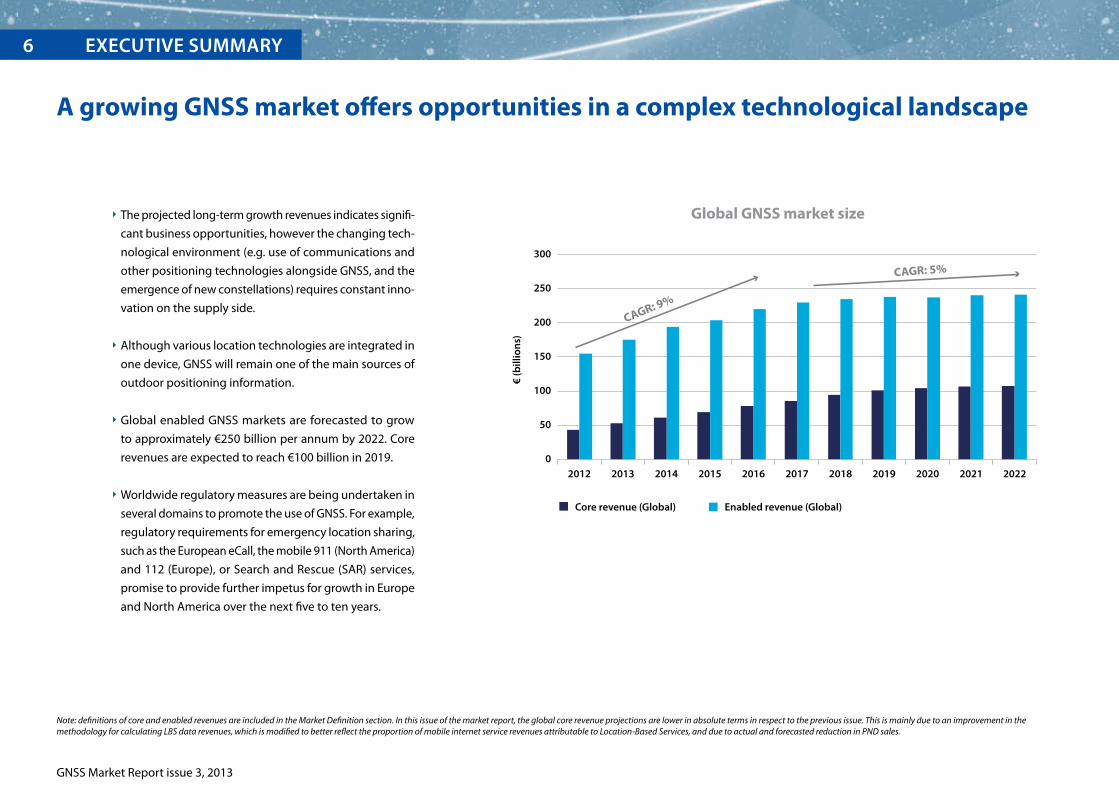
Note: definitions of core and enabled revenues are included in the Market Definition section. In this issue of the market report, the global core revenue projections are lower in absolute terms in respect to the previous issue. This is mainly due to an improvement in the methodology for calculating LBS data revenues, which is modified to better reflect the proportion of mobile internet service revenues attributable to Location-Based Services, and due to actual and forecasted reduction in PND sales.
A growing GNSS market offers opportunities in a complex technological landscape
Global GNSS market size
0
50
100
150
200
250
300
2012 2013 2014 2015 2016 2017 2018 2019 2020 2021 2022
Core revenue (Global) Enabled revenue (Global)
CAGR: 9%
CAGR: 5%
€ (b
illio
ns)
The projected long-term growth revenues indicates signifi-
cant business opportunities, however the changing tech-
nological environment (e.g. use of communications and
other positioning technologies alongside GNSS, and the
emergence of new constellations) requires constant inno-
vation on the supply side.
Although various location technologies are integrated in
one device, GNSS will remain one of the main sources of
outdoor positioning information.
Global enabled GNSS markets are forecasted to grow
to approximately €250 billion per annum by 2022. Core
revenues are expected to reach €100 billion in 2019.
Worldwide regulatory measures are being undertaken in
several domains to promote the use of GNSS. For example,
regulatory requirements for emergency location sharing,
such as the European eCall, the mobile 911 (North America)
and 112 (Europe), or Search and Rescue (SAR) services,
promise to provide further impetus for growth in Europe
and North America over the next five to ten years.

GNSS Market Report issue 3, 2013
ExEcutivE Summary 7
Smartphones dominate global GNSS revenues and are expanding into other market segments
Cumulative core revenue 2012-2022
4.1%
46.2%
47.0%
1.4%
1.0% 0.3%
Agriculture
Road
Maritime
Aviation
LBS
Surveying
0.1%
Rail
New smartphone capabilities alongside integrated tech-
nologies are blurring the market segment breakdowns, as
LBS devices increasingly support navigation and services
in other applications.
LBS is forecasted to be the largest market segment by rev-
enue, overtaking Road, where the PND market continues
to decline, being cannibalised by the use of smartphones
in cars. LBS devices are also being increasingly used in
general aviation and leisure maritime.
New applications are continually introduced and consum-
ers have begun to appreciate the capabilities of LBS in
their daily lives.
Competitive pricing has made smartphones more afford-
able and their market share is rapidly increasing compared
to traditional mobile phones without GNSS capability;
leading to an increase in GNSS penetration, especially in
lower income countries.

Multi-constellation receivers become widely available on the market
* Source: GSA analysis based on GPS World Survey 2013. Percentages based on number of models available, not sales
GNSS Market Report issue 3, 2013
EXECUTIVE SUMMArY8
Multi-constellation devices that use all navigation signals
in view are becoming more common in the market, offer-
ing increased availability (appreciated especially in urban
environments) and more robust performance in profes-
sional applications (e.g. in Surveying).
More than 70% of models available on the market are
GPS-SBAS capable (SBAS comprising WAAS, EGNOS, and
MSAS) and the penetration will grow further with the
expansion of SBAS coverage around the globe.
Galileo is recognised as a valuable element in multi-con-
stellation systems, and it is already present in more than
30% of receiver models, well ahead of its full operational
capability.
GLONASS is the second constellation of choice after GPS.
BeiDou published its Interface Control Document in
December 2012. Several equipment manufacturers, par-
ticularly those based in Asia-Pacific have started to offer
BeiDou-enabled models.
GPS SBAS Galileo GLONASS BeiDou0%
20%
40%
60%
80%
100%
GNSS capability in receivers*

eU shipments and revenues will increase strongly over the next decade
Shipments (in millions) of GNSS devices to the eU27 Revenue (in billion €) raised in the eU27
The shipments of GNSS-enabled devices in the EU27 will grow from 218 million to more than 600 million per annum by 2022. Revenues are expected to more than double over the decade
to €24 billion in 2022.
The EU market will continue to grow (both in terms of shipments and revenues), indicating that even in the developed world the market remains far from saturated.
The growing LBS market, with EU unit sales projected to reach almost 450 million units by 2017, remains the largest segment, followed by Road, which together account for c. 99% of all
shipments.
On the supply side, EU-based companies have strong positions in antenna manufacturing, automotive, rail, surveying, defence/public utilities, and telecoms. A recent GSA study found the
EU share in global market volume in these fields to be between 27% and 45% in 2011.
GNSS Market Report issue 3, 2013
EXECUTIVE SUMMArY 9
*Note: The sizes of the bubbles and number represent shipments to end-users in the EU27. *Note: The sizes of the bubbles and number represent revenues raised from end-users in the EU27.
218 441 613 10.9 17.9 23.5
2012 2017 2022 2012 2017 2022
218 441 613 10.9 17.9 23.5
2012 2017 2022 2012 2017 2022

GNSS Market Report issue 3, 2013
EUrOpEAN GNSS SYSTEMS10
Galileo Services
Open Service (OS) – a freely accessible service for positioning, navigation and
timing, utilising the dual-frequency Galileo Signal in Space (SIS). The Open Service is
global and free to use.
Public Regulated Service (PRS) – an encrypted, secure service with additional
advanced features designed for greater robustness and higher availability, primarily
directed at government/public sector operations.
Commercial Service (CS) – delivers authentication and high accuracy services for
commercial applications.
Search and Rescue Service (SAR) – assists in locating people, vessels and aircraft in
distress, with confirmation that help is on the way.
Open Service
public regulated Service
Commercial Service
Search and rescue
consolidating the market positionEGNOS, the European Satellite Based Augmentation System, increases the accuracy of GPS posi-
tioning and provides information on its reliability (integrity), making it suitable for safety-critical
applications. EGNOS has been fully operational since 2009.
Consisting of three geostationary satellites and a network of ground stations, EGNOS is inter-
operable with WAAS (US), MSAS (Japan), and GAGAN (India).
Designed primarily for Aviation, EGNOS has been widely adopted in other segments, such as
Agriculture and Road.
An enhanced version of EGNOS is currently under development. It will offer Galileo corrections
and a wider coverage area expanding into Africa and the Middle East.
early Services on the horizonGalileo, Europe’s own Global Navigation Satellite System, will provide highly
accurate global positioning services worldwide firmly under civilian control and wholly interop-
erable with GPS, GLONASS, and BeiDou. Many GNSS receivers and chipsets in the marketplace
are already “Galileo-ready”.
Galileo is currently finalising its In-Orbit Validation (IOV) phase using an initial group
of 4 satellites launched during 2011-2012. On 12th March 2013, Galileo passed an historic
milestone for European space when the very first determination of a ground location fix
was achieved.
Early Service
Early Servicepilot projects
2012 2013 2014 2015 2016 2017
Stable signals
demonstrator Early Service
Early Service

Location-Based Services
11
© T
hink
stoc
k

Mobile applications getting closer to where you are
Key market trends:
Growing diversity of mobile applications, also integrating location-based information in camera view (augmented reality).
Use of GNSS in devices traditionally unrelated to location.
Increasing number of devices per user and regional expansion towards developing countries.
Application Stores:Apple App Store
Windows Phone StoreGoogle Play
Amazon App Store
Devices: Smartphones, tablets, digital cameras,
fitness and tracking devices, binoculars
Applications: personal navigation, point of interest search, LBS advertising, person and objects tracking,
emergency caller location, location based gaming, sport and entertainment, weather information and news, social networking
Complexity of LBS segment
Technology:Cell ID, Wi-Fi,
GNSS, INS
Recent developments: Augmented reality – an information overlay in mobile
devices on top of the physical world. Indoor positioning – location of people and objects inside
large buildings, such as airports and shopping centres.
examples of applications: Foursquare – users “check in” at a certain location,
enabling social networking, finding points of interest and recommending places. Wikitude – augmented reality application, adding
information to camera view on points of interest, tourist information, etc. Find Me Maybe – sends geo-localized SMS to Facebook
and Twitter informing contacts of the user’s situation.
Upsurge in number of applications: 775,000 in Apple App Store in 2013. 700,000 in Android Apps compared to 88,000 in 2011. An estimated 40% of applications use location information.
Integration of positioning into devices such as cameras, watches, and binoculars. Location information sent from devices to application layers to enable
sharing and tracking (e.g. for recording the distance run, social networking).
Binoculars – built-in GPS receiver automatically geo-tags video clips and photos. Fitness devices – GPS watches for runners, cyclists, and
swimmers. Augmented reality glasses.
Various positioning technologies integrated into one device. GNSS remains the primary positioning solution outdoors, offering better accuracy
than Cell ID and Wi-Fi . Technological developments concentrate on seamless integration and the switch from
outdoor to indoor positioning.
IMES* – provides 3D position in indoor locations with an accuracy of about 10 m. The same GNSS receiver can process both GNSS and IMES signals leading to seamless navigation between outdoor and indoor environments.
GNSS Market Report issue 3, 2013
GNSS MArKET LOCATION-BASEd SErVICES12
* Indoor Messaging System * Indoor Messaging System

GNSS Market Report issue 3, 2013
LBS value chainEx
amp
les
of k
ey p
laye
rs
Broadcom
CSR-SiRF
Fujitsu Ltd
Intel
Mediatek
Qualcomm
Skytraq
STM
Texas Instruments
U-Blox AG
Smartphone/tablet: Apple, HTC, Huawei, Malata, Nokia, RIM, Samsung, ZTE Cameras:
Canon, Nikon, Sony watches:
Garmin, Suunto, Timex pCs:
Apple, Dell, HP, Lenovo people tracking:
Garmin, Pocket Finder, Spot OEMs:
Pegatron, Wistron
Apple
Garmin
Nokia
TomTom
Assistance data providers
Mobile Network Operators
App developers: Apple, Electronic Arts, Google,
Microsoft, TripAdviser, Yelp, Zynga
Retailers: Airlines Banks General retailers Media companies Mobile Network Operators Transport providers Vehicle manufacturers
Apple App Store Amazon App store Google Play Windows Phone Store
Mar
ket T
ren
ds
Integration of sensors and RF technologies (GNSS, GSM, Wi-Fi) together with GNSS multi-constellation.
Continuous improvements in cost, power consumption and performance.
Highly competitive global market with rapid innovation and integration along the value chain, tying together content, platforms, and applications.
Increasingly GNSS is a standard feature in many platforms, such as digital cameras, laptops, watches, and personal tracking.
The increasing demand for location-based applications opens up new opportunities for service providers.
Increasing value perceived in controlling mapping solutions e.g. Apple Maps set up so as to be independent of Google Maps data.
The decline of the automotive PND market pushed many important players to utilise their assets (such as map and traffic information data) to become a service provider.
Retailers commission apps and benefit from new opportunities for customer relationship management and vehicles for location-based advertising.
App developers are increasingly consolidated, however there are many small scale hobbyists who develop highly useful apps.
The market is dominated by the major platform developers, Apple and Google, that have become particularly strong players in the value chain.
Chipset Manufacturers
Device Vendors App StoresApp Developers
& RetailersService & Content
Providers
EXECUTIVE SUMMArY 13GNSS MArKET LOCATION-BASEd SErVICES 13

GNSS Market Report issue 3, 2013
The LBS market has seen phenomenal growth
Rapid evolution of GNSS capability in LBS:
The first LBS services were launched in 2001 by TeliaSonera in Sweden
and by EMT in Estonia, relying on the Ericsson mobile positioning
system.
The first advertisement for iPhone was broadcast during the 79th
Academy Awards in 2007.
Mobile apps exploded onto the market in 2008 with the launch of
the App Store – allowing 3rd party developers access to the iPhone
platform for the first time.
In 2009 Google introduced turn-by-turn directions as a feature of its
Android operating system, hastening the demise of the Road Portable
Navigation Device (PND) market whilst providing greater access to
driving, cycling, and walking directions.
MTS launched the first GLONASS smartphone in 2011.
In 2013 Google announced an open beta test of its Google Glass
augmented reality glasses.
GNSS penetration worldwide increased from 5% in 2006 to 20% in 2012. In Europe and North
America, more than half of mobile phones have GNSS capability.
Global shipments of GNSS-enabled LBS devices have grown from 150 million to 800 million
in the last five years (40% CAGR).
The Rest of the World represents approximately 50% of the market and is growing quickly
due to rapid economic growth in these regions and decreasing device prices, making them
more affordable.
2006 2007 2008 2009 2010 2011 2012
EU27 North America Rest of the World GNSS penetration
Un
its
(mill
ion
s)
GN
SS p
enet
rati
on*
900
800
700
600
500
400
300
200
100
0
25%
20%
15%
10%
5%
0%
Shipments of GNSS devices by region
GNSS MArKET LOCATION-BASEd SErVICES14
* The penetration represents the percentage of LBS devices in use that are GNSS enabled
GNSS Market Report issue 3, 2013
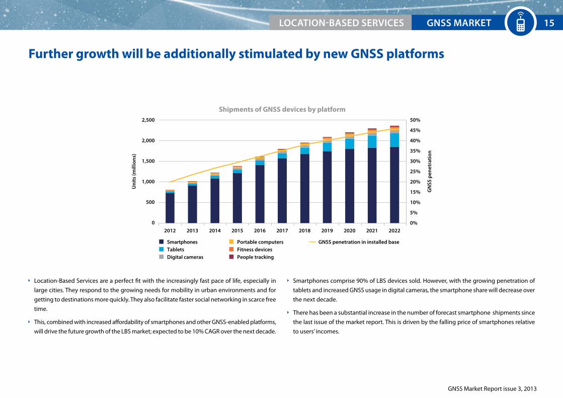
Further growth will be additionally stimulated by new GNSS platforms
Location-Based Services are a perfect fit with the increasingly fast pace of life, especially in
large cities. They respond to the growing needs for mobility in urban environments and for
getting to destinations more quickly. They also facilitate faster social networking in scarce free
time.
This, combined with increased affordability of smartphones and other GNSS-enabled platforms,
will drive the future growth of the LBS market; expected to be 10% CAGR over the next decade.
Smartphones comprise 90% of LBS devices sold. However, with the growing penetration of
tablets and increased GNSS usage in digital cameras, the smartphone share will decrease over
the next decade.
There has been a substantial increase in the number of forecast smartphone shipments since
the last issue of the market report. This is driven by the falling price of smartphones relative
to users’ incomes.
2012 2013 2014 2015 2016 2017 202020192018 2021 2022
Shipments of GNSS devices by platform
Un
its
(mill
ion
s)
GN
SS p
enet
rati
on
2,500
2,000
1,500
1,000
500
0
50%
45%
40%
35%
30%
25%
20%
15%
10%
5%
0%
Digital cameras
SmartphonesTablets
People tracking
Portable computersFitness devices
GNSS penetration in installed base
EXECUTIVE SUMMArY 15GNSS MArKET LOCATION-BASEd SErVICES 15

GNSS Market Report issue 3, 2013
GNSS MArKET LOCATION-BASEd SErVICES16
Galileo offers benefits for advanced LBS applications
Galileo will contribute to better performance in LBS
Availability will be further improved by the use of Galileo satellites, enhancing
continuity of service in urban environments.
Galileo, as a part of a multi-constellation solution, can respond to the need for higher ac-
curacy for some more demanding applications. For example, the ability to locate a user
in front of a particular shop opens new opportunities for location-based advertising.
State-of-the-art signal characteristics of Galileo will have better resistance to multipath interfer-
ence (interference from reflected signals).
The most important GNSS characteristics for the LBS market are Time-To-First-Fix (TTFF) and availability. Use of assisted GNSS lowers TTFF by transferring part of the data used to determine the
position over mobile networks.
Several test results show that availability is significantly improved (especially in urban canyons) by the existence of additional satellite constellations.
example of R&D project: i-Going
Although 90% of phone usage occurs indoors, there are no suitable services
yet to provide accurate positioning of these devices inside buildings.
i-Going project develops a service that generates specific indoor signals
by making use of a network of pseudolites, which are installed inside buildings and are
connected to a localisation server that manages them.
More information can be found at: http://www.igoing.eu
example of R&D project: PeRNASVIP
Visually disabled people have striking needs for trustful navigation sys-
tems that improve their day-to-day autonomy. Existing positioning and
navigation technologies still lack accuracy and reliability or they rely on
costly infrastructures.
PERNASVIP aims to develop a GNSS-based mobility service with EGNOS/Galileo capabili-
ties that solves these problems in an urban environment. The service meets the 4m level of
accuracy and reliability, enabling efficient mobility in daily life.
More information can be found at: http://pernasvip.di.uoa.gr/index.php
GPS SBAS Galileo GLONASS BeiDou0%
20%
40%
60%
80%
100%
GNSS capability of LBS chipsets*
* Source: GSA analysis based on GPS World Survey 2013. Percentages based on number of models available, not sales.
GNSS Market Report issue 3, 2013
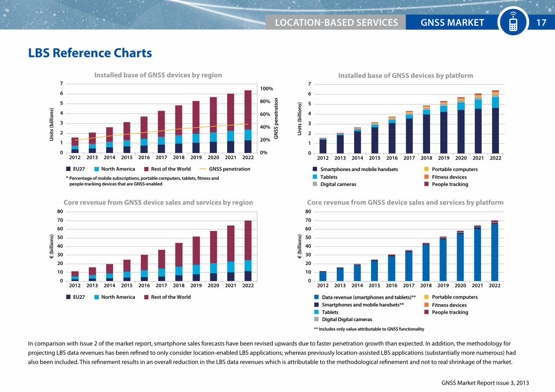
LBS Reference Charts
2012 2013 2014 2015 2016 2017 202020192018 2021 2022
Installed base of GNSS devices by region
Un
its
(bill
ion
s)
7
6
5
4
3
2
1
0
100%
80%
60%
40%
20%
0%
* Percentage of mobile subscriptions, portable computers, tablets, fitness andpeople-tracking devices that are GNSS-enabled
GN
SS p
enet
rati
on
EU27 North America Rest of the World
2012 2013 2014 2015 2016 2017 202020192018 2021 2022
Installed base of GNSS devices by platform
Un
its
(bill
ion
s)
7
6
5
4
3
2
1
0
Smartphones and mobile handsets
TabletsDigital cameras
Fitness devicesPeople tracking
Portable computers
Data revenue (smartphones and tablets)**Smartphones and mobile handsets**Tablets
Fitness devicesPeople tracking
Portable computers
Digital Digital cameras
2012 2013 2014 2015 2016 2017 202020192018 2021 2022
Core revenue from GNSS device sales and services by region
€ (b
illio
ns)
80
70
60
50
40
30
20
10
02012 2013 2014 2015 2016 2017 202020192018 2021 2022
** Includes only value attributable to GNSS functionality
Core revenue from GNSS device sales and services by platform
€ (b
illio
ns)
80
70
60
50
40
30
20
10
0
EU27 North America Rest of the World
GNSS penetration
In comparison with Issue 2 of the market report, smartphone sales forecasts have been revised upwards due to faster penetration growth than expected. In addition, the methodology for
projecting LBS data revenues has been refined to only consider location-enabled LBS applications; whereas previously location-assisted LBS applications (substantially more numerous) had
also been included. This refinement results in an overall reduction in the LBS data revenues which is attributable to the methodological refinement and not to real shrinkage of the market.
EXECUTIVE SUMMArY 17GNSS MArKET LOCATION-BASEd SErVICES 17

GNSS Market Report issue 3, 2013
18

19
Road
GNSS Market Report issue 3, 2013
GNSS consolidates its position in vehicles
Key market trends:
Increased regulatory pressure for emergency location sharing and safety-related applications drives the demand for telematics equipment,
which serves as a platform for innovative applications.
dedicated nomadic GNSS devices (pNds) are becoming redundant with increasing use of smartphones and better affordability of In-Vehicle Systems (IVS).
Current industry view
Lower costs of data connectivity and consumer electronics drive the development of new appli-
cations. The number of embedded devices and On-Board Units (OBUs) is growing, replacing
traditional nomadic devices (e.g. PNDs). Smartphones are increasingly used for road navigation
purposes. New Intelligent Transport System (ITS) services are expected to be deployed in the
coming years, taking the use of GNSS far beyond in-vehicle navigation.
The following applications beyond traditional navigation are selected for this report:
Pay-per-use insurance (PPUI) enabling pricing policies based on timing, location and driving
behaviour.
Advanced Driver Assistance Systems (ADAS) and connected vehicles where GNSS, comple-
mented by sensors (e.g. camera, radar) and communications systems (e.g. Wi-Fi, 3G), is used
to enhance intelligent vehicle safety systems (e.g. intelligent speed adaptation, lane change
assistance, curve speed warning, collision avoidance, automated driving).
Road User Charging (RUC) solutions, determining the position of vehicles using GNSS data
received by OBUs, which calculate road tolls based on distance travelled at a particular loca-
tion and time.
Satellite road traffic monitoring using real-time traffic information. The floating car location
data, collected in real-time from vehicles, are sent to a central processing centre and shared
with interested parties.
eCall - see description on the right side of the page.
eU policies drive GNSS adoption:
Digital Tachograph (DT)
EU policy has made DTs mandatory for vehicles with a mass of more than 3.5 tonnes in goods
transport and those carrying more than 9 persons in passenger transport, in order to enforce
rules on driving times and rest periods, guaranteeing fair competition and road safety.
The new regulation introduces the use of GNSS positioning in future DTs. GNSS technology
will help automate operations so far performed manually to record the position of the vehicle
at determined points, with estimated cost-saving of €350 million per year for the sector. The
presence of GNSS in DTs will also foster the use of the satellite-based positioning to guarantee
to origin and the integrity of the DT records and will open up further possibilities for the intro-
duction of a standardised interface to support Intelligent Transport Systems (ITS) applications.
eCall
According to a new regulation proposed by the European Commission, all new types of pas-
senger cars and light vehicles will need to have an eCall system from 2015.
The eCall system will automatically:
send an emergency call to 112 in case of accident, offering rapid assistance to drivers in every
part of the European Union.
provide vehicle identity and GNSS-based location, shortening the intervention time.
GNSS MArKET rOAd20

GNSS Market Report issue 3, 2013
Road Value ChainEx
amp
les
of k
ey p
laye
rs
Broadcom
CSR-SiRF
Furuno
Japan Radio Co.
Mediatek
Pulse Electronics
Qualcomm
ST Micro
U-Blox
Bosch
Continental
Denso
Ficosa
Garmin
Magneti Marelli
Siemens
TomTom
Fuel/fleet card issuing companies
Mobile network operators
Traffic information providers
Telematics service providers
Toll operators
BMW
Daimler
Fiat
Ford
General Motors
Jaguar Land-Rover
Peugeot Citroen
Renault Nissan
Toyota
Volkswagen
Volvo
Car owners
Fleet operators
Insurance companies
Member States
GN
SS M
arke
t Tre
nd
s
GNSS performance continues to improve through availability of new modern signal processing techniques and closer integration with various technologies (Assisted GNSS, Wi-Fi, and other sensors).
New products include multiple constellation capability – essential for many urban ITS applications.
The use of nomadic devices in cars is decreasing which, together with price erosion, results in lower revenues.
PND market is strongly cannibalised by the use of smartphones in vehicles.
The share of embedded devices, supported by regulation and consumer demand, is increasing.
Apart from map data providers, this market is not yet consolidated and includes many business models.
The level of innovation is high and convergence with internet and mobile applications is taking place.
In ITS deployed scenarios GNSS-enabled services are expected to become a key revenue driver.
Platform convergence is expected, driven by common data standards, lower data tariffs, and interest in vehicle connectivity.
EU eCall regulations by 2015 will support the market for embedded devices and could be an incentive to leverage development costs through a wider service offering (e.g. ADAS, infotainment).
The socio-economic benefits coming from GNSS help to overcome some of the challenges on the road such as rising congestion, pollution, and costs of fuel and insurance.
These challenges drive new service offerings e.g. asset tracking, PPUI insurance, and real-time traffic information.
Chipset Manufacturers
Tier 1 and Device Vendors UsersOriginal equipment
ManufacturersService
Providers
GNSS MArKETrOAd 21

GNSS Market Report issue 3, 2013
PNDs further replaced by embedded devices
The appearance of the first GNSS-based RUC schemes resulted in the uptake of dedicated
OBUs with the market share increasing from almost zero in 2009 to more than 2% of all road
devices sold in 2012.
The installed base of GNSS devices quadrupled from 2006 to 2012, reaching over 200 million
devices (see reference page).
Significant growth in installed base was observed in all regions, as average device prices fell
and GNSS-based Intelligent Transport Systems (ITS) became more common in vehicles.
With smartphone navigation becoming increasingly popular, the PND market has been declin-
ing since 2009*.
Lower connectivity costs and emergence of innovative solutions linked with infotainment
platforms have resulted in increased uptake of IVS. The IVS market grew by approximately
13% CAGR between 2009 and 2012.
2006 2007 2008 2009 2010 2011 2012
Un
its
(mill
ion
s)
60
50
40
30
20
10
0
Shipments of GNSS devices by application
Personal Navigation Device (PND)In-Vehicle System (IVS)
RUC eCallADASPPUI
GNSS MArKET rOAd22
* Smartphones used for navigation in vehicles are excluded in the Road segment device shipments charts and presented as part of the LBS market.

GNSS Market Report issue 3, 2013
2323
New ITS applications drive market growth
2012 2013 2014 2015 2016 2017 202020192018 2021 2022
Shipments of GNSS devices by application
Un
its
(mill
ion
s)
140
120
100
80
60
40
20
0
Personal Navigation Device (PND)In-Vehicle System (IVS)
RUC eCallADASPPUI
Increased connectivity of vehicles and GNSS multi-constellation capabilities expand new
products and urban ITS applications in Road.
PNDs, replaced by multi-function devices, are forecast to account for only 10% of total Road
GNSS device shipments by the end of the decade.
New applications in use from 2015 are driven by the eCall initiative and related to reliable
telematics devices. Common data standards and lower tariffs will foster IVS uptake, account-
ing for about one third of total shipments in 2022.
Market needs for cheaper and more sustainable transportation systems favour GNSS-based
RUC schemes and PPUI applications. Combined shipments of devices in these two applications
will grow to around 20% in 2022.
Competition in the automotive industry and from smartphones, combined with declining
prices in consumer electronics in general, will result in price erosion for both PND and IVS.
Traffic information services enabled by GNSS are forecast to be the primary driver of growth
in service revenues until 2018. Thereafter, fierce competition in this segment will result in total
revenues declining to around 2012 levels by 2022 (see reference page).
GNSS MArKETrOAd 23

GNSS Market Report issue 3, 2013
GNSS MArKET rOAd24
european GNSS enhances Intelligent Transport Systems
Galileo is expected to bring immediate benefits in the Road segment, even from
Early Services, as part of a multi-constellation solution. It will add value in all
applications by providing increased availability, especially in urban environments
where the number of satellites in view can be limited. This will result in better
accuracy and reliability of positioning. Additional benefits are expected when the dual-frequency
capacity of Galileo is fully exploited by consumer devices.
Many new GNSS chipsets aimed at the automotive market include Galileo tracking capabilities
(see chart on the right) and the share is expected to increase rapidly with the upcoming eCall
implementation.
By improving accuracy and providing information on the reliabil-
ity of GPS signal, at no additional cost, EGNOS is now included in
many automotive GNSS chipsets and has started to be valued in
applications such as road charging and dangerous goods transport monitoring.
example of R&D project: TACOT
The TACOT (trusted multi-application receiver for trucks) project promotes the use
of EGNOS and Galileo in the road industry through trusted GNSS function in Digital
Tachographs (DT). Benefits include:
The possibility to record start and end positions for truck journeys.
Usage in other ITS domains: pay as you drive services, anti-theft systems, fleet
management, and new applications using the trusted Position, Velocity and Time (PVT).
TACOT aims to demonstrate that a GNSS-based “trusted” PVT enabling
liability critical and legally binding applications, can be achieved at
relatively low cost using EGNOS and Galileo.
More information can be found at:
http://www.gsa.europa.eu/trusted-multi-application-receiver-trucks
GPS SBAS Galileo GLONASS BeiDou0%
20%
40%
60%
80%
100%
GNSS capability of Road devices*
* Source: GSA analysis based on GPS World Survey 2013. Percentages based on number of models available, not sales.

GNSS Market Report issue 3, 2013
Road Reference Charts
EU27 North America Rest of the World Personal Navigation Device (PND)
RUCPPUI
eCallADAS
In-Vehicle System (IVS)
Personal Navigation Device (PND)RUCPPUI
Traffic information services
ADAS
In-Vehicle System (IVS)eCall
2012 2013 2014 2015 2016 2017 202020192018 2021 2022
Installed base of GNSS devices by region
Un
its
(mil
lio
ns)
600
500
400
300
200
100
02012 2013 2014 2015 2016 2017 202020192018 2021 2022
Installed base of GNSS devices by application
Un
its
(mil
lio
ns)
600
500
400
300
200
100
0
2012 2013 2014 2015 2016 2017 202020192018 2021 2022
Core revenue from GNSS device sales and services by region
€ (b
illio
ns)
50
45
40
35
30
25
20
15
10
5
0
Dev
ice
pri
ce €
700
600
500
400
300
200
100
0
EU27 North America Rest of the World
2012 2013 2014 2015 2016 2017 202020192018 2021 2022
Core revenue from GNSS device sales and services by application
€ (b
illio
ns)
50
40
30
20
10
0
Dev
ice
pri
ce €
800
600
400
200
0
Average device price
Device price: PNDDevice price: IVS
EUrOpEAN GNSS SYSTEMSrOAd 25

GNSS Market Report issue 3, 2013
26

Aviation
27
© T
hink
stoc
k

GNSS Market Report issue 3, 2013
GNSS as a key enabler for Performance-Based Navigation (PBN)
Key market trends:
Transition from traditional routing to GNSS navigation solutions for all phases of flight.
New operational requirements driving the growth of GNSS avionics use.
Growing availability of SBAS-based procedures in European aerodromes.
The aviation market
Navigation systems in Aviation demand the highest robustness and integrity, and support
continuous operations in aerodromes of varying infrastructure complexity.
GNSS applications in Aviation vary greatly depending on the accuracy and integrity of the
position needed. Operations relying on GNSS are subject to certification (Instrument Flight
Rules), otherwise GNSS can be used as an additional aid to the pilot without requiring regula-
tory approval (Visual Flight Rules).
The Aviation market has been segmented according to the use of the aircraft/helicopters into:
commercial, regional and business & general aviation.
This issue of the market report adds General Aviation Visual Flight Rules (GA VFR) as a sub-
segment, the largest aviation application in terms of shipments and with the least demanding
requirements (non-certified GNSS devices). Typical users include kit planes, micro lights, ultra
lights, gliders, and hot-air balloons.
High-end business aviation and commercial operators tend to have GNSS receivers tightly
integrated into their avionics, whilst panel mounted displays provide a cheaper and simpler
solution for regional and general aviation users.
Performance-Based Navigation leverages GNSS benefits
GNSS is essential for the introduction of Performance-Based Navigation (PBN) in line with ICAO
standards that place requirements on the quality and accuracy of aircraft navigation along
predefined routes, on an instrument approach procedure or in designated airspace. It envis-
ages a transition from traditional ground-based navigation towards space-based navigation.
GNSS helps to increase safety, reduce congestion, save fuel, protect the environment, reduce
infrastructure operating costs, and maintain reliable all weather operations, even at the most
challenging airports.
Growth in the use of GNSS
GNSS use in Aviation will increase as more flight procedures are designed to take advantage of
PBN. For example, EGNOS-enabled instrument approach procedures to LPV* minima are being
rolled out in Europe, increasing safety and business continuity at aerodromes.
New GNSS constellations are expected to be available in the next few years providing multi-
frequency and multi-constellation navigation capabilities, which may improve the performance
of existing PBN applications. It is expected to be a key enabler for Ground Based Augmentation
Systems (GBAS), resulting in lower minima to CAT II or CAT III standards, demanded by some
commercial operators.
GNSS MArKET AVIATION28
* Localiser performance with vertical guidance is an Instrument Approach Procedure that provides later and vertical guidance based on GPS augmented by SBAS (EGNOS/WAAS) down to 250 ft.

GNSS Market Report issue 3, 2013
Aviation Value ChainEx
amp
les
of k
ey p
laye
rs
Main Players (CA/RA): Honeywell (US) Rockwell Collins (US) Thales Avionics (FR) Universal (US)
Main Players (BA/GA): Garmin (US) Honeywell (US) Rockwell Collins (US)
Main Players (CA/RA): Airbus (EU) Boeing (US) Embraer (BR)
Main Players (BA/GA): Bombardier (CAN) Cessna (US) Cirrus (US) Piper (US)
Main airline alliances: Oneworld SkyTeam Star Alliance
General Aviation: Aircraft Owners and Pilots
Association (AOPA)
Main Organisations: The Civil Air Navigation
Services Organisation (CANSO) represents ANSPs worldwide
The International Civil Aviation Organisation (ICAO) codifies the principles of air navigation
Main Categories: International airports Regional airports Private airports
GN
SS M
arke
t Tre
nd
s
The capabilities of GNSS devices respond to customer demand and fit within the regulatory environment.
Penetration of GNSS in the VFR sub-segment is increasing.
New features and capabilites from regulated devices are expected to align with the requirements of PBN and the progression towards multi-frequency integration.
Aircraft manufacturers continue to offer avionics from a limited set of manufacturers due to high investment and certification requirements.
This limitation does not exist for VFR pilots who can make choices purely on personal preference.
GNSS is included in all modern aircraft. Whereas, SBAS capability is a standard mostly in business and general aviation.
Demand for GNSS - in particular EGNOS - is particularly high in less equipped airfields where precision approach capabilities may not exist.
The move to PBN may result in some retrofit of SBAS capabilities - particularly in regional aviation.
Commercial aviation will continue with APV Baro for approach procedures using current capabilities. It is expected that the availability of GBAS CAT II and CAT III will increase interest in retrofits in this segment.
ANSPs are moving towards the deployment of PBN operations within the en-route and terminal phases of flight.
It is expected that, as PBN operations become more common and multi-frequency GNSS becomes available, ANSPs will look at rationalisation of traditional navigation infrastructures.
Regional and private aerodromes are driving the uptake of GNSS approaches as a means to offer near precision approach capabilites for significantly reduced costs.
International aerodromes retain precision approaches and are served primarily by commercial airlines using APV that do not require extensive retrofits. These aerodromes are expected to deploy GBAS CAT II and III, when available.
Device Manufacturers
AircraftManufacturers AerodromesAir Navigation Service
Providers (ANSP)Airlines/
Aircraft owners
GNSS MArKETAVIATION 29
GNSS Market Report issue 3, 2013
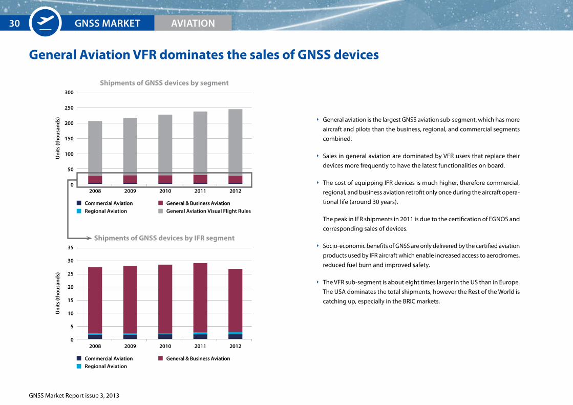
General Aviation VFR dominates the sales of GNSS devices
General aviation is the largest GNSS aviation sub-segment, which has more
aircraft and pilots than the business, regional, and commercial segments
combined.
Sales in general aviation are dominated by VFR users that replace their
devices more frequently to have the latest functionalities on board.
The cost of equipping IFR devices is much higher, therefore commercial,
regional, and business aviation retrofit only once during the aircraft opera-
tional life (around 30 years).
The peak in IFR shipments in 2011 is due to the certification of EGNOS and
corresponding sales of devices.
Socio-economic benefits of GNSS are only delivered by the certified aviation
products used by IFR aircraft which enable increased access to aerodromes,
reduced fuel burn and improved safety.
The VFR sub-segment is about eight times larger in the US than in Europe.
The USA dominates the total shipments, however the Rest of the World is
catching up, especially in the BRIC markets.
2008
2008
2009 2010 2011 2012
Un
its
(th
ousa
nd
s)
300
250
200
150
100
50
0
Shipments of GNSS devices by segment
2009 2010 2011 2012
Un
its
(th
ousa
nd
s)
35
30
25
20
15
10
5
0
Shipments of GNSS devices by IFR segment
Commercial AviationRegional Aviation
General & Business AviationGeneral Aviation Visual Flight Rules
Commercial AviationRegional Aviation
General & Business Aviation
GNSS MArKET AVIATION30
GNSS Market Report issue 3, 2013
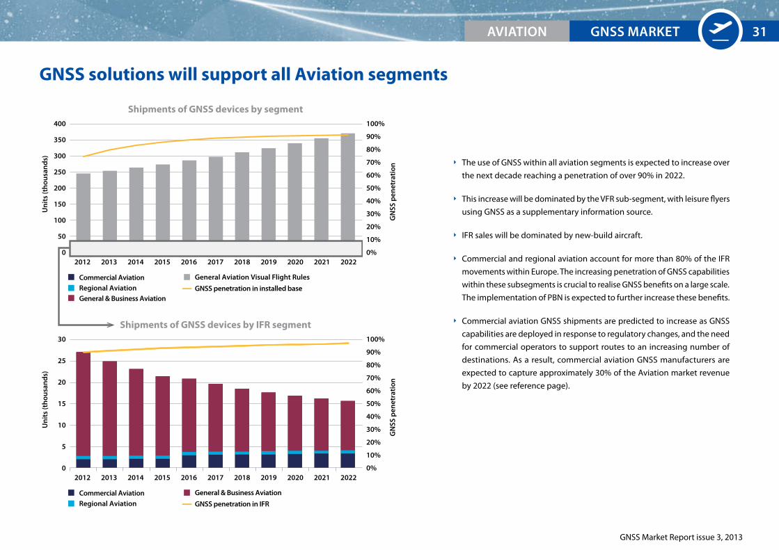
GNSS solutions will support all Aviation segments
The use of GNSS within all aviation segments is expected to increase over
the next decade reaching a penetration of over 90% in 2022.
This increase will be dominated by the VFR sub-segment, with leisure flyers
using GNSS as a supplementary information source.
IFR sales will be dominated by new-build aircraft.
Commercial and regional aviation account for more than 80% of the IFR
movements within Europe. The increasing penetration of GNSS capabilities
within these subsegments is crucial to realise GNSS benefits on a large scale.
The implementation of PBN is expected to further increase these benefits.
Commercial aviation GNSS shipments are predicted to increase as GNSS
capabilities are deployed in response to regulatory changes, and the need
for commercial operators to support routes to an increasing number of
destinations. As a result, commercial aviation GNSS manufacturers are
expected to capture approximately 30% of the Aviation market revenue
by 2022 (see reference page).
2012 2013 2014 2015 2016 2017 202020192018 2021 2022
Shipments of GNSS devices by segment
Un
its
(th
ousa
nd
s)
400
350
300
250
200
150
100
50
0
GN
SS p
enet
rati
on
100%
90%
80%
70%
60%
50%
40%
30%
20%
10%
0%
Commercial AviationRegional AviationGeneral & Business Aviation
General Aviation Visual Flight Rules
2012 2013 2014 2015 2016 2017 202020192018 2021 2022
Shipments of GNSS devices by IFR segment
Un
its
(th
ousa
nd
s)
30
25
20
15
10
5
0
GN
SS p
enet
rati
on
100%
90%
80%
70%
60%
50%
40%
30%
20%
10%
0%
Commercial AviationRegional Aviation
General & Business Aviation
GNSS penetration in IFR
GNSS penetration in installed base
GNSS MArKETAVIATION 31
GNSS MArKET
GNSS Market Report issue 3, 2013
AVIATION32
Growing eGNOS use delivers real benefits to aviation
Benefits to aviation
Standalone GPS is neither accurate nor reliable enough for preci-
sion approaches. EGNOS guarantees the level of vertical accuracy required for PBN and offers
safety and integrity for instrument approach procedures across Europe for fixed wing aircraft
and helicopters (similar to WAAS in USA).
It improves the efficiency of aerodromes and allows smaller airports to remain accessible even
in poor weather conditions.
No additional ground infrastructure is required for the use of EGNOS. EGNOS approach pro-
cedures have similar performance to ILS CAT I and give aerodromes with EGNOS procedures
a competitive advantage over aerodromes only offering non-precision approach procedures.
By enabling more efficient routes, EGNOS reduces environmental impact and distortions of air
traffic delivering operational benefits.
The EU activities in combination with countries’ PBN implementation plans support the increas-
ing demand from aviation users and build EGNOS implementation capacity. An increase in the
number of procedures which use EGNOS operationally is expected to continue in the future.
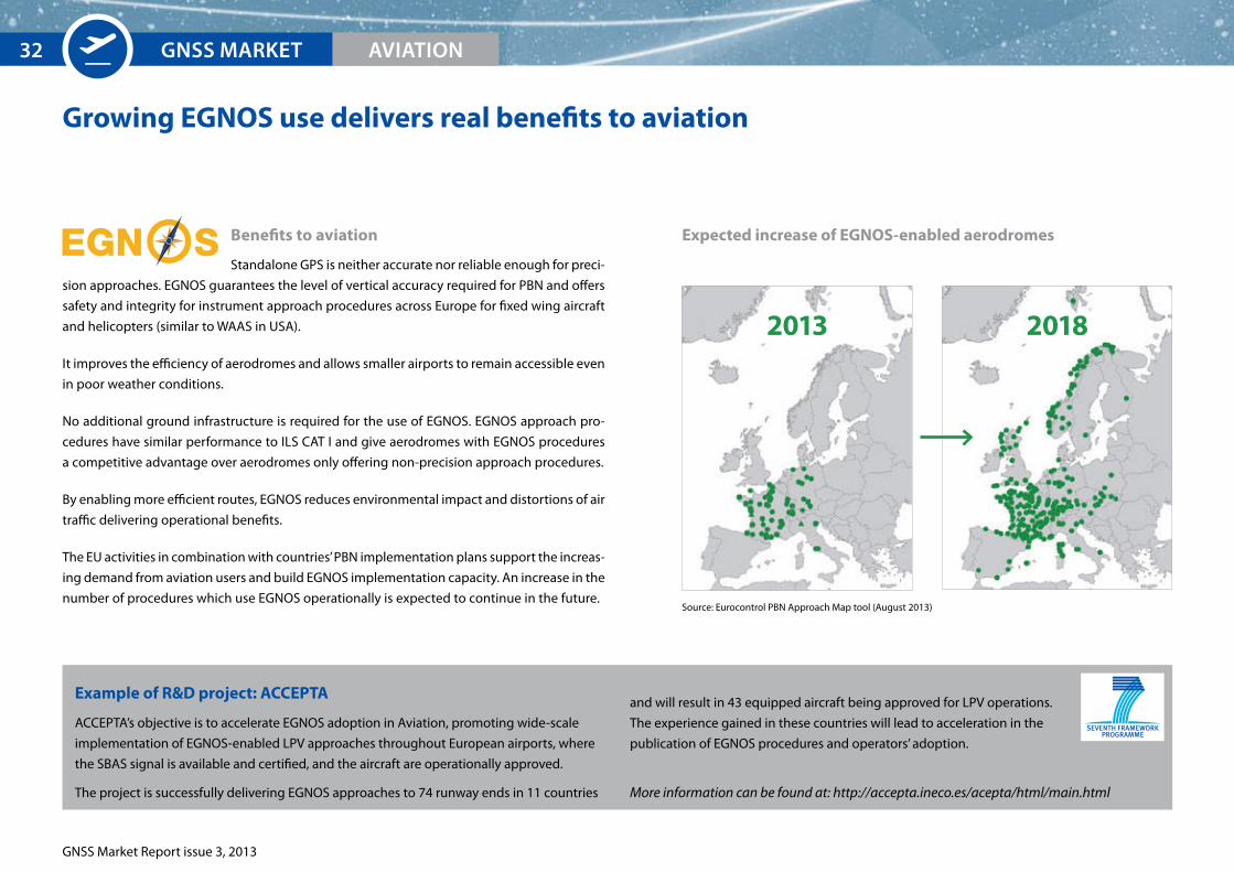
expected increase of eGNOS-enabled aerodromes
example of R&D project: ACCePTA
ACCEPTA’s objective is to accelerate EGNOS adoption in Aviation, promoting wide-scale
implementation of EGNOS-enabled LPV approaches throughout European airports, where
the SBAS signal is available and certified, and the aircraft are operationally approved.
The project is successfully delivering EGNOS approaches to 74 runway ends in 11 countries
and will result in 43 equipped aircraft being approved for LPV operations.
The experience gained in these countries will lead to acceleration in the
publication of EGNOS procedures and operators’ adoption.
More information can be found at: http://accepta.ineco.es/acepta/html/main.html
2013 2018
Source: Eurocontrol PBN Approach Map tool (August 2013)
EUrOpEAN GNSS SYSTEMS
GNSS Market Report issue 3, 2013
Aviation Reference Charts
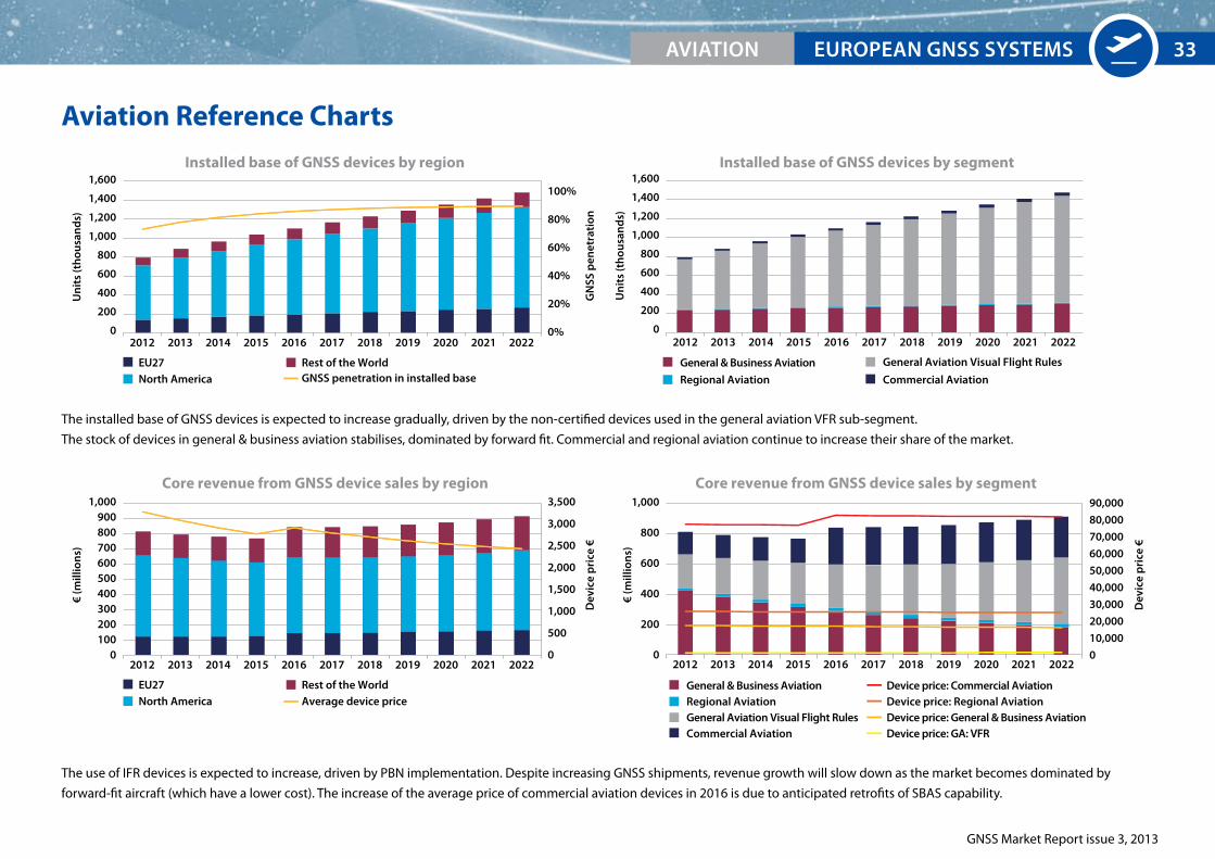
The use of IFR devices is expected to increase, driven by PBN implementation. Despite increasing GNSS shipments, revenue growth will slow down as the market becomes dominated by
forward-fit aircraft (which have a lower cost). The increase of the average price of commercial aviation devices in 2016 is due to anticipated retrofits of SBAS capability.
The installed base of GNSS devices is expected to increase gradually, driven by the non-certified devices used in the general aviation VFR sub-segment.
The stock of devices in general & business aviation stabilises, dominated by forward fit. Commercial and regional aviation continue to increase their share of the market.
2012 2013 2014 2015 2016 2017 202020192018 2021 2022
Installed base of GNSS devices by region
Un
its
(th
ousa
nd
s)
1,600
1,400
1,200
1,000
800
600
400
200
0
Un
its
(th
ousa
nd
s)
1,600
1,400
1,200
1,000
800
600
400
200
0
100%
80%
60%
40%
20%
0%
3,500
3,000
2,500
2,000
1,500
1,000
500
0
90,000
80,000
70,000
60,000
50,000
40,000
30,000
20,000
10,000
0
EU27North America
Rest of the World
EU27North America
Rest of the World
2012 2013 2014 2015 2016 2017 202020192018 2021 2022
Installed base of GNSS devices by segment
GN
SS p
enet
rati
onD
evic
e p
rice
€
General & Business Aviation
Commercial Aviation
General Aviation Visual Flight Rules
Regional Aviation
Dev
ice
pri
ce €
2012 2013 2014 2015 2016 2017 202020192018 2021 2022
Core revenue from GNSS device sales by region
€ (m
illio
ns)
1,000900800700600500400300200100
0
Core revenue from GNSS device sales by segment
2012 2013 2014 2015 2016 2017 202020192018 2021 2022
€ (m
illio
ns)
1,000
800
600
400
200
0
GNSS penetration in installed base
Average device priceDevice price: Commercial Aviation
Device price: General & Business Aviation
General & Business Aviation
General Aviation Visual Flight RulesCommercial Aviation
Regional Aviation Device price: Regional Aviation
Device price: GA: VFR
2012 2013 2014 2015 2016 2017 202020192018 2021 2022
Installed base of GNSS devices by region
Un
its
(th
ousa
nd
s)
1,600
1,400
1,200
1,000
800
600
400
200
0
Un
its
(th
ousa
nd
s)
1,600
1,400
1,200
1,000
800
600
400
200
0
100%
80%
60%
40%
20%
0%
3,500
3,000
2,500
2,000
1,500
1,000
500
0
90,000
80,000
70,000
60,000
50,000
40,000
30,000
20,000
10,000
0
EU27North America
Rest of the World
EU27North America
Rest of the World
2012 2013 2014 2015 2016 2017 202020192018 2021 2022
Installed base of GNSS devices by segment
GN
SS p
enet
rati
onD
evic
e p
rice
€
General & Business Aviation
Commercial Aviation
General Aviation Visual Flight Rules
Regional Aviation
Dev
ice
pri
ce €
2012 2013 2014 2015 2016 2017 202020192018 2021 2022
Core revenue from GNSS device sales by region
€ (m
illio
ns)
1,000900800700600500400300200100
0
Core revenue from GNSS device sales by segment
2012 2013 2014 2015 2016 2017 202020192018 2021 2022
€ (m
illio
ns)
1,000
800
600
400
200
0
GNSS penetration in installed base
Average device priceDevice price: Commercial Aviation
Device price: General & Business Aviation
General & Business Aviation
General Aviation Visual Flight RulesCommercial Aviation
Regional Aviation Device price: Regional Aviation
Device price: GA: VFR
AVIATION 33

GNSS Market Report issue 3, 2013
34
35
Rail
35
© T
hink
stoc
k
GNSS Market Report issue 3, 2013
Growing interest in GNSS use in Rail applications
Key market trends:
Growing interest in GNSS as a complementary technology for safety related functions.
GNSS is becoming a standard feature in non-safety applications.
Railways – a challenging environment
Railway lines are a challenge for GNSS because of high safety requirements comparable to avia-
tion, combined with a challenging environment with the presence of tunnels, covered stations,
deep cuttings, etc. where the signal is not available. However, integrated solutions combining
GNSS with other technologies such as inertial navigation systems and traditional odometry
can provide a good level of coverage. This is particularly the case for applications resistant to
small periods of reduced accuracy.
A wide range of GNSS-assisted applications is considered:
High Density Command & Control Systems, assisting train command and control on main
lines referring primarily to the European Train Control System (ETCS) Level 3 (as part of the
ERTMS standard) in Europe and some regions in Rest of the World, as well as Positive Train
Control (PTC) in North America. GNSS is a source of additional input, e.g. for enhanced odom-
etry in ETCS or Differential Global Navigation Satellite System (DGNSS) supporting PTC.
Low Density Line Command & Control Systems, providing full signalling capabilities deliv-
ered by GNSS on lines with loose headway between trains. These lines are usually found in
rural areas where cost savings can be vital for the viability of a service.
Asset Management, including functions such as fleet management, need-based maintenance,
infrastructure charges, and inter-modal transfers. GNSS is increasingly seen as a standard
source of positioning and timing information in these systems.
Passenger Information systems on-board trains showing the real-time location of the train
along its route. Increasingly, the GNSS location of a train also is supporting platform and
online passenger information services.
The revolution in mainline signalling
Traditionally, track-based systems have detected the presence of a train and fed this information
back to a signalling system. This would then be relayed back to the driver in the form of line-side
signals, providing the train with the authority to pass a particular point along the track.
In the future, a train is expected to detect its own position, through different technologies such
as balises, RFID and GNSS. This position will then be reported to the signaller and movement
authority will be displayed on in-cab signals, removing the need for costly lineside signalling
infrastructure.
In Europe and in some parts of the Rest of the World the signalling system will gradually migrate
to ETCS. GNSS will support this programme by providing an additional source of positioning
information, especially in the evolution of the signalling system.
In some cases (such as PTC in the USA) GNSS will form the core of the signalling system, whereas
in others it will more likely be a fall-back capability.
EXECUTIVE SUMMArY GNSS MArKET rAIL36
GNSS Market Report issue 3, 2013
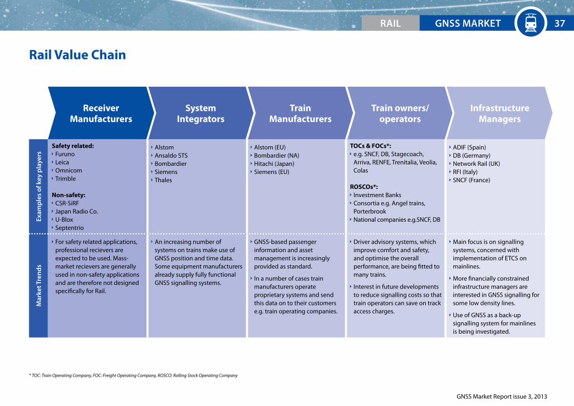
Rail Value ChainEx
amp
les
of k
ey p
laye
rs
Safety related: Furuno Leica Omnicom Trimble
Non-safety: CSR-SiRF Japan Radio Co. U-Blox Septentrio
Alstom Ansaldo STS Bombardier Siemens Thales
Alstom (EU) Bombardier (NA) Hitachi (Japan) Siemens (EU)
TOCs & FOCs*: e.g. SNCF, DB, Stagecoach,
Arriva, RENFE, Trenitalia, Veolia, Colas
ROSCOs*: Investment Banks Consortia e.g. Angel trains,
Porterbrook National companies e.g.SNCF, DB
ADIF (Spain) DB (Germany) Network Rail (UK) RFI (Italy) SNCF (France)
Mar
ket T
ren
ds
For safety related applications, professional recievers are expected to be used. Mass-market recievers are generally used in non-safety applications and are therefore not designed specifically for Rail.
An increasing number of systems on trains make use of GNSS position and time data. Some equipment manufacturers already supply fully functional GNSS signalling systems.
GNSS-based passenger information and asset management is increasingly provided as standard.
In a number of cases train manufacturers operate proprietary systems and send this data on to their customers e.g. train operating companies.
Driver advisory systems, which improve comfort and safety, and optimise the overall performance, are being fitted to many trains.
Interest in future developments to reduce signalling costs so that train operators can save on track access charges.
Main focus is on signalling systems, concerned with implementation of ETCS on mainlines.
More financially constrained infrastructure managers are interested in GNSS signalling for some low density lines.
Use of GNSS as a back-up signalling system for mainlines is being investigated.
ReceiverManufacturers
SystemIntegrators
InfrastructureManagers
Train owners/operators
TrainManufacturers
* TOC: Train Operating Company, FOC: Freight Operating Company, ROSCO: Rolling Stock Operating Company
EXECUTIVE SUMMArY GNSS MArKETrAIL 37

GNSS Market Report issue 3, 2013
GNSS systems are predominantly used for non-safety related applications
Europe, which has a very well developed passenger train network, has
historically been the main market for GNSS devices, as sales have been
dominated by passenger information systems. However, as many regions
invest heavily in rail infrastructure, particularly in China, the Rest of the
World market has grown to become highly significant, representing roughly
40% of GNSS shipments in 2012.
Compared to other industries, the railways have been slow to adopt GNSS
technology, this is in part due to the perceived challenges of using space
technology on the railways and safety considerations.
The main current use of GNSS in Rail is in passenger information systems,
however other non-safety critical applications, such as asset management,
are becoming significant, with sales of approximately 1000 devices in 2012.
The majority of new trains include GNSS systems for non-safety related
functions.
Major train manufacturers use GNSS devices as standard equipment to
track, in real time, all of the trains they have produced. This positioning
information is routinely fed back to train operators to provide them with
inputs to operations management. Most manufacturers use proprietary
systems, however, interfaces between these are provided where needed.
2006 2007 2008 2009 2010 2011 2012
EU27 North America Rest of the World
Un
its
(th
ousa
nd
s)
GN
SS p
enet
rati
on
10
9
8
7
6
5
4
3
2
1
0
100%
80%
60%
40%
20%
0%
Shipments of GNSS devices by region
2006 2007 2008 2009 2010 2011 2012
Asset Management Low Density Line CCS*
Passenger Information High Density CCS* support
Un
its
(th
ousa
nd
s)
10
9
8
7
6
5
4
3
2
1
0
Shipments of GNSS devices by application
* Command & Control Systems
GNSS penetration in installed base
EXECUTIVE SUMMArY GNSS MArKET rAIL38

GNSS Market Report issue 3, 2013
Safety related GNSS systems are expected to complement traditional rail technologies
Over the coming decade, GNSS use in Rail is expected to increase substantially.
It is forecast that 30% of trains in use worldwide will be equipped with GNSS for some purpose
by 2022. Most devices are likely to be non-safety critical in the short to medium term, however,
GNSS devices will increasingly support safety critical functions.
The regulatory requirements for Positive Train Control (PTC) in the USA drive the sales of high
density train control devices between 2015 and 2019. The roll-out programme was originally
intended to be completed for Class-1 railroads by 2015, though there have been some delays
to this timescale.
European roll-out of ETCS Level 3 is expected to occur gradually towards the end of the decade.
Low density line CCS (offering significant cost savings by removing large parts of the trackside
infrastructure) is expected to see cautious introduction, particularly on passenger lines.
2012 2013 2014 2015 2016 2017 202020192018 2021 2022
Shipments of GNSS devices by application
Un
its
(th
ousa
nd
s)
GN
SS p
enet
rati
on
80
70
60
50
40
30
20
10
0
35%
30%
25%
20%
15%
10%
5%
0%
Asset ManagementPassenger InformationLow Density Line CCS
High Density CCS supportdevices
GNSS penetration in installed base
EXECUTIVE SUMMArY GNSS MArKETrAIL 39
GNSS Market Report issue 3, 2013
EXECUTIVE SUMMArY GNSS MArKET rAIL40
example of R&D project: Satloc
The project aims at the development and demonstration of an
innovative GNSS safety-of-life rail application for train control, speed
supervision, traffic control, and traffic management of UIC-E lines (low density lines).
The application contributes primarily to the safe adoption of EGNOS in Rail and paves the
way for the introduction of Galileo in the rail safety domain.
It develops a new rail integrated operational concept, software, hardware, services and
datasets compatible with the current evolution of the rail signalling and standards.
More information can be found at: http://satloc.uic.org/Project-summary
european GNSS will enhance the GNSS offering to the rail industry
example of R&D project: GaLoROI
New solutions are required today to reach an enduring strengthening
of railways. The GaLoROI project aims to develop a certified, safety
relevant, satellite-based on-board train localisation unit to be used on
low density railway lines. Galileo will be used as a base for migration
from conventional railway localisation equipment towards European GNSS, in order to
provide cost benefits for low density lines.
More information can be found at: http://www.galoroi.eu/
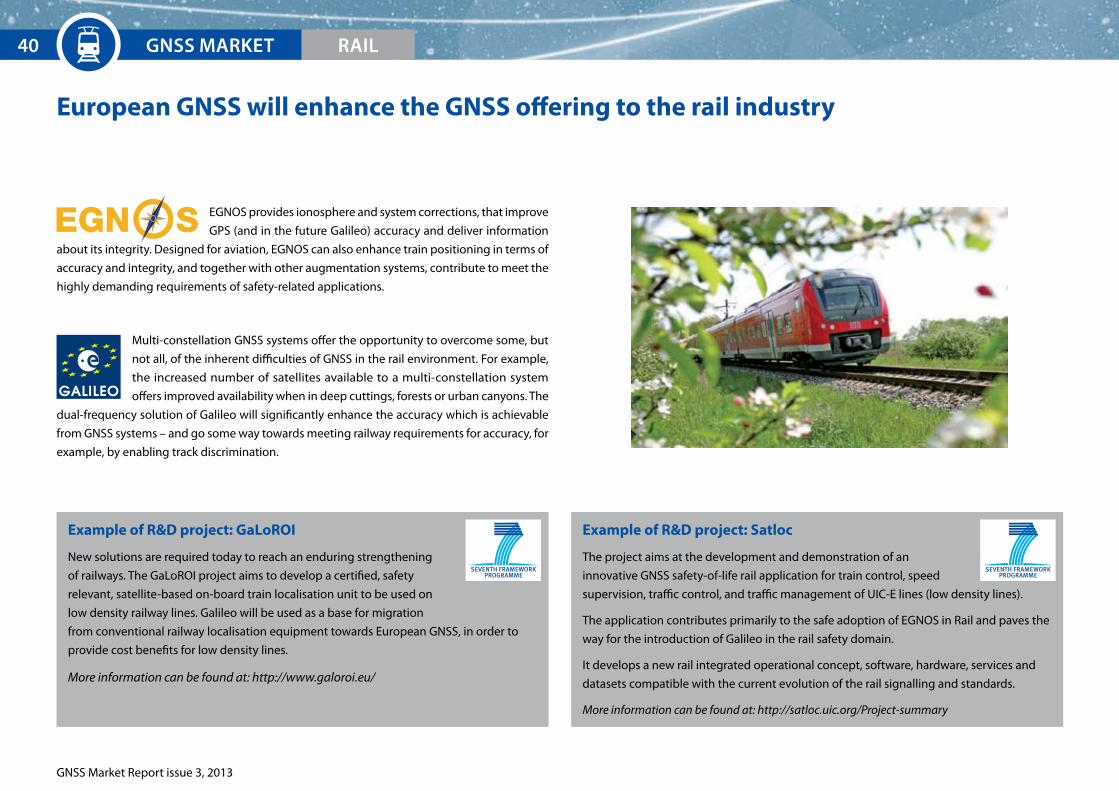
EGNOS provides ionosphere and system corrections, that improve
GPS (and in the future Galileo) accuracy and deliver information
about its integrity. Designed for aviation, EGNOS can also enhance train positioning in terms of
accuracy and integrity, and together with other augmentation systems, contribute to meet the
highly demanding requirements of safety-related applications.
Multi-constellation GNSS systems offer the opportunity to overcome some, but
not all, of the inherent difficulties of GNSS in the rail environment. For example,
the increased number of satellites available to a multi-constellation system
offers improved availability when in deep cuttings, forests or urban canyons. The
dual-frequency solution of Galileo will significantly enhance the accuracy which is achievable
from GNSS systems – and go some way towards meeting railway requirements for accuracy, for
example, by enabling track discrimination.
EUrOpEAN GNSS SYSTEMS
GNSS Market Report issue 3, 2013
Rail Reference Charts
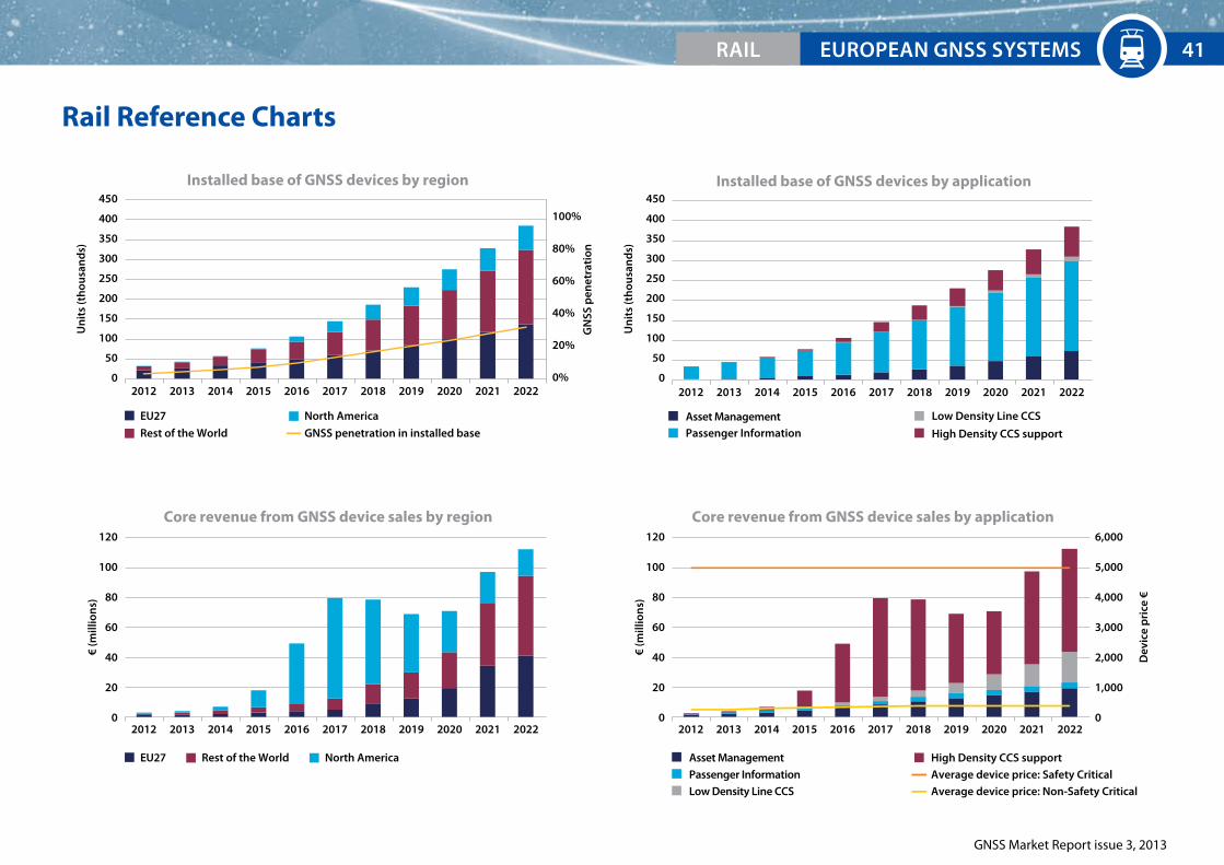
2012 2013 2014 2015 2016 2017 202020192018 2021 2022
Installed base of GNSS devices by region
Un
its
(th
ousa
nd
s)
450
400
350
300
250
200
150
100
50
0
Un
its
(th
ousa
nd
s)
450
400
350
300
250
200
150
100
50
0
100%
80%
60%
40%
20%
0%
GN
SS p
enet
rati
on
EU27 North America
Rest of the World
EU27 North AmericaRest of the World
2012 2013 2014 2015 2016 2017 202020192018 2021 2022
Installed base of GNSS devices by application
Asset ManagementPassenger Information High Density CCS support
Low Density Line CCS
Asset Management High Density CCS support
2012 2013 2014 2015 2016 2017 202020192018 2021 2022
Core revenue from GNSS device sales by region
€ (m
illio
ns)
120
100
80
60
40
20
0
€ (m
illio
ns)
Dev
ice
pri
ce €
120
100
80
60
40
20
0
6,000
5,000
4,000
3,000
2,000
1,000
02012 2013 2014 2015 2016 2017 202020192018 2021 2022
Core revenue from GNSS device sales by application
GNSS penetration in installed base
Passenger Information Average device price: Safety Critical
Low Density Line CCS Average device price: Non-Safety Critical
rAIL 41
GNSS Market Report issue 3, 2013
42
Maritime
43
GNSS Market Report issue 3, 2013
e-navigation and GNSS-enabled SAR (MeOSAR) operations open new horizons to mariners
Key market trends:
Multi-constellation GNSS receivers at the centre of the proposed IMO* e-navigation concept.
COSpAS-SArSAT enhancing the infrastructure with GNSS to reduce reaction time in emergency response.
Background
Maritime general navigation was an early adopter of GPS and remains an extensive user. This
issue of the market report covers the following maritime applications:
General navigation
Traffic management
Marine engineering
Homeland security
Search and rescue
Ports**
Inland waterways**
Recent developments
e-navigation: This is an initiative of IMO designed to reduce the complexity of on-board systems
by integrating bridge systems with all data inputs. It could be a driver for multi-constellation
uptake within the maritime community. It is being implemented by the IMO’s e-NAV Committee
involving maritime authorities.
Fisheries policy: There is an increasing interest in proving where fishing vessels are to comply
with the regulatory requirements of the EU Common Fisheries Policy. GNSS is playing an increas-
ingly significant role in providing positioning information to authorities.
Search and Rescue services
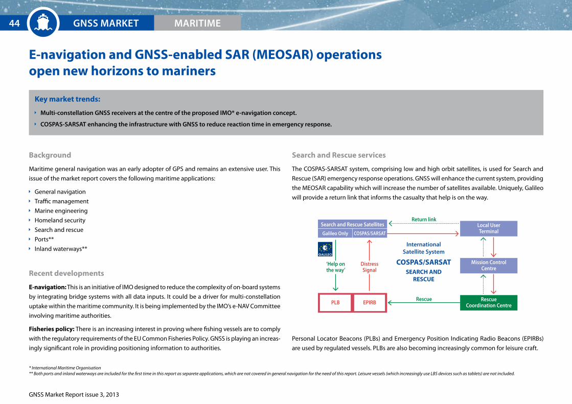
The COSPAS-SARSAT system, comprising low and high orbit satellites, is used for Search and
Rescue (SAR) emergency response operations. GNSS will enhance the current system, providing
the MEOSAR capability which will increase the number of satellites available. Uniquely, Galileo
will provide a return link that informs the casualty that help is on the way.
Personal Locator Beacons (PLBs) and Emergency Position Indicating Radio Beacons (EPIRBs)
are used by regulated vessels. PLBs are also becoming increasingly common for leisure craft.
* International Maritime Organisation** Both ports and inland waterways are included for the first time in this report as separete applications, which are not covered in general navigation for the need of this report. Leisure vessels (which increasingly use LBS devices such as tablets) are not included.
Local UserTerminal
Mission ControlCentre
rescueCoordination CentrepLB EpIrB
rescue
return link
distress Signal
‘Help onthe way’
InternationalSatellite System
COSPAS/SARSATSeARCH AND
ReSCUe
GNSS MArKET44 MArITIME
Search and rescue Satellites
Galileo Only COSpAS/SArSAT
GNSS Market Report issue 3, 2013
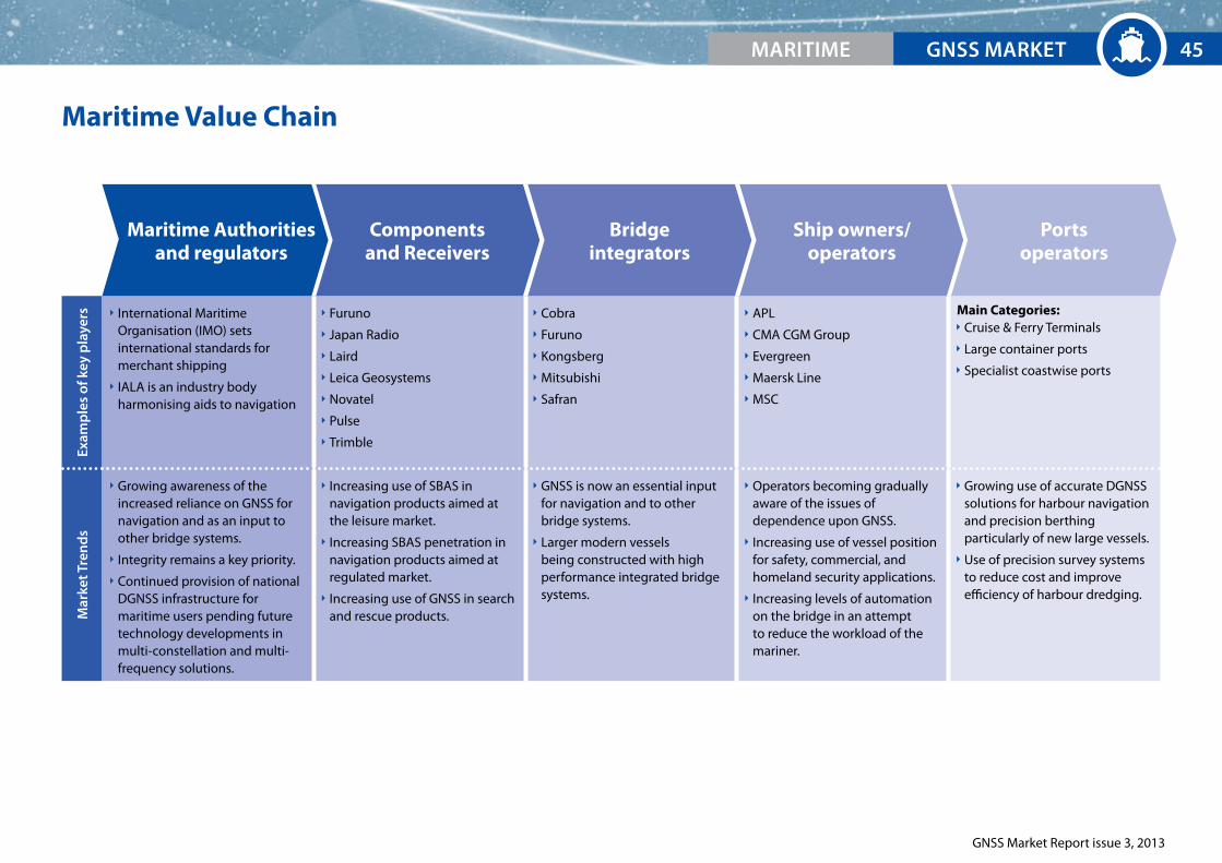
Maritime Value ChainEx
amp
les
of k
ey p
laye
rs International Maritime Organisation (IMO) sets international standards for merchant shipping
IALA is an industry body harmonising aids to navigation
Furuno
Japan Radio
Laird
Leica Geosystems
Novatel
Pulse
Trimble
Cobra
Furuno
Kongsberg
Mitsubishi
Safran
APL
CMA CGM Group
Evergreen
Maersk Line
MSC
Main Categories: Cruise & Ferry Terminals
Large container ports
Specialist coastwise ports
Mar
ket T
ren
ds
Growing awareness of the increased reliance on GNSS for navigation and as an input to other bridge systems.
Integrity remains a key priority.
Continued provision of national DGNSS infrastructure for maritime users pending future technology developments in multi-constellation and multi-frequency solutions.
Increasing use of SBAS in navigation products aimed at the leisure market.
Increasing SBAS penetration in navigation products aimed at regulated market.
Increasing use of GNSS in search and rescue products.
GNSS is now an essential input for navigation and to other bridge systems.
Larger modern vessels being constructed with high performance integrated bridge systems.
Operators becoming gradually aware of the issues of dependence upon GNSS.
Increasing use of vessel position for safety, commercial, and homeland security applications.
Increasing levels of automation on the bridge in an attempt to reduce the workload of the mariner.
Growing use of accurate DGNSS solutions for harbour navigation and precision berthing particularly of new large vessels.
Use of precision survey systems to reduce cost and improve efficiency of harbour dredging.
Maritime Authoritiesand regulators
Components and Receivers
Portsoperators
Ship owners/ operators
Bridge integrators
GNSS MArKETMArITIME 45

GNSS Market Report issue 3, 2013
General navigation, inland waterways and SAR represent the largest share in shipments
General navigation and inland waterways represent a large proportion of the market.
Many of the regulated applications of GNSS in the Maritime segment already have high, if not
total, GNSS penetration.
For these applications, equipment replacement and new vessel construction are the drivers for
equipment sales, as systems reach the end of their lifecycle or become outdated or obsolete.
With over 50,000 regulated vessels globally and large ships using several receivers, this rep-
resents a very established, yet stable market.
2006 2007 2008 2009 2010 2011 2012
Search & Rescue
General Navigation
Inland Waterways
Traffic Management
Homeland Security*
Marine Engineering
Ports
Un
its
(th
ousa
nd
s)
120
100
80
60
40
20
0
Shipments of GNSS devices by segment
Shipments of GNSS devices by region (2012)
EU27
North America
Rest of the World
26%
6%68%
2006 2007 2008 2009 2010 2011 2012
Search & Rescue
General Navigation
Inland Waterways
Traffic Management
Homeland Security*
Marine Engineering
Ports
120
100
80
60
40
20
0
Shipments of GNSS devices by region (2012)
EU27
North America
Rest of the World
26%
6%68%
* Homeland Security includes Long Range Identification and Tracking (LRIT) devices
GNSS MArKET46 MArITIME
The Rest of the World dominates Maritime device shipments. The regional breakdown of device
shipments is expected to remain roughly constant over the next decade.
The region a ship is assigned to is dictated by where the true controlling interest of the fleet
is located, which is determined by the United Nations Conference on Trade and Development
(UNCTAD).
EU27
North America
Rest of the World
26%
6%
68%

GNSS Market Report issue 3, 2013
Safety related applications will drive the growth
Sales of devices are forecast to be led by GNSS-equipped SAR beacons for
which a number of devices may be installed on each vessel (e.g. on lifeboats).
In addition, the lifecycle of a SAR beacon tends to be shorter than for a
standard navigation receiver.
Second-generation SAR beacons, which are foreseen to have the return link
feature, are likely to further stimulate the market in the next decade. The
regulatory requirements for such beacons are currently being developed
by COSPAS-SARSAT.
The use of GNSS in ports is forecast to grow rapidly due to the increasing
congestion of the waters in and around ports, combined with the ever
increasing size of vessels.
Two significant applications are: Portable Pilot Units (PPUs), GNSS-enabled
specialist navigation aids used to enter ports, and port automation, such as
the tracking of shipping containers and other goods. For these applications,
GNSS is used to improve the efficiency of large ports.
Ports are set to grow into the largest application by revenue by 2022.
Un
its
(th
ousa
nd
s)
200
180
160
140
120
100
80
60
40
20
0
Search & Rescue
General Navigation
Inland Waterways
Traffic Management
Homeland Security
Marine Engineering
Ports
Search & Rescue
General Navigation
Inland Waterways
Traffic Management
Homeland Security
Marine Engineering
Ports
Core revenue of GNSS device sales by application
2012 2013 2014 2015 2016 2017 202020192018 2021 2022
Shipments of GNSS devices by application
0.4%
1%
13%
18%
29%
24%
11%5% 16%
12%
12%7%
16%
36%
GNSS MArKETMArITIME 47
2012 2022
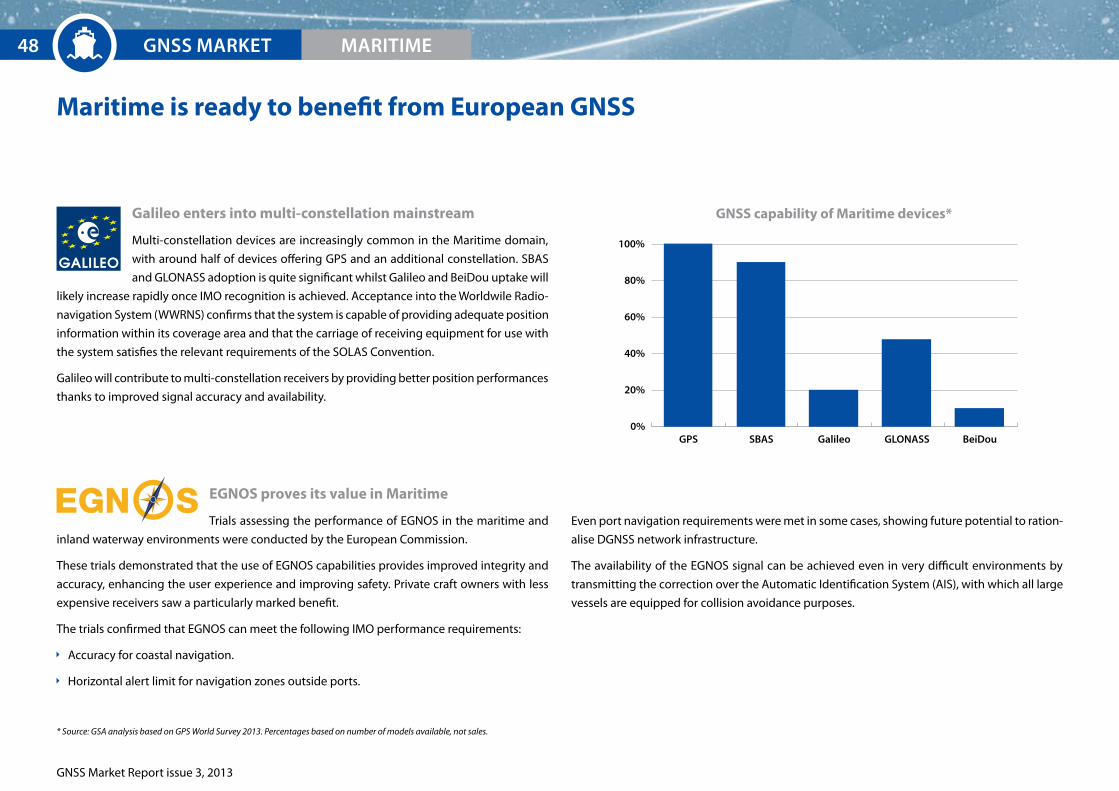
GNSS Market Report issue 3, 2013
EXECUTIVE SUMMArYGNSS MArKET MArITIME48
Maritime is ready to benefit from european GNSS
Galileo enters into multi-constellation mainstream
Multi-constellation devices are increasingly common in the Maritime domain,
with around half of devices offering GPS and an additional constellation. SBAS
and GLONASS adoption is quite significant whilst Galileo and BeiDou uptake will
likely increase rapidly once IMO recognition is achieved. Acceptance into the Worldwile Radio-
navigation System (WWRNS) confirms that the system is capable of providing adequate position
information within its coverage area and that the carriage of receiving equipment for use with
the system satisfies the relevant requirements of the SOLAS Convention.
Galileo will contribute to multi-constellation receivers by providing better position performances
thanks to improved signal accuracy and availability.
eGNOS proves its value in Maritime
Trials assessing the performance of EGNOS in the maritime and
inland waterway environments were conducted by the European Commission.
These trials demonstrated that the use of EGNOS capabilities provides improved integrity and
accuracy, enhancing the user experience and improving safety. Private craft owners with less
expensive receivers saw a particularly marked benefit.
The trials confirmed that EGNOS can meet the following IMO performance requirements:
Accuracy for coastal navigation.
Horizontal alert limit for navigation zones outside ports.
GPS SBAS Galileo GLONASS BeiDou0%
20%
40%
60%
80%
100%
GNSS capability of Maritime devices*
Even port navigation requirements were met in some cases, showing future potential to ration-
alise DGNSS network infrastructure.
The availability of the EGNOS signal can be achieved even in very difficult environments by
transmitting the correction over the Automatic Identification System (AIS), with which all large
vessels are equipped for collision avoidance purposes.
* Source: GSA analysis based on GPS World Survey 2013. Percentages based on number of models available, not sales.
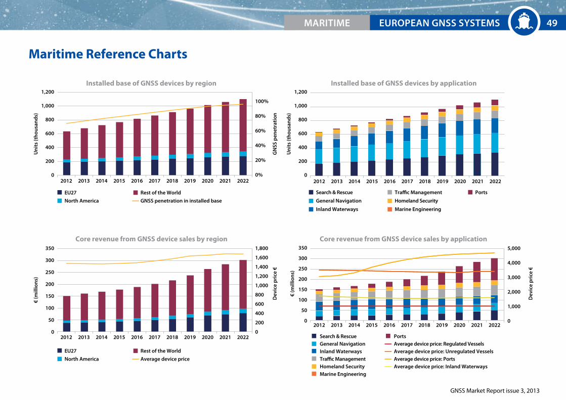
MArITIME EUrOpEAN GNSS SYSTEMS
GNSS Market Report issue 3, 2013
Maritime Reference Charts
2012 2013 2014 2015 2016 2017 202020192018 2021 2022
Installed base of GNSS devices by region
Un
its
(th
ousa
nd
s)
1,200
1,000
800
600
400
200
0
Un
its
(th
ousa
nd
s)
1,200
1,000
800
600
400
200
0
100%
80%
60%
40%
20%
0%
1,800
1,600
1,400
1,200
1,000
800
600
400
200
0
5,000
4,000
3,000
2,000
1,000
0
EU27
North America
Rest of the World
EU27
North America
Rest of the World
Search & Rescue
General Navigation
Inland Waterways
Traffic Management
Homeland Security
Marine Engineering
Ports
2012 2013 2014 2015 2016 2017 202020192018 2021 2022
Installed base of GNSS devices by application
GN
SS p
enet
rati
onD
evic
e p
rice
€
Search & RescueGeneral NavigationInland WaterwaysTraffic Management
Dev
ice
pri
ce €
2012 2013 2014 2015 2016 2017 202020192018 2021 2022
Core revenue from GNSS device sales by region
€ (m
illio
ns)
350
300
250
200
150
100
50
0
Core revenue from GNSS device sales by application
2012 2013 2014 2015 2016 2017 202020192018 2021 2022
€ (m
illio
ns)
350
300
250
200
150
100
50
0
Marine EngineeringHomeland Security
Ports
GNSS penetration in installed base
Average device price
Average device price: Regulated VesselsAverage device price: Unregulated VesselsAverage device price: PortsAverage device price: Inland Waterways
49

GNSS Market Report issue 3, 2013
50

Agriculture
51
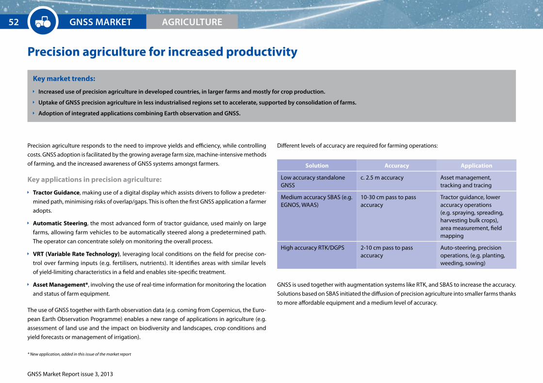
GNSS Market Report issue 3, 2013
Precision agriculture for increased productivity
Key market trends:
Increased use of precision agriculture in developed countries, in larger farms and mostly for crop production.
Uptake of GNSS precision agriculture in less industrialised regions set to accelerate, supported by consolidation of farms.
Adoption of integrated applications combining Earth observation and GNSS.
Precision agriculture responds to the need to improve yields and efficiency, while controlling
costs. GNSS adoption is facilitated by the growing average farm size, machine-intensive methods
of farming, and the increased awareness of GNSS systems amongst farmers.
Key applications in precision agriculture:
Tractor Guidance, making use of a digital display which assists drivers to follow a predeter-
mined path, minimising risks of overlap/gaps. This is often the first GNSS application a farmer
adopts.
Automatic Steering, the most advanced form of tractor guidance, used mainly on large
farms, allowing farm vehicles to be automatically steered along a predetermined path.
The operator can concentrate solely on monitoring the overall process.
VRT (Variable Rate Technology), leveraging local conditions on the field for precise con-
trol over farming inputs (e.g. fertilisers, nutrients). It identifies areas with similar levels
of yield-limiting characteristics in a field and enables site-specific treatment.
Asset Management*, involving the use of real-time information for monitoring the location
and status of farm equipment.
The use of GNSS together with Earth observation data (e.g. coming from Copernicus, the Euro-
pean Earth Observation Programme) enables a new range of applications in agriculture (e.g.
assessment of land use and the impact on biodiversity and landscapes, crop conditions and
yield forecasts or management of irrigation).
Different levels of accuracy are required for farming operations:
GNSS is used together with augmentation systems like RTK, and SBAS to increase the accuracy.
Solutions based on SBAS initiated the diffusion of precision agriculture into smaller farms thanks
to more affordable equipment and a medium level of accuracy.
* New application, added in this issue of the market report
Solution Accuracy Application
Low accuracy standalone GNSS
c. 2.5 m accuracy Asset management, tracking and tracing
Medium accuracy SBAS (e.g. EGNOS, WAAS)
10-30 cm pass to pass accuracy
Tractor guidance, lower accuracy operations (e.g. spraying, spreading, harvesting bulk crops), area measurement, field mapping
High accuracy RTK/DGPS 2-10 cm pass to pass accuracy
Auto-steering, precision operations, (e.g. planting, weeding, sowing)
GNSS MArKET52 AGrICULTUrE

GNSS Market Report issue 3, 2013
Exam
ple
s of
key
pla
yers
SAPOS (De) is the satellite positioning service of the Official German Surveying and Mapping Authority. The service is available throughout Germany and is based on reference stations processing GNSS signals and providing observation and correction data via data communication media.
Hexagon (Se), a measurement technologies group with c. €2.5 billion sales worldwide in 2012, is active in the precision agriculture market via its two subsidiaries Leica Geosystems and NovAtel.
Topcon Precision Agriculture (JP) is a subsidiary of Topcon Positioning Systems (TPS Inc.), providing tractor guidance and auto-steering, VRT, water management, and planning/documentation solutions.
AGCO Corporation is focused on the design, manufacture and distribution of agricultural machinery with c. $10 billion sales worldwide in 2012. AGCO’s Advanced Technology Solutions incorporates precision farming technologies distributed by AGCO. The group provides solutions for satellite-based steering, data collection and management, yield-mapping and other purposes.
Trimble (US) is a major GNSS systems and solutions vendor in the precision market and generated a total turnover of over $2 billion in 2012 (c. 25% of which in field solutions, including agriculture). Omnistar acquired by Trimble in March 2011, is provider of satellite-based augmentation services and also broadcasts to users that work with third-party GNSS equipment (e.g. NovAtel).
NavCom, a subsidiary of John Deere (US) is the main competitor of Omnistar in the precision agriculture market. NavCom provides both global satellite–based augmentation services (StarFire Network) and core technology hardware, such as RTK systems and geodetic quality multi-frequency GNSS receivers. Its services require proprietary receivers.
John Deere (US) is a leader in agriculture vehicles and machineries with a turnover of over $36 billion in 2012. Its subsidiary, John Deere Ag Management Solutions, develops applications for GNSS guidance and machine control based on core receivers developed by NavCom.
CLAAS (De) is present in the GPS reference stations network industry via acquisition of a 34% stake in SAT-INFO (FR) in 2009.
CLAAS (De) is a major agricultural machinery manufacturer with a turnover of approximately €3.5 billion in 2012. Through its Agrosystems division, it provides guidance and automatic steering solutions with accuracies up to 2-3 cm.
Mar
ket t
ren
ds
Service providers offer an augmentation service that enhances the performance of GNSS. SBAS corrections are provided for free, while services offering a higher level of accuracy are paid. The two leading players in commercial services adopt different strategies: NavCom exploits John Deere’s sales channels while Omnistar cooperates with major device vendors. With the recent acquisition of Omnistar by Trimble, the market is strongly consolidated.
Device and application vendors usually provide both the hardware and the software required to perform precision agriculture operations. Players include manufacturers of multi-frequency and multi-constellation receivers, equipment manufacturers (e.g. guidance systems), system integrators, and applications providers.
Machine/tractor manufacturers establish agreements and partnerships with device vendors. They can also be service providers (e.g. John Deere provides the StarFire service via NavCom).
Service Providers
Tractor Manufacturers
Application Providers
Device Vendors
Agriculture Value Chain
GNSS MArKETAGrICULTUrE 53
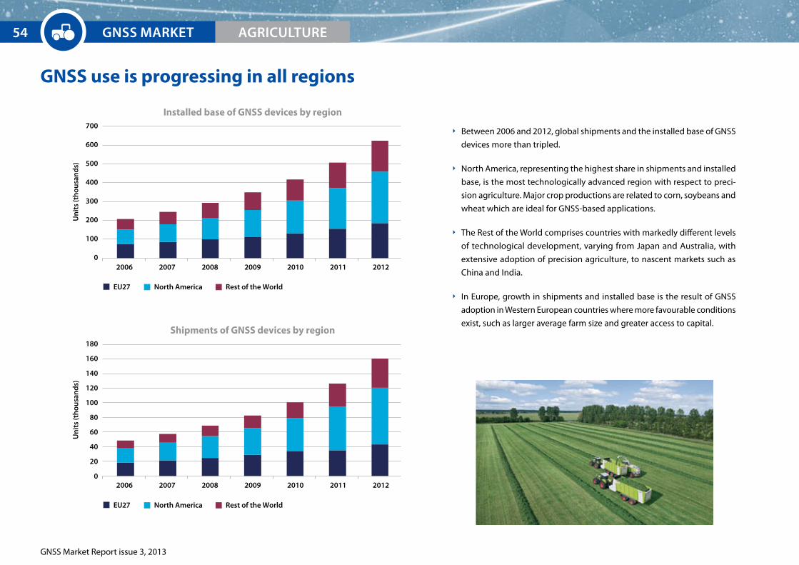
GNSS Market Report issue 3, 2013
GNSS use is progressing in all regions
Between 2006 and 2012, global shipments and the installed base of GNSS
devices more than tripled.
North America, representing the highest share in shipments and installed
base, is the most technologically advanced region with respect to preci-
sion agriculture. Major crop productions are related to corn, soybeans and
wheat which are ideal for GNSS-based applications.
The Rest of the World comprises countries with markedly different levels
of technological development, varying from Japan and Australia, with
extensive adoption of precision agriculture, to nascent markets such as
China and India.
In Europe, growth in shipments and installed base is the result of GNSS
adoption in Western European countries where more favourable conditions
exist, such as larger average farm size and greater access to capital.
2006 2007 2008 2009 2010 2011 2012
EU27 North America Rest of the World
Un
its
(th
ousa
nd
s)
700
600
500
400
300
200
100
0
Installed base of GNSS devices by region
2006 2007 2008 2009 2010 2011 2012
Un
its
(th
ousa
nd
s)
180
160
140
120
100
80
60
40
20
0
Shipments of GNSS devices by region
EU27 North America Rest of the World
GNSS MArKET54 AGrICULTUrE

GNSS Market Report issue 3, 2013
Automatic steering and VRT common in future farms
Technological progress and consolidation of farms are the key drivers for growth in shipments
of GNSS devices in all regions.
Farmers in developed countries will opt for more advanced solutions (e.g. Automatic steering
and VRT) to further increase productivity.
Developing countries will modernise their means of agricultural production in order to face
the major challenges of rising input costs, resource scarcity, and food demand.
In Europe, future growth is expected to be increasingly driven by uptake of GNSS technolo-
gies in Central and Eastern Europe, currently representing lower GNSS penetration.
Falling prices will be an important driver for the uptake of precision agriculture over the next
decade.
Revenues will be generated mainly by automatic steering and VRT, growing much faster than
previously estimated. Together, these two applications will provide nearly 80% of revenues
in 2022 (see reference page).
2012 2013 2014 2015 2016 2017 202020192018 2021 2022
Shipments of GNSS devices by region
Un
its
(th
ousa
nd
s)
GN
SS p
enet
rati
on
900
800
700
600
500
400
300
200
100
0
45%
40%
35%
30%
25%
20%
15%
10%
5%
0%
EU27 North America Rest of the World GNSS penetration
GNSS MArKETAGrICULTUrE 55

GNSS Market Report issue 3, 2013
GNSS MArKET56 AGrICULTUrE
european GNSS to bring benefits beyond the industry
The main system of choice for tractor guidance
EGNOS delivers various benefits to farmers:
Minimal investment.
Optimisation of yields.
Increased labour productivity and profit margins.
Reduced driver fatigue.
… and to society:
Increased productivity to better feed increasing population.
EGNOS is used within the Common Agriculture Policy (CAP) for on-the-spot checks to
verify subsidy claims. Tests have shown positive results with an improvement in accuracy and
reliability in comparison with GPS only. Thus, using EGNOS, which is free of charge, reduces the
need for second measurements.
Galileo will bring additional benefits
Dual-frequency capability to offer enhanced real-time positioning accuracy
to sub-metre range.
RTK receivers with multi-constellation service will further increase
performance.
Improved availability and continuity derived from multi-constellation environment.
Reduced dependence on ground-based augmentation systems.
No subscription fee for Galileo Open Service.
The Farming by Satellite prize
The aim of this competition is to promote the benefits generated by GNSS in agriculture
among farmers. Participating teams propose innovative ideas for satellite service usage in
agriculture, food production, or land management.
The winning ideas for 2012 were:
1st prize: Geo-referenced online data sharing platform with information services for
farmers across Europe.
2nd prize: Hay bale collection optimisation solution using less
fuel and saving time.
3rd prize: Using satellite positioning in combination with camera-based recognition of
biomass for small and medium sized vineyards.
For more information and to be ready for the new edition of the Farming by Satellite prize:
www.farmingbysatellite.eu

EUrOpEAN GNSS SYSTEMS
GNSS Market Report issue 3, 2013
Agriculture Reference Charts
2012 2013 2014 2015 2016 2017 202020192018 2021 2022
Installed base of GNSS devices by region
Un
its
(th
ousa
nd
s)
4,000
3,500
3,000
2,500
2,000
1,500
1000
500
0
Un
its
(th
ousa
nd
s)
4,000
3,500
3,000
2,500
2,000
1,500
1,000
500
0
100%
80%
60%
40%
20%
0%
4,000
3,500
3,000
2,500
2,000
1,500
1000
500
0
7,000
6,000
5,000
4,000
3,000
2,000
1,000
0
Tractor Guidance
Automatic Steering
VRT
Asset Management
EU27
North America
Rest of the World
2012 2013 2014 2015 2016 2017 202020192018 2021 2022
Installed base of GNSS devices by application
GN
SS p
enet
rati
onD
evic
e p
rice
€
Dev
ice
pri
ce €
2012 2013 2014 2015 2016 2017 202020192018 2021 2022
Core revenue from GNSS device sales by region
€ (m
illio
ns)
2,000
1,800
1,600
1,400
1,200
1,000
800
600
400
200
0
2,0001,8001,6001,4001,2001,000
800600400200
0
Core revenue from GNSS device sales by application
2012 2013 2014 2015 2016 2017 202020192018 2021 2022
€ (m
illio
ns)
Tractor Guidance
Automatic Steering
VRT
Asset Management
EU27
North America
Rest of the World
GNSS penetration in installed base
Average device price
Average device price: TG
Average device price: AM
Average device price: AS
Average device price: VRT
AGrICULTUrE 57

GNSS Market Report issue 3, 2013
58

Surveying
59
© is
tock

GNSS Market Report issue 3, 2013
GNSS in the centre of surveying applications
Key market trends:
Major growth in surveying depends heavily on economic conditions in high growth economies. Cadastral and construction segments are the largest applications of GNSS in surveying.
New professional users in environmental and engineering disciplines together with mapping communities are fostering the use of geoinformation and the development of new
applications.
GNSS and surveying
Surveying is an early adopter of new location technologies such as GNSS. Currently, professional
surveying receivers are already using all available GNSS signals (multi-constellation and multi-
frequency) and other differential correction techniques (e.g. SBAS, RTK, DGPS).
The role of GNSS receivers in the surveying equipment market has demonstrated the added
value of satellite positioning to optimise survey operations and fruitful co-existence with other
land measurement technologies, such as laser scanners and photogrammetric/LIDAR cameras.
The main GNSS-enabled applications include:
Discipline Overview
Lan
d
Cadastral surveying Cadastral surveying involves the physical delineation of property boundaries in parcels and the determination of dimensions, areas and certain rights associated with properties. Land taxes are frequently paid according to this determination of parcels. Frequently, cadastral surveying is performed to subdivide parcels, to re-establish physical boundaries, or to facilitate the transfer of the property title in accordance with the national land laws. This work is normally performed by Licensed Surveyors.
Construction surveying In addition to GNSS, other surveying equipment (e.g. levels, total stations, laser scanners) are used for accurate measurement in areas with poor satellite coverage, such as indoor structures, tunnels, and other extreme environments. Traditional operations in construction surveying are related to the precise drawing of the future work site for buildings and infrastructure; as well as the stake-out of reference points that will guide the construction of new structures.
Mapping Mapping is the use of GNSS to plot maps and charts that contain locations of points of interest. Specific applications include road mapping, pipeline mapping, planning of public works and forestry management.
Mine surveying Mine surveying includes all measurements, calculations and mapping which serve the purpose of ascertaining and documenting information at all stages from prospecting to exploitation and utilising mineral deposits both by surface and underground working.
Mar
ine
Hydrographic Surveys Hydrographic surveying is the science of measurement and description of features which affect maritime navigation, marine construction, dredging, offshore oil exploration, and related activities.
Offshore surveys Offshore vessels that utilise surveying include: Anchor Handling Tug Supply (AHTS) vessels (mainly built to handle anchors for oil rigs, tow them to location and anchor them up) and salvage vessels.
GNSS MArKET60 SUrVEYING

GNSS Market Report issue 3, 2013
Exam
ple
s of
key
pla
yers Fugro
Leica Geosystems
Navcom
Omnistar
Orpheon
SAPOS
TERIA
Veripos
Ashtech
Deere & Co
Hemisphere
Javad
Laird
Leica Geosystems
North Surveying
Constructors
Educators
Engineers
Environmentalists
Professional Organisations
Scientists
Surveyors
Public organisations
Private companies
Individuals
Natural resource management firms
Hydrographic offices, chart publishers
Offshore wind farms underwater cable & pipeline installers
Mar
ket T
ren
ds
Augmentation services provided by complementary infrastructures are essential for precise positioning.
These infrastructures are particularly useful for the fast collection of accurate coordinates.
The use of complementary infrastructure is expected to grow.
The market for receiver manufacturers is very consolidated and the top 3, Trimble, Leica and TopCon, are dominating, particularly within the land surveying sector.
Many commercial grade receivers will be able to take advantage of the Galileo signal, sometimes after a simple firmware update.
Following the recession, the construction market is recovering, especially in Central & Eastern Europe and the Middle East.
The production of topographical maps for official purposes require accredited professionals in some countries.
The number of professional users coming from transversal disciplines is increasing, e.g. from environmental and spatial planning applications.
Demand for certified positioning is expected to increase over the short term.
Users may also contribute to the creation of maps through mapping communities. Several crowdsourcing initiatives exist already e.g. Open Street Map.
Complementary Infrastructure(Commercial
augmentations)
CustomersProfessionalUsers
Receiver & Firmware
Surveying Value Chain
GNSS MArKETSUrVEYING 61
Novatel
Pentax
Pulse Electronics
Septentrio
Topcon/Sokkia
Trimble
Yageo Corporation
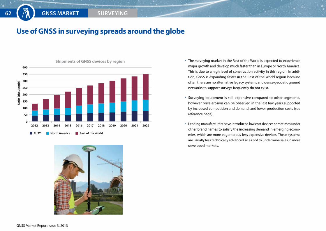
GNSS Market Report issue 3, 2013
Use of GNSS in surveying spreads around the globe
Un
its
(th
ousa
nd
s)
400
350
300
250
200
150
100
50
02012 2013 2014 2015 2016 2017 202020192018 2021 2022
Shipments of GNSS devices by region
EU27 North America Rest of the World
GNSS MArKET62 SUrVEYING
The surveying market in the Rest of the World is expected to experience
major growth and develop much faster than in Europe or North America.
This is due to a high level of construction activity in this region. In addi-
tion, GNSS is expanding faster in the Rest of the World region because
often there are no alternative legacy systems and dense geodetic ground
networks to support surveys frequently do not exist.
Surveying equipment is still expensive compared to other segments,
however price erosion can be observed in the last few years supported
by increased competition and demand, and lower production costs (see
reference page).
Leading manufacturers have introduced low cost devices sometimes under
other brand names to satisfy the increasing demand in emerging econo-
mies, which are more eager to buy less expensive devices. These systems
are usually less technically advanced so as not to undermine sales in more
developed markets.
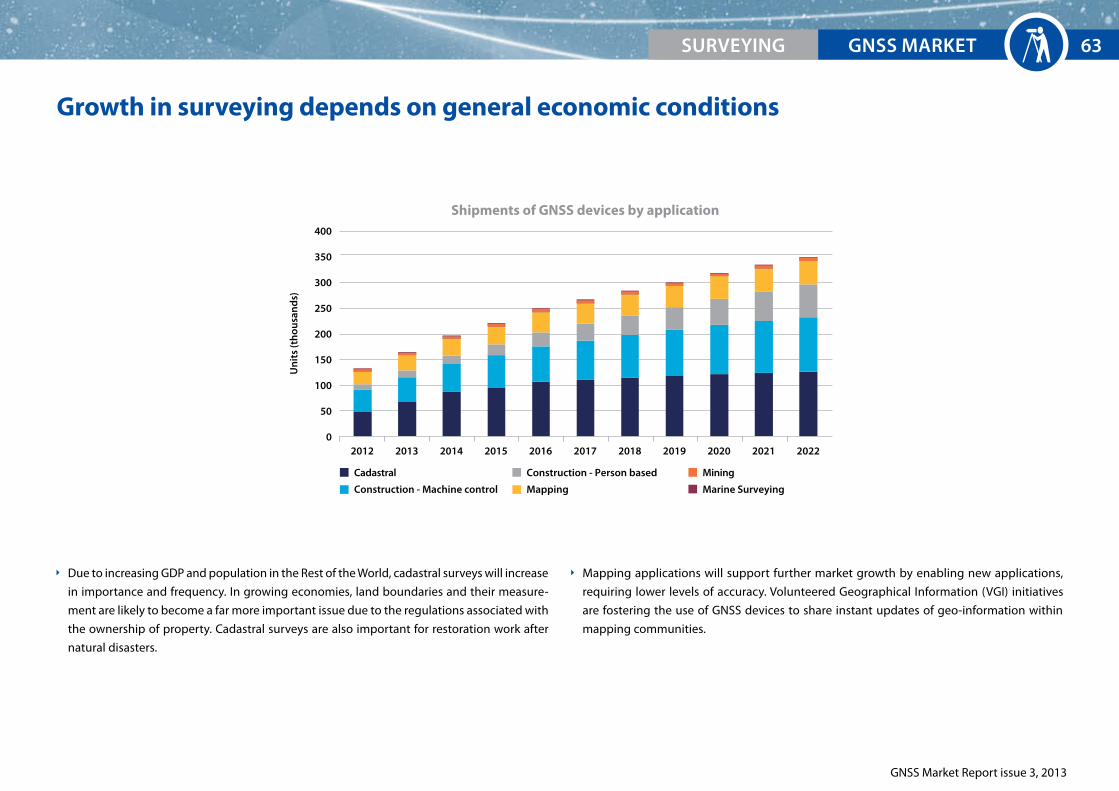
GNSS Market Report issue 3, 2013
Growth in surveying depends on general economic conditions
Due to increasing GDP and population in the Rest of the World, cadastral surveys will increase
in importance and frequency. In growing economies, land boundaries and their measure-
ment are likely to become a far more important issue due to the regulations associated with
the ownership of property. Cadastral surveys are also important for restoration work after
natural disasters.
Mapping applications will support further market growth by enabling new applications,
requiring lower levels of accuracy. Volunteered Geographical Information (VGI) initiatives
are fostering the use of GNSS devices to share instant updates of geo-information within
mapping communities.
2012 2013 2014 2015 2016 2017 202020192018 2021 2022
Shipments of GNSS devices by application
Un
its
(th
ousa
nd
s)
400
350
300
250
200
150
100
50
0
Cadastral
Construction - Machine control
Construction - Person based
Mapping
Mining
Marine Surveying
GNSS MArKETSUrVEYING 63

GNSS Market Report issue 3, 2013
GNSS MArKET64 SUrVEYING
example of R&D project: WalkeGNOS
The project allows users to record their walks/mountain bike routes on
their GNSS-enabled smartphone. The GNSS data gathered by the user
in their journey is uploaded and corrected by post-processing EGNOS
corrections, allowing the route to be accurately plotted on a map or satellite image.
More information can be found at: http://walkegnos.net/
The professional market is ready for Galileo
The trend in surveying is to adopt all new signals in one device, maximising
accuracy of measurements and improving availability in places with poor aerial
exposure (e.g. urban canyons and forests).
Galileo will enable enhanced performance compared to previous combinations of GPS and
GLONASS by providing signals on dual frequencies. GLONASS has achieved high market
penetration due to its early availability and the associated performance improvements that
multi-constellation offers.
Galileo is already present in many receivers, some of them still require firmware update.
Galileo Commercial Service (CS) will deliver high accuracy and robustness even for very demand-
ing applications.
EGNOS provides metre level accuracy, responding well to the
needs for enhanced GPS positioning by municipalities, forestry
authorities, etc.
It is widely adopted in all levels of devices, providing added value free of charge. Using EDAS, it
can also be received by alternative communication channels in areas with poor satellite coverage.
GPS SBAS Galileo GLONASS BeiDou0%
20%
40%
60%
80%
100%
GNSS capability of Professional devices*
example of R&D project: ASPHALT
ASPHALT is the Advanced Galileo Navigation System For Asphalt
fleet machines. The objective of the project is to develop a system for
machine control and fleet management on a construction site, which
enables roads of better quality and durability to be built.
More information can be found at: http://www.asphalt-fp7.eu/
* Source: GSA analysis based on GPS World Survey 2013. Percentages based on number of models available in Agriculture and Surveying combined, not sales.

EUrOpEAN GNSS SYSTEMS
GNSS Market Report issue 3, 2013
Surveying Reference Charts
2012 2013 2014 2015 2016 2017 202020192018 2021 2022
Installed base of GNSS devices by region
Un
its
(th
ousa
nd
s)
1,400
1,200
1,000
800
600
400
200
0
Un
its
(th
ousa
nd
s)
1,400
1,200
1,000
800
600
400
200
0
100%
80%
60%
40%
20%
0%
18,000
16,000
14,000
12,000
10,000
8,000
6,000
4,000
2,000
0
18,000
16,000
14,000
12,000
10,000
8,000
6,000
4,000
2,000
0
EU27
North America
Rest of the World
2012 2013 2014 2015 2016 2017 202020192018 2021 2022
Installed base of GNSS devices by application
GN
SS p
enet
rati
onD
evic
e p
rice
€
Dev
ice
pri
ce €
2012 2013 2014 2015 2016 2017 202020192018 2021 2022
Core revenue from GNSS device sales and services by region
€ (m
illio
ns)
4,500
4,000
3,500
3,000
2,500
2,000
1,500
1,000
500
0
4,500
4,000
3,500
3,000
2,500
2,000
1,500
1,000
500
0
Core revenue from GNSS device sales and service by application
2012 2013 2014 2015 2016 2017 202020192018 2021 2022
€ (m
illio
ns)
Cadastral Mining
Construction - Machine control Marine Surveying
Construction - Person based
Mapping
EU27
North America
Rest of the World
Cadastral
Construction - Machine control
Construction - Person based
Mapping
Mining
Marine SurveyingGNSS penetration in installed base
Average device priceAverage device price: Land Surveying
Average device price: Maritime Surveying
SUrVEYING 65

GNSS Market Report issue 3, 2013
ANNEX66
Methodology and sources of information
The present market report has been produced by applying the GSA’s* market monitoring and
forecasting process.
Employing the same general methodology as previous issues, the underlying market model**
utilises advanced forecasting techniques applied to a wide range of input data, assumptions,
and scenarios to forecast the size of the Global Navigation Satellite System (GNSS) market in
terms of shipments, revenue, and installed base of receivers.
Historical values are anchored to actual data, where possible, in order to ensure a high level of
accuracy. Assumptions are informed by expert opinions and model results are cross-checked
against the most recent market research reports from independent sources, before being
validated through an iterative consultation process with sector experts and stakeholders.
The model makes use of publicly available information including the following sources: Eurostat,
United Nations Conference on Trade and Development (UNCTAD), United Nations public
information, US National Transportation Statistics, US Bureau of Labor Statistics, International
Road Assessment Programme (IRAP), International Telecommunication Union (ITU), Nations
Online, GSM Association, Boeing, Airbus, Federal Aviation Administration, General Aviation
Manufacturers Association (GAMA), World Shipping Council, Equasis, Eurocontrol, Infomines
Food and Agriculture Organisation (FAO), and FP7 project websites. Additional data and reports
were purchased from: ABI Research, Berg Insight, Bureau van Dijk (ORBIS), Clarkson Research
Ltd, Farstad Shipping, UIC International Railway Statistics and the Council of European Geodetic
Surveyors (CLGE).
Disclaimer
The information provided in this report is based on the Agency’s best estimates and forecasts at the time of
publication***. Although the Agency has taken utmost care in checking the reasonableness of assumptions
and results with the support of industry experts, the Agency accepts no responsibility for the further use
made of the content of this report.
* About the GSA: The European GNSS Agency (GSA) is an agency of the European Union. One of its missions is to support the European Commission in promoting the use of European GNSS (EGNOS and Galileo), keeping Europe at the forefront of the satellite navigation sector.** The market monitoring and forecasting process is supported by London Economics (www.londecon.co.uk/aerospace) and Helios (www.askhelios.com).*** Previous reports: In the past, the Agency communicated various market forecasts through different channels including its own website and conference presentations. The current publication is based on the latest and most comprehensive analyses, and the most recent
trends and information with respect to the Galileo deployment.
METHOdOLOGY

GNSS Market Report issue 3, 2013
ANNEX 67
List of acronyms
ACCePTA ACCelerating EGNOS adoPTion in AviationADAS Advanced Driver Assistance SystemAIS Automatic Identification SystemANSP Air Navigation Service ProviderAOPA Aircraft Owners and Pilots AssociationAPV Approach Procedure with Vertical guidanceBA Business AviationBRIC Refers to: Brazil, Russia, India, ChinaCA Commercial AviationCAGR Compounded Annual Growth RateCANSO Civil Air Navigation Services OrganisationCAT I, II, III ILS Categories for precision instrument approach and landingCCS Command and Control SystemCOSPAS-SARSAT Russian Cosmicheskaya Sistyema Poiska Avariynich Sudow - Search and Rescue Satellite-Aided Tracking (International Satellite System For Search and Rescue)CS (Galileo) Commercial ServiceDGNSS Differential Global Navigation Satellite SystemDGPS Differential Global Positioning SystemDT Digital TachographeDAS EGNOS Data Access ServiceeGNOS European Geostationary Navigation Overlay ServiceeSA European Space AgencyeTCS European Train Control SystemeU European UnionFAA Federal Aviation AdministrationFAO Food and Agriculture OrganisationFOC Full Operational CapabilitiesFOC Freight Operating CompanyGA General AviationGAGAN GPS Aided Geo Augmented NavigationGAMA General Aviation Manufacturers AssociationGBAS Ground Based Augmentation SystemGDP Gross Domestic ProductGNSS Global Navigation Satellite SystemGPS Global Positioning SystemGSA European GNSS AgencyGSM Global System for Mobile CommunicationsICAO International Civil Aviation OrganisationIFR Instrument Flight RulesILS Instrument Landing SystemIMeS Indoor Messaging System
IMO International Maritime OrganisationINS Inertial Navigation SystemIOC Initial Operational CapabilitiesIOV In-Orbit ValidationIRAP International Road Assessment ProgrammeITS Intelligent Transport SystemITU International Telecommunication UnionIVS In-Vehicle SystemLBS Location Based ServiceLPV Localizer Performance with Vertical guidanceMeOSAR Medium Earth Orbit Search and Rescue satellitesMSAS Multi-functional Satellite Augmentation SystemOBU On-Board UnitOS (Galileo) Open ServicePBN Performance Based NavigationPeRNASVIP PERsonal NAvigation System for Visually disabled PeoplePND Portable Navigation DevicePPP Precise Poing PositioningPPUI Pay Per Use InsurancePRS Public Regulated ServicePTC Positive Train ControlPVT Position, Velocity, TimingRA Regional AviationRFID Radio-Frequency IDentificationRIMS Ranging and Integrity Monitoring StationsROSCO Rolling Stock Operating CompanyRTK Real Time KinematicRUC Road User ChargingSAR Search and RescueSBAS Space Based Augmentation SystemSIS Signal In SpaceSMS Short Message ServiceSOLAS International Convention for the Safety of Life at SeaTACOT Trusted multi-application receiver for trucksTOC Train Operating CompanyTTFF Time To First FixUNCTAD United Nations Conference on Trade and DevelopmentVFR Visual Flight RulesVGI Volunteered Geographical InformationVRT Variable Rate TechnologyWAAS Wide Area Augmentation SystemWWRNS World-Wide Radio Navigation System
LIST OF ACrONYMS
GNSS Market Report issue 3, 2013
ANNEX68
The european Commission
The European Commission is responsible for management of
the European satellite navigation programmes, Galileo and EGNOS,
including:
management of funds allocated to the programmes,
supervising the implementation of all activities related to the programmes,
ensuring clear division of responsibilities and tasks in particular between the European GNSS
Agency and European Space Agency,
ensuring proper reporting on the programme to the Member States of the EU, to the Euro-
pean Parliament and to the Council of European Union.
The Galileo and EGNOS programmes are entirely financed by the European Union.
The european GNSS Agency (GSA)
The GSA is the European Union Community Agency
formed to accomplish specific tasks related to Euro-
pean GNSS programmes.
The GSA’s current mission is to:
contribute to the preparation of the commercialisation and the exploitation of the systems,
laying the foundations for their economic sustainability and maximising the economic, social
and public benefits;
ensure the security accreditation of the systems and the operation of the Galileo security
centre;
accomplish other tasks entrusted to it by the Commission, such as the promotion of applica-
tions and services and managing R&D programmes on satellite navigation.
ABOUT THE AUTHOrS

GNSS Market Report issue 3, 2013
69

www.gsa.europa.eu
www.egnos-portal.eu
© 2013 European GNSS Agency
Copyright note: This information can be republished without charge provided the European GNSS Agency (GSA) is acknowledged. If you do republish, we would be grateful if you link back to the GSA website (www.gsa.europa.eu).