of the triassic systems of b. bur ton. - dalhousie...
TRANSCRIPT

A Correlation of the Triassic Systems of Nova Scotia
and the Eastern United States with a
Possible Origin of the North Mountain Basalts.
Willi am B. Bur ton.
A thesis submitted to the Dene~tMP~t n~ n~olo~v
Faculty of Art~ ann S~ience in partial fulfillment
of the T'eouirement.~ frrr the ~o-ree of Ratchelor
of Science with Ron ours in Geology.
Approved
Dalhousie University
25th April 1973
Halifax, Nova Scotia.
il
ACKNOWLEDGMENTS
Field work for this project was started in the
summer of 1970 when I worked under Dr. R. P. Sinha
who had just written his Ph. D. thesis on the Petrology
of North Mountain. I would like to thank Dr. Sinha for
his help and direction in UW study of the Triassic
basalts of the Cap d'Or area.
In the summer of 1972 while workinp: for the
Imperial Oil Company I had the chance to study the
Cobequid-Chedabuct·o fault and to observe many of the
nearby diabasic intrusives. For this opportunity I
would like to thank Mr. S. B. ~~cEachern and also
Mr. P. Hannon for his guidance in the field.
Fina1ly, I would like to thank Dr. D. R. Clarke
for his comments and help in the construction of the
paper during the last few months.
iii
TARLE OF CONTENTS
l • Ac kn owledgmen t s . ...................... . il
2. Abs t ra.c t • • • • • • .. • • • • • • • • • • • • • • • • • • • • • • • • iv
J. G e o l o g i c Set t i n g of t h e 11 r j_ Ct.S • __ _ . ..... . A. In t r od u c t i on 0 •••••••••••• • 0 . . . . . I B. Nova Scotia •••• 0 ••••••••• 0 c • . . . . 5 c. Eastern United States " •• 0 ... . . . . 7 D. Petrological r orr.par is on • • . . . . . . . II . E. Conclusion
• • • • • • a • • • • • • . . . . . . . . . 13 .
4. The rTri ass ic of Nova Scotia • • • • • • • • • • • 0 /4 .
A. Sediments . . . . . .. . . . . . . . . . . . . . It. B. Ex tru si ves . . . . . . . . . . • • . . . 17 . c. Intrusives ... . . . . . . . . . . . . . . . . ... ~5.
D. Petrology of the Goshen Pi u !7 s ... 3l. E. Summary and \. on c l u s i on s . .... JS.
s. Structural Geolopy • •••••••••••••••••• If • + 3.
6. Conclusion • ............................. 57.
Cited References • • • • • • • • • • • • • • • • • • • • • • • 6 0.
s. General References . . . . . . . . . . . . . . . . . . . . . 63.

IV
~he petro1o~y and geochemistry of the Nova
S c o t i a Trias s i c v o l c an i c s a re con s i d e r e d in the t e c
tonic framework of eastern ;\forth America. The pattern
~)r sediment&tion and mBgrnRtism is similar througrjout
the region. Source areas 0f the ex tru si ves range frorr;
l a r ge dykes to p o s s i b l e e en t r a l eruptive a rea s , and a
case is made for c onsiderin F! the- plugs near Goshen,
Guysborough County, as a conduit for the North
Mountain Bas~lts of Nova Scotia.
These plugs (diaba~ic ir;trusions) ar-e approx-
i ma t: e 1 y l 0 0 m i l e s ea s t of t h e c 2 o s e :;t r,; o r t h M our: t a i r.
basalts. This discrepancy can be accounted for if a
dextral strike-slip of llO miles is proposed r·or the
~obequid-Chedabucto fault in the ear·.~y Jurassic. rrhis
type of displacement appears t~ aP-"ree wit-h the tectonic
evolution of Nova Scotia.
GEOLOGIC SETTING OF THE TRIASSIC
A Introduction
rrh ere is a grow in[" body Of evidenCe ~rhi ch St' OW S
that the Atlantic continental margin of North Ame.r·ica
may well have developed in late Triassic times by rift-
in g from A f r i c a ( B i r d and I:€ we y l 97 0 ) • It appears
that initially the continental crust was stretched and
that gr a ben s for me d on e i the r s i d e of a c en t r a l r if t -
now tr:e mid-Atlantic ridp-e, w'here the marp:-in was
thinned and faulted, the continental crust was in
vaded by dikes which may have resulted in the develop
ment of volcanoes or sill intrusions.
Mare:inal grabens are usually asynm~etrical, with
the largest faults developing on the side away from
the c en t ra l site, or line, of r i f' t: in g ( B i rd and
Dew e y l 9 7 0 ) • In the c a s e o f n o r· t. h e a s t e r n No r t h A.-·n e r i c a
t hi s is the we s t s i de • Oc e an i c c ru s t is p rod u c e d at
an accreting plate marp-in when the central rift is
torn apart. Flanking grabens, with clastic and vol-
e ani c seq u en c e s which de v e l oped durin g r u pt u re , are
pre s e r v e d on con t i n en t a_l margin s that r: a v e mo v e d away
from the new mid-oceanic ridfle.
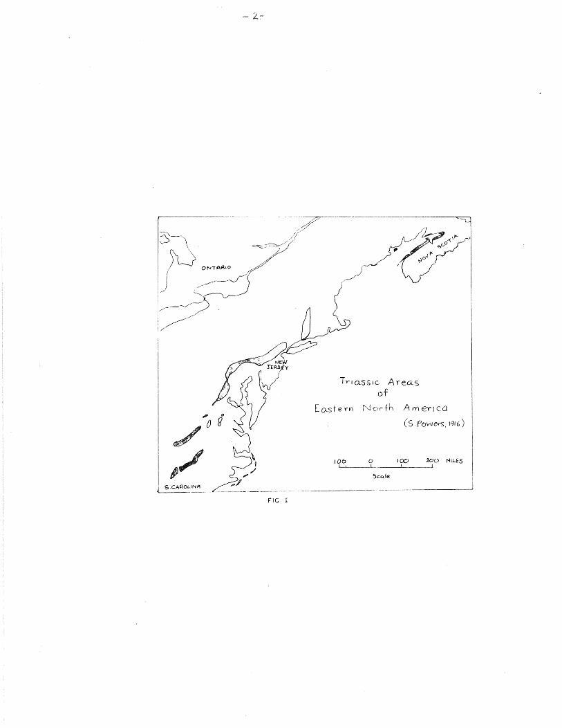
- --------~-----------------
FIG I
T rt o. s s 1 c A rea. s of
Ea-st e rY'I f'.__J Or th A('() en ca
( S Powev-s, 1916)
tOO 0 ICO :J.oo NIJ...ES __ _.!_, __ _.[
Scc:de
------------- _______________________ _;

:::; e d :i r:1e n t s we r P de p o s i t e rl in t r_ e s e gr e. ben s .. The C!
~lowed a pericd e c u s e c t, i " i t y .. Today re-rnr + s
( t,l--:ese Triassic ever:t.s car, be seen aloYlc_" tr·e ea;;~er·r'
I I •
Hides p read o asH l t i .: v c; : can j s m and in t r us i ::-: n of
A rr e r i c s EJL d in n or t h we s t Af' r i c: a •
sy ste:.T.o8 tic pat tern. 'J'r'PSA cikes are di.--;c OY'ObC t. to thn
su rr•oun din rr str'ucturaL ,'~'ra:Ln, and appeBr urd'e.: a tefl t0
t'r:e regional struct~re. 'l-ebrendt ard ~'.J'ot.orson ( l97C)
c on s ·1 d e r ~- ~: e cl i k e s to be c 1 o s e 1 :v a.~; s o c i e t e d w i t ~i t t e
.1 ~ 1 · i a l p r1 a s e of c o :-~ t i r1 e n 1. a 1 d r i f' t •
if the f·.tlantic: ':onLinents were restored t'J
their relative r:ositior.~ bef'·:-:r·e ~.!ntiner:·.al drift, a
pat:.ern would eT"ler.Q"e ir. w icr f.ne dikes 1.,JC•!Jiri have the
form of a rao ia 1 swarm. A l 1 t h e rl i k e s w l' ._. l c s e e m t o
convert::e or: a -.:enter .located Lr the vicinity of' the
Bahama platfcr-rn.
It· woul(:J seem proba'cle tbat thi ~; pat tern of
dikes formed in response to tr1e crustal st ~'esses ac-
c om pan y i o g c on t in en t a l b re a k _, 'J p • It wouJd appear

equally probable that the Triassic-tTurassL-~ intrusion
of these dikes also occurred as part of the phenomena~
::) cor:tinenta1 riftinv, and could thus account Co the
j_ntrusion of earJy sea-floor (oceanic) material into
t\1e edges of' tre continental masses.
These intrusive diabases are tholeiitic and
t ~- e i r r, en e r a 1 c o mp o s j t. i on i s we l l w i t h i n the c h e r1i r. a 1
ran~e of oceanic basalts.
The relatively new theory of plate tectonics
c a ll s for a re- ex ami n a t i on of t h e t ec t on i c de v e 1 o p
ment of north-eastern ~!orth Ameriea during the Triassic
and J:urassic. Cantin enta-1 drift and t~-"e creation of
the North Atlantic Ocean produced a complex system of
faults and rift valleys still in evidence alon~ the
At.Lantic ccJnt.inental margins or ~;orth Amer>ica and
No;'tL Africa. The r!eolcgical structu1·es, sequences
an d ev en t s in the s e margin a l are as h a v e s u b s tan t i a l
similarities. A great man:: p·eo1ogicaJ studies have
been made in North-eastern t'Jorth America, so that the
similarities in this area can readily be found and doc
umented. However, the correlation of events between
Nortb America and North Africa require more study on
the African side.
Correlations have been made between Triassic

on tin en ta 1 red beds in various rifts in east ern ort y,
America.. However, no correlation has been attempted
be t ~r: e en the rr r i as s i c v o l c an i c ac t i v it y of Nov a S c o t i a
ar,d that of t-he eastern United States.
In the last ten years considerable controversy
has been generated over the definition of the
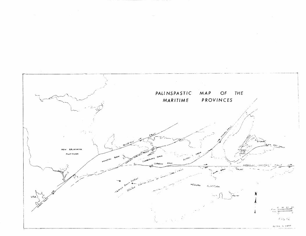
Cobequid-Chedabucto fault (Fig. 12. ). Investigations
seem to show that several types and periods of motion
probably took place along this fault. There is evi
dence for both dip-slip and dextral strike-slip mo
tion with the possibility of sinistral strike-slip.
B • Nov a Sc o t i a
The c 1 o s in g stages of the Pa 1 e o z oi c era in
North America witnessed the end of the Appalachian
geosyncline. The Appalachian mountains had been folded
up out of the trough during the Perrr:ian by strong
mountain-building forces. As they were reduced by
erosion during the Triassic a new elongated basin of
deposition formed along the eastern flank of the range
extending from South Carolina north-easterly to the
Acadian area in Nova Scotia. The area of deposition,
fed by clastic sediments! carried down by late Triassic
rivers, was actually built on the old rock platform of
the land mass of Appalachia.
-6-
During the time these Appalachian clastic sedi
ments were being laid down there was considerable in
termittent volcanic activity. Great flows of basalt
were poured out onto shallow lakes or wet lacustrine
sediments, or were intruded as sheets between the sedi
mentary layers. This Triassic basin may have lain al
most adjacent to north-western Africa and may have
been c on t i gu o u s wi t h it .•
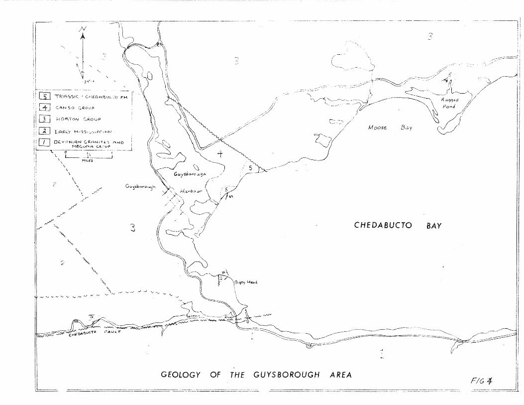
J n i; o v a Sc o t i a the T r i a s s i c s y s t em i s c on f 1 n e d
to a northeast-southwest trending belt along the Bay
of F'undy and Minas Basin shores, with a few patches of
sedimentary material on the shores of Chedabucto Bay.
The southern ~oundary of the ~riassic is a non-conformity
on early Paleozoic Meguma strata, later Devonian plutons
and an angu1ar unconformity on \~arboniferous beds
( F i g • I 7 ) • Tho 1 e i i tic basal t s ov e r l i e the Trias sic
s e d i men t s t o a t hi c kn e s s of n ear 1 y 90 0 fee t • The
flows dip from S to 10 degrees under the Bay of Fundy
as the south limb of a gently plunging syncline (Minas
Syncline), which forms such features as Scott's Bay,
Cape Split and Cape Blomidon. In a few places along
the Fundy shore the basalts are in turn overlain unc on
formably by 16 feet of calcareous limestones and
~reenish sandstones of the Scott's Bav Formation.
other 'rr i as s i c ac t i v i t y in Nov a S c ot i a inc l u d e d
the emplacement of basic intrusives such as the Gre t
5)r~eJburne dike in southern Nova Scotia. In northern
o~a Scotia Triassic intrusives include quartz
diabase,. diorite and amphibolite dikes in lolchester,
Pictou, Antigonish and Guysborough counties. Recent
p;eolopy in the southern part of Nova. Scotia, es
pecially on outlying islands, has turned up more die.-
base and diorite dikes. One small olivine-diabase
sill near Shelburne closely resembles the rocks of the ·
T r i as s i c-age North Moun t a in Rasa l t s •
C. Eastern United States
The Triassic system in ea.3tern North America is
collectively called the Newark group. This group is
found in six major elongated basins and several minor
basins which are found from Nova Scotia to North
C a r o l i n a ( s e e Fi g • l ) • In the eastern United States
they consist, typically, of a sandstone sequence, a
shale sequence, diabase of basalt intrusives and basalt
flows in some northern basins. Fossils in the terres-
trial sediments are extremely rare; how er, a few
vertebrate fossils have been found which indicate that
the Newark series is upper Triassic in age. In New
-lj-
s y the Triassic strata dip towards the northwest
d the basal arkose, a red sandstone forma Lion, an
upper red sbale for'rrta~ion and three lava flows have
en matched by an equivalent sequence of Triassic
r oc k s in C on r, e c t i c u L • Th is b as i n con t a i n s rn ore t h a r:
10,000 feet of Triassic sandstones, shales and lava
r J ows. The three lava sheets of the Watchung T'~oun tain s
i n New tT e r s e y c over an are a at pres en t of over f i v e
hundred miles and attain thicknesses of as much as 800
feet (Fig. 2 ). The ring oike of Cushetu~k Mountain
consists of a sheet of diabase n1ore than 100 ~·eet
thick dipping outward at an angle of from SO to 60
de~~ re e s. Basalt dikes al several places may be mea-
s u r e d in ten s of f e e t i n w i d t C:1 and f' r· om hun d r e d s ·J f
feet up to ei~ht miles in length.
Late jn the Triassic, as tbe p.:rea~ basin that
was rentral New Jersey became fil1ed with thousands
of feet of sediment, igneous act:iFity, called the
Palisade disturbance, resulted in the outpouring of
lava from feeder pipes and dikes along the northwest
side of the Triassic basin and intrusions of basalt
and diabase elsewhere. There were three volcanic
episodes ·each separated ~y depositional periods. Each
episode consisted of one or more lava flows which built
up a total thickness of several hundred feet of basalt.
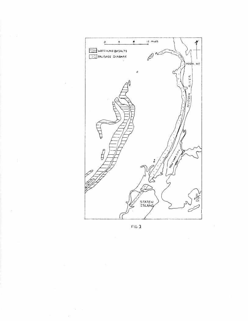
a W'ATCHlJNO 8A5AL. TS
0 PALI':>AOf DIA8A'S(
FIGl
fipes, dikes and other intrusive bodies a n
f ou n d in t h e rr r i as s i c s e d i men t s an d in tr u d in g t h e b or-
dering gneisses. However, there is no proof that t~~ese
dikes and pipes were sources of the several widespread
outpou,rings of lava. Some of these may be sources,
but. most intrusives lie outside the Watchung r~ountain
area of vulcanism. During this late stage of vulcan-
ism the mol~en basalt, finding most of the conduits
bLocked, was intruded between sedimentary beds to form
the Pal i sad e s S i 11 of d i a bas e .. C or re l at i on between
the sill and the Watchunv lavas is indeterminate.
The bulk of the igneous activity in the Triassic basins
is irtrusive or extrusive basalts and both are found
only in New Jersey, Nova Scotia and Connecticut.
Recent evidence seems to show that this Triassic
igneous activity oririnated along a fault line at the
eastern edg~ of the Triassic basin. The basaltic
magma then found it easier to intrude and lift a
great thickness of overlying sediments than to break
through to the surface. rro the west the faults may
still have been active and favourable to form the
series of lava flows. Thus there seems to be a type
of rift valley system with intrusions along both flanks. i •
This type of hypothesis may also be appli~d to the o
gin of the Nova Scotia basalts.
•i
J .. Pet r·o l rison
The geologic environment of the Trias c of t
astern United States closely resembles that of ovA
:)cotia .. 1Ple sequence of sedimentation and the ex-
tens 3_ve magmatic activity is almost ident L~al in both
areas .. 'The extrusive rocks produce normal tholeiitic
flood basalts while the intrusive material forms dia-
base dikes and sills. In both regions the conduits for
the volcanics appear as larf{'e dikes and volcanic plugs.
Petrological comparisons in both areas show very
similar mineral and chemical constituents (~,ig. 10 ) •
F'or example, both show t""Je pyroxeneE~ augite, subc a lcic
augite, and pigeonite in two distinct {lenerations and
a variation in the plagioclase feldspars from An
to An • Also, variation diagrams show that frac-
tiDr;ation of the phases was subject to calcium control.
W i t h the a i d o f a c om p u t e r program, r. T Pii.J nor
mat i ve values were calculated for· rocks from the North
Mountain basalts, the Palisades diabase and the Great
S h e 1 burn e Dike • The re s u 1 t s s h ow a c 1 o s e s i mi 1 a r i t y
between the mineral constituents of each suite of
rocks. (Computer summary in back pocket). To show
th3 petrological relationships between these three
areas a ternary diagram was used to plot the

'-------·)L_____ ______ v'_;::__
Co.M'j S ·, 2 0 6
(D•ops•de..)
-12.-
I
..... I
Co.Ail S. 2 0 8
( A!"lor--1-h•+e')
---,. \
\
A \
I PLAY.
I
(!.
ll
/ /
I qrz.
FIG 3.
b. Nov-+~ Mo.._.,..,+o..ir- Bo..so-.1+-s
x Po. I•:.:, o.cle.s J) io..l:x..s~ .
o C.-reo.:+ Sl-~\ l>ur(Hc l)J~e. .
S;Oz ( Q"a.rh: .. J
oclase diop8ide and quartz values. Tl'Jese value
ere calculated from the summary of the computer pr
shows how both the North ~'toun tain ba-
sB,_ts and t":-le Great ~~-helburne Dike overlap the fielri
of the Palisades diabase.
E. :onclusion
~here are remarkable petrological similarities
betHeen the eastern United States and the Nova Scotia
igneous Triassic system~. These similarities probably
indicate a much closer relationship both in time and
space between tne two &rroups. It also seems probable
t h a t both i gn e o us s .'T s t ems or i ? in ate d fr om. a c lose l y
related parent magma and that both were affected by
the same magmatic disturbances. is Lrn eous dis-
turbance may well be the result of tf-:e last opening
of tte North Atlantic which probably started in the
La t e Tria 8 8 i c •
THE TI~IASSIC OP NOVA SCOTIA
~)ed i men ts
In the Acadian area of Nova Scotia, t:--1e Tria.ssic
sediments form what is known as the Annapolis FoPrnation.
l t consists of nearly 2, SOO f'eet qf undeformed non-
marine sediments, mainly red conglomerates and fi:1er
detrital rocks. Over these sediments flowed a thi,~k
layer of ~rriassic bas a 1 tie lava forming the North
~ountain basalts. Together, these two formations make
p ~.be b'undy Group. Powers (1916) named the Annapolis
For·<Y,at.ion and subdivided it into two members: the
lower, :PJo: ~vl.1le Formation; the uppAr Plomidon Formation
(Fig .. II \ ) ..
Due to the semi-Arid climate and depositional
coned tions, few f'ossi Ls are fcu::d in tLe scrata. The
few o s ~~- r ac o d s an d s i 1 i c i r i e d a :11 : a r b on i z e d p 1 an t r e-
ma i n s i n d i c a t e La~ e T r i a s s i c a rr e • JV~ ore o v e r , f ish an d
shell remains in the Scott's Bay Formation, w'nict over-
lies the North J~1ountain basalt, tend to confirm Late
Triassic age. In addition, fossils of ~t-:,eria found
by Haycock in the Kentvilile area are compar-able with
E. ovata Lea, which is characteristic of tt-:e Appalachian

:ri. ssis. In t b i s conn e c t i on , Pow e r s { l 9l ;_, ) s t at e s :
'l1t1e paleontolo[!ical and p leobotanical evidence prove
tr~at t£1e Acadian area is part of the ~ewark tern. ,.
Named by Powers in 1916, the Scott's Bay
For rna t i. on i s t b e yo u n p- e s t s eq u en c e of rr r i a s s i c s e d i -
rne o t s ( b' i g • II ) • It is the uppermost formation of the
A c ad i an T r i as s i c a o d l i e s d i s c on f or rna b l y on t h e North
:·~Jountain basalts from which some of u·,e sediments
originated. The formation is composed of up to 16
feet of interbedded arenaceous limestones and cal-
careous sandstones, which are exposed in two small
s t r, u c t ural bas in s on trJ e n or t h shore of Nor t l": Moun t a in •
In 195"/, I. M. Stevenson found several out-
crops of sedimentary rock in the Guysborough area
1- ) • de V. Klein named these outcrops col-
lecti vely as the \,hedabucto Formation. VerteLrate
f o s s i 1 e vi den c e c on f i r ms La t e T r i as s i c age • Voss i l
remains of Archosauria sugpest B correlation with the
Late Triassic of New Jersey and Connecticut.
The Chedabucto Pormation consists of a few
outcrops of continental red beds lithographically com-
parable with the Wolfville Formation an comprising
brownish-red sharpstone conglomerates with minor sand-
stones and siltstones gradational into each other.
___ --~ ._--~ ~--~-~- -~ --L GEOLOGY OF THE GUYS BOROUGH
_____ ::::.-==:::..=..:----- - --====
CHEDABUCTO BAY
-- ------~ r::~~-- -- j I --~----Jl --~--
AREA

ev
.. " d ud.aeea 11•
~n -~r~!D.V•~r .. ~k• u th4t7 4o Trure area
,. ~ ~~ .. ~~~- - •• .,._..,;- ... '!!i'' ..; - ... 'w! • "" ............ - -· --.
' 1f•t1oel lit•WII~••· ll&b ••\81a et•• "DilGMr&~•• . !1M __ Oen1alll Jta~1N oonsl...,.\e
·it leat •••"'" ~-~ .._ nor~ awe et IUDu
·kala.
aleas
.... u.al atl'ike-alip ., abMit 110 aile•
c•···t~-eto. tul' , ......... , "'• Chedabueto·•••.atl .. aa4 the .O.rr.l8b Paelea have
had a 0~ Ol'iai8e
1117 ot

t::==============~=====================--=-==--=-=-=-=--=·~~===--------~:-·--------------·--------------·-- -----------· ------------- ---··-COI3£QU!D
<S;.l
U TRIASSIC BASi\LTS
Fl 5

ell-twinned usual thout alteration.
r ox ene (pigeon ite and augite) is also quite fresh and
constitutes about 3_5 percent of the rock. It seems
o have crystallized after the plagioclase and tends
to occur in small aggregations.
There seem to be two groups of pyroxene crys
tals in these basalts, perhaps representing two genera
tions. The first of large phenocrysts and the second
of quite small phenocrysts. Brown glass appears to
fill in many of the spaces between the three major
constitutents, plagioclase, pyroxene and magnetite.
Specimens with less glass showed ophitic texture with
plagioclase enclosed in au~ite. Sections of pillow
lavas with glassy rinds showed variolitic texture
(Sinha, 1970); however, these are, probably not true
pillows.
Minor constituents in these e.xtrusives include
apatite and hematite. Zeolite-filled amygdules show
an outer brownish rim, followed by a pleochroic green
yellow zone. Som·e vesicles are filled with clay which
is probably a result of assimilatioo. This type of
assimilation is only shown in the Cape Split flows.
It could be due to either interstratified sediments or
the basal Triassic sediments.
- 20-
Opinions as to the number of flows that con-
stitute the North Mountain basalts vary considerably.
Klein (1960) first noted as many as sixty-six flows,
but later revised the number to sixteen. More re-
c en t 1 y Sinh a ( l 97 0 ) s t a t e s t h at on 1 y f our bas a 1 t i c
flows occur in the North Mountain area. Most of the
authors of the many publications and papers relating
t o the s u b j e c t do n o t c 1 earl y de fin e the t e rm 11 f l ow"
in the context of their study, so that a reconcilia-
tion is difficult.
After extensive study of the North Mountain
area and the extent of flows and flow units, it a.p-
pears to me that following the huge basal unit only
about three or four major volcanic eruptions occur red.
Some areas do show a sli~htly larger number of flows,
but most of these appear to be local flow units due in
to topographic irregularities and irregularity~erup-
tions.
The lowest flow, the Cape Spencer or Blomidon
flow (Sinha, 1970), is by far the most extensive flow • I
with a thickness of about 600 feet. It is character-
istically dark and massive with columnar jointing and
very little or no amygdaloidal top. This flow fol-
lowed by the lower Cape Split flow which shows no
j o in t in g , a l a amygdaloidal top and character-
s t i c a 11 y br own i sh-red • Th e upper Cape S p li t ow is
~ milar except that it has a more dark-purple tinge to
t~Je basalt. Both flows contain a large percentage of
z e o l i t e s bu t to ge the r are no more than 8 0 fee t t h i c k.
Just before the last flow interstratified sedi
ments occur indicatin~ two major extrusive events.
The Goshen plugs include two large extrusive vents and
further studies may show a relationship between the
basalt flows and the vent through which they were
erupted.
The t op unit i s the Sc ott ' s Ea. y f 1 ow • It is
compact, grey and has rinds of iron oxide or some
times chert along the joints. It is about 80 feet
thick but the vesicular top is n~ver complete due to
erosion.
Throughout the whole North Mountain there is,
to date, no evidence of volcanoes, fissures or other
feeders. In 1960 A B:udg:ins suggested topographic
ring structures on Long Island in Digby County as a
chain of ex t ru s i v e vent s , but p e t r o l og i c a l e v ide n c e is
lacking. The only other 1 oc at ion in the North
Mountain area which has lbeen suggested as the source of
the North Mountain basalts is on the north shore of
Minas Basin (Marster, 1890; Powers 19 : MacNeil and
Take 1966). The following evidence points to a vol
canic source in this area in the vicinity of the
'w a s s on 1 s B l u f f - F i v e Is 1 an d s ar e a •
Peperites
In 195 3 Michel said '' Peperi tes ( peperi tic
breccias) re~ult from intrusion, fragmentation and
mixture of basaltic magma with shalJ.ow water and wet
l a c us t ri n e c a 1 c are o u s , ar g i 11 a c e o u s or d i at o mac e o u s
sedjrnents." The majority of the peperites occurring
in Nova Scotia are found on the north shore of Minas
Basin. Here basaltic lava was extruded onto shallow
water sediments from a nearby source. As the lava
cooled rapidly, the gaseous basal material rose
through the above flow causing extensive fragmentation
associated with escaping gases and solutions. The
restricted occurrence of these peperites to the north
shore of the Minas Basin suggests a local extrusive
vent.
Volcanic Bombs
In the whole Tri~ssic sequence v ol can ic bombs
embedded in sediments underlying lava flows have been

-lund only in the Wasson's Bluff - Five Islands area ..
,, ey have a thin rim of baked sediment indicating tLat
tL bombs were hot when emplaced in the sediments.
5::,ha (19'/0) notes that the downwarping of the under
lyine: strata indicates that they were dropped into
t h e s e d i men t s , probably from a n ear by v en t. A l s o ,
pyroclastic material at McKay Head near Wasson 1 s
Bluff and other nearby areas shows occasional beds of
thin to thick tuffs. No other pyroclastic materials
have been found in the North Mountain area.
Flow Directions
The basal unit shows no tubular vesicles so
that flow directions can only be deduced from the
trend of the c o 1 u mn a r join t in g • As the la v a c oo led an d
formed columnar jointing, there could still have been
a very slow creep of the viscous portion. This might
tend to send the columnar basalt in the direction of
flow. If this is in fact the case then the lava
flowed southwest down the Bay of Fundy in an average
azimuth direction of 250°.
Due to the absence of int erf low sediments it
would seem that only a re1atively short time elapsed
before the next volca.nic event. This second unit, the

: OvJer Cape Split flow (Sinha 1970) dif s cons der-
biy fr·om the basal unit. It shows good tubular
v~sicles especially along its bottom contact. T~e
,1irection of these ves-:.cles shows a general trend of
the lava fr·om the northeast (the Minas Basin area! to
the southwest.
TVTi n era liz at ion
The mineralization of the basalts in the \.Jasson 's
Bluff- Five Islands area is especially diverse and
abundant. As one progresses from this ares to the
southwest there is a marked decrease in minera1izatioc.
Certain zeolites are particula:r·ly abundant in
the extreme northeastern outcrops and some, such as
chabazite and gmelinite, are almost completely re
stricted to this area.
Siliceous sinters are also fairly abundant here
but are very rare or absent further southwest.
MacNeil and Take (1966) found evidence of
native silver and base metal sulphide mineralization
which they say is closely associated with the source
of the basalts.
lntrusives
The northernmost confirmed r of the group
o Triassic-Jurassic dikes is in southern Nova Scotia
and is kr;own as the Great Shelburne Dike. The
Canaciian Geological Survey (1969) indicates that there
may a1 so be another dike off-shore, having the same
cen eral strike.
In Triassic times, prior to continental drift,
the Nova Scotia dikes are seen to be paral .1 e1 to the
late Triassic dikes in the Anti-Atlas Mountains of
Morocco. Both sets of dikes are parallel to the
proto-Atlantic rift. In f''!oroc co the dikes are as-
sociated with sills and basalt flows in Triassic red
heds similar to the Newark series of the Appalachian
region.
The Great Shelburne Dike is a quar·tz-diabase in
trusive extending along the soutL shore of No' a Scotia
from the LaHave Islands to Pubnico, a distance of
about 70 miles. rrhe dike intrudes the Ordovician
Meguma Group and the Devonian granites. Like the
Palisade sill it is a typical tho iite. There are
only a few outcrops of this dike and it s best re
vealed by aeromagnetic maps which show an anomaly along
the length of the dike. The dike is best exposed at
1 s wh ere it has a wid t h of o v e r 0 feet.
th the contacts are not exposed a decrease in
€! c E! in s i z e is e v i den t on bot h s i d e s s u sting a
r_ ar·by contact.
~.r h i s diabase is a me d i u m- t o- c oars e 8'r a in e d
ro~k with light grey plagioclase laths enclosing
vrAenish-black pyroxene. These pyroxenes weather to a
red-brown and 'the plagioclase to a yellowish grey.
This makes outcrops and boulders easily recognizable.
The rock shows good oph it ic texture, under the
microscope, with plagioclase (mainly labradorite) and,
rarely, andesine in the outer zone of a few zoned
laths. There is only minor serictic alteration of the
pl agi oc lase. Augite is locally altered to urali te
which in turn seems to be altered to chlorite.
Hic1·ographic intergrowths of quartz and sodic platio-
c lase are abundant. Other minerals include a few crys-
tals of apatite and skeletal ma~netite crystals.
Another possible Trias sic intrusive exists on
the south shore of Minas· Basin, 10 miles north of
Windsor. On the north shore- of Johnson Cove diabase
sills cut Horton Bluff shales. In 1905 H. Fletcher
described these as "fhree small areas of trap'' re-I
lated to the North Mountain basalts. Petrolopica.lly

/
HANTS C.o ·
/
N or-thurnberland
_,/"'
/' /
Stra.l.t
\ \
~
./"' _./
HAL..I~AX c..o
_./
-::;
PIC.TOU C.O.
\ ---/\-· -------/
\ '\
\ \
-- --~~··
_...---
GVY5130f\OIJC.H Co.
\
9
Ocean
(
~ /
INDEX
}(
MAP-
CENTRAL NOVA SCOT!
Sco..le of M:ies

1ey seern identical with the other Triass c jn usiv s
d lithoJogically they are at least post-
s iss L ppian.
The only other possible Trjassic dikes sou of
the obequid-CYedabuc to fault are found in the Truro
area. On the Salmon River, J/4 mile upstream from the
j u rJ c L i on o f' B 1 a c k H i v e r , a d i a b a s e dike c u t s r or~ k s of
t L e C an s o group an d shows min or a l t e r a t i on of ad
jacent Riversdale shales. The diabase consists
mainly of augite, which has altered locally to uralite,
with manor plagioclase (An 60 ) pyrite and calcite.
F1r om the aeromagnetic profiles (Map No. 787G) the dike
a pr.lears to strike eastwest and dip steeply to the
north. It seems likely that this dike was intruded
along the adjacent Riversdale fault which is part of
the Cobequid-Chedabucto fault system.
On Penny Mountain, also in the 'rruro area, just
east of the old Truro-Pictou Hight-1ay, H. Pletcher
(1889) describes a hill of black diorite", but no
positive outcrops are evident today. However, dia
base and altered rocks of the ranso and Riversdale
group are found as float in the area. "Using the
aeromagnetic maps this intrusive was located more
precisely and shows an eas.t-west trend across the hill.
Th mineralogy of the diabase float is alm t den-
ti a to that of the dikes described earlier.
~here are a preat many diabasic intrusives
just nort'r, of t11e Cobequid-Chedabucto fault line. ;\
feH of those e:xarrir,ed are summarized in the fo~ l,,w
in g paragraphs.
In Pictou County basic intrusives rocks cut
batt Windsor and Canso strata. At Centredale, dark
green, fine-grained diabase has metamorphosed Winds or
3ha e to an argillite. The diabase is predomj nantly
augite and plagioclase (labradorite) with smaller
arr:ounts of hornblende, muscovite, chl:;ri t e, epidote
and magnetite. There ls only minor sericitization of
t b e p l a 9 i o c lase , and mod e rate a 1 t e r a t i on of au p: i t e an d
hornb] en de to chlorite. Simi1ar diabase dikes out
crop on Black Brook and on Cameron 3rook south of
Hopewell. These intrusives all sr:ow good ophi tic
texture and, often, reactioYJ rims of epidote around
horn b 1 end e.
The dikes in Pictou County do not strike east
west as in the Truro area but seem to parallel fault
planes that strike northwest-southeast. Stresses pro
ducing this type of fault system could have resulted
from dextral strike-slip along the Cobequid-Chedabucto
fault.
The most important group of ic tru ves
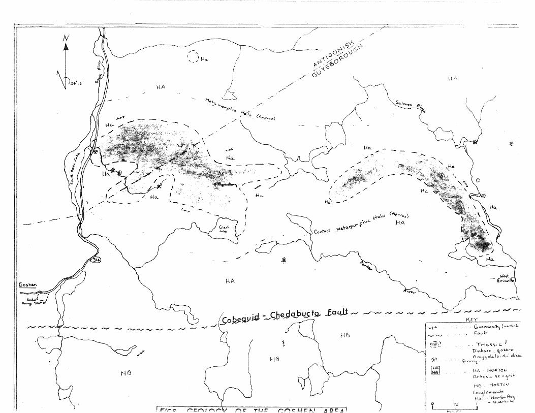
occurs near Goshen, Guysborough County at the
waters of the Salmon River (Fig. 8 ). In this area
numerous diabasic and gabbroic dikes, sills and small
plutons all cut Paleozoic rocks. Aeromag netic maps
are helpful in delineating these intrusives. These
Goshen intrusives include diabase, gabbro and amyg
daloidal diabase. They intrude rocks of the Horton
group producing a coo tact metamorphic halo. Meta
morphism has produced argillites, quartzites and slates
from Horton sediments as well as a gneissosity which
seems to parallel the boundary of the intrusives.
(Fig. 8 ).
D. Petrology of the Goshen Plu~
The plugs are easily recognised in the field as
small. hills or knobs up t 50 feet in height. Their
texture is seriate to microporphyritic, but much of the
groundmass has been replaced by chlorite and epidote.
There is no apparent flow alignment of phenocrysts but
vesicles d elop flow bands near the contacts.
The essential minerals of the plugs are plagio
clase (An 60 ) and augite. The anhedral to sub
hedral augite grains are sometimes twinned oo ( 100).
N
HA
----· --- ~·
,.-' I l
" - / ).-Ia_
1
I
HA
\
I (
I I
~
\
HA
-
(
~ /

M etite occurs as subhedral to euhed crystals
which are often s"keletal. There are, throughout the
plup;s, small amounts of orthopyroxene.
Secondary alteration of the plugs can be seen
by extensive albitization of plagioclase phenocrys-
tals which now contain larr,e patches of chlorite and
epidote. Of the few vesicles found most are filled with
radiating bundles of chlorite.
The following is e. short description of a few
thin sections of rocks from the Goshen plup.;s :-
A -1 Di a bas e • (South R i v e r Lake Quarry )
Somewhat irregular, altered laths of labrador
ite are partially enclosed in rims of alkali
f e l d spar ( alb i t e ) • Ferro ma gn e s ian min era 1 s in
elude ortho-pyroxene, augite, biotite. The
biotite is altered to magnetite and chlorite.
Accessories include subhedral magnetite, and
epidote.
B-ll Diabase prophyry. (Erin v i ll e Qu a r r y ) •
This rock contains large altered phenocrysts of
labradorite containing chlorite and epidote. The
fine-grained matrix in yludes pl i oc lase horn
blende, biotite and magnetite. There is also
min or carbon at e f i ll in g s an d a few e u he d ra l
crystals.
8 Diabase. ( H oppen de ) . Mainly composed of a1bitized labradorite and
anhedral augite with ophitic texture. The
aug i te is s 1 i p: h t 1 y a 1 t e r e d to u r ali t e and b i o
t i t e • Thi s r oc k rna y a 1 so c on t a in a r e w grains
of pigeonite indicative of near surface intru
sives. Other minerals include up to 5% apatite
and 10% ma.gn et it e.
When comparing the petrology of the Goshen plugs
with well-known diabases there is found to be close
similarity; especially with the Palisades sill and the
Great Sb e l b u rn e Dike • ( 111 i g • I 0 ) •
In Connecticut, within the Newark system,
several. volcanic plugs have been the source of basal
tic lava flows. The following comparison of these
pluvs with those near Goshen indicates that they are
very similar:-
(1) Both volcanic plugs have chemical analyses that
correspond to average tholeiitic diabases.
( 2) The essent 1 nerals of the plugs are plagio-
clase and augite, with minor magnetite and
orthopyroxene.

( 3 ) The two main constituents, pl oc
a.ugi t e, show good oph ic texture.
e and
(4) Both diabases coot n vesic s filled with
chlorite and show secondary alteration.
()) The plugs in both areas intrude sedimentary
rocks prod u c in g con t a c t au r eo l e s that are
substantially larger than the surface area of
the plugs.
(6) Volcanic bombs and tuffs seem to have originated
from these vents, as well as basal tic flows.
These similarities su g~es t that the Goshen
plup-s, like those in Connecticut, acted as conduits to
lava flows. In Connecticut the flows are adjacent
to the parental volcanic pluers whereas in Nova Scotia
the flows have been offset from the plugs by a major
dextral fault.
Partial chemical analyses of a few of the in
trusive rocks from the Goshen area (below) have been
compared with similar tholeiites from the North
Mountain, the Great Shelburne Dike, and the Palisades
( fi' i g • I 0 ) •

r r~~~4 Al 2 03 Fe.T /'13 0 Ca..O K;(O \-, Oz. P2 Os
I A-1 ~50·80 1'1-10 12 64 j$-JO ! rl·tf-6 o-m _.2 Ob- 0·4.3
---------·------
B-It I 4-~JO 14 50 13·93 5·60 '1·58 0-84 3 -It- 2 01 - -----·---------
13- 4-0 I 5" 5"6 6·70 'l-06 0· 8"5" J-oa o ·¢S
-----------
14·50 l ~ 36 ~-~0 Y·84- 0 7~ ~ ·71 0 67 ----- -----
Mineralogical similarities also exist with the
North JVlounain basalts and the Great Sr1elburne Dike.
The mineral ranges of these two grours are compared
below with the Goshen intrusive.
Labradorite
1Au gi te
Pigeonite
L' A tN Lund (1930) Hudgins (1960)
3 8-50~~ av.
20-40% av.
0-15%
GO~HEN1NTHtJSIVES
40-60% av.
25-40% av.
GREAT DIKE Lawrence ( 1966)
45-60/S av.
18-4.5% av.
I
I 0-10% Orthopyroxene
Glass and Magnetite 5-10~~ 10-200~ av. 15% ~~------------+-----~-----------------
0-.5%
10-JO% av. lA% I

A RfSO F E L L
I. 3 4 s-. b 7. 5' 9
s1o.2. 50· ao 49 · 3n 4q 41 51 ·80 47. tJ6 48 ·30 s-1 '70 j-o r 7 4q to
Al,zq /-4. I /Lt 50 /5 'jq j 3 '13 14-~q 13-+o 15Ao /4- 65" 11 8'0
F~o I Fa..! o1j ll ) c_,~ 13 q 3 13 31- 12 OS L I · 34- 1 ~-- s-6 I o ·So ( 0 6{ i.2. ·b'f-
1'"'150 b J I 5 bO 61.7 6-50 '-{' 1'8 6 ·co 6·70 b 'f'S" IO Jo
(a_O I 0 ''TO q.s 8 q -65" g. 6'5" 7 8b. Lf·Ob q So 9' 3 3 7 86
K2 0 o·z?l 0· 81- 0-5"'0 0·75" 0·77 0 '65" 0·98' Q. 7"i t)·5'7
02. 2 05' 3' 14- l-6t I· 6 'J 1 ·s-o 3 .oo 1- I I l l 3 ( /0
Pz05 0·23 2 0( 0·16 O·l.O 0·32 Q. 6S" o-14 0 ·IS 0 43
F'IG 10.
f. Ave.ro.c1
.c. +-ho\e .. .'r ii-i c. ba..soJt O.'f'd._ d..io..bo.se.. , Noc..ko\c:L<>;, (tqS'1- f 101.1)
z. Goshen Inh·u'bi\1€.. - cUo..bo...se.. - f3-ll Wes+- Erir.v;lle..
3 N'orth. Noun-\-()..in Ba.'5o...lt 1
Si.,-..ho.__ (1q70 #31(\).
4. Ave:f'CL~e... C-ompos c' i-io n. 0 ~ -the. 'PCL\; so...d.e 'S t' ..,-f.'("'v$'1 Oh ( t< W'o..\lr..e..r lqGq)
5. N o.;-t-h. Houn+o...i""' 6o.so..lt- ( McKo..j Hd. J SiAho.. !<l. 70.
6. L::O..sf Mou"+a..in - clio.. ba.se.. i"'-f-r.usion -EM-I
7. GrecL:f- .D~ke... , SI·H!.Jiou'('l"\e., ( ..(QcvV"enc..e.. !Cf66J
5. PcdisCLde~ cLo.bo...se, 5pr;f'\'Jf;e1cl New Je'("'se~ (wo...tke_.-- F· lGl.<to)
q, Goshen Irt+rusivc. - dia..loa..s~ -Sout-h.. ~iver ~RE.. Quo.rrj · A-1

E (' .._) an d C on c l us i on s
It seems very likely that the intrusives of
t. e Gost:en area were once basal tic plup-s and that tb
necks served as the conduit for basal tic flows. ·~e
v o 1 c an i c con e s which mu s t h a v e ex i s t e d on t h e s u r r a c e
could have been removed by e.ciation. However, there
is no evidence in the area of any extrusive post-
Carboniferous or Triassic flows. It is therefore sug-
gested that these volcanic necks might have been the
conduits for the North l"'lountain basalts, the outflows
being in a south-westerly direction crossing the im-
mediately adjacent fault line.
In summary, the following factors support this
proposition:-
( l) The plugs are composed of diabases which
closely resemble the North Mountain basalts
both petrologically and veochemically.
(2) The diabases vary from the contact to their
centre. For ample, one of the inner rings s
considerably richer in apatite than one fur-
ther out.
(3) 'rhe contact metamorphic aureole is larger than
the surface area of the plugs which suggests

that there may well have been a conside 1.
amount of magma passing through thes con uit
(4) 'The plugs are very similar to volcanic plus in
Connecticut that have been identified as con
duits for local basalt flows.
The origin of the North Mountain basal L s seems
to lie near the intensely block-faulted north limb of
the Minas syncline, just south of the Cobequid
Chedabucto Fault. MacNeil and Take (1966) stated 9
"rr he r e i s c on c l u s i v e ev i d en c e that a chain of T ri as s i c
volcanoes existed in the block-faulted zone near the
Cobequid Border Fault ••• " Along the north shore
of Minas Basi~, near b,ive Islands, sill, agglomerates,
volcanic tuff's, bombs, pipes, base metal sulphide
mineralization and a unique zeolite assemblage all
seem to testify to the above statement.
The volcanoes reported by MacNeil and Take and
the Goshen volcanic plugs in Guysborough County lie on
opposite sides of the Cobequid-Chedabucto fault and
are approximately 110 miles apart. The discrepancy
in distance between the Goshen plugs and the extru
sive material can be resolved by postulating a dextral
strike-slip along the Cobequid-Chedabucto fault. This
p~acement would have occurred after ext s o
--)r t:,[l North Mountain basalts, sometime durin
ea ly ,Turass}c.
Jf' a source f'or the North fv1ountain basalts rloes
lie tTear the nortr: shore of Minas Basi~ one important
question arises. Is it
would extrude lava that
likely that a single source
travelled along a basin for a
dis ance of 125 miles or more? The g;ently dippinp,
linear character of the North Mountain flow sup-p:ests
that the basalts might have been extruded from fissures
an d n o t from v o 1 c an i c c en t r e s • Howe'' e r, the C o 1 u m bi a
f?:iver district shows vast plateaus of basalts that have
been extruded from a local source and nave travelled
almost 100 miles in several directions. ( H o l me s , l 96 S ) •
It seems almost certain that there once was,
in the area around Five Islands, at least one extru
sive vent which was the source of these volcanic
materials. It also seems lik8ly that the vent or
v en t s in fa c t ext ru d e d l a v a • ri'h ere has a l ways been a
marked difference between the North Mountain basalts
and the basalts on the north shore of l1in as Basin.
Klein, (1960) described the two as different basaltic
areas lying strati graphiq ally apart: he named those of
the north shore of Minas Basin the McKay Head basalts.

te novJP pr>, Sinha (1970) demonstrated . t t y
e e tratt ica lly identical and he, therefore
1' •(p-·n('np pr t~em into t!--)e North Mountain ba alt~
ever· heless. t\-J(' "'l"f"l"'ir. i"roups may well exist;
Nortr·1 ~loun tain basalts and Klein's old Me r'J3.y Head
basalts (Fig. II). rrhe two groups would be strati
gra.pLically similar but could derive from dif fe~ent
sources.
In conclusion it is suggested that in the Late
Triassic the Goshen plugs were positioned just to the
north of Hasson's Bluff and Five Islands. From this
p :) s i t i on i' t i s p o s s i b 1 e t h at the s e v e n t s c c u l d ha v e
ex t ru d e d all the bas a l t s of the North Moun t a in , and
t"here is an even stronger probabi 1ity that they served
as a chain of extrusive vents producing the volcanic
tuffs, bombs, agglomerates, associated mineraliza
tion and flows of the I~cKay Head basalts.

K 1 e i n (tqGo)
An n o..p o I is - Co~ (\ w 0- I t Yo...\ I Q_Y , Kinqs , Co.
Strat,grophic Successton of Triassic Rocks -Neva~ ot1~
Go.s 1 n Noy-+h Shoy-e
i
Ann o.po I' s -(o,.-nv.r~\ I 1 s Vo..\\e'j, K1n~s Co
--------------------+--------------··-----·------·---+-+--------------- -------- -
C5lomtd..of\ Fov-rno..t lC>r"\ B \om ; d...o v"'~ F o r'r'l"0- t 1 o r>
_j_ _________________ -----1 i :I i'
T--
M 1 n (.1.. S G s 1 Vl
t'fo( +h Sno"e
-----------------r------1 He-~=~ ---~~~-~J---~-~s~ l t -----l~---·------------------------------+-----'---------------------~ !
Wolf Vt I I e. ~ oy10o.t i oY~ Wo ( f v 1 \ <2. F OY"rYvJ.J-; ov'
------------------L-------------- ---------Fl G II
.wor f \/1 I )e FOYY'YlQ...t ion Wa \ fv 1 \I e F o" (Y\.(lt- , ~: (1
The C o be q u i d- Ch e d a b u c t o fa u l t i s par t of a l on
2ystem of faults extending northeasterly along the
Atlant.ic seaboard, across Acadia and through Newfound d.
The whole system seems to have been active since the
1ate Devonian with most of the structural movements
tak ng place throughout the Carboniferous. However,
the robequid-Chedabucto fault appears to have been
active in the rate Triassic or early Jurassic as well.
Along the entire fault system the latest phase
of slippage was dextral with the exception of the Harvey
Hopewell fault in s out bern New Brunswick, w~~ ere a
sinistral movement followed larger dextral slips .. A
arboniferous dextral displacement of 12S miles has
been estimated in southern New Brunswick by Webb
(1969) who has also suggested a similar displacement
on the Cobequid-Hollow fault and perhaps 65-100 miles
in Newfoundland. There is no evidence of dextral slip
along the Cobequid-Chedabucto fault in the Carboniferous
but during the late Triassic there appears to be a
strong probability of a dextral strike-slip of 110
miles for the following reasons.
\
\
(
\ ) l ~/
PALl NSPASTIC
MARITIME
MAP OF
PROVINCES
THE
/

( l ) 1 f th e G o s h e n p 1 up s are t h e o u r c e are
fur the basa1 ts of the
been displaced 110 miles.
of FUn they have sine
(~-}) The Triassic sediments exposed near
Guy sborough seem to be d i sp laced from their counter
parts in the Minas Basin area.
(J) There is a general mismatch of rock types
and ages across the fau 1 t. A repositioning of the
southern po~rti..on of Nova Scotia 110 miles to the
east aligns many identical rock groups.
(4) rr,he Mississippian rocks of the Windsor
S h u ben ac ad i e re g i on co u 1 d h a v e l a i n j u s t s o u t h of
their counterparts in tre Antivonish-Canso Strait
area~
(5) Dextral stri e-slip motion is indicated
by secondary sinistral dra.g faults on the northern
side (Fig. /6 ).
(6) The epic enter of the d Banks earth-
quake of 1929 lies almost due east along the strike
of the fault and this may indicate recent motion
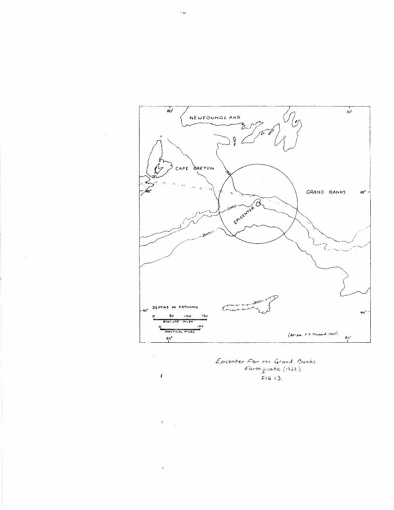
a l on g t hi s fa u 1 t z on e. ( Fig • 13 ) •
0 50 IO<J 1~0
q 100
NII\ITIC.AI- MIL£-' I
6o•
GRAND BANKS ~·
£p,cenfe_r F~r -;-;, 12 Grand. f3a.n ks
Eo.....--f-1-...Xvo.Ae- ( JC(;.q)
J:IG. 13.

1\ e en t 1 y p u b l i shed data in d i c at e s th a t t h e
·umberland Basin just north of the Cobequid complex
-~ , ~ a 1 s o p a r t of a r i f' t s y s t em ha v in g i t s ow n d n
a ion and structural envit>cmments. Subsidence prot~ o-
1y began in the late Cevonian perhaps resulting t·rom a
~T"aben or rift after the Appalachian orogeny. t also
seems likely that this period marked the first ap-
pe ranee of the Cobequid fault as block faultinr
oc8urred on both sides of the Cobequid arch, witL t~le
central Nova Scotia rift beinp formed on the soutr,
side. nere Horton group rocks were deposited in a
r i f t v a l 1 e y with t he C o be q u i d on it s n or t 1-L e r n b our;
dar y an d the We s t Hi v er-St • Mary ' s fa u l t t o the
south. Later Carboniferous north-south thrust fault-
in g prod u c e d the R i v e r s d a l e I:<' au l t an d o t he r s in the
Truro area. A section through the East l"1ountain area
shows the relationship of Carboniferous and [Triassic
strata to these thrust faults (Fig. 14 ). There is
e v i den c e that s t i 11 1 at e r, pe r haps d u r in g- t_:, he r !l ria s s i c ,
extensive dextral movement occurred on the Gobequid
Cherlabucto fault offsetting the once-related Cobequid
Hollow fault line. The other segment of the Hollow
fault, therefore, should reappear south of the
Cobequid fa.u 1 t in the Bey of Fundy (Fig. 12 ) •

·---
4
/ /
/ /
/ /
/
4
\
3
3
2
F I 14-
------------
/ /
0
L__
/ /
/ /
/
s-oo §00
/
1/ T J s-/
/
I ~~ I I
+ 5 \5)

Althou~h there was probably substantial pr
r .ssic strike-s p faulting on the Cabot-Hollow
raul t, the Belleisle fault, and the Harvey-Hopew
f'aul t, no strike-slip 'nad yet occurred on the
Cobequid-C'_-Iedabucto fault. Luring the late rrriassic
tensional movements reopened many of the Carboniferous
rift basins along eastern North America. Similarly
str ctural activities also occurred on the eastern
portion of the North African craton. In "0Jova Scotia
this produced major dip-slip displacement along the
Cobequid-Chedabucto fault with the Cobequid Arch on
t r. e west moving up re 1 at i v e to the Triassic rift v a 11 e y
t o the s ou t h •
After the Triassic period the Cobequid-Chedabucto
fa u l t was re-a c t i v at e d pro b a b 1 y as a t ran s form fa u 1 t •
~ovement of the crust away from tte accretin~ plate
mar·~Tin of the mid-Atlantic caused the Nova Scotia
platform south of the Cobequ1d-~hedabucto fault to move
we s t r e 1 a t i v e t o the northern c rat on • 0 i s d ex t r a l
strike-slip motion displaced once related geological
features and left the crustal blocks in their present
position. As the North Atlantic continued to open
the older oceanic basement slowly subsided. This
subsidence probably caused dip-slip motion of the

mrrmm
r ~t
Rnh
r '"'"'---. ____...1 pre -W. HIGHLANDS
X P L A N A T I 0 N RP -- Normal
R ha --===-- Inferred ._,.
~eb ( Intrusives
lv v l pre-~ E. HIGHLANDS
/"' FIG IS
fa u It s t ri k -slip omitted)
/
fa u \ t
Plate 1. Geologic map of C3illard Graben and \"icinity, Branford, r\ew H.JVI'n \\ .diJII._!f,,rd, c.id!,,rd .t!ld I ),,rl..ttll 7 1:: llllllllk <JII,!dr\IH.:l·'
John E. Samkr'i, ha'>~-d on ddailt:d mappi!l:..; i11 Hr:111ford, '1\f"w ILn!·n, and .dl11:.:f<>I:i ljti.idr.tr•gln ( lrn1t1 \!,l..ttlil , 111.] j),,I!'Jll.W I' minor omitted Bl.Kl areas are water ( bkn ;.ll,d Long bLwd So••r1d J
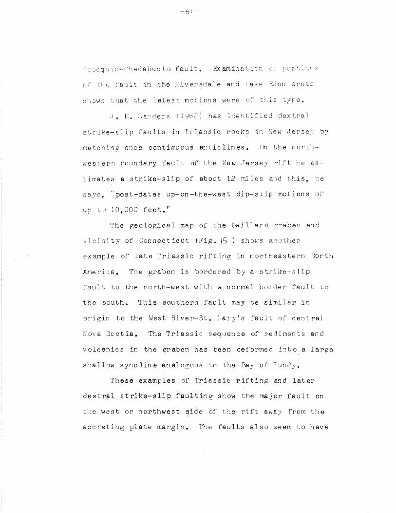
qu d--l'hedabuc Lo fault. Exarninat on
o;· tie fault in the hiversdale and J,ake r:den ar s
'·,ows that -::,he latest motions were of tLis e
.1. E. ::a~!der~i ( l ~) has identified de.x tra l
s t r ike- s l i p f au l L s in T r i as s i c r o c k s in e w tr e r s e
matching once conti~uous anticlines. On the north-
western boundary fault of the j\Jew .Jersey rift ~'e es
ti tes a strike-slip of about 12 miles and this, he
says, ·~post-dates up-on-the-west dip-slip motions of
~; ~J t c) 1 0 , 0 0 0 f e e t • ''
'l1 he geological map of the Gaillard graben and
vicinity of Connecticut (Fig. IS ) shows another
ex amp 1 e of l at e T r i as s i c r i f t in g in n or t h e as tern Nor t h
America. The graben is bordered by a strike-slip
fault to the north-west with a normal border fault to
the south. This southern fault may be similar in
or i p: in t o the We s t R i v e r- S t • : l a r· y ' s fa u l t of c en t r a 1
Nova Scotia. The Triassic sequence of sediments and
volcanics in the graben has been deformed i}lt o a large
shallow syncline analogous to the Bay of >.'undy.
These examples of Triassic rifting and later
dextral Strike-Slip fau 1 tin g SrcOW the mB. j Or fa.u 1 t on
the west or northwest side of' the rift away from the
accreting plate margin. The faults also seem to have
li f"l.ed as rlier block-faul s with h bl l
st moving up ..
A ce c en t e am r l e of t hi s t y p e of r u l t i n
~~e initial riftlng of two plates is given by :J
and Berr" r lc;r:;;C). They ex arnined the firs· moti uf
e rthquakes in thA V\'e~d.ern rift valley of' East J, rica
and alth'JUt·~b the data was not extensive enough to cle-
t e r min e tr. e pre d omi n an c e of fa u 1 t in f, the fir s t m o
tions were dip-slip faulting on steeply dipping
planes of known faults or on faults parallel to them.
This was followed by strike-slip faulting on the near
vertical faults as horizontal motions bepan. Also,
es pointed out by D3wey and Bird (1970), trle major
fa u l t s o c c u r on trJ. e s i d e away fr orn t r. e ac c r e t in g mar
gi~ with block faults on the opposite side of the
rif't. Both of these situations seem to fit the posi
tion of the Cobequid-Chedabucto fault.
I suggest that these rift structures and tte sub
sequent wrench faulting were caused by the separ·ation
of Afr·ic a from North Amer·ic a during the ear 1.y s ta9es of
sea-floor spread in g. The complexity of' faults and
rifts along the zone of separ•ation between the two con
tinents is prcbably a result of cr·ustaJ fragmentation.
Differential motion caused transposition of fragments
Oif1 00 on t in en ~ t o an o t r • The s o u the r n c t -nj of
eva Scctia, which includes the Plat for·m, was
'JLably one of these crustal fragments. It could e
e ined its posi t:on against North America by sub-
stantial dextraJ strike-slip along the C::obequid-
Chedabucto transform fault durung the Jurassic. fr1e
c or r· el_ at i on s J h a v e rna d e a c ro s s the Cob e q u i d- C h ed a b u c t o
f'aul do not include muct evidence for pre-Triassic
rna t c L i r: ~~. It is possible, therefore, that the rift
and fGult structures described could be due to the
s o u the r n U o v a & o t i a p l a t f orm mo v i r: g ba c k in t o
original position. This sequence of events would
start with the crustal fragments in approximately
their r r e s en t p o s i t i on • First , the s t ret c hi n g of the
crust between Africa and North America, during the
late Triassic, pulled t1-le southern portion of tJova
Scotia eastward along the Cobequid-Chedabucto fault.
Then, after several at tempts at a centra1 rift per-
haps along the Bay of ~undy and through the Anti-
Atlas WDuntains the present mid-Atlantic rift opened
east of the Nov a Scotian fragmen Finally, as the
ocean floor began to move away from this accreting
plate margin the Cobequid-Chedabucto fault became a
transform fault. Differential movement of oceanic
st then caused the southern Nova Scotia a
west in relation to the northern platfo o
ume its present position.
If a large dextral displacement is postulate
for the Cobequid-Chedabucto fault several second ry
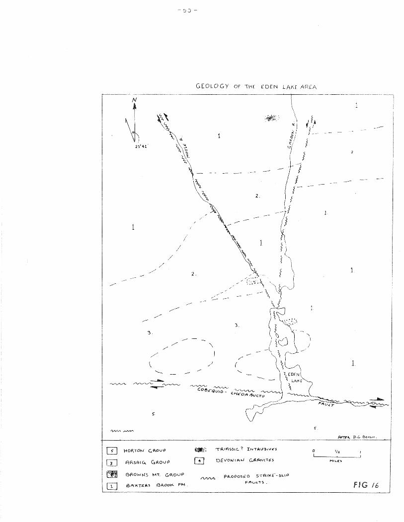
faults can be explained. In the Eden Lake area of
Pi c t o u c o u n t y sever a l s e c on dar y fa u l t s ar e p r od J c e d
sinistral drag on the north side of the fault.
Sinistral displacements of nearly one mile can be
0
seen from the offset of Brown's Mountain rocks, (Fig. /6 ) •
The L'Ardoise thrust block of southeastern Cape Breton
is bordered on the west side by a long northeasterly
fault which extends from St. Peter's to En on Lake
along the Salmon River, then curves eastward into ra
Bay. L. tT. \>.leeks (1954) observed zones of dra;:.:r-
folding and faultin~ with dextral movement and struc
tures in pre-Horton ian rocks to the north ttat suggest
dextral; in relation to the geology would seem not
unlikely that this is a wrench fault related to, and
conceivably resulting from. dextral movement along the
Cobequid-Chad cto fault.
The structural forces that folded the Triassic
rocks in the Bay of Fundy area are probably due to an
east-west compression. The rocks have been very
) --
GEOLOGY Of IHE EDEN LAK£ APEA
/
/
I l I
/
/ /'
// 2, / ·.
/
~ -------~-
/
3.
' -------...._ I
"\ / /'
~
/ ( 1 / '-...
6'.
QJ HOf\TON" (, P..OU P ,.f; "TfJ..II'\'S5tC.. i' IN"TAU~.VAfS
I 3 I AASAl~ G~ov~ GJ DEVONIAN C. A. A-N rT I.H MIL.!(!>
m BP.OWN'5 MT- C.P.OUP P~OPOS!;i:O STAI~t -51-.IP I'VVV!..
m 6A:><.Tt:::fl..:!t ~P...OOI'<- FM. Fl"'v<..TS, Fl

i ly folded into the Minas Syncline where
stratum dips from 5 to 10 degrees. This folding
p obably took place in the early Jurassic as the mo
tion of the southern platform of Nova Scotia pushed 0he
'Triassic· basin against the New Brunswick platform
(Fig. 12.. ).
CONCLUSION
During the Late Triassic there was considerable
tectonic and magmatic tivity along the Atlantic rnar-
gin of North America and North Africa. In North
America sequences of rifting, sedimentation and mag
matism seem to correlate very well between Nova Scotia
and the eastern Un.i ted States. These events are
probably coincident with or perhaps even resultant
from the last opening of the North Atlantic ..
The Triassic tholeiites of both Nova Scotia and
the eastern United States inculde extensive basaltic
flows, large die. basic dikes and many smaller intru-
sives. Petrologically and geochemically the tholei-
ites in the two areas appear closely related.. These
rocks may all have originated from the injection of
pare n tal oc e an i c rna gma in t o the c on t in en t a 1 rna r gin s
during the initial stages of North Atlantic rifting.
Near Goshen, Nova Scotia, there is a group of
diabasic intrusives which are almost identical to the
other Triassic· intrusives of eastern North America. The
Goshen intrusives appear to be volcanic plugs and their
conduits could have fed volcanoes or have extruded
lava flows. These plugs are so!Tle 100 mi s to the east

of the HcKay Head~North Mountain basalts; but it will
be noted that they are located just to the north of
the Cobea uid-Chedabucto fault whereas the McKa_y Head- 11 J'-'·
basalts lie just to the south of the fault.
There is evidence of a dextral strike-slip
fault of approximately 100 miles along the Cobequid
Chedabucto fault in the early Jurassic. This would
mean that the Goshen plugs would then have been ad
jacent to the Wasson's Bluff-Five Islands area of the
Me Kay Head basalts on the north shore of Minas Basin.
There is also evidence that the conduits of the
Goshen plugs extruded a considerable volume of lava.
It is concluded therefore that the conduits could well
have been the source of the Triassic flows both for
the McKay Head area and perhaps also for the entire
North Mountain formation.
- 0-
CITED REFERENCES
nird, .J. M. and J. F. Dewey. "Lithosphere plate: rontinental Margin Tectonics a.nd.the Evolution
1970. of the Appalachian Orop;en. 11 Geo. Soc. Amer. Bu1. v 0 1 • 81 p. 10 J l-1 0 59.
Dewey, J. F. and J. JV1. Bird. New Global Tectonics."
1970 Vol. 72 #14.
,;Mountain Belts and the Jour. Geophy. Res.
Fletcher, H. "Report on the Geological Surveys and Explorations in the counties of Guysboroughll
1886 Antigonish and Pictou, Nova Scotia.'' Geo1. Survey of Canada, Ann. Report 1886 Vol. II part P ( 1887)
• '1Report an the Geological Surveys and
---EX---plorations in the counties of Colchesterll Hants 1905 and Kings counties. Geol. Survey of Canada.
Ann. Report 1905 •
• ll an d J • A • Robert s • R om an V a 11 e y, N o v a ------s~c-otia: Canada. Geol. Survey Map Jl 1886
Holmes, A. Principles of Physical Geology. T. Nelson and Sons Ltd. 1966 (Revised)
1944
Hudgins, A. D. The Geology of the North Hountain in the map area, Baxter Harb-our to Victoria
1960 Beach. Unpubl. M.sc. thesis, Acadia Univ.
Klein, G. de V. "Triassic Sedimentation, Maritime Provinces, Care. da," Bull. Geol. Soc. Amer.
1962 Vol. 7 J pp. 1127-1146.
Lawrence, D. E. A Contribution to the Petrology of the Great Dtke of Nov a Scotia. Unpubl. M. Sc.
1966 thesis, Dal ousie University.

,un d,
1930
R. J. ''Diff tie. on in the P 1 ow 11 The Ame r • Mine o g i s t •
II 539-565 e
Sp c Vol. 15
TJ1acNeil, R. H. and w. F. Take. ''Triassic Bas t and Structure, Nova Scotia." Guidebook: Geology
1966 of Parts of Atlantic Provinces. Geol. Assoc. Canada. w. H. Poole Ed.
Powers, s. "The Acadian Triassic," Journal of Geo. 24 pp. l-26, 105-122. Vol.
1916
San de r s , J • E • "Strike- slip d i s p lac erne n t on fa u 1 t s in 'J.lriassic Rocks in New Jersey." Science Vol.
196 2 13 6 ' 4 0 •
• "Late Triassic Tectonic History of ---... N-ortheastern United States." Amer. J. Sci. 1963 Vol. 261 p. 501-524.
• ''Stratigraphy and Structure of the Triassic ---~S..,.-trata of the Gaillo.rd Graben, South-Central 1970 Connecticut." ·State Geol. and Nat. Historv
Survey of Conn. Guidebook #J. "
Sinha, R. P. Petrology of Vole ic Rocks bf J'Jorth Hountain, Nova Scotla.. trn publ. Ph.D. thesis,
1970 rralhousie university.
Stevenson, I. M. Cheda.bucto Bay, Nova Scotia: Geol. Survey.Map 3-1959.
1959
• "New ~currences of Triassic sedimentary ----r-ocks in Chedabucto Bay area, Nova Scotia; 11
1960 Geol. Soc. America Bull. v. 71 p. 1807-1808.
Sutton, G. H. and E. Berg. "Direction of faulting from first-motion studies," Bull. Sei smol.
1958 Soc. Am., vol. 48 p. 112~12~.
Walker, F. "Differentiation of the Palisade Diabase. New J e r s e y • " Bu 11 • Ge o • Soc • A mer • v o 1. 51
1 CJ+O (part 2) pp. 1059-1105.
ker, R. "The Palisade Sill, New Jer y. Reinvestigation '' Gaol. Soc. Amer. r
1969
hiebb. G. VJ. "Occurrence and Explo ation Si ifi of Strike-Slip Faults in Southern New Brunswick
196_3 Canada." Bull A.A.P.G. Vol. 47, 11.
White·, R. D. ''rrhe Cumberland Basin - A Possible n C.I.M.M. Bulletin Vol. 65 pt. 2 pp. 83-SH.
197 2
______ • "Palinspastic restoration s u~est in g late Paleozoic North Atlantic rifting.' Science v. 159 p. 875-878. 1968
• "Paleozoic Wrench Faults in Canadian ---A...-p-palachians." North-Atlantic-Geology and 1969 Continental Drift. A.A. P.G. Memoir 12.

GENERAL REFERENCES
A.cock, F. J. Geology of Saint John regi6n~ New B run s c k : canada • G e o 1 • Sur v e y Hem. 16 t35 p ..
1938
Aumento, F. Thermal transformations of selected Zeolites and related Hydrated Silicates.
l 96 5 Ph • D. The s i s ; Da lh ou s i e Un i v •
and C. G. I. Friedlander. ''7, eoli t es from -North Moun t a in N 6 v a Sc o t i a~ " In t • Min • As s o c •
1966 Papers: Min. Soc. of India, IMA Volume. pp. ]J~9-l54
Ballard, R. D. and E. Uchupi. !!Carboniferous and rr r ias sic Rifting: A Prell minary Outline of the
1972 Tee tonic History of the Gulf of !V'Iaine. Geol. Soc • A mer • Bu 11. V o 1 • 8 3 N o • 8 •
Bell, W. A. Horton-Windsor district2
Nova Scotia: Canada Geol. Survey Hem. 155 68 p.
1929
Benson, D. c. Hopewell, Nova Scotia. Canada Geol. Survey Map J-1962.
1962
Bowen, N. L. The Evolution of the Igneous Rocks. Dover l9:S6.
1928
Bower, Ivi. E. "Seamagnetometer Surveys off Southwestern Nova Scotia.'~ Geol. Sur. Canada. Paper 62-6.
1962
Cameron, H. L., ''Faulting in Nova Scotia;" Trans. Roy. Soc. Canada; Ser J, Sec IV v 43 pp. 13-21.
1949
• "Tectonics of the-Maritime Area; ·Roy. Soc. ----c-anada Trans." 3rd ser. v. 50 see 4 p. 45-51. 1956

·': 1 ke, T F. Roy. Soc. Canada
l 7
Croneis, c. and W. c. Krumbein. Down to Earth pp The University of Chicago Press (19th impres
1
Darton, .N. H. "On the Great Lava Flows and Intrusive Trap. Sheets of the Newark System in l'lew Jerse
1889 Amer. J. Sci. 3rd series vol 38 p. 134-139
DeBoer, J. "Paleomagnetic Differentiation and Correlation of Late Tria~sic Volcanic.rocks in
l 8 the Central Appalachians. 11 Geol. Soc. Amer. B u 11. v • 7 9 p. 6 0 9-6 2 6 •
Ei s bache r, G • H • and D. G • Ke 11 y • '' T e c t on i c Stud i e s in the Cobequid Mountains, Nova Scotia. 11
1966 Maritime Sediments v. 2 p. 180-183.
Eri kson, G. P. and J. L. Kulp. "Potassium-Argon Measurements of the Palisades Sill, New Jersey.''
1961 Geol. Soc. Amer. Bull. vol. 72 p. 649-652.
Fairbairn, H. w.; P. M. Hurley; W. H. Pinson and R. F. Cormier. "Age of the Granite rocks of
1960 Nova Scotia;" Bull. Geol. Soc. Amer. vol. 71 PP • 3 9 9-~ 14 •
7-388 9
Kelley, D. G. and W. D. I"-1acKasey. Basal Mississippia.n volcanic rocks in Cape Breton Island, Nova Scotia.
1965 Canadian Geo. Sur. Paper 64-
Maehl, R. H., The Older Paleozoic in Pictou, Nova Scotia. N.S. Dept~ Mines. Memoir #4.
1961
May, P. R. 11 Pat tern of Triassic-Jurassic Diabase dikes around the North Atlantic in the Context of
1971 Predrift Position of the Continents 11 Geol. Soc • Ame r • B u 11 • v o 1 e 2 P. 12 8 5-12 9 2 •
Schiller, E. Guysborough, Nova Scotia: Canada Geolo. Survey Map 27-1961.
1961

l
on V era logy and Petro 1 ln trusive Triassic Di se, Virgini T1 S .. Nat • Tv1u s 6 Art 2,.
i t h 1:J • F; .. T • '' So rn e G e o l o g i c a 1 an d c t on i c c on s i de tions or· eastern Canadian earthquakes;
7 ~)oc.. Can. Spec Pub.. #1J.. Appal an c pp .. 83-93 ..
tose; G. W. and J .. v. Lewis. "Triassic Igneous Roc s Gettysburg, Penn." Bull. Geo1. Soc .. America
19 v. 27 pp. 623-6L+h·
S w i r t, D. J • P .. an d A .. L.. Ly a ll • 11 He c on n a i s s c f Bedrock Geology by Sub-bottom Profiler, Ba of
1966 Fundy." Geol. Soc. America Bull. v. 79. p. 639-646.
Sjkes, L. R. "Mechanism of Earthquakes and g on the Mid-oceanic rldges;"
72 p. 2131. Fault
1967 Res. v
T
1907
L. J. Scotia.
dme , K. vol ..
964
"The Geology and Ge 19. The New Jersey
raphy st ori
ll i a ms , H • ; M • J • Kennedy, an d H "The Hermitage r'lexure, 'rhe Cabo
1970 Disa~pe ce of the Newfoundlan Belt· G .. S. A. Bull. val. 8
1 s on , J .. T ~~~ Cabot Fa u l t , An of the San Andrea and Great G
1962 Implications for Continental Nature. vo1. 195 p. 135-138