off-site source ground water investigation technical guidance · off-site source ground water...
TRANSCRIPT

New Jersey Department of Environmental Protection
Site Remediation Program
Off-Site Source Ground Water Investigation
Technical Guidance
April 2015 Version 1.0

Table of Contents 1.0 Introduction ............................................................................................................................. 3
1.1 Intended Use of Guidance Document .................................................................................. 3 1.2 Document Overview ............................................................................................................. 4
2.0 Administrative Requirements .................................................................................................. 4 2.1 Regulatory Basis ................................................................................................................... 4 2.2 Affirmative Obligation to Investigate/Remediate Discharges ............................................. 5 2.3 Contamination Discovered/Department Notification ........................................................... 5 2.4 On-Site Ground Water Contamination from an Off-Site Source is Verified ....................... 6
2.4.1 Unregulated Heating Oil Tanks .....................................................................................7 3.0 Preliminary Assessment .......................................................................................................... 7
3.1 Preliminary Assessment Tools ............................................................................................. 8 3.2 Preliminary Conceptual Site Model (CSM) and Lines of Evidence .................................... 8
4.0 Off-Site Source Ground Water Investigation ......................................................................... 9 4.1 Data Objectives .................................................................................................................... 9
4.1.1 Ground Water Flow Direction Determination ...............................................................9 4.1.2 Document that Contamination is Migrating or has Migrated onto the
Site from an Off-Site Source ..........................................................................................9 4.1.3 Demonstrate a Migration Pathway between the Off-Site Source and
On-Site Area of Concern .............................................................................................10 4.1.4 Demonstrate that there is no Contribution from any On-Site Area of Concern ..........10
4.2 Use of Existing Data ........................................................................................................... 11 4.3 Refine the Conceptual Site Model ...................................................................................... 11 4.4 Adequate Demonstration of an Off-Site Source ................................................................. 12
5.0 Introduction to Case Studies ................................................................................................. 12
FIGURES Figure 1 Off-site Source Investigation Flow Chart................................................................. 14
TABLES Table 1 Data Gathering Tools Table ....................................................................................... 15 Table 2 Potential Line of Evidence Checklist ......................................................................... 22
APPENDICES Appendix A Data Miner Tutorial ............................................................................................ 23 Appendix B Service Station Case Study ................................................................................. 28 Appendix C Multi-Scenario Case Study ................................................................................. 36 Appendix D Acronyms ........................................................................................................... 47
2

Off-Site Source Technical Guidance 1.0 Introduction
1.1 Intended Use of Guidance Document This guidance document is designed to help the person responsible for conducting the remediation (PRCR) to comply with the New Jersey Department of Environmental Protection (Department or NJDEP) requirements established by the Technical Requirements for Site Remediation (Technical Rules), N.J.A.C. 7:26E. This guidance will be used by many different people involved in the remediation of a contaminated site, such as Licensed Site Remediation Professionals (LSRP), Non-LSRP environmental consultants, and other environmental professionals. Therefore, the generic term “investigator” will be used to refer to any person that uses this guidance to remediate a contaminated site on behalf of the PRCR, including the PRCR itself. The procedures for a person to vary from the technical requirements in regulation are outlined in the Technical Rules at N.J.A.C. 7:26E-1.7. Variances from a technical requirement or departure from guidance must be documented and adequately supported with data or other information. In applying technical guidance, the Department recognizes that professional judgment may result in a range of interpretations on the application of the guidance to site conditions. This guidance supersedes any previous Department guidance issued on this topic. Technical guidance may be used immediately upon issuance. However, the Department recognizes the challenge of using newly issued technical guidance when a remediation affected by the guidance may have already been conducted or is currently in progress. To provide for the reasonable implementation of new technical guidance, the Department will allow a 6-month “phase-in” period between the date the technical guidance is issued final (or the revision date) and the time it should be used. This guidance was prepared with stakeholder input. The following people were on the Committee that prepared this document: New Jersey Department of Environmental Protection representatives: George Nicholas, Co-Chairperson Christina Page, Co-Chairperson Amy DaSilva Ray Pinkstone Ron Poustchi External representatives: Michelle Barbaro, LUKOIL Kari Brookhouse, LSRP, AECOM Ed Henke, Shell Oil Products US Chris Pittarese, LSRP, Groundwater & Environmental Services, Inc. Marc Policastro, Esq., Giordano, Halleran, & Ceisla Steve Posten, LSRP, AMEC Foster Wheeler Environment and Infrastructure, Inc. Vamsee M. Veera, Key Environmental, Inc. The Committee would also like to acknowledge the contributions of former Committee Members Gwen Zervas (NJDEP - Former Chairperson) and Bill Lindner (NJDEP).
3

1.2 Document Overview
This technical guidance focuses on the investigation necessary to determine if contaminated ground water is migrating onto a site from an off-site contaminant source. It provides tools and strategies to aid the investigator in developing lines of evidence to document this condition, and identifies administrative procedures for notifying the Department and issuing a Remedial Action Outcome (RAO) to address it. This Technical Guidance does not address soil, non-aqueous phase liquid, or sediments.
An off-site source of ground water contamination condition exists when one or more contaminants migrate onto a site from an off-site property. The term “off-site source” pertains to the ground water contamination migrating onto the subject site, not the actual source. The site may or may not have distinct ground water contamination attributable to the site itself. Section 3.9(a) of the Technical Requirements for Site Remediation (N.J.A.C. 7:26E) describe the steps to properly investigate and document the presence of an off-site source of ground water contamination. The investigation outlined in N.J.A.C. 7:26E-3.9(a) is optional. The person responsible for conducting remediation (PRCR, as defined in N.J.A.C. 7:26C-1.3) may choose to conduct an investigation in accordance with N.J.A.C. 7:26E 3.9(a) to be relieved of the responsibility to remediate it, or they may choose to remediate the contamination themselves. It is important to note that N.J.A.C. 7:26E-3.9 requires the investigator to document that contamination is migrating onto the subject site from an off-site source and that no on-site source(s) for that contamination exist. However, N.J.A.C. 7:26E-3.9 does not require the investigator to document the actual location of the off-site source(s) that is causing the contamination.
The Department’s Commingled Plume Technical Guidance document will complement this document. A commingled plume is the condition that exists when ground water contaminated from two or more temporally or spatially discrete discharges have mixed to the extent that the remediation performed on one plume will necessarily affect the other. When a ground water plume originating from an off-site source combines, to some extent, with another ground water plume originating from an on-site source, the investigator should consult the Commingled Plume Technical Guidance document. The Commingled Plume Technical Guidance document is currently under development and scheduled to be issued in 2015. All SRP Technical Guidance documents can be viewed and downloaded from the SRP Guidance Webpage located at http://www.nj.gov/dep/srp/guidance/.
It is important to note that the subject guidance does not alleviate the PRCR obligations to complete the proper investigation and remediation pursuant to the Administrative Requirements for the Remediation of Contaminated Sites, N.J.A.C. 7:26C, Remediation Standards, N.J.A.C. 7:26D, and the Technical Requirements for Site Remediation, N.J.A.C. 7:26E.
2.0 Administrative Requirements
2.1 Regulatory Basis
Regulatory requirements for determining the presence of an off-site source of contamination are outlined in N.J.A.C. 7:26E-3.9. • N.J.A.C. 7:26E-3.9(a) allows the person responsible for conducting the remediation to investigate
the extent to which contamination in on-site soil or ground water is due to an off-site source.
• N.J.A.C. 7:26E-3.9(a)1 requires the collection of a sufficient number of horizontal and vertical samples to adequately determine there is an off-site source of contamination. Samples must be
4

collected at the property boundary (or further upgradient if necessary) in order to be upgradient of, and beyond the influence of, any on-site area of concern (AOC).
• N.J.A.C. 7:26E-3.9(a)2 requires that a sufficient number of samples be collected to demonstrate that
a contaminant migration pathway exists between the off-site source and the on-site AOC.
• N.J.A.C. 7:26E-3.9(a)3 requires a preliminary assessment to be conducted pursuant to N.J.A.C. 7:26E-3.1 and, if necessary, a site investigation pursuant to N.J.A.C. 7:26E-3.3 to determine whether a source of the contaminant exists on-site.
• N.J.A.C. 7:26E-3.9(b) states that the person responsible for conducting the remediation is not
required to remediate the contamination migrating onto their site. 2.2 Affirmative Obligation to Investigate/Remediate Discharges
In accordance with the Brownfield and Contaminated Site Remediation Act (N.J.S.A. 58:10B-1.3), an owner or operator of an industrial establishment that has discharged a hazardous substance must remediate the discharge. Therefore, it is important to know whether a discharge identified on a site is from the site or from an off-site source because:
• If an IEC condition exists, timeframes and requirements apply that would need to be addressed in
accordance with N.J.A.C. 7:26E-1.11 and the Department’s IEC Technical Guidance and IEC website (http://www.nj.gov/dep/srp/guidance/IEC/index.html).
• If no action is taken and it is later determined that the contamination was a site related discharge, the PRCR could be subject to applicable fines and penalties.
In all instances, the investigator shall ensure the protection of public health and the environment (N.J.S.A. 58:10C-16), even when the investigator may be uncertain as to the specific source or responsibility of ground water contamination.
2.3 Contamination Discovered/Department Notification In accordance with N.J.A.C. 7:1E-5.3(a) and 7:26C-1.7, when contamination that is not already known to the Department is identified at a site, the PRCR must immediately call the NJDEP Hotline (1-877-WARNDEP) to report the contamination to the Department. This includes notification for each new AOC, unless the case is subject to the Industrial Site Recovery Act [ISRA (N.J.A.C. 7:26B)]. For ISRA cases, one call to the Hotline and one incident number is sufficient for the entire site unless a discharge (or contaminant) detected is suspected to be migrating onto the site from an off-site source, in which case it should be reported. For sites that have been addressed as part of an existing case prior to issuance of this guidance, and where contamination on the subject site was identified and is undergoing remediation, the PRCR or LSRP are not required to report the historic discharge. When calling the Hotline, the operator will request information about the discharge and provide the caller with a Communication Center Number (i.e., Incident Number). It is important to record the Communication Center Number to use later if an off-site source investigation is completed (N.J.A.C. 7:26E-3.9) and an RAO is issued. The RAO issued could be either an “Area of Concern Response Action Outcome” (RAO-A) or an “Entire Site RAO” (RAO-E). Refer to Figure 1 (Flow Chart) for an overview of the off-site source investigation process.
5

Within 14 days after a discharge of hazardous substance has been reported to the Department’s Hotline, the PRCR must submit a Confirmed Discharge Notification (CDN) Form to the Department [N.J.A.C. 7:26C- 1.7(d)]. Within 45 days of the same triggering event, the PRCR must notify the Department that an LSRP has been retained using the LSRP Notification of Retention or Dismissal form available through the NJDEP Online Portal [N.J.A.C. 7:26C-2.3(a)].
2.4 On-Site Ground Water Contamination from an Off-Site Source is Verified
If an off-site source investigation is conducted in accordance with N.J.A.C. 7:26E-3.9 (see Section 4.0 of this document) and the results of that investigation support the conclusion that contamination is migrating onto the site from an off-site source, conduct the following procedures: • Call the DEP Hotline (1-877-WARNDEP) and use the following phrase to report the confirmed off-
site source of contamination: “I am reporting a discharge in ground water that is not related to my site under investigation and the contamination is verified to be from an off-site source”. The investigator should then be prepared to provide the operator with the information below:
o Identify if the sampling conducted to confirm the verified, unknown off-site source was
completed on or off the subject site o Identify the address and land use of the property or properties where the sampling was conducted
(residential or non-residential) o All contaminants detected (related to the off-site source), contaminant concentrations, and the
contaminated media (i.e. ground water) o Identify if a preliminary assessment/site investigation was conducted to confirm that
contamination migrating onto the site is from an unknown off-site source. o Identify the Department’s Preferred Identification Number (PI#) of the subject site (the site that
is receiving the contamination from an off-site source) o All receptors that may be affected (schools, daycares, residences, etc.) o If a potential or actual IEC condition exists and a responsible entity is not identified, clearly
report the IEC condition to the operator so the Department can appropriately document and address it
The DEP Hotline Operator will provide a new Communication Center Number for the verified unknown off-site source. Following the notification to the Department as outlined in the bullets above, the LSRP can then issue an RAO for the off-site source of contamination. This will allow the Department to remove the incident number from the responsibility of the on-site responsible entity. The RAO should reference the initial Communication Center Number (i.e., Incident Number) provided by the NJDEP Hotline Operator when the investigator first called to report the contamination believed to be from an off-site source (Section 2.3 above). This number is inserted in the “Re:” or “Reference” section of the RAO (top of the first page of the RAO). The second Communication Center Number provided by the DEP Hotline Operator when the investigator called to report a “verified unknown off-site source” (as described earlier in this Section) should be referenced in the appropriate line of the RAO Notice titled “Contamination Remains On-Site due to Off-Site Contamination”. As previously stated in Section 2.3, for some ISRA sites and sites that have been addressed, as part of an existing case prior to issuance of this guidance, the off-site source of contamination may not have been reported. In this case, the Communication Center Number (i.e., Incident Number) in the “Reference” section of the RAO should be left blank. The Communication Center Number provided for the “verified
6

unknown off-site source” (as described earlier in this Section) should be referenced where prompted in the RAO Notice “Contamination Remains On-Site due to Off-Site Contamination”. See the RAO example for the Service Station Case Study in Appendix B. The investigator must submit all supporting documentation for the issuance of an RAO as required by N.J.A.C. 7:26C-2.3(a)7. If issuing an RAO-A for the off-site source of contamination , the LSRP has the option to report to the Department only the AOCs related to the off-site source investigation in the Case Inventory Document (CID), Preliminary Assessment (PA) report and PA form. In order to assist the Department with properly locating the verified unknown off-site source and evaluating risk to receptors, the person responsible for conducting remediation shall [N.J.A.C 7:26E-1.6(a)] submit the ground water laboratory data and Electronic Data Deliverables (EDD) supporting the verified unknown off-site source. To expedite this process, the EDD should be emailed to the Department at [email protected] as applicable. 2.4.1 Unregulated Heating Oil Tanks
If an LSRP/sub-surface evaluator (SSE) encounters contaminants on or off the subject site and the subject site is a heating oil tank at a residential property, then the LSRP/SSE or person responsible for conducting remediation should follow the Department’s “Administrative Guidance for Licensed Site Remediation Professionals and Subsurface Evaluators when Encountering Contamination that is Suspected to be Unrelated to a Known Discharge Undergoing Remediation”. This guidance can be accessed and downloaded from SRP’s Guidance Library here: http://www.nj.gov/dep/srp/guidance.
3.0 Preliminary Assessment
During an off-site source investigation, a Preliminary Assessment (PA) is required pursuant to N.J.A.C. 7:26E-3.9. The goal of the PA relative to this guidance document is to evaluate whether the observed contamination is from an on-site source or the result of contamination migrating onto the site from an off-site source. The investigator should consider the current and historical use of off-site properties in addition to the on-site property usage to obtain a more comprehensive understanding of regional land use and potential sources. The data and information collected in the PA will represent one or more lines of evidence needed to demonstrate that the observed contamination is from an off-site source. If discharges/sources are identified on-site, but it is possible to show that they are not contributing to the off-site plume migrating onto the site (i.e., the plumes are distinct and separate), it is still possible to remediate the on-site source and associated contamination while issuing an RAO-A for the off-site source/plume. When conducting the PA, it is recommended that the investigator follow the NJDEP Preliminary Assessment Technical Guidance (http://www.nj.gov/dep/srp/guidance). When evaluating AOC(s), ensure that all potential contaminants are evaluated. The investigator should also take into account the degradation of parent compounds [i.e., tetrachlorethylene (PCE)] and the resulting daughter products [i.e., trichloroethylene (TCE), dichloroethlyene (DCE), and vinyl chloride (VC)]. For instance, if the suspected off-site contaminant were VC, the investigator would need to evaluate not only all potential on-site sources where VC was present, but also those potential AOCs where PCE was present. It should be considered that occasionally, the detection of contaminants in ground water might be related to an on-site discharge even though the results of a PA did not indicate the contaminant was used on-site.
7

3.1 Preliminary Assessment Tools Various investigative tools can be used to obtain pertinent data when conducting the PA. Some of the more widely used tools for the data gathering process are provided in the Data Gathering Tools Table (Table 1) and include:
• Sanborn Maps: Fire insurance companies created these maps predominately for urban areas in the
United States. The maps are helpful to assess historic uses and environmental hazards that may have existed on a property or on nearby properties. Sanborn Maps are available to purchase through:
o Commercial services, via the Internet o The New Jersey State Library, which is located at 185 West State Street, Trenton, New Jersey.
A New Jersey State Library Card is required to access the maps online. o Princeton University, which has full color maps here:
http://libweb.princeton.edu/libraries/firestone/rbsc/aids/sanborn/sanborn-web.xls. • NJ-Geo Web: This can be used to identify potential sources of contamination throughout the State
and can be accessed through the SRP home page or here: http://www.nj.gov/dep/gis/geowebsplash.htm.
• Data Miner: This internet tool contains a variety of reports, which provides public access to a wide
range of the State’s environmental information. Additional information regarding the use of Data Miner is available in Appendix A. Data Miner can be accessed here: http://nj.gov/dep/opra/online.html
Regardless of the tools employed, a PA provides some of the lines of evidence for completing the off-site source investigation; specifically, in demonstrating whether there are potential on-site sources causing or contributing to the contamination believed to be from an off-site source.
3.2 Preliminary Conceptual Site Model (CSM) and Lines of Evidence
The Conceptual Site Model (CSM) is a written and/or illustrative representation of the physical, chemical and biological processes that control the transport, migration and impact of contamination to human and/or ecological receptors (Source>Pathway>Receptor). The goal of a CSM is to provide a description of relevant site features and the surface and subsurface conditions necessary to understand the extent of identified contaminants of concern (CoCs) and the risk they pose to receptors. The CSM is an iterative tool that should be developed and refined as information is obtained during review of the site history and throughout the site and/or remedial investigation and even afterward if new data becomes available. The level of detail of the CSM should match the complexity of the site and available data. Development and refinement of the CSM will help identify investigative data gaps in the characterization process and can ultimately support remedial decision-making (Technical Guidance for Preparation and Submission of a Conceptual Site Model: http://www.nj.gov/dep/srp/guidance/). A successful off-site source investigation will typically employ the CSM approach and multiple lines of evidence. Lines of evidence include the following:
• ground water concentration gradients
• surface water and/or ground water flow direction
8

• suspected source operating history
• surface or subsurface soil sample results
• temporal variation in concentrations Within the context of this guidance document, the CSM will focus on documentation of one or more off-site sources and the pathways (typically ground water) through which contamination is migrating on-site. Some of the benefits of developing a CSM in the PA phase of the investigation include identifying AOCs, helping locate sampling points, estimating ground water flow direction and identifying potential off-site sources. As part of the CSM development, the investigator will begin building multiple lines of evidence to support decisions and conclusions regarding the off-site source determination. A recommended checklist has been provided to aid the investigator in identifying the lines of evidence that would support an off-site source determination. The Potential Lines of Evidence Checklist is provided as Table 2. Refining the CSM is discussed further in Section 4.3 of this document.
4.0 Off-Site Source Ground Water Investigation
4.1 Data Objectives
For the off-site source investigation, data objectives focus on meeting the requirements of N.J.A.C 7:26E 3.9. Those objectives include the following:
• determine ground water flow direction,
• document that contamination is migrating or has migrated onto the site from an off-site source,
• demonstrate there is a migration pathway between the off-site source and the on-site AOC, and
• demonstrate that no on-site AOC is contributing to the observed contamination coming from the off-
site source by performing a PA. If necessary, a site investigation (SI) may be required if potential AOCs are identified.
4.1.1 Ground Water Flow Direction Determination
To comply with N.J.A.C. 7:26E 3.9(a), an understanding of ground water flow is required to establish upgradient and downgradient flow relationships relative to the AOC in question and the overall site. The investigator should determine ground water flow direction in all relevant water bearing zones or aquifers involved in the off-site source investigation. Additional detail on determining ground water flow direction is available in section 3.3.1.1 of the Department’s Ground Water SI/RI/RA Technical Guidance (http://www.nj.gov/dep/srp/guidance/) and Appendix D of the Department’s Monitored Natural Attenuation Technical Guidance (http://www.nj.gov/dep/srp/guidance/).
4.1.2 Document that Contamination is Migrating or has Migrated onto the Site from an Off-Site
Source To comply with N.J.A.C. 7:26E 3.9(a)1, the investigator should collect a ground water sample at the property boundary (or further upgradient if necessary) to be upgradient of, and beyond the influence
9

of any on-site AOC (as identified through the completion of a PA). The investigator should collect samples from the water-bearing zones believed to contain contamination originating from the off-site source, and for all applicable CoCs associated with the off-site source. It should be recognized that in certain circumstances a simple concentration gradient may not exist between the suspected off-site source of ground water contamination and on-site ground water contamination. For example, a truncated plume or a pulsed/periodic discharge from an off-site source may not result in a simple concentration gradient. In these cases, lower plume concentrations may be observed at the off-site source area relative to on-site concentrations. Evaluation of such conditions may require additional forensic analysis, such as knowledge of the nature and timing of off-site remedial activities or discharges, the performance of flow and solute transport ground water modeling to substantiate observed conditions, etc. (for additional information, see Table 1: Data Gathering Tools).
4.1.3 Demonstrate a Migration Pathway between the Off-Site Source and On-Site Area of
Concern When evaluating a ground water contaminant migration pathway, ground water flow direction is one of the primary lines of evidence used to assess contaminant movement. However, in some cases, contaminant degradation, dilution, changing hydraulic conditions and preferential flow paths can affect the direction and concentration of contaminants migrating onto a site. Due to these factors, it is important to demonstrate that a migration pathway exists or existed between the point at the property boundary where contaminants are migrating onto the site and the on-site AOC where contamination is detected. Some tools and approaches used to demonstrate the presence of a migration pathway might include the following: • Ground water sampling: Collect ground water samples along the perceived flow path between
the off-site contamination and the AOC in question to document the presence of a pathway. Make sure to collect samples in the same water bearing zones that are impacted from the off-site contamination.
• Fate and transport modeling: Use applicable ground water laboratory data and ground water flow direction data to evaluate contaminant fate and transport. The investigator should explain and justify the appropriateness of the evaluation and all aquifer parameters used.
• Evaluate the potential for preferential flow paths: Characterize lithology (clay layers, high
permeability zones, etc.), and identify the presence of buried utilities to evaluate if they affect on-site contaminant migration.
4.1.4 Demonstrate that there is no Contribution from any On-Site Area of Concern
To comply with N.J.A.C. 7:26E-3.9, the investigator must demonstrate that potential on-site sources are not contributing to the ground water contaminant plume by performing a PA and, if necessary, a site investigation (SI) if potential AOCs are identified. When investigating potential contribution from on-site AOCs, ground water samples should be collected in areas that are proximal to and hydrologically downgradient of the AOC; however, the presence of an upgradient plume may make it difficult to differentiate between impact from on-site and off-site sources. The investigator should review the CSM paying particular attention to flow
10

direction, contaminant degradation, potential pathways, and fate and transport modelling before choosing sampling locations. Additional guidance specific to conducting ground water site investigations can be found on the Department’s Ground Water SI/RI/RA Technical Guidance at http://www.nj.gov/dep/srp/guidance/srra/gw_inv_si_ri_ra.pdf.
4.2 Use of Existing Data Depending on the circumstances, it may be possible to use existing on-site and off-site data as a line of evidence to support a claim that off-site ground water contamination is causing on-site ground water contamination. However, the use of existing data must be adequately justified. The investigator should consider the following points when using existing data:
• Sample Quality: Ground water sampling techniques, sample handling and analytical methodologies
can affect data quality. When using data collected by other remediating parties, there may be uncertainties regarding how the sample was collected and/or analyzed. Providing that the samples were collected in accordance with the Department’s Field Sampling Procedures Manual and analyzed by a NJDEP Certified Lab, the data should be acceptable.
• Sampling Date: Aquifer flow conditions, geochemistry and contaminant concentrations can
fluctuate over time. Ground water samples used for comparative purposes should represent similar hydrogeologic and geochemical conditions.
• Sampling Parameters: If using existing data, the analytical parameters for the sample should
include all of the constituents identified to be migrating onto the site from the off-site source.
• Sample Location: Existing data used to support an off-site source determination should be collected at appropriate locations. At a minimum, data being used to demonstrate the presence of a flow path between the property boundary and the AOC in question should be located along the presumed contaminant flow path. Likewise, data being used to demonstrate that on-site AOCs are not contributing to detected contamination should be proximal or downgradient of those AOCs. In addition, specific requirements in N.J.A.C. 7:26E 3.9(a)1 require a sample to be collected at the property boundary (or further upgradient if necessary) to be upgradient of, and beyond the influence of any on-site AOC. The intent of this requirement is to document that contamination is migrating onto the site from an off-site source. Depending on the location of sampling points, existing data may or may not meet the intent of this regulatory requirement.
• Water-bearing Zone: Existing data should be collected from the same aquifer or water-bearing
zone(s) as the contamination migrating onto the site from the off-site source. 4.3 Refine the Conceptual Site Model
As new data becomes available, the investigator should update and refine the CSM. In addition to identifying potential off-site sources, it is necessary to establish the local or regional hydrogeologic conditions that support on-site contamination resulting from the lateral or vertical migration of contaminants from the off-site source(s) to the AOC in question. This may require collection of additional data on surface and subsurface conditions (lithology and ground water flow direction), contaminant types/distribution, potential source areas/ migration pathways, preferential flow paths, and risk to receptors. Updating the CSM through incorporation of these new may result in a change to the
11
initial interpretation of contaminant migration into or within the site. As the investigator develops credible lines of evidence within the CSM, data gaps may become apparent; if so, these should be addressed to the extent necessary to adequately support all conclusions regarding the nature of contaminant migration.
4.4 Adequate Demonstration of an Off-Site Source An off-site source determination must:
• Demonstrate that contamination is migrating, or has migrated, onto the site from an off-site source
through an understanding of ground water flow paths and hydraulic gradients; • Document that a migration pathway exists or existed between the contamination coming onto the site
at the property boundary and the on-site AOC being investigated; and • Identify all actual or potential on-site contributions to the contamination that is migrating onto the
site from an off-site source. Ultimately, the investigator must use their professional judgment to decide if they have collected enough information during each phase of the investigation to adequately support the off-site source determination.
Based on site conditions, three basic scenarios exist for off-site source demonstrations as described below:
a) If an off-site source is demonstrated and there are no on-site contributions to the contamination, then
N.J.A.C. 7:26E 3.9(b) states that the person responsible for conducting the remediation is not required to remediate the contamination migrating onto their site. The investigator should then follow the administrative procedures detailed in Section 2.4 of this document to address the contamination migrating onto their site from the off-site source.
b) If an off-site source is demonstrated but there is also an on-site source contributing to the plume (or
cannot be ruled out as contributing to the plume), then the investigator should refer to the Department’s Commingled Plume Technical Guidance (scheduled to be issued in 2015). The Commingled Plume Technical Guidance will identify additional options, tools and procedures to help the investigator move forward in the remedial process.
c) If an off-site source is demonstrated and there is contamination from an on-site source that does not
commingle with the off-site plume migrating onto the site, then the PRCR is required to remediate only the contamination associated with the on-site source [N.J.S.A. 58:10B-12g (5) and N.J.A.C. 7:26E-3.9(b)]. The investigator should follow the administrative procedures detailed in Section 2.4 of this document to address the contamination migrating onto their site from the off-site source.
5.0 Introduction to Case Studies
To provide guidance regarding the nature and extent of field investigation necessary to document the presence of an off-site source in ground water, case studies have been developed for illustrative purposes. The Service Station Case Study (Appendix B) evaluates the situation of multiple plumes of the same constituent on-site from both on-site and off-site sources at a service station. The Multi-Scenario Case Study (Appendix C) is based on an actual field site for which the confidence level and availability of on-
12

site and off-site documentation has been varied to accommodate a range of appropriate response actions. The cases include the following:
• on-site and off-site confirmatory monitoring/sampling
• targeted on-site up gradient sampling, and
• no sampling (relying on documented off-site monitoring and sampling to achieve regulatoryrequirements).
13

Found: contaminant suspected to be from an
off-site source
If not previously reported to the Department, call NJDEP Hotline to notify of new discharge. Complete CDN and LSRP Retention form. If plume is determined to be commingled, refer to the Commingled Plume Guidance (currently under development) (Pages 6-7)
Conduct a Preliminary Assessment on the site receiving contamination pursuant to N.J.A.C.
7:26E-3.9(a)3 and if necessary a Site Investigation and develop preliminary CSM
(Pages 7-9)
Is there sufficient information to verify the unknown off-site
source? (Pages 12-13)
Is there sufficient information to verify the unknown off-site
source? (Pages 12-13)
Call NJDEP Hotline to notify of verified unknown off-site source, prepare and submit
the RAO (pages 6-7)
NO
YES
YES
OR
Figure 1: Off-Site Source Investigation Flow Chart
Conduct on-site remedial activities. Refer to
appropriate guidance.
NO
Refer to Data Gathering Tool Table (Table 1)
Update CSM (Page 12 and use CSM Guidance)
14

Table 1: Data Gathering Tools
I: Source Assessment Tools
Tool Description Applicability Benefits Drawbacks
Aerial Photo Review Historical aerial photography Evaluate historical land use (ground disturbance, visual anomalies, etc.).
Evaluate historical land use (ground disturbance, visual anomalies, etc.).
Sporadic availability; limited availability prior to 1950; scale and quality issues.
Sanborn Maps Fire insurance maps Evaluate historical land use
(presence of fuel tanks, nature of business, etc.).
Identify AOCs/potential sources of contamination and cont1aminant
pathways.
Map coverage is limited outside of urban areas.
Topographic Maps U.S.G.S quadrangle maps Identification of drainage systems;
historic land use.
Supplements land use information available from aerial photography;
topography/drainage patterns provide inferences regarding shallow
ground water flow.
Scale issue with older (15 minute) quadrangle maps; land use features updated
sporadically; inferences regarding ground water flow
should be calibrated with measured hydraulic head data.
Geologic Maps/Reports U.S.G.S. and N.J.G.S Identify aquifer characteristics,
depth/thickness. Evaluate potential ground water impact area/extent.
Information not available for all areas; should be
supplemented with site-specific investigation data.
15

Table 1: Data Gathering Tools
I: Source Assessment Tools
Tool
Description
Applicability
Benefits
Drawbacks
File Review
N.J. Open Public Records Act (OPRA)
Site-specific investigation/remediation reports and pertinent correspondence.
Potential detailed information regarding on-site and off-site
remedial investigations.
Information may not be comprehensive; procurement of files can be subject to lengthy
delays.
DEP Online Resources
Data Miner; i-MAP, NJGeoWeb
Overview of site-specific remedial case status; location of pertinent
environmental/institutional features relative to site.
Site-specific remedial case status overview; location of Classification Exception Areas (CEAs), Known
Contaminated Sites (KCS), Currently Known Extent of Ground Water Contamination (CKE), etc.
Data Miner can be difficult to access; information from sources
may not be comprehensive.
Lineament Analysis
Stereo aerial photography review performed to identify
linear features in soil/bedrock
Identification of surface features that reflect the physical expression
of underlying bedrock structure.
Faults or fracture traces or changes in lithology often
represent preferential ground water flow paths.
Requires experience in interpreting stereo photos; data sets are not always available;
requires field mapping to confirm findings.
Magnetics, electromagnetics, ground penetrating radar
(GPR)
Surface geophysical methods used to infer subsurface
conditions/identify anomalies
Identification of metallic objects; approximate depth to saturation; soil disturbance/major lithology
variation.
No waste stream; non-intrusive.
Requires experienced operator to process data; subject to personal judgments; subject to artifacts.
16

Table 1: Data Gathering Tools
II: Ground Water/Hydraulic Characterization Tools
Tool
Description
Applicability
Benefits
Drawbacks
Existing Monitoring Wells
Existing on-site or off-Site monitoring wells.
Water level measurement; estimation of hydraulic gradient.
Allow for seasonal evaluation of lateral hydraulic gradient.
Long screens below water table can mix stratified systems and compromise ability to discern discrete hydrostratigraphic units.
Nested Wells Adjacent wells screened at different depths.
Determine vertical gradients; useful for determining diving plumes either through direct
sampling or piezometric interpretation; usually necessary
for fractured bedrock environments.
Allow for seasonal evaluation of lateral and vertical hydraulic gradient and ground water
quality; can be used to devise 3- dimensional flow patterns.
Improperly completed nested wells can result in cross-contamination of stratified
systems; screens should be short on the order of 1 to 5 feet (less is better); useful only when wells are
in very close proximity to each other; interpreter needs to be fully
versed in ground water flow mechanics.
Piezometers
Well points designed primarily for
hydraulic head measurement.
Determination of point ground water-level elevation.
Allows for evaluation of lateral or vertical hydraulic head gradients in areas with insufficient monitoring
well coverage; multiport installation typical in bedrock boreholes.
Not ideal for ground water sampling as the diameter of the
piezometer is typically narrow with respect to sampling tools; usually
driven in with hammer system thus limited to relatively shallow
depths; deeper piezometers typically wells with short screens.
Hydraulic Profiling Tool
Direct push tool used for screening- level characterization
of hydraulic conductivity distribution.
Provide continuous estimates of hydraulic conductivity, and identify
vertical variation on hydraulic conductivity distribution.
Can be coupled with MIP to provide rapid screening of both
contaminant concentration distribution and hydraulic conductivity distribution
(permeable and restrictive zones).
Expensive; pressure head-related solutions for hydraulic conductivity are subject to same limitations as
instantaneous discharge (slug) tests; data are best interpreted to describe distribution of permeable
and restrictive zones and relationship with contaminant
distribution.
17

Table 1: Data Gathering Tools
II: Ground Water/Hydraulic Characterization Tools
Tool
Description
Applicability
Benefits
Drawbacks
Slug Testing
Estimate lateral hydraulic conductivity of water bearing zone.
Hydraulic conductivity is an
aquifer parameter necessary for the estimation of seepage
velocity, and is a required input parameter for the performance of
ground water modelling.
Quick method to estimate lateral hydraulic conductivity; generates
little or no waste stream.
Test influences water bearing zone only within the immediate
vicinity of well screen; interpretation and application of
data requires experienced hydrogeologist.
Pump Test
Estimate lateral/vertical hydraulic conductivity of water bearing zone.
Preferred method for estimating transmissivity/hydraulic
conductivity and storativity for estimation of aquifer yield,
seepage velocity, and performance of ground water
modeling.
Characterizes large volume of aquifer; if data are recorded from multiple monitoring wells, two and
three dimensional flow patterns can be interpreted.
Test design requires experienced hydrogeologist, knowledge of local
geology and hydrogeology, and good conceptual model for the
site; time durations may be approximately 72 hours; requires
at least one monitoring well; pumping rates need to be
adequate to "stress" the aquifer; generates large waste stream.
Tracer Test
Use of dyes or other markers to track the direction and calculate
the rate of ground water flow.
Determine ground water velocity and flow path from source.
Identification of dye or other marker in monitoring location
definitively establishes a direct pathway from source.
Requires downgradient monitoring points, blind tests (without good
conceptual site model) is not recommended; may require public notification or regulatory agency
permitting.
Ground Water Modeling
Analytical or numerical flow and solute transport modeling.
Evaluate variability in ground water flow paths due to pumping, seasonal variability in recharge,
etc.; evaluate CoC and breakdown product distribution
over time.
Estimate the growth of
contaminant plumes over time, including hindcasting and
forecasting; evaluate reasonableness of contaminant
migration scenarios.
Can be difficult to reasonably estimate input parameters; typically requires technical
specialist for application; requires calibration to field conditions and
performance of sensitivity analyses to evaluate confidence of
solutions.
18

Table 1: Data Gathering Tools
III: Bedrock-Specific Characterization Tools
Tool
Description
Applicability
Benefits
Drawbacks
Rock Coring
Recovery of intact rock sample.
Evaluation of fracture or bedding plane structure/flow paths.
Actual rock samples suitable for laboratory analysis and physical
fracture descriptions.
Expensive, requires skilled driller; highly specialized drilling
equipment; requires experienced geologist to interpret.
Packer Test
Method for testing/sampling discrete zone within bedrock
borehole.
Analysis of multiple zones allows for evaluation of vertical hydraulic
and chemical stratification of aquifer; variations from different
vendors allow multiple zones to be simultaneously sampled.
Isolates sampling to specific
interval; can be used with other tools: pump/slug test, spinner test,
ground water sampling; once installed; can be left in place for subsequent follow up testing.
Expensive, requires skilled
operator to install highly specialized equipment; pressure monitoring required above, within and below packer array to validate
integrity of seal.
Downhole Geophysics
Visual and geophysical scanning of bedrock borehole.
Evaluate nature of bedrock flow system.
Identify water-bearing zones for correlation of on-site or off-site
flow paths.
Best used in conjunction with core data; in fresh water conditions, interpretation beyond fracture orientation is qualitative (curve matching); requires experience
contractor to perform and experience geologist to interpret. Can become expensive on deep
holes.
FLUTe Liner
Fabricated liner of varying material/ application that is
emplaced in bedrock borehole.
When installed/removed under controlled conditions, can
provide estimates of transmissivity/hydraulic
conductivity; typically applied in fractured bedrock to rapidly seal
borehole and prevent cross- contamination.
Specialized liners can also be used to: (1) map vertical
distribution of DNAPL or dissolved contamination in fractures; (2) act
as a multilevel sampler.
Effectiveness reduced where there are significant borehole wall asperities; independent analysis for results not fully documented;
requires skilled individual and specific equipment to perform
thus can be expensive; liners are usually designed and constructed
for a single borehole only.
19

Table 1: Data Gathering Tools
IV: Contaminant Characterization Tools
Tool
Description
Applicability
Benefits
Drawbacks
Existing Monitoring Wells
Existing on-site or off-site monitoring wells.
LNAPL observation when screened through the water table; ground water quality (sampling).
Direct observation of LNAPL; allows for seasonal evaluation of
ground water quality.
Ground water sampling produces liquid waste stream; long screens
below water table can mix stratified systems or compromise
detection of discrete zones of contamination (dilution).
Temporary well points/hydropunch
Temporary conventional well installation (filter pack and screen)
or Geoprobe/hydropunch test penetration.
In-situ ground water quality sampling.
Rapid data acquisition (one-day); limits exposure to cross
contamination in stratified systems if borehole/test penetration sealed
and abandoned properly.
Temporary well installation best suited to water table
investigations, especially if limited understanding of the local geology
or hydrogeology; head data suspect if local equilibrium cannot
be reached within one day.
Ground water Samples Collection of ground water
samples for laboratory analysis.
Constituents of Concern (CoCs); major solute chemistry;
geochemistry.
Characterize distribution of CoCs (source, plume core); major solute chemistry can aid in understanding subsurface flow pattern, especially
useful in understanding stratification or discrete formation
water characteristics.
Ground water sampling produces liquid waste stream; long screens
below water table can mix stratified systems or compromise
detection of discrete zones of contamination (dilution).
Membrane Interface Probe (MIP)
Direct push tool used for screening- level characterization
of site contamination.
Identify vertical concentration distribution of volatile organic
contaminants in the vadose and saturated zone.
Through performance of transect
and profile or gridded investigation array, can assist in understanding of contaminant migration through development of three dimensional
contaminant distribution plots.
Expensive; should be applied following development of
conceptual site model that describes or anticipates the
general location of source zone contamination and the orientation
of the hydraulic gradient.
20

Table 1: Data Gathering Tools
IV: Contaminant Characterization Tools
Tool
Description
Applicability
Benefits
Drawbacks
Laser Induced Fluorescence (LIF)/TarGOST
Direct push tool used for screening- level
characterization of LNAPL/heavy oils.
Identify vertical distribution of LNAPL/MGP-tar related
constituents in the vadose and saturated zone.
Through performance of transect and profile or gridded
investigation array, can assist in understanding NAPL behavior through development of three
dimensional NAPL/contaminant distribution plots
Expensive; should be applied following development of conceptual site model
that describes or anticipates the general location of source zone contamination.
NAPL Fingerprinting Laboratory analysis of PAHs and Biomarkers (hopanes,
steranes) in petroleum NAPL.
Identify sources of petroleum NAPL.
High confidence in the differentiation of petroleum NAPL
sources.
Expensive to complete and requires highly skilled individuals to perform laboratory analysis and interpret
results.
Compound specific isotope analysis (CSIA)
Laboratory analysis of the stable isotope concentration of
specific fuel oxygenate or chlorinated solvent compounds.
Identify/differentiate sources of fuel oxygenate or chlorinated
solvent compounds; constituents and isotope analyses typically performed MTBE/TBA (13C/12C,
2H/1H); PCE,TCE,DCE, vinyl
chloride (13C/12C,37Cl/35Cl).
Definitive documentation of biodegradation of fuel
oxygenates and chlorinated solvent compounds, and high
confidence in the differentiation of these compounds.
Expensive to complete and requires highly skilled individuals to perform laboratory analysis and interpret
results.
Daughter product ratio maps
Plots of the ratio of breakdown products to total
concentrations at each monitoring point.
Typically applied to the analysis of chlorinated solvents
(e.g., PCE, TCE, DCE, vinyl chloride).
Allows for differentiation of plumes from separate sources, or relative assessment of plume
age; rapid analysis of data typically available from routine VOC ground water sampling.
Analysis may not be definitive based on age of source(s) and density of
monitoring points.
Ground Water Modeling Analytical or numerical flow
and solute transport modeling.
Evaluate variability in ground water flow paths due to
pumping, seasonal variability in recharge, etc.; evaluate CoC and breakdown product distribution
over time.
Estimate the growth of contaminant plumes over time,
including hindcasting and forecasting; evaluate
reasonableness of contaminant migration scenarios.
Can be difficult to reasonably estimate input parameters; typically requires technical specialist for application;
requires calibration to field conditions and performance of sensitivity analyses
to evaluate confidence of solutions.
21

TABLE 2
Potential Lines of Evidence Checklist This is an optional checklist for the Investigator that identifies the information or potential lines of evidence that could be collected to support the conclusion of an off-site source. Several items on this checklist may not apply to each site and depending upon the complexity / simplicity, there may be more or less information necessary in the data gathering process and/or development of potential lines of evidence to demonstrate the off-site source of contamination. Use of this checklist is at the discretion of the Investigator. This is for the Investigator's purposes only and is not required to be submitted to the Department.
Check off the boxes that support that contamination is from an off-site source. Site Name: Prepared By: Site Address: NJDEP PI# Incident #: Block: Lot:
On-Site Off-Site (if known)
Current Operations
Historical Operations
Current Operations
Historical Operations
Preliminary Assessment * Ownership and Operations Aerial Photography Historical Sanborn Fire Insurance Maps NJ GeoWeb Data Miner Site Inspection OPRA / File Reviews
Potential / Existing / Historic Areas of Concern and Source Areas
Remediation History/Status - NFA/RAO Deed Notice / CEA Constituents of Concern Utilized
On-Site Off-Site (if known) Conceptual Site Model** Ground Water Flow Direction Lithology / Depth to Ground Water
Pathways: Utilities/Subsurface Features, Surface Water Features
Contaminant Gradient Upgradient Samples*** Notes:
* Required as per the Department's Technical Requirements of Site Remediation (http://www.state.nj.us/dep/srp/regs/) N.J.A.C. 7:26E-3.1(b), last amended May 7, 2012; refer to the Department’s Preliminary Assessment Guidance Document (http://www.nj.gov/dep/srp/guidance/)
** Refer to the Department’s Conceptual Site Model Guidance Document (http://www.nj.gov/dep/srp/guidance/)
*** Required as per the Department's Technical Requirements of Site Remediation N.J.A.C. 7:26E-3.9(a), last amended May 7, 2012
22

APPENDIX A
DATA MINER TUTORIAL
23

Data Miner Tutorial Data Miner is an internet based tool that provides public access to a wide range of information about contaminated sites in the SRP. Some of the remediation data and reports provided by Data Miner include the following:
• Site Search Reports (search by PI Address, PI Name or PI Number) • Sites and Cases (including Municipal Reports) • Underground Storage Tanks (UST) • Case Tracking Reports • General Reports (including Closed Cases, New Cases and IEC Cases) • Institutional Controls (including CEAs and Deed Notices) • Administrative Oversight Reports
Site Search Reports The investigator can use the Site Search Reports category to find a specific site or Preferred Identification (PI) name. If the investigator knows the site name, PI name or PI address, searches can be performed to find a desired site and additional information can be retrieved via a link to the Department’s “Site Detail" report. The "Site Detail" report includes information on Document Type, Document Status and Document Title plus links to many other reports that contain an abundance of pertinent information. (http://datamine2.state.nj.us/DEP_OPRA/OpraMain/categories?category=Site+Search+Reports). Sites & Cases This sub-category of reports assists the investigator in searching for sites by county/municipality: The county/municipality search provides the investigator with a list of all of the known sites with or without contamination. (http://datamine2.state.nj.us/DEP_OPRA/OpraMain/categories?category=Site+Case+sub-category).
Available reports include the following: • Active Sites • Incidents • All Sites • New Cases • No Further Action Cases • Pending Cases
From this list, the investigator can run detailed reports, including site status, site conditions, completed tasks, case manager name and the case manager’s phone number. Also included in this subcategory is an improved Known Contaminated Sites in New Jersey (KCS-NJ) format report. The new format includes three real time reports, where past reporting had involved a single report. The three reports available are as follows:
Active Sites With Confirmed Contamination Pending Sites With Confirmed Contamination Closed Sites With Remediated Contamination
24

The reports consider all cases and activities at a site. These data are available as a static list in Microsoft Excel Spreadsheet format and Tab Delimited ASCII format at KCSNJ. The list, updated at routine intervals, provides a case history. The KCS list is available through the Data Miner Active Sites and All Sites reports via the PI number, which is provided in the report. Underground Storage Tanks The investigator can use this database to access remedial and non-remedial information on sites subject to the Underground Storage of Hazardous Substances Act. Available information includes details on soil and/or ground water remediation. The non-remedial information focuses on regulated facilities, active facilities with compliant tanks and other administrative data. (http://datamine2.state.nj.us/DEP_OPRA/OpraMain/categories?category=Underground+Storage+Tanks). Case Tracking Reports These reports can assist investigators, responsible entities and LSRPs in evaluating due dates, availability of required reports and submittals, PI numbers, name of the remediating organization, and LSRP license number. (http://datamine2.state.nj.us/DEP_OPRA/OpraMain/categories?category=Case+Tracking). A search can be made as follows:
• Case Tracking Tool by LSRP This report enables the investigator to identify incomplete upcoming and past due tasks associated with a case for which an LSRP has been retained for which the license number has been entered into the "prompt field."
• Case Tracking Tool by Selected Organization Responsible for the Remediation This report enables the investigator to identify incomplete upcoming and past due tasks associated with a case that corresponds to the name of the organization conducting the remediation that was entered into the "prompt field." If there is more than one active case for the organization, all case schedules with upcoming and past due tasks associated with each case that are considered by the Department to be incomplete will be retrieved. If the full name is unknown, partial name entry is acceptable.
• Case Tracking Tool by Selected PI Number This report enables the investigator to identify incomplete upcoming and past due tasks associated with a case that corresponds to the PI Number that is entered into the "prompt field." If there is more than one active case for the PI Number, all cases with upcoming and past due tasks that are considered by the Department to be incomplete will be retrieved.
These reports do not capture every regulatory or mandatory timeframe due date established in the Site Remediation rules. In some instances, the Department may only have become aware of a due date after the due date has passed. Furthermore, information regarding cases is provided to the Department daily, and the investigator should check these reports frequently.
25

General Reports Category This category of reports assists the investigator to identify sites in the neighborhood in terms of IEC by county and municipality, spill fund claim payments by Tax ID/Vendor ID number, the known and suspected sites report by county and municipality, and XY Well Search Permit data as follows (http://datamine2.state.nj.us/DEP_OPRA/OpraMain/categories?category=General):
• Sites with an Immediate Environmental Concern This report enables the investigator to receive a list of all cases that have been given the status of "Immediate Environmental Concern" (IEC). An IEC is a condition at a contaminated site where any of the following are found:
o contamination in a well used for potable purposes at concentrations at or above
the Class II ground water remediation standards
o contamination in indoor air at a level greater than any vapor intrusion (VI) indoor air rapid action level
o contamination in surface soil where dermal contact, ingestion, or inhalation of the
contamination could result in an acute human health exposure
o contamination in an occupied or confined space producing a toxic or harmful atmosphere resulting in an unacceptable human health exposure, producing an oxygen deficient atmosphere, or resulting in demonstrated physical damage to essential underground services.
• Sites with an Immediate Environmental Concern by Municipality
• The Known and Suspected Sites Report by County
This report enables the investigator to view a list of both known and suspected sites within a specified county.
• The Known and Suspected Sites Report by County and Municipality This report enables the investigator to view a list of both known and suspected sites within a specified county and municipality
• XY Permit Well Search This report retrieves all approved/accepted well documents received by the Department that have been electronically data managed. Cancelled permits are not displayed. Each row displays information for a permit, record, or decommissioning.
26

Sites with Institutional Controls including CEAs and Deed Notices
An investigator can use the following reports to find specific sites in SRP with Classification Exception Areas (CEAs), Deed Notices (DN), and overdue Biennial Certifications by county and municipality: (http://datamine2.state.nj.us/DEP_OPRA/OpraMain/categories?category=Institutional+Controls+and+Special+Conditions).
An institutional control is a mechanism used to limit human activities at or near a contaminated site. A CEA is an area where one or more constituent standards and designated uses are suspended in accordance with N.J.A.C. 7:9C-1.6. A DN is a document that provides notice of specific real property contamination issues in accordance with N.J.A.C. 7:26C.
• Sites with a Classification Exception Area
This report enables the investigator to access a list of all CEAs issued within the SRP. The report is sorted by county and then by municipality. There is also GIS coverage on NJDEP Geo-Web.
• Sites with a Classification Exception Area by County
• Sites with a Classification Exception Area by Municipality
• Sites with a Deed Notice This report enables the investigator to access a list of all Declaration of Environmental Restrictions/Deed Notices (DER/DN) issued within Site Remediation. The report is sorted by county and then by municipality. There is also GIS coverage on NJDEP Geo-Web.
• Sites with a Deed Notice by County
• Sites with a Deed Notice by Municipality
• Biennial Certifications Overdue This report displays Biennial Certification listings for CEAs and DNs
Administrative/Oversight Sites The investigator can use this database to access a list of sites that have received an "Administrative Consent Order" (ACO) or Remediation Agreement (RA) oversight documents (http://datamine2.state.nj.us/DEP_OPRA/OpraMain/categories?category=Administrative+or+Oversight+sub-category). The report is sorted by county and then by municipality.
27

APPENDIX B
SERVICE STATION CASE STUDY
28
Service Station Case Study
The site is approximately 1/4 acre in size and is located in a suburban area of southern New Jersey. It consists of a convenience store, parking lot, several underground storage tanks (USTs). The land use surrounding the site is commercial and residential. Historically, the site was originally a small gasoline/service station with one 550-gallon waste oil UST and one 4,000-gallon gasoline steel UST. The two USTs were removed from the site. Ground water was not encountered in either excavation. The post-excavation soil sample collected from the waste oil UST excavation was non-detect for all compounds. Post excavation samples collected from the excavation of the gasoline UST contained benzene concentrations above the most stringent soil cleanup criteria. The Department was contacted and a Communication Center Number (a.k.a. Incident Number) was assigned. Currently, the site is a gas station/convenience store with two 10,000-gallon unleaded gasoline USTs and one 8,000-gallon diesel UST. Three monitoring wells (MW) were installed on-site to evaluate ground water quality. MW-1 was located in the former gasoline UST excavation; MW-2 was located in the assumed downgradient direction (east) of MW-1; and MW3 was located in the assumed downgradient direction from the former waste oil UST. Ground water flow was determined to be east-southeast. Benzene was detected at concentrations exceeding the Ground Water Quality Standards (GWQS) in wells MW1 and MW2. Additionally, tetrachloroethene (PCE) was detected in all three monitoring wells. The detection of PCE in the three monitoring wells was reported to the Department and another Incident Number (12-12-1212-12-12) was issued for the PCE contamination. In addition, a Confirmed Discharge Notification Form was submitted to the Department for the presence of PCE. The concentrations of PCE in ground water ranged from 2 µg/L to 6 µg/L. The concentrations of benzene in monitoring wells MW1 and MW2 were 166 µg/L and 45µg/L, respectively (Figure 1). PCE concentrations did not trigger a Vapor Intrusion (VI) investigation as the concentrations were below the Ground Water Screening Levels. Benzene concentrations in MW-1 and MW-2 triggered a VI investigation even though both wells were located more than 30 feet from the convenience store. This is because the 30-foot VI investigation trigger distance for petroleum hydrocarbons is based on the limits of groundwater contamination, not necessarily the location of a monitoring well. Since both wells were contaminated, the LSRP extrapolated ground water contamination to be closer to the convenience store than the 30-foot trigger distance. The LSRP conducted a sub-slab soil gas survey at the Convenience store. The results of the sub-slab soil gas sampling did not detect contaminant concentrations in excess of the Soil Gas Screening Levels. Since a completed receptor pathway did not exist, the LSRP terminated the VI investigation. Two additional monitoring wells were installed at the site. MW-4 was installed in an upgradient off-site location, near the property boundary to evaluate the potential for PCE migrating onto the site from an off-site source. MW-5 was installed adjacent to the 8,000-gallon diesel UST as part of the ongoing remedial investigation (Figure 2). Ground water sampling indicated that the
29

concentration of PCE in MW-4 was greater than the concentrations of PCE in any on-site monitoring well. While the investigation of the benzene plume was ongoing, the LSRP also conducted additional work to document that the PCE contamination detected on-site was from an off-site source or the result of a current or historic on-site discharge. A Preliminary Assessment (PA) was conducted to determine whether a source of PCE exists (or existed) at the site. The PA identified that the waste oil UST could have been a source for the PCE contamination. As previously stated, the soil sample collected at the waste oil UST was non-detect for all compounds. Based upon the results of the PA, ground water sampling data and ground water flow, the LSRP determined that the PCE was migrating onto the site from an off-site source. The LSRP for the service station contacted the NJDEP Hotline and reported that a verified unknown off-site source of PCE associated with Incident Number 12-12-12-1212-12 was determined to be migrating onto the site from an unknown off-site source. The LSRP provided all requested information and received a new Incident Number for the unknown off-site source of PCE contamination. The LSRP issued an RAO-A for the “PCE in Ground Water” AOC associated with the off-site PCE contamination by including the notice titled “Contamination Remains On-Site due to Off-Site Contamination” in the RAO. The RAO referenced the original incident number issued for the PCE contamination (12-12-1212-12-12) and the newly issued Incident Number for the unknown off-site PCE source was inserted into the “Contamination Remains On-Site due to Off-Site Contamination” notice.
Lines of Evidence: • PA conducted • No soil samples contained concentrations of
PCE • Off-site hydraulic gradient defined by
installation of off-site monitoring well • Off-site source of PCE contamination
documented by higher concentrations of PCE coming onto the site
30

APPENDIX B: FIGURE 1
31

APPENDIX B: FIGURE 2
32

EXAMPLE RAO PRCR [INSERT DATE] Address City, Municipality, Zip Re: Response Action Outcome
Remedial Action Type: Unrestricted Use Scope of Remediation: Area(s) of Concern: PCE in ground water and no other areas Case Name: Service Station Address: 100 Milky Way Municipality: Neptune County: Monmouth Block: 15 Lot: 3 Preferred ID: 000000 Communication Center # 12-12-12-1212-12
Dear Person Responsible for Conducting the Remediation: As a Licensed Site Remediation Professional authorized pursuant to N.J.S.A. 58:10C to conduct business in New Jersey, I hereby issue this Response Action Outcome for the remediation of the area(s) of concern specifically referenced above. I directly oversaw and supervised all of the referenced remediation and personally reviewed and accepted all of the referenced remediation and based upon this work, it is my professional opinion that this remediation has been completed in compliance with the Administrative Requirements for the Remediation of Contaminated Sites (N.J.A.C. 7:26C), that is protective of public health, safety and the environment. Also, full payment has been made for all Department fees and oversight costs pursuant to N.J.A.C. 7:26C-4. This remediation includes the completion of a Preliminary Assessment, Site Investigation, Remedial Investigation as defined pursuant to the Technical Requirements for Site Remediation (N.J.A.C. 7:26E), My decision in this matter is made upon the exercise of reasonable care and diligence and by applying the knowledge and skill ordinarily exercised by licensed site remediation professionals in good standing practicing in the State at the time these professional services are performed. As required pursuant to N.J.A.C. 7:26C-6.2(b)2ii, a copy of all records related to the remediation that occurred at this location is being simultaneously filed with the New Jersey Department of Environmental Protection (Department). These records contain all information upon which I based my decision to issue this Response Action Outcome.
Note: Leave Communication Number blank if the contamination was already reported to the
Department prior to issuance of this Guidance, as part of a historic/legacy site investigation that
included contaminants in addition to those associated with the off-site source.
33

By operation of law a Covenant Not to Sue pursuant to N.J.S.A. 58:10B -13.2 applies to this remediation. The Covenant Not to Sue is subject to any conditions and limitations contained herein. The Covenant Not to Sue remains effective only as long as the real property referenced above continues to meet the conditions of this Response Action Outcome. CONDITIONS Pursuant to N.J.S.A. 58:10B-12o, Person Responsible for Conducting the Remediation and any other person who is liable for the cleanup and removal costs, and remains liable pursuant to the Spill Compensation and Control Act, N.J.S.A. 58:10-23.11 et seq. shall inform the Department in writing, on a form available from the Department, within 14 calendar days after its name or address changes. Any notices you submit pursuant to this paragraph shall reference the above case numbers and shall be sent to:
New Jersey Department of Environmental Protection Bureau of Case Assignment and Initial Notice Mail Code 401-05H 401 East State Street, 5th floor PO Box 420 Trenton, New Jersey 08625-0420
NOTICES Contamination Remains On-Site due to Off-Site Contamination Please be advised that contamination in the ground water at this site exists above the Ground Water Quality Standards (N.J.A.C. 7:9C-1.7) which may limit ground water use at this site. Based on completion of a preliminary assessment and site investigation (as applicable), pursuant to N.J.A.C. 7:26E-3, and completion of a background investigation pursuant to N.J.A.C. 7:26E-3.9, there is no onsite contribution to this contamination and I have confirmed the source of this contamination is from offsite. This aspect of the site was reported to the Department and assigned the Department’s Hotline incident number 13-13-13-1313-13. Any redevelopment on this site should take into consideration the potential for vapor intrusion from the ground water contamination. In concluding that this remediation has been completed, I am offering no opinions concerning whether either primary restoration (restoring natural resources to their pre-discharge condition) or compensatory restoration (compensating the citizens of New Jersey for the lost interim value of the natural resources) has been completed. Pursuant to N.J.S.A. 58:10C-25, the Department may audit this Response Action Outcome and associated documentation up to three years following issuance. Based on a finding by the Department that a Response Action Outcome is not protective of public health, safety and the environment, the Department can invalidate the Response Action Outcome. Other justifications for the Department’s invalidation of this Response Action Outcome are listed in the
Note: As described in Section 2.4, the Communication Center Number provided for the
“verified unknown off-site source” is
inserted here.
34
Administrative Requirements for the Remediation of Contaminated Sites at N.J.A.C. 7:26C-6, including, but not limited to, a Department audit following issuance of this document may be initiated at any time if: a) undiscovered contamination is found that was not addressed by the Response Action Outcome, b) if the Licensed Site Remediation Professional Board conducts an investigation of the Licensed Site Remediation Professional issuing the Response Action Outcome or, c) if the license of that person is suspended or revoked. Thank you for your attention to these matters. If you have any questions, please contact me at (xxx)xxx-xxxx.
Sincerely,
Name, Licensed Site Remediation Professional #
c: Local, County Environmental Health Act Agency and Regional Health
Department(s) Mayor/Clerk/Town Council, City of [ City ] Municipal Clerk NJDEP Bureau of Case Assignment and Initial Notice NJDEP Bureau of Enforcement and Investigations
35

APPENDIX C
MULTI-SCENARIO CASE STUDY
Parts 1, 2, 3
36

Multi-Scenario Case Study The Site is approximately 1/3 acre in size and is located in an urban area of northern New Jersey. The Site consists of a bank building and a parking lot; this land use has been associated with the Site for at least several decades. Land use surrounding the Site is primarily residential single family and apartment complexes, although industrial properties are located to the north, and commercial properties, including auto repair, auto body/tire repair, and dry cleaning are located to the west of the Site. A commercial shopping district is located to the south of the Site. In 2000, a 2,000-gallon heating oil underground storage tank (UST) was removed from below the parking lot, in an area just to the north of the bank building. The UST was observed to be perforated and 63 tons of oil-stained soil were removed from the UST excavation. Post-excavation samples indicated the presence of Total Petroleum Hydrocarbons (TPH)1 and benzene at one location in excess of the Total Organic Contaminant (TOC) cleanup criterion and Impact to Ground Water Soil Cleanup Criterion (IGWSCC), respectively, in effect at that time. The contaminated sample was located between the tank excavation and the brick building foundation, and additional soil excavation was not deemed practical. Subsequent soil delineation sampling indicated the presence of TOC in excess of the cleanup criterion at one additional location down gradient of the source (under a sidewalk adjacent to a city street); no chlorinated volatile organic compounds (CVOCs) were detected in any soil samples. The hydraulic gradient at the Site was estimated through the installation of temporary well points (piezometers) in sample boreholes during soil delineation sampling; based on vertical points previously established by a licensed surveyor, the gradient was measured to be shallow, and appeared to be oriented to the south/southeast. In 2001, three monitoring wells were installed on-site to evaluate potential ground water contamination from the historic UST releases. MW-1 was located in the tank excavation; MW-2 was located down gradient (southeast) of MW-1; and MW-3 was located crossgradient of MW-1 and MW-2 (southwest and west, respectively). No fuel constituents were detected in ground water, but several CVOCs, particularly trichloroethene (TCE), were detected in all wells. TCE concentrations ranged from 190-250 µg/L, well in excess of the ground water quality standard (GWQS) of 1 µg/L. The observed pattern of TCE contamination (uniform concentration across site with no apparent source), coupled with the on-site land use and observed adjacent commercial land uses, strongly suggested the presence of an upgradient, off-site source of area-wide CVOC contamination. A PA was performed in 2003 and submitted to NJDEP; to varying degrees of certainty (as noted in Cases #1, #2 and #3, below), the PA did not identify any potential historic sources of CVOCs on-site. Consultation with municipal officials as part of the PA did reveal that CVOC contamination of ground water was apparently common in the area, but no further investigation of off-site sources was performed at that time. Following a series of mergers and acquisitions, a LSRP was assigned to the case by the new property owner (also a Bank) in 2010, as required by the 2009 Site Remediation Reform Act (SRRA). Because of changes in analytical protocols, the
1 TPH and the TOC criterion were replaced by the Extractable Petroleum Hydrocarbon (EPH) Protocol in August 2010.
37
LSRP performed confirmatory soil sampling [Extractable Petroleum Hydrocarbons (EPH) and VOC) at locations that had previously exceeded TOC/benzene criteria; resultant findings were below current criteria. Ground water sampling indicated a continued lack of fuel constituents; TCE concentrations were much lower than previously observed; i.e., 3-10 µg/L in crossgradient and downgradient wells, respectively; non-detect in the source well). The three scenarios outlined below result in a range of responses to site conditions based on assumed varying levels of information obtained from the PA and the results of supplemental Open Public Record Act (OPRA) file reviews of off-site properties. Case #1 In this case, the PA was conducted, however site history and ownership could only be documented back to the early 1960s. Aerial photography images were of poor quality prior to 1966, and the Sanborn Fire Insurance Map coverage was incomplete (maps missing or images cut-off across Site area prior to 1950). An “auto repair” shop was noted across the street from the Site to the north (upgradient) on 1973, 1989 and 1994 Sanborn Maps. The OPRA file review did not document the presence of an upgradient, off-site source. Under such a scenario, if on-site upgradient investigation data are inconclusive or such investigation is not feasible due to access constraints, off-site investigation would likely be necessary. Such investigation could include the installation of monitoring wells or piezometers to establish the area-wide hydraulic gradient (if on-site data are limited or equivocal), and/or performance of hydropunch/temporary well sampling or monitoring well installation to document upgradient target compound contamination in ground water. For Case #1, a rapid hydropunch investigation was performed along the upgradient Site boundary; due to scheduling limitations associated with a pending property sale, this investigation was limited to sample collection only at the water table interval from four locations (indicated as HP-1 through HP-4 in the attached Case #1, Page 1 figure). Laboratory analytical data from this investigation were not conclusive regarding the presence of an off-site source; i.e., two of the sample locations did not detect CVOCs, and concentrations of selected CVOCs at the other locations were less than in the on-site monitoring wells. Due to some uncertainty regarding the orientation of the hydraulic gradient across the Site (due to small variation in head elevation), a piezometer (PZ-1) was installed in a city street ROW located one block to the north of the Site (in the presumed upgradient direction). Water level elevation measurements from the piezometer and the on-site wells clearly established a north to south hydraulic gradient in the area. Subsequently, a more targeted and comprehensive hydropunch ground water sampling investigation was performed in the street ROW to the north of the Site (two locations at multiple depths; HP-5 and HP-6 on the attached Case #1, Page 1 figure). Data from this investigation
Lines of Evidence: • PA conducted • On-site land use history partially
documented • Off-site hydraulic gradient defined by
Installation of off-site piezometer • Off-site source of CVOC
contamination documented by performance of off-site ground water sampling (hydropunch transect).
38

clearly established the presence of significant CVOC contamination in ground water upgradient of the Site. Case #2 This case is identical to Case #1, except that the OPRA file reviews documented the presence of one upgradient, off-site source of CVOCs (Case #2, Page 1 of 3). This property is located about three blocks north of the Site (“Upgradient Property 1”). Case file data indicated the presence of a range of CVOCs in both soil and ground water. Contamination was documented in both the shallow (water table) water bearing zone (consistent with the Site), and deeper into the saturated zone. Measurements of water levels in monitoring wells indicated a hydraulic gradient to the south towards the Site (Case #2, Page 2 of 2). Due to incomplete Site history information and the distance of the off-site source from the Site, a series of hydropunch direct push penetrations were performed around the upgradient boundary of the Site to document the presence of off-site contamination. The entire northeast-southwest boundary of the Site was investigated due to uncertainties in seasonal variation of the hydraulic gradient (due to the shallow nature of the gradient), and the observed presence of cross-gradient land uses that could also contribute CVOCs to the Site. Ground water samples were obtained from three depths at each hydropunch location, since both shallow and deeper contamination was noted at the off-site source area, either of which could contribute to observed contamination at the Site. As indicated on Case #2, Page 3, the results of the hydropunch investigation clearly documented the presence of off-site source(s) of CVOC contamination entering the Site. TCE, as well as a suite of CVOCs, were consistently detected in the range of 10s-100s µg/L, with a TCE concentration of 1,100 µg/L in a deeper interval of HP-1. The fact that no CVOCs were detected in some intervals at some locations suggests that a more comprehensive “screening-level” approach such as the hydropunch investigation (i.e., multiple locations and multiple depths) would be preferred to an approach that entailed installation of one or more monitoring wells at fixed depths. Case 3 In this case, the PA documented continuing operation of the Site as a Bank property back to 1917 (through chain of title and City Directory listings). Review of aerial photography (through 1946)
Lines of Evidence: • PA conducted • Off-site hydraulic gradient partially
documented • Off-site, upgradient CVOC
contamination in soil and ground water documented at a source several blocks away from site
• On-site land use history partially documented
• Off-site source of CVOC contamination documented by performance of on-site upgradient property boundary ground water sampling (hydropunch transects)
39

and Sanborn Fire Insurance Maps (through 1892) did not indicate the presence of any structures on-site other than a home (abandoned in 1930) and the bank building (constructed between 1908 and 1930). “Machine shop”, “auto storage”, “auto repair” and “tool manufacturer” facilities were noted on the Sanborn Maps as occupying adjacent properties to the north/northwest (upgradient) of the Site between 1930 and 1994. The OPRA file reviews documented the presence of two upgradient, off-site sources of CVOCs (Case #3, Page 1 of 2). These properties are located one and three blocks north of the Site (“Upgradient Property 1” and “Upgradient Property 2”, respectively), and extensive case file data indicates the presence of a range of CVOCs in both soil and ground water. Contamination was documented in both the shallow (water table) water bearing zone (consistent with the Site), and deeper into the saturated zone. Measurements of water levels in monitoring wells over an extended period of time from both off-site properties (9 wells at Upgradient Property 1 and 10 wells at Upgradient Property 2) clearly indicate a hydraulic gradient to the south towards the Site (excerpts from the historical record are illustrated in Case #3, Page 2 of 2). For these reasons, the recommended course of action to document the off-site source of contamination for Case# 3 consisted of conducting both a PA and an OPRA file review of off-site data and documentation. No additional subsurface sampling was deemed necessary either on-site or off-site. It is important to note that in this case (Case #3); the PA included multiple lines of evidence, which clearly established that the CVOCs were not attributable to any on-site AOCs. The investigator also utilized existing off-site ground water data to satisfy the regulatory requirement (N.J.A.C 7:26E-3.9(a)1 and 2) that background ground water samples be collected.
Lines of Evidence: • PA conducted • Off-site hydraulic gradient
documented • Off-site, upgradient CVOC
contamination in soil and ground water at multiple sources documented
• On-site land use history fully documented
40
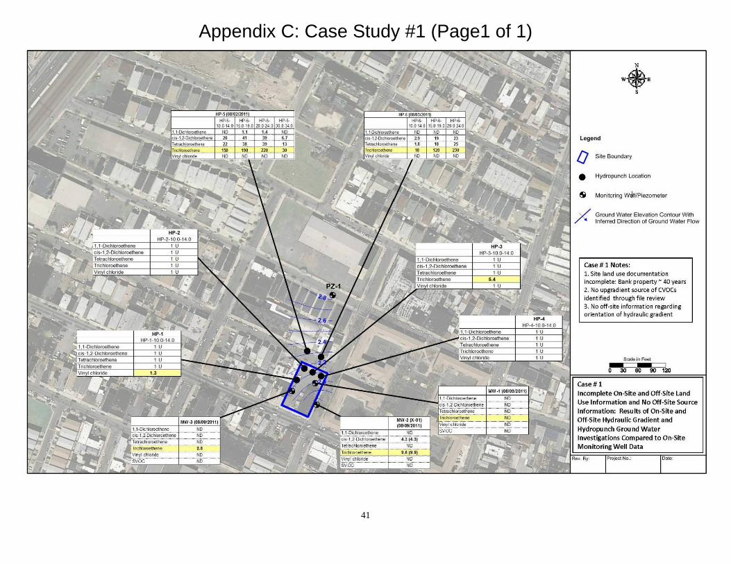
Appendix C: Case Study #1 (Page1 of 1)
41

Appendix C: Case Study #2 (Page 1 of 3)
42

Appendix C: Case Study #2 (Page 2 of 3)
Upgradient Property Hydraulic Gradients
43

Appendix C: Case Study #2 (Page 3 of 3)
44

Appendix C: Case Study #3 (Page 1 of 2)
45

Appendix C: Case Study #3 (Page 2 of 2)
46

APPENDIX D
ACRONYMS
47
Acronyms
ACO Administrative Consent Order
AOC Area of Concern
CDN Confirmed Discharge Notification
CEA Classification Exception Area
CID Case Inventory Document
COC Contaminant of Concern
CSM Conceptual Site Model
CVOCs Chlorinated Volatile Organic Compounds
DAP Diffuse Anthropogenic Pollution
DCE Dichloroethylene
DER/DN Declaration of Environmental Restrictions/Deed Notices
EDD Electronic Data Deliverables
EPH Extractable Petroleum Hydrocarbons
GWQS Ground Water Quality Standards
IEC Immediate Environmental Concern
IGWSCC Impact to Ground Water Soil Cleanup Criterion
ISRA Industrial Site Recovery Act
KCS Known Contaminated Sites
LSRP Licensed Site Remediation Professional
MW Monitoring Well
N.J.A.C. New Jersey Administrative Code
NJDEP New Jersey Department of Environmental Protection
N.J.S.A. New Jersey Statutes Annotated
OPRA Open Public Records Act
PA Preliminary Assessment
PCE Tetrachloroethene
48

PI# Preferred Identification Number
RA Remediation Agreement
RAO Response Action Outcome
RAO-A Area of Concern Response Action Outcome
SI Site Investigation
SRP Site Remediation Program
TCE Trichloroethylene
TOC Total Organic Contaminant
TPH *****
UST Underground Storage Tank
VC Vinyl Chloride
VI Vapor Intrusion
VOC Volatile Organic Compound
49