offshore vessel traffic - navcen · buoy tender pollution control vessel yacht search & rescue...
TRANSCRIPT

Offshore Vessel Traffic This category oftraffic was added to analyze information on vessels participating in Outer
Continental Shelf (OCS) exploratory drilling, which has recently led to an increase in transits of the
Bering Strait. Offshore industry vessels operating within the Bering Sea region are predominantly
destined for the Chukchi and Beaufort Seas and typically make a nonstop transit by the shortest route
possible across the Bering Sea. This direct route involves transiting in close proximity to the east side of
St. Lawrence Island, which is an environmentally sensitive area and punctuated with shoal water. Nearly
all vessels bound for areas where OCS activity might occur in US Arctic waters would be well suited to
follow the recommended route. This affords a vessel the opportunity to follow a well surveyed transit
route, increase their distance from shore and avoid environmentally sensitive areas.
The proposed two-way route pass through several OSC lease sale areas. Currently there are no
plans for additional OCS lease sales in Alaskan waters south of the Bering Strait, but lease sales have
occurred previously in this area. In 1983, lease sales #57 and #70 offered tracts in the Norton Basin and
St. George Basin, respectively. In 1988, Lease Sale #92 offered tracts in the North Aleutian Basin, which
is located just to the east of the proposed two-way route. The Coast Guard finds it advantages to
identify ship routing measures in advance of OCS development. Doing so aids in the screening process
by identifying which specific tracts should be reserved from lease to meet the needs of navigation.
Vessel TyPe Anchor Handling Tug Supply Platform Supply Ship Standby Safety Vessel Drilling Ship Drilling Rig. semi submersible Crew /Supply Vessel Offshore Tug/Supply Ship FSO,Oil Diving Support Vessel
2017-2022 Oil and Gas lAHing Prop<>Md Final PrognmAlff
tor llM Alaska Region
c::J PllMlnQ Atta BoYtldary
- Prnm:irr.tW \WJdl'•• ...,..,
- Pfop:!Md Fonel Prvgnm ""'•
~-----§: .. ::w~~
Transit Segment 159 116 40 38 23 11 5 3 1
396
110
Offshore Vessel

Offshore Vessels All Tonnage 2014 - 2015
·:, Red Dog Mine
-- Proposed Route
- High Traffic
Low Traffic
Russia
Nome
st Lawrenbe Is. L Alaska
Bethel
East<As/a Shipping €orridar Unimak Pass

Offshore Vessels All Tonnage 2014 - 2015
Red Dog Mine
-- Proposed Route
- - Offshore Traffic Kotzebue
Russia
Nome
/
St. Lawrence Is.
Alaska
Bethel
East.A.sia Ship.,plng Corridor

Research Vessels and Icebreaker Traffic
Research and lcebreaking vessels regularly operate in the Bering Sea and above the Bering
Strait. Due to the nature of their work, these vessels have irregular traffic patterns that are highly
variable. There are times however, when their transit does correlate with the proposed routing
measures and they would be well suited to follow the recommended rout thereby allowing them to
follow a well surveyed transit route, increase their distance from shore and avoid environmentally
sensitive areas.
The heat track map indicates much more frequent use of the proposed two-way route by
research vessels and icebreakers. This is due, in part, to vessels in this category actively gathering
hydrographic survey data on the proposed route in 2014 and 2015.
Vessel Type Research Survey Vessel
Icebreaker Icebreaker/Research
Transit Segment 428
116 33
577
113
} Research and lcebreaking Vessel

Research and lcebreaking Vessels All Tonnage 2014 - 2015
-- Proposed Route
High Traffic
Low Traffic
Russia
EasvAsia Sl'lfpping eemdbr
St. Lawrence Is.
Red Dog Mine
Kotzebue
Alaska
Bethel
Nunivak Is.

Research and lcebreaking Vessels All Tonnage 2014 - 2015
-- Proposed Route
- - - Research & Icebreaker
Russia
St. Lawrence Is.
,-
East Asia Shipping Corridor
Red Dog Mine
Alaska
Bethel
~/
/./

Tug and Barge Traffic Tug vessel traffic operating in the Bering Sea region is predominately tug and barge services
making cargo deliveries to coastal communities. Tank barges carrying petroleum products are captured
under the tank vessel category. Consequently the typical tug vessel transit profile is involves coastal
trade routes as opposed to transits through the central Bering Sea. These vessels are not expected to
utilize the proposed route unless it is convenient for a tug's particular destination. There are, however, a
few tug vessels that depart Dutch Harbor and transit continuously through the Bering Strait for
operations in the Beaufort and Chukchi Sea's and Alaska's Northern Coast. Some of this tug traffic is
transporting equipment and supplies for ongoing North Slope oil and gas exploration and production
which is centered near Prudhoe Bay. This segment of tug/barge traffic could increase in the near future,
triggered by additional on-shore oil & gas development as well as exploration and development of new
prospects in waters managed by the State of Alaska. One recent find in Smith Bay is a good example of
this. Smith Bay lies well to the west of Prudhoe Bay and is most easily accessed by water as opposed to
existing onshore North Slope infrastructure. This traffic would be well suited to follow the
recommended route which allows tugs bound for the North Slope to follow a well surveyed transit
route, increase their distance from shore and avoid environmentally sensitive areas.
Vessel Type Transit Segment Tug 5,651 }-
-P_u_sh_e_rT_u_g~~~~~~~~~~~~~~~z-4_0~~~ Tug Vessel Articulated Pusher Tug 58 5,949
116

!ug and Barge All Tonnage 2014 - 2015
-- Proposed Route
High Traffic
Low Traffic
Russia
Eas.t P.lsia Shipping Corridor
/, / .. . "
$t: Lawrence Is.
~~· , --l Red Dog Mine
l
Alaska
Bethel

Tug and Barge All Tonnage 2014 - 2015
-- Proposed Route
Tug Traffic
Russia
I

Miscellaneous Vessel Traffic The miscellaneous vessel types that operate in the region are most heavily concentrated near
the Aleutian Islands but occasionally transit across the Bering Sea and through the Bering Strait. Due to
the nature of their work, these vessels have irregular traffic patterns that are highly variable. There are
times however, when these transits do correlate with the proposed routing measures. In these cases,
vessels would be well suited to follow the recommended two-way route which allows vessels to follow a
well surveyed transit route, increase their distance from shore and avoid environmentally sensitive
areas.
Vessel TyPe Salvage Ship Buoy Tender Pollution Control Vessel Yacht Search & Rescue Vessel Training Ship Grab Dredger Cable Layer Logistics Vessel (Naval Ro-Ro Cargo)
Transit Segment 340 130 48 36 24 16 13 4 4
615
119
Miscellaneous Vessels

-- Proposed Route
High Traffic
Low Traffic
Miscellaneous Vessels All Tonnage 2014 - 2015
' I Red Dog Mine
Kotzebue
Russia
Nome
St. Lawrence· is.
Alaska
Bethel
Nunivak I:?.

I
)
-- Proposed Route
- - Misc. Traffic
Miscellaneous Vessels All Tonnage 2014 - 2015
Red Dog Mine
Kotzebue
Russia
I
/ /
,..._
I
/
( St """- " · ,__.,.,
East ASla.SJil~ping Corridor
I Nµnivak Is.
Alaska
Bethel
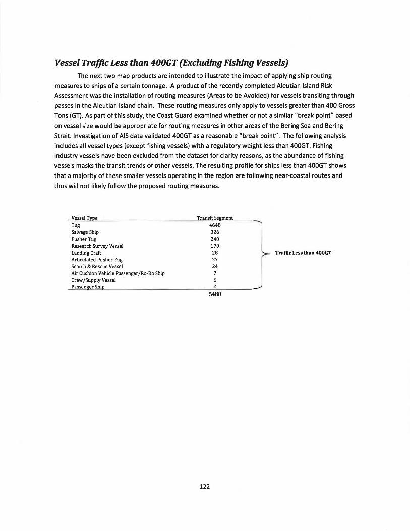
Vessel Traffic Less than 400GT (Excluding Fishing Vessels)
The next two map products are intended to illustrate the impact of applying ship routing
measures to ships of a certain tonnage. A product of the recently completed Aleutian Island Risk
Assessment was the installation of routing measures (Areas to be Avoided) for vessels transiting through
passes in the Aleutian Island chain. These routing measures only apply to vessels greater than 400 Gross
Tons (GT). As part of this study, the Coast Guard examined whether or not a similar "break point" based
on vessel size would be appropriate for routing measures in other areas of the Bering Sea and Bering
Strait. Investigation of AIS data validated 400GT as a reasonable "break point". The following analysis
includes all vessel types (except fishing vessels) with a regulatory weight less than 400GT. Fishing
industry vessels have been excluded from the dataset for clarity reasons, as the abundance of fishing
vessels masks the transit trends of other vessels. The resulting profile for ships less than 400GT shows
that a majority of these smaller vessels operating in the region are following near-coastal routes and
thus will not likely follow the proposed routing measures.
Vessel Type Tug Salvage Ship Pusher Tug Research Survey Vessel Landing Craft Articulated Pusher Tug Search & Rescue Vessel Air Cushion Vehicle Passenger /Ro-Ro Ship Crew /Supply Vessel Passenger Ship
Transit Segment
4648 326 240 170 28 27 24 7 6 4
5480
122
Traffic Less than 400GT

Vessels Less Than 400GT Excluding Fishing Vessels 2014 - 2015
-- Line_Symbol_For_Maps
High Traffic
Low Traffic
Russia
East Asia Shipping Corridor
St. Lavirence Is.
. , , .. I• .yt,., .f.,
/'1 ,
, . , .l Red Dog Mine
j 'i "'.
,,__ ... - --Kotzebue
Nome
...
Alaska
Bethel
I

Vessels Less Than 400GT Excluding Fishing Vessels 2014 - 2015
-- Proposed Route
400GT or Less
Russia
St. Lawrence Is.
I

Vessel Traffic 400GT and Over (Excluding Fishing Vessels)
The following map product shows all vessel types with a regulatory weight of 400GT and over.
As in the previous map product, fishing vessels have been excluded from the dataset for clarity reasons.
The resulting profile shows that ships 400GT and greater are more likely to operate in the vicinity of the
proposed routing measures, and thus more likely to follow the proposed routing measures and accrue
the risk mitigation benefits of doing so.
Vessel Type
Bulk Carrier Container Ship (Fully Cellular) Refrigerated Cargo Ship Vehicles Carrier General Cargo Ship Open Hatch Cargo Ship Chemical/Products Tanker Tug Products Tanker Wood Chips Carrier Landing Craft Research Survey Vessel Crude Oil Tanker Anchor Handling Tug Supply Passenger /Cruise Buoy Tender Icebreaker Platform Supply Ship Chemical Tanker General Cargo Ship (with Ro-Ro facility) Passenger/Ro-Ro Ship (Vehicles) LPG Tanker Crude/Oil Products Tanker LNGTanker Pollution Control Vessel Standby Safety Vessel Asphalt/Bitumen Tanker Drilling Ship Yacht Icebreaker /Research Articulated Pusher Tug Drilling Rig, semi submersible Livestock Carrier Bulk Carrier, Self-discharging Other Vessel Types with less than 20 transit segments
Transit Segment
125
20120 15228 4234 2829 1927 1387 1196 1003 498 362 271 258 235 159 147 130 116 116 112 87 78 70 69 57 48 40 38 38 36 33 31 23 23 21 122
51142
Vessel Traffic 400GT & Over

Vessels 400GT or Greater Excluding Fishing Vessels 2014 - 2015
-- Proposed Route
High Traffic
Low Traffic
Russia
, ..; (
~ ---r; ·-: ;..
'="'
St. Lawrence Is.
I .
Alaska

Vessels 400GT or Greater Excluding Fishing Vessels 2014 - 2015
-- Proposed Route (~
-- - 400GT or Over
Russia
Alaska
Bethel

Appendix I - References
Alaska Department of Labor and Workforce Development Research and Analysis Section. 2010 Census
Shapefile, Accessed Online at http://live.laborstats.alaska.gov/cen/maps.cfm
Kawerak Inc. Bering Strait Region Local and Traditional Knowledge Pilot Project, A Comprehensive
Subsistence Use Study ofthe Bering Strait Region, A. Ahmasuk, E. Trigg, Nome, AK
Kawerak Inc. Subsistence in Alaska Timeline, Accessed Online:
http://www.kawerak.org/forms/nr/Subsistence%20Timeline.pdf
National Marine Fisheries Service, Marine Mammal Species Range and Critical Habitat Interactive Map,
Accessed Online at https://alaskafisheries.noaa.gov/mapping/esa/
NOAA. Office of Response and Restoration, Environmental Sensitivity Index (ESI) Maps, Accessed Online
at http:/ I response. restoration. no a a .gov Im aps-a nd-spatia I-data/ enviro nme nta 1-sensitivity-index-esi-
m a ps. htm I
NOAA. United States Coast Pilot, Volume 9, 30th edition, 2012. p 409
Oceana and Kawerak. Bering Strait Marine Life and Subsistence Use Data Synthesis, July 2014; Accessed
Online at http://oceana.org/publications/reports/the-bering-strait-marine-life-and-subsistence-data
synthesis
Ships Routeing. International Maritime Organization (IMO}, London, 2015 Ed.
USFWS. Environmental Conservation Online System (ECOS), Accessed Online at
https :// ecos. fws.gov / ecpO/ reports/ species-listed-by-state-re port ?state=AK&status=listed
128