ogc standards for spatio- temporal applications
TRANSCRIPT
Copyright © Open Geospatial Consortium (2007)Copyright © Open Geospatial Consortium (2007)
OGC Standards for Spatio-OGC Standards for Spatio-Temporal ApplicationsTemporal Applications
Josh LiebermanTraverse Technologies Inc.
OGC Interoperability Program [email protected]
Helping the World to CommunicateGeographically
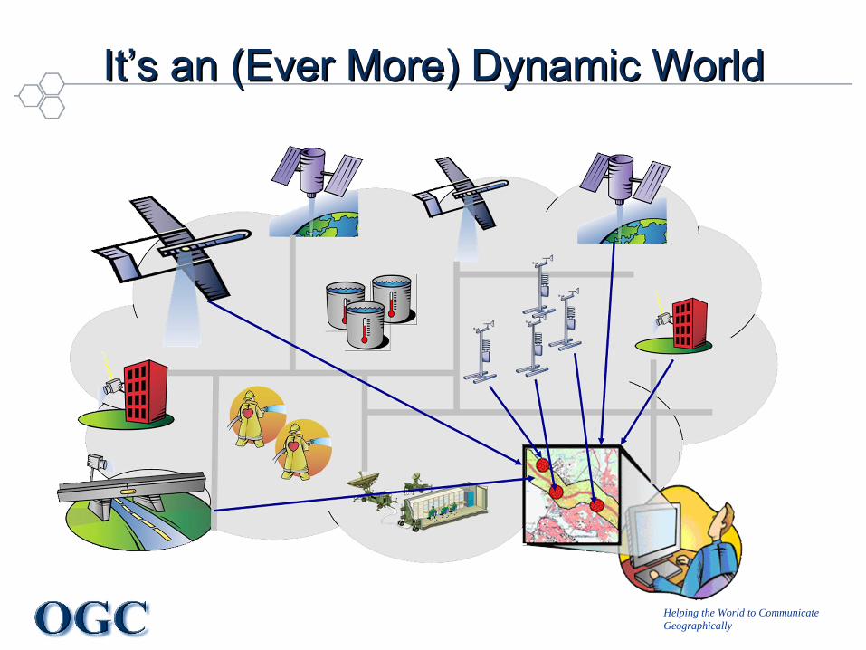
It’s an (Ever More) Dynamic WorldIt’s an (Ever More) Dynamic World
Helping the World to CommunicateGeographically
OverviewOverview
• The Open Geospatial Consortium (OGC) in cooperation with ISO TC211 has established many of the fundamental standards for exchange and provision of geospatial information.
• Increasingly, this spatial perspective is being augmented by a time dimension. Spatio-temporal capabilities being addressed in OGC testbed and specification activity include– Time validity of geospatial features and services– Multiple temporal aspects of sensor observations– Incorporation of dynamically changing geospatial information in decision
support applications. • Advances in this standards area will depend on bringing conceptual
advances, industry practice, and compelling applications of spatio-temporal information into the OGC consensus specification development process.
Copyright © Open Geospatial Consortium (2007)
Helping the World to CommunicateGeographically
TopicsTopics
• Introduction to the OGC and history of geospatial standards development / challenges
• Landscape of spatiotemporal information standards.• Time in the Geographic Markup Language• Events and time in the Sensor Web• Geospatial services, geosynchronization, and the
communication of time• Spatiotemporal activities in the OGC Web Services Testbed
Initiative, Phase 7 and GEOSS AIP-3 Pilot• Future directions for OGC spatiotemporal specifications
Copyright © Open Geospatial Consortium (2007)
Helping the World to CommunicateGeographically
5
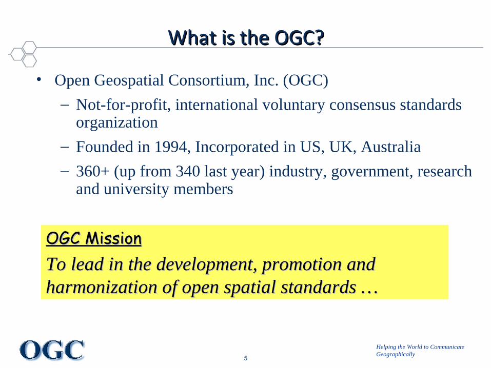
What is the OGC?What is the OGC?
• Open Geospatial Consortium, Inc. (OGC)
– Not-for-profit, international voluntary consensus standards organization
– Founded in 1994, Incorporated in US, UK, Australia
– 360+ (up from 340 last year) industry, government, research and university members
OGC MissionOGC MissionTo lead in the development, promotion and To lead in the development, promotion and harmonization of open spatial standards …harmonization of open spatial standards …
Helping the World to CommunicateGeographically
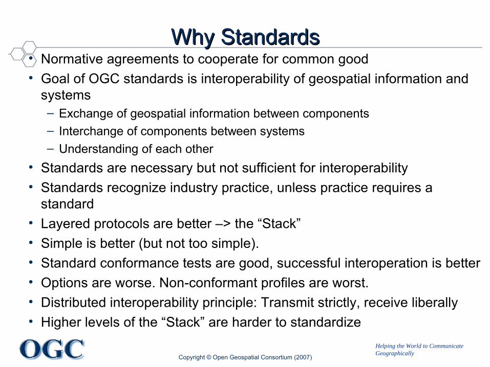
Why StandardsWhy Standards• Normative agreements to cooperate for common good• Goal of OGC standards is interoperability of geospatial information and
systems– Exchange of geospatial information between components– Interchange of components between systems– Understanding of each other
• Standards are necessary but not sufficient for interoperability• Standards recognize industry practice, unless practice requires a
standard• Layered protocols are better –> the “Stack”• Simple is better (but not too simple).• Standard conformance tests are good, successful interoperation is better• Options are worse. Non-conformant profiles are worst.• Distributed interoperability principle: Transmit strictly, receive liberally• Higher levels of the “Stack” are harder to standardize
Copyright © Open Geospatial Consortium (2007)

Helping the World to CommunicateGeographically
Copyright © Open Geospatial Consortium (2007)
OGC’s Approach for Advancing InteroperabilityOGC’s Approach for Advancing Interoperability
• Interoperability Program (IP) - a global, innovative, rapid hands-on prototyping and testing program designed to accelerate interface development and validation, and bring interoperability to the market
• Specification Development Program –OGC’s Technical and Planning Committees support a consensus standards process similar to other Industry consortia (World Wide Web Consortium, OMA etc.).
• Outreach and Community Adoption Program – education and training, encourage take up of OGC specifications, business development, communications programs
Helping the World to CommunicateGeographically
Copyright © Open Geospatial Consortium (2007)
The OGC Interoperability ProgramThe OGC Interoperability Program
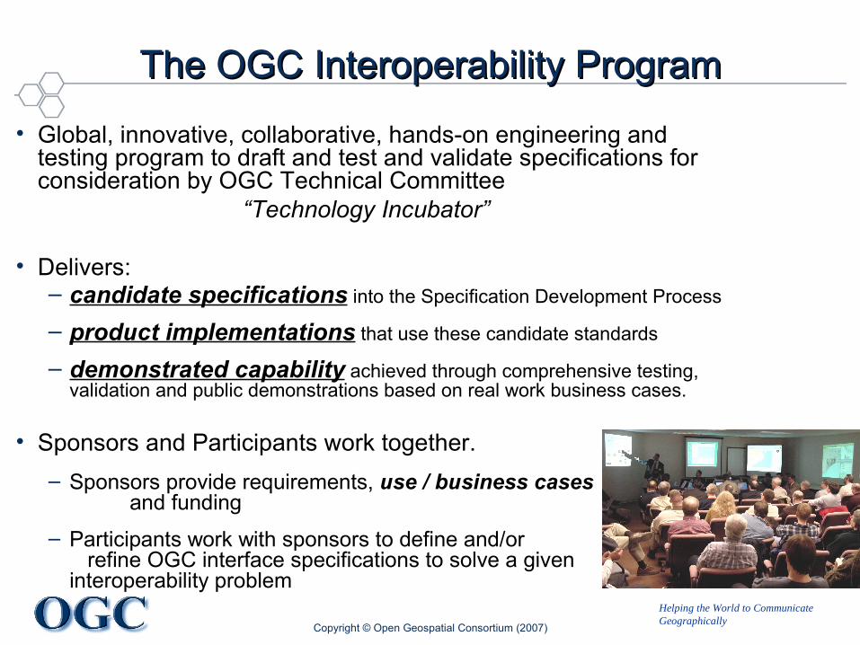
• Global, innovative, collaborative, hands-on engineering and testing program to draft and test and validate specifications for consideration by OGC Technical Committee
“Technology Incubator”
• Delivers:– candidate specifications into the Specification Development Process
– product implementations that use these candidate standards
– demonstrated capability achieved through comprehensive testing, validation and public demonstrations based on real work business cases.
• Sponsors and Participants work together.– Sponsors provide requirements, use / business cases
and funding– Participants work with sponsors to define and/or
refine OGC interface specifications to solve a given interoperability problem
Helping the World to CommunicateGeographically
Copyright © Open Geospatial Consortium (2007)
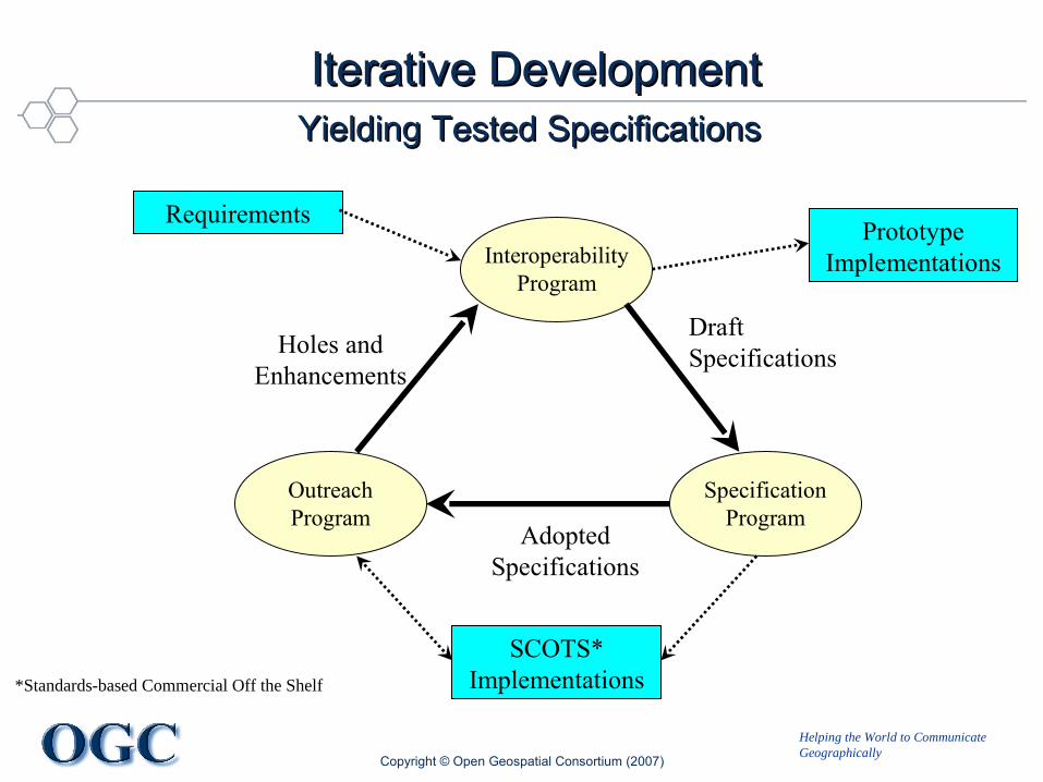
Iterative DevelopmentIterative DevelopmentYielding Tested SpecificationsYielding Tested Specifications
Interoperability Program
Specification Program
Outreach Program
Draft Specifications
Adopted Specifications
Holes and Enhancements
SCOTS* Implementations
Prototype Implementations
Requirements
*Standards-based Commercial Off the Shelf
Helping the World to CommunicateGeographically
10
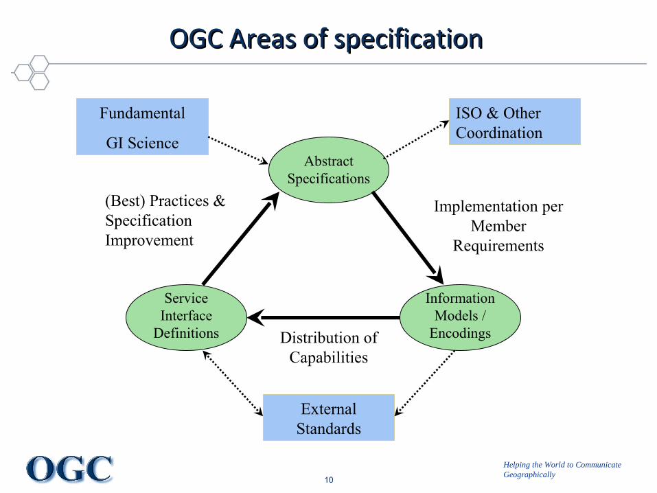
OGC Areas of specificationOGC Areas of specification
Abstract Specifications
Information Models /
Encodings
Service Interface
Definitions
Implementation per Member
Requirements
Distribution of Capabilities
(Best) Practices & Specification Improvement
External Standards
ISO & Other Coordination
Fundamental
GI Science

Helping the World to CommunicateGeographically
Standard StandardsStandard Standards• Abstract• Implementation• Encoding• Interface• Protocol• Best Practice• Reference Model• Reference Architecture• Reference Implementation• Policy & Procedure• Discussion Paper / Engineering Report
Copyright © Open Geospatial Consortium (2007)

Helping the World to CommunicateGeographically
12
OGC Reference Model (ORM)OGC Reference Model (ORM)

Helping the World to CommunicateGeographically
Copyright © Open Geospatial Consortium (2007)
Types of IP InitiativesTypes of IP Initiatives
• Testbeds provide an environment for fast-paced, multi-vendor collaborative efforts to define, design, develop, and test candidate interface and encoding specifications. These draft specifications are then reviewed, revised, and, potentially, approved in the OGC Specification Program.
• Interoperability Experiments are brief, low overhead, formally structured and approved initiatives led and executed by OGC members to achieve specific technical objectives that further the OGC Technical Baseline.
• Pilot Projects apply and test OpenGIS Specifications in real world applications using standards-based commercial off-the-shelf (SCOTS) products that implement OpenGIS Specifications. Pilot projects are designed to help users understand how to best implement interoperable geoprocessing that meets their requirements for application, spatial data, and geoprocessing service sharing.

Helping the World to CommunicateGeographically
Copyright © Open Geospatial Consortium (2007)
Key Interoperability ProgramKey Interoperability ProgramResources / ReferencesResources / References
• Overview of OGC’s Interoperability Program:– http://www.opengeospatial.org/ogc/programs/ip
• Interoperability Program Policies and Procedures– http://www.opengeospatial.org/ogc/policies/ippp
• Active Interoperability Program initiatives:– http://www.opengeospatial.org/projects/initiatives/active
• Past initiatives:– http://www.opengeospatial.org/projects/initiatives/past
• Video Summary of a recent OGC Testbed, OGC Web Services 6 (OWS-6)– http://www.opengeospatial.org/pub/www/ows6/index.html
Helping the World to CommunicateGeographically
TopicsTopics
• Introduction to the OGC and history of geospatial standards development
• Landscape of spatiotemporal information standards.• Time in the Geographic Markup Language• Events and time in the Sensor Web• Geospatial services, geosynchronization, and the
communication of time• Spatiotemporal activities in the OGC Web Services Testbed
Initiative, Phase 7 and GEOSS AIP-3 Pilot• Future directions for OGC spatiotemporal specifications
Copyright © Open Geospatial Consortium (2007)

Helping the World to CommunicateGeographically
Topic 2: What is a Feature?Topic 2: What is a Feature?
• “Recognition” of a portion of shared reality
• “Model” of shared reality characteristics or attributes
• “Geometric representations” of location and spatial extent

Helping the World to CommunicateGeographically
Interoperability StackInteroperability Stack
• Meaning - ? (OWL, RDF, MDL, …)
• Vocabulary – UML, XML Schema, OWS
• Encoding - ASCII, UTF-8, XML
• Control – TCP, HTTP, WAP
• Signal – Internet Protocol, DNS
• Transport – Ethernet, WiFi, GPRS
• Medium – Physical Connection
Increasing / higher level interoperability - not even this is so easyHuman-centric
Machine-centric
Helping the World to CommunicateGeographically
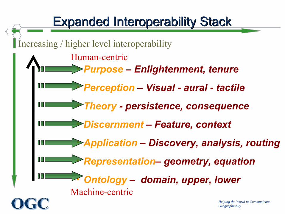
Expanded Interoperability StackExpanded Interoperability Stack
• Purpose – Enlightenment, tenure
• Perception – Visual - aural - tactile
• Theory - persistence, consequence
• Discernment – Feature, context
• Application – Discovery, analysis, routing
• Representation– geometry, equation
• Ontology – domain, upper, lower
Increasing / higher level interoperabilityHuman-centric
Machine-centric
Helping the World to CommunicateGeographically
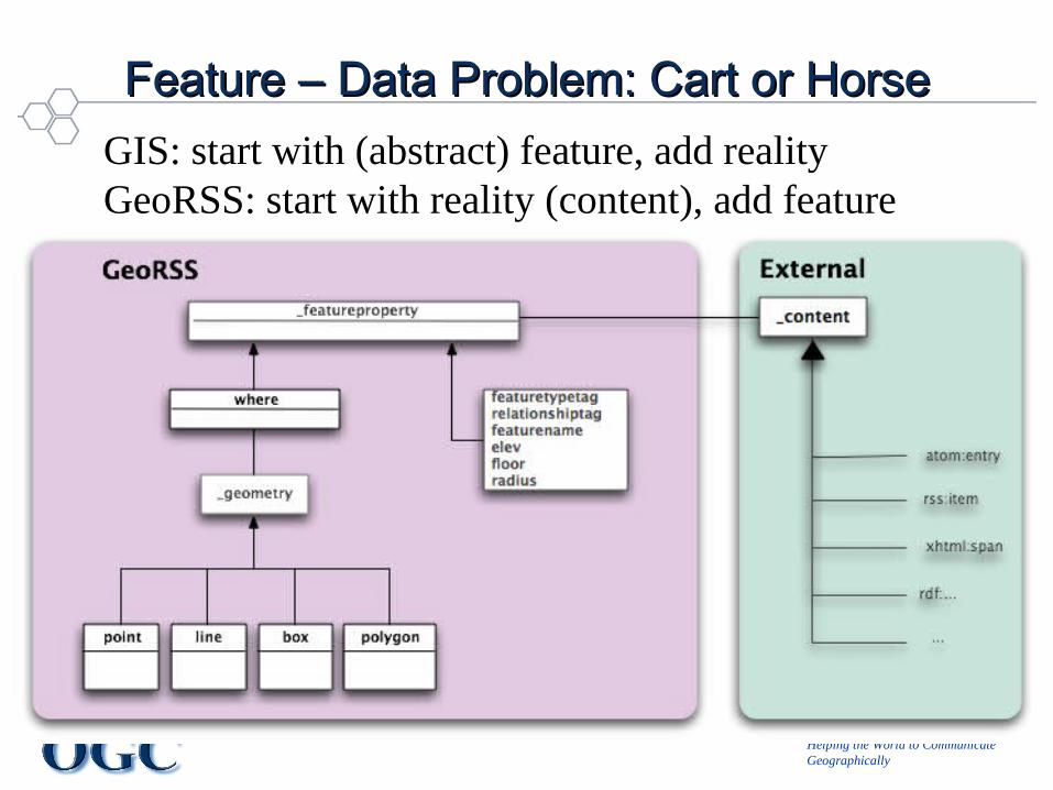
Feature – Data Problem: Cart or HorseFeature – Data Problem: Cart or HorseGIS: start with (abstract) feature, add realityGeoRSS: start with reality (content), add feature
Helping the World to CommunicateGeographically
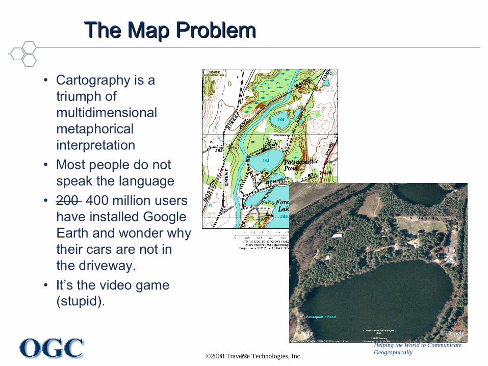
20©2008 Traverse Technologies, Inc.
The Map ProblemThe Map Problem

Helping the World to CommunicateGeographically
Spatiotemporal RepresentationSpatiotemporal Representation
• Modes of technology +/- modes of perception• Distributed / federated systems Societies
Copyright © Open Geospatial Consortium (2007)
Time
Slices(Versions)
Events(Transitions)
Processes(T-Topology)
Propagation(Sync, Comm)
Features HappenUpdatesPublished
UpdatesSubscribed
CurrentlyKnown

Helping the World to CommunicateGeographically
……So Many to Choose FromSo Many to Choose From• ISO – TC211 family of standards, many shared with OGC
– E.g. OGC Topic 2 and ISO 19107: Spatial Schema; 19108: Temporal– ISO 8601: Representation of dates and times– ISO 15926: Processes; ISO 18026: Models
• OGC – Abstract and implementation standards for geodata and services – features / events / processes
• W3C – owl time, w3cgeo, neogeo.owl, fundamental Web standards
• IETF – Atom, Geopriv, fundamental Internet standards• INSPIRE – data frameworks, e.g. temporal metadata for
discovery• OASIS – temporal aspects to ebXML, XACML, BPMN, etc.• Other – GeoRSS, HLA,, Dynamic Segmentation
Copyright © Open Geospatial Consortium (2007)
Helping the World to CommunicateGeographically
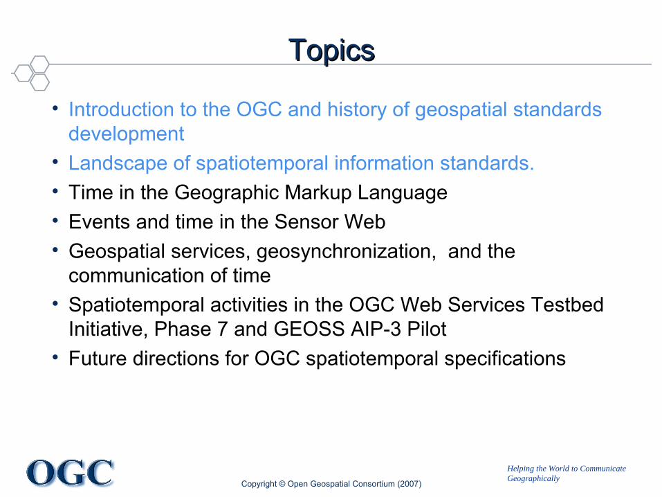
TopicsTopics
• Introduction to the OGC and history of geospatial standards development
• Landscape of spatiotemporal information standards.• Time in the Geographic Markup Language• Events and time in the Sensor Web• Geospatial services, geosynchronization, and the
communication of time• Spatiotemporal activities in the OGC Web Services Testbed
Initiative, Phase 7 and GEOSS AIP-3 Pilot• Future directions for OGC spatiotemporal specifications
Copyright © Open Geospatial Consortium (2007)
Helping the World to CommunicateGeographically
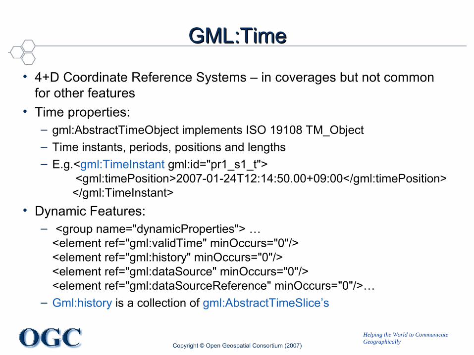
GML:TimeGML:Time
• 4+D Coordinate Reference Systems – in coverages but not common for other features
• Time properties:– gml:AbstractTimeObject implements ISO 19108 TM_Object– Time instants, periods, positions and lengths– E.g.<gml:TimeInstant gml:id="pr1_s1_t">
<gml:timePosition>2007-01-24T12:14:50.00+09:00</gml:timePosition> </gml:TimeInstant>
• Dynamic Features: – <group name="dynamicProperties"> …
<element ref="gml:validTime" minOccurs="0"/><element ref="gml:history" minOccurs="0"/><element ref="gml:dataSource" minOccurs="0"/><element ref="gml:dataSourceReference" minOccurs="0"/>…
– Gml:history is a collection of gml:AbstractTimeSlice’s
Copyright © Open Geospatial Consortium (2007)

Helping the World to CommunicateGeographically
GML Time SlicesGML Time Slices
Copyright © Open Geospatial Consortium (2007)

Helping the World to CommunicateGeographically
GML Temporal TopologyGML Temporal Topology
• Follows ISO 19108 Temporal Schema• Means of representing succession• Minimal implementation…
Copyright © Open Geospatial Consortium (2007)

Helping the World to CommunicateGeographically
KML TimeKML Time
• kml:TimeStamp • kml:TimeSpan• Enables use of a time slider in Google Earth +/- other
KML applications
Copyright © Open Geospatial Consortium (2007)

Helping the World to CommunicateGeographically
TopicsTopics
• Introduction to the OGC and history of geospatial standards development
• Landscape of spatiotemporal information standards.• Time in the Geographic Markup Language• Feature temporal validity and information lifecycle• Events and time in the Sensor Web• Dynamic features and decision-making processes• Geospatial services, geosynchronization, and the
communication of time• Spatio-temporal activities in the OGC Web Services Testbed
Initiative, Phase 7 and GEOSS AIP-3 Pilot• Future directions for OGC spatio-temporal specifications
Copyright © Open Geospatial Consortium (2007)
Helping the World to CommunicateGeographically
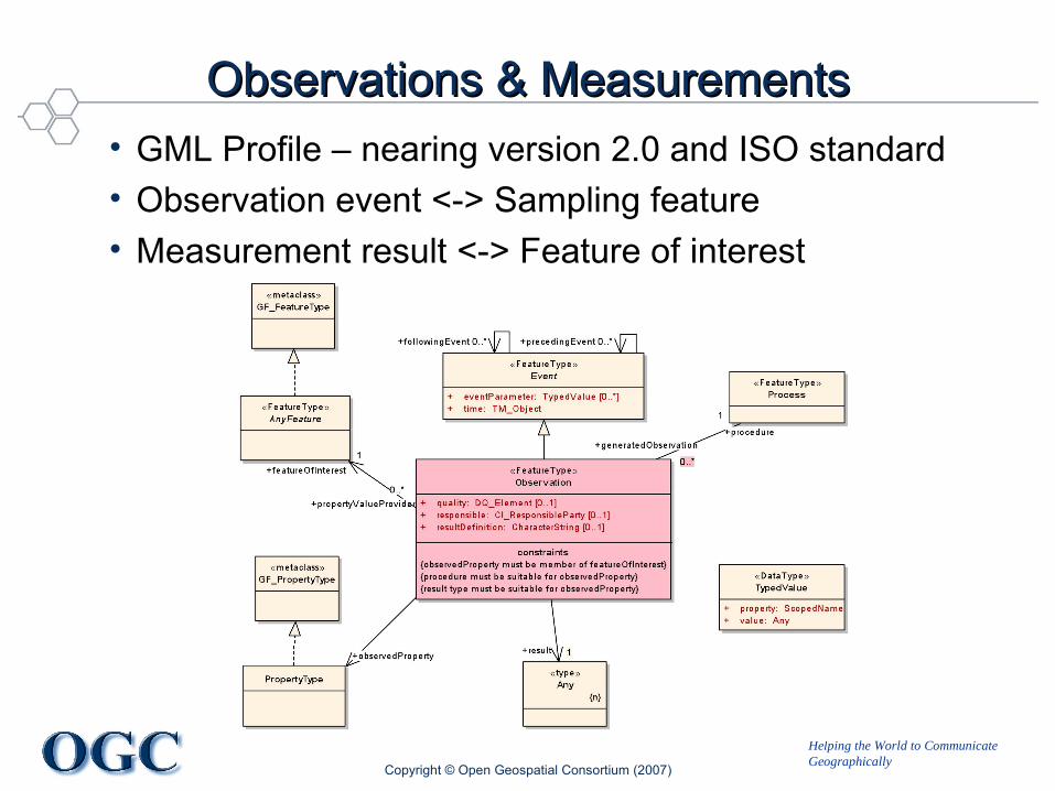
Observations & MeasurementsObservations & Measurements• GML Profile – nearing version 2.0 and ISO standard• Observation event <-> Sampling feature• Measurement result <-> Feature of interest
Copyright © Open Geospatial Consortium (2007)
Helping the World to CommunicateGeographically
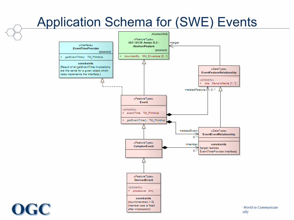
Application Schema for (SWE) Events

Helping the World to CommunicateGeographically
TopicsTopics
• Introduction to the OGC and history of geospatial standards development
• Landscape of spatio-temporal information standards.• Time in the Geographic Markup Language• Feature temporal validity and information lifecycle• Events and time in the Sensor Web• Geospatial services, geosynchronization, and the
communication of time• Spatio-temporal activities in the OGC Web Services Testbed
Initiative, Phase 7 and GEOSS AIP-3 Pilot• Future directions for OGC spatio-temporal specifications
Copyright © Open Geospatial Consortium (2007)
Helping the World to CommunicateGeographically
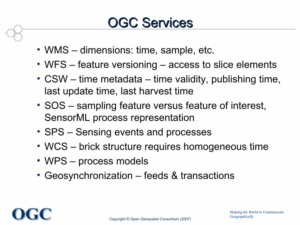
OGC ServicesOGC Services
• WMS – dimensions: time, sample, etc.• WFS – feature versioning – access to slice elements• CSW – time metadata – time validity, publishing time,
last update time, last harvest time• SOS – sampling feature versus feature of interest,
SensorML process representation• SPS – Sensing events and processes• WCS – brick structure requires homogeneous time• WPS – process models• Geosynchronization – feeds & transactions
Copyright © Open Geospatial Consortium (2007)

Helping the World to CommunicateGeographically
GeosynchronizationGeosynchronization
• Transactional, “eventual” consistency across a network• Geosynchronization service: publication-subscription for
synchronization messages (atom entries).• Relevant to other ST distribution technologies (e.g. DHT)
Copyright © Open Geospatial Consortium (2007)

Helping the World to CommunicateGeographically
TopicsTopics
• Introduction to the OGC and history of geospatial standards development
• Landscape of spatiotemporal information standards.• Time in the Geographic Markup Language• Events and time in the Sensor Web• Geospatial services, geosynchronization, and the
communication of time• Spatiotemporal activities in the OGC Web Services Testbed
Initiative, Phase 7 and GEOSS AIP-3• Future directions for OGC spatiotemporal specifications
Copyright © Open Geospatial Consortium (2007)
Helping the World to CommunicateGeographically
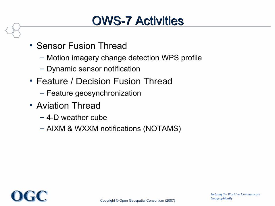
OWS-7 ActivitiesOWS-7 Activities
• Sensor Fusion Thread– Motion imagery change detection WPS profile– Dynamic sensor notification
• Feature / Decision Fusion Thread– Feature geosynchronization
• Aviation Thread– 4-D weather cube– AIXM & WXXM notifications (NOTAMS)
Copyright © Open Geospatial Consortium (2007)
Helping the World to CommunicateGeographically
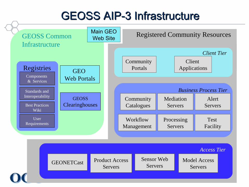
GEOSS AIP-3 Infrastructure GEOSS AIP-3 Infrastructure
GEOSSClearinghouses
GEO Web Portals
GEOSS Common Infrastructure
Components & Services
Standards andInteroperability
Best PracticesWiki
User Requirements
Registries
Main GEOWeb Site Registered Community Resources
Community Portals
Client Applications
Client Tier
Business Process Tier
CommunityCatalogues
AlertServers
WorkflowManagement
ProcessingServers
Access Tier
GEONETCast Product AccessServers
Sensor WebServers
Model AccessServers
Test Facility
MediationServers
Helping the World to CommunicateGeographically
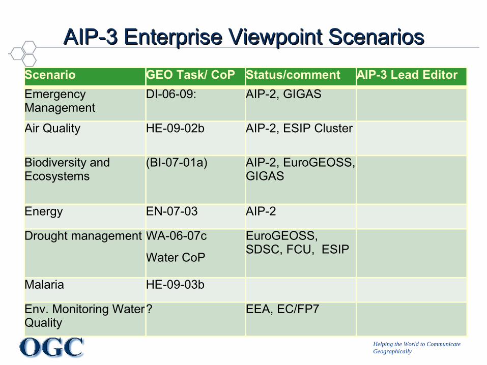
AIP-3 Enterprise Viewpoint ScenariosAIP-3 Enterprise Viewpoint ScenariosScenario GEO Task/ CoP Status/comment AIP-3 Lead EditorEmergency Management
DI-06-09: AIP-2, GIGAS
Air Quality HE-09-02b AIP-2, ESIP Cluster
Biodiversity and Ecosystems
(BI-07-01a) AIP-2, EuroGEOSS, GIGAS
Energy EN-07-03 AIP-2
Drought management WA-06-07c
Water CoP
EuroGEOSS, SDSC, FCU, ESIP
Malaria HE-09-03b
Env. Monitoring Water Quality
? EEA, EC/FP7

Helping the World to CommunicateGeographically
AIP-3 CFP Information Viewpoint - DraftAIP-3 CFP Information Viewpoint - Draft• Spatial Referencing• Observations, Sensor Information• Geophysical Parameters• Maps, features, coverages, and observations• Product Types: Global and framework datasets• Product Encoding Formats• Predictive Models• Scenario Workflows• Registry Information Models and Metadata• Alerts and Feeds• Policy, Rights Management, Licenses
Helping the World to CommunicateGeographically
TopicsTopics
• Introduction to the OGC and history of geospatial standards development
• Landscape of spatiotemporal information standards.• Time in the Geographic Markup Language• Events and time in the Sensor Web• Geospatial services, infrastructure, and the communication of
time• Spatiotemporal activities in the OGC Web Services Testbed
Initiative, Phase 7 and GEOSS AIP-3 Pilot• Future directions for OGC spatiotemporal specifications
Copyright © Open Geospatial Consortium (2007)
Helping the World to CommunicateGeographically
TopicsTopics
• Introduction to the OGC and history of geospatial standards development
• Landscape of spatio-temporal information standards.• Time in the Geographic Markup Language• Feature temporal validity and information lifecycle• Events and time in the Sensor Web• Dynamic features and decision-making processes• Spatio-temporal activities in the OGC Web Services Testbed
Initiative, Phase 7• Geospatial services, infrastructure, and the communication of
time• Future directions for OGC spatio-temporal specifications
Copyright © Open Geospatial Consortium (2007)
Your Turn!

Helping the World to CommunicateGeographically
GeoRSS Story OverlayGeoRSS Story Overlay
• Relational links (rel=georss:NextEvent) + spatiotemporal tags (georss:where, georss:when) to define dynamic artifacts (stories).
Copyright © Open Geospatial Consortium (2007)

Helping the World to CommunicateGeographically
Lieberman BioLieberman Bio
• Principal in an interoperability engineering consultancy– Architecture, strategy, standards-based development– “Long-tail specialists” leveraging Web and geospatial technologies
• OGC member ~10 yrs, – Member OGC Architecture Board– Chair of Geosemantics & Services working groups
• IP Team Architect for OGC initiatives – GEOSS, OWS• Part-time lecturer in Geoweb services & modeling• Background in earth & environmental sciences• Once upon a time – Himalayan geologist
Copyright © Open Geospatial Consortium (2007)