ohio rapid assessment method for wetlands (oram… 3... · ohio rapid assessment method for...
TRANSCRIPT

OHIO RAPID ASSESSMENT METHOD FOR WETLANDS (ORAM) FORMS FOR WETLAND D/E/I – WETLAND H

ww
w.c
velim
ited
.com
Fax
44
0.43
9.19
69C
leve
land
, Ohi
o 44
146-
5667
Phon
e
440.
439.
1999
2299
9 Fo
rbes
Roa
d, S
uite
B

Ohio Rapid Assessment Method for Wetlands (ORAM)-Background Form
Chagrin Valley Engineering Cobblestone Park Subdivision - 16158 3/23/16
Contact Information Applicant: Agent:
Company Name: Cobblestone Park Development, LLC
Chagrin Valley Engineering, Inc.
Address: 2573 Wyndgate Court 22999 Forbes Road, Suite B
City, State, Zip: Westlake, Ohio 44145 Cleveland, Ohio 44146
Contact Person: Mr. Richard Batt Larry Ludwig
Phone Number(s): (216) 970-3236 (440) 439-1999
E-Mail Address: [email protected] [email protected]
Project Information Project Name: Cobblestone Park Subdivision
Street: Cobblefield Drive City/Township: Montville Twp County: Medina
Watershed (8-Digit HUC): 04110001 01 03 USGS Quad: Seville
NWI Map: (Seville) No wetlands identified on site
Soil Survey: (Medina) Indicates presence of WaA, WaB and Mr present on site
Delineation Report/Mapping: Full wetland delineation report & maps including: location, USGS, NWI, Soils and wetland delineation.
Dates of Site Visit: 3/23/16
USACE District: Buffalo Affirmed by Corps: Pending
Agent: Baker (DA 2004-00299)
Wetland Information
Wetland Acreage Category (Score)
HGM Class Vegetation
Community Class Lat/Long
Coordinates
D/E/I 5.33 Mod. 2 (38.5)
Isolated depression,
open, mineral soils
Mixed Emergent, Shrub Swamp, Swamp Forest
41.0947, -81.8550
Wetland D/E/I is a large wetland complex with multiple vegetation communities. This wetland appears to extend off the subject property to the south. These areas were taken into consideration when scoring Wetland D/E/I. The prior land use was agriculture which modified the hydrology and vegetation community of Wetland D/E/I. The invasive species Frangula alnus (buckthorn), Phragmites australis (tall reed) and Phalaris arundinacea (reed canary) were observed within this wetland.
Wetland sketch information including north arrow, relationship with other surface waters and vegetation zones are included on the attached ORAM Information Map.

Ohio Rapid Assessment Method for Wetlands (ORAM) -Scoring Boundary Worksheet
Chagrin Valley Engineering Cobblestone Park Subdivision 3/23/16
Wetland D/E/I
#
Steps in properly establishing scoring boundaries
Done?
Not Applicable
Step 1 Identify the wetland area of interest. This may be the site of a proposed impact, a mitigation site, conservation site, etc.
X
Step 2 Identify the locations where there is physical evidence that hydrology changes rapidly. Such evidence includes both the natural and human-induced changes including, constrictions, caused by berms or dikes, points where water velocity changes rapidly at rapids or falls, points where significant inflows occur at the confluence of rivers, or other factors that may restrict hydrologic interaction between the wetlands or parts of a single wetland.
X
Step 3 Delineate the boundary of the wetland to be rated such that all areas of interest that are contiguous to and within areas where the hydrology does not change significantly, i.e. areas that have a high degree of hydrologic interaction are included within the scoring boundary.
X
Step 4 Determine if artificial boundaries such as property lines, state lines, roads, railroad embankments are present. These should not be used to establish scoring boundaries unless they coincide with areas where hydrologic regime changes.
X
Step 5 In all instances the Rater may enlarge the minimum scoring boundaries discussed here to score together wetlands that could be scored separately.
X
Step 6 Consult ORAM Manual Section 5.0 for how to establish scoring boundaries for wetlands that form a patchwork on the landscape, divided by artificial boundaries, contiguous to streams, lakes or rivers or for dual classifications.
X

Ohio Rapid Assessment Method for Wetlands – Narrative Rating
Chagrin Valley Engineering Cobblestone Park 3/23/16
INSTRUCTIONS. Answer each of the following questions. Questions 1, 2, 3 and 4 should be answered based on information obtained from the site visit or the literature and by submitting a Data Services Request to the Ohio Department of Natural Resources, Division of Natural Areas and Preserves, Natural Heritage Data Services, 1889 Fountain Square Court, Building F-1, Columbus, Ohio 43224, 614-265-6453 (phone), 614-265-3096 (fax), http://www.dnr.state.oh.us/dnap. The remaining questions are designed to be answered primarily by the results of the site visit. Refer to the User's Manual for descriptions of these wetland types. Note: "Critical habitat" is a legally defined in the Endangered Species Act and is the geographic area containing physical or biological features essential to the conservation of a listed species or as an area that may require special management considerations or protection. The Rater should contact the Region 3 Headquarters or the Reynoldsburg Ecological Services Office for updates as to whether critical habitat has been designated for other federally listed threatened or endangered species. “Documented” means the wetland is listed in the appropriate State of Ohio database.
Wetland D/E/I
# Question Circle One
#1 Critical Habitat. Is the wetland in a township, section, or subsection of a United States Geological Survey 7.5 minute Quadrangle that has been designated by the U.S. Fish and Wildlife Service as "critical habitat" for any threatened or endangered plant or animal species? Note: as of January 1, 2001, of the federally listed endangered or threatened species which can be found in Ohio, the Indiana Bat has had critical habitat designated (50 CFR 17.95(a)) and the piping plover has had critical habitat proposed (65 FR 41812 July 6, 2000).
YES Wetland should be evaluated for possible Category 3 status Go to Question 2
NO Go to Question 2
#2 Threatened or Endangered Species. Is the wetland known to contain an individual of, or documented occurrences of federal or state-listed threatened or endangered plant or animal species?
YES Wetland is a Category 3 Go to Question 3
NO Go to Question 3
#3 Documented High Quality Wetland. Is the wetland on record in Natural Heritage Database as a high quality wetland?
YES Wetland is a Category 3 Go to Question 4
NO Go to Question 4
#4 Significant Breeding or Concentration Area. Does the wetland contain documented regionally significant breeding or nonbreeding waterfowl, neotropical songbird, or shorebird concentration areas?
YES Wetland is a Category 3 Go to Question 5
NO Go to Question 5
#5 Category 1 Wetlands. Is the wetland less than 0.5 hectares (1 acre) in size and hydrologically isolated and either 1) comprised of vegetation that is dominated (greater than eighty per cent areal cover) by Phalaris arundinacea, Lythrum salicaria, or Phragmites australis, or 2) an acidic pond created or excavated on mined lands that has little or no vegetation?
YES Wetland is a Category 1 Go to Question 6
NO Go to Question 6
#6 Bogs. Is the wetland a peat-accumulating wetland that 1) has no significant inflows or outflows, 2) supports acidophilic mosses, particularly Sphagnum spp., 3) the acidophilic mosses have >30% cover, 4) at least one species from Table 1 is present, and 5) the cover of invasive species (see Table 1) is <25%?
YES Wetland is a Category 3 Go to Question 7
NO Go to Question 7
#7 Fens. Is the wetland a carbon accumulating (peat, muck) wetland that is the saturated during most of the year, primarily by a discharge of free flowing, mineral rich, ground water with a circumneutral ph (5.5-9.0) and with one or more plant species listed in Table 1 and the cover of invasive species listed in Table 1 is <25%?
YES Wetland is a Category 3 Go to Question 8a
NO Go to Question 8a

Ohio Rapid Assessment Method for Wetlands – Narrative Rating
Chagrin Valley Engineering Cobblestone Park 3/23/16
#8a “Old Growth Forest”. Is the wetland a forested wetland and is the forest characterized by, but not limited to, the following characteristics: overstory canopy trees of great age (exceeding at least 50% of a projected maximum attainable age for a species); little or no evidence of human-caused understory disturbance during the past 80 to 100 years; an all-aged structure and multilayered canopies; aggregations of canopy trees interspersed with canopy gaps; and significant numbers of standing dead snags and downed logs?
YES Wetland is a Category 3 Go to Question 8b
NO Go to Question 8b
#8b Mature forested wetlands. Is the wetland a forested wetland with 50% or more of the cover of upper forest canopy consisting of deciduous trees with large diameters at breast height (dbh), generally diameters greater than 45cm (17.7in) dbh?
YES Wetland should be evaluated for possible Category 3 status Go to Question 9a
NO Go to Question 9a
#9a
Lake Erie coastal and tributary wetlands. Is the wetland located at an elevation less than 575 feet on the USGS map, adjacent to this elevation, or along a tributary to Lake Erie that is accessible to fish?
YES Go to Question 9b
NO Go to Question 10
#9b
Does the wetland's hydrology result from measures designed to prevent erosion and the loss of aquatic plants, i.e. the wetland is partially hydrologically restricted from Lake Erie due to lakeward or landward dikes or other hydrological controls?
YES Wetland should be evaluated for possible Category 3 status Go to Question 9d
NO Go to Question 9c
#9c
Are Lake Erie water levels the wetland's primary hydrological influence, i.e. the wetland is hydrologically unrestricted (no lakeward or upland border alterations), or the wetland can be characterized as an "estuarine" wetland with lake and river influenced hydrology. These include sandbar deposition wetlands, estuarine wetlands, river mouth wetlands, or those dominated by submersed aquatic vegetation.
YES Go to Question 9d
NO Go to Question 9d
#9d
Does the wetland have a predominance of native species within its vegetation communities, although non-native or disturbance tolerant species can also be present?
YES Wetland is a Category 3 Go to Question 10
NO Go to Question 9e
#9e
Does the wetland have predominance of non-native or disturbance tolerant native plant species?
YES Wetland should be evaluated for possible Category 3 status Go to Question 10
NO Go to Question 10
#10 Lake Plain Sand Prairies (Oak Openings). Is the wetland located in Lucas, Fulton, Henry, or Wood Counties and can the wetland be characterized by the following description: the wetland has a sandy substrate with interspersed organic matter, a water table often within several inches of the surface, and often with a dominance of the gramineous vegetation listed in Table 1 (woody species may also be present). The Ohio Department of Natural Resources Division of Natural Areas and Preserves can provide assistance in confirming this type of wetland and its quality.
YES Wetland is a Category 3 Go to Question 11
NO Go to Question 11
#11 Relict Wet Prairies. Is the wetland a relict wet prairie community dominated by some or all of the species in Table 1. Extensive prairies were formerly located in the Darby Plains (Madison and Union Counties), Sandusky Plains (Wyandot, Crawford, and Marion Counties), northwest Ohio, Erie County, and portions of western Ohio Counties (e.g. Darke, Mercer, Miami, Montgomery, etc.).
YES Wetland should be evaluated for possible Category 3 status Complete Quantitative Rating
NO Complete Quantitative Rating

ORAM v. 5.0 Field Form Quantitative Rating
Site: Rater(s): Date:
3 3
Metric 1. Wetland Area (size).Select one size class and assign score.
> 50 acres (<20.2ha) (6 pts)
25 to <50 acres (10.1 to <20.2ha) (5 pts)
3 10 to <25 acres (4 to <10.1ha) (4 pts)
3 3 to 10<acres (1.2 to <4ha) (3 pts)
0.3 to <3 acres (0.12 to <1.2ha) (2 pts)
0.1 to <0.3 acres (0.04 to <0.12ha) (1 pt)
<0.1 acres (0.04ha) (0 pts)
5 8 Metric 2. Upland buffers and surrounding land use. 2a. Calculate average buffer width. Select only one and assign score. Do not double check.
WIDE. Buffers average 50m (164 ft) or more around wetland perimter (7)
1 MEDIUM. Buffers average 25m to <50m (82 to <164 ft) around wetland perimeter (4)
1 NARROW. Buffers average 10m to <25m (32 ft to <82 ft) around wetland perimter (1)
VERY NARROW. Buffers average <10m (<32ft) around wetland perimter (0)
2b. Intensity of surrounding land use. Select one or double check and average.
VERY LOW. 2nd growth or older forest, prairie, savannah, wildlife area, etc. (7)
4 5 LOW. Old field (>10 years), shrubland, young second growth forest. (5)
3 MODERATELY HIGH. Residential, fenced pasture, park, conservation tillage, new fallow field. (3)
HIGH. Urban, industrial, open pasture, row cropping, mining, construction. (1)
14 22 Metric 3. Hydrology.3a. Sources of water. Score all that apply. 3b. Connectivity. Score all that apply.
High pH groundwater (5) 100 year floodplain (1)
Other groundwater (3) Between stream/lake and other human use (1)
4 1 Precipitation (1) 1 1 Part of wetland/upland (e.g. forest), complex (1)
3 Seasonal/Intermittent surface water (3) Part of riparian or upland corridor (1)
Perennial surface water (lake or stream) (5) 3d. Duration inundation/saturation. Score one or dbl check.
3c. Maximum water depth. Select only one and assign score. Semi-to permanently inundated/saturated (4)
>0.7 (27.6in) (3) 3 Regularly inundated/saturated (3)
1 04. to 0.7m (15.7 to 27.6in) (2) 3 Seasonally inundated (2)
1 >0.4m (<15.7in) (1) Seasonally saturated in upper 30 cm (1)
3e. Modifications to natural hydrologic regime. Score one or double check and average.
None or none apparent (12)
7 Recovered (7) Check all disturbances observed
5 3 Recovering (3) X ditch point source (non stormwater)
Recent or no recovery (1) tile X filling/grading
dike X road bed/RR track
weir dredging
stormwater input other
11.5 33.5 Metric 4. Habitat alteration and development.4a. Substrate disturbance. Score one or double check and average. 4c. Habitat alteration. Score one or double check and average.
4 None or none apparent (4) None or none apparent (9)
4 Recovered (3) 4.5 6 Recovered (6)
Recovering (2) 3 Recovering (3)
Recent or no recovery (1) Recent or no recovery (1)
4b. Habitat development. Select only one and assign score.
Excellent (7)
Very good (6) Check all disturbances observed
Good (5) mowing shrub/sapling removal
3 Moderately good (4) grazing herbaceous/aquatic bed removal
3 Fair (3) clearcutting sedimentation
Poor to fair (2) selective cutting dredging
Poor (1) woody debris removal farming
toxic pollutants nutrient enrichment
33.5 last revised 1 February 2001 jjm
Cobblestone Subdivision Chagrin Valley Engineering, Ltd. 3/23/16
Wetland: D/E/I 5.30 acres +
38.5 2max 6 pts subtotal
max 20 pts subtotal
Subtotal this page
max 14 pts subtotal
max 30 pts subtotal
Final Score Category
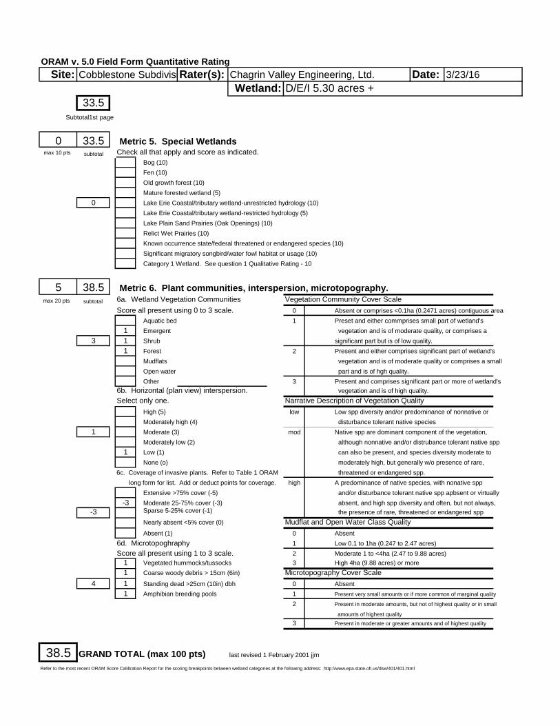
ORAM v. 5.0 Field Form Quantitative Rating
Site: Rater(s): Date:
33.5
0 33.5 Metric 5. Special WetlandsCheck all that apply and score as indicated.
Bog (10)
Fen (10)
Old growth forest (10)
Mature forested wetland (5)
0 Lake Erie Coastal/tributary wetland-unrestricted hydrology (10)
Lake Erie Coastal/tributary wetland-restricted hydrology (5)
Lake Plain Sand Prairies (Oak Openings) (10)
Relict Wet Prairies (10)
Known occurrence state/federal threatened or endangered species (10)
Significant migratory songbird/water fowl habitat or usage (10)
Category 1 Wetland. See question 1 Qualitative Rating - 10
5 38.5 Metric 6. Plant communities, interspersion, microtopography.6a. Wetland Vegetation Communities Vegetation Community Cover Scale
Score all present using 0 to 3 scale. 0 Absent or comprises <0.1ha (0.2471 acres) contiguous area
Aquatic bed 1 Preset and either commprises small part of wetland's
1 Emergent vegetation and is of moderate quality, or comprises a
3 1 Shrub significant part but is of low quality.
1 Forest 2 Present and either comprises significant part of wetland's
Mudflats vegetation and is of moderate quality or comprises a small
Open water part and is of hgh quality.
Other 3 Present and comprises significant part or more of wetland's
6b. Horizontal (plan view) interspersion. vegetation and is of high quality.
Select only one. Narrative Description of Vegetation Quality
High (5) low Low spp diversity and/or predominance of nonnative or
Moderately high (4) disturbance tolerant native species
1 Moderate (3) mod Native spp are dominant component of the vegetation,
Moderately low (2) although nonnative and/or distrubance tolerant native spp
1 Low (1) can also be present, and species diversity moderate to
None (o) moderately high, but generally w/o presence of rare,
6c. Coverage of invasive plants. Refer to Table 1 ORAM threatened or endangered spp.
long form for list. Add or deduct points for coverage. high A predominance of native species, with nonative spp
Extensive >75% cover (-5) and/or disturbance tolerant native spp apbsent or virtually
-3 Moderate 25-75% cover (-3) absent, and high spp diversity and often, but not always,
-3 Sparse 5-25% cover (-1) the presence of rare, threatened or endangered spp
Nearly absent <5% cover (0) Mudflat and Open Water Class Quality
Absent (1) 0 Absent
6d. Microtopoghraphy 1 Low 0.1 to 1ha (0.247 to 2.47 acres)
Score all present using 1 to 3 scale. 2 Moderate 1 to <4ha (2.47 to 9.88 acres)
1 Vegetated hummocks/tussocks 3 High 4ha (9.88 acres) or more
1 Coarse woody debris > 15cm (6in) Microtopography Cover Scale
4 1 Standing dead >25cm (10in) dbh 0 Absent
1 Amphibian breeding pools 1 Present very small amounts or if more common of marginal quality
2 Present in moderate amounts, but not of highest quality or in small
amounts of highest quality
3 Present in moderate or greater amounts and of highest quality
38.5 GRAND TOTAL (max 100 pts) last revised 1 February 2001 jjm
Refer to the most recent ORAM Score Calibration Report for the scoring breakpoints between wetland categories at the following address: http://www.epa.state.oh.us/dsw/401/401.html
Wetland: D/E/I 5.30 acres +
Cobblestone Subdivision Chagrin Valley Engineering, Ltd. 3/23/16
max 10 pts subtotal
max 20 pts subtotal
Subtotal1st page

Ohio Rapid Assessment Method for Wetlands – Summary Worksheet
Chagrin Valley Engineering Cobblestone Park 3/23/16
Wetland D/E/I
Narrative Rating Question 1. Critical Habitat Yes
No If yes, Category 3
Question 2. Threatened or Endangered Species
Yes No
If yes, Category 3
Question 3. High Quality Natural Wetland Yes No
If yes, Category 3
Question 4. Significant Bird Habitat Yes No
If yes, Category 3
Question 5. Category 1 Wetlands Yes No
If yes, Category 1
Question 6. Bogs Yes No If yes, Category 3
Question 7. Fens Yes No
If yes, Category 3
Question 8a. Old Growth Forest Yes No
If yes, Category 3
Question 8b. Mature Forested Wetland
Yes No
If yes, evaluate for Category 3; may
also be 1 or 2
Question 9b. Lake Erie Wetlands-Restricted
Yes No
If yes, evaluate for Category 3; may
also be 1 or 2
Question 9d. Lake Erie Wetlands-Unrestricted with native plants
Yes No
If yes, Category 3
Question 9e. Lake Erie Wetlands-Unrestricted with invasive plants
Yes No
If yes, evaluate for Category 3; may
also be 1 or 2
Question 10. Oak Openings Yes No
If yes, Category 3
Question 11. Relict Wet Prairies
Yes No
If yes, evaluate for Category 3; may
also be 1 or 2
Quantitative Rating
Metric 1. Size 3
Metric 2. Buffers and Surrounding Land Use 5
Metric 3. Hydrology 14
Metric 4. Habitat 11.5
Metric 5. Special Wetland Communities 0
Metric 6. Plant Communities, Interspersion, Microtopography
5
TOTAL SCORE 38.5

Ohio Rapid Assessment Method for Wetlands (ORAM) -Categorization Worksheet
Chagrin Valley Engineering Cobblestone Park 3/23/16
Wetland D/E/I Choices Circle One Evaluation of Categorization Result of
ORAM Did you answer “Yes” to any of the following questions: Narrative Rating Nos. 2, 3, 4, 6, 7, 8a, 9d, 10
YES Wetland is categorized as a Category 3 wetland
NO Is quantitative rating score less than the Category 2 scoring threshold (excluding gray zone)? If yes, reevaluate the category of the wetland using the narrative criteria in OAC Rule 3745-1-54© and biological and/or functional assessments to determine if the wetland has been over-categorized by the ORAM.
Did you answer “Yes” to any of the following questions: Narrative Rating Nos. 1, 8b, 9b, 9e, 11
YES Wetland should be evaluated for possible Category 3 status
NO Evaluate the wetland using the 1) narrative criteria in OAC Rule 3745-1-54© and 2) the quantitative rating score. If the wetland is determined to be a Category 3 wetland using either of these, it should be categorized as a Category 3 wetland. Detailed biological and/or functional assessments may also be used to determine the wetland’s category.
Did you answer “Yes” to Narrative Rating No. 5
YES Wetland is categorized as a Category 1 wetland
NO Is quantitative rating score greater than the Category 2 scoring threshold (excluding gray zone)? If yes, reevaluate the category of the wetland using the narrative criteria in OAC Rule 3745-1-54© and biological and/or functional assessments to determine if the wetland has been under-
categorized by the ORAM. Does the quantitative score fall within the scoring range of a Category 1, 2, or 3 wetland?
YES Wetland is assigned to the appropriate category based on the scoring range.
NO If the score of the wetland is located within the scoring range for a particular category, the wetlands should be assigned to that category. In all instances however, the narrative criteria described in OAC Rule 3745-1-54 © can be used to clarify or change a categorization based on a quantitative score.
Does the quantitative score fall within the “gray zone” of a Category 1, 2, or 3 wetland?
YES Wetland is assigned to the higher of the two categories or assigned to a category based on detailed assessments and narrative criteria.
NO Rater has the option of assigning the wetland to the higher of the two categories or to assign a category based on the results of a non-rapid wetland assessment method, e.g. functional assessment, biological assessment, etc, and a consideration of the narrative criteria in OAC Rule 3745-1-54 ©.
Does the wetland otherwise exhibit moderate OR superior hydrologic OR habitat, OR recreational functions AND the wetland was not
categorized as a Category 2 wetland (in the case of moderate functions) or a Category 3 wetland (in the case of superior functions) by this method?
YES Wetland was under-categorized by this method. A written justification for re-categorization should be provided on Background Information Form.
NO A wetland may be under-categorized using this method, but still exhibit one or more superior functions, e.g. a wetland’s biotic communities may be degraded by human activities, but the wetland may still exhibit superior hydrologic functions because of its type, landscape position, size, local or regional significance, etc. In this circumstance, the narrative criteria in OAC Rule 3745-1-54 © (2) and (3) are controlling, and the under-categorization should be corrected. A written justification with supporting reasons or information for this determination should be provided.
FINAL CATEGORY:
Category 2

Ohio Rapid Assessment Method for Wetlands (ORAM)-Background Form
Chagrin Valley Engineering Cobblestone Park Subdivision - 16158 3/23/16
Contact Information Applicant: Agent:
Company Name: Cobblestone Park Development, LLC
Chagrin Valley Engineering, Inc.
Address: 2573 Wyndgate Court 22999 Forbes Road, Suite B
City, State, Zip: Westlake, Ohio 44145 Cleveland, Ohio 44146
Contact Person: Mr. Richard Batt Larry Ludwig
Phone Number(s): (216) 970-3236 (440) 439-1999
E-Mail Address: [email protected] [email protected]
Project Information Project Name: Cobblestone Park Subdivision
Street: Cobblefield Drive City/Township: Montville Twp County: Medina
Watershed (8-Digit HUC): 04110001 01 03 USGS Quad: Seville
NWI Map: (Seville) No wetlands identified on site
Soil Survey: (Medina) Indicates presence of WaA, WaB and Mr present on site
Delineation Report/Mapping: Full wetland delineation report & maps including: location, USGS, NWI, Soils and wetland delineation.
Dates of Site Visit: 3/23/16
USACE District: Buffalo Affirmed by Corps: Pending
Agent: Baker (DA 2004-00299)
Wetland Information
Wetland Acreage Category (Score)
HGM Class Vegetation
Community Class Lat/Long
Coordinates
F 0.44 2 (54)
Isolated depression, headwater,
mineral soils
Swamp Forest 41.0949, -81.8575
Wetland F is a forested wetland with standing water and an emergent understory. This wetland appears to extend off the subject property to the south and west. These areas were taken into consideration when scoring Wetland F. No invasive species were observed within this wetland.
Wetland sketch information including north arrow, relationship with other surface waters and vegetation zones are included on the attached ORAM Information Map.

Ohio Rapid Assessment Method for Wetlands (ORAM) -Scoring Boundary Worksheet
Chagrin Valley Engineering Cobblestone Park Subdivision 3/23/16
Wetland F
# Steps in properly establishing scoring boundaries
Done?
Not Applicable
Step 1 Identify the wetland area of interest. This may be the site of a proposed impact, a mitigation site, conservation site, etc.
X
Step 2 Identify the locations where there is physical evidence that hydrology changes rapidly. Such evidence includes both the natural and human-induced changes including, constrictions, caused by berms or dikes, points where water velocity changes rapidly at rapids or falls, points where significant inflows occur at the confluence of rivers, or other factors that may restrict hydrologic interaction between the wetlands or parts of a single wetland.
X
Step 3 Delineate the boundary of the wetland to be rated such that all areas of interest that are contiguous to and within areas where the hydrology does not change significantly, i.e. areas that have a high degree of hydrologic interaction are included within the scoring boundary.
X
Step 4 Determine if artificial boundaries such as property lines, state lines, roads, railroad embankments are present. These should not be used to establish scoring boundaries unless they coincide with areas where hydrologic regime changes.
X
Step 5 In all instances the Rater may enlarge the minimum scoring boundaries discussed here to score together wetlands that could be scored separately.
X
Step 6 Consult ORAM Manual Section 5.0 for how to establish scoring boundaries for wetlands that form a patchwork on the landscape, divided by artificial boundaries, contiguous to streams, lakes or rivers or for dual classifications.
X
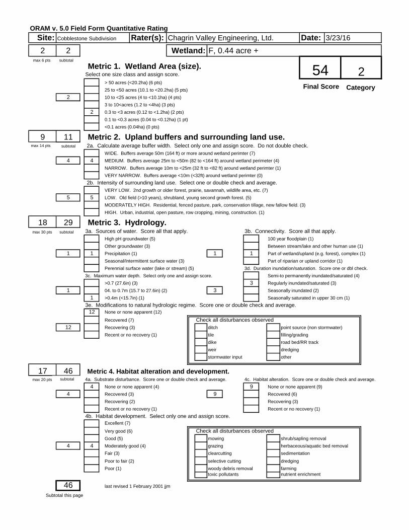
ORAM v. 5.0 Field Form Quantitative Rating
Site: Rater(s): Date:
2 2
Metric 1. Wetland Area (size).Select one size class and assign score.
> 50 acres (<20.2ha) (6 pts)
25 to <50 acres (10.1 to <20.2ha) (5 pts)
2 10 to <25 acres (4 to <10.1ha) (4 pts)
3 to 10<acres (1.2 to <4ha) (3 pts)
2 0.3 to <3 acres (0.12 to <1.2ha) (2 pts)
0.1 to <0.3 acres (0.04 to <0.12ha) (1 pt)
<0.1 acres (0.04ha) (0 pts)
9 11 Metric 2. Upland buffers and surrounding land use. 2a. Calculate average buffer width. Select only one and assign score. Do not double check.
WIDE. Buffers average 50m (164 ft) or more around wetland perimter (7)
4 4 MEDIUM. Buffers average 25m to <50m (82 to <164 ft) around wetland perimeter (4)
NARROW. Buffers average 10m to <25m (32 ft to <82 ft) around wetland perimter (1)
VERY NARROW. Buffers average <10m (<32ft) around wetland perimter (0)
2b. Intensity of surrounding land use. Select one or double check and average.
VERY LOW. 2nd growth or older forest, prairie, savannah, wildlife area, etc. (7)
5 5 LOW. Old field (>10 years), shrubland, young second growth forest. (5)
MODERATELY HIGH. Residential, fenced pasture, park, conservation tillage, new fallow field. (3)
HIGH. Urban, industrial, open pasture, row cropping, mining, construction. (1)
18 29 Metric 3. Hydrology.3a. Sources of water. Score all that apply. 3b. Connectivity. Score all that apply.
High pH groundwater (5) 100 year floodplain (1)
Other groundwater (3) Between stream/lake and other human use (1)
1 1 Precipitation (1) 1 1 Part of wetland/upland (e.g. forest), complex (1)
Seasonal/Intermittent surface water (3) Part of riparian or upland corridor (1)
Perennial surface water (lake or stream) (5) 3d. Duration inundation/saturation. Score one or dbl check.
3c. Maximum water depth. Select only one and assign score. Semi-to permanently inundated/saturated (4)
>0.7 (27.6in) (3) 3 Regularly inundated/saturated (3)
1 04. to 0.7m (15.7 to 27.6in) (2) 3 Seasonally inundated (2)
1 >0.4m (<15.7in) (1) Seasonally saturated in upper 30 cm (1)
3e. Modifications to natural hydrologic regime. Score one or double check and average.
12 None or none apparent (12)
Recovered (7) Check all disturbances observed
12 Recovering (3) ditch point source (non stormwater)
Recent or no recovery (1) tile filling/grading
dike road bed/RR track
weir dredging
stormwater input other
17 46 Metric 4. Habitat alteration and development.4a. Substrate disturbance. Score one or double check and average. 4c. Habitat alteration. Score one or double check and average.
4 None or none apparent (4) 9 None or none apparent (9)
4 Recovered (3) 9 Recovered (6)
Recovering (2) Recovering (3)
Recent or no recovery (1) Recent or no recovery (1)
4b. Habitat development. Select only one and assign score.
Excellent (7)
Very good (6) Check all disturbances observed
Good (5) mowing shrub/sapling removal
4 4 Moderately good (4) grazing herbaceous/aquatic bed removal
Fair (3) clearcutting sedimentation
Poor to fair (2) selective cutting dredging
Poor (1) woody debris removal farming
toxic pollutants nutrient enrichment
46 last revised 1 February 2001 jjm
Cobblestone Subdivision Chagrin Valley Engineering, Ltd. 3/23/16
Wetland: F, 0.44 acre +
54 2max 6 pts subtotal
max 20 pts subtotal
Subtotal this page
max 14 pts subtotal
max 30 pts subtotal
Final Score Category

ORAM v. 5.0 Field Form Quantitative Rating
Site: Rater(s): Date:
46
0 46 Metric 5. Special WetlandsCheck all that apply and score as indicated.
Bog (10)
Fen (10)
Old growth forest (10)
Mature forested wetland (5)
0 Lake Erie Coastal/tributary wetland-unrestricted hydrology (10)
Lake Erie Coastal/tributary wetland-restricted hydrology (5)
Lake Plain Sand Prairies (Oak Openings) (10)
Relict Wet Prairies (10)
Known occurrence state/federal threatened or endangered species (10)
Significant migratory songbird/water fowl habitat or usage (10)
Category 1 Wetland. See question 1 Qualitative Rating - 10
8 54 Metric 6. Plant communities, interspersion, microtopography.6a. Wetland Vegetation Communities Vegetation Community Cover Scale
Score all present using 0 to 3 scale. 0 Absent or comprises <0.1ha (0.2471 acres) contiguous area
Aquatic bed 1 Preset and either commprises small part of wetland's
1 Emergent vegetation and is of moderate quality, or comprises a
3 0 Shrub significant part but is of low quality.
2 Forest 2 Present and either comprises significant part of wetland's
Mudflats vegetation and is of moderate quality or comprises a small
Open water part and is of hgh quality.
Other 3 Present and comprises significant part or more of wetland's
6b. Horizontal (plan view) interspersion. vegetation and is of high quality.
Select only one. Narrative Description of Vegetation Quality
High (5) low Low spp diversity and/or predominance of nonnative or
Moderately high (4) disturbance tolerant native species
1 Moderate (3) mod Native spp are dominant component of the vegetation,
Moderately low (2) although nonnative and/or distrubance tolerant native spp
1 Low (1) can also be present, and species diversity moderate to
None (o) moderately high, but generally w/o presence of rare,
6c. Coverage of invasive plants. Refer to Table 1 ORAM threatened or endangered spp.
long form for list. Add or deduct points for coverage. high A predominance of native species, with nonative spp
Extensive >75% cover (-5) and/or disturbance tolerant native spp apbsent or virtually
Moderate 25-75% cover (-3) absent, and high spp diversity and often, but not always,
1 Sparse 5-25% cover (-1) the presence of rare, threatened or endangered spp
Nearly absent <5% cover (0) Mudflat and Open Water Class Quality
1 Absent (1) 0 Absent
6d. Microtopoghraphy 1 Low 0.1 to 1ha (0.247 to 2.47 acres)
Score all present using 1 to 3 scale. 2 Moderate 1 to <4ha (2.47 to 9.88 acres)
0 Vegetated hummocks/tussocks 3 High 4ha (9.88 acres) or more
1 Coarse woody debris > 15cm (6in) Microtopography Cover Scale
3 1 Standing dead >25cm (10in) dbh 0 Absent
1 Amphibian breeding pools 1 Present very small amounts or if more common of marginal quality
2 Present in moderate amounts, but not of highest quality or in small
amounts of highest quality
3 Present in moderate or greater amounts and of highest quality
54 GRAND TOTAL (max 100 pts) last revised 1 February 2001 jjm
Refer to the most recent ORAM Score Calibration Report for the scoring breakpoints between wetland categories at the following address: http://www.epa.state.oh.us/dsw/401/401.html
Wetland: F, 0.44 acre +
Cobblestone Subdivision Chagrin Valley Engineering, Ltd. 3/23/16
max 10 pts subtotal
max 20 pts subtotal
Subtotal1st page

Ohio Rapid Assessment Method for Wetlands – Summary Worksheet
Chagrin Valley Engineering Cobblestone Park 3/23/16
Wetland F
Narrative Rating Question 1. Critical Habitat Yes
No If yes, Category 3
Question 2. Threatened or Endangered Species
Yes No
If yes, Category 3
Question 3. High Quality Natural Wetland Yes No
If yes, Category 3
Question 4. Significant Bird Habitat Yes No
If yes, Category 3
Question 5. Category 1 Wetlands Yes No
If yes, Category 1
Question 6. Bogs Yes No If yes, Category 3
Question 7. Fens Yes No
If yes, Category 3
Question 8a. Old Growth Forest Yes No
If yes, Category 3
Question 8b. Mature Forested Wetland
Yes No
If yes, evaluate for Category 3; may
also be 1 or 2
Question 9b. Lake Erie Wetlands-Restricted
Yes No
If yes, evaluate for Category 3; may
also be 1 or 2
Question 9d. Lake Erie Wetlands-Unrestricted with native plants
Yes No
If yes, Category 3
Question 9e. Lake Erie Wetlands-Unrestricted with invasive plants
Yes No
If yes, evaluate for Category 3; may
also be 1 or 2
Question 10. Oak Openings Yes No
If yes, Category 3
Question 11. Relict Wet Prairies
Yes No
If yes, evaluate for Category 3; may
also be 1 or 2
Quantitative Rating
Metric 1. Size 2
Metric 2. Buffers and Surrounding Land Use 9
Metric 3. Hydrology 18
Metric 4. Habitat 17
Metric 5. Special Wetland Communities 0
Metric 6. Plant Communities, Interspersion, Microtopography
8
TOTAL SCORE 54

Ohio Rapid Assessment Method for Wetlands (ORAM) -Categorization Worksheet
Chagrin Valley Engineering Cobblestone Park 3/23/16
Wetland F Choices Circle One Evaluation of Categorization Result of
ORAM Did you answer “Yes” to any of the following questions: Narrative Rating Nos. 2, 3, 4, 6, 7, 8a, 9d, 10
YES Wetland is categorized as a Category 3 wetland
NO Is quantitative rating score less than the Category 2 scoring threshold (excluding gray zone)? If yes, reevaluate the category of the wetland using the narrative criteria in OAC Rule 3745-1-54© and biological and/or functional assessments to determine if the wetland has been over-categorized by the ORAM.
Did you answer “Yes” to any of the following questions: Narrative Rating Nos. 1, 8b, 9b, 9e, 11
YES Wetland should be evaluated for possible Category 3 status
NO Evaluate the wetland using the 1) narrative criteria in OAC Rule 3745-1-54© and 2) the quantitative rating score. If the wetland is determined to be a Category 3 wetland using either of these, it should be categorized as a Category 3 wetland. Detailed biological and/or functional assessments may also be used to determine the wetland’s category.
Did you answer “Yes” to Narrative Rating No. 5
YES Wetland is categorized as a Category 1 wetland
NO Is quantitative rating score greater than the Category 2 scoring threshold (excluding gray zone)? If yes, reevaluate the category of the wetland using the narrative criteria in OAC Rule 3745-1-54© and biological and/or functional assessments to determine if the wetland has been under-
categorized by the ORAM. Does the quantitative score fall within the scoring range of a Category 1, 2, or 3 wetland?
YES Wetland is assigned to the appropriate category based on the scoring range.
NO If the score of the wetland is located within the scoring range for a particular category, the wetlands should be assigned to that category. In all instances however, the narrative criteria described in OAC Rule 3745-1-54 © can be used to clarify or change a categorization based on a quantitative score.
Does the quantitative score fall within the “gray zone” of a Category 1, 2, or 3 wetland?
YES Wetland is assigned to the higher of the two categories or assigned to a category based on detailed assessments and narrative criteria.
NO Rater has the option of assigning the wetland to the higher of the two categories or to assign a category based on the results of a non-rapid wetland assessment method, e.g. functional assessment, biological assessment, etc, and a consideration of the narrative criteria in OAC Rule 3745-1-54 ©.
Does the wetland otherwise exhibit moderate OR superior hydrologic OR habitat, OR recreational functions AND the wetland was not
categorized as a Category 2 wetland (in the case of moderate functions) or a Category 3 wetland (in the case of superior functions) by this method?
YES Wetland was under-categorized by this method. A written justification for re-categorization should be provided on Background Information Form.
NO A wetland may be under-categorized using this method, but still exhibit one or more superior functions, e.g. a wetland’s biotic communities may be degraded by human activities, but the wetland may still exhibit superior hydrologic functions because of its type, landscape position, size, local or regional significance, etc. In this circumstance, the narrative criteria in OAC Rule 3745-1-54 © (2) and (3) are controlling, and the under-categorization should be corrected. A written justification with supporting reasons or information for this determination should be provided.
FINAL CATEGORY:
Category 2

Ohio Rapid Assessment Method for Wetlands (ORAM)-Background Form
Chagrin Valley Engineering Cobblestone Park Subdivision - 16158 3/23/16
Contact Information Applicant: Agent:
Company Name: Cobblestone Park Development, LLC
Chagrin Valley Engineering, Inc.
Address: 2573 Wyndgate Court 22999 Forbes Road, Suite B
City, State, Zip: Westlake, Ohio 44145 Cleveland, Ohio 44146
Contact Person: Mr. Richard Batt Larry Ludwig
Phone Number(s): (216) 970-3236 (440) 439-1999
E-Mail Address: [email protected] [email protected]
Project Information Project Name: Cobblestone Park Subdivision
Street: Cobblefield Drive City/Township: Montville Twp County: Medina
Watershed (8-Digit HUC): 04110001 01 03 USGS Quad: Seville
NWI Map: (Seville) No wetlands identified on site
Soil Survey: (Medina) Indicates presence of WaA, WaB and Mr present on site
Delineation Report/Mapping: Full wetland delineation report & maps including: USGS, NWI, Soils, FEMA and wetland delineation.
Dates of Site Visit: 3/23/16
USACE District: Buffalo Affirmed by Corps: Pending
Agent: Baker (DA 2004-00299)
Wetland Information
Wetland Acreage Category (Score)
HGM Class Vegetation
Community Class Lat/Long
Coordinates
G 0.66 Mod. 2
(34)
Riparian depression, headwaters, mineral soils
Mixed Emergent, Shrub Swamp 41.0949, -81.8575
Wetland G is dominated by emergent vegetation surrounding an old farm pond. Wetland G appears to extend off the property to the west. This area was taken into consideration when evaluating Wetland G.
Wetland sketch information including north arrow, relationship with other surface waters and vegetation zones are included on the attached ORAM Information Map.

Ohio Rapid Assessment Method for Wetlands (ORAM) -Scoring Boundary Worksheet
Chagrin Valley Engineering Cobblestone Park Subdivision 3/23/16
Wetland G
# Steps in properly establishing scoring boundaries
Done?
Not Applicable
Step 1 Identify the wetland area of interest. This may be the site of a proposed impact, a mitigation site, conservation site, etc.
X
Step 2 Identify the locations where there is physical evidence that hydrology changes rapidly. Such evidence includes both the natural and human-induced changes including, constrictions, caused by berms or dikes, points where water velocity changes rapidly at rapids or falls, points where significant inflows occur at the confluence of rivers, or other factors that may restrict hydrologic interaction between the wetlands or parts of a single wetland.
X
Step 3 Delineate the boundary of the wetland to be rated such that all areas of interest that are contiguous to and within areas where the hydrology does not change significantly, i.e. areas that have a high degree of hydrologic interaction are included within the scoring boundary.
X
Step 4 Determine if artificial boundaries such as property lines, state lines, roads, railroad embankments are present. These should not be used to establish scoring boundaries unless they coincide with areas where hydrologic regime changes.
X
Step 5 In all instances the Rater may enlarge the minimum scoring boundaries discussed here to score together wetlands that could be scored separately.
X
Step 6 Consult ORAM Manual Section 5.0 for how to establish scoring boundaries for wetlands that form a patchwork on the landscape, divided by artificial boundaries, contiguous to streams, lakes or rivers or for dual classifications.
X
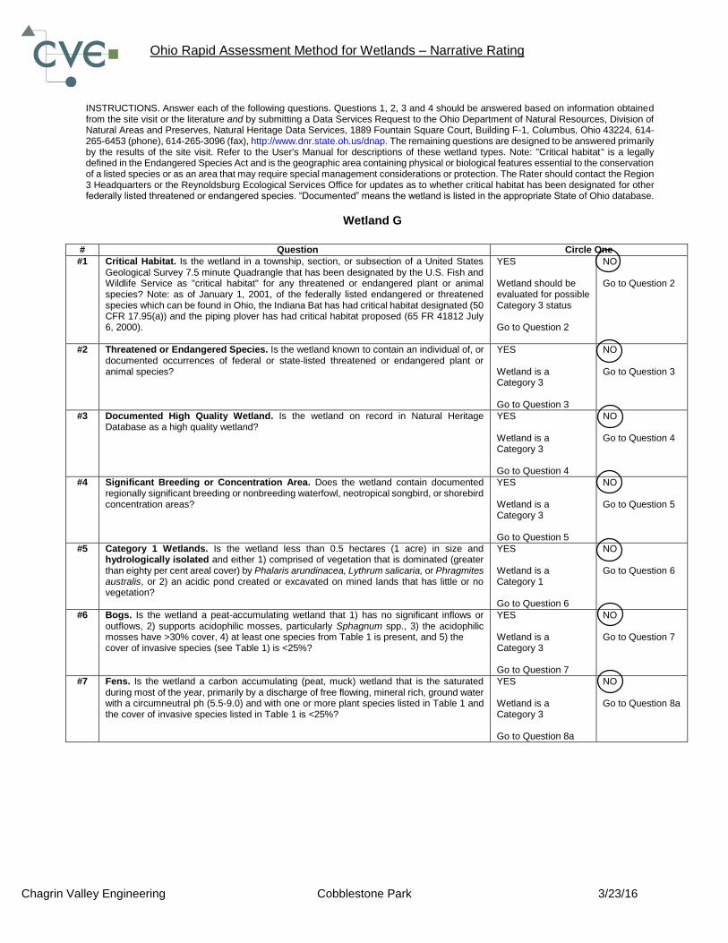
Ohio Rapid Assessment Method for Wetlands – Narrative Rating
Chagrin Valley Engineering Cobblestone Park 3/23/16
INSTRUCTIONS. Answer each of the following questions. Questions 1, 2, 3 and 4 should be answered based on information obtained from the site visit or the literature and by submitting a Data Services Request to the Ohio Department of Natural Resources, Division of Natural Areas and Preserves, Natural Heritage Data Services, 1889 Fountain Square Court, Building F-1, Columbus, Ohio 43224, 614-265-6453 (phone), 614-265-3096 (fax), http://www.dnr.state.oh.us/dnap. The remaining questions are designed to be answered primarily by the results of the site visit. Refer to the User's Manual for descriptions of these wetland types. Note: "Critical habitat" is a legally defined in the Endangered Species Act and is the geographic area containing physical or biological features essential to the conservation of a listed species or as an area that may require special management considerations or protection. The Rater should contact the Region 3 Headquarters or the Reynoldsburg Ecological Services Office for updates as to whether critical habitat has been designated for other federally listed threatened or endangered species. “Documented” means the wetland is listed in the appropriate State of Ohio database.
Wetland G
# Question Circle One
#1 Critical Habitat. Is the wetland in a township, section, or subsection of a United States Geological Survey 7.5 minute Quadrangle that has been designated by the U.S. Fish and Wildlife Service as "critical habitat" for any threatened or endangered plant or animal species? Note: as of January 1, 2001, of the federally listed endangered or threatened species which can be found in Ohio, the Indiana Bat has had critical habitat designated (50 CFR 17.95(a)) and the piping plover has had critical habitat proposed (65 FR 41812 July 6, 2000).
YES Wetland should be evaluated for possible Category 3 status Go to Question 2
NO Go to Question 2
#2 Threatened or Endangered Species. Is the wetland known to contain an individual of, or documented occurrences of federal or state-listed threatened or endangered plant or animal species?
YES Wetland is a Category 3 Go to Question 3
NO Go to Question 3
#3 Documented High Quality Wetland. Is the wetland on record in Natural Heritage Database as a high quality wetland?
YES Wetland is a Category 3 Go to Question 4
NO Go to Question 4
#4 Significant Breeding or Concentration Area. Does the wetland contain documented regionally significant breeding or nonbreeding waterfowl, neotropical songbird, or shorebird concentration areas?
YES Wetland is a Category 3 Go to Question 5
NO Go to Question 5
#5 Category 1 Wetlands. Is the wetland less than 0.5 hectares (1 acre) in size and hydrologically isolated and either 1) comprised of vegetation that is dominated (greater than eighty per cent areal cover) by Phalaris arundinacea, Lythrum salicaria, or Phragmites australis, or 2) an acidic pond created or excavated on mined lands that has little or no vegetation?
YES Wetland is a Category 1 Go to Question 6
NO Go to Question 6
#6 Bogs. Is the wetland a peat-accumulating wetland that 1) has no significant inflows or outflows, 2) supports acidophilic mosses, particularly Sphagnum spp., 3) the acidophilic mosses have >30% cover, 4) at least one species from Table 1 is present, and 5) the cover of invasive species (see Table 1) is <25%?
YES Wetland is a Category 3 Go to Question 7
NO Go to Question 7
#7 Fens. Is the wetland a carbon accumulating (peat, muck) wetland that is the saturated during most of the year, primarily by a discharge of free flowing, mineral rich, ground water with a circumneutral ph (5.5-9.0) and with one or more plant species listed in Table 1 and the cover of invasive species listed in Table 1 is <25%?
YES Wetland is a Category 3 Go to Question 8a
NO Go to Question 8a

Ohio Rapid Assessment Method for Wetlands – Narrative Rating
Chagrin Valley Engineering Cobblestone Park 3/23/16
#8a “Old Growth Forest”. Is the wetland a forested wetland and is the forest characterized by, but not limited to, the following characteristics: overstory canopy trees of great age (exceeding at least 50% of a projected maximum attainable age for a species); little or no evidence of human-caused understory disturbance during the past 80 to 100 years; an all-aged structure and multilayered canopies; aggregations of canopy trees interspersed with canopy gaps; and significant numbers of standing dead snags and downed logs?
YES Wetland is a Category 3 Go to Question 8b
NO Go to Question 8b
#8b Mature forested wetlands. Is the wetland a forested wetland with 50% or more of the cover of upper forest canopy consisting of deciduous trees with large diameters at breast height (dbh), generally diameters greater than 45cm (17.7in) dbh?
YES Wetland should be evaluated for possible Category 3 status Go to Question 9a
NO Go to Question 9a
#9a
Lake Erie coastal and tributary wetlands. Is the wetland located at an elevation less than 575 feet on the USGS map, adjacent to this elevation, or along a tributary to Lake Erie that is accessible to fish?
YES Go to Question 9b
NO Go to Question 10
#9b
Does the wetland's hydrology result from measures designed to prevent erosion and the loss of aquatic plants, i.e. the wetland is partially hydrologically restricted from Lake Erie due to lakeward or landward dikes or other hydrological controls?
YES Wetland should be evaluated for possible Category 3 status Go to Question 9d
NO Go to Question 9c
#9c
Are Lake Erie water levels the wetland's primary hydrological influence, i.e. the wetland is hydrologically unrestricted (no lakeward or upland border alterations), or the wetland can be characterized as an "estuarine" wetland with lake and river influenced hydrology. These include sandbar deposition wetlands, estuarine wetlands, river mouth wetlands, or those dominated by submersed aquatic vegetation.
YES Go to Question 9d
NO Go to Question 9d
#9d
Does the wetland have a predominance of native species within its vegetation communities, although non-native or disturbance tolerant species can also be present?
YES Wetland is a Category 3 Go to Question 10
NO Go to Question 9e
#9e
Does the wetland have predominance of non-native or disturbance tolerant native plant species?
YES Wetland should be evaluated for possible Category 3 status Go to Question 10
NO Go to Question 10
#10 Lake Plain Sand Prairies (Oak Openings). Is the wetland located in Lucas, Fulton, Henry, or Wood Counties and can the wetland be characterized by the following description: the wetland has a sandy substrate with interspersed organic matter, a water table often within several inches of the surface, and often with a dominance of the gramineous vegetation listed in Table 1 (woody species may also be present). The Ohio Department of Natural Resources Division of Natural Areas and Preserves can provide assistance in confirming this type of wetland and its quality.
YES Wetland is a Category 3 Go to Question 11
NO Go to Question 11
#11 Relict Wet Prairies. Is the wetland a relict wet prairie community dominated by some or all of the species in Table 1. Extensive prairies were formerly located in the Darby Plains (Madison and Union Counties), Sandusky Plains (Wyandot, Crawford, and Marion Counties), northwest Ohio, Erie County, and portions of western Ohio Counties (e.g. Darke, Mercer, Miami, Montgomery, etc.).
YES Wetland should be evaluated for possible Category 3 status Complete Quantitative Rating
NO Complete Quantitative Rating

Ohio Rapid Assessment Method for Wetlands – Summary Worksheet
Chagrin Valley Engineering Cobblestone Park 3/23/16
Wetland G
Narrative Rating Question 1. Critical Habitat Yes
No If yes, Category 3
Question 2. Threatened or Endangered Species
Yes No
If yes, Category 3
Question 3. High Quality Natural Wetland Yes No
If yes, Category 3
Question 4. Significant Bird Habitat Yes No
If yes, Category 3
Question 5. Category 1 Wetlands Yes No
If yes, Category 1
Question 6. Bogs Yes No If yes, Category 3
Question 7. Fens Yes No
If yes, Category 3
Question 8a. Old Growth Forest Yes No
If yes, Category 3
Question 8b. Mature Forested Wetland
Yes No
If yes, evaluate for Category 3; may
also be 1 or 2
Question 9b. Lake Erie Wetlands-Restricted
Yes No
If yes, evaluate for Category 3; may
also be 1 or 2
Question 9d. Lake Erie Wetlands-Unrestricted with native plants
Yes No
If yes, Category 3
Question 9e. Lake Erie Wetlands-Unrestricted with invasive plants
Yes No
If yes, evaluate for Category 3; may
also be 1 or 2
Question 10. Oak Openings Yes No
If yes, Category 3
Question 11. Relict Wet Prairies
Yes No
If yes, evaluate for Category 3; may
also be 1 or 2
Quantitative Rating
Metric 1. Size 2
Metric 2. Buffers and Surrounding Land Use 4
Metric 3. Hydrology 15.5
Metric 4. Habitat 12.5
Metric 5. Special Wetland Communities 0
Metric 6. Plant Communities, Interspersion, Microtopography
0
TOTAL SCORE 34
Ohio Rapid Assessment Method for Wetlands (ORAM) -Categorization Worksheet
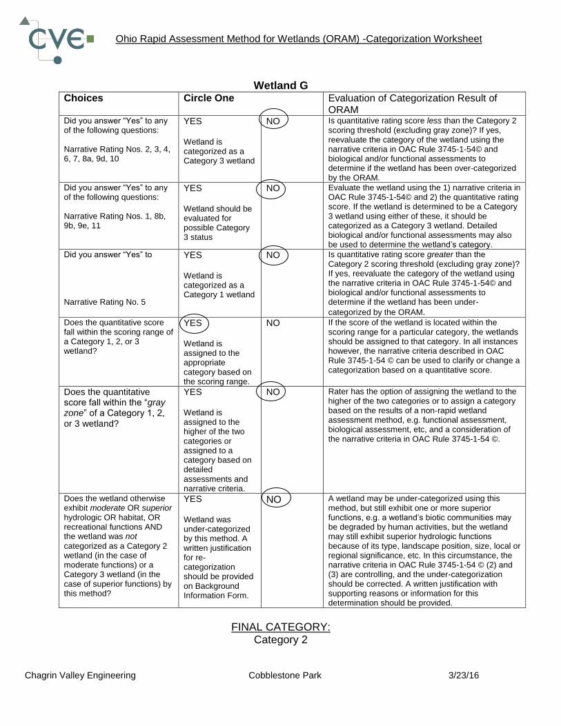
Chagrin Valley Engineering Cobblestone Park 3/23/16
Wetland G Choices Circle One Evaluation of Categorization Result of
ORAM Did you answer “Yes” to any of the following questions: Narrative Rating Nos. 2, 3, 4, 6, 7, 8a, 9d, 10
YES Wetland is categorized as a Category 3 wetland
NO Is quantitative rating score less than the Category 2 scoring threshold (excluding gray zone)? If yes, reevaluate the category of the wetland using the narrative criteria in OAC Rule 3745-1-54© and biological and/or functional assessments to determine if the wetland has been over-categorized by the ORAM.
Did you answer “Yes” to any of the following questions: Narrative Rating Nos. 1, 8b, 9b, 9e, 11
YES Wetland should be evaluated for possible Category 3 status
NO Evaluate the wetland using the 1) narrative criteria in OAC Rule 3745-1-54© and 2) the quantitative rating score. If the wetland is determined to be a Category 3 wetland using either of these, it should be categorized as a Category 3 wetland. Detailed biological and/or functional assessments may also be used to determine the wetland’s category.
Did you answer “Yes” to Narrative Rating No. 5
YES Wetland is categorized as a Category 1 wetland
NO Is quantitative rating score greater than the Category 2 scoring threshold (excluding gray zone)? If yes, reevaluate the category of the wetland using the narrative criteria in OAC Rule 3745-1-54© and biological and/or functional assessments to determine if the wetland has been under-
categorized by the ORAM. Does the quantitative score fall within the scoring range of a Category 1, 2, or 3 wetland?
YES Wetland is assigned to the appropriate category based on the scoring range.
NO If the score of the wetland is located within the scoring range for a particular category, the wetlands should be assigned to that category. In all instances however, the narrative criteria described in OAC Rule 3745-1-54 © can be used to clarify or change a categorization based on a quantitative score.
Does the quantitative score fall within the “gray zone” of a Category 1, 2, or 3 wetland?
YES Wetland is assigned to the higher of the two categories or assigned to a category based on detailed assessments and narrative criteria.
NO Rater has the option of assigning the wetland to the higher of the two categories or to assign a category based on the results of a non-rapid wetland assessment method, e.g. functional assessment, biological assessment, etc, and a consideration of the narrative criteria in OAC Rule 3745-1-54 ©.
Does the wetland otherwise exhibit moderate OR superior hydrologic OR habitat, OR recreational functions AND the wetland was not
categorized as a Category 2 wetland (in the case of moderate functions) or a Category 3 wetland (in the case of superior functions) by this method?
YES Wetland was under-categorized by this method. A written justification for re-categorization should be provided on Background Information Form.
NO A wetland may be under-categorized using this method, but still exhibit one or more superior functions, e.g. a wetland’s biotic communities may be degraded by human activities, but the wetland may still exhibit superior hydrologic functions because of its type, landscape position, size, local or regional significance, etc. In this circumstance, the narrative criteria in OAC Rule 3745-1-54 © (2) and (3) are controlling, and the under-categorization should be corrected. A written justification with supporting reasons or information for this determination should be provided.
FINAL CATEGORY:
Category 2

Ohio Rapid Assessment Method for Wetlands (ORAM)-Background Form
Chagrin Valley Engineering Cobblestone Park Subdivision - 16158 3/23/16
Contact Information Applicant: Agent:
Company Name: Cobblestone Park Development, LLC
Chagrin Valley Engineering, Inc.
Address: 2573 Wyndage Court 22999 Forbes Road, Suite B
City, State, Zip: Westlake, Ohio 44145 Cleveland, Ohio 44146
Contact Person: Mr. Richard Batt Larry Ludwig
Phone Number(s): (216) 970-3236 (440) 439-1999
E-Mail Address: [email protected] [email protected]
Project Information Project Name: Cobblestone Park Subdivision
Street: Cobblefield Drive City/Township: Montville Twp County: Medina
Watershed (8-Digit HUC): 04110001 01 03 USGS Quad: Seville
NWI Map: (Seville) No wetlands identified on site
Soil Survey: (Medina) Indicates presence of WaA, WaB and Mr present on site
Delineation Report/Mapping: Full wetland delineation report & maps including: USGS, NWI, Soils, FEMA and wetland delineation.
Dates of Site Visit: 3/23/16
USACE District: Buffalo Affirmed by Corps: Pending
Agent: Baker (DA 2004-00299)
Wetland Information
Wetland Acreage Category (Score)
HGM Class Vegetation
Community Class Lat/Long
Coordinates
H 0.24 1 (28.5)
Isolated depression,
closed, mineral soils
Mixed Emergent, Swamp Forest 41.0946, -81.8540
Wetland H is almost entirely located within an old wood lot surrounding by fallow agricultural field and new residential development. A minor portion of Wetland H is dominated by emergent vegetation and standing water hydrology. Frangula alnus makes up a large percentage of the shrub community.
Wetland sketch information including north arrow, relationship with other surface waters and vegetation zones are included on the attached ORAM Information Map.

Ohio Rapid Assessment Method for Wetlands (ORAM) -Scoring Boundary Worksheet
Chagrin Valley Engineering Cobblestone Park Subdivision 3/23/16
Wetland H
# Steps in properly establishing scoring boundaries
Done?
Not Applicable
Step 1 Identify the wetland area of interest. This may be the site of a proposed impact, a mitigation site, conservation site, etc.
X
Step 2 Identify the locations where there is physical evidence that hydrology changes rapidly. Such evidence includes both the natural and human-induced changes including, constrictions, caused by berms or dikes, points where water velocity changes rapidly at rapids or falls, points where significant inflows occur at the confluence of rivers, or other factors that may restrict hydrologic interaction between the wetlands or parts of a single wetland.
X
Step 3 Delineate the boundary of the wetland to be rated such that all areas of interest that are contiguous to and within areas where the hydrology does not change significantly, i.e. areas that have a high degree of hydrologic interaction are included within the scoring boundary.
X
Step 4 Determine if artificial boundaries such as property lines, state lines, roads, railroad embankments are present. These should not be used to establish scoring boundaries unless they coincide with areas where hydrologic regime changes.
X
Step 5 In all instances the Rater may enlarge the minimum scoring boundaries discussed here to score together wetlands that could be scored separately.
X
Step 6 Consult ORAM Manual Section 5.0 for how to establish scoring boundaries for wetlands that form a patchwork on the landscape, divided by artificial boundaries, contiguous to streams, lakes or rivers or for dual classifications.
X

Ohio Rapid Assessment Method for Wetlands – Narrative Rating
Chagrin Valley Engineering Cobblestone Park 3/23/16
INSTRUCTIONS. Answer each of the following questions. Questions 1, 2, 3 and 4 should be answered based on information obtained from the site visit or the literature and by submitting a Data Services Request to the Ohio Department of Natural Resources, Division of Natural Areas and Preserves, Natural Heritage Data Services, 1889 Fountain Square Court, Building F-1, Columbus, Ohio 43224, 614-265-6453 (phone), 614-265-3096 (fax), http://www.dnr.state.oh.us/dnap. The remaining questions are designed to be answered primarily by the results of the site visit. Refer to the User's Manual for descriptions of these wetland types. Note: "Critical habitat" is a legally defined in the Endangered Species Act and is the geographic area containing physical or biological features essential to the conservation of a listed species or as an area that may require special management considerations or protection. The Rater should contact the Region 3 Headquarters or the Reynoldsburg Ecological Services Office for updates as to whether critical habitat has been designated for other federally listed threatened or endangered species. “Documented” means the wetland is listed in the appropriate State of Ohio database.
Wetland H
# Question Circle One
#1 Critical Habitat. Is the wetland in a township, section, or subsection of a United States Geological Survey 7.5 minute Quadrangle that has been designated by the U.S. Fish and Wildlife Service as "critical habitat" for any threatened or endangered plant or animal species? Note: as of January 1, 2001, of the federally listed endangered or threatened species which can be found in Ohio, the Indiana Bat has had critical habitat designated (50 CFR 17.95(a)) and the piping plover has had critical habitat proposed (65 FR 41812 July 6, 2000).
YES Wetland should be evaluated for possible Category 3 status Go to Question 2
NO Go to Question 2
#2 Threatened or Endangered Species. Is the wetland known to contain an individual of, or documented occurrences of federal or state-listed threatened or endangered plant or animal species?
YES Wetland is a Category 3 Go to Question 3
NO Go to Question 3
#3 Documented High Quality Wetland. Is the wetland on record in Natural Heritage Database as a high quality wetland?
YES Wetland is a Category 3 Go to Question 4
NO Go to Question 4
#4 Significant Breeding or Concentration Area. Does the wetland contain documented regionally significant breeding or nonbreeding waterfowl, neotropical songbird, or shorebird concentration areas?
YES Wetland is a Category 3 Go to Question 5
NO Go to Question 5
#5 Category 1 Wetlands. Is the wetland less than 0.5 hectares (1 acre) in size and hydrologically isolated and either 1) comprised of vegetation that is dominated (greater than eighty per cent areal cover) by Phalaris arundinacea, Lythrum salicaria, or Phragmites australis, or 2) an acidic pond created or excavated on mined lands that has little or no vegetation?
YES Wetland is a Category 1 Go to Question 6
NO Go to Question 6
#6 Bogs. Is the wetland a peat-accumulating wetland that 1) has no significant inflows or outflows, 2) supports acidophilic mosses, particularly Sphagnum spp., 3) the acidophilic mosses have >30% cover, 4) at least one species from Table 1 is present, and 5) the cover of invasive species (see Table 1) is <25%?
YES Wetland is a Category 3 Go to Question 7
NO Go to Question 7
#7 Fens. Is the wetland a carbon accumulating (peat, muck) wetland that is the saturated during most of the year, primarily by a discharge of free flowing, mineral rich, ground water with a circumneutral ph (5.5-9.0) and with one or more plant species listed in Table 1 and the cover of invasive species listed in Table 1 is <25%?
YES Wetland is a Category 3 Go to Question 8a
NO Go to Question 8a

Ohio Rapid Assessment Method for Wetlands – Narrative Rating
Chagrin Valley Engineering Cobblestone Park 3/23/16
#8a “Old Growth Forest”. Is the wetland a forested wetland and is the forest characterized by, but not limited to, the following characteristics: overstory canopy trees of great age (exceeding at least 50% of a projected maximum attainable age for a species); little or no evidence of human-caused understory disturbance during the past 80 to 100 years; an all-aged structure and multilayered canopies; aggregations of canopy trees interspersed with canopy gaps; and significant numbers of standing dead snags and downed logs?
YES Wetland is a Category 3 Go to Question 8b
NO Go to Question 8b
#8b Mature forested wetlands. Is the wetland a forested wetland with 50% or more of the cover of upper forest canopy consisting of deciduous trees with large diameters at breast height (dbh), generally diameters greater than 45cm (17.7in) dbh?
YES Wetland should be evaluated for possible Category 3 status Go to Question 9a
NO Go to Question 9a
#9a
Lake Erie coastal and tributary wetlands. Is the wetland located at an elevation less than 575 feet on the USGS map, adjacent to this elevation, or along a tributary to Lake Erie that is accessible to fish?
YES Go to Question 9b
NO Go to Question 10
#9b
Does the wetland's hydrology result from measures designed to prevent erosion and the loss of aquatic plants, i.e. the wetland is partially hydrologically restricted from Lake Erie due to lakeward or landward dikes or other hydrological controls?
YES Wetland should be evaluated for possible Category 3 status Go to Question 9d
NO Go to Question 9c
#9c
Are Lake Erie water levels the wetland's primary hydrological influence, i.e. the wetland is hydrologically unrestricted (no lakeward or upland border alterations), or the wetland can be characterized as an "estuarine" wetland with lake and river influenced hydrology. These include sandbar deposition wetlands, estuarine wetlands, river mouth wetlands, or those dominated by submersed aquatic vegetation.
YES Go to Question 9d
NO Go to Question 9d
#9d
Does the wetland have a predominance of native species within its vegetation communities, although non-native or disturbance tolerant species can also be present?
YES Wetland is a Category 3 Go to Question 10
NO Go to Question 9e
#9e
Does the wetland have predominance of non-native or disturbance tolerant native plant species?
YES Wetland should be evaluated for possible Category 3 status Go to Question 10
NO Go to Question 10
#10 Lake Plain Sand Prairies (Oak Openings). Is the wetland located in Lucas, Fulton, Henry, or Wood Counties and can the wetland be characterized by the following description: the wetland has a sandy substrate with interspersed organic matter, a water table often within several inches of the surface, and often with a dominance of the gramineous vegetation listed in Table 1 (woody species may also be present). The Ohio Department of Natural Resources Division of Natural Areas and Preserves can provide assistance in confirming this type of wetland and its quality.
YES Wetland is a Category 3 Go to Question 11
NO Go to Question 11
#11 Relict Wet Prairies. Is the wetland a relict wet prairie community dominated by some or all of the species in Table 1. Extensive prairies were formerly located in the Darby Plains (Madison and Union Counties), Sandusky Plains (Wyandot, Crawford, and Marion Counties), northwest Ohio, Erie County, and portions of western Ohio Counties (e.g. Darke, Mercer, Miami, Montgomery, etc.).
YES Wetland should be evaluated for possible Category 3 status Complete Quantitative Rating
NO Complete Quantitative Rating

ORAM v. 5.0 Field Form Quantitative Rating
Site: Rater(s): Date:
1 1
Metric 1. Wetland Area (size).Select one size class and assign score.
> 50 acres (<20.2ha) (6 pts)
25 to <50 acres (10.1 to <20.2ha) (5 pts)
1 10 to <25 acres (4 to <10.1ha) (4 pts)
3 to 10<acres (1.2 to <4ha) (3 pts)
0.3 to <3 acres (0.12 to <1.2ha) (2 pts)
1 0.1 to <0.3 acres (0.04 to <0.12ha) (1 pt)
<0.1 acres (0.04ha) (0 pts)
5 6 Metric 2. Upland buffers and surrounding land use. 2a. Calculate average buffer width. Select only one and assign score. Do not double check.
WIDE. Buffers average 50m (164 ft) or more around wetland perimter (7)
1 MEDIUM. Buffers average 25m to <50m (82 to <164 ft) around wetland perimeter (4)
1 NARROW. Buffers average 10m to <25m (32 ft to <82 ft) around wetland perimter (1)
VERY NARROW. Buffers average <10m (<32ft) around wetland perimter (0)
2b. Intensity of surrounding land use. Select one or double check and average.
VERY LOW. 2nd growth or older forest, prairie, savannah, wildlife area, etc. (7)
4 5 LOW. Old field (>10 years), shrubland, young second growth forest. (5)
3 MODERATELY HIGH. Residential, fenced pasture, park, conservation tillage, new fallow field. (3)
HIGH. Urban, industrial, open pasture, row cropping, mining, construction. (1)
11 17 Metric 3. Hydrology.3a. Sources of water. Score all that apply. 3b. Connectivity. Score all that apply.
High pH groundwater (5) 100 year floodplain (1)
Other groundwater (3) Between stream/lake and other human use (1)
1 1 Precipitation (1) 1 1 Part of wetland/upland (e.g. forest), complex (1)
Seasonal/Intermittent surface water (3) Part of riparian or upland corridor (1)
Perennial surface water (lake or stream) (5) 3d. Duration inundation/saturation. Score one or dbl check.
3c. Maximum water depth. Select only one and assign score. Semi-to permanently inundated/saturated (4)
>0.7 (27.6in) (3) Regularly inundated/saturated (3)
1 04. to 0.7m (15.7 to 27.6in) (2) 1 Seasonally inundated (2)
1 >0.4m (<15.7in) (1) 1 Seasonally saturated in upper 30 cm (1)
3e. Modifications to natural hydrologic regime. Score one or double check and average.
None or none apparent (12)
7 Recovered (7) Check all disturbances observed
7 Recovering (3) ditch point source (non stormwater)
Recent or no recovery (1) tile filling/grading
dike road bed/RR track
weir dredging
stormwater input other
13 30 Metric 4. Habitat alteration and development.4a. Substrate disturbance. Score one or double check and average. 4c. Habitat alteration. Score one or double check and average.
4 None or none apparent (4) None or none apparent (9)
4 Recovered (3) 6 6 Recovered (6)
Recovering (2) Recovering (3)
Recent or no recovery (1) Recent or no recovery (1)
4b. Habitat development. Select only one and assign score.
Excellent (7)
Very good (6) Check all disturbances observed
Good (5) mowing shrub/sapling removal
3 Moderately good (4) grazing herbaceous/aquatic bed removal
3 Fair (3) clearcutting sedimentation
Poor to fair (2) selective cutting dredging
Poor (1) woody debris removal farming
toxic pollutants nutrient enrichment
30 last revised 1 February 2001 jjm
Cobblestone Subdivision Chagrin Valley Engineering, Ltd. 3/23/16
Wetland: H, 0.24 acre
29 1max 6 pts subtotal
max 20 pts subtotal
Subtotal this page
max 14 pts subtotal
max 30 pts subtotal
Final Score Category

ORAM v. 5.0 Field Form Quantitative Rating
Site: Rater(s): Date:
30
0 30 Metric 5. Special WetlandsCheck all that apply and score as indicated.
Bog (10)
Fen (10)
Old growth forest (10)
Mature forested wetland (5)
0 Lake Erie Coastal/tributary wetland-unrestricted hydrology (10)
Lake Erie Coastal/tributary wetland-restricted hydrology (5)
Lake Plain Sand Prairies (Oak Openings) (10)
Relict Wet Prairies (10)
Known occurrence state/federal threatened or endangered species (10)
Significant migratory songbird/water fowl habitat or usage (10)
Category 1 Wetland. See question 1 Qualitative Rating - 10
-1 29 Metric 6. Plant communities, interspersion, microtopography.6a. Wetland Vegetation Communities Vegetation Community Cover Scale
Score all present using 0 to 3 scale. 0 Absent or comprises <0.1ha (0.2471 acres) contiguous area
Aquatic bed 1 Preset and either commprises small part of wetland's
0 Emergent vegetation and is of moderate quality, or comprises a
1 0 Shrub significant part but is of low quality.
1 Forest 2 Present and either comprises significant part of wetland's
Mudflats vegetation and is of moderate quality or comprises a small
Open water part and is of hgh quality.
Other 3 Present and comprises significant part or more of wetland's
6b. Horizontal (plan view) interspersion. vegetation and is of high quality.
Select only one. Narrative Description of Vegetation Quality
High (5) low Low spp diversity and/or predominance of nonnative or
Moderately high (4) disturbance tolerant native species
0 Moderate (3) mod Native spp are dominant component of the vegetation,
Moderately low (2) although nonnative and/or distrubance tolerant native spp
Low (1) can also be present, and species diversity moderate to
0 None (o) moderately high, but generally w/o presence of rare,
6c. Coverage of invasive plants. Refer to Table 1 ORAM threatened or endangered spp.
long form for list. Add or deduct points for coverage. high A predominance of native species, with nonative spp
Extensive >75% cover (-5) and/or disturbance tolerant native spp apbsent or virtually
-3 Moderate 25-75% cover (-3) absent, and high spp diversity and often, but not always,
-3 Sparse 5-25% cover (-1) the presence of rare, threatened or endangered spp
Nearly absent <5% cover (0) Mudflat and Open Water Class Quality
Absent (1) 0 Absent
6d. Microtopoghraphy 1 Low 0.1 to 1ha (0.247 to 2.47 acres)
Score all present using 1 to 3 scale. 2 Moderate 1 to <4ha (2.47 to 9.88 acres)
0 Vegetated hummocks/tussocks 3 High 4ha (9.88 acres) or more
1 Coarse woody debris > 15cm (6in) Microtopography Cover Scale
1 0 Standing dead >25cm (10in) dbh 0 Absent
0 Amphibian breeding pools 1 Present very small amounts or if more common of marginal quality
2 Present in moderate amounts, but not of highest quality or in small
amounts of highest quality
3 Present in moderate or greater amounts and of highest quality
29 GRAND TOTAL (max 100 pts) last revised 1 February 2001 jjm
Refer to the most recent ORAM Score Calibration Report for the scoring breakpoints between wetland categories at the following address: http://www.epa.state.oh.us/dsw/401/401.html
Wetland: H, 0.24 acre
Cobblestone Subdivision Chagrin Valley Engineering, Ltd. 3/23/16
max 10 pts subtotal
max 20 pts subtotal
Subtotal1st page
Ohio Rapid Assessment Method for Wetlands – Summary Worksheet
Chagrin Valley Engineering Cobblestone Park 3/23/16
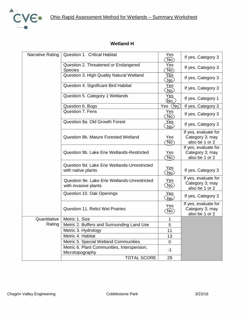
Wetland H
Narrative Rating Question 1. Critical Habitat Yes
No If yes, Category 3
Question 2. Threatened or Endangered Species
Yes No
If yes, Category 3
Question 3. High Quality Natural Wetland Yes No
If yes, Category 3
Question 4. Significant Bird Habitat Yes No
If yes, Category 3
Question 5. Category 1 Wetlands Yes No
If yes, Category 1
Question 6. Bogs Yes No If yes, Category 3
Question 7. Fens Yes No
If yes, Category 3
Question 8a. Old Growth Forest Yes No
If yes, Category 3
Question 8b. Mature Forested Wetland
Yes No
If yes, evaluate for Category 3; may
also be 1 or 2
Question 9b. Lake Erie Wetlands-Restricted
Yes No
If yes, evaluate for Category 3; may
also be 1 or 2
Question 9d. Lake Erie Wetlands-Unrestricted with native plants
Yes No
If yes, Category 3
Question 9e. Lake Erie Wetlands-Unrestricted with invasive plants
Yes No
If yes, evaluate for Category 3; may
also be 1 or 2
Question 10. Oak Openings Yes No
If yes, Category 3
Question 11. Relict Wet Prairies
Yes No
If yes, evaluate for Category 3; may
also be 1 or 2
Quantitative Rating
Metric 1. Size 1
Metric 2. Buffers and Surrounding Land Use 5
Metric 3. Hydrology 11
Metric 4. Habitat 13
Metric 5. Special Wetland Communities 0
Metric 6. Plant Communities, Interspersion, Microtopography
-1
TOTAL SCORE 29

Ohio Rapid Assessment Method for Wetlands (ORAM) -Categorization Worksheet
Chagrin Valley Engineering Cobblestone Park 3/23/16
Wetland H Choices Circle One Evaluation of Categorization Result of
ORAM Did you answer “Yes” to any of the following questions: Narrative Rating Nos. 2, 3, 4, 6, 7, 8a, 9d, 10
YES Wetland is categorized as a Category 3 wetland
NO Is quantitative rating score less than the Category 2 scoring threshold (excluding gray zone)? If yes, reevaluate the category of the wetland using the narrative criteria in OAC Rule 3745-1-54© and biological and/or functional assessments to determine if the wetland has been over-categorized by the ORAM.
Did you answer “Yes” to any of the following questions: Narrative Rating Nos. 1, 8b, 9b, 9e, 11
YES Wetland should be evaluated for possible Category 3 status
NO Evaluate the wetland using the 1) narrative criteria in OAC Rule 3745-1-54© and 2) the quantitative rating score. If the wetland is determined to be a Category 3 wetland using either of these, it should be categorized as a Category 3 wetland. Detailed biological and/or functional assessments may also be used to determine the wetland’s category.
Did you answer “Yes” to Narrative Rating No. 5
YES Wetland is categorized as a Category 1 wetland
NO Is quantitative rating score greater than the Category 2 scoring threshold (excluding gray zone)? If yes, reevaluate the category of the wetland using the narrative criteria in OAC Rule 3745-1-54© and biological and/or functional assessments to determine if the wetland has been under-
categorized by the ORAM. Does the quantitative score fall within the scoring range of a Category 1, 2, or 3 wetland?
YES Wetland is assigned to the appropriate category based on the scoring range.
NO If the score of the wetland is located within the scoring range for a particular category, the wetlands should be assigned to that category. In all instances however, the narrative criteria described in OAC Rule 3745-1-54 © can be used to clarify or change a categorization based on a quantitative score.
Does the quantitative score fall within the “gray zone” of a Category 1, 2, or 3 wetland?
YES Wetland is assigned to the higher of the two categories or assigned to a category based on detailed assessments and narrative criteria.
NO Rater has the option of assigning the wetland to the higher of the two categories or to assign a category based on the results of a non-rapid wetland assessment method, e.g. functional assessment, biological assessment, etc, and a consideration of the narrative criteria in OAC Rule 3745-1-54 ©.
Does the wetland otherwise exhibit moderate OR superior hydrologic OR habitat, OR recreational functions AND the wetland was not
categorized as a Category 2 wetland (in the case of moderate functions) or a Category 3 wetland (in the case of superior functions) by this method?
YES Wetland was under-categorized by this method. A written justification for re-categorization should be provided on Background Information Form.
NO A wetland may be under-categorized using this method, but still exhibit one or more superior functions, e.g. a wetland’s biotic communities may be degraded by human activities, but the wetland may still exhibit superior hydrologic functions because of its type, landscape position, size, local or regional significance, etc. In this circumstance, the narrative criteria in OAC Rule 3745-1-54 © (2) and (3) are controlling, and the under-categorization should be corrected. A written justification with supporting reasons or information for this determination should be provided.
FINAL CATEGORY:
Category 1

PRIMARY HEADWATER HABITAT EVALUATION INDEX FOR STREAMS (HHEI)

