oil conservation commissionocdimage.emnrd.state.nm.us/imaging/filestore/santafeadmin/cf/ada-0… ·...
TRANSCRIPT
J N
OIL CONSERVATION COMMISSION P. O. BOX 2 0 8 8
SANTA F E , NEW MEXICO 87501
July 16, 1974
Parry R. Baas Port Worth National Bank Building fore Worth, Texas 76102
Attention: Mr. U. P. Duncan, Jr.
Ret Initial Participating Area Morrow Formation, Big Bddy Unit, Eddy County, Haw Maxico
Gentlemen:
This Is to advise that the Kew Hsacico OH Conservation Coraeiasion has this date approved the Initial Participating Area for the Morrow Formation for the Big Eddy Unit, Eddy County, Hew Mexico, subject to like approval by the United States Geological Survey and the Commissioner of Public Lands of the State of Hew Mexico.
One approved copy of the application ia returned herewith.
Very truly yours,
A. L. PORTER, Jr. Secretary-Director
ALP/JEK/og
cct Oil Conservation Commission Artesia, Aatec, Hobbs

State of NewAAexico 3 v O - o _ / " /«*•;
A L E X J . A R M I J O P . O . BOX 1 1 48
SANTA F E , NEW MEXICO COMMISSIONER
rry -U jjass Fort Worth National Bank Building ' ' r r t Worth, Tux*.a 76102
He: Big Eddy Unit INITIAL PARTICIPATING *REA, M0H10W FORMATION EDDY AND LEA COUNTIES, NEW MEXICO
ATTENTION: Mr. W. P. Duncan, Jr.
Gentlemen:
The Commissioner of Public Lands has this date approved your I n i t i a l Participating Area for the Morrow Formation covering th? N/2 of Section 29, Township 21 South, Range 28 East, This approval l s subject to like approval by the United States Geological Survey and the New Kexieo O i l Conservation Commission.
Enclosed is one approved copy for your f i l e s .
In the future please submit three copies to this o f f i c e .
Very t r u l y yours,
RAY D. GRAHAM, Director O i l and Gas Department
AJA/RDG/s encIs. 1 c c : USGS-Rosweii, New Mexico
OCC- Santa Pe, Raw Maxico

P E R R Y R. B A S S
F O R T W O R T H N A T I O N A L B A N K B U I L D I N G
F O R T W O R T H , T E X A S
June 11. 1974
> Re: Big Eddy Unit
No. 14-08-001-326
U. S. Geological Survey Drawer 1857 Roswell, New Mexico 88201
Commissioner of Public Lands P. 0. Box 1148 Santa Fe, New Mexico 87501
Oil Conservation Commission P. 0. Box 2088 Santa Fe, New Mexico 87501
Gentlemen:
Reference is made to the above captioned Unit covering lands located i n Eddy and Lea Counties, New Mexico. Perry R. Bass, as operator, hereby requests that an I n i t i a l Participating Area of the N/2 of Section 29-T21S-R28E be established for the Morrow formation.
The Perry R. Bass #39 Big Eddy Unit w e l l , located 1980' from the North and East lines of Section 29-T21S-R28E, was d r i l l e d to a t o t a l depth of 12,240'. The well was then completed i n the Morrow formation from perforations from 11,762-66, 11,772-76, 11,796-803, 11,842-53 for an i n i t i a l potential of 9,000 MCF of gas per day.
In support of t h i s application, the following are attached hereto and made a part hereof:
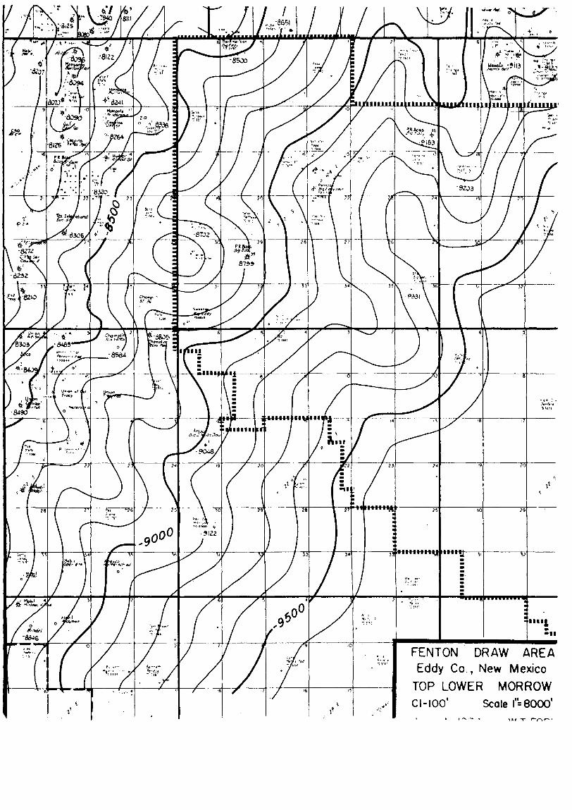
Exhibit "A": Map showing portion of Unit boundary and I n i t i a l Participating Area.
Exhibit "B": Schedule showing lands e n t i t l e d to participate i n unitized substances produced from the Morrow formation, with the percentage of participation of each lease indicated thereon.
Exhibit "C": Geological structure map.

U. S. Geological Survey Commissioner of Public Lands Oil Conservation Commission June 11, 1974 page 2
As unit operator, we hereby respectfully submit that a Morrow Participating Area covering the N/2 of Section 29 be established i n accordance with the terms and provisions of the Big Eddy Unit Agreement.
WPD:ld Attachments
APPROVED:
U. S. Geological Survey
By
Date
Commissioner of Public Lands
By_ Date
New Mexico O i l Conservation Commission
Yours very t r u l y ,


*1 ro ro
H
• CO I
VD M •• OO
0>
• B ro f c cn
N> U i
r 1
r> i o Ln vo to _> U l
GO H fO NJ O M • 00
I to pd VO ts3 •• 00
tn
C-
oo
ho
00 •P-o O ro
cn
> po XI w a C ro p> o a 4 H cn n cn o . ro
n W X) S3 r t fd 3 n H*
fd r t
o r t ro & O w o C f» •3 t-i o U l CD i-t r t tn H- H-H- Cfl 3 O o ro JQ 13 — CO
M O XI 3 o Xi H r t
• 01 O ro a. l-i c ro
t r o CO r t r t
ro H-O
r t 3 0
n o *
a CO
>

Roswell, New Mexico 88201
December 23, 1974
Perry R. Bess —• Attention: Mr. S. Arthur Hamilton Port Worth Nation-1 Bank Building Fort Worth, Texas 76102
Gentlemen:
The 1975 plan of development submitted for the Big Bddy unit area, Eddy
County, New Mexico, was approved oe this date subject to like approval
by the appropriate State officials. Such plan proposes the re-entry and
deepening of unit well No. 32 ia sec. 15, T. 21 S., R. 28 E., to the Morrow
and the drilling of two Morrow wells. Four approved copies are enclosed.
Sincerely yours,
G. R. DANIELS Acting Area Oil and Gas Supervisor
ec: /NMOCC, Santa Fe ( l t r only) Com. Pub. Lands, Santa Fe ( l t r only) Artesia (w/cy plan)
JAGillhatruds

United States Department of the Interior GEOLOGICAL SURVEY ^ C £lV£f l
Mil % Or*»»r 1 * r 7 ° *Z $ '7J
Roswell. New Mexico 88201 ^ w
July 9, 1974
Perry R. Bass Fort Worth National Bank Bldo. Fort Worth. Texas 76102
Gentlemen:
The In i t ia l Morrow participating area of Big Eddy unit agreement, Eddy and Lea Counties, New Mexico, No. 14-03 - 001-326.. was approved or> Kily 9, 1974. by the Acting Area Oil and Sas Supervisor. U . S . £eoloo;1cal Survey, and 1s effective as of January l c 1974 r?jrsuar»t to section 11 of the unit agreement.
Tne ini t ia l Morrow "articipatinc area embraces the H\ o* section 29, T. el S . , R. 28 E . 5 N.M.P.M., containing 32Q.W acr?s, *nd is bised on tne comoletlon of u«1t well No. 39 located 1r thp SW? NFl: of section 29 as a commercial wei I tfMt well Nn. 30 was rnraol«t-».d on .larv.i ry T>., 1974, for a calculated absolute ooen flow potential of 9,000 MCFGP© from the Morrow interval 11 76? to 11 J*53 feet.
Copies of the aooroved a^licatio*! a»*e )^1ni "*in*;r"!*>iit.w! to iinro">r1ate Federal offices and five cool** are ret'imed heron*th. Yotj **••*? v,eq-r?sted to furnish tne State of Hew Mexico and al l Interested '»a*,t1p": with -"Tropriate evidence of this aonrov^l
(OR1G. SGD.) C A R L C . T R A Y W I C K
CARL C. TRAYVflCr', Acting Area 011 and Gas Supervisor
cc: BLM, Santa Fe (ltr only) Artesia (w/cy appln.) ^ NMOCC, Santa Fe (ltr only)W^ Com. Pub. Lands, Santa Fe (ltr only)
AIVJ Lcl 1 : td

United States Department of the Interior
GEOLOGICAL SURVEY
Drawer 1857 Roe well, New Mexico 88201
January 18, 1974
Perry R. Bass Attention: Mr. Howard V. Jennings Twelfth Floor, Fort Worth National Bank Bldg. Fort Worth, Texas 76102
Gentlemen:
One approved copy of your 1974 plan of development for the Big Eddy unit area, Eddy County, New Mexico, is enclosed. Such plan proposes to 1) complete the dr i l l ing of unit well No. 38 which is now dr i l l ing below 7,000 feet, 2) d r i l l a 13,300 foot Morrow test in aec. 27, T. 21 S . , R. 29 B . , following a productive completion of unit well No. 38, 3) d r i l l a 12,200 foot Morrow well in sec. 20, T. 21 S . , R. 28 E . , offsetting unit well No. 39, 4) conduct approximately 60 miles of geophysical work, 5) d r i l l a unit wildcat at a location to be determined from the information supplied by the geophysieai work and 6) take appropriate and adequate measures to prevent drainage of unitizmd substances from lands subject to the unit agreement.
This plan was approved on thia date and is subject to like approval by the appropriate o f f ic ia l s of the State of New Mexico.
Sincerely yours,
CARL C. TRAYWICK Acting Area Oil & Gas Supervisor
cc: i/NMOCC, Santa Fe ( l t r only)
Com. Pub. Lands, Santa Fe ( l t r only) Artes ia (w/cy plan)
JAGillham:ds

O I L C O N S E R V A T I O N COMMISSION P. O. BOX 2088
SANTA F E , NEW MEXICO 87501
January 9, 1974
Perry R. Bass 12th Floor Ft. Worth Nat'l Bank Bldg. Fort Worth, Texas 76102
Attention: Mr. Howard W. Jennings
Re: 1974 Plan of Development Big Eddy Unit, Eddy County, New Mexico.
Gentlemen:
This i s to advise that the New Mexico Oil Conservation Commission has this date approved the Plan of Development for the calendar year 1974 for the Big Eddy Unit, Eddy County, New Mexico, inject to l i k e approval by the United States Geological Survey and the Commissioner of Public Lands of the State of Mew Mexico.
One approved copy of the plan i s returned herewith.
Very truly yours,
A. L. PORTER, J r . Seeretary-Direc tor
ALP/JEK/og
cc: Commissioner of Public Lands - Santa Fe U. S. Geological Survey - Roswell
P E R R Y R. B A S S •- FLOOR FT WORTH N A T L BANK BLDO
F O R T W O R T H , T E X A S
7 6 1 0 2
December 14, 1973
United States Geological Survey (3) Drawer 1857 Roswell, New Mexico 88201
Commissioner of Public Lands (2) P. O. Box 1148 Santa Fe, New Mexico 87501
Oil Conservation Commission (2) P. O. Box 2088 Santa Fe, New Mexico 87501
Re: 1974 Plan of Development Big Eddy Unit Eddy County, New Mexico
Gentlemen:
In accordance with Section 10 of the Big Eddy Unit Agreement, Perry R. Bass, Operator for said Uni t , hereby submits a Plan of Development for the above captioned Unit for 1974.
HISTORY OF PAST DEVELOPMENT
We refer to our previous Plans of Development for a detailed description of past development on this Uni t . To date, we have dr i l l ed , or caused to be d r i l l ed , 24 deep tests within the Unit area. By deep tests, i t is meant that the wells were dri l led to approximately 12,000', or deeper, to test the Pennsylvanian and/or Devonian formations. In addition to the deep tests, f ive shallow tests have also been d r i l l ed .
1973 ACTIVITY
During the year of 1973 we conducted 62 .903 miles of sismograph lines on this Unit costing approximately $100,000.00. We attach a map hereto showing the location of this work.

1974 Plan of Development Big Eddy Unit Eddy County, New Mexico
Page 2 December 14, 1973
In addition to the above we dri l led Big Eddy No. 35, 1980' FN&WL's Section 27, T-20S, R-30E, Eddy County, New Mexico. This wel l was spudded 3-29-73 and dri l led to TD of 12,684'. The wel l was P3 12,601' and perforated 12,236-552'. The IP was an estimated 2. 930 MMCF per day. The wel l made 10 bbls . of condensate per MMCF plus 67 BW. It was completed 6-28-73 and is presently shut in for a gas connection.
Big Eddy No. 36 was dri l led 1980' FSL & 660' FEL Section 12, T-21S, R-28E, Eddy County, New Mexico. This wel l was spudded 6-2-73 and dri l led to a TD of 12,756'. This wel l was dri l led in a seismic low, and was dry and abandoned 7-25-73.
Big Eddy No. 37 was dri l led 1980' FN&WL's Section 10, T-20S, R-31E, Eddy County, New Mexico. This wel l was spudded 7-26-73 and dr i l led to a TD of 13,016'. This well indicated possible Morrow sands near this location but the wel l was dry and abandoned 9-14-73.
Big Eddy No. 38 is presently dr i l l ing 660' FNL & 1980' FWL Section 34, T-21S, R-29E, Eddy County, New Mexico. The wel l was spudded 1 1-28-73 and as of this date is dr i l l ing below 7,000' .
Big Eddy No. 39 was dri l led 1980' FN&EL's Section 29, T-21S, R-28E, Eddy County, New Mexico. The wel l was spudded 9-26-73 and dri l led to a TD of 12,240 - PB 12 ,236 ' . This wel l tested 9 MMCF on a d r i l l stem test in the upper Morrow and we are presently testing the lower Morrow to determine i f i t is productive.
FUTURE DEVELOPMENT
At the present time we have programed seismic lines for 1974 of approximately 60 miles . Depending, of course, on our completion tests on Big Eddy No's 38 & 39, we need this seismic data for future development.
We anticipate at the present time to d r i l l an offset to Big Eddy 39, 1980' from South and East lines Section 20-21S-28E. We anticipate this wel l w i l l be dri l led to a TD 12,200' to test the Morrow formation.
We also have a tentative location 1980' from South and East lines of Section 27-21S-29E which would be offset t ing Big Eddy No. 38. This wel l is estimated to be dri l led to 13,300' to test the Morrow formation.

1974 Plan of Development Big Eddy Unit Eddy County, New Mexico
Page 3 December 14, 1973
In addition to the above we have tentative plans for another wildcat wel l on the Uni t . After our seismic survey has been completed we expect to pick this locat ion.
In addition to the above we l l s , Unit Operator has committed to support additional Morrow tests on the perimeter of the Unit area. No definite conclusions have been reached concerning the dr i l l ing of these tests; however, Unit Operator is actively pursuing these ventures.
OFFSET OBLIGATIONS
Appropriate and adequate measures w i l l be taken to prevent drainage of unitized substances from land subject to the Big Eddy Unit Agreement, or, pursuant to applicable regulation, fair and reasonable compensatory royalty w i l l be paid as provided by the Unit Agreement.
ADDITIONAL DEVELOPMENT
This Plan of Development shall constitute the dr i l l ing obligations of the Unit Operator under the terms of the Big Eddy Unit Agreement for the period ending December 3 1 , 1974.
MODIFICATIONS
It is understood that this Plan of Development may be modified from time to time to meet changing condit ions.
EFFECTIVE DATE
This plan of Development shall be effect ive January 1, 1974.
If this Plan of Development meets wi th your approval, please i n d i cate in the appropriate space provided below and return one copy for our f i l e s .
Yours very t ru ly ,
PERRY R./BASS, Unit Operator
Howard W. Jennirtqs
J

1974 Plan of Development Big Eddy Unit Eddy County, New Mexico
Page 4 December 14, 1973
Approved: Date: Supervisor, United States Geological Survey
Approved: Date_ Commissioner of Public Lands
Oil Conservation Commission ' Approved: l**- • *\ * ^^t£^\^*^A-" J~** Dat^y^,^ ^ ^^^^i ^ ' f J v
Oil Conservation Commission ' / . / /