oil occurrences in crystalline basement rocks, southern...
TRANSCRIPT
Linnéa GunterbergDissertations in Geology at Lund University, Bachelor’s thesis, no. 344(15 hp/ECTS credits)
Department of Geology Lund University
2013
Oil occurrences in crystalline basement rocks, southern Norway – comparison with deeply weathered basement rocks in southern Sweden

Oil occurrences in crystalline base-ment rocks, southern Norway – com-parison with deeply weathered base-
ment rocks in southern Sweden
Bachelor’s thesis Linnéa Gunterberg
Department of Geology Lund University
2013
Table of Contents
1. Introduction……………………………………………………………………………………………………. 5
1.1 Petroleum in crystalline basement rocks…………………………………………………………………....5
1.2 Aims and objectives………………………………………………………………………………………... 6
2. Geological background………………………………………………………………………………………....6
2.1 Caledonian Orogeny of Scandinavia………………………………………………………………………..6
2.2 Utsira High…………………………………………………………………………………………………. 7
3. Deep chemical weathering and saprolite formation…………………………………………………………. 7
4. Field observations…………………………………………………………………………………………….. 8
4.1 Onshore basement deep weathering……………………………………………………………………..... 8
4.2 Bømlo……………………………………………………………………………………………………... 8
4.3 Ivö Island…………………………………………………………………………………………………. 10
5. Discussion……………………………………………………………………………………………………... 11
6. Conclusions………………………………………………………………………………………………….....11
7. Acknowledgements………………………………………………………………………………………….... 12
8. References…………………………………………………………………………………………………….. 12
9. Appendix…………………………………………………………………………………………………….... 14
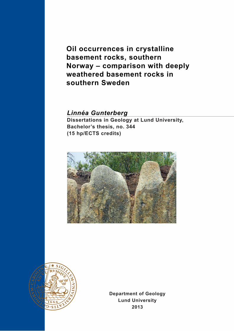
Cover Picture: Deep weathering at Bømlo.

Oil occurrences in crystalline basement rocks, southern Norway –
comparison with deeply weathered basement rocks in southern
Sweden
LINNÉA GUNTERBERG
Gunterberg, L., 2013: Oil occurrences in crystalline basement rocks, southern Norway – comparison with deeply
weathered basement rocks in southern Sweden. Dissertations in Geology at Lund University, No. 344, 14 pp. 15 hp
(15 ECTS credits).
Keywords: Petroleum, crystalline basement, deep weathering, saprolite
Supervisor: Mikael Calner
External supervisor: Mats Andersson
Linnéa Gunterberg, Department of Geology, Lund University, Sölvegatan 12, SE-223 62 Lund, Sweden.
E-mail: [email protected]
Abstract: Rising oil prices and an increasing global use of fossil fuels make the survey of alternative petroleum
reservoirs of great importance. Instead of drilling in regular sedimentary successions, the possibility of investigat-
ing reservoirs in crystalline basement is in many places of economic interest. Reservoirs in crystalline basement
rock are producing oil in several countries e.g. Vietnam and Yemen, and oil exploration including drillings are
made continuously to look for reservoirs in basement rocks in other places. The Norwegian company Lundin Nor-
way AS has found traces of petroleum in weathered granites in drill cores from the Utsira High, southwestern Nor-
way. Drilling and survey offshore can be expensive and difficult while analog research onshore could result in sig-
nificant information and increased knowledge. Bømlo basement is related in age and petrology with the basement
of Utsira High. This makes the, easy accessed, onshore island to a high quality survey area. The weathered material
with petroleum occurrences from Utsira High makes Ivön, southeastern Sweden, a key locality since the latter area
yields several good exposures where the relationships between deep weathered basement and unweathered base-
ment can be studied. This thesis details the development of petroleum occurrences in crystalline basement.
Oljeförekomster i kristallin berggrund, södra Norge – en jämfö-
relse med djupt vittrad berggrund i södra Sverige.
LINNÉA GUNTERBERG
Gunterberg, L., 2013: Oljeförekomster i kristallin berggrund, södra Norge – en jämförelse med djupt vittrad berg-
grund i södra Sverige. Examensarbeten i geologi vid Lunds universitet, Nr. 344, 14 sid. 15 hp.
Nyckelord: Petroleum, kristallin berggrund, djupvittring, saprolite.
Ämnesinriktning: Berggrundsgeologi
Linnéa Gunterberg, Geologiska institutionen, Lunds universitet, Sölvegatan 12, 223 62 Lund, Sverige.
E-post: [email protected]
Sammanfattning: Ökande oljepriser och en stigande efterfrågan gör idag undersökningar av alternativa petroleum-
reservoarer extra intressanta. Istället för att borra i den sedimentära bergrunden ges nu möjligheten att granska
kristallina bergrundsreservoarer. Den här typen av borrning i kristallin berggrund äger rum på flera platser i värl-
den, exempelvis i Vietnam och Yemen. Det norska företaget Lundin Norway AS har funnit petroleum i vittrade
graniter i kärnborrsprover från Utsira höjden, sydvästra Norge. Att utföra borrningar och undersökningar offshore
kan vara både dyrt och komplicerat. Granskningar och analoga undersökningar onshore kan därför vara att föredra
då de tillför viktig information och bidrar med ökad kunskap för de aktuella områdena. Bergrunden på Bømlo är
nära besläktad med bergrunden på Utsira Höjden. Detta gör den lättåtkomliga ön ett högkvalitativt undersöknings-
område. Det vittrade materialet med petroleumfynd från Utsira Höjden gör att även Ivön, sydöstra Sverige, med sin
likartade historia i ålder och petrologi blir en viktig nyckellokal för att förstå petroleumförekomster i vittrad berg-
grund. Naturliga skärningar på Ivön visar skarpa konturer mellan vittrat berg och färskt, ovittrat berg. Denna upp-
sats tar upp samband och möjligheter till hur petroleum kan påträffas i kristallin bergrund.

5
1 Introduction 1.1 Petroleum in crystalline basement
rocks Petroleum forms through accumulation and burial of
organic material in marine shales. Deposition of sedi-
ments will bury the shale which then will experience
increasing temperature and pressure. As the burial
continuous and the source rock becomes heated to
between 70-120°C, long chains of hydrocarbons will
break away from the organic kerogen and form waxy
and viscous heavy oil at a depth around 3-4.5 km. At
an increased temperature, about 160°C, the cropped
hydrocarbon chains generates light oil. By a depth
around 5-6 km and temperatures above 160°C the hy-
drocarbon chains convert into gas (Arid 2011). Migra-
tion occurs by pressure and density differences be-
tween the petroleum phases and the surrounding pore
water. The oil migrates towards higher permeability
and lower pressure into reservoir rocks but may be
restricted by capillary forces (Munz et al. 2002). The
accumulation of oil or gas occur by trapping of a seal-
ing cap rock, mostly shale or clay rocks (Arid 2011).
Petroleum reservoir rocks are generally sedimen-
tary rocks such as sandstone and limestone. These
rocks usually have high permeability and porosity in
which hydrocarbons can accumulate. It is far less com-
mon that hydrocarbons are retrieved from crystalline
basement rocks. Crystalline basement is mostly hard
and solid, but in fractured and weathered zones the
porosity and permeability can increase. Basement
rocks as igneous, metamorphic and volcanic have been
observed to contain petroleum through infiltration
from adjacent sedimentary basins (Munz et al. 2002).
Crystalline reservoirs are discussed in this thesis.
The way oil occurs in crystalline basement is
shown in Fig. 1. Oil producing source rock is buried
with an increasing temperature and depth. Tectonic
movements create fractures and uplift in the basement.
This locally forces the oil producing source rocks to a
lower level relative the basement, e.g. along the lower
flanks of anticlinals. The producing hydrocarbon mi-
grates upwards along the flank of the basement and
accumulates in the new convex structure. A sealing
cap of shale or clay will trap the hydrocarbons. A
filled trap can result in seeps toward the surface or
downward into lower depth and more permeable frac-
ture zones (Hurricaneenergy 2013). In this case the
possibility of finding oil in fractured basement highs
increases (Salah & Alsharhan 1998).
The porosity and permeability of matrix in the frac-
tured and weathered basement has a significant role as
it makes rock more or less capable for oil trapping.
Weathered zones can contain 5-10% of matrix porosity
comparing with < 0.5 % in fresh basement rocks. Frac-
ture porosity reservoirs usually have a porosity value
between 0.1 % and 1 % (Nelson 2001). Increasing
permeability or extensive weathering zones as well as
a sealing cap rock are the significant factors of oil
trapping.
When petroleum migrates downwards to a greater
depth with high temperatures it will decompose to
pyrobitumen (Munz et al. 2002). According to the
Landis & Castaño (1995) classification (cf. Appendix
Tab. 1), based on high reflection, bitumen can be
named pyrobitumen. Pyrobitumen is a black, solid
substance with a main containing of carbon. Bacterial
degradation and high temperatures has influenced the
mentioned substance. Generally observations of py-
robitumen are important as it shows that the oil is
coming from a sedimentary host rock (Pedersen 2005).
Bitumen commonly occurs within fracture zones or
breccias (Welin 1966; Aberg et al. 1985). It also asso-
ciates with quartz veins (Munz et al. 2002).
Pyrobitumen has been observed in the Modum
Complex, a Precambrian basement with quartz veins
located in southern Norway. The metamorphic grade
of the basement rocks is mostly amphibolites to granu-
lite facies. A sedimentary succession including organ-
ic-rich shale overlies the basement. During late Palae-
ozoic and Mesozoic the area became subsequently
eroded (Larson et al. 1999) and in the Carboniferous
and Permian the Oslo Graben was formed (Munz et al.
2002). The Modum Complex is a well investigated
area were petroleum associated with pyrobitumen has
been discovered (Munz et al. 2002).
A biogenic origin is clearly indicated by the δ13C
composition in the pyrobitumen (Eakin 1989) and gas
Fig. 1. Suggested way how oil can accumulate in crystalline
basement rocks. A. Shows a sedimentary basin with and oil-
producing source rock overlain by less permeable cap rocks.
B. Shows tectonic uplift of the basement rock, and the black
vertical stripes. B-F. Represents fractures caused by the tec-
tonic movements. C. Oil migrates along the basement rock
(pressure, capillary forces). D-F. When reaching the thick
layers of muds/shales it will accumulate and migrate down-
wards in the fractured zones of the basement rock. Figure
modified from Hurricaneenergy.
6
components (Karlsen et al. 1993). Both fluid inclu-
sions and solid phases (bitumen and chlorite) are given
evidences of the physical conditions of the petroleum
condition during basement infiltration (Munz et al.
2002).
Pressure, temperature, time and composition (P-T-
t-X) will be crucial parameters concerning downward
fluid flows. The containing veins can also be of great
importance as they could work as a transport system of
the petroleum fluids. To make the petroleum migrate
downwards a higher fluid pressure must exist in the
overlying sediments, for example in a basin which has
been affected by tectonic compressions. Rapid deposi-
tion and compression in the Modum Complex lead to
overpressure. On the other hand, the crystalline base-
ment was dry and fractured, which caused it to have a
low pressure. Overall, these conditions made it possi-
ble for the oil to migrate and accumulate in the base-
ment (Munz et al. 2002).
1.2 Aims and objectives This literature study aims to outline and discuss the
relationship between deep chemical weathering of
crystalline basement rocks and the presence of hydro-
carbons in such rocks. Oil bearing crystalline base-
ment rocks derived from drill cores from the Utsira
High has been found and are today of great interest for
potential future petroleum production. During the
course of this study, two field trips to two key locali-
ties have been made. The purpose was to study base-
ment rocks with fractures and weathered material. The
survey areas include the large island Bømlo, south-
western Norway, and Ivön in Lake Ivösjön, southeast-
ern Sweden. By describing the relationship between
deep chemical weathering and hydrocarbon migration
in crystalline basement, together with collected data,
this thesis help to improve the overall understanding of
new alternative drilling offshore in crystalline base-
ment. The rocks of the Precambrian Modum Complex,
in the Oslo region, will work as a comparison as the
basement of Utsira High is relative unexplored. The
project and literature study was a co-operation be-
tween Lund University and Lundin Norway AS.
2. Geological background
2.1 Caledonian Orogeny of Scandinavia The assembly of the 1800 km long Caledonian moun-
tain belt of Scandinavia and northeast Greenland was
caused by a continental collision between Baltica and
Laurentia, starting in the early Ordovician and culmi-
nating in the mid Silurian to early Devonian (Roberts
2003; Fossen & Dunlap 2006; Gee et al. 2008; Slag-
stad et al. 2011). The roots of the mountain chain are
exposed in Norway, western Sweden, westernmost
Finland, on Svalbard and in northeast Greenland. Pal-
aeozoic strata overlain by younger sedimentary suc-
cessions are today covering the shelves between west-
ern Scandinavia and eastern Greenland. The collision
resulted in a subduction zone where a partial melting
of the underthrust (Baltica) caused island arcs and
back-arc basins. Ocean-derived allochthons and Cam-
bro-Ordovician Iapetus sea floor sediments are also
preserved in the thrust sheet. The subduction of the
Baltica basement resulted into Lower, Middle, Upper
and Uppermost allochthons (cf. Fig. 2) with a cover of
late Neoproterozoic to Silurian metasedimentary depo-
sitions (Gee et al. 2008; Labrousse et al. 2010). The
Upper Allochthon is dominated by sedimentary and
igneous rocks including ophiolites and island-arc com-
plexes where mature magmatic intrusive complexes,
such as the Sunnhordland Batholith, the West Karmøy
Igneous Complex and the Krossneset granite, consti-
tute the main part of the southwest part of the Upper
Allochthon (Stephens 1988).
The Sunnhordland Batolith together with Krossne-
set granite constitute two of the magmatic intrusives
that form the northern part of Bømlo (Stephens 1988).
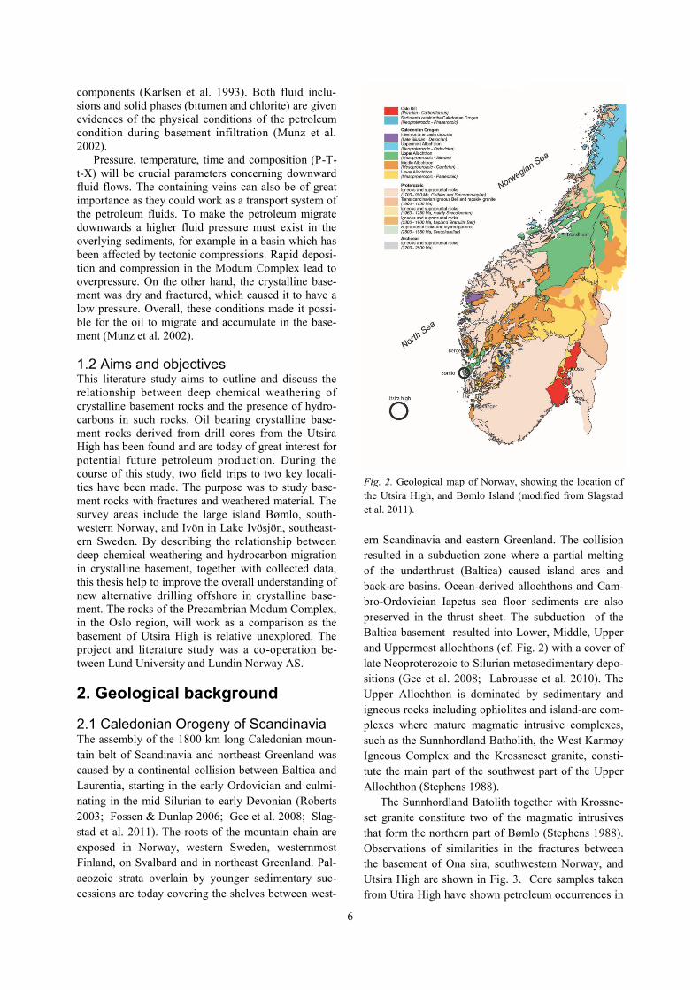
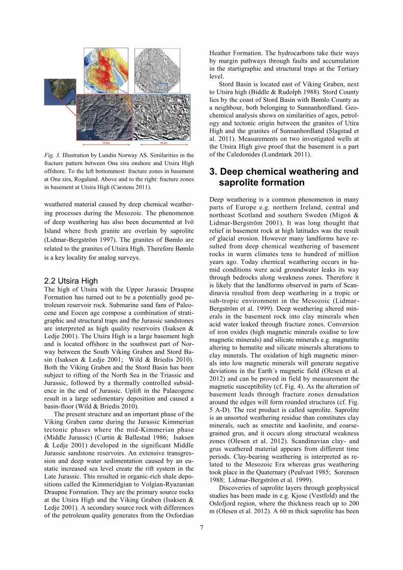
Observations of similarities in the fractures between
the basement of Ona sira, southwestern Norway, and
Utsira High are shown in Fig. 3. Core samples taken
from Utira High have shown petroleum occurrences in
Fig. 2. Geological map of Norway, showing the location of
the Utsira High, and Bømlo Island (modified from Slagstad
et al. 2011).
7
weathered material caused by deep chemical weather-
ing processes during the Mesozoic. The phenomenon
of deep weathering has also been documented at Ivö
Island where fresh granite are overlain by saprolite
(Lidmar-Bergström 1997). The granites of Bømlo are
related to the granites of Utsira High. Therefore Bømlo
is a key locality for analog surveys.
2.2 Utsira High The high of Utsira with the Upper Jurassic Draupne
Formation has turned out to be a potentially good pe-
troleum reservoir rock. Submarine sand fans of Paleo-
cene and Eocen age compose a combination of strati-
graphic and structural traps and the Jurassic sandstones
are interpreted as high quality reservoirs (Isaksen &
Ledje 2001). The Utsira High is a large basement high
and is located offshore in the southwest part of Nor-
way between the South Viking Graben and Stord Ba-
sin (Isaksen & Ledje 2001; Wild & Briedis 2010).
Both the Viking Graben and the Stord Basin has been
subject to rifting of the North Sea in the Triassic and
Jurassic, followed by a thermally controlled subsid-
ence in the end of Jurassic. Uplift in the Palaeogene
result in a large sedimentary deposition and caused a
basin-floor (Wild & Briedis 2010).
The present structure and an important phase of the
Viking Graben came during the Jurassic Kimmerian
tectonic phases where the mid-Kimmerian phase
(Middle Jurassic) (Curtin & Ballestad 1986; Isaksen
& Ledje 2001) developed in the significant Middle
Jurassic sandstone reservoirs. An extensive transgres-
sion and deep water sedimentation caused by an eu-
static increased sea level create the rift system in the
Late Jurassic. This resulted in organic-rich shale depo-
sitions called the Kimmeridgian to Volgian-Ryazanian
Draupne Formation. They are the primary source rocks
at the Utsira High and the Viking Graben (Isaksen &
Ledje 2001). A secondary source rock with differences
of the petroleum quality generates from the Oxfordian
Heather Formation. The hydrocarbons take their ways
by margin pathways through faults and accumulation
in the startigraphic and structural traps at the Tertiary
level.
Stord Basin is located east of Viking Graben, next
to Utsira high (Biddle & Rudolph 1988). Stord County
lies by the coast of Stord Basin with Bømlo County as
a neighbour, both belonging to Sunnanhordland. Geo-
chemical analysis shows on similarities of ages, petrol-
ogy and tectonic origin between the granites of Utira
High and the granites of Sunnanhordland (Slagstad et
al. 2011). Measurements on two investigated wells at
the Utsira High give proof that the basement is a part
of the Caledonides (Lundmark 2011).
3. Deep chemical weathering and saprolite formation
Deep weathering is a common phenomenon in many
parts of Europe e.g. northern Ireland, central and
northeast Scotland and southern Sweden (Migoń &
Lidmar-Bergström 2001). It was long thought that
relief in basement rock at high latitudes was the result
of glacial erosion. However many landforms have re-
sulted from deep chemical weathering of basement
rocks in warm climates tens to hundred of million
years ago. Today chemical weathering occurs in hu-
mid conditions were acid groundwater leaks its way
through bedrocks along weakness zones. Therefore it
is likely that the landforms observed in parts of Scan-
dinavia resulted from deep weathering in a tropic or
sub-tropic environment in the Mesozoic (Lidmar-
Bergström et al. 1999). Deep weathering altered min-
erals in the basement rock into clay minerals when
acid water leaked through fracture zones. Conversion
of iron oxides (high magnetic minerals oxidise to low
magnetic minerals) and silicate minerals e.g. magnetite
altering to hematite and silicate minerals alterations to
clay minerals. The oxidation of high magnetic miner-
als into low magnetic minerals will generate negative
deviations in the Earth´s magnetic field (Olesen et al.
2012) and can be proved in field by measurement the
magnetic susceptibility (cf. Fig. 4). As the alteration of
basement leads through fracture zones denudation
around the edges will form rounded structures (cf. Fig.
5 A-D). The rest product is called saprolite. Saprolite
is an unsorted weathering residue than constitutes clay
minerals, such as smectite and kaolinite, and coarse-
grained grus, and it occurs along structural weakness
zones (Olesen et al. 2012). Scandinavian clay- and
grus weathered material appears from different time
periods. Clay-bearing weathering is interpreted as re-
lated to the Mesozoic Era whereas grus weathering
took place in the Quaternary (Peulvast 1985; Sorensen
1988; Lidmar-Bergström et al. 1999).
Discoveries of saprolite layers through geophysical
studies has been made in e.g. Kjose (Vestfold) and the
Oslofjord region, where the thickness reach up to 200
m (Olesen et al. 2012). A 60 m thick saprolite has been
Fig. 3. Illustration by Lundin Norway AS. Similarities in the
fracture pattern between Ona sira onshore and Utsira High
offshore. To the left bottommost: fracture zones in basement
at Ona sira, Rogaland. Above and to the right: fracture zones
in basement at Utsira High (Carstens 2011).
8
observed along a structural weakness zone in Scania
(Lidmar-Bergström et al. 1999). Uplift in the early
Cainozoic exposed the Mesozoic erosion surface and
continued denudation into Neogene (Lidmar -
Bergström et al. 1999). The weathering occurs mostly
all over a paleosurface of bedrock but can also be lo-
cated deeper if joints and faults in the weakness zones
are favourable. Evidences of deep weathering on the
mainland are unfortunately often destroyed by denuda-
tion and erosion (Olesen et al. 2012).
Deep weathering can influence large scale land-
scapes by creating a joint valley landscape or undulat-
ing hilly landscape (cf. Fig. 5). The shape of the land-
form depends on the mineralogical composition of
bedrock, space between the joints and weathering his-
tory (Lidmar-Bergström 1995). One theory of joint
valley landscape forming is when an area during a
short phase is exposed by a deep weathering, stripping,
uplift and then renewed weathering. The renewed
weathering will take place in the old weathered struc-
ture with a resulting expanding. Undulating hilly land-
scape includes longer phase of weathering and strip-
ping and the relief amplitudes will increase into an
undulating hilly landscape (Lidmar-Bergström 1995).
Increased amplitude of the relief is highly depending
on the prevailing climate. Tropic or sub-tropic envi-
ronments create higher amplitudes and relief than arid
environments. Longer influences of arid climates will
at last result in a pediplain (Lidmar-Bergström 1995).
4. Field observations
4.1 Onshore basement deep weathering A fieldwork was performed by Gunterberg in 2012
and 2013 in two locations; Bømlo, Norway, and Ivö
Island, Sweden. Mapping of kaolin weathered frac-
tures, fracture zones, cross zones and documentation
of evidences for pre-glacial weathering was made.
Also measurements of the magnetic susceptibility,
strike and dip of the fractures, photographs and hand
taken samples of kaolin were collected. The fieldwork
documentation (cf. Fig. 6.) is to compare with the ge-
ology at Utsira high.
4.2 Bømlo Bømlo is located in the Sunnanhordland region and
belong to the Upper allochthon (Roberts 1980; Brekke
et al. 1984). Bømlo is divided in five lithostratigrahic
units: Lykling Ophiolite, Geitung Unit, Siggjo Com-
plex, Vikafjord Group and the Langevåg group with
the underlying Caledonian rocks (Brekke et al. 1984).
Around the central parts of Bømlo, the Lykling
Ophiolite and the Geitung units are settled. The
Lykling Ophiolite is dominated by ophiolites and is
the oldest rock of Bømlo. The overlying Geitung Unit
consist mostly of greenstones, quartzkeratophyres and
volcaniclastic breccias. The Siggjo Complex overlies
these units and comprises volcanic followed by the
Vikafjord Group with e.g. conglomerate and lime-
stones. On southernmost Bømlo the Langevåg Group
appears with its marine basin.
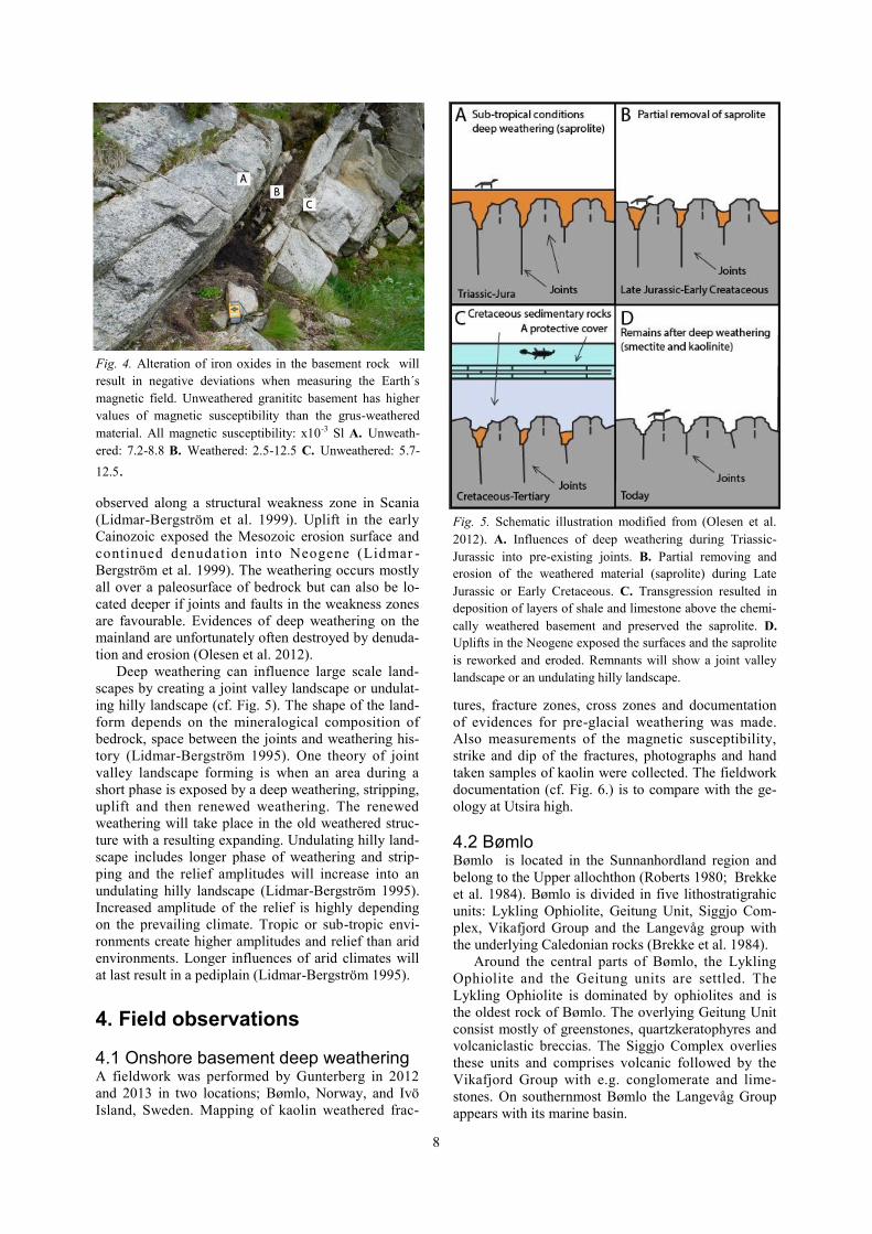
Fig. 5. Schematic illustration modified from (Olesen et al.
2012). A. Influences of deep weathering during Triassic-
Jurassic into pre-existing joints. B. Partial removing and
erosion of the weathered material (saprolite) during Late
Jurassic or Early Cretaceous. C. Transgression resulted in
deposition of layers of shale and limestone above the chemi-
cally weathered basement and preserved the saprolite. D.
Uplifts in the Neogene exposed the surfaces and the saprolite
is reworked and eroded. Remnants will show a joint valley
landscape or an undulating hilly landscape.
Fig. 4. Alteration of iron oxides in the basement rock will
result in negative deviations when measuring the Earth´s
magnetic field. Unweathered granititc basement has higher
values of magnetic susceptibility than the grus-weathered
material. All magnetic susceptibility: x10-3 Sl A. Unweath-
ered: 7.2-8.8 B. Weathered: 2.5-12.5 C. Unweathered: 5.7-
12.5.

9
Fig. 6. Field work documentation. A. and B. Large and small scale of pre-glacial weathering, Bømlo . Fractures along the gran-
ite basement with typical rounded forms. C. and D. Rounded granite affected by deep weathering along fracture zones, Bømlo .
F. and E. Granite with grus-weathering along fracture zones, Bømlo . G. Weathered granitic basement next to granitic unweath-
ered basement, Ivö Island. H. Kaolin weathered material with a slightly weathered granitic basement beneath, Ivö Island.

10
Stord Basin is located to the east of Viking Graben
in the same area where the Utsira High is situated
(Biddle & Rudolph 1988). Bømlo County lies next to
Stord County and is one of the two investigated key
areas in this study. Slagstad et al. (2011) describes in
their article geochemical similarities between the gran-
ites of the Utsira High and the granites in Sunnanhord-
land. The authors show similarities of ages, petrology
and tectonic origin between the granites of Utsira High
and the granites of Sunnanhordland. A reference to
Fossen & Austrheim dates of the north located granites
of Bømlo it shows similar ages. Other related areas
with comparing intrusions and basement onshore and
offshore are also present in Slagstad et al. (2011) arti-
cle (cf. Slagstad et al., 2011).
The northern part of Bømlo is dominated by the
Rolvsnes Granit/ Granodiorite as well as Krossnes
granites, (Fig. 7). Rolvsnes Granit/ Granodiorite are
the largest granite pluton of the Sunnanhordland bath-
oliths. Pegmatite and aplite veins are common in the
otherwise homogeneous granite. The Krossnes Gran-
ites is dated to 430 Ma (Fossen & Austrheim 1988).
These granites are related to the investigated area of
Rolvsnes granite and both are located in the north of
Bømlo (Fossen & Austrheim 1988). Deep weathering
during the Mesozoic influenced and formed some parts
of the landscape of Bømlo. Evidences of deep weath-
ering are shown in Fig. 4 A-D.
4.3 Ivö Island Remnants of Mesozoic saprolites resting on crystalline
basement of the Fennoscandian Shield can be found in
several places. Deep kaolinitic weathering is common-
ly found beneath or close to exposed Lower Jurassic
and Upper Cretaceous sediments (Lidmar-Bergström
1995). An abandoned quarry at Ivö Island, southeast-
ern Sweden (Fig. 8), shows an exhumed weathering
front capped by a kaolinitic weathering mantle. Field
work at Ivö Island was performed together with Karna
Lidmar-Bergström and Länsstyrelsen of Scania. The
close relationship between the relief of the Precambri-
an basement and the Mesozoic weathering mantle
makes the area a key locality for study of the proper-
ties of altered basement rocks (cf. 5 E-F) (Migoń &
Lidmar-Bergström 2001).
The abandoned quarry had earlier been covered
with Cretaceous limestone. Borings have shown that
the saprolite was at least 30 metres thick before quar-
rying. The saprolite can easily be seen, sometimes
Fig. 7. Map of Bømlo. Granitic basement is located north
(NGU, 2013).
Fig. 8. Map of Ivö Island, southeastern Sweden.
11
together with unweathered granite boulders, and still
some part of the limestone can be found in the hill
slopes. The weathered material dominates by kaolinite
(Migoń & Lidmar-Bergström 2001).
5. Discussion
During the Mesozoic the fractured basement at Utsira
High was exposed for chemical weathering. This cre-
ated an increased permeability in granites in which
hydrocarbons have accumulated. Rock samples de-
rived from coring show the evidence of these oil oc-
currences and make the Utsira High an important tar-
get for evaluating basement rocks as potential reser-
voir rocks. Although the area possesses the right geo-
logical conditions and possibilities for oil drilling, ad-
ditional surveys and drillings has to be carried out be-
fore the extent of the oil occurrence can be predicted.
The granites at Bømlo are related in age, petrology
and weathering with the granites at Utsira High, no oil
occurrences have been found at Bømlo. But since the
island is located on the mainland and is easily accessed
it is a high quality analog area that can be studied and
compared with Utsira High. To increase the
knowledge of the Utsira High, mapping of Bømlo is of
high value. An explanation for the absence of oil at
Bømlo can be the lack of overlying sedimentary cover
in the past. Deep weathered material has been ob-
served in several places in Scandinavia. The weathered
material can form many meters of saprolite layers with
high porosity where infiltrated oil can accumulate. As
samples from Utsira High has proved to contain oil in
weathered basement rocks it is of a significant im-
portance to understand the structure, composition, per-
meability and porosity of such material as well as the
processes that are producing saprolites. In this aspect
also Ivö Island, southeastern Sweden, is a key area. In
outcrops at Ivö Island it is possible to study the rela-
tionship between the kaolinitic saprolite and the subja-
cent, both weathered and unweathered, granitic base-
ment. The saprolite is of importance as the material
can reveal the porosity and permeability of the weath-
ered material. Different types of weathered material
have been observed in the investigated areas. Bømlo as
well as Utsira high contains grus-weathered and clay-
weathered material whereas at Ivö Island mostly clay-
bearing material occurs. Clay- and grus-weathered
material of Scandinavia has, probably, formed during
completely different periods of time. Clay-producing
weathering is interpreted as of Mesozoic age whereas
grus-weathering took place later, in the Quater-
nary(Peulvast 1985; Sorensen 1988; Lidmar -
Bergström et al. 1999). These differences in weathered
material is caused by a continued denudation in the
Neogene (Lidmar-Bergström et al. 1999). As chemical
weathering increases the size of fractures with an in-
crease permeability petroleum can occur in the weak-
ness zones. Depending on the weathered material type,
it can be positive or negative considering fluid content.
In some cases, fractured basement without connection
to deep weathering will be of a higher value since the
weathered material can act resisting of the fluid flow.
Clay-bearing material will cause fluid-resistance
whereas grus-bearing material, in return, can host con-
siderably larger amounts of fluids. Ivö Island and
Bømlo does not have favourable lithological condi-
tions (e.g. no source rock) for petroleum formation.
The absence of the right geology e.g. no potential
source rock, Ivö Island as well as Bømlo does not in-
crease petroleum remnants. The basement of the Utsi-
ra High and the basement of the Modum Complex
have similarities in basementand geological settings.
The lack of earlier studies at Utsira high concerning
downward migration makes the downward migration
at the Modum Comlex a potential comparison site. The
Modum Complex is well investigated by Munz et al.
(2002). The authors argue that the P-T-t-X is crucial
parameters concerning downward fluid flows. Higher
pressure must exist in the overlying sediments, for
example in a basin which has been affected by tectonic
compressions with resulting fractures. The similarities
are well known in both basements. Today´s growing
demand and elevated oil prices makes the Utsira High
a specific area of great interest as an alternative petro-
leum resource. Further investigations of the Utsira
High may result in a petroleum source rock with eco-
nomic purpose. Expectations of double drilling in both
sedimentary Jurassic sandstones and crystalline grus-
weathered basement in the future are also high
(Carstens 2011).
6. Conclusions
1) The economic interest for crystalline basement res-
ervoirs is more common today; basis on increasing oil
prices and pending decreases/exhausted sedimentary
reservoirs.
2) Oil occurrences in the granites at the Utsira High
lead to an analogue survey of the granites of Bømlo
and the saprolite layers at Ivö Island. Drill cores prove
that the oil is established in grus-weathered material
found in fracture zones.
3) Deep weathering in southern Scandinavia is a phe-
nomenon that occurred during the Mesozoic when the
basement was exposed. It is found in several places in
southwester Norway and southeaster Sweden.
4) Acid leaking groundwater in humid climate lead it
way through fracture zones in basement and degraded
the fresh basement rocks to saprolite. Alteration of
iron oxides will results in a negative deviation in the
Earth´s magnetic field. Mapping negative deviations
will explore current weathered fractures. Deep weath-
ering is found at Utsira High, Bømlo and Ivö Island.
5) P-T-t-X concerning downward migration is of sig-
nificant importance of fluid flows.

12
7. Acknowledgements
First of all I want to thank my extern supervisor Mats
Andersson for his engagement and helpfulness during
the entire project. Futhermore, I am grateful to my
supervisor Mikael Calner as with corrections and ad-
vices made my report complete. I will also thank Oli-
ver Björnfors for a great support for providing discus-
sions, and at last Martin Qvarström for proof-reading
parts of my thesis.
8. References
Aberg, G., Lofvendahl, R., Nord, A. G. & Holm, E.,
1985: Radionuclide mobility in thucholitic hydro-
carbons in fractured quartzite. Canadian Journal of
Earth Sciences 22, 959-967.
Arid, P. 2011. How oil drilling works. Retrieved 22
April 2011, from www.kingdomdrilling.co.uk.
Biddle, K. T. & Rudolph, K. W., 1988: Early Tertiary
structural inversion in the Stord Basin, Norwegian
North Sea. Journal of the Geological Society 145,
603-611.
Brekke, H., Furnes, H., Nordas, J. & Hertogen, J.,
1984: Lower Paleozoic convergent platemargin
volcanism on Bomlo, SW Norway, and its bearing
on the tectonic environments of the Norwegian
Caledonides. Journal of the Geological Society
141, 1015-1032.
Carstens, H. 2011. Gammelt grunnfjell - mettet med
o l j e . R e t r i e v e d 1 6 A p r i l 2 0 1 3 , f r o m
http://www.geo365.no/olje_og_gass/mettet-med-
olje/.
Curtin, D. P. & Ballestad, S., 1986: South Viking Gra-
ben; habitat of Mesozoic hydrocarbons. In: A. M.
Spencer (ed.) Habitat of hydrocarbons on the Nor-
wegian continental shelf; proceedings of an inter-
national conference. Graham & Trotman,
London, United Kingdom. 153-157 pp.
Eakin, P. A., 1989: The origin and properties of urani-
um-niobium-tantalum mineralised hydrocarbons at
Naresto, Arendal, southern Norway. Norsk Geolo-
gisk Tidsskrift 69, 29-37.
Fossen, H. & Austrheim, H., 1988: Age of the Kross-
nes Granite, West Norway. Bulletin - Norges Geol-
ogiske Undersokelse 413, 61-65.
Fossen, H. & Dunlap, J., 2006: Age constraints on the
late Caledonian (Scandian) deformation in the Ma-
jor Bergen Arc, SW Norway. Norsk Geologisk
Tidsskrift 86, 59-70.
Gee, D. G., Fossen, H., Henriksen, N. & Higgins, A.
K., 2008: From the early Paleozoic platforms of
Baltica and Laurentia to the Caledonide Orogen of
Scandinavia and Greenland. Episodes 31, 44-51.
Hurricaneenergy. 2013. How does oil get into the
basement? Retr ieved 21 May 2013, from
http://www.hurricaneenergy.com/Expertise/Whatar
ebasementreservoirs/Howdoesoilgetintothebaseme
nt/.
Isaksen, G. H. & Ledje, H. I., 2001: Source rock quali-
ty and hydrocarbon migration pathways within the
greater Utsira High area, Viking Graben, Norwe-
gian North Sea. American Association of Petrole-
um Geologists Bulletin 85, 861-883.
Karlsen, D. A., Nedkvitne, T., Larter, S. R. & Bjor-
lykke, K., 1993: Hydrocarbon composition of au-
thigenic inclusions: application to elucidation of
petroleum reservoir filling history. Geochimica et
Cosmochimica Acta 57, 3641-3659.
Labrousse, L., Hetenyi, G., Raimbourg, H., Jolivet, L.
& Andersen, T. B., 2010: Initiation of crustal scale
thrusts triggered by metamorphic reactions at
depth; insights from a comparison between the
Himalayas and Scandinavian Caledonides. Tecton-
ics 29.
Landis, C. R. & Castano, J. R., 1995: Maturation and
bulk chemical properties of a suite of solid hydro-
carbons. Organic Geochemistry 22, 137-149.
Larson, S. A., Tullborg, E.-L., Cederbom, C. &
Stiberg, J.-P., 1999: Sveconorwegian and Caledo-
nian foreland basins in the Baltic Shield revealed
by fission-track thermochronology. Terra Nova 11,
210-215.
Lidmar-Bergström, K., 1995: Relief and saprolites
through time on the Baltic Shield. Geomorphology
12, 45-61.
Lidmar-Bergström, K., 1997: A long-term perspective
on glacial erosion. Earth surface processes and
landforms 22, 297-306.
Lidmar-Bergström, K., Olsson, S. & Roaldset, E.
1999: Relief Features and Palaeoweathering Rem-
nants in Formerly Glaciated Scandinavian Base-
ment Areas. In M. Thiry & R. Simon-Coincon
(eds.): Palaeoweathering, palaeosurfaces and relat-
ed continental deposits, 275-301. Special Publica-
tion 27, International Association of Sedimentolo-
gists, Blackwell Science.
Lundmark, A. M., 2011: Zircon U-Pb LA-ICPMS age
determinations and Lu-Hf analyses of basement
granitoids, Utsira High, the North Sea.
Migoń, P. & Lidmar-Bergström, K., 2001: Weathering
mantles and their significance for geomorphologi-
cal evolution of central and northen Europe since
the Mesozoic. Earth-Science Reviews 56, 285-324.
Munz, I. A., Yardley, B. W. D. & Gleeson, S. A.,
2002: Petroleum infiltration of high-grade base-
ment, South Norway: Pressure-Temperature-time-
composition (P-T-t-X) constraints. Geofluids 2, 41-
53.
Nelson, R. A., 2001: Geologic analysis of naturally
fractured reservoirs. Gulf Publishing Co. Book
Division.
Norsk geologisk undersøkelse. 2013: NGU165706
[Map], 4845111 667671135. Berggrunn Nasjonal
b e r g g r u n n s d a t a b a s e . R e t r i v e d f r o m
http://geo.ngu.no/servlet/lagKartbilde. 1:50 000. 15
May 2013.
Olesen, O., Bering, D., Brönner, M., Dalsegg, E., Fa-
bian, K., Fredin, O., Gellein, J., Husteli, B., Mag-
13
nus, C., Rønning, S., Solbakk, T., Tønnesen, J. &
Øverland, J., 2012: Tropical Weathering In Nor-
way, TWIN Final Report.
Pedersen, J. H., 2005: Olje fra oldtiden. GEO 8, 40-42.
Peulvast, J. P., 1985: In situ weathered rocks on plat-
eaus, slopes and strandflat areas of the Lofoten-
Vesteralen, North Norway. Fennia 163, 333-340.
Roberts, D., 1980: Petrochemistry and palaeogeograp-
hic setting of the Ordovician volcanic rocks of
Smola, central Norway. Norges Geologiske Under-
sokelse 359, 43-60.
Roberts, D., 2003: The Scandinavian Caledonides:
event chronology, palaeogeographic settings and
likely, modern analogues. Tectonophysics 365,
283-299.
Salah, M. G. & Alsharhan, A. S., 1998: The Precam-
brian basement: a major reservoir in the rifted ba-
sin, Gulf of Suez. Journal of Petroleum Science
and Engineering 19, 201-222.
Slagstad, T., Davidsen, B. & Daly, J. S., 2011: Age
and composition of crystalline basement rocks on
the Norwegian continental margin: offshore extens-
ion and continuity of the Caledonian-Appalachian
orogenic belt. Journal of the Geological Society
168, 1167-1185.
Sorensen, R., 1988: In-situ rock weathering in Vest-
fold, southeastern Norway. Geografiska Annaler,
Series A 70 A, 299-308.
Stephens, M., 1988: The Scandinavian Caledonides: a
complexity of collisions. Geology Today 4, 20-26.
Welin, E., 1966: The occurrence of asphaltite and
thucholite in the Precambrian bedrock of Sweden.
Geologiska Foereningen i Stockholm Foerhand-
lingar 87, Part 4, 509-526.
Wild, J. & Briedis, N., 2010: Structural and stratigrap-
hic relationships of the Palaeocene mounds of the
Utsira High. Basin Research 22, 533-547.

14
9. Appendix
Appendix. 1. Classification of solid bitumen, based on high reflection. Modified by Landis & Castano (1995).

Tidigare skrifter i serien ”Examensarbeten i Geologi vid Lunds universitet”:
294. Flodhammar,Ingrid,2011:Lövestadsåsar:EnisälvsavlagringbildadvidinlandsisenskantiWeichselsslutskede.(15hp)
295. Liu,Tianzhuo,2012:Exploringlong-termtrendsinhypoxia(oxygendepletion)inWesternGotlandBasin, theBaltic Sea.(45hp)
296. Samer, Bou Daher, 2012: Lithofaciesanalysis and heterogeneity study ofthe subsurface Rhaetian–PliensbachiansequenceinSWSkåneandDenmark.(45hp)
297. Riebe,My, 2012: Cosmic ray tracks inchondriticmaterialwithfocusonsilicatemineralinclusionsinchromite.(45hp)
298. Hjulström,Joakim,2012:Återfyllningavborrhåligeoenergisystem:konventioner,metodochmaterial.(15hp)
299. Letellier, Mattias, 2012:A practicalassessmentoffrequencyelectromagneticinversion in a near surface geologicalenvironment.(15hp)
300. Lindenbaum,Johan,2012:IdentificationofsourcesofammoniumingroundwaterusingstablenitrogenandboronisotopesinNamDu,Hanoi.(45hp)
301. Andersson,Josefin,2012:Karaktäriseringav arsenikförorening i matjordsprofilerkringKlippansLäderfabrik.(45hp)
302. L um e t z b e r g e r , M i k a e l , 2 0 1 2 :Hyd rogeo l og i s k k a r t l ä ggn i ng avinf i l t ra t ionsvat ten t ranspor t genomresistivitetsmätningar.(15hp)
303. Martin, Ellinor, 2012: Fossil pigmentsandpigmentorganelles–colourationindeeptime.(15hp)
304. Rådman,Johan,2012:Sällsyntajordarts-metalleritungsandvidHavängpåÖsterlen.(15hp)
305. Karlstedt, Filippa, 2012: JämförandegeokemiskstudiemedportabelXRFavobehandladeochsågadeytor,samtpulveravKarlshamnsdiabas.(15hp)
306. Lundberg,Frans,2012:DensenkambriskaalunskifferniVästergötland–utbredning,mäktigheterochfaciestyper.(15hp)
307. T h u l i n O l a n d e r , H e n r i c , 2 0 1 2 :Hydrogeologisk kartering av grund-vattenmagasinetEkenäs-Kvarndammen,Jönköpingslän.(15hp)
308. Demirer,Kursad,2012:U-PbbaddeleyiteagesfrommaficdykeswarmsinDharwarcraton, India – l inks to an ancientsupercontinent.(45hp)
309. Leskelä, Jari , 2012: Loggning ochåterfyllningavborrhål–Praktiskaförsökoch utveckling av täthetskontroll i fält.(15hp)
310. Eriksson,Magnus, 2012: Stratigraphy,facies and depositional history of theColonusShaleTrough,Skåne, southernSweden.(45hp)
311. Larsson, Amie, 2012: Kartläggning,beskrivning och analys avKalmar länsregionaltviktigavattenresurser.(15hp)
312. Olsson,Håkan, 2012: Prediction of thedegreeofthermalbreakdownoflimestone:A case study of the Upper OrdovicianBodaLimestone,Siljandistrict, centralSweden.(45hp)
313. Kampmann,TobiasChristoph,2012:U-Pbgeochronology and paleomagnetism oftheWesterberg sill, Kaapvaal Craton –supportforacoherentKaapvaal-Pilbarablock(Vaalbara).(45hp)
314. Eliasson,IsabelleTimms,2012:Arsenik:förekomst,miljö och hälsoeffekter. (15hp)
315. Badawy,AhmedSalah,2012:Sequencestratigraphy,palynologyandbiostratigraphyacrosstheOrdovician-SilurianboundaryintheRöstånga-1core,southernSweden.(45hp)
316. Knut,Anna, 2012: Resistivitets- ochIP-mätningar på Flishultsdeponin förlokaliseringavgrundvattenytor.(15hp)
317. Nylén,Fredrik,2012:Förädlingavballast-materialmedhydrocyklon,ettfungerandealternativ?(15hp)
318. Younes, Hani, 2012: Carbon isotopechemostratigraphy of the Late SilurianLauEvent,Gotland,Sweden.(45hp)
319. Weibull,David,2012:SubsurfacegeologicalsettingintheSkagerrakarea–suitabilityforstorageofcarbondioxide.(15hp)
320. Petersson,Albin, 2012: Förutsättningarför geoenergi till idrottsanläggningari Kallerstad, Linköpings kommun: Enförstudie.(15hp)
321. Axbom, Jonna, 2012: Klimatets ochmänniskansinverkanpåtallensetableringpå sydsvenskamossarunderde senasteårhundradena–endendrokronologiskochtorvstratigrafiskanalysavtresmåländskamossar.(15hp)
Geologiska institutionenLunds universitet
Sölvegatan 12, 223 62 Lund
322. Kumar, Pardeep, 2012: Palynologicalinvestigationofcoal-bearingdepositsoftheTharCoalFieldSindh,Pakistan.(45hp)
323. Gabrielsson, Johan, 2012: Havsisen iarktiskabassängen–nutidochframtidiettglobaltuppvärmningsperspektiv.(15hp)
324. Lundgren,Linda,2012:VariationinrockqualitybetweenmetamorphicdomainsinthelowerlevelsoftheEasternSegment,SveconorwegianProvince.(45hp)
325. Härling,Jesper,2012:Thefossilwondersof the Silurian Eramosa Lagerstätte ofCanada:thejawedpolychaetefaunas.(15hp)
326. Qvarnström,Martin,2012:Aninterpretationofoncoidmass-occurrenceduringtheLateSilurianLauEvent,Gotland,Sweden.(15hp)
327. Ulmius, Jan, 2013: P-T evolution ofparagneisses and amphibolites fromRomeleåsen,Scania,southernmostSweden.(45hp)
328. HultinEriksson,Elin,2013:Resistivitets-mätningar för avgränsning av lak-vattenplym från Kejsarkullens deponisinfiltrationsområde.(15hp)
329. MozafariAmiri, Nasim, 2013: Fieldrelations, petrography and 40Ar/39Arcoolingagesofhornblendeinapartoftheeclogite-bearingdomain,SveconorwegianOrogen.(45hp)
330. Saeed,Muhammad,2013:SedimentologyandpalynofaciesanalysisofJurassicrocksEriksdal,Skåne,Sweden.(45hp)
331. Khan,Mansoor,2013:RelationbetweensedimentfluxvariationandlandusepatternsalongtheSwedishBalticSeacoast.(45hp)
332. Bernhardson,Martin,2013:Iceadvance-retreat sediment successions along theLogataRiver,TaymyrPeninsula,ArcticSiberia.(45hp)
333. Shrestha, Rajendra, 2013: OpticallyStimulatedLuminescence (OSL)dating
of aeolian sediments of Skåne, southSweden.(45hp)
334. Fullerton,Wayne,2013:TheKalgoorlieGold:A review of factors of formationforagiantgolddeposit.(15hp)
335. Hansson,Anton,2013:Adendroclimaticstudy at StoreMosse, South Sweden –climaticandhydrologicimpactsonrecentScots Pine (Pinus sylvestris) growthdynamics.(45hp)
336. Nilsson,Lawrence,2013:Thealterationmineralogy of Svartliden, Sweden. (30hp)
337. Bou-Rabee,Donna,2013:InvestigationsofastalactitefromAlHotacaveinOmanand its implications for palaeoclimaticreconstructions.(45hp)
338. Florén,Sara,2013:GeologiskguidetillSöderåsen – 17 geologiskt intressantaplatserattbesöka.(15hp)
339. Kullberg,Sara,2013:Asbestkontaminationav dricksvatten och associerade risker.(15hp)
340. Kih lén , Robin , 2013 : Geofys i skaresistivitetsmätingar i Sjöcrona Park,Helsingborg,undersökningavområdetsgeologiskaegenskapersamt3DmodelleringiGeoScene3D.(15hp)
341. Linders,Wictor, 2013: Geofysiska IP-undersökningar och 3D-modellering avgeofysiska samt geotekniska resultat iGeoScene3D,SjöcronaPark,Helsingborg,Sverige.(15hp)
342. Sidenmark,Jessica,2013:AreconnaissancestudyofRävlidenVHMS-deposit,northernSweden.(15hp)
343. Adamsson,Linda,2013:PeatstratigraphicalstudyofhydrologicalconditionsatStassMosse,southernSweden,andtherelationtoHolocenebog-pinegrowth.(45hp)
344. Gunterberg,Linnéa,2013:Oiloccurrencesin crystalline basement rocks, southernNorway – comparison with deeplyweathered basement rocks in southernSweden.(15hp)