oil spill contingency plan 2021
TRANSCRIPT

1 | P a g e U N C O N T R O L L E D W H E N P R I N T E D
Oil Spill Contingency Plan 2021
For amendments/updates, please contact:
Harbour Master Associated British Ports Southampton
Ocean Gate Atlantic Way Southampton SO14 3QN
Tel: 02380 488800
Date of Issue: August 2021

2 | P a g e U N C O N T R O L L E D W H E N P R I N T E D
Document Control Information
Policy Information
Document Number 1.0
Business Area Port of Southampton
Document Title Oil Spill Contingency Plan 2021
Version 1
Author(s) Caitlin Lewis
Approver(s) Steven Masters
Review/Approval History
Version Date Reason for Update Updated by Signed Off by
Accountable Owner
The Accountable Owner for this Policy.
Accountable Owner Title Geographical Location
Steven Masters Harbour Master Port of Southampton
Effective Date 12th August 2021
Review Date 11th August 2026

3 | P a g e U N C O N T R O L L E D W H E N P R I N T E D
Contents Revision Procedure ....................................................................................................................................................................... 6
Glossary ......................................................................................................................................................................................... 7
1.1 Statutory Requirement ................................................................................................................................................................................... 9
1.2 Purpose of the Plan ......................................................................................................................................................................................... 9
1.3 Scope of Plan.................................................................................................................................................................................................. 10
Figure 1.1 ................................................................................................................................................................................................................ 11
1.4 Interfacing Oil Spill Contingency Plans ................................................................................................................................................. 12
1.4.1 Oil Company and Local Installation Plans ................................................................................................................................... 12
1.4.2 Local Authority Plans .......................................................................................................................................................................... 13
1.4.3 Adjacent Harbour Authority Oil Spill Plans ................................................................................................................................. 13
1.4.4 Marinas within the Port Area ............................................................................................................................................................ 13
1.4.5 National Contingency Plan (NCP) ................................................................................................................................................... 14
1.4.6 The SOLFIRE Plan ................................................................................................................................................................................ 14
1.5 Consultation .................................................................................................................................................................................................... 15
1.6 Risk Assessment ........................................................................................................................................................................................... 15
Figure 1.2 Interfacing Oil Spill Contingency Plan ........................................................................................................................................... 17
1.7 Classification of Oil Spills .......................................................................................................................................................................... 18
1.8 Tidal Movement of Oil on Southampton Water .................................................................................................................................... 18
Figure 1.3 Southampton Tidal Curves ........................................................................................................................................................... 19
Appendix 1a Fawley Marine Terminal and BP Hamble Terminal Areas of Responsibility .................................................................... 20
Appendix 1b Port of Marchwood, Area of Responsibility ............................................................................................................................ 22
2. Incident Response Organisation ............................................................................................................................................ 23
2.1 Harbour Master .............................................................................................................................................................................................. 23
2.2 Oil Spill Management Team (OMT) .......................................................................................................................................................... 23
2.3 Protracted Incidents ..................................................................................................................................................................................... 23
2.4 Tier 1 Incident ................................................................................................................................................................................................. 24
2.4.1 Oil Terminals and Local Installations ............................................................................................................................................ 24
2.4.2 All Other Harbour Areas including Dock Complexes ............................................................................................................... 24
2.5 Tier 2 Incidents ............................................................................................................................................................................................... 24
Figure 2.1 Normal Organisational Structure ............................................................................................................................................ 25
2.6 Tier 3 Incident ................................................................................................................................................................................................. 25
2.7 Tactical Coordinating Group (TCG) and Strategic Coordinating Group (SCG) ........................................................................ 26
2.8 Environment Group ...................................................................................................................................................................................... 26
2.9 Simultaneous Oil Spills ............................................................................................................................................................................... 27
2.10 Response Specific to Fawley Marine Terminal (FMT) ..................................................................................................................... 27
2.10.1 Specific to Fawley Marine Terminal. ............................................................................................................................................ 27
2.10.2 Harbour Master ................................................................................................................................................................................... 28
2.10.3 Oil Spill Management Team (OMT) for Fawley based Incidents ......................................................................................... 29
2.10.4 Tier 1 Incidents ................................................................................................................................................................................... 30
2.10.5 Tier 2 Incidents ................................................................................................................................................................................... 30
2.10.6 Tier 2A Incident ................................................................................................................................................................................... 30
2.10.7 Tier 2B Incident ................................................................................................................................................................................... 31
2.10.8 Tier 3 Incident ...................................................................................................................................................................................... 31
2.10.9 Tier 2A Response – Organisational Chart .................................................................................................................................. 33

4 | P a g e U N C O N T R O L L E D W H E N P R I N T E D
2.10.10 Tier 2B Response – Organisational Chart ............................................................................................................................... 34
2.10.11 Oil Spill Reporting Form ................................................................................................................................................................ 35
2.10.12 Oil Spill Progress Report for FMT .............................................................................................................................................. 35
2.10.13 Fawley Control of Major Hazards (COMAH) ............................................................................................................................ 35
3. Reporting Procedures ............................................................................................................................................................. 36
3.1 Use of Section ................................................................................................................................................................................................ 36
3.2 Prevention of Oil Pollution Acts 1971 & 1986 ...................................................................................................................................... 36
3.3 Notification Matrices .................................................................................................................................................................................... 36
Appendix 3A: Regulation Extract .............................................................................................................................................................. 37
Appendix 3B - Guidelines to Information Required by MMO in Considering Request for Dispersant Spraying Approval........ 38
4. Action Sheets ........................................................................................................................................................................... 39
4.1 Oil Spill Incident Checklist ......................................................................................................................................................................... 39
Appendix 4A: Adler and Allan Activation and Notification Procedure ....................................................................................................... 40
Appendix 4B Contact Checklist ......................................................................................................................................................................... 41
5. Response Guide....................................................................................................................................................................... 42
5.1 Natural England Recommendations on Response Guidelines ...................................................................................................... 42
5.2 Oil Sampling .................................................................................................................................................................................................... 43
Table 5.1 Sites of Special Interest (SSSI’s) within Harbour Areas .............................................................................................................. 43
Figure 5.1 Light Oil Response Strategy Guideline .................................................................................................................................... 44
Figure 5.2 Medium Oil Response Strategy Guideline.................................................................................................................................... 45
Figure 5.3 Heavy Oil Response Strategy Guideline ...................................................................................................................................... 46
Appendix 5A STOp Notices ................................................................................................................................................................................ 47
6. Communications/Public Relations Plan ................................................................................................................................. 48
6.1 Communications Plan.................................................................................................................................................................................. 48
6.2 Public Relations Plan ................................................................................................................................................................................... 48
6.2.1 Media Release Procedure .................................................................................................................................................................. 49
7. Health and Safety Plan ............................................................................................................................................................ 50
7.1 Legislative Requirements ........................................................................................................................................................................... 50
7.1.1 Employers Duties ................................................................................................................................................................................. 50
7.1.2 Employees Duties................................................................................................................................................................................. 51
7.2 Site Hazards .................................................................................................................................................................................................... 51
7.2.1 Bird Handling ......................................................................................................................................................................................... 51
7.2.2 Boat Safety ............................................................................................................................................................................................. 52
7.2.3 Chemical Hazards................................................................................................................................................................................. 52
7.2.4 Cold Stress ............................................................................................................................................................................................. 53
Figure 7.1 Wind Chill Chart .......................................................................................................................................................................... 53
7.2.5 Drum Handling/Manual Handling .................................................................................................................................................... 53
7.2.6 Equipment Operations ........................................................................................................................................................................ 54
7.2.7 Electrical Hazards................................................................................................................................................................................. 54
7.2.8 Fatigue ..................................................................................................................................................................................................... 54
7.2.9 Fire, Explosion and In-Situ Burning ............................................................................................................................................... 54
7.2.10 Heat Stress ........................................................................................................................................................................................... 55
Figure 7.2 Heat Index Chart ......................................................................................................................................................................... 55
7.2.11 Helicopter Operations ....................................................................................................................................................................... 56
7.2.12 Crane Operations ............................................................................................................................................................................... 56

5 | P a g e U N C O N T R O L L E D W H E N P R I N T E D
7.2.13 Motor Vehicles .................................................................................................................................................................................... 56
7.2.14 Noise ...................................................................................................................................................................................................... 56
7.2.15 Overhead and Buried Utilities ........................................................................................................................................................ 57
7.2.16 Pumps and Hoses .............................................................................................................................................................................. 57
7.2.17 Slips, Trips and Falls......................................................................................................................................................................... 57
8. General Waste Management Plan ........................................................................................................................................... 58
8.2 Waste Management Strategy ..................................................................................................................................................................... 58
8.3 Duty of Care .................................................................................................................................................................................................... 58
8.4 Duty of Care – Hazardous Waste ............................................................................................................................................................. 59
8.5 Waste Arising ................................................................................................................................................................................................. 59
8.6 Records ............................................................................................................................................................................................................ 61
8.7 Temporary Storage ....................................................................................................................................................................................... 61
8.7.1 Oiled Waste ............................................................................................................................................................................................ 61
8.8 Oiled Birds and Wildlife ............................................................................................................................................................................... 62
Figure 8.1 – Oiled Waste Temporary Storage Areas ................................................................................................................................. 63
8.9 Waste Oil Recovery and Disposal............................................................................................................................................................ 64
8.9.1 Minimizing Waste ................................................................................................................................................................................. 64
8.9.2 Local Licensed Waste Disposal Contractors .............................................................................................................................. 64
8.10 Recovery and Disposal Methods ........................................................................................................................................................... 65
8.11 Considerations regarding waste management issues ................................................................................................................... 66
Appendix 8A – STOp Notice 3/2016 Guidance for Waste Management ............................................................................................. 66
9. Training and Exercise Policy .................................................................................................................................................. 67
9.1 Post Incident and Post Exercise Evaluation Reports ........................................................................................................................ 67
Appendix 9A – Training Policy Table ............................................................................................................................................................ 68
Appendix 9B - Exercise Policy Table ............................................................................................................................................................. 68
10. Risk Assessment ................................................................................................................................................................... 69
10.1 Port Operations ........................................................................................................................................................................................... 70
10.1.1 Pilotage .................................................................................................................................................................................................. 70
10.1.2 Vessel Traffic Service (VTS) ........................................................................................................................................................... 70
10.1.3 Thorn Channel ..................................................................................................................................................................................... 70
10.1.4 Main Channel ....................................................................................................................................................................................... 71
10.1.5 Collision between Vessels Underway ......................................................................................................................................... 71
10.1.6 Tug Impact ............................................................................................................................................................................................ 71
10.1.7 Berthing Incident ................................................................................................................................................................................ 72
10.2 Oil Transfer Options ................................................................................................................................................................................... 72
10.3 Pipelines ........................................................................................................................................................................................................ 72
10.4 Bunkering and Bulk Liquids Transfer Operations ........................................................................................................................... 73
10.5 Effluent Discharges to Harbour Waters ............................................................................................................................................... 73
10.6 Miscellaneous Spill Sources ................................................................................................................................................................... 73
10.7 Place of Refuge ............................................................................................................................................................................................ 74
Appendix 10A Storm Water Outfalls .............................................................................................................................................................. 75
Appendix 10B – Table of Incidents Recorded at Southampton 2010-2020 ....................................................................................... 77
11. Sensitivity Maps and Environmental Information ................................................................................................................ 78
11.1 Priority Sensitive Areas ............................................................................................................................................................................ 78
11.1.1 Site Specific Priority Sensitive Areas .......................................................................................................................................... 78

6 | P a g e U N C O N T R O L L E D W H E N P R I N T E D
11.2 Priority Protection Areas .......................................................................................................................................................................... 80
Table 11.2 Vulnerability of Shoreline Habitats and their general physical and biological characteristics ...................................... 80
11.3 Port of Southampton Coastline .............................................................................................................................................................. 81
11.3.1 Lepe to Calshot ................................................................................................................................................................................... 81
11.3.2 Calshot Spit to Ashlett Creek ......................................................................................................................................................... 81
11.3.3 Ashlett Creek to Esso Outfall 1 ..................................................................................................................................................... 82
11.3.4 Esso Outfall 1 to Hythe Park Marina ............................................................................................................................................ 82
11.3.5 Hythe Marine Park to SGL, Marchwood. ..................................................................................................................................... 82
11.3.6 Port of Marchwood to Bury Creek ................................................................................................................................................ 83
11.3.7 Bury Creek to Eling and Redbridge Causeway ........................................................................................................................ 83
11.3.8 Southampton Docks SCT1 to 30 Berth ....................................................................................................................................... 83
11.3.9 River Itchen, 30 berth to Woodmill ............................................................................................................................................... 84
11.3.10 Mouth of River Itchen, Woolston to River Hamble (West Bank) ....................................................................................... 84
11.3.11 River Hamble (West Bank) to Hillhead ...................................................................................................................................... 84
11.3.12 Hillhead to Lee-on-Solent .............................................................................................................................................................. 85
11.4.12 Solent and Dorset Coast SPA ...................................................................................................................................................... 85
11.4.13 Yarmouth to Cowes Marine Conservation Zone .................................................................................................................... 85
12. Roles and Responsibilities .................................................................................................................................................... 86
12.1 Harbour Authority ....................................................................................................................................................................................... 86
12.2 Local Authorities ......................................................................................................................................................................................... 86
12.2.1 District Councils & Borough Councils ........................................................................................................................................ 86
12.2.2 County Council and Unitary Authorities ..................................................................................................................................... 86
12.3 Maritime and Coastguard Agency ......................................................................................................................................................... 86
12.4 Marine Management Organisation ........................................................................................................................................................ 87
12.5 Natural England ........................................................................................................................................................................................... 87
12.6 Environment Agency ................................................................................................................................................................................. 87
12.8 Oil Spill Management Team ..................................................................................................................................................................... 88
12.9 Marine Response Centre .......................................................................................................................................................................... 88
13 Resource Directory ................................................................................................................................................................. 88
14. Product Information ............................................................................................................................................................... 90
15. Contact Information ............................................................................................................................................................... 90
Revision Procedure This plan will be reviewed annually and if required updated; such revisions/updates will take
account of experience gained from exercises and/or actual spill incidents, changes in risk or port
operations or legislation.
A formal review of the plan will be conducted at 5 yearly intervals and the plan re-submitted for
approval.
7 | P a g e U N C O N T R O L L E D W H E N P R I N T E D
Glossary ABP ASSOCIATED BRITISH PORTS
AHM (VTS) Assistant Harbour Master (VTS) BP British Petroleum CCA Civil Contingencies Act CCTV Closed Circuit Television CEFAS Centre for Environment, Fisheries and Aquaculture Science COMAH Control of Major Accident Hazards COPO County Oil Pollution Office COSHH Control of Substances Hazardous to Health CPSO Counter Pollution and Salvage Officer DFT Department for Transport DEFRA Department for Environment, Food and Rural Affairs DHM Deputy Harbour Master EA Environment Agency EG Environment Group ELO Environment Liaison Officer FEPA Food and Environmental Protection Act FMT Fawley Marine Terminal HCC Hampshire County Council HM Harbour Master HMCG Her Majesty’s Coast Guard HQ Headquarters HW High Water ITOPF International Tanker Owners Pollution Federation JNCC Joint Nature Conservation Committee JRCC Joint Rescue Coordination Centre LNR Local Nature Reserve LOPO Local Oil Pollution Officer LRF Local Resilience Forum LW Low Water MCA Maritime and Coastguard Agency MCC Marine Control Centre MMO Marine Management Organisation MOU Memorandum of Understanding MOD Ministry of Defence MPZ Moving Prohibited Zone MRC Marine Response Centre MSDS Material Safety Data Sheet NCP National Contingency Plan NE Natural England NGO Non-Governmental Organisation NT National Trust OMT Oil Spill Management Team OSRL Oil Spill Response Limited P&I Protection and Indemnity (Insurance) PHE Public Health England POLREP Pollution Report PSP Perenco Purbeck-Southampton Pipeline QHM Queens Harbour Master (Portsmouth) RO-RO Roll-on Roll-off vessel RSPB Royal Society for the Protection of Birds RSPCA Royal Society for the Prevention of Cruelty to Animals SAC Special Area of Conservation (EU Habitats Directive) SCAT Shoreline Clean up Assessment Team SCG Strategic Coordinating Group SCU Salvage Control Unit SEG Solent Environmental Group SGL Solent Gateway Limited

8 | P a g e U N C O N T R O L L E D W H E N P R I N T E D
SITREP Situation Report SMC Sea Mounting Centre (Ministry of Defence, Marchwood) SOSREP Secretary of States’ Representative SPA Special Protection Area SPMUG Southampton Port Marine Users Group SSSI Site of Special Scientific Interest STOP NOTICE Scientific, Technical and Operational Advice Notice TCG Tactical Coordinating Group TPH Tonnes Per Hour VLCC Very Large Crude Carrier VTS Vessel Traffic Services

9 | P a g e U N C O N T R O L L E D W H E N P R I N T E D
1. Introduction
1.1 Statutory Requirement
This Oil Spill Contingency Plan has been developed to conform with the Merchant
Shipping (Oil Pollution Preparedness, Response and Co-operation Convention)
Regulations 1998, No. SI 1056 (with amendment SI No 1639 of 2001), which entered
effect on 15 May 1998. The plan is designed to meet the statutory responsibilities
placed on the Harbour Authority for responding to oil pollution within the harbour area.
1.2 Purpose of the Plan
The plan is provided to assist the Harbour Authority and other relevant organisations
in dealing with an accidental discharge of oil or, indeed, other polluting substances.
Its primary purpose is to set in motion the necessary actions to stop or minimise the
discharge and to mitigate its effects. Effective planning ensures that the necessary
actions are taken in a structured, logical and timely manner.
This plan guides the Harbour Master and his Duty Officers through the decisions
which will be required in an incident response. The tables, figures and checklists
provide a visible form of information, thus reducing the chance of oversight or error
during the early stages of dealing with an emergency.
For the plan to be effective, it must be:
• familiar to those with key response functions in the Port;
• regularly exercised; and,
• reviewed and updated on a regular basis.
This plan uses a tiered response to oil pollution incidents. The plan is designed to
deal with Tier 1 and Tier 2 incidents, and to provide guidance for the initial response
to a Tier 3 incident. Where a spillage is associated with a wider emergency, then
additional factors involving the safety of personnel will take precedence over the
pollution response. In this case, reference must be made to the Solent and
Southampton Water Emergency Response Plan (SOLFIRE). The salvage and
casualty management of any vessel, which poses a threat of pollution, are priority
considerations.
During oil spill response, an activities account must be taken of the following:
• site hazard information
• adherence to permit procedures
• spill site pre-entry briefing
• boat safety
• COSHH Regulations and material safety data sheets
• personal protective equipment needs
• heat stress, cold stress and hypothermia
• decontamination
• environmental sensitivities
• record keeping
• public relations
• waste disposal

10 | P a g e U N C O N T R O L L E D W H E N P R I N T E D
1.3 Scope of Plan
The plan details the contingency arrangements for responding to actual or threatened
oil pollution incidents within the statutory limits of the Port of Southampton. The Port
extends from its northern limit (Redbridge Causeway on the River Test and Woodmill
on the River ltchen) to a line between Egypt Point and Stansore Point (south western
limit) and to a line between Hillhead and Old Castle Point (eastern limit). The eastern
limit of the Port of Southampton represents the western limit of the Dockyard Port of
Portsmouth. The northern limit of Cowes Harbour is also the southern limit of the Port
of Southampton. The statutory port area is shown in Figure 1.1
The response strategy has been developed considering the spill risks and possible
sources of spillage associated with the port's operations, including those at the Esso
Fawley Jetty and Refinery, the BP Hamble Jetty and Perenco Purbeck - Southampton
Pipeline from Wytch Farm, the Solent Gateway, Marchwood and other marine
facilities within the Port. The plan consists of three important elements:
Element 1: Strategy Plan
This describes statutory requirements and the purpose and scope of the plan, including
its geographical coverage. It shows the relationship of the plan to the National
Contingency Plan for Marine Pollution from Shipping and Offshore Installations (NCP)
and plans of local organisations. Also included are perceived risks, and the Incident
Response Organisation and responsibilities of individuals for defined categories of
spill.
Element 2: Action Plan
This sets out the emergency procedures that will allow rapid mobilisation of resources and an early response to the situation.
Element 3: Data Directory
This contains all supplementary information relevant to the performance of the plan
such as; Contact Directory, Training and Exercise Policy, Risk Assessment,
Sensitivity maps, Roles and Responsibilities of Government and Other Agencies,
Resources Directory and Product Information Sheets.

11 | P a g e U N C O N T R O L L E D W H E N P R I N T E D
Figure 1.1
12 | P a g e U N C O N T R O L L E D W H E N P R I N T E D
1.4 Interfacing Oil Spill Contingency Plans
See Figure 1.2 below
1.4.1 Oil Company and Local Installation Plans
See Figure 1.2 and Appendices 1a and 1b BP Oil UK operates an oil installation at Hamble, importing ground fuels and
exporting crude oil. BP has published a contingency plan which details its
response to Tier 1 incidents at the Hamble site. BP will initiate the appropriate first
response actions in the event of an oil spill at their installation: these will include
immediately informing the Harbour Master via the Duty Assistant Harbour Master
(VTS) who will activate the appropriate notification procedure. BP will either
complete the clean-up to the satisfaction of the Harbour Master, or in the event of
larger spills, will deploy their resources as directed by the Oil Spill Management
Team (OMT) convened at Southampton VTS Marine Response Centre.
Perenco Wytch Farm (PWF) exports Wytch Farm crude oil to the Hamble Oil
Terminal. Perenco has published a Contingency Plan which details its response
to Tier 1 to Tier 3 incidents from its well sites / flow line / gathering station / pipeline
operation. This plan interfaces with the Hamble Terminal OSC Plan, Fawley MT
OSC plan (for the pipeline section through Esso Fawley Refinery) and ABP
Southampton's OSC Plan (for the pipeline under Southampton Water). Perenco
will initiate the appropriate initial response actions via its Gathering Station Central
Control Room (GSCCR), which will include informing the Harbour Master, via the
Duty Assistant Harbour Master (VTS), who will activate the appropriate notification
procedure. Perenco will either complete the clean up to the Harbour Master's
satisfaction or will deploy its resources as directed by the OMT convened at
Southampton VTS.
Esso Petroleum Company has individually published a contingency plan which
details its response to Tier 1 and Tier 2 incidents at the Fawley site. Esso will
initiate the appropriate first response actions in the event of an oil spill at their
installation: these will include immediately informing the Harbour Master via the
Duty Assistant Harbour Master (VTS) who will activate the appropriate notification
procedure. Esso will either complete the clean-up to the satisfaction of the Harbour
Master, or in the event of larger spills, will deploy their resources as directed by
the Oil Spill Management Team (OMT) convened at Southampton VTS, or at the
Esso Site.
Solent Gateway Limited, Marchwood and the SMC, Marchwood have also maintained their own plans for response to spill incidents at Tier 1, 2 and 3 levels. SGL and SMC will initiate the appropriate response in each case, including immediately notifying the Harbour Master via the Duty Assistant Harbour Master (VTS), for activation of the appropriate Port response, and activating call out of their respective Emergency Spillage Response Contractors. Again, Solent Gateway will either complete the clean-up to the satisfaction of the Harbour Master, or in the event of larger spills, will deploy its resources as directed by the Oil Spill Management Team (OMT) convened at the Southampton VTS. The latest version of SGL and SMC spill response Plans can be obtained by contacting SGL Marchwood directly. Copies of the Esso, SMC, Marchwood and Solent Gateway Limited plans are available on the Southampton VTS website. The SGL and SMC Oil Spill plans are
13 | P a g e U N C O N T R O L L E D W H E N P R I N T E D
currently under review and will be published as soon as available http://www.southamptonvts.co.uk/Port_Information/Emergency_Planning/Oil_Spill_Contingency/
1.4.2 Local Authority Plans
In the event of actual or threatened shoreline impact, the appropriate unitary,
district or county authority plan(s) will be implemented. The level of activation will
be dictated by the incident classification (refer to Section 1.7).
The interfacing plans are:
In addition, where there is a possibility that oil may impact on the northern
shoreline of the Isle of Wight there will be close liaison with the Isle of Wight
Council and an interface with the Isle of Wight Council's Marine Pollution
Response Plan and Cowes Oil Spill Response Plan.
1.4.3 Adjacent Harbour Authority Oil Spill Plans
The western limit of the Dockyard Port of Portsmouth also represents the eastern
limit of the Port of Southampton. There are similar boundaries between
Southampton and the Hamble River and Southampton and Cowes Harbour.
Where the possibility exists that spilled oil may migrate to, or from, adjacent
harbour areas, close liaison will be maintained between the Harbour Authorities.
While each Harbour will activate its own oil spill contingency plan for oil on its
water, Southampton will act in support of the response for a spill that has
originated in an adjacent harbour. Where a spill that has originated in the
Southampton area threatens an adjacent harbour a representative of that harbour
will be invited to attend the Oil Spill Management Team (OMT) at Southampton
VTS (MRC).
1.4.4 Marinas within the Port Area
The Port has several large yacht marinas within it, such as Hythe Marina Village,
Ocean Village Marina, Shamrock Quay, Saxon Wharf and Town Quay. All have
spill plans, assets and training levels commensurate with their activities. Marina
Developments Limited (owner of the 4 first named marinas) has Tier 1 and 2
contracts with Cleansing Service Group (CSG) and spill bags and salvage pumps
available at their sites. Town Quay is an ABP marina and has trained staff and
No. Owner Title
1. Hampshire County Council Coastal Pollution Plan
2. Southampton City Council Southampton and Portsmouth City Council Coastal Pollution plan
3. Eastleigh Borough Council Oil and Chemical Pollution Plan
4. New Forest District Council Oil and Chemical Pollution Plan
5. Fareham Borough Council Emergency Response Plan
6. River Hamble Harbour Authority Oil Spill Contingency Plan
14 | P a g e U N C O N T R O L L E D W H E N P R I N T E D
suitable equipment for immediate response and access to ABP's Tier 2 contract
with Adler & Allan.
1.4.5 National Contingency Plan (NCP)
In the event of a large oil spill incident which calls for national resources to be
deployed, a Tier 3 response, the Maritime and Coastguard Agency may decide to
establish a Marine Response Centre (MRC) to contain, disperse and remove
potential pollutants from the scene. This MRC will be established at the most
appropriate location, which may be at Southampton VTS, MCA headquarters in
Southampton or at the National Maritime Operations Centre (NMOC) at Fareham.
During a shipping incident, The Secretary of States' Representative (SOSREP)
will monitor and tacitly approve response actions and proposals. SOSREP role
was created as part of the Government's response to Lord Donaldson's Review
of Salvage and Intervention and their command and control. SOSREP will
oversee, control and, if necessary, intervene and exercise 'ultimate command and
control' acting in the over-riding interest of the UK in salvage operations within UK
waters, involving vessels when there is a significant risk of pollution.
In certain circumstances, SOSREP is empowered to establish a Salvage Control
Unit (SCU) and to take over command of all operations. Should this situation
arise, there will be a formal hand-over of responsibility for dealing with the incident
and the Port's oil spill response resources and facilities will be made available to
SOSREP.
The SCU's primary role is to monitor salvage operations and actions that are being
taken and/or proposed relating to salvage activity and to ensure that such actions
do not have an adverse effect on safety or on the environment. The SOSREP
determines the requirement for an SCU taking into consideration the nature and
scale of the incident. It will operate close to the incident site, at an appropriate
location, as suggested above.
ABP Southampton's offices and all facilities would be made available to SOSREP
in such circumstances.
When pollution threatens the shoreline, a Tactical Co-ordinating Group (TCG) and
Strategic Co-ordinating Group (SCG) will be established and will exercise overall
co-ordination of the shoreline clean-up in accordance with the procedures and
guidance given in the National Contingency Plan. The appropriate members of the
Port's Oil Spill Management Team will re-deploy to the TCG / SCG and/or the MCA
MRC as required (See Sections 2.5 & 2.6)
In the event of a major spill, an environmental group including representatives
from MMO, Environment Agency, Natural England and local councils will be set
up to coordinate the appropriate response. The Standing Environment Group
(SEG) for the Solent covers an area stretching from Selsey Bill to the Dorset.
Hampshire boarder. More details on this can be found here.
1.4.6 The SOLFIRE Plan
SOLFIRE is a contingency plan developed to deal with any marine emergency or non-routine incident occurring within the Dockyard Port of Portsmouth, the Port of Southampton and Cowes Harbour Areas of Responsibility. This area is known as

15 | P a g e U N C O N T R O L L E D W H E N P R I N T E D
the SOLFIRE Area.
For the purposes of the plan "marine emergency or non-routine incident" includes all forms of marine related security, counter terrorist and environmental emergencies involving vessels underway or at anchor in the SOLFIRE Area.
The SOLFIRE Plan has been produced jointly by the Harbour Authorities of ABP Southampton, QHM Portsmouth and Cowes Harbour Commission, in consultation and agreement with the Maritime and Coastguard Agency, other emergency services and relevant local authorities. The Plan considers The National Contingency Plan, the Home Office crisis management model and responsibilities for firefighting at sea.
This plan is intended to provide the command, control and communications structure to draw together and co-ordinate adequate resources to deal with any marine emergency occurring within the SOLFIRE Area. It is interfaced with and may be supplemented by other contingency and action plans held by the emergency services, local authorities, commercial facilities and marine related companies, which will be activated as necessary in response to an incident. The SOLFIRE Plan is available at: http://www.southamptonvts.co.uk/Port_Information/Emergency_Planning/Solfire/ NB: August 2021 – The SOLFIRE plan is currently under review and this section will be updated when the review is completed. In the meantime, the current SOLFIRE plan remains valid.
1.5 Consultation
The following authorities and organisations have been formally consulted during the
preparation of this plan:
• Natural England
• Environment Agency
• Marine Management Organisation
• Hampshire County Council
• Maritime and Coastguard Agency
The requirements of these authorities and organisations have been considered and
they have individually confirmed their general agreement to the plan details.
In addition, consultations have taken place with adjacent harbour authorities, local
district and unitary councils and Isle of Wight Council.
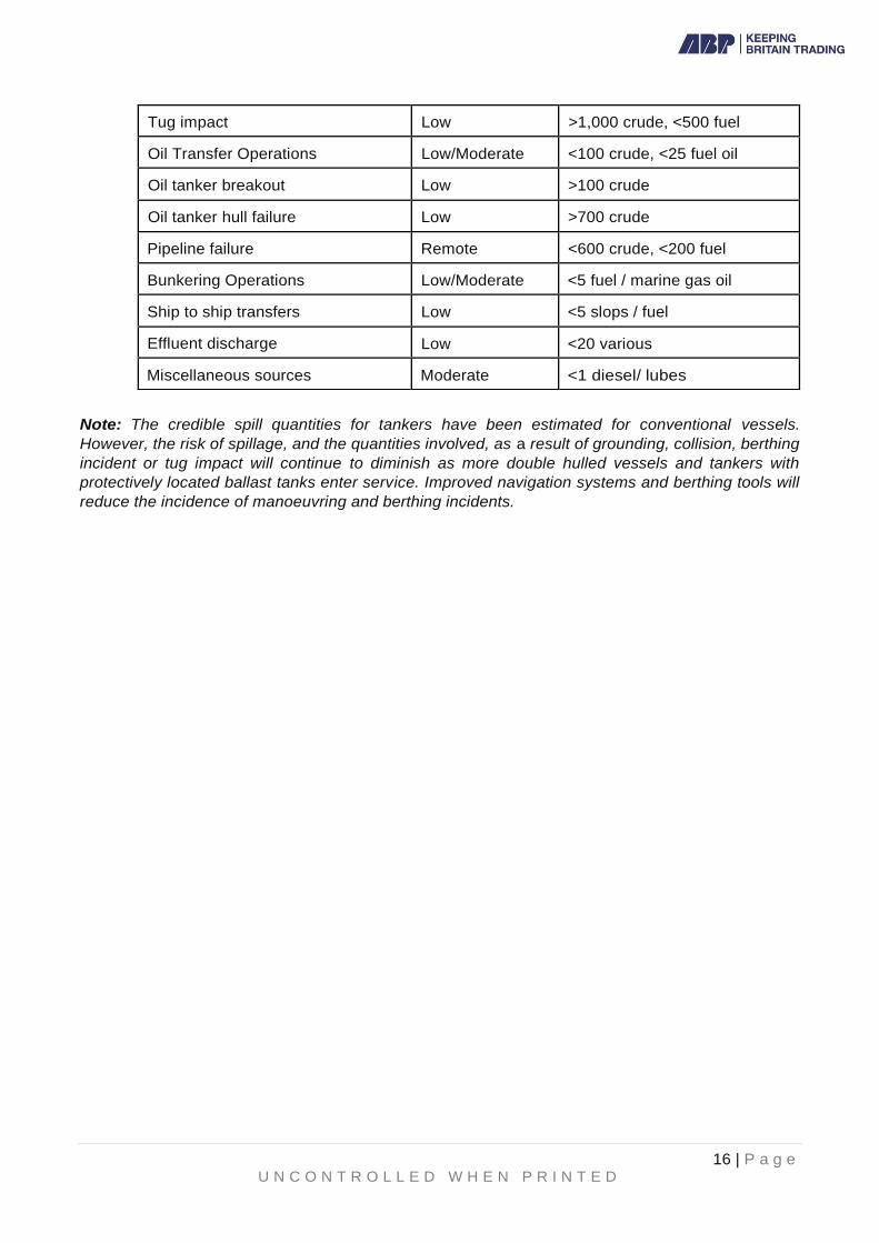
1.6 Risk Assessment
Cause Assessed Risk Credible Spill Quantity
(Tonnes)
Grounding in Thorn Channel Low >100 cargo, <50 fuel
Grounding in Southampton Water Low <50 fuel
Collision underway Low >500 crude, >100 fuel
Berthing incident Low <1,000 crude, <1,000 fuel
16 | P a g e U N C O N T R O L L E D W H E N P R I N T E D
Note: The credible spill quantities for tankers have been estimated for conventional vessels.
However, the risk of spillage, and the quantities involved, as a result of grounding, collision, berthing
incident or tug impact will continue to diminish as more double hulled vessels and tankers with
protectively located ballast tanks enter service. Improved navigation systems and berthing tools will
reduce the incidence of manoeuvring and berthing incidents.
Tug impact Low >1,000 crude, <500 fuel
Oil Transfer Operations Low/Moderate <100 crude, <25 fuel oil
Oil tanker breakout Low >100 crude
Oil tanker hull failure Low >700 crude
Pipeline failure Remote <600 crude, <200 fuel
Bunkering Operations Low/Moderate <5 fuel / marine gas oil
Ship to ship transfers Low <5 slops / fuel
Effluent discharge Low <20 various
Miscellaneous sources Moderate <1 diesel/ lubes

17 | P a g e U N C O N T R O L L E D W H E N P R I N T E D
Figure 1.2 Interfacing Oil Spill Contingency Plan

18 | P a g e U N C O N T R O L L E D W H E N P R I N T E D
1.7 Classification of Oil Spills
1.8 Tidal Movement of Oil on Southampton Water
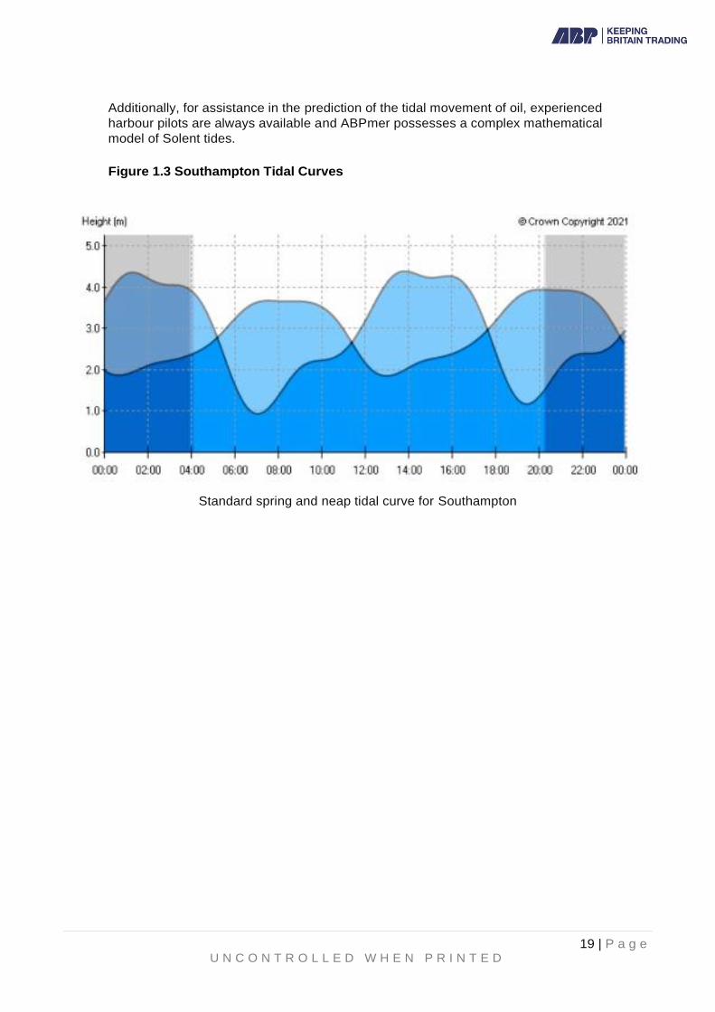
Southampton water is subject to the unusual phenomenon of a 'Double High Water'
tidal effect. A full tidal cycle lasts approximately 13 hours with the flood tide lasting
about 7 hours, a 2 hour stand at high water and an ebb tide of about 3 hours. The
short duration of the ebb tide makes for a greater velocity of flow. Maximum tidal rates
of up to 3.8 knots are experienced in the central Solent and 1.8 knots in Southampton
Water during a spring ebb tide. Neap and flood tidal rates are considerably less.
Movement of oil in Southampton Water is likely to be parallel to the shoreline. It will
be either in a north-westerly or south-easterly direction, in line with the flood or ebb
tidal flows, dependant also on the effect of wind force and direction. Slack water
occurs for 2 hours between the Southampton 1st and 2nd High Waters. Additionally, a
considerable slackening of the flood tide occurs 2 hours after Low Water in a local
effect known as the 'Young Flood Stand' which is particularly pronounced over spring
tides. This lasts for about 2 hours before the final accelerated rise to High Water.
Tidal flows in the Central Solent are complex but flow with maximum rate to the west
on an ebb tide off Cowes Harbour, midway between the Southampton 1st and 2nd High
Waters. The VTS Centre Southampton is equipped with live tidal information from tide
gauges.
Tier 1
Small operational type spills that may occur within a location as a result of daily activities. The level at which a response operation could be carried out successfully using individual resources and without assistance from others.
Tier 2
A medium sized spill within the vicinity of a company’s location where immediate resources are insufficient to cope with the incident and further resources may be called in on a mutual aid basis. A Tier 2 incident may involve Local Government.
Tier 3
A large spill where substantial further resources are required and support from a national (Tier 3) or international cooperative stockpile may be necessary. A Tier 3 incident is beyond the capability of both local and regional resources. This is an incident that requires national assistance through the implementation of the National Contingency Plan and will be subject to Government controls.
19 | P a g e U N C O N T R O L L E D W H E N P R I N T E D
Additionally, for assistance in the prediction of the tidal movement of oil, experienced
harbour pilots are always available and ABPmer possesses a complex mathematical
model of Solent tides.
Figure 1.3 Southampton Tidal Curves
Standard spring and neap tidal curve for Southampton

20 | P a g e U N C O N T R O L L E D W H E N P R I N T E D
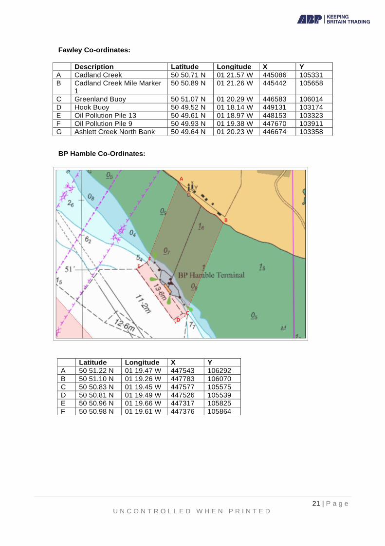
Appendix 1a Fawley Marine Terminal and BP Hamble Terminal Areas of Responsibility
21 | P a g e U N C O N T R O L L E D W H E N P R I N T E D
Fawley Co-ordinates:
BP Hamble Co-Ordinates:
Description Latitude Longitude X Y
A Cadland Creek 50 50.71 N 01 21.57 W 445086 105331
B Cadland Creek Mile Marker 1
50 50.89 N 01 21.26 W 445442 105658
C Greenland Buoy 50 51.07 N 01 20.29 W 446583 106014
D Hook Buoy 50 49.52 N 01 18.14 W 449131 103174
E Oil Pollution Pile 13 50 49.61 N 01 18.97 W 448153 103323
F Oil Pollution Pile 9 50 49.93 N 01 19.38 W 447670 103911
G Ashlett Creek North Bank 50 49.64 N 01 20.23 W 446674 103358
Latitude Longitude X Y
A 50 51.22 N 01 19.47 W 447543 106292
B 50 51.10 N 01 19.26 W 447783 106070
C 50 50.83 N 01 19.45 W 447577 105575
D 50 50.81 N 01 19.49 W 447526 105539
E 50 50.96 N 01 19.66 W 447317 105825
F 50 50.98 N 01 19.61 W 447376 105864
22 | P a g e U N C O N T R O L L E D W H E N P R I N T E D
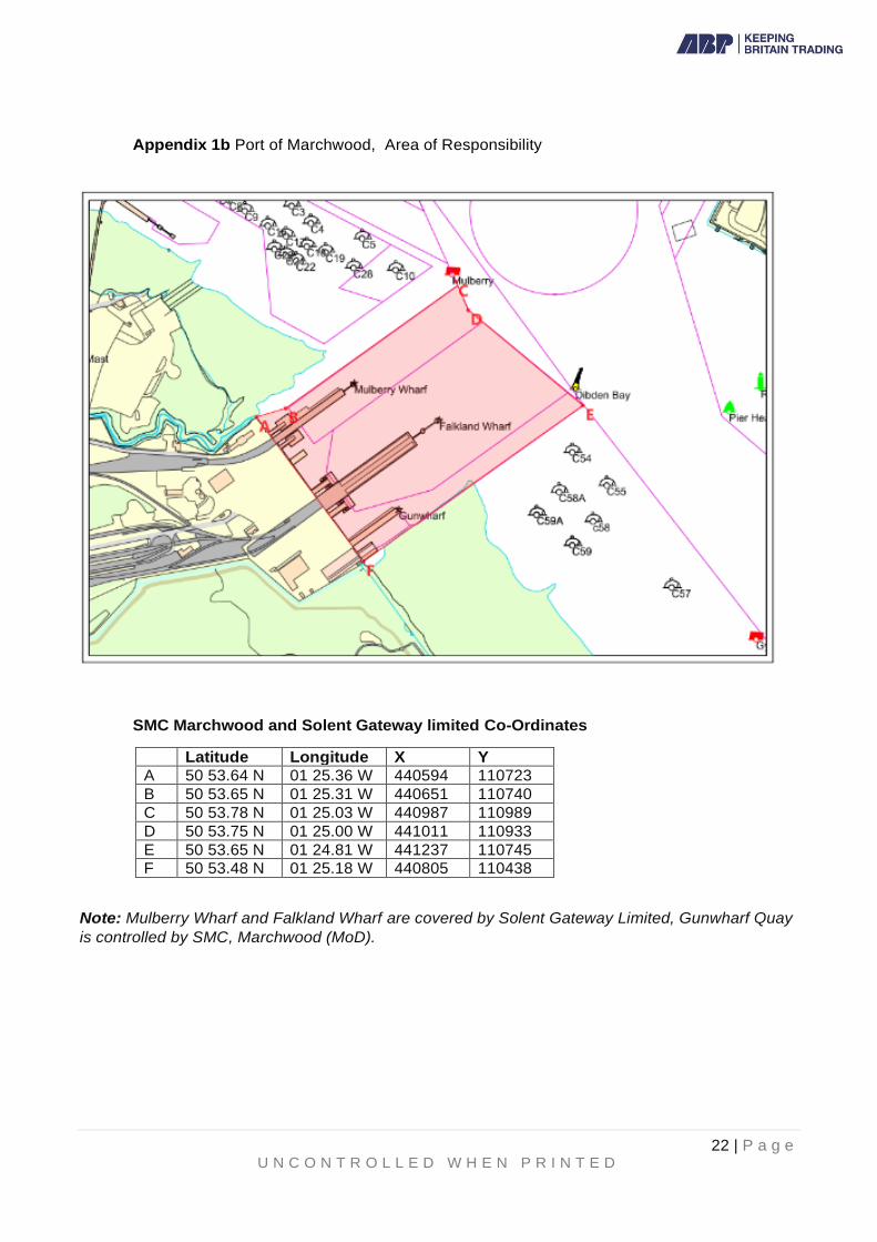
Appendix 1b Port of Marchwood, Area of Responsibility
SMC Marchwood and Solent Gateway limited Co-Ordinates
Latitude Longitude X Y
A 50 53.64 N 01 25.36 W 440594 110723
B 50 53.65 N 01 25.31 W 440651 110740
C 50 53.78 N 01 25.03 W 440987 110989
D 50 53.75 N 01 25.00 W 441011 110933
E 50 53.65 N 01 24.81 W 441237 110745
F 50 53.48 N 01 25.18 W 440805 110438
Note: Mulberry Wharf and Falkland Wharf are covered by Solent Gateway Limited, Gunwharf Quay
is controlled by SMC, Marchwood (MoD).

23 | P a g e U N C O N T R O L L E D W H E N P R I N T E D
2. Incident Response Organisation
2.1 Harbour Master
The Harbour Master (or his nominated deputy) has overall responsibility for the conduct of spill response operations and for casualty / salvage management within the Port. He will be supported in his role by ABP personnel and by the Oil Spill Management Team.
2.2 Oil Spill Management Team (OMT)
An Oil Spill Management Team (OMT) will, in general, be established at Southampton VTS, under the chairmanship of the Harbour Master for Tier 2 and Tier 3 incidents. The OMT will provide the command and control structure to coordinate and direct the marine response to the incident. The OMT will, as required, consist of representatives from the following organisations and authorities.
Management Team Advisory and Support Team
Harbour Master Oil Company (if appropriate) SMC Marchwood Operarions (if appropriate) SGL Marchwood Operations (if appropriate) Vessel Owners P & I Club Salvor (if appropriate) MCA (if appropriate)
Adler and Allan Hampshire County Council Coastal District / Borough Councils Environment Agency
Natural England MMO
Associated British Ports Environment Group (if
convened)
The OMT, under the chairmanship of the Harbour Master, may use all response agencies and available assets as necessary to deal with the incident.
In the event of a Tier 3 incident and the implementation of the National Contingency Plan, the OMT will assist the MCA and appropriate members of the OMT will re-deploy to the TCG or SCG as required.
Southampton VTS will remain active unless superseded by the MCA Marine Response Centre (MRC). The Harbour Master will require the transfer of responsibility for managing the incident response to be formally documented prior to relinquishing overall control of at-sea counter pollution measures to the MCA.
2.3 Protracted Incidents
Most incidents experienced in the port in recent years have been dealt with within the period of a 12-hour watch, or at longest over 2 -3 days. However, consideration must be given to a major incident which could take weeks or longer to resolve. The Marine Department operates on a 5-watch basis for all operational staff (VTS, launch crew, Berthing Officers etc) and maintains full operational capability 24/7/365. Whilst normal out of hours numbers are limited (4 VTS staff, 2 launch crew, 1 Berthing Officer, plus a Duty Harbour Master), these can be quickly augmented from off watch staff to ensure operational capability is maintained or enhanced as necessary.
24 | P a g e U N C O N T R O L L E D W H E N P R I N T E D
The Duty Harbour Masters' roster is 3 strong and, whilst the normal duty period is 1
week in 3, for any major incident a 2-watch roster, with 2 Duty Harbour Masters in
each, would quickly be instigated and would be sustainable over a longer period. The
AHM (Leisure & Compliance) would join the 3 strong normal group to achieve this.
In the event of a major incident at one of the oil terminals within the port, port staff
would be augmented on the ground by terminal staff and additionally by staff
employed by respective Tier 2 Contractors.
Members of the Oil Spill Management Team would need to arrange reliefs from within
their own organisations to ensure 24/7 requirements could be met. Incident response
would be coordinated by the OMT leaving port operational staff to maintain the port's
operations as close to normality as the incident allowed and ensure business as usual.
2.4 Tier 1 Incident
2.4.1 Oil Terminals and Local Installations
See also Section 2.10: Response at Fawley Marine Terminal
The terminal / installation involved will immediately inform the Duty Harbour
Master via the Duty Assistant Harbour Master (VTS) who will in turn activate
the notification procedure. The terminal/ installation will activate their own
response centre and will initiate the appropriate response actions. The
Harbour Master will send a senior representative to monitor the response
being taken. That representative will advise the Harbour Master whether
control of the response should be transferred to Southampton VTS Marine
Response Centre if the spill is extending or migrating beyond the immediate
vicinity of the terminal, or that the response being taken is considered
inappropriate.
2.4.2 All Other Harbour Areas including Dock Complexes
The Duty Assistant Harbour Master (VTS) will initiate the appropriate response
actions and will immediately advise the Duty Harbour Master and activate the
notification procedure (Section 3). After the Duty Harbour Master has relieved
the Duty Assistant Harbour Master (VTS), management of the response will
be in line with the established day-to-day management structure of the
Harbour Master's Department (see Figure 2.1).
2.5 Tier 2 Incidents
See also Section 2.10: Response at Fawley Marine Terminal
In addition to the actions described above and the activation of the notification
procedure, the Harbour Master will decide whether to set up an Oil Spill Management
Team and, in the event of an oil company involvement, whether the OMT will operate
from the Southampton VTS Marine Response Centre or from the oil company's
response centre. Depending on the circumstances of the incident, the OMT will
include representatives from the following organisations and authorities:
1 Harbour Authority □ 2 Adler and Allan □ 3 Environment Agency □ 4 Oil Companies/ Installations (terminal spill or as required) □

25 | P a g e U N C O N T R O L L E D W H E N P R I N T E D
Figure 2.1 Normal Organisational Structure
2.6 Tier 3 Incident
In addition to the actions described above for Tier 1 and Tier 2, for a Tier 3 incident
an Oil Spill Management Team, under the chairmanship of the Harbour Master, will
be established at the Southampton VTS Marine Response Centre and will include
representatives from the following organisations and authorities:
1 Harbour Authority □ T/S CG
2 Adler and Allan □ T/S CG
3 Environment Agency □ T/S CG
4 Oil Companies/ Installations (terminal spill or as required) □ T/S CG
5 Hampshire County Council □ T/S CG
6 Natural England □ T/S CG
7 MMO (Marine Management Organisation) □ T/S CG
8 Coastal District/Borough Council(s) (as appropriate) □ T/S CG
9 ITOPF (International Tanker Owners Pollution Federation) □ T/S CG
5 Hampshire County Council □ 6 Natural England □ 7 MMO (Marine Management Organisation) □ 8 Coastal District/Borough Council(s) (as appropriate) □ 9 Salvor □
10 P & I Club / ITOPF □ 11 MCA □ 12 Vessel Owners □ 13 Solent Environment Group □

26 | P a g e U N C O N T R O L L E D W H E N P R I N T E D
10 P & I Club □ T/S CG
11 Salver (if appointed) □ 12 Police □ T/S CG
13 Hampshire & Isle of Wight Fire and Rescue Service □ T/S CG
14 MCA Counter Pollution and Salvage Officer □ T/S CG
15 MCA - HM Coastguard □ 16 Vessel Owners □ 17 Adjacent Harbour Authorities (as appropriate) □ 18 Solent Environment Group □
2.7 Tactical Coordinating Group (TCG) and Strategic Coordinating Group (SCG)
The implementation of the National Contingency Plan will involve establishment of a
Tactical Coordinating Group (TCG) and a Strategic Coordinating Group (SCG) under
the chairmanship of a senior police officer, or senior local authority officer if there is
no immediate threat to life. These Groups will cover many of the functions previously
carried out by the Shoreline Response Centre when pollution threatens the coastline.
The SCG's primary function is to co-ordinate the overall strategic shoreline response
and clean-up activity. For an incident within ABP Southampton's statutory area, it is
highly likely that the SCG will be established at Hampshire & Isle of Wight Fire and
Rescue Service and Police Headquarters in Eastleigh, with a fall-back location at
Hampshire County Council's Offices in Winchester. Appropriate members of the OMT
(as indicated at 2.2 above) will re-deploy as requested by the MCA and Hampshire
County Council. The OMT / TCG will retain responsibility for tactical marine response
to the incident. Hampshire and Isle of Wight Local Resilience Forum Emergency
Response Arrangements will also be activated at the TCG and SCG.
2.8 Environment Group
The Environment Group provides a single advisory line on public health and
environmental issues at sea to all response cells. Where the incident poses a
significant threat to health or the environment on land, the SCG may establish a
Scientific and Technical Advice Cell (STAC) and this may be integrated with the
Environment Group. At the outset of an incident, at sea, the MCA triggers the
formation of an Environment Group to provide advice requiring a local, regional or
national response. The local Standing Environment Group, the Solent Environment
Group (SEG), covers The Solent area and the MCA co-ordinates its contact details
and call out arrangements. The SEG comprises the statutory environmental
regulators, fisheries departments, nature conservation bodies and public health
bodies plus a range of specialist public sector and non-government organisations. The
SEG enables a co-ordinated and timely environmental input to more localised or
specialised incidents.
The SEG may be stood up as a precautionary approach when there is potential for
incident escalation. In more minor incidents, the SEG remains a 'virtual' group
responding with advice when requested. The SEG's remit is advisory and it has no
powers of direction or enforcement. The regulatory functions of individual members
of the SEG will be exercised outside the Group structure and function.
Further detail on The Environment Group in Maritime Pollution Response in the UK
may be found in STOp Notice 2/16 and 3/16 here.

27 | P a g e U N C O N T R O L L E D W H E N P R I N T E D
2.9 Simultaneous Oil Spills
If a second simultaneous oil spill occurs within the harbour area, then the Duty
Assistant Harbour Master (VTS) will make an initial assessment of the priority for
response based on the initial report. He/she will task the Harbour Patrol launch to the
spill of greater priority and a second launch, as available, to the other spill. Following
reports from the scene of the spills the response priorities will be re-assessed. Adler
and Allan have the capability to respond to two simultaneous oil spills.
2.10 Response Specific to Fawley Marine Terminal (FMT)
2.10.1 Specific to Fawley Marine Terminal.
There are several different elements to the response to an oil spill at the Terminal. Spills are categorized as per the table below:
• Category
11
Management Team Location a Lead
Tier 1 ESSO Fawley Esso
'A' ESSO Fawley Esso
ESSO Fawley
Tier 2
or
Harbour 'B' Southampton VTS
Master
Marine Response Centre
(MRC)
Tier3
Southampton VTS MRC
Harbour
Master
In the event of a spill, FMT will inform VTS by phone, followed by a faxed / emailed copy of the Spill Report Form (template at 2.10.11) which will confirm the nature and extent of the spill and the Tier allocated. The Assistant Harbour Master (VTS) to commence spill actions, as per this Plan, relevant to the indicated Tier - thus Tier 1, Tier 2 etc. Notifications should be commenced based on the assessment provided.
FMT will clarify the required Tier 2 response by suffixing Tier 2 with 'A' or 'B' -

28 | P a g e U N C O N T R O L L E D W H E N P R I N T E D
Tier 2 A indicates that the spill remains within the Fawley Marine Terminal Area of Responsibility and capability to recover and Tier 2 B that the spill extends beyond the FMT Area of Responsibility and capability to recover. As can be seen above, depending on whether Tier 2A or 2B will dictate where the Oil Spill Management Team will close-up and who will be the lead.
The Defined Area of Responsibility is detailed in the following table:
Latitude Longitude Description X y
A 50 50.74 N 01 21.66 W Cadland Creek 445086 105331
B 50 50.92 N 01 21.35 W Cadland Creek
Mile Marker 1 445442 105658
C 50 51.11 N 01 20.38 W Greenland
Buoy 446583 106014
D 50 49.56 N 01 18.23 W Hook Buoy 449131 103174
E 50 49.65 N 01 19.06 W Oil Pollution
Pile 13 448153 103323
F 50 49.97 N 01 19.47 W Oil Pollution
Pile 9 447670 103911
G 50 49.67 N 01 20.32 W Ashlett Creek
North Bank 446674 103358
The area of responsibility is derived from the expected location an oil slick
would migrate to within 1 hour, from its source at FMT.
The reference points detailed above are physical, easily identifiable land & sea marks.
Appendix 1A above illustrates the location of Fawley Marine Terminal & the
boundary for Tier 1 & 2 incidents.
2.10.2 Harbour Master
At Tier 2A level (as defined in 2.10.1), FMT has overall responsibility for the
conduct of spill response operations with the Harbour Master's assistance. At
Tier 2B level the Harbour Master (or his nominated deputy) has overall
responsibility for the conduct of spill response operations and for
casualty/salvage management within the Port and Southampton Water.

29 | P a g e U N C O N T R O L L E D W H E N P R I N T E D
2.10.3 Oil Spill Management Team (OMT) for Fawley based Incidents
The OMT will provide the command and control structure to co-ordinate and
direct the incident response. The OMT will typically consist of representatives
from the following organisations and Authorities:
=
MANAGEMENT TEAM ADVISORY/ SUPPORT TEAM
Harbour Master Environment
Agency
Oil Company (if appropriate) Hampshire
County Council
Oil Spill Response (OSR)/Adler and Allan District/
Borough Councils
Vessel Owners
Natural England
Marine Management Organisation (MMO) P & I Club
Salver (if appropriate) MCA
(if appropriate)
Associated British Ports (ABP):
Administration Public
Relations
Finance and Accounts
The OMT, under the chairmanship of the Harbour Master, irrespective of
where located may use all response agencies and available assets as
necessary to deal with the incident.
The table below shows the preferred location of the OMT dependent upon the
category of the spill incident.
-
CategoryJ Management Team Location
-
Lead
Tier 1 ESSO Fawley Esso
Tier 2
'A'
ESSO Fawley
Esso
'B'
ESSO Fawley
or
Southampton VTS
Marine Response Centre (MRC)
Harbour Master
Tier 3
Southampton VTS MRC
Harbour Master
Respective organisation charts are shown in Section 2.10.10. In the event of a Tier 3 incident and the implementation of the National
Contingency Plan, the OMT will assist the MCA and appropriate members
of the OMT will deploy to the MCA MRC, TCG and SCG.

30 | P a g e U N C O N T R O L L E D W H E N P R I N T E D
The Southampton VTS MRC or Fawley Marine Terminal Control Room will
remain active unless superseded by the MCA MRC.
2.10.4 Tier 1 Incidents
Response will be as per Section 2.4
2.10.5 Tier 2 Incidents
TIER 2
Medium release within defined area of responsibility, which is likely to impact on the
shoreline or migrate outside of the defined area.
Tier 2 is divided into two levels of response:
Tier 2 'A' a release which can be contained, recovered and dispersed by the
use of support personnel and equipment that can be readily deployed. e.g.
tugs, sorbent boom etc. by Fawley Refinery and its associated specialist
contractor (OSR).
Tier 2 'B' a release which requires substantial commitment of the ABP
Southampton Oil Spill Contingency Plan and may involve regional assistance
with the response being managed under the chairmanship of the Harbour
Master.
FMT will activate the response for a Tier 2 category in the same way as a Tier
1 or, may re categorise a Tier 1 if the pollution is likely to migrate outside the
Tier 1 area of responsibility, or if it is likely that the pollution will reach the
shoreline.
2.10.6 Tier 2A Incident
An Oil Spill Management Team will include representatives from the following
organisations. The team will be in Room 4B EPCo Admin building.
I
Organisation ,.,
1 Port of Southampton (Duty Harbour Master)
2 Hampshire County Council & Coastal District/Borough Council(s) (as
advised by HCC)
3 Environment Agency
4 Fawley Site Representative (Environmental Group Head)
5 Hamble Harbour Master
6 Natural England

31 | P a g e U N C O N T R O L L E D W H E N P R I N T E D
2.10.7 Tier 2B Incident
An Oil Spill Management team, under the Chairmanship of the Harbour
Master, will be established at the Southampton VTS Marine Response Centre
or at the MCC at FMT.
Depending on the circumstances of the incident, the OMT will typically include
representatives from the following organisations and authorities:
I Organisation
I
1 Port of Southampton (Duty Harbour Master)
2 Environment Agency
3 ESSO Fawley Site Management Representative
4 Hampshire County Council
5 Hamble Harbour Master
6 Natural England
The following organizations and authorities will be included within the OMT as required:
7 Marine Management Organisation (MMO)
8 Coastal District/Borough Council(s) (as advised by HCC)
9 Salvor
10 P & I Club / ITOPF
11 MCA
12 Vessel Owners
13 Oil Spill Response / Adler and Allan
14 Solent Environment Group
The above list is not exhaustive. Further contacts may be appropriate as the
incident develops.
2.10.8 Tier 3 Incident
An Oil Spill Management Team, under the chairmanship of the Harbour
Master, will be established at the Southampton VTS MRC and will typically

32 | P a g e U N C O N T R O L L E D W H E N P R I N T E D
include representatives from the following organisations and authorities:
1
-
Port of Southampton (Harbour Master)
2 Oil Spill Response Ltd / Adler and Allan
3 Environment Agency
4
ESSO Fawley Site OSR Team or other Oil/Terminal OSR Team (if
applicable)
5 Hampshire County Council
6 Natural England
7
- Marine Management Organisation (MMO)
8 Coastal District/Borough Council(s) (as advised by HCC)
9 ITOPF (International Tanker Owners Pollution Federation)
10 P & I Club
11 Salvor (if appointed)
12 Police
13 Hampshire & Isle of Wight Fire and Rescue Service
14 British Telecom
15 MCA - Principal Counter Pollution & Salvage Officer.
16 HM Coastguard
17 Vessel Owners
18 Adjacent Harbour Authorities (as appropriate).
19 Solent Environment Group
NB. Any oil spill volume calculations should be made in accordance with the
Bonn Agreement Oil Appearance Code - Reference Part 3, Annex A of the
Bonn Agreement Aerial Operations Handbook, 2016.
The full handbook can be downloaded from:
https://www.bonnagreement.org/site/assets/files/1081/aerial_operations_handbook.pdf
In a declared Tier 3 incident, the Oil Spill Management Team will remain
in charge until the MCA implements the National Contingency Plan and

33 | P a g e U N C O N T R O L L E D W H E N P R I N T E D
establishes a Marine Response Centre.
2.10.9 Tier 2A Response – Organisational Chart
TIER 2A

34 | P a g e U N C O N T R O L L E D W H E N P R I N T E D
2.10.10 Tier 2B Response – Organisational Chart
Oil Spill Management Team Organisation Chart – Fawley Site

35 | P a g e U N C O N T R O L L E D W H E N P R I N T E D
2.10.11 Oil Spill Reporting Form
This form can be found on the Oil Spill Contingency Plan 2021: Supporting forms
document, section 1.1
2.10.12 Oil Spill Progress Report for FMT
This form can be found on the Oil Spill Contingency Plan 2021: Supporting forms
document, section 1.2
2.10.13 Fawley Control of Major Hazards (COMAH)
Fawley Marine Terminal has an approved plan to conform with COMAH regulations which lays out the process for alerting nearby residents to an emergency on site. Although not limited to just Oil Spills, it is important to note the existence of this plan, a copy of which will be available at the VTS website when made available.
36 | P a g e U N C O N T R O L L E D W H E N P R I N T E D
3. Reporting Procedures
3.1 Use of Section
This section sets out the reporting and notification procedures which should be followed if an oil spill occurs within the harbour area. Copies of reporting forms can
be found in the supplementary document Oil Spill Contingency Plan 2021: Supporting Forms.
The extent of notification of external organisations and authorities will be determined by
the initial classification of the incident. Responsibility for external notification and
the completion of POLREP CG77 rests with the Duty Assistant Harbour Master
(VTS). The POLREP CG77 form can be found at the Oil Spill Contingency Plan
2021: Supporting Forms document, section 3.1.
The statutory requirement, placed on the Harbour Master under Statutory Instrument 1998 No. 1056, to report all actual or probable discharges of oil to the sea to MCA-HM Coastguard is noted in the appendices to this section; the appendices also include POLREP CG77 and an Oil Spill Progress Report.
3.2 Prevention of Oil Pollution Acts 1971 & 1986
These Acts place an obligation on persons to immediately report to the Harbour Master an oil spill which enters, or threatens to enter, Southampton Water. Persons include port users, vessel Masters, oil companies and industrial firms with water frontage.
3.3 Notification Matrices
The Duty Assistant Harbour Master (VTS) will implement the following notification matrix in accordance with the category of oil spill incident declared. Note: The matrices below give the primary telephone contact numbers; alternative
telephone and facsimile numbers are included in Section 15.
Tier 1 Incident
Contact checklist can be found in the OSCP: Supporting Forms document, Section
2.1
Tier 2 Incident
Contact checklist can be found in the OSCP: Supporting Forms document, Section 2.2
Note 1: On notification of a Tier 2 incident the VTS Assistant Harbour Master (VTS) will confirm that an Oil Spill Management Team (OMT) will be established at Southampton VTS Marine Response Centre (or an alternative location if appropriate) and that, having been notified, attendance at the OMT is required.
Note 2: For all Tier 1 and Tier 2 incidents, the Contact Check List in the supporting
document is to be used to record the notification time for each authority informed.
Tier 3 Incident

37 | P a g e U N C O N T R O L L E D W H E N P R I N T E D
Contact checklist can be found in the OSCP: Supporting Forms document, Section 2.3. Hampshire County Council will additionally alert the following for Tier 2 and 3 Incidents:
o British Telecom (Emergency Installation) o County Departments as necessary o West Sussex County Council o Dorset County Council o Waste Disposal Contractors
Note 1: On notification of a Tier 3 incident the VTS Assistant Harbour Master (VTS) will confirm that an Oil Spill Management Team (OMT) will be established at Southampton VTS Marine Response Centre (or an alternative location if appropriate) and that, having been notified, attendance at the OMT is required.
Appendix 3A: Regulation Extract
Extract from Statutory Instrument 1998 No. 1056 Regulation 4 Paragraph 6
and as amended by SI 2015 No 386 Regulation 6 Paragraph 12:
“(9) Every responsible person must-
(a) maintain equipment and expertise relevant to the oil pollution
emergency plan which is approved in respect of matters for which the
person is responsible;
(b) ensure that such equipment and expertise is available for use at all times;
(c) make such equipment and expertise available to the authorities
responsible for the execution of the National Contingency Plan;
(d) undertake exercises to maintain relevant expertise for the
implementation of the plan, including interaction with the National
Contingency Plan;
(e) retain evidence of those exercises; and
(f) provide such evidence to the Secretary of State, if so required by
the Secretary of State by written notice.
38 | P a g e U N C O N T R O L L E D W H E N P R I N T E D
Appendix 3B - Guidelines to Information Required by MMO in Considering
Request for Dispersant Spraying Approval
As much of the following information as possible should be provided when requesting approval.
• Name of authority or organisation requiring approval.
• Name of contact and telephone and fax number used.
• Locality of spill preferably in degrees (but could be grid reference or
description such as "Western end of King George Dock" or "Length of river
between power station and oil refinery").
• Oil type or description of appearance if not known. If crude - what type?
• Quantity of oil spilled - preferably in tonnes.
• Source of spill.
• Potential for further spill.
• Description of slick - including dimensions and colour.
• Volume and name of dispersant for which approval is requested.
• Other methods of response being applied or considered and assistance
being sought (e.g. MFA, Environment Agency).
• Local fisheries considerations (such as seasonal fisheries, advice given to
fishermen).
• Local wildlife considerations (e.g. whether migrant birds are present).
• Tide - type and speed, and time of HW/LW particularly.
• Wind and weather (such as "Moderate breeze NW" "Overcast drizzle").
• Sea state.

39 | P a g e U N C O N T R O L L E D W H E N P R I N T E D
4. Action Sheets
Action Sheets must be used for the following positions. All Action Sheet Templates can be found at the Oil Spill Response Contingency Plan 2021: Supporting Forms document, in section 5.
• Duty Assistant Harbour Master (VTS)
• Duty Coxswain (Marine Officer) - Southampton Patrol
• Duty Harbour Master
• Oil Terminal Representative (Oil Terminal Spill) Fawley Marine Terminal, BP Hamble Terminal and Solent Gateway, Marchwood Spill
4.1 Oil Spill Incident Checklist
The checklists are intended to promote consistency of approach by all personnel involved in the incident response. All checklists can be found on the Oil Spill Contingency Plan 2021: Supporting Forms document
• Oil Spill Assessment Checklist {C1).
This checklist ensures that the initial assessment of the oil spill is accurate and all
aspects likely to affect the classification such as quantity, oil type and likely fate of
the spilled oil, are investigated thoroughly. Form can be found at OSCP 2021:
Supporting Form section 4.5
• Incident Briefing Checklist {C2).
This checklist ensures that all personnel involved in the management of the incident
are given a thorough briefing and are then able to give a consistent and effective
briefing to personnel under their control during the incident. Form can be found at
OSCP 2021: Supporting Form section 4.6
• Personal Log Checklist {C3).
This checklist ensures that all personnel involved in the incident response record
correct and relevant information throughout the operation; consistent logs and
records can then be submitted to the Harbour Master for his use in subsequent
reports and actions. Form can be found at OSCP 2021: Supporting Form section 4.7
• Oil Spill Sampling Checklist {C4).
This checklist outlines the sampling procedure to be followed by ABP Berthing/Marine
Officers attending an oil spill. It also summarises the guidance given in the MCA
STOp Notices. Following the guidance ensures that samples of enough quantity will
be taken, sealed, labelled and handled correctly. Form can be found at OSCP 2021:
Supporting Form section 4.8

40 | P a g e U N C O N T R O L L E D W H E N P R I N T E D
Appendix 4A: Adler and Allan Activation and Notification Procedure
Adler & Allan ACTIVATION PROCEDURE
CONTACT NUMBERS In order to access Adler & Allan services in the event of an oil spill incident please call: -
Adler & Allan - Tel: +44 (0)800 592827
If calling from outside of the United Kingdom ensure that your country code precedes the telephone number. These telephones will be manned on a 24-hrs basis. The caller will be asked to provide: -
1) Name of Caller 2) Name of Company 3) Location of Caller 4) Telephone Number including prefixes 5) Brief details of the incident
The Duty Manager will then be contacted and contact the requesting party. Once contact has been made further details will be collected to enable a response strategy to be determined. AN EMAIL / FAX AUTHORISING THE RESPONSE WILL BE REQUIRED FROM ONE OF THE NOMINATED REPRESENTATIVES OF THE COMPANY.
Adler & Allan Fax Duty Manager email:
*NOTIFICATION FORM CAN BE FOUND AT OSCP 2021: SUPPORTING FORMS DOCUMENT,
SECTION 4.9*

41 | P a g e U N C O N T R O L L E D W H E N P R I N T E D
Appendix 4B Contact Checklist
Tier: …………… Called: ……………… Date: …………….
Notified ABP Time
Harbour Master
Deputv Harbour Master (Marine Ops)
Deputv Harbour Master (Pilotage)
Alert List - Person Contacted Time
Initiate Tier D'grade Tier Cancelled
1 2 3 2 1
OHM Portsmouth
HMCG
ABP Group Comms
Hampshire County*
loW County Council *
Adler and Allan
Southampton City Council
New Forest District
Eastleigh Borough *
Fareham Borough *
Hamble HM*
Cowes HM*
Beaulieu HM *
MMO
Environment Agency
Natural England
Southern IFCA
Essa Marine Terminal
BP Oil Hamble
Perenco
Hants Police
Sea Mounting Centre, Marchwood
Hants Fire and Rescue
Marchwood Power Station
* Alert as Geographically appropriate
Note: AHM (VTS) please ensure that at Tier 2, all authorities notified are informed that their presence is required at the OMT in VTS Centre MRC.

42 | P a g e U N C O N T R O L L E D W H E N P R I N T E D
5. Response Guide
This section provides strategy guidelines for three oil types:
No. Oil Type Strategy Guideline
Specific
Gravity
Genre Characteristics Examples
1 Light oils 5.1 < 0.8 White
oils Non-persistent, Volatile
Diesel
Gas oil
Aviation
fuel,
Kerosene Motor spirit
3 Medium
oils
5.2 0.8 - 0.95 Blac
k oils
Persistent, Fluid Crude oils
2 Heavy oils 5.3 > 0.95 Blac
k oils
Persistent, Viscous, Emulsion
Fuel oils
Bunker oils
bitumens
By selecting the appropriate Strategy Guideline, the user can derive an indicative strategy
path to mitigate the effects of an oil spill, consistent with safe practice and net environmental
benefit.
Additional environmental advice, including Environmental Sensitivity Maps and Priority
Protection Areas, is given in Section 12.
Although the guidelines offer the option of a dispersant response, the Port of Southampton does not maintain stocks of chemical dispersant and does not hold a Standing Approval for the application of dispersant within the port area.
Esso / Fawley Marine Terminal has a derogation to spray up to 150 gallons of Type 3
approved dispersant in an area extending from the marker buoys at the deep-water intake of
the now closed Fawley Power Station to a line across Southampton Water from Hythe Ferry
to Weston Hard. This standing approval from MMO HQ exists for certain types of oil under
certain conditions only and is currently set to expire in September 2021.
5.1 Natural England Recommendations on Response Guidelines
A general principle of any clean-up operation is not to cause further damage than
leaving the oil in situ. Therefore, Natural England recommends:
For shorelines that are comprised of loose material, boulders, cobbles etc.
the recommended technique is for low pressure, high volume washing to be
used in combination with booms and sorbent material.
Caution should be used when using heavy plant machinery on mud or sand
habitats even those that are thought to be hard packed to avoid entraining oil
deeper into the mud/ sand.
Natural England also recommends that authority to use dispersants should not be
assumed (as suggested at recommendations 5 & 6 of Table 12.5) especially as not all
types of heavy or crude oil are responsive to dispersant use. Natural England cautions

43 | P a g e U N C O N T R O L L E D W H E N P R I N T E D
against these blanket assumptions and advises that incident specific advice should
always be sought from the local Environment Group / Natural England before deciding
any incident specific clean up strategy. Natural England also recommends that the
collection of any loose material, where possible, should always be undertaken to
minimise the potential spread of the oil.
Table 5.1 below details Sites of Special Scientific Interest within the port area, which
require consideration in devising a response strategy.
5.2 Oil Sampling
On all feasible occasions, the Southampton Patrol launch (call sign 'SP') will be
deployed to the scene of a spill to gather information on the nature and extent of the
spill and, if possible, to obtain samples of the oil spilled. Sampling kits are held in both
patrol launches for this purpose, with spare bottles being available in store at 22 Berth.
Instructions on how to collect and handle oil samples are contained within the current
STOp notices - link at Appendix 5A.
Table 5.1 Sites of Special Interest (SSSI’s) within Harbour Areas
Note: Refer to Sensitivity Maps in Section 11 for locations of SSSls, Special
Protection Areas (SPA's) and Special Area's of Conservation (SAC's)
Sensitivity Map
Page No
Name
Sect 12 Page 20 Lower Test Valley
Sect 12 Paqe 20 Eling and Bury Marshes
Sect 12 Page
20/21
Lee on Solent to ltchen Estuary
Sect 12 Page
20/21
Hythe to Calshot Marshes
Sect 12 Page 21 Titchfield Haven
Sect 12 Page 21 North Solent (Beaulieu River and Lepe to Calshot)

44 | P a g e U N C O N T R O L L E D W H E N P R I N T E D
Figure 5.1 Light Oil Response Strategy Guideline

45 | P a g e U N C O N T R O L L E D W H E N P R I N T E D
Figure 5.2 Medium Oil Response Strategy Guideline
*

46 | P a g e U N C O N T R O L L E D W H E N P R I N T E D
Figure 5.3 Heavy Oil Response Strategy Guideline

47 | P a g e U N C O N T R O L L E D W H E N P R I N T E D
Use of Dispersants in relation to an Oil Spill
Currently the use of dispersants is only likely for a large scale spill from Fawley Marine
Terminal. More information regarding dispersants can be found at the Government
website here.
Appendix 5A STOp Notices
STOp (Scientific Technical and Operational Advice) notices provide guidance on counter pollution and salvage operational procedures and will be of particular interest
to coastal local authorities and organisations dealing with coastal pollution incidents. All current notices can be found here.
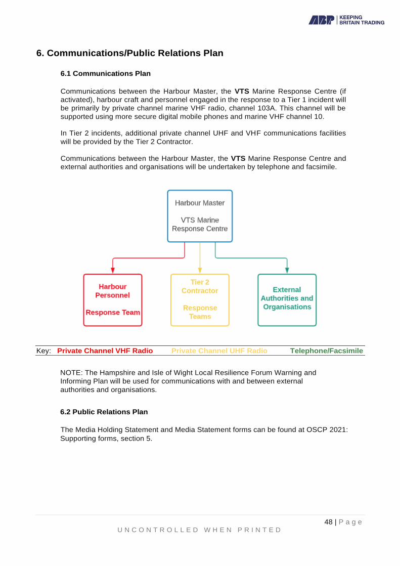
48 | P a g e U N C O N T R O L L E D W H E N P R I N T E D
6. Communications/Public Relations Plan
6.1 Communications Plan
Communications between the Harbour Master, the VTS Marine Response Centre (if
activated), harbour craft and personnel engaged in the response to a Tier 1 incident will
be primarily by private channel marine VHF radio, channel 103A. This channel will be
supported using more secure digital mobile phones and marine VHF channel 10.
In Tier 2 incidents, additional private channel UHF and VHF communications facilities
will be provided by the Tier 2 Contractor.
Communications between the Harbour Master, the VTS Marine Response Centre and external authorities and organisations will be undertaken by telephone and facsimile.
Key: Private Channel VHF Radio Private Channel UHF Radio Telephone/Facsimile
NOTE: The Hampshire and Isle of Wight Local Resilience Forum Warning and
Informing Plan will be used for communications with and between external
authorities and organisations.
6.2 Public Relations Plan
The Media Holding Statement and Media Statement forms can be found at OSCP 2021:
Supporting forms, section 5.

49 | P a g e U N C O N T R O L L E D W H E N P R I N T E D
6.2.1 Media Release Procedure

50 | P a g e U N C O N T R O L L E D W H E N P R I N T E D
7. Health and Safety Plan Full account must be taken of the health and safety requirements for all personnel involved in oil spill response activities. The Site-Specific Health and Safety Plan Assessment Form (OSCP 2021: Supporting Forms section 6) lists site characteristics, site hazards and personal protective equipment and site facility needs. This plan is intended to act as an aide-memoire to ensure that all applicable health and safety requirements are considered, and appropriate actions are taken.
Sections 7.1 and 7.2 summarise legislative requirements and give guidance on specific oil spill clean-
up tasks and hazards. In Tier 2 and Tier 3 incidents, the Harbour Master will be supported in the
control and management of the health and safety function by a member of the ABP Compliance team.
7.1 Legislative Requirements
7.1.1 Employers Duties
The principal duty of an employer is that imposed by the Health and Safety at Work Act 1974. The Act states the employer is to ensure, as far as is reasonably practicable, the health, safety and welfare of their employees and anyone else who may be affected by their business activities whilst at work.
• The Management of Health and Safety at Work Regulations 1992 impose specific duties on employers to:
• Carry out risk assessments of their work activities in order to identify protective and preventative measures - significant findings must be recorded if there are five or more employees;
• Make arrangements for the planning, organisation, control, monitoring and review of the preventive and protective measures. When there are five or more employees these arrangements must be recorded;
• Provide employees with appropriate health surveillance, where this is shown to be necessary by risk assessment;
• Appoint a competent person(s) to help ensure compliance with health and safety law;
• Set up emergency procedures;
• Only allow persons with sufficient health and safety instructions and training to have access to restricted areas;
• Provide employees with comprehensive health and safety information relating to the details above;
• Full co-operation with other employers sharing the workplace;
• Provide the relevant health and safety information to any outside employer working within their premises, including relevant instruction and information;
• Provide the relevant health and safety training to employees; and
• Provide all temporary workers with relevant information on health and safety requirements appropriate to their position within the company.

51 | P a g e U N C O N T R O L L E D W H E N P R I N T E D
7.1.2 Employees Duties
All employees have a duty under the Health and Safety at Work Act 1974, to
take reasonable care for the health and safety of themselves and their
colleagues at work who may be affected by their acts or omissions.
Under the Health and Safety at Work Act 1974 employees have a duty to co-
operate with their employer and colleagues enabling them to comply with
statutory duties and requirements.
Additionally, the Health and Safety at Work Act 1974 states that employees
must not intentionally or recklessly misuse any equipment and the like
provided for them in the interests of health, safety or welfare.
The Management of Health and Safety at Work Regulations 1992, further
oblige employees to:
• use any of the equipment etc, provided in the interests of safety;
• follow health and safety instructions;
• report any problem they consider to be a danger; and
• report any shortcomings in the protection arrangements for health and
safety.
7.2 Site Hazards
7.2.1 Bird Handling
Handling of birds must be undertaken by properly trained personnel to ensure
the protection of both bird and handler; wild birds have no way of
understanding human intentions. Even a greatly weakened bird can inflict
serious injury to handlers, especially to their eyes. Open wounds on hands
and arms from such injuries can present opportunities for oily contaminants
and disease to enter the handler's blood stream.
Handling of oiled birds is usually best left to experts, or to volunteers who have
received some training. Chasing and man handling birds puts them under
additional stress. If oiled birds are found, the Beach Master should be notified,
and he/she will seek advice on what action to take. If a decision is made to
catch an oiled bird take the following actions:
Equipment:
• Thick gloves (able to withstand pecks)
• Overalls
• Safety footwear
• Cardboard Box with lid of a suitable size to give the bird some room for movement
• Goggles to protect eyes
• Optional long-handled net to help catch birds

52 | P a g e U N C O N T R O L L E D W H E N P R I N T E D
Procedures:
• Do not let the bird get close to the head, as it may try to peck at eyes.
• Catch the bird by hand or with the aid of a long-handled net. Do not put the
birds under any more stress than necessary. Only attempt capture if it can be
done quickly and efficiently.
• Hold the bird with both hands to hold the wings in.
• Put the bird in a cardboard box lined with absorbent material (e.g. newspaper), with a lid.
• Do not wrap the bird up in anything - it may get too hot and too stressed.
• Take the bird to a cleaning station as soon as possible. Let cleaning station staff know where and when the bird was caught.
• Keep a note of all birds caught and sent to the cleaning station. Make a note
of species if possible.
7.2.2 Boat Safety
• Boat operators must familiarise themselves and their passengers with safety
features and equipment on their boats.
• Boats must be operated by qualified individuals.
• Lifejackets must be worn by all personnel on boats.
• Use of cold-water immersion suits is particularly critical under conditions of cold stress.
• Boats should generally not be used after sunset for oil recovery. If this is
required or poses minimal risk, areas of operation should be carefully
prescribed and individual boat operators should maintain a communication
schedule with a shore base. Each boat should be fully equipped with
appropriate navigation lights.
• Distress signals should be carried on all vessels.
• Boat operators must keep their supervisors informed of their area of
operation, especially when they change their work area (if plans call for a
boat to move to another location during a shift, the operator should advise
the supervisor of his actual time of departure).
• Portable fuel tanks should be filled outside of the boat. All sources of ignition
in the area of refuelling should be isolated.
• Personnel working in or operating boats should wear appropriate non-slip footwear.
• Fixed ladders or other substantial access/egress should be provided at boat
transfer locations from low water line to platform.
• Workers should be cautioned about using their arms or legs to fend off during
berthing, or getting their hands, arms, or legs between vessels and docks or
fixed structure
7.2.3 Chemical Hazards
*Attach appropriate Material Safety Data and COSHH Sheets for all

53 | P a g e U N C O N T R O L L E D W H E N P R I N T E D
hazardous substances likely to be used at a spill site*
7.2.4 Cold Stress
Cold stress can occur among responders as a result of prolonged exposure
to low environmental air temperatures or from immersion in low temperature
water. It can lead to several adverse effects including frostbite, chilblain and
hypothermia. The single most important aspect of life-threatening hypothermia
is the fall in the deep core temperature of the body.
Workers shall be provided with warm clothing, rest opportunities, exposure
protection, and warm and I or sweet fluids. Boat crew personnel will wear
immersion suits if the water temperature is below 15° Celsius, or the combined water and air temperature is less than 48° Celsius. Refer to the wind chill chart below for more information
Figure 7.1 Wind Chill Chart
7.2.5 Drum Handling/Manual Handling
Drum handling at a spill site will primarily involve drums of waste and
contaminated clothing. Several types of drums and containers may be used
ranging from 25 to 200 litres in size. All drums and containers must be properly
labelled. If in doubt as to the contents of a drum - seek advice.
Manual lifting and moving of drums should be kept to a minimum. A guide to
manual handling is as follows:
• Wear gloves.
• Assess the weight of the load and get help if it is beyond capability. Where
appropriate, use mechanical aids provided.
• Size up the job - remove any obstructions; note any snags and make sure
there is a clear space where the load has to be set down. Ensure that the
load does not block visibility when carrying it.
• Look out for any splinters, projecting nails or sharp edges or wire.
• Stand close to the object and with feet 20 to 30 cm apart, place one foot in advance of the other, pointing in the direction it is intended to move.
• Put the chin in - avoid moving the head backwards or forwards.
Strength Speed Temperature (in celsius)
Calm 0km 10 4 -1 -7 -12 -18 -23 -29 -34 -40 -45
Breeze 16km 4 -2 -9 -15 -23 -31 -44 -51 -51 -57 -64
Moderate 32km 0 -8 -15 -23 -32 -40 -48 -55 -64 -72 -80
Near Gale
48km -2 -10 -19 -28 -36 -45 -53 -62 -71 -79 -87
Gale 64km -4 -12 -21 -31 -38 -48 -57 -66 -74 -83 -92
Little to no danger to properly dressed personnel
Danger of freezing exposed flesh
Greatest danger

54 | P a g e U N C O N T R O L L E D W H E N P R I N T E D
• Bend the knees to a crouch position, keeping back straight.
• Get a firm grip at opposite corners of the load with the palm of the hand and
the roots of the fingers, arms as close to the body as possible.
• Lift with the thigh muscles by looking up and straightening the legs. • Apply the above principles, to any movement such as pushing, pulling,
digging, shovelling etc.
• Use the reverse procedure when setting down the load.
7.2.6 Equipment Operations
Heavy Equipment
Operators of heavy equipment, such as frontend loaders, graders, bulldozers
etc must be trained and qualified in their safe operation. The operator and
banksman must be familiar with agreed signalling techniques. Where
appropriate the banksman should use protective headgear.
Buckets must not be used for personnel transport.
Forklifts
Only trained and authorised operators shall be allowed to operate forklifts.
Only stable or safely arranged loads that do not exceed the capacity of the
truck shall be handled. Operators are expected to carry out daily checks of the
forklift trucks in use. All inspection defects are to be corrected prior to its
operation. If it cannot be rectified immediately, the truck should be taken out
of service.
7.2.7 Electrical Hazards
Electrical hazards shall be identified and marked with suitable placards,
barricades, or warning tape as necessary.
7.2.8 Fatigue
Working long hours without rest may be required, especially during the early
phase of response. This, coupled with the stress of the situation and wearing
required PPE, can contribute to fatigue. Symptoms include loss of
concentration, errors in judgement, irritability, sleepiness, soreness and
stiffness in joints and muscles. Rest and sleep are the primary treatments for
fatigue. Stress can be addressed by relaxation techniques, such as deep
breathing, stretching and taking breaks.
7.2.9 Fire, Explosion and In-Situ Burning
Flammable and combustible materials may be encountered at the spill site.
These may be fuels for vehicles and equipment or the spilled material itself.
However other chemicals may be used during the response. Refer to the
container label and MSDS for more information on these materials.
Precautions should be taken when working with either flammables or combustibles:
• No smoking
• Store in approved, labelled containers
• Provide fire extinguishers in areas where these materials are used.

55 | P a g e U N C O N T R O L L E D W H E N P R I N T E D
In-situ burning presents health and safety hazards not only to the workers
engaged in the burning activities, but also to individuals downwind of the burn
site. Health and safety hazards include:
▪ Physical hazards: explosions, heat, loss of control of burning oil.
▪ Inhalation of airborne burn products: These may include toxic and
irritating substances such as smoke particles, carbon monoxide,
carbon dioxide, sulphur oxides, nitrogen dioxide, polycyclic aromatic
hydrocarbons, acid aerosols, aldehydes, acrolein, polynucleic
aromatic hydrocarbons, volatile organic hydrocarbons.
Safety factors include the status of the spill; weather and sea conditions;
distance of intended burn location to the spill source; type and condition of oil;
proximity of ignitable vegetation, docks and other facilities; and control measures.
A detailed Burn Plan should be prepared. This should include a summary of safety and control measures. Care must be taken to protect all personnel from
any harmful exposure to heat and or combustion products.
7.2.10 Heat Stress
Heat stress can result as responders perform heavy labour work in protective
and/or impermeable clothing that does not breathe or allow for the normal
dissipation of body heat. Heat build-up can lead to several adverse health
effects including heat rash, heat cramps, dehydration, heat exhaustion or heat
stroke.
The incidence of heat stress is dependent on several factors such as
temperature, humidity, a person's fitness, age, weight and clothing worn.
Therefore, supervisors should continually monitor their employees when
workloads are heavy, and temperatures and/or humidity are high (see figure
below for guidance).
Fluids shall always be available, and personnel will be encouraged to drink
these during rest periods. Shaded rest areas will be made available where
feasible.
Figure 7.2 Heat Index Chart
21° 24° 26° 30° 32° 35° 38° 40° 44° 46°
20% 19° 22° 25° 28° 31° 34° 37° 41° 45° 49°
40% 20° 24° 26° 30° 34° 39° 44° 51° 58° 66°
60% 21° 25° 28° 32° 38° 46° 56° 65°
80% 22° 26° 30° 36° 45° 58°
Little or no danger to properly equipped personnel
Heat cramps or exhaustion like. Heat stroke possible
Heat stroke highly likely
Heat Index Chart
Relative HumidityAir Temperature (in celcius)

56 | P a g e U N C O N T R O L L E D W H E N P R I N T E D
7.2.11 Helicopter Operations
Helicopters may be used at the spill site for overflight surveillance; site characterization; personnel/equipment transport; and rescue/medical transport. Safe working practices for passengers and other personnel include:
• Passengers must receive a safety briefing from the pilot prior to take-off.
The briefing shall include: safety features and equipment location on the
aircraft; helicopter underwater escape procedures when appropriate; and
emergency information.
• Passengers and ground crew should approach/depart from the FRONT of
the helicopter only when signalled by the pilot and shall never walk under or
around the tail rotor or exhaust.
• Loose fitting clothing, hats or other gear which might be caught in the rotor
down draught, must be secured or removed within 100 feet of operating
helicopters.
• Passengers shall always wear seat belts and personal flotation devices
when flying over water.
• Passengers and ground crew shall wear hearing protection (which may
include communication headsets), always around operating helicopters.
• During emergency landing on water:
o Do not exit until instructed to do so by the pilot after rotor blades stop
turning or pilot signals all clear.
o Do not inflate personal flotation devices until outside of the helicopter.
7.2.12 Crane Operations
Cranes must be operated in accordance with the manufacturers' instructions.
Only trained and authorised operators shall be allowed to operate cranes.
Outriggers must be fully extended to assure maximum stability of the
equipment. Cranes must only be operated where the ground provides
adequate support.
Rigging components must be inspected daily. Only certified wire rope slings
or web strops shall be used. Each sling or strop must be clearly marked or
tagged with its rated capacity and must not be used in excess of this rating.
Personnel should not be allowed under the jib or load except for the minimum
time necessary to hook or unhook the load.
7.2.13 Motor Vehicles
Drivers shall always maintain a safe speed and shall not be allowed to operate
vehicles in a reckless manner.
7.2.14 Noise
Appropriate hearing protection shall be used in designated high noise areas
where personnel noise exposure exceeds 85 dBA time weighted average over
an 8 hour work shift / period.

57 | P a g e U N C O N T R O L L E D W H E N P R I N T E D
7.2.15 Overhead and Buried Utilities
If work must be carried out near overhead lines, consultation with the
organisation that operates the supply system should be undertaken. A safe
working distance from these overhead lines should be determined and the
area cordoned off.
The estimated location of buried utilities such as sewer, telephone, fuel,
electric or water should be predetermined before work begins. Utility
companies or owners must be contacted, advised of the proposed work and
informed of the urgency of the situation.
7.2.16 Pumps and Hoses
Pumps and hoses may be used at the spill site to apply water, steam or
chemical for clean-up and/or decontamination. They may also be used for
transfer of liquid waste. Caution should be used when working in these areas
where hoses are being used as they represent a tripping hazard. Additionally,
when using pumps and hoses, determine their last contents to avoid
unnecessary contamination.
7.2.17 Slips, Trips and Falls
Slips, trips and falls on oily surfaces are the major cause of injuries at an oil
spill site. Many of these injuries occur in the first few minutes of work before
workers realise the conditions and begin to take precautionary measures.
When entering a spill site, walk slowly and carefully in oil coated areas. Be
especially careful when walking on oil covered rocks. Oil resistant safety
footwear with non-slip soles should be worn.
It is better to clear an access/egress route than to walk through oiled areas.

58 | P a g e U N C O N T R O L L E D W H E N P R I N T E D
8. General Waste Management Plan Note: Oiled waste is classed as hazardous waste and the transfer and disposal of such
material is governed by The Hazardous Waste (England and Wales) Regulations 2005 as
amended.
8.1 Responsibility for Clean Up
Ship owners, operators of oil handling facilities and the harbour masters of
ports/harbours bear the primary responsibility for operating in a manner that avoids
marine pollution. They are equally responsible for ensuring that they have the
means at their disposal to respond to pollution incidents within the limits of their
stipulated area of jurisdiction. The table below gives guidance on who would
assume the lead for ensuring responsibility for clean up:
8.2 Waste Management Strategy
Waste minimisation, recycling, recovery and treatment to reduce the hazardous nature of the
waste will be the principles that inform the development of the strategy for clean-up. It is
paramount that the disposal strategy is integrated with the response overall, from the outset,
and is not developed in isolation. The strategy should include bulk waste removal and
decontamination.
Guidance for contingency planning and operation of a waste management sub-group in a
major incident may be found in current Scientific, Technical and Operational Advice Note. Link
in Appendix 5A
8.3 Duty of Care
Wherever possible, spilled oil should be recovered for recycling and re-use. However, any shoreline clean-up operation is likely to result in amounts of oily waste far in excess of the original oil on the shoreline.
The responsibility for the arrangements to dispose of oil recovered from the Dock or Harbour
waters, rests with the Statutory Harbour Authority and its Tier 2 Response Contractor (Adler
and Allan).
Location of pollution Responsibility for ensuring clean up
On the water, jetties, wharves,
structures, beach or shoreline owned by
the harbour authority within the
port/harbour area
Harbour Authority
Shoreline (including land exposed by
falling tide)
Local Authority
Jetties, wharves, structures, beach or shoreline which is privately owned
Owner of the property/land
All other areas at sea (inside the EEZ/UK
Pollution Control Zone and the UK
Continental Shelf)
MCA
59 | P a g e U N C O N T R O L L E D W H E N P R I N T E D
Additionally, the arrangements for disposal of shoreline pollution wastes will be agreed
between the Statutory Harbour Authority, Southampton City Council, Hampshire County
Council and the Environment Agency.
When dealing with an incident, The Environment Agency recognises that even where there is likelihood of serious environmental damage the situation should be controlled first. However, this action does not preclude any subsequent enforcement response. Whether any acts that would normally require permits, carried out in an emergency, would result in enforcement action would be considered in light of their enforcement policy. There is a defence for actions taken in an emergency under Regulation 40 of the Environmental Permitting (England and Wales) Regulations 2007. The Environment Agency would not normally take enforcement action in case of such emergency. An emergency only applies if it is proven that the acts were carried out in order to avoid danger to public health and steps were taken to minimise pollution. The Environment Agency must be notified of the acts as soon as reasonably practicable.
8.4 Duty of Care – Hazardous Waste
All movements of hazardous waste will be required to comply with the Control of
Pollution (Amendment) Act 1989 and the Statutory Harbour Authority and waste
carrier (Local Licensed Waste Disposal Contractors) have a duty of care under the
Environmental Protection Act 1990 and the Environmental Protection (Duty of Care)
Regulations 1991.
In terms of the Hazardous Waste (England and Wales) Regulations 2005 as
amended, there is a defence for actions taken in an emergency or where there is a
risk of grave danger, as defined in the Regulations:
“A present or threatened situation arising from a substance or object which is,
or which there are reasonable grounds to believe is, hazardous waste and the
situation constitutes a threat to the population or the environment in any
place.”
The Environment Agency will not normally take enforcement action in these
circumstances, but it must be recognised that under Section 62 of the Hazardous
Waste Regulations 2005, holders of hazardous waste must take steps to avert an
emergency or danger.
8.5 Waste Arising
By no means an exclusive list, the types of waste described below are amongst those
that may arise from any spillage.
• recovered oil (not heavily contaminated)
• water in oil emulsion - untreated
• water in oil emulsion - treated with dispersant • thick weathered oil - lumps
• semi-solid bunker oil
• oil and sand mixtures
• dry waste
• oiled shingle
• heavily oiled seaweed and other debris
The above substances are classed as Hazardous Waste

60 | P a g e U N C O N T R O L L E D W H E N P R I N T E D
The most common European Waste Codes for likely waste are listed below. A full list can be found at: https://www.gov.uk/how-to-classify-different-types-of-waste/vehicle-and-oily-wastes
Waste status
Contains PCBs (polychlorinated biphenyls)
Mineral-based and chlorinated
Mineral-based and non-chlorinated
Synthetic Readily biodegradable
Other oils
Hydraulic oils
Hazardous 13-01-01* 13-01-09* 13-01-10* 13-01-11* 13-01-12*
13-01-13*
Engine, gear and lubricating oils
Hazardous Not applicable
13-02-04* 13-02-05* 13-02-06* 13-02-07*
13-02-08*
Insulating and transmission oils
Hazardous 13-03-01* 13-03-06* 13-03-07* 13-03-08* 13-03-09*
13-03-10*
Fuel oil and diesel
Hazardous 13-07-01*
Petrol Hazardous 13-07-02*
Other fuels, including mixed fuels from mis-fuelling Hazardous 13-07-03*
Brake fluids Hazardous 16-01-13*
Antifreeze containing hazardous substances Hazardous 16-01-14*
Antifreeze not containing hazardous substances Non-hazardous
16-01-15
Interceptor sludges Hazardous 13-05-03*
Oily water from interceptor Hazardous 13-05-07*
Solid waste from interceptor Hazardous 13-05-01*

61 | P a g e U N C O N T R O L L E D W H E N P R I N T E D
8.6 Records
Notwithstanding the above defenses, movements of all hazardous waste should be appropriately recorded, and Consignment Notes completed, signed and retained for future audit. Waste movement from beaches and shore lines to temporary storage sites should also be recorded.
8.7 Temporary Storage
8.7.1 Oiled Waste
Clean-up activities may produce quantities of oil and oily debris at a faster
rate than they can be properly disposed of and temporary storage will
frequently be necessary. ABP Southampton may be able to make limited hard
standing available for temporary storage purposes; such areas will require to
be temporarily bunded or provided with portable tanks and will require the
agreement of The Environment Agency on an incident by incident basis.
Areas which could possibly be made available, on a case be case basis, are:
• Berth 37 Quay Apron
1 x 40m x 10m area on east side of quay
• Berth 40 block paved storage area
1 x 100m x 6m area along
southern face of quay 1 x 20m x
20m area on southern end of quay
• Berth 43 block paved storage area
1 x 50m x 20m area on southern end of quay Above areas outlined in figure 8.1

62 | P a g e U N C O N T R O L L E D W H E N P R I N T E D
The following table summarises the temporary storage methods that can be used:
Type of Oil/Waste Storage Facility Comments
Liquid Barges Suitable for initial storage
Road Tankers Ideal for routing to final disposal site
Tanks Portable such as 'Fastank' or similar
Bunds Cheaper than pits. Liners required
Liquid/solid mixture Bunds As above
Skips Versatile, robust and cheap
Oil Drums Difficult to handle when full
Plastic Containers Quick deployment. Useful for inaccessible
areas
Heavy Duty Plastic
Bags
Ideal for manual clean-up. Cheap, easy to
deploy. Can create disposal problems.
Solids Lorries Restricted to solid debris. Access problems.
Skips Restricted to solid debris. Access problems.
Dead birds and wildlife
Heavy Duty Plastic
Bags
Dead birds should be separated from other
waste and retained for collection and further
analysis.
Cardboard boxes /
wire cages
For live birds and wildlife awaiting treatment
or collection.
8.8 Oiled Birds and Wildlife
38 Berth Shed (southern end) will be available for use as a bird-washing facility for live oiled
birds and as a storage area for all dead birds and other wildlife. Dead birds, whether showing
visible evidence of oiling or not, will need to be separated into the geographical areas in
which they were found. They should be retained for collection later and for subsequent
analysis.
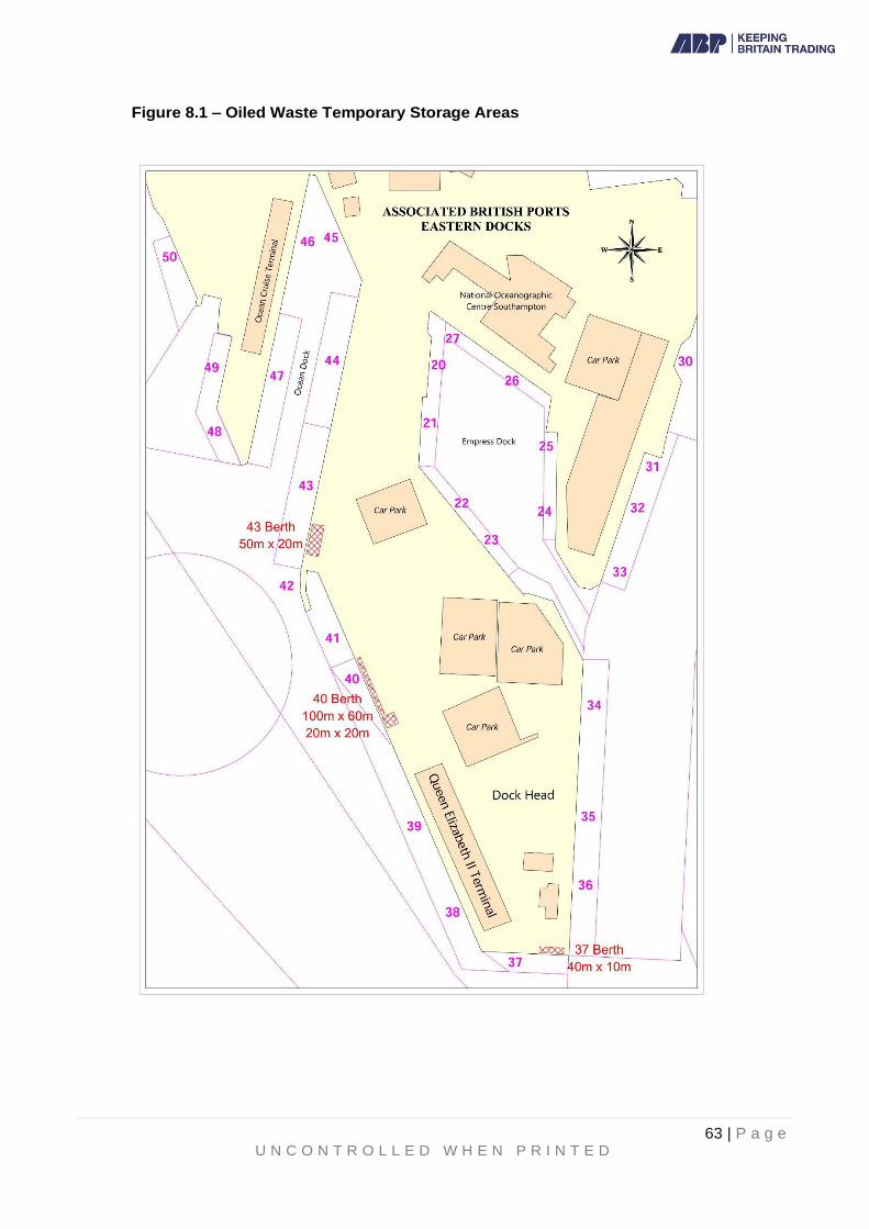
63 | P a g e U N C O N T R O L L E D W H E N P R I N T E D
Figure 8.1 – Oiled Waste Temporary Storage Areas

64 | P a g e U N C O N T R O L L E D W H E N P R I N T E D
8.9 Waste Oil Recovery and Disposal
8.9.1 Minimizing Waste
The arrangements for disposal of pollution wastes, whether removed from
Dock or Harbour waters or from the shoreline, will be agreed between the
Statutory Harbour Authority, Southampton City Council, Hampshire County
Council and The Environment Agency.
Minimisation techniques should be employed to reduce the amount of waste
entering the waste stream. This can reduce the amount of waste for final
disposal and limit environmental and economic impact. Efficient methods
should be employed for oil spill clean up to ensure that the minimum material
is used and/or contaminated during the process. Several methods can be
used:
- recovery equipment should be cleaned and reused rather than discarded.
reusable personal protective equipment (PPE) should be utilised where
appropriate, for example, products such as rubber boots that can be
cleaned and reused. - sorbents should be used sparingly and effectively.
- production of a marketable product from waste eg taking waste
oil to a power generating station for use as a fuel.
Adding to the waste stream is the least desirable option. If none of the above
methods can be carried out, for whatever reason, the waste must be disposed
of effectively following guidance from The Environment Agency.
8.9.2 Local Licensed Waste Disposal Contractors
The Waste Contractors listed below are approved to operate in the Port of
Southampton by virtue of their Waste Management Licence/Environmental
Permit issued in accordance with Section 35 of the Environmental Protection
Act 1990 (as amended) or Disposal Licence issued under Section 5 of the
Control of Pollution (Amendment) Act 1989.
By law, a Waste Transfer Note or Consignment Note must be generated by
the Waste Contractor when waste is collected from the port and a copy left
with the organisation employing the contractor (i.e.. Harbour Master, Tier 2
Contractor, Local Authority etc). The details in the Note will constitute the
record of the quantity of waste transferred from the port during the incident.
Contractor Contact Numbers
Veolia Environmental Services Ltd 023 8042 7100
Biffa Waste Services Ltd 023 8066 7140
Cleansing Service Group Ltd 01489 782232

65 | P a g e U N C O N T R O L L E D W H E N P R I N T E D
8.10 Recovery and Disposal Methods
Minimization and Pre – Treatment
As previously stated, waste minimisation is a key principle within the Port's waste management strategy. ABP Southampton's Port Waste Management Plan may be accessed at:
www.southamptonvts.co.uk
Under Port Information – Regulations – Port Waste
Recovery to Oil Processing Installations
Reprocessing is the preferred option. In general, only pure oil and possibly oil/water mixtures will be acceptable. Several Local Licensed Waste Disposal Contractors (listed at section 8.9.2 above) can accept recovered oil for recycling or reprocessing.
Chemical Stabilization
This is a recovery and containment method that involves mixing a powdered chemical such as calcium oxide (“quicklime”) or poly iso-butylene (“Elastol”) with the oil spill. This coagulates or solidifies the Oil on the surface for easy recovery and containment. These chemicals are also non-toxic, so pose little risk to aquatic wildlife. This is an expensive alternative for recovery and containment.
Land Farming
This can make only a very limited contribution to oil disposal and is becoming less acceptable. However, it may be suitable for small quantities of oily waste, such as contaminated seaweed.
Combustion
Uncontrolled combustion is unsatisfactory because of the air pollution it causes. Commercial waste incinerators can dispose of only limited quantities of oily waste.
Disposal to Landfill This is no longer the principle disposal method and can only be used in limited
circumstances.
The Landfill (England and Wales) Regulations 2002, The Landfill (England and
Wales) (Amendment) Regulations 2004 and The Landfill (England and Wales)
(Amendment) Regulations 2005 require waste to be pre-treated prior to disposal at
landfill. Waste is considered to have been pre-treated if it has undergone a physical,
thermal or biological process, including sorting, that:
i) changes the characteristics of the waste; and
ii) does so in order to reduce its mass or reduce its hazardous nature or
facilitate its handling or enhance its recovery.
iii)
In practice, this requirement will be implemented by ABP Southampton's Tier 2
Contractor and appointed waste contractors. Some of the pre-treatment may be
undertaken at an off site facility.

66 | P a g e U N C O N T R O L L E D W H E N P R I N T E D
Waste disposal criteria and guidance for disposal of waste to landfill can be found at:
www.environment -agency.gov.uk
Wastes banned from landfill include:
• any liquid waste
• any waste that does not meet the waste acceptance criteria for that class of landfill.
Information on the landfilling of hazardous waste, and which Landfill Sites in the UK that can accept hazardous waste, can be found at; www.environme nt-agency.gov.uk
8.11 Considerations regarding waste management issues
Make initial contact with Local Licensed Waste Disposal Contractors to decide for the
ultimate disposal of waste materials.
Ensure that all Contractors' vehicles are carrying valid Registered Carriers Registration
Certificates before they arrive on site.
Obtain data on likely quantities of liquid oily wastes that are being collected by any
recovery operations.
Estimate quantities of non-liquid oiled wastes created primarily on shorelines. Initiate
appropriate Duty of Care and Hazardous Waste documentation to cover all waste
transportation used and ensure drivers are clearly briefed on their destination.
Ensure that transport of oily waste is of a frequency enough to prevent the temporary
storage from being overwhelmed.
Confirm with all waste disposal facilities used that they have received all documentation
required.
Plans for handling and temporary storage of wastes arising during the oil spill response must be discussed with The Environment Agency at the earliest opportunity.
The disposal site for the waste must have a licence to receive that type of waste.
The Harbour Authority and Tier 2 Contractor must ensure that all relevant regulations
have been complied with.
Appendix 8A – STOp Notice 3/2016 Guidance for Waste Management
SCIENTIFIC, TECHNICAL AND OPERATIONAL ADVICE NOTE- STOp Notice 03/2016
Guidance for Contingency Planning and Operation of the Technical Team Waste
Management Sub-Group within a National Contingency Plan Shoreline Response
Centre in England and Wales
https://www.gov.uk/government/publications/scientific-technical-and-operational-
advice-notes-stop-notes

67 | P a g e U N C O N T R O L L E D W H E N P R I N T E D
9. Training and Exercise Policy Training The importance of training for harbour personnel who may become involved in the response to oil spill incidents is recognised and acknowledged. All members of the Management Team and Supervisors will undergo periodic training in line with the matrices below. Members of the Duty Harbour Master's Roster (4 - Harbour Master, Deputy Harbour Master, (Pilotage), Deputy Harbour Master (Marine Operation) and AHM Leisure & Compliance are trained, in date, to MCA 4p level. All staff likely to be directly involved in a spill response (Assistant Harbour Master (VTS) (5), Berthing Officers (5) and Patrol Launch crew (10)) are all trained, to date, to MCA 2p level. The training courses are accredited by the Nautical Institute for the Maritime and Coastguard Agency; the syllabus of the courses matches the requirements of UK oil spill training standards. Exercises An annual exercise already takes place within the Port and this practice will continue. Harbour personnel also participate in oil company exercises and an oil pollution element is regularly included in the major exercises of the Marine Emergency Plan (SOLFIRE) which are held each year.
Other organisations will be invited to participate in these exercises as appropriate and
lessons learnt will be shared.
9.1 Post Incident and Post Exercise Evaluation Reports
Statutory Instrument 1998 No 1056 Regulation 4, as amended by Statutory Instrument 2015 No 386 Regulation 6 (12) (extracts at Appendix 3A), requires that details of all incidents and of all exercises conducted by the port authority are to be reported to the MCA, on behalf of the Secretary of State.
Thus, the circumstances of all incidents should be appropriately investigated, and the details recorded in the MarNIS Incident Database. Investigation reports should be forwarded to the MCA as required.
All exercises conducted by the port authority are to have an aim and appropriate
objective. Post exercise reporting should comment on whether the aim and objectives were met or not.
All lessons learned should be incorporated in this Plan at the earliest opportunity
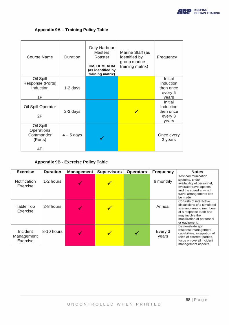
68 | P a g e U N C O N T R O L L E D W H E N P R I N T E D
Appendix 9A – Training Policy Table
Course Name
Duration
Duty Harbour
Masters Roaster
HM, DHM, AHM (as identified by training matrix)
Marine Staff (as identified by group marine training matrix)
Frequency
Oil Spill Response (Ports)
Induction
1P
1-2 days
Initial Induction then once
every 5 years
Oil Spill Operator
2P
2-3 days
✓
Initial Induction then once
every 3 years
Oil Spill Operations
Commander (Ports)
4P
4 – 5 days
✓
Once every 3 years
Appendix 9B - Exercise Policy Table
Exercise Duration Management Supervisors Operators Frequency Notes
Notification
Exercise
1-2 hours
✓
✓
6 monthly
Test communication systems, check availability of personnel, evaluate travel options and the speed at which travel arrangements can be made
Table Top Exercise
2-8 hours
✓
✓
Annual
Consists of interactive discussions of a simulated scenario among members of a response team and may involve the mobilization of personnel or equipment.
Incident
Management Exercise
8-10 hours
✓
✓
✓
Every 3 years
Demonstrate spill response management capabilities, integration of roles of different parties, focus on overall incident management aspects.

69 | P a g e U N C O N T R O L L E D W H E N P R I N T E D
10. Risk Assessment The Port of Southampton is a large multi-user port. Local ferry traffic is extensive with services operating between Southampton and the Isle of Wight and Southampton and Hythe for up to 20 hours per day. Both dedicated passenger and Ro-Ro services operate to and from Cowes.
The BP Hamble and Esso Fawley oil terminals lie within the port area and are serviced by
tankers of up to VLCC size - at up to 330 metres LOA, 60 metres beam and +15 metres draught
- for the import and export of crude oil; both terminals also handle a wide range of products.
The level of deep-sea Ro-Ro traffic using the port is increasing year on year and services
operate both within the European area and worldwide. These vessels are on average 200
metres LOA and 32 metres beam but changes in design have seen an increase in size in recent
years, with 240 metres LOA or 36 metres beam no longer being unusual. Southampton has
upwards of 1 million units being moved through the Docks annually.
Dubai Ports World (Southampton) Terminal lies in the River Test and can accept the largest
container ships in the world, currently at up to 399 metres LOA, 61 metres beam and +16 metres
draught. Many of the vessels are on loop routes from the Far East and call regularly at the port
every 8 - 10 weeks.
Bulk cargo vessels are regular visitors to the Bulks terminals in the Western Docks and to King
George V Dock, for the delivery of salt, animal feeds or woodchip and loading of scrap. Again,
these can be significant vessels at up to 200 metres LOA and 32 metres beam.
Southampton is the 'home port' for the Carnival UK stable of cruise ships, as well as Royal
Caribbean, MSC, Fred Olsen and Saga Cruise Lines and, in general, is a turnaround port -
being the start and end point for many cruises. The cruise season is largely between March and
October but, more and more, cruise visits are occurring all year round. Again, these are
generally very sizeable vessels, at up to 360 metres LOA, 47 metres beam and up to 10 metres
draught.
Except for vessels berthed at the Fawley jetties, most bunkering operations within the port are
undertaken by bunker barge.
Recreational use of the harbour waters is extensive. Activities and events are co-ordinated
through the Southampton Port Marine Users Group (SPMUG) chaired by the Harbour Master.
Numerous sailing clubs and marinas are located within, or adjacent to, the harbour limits.
Much of the shoreline is designated as Sites of Special Scientific Interest. Additionally there are
a number of other environmental designations including Ramsar sites, SPAs and SACs.
Southampton Water is subject to the unusual phenomenon of a 'Double High Water tidal effect.
A full tidal cycle lasts approximately 13 hours with the flood tide lasting about 7 hours, a 2-hour
stand at High Water and an ebb tide of about 3 hours. The short duration of the ebb makes for
a greater velocity of flow. Maximum tidal rates of up to 3.8 knots are experienced in the Central
Solent and 1.8 knots in Southampton Water during a spring ebb tide. Neap and flood tidal rates
are considerably less.
Appendix 10B showing different incident categories and the number reported has been used
when considering in the development of appropriate Risk Assessments

70 | P a g e U N C O N T R O L L E D W H E N P R I N T E D
Below is a visual representation of the numbers of different vessels that utilised the Port and
approaches at key transects in 2020:
10.1 Port Operations
10.1.1 Pilotage
Pilotage is compulsory for all vessels over 61 metres in length and for vessels over 20 metres in length carrying more than 12 passengers, other than those which trade regularly to the port and whose Master’s have been granted pilotage exemption certificates.
10.1.2 Vessel Traffic Service (VTS)
The Port operates a modern Vessel Traffic Services control centre equipped with radar surveillance, communications and vessel traffic management systems. All vessels of 20 metres or more in length entering, leaving or manoeuvring within the port fall under the direction, co-ordination and management of Southampton VTS. Pilots of large and/or deep draught vessels maintain a close liaison with the Duty Assistant Harbour Master (VTS) who closely monitors their passage while underway. While risk cannot be wholly eliminated from any transport operation, the provision of a traffic management service considerably reduces the likelihood of collision between vessels underway within the port.
10.1.3 Thorn Channel
71 | P a g e U N C O N T R O L L E D W H E N P R I N T E D
There are several traffic rules governing the movement of vessels through the Thorn Channel entrance to Southampton Water. Vessels constrained by their draught are afforded sole occupancy status of the main shipping channel when entering or leaving the port. Additionally, all large tankers carrying crude oil cargoes are under active tug escort while transiting the Thorn Channel.
No two vessels, each having a length of 180 metres or more, shall pass or overtake each other within the Thorn Channel. All vessels greater than 150 metres in length are assigned a Moving Prohibited Zone (MPZ) extending 1000 metres ahead and 100 metres either side of the vessel from which sailing craft and small vessels are excluded. Most large vessel movements through the Thorn Channel are assigned a harbour patrol escort launch.
10.1.4 Main Channel
The risk of grounding in Southampton Water is considerably lower than that which
applies to transiting the Thorn Channel. The main channel is straight with the channel
margins clearly marked and large loaded and partly-loaded tankers are under active
tug escort while proceeding to and from the berths at Fawley and Hamble. Recent
dredging has increased the available depths in the main channel to 13.2 metres.
While the risk of grounding is low, it cannot be wholly eliminated; the most probable
risk is steering or propulsion system failure where resultant damage to the mid-body
plating of tankers is unlikely, but tankers, container vessels and passenger ships could
sustain damage to bunker tanks in the fore part of the vessel leading to small releases
of fuel oil.
10.1.5 Collision between Vessels Underway
Many movements within the Port of Southampton limits involved conventional oil tankers, many of which were not entitled to sole occupancy of the Thorn Channel. Smaller tankers, including bunkering vessels and others carrying persistent oils, also operate north of the Fawley Reach. The potential for a spillage of fuel or other persistent oil as a direct result of a ship collision must be acknowledged.
Large container ships and passenger vessels can also carry substantial
quantities of fuel oil; collision impact could result in hull damage in way of bunker
tanks with a consequent risk of spillage.
Given the controls which are imposed on ship movements within the port and the
fact that there have been no collisions between vessels underway since 1988,
that has involved the release of cargo oil or fuel oil, the risk of oil spillage as a
direct result of ship collisions must be regarded as low.
10.1.6 Tug Impact
There are well-documented incidents where cargo or bunker oil has been released as a result of hull impact damage by tugs. This can occur when tugs are approaching a vessel underway prior to berthing, or when coming alongside a moored vessel prior to unberthing.
The potential spill quantities again depend on the location and extent of the impact damage but can be over 500 tonnes for bunker oil and 2,000 tonnes for cargo oil.

72 | P a g e U N C O N T R O L L E D W H E N P R I N T E D
There is a small risk of a spill occurring during towage, but the risk is acknowledged and mitigated as much as possible by Tug operators.
10.1.7 Berthing Incident
Oil spills can occur as a result of hull contact with the knuckle end of quay walls
or breasting dolphins during ship berthing or unberthing manoeuvres. Such
incidents are generally due to failure of a vessel's main propulsion or steering
systems, loss of control onboard an attendant tug or pilot error or misjudgement.
The potential spill quantities involved depend on the vessel type and the location
and the extent of the impact damage; hull damage to a large crude oil tanker in
way of a mid-body wing tank, for example, could give rise to a release of some
5,000 tonnes. The potential spill quantity should hull plating be ruptured in way
of an aft wing fuel oil bunker tank can, historically, be in excess of 1,000 tonnes.
10.2 Oil Transfer Options
The BP Hamble and Esso Fawley installations handle crude oil at flow rates of up to
10,000 m3 /hr; additionally, fuel oil is exported and imported at the Fawley Marine Terminal. Both installations also handle a range of refined products.
This section summarises the potential sources of oil spills during cargo handling operations; the summary is based on information published in the Fawley Marine Terminal Oil Spill Contingency Plan, oil industry data and ITOPF statistics. It should be noted that the ITOPF statistics demonstrate that most oil spill incidents occur during routine cargo handling operations and that some 91% of these incidents resulted in spillages of less than 7 tonnes.
Cause Assessed Risk
Credible Spill Quantity (Tonnes)
Cargo tank overflow Low 100
Slop tank overflow Low 25
Loading arms Moderate <50
Ballast water discharge Low <50
Sea/overboard discharge valves Moderate <25
Vessel breakout Low >100
Hull failure Low >700
10.3 Pipelines
The pipe bundle trenched in the pipeline crossing of Southampton Water includes
pipelines which transport both non-persistent and persistent oils. The Esso Fawley
Refinery supplies fuel oil and refined products via pipelines which connect with the
UK pipeline network. Crude oil production from the Wytch Farm oilfield is

73 | P a g e U N C O N T R O L L E D W H E N P R I N T E D
transferred to the BP Hamble Terminal via the Perenco Purbeck-Southampton
Pipeline (PSP). The pipeline crossing is clearly indicated on navigational charts as
a Prohibited Anchorage Area and is also delineated by shore marks. The likelihood
of third-party impact damage to any of the pipelines must be considered remote
but is, nonetheless, acknowledged as a risk. The worst-case scenario is failure of
the crude oil pipeline as a result of third-party impact damage; this could lead to a
release of some 600 tonnes of crude oil.
10.4 Bunkering and Bulk Liquids Transfer Operations
Except for those vessels which refuel at the Esso Refinery berths, all other ships are
bunkered ex-barge while alongside their berths. Bunkering at anchor is now no longer
allowed. Heavy, intermediate and light fuel oils together with marine gas oil are
supplied. Transfer rates of up to 500 tph can be achieved. Although flexible hoses are
tested at six monthly intervals and all bunkering craft are equipped with emergency
shut down facilities, the possibility of hose failure or a bunker tank overflow onboard
the receiving vessel must be recognised. In estimating the potential spill quantities, the
facts that Check Lists are completed prior to each operation and that a continuous deck
watch is maintained on board bunkering craft have been considered.
Occasionally, road tanker deliveries of gas oil and transfer of bulk liquids, in general,
takes place at alongside berths and procedures are in place to ensure that permission
is gained prior to delivery/collection. The fact that a comprehensive Check List is
completed before bunkering commences, and the Duty Assistant Harbour Master
(VTS) is informed prior to commencement and on completion of the evolution,
minimises the potential for a significant spill. The Bulk Liquids Transfer Request Form
(MF012) can be found on the SharePoint site under Quick Links – Marine Forms.
LNG Bunkering operations also regularly take place within Southampton Docks via
both road and vessel transfers.
Cause Assessed Risk Potential Spill Quantity (Tonnes)
Hose failure Low <5
Tank overflow Moderate <2
10.5 Effluent Discharges to Harbour Waters
Treated effluent from several industrial sites, including the two oil terminals, is discharged
into harbour waters. The discharge consent levels are set and monitored by the
Environment Agency and the site operators regularly test for effluent quality.
Instrumentation malfunction, failure of in-line samplers or operator error can result in the
entrainment of oil in the final discharge to harbour waters. Most spillages of this nature
are not substantial and, based on port records and industry experience elsewhere, are
unlikely to exceed 25m3 in volume.
10.6 Miscellaneous Spill Sources
Given the level and range of activity within the port, there are several other potential
sources of oil or chemical spills. Examples include the refuelling of leisure craft from
74 | P a g e U N C O N T R O L L E D W H E N P R I N T E D
marina forecourt type pumps, leakage from dockside storage tanks, discharges of engine
compartment bilge water and spills arising during the transfer of cargo, for example, from
the puncturing of flexitanks within containers during cranage operations.
Additionally, the Port has a surface water drainage infrastructure which flows directly into
the River Test. Several storm water outfalls carrying storm water from the City of
Southampton flow directly into the River Test and these are not, in general, equipped
with shut-off valves or penstocks (See Appendix 10A). Heavy rain following a dry spell
of weather may result in a sheen developing locally in the outfall locations from road oil
and tyre dust.
10.7 Place of Refuge
A 'Place of Refuge' means a place where a ship in need of assistance can act to enable
it to stabilise its condition, reduce the hazard it presents to navigation, protect human life
and protect the environment.
The process of identifying an appropriate place of refuge is driven by the circumstances
of the incident, including such event-specific data as the weather, the geographical
whereabouts of the incident and the type of threat posed by the ship and its cargo. The
MCA Counter Pollution and Salvage Branch will identify and, in consultation with the
Solent Environment Group and the Port when necessary and as far as is practicable,
carefully consider Southampton as a place of refuge. They will conduct a risk
assessment of this location prior to submission to SOSREP, who will make the final
decision to assign the port as a 'Place of Refuge'. The extent of the risk assessment and
measures put in place to prepare for the casualty's arrival will very much depend on the
nature of the incident, level of damage to the casualty and time available before arrival.
The wider Solent and the Port of Southampton have been used as a place of refuge on
several occasions in the past and thus this can be expected to occur in the future. The Solent can offer a deep-water approach channel and sheltered anchorages with easy
access to towage assets. Additionally, the port can offer berths capable of accepting vessels up to 400 meters in length overall, with draughts in excess of 11.5 metres, with
ready and close access by the emergency services and MCA headquarters.
Depending on the nature of the ship casualty, the Port's Oil Spill Contingency Plan would
be placed at notice and would be fully supported by SOSREP and the MCA, were a spill
to occur, or in the event of a risk of significant pollution.

75 | P a g e U N C O N T R O L L E D W H E N P R I N T E D
Appendix 10A Storm Water Outfalls
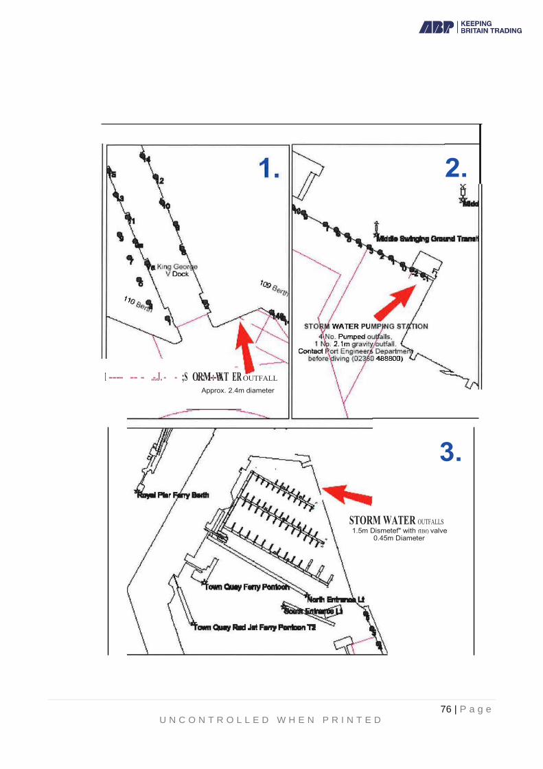
76 | P a g e U N C O N T R O L L E D W H E N P R I N T E D

77 | P a g e U N C O N T R O L L E D W H E N P R I N T E D
Appendix 10B – Table of Incidents Recorded at Southampton 2010-2020
Event
Year
An
nu
al
fre
qu
en
cy
20
10
20
11
20
12
20
13
20
14
20
15
20
16
20
17
20
18
20
19
20
20
To
tal
Capsize/Sinking 1 0 0 0 1 1 0 0 0 0 0 3 0.27
Collision 28 30 28 18 20 21 11 14 32 7 12 221 20.10
Equipment failure 21 18 25 20 19 40 51 39 44 30 35 342 31.10
Fire/Explosion 3 0 0 1 0 1 2 3 1 2 3 16 1.45
Grounding 5 4 2 3 3 2 2 0 4 2 1 28 2.55
Impact with Structure 2 7 6 1 4 6 6 15 9 5 8 69 6.27
Other nautical safety 13 3 9 7 14 13 32 41 41 38 43 254 23.10
Pollution 9 14 12 2 3 10 6 7 4 2 14 83 7.54
Total 82 76 82 52 64 94 110 119
135 86 116 1,016 92.36

78 | P a g e U N C O N T R O L L E D W H E N P R I N T E D
11. Sensitivity Maps and Environmental Information This section contains Environmental Sensitivity Maps depicting the Sites of Special Scientific Interest, Special Protection Areas and Special Areas of Conservation which lie within, or immediately adjacent to, the statutory Harbour area. Priority protection areas have been identified as it is recognized that not all sensitive areas may be capable of protection in a large oil spill incident. The information given in this section should be used in conjunction with Response Guidelines included in Section 5.
11.1 Priority Sensitive Areas
The priority sensitive areas for Southampton Water, River Test, River ltchen and River
Hamble have been divided into two groups:
Group A - identified as sensitive because of the habitat types or species found at
each site. These designated areas should receive priority protection. "A" priority
habitats are saltmarshes, sheltered tidal flats and sheltered rock coasts. Although all
"A" habitats require priority protection, it may be necessary to have a further
breakdown of "A" sites in case all such areas cannot be protected, and choices have
to be made. "A" sites have therefore been divided into A1, A2 and A3 categories;
division into these 3 categories has been made on the basis of the presence of
nationally or locally important sites for bird concentrations, botanical species,
important sites for agriculture and major water intakes.
Group B - these areas are generally less sensitive to oil pollution effects, have a
shorter recovery time and greater successful clean-up potential than Group A sites or
are sites that have been ranked as such because it is not possible to protect them
with the downstream booming sites. "B" Priority Protection Areas are listed in section
11.1.1 below. Certain ecological sites, primarily on the Rivers ltchen and Test, have
been included in the B priority areas.
11.1.1 Site Specific Priority Sensitive Areas
Active times are highlight in yellow A1 AREAS
• Upper Hamble Estuary & Woods: Large Population of invertebrates in intertidal flats as well as a rich feeding ground for waders, ducks and grey heron (Sept – March). Country park located at Upper Hamble.
• Lower Test Valley: Rich in flowering plant species including rare bulbous foxtail in the Saltmarsh. Important wetland breeding ground for wetland birds (March-Aug) as well as feeding and roosting ground for ducks & waders (Sept – March). Large breeding population of reed and sedge warblers and autumn roosting site for passerine birds (March-Aug). Wildlife Reserve at Lower Test.
• Eling & Bury Marshes: Feeding and roosting areas for autumn & winter populations of waders, ducks and grey heron (Sept – March). Regionally & Nationally important species composition as well as the only Puccinelia saltmarsh on the central south coast.
• Hythe & Calshot Marshes: Nationally important migratory and over winter site for waders (Sept – March) and a breeding colony of black headed gulls are at Fawley Power Station (April – July). Important feeding and roosting area for wildfowl as well as Spartina Saltmarsh (scientific importance). Wildlife Trust Reserve at Hythe and Local Nature Reserve at Calshot, as well as 2 nationally rare species of shingle plant at Calshot Castle.

79 | P a g e U N C O N T R O L L E D W H E N P R I N T E D
• Lincegrove & Hackett Marshes: Saltmarsh and mudflats of international importance.
• Hamble River: Large majority of mudflat and saltmarshes is of international importance for waterfowl.
• Chessell Bay on River Itchen: Sheltered mudflats of international importance for waterfowl
• Titchfield Haven Reedbeds: Large reedbed connected to Southampton water by sluice, as well as being of international importance for waterfowl. All year but especially Sept – March.
A2 AREAS
• Marchwood & Fawley: Water Intake at respective Power Stations.
A3 AREAS
• Hamble River: Local Nature Reserve at Mercury Marshes and National Trust site at Curbridge.
• South Netley: Royal Victoria Country Park.
B1 AREAS
• Hamble River: Local Nature Reserve at Hook with Warsash
• Southampton Water: Inshore fisheries of native oysters and hard-shelled clams for harvesting and Bass nursery grounds (May – Nov). Nationally rare benthic sponge Suberites Massa and Lagoon cockle Cerastoderma Glaucum occur in Southampton Water all year.
B2 AREAS
• Hill Head: Approx 75 moorings and 2 sailing clubs – all year.
• Titchfield Haven: Small Harbour and sailing clubs – all year
• River Hamble: 4 Marinas: Port Hamble, Hamble Point, Mercury Yacht Club and Swanwick aswell as 8 public slipways – all year but peak periods April – Sept.
• Hamble Quay: 4 sailing clubs, 3 canoe clubs with total capacity of 3200 (1867 moorings, 1273 marina berths, 470 boats ashore, 30 visitor berths). All year but peak periods April – Sept.
• Woolston to Hamble Point: 3 sailing clubs, angling club and public sliplway at Weston Point, Weston Shore, Netley and Royal Victoria Country Park. All year but peak periods April – Sept.
• River Itchen: Multiple Marinas including Bluffs Quay, Kemps Quay, Quayside Marina, Saxon Wharf, Ocean Quay Marina and Ocean Village. 8 public slipways, 2 sailing clubs, 6 rowing clubs, angling club and Southampton Waterborne Activities centre. All year but peak periods April – Sept.
• Totton – Calshot: Hythe Marina village, Hythe Pier, 9 sailing clubs, 5 public slipways and Solent canoe club. All year but peak periods April – Sept.
B3 AREAS
• Hill Head: Bathing beach. Peak April – Sept
• Calshot: Bathing beach. Peak April - Sept

80 | P a g e U N C O N T R O L L E D W H E N P R I N T E D
11.2 Priority Protection Areas
Establishing priorities for protection of areas of the coastal zone of Southampton Water, River ltchen, River Hamble and Test River has been based on the principle of greatest net environmental benefit by assessing, in combination, the following key parameters: environmental sensitivity; areas where oil concentration is likely to have the longest term effects; and areas where clean up options are most restricted meaning that prevention, and therefore priority protection, will be the primary means to minimize pollution effects. In Table 11.2, sensitivity has been assessed using as a basis the widely accepted index of shores developed by Gundlach and Hayes (1979). The length of recovery time from pollution effects and susceptibility to adverse impact from clean-up operations are bound up with two key variables: the energy level of the shoreline (essentially degree of exposure to wave energy) and the substratum type. On exposed rocky shores effects on shore life tend to minimal and recovery rates rapid because oil does not stick easily to such shores and if it does it tends to be quickly cleaned off by vigorous wave action. With increasing shelter, the likelihood of persistence increases as does the biomass to trap the oil. The most sheltered shores tend to be the sedimentary mud flats and saltmarshes. Such areas have a high biological productivity, are also the worst oil traps and are amongst the most susceptible to damage by beach clean-up methods. In estuarine areas, oil pollution damage will thus be most pronounced in the sheltered estuarine bays, inlets and creeks. Combining energy levels, substratum types and sensitivity it is possible to derive shoreline protection and clean-up methods ordered according to sensitivity and requirement for protection as a priority over clean-up. This has been done and the results reproduced in Table 11.2 which presents a sequence from exposed rocky headlands where active shoreline protection and beach clean-up are likely to be needed though to sheltered tidal flats and saltmarshes where the priority is for protection and avoidance of clean-up.
Table 11.2 Vulnerability of Shoreline Habitats and their general physical and
biological characteristics
Shoreline Habitat Characteristic and vulnerability Exposed rocky headland Wave reflections keeps more oil offshore;
active shoreline protection and beach clean-up necessary
Eroding wave cut platforms/intertidal and sub tidal rocky shores
Shoreline protection is unlikely to be necessary. Most oil removed by natural
processes within weeks
Fine-grained sand beaches Oil does not penetrate the sediment, facilitating mechanical removal if necessary.
Otherwise oil persists for several months
Coarse-grained sand beaches Oil may sink into and/or be buried rapidly, making clean up difficult. Under moderate to high energy conditions, oil will be removed
naturally.
Exposed compacted tidal flats Recovery sand/mud flats may be facilitated by nearshore releases of dispersants. Most oil
will not adhere to, nor penetrate, the compacted tidal flat. Clean up usually
necessary.
Mixed sand and gravel beaches Dispersant in nearshore areas may be an effective protection. Manual removal if heavily
oiled.

81 | P a g e U N C O N T R O L L E D W H E N P R I N T E D
Gravel beaches Natural clean up or physical collection are the best options
Sheltered rocky coasts Protection/diversionary booming. Areas of reduced wave action. Oil may persist for many years. Clean up is not recommended unless
oil concentrations are very heavy
Sheltered tidal flats Protection/diversionary booming. Clean up is not recommended unless oil accumulation is
very heavy. Bioremediation techniques can be considered.
Salt marshes Protection options: Protection/diversionary booming. Avoid dispersants. If oil enters
marshes; containment and recovery in creeks; absorbents
11.3 Port of Southampton Coastline
11.3.1 Lepe to Calshot
• Length of Shoreline: 4 miles
• Description: Mud, sand and shingle beach, backed by Lepe country park; some MOD land, woodland and grassland; some groins at Lepe
• Adjacent sea areas: Major oyster beds particularly at Stanswood Bay and Calshot, and at Bramble bank and Thorn Knoll in mid channel.
• Ecological Sensitivity: An SSSI, part of the Solent and Southampton Water SPA, part of the Solent Maritime SAC and, in large part, a National Nature Reserve. The SSSI supports the largest British colony of black headed gulls and is a nationally important ternary. The inter-tidal area at Calshot Spit has Zostera Marina eelgrass beds. The whole site is an important wild fowl refuge and is of national importance as a coastal ecosystem. The coastline also forms part of the New Forest National Park. There is an inshore nature sanctuary at Calshot.
• Main Uses: Shoreline for recreation and water for sailing, water sports, bathing, fisheries and sea angling
• Access to Shoreline: Access points at Lepe and Calshot but movement of mechanical equipment along the beach is inhibited in places by groins and fencing.
• Clean up plan: Physical removal of contaminated shingle, dispersants MUST NOT be used. Set up bird scarers if necessary
11.3.2 Calshot Spit to Ashlett Creek
• Length of shoreline: 1 Mile
• Description: Some shingle but mainly mudflats and saltmarsh backed by
grassland and Fawley Power Station.
• Adjacent sea area: Oyster cleansing area off Calshot spit.
• Ecological sensitivity: Designated SSSI, an SPA and a SAC. A local Nature
Reserve in part and the coastline also forms part of the New Forest National
Park.
• Main uses: Shoreline for recreation (particularly Calshot), water for sailing with
moorings at Calshot and Ashlett creek, water sports, bathing at Calshot,
fisheries and sea angling.
• Access to Shoreline: Access points at Calshot Activities Centre and Ashlett
Creek.

82 | P a g e U N C O N T R O L L E D W H E N P R I N T E D
• Clean up plan: Leave to natural cleaning processes, shingle shorelines may
be cleaned manually. No dispersant use, particularly on saltmarsh of mudflats,
or near Calshot. Heavy equipment mustn’t be put on saltmarsh and absorbent
booms should be deployed at saltmarsh and Ashlett creek if accessible.
11.3.3 Ashlett Creek to Esso Outfall 1
• Length of shoreline: 1.2 miles
• Description: Mudflats ad saltmarsh backed by Esso refinery landscaping area.
• Adjacent sea area: Water intakes for Fawley refinery.
• Ecological Sensitivity: Whole area designated an SSSI, SPA and SAC.
• Main Uses: Nothing on shoreline, sailing in water.
• Access to shoreline: At Ashlett Creek and via Ashlett Club, elsewhere, across
seawall at Esso. Not suitable for mechanical equipment.
• Clean up plan: Leave to natural cleaning processes. Manually clean oil from
Solent view area if practical, no dispersant to be used (particularly on
saltmarsh) and deploy absorbent booms if accessible and necessary.
11.3.4 Esso Outfall 1 to Hythe Park Marina
• Length of shoreline: 2.2 miles
• Description: Extensive saltmarsh backed mainly by the industrial land and beech wood.
• Adjacent sea areas: Clam fisheries in the whole area as well as nearby Yacht marina.
• Ecological Sensitivity: An SSSI, SPA and SAC along with a Nature Reserve at Hythe end. A major wildfowl refuge for winter migrants and marshes dominated by Spartina. Flats dominated at times by green algae supporting large percentages of national populations of ringed plover, grey plover, curlew and dunlin. Feeding grounds for teal, shelduck and brent geese.
• Main uses: Water used for sailing
• Access to shoreline: Numerous access sites but not suitable for mechanical equipment. Access with Esso zone 2 or Frost Lane (Hythe).
• Clean up plan: Leave to nature, no dispersant to be used ad deploy absorbent booms at saltmarsh creeks if accessible. No personnel or heavy equipment on the saltmarshes.
11.3.5 Hythe Marine Park to SGL, Marchwood.
• Length of shoreline: 2 miles
• Description of coastline: Mainly shingle and boulder shoreline, with intertidal
mudflat, backed by Hythe Marine and rough grassland,
• Adjacent sea areas: Clam fisheries in the whole area as well as major marine
usage at Hythe. Offshore yacht anchorages in the area.
• Ecological Sensitivity: Whole are designated an SSSI and SPA. Valuable as
a feeding resource for birds.
• Main uses: Sailing and some angling at Hythe.
• Access to shoreline: Via Marina or minor footpaths from Hythe area. Vehicle
access to the Dibden Bay foreshore is possible via West Cliff Hall.
• Clean up plan: Physical removal where possible and dispersants could be
used with the agreement of MMO and Natural England.

83 | P a g e U N C O N T R O L L E D W H E N P R I N T E D
11.3.6 Port of Marchwood to Bury Creek
• Length of shoreline: 1.3 miles
• Description of coastline: Part mud and shingle beach with open pile quay line backed by urban and industrial development. Husbands shipyard, Marchwood aggregate what with sailing clubs at Cracknore and Marchwood.
• Adjacent sea areas: Small craft mooring areas and shellfish beds. Water intake for Marchwood Power station.
• Ecological sensitivities: Although not designated, the mudflats are used by SPA and SSSI birds as a feeding resource and are important to the function of nearby designated sites. The mudflats are locally designated as a Site of Importance for Nature Conservation (SINC).
• Main uses: Shoreline is predominately industrial and water is used for sailing, commercial vessel movements and some angling.
• Access to shoreline: Slipways at Cracknore and Marchwood.
• Clean up plan: Physical removal and treat shingle with dispersant before advancing tide subject to agreement of MMO and Natural England.
11.3.7 Bury Creek to Eling and Redbridge Causeway
• Length of shoreline: 3 miles
• Description of coastline: Some shingle but mainly mudflats and saltmarsh backed by woodland, grassland and industrial development.
• Adjacent sea areas: Small craft moorings in Eling creek, jet ski, PWC and water ski area in Redbridge channel.
• Ecological sensitivity: Whole coastline designated an SSSI, SPA and SAC.
• Main uses: Shoreline used as recreation at Goatee beach, Eling channel. Sailing, water skiing and jet skiing on the water along with some angling.
• Access to shoreline: Via slipway at Eling creek or footpaths to Goatee beach and Bury marshes.
• Clean up plan: Leave to natural cleaning processes. No dispersant use, particularly on saltmarsh and no personnel or heavy equipment to be put on saltmarshes. Deploy absorbent booms at saltmarsh creeks if accessible and necessary. Physical removal of cleaning of contaminated shingle at Goatee beach. Set up bird scarers if necessary.
11.3.8 Southampton Docks SCT1 to 30 Berth
• Length of shoreline: 4.5 miles
• Description of coastline: Industrial commercial dock complex with public
access to civic Mayflower Park and recreational/office development at Town
Quay backed by urban and industrial development.
• Adjacent sea areas: Marina at Town Quay
• Access to waterfront: Western docks via dock gates 20, 10 and 8 is subjected
to restricted access (generally late august to end September for boat show).
All other gates are 24-hour access. Eastern docks via dock gate 4 with slipways
at Mayflower park and Town Quay.
• Clean up plan: Physical removal where possible. Some dispersant can be
used but only with the agreement of the MMO and Natural England.

84 | P a g e U N C O N T R O L L E D W H E N P R I N T E D
11.3.9 River Itchen, 30 berth to Woodmill
• Length of shoreline: 6.5 miles
• Description of coastline: Mainly mud and some shingle backed by urban and
industrial development. Numerous private commercial wharfs in lower reaches
below Northam Bridge and marinas at Ocean village, Shamrock Quay and
Kemps Quay. Numerous small boat yards above Northam Bridge with
sewerage treatment plant at Portswood. Woods and parkland above Cobden
Bridge.
• Adjacent water areas: Shellfish beds and numerous small craft moorings
below Riverside park.
• Ecological sensitivity: Local nature reserve at Chessel Bay and some reed
beds above Riverside park. East bank is a SPA between Spitfire Quay and
Hawkeswood Road.
• Main uses: Light industrial, urban and recreation on shoreline. Sailing, rowing,
canoeing and angling on the water as well as commercial ship operations
below Northam Bridge.
• Access to shoreline: Public slipways at Crosshouse Hard, Itchen Ferry Hard,
Belvidere Hard, Millbank Hard, Priory Road Hard and Riverside Park.
• Clean up plan: Physical removal. Absorbent booms around reed beds where
accessible, no dispersant use.
11.3.10 Mouth of River Itchen, Woolston to River Hamble (West Bank)
• Length of shoreline: 4.2 miles
• Description of coastline: Mudflats backed with shingle beach, in turn backed
by urban and industrial development as well as the Royal Victoria Country
Park.
• Adjacent water areas: Oyster fisheries in the whole area and yacht
anchorages near mouth of River Itchen.
• Ecological sensitivity: Whole coastline designated a SSSI and SPA
• Main uses: Shoreline used for recreation and water used for sailing, water
sports, fisheries and sea angling.
• Access to shoreline: Via Copse Lane in Hamble and gate to west of BP
Hamble Terminal. Access to small beach at Netley sailing club and extensive
access at Weston.
• Clean up plan: Physical removal. Shingle may be treated with dispersant
before advancing tide subject to agreement from the MMO and Natural
England. Set up bird scarers if necessary.
11.3.11 River Hamble (West Bank) to Hillhead
• Length of shoreline: 3.9 miles
• Description of coastline: Mudflats backed by shingle beach and coastal
rough land. Groins at Hillhead. Some rocks on beach, River Meon mouth (fast
flowing)
• Adjacent sea areas: Oyster beds in the whole are, particularly off Chilling.
• Ecological sensitivity: Titchfield Haven is largely a National Nature Reserve
with a small selection outside this being a Local Nature Reserve. It is protected
by a tidal flap and is an important wildfowl refuge. There is also a Local Nature
85 | P a g e U N C O N T R O L L E D W H E N P R I N T E D
Reserve near Warsash. Whole coastline designated a SSSI and SPA. Mouth
of the River Hamble is a designated SAC.
• Main uses: Recreational beach at Hillhead end and sailing and fisheries in the
water.
• Access to shoreline: Access for mechanical equipment at Warsash, Solent
Breezes Caravan park and Hillhead. Access at Warsash (near old maritime
school site) is via a locked gate – key held by environment agency. Movement
along beach at Hillhead is impeded by groins ad there are locked gates around
the river mouth. Additional gated access at Chilling Substation and the key is
held by National Power, Nursling (tel: 01703 732125).
• Clean up plan: Physical removal. Shingle may be treated with dispersant
before advancing tide subject to agreement from the MMO and Natural
England. Set up bird scarers if necessary.
11.3.12 Hillhead to Lee-on-Solent
• Length of shoreline: 1.9 miles
• Description of coastline: Mudflats and shingle backed by urban areas and
MoD land.
• Adjacent sea areas: Oyster beds in the whole area
• Ecological sensitivity: Coastline designated a SSSI and SPA.
• Main uses: Recreation on shoreline. Sailing, water sports, fisheries and sea
angling on the water.
• Access to shoreline: Good access for mechanical equipment via large
slipway at Lee-on-Solent and other minor slipways. Movement along beach
impeded by groins. Good access along whole beach for manual clean up.
• Clean up plan: Physical removal. Treat shingle with dispersant before
advancing tide subject to agreement of the MMO and Natural England.
11.4.12 Solent and Dorset Coast SPA
• Size: Approx. 259.7 nm2 extending from the Isle or Purbeck in the West to
Bognor Regis in the East
• Description of SPA: Overall SPA for Southampton. Includes the Chichester
& Langstone Harbours SPA, Solent and Southampton Waters SPA and
Pagham Harbour SPA.
• The Solent and Dorset Coast SPA includes the entire water column up to
HW, or low water where it meets an existing SPA. This is for the protection of
Terns plunge diving primarily during the summer months. Further information
regarding this SPA can be found here.
11.4.13 Yarmouth to Cowes Marine Conservation Zone
• The boundary of the Yarmouth and Cowes Marine Conservation Zone is
located approximately 500m south west of Egypt Point. Whilst this is outside
of Southampton Port limits, its proximity means that special consideration
must be given in relation to this plan. Natural England are currently in the
process of developing a Conservation Advise package which will be available
here once published.

86 | P a g e U N C O N T R O L L E D W H E N P R I N T E D
12. Roles and Responsibilities
12.1 Harbour Authority
The Harbour Authority is responsible for the conservancy of its area together with the safety of navigation, pilotage and movement of all vessels. Its powers are derived from Principal and Local Harbour Acts and are exercised through bye-laws and Harbour Master directions. It has responsibility for responding to Oil Pollution within its area under the Merchant Shipping (Oil Pollution Preparedness, Response and Co-operation Convention) Regulations 1998 No. SI 1056 (with amendment SI No 1639 of 2001). The regulations state they apply to “any Harbour for which there is a SHA having an annual turnover of more than £1 million” The SHA has a responsibility under section 133 of the Marchant Shipping Act 1995 for bringing prosecutions for the offences of discharge of oil, or a mixture containing oil, into the waters of the Harbour.
12.2 Local Authorities
12.2.1 District Councils & Borough Councils
The 3 District and Borough councils in the plan area have accepted a non-statutory
responsibility for dealing with oil on the shoreline and beaches down to the low water
line, within the limit of their resources.
12.2.2 County Council and Unitary Authorities
Southampton City Council is a Unitary Authority and, along with other local authorities,
will be responsible for dealing with oiled shorelines in the City area. Hampshire County
Council assumes responsibility for co-ordinating the local authority action in the event
of widespread pollution affecting more than one district. The County Council may be
able to provide support to Districts for clean-up activities, District Councils remain
responsible for physical clearance in their respective areas of jurisdictions.
12.3 Maritime and Coastguard Agency
The Maritime and Coastguard Agency (an executive agency of the DfT) discharges DfT’s
responsibility for both the coordination of civil maritime Search and Rescue and counter-
pollution operations in UK waters.
In the event of an oil spill incident which calls for a Tier 3 response, the National Contingency
Plan may be implemented. In this event, and after the formal transfer of responsibility, the
MCA will take control of at sea counter pollution measures exercising this from a Marine
Response Centre (MRC) at MCA HQ Southampton, the JRCC at Fareham or another suitable
location (either within the ABP Estate or not). The Ports oil spill response resources and
facilities will be made available to the MCA.
87 | P a g e U N C O N T R O L L E D W H E N P R I N T E D
12.4 Marine Management Organisation
The MMO plays a major role in the protection of the marine environment, particularly in respect of fisheries and in ensuring the safety of the aquatic food chain, including the safety of consumers of fish and shellfish. The MMO is the statutory authority for approving deposits in the sea. Under the terms of the Marine and Coastal Access Act 2009 and The Marine Licensing (Exempted Activities) Order 2011, it is a legal requirement that oil treatment products may only be used in English or Welsh waters if they have been formally approved for this purpose by the MMO. In addition, specific permission from the MMO must be obtained before any such products are used in shallow waters – these are defined as any area of the sea which is less than 20 meters deep, or within one nautical mile of such an area. This includes any use in tidal docks, locks and on beaches, shorelines or structures such as piers and breakwaters. MMO’s representation in the EG will be from local MMO offices – the role of local MMO staff is to give advice on fisheries, shellfisheries, marine conservation zones, marine licensing and dispersant use, but not dispersant approval. In addition, other local MMO staff may be called upon to act as an environmental liaison officer in the EG.
12.5 Natural England
Natural England is the organization responsible for advising the Government on nature conservation policies in England. When an incident occurs, Natural England provides advice to local authorities, the counter pollution branch of the MCA and other relevant bodies on the likely environmental impacts and the best methods of treating oil to minimize damage to wildlife. The advice would normally be provided through their representative on the established Solent Environment Group, more information on this can be found in Section 2.8.
Natural England will provide advice on location and features of designated sites, sensitivity of those features to marine pollution, priorities for protection and suitability of various clean up techniques.
12.6 Environment Agency
The Environment Agency is a non-departmental public body with the statutory duties and
powers in relations to water resources, pollution control, flood defences, fisheries, recreation,
conservation and navigation in England and Wales. Under the Water Resources Act 1991,
the EA is responsible for the control of pollution and water quality in all controlled waters which
include groundwaters, fresh waters, estuaries and coastal waters up to 3 nautical miles
offshore.
The EA has powers to both control and remedy pollution. It has powers to prosecute for
pollution offences under Section 85 of the Water Resources Act 1991 and under section 161,
the EA can act to prevent pollution entering controlled waters. Under section 161 the EA may
also remove and dispose of polluting matter which has entered controlled waters, remedy or
mitigate its presence and restore the water to its previous condition.
With regards to marine/estuary pollution, the EA may take the lead for land based pollution
sources, or where there is no other Harbour or Local Authority plan already in place (e.g
Harbour Plans).

88 | P a g e U N C O N T R O L L E D W H E N P R I N T E D
During a marine incident, the EA will:
• Advise on environmental sensitivity, impact and action required to mitigate pollution.
• Regulate and provide advise on any waste management activities
• Advise on necessary remedial actions
• Investigate offences.
12.8 Oil Spill Management Team
Oil Spill Management Team (OMT) is the nomenclature used to describe the command and
control team established for the spill incident within the Port of Southampton, with
representatives of organisations attending in accordance with the category of oil spill response
established, as described in section 2.2.
12.9 Marine Response Centre
The MRC for the Port of Southampton (not to be confused with an MCA led MRC) is a
dedicated facility in the VTS offices with communications, IT and radar links to the Port
Operations room and is where the OMT will convene.
13 Resource Directory Inventory of available equipment at organizations within the Port of Southampton
Port of Southampton
• 100m floating boom
• 100m absorbent boom
• Various absorbent materials (nongranular chemical nature)
• 3 in service harbour/pilot launches
• 5 additional work boats/harbour launches available at notice.
• 4 VTS operators on duty 24 hours a day
• Communications, Radar and CCTV equipped VTS Centre
• Equipped Marine Response Centre
• Contracted Tier 2 Responder Adler and Allan Limited
As well as the above, Town Quay Marina under ABP Management has the following
resources:
• 4 x 5m by 200mm floating booms
• 12 x 3m by 125mm floating booms
• Absorbent pads for small landside spillages
• PPE including protective gloves and goggles
• Absorbent granules for small landside spillages
• Miscellaneous small booms and absorbent pads for smaller oil spills from yachts
Adler and Allan (Tier 2 Contractor)
Extensive stockpile of booms, pump, skimmers and other equipment capable of dealing with
Tier 1, 2 and 3 spillages include crude and fuel oils, diesel, MGO, shoreline clean up
equipment and landside HNS spillages. Full Adler and Allan equipment inventory is held by
the Harbour Master.

89 | P a g e U N C O N T R O L L E D W H E N P R I N T E D
BP Oil UK Limited
• 1 x semi rigid inflatable boat
• 100m Shore guardian boom
• 300m bay boom
• 250m permanent buoyancy boom
• 300m Frogmat
• 2 x Fastanks (2000 gal)
• 1 x spare pump
• Miscellaneous Items including water pumps, air blowers, anchors, absorbent booms
and materials.
Perenco (Hamble Terminal)
• Road trailer for anti-pollution (oil recovery, boom deployment)
• 100m Vikoma Shore guardian (5 x 20m)
• 30m Vikoma shore guardian (3 x 10m)
• Miscellaneous items including water pumps, air blowers, anchors and absorbent
booms.
Note: Road trailers from Sway and Well Sites X, D or F, with similar resources would
respond to any incident involving the Purbeck – Southampton Pipeline
SMC Marchwood and Solent Gateway Limited
350m floating boom that is deployable via the slipway
Itchen Marine Limited
9 assorted workboats, tugs and barges Williams Shipping Limited 2 launches, 1 tug and 1 store barge (300 tonnes) Solent Towage Limited
• Tugs Lomax, Phenix and Apex each fitted with 200m of Nordlence 450 S inflatable booms on reels and 146m3 oil recovery tanks.
• Phenix and Apex each fitted with Desmi weir skimmer (120 m3/hr), 2000lts of Correxit 9500 dispersant and 120 m3 oil recovery tank.
• Tug Thrax (when stationed at Fawley) fitted with 200m Nofi Highseas inflatable boom on reel and 120 m3 oil recovery tanks.
90 | P a g e U N C O N T R O L L E D W H E N P R I N T E D
14. Product Information Material Safety Data Sheets for oils and products handled in the Port of Southampton can change
regularly. Once Southampton VTS are informed of an incident, Esso, BP, Perenco and Marchwood
will provide detailed and up to date MSDS information of the pollutant involved. Additionally,
Southampton VTS has access to Hazcheck online to aid staff in identifying the pollutant.
15. Contact Information
Contact information for all necessary parties can be found on a separate document: Section 15 –
Contact Details. This document will be available from VTS and a copy will also be held by the Harbour
Master. Contact checklists with corresponding contact numbers can also be found at the Oil Spill
Contingency Plan – Supporting Forms document.