oklahoma state ctp business plan - the water agency · gis geographic information system . hec-1...
TRANSCRIPT

Oklahoma State CTP Business Plan
Federal Emergency Management Agency
Department of Homeland Security
800 N. Loop 288
Denton, TX 76209
CTP Business Plan State of Oklahoma
Oklahoma Water Resources Board
FEMA Contract EMW-2014-CA-K00185
Mapping Activities Statement No.7
April 6, 2015

Oklahoma State CTP Business Plan
Version 1.0 – April 6, 2015 i
Table of Contents
I. Acronyms and Abbreviations ............................................................................................. iii
II. Introduction ........................................................................................................................... 1
A. Program Accomplishments ............................................................................................. 1
B. Leverage and Local Support ........................................................................................... 2
III. Needs Assessment ................................................................................................................. 3
A. Program Participation..................................................................................................... 3
B. Mapping Status ................................................................................................................ 3
C. CNMS Inventory .............................................................................................................. 4
D. LiDAR Availability ........................................................................................................... 5
E. Discovery ......................................................................................................................... 6
F. Areas of Mitigation Interest ........................................................................................... 7
IV. Key Risk MAP Projects ......................................................................................................... 8
A. FEMA Funding Request ................................................................................................. 10
B. Local Funding Cash-Match ........................................................................................... 10
C. LiDAR Acquisition ......................................................................................................... 10
D. Pre-Phase 1: First Order Approximation ....................................................................... 11
E. Phase 1: Discovery .......................................................................................................... 12
F. Phase 2: Studies .............................................................................................................. 13
G. Pilot Projects ................................................................................................................... 16
V. Recommended Schedule ..................................................................................................... 17
List of Tables
Table 1: Summary of Local and FEMA CTP Funding ................................................................ 1
Table 2: Oklahoma Risk MAP Program Metrics ....................................................................... 2
Table 3: Oklahoma Stream Miles Inventory ............................................................................. 4
Table 4: Unmapped or Paper Counties – LiDAR Status .......................................................... 5
Table 5: Unmapped and Paper Counties – No Discovery ........................................................ 7
Table 6: Area of Mitigation Interest .......................................................................................... 8
Table 7: Oklahoma Risk MAP CTP Program (FY 2015-2016) Summary ................................ 10
Table 8: Oklahoma LiDAR Collection Priorities (FY 2015) ..................................................... 11

Oklahoma State CTP Business Plan
Version 1.0 – April 6, 2015 ii
Table 9: Oklahoma FOA Priorities FY 2015 .............................................................................. 11
Table 10: Oklahoma Discovery Priorities (FY 2015) ................................................................. 12
Table 11: Oklahoma Phase 2 Study Inventory ..........................................................................14
Table 12: Oklahoma Potential Pilot Projects ........................................................................... 16
Table 13: Oklahoma Risk MAP Program Schedule ................................................................. 18
List of Figures
Figure 1: Oklahoma NRCS LiDAR Coverage (2014) .................................................................. 3
Figure 2: Oklahoma Map Inventory .......................................................................................... 4
Figure 3: Oklahoma Topographic Data Inventory ................................................................... 6
Figure 4: Oklahoma Discovery Status ....................................................................................... 7
Figure 5: Oklahoma RLP Data Inventory .................................................................................. 8
Figure 6: State of Oklahoma Mapping Support Process .......................................................... 9
Figure 7: Brookhollow Creek ..................................................................................................... 15
Figure 8: Ten Mile Creek Flooding Event, 2013 ....................................................................... 15
Figure 9: Brookhaven Creek ..................................................................................................... 16
Appendices
Appendix A ............................................................................................................ Computations
Appendix B ................................................................................................ Commitment Letters
Appendix C .......................................................................................................... Phase 2 Studies

Oklahoma State CTP Business Plan
Version 2.0 – April 6, 2015 iii
I. ACRONYMS AND ABBREVIATIONS
OGI Oklahoma Geographic Information Council
OWRB Oklahoma Water Resources Board
OGI Oklahoma Geographic Information Council
BFE Base (1-percent-annual-chance) Flood Elevation
BCW Bird Creek Watershed
CAV Community Assistance Visit
CEO Chief Elected Officer
CERCLA Comprehensive Environmental Response, Compensation, and Liability Act
CFR Code of Federal Regulations
CFS Cubic Feet per Second
CID Community Identification Number
CLOMR Conditional Letter of Map Revision
CNMS Coordinated Needs Management Strategy
CRS Community Rating System
CTP Cooperating Technical Partner
DEM Digital Elevation Model
DFIRM Digital Flood Insurance Rate Map
eLOMA Electronic Letter of Map Amendment
EPA Environmental Protection Agency
ESRI Environmental Systems Research Institute
FEMA Federal Emergency Management Agency
FIRM Flood Insurance Rate Map
FIS Flood Insurance Study
FPA Floodplain Administrator
FY Fiscal Year
G&S Guidelines and Standards for Flood Hazard Mapping Partners
GIS Geographic Information System
HEC-1 Hydrologic Engineering Center – Hydrologic Model Program
HEC-2 Hydrologic Engineering Center – Hydraulic Model Program
HEC-HMS Hydrologic Engineering Center – Hydrologic Modeling System
H&H Hydrologic and Hydraulic
HMP Hazard Mitigation Plan
HUC Hydrologic Unit Code
HWM High Water Mark
IDIQ Indefinite Delivery Indefinite Quantity
LiDAR Light Detection and Ranging System
LOMA Letter of Map Amendment
LOMC Letter of Map Change
LOMR Letter of Map Revision
LOMR-F Letter of Map Revision based on Fill
MAT Mitigation Assessment Team
MDP Master Drainage Plan
MIP Mapping Information Platform
MLP Midterm Levee Inventory
MXD ArcMap Document Extension
NAVD North American Vertical Datum
NCDC National Climatic Data Center
NRCS National Resource Conservation Service
NFIP National Flood Insurance Program
NHD National Hydrologic Dataset
NVUE New Validated or Updated Engineering
OEM Oklahoma Department of Emergency Management
ODEQ Oklahoma Department of Environmental Quality
ODOT Oklahoma Department of Transportation
OKC Oklahoma City
OWRB Oklahoma Water Resources Board
PDF Portable Document Format File
PMR Physical Map Revision
RAMPP Risk Assessment, Mapping and Planning Partners
RCRA Resource Conservation and Recovery Act
Risk MAP Risk Mapping, Assessment, and Planning
RL Repetitive Loss
RSC Regional Service Center
SFHA Special Flood Hazard Area
SHMO State Hazard Mitigation Officer
SHP ESRI Shape File
SQ MI Square Mile
SRL Severe Repetitive Loss
USACE U.S. Army Corps of Engineers
USDA U.S. Department of Agriculture
USGS U.S. Geological Survey

Oklahoma State CTP Business Plan
Version 2.0 – April 6, 2015 1
II. INTRODUCTION
This Business Plan is prepared at the request of the Federal Emergency Management
Agency (FEMA) and details the State of Oklahoma’s strategy for deployment of the Risk
MAP Program under a Cooperative Technical Partner (CTP). This document is an update
of the previously submitted plans, and incorporates revisions based on the work
completed in past years of the State’s Risk MAP program.
The OWRB vision for 2015 – 2020 is to further the implementation of a multi-hazard, risk-
focused approach for mitigation actions statewide through implementation of the
following strategies:
Strategy 1: Expand Digital Mapping to all NFIP participating Communities
Strategy 2: Increase Mitigation Actions in Deployed Communities
Strategy 3: Advance CNMS Deployment Statewide
The OWRB intends on using local funds and federal dollars for leverage in the
deployment of a self-funding state program, long-term. FEMA funding is requested in
the amount of $ 1,914,000. Program scope, cost estimates and metrics are detailed in
subsequent sections of this report.
A. Program Accomplishments
In partnership with FEMA and local
communities, the State has facilitated
completion 0f four Phase 1 discoveries,
three Phase 2 (90 stream-miles) studies
and two Phase 3 projects (35 stream-
miles). Physical Map Revisions (PMR)
are currently underway in Tulsa,
Wagoner and Rogers Counties. Today,
the State is completing one discovery,
two (35 stream-miles) phase 2 studies –
all scheduled for completion in 2015 –
and phase 3 support.
Support from local communities for CTP projects remains very high, with local cash-
match contributions meeting or exceeding 25% of total project funding. A summary of
allocations is shown in Table 1.
Table 1: Summary of Local and FEMA CTP Funding
MAS No. Year Grant Total
Local Cash Match
1 2011 $ 299,000.00 $ -
2 2011 $ 1,000,000.00 $ 250,000.00
3 2012 $ 50,000.00 $ -
4 2012 $ 100,000.00 $ 25,000.00
5 2013 $ 50,000.00 $ -
6 2013 $ 706,000.00 $ 176,500.00
7 2014 $ 50,000.00 $ -
8 2014 $ 144,004.00 $ -
Total $ 2,399,004.00 $ 451,500.00

Oklahoma State CTP Business Plan
Version 2.0 – April 6, 2015 2
It should also be noted that all studies completed within the City of Tulsa have employed
existing topographic data (provided by local community at no cost to FEMA). These have
resulted in considerable project savings, estimated between $50,000 and $75,000.
Prior to FEMA NFHL deployment, the OWRB launched a web-based mapping application
(OWRB Floodplain Viewer) to assist Oklahoma communities in navigating the most
current floodplain management information, flood mitigation resources, and flood
preparedness. Training of local officials in the use of these digital tools occurs quarterly,
as demand by communities continues to increase.
Today, the OWRB Floodplain Viewer provides a free, ESRI based, simple platform that
allows communities and the public to easily locate and compare properties to the FEMA
SHFA. The OWRB soon plans to incorporate parcel data from County Assessors to
support Disaster Response, Hazard determination and Loss estimates, and Community
outreach efforts. The parcel data, once displayed on the web viewer, would facilitate
query for parcels impacting the SFHA, data often needed by but seldom available to
communities seeking to increase insurance outreach efforts.
The OWRB also continues to foster partnerships with USACE, OEM, OGI, ODEQ and
other State agencies for the purpose of promoting flood risk mitigation actions. The
efforts have resulted in deployment
of new flood warning tools, increased
leverage of grant funding for risk
mitigation and multi-agency sharing
of valuable, existing GIS data.
Table 2 provides a status of the
State’s Risk MAP Program in terms
of Deployment and NVUE metrics. Deployment is computed based on Oklahoma
Watersheds Discovered, while NVUE is computed as Valid Miles over Total Miles
reported in the CNMS dataset dated October 2013. Benchmark Measures were obtained
from FEMA publication “RiskMAP Performance Measures”, December 7, 2011.
B. Leverage and Local Support
As mentioned above, support from local communities for CTP projects remains very high,
with local cash-match contributions of 25% of total project funding. To date, Oklahoma
communities have contributed nearly $500,000 in cash funding to the Risk MAP program
and have budgeted an additional $375,000 in cash for funding of FY 2015 Risk MAP
projects – See Appendix A for Commitment Letters.
Table 2: Oklahoma Risk MAP Program Metrics
Measure 2011 2015
Actual Goal Actual Goal
Deployment 12.4% 44% 53% 53%
NVUE 45% 52% 45% 64%
Action 1 33% 43%
Action 2 37% 43%

Oklahoma State CTP Business Plan
Version 2.0 – April 6, 2015 3
New topographic information (NRCS 2013 LiDAR coverage) exists for a significant portion
of the State – See Figure 1, and the majority of Oklahoma urban communities have
acquired their own topographic information. The City of Tulsa, for example, has updated
topographic information, all of which has been and will continue to be used for Risk MAP
studies at no cost to the projects.
The OWRB remains committed to the success of the State’s CTP Program and has
experienced personnel in the completion of Risk MAP discoveries, studies and PMRs.
Refer to previous State Business Plan documents for detailed discussion of CTP personnel
resources and capabilities.
III. NEEDS ASSESSMENT
A. Program Participation
Of Oklahoma’s 77 counties, 55 currently participate in the NFIP – or 70% of the State’s area.
B. Mapping Status
Forty-nine Oklahoma counties have been mapped to-date, of which 46 are DFIRMs and 13
paper-mapped. These account for 60% of the State’s area. Of the unmapped counties,
only one – McIntosh County1 – participates in the NFIP (see Figure 2).
1 County received FY 2010 funding – work which is currently underway. Prelim Date for mapping (34 miles) is scheduled for 9/30/15.
Figure 1: Oklahoma NRCS LiDAR Coverage (2014)

Oklahoma State CTP Business Plan
Version 2.0 – April 6, 2015 4
Approximately 38% of Oklahoma’s stream miles are mapped, 31% modernized and 7%
paper inventory. Of the modernized and paper inventory, the overwhelming majority
(90%) is Zone A. Unmapped inventory contains over 60,000 stream miles and comprises
over 62% of Oklahoma’s stream miles.
During review of the Draft document, it was noted that both Craig and McIntosh County
are currently under mapping. Thus, these counties has been removed from further
consideration in the final version of this document.
C. CNMS Inventory
As shown in Table 3, 54% of modernized and 45% of all mapped miles are categorized as
NVUE compliant. Unmapped miles are not included in the CNMS inventory.
Table 3: Oklahoma Stream Miles Inventory
Mapping Inventory Stream Miles
Mile Inventory Detailed Approximate Total
Modernized 3,654.02 26,495.53 30,149.55
Paper 75.13 7,051.16 7,126.29
Unmapped N/A N/A 61,432
NVUE Inventory Compliant Non-Compliant Percent Compliant
Modernized 16,306.50 13,843.05 54.09%
Full Inventory 16,756.73 20,825.89 44.59%
Figure 2: Oklahoma Map Inventory

Oklahoma State CTP Business Plan
Version 2.0 – April 6, 2015 5
D. LiDAR Availability
Existing LiDAR coverage extends over 53% of the State’s area – expanding over 61 of the
State’s 77 counties. NRCS LiDAR coverage, available since 2010, has increased annually
thereafter now covering a significant portion of the State. Recently, as part of Risk MAP
efforts, FEMA also purchased LiDAR data for portions of Craig, Comanche, Cotton,
Delaware, McIntosh and Ottawa Counties. A listing of unmapped or paper counties
which currently lack LiDAR coverage are provided in Table 4. Partial availability is noted
for those counties with LiDAR coverage less than 100%. Figure 3 illustrates the current
LiDAR coverage (from NRCS and FEMA sources) for the State.
Table 4: Unmapped or Paper Counties – LiDAR Status
County Name NFIP
Participation Mapping
Status LiDAR
Availability Area
(sq. mi.)
Alfalfa No Unmapped Yes 881.57
Atoka Yes Paper Partial 990.89
Beaver No Unmapped No 1,817.55
Beckham Yes Paper Yes 904.35
Blaine Yes Paper Partial 938.86
Choctaw Yes Paper Yes 801.67
Cimarron No Unmapped No 1,841.06
Coal Yes Paper Yes 521.67
Cotton Yes Paper Partial 643.24
Craig Yes Ongoing No 762.64
Dewey No Unmapped Partial 1,008.07
Ellis No Unmapped No 1,231.82
Grant No Unmapped No 1,003.51
Harper No Unmapped No 1,040.97
Haskell No Unmapped Partial 625.39
Hughes Yes Ongoing Yes 814.90
Jefferson No Unmapped Yes 776.56
Johnston No Unmapped Yes 658.87
Latimer Yes Paper Yes 729.36
Love No Unmapped Yes 534.60
Major No Unmapped Partial 957.82
Marshall No Paper Partial 427.45
McIntosh Yes Ongoing Partial 712.54
Murray No Unmapped Yes 425.21
Noble Yes Paper Yes 742.45
Okfuskee No Unmapped Yes 629.10
Pawnee No Unmapped Yes 594.89
Pushmataha No Unmapped Partial 1,423.99
Roger Mills Yes Paper Partial 1,146.34

Oklahoma State CTP Business Plan
Version 2.0 – April 6, 2015 6
County Name NFIP
Participation Mapping
Status LiDAR
Availability Area
(sq. mi.)
Tillman No Unmapped Yes 880.01
Woods Yes Paper No 1,290.14
LiDAR coverage is scarce along the Oklahoma panhandle and along the Northern and
Easter parts of the State, including areas in digital form. The State’s goal is to increase
LiDAR coverage to all counties – whether mapped or not – to assist local risk mitigation
and study efforts across the State.
Currently, 32 counties have no or partial LiDAR coverage. Of these, 16 are in DFIRM
inventory, and the remaining 16 are unmapped or on paper only. Of the latter group, 6
are NFIP-participating counties.
The City of Woodward is one example in a long list of communities requesting LiDAR to
facilitate local studies, grants and other local mitigation actions. The requested LiDAR
covers 16 sq. mi. (basin) for the study of Woodward Creek Tributaries (approximately 8.1
stream miles) located in the urban area.
E. Discovery
Discovery efforts in Oklahoma have encompassed eight HUC-8 watersheds, expanding
over 33 counties and 41.3% of the State’s area. Figure 4 provides an overlay of Discovery
coverage over the State’s mapping inventory.
Figure 3: Oklahoma Topographic Data Inventory

Oklahoma State CTP Business Plan
Version 2.0 – April 6, 2015 7
Eight counties (4 of the 18 unmapped and 4 of the 13 paper counties) have been included
in Discovery thus far. Similarly, Table 5 provides a listing of remaining counties –
unmapped or paper-mapped – which have not underwent Discovery. Mapping Status and
LiDAR availability is provided for each.
Table 5: Unmapped and Paper Counties – No Discovery
County Name
Mapping Status
LiDAR Availability
County Name
Mapping Status
LiDAR Availability
Alfalfa Unmapped Yes Jefferson Unmapped Yes
Atoka Paper Partial Johnston Unmapped Yes
Beaver Unmapped No Latimer Paper Yes
Beckham Paper Yes Love Unmapped Yes
Choctaw Paper Yes Marshall Paper Partial
Cimarron Unmapped No Murray Unmapped Yes
Coal Paper Yes Noble Paper Yes
Cotton Paper Partial Pawnee Unmapped Yes
Ellis Unmapped No Pushmataha Unmapped No
Grant Unmapped No Roger Mills Paper Partial
Harper Unmapped No Tillman Unmapped Yes
Haskell Unmapped No
F. Areas of Mitigation Interest
The State is continuously collecting Areas of Mitigation Interest (AoMI) data as part of its
CTP efforts. Data claims, flood risk areas, land use changes, urban growth, levees, dams,
Figure 4: Oklahoma Discovery Status

Oklahoma State CTP Business Plan
Version 2.0 – April 6, 2015 8
flood constrictions, and more, is collected as part of Discovery. This information is
reviewed annually for planning, scheduling and prioritization of future projects.
Table 6: Area of Mitigation Interest
Claims Ranking
County Name
NFIP Participant
Mapping Status
LiDAR Availability Disocvery
Area (sq. mi.)
1 Tulsa Yes Yes Yes Yes 586.87
2 Ottawa Yes Yes Yes Yes 484.79
3 Oklahoma Yes Yes Yes Yes 718.27
4 Logan Yes Yes Yes Yes 748.84
5 Kingfisher Yes Yes Yes Yes 905.87
6 Comanche No Yes Yes No 1,084.42
7 Wagoner Yes Yes No Yes 590.94
8 Kay No Yes Partial No 945.29
9 Creek Yes Yes Yes Yes 969.54
10 Grady No No Yes No 1,105.59
IV. KEY RISK MAP PROJECTS
Risk MAP projects are identified following the process depicted in Figure 6. Prioritization
is based on the “Risk, Needs and Action Factors” weighted based on importance to
meeting FEMA performance measures and the objectives of the State’s Program.
Figure 5: Oklahoma RLP Data Inventory

Oklahoma State CTP Business Plan
Version 2.0 – April 6, 2015
Figure 6: State of Oklahoma Mapping Support Process

Oklahoma State CTP Business Plan
Version 2.0 – April 6, 2015 10
Criteria includes Deployment, NVUE, Risk Awareness and Action – incorporating FEMA’s
trifecta as well as local funding availability and support. Projects which further digital
mapping and/or support local mitigation actions in NFIP participating communities were
given the highest priority.
A. FEMA Funding Request
FEMA funding is requested in the amount of $ 2,064,000. The FY 2015‐2016 proposal
includes First Oder Approximation projects, Discovery and Phase 2 studies – as a
comprehensive, prioritized approach for Risk MAP in the State. It is understood that
FEMA may opt to complete some of this work outside of the CTP program. A summary of
the proposal is shown in Table 7.
B. Local Funding Cash‐Match
Local funding is necessary for the deployment of Risk MAP projects under the CTP
Program in Oklahoma. For FY 2015‐2016, local funding has been guaranteed by
contributions from the City of Tulsa and City of Norman in the amount of $475,000.
Commitment Letters are included in Attachment B.
Table 7: Oklahoma Risk MAP CTP Program (FY 2015‐2016) Summary
CTP Projects Estimated
Project Costs
Leverage
Cash‐Match Avail. LiDAR
Pre‐Phase 1 FOA Pilot $ 150,000 Yes
Phase 1: Discoveries $ 25,000
Little Watershed $ 100,000 N/A
Deep Fork Watershed $ 100,000 N/A
Phase 2: Studies
Bird Creek $ 275,000
Brookhollow $ 264,000 Yes
Dirty Butter $ 311,000 Yes
Flat Rock $ 510,000 Yes
Polecat‐Snake $ 100,000
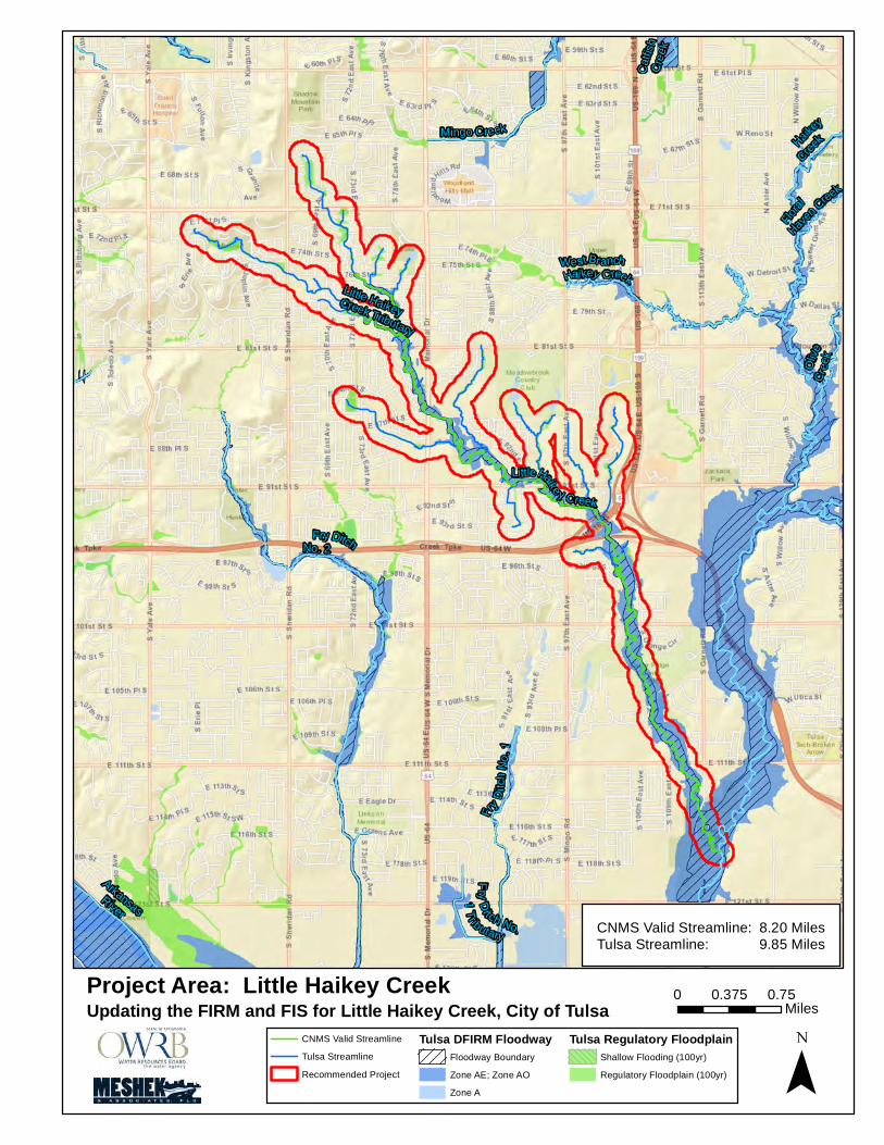
Little Haikey $ 364,000 Yes
Lower Canadian‐Walnut $ 75,000
Ten Mile‐Brookhaven $ 265,000 Yes
Total $ 2,064,000 $ 475,000
C. LiDAR Acquisition
The State’s FY 2015 topographic data acquisition priorities are listed in Table 8. Priority
has been given to NFIP‐participating, unmapped or paper‐mapped map counties which
have underwent Discovery. Further prioritization was given based on “Risk, Needs and

Oklahoma State CTP Business Plan
Version 2.0 – April 6, 2015 11
Action Factors” weighted based on importance to meeting FEMA performance measures
and the objectives of the State’s Program. Refer to Appendix A for additional
information.
Table 8: Oklahoma LiDAR Collection Priorities (FY 2015)
LiDAR Priority
County Name
NFIP Participant
Mapping Status
LiDAR Coverage
Discovery Area
(sq. mi.)
1 Blaine Yes Paper 25% Yes 938.86
2 Woods Yes Paper 0% Yes 1,290.14
N/A Atoka Yes Paper 79% No 990.89
N/A Roger Mills Yes Paper 82% No 1,146.34
N/A Cotton Yes Paper 89% No 643.24
LiDAR coverage for Atoka, Roger Mills and Cotton – although not 100% - is deemed
sufficient for mapping purposes. No additional LiDAR is requested at this time.
D. Pre-Phase 1: First Order Approximation
The First Order Approximation (FOA) process is being evaluated by FEMA for validation
of existing Zone A’s and development of non-regulatory and regulatory products. The
FOA process can be used to produce estimates of flood hazard boundaries for multiple
recurrence intervals, and estimates of BFEs for communities seeking this information.
Of the 11 Oklahoma counties that remain in paper inventory, 3 (McIntosh, Hughes and
Craig) are currently undergoing mapping by FEMA. Of the remaining 8, Discovery has
been performed for Blain and Woods, and LiDAR is currently available for Latimer, Coal,
Cotton, Roger Mills, Atoka, Beckham, Noble and Choctaw. Table 9 provides a summary
of the State’s FOA priorities.
Table 9: Oklahoma FOA Priorities FY 2015
FOA Priority
County Name
NFIP Participant
Mapping Status
LiDAR Availability
Discovery Stream
Miles (mi)
Ongoing McIntosh Yes Unmapped Partial Yes
Ongoing Hughes Yes Paper Yes Yes
Ongoing Craig Yes Paper No Yes
1 Latimer Yes Paper Yes No 863
2 Coal Yes Paper Yes No 296
3 Cotton Yes Paper Yes No 375
4 Roger Mills Yes Paper Yes No
5 Atoka Yes Paper Yes No
6 Beckham Yes Paper Yes No
7 Noble Yes Paper Yes No
8 Choctaw Yes Paper Yes No
9 Blaine Yes Paper Partial Yes
10 Woods Yes Paper No Yes

Oklahoma State CTP Business Plan
Version 2.0 – April 6, 2015 12
E. Phase 1: Discovery
Discovery projects were prioritized based on “Risk, Needs and Action Factors” weighted
based on importance to meeting FEMA performance measures and the objectives of the
State’s Program. Highest priority is given to NFIP-participating, unmapped or paper-
mapped county for which LiDAR acquisition is currently available. This group is followed
by counties for which LiDAR acquisition and FOA had been identified as a priority in the
previous sections.
The State also wished to facilitate Discovery for NFIP-participating communities with
digital maps which can complete mitigation projects. The Cities of Oklahoma City and
Norman have communicated interest in completing Phase 2 studies as part of the CTP
Program for grant purposes. To enable programming of such projects, discovery of Deep
Fork and Little Watersheds have been added to FY 2015 priorities.
Table 10: Oklahoma Discovery Priorities (FY 2015)
Discovery Priority
County Name HUC-8 Watershed
1 Various Deep Fork
2 Various Little
3 Latimer Lower Canadian
4
Coal
Muddy Boggy Atoka
Choctaw
5 Cotton Cache
6 Roger Mills
Washita Headwaters Beckham
7 Noble Black Bear-Red Rock
The State wishes to investigate the possibility of completing a State-Wide Discovery
Project. Efforts will result in a single Discovery Map for the State, along with
consolidated databases for Flood Risk Review and Flood Risk Assessment purposes.
These efforts will also expedite the completion of FOAs for non-digital, NFI-participating
counties.
Most importantly, Statewide Discovery will enable immediate deployment of FOAs for
non-participating communities with existing LiDAR data. This, the State believes, can
achieve significant gains towards the goal of engaging non-participating communities in
flood risk mitigation.

Oklahoma State CTP Business Plan
Version 2.0 – April 6, 2015 13
F. Phase 2: Studies
Once needs area are identified via Discovery, Phase 2 Projects are prioritized based on a
formula containing nine, project-specific factors: Population Density, Percent Urban,
Number of Repetitive Loss Properties, Total Value of Repetitive Loss Claims, Percent
Available Topographic Data, Population Density in the Floodplain, Effective Study Age,
Validation Status, and Available Local Funding.
Projects located in Bird, Lower Canadian-Walnut, Lower Verdigris, Middle North
Canadian, and Polecat-Snake Watersheds have been include in the State’s prioritization
process. This inventory includes a total of 105 studies covering 2,270 stream miles for an
estimated cost of nearly $50 million. Of this sum, 15 projects have been completed to-
date, either via a CTP grant or local undertakings.
This list of projects is presented to communities for input annually for planning and
prioritization purposes. At this time, communities interested in participating in the CTP
Program are asked to budget contributions in advanced for future grant applications. As
part of this process, communities also communicate preference for prioritization of their
listed projects.
For example, since Discovery, the City of Broken has withdrawn interest in participating
in the CTP Program for the re-mapping of several highly ranked streams by FEMA’s
performance measures. Studies of Adams, Aspen and Elm Creek have been completed
fairly recently by the City and provide sufficient flood risk data for implementation of
local ordinance requirements.
Similarly, the City of Tulsa has also communicated the availability of several studies
completed by the City (highly ranked streams) which serve adequately to support local
risk mitigation actions. The State’s inventory tracks availability of local studies and
adjusts project rankings accordingly.
Table 11, below, provides Phase 2 Projects – with local funding budgeted support – listed
in the descending order of priority by FEMA’s performance measures. It also provides the
Community Ranking, 1 representing highest priority, for funding and scheduling.
Projects highlighted in “orange” are those proposed for study in FY 2015.

Oklahoma State CTP Business Plan
Version 2.0 – April 6, 2015 14
Table 11: Oklahoma Phase 2 Study Inventory
HUC 8 Name Project Name Project Length
Cost Community
Priority
Polecat-Snake Updating the FIRM and FIS for Little Haikey Creek, City of Tulsa
18.05 $ 364,000 2
Polecat-Snake Updating the FIRM and FIS for Harlow Creek, Bigheart Creek and West Bigheart Creek, Osage and Tulsa County
11.71 $ 236,000 1
Bird Creek Updating the FIRM and FIS for Brookhollow Creek, City of Tulsa
11.05 $ 387,000 1
Bird Creek Updating the FIRM and FIS for Audubon Creek, City of Tulsa
1.89 $47,261 5
Bird Creek Updating the FIRM and FIS for Tupelo Creek and Tributaries, City of Tulsa
4.93 $ 123,198 5
Bird Creek Updating the FIRM and FIS for Cooley Creek, City of Tulsa
7.04 $ 176,026 3
Bird Creek Updating the FIRM and FIS for Mingo Creek, City of Tulsa
16.51 $ 412,737 4
Bird Creek Updating the FIRM and FIS for Jones Creek, City of Tulsa
3.30 $82,541 5
Bird Creek Updating the FIRM and FIS for Mill Creek, City of Tulsa
3.30 $82,541 5
Lower Canadian-Walnut
Updating the FIRM and FIS for Ten Mile Flat Creek, City of Norman.
5.40 $ 128,613 1
Lower Canadian-Walnut
Updating the FIRM and FIS for Brookhaven Creek and Tributaries, City of Norman.
5.73 $ 136,473 1
Bird Creek Updating the FIRM and FIS for Dirty Butter Creek and Tributary, City of Tulsa
14.33 $ 311,000 2
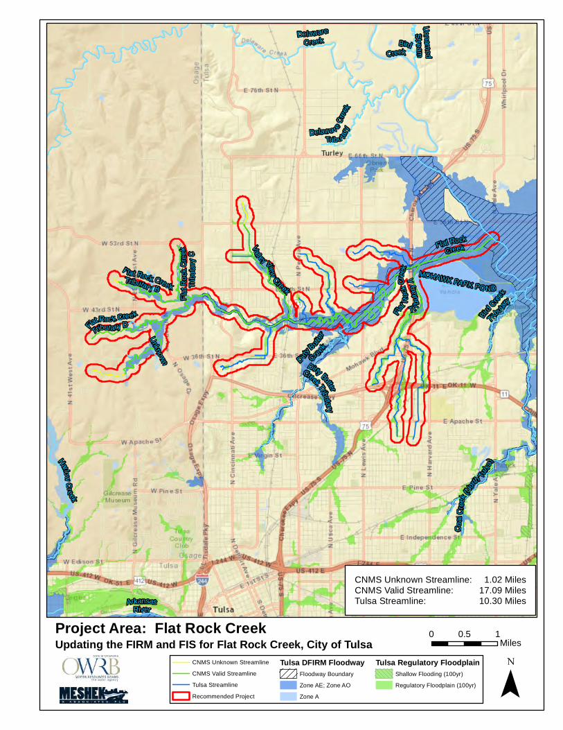
Bird Creek Updating the FIRM and FIS for Flat Rock Creek and Tributaries, City of Tulsa
28.41 $ 510,000 2
The following Phase 2 projects have received FY 2015 local match:
Little Haikey Creek: This is the highest priority Phase 2 study in the State’s
inventory. City of Tulsa has provide matching funding and has LiDAR data which
will be made available for the study.
Brookhollow Creek: The City of Tulsa requests assistance to resolve an existing
mapping deficiencies which surfaced following submittal of LOMR 13-06-2412P –
see Figure 7. FEMA seeks to expand the model submitted under the LOMR to
model segments of the stream lack floodways. The stream is located in the Bird
Watershed which is currently under Discovery. The city has LiDAR data which
will be made available for the study.

Oklahoma State CTP Business Plan
Version 2.0 – April 6, 2015 15
Ten Mile Flat Creek: The
City of Norman has
requested the detailed
study of 10 Mile Flat Creek
to mitigate existing flood
risk to life and property.
This basin is extremely flat
and has poor drainage
throughout. Over the
years development has
occurred mostly consisting
of road widening projects,
homes, barns, and
outbuildings. Although
there is no 1% chance
floodplain north of West
Tecumseh Road, several structures have either flooded or experienced drainage
problems over the years. In July of 2013, a new house under construction located
in Zone “X” experienced flooding during a heavy rain event. Other existing Zone
“X” structures were flooded as well. See Figure 8.
The Majority of 10 Mile Flat
Creek basin is Zone “X”
2013 Flooding in Ten Mile
Flat Creek Basin
5651 West Tecumseh Road
(new construction)
Figure 8: Ten Mile Creek Flooding Event, 2013
Brookhaven Creek: Several homes and commercial businesses have been
constructed in the basin especially at the north end over the last several years. The
Oklahoma Department of Transportation also constructed a new overpass and
embankment at Rock Creek Road over I-35 that traverses the regulatory floodplain.
Although each individual building and structure met Norman’s floodplain
ordinance and was approved by the Floodplain Permit Committee at the time, the
cumulative effect has been encroachment into the floodplain. See Figure 9.
Figure 7: Brookhollow Creek

Oklahoma State CTP Business Plan
Version 2.0 – April 6, 2015 16
Dirty Butter Creek and Tributary and Flat Rock Creek and Tributaries. Projects
rank high in the State’s inventory. The City of Tulsa has provide matching funding
and has LiDAR data which will be made available for the study.
Location maps – depicting extent of each study – have been included in Appendix C.
G. Pilot Projects
The State maintains an inventory of potential outreach projects derived from requests
received for assistance from Oklahoma communities and/or State agencies (see Table 12).
None are scheduled for FY 2015-2016 due to lack of local match funding.
Table 12: Oklahoma Potential Pilot Projects
Project Description Request Agency Description
Develop Ranking Criteria for RL/SRL Properties
Oklahoma Emergency Management Agency (OEM)
OEM seeks assistance for the prioritization of property acquisition for the purpose of grant funding. The State proposes to use criteria – derived from Risk MAP projects – for the ranking of properties.
Low Water Crossing Inventory
Oklahoma Floodplain Managers Association
In cooperation with other agencies, the State wishes to complete a comprehensive inventory of low water crossings in the State for public outreach, assessment and mitigation purposes.
Encroachment into the
Brookhaven Creek
floodplain near Rock Creek
Road and I-35. This
floodplain is Zone A, an
unstudied area.
Figure 9: Brookhaven Creek

Oklahoma State CTP Business Plan
Version 2.0 – April 6, 2015 17
Project Description Request Agency Description
CNMS Update FEMA State wishes to collaborate with FEMA Region VI in the upcoming CNMS update to incorporate community data. Studies – enforced as higher standards – are available from several urban communities. These studies may be used to update Unknown or Unverified streams to Valid.
V. RECOMMENDED SCHEDULE
Table 13 illustrates the State’s proposed timeframe for performance of projects for which local support has been identified. The proposed schedule is subject to FEMA approval and funding – as well as local matching requirements.

Oklahoma State CTP Business Plan
Version 1.0 – April 6, 2015 18
Table 13: Oklahoma Risk MAP Program Schedule
Activity Year 1 Year 2 Year 3 Year 4 Year 5
FOA
Latimer Roger Mills Noble Woods
Coal Atoka Choctaw
Cotton Beckham Blaine
Discovery
Little Deep Fork
Lower Canadian Muddy Boggy
Cache Washita Headwaters
Black Bear-Red Rock Lower North Fork Red
Risk Identification &
Assessment
Little Haikey
REVIEW ANNUALLY
Brookhollow
Ten Mile
Brookhaven
Dirty Butter
Flat Rock
Preliminary Regulatory
NONE TO BE DETERMINED BASED ON PHASE 2 FUNDED PROJECTS
Post-Preliminary Regulatory
Joe Creek Red Fork
TO BE DETERMINED BASED ON PHASE 3 FUNDED PROJECTS

Oklahoma State CTP Business Plan
Version 2.0 – April 6, 2015
Appendix A Computations

TABLE A.1: STATE PRIORITIZATION COMPUTATIONS (PRE‐ AND PHASE 1)
County NameNFIP
ParticipationMapping Status LiDAR Discovered DFIRM
CNMS Database Area (sq.mi.)
Risk Factor Rank
Repetitive Loss P
LiDAR Rank FOA Rank Discovery
Adair Yes DFIRM Partial No Yes Yes 576.97 7.79 Alfalfa No Unmapped Yes No No No 881.57 14.75 4Atoka Yes Paper Partial No No Yes 990.89 27.29 0 5 Muddy BoggyBeaver No Unmapped No No No No 1,817.55 8.32 6Beckham Yes Paper Yes No No Yes 904.35 20.66 6 Washita HeadwatersBlaine Yes Paper Partial Yes No Yes 938.86 12.08 1 9 Middle North CanadianBryan Yes DFIRM Yes No Yes Yes 944.65 15.81 1Caddo Yes DFIRM Yes Yes Yes Yes 1,290.53 16.90 Canadian Yes DFIRM Yes Yes Yes Yes 905.26 38.23 15Carter No DFIRM Yes No Yes Yes 834.50 29.91 2Cherokee Yes DFIRM No No Yes Yes 776.39 7.11 3Choctaw Yes Paper Yes No No Yes 801.67 10.27 8 Muddy BoggyCimarron No Unmapped No No No No 1,841.06 8.26 7Cleveland Yes DFIRM Partial Yes Yes Yes 558.35 34.66 26Coal Yes Paper Yes No No Yes 521.67 12.73 2 Muddy BoggyComanche Yes DFIRM Yes No Yes Yes 1,084.42 25.08 42Cotton Yes Paper Partial No No Yes 643.24 12.31 0 3 CacheCraig Yes Ongoing No Yes No Yes 762.64 13.93 0Creek Yes DFIRM Yes Yes Yes Yes 969.54 22.15 29Custer Yes DFIRM Yes No Yes Yes 1,002.02 27.23 1Delaware Yes DFIRM Partial Yes Yes Yes 792.27 18.40 10Dewey No Unmapped Partial Yes No No 1,008.07 5.70 10Ellis No Unmapped No No No No 1,231.82 5.82 9Garfield Yes DFIRM Yes Yes Yes Yes 1,059.88 37.40 4Garvin No DFIRM Yes Yes Yes Yes 814.10 28.78 4Grady No DFIRM Yes No Yes Yes 1,105.59 20.79 29Grant No Unmapped No No No No 1,003.51 5.17 1 11Greer Yes DFIRM Partial No Yes Yes 643.78 8.28 Harmon Yes DFIRM Partial No Yes Yes 538.81 5.23 Harper No Unmapped No No No No 1,040.97 4.93 12Haskell No Unmapped Partial No No No 625.39 12.42 3Hughes Yes Ongoing Yes Yes No Yes 814.90 14.28 Jackson Yes DFIRM Yes No Yes Yes 804.41 14.88 1Jefferson No Unmapped Yes No No No 776.56 13.78 Johnston No Unmapped Yes No No No 658.87 13.49 Kay Yes DFIRM Partial No Yes Yes 945.29 14.38 33
PAGE 1 OF 7 4/6/2015

TABLE A.1: STATE PRIORITIZATION COMPUTATIONS (PRE‐ AND PHASE 1)
County NameNFIP
ParticipationMapping Status LiDAR Discovered DFIRM
CNMS Database Area (sq.mi.)
Risk Factor Rank
Repetitive Loss P
LiDAR Rank FOA Rank Discovery
Kingfisher Yes DFIRM Yes Yes Yes Yes 905.87 20.21 48Kiowa Yes DFIRM Yes No Yes Yes 1,031.15 15.21 2Latimer Yes Paper Yes No No Yes 729.36 13.69 1 Lower CanadianLe Flore Yes DFIRM Yes No Yes Yes 1,608.61 15.82 1Lincoln Yes DFIRM Yes Yes Yes Yes 965.63 15.88 3Logan Yes DFIRM Yes Yes Yes Yes 748.84 22.89 53Love No Unmapped Yes No No No 534.60 13.07 Major No Unmapped Partial Yes No No 957.82 7.80 8Marshall No Paper Partial No No Yes 427.45 9.74 1 5Mayes Yes DFIRM No Yes Yes Yes 683.45 6.44 7McClain Yes DFIRM Yes Yes Yes Yes 580.42 14.59 2McCurtain No DFIRM Partial No Yes Yes 1,899.94 14.29 5McIntosh Yes Ongoing Partial Yes No No 712.54 10.30 0Murray No Unmapped Yes No No No 425.21 13.05 Muskogee Yes DFIRM Partial Yes Yes Yes 838.96 10.96 22Noble Yes Paper Yes No No Yes 742.45 14.15 7 Black Bear‐Red RockNowata Yes DFIRM Partial No Yes Yes 580.90 9.36 Okfuskee No Unmapped Yes Yes No No 629.10 13.46 Oklahoma Yes DFIRM Yes Yes Yes Yes 718.27 49.41 103Okmulgee Yes DFIRM Yes Yes Yes Yes 702.36 16.19 2Osage Yes DFIRM Partial Yes Yes Yes 2,303.44 28.32 2Ottawa Yes DFIRM Yes Yes Yes Yes 484.79 40.46 132Pawnee No Unmapped Yes No No No 594.89 13.61 Payne Yes DFIRM Yes No Yes Yes 697.10 17.06 4Pittsburg Yes DFIRM Partial No Yes Yes 1,378.36 17.47 Pontotoc Yes DFIRM Yes Yes Yes Yes 725.87 14.95 1Pottawatomie Yes DFIRM Yes Yes Yes Yes 793.27 18.06 14Pushmataha No Unmapped Partial No No No 1,423.99 11.66 4Roger Mills Yes Paper Partial No No Yes 1,146.34 13.52 0 4 Washita HeadwatersRogers Yes DFIRM Yes Yes Yes Yes 711.37 17.02 19Seminole Yes DFIRM Yes Yes Yes Yes 640.64 14.23 Sequoyah Yes DFIRM Yes Yes Yes Yes 714.84 8.62 4Stephens Yes DFIRM Yes No Yes Yes 891.85 16.54 7Texas Yes DFIRM No No Yes Yes 2,049.01 11.36 Tillman No Unmapped Yes No No No 880.01 14.55 1Tulsa Yes DFIRM Partial Yes Yes Yes 586.87 62.25 243
PAGE 2 OF 7 4/6/2015

TABLE A.1: STATE PRIORITIZATION COMPUTATIONS (PRE‐ AND PHASE 1)
County NameNFIP
ParticipationMapping Status LiDAR Discovered DFIRM
CNMS Database Area (sq.mi.)
Risk Factor Rank
Repetitive Loss P
LiDAR Rank FOA Rank Discovery
Wagoner Yes DFIRM Partial Yes Yes Yes 590.94 13.00 38Washington Yes DFIRM Yes Yes Yes Yes 424.11 17.55 26Washita Yes DFIRM Yes No Yes Yes 1,009.13 15.08 Woods Yes Paper No Yes No Yes 1,290.14 6.25 2 10 Upper Salt Fork ArkansasWoodward Yes DFIRM No Yes Yes Yes 1,245.81 6.69 2
PAGE 3 OF 7 4/6/2015

TABLE A.2: CTP PROJECT INVENTORY
ID Status HUC 8 Name Project Name Project Length
Ranking Cost
1 Under Study by USACE Polecat‐SnakeUpdating the FIRM and FIS for Crow Creek, Tulsa County
1.84 69.75 35,000$
2 CompletedPolecat‐Snake
Updating the FIRM and FIS for Joe Creek, Tulsa County
12 7/8 69.75 $ 322,000
3 Completed Polecat‐SnakeUpdating the FIRM and FIS for Mooser Creek, Tulsa County
4.74 69.75 119,000$
4 Study Available Lower VerdigrisUpdating the FIRM and FIS for Adams Creek, Tulsa and Wagoner Counties
63.67 50.08 795,875$
Study Available Polecat‐SnakeUpdating the FIRM and FIS for Aspen Creek, Tulsa County
7.14 45.77 178,500$
Study Available Polecat‐SnakeUpdating the FIRM and FIS for Elm Creek, Tulsa County
4.00 45.77 100,000$
7 Completed Polecat‐SnakeUpdating the FIRM and FIS for Broken Arrow Creek, Tulsa and Wagoner County
24.94 45.77 603,000$
8 No Local Interest Lower VerdigrisUpdating the FIRM and FIS for Cat Creek and Dog Creek in Rogers County
35.41 45.62 886,000$
Polecat‐SnakeUpdating the FIRM and FIS for Harlow Creek, Bigheart Creek and West Bigheart Creek, Osage and Tulsa County
11.71 30.00 236,000$
10 No Local Interest Polecat‐SnakeUpdating the FIRM and FIS for Haikey Creek, City of Broken Arrow and Bixby
25.00 41.99 625,000$
11 Under Study by Others Polecat‐SnakeUpdating the FIRM and FIS for White Church Creek, Tulsa County
4.09 41.17 103,000$
12 Lower VerdigrisUpdating the FIRM and FIS for Inola Creek, Rogers County
64.39 38.24 1,610,000$
13 Completed Polecat‐SnakeUpdating the FIRM and FIS for Nickel Creek, Creek County
6.65 36.98 167,000$
14 Polecat‐SnakeUpdating the FIRM and FIS for Wilmott Creek, Tulsa County
1.27 36.98 32,000$
15 Completed Polecat‐SnakeUpdating the FIRM and FIS for Red Fork Creek, Tulsa County
2/3 36.85 $ 17,000
16 Polecat‐SnakeUpdating the FIRM and FIS for Coal Creek, Tulsa County
20.32 33.46 387,000$
17 Middle North CanadianUpdating the FIRM and FIS for Campbell Creek, Canadian and Oklahoma Counties.
13.00 33.16 325,000$
18 Middle North CanadianUpdating the FIRM and FIS for North Canadian River Tributary 14, Oklahoma County.
3.35 33.16 84,000$
19 Middle North CanadianUpdating the FIRM and FIS for Mustang Creek, City of Mustang and Canadian County.
32.55 30.91 814,000$
20 Lower VerdigrisUpdating the FIRM and FIS for Commodore Creek‐ Verdigris River
35.76 30.08 895,000$
2 Bird CreekUpdating the FIRM and FIS for Brookhollow Creek, City of Tulsa
11.05 29.38 264,000$
22 Polecat‐SnakeUpdating the FIRM and FIS for Fry Creek, Tulsa County
5.54 29.82 106,000$
23 Completed Lower VerdigrisUpdating the FIRM and FIS for Spunky Creek, Rogers, Tulsa and Wagoner Counties
21.56 29.77 539,000$
1 Polecat‐SnakeUpdating the FIRM and FIS for Little Haikey Creek, City of Tulsa
18.05 41.99 364,000$
Bird CreekUpdating the FIRM and FIS for Dirty Butter Creek and Tributary, City of Tulsa
14.33 13.28 311,000$
Bird CreekUpdating the FIRM and FIS for Flat Rock Creek and Tributaries, City of Tulsa
28.41 13.28 510,000$
PAGE 4 OF 7 4/6/2015

TABLE A.2: CTP PROJECT INVENTORY
ID Status HUC 8 Name Project Name Project Length
Ranking Cost
5 Bird CreekUpdating the FIRM and FIS for Cooley Creek, City of Tulsa
7.04 29.38 176,026$
6 Bird CreekUpdating the FIRM and FIS for Mingo Creek, City of Tulsa
16.51 29.38 412,737$
3 Bird CreekUpdating the FIRM and FIS for Audubon Creek, City of Tulsa
1.89 29.38 47,261$
4 Bird CreekUpdating the FIRM and FIS for Tupelo Creek and Tributaries, City of Tulsa
4.93 29.38 123,198$
31 Lower VerdigrisUpdating the FIRM and FIS for Port of Dunkin‐Verdigris River for Rogers County
14.45 29.12 361,243$
32 Middle North CanadianUpdating the FIRM and FIS for Turtle Creek, Canadian County.
8.30 27.30 208,000$
33 Polecat‐SnakeUpdating the FIRM and FIS for Bixby Creek, Tulsa County
1.00 27.29 10,000$
34 Completed Polecat‐SnakeUpdating the FIRM and FIS for Vensel Creek, Tulsa County
4.57 27.29 115,000$
35 Lower Canadian‐WalnutUpdating the FIRM and FIS for the Canadian River, Cleveland County.
58.37 27.13 1,361,000$
36 Polecat‐SnakeUpdating the FIRM and FIS for Coweta Creek, Wagoner County
15.81 27.04 301,000$
37 Polecat‐SnakeUpdating the FIRM and FIS for Haskell Creek, Muskogee County
7.46 27.04 142,000$
38 Lower VerdigrisUpdating the FIRM and FIS for Moss Creek‐Verdigris River for Rogers County
44.66 26.11 1,117,000$
39 Lower Canadian‐WalnutUpdating the FIRM and FIS for Buggy Creek, Caddo Counties.
18.09 23.32 304,000$
40 Completed Middle North CanadianUpdating the FIRM and FIS for Fourmile Creek, Canadian County.
18 1/3 22.55 $ 458,000
9 Lower Canadian‐WalnutUpdating the FIRM and FIS for Ten Mile Flat Creek, City of Norman.
5.40 22.49 128,613$
42 Middle North CanadianUpdating the FIRM and FIS for Shell Creek, Canadian County.
28.88 22.32 723,000$
43 Lower VerdigrisUpdating the FIRM and FIS for Salt Creek for Wagoner County
14.83 21.73 370,696$
44 Lower VerdigrisUpdating the FIRM and FIS for Fife Creek for Wagoner County
26.20 21.07 655,085$
45 Lower Canadian‐WalnutUpdating the FIRM and FIS for Pond Creek, City of Newcastle.
9.96 20.99 254,000$
46 Lower Canadian‐WalnutUpdating the FIRM and FIS for Merkle Creek, City of Norman.
3.85 20.60 88,000$
10 Lower Canadian‐WalnutUpdating the FIRM and FIS for Brookhaven Creek and Tributaries, City of Norman.
5.73 20.51 136,485$
48 Lower VerdigrisUpdating the FIRM and FIS for Lake Claremore Dam for Rogers County
59.20 19.85 1,480,050$
49 Lower Canadian‐WalnutUpdating the FIRM and FIS for Bishop Creek and Tributaries, City of Norman.
18.33 19.77 466,000$
50 Lower Canadian‐WalnutUpdating the FIRM and FIS for Unnamed Stream, City of Slaughterville. Project A
1.48 19.39 25,000$
51 Lower Canadian‐WalnutUpdating the FIRM and FIS for East Creek, City of Tuttle, Grady County.
17.81 18.14 299,000$
52 Lower Canadian‐WalnutUpdating the FIRM and FIS for the Canadian River Tributaries, Oklahoma City.
30.98 18.00 767,000$
PAGE 5 OF 7 4/6/2015

TABLE A.2: CTP PROJECT INVENTORY
ID Status HUC 8 Name Project Name Project Length
Ranking Cost
53 Lower Canadian‐WalnutUpdating the FIRM and FIS for the Canadian River, Blaine, Canadian, Caddo and Grady Counties.
108.98 17.98 1,831,000$
54 Lower Canadian‐WalnutUpdating the FIRM and FIS for Cow Creek, Oklahoma City.
29.58 17.54 725,000$
55 Middle North CanadianUpdating the FIRM and FIS for Purcell Creek, Canadian County.
31.07 17.42 777,000$
56 Lower Canadian‐WalnutUpdating the FIRM and FIS for the Snake Creek, Grady County.
5.06 17.35 85,000$
57 Lower VerdigrisUpdating the FIRM and FIS for Four Mile Creek for Rogers County
47.26 17.30 1,182,000$
58 Middle North CanadianUpdating the FIRM and FIS for Sixmile Creek and Tributary, El Reno and Canadian County.
45.95 17.22 982,000$
59 Lower Canadian‐WalnutUpdating the FIRM and FIS for Coal Creek, City of Tuttle, Grady County.
14.13 17.20 325,000$
60 Lower Canadian‐WalnutUpdating the FIRM and FIS for Walnut Creek, McClain and Grady Counties.
53.51 17.03 1,014,000$
61 Lower Canadian‐WalnutUpdating the FIRM and FIS for Walnut Creek, City of Purcell.
4.62 16.99 118,000$
62 Lower Canadian‐WalnutUpdating the FIRM and FIS for Buggy Creek, Grady County.
22.52 16.93 378,000$
63 Lower Canadian‐WalnutUpdating the FIRM and FIS for Worley Creek, City of Tuttle, Grady County.
12.10 16.59 308,000$
64 Polecat‐SnakeUpdating the FIRM and FIS for Arkansas River, Muskogee County
4.62 16.53 116,000$
65 Lower Canadian‐WalnutUpdating the FIRM and FIS for Buggy Creek, Canadian County.
10.80 16.51 181,000$
66 Middle North CanadianUpdating the FIRM and FIS for North Canadian River, Canadian, Oklahoma and Woodward County.
120.19 16.26 2,616,000$
67 Lower Canadian‐WalnutUpdating the FIRM and FIS for the Canadian River, McClain, Pottawatomie and Pontotoc Counties.
107.52 16.21 1,829,000$
68 Middle North CanadianUpdating the FIRM and FIS for Laughlin Lake, Canadian County.
1.22 16.08 24,000$
69 Lower Canadian‐WalnutUpdating the FIRM and FIS for West Creek, City of Tuttle, Grady County.
8.91 15.93 150,000$
70 Lower Canadian‐Walnut Modernize Hughes County. 105.49 15.85 1,772,000$
71 Polecat‐SnakeUpdating the FIRM and FIS for Rock Creek, Tulsa County.
10.48 15.80 263,000$
72 Lower Canadian‐WalnutUpdating the FIRM and FIS for Unnamed Stream, City of Slaughterville. Project B
3.03 15.80 51,000$
73 Bird CreekUpdating the FIRM and FIS for Horse Creek, City of Skiatook
1.12 15.41 27,974$
74 Bird CreekUpdating the FIRM and FIS for Horsepen Creek, Tulsa and Osage Counties
1.87 15.41 46,714$
75 Bird CreekUpdating the FIRM and FIS for Skiatook Lake, Osage County
131.09 15.41 3,277,229$
76 Lower Canadian‐WalnutUpdating the FIRM and FIS for Little Sandy Creek, City of Ada, Pontotoc County.
13.21 15.37 247,000$
77 Lower Canadian‐WalnutUpdating the FIRM and FIS for Belle Creek, City of Noble.
4.52 14.45 89,000$
78 Polecat‐SnakeUpdating the FIRM and FIS for Crow Creek, Tulsa County
1.84 14.29 35,000$
PAGE 6 OF 7 4/6/2015

TABLE A.2: CTP PROJECT INVENTORY
ID Status HUC 8 Name Project Name Project Length
Ranking Cost
79 Lower Canadian‐WalnutUpdating the FIRM and FIS for Imhoff Creek, City of Norman.
4.07 14.00 104,000$
80 Lower Canadian‐WalnutUpdating the FIRM and FIS for Dripping Springs Creek, City of Slaughterville.
9.75 13.78 202,000$
7 Bird CreekUpdating the FIRM and FIS for Jones Creek, City of Tulsa
3.30 29.38 82,541$
8 Bird CreekUpdating the FIRM and FIS for Mill Creek, City of Tulsa
3.30 29.38 82,541$
83 Lower Canadian‐WalnutUpdating the FIRM and FIS for Chouteau Creek (North of Lexington), City of Slaughterville.
22.25 12.21 432,000$
84 Middle North CanadianUpdating the FIRM and FIS for City of Woodward, Woodward County.
22.35 12.15 528,000$
85 Polecat‐SnakeUpdating the FIRM and FIS for Polecat Creek, Creek and Tulsa County
17.07 11.58 427,000$
86 Lower VerdigrisUpdating the FIRM and FIS for East Coal for Wagoner County
21.39 11.07 534,798$
87 Middle North CanadianUpdating the FIRM and FIS for City of Watonga, Blain County.
5.99 10.34 114,000$
88 Lower Canadian‐WalnutUpdating the FIRM and FIS for West Willow Creek, City of Slaughterville.
15.75 9.63 265,000$
89 Polecat‐SnakeUpdating the FIRM and FIS for Childres Creek, Creek County
11.20 9.46 213,000$
Completed Bird CreekUpdating the FIRM and FIS for Coal Creek, City of Tulsa
6.72 8.39 167,881$
91 Bird CreekUpdating the FIRM and FIS for Ator Tributary, City of Owasso
0.40 8.39 9,998$
92 Bird CreekUpdating the FIRM and FIS for Bird Creek and Tributary 5A, City of Owasso
6.43 8.39 160,685$
93 Bird CreekUpdating the FIRM and FIS for Ranch Creek, City of Owasso
24.11 8.39 602,757$
94 Polecat‐SnakeUpdating the FIRM and FIS for Snake Creek, Tulsa County
15.65 7.34 392,000$
95 Middle North CanadianModernize unmapped segments of North Canadian River, Blain, Dewey and Major County.
84.55 6.08 1,607,000$
96 Bird CreekUpdating the FIRM and FIS for Bird Creek, City of Skiatook
30.00 4.26 749,984$
97 Completed Polecat‐SnakeUpdating the FIRM and FIS for Hager Creek, Tulsa County
4.02 4.02 77,000$
98 Middle North CanadianUpdating the FIRM and FIS for South Persimmon Creek, Woodward County.
9.95 3.87 190,000$
99 Bird CreekUpdating the FIRM and FIS for Elm Creek, City of Owasso
11.95 3.57 298,641$
Bird CreekUpdating the FIRM and FIS for Bird Creek, Rogers County
10.92 3.57 272,922$
101 Middle North CanadianUpdating the FIRM and FIS for Indian Creek, Woodward County.
21.44 3.26 408,000$
102 Middle North CanadianUpdating the FIRM and FIS for Persimmon Creek, Woodward County.
45.05 1.66 856,000$
103 Bird CreekUpdating the FIRM and FIS for Hominy Creek, Osage County
36.80 0.57 919,921$
104 Bird CreekUpdating the FIRM and FIS for Claremore Creek, Osage County
4.32 0.46 108,000$
105 Bird CreekUpdating the FIRM and FIS for Penn Creek and Unmapped Tributary, City of Hominy
2.96 0.46 73,918$
PAGE 7 OF 7 4/6/2015

Oklahoma State CTP Business Plan
Version 2.0 – April 6, 2015
Appendix B Commitment Letters


January 2, 2014 Mr. Ron Wanhanen DHS/FEMA Region VI 800 N. Loop 288 Denton, TX 76209 RE: Cooperating Technical Partner FY2016 CTP Funding Requirements Planning Application Grant Dear Mr. Wanhanen: The City of Norman would like to participate in the Cooperating Technical Partner Program referenced above. The City of Norman has identified local matching funds in the amount of $100,000 for the flood studies of 10 Mile Flat Creek and Brookhaven Creek. The City of Norman is committed to processing an application when FEMA is ready to move forward with these projects. It is anticipated that the City’s portion of this funding will not be required until October 1, 2015. The City of Norman is excited to participate in this program and appreciates the assistance of you and your staff. If you need further information, please contact me at 405-307-7118. Sincerely,
Shawn O’Leary, P.E., CFM Director of Public Works/Floodplain Administrator City of Norman, Oklahoma 201 W. Gray St., Bldg. A Norman, OK 73069 cc: Steve Lewis, City Manager Scott Sturtz, City Engineer Todd McLellan, Development Engineer Ana Stagg, Meshek & Associates, PLC
T h e C i t y o f
NORMAN 201 West Gray, Bldg. A · P.O. Box 370
Norman, Oklahoma 73069 · 73070

Oklahoma State CTP Business Plan
Version 2.0 – April 6, 2015
Appendix C Phase 2 Studies

Floral
Haven Creek
Mill Creek
Audubon
Creek
Fulton
Creek
Tupelo CreekTributary A
Alsu
m
aC
reek
Ca
tfish
Creek
Tupelo CreekTributary C
Bell
Creek
Bel
l Cre
ek Tri b
uta
ry
Haikey
Creek
TupeloCreek
BrookhollowCreek Tributary
Brookhollow
Creek
SouthparkCreek
Sugar Creek
CooleyCreek
Fo rd Creek
Co
o ley Creek
T
ributary
Mingo
C
reek
CNMS Valid Streamline
Tulsa Streamline
Recommended Project
Tulsa DFIRM FloodwayFloodway Boundary
Zone AE; Zone AO
Zone A
Tulsa Regulatory FloodplainShallow Flooding (100yr)
Regulatory Floodplain (100yr)
´Project Area: Brookhollow CreekUpdating the FIRM and FIS for Brookhollow Creek, City of Tulsa
¯0 0.750.375
Miles
CNMS Valid Streamline:Tulsa Streamline:
5.51 Miles5.54 Miles

Flat Rock CreekTrib utary B
Unknow
n
Valley
Vie
wCreek
Coa
l Cre
ek
Trib
utar
y
MOHAWKPARK POND
Fla
tRo
c kC
reek
Trib
uta
ryC
Dirty
Butter
Cree
k Tribu
tary
Fla
tRock
Cr e ek
Trib
utar
yA
Flat Rock Creek
Trib u tary D
ArkansasRiver
D irty
But
ter
Creek
Flat RockCreek
CNMS Valid Streamline
Tulsa Streamline
Recommended Project
Tulsa DFIRM FloodwayFloodway Boundary
Zone AE; Zone AO
Zone A
Tulsa Regulatory FloodplainShallow Flooding (100yr)
Regulatory Floodplain (100yr)
Project Area: Dirty Butter CreekUpdating the FIRM and FIS for Dirty Butter Creek, City of Tulsa
¯0 0.750.375
Miles
CNMS Valid Streamline:Tulsa Streamline:
4.43 Miles9.90 Miles
Harlo
wC
reek
F lat Rock CreekTributary B
Unknow
n
Vall ey View
Creek
Bird
C
re
ek
Tr ibu ta
ry
ArkansasRiver
Dirty Butter
Creek Tributary
Fla
tRo
ckC
reek
Tri
buta
ryC
Flat
Ro
ckC
reek
Tr ib
utar
yA
Un
named
Stre a
m
Delawa r eC
reek
Trib u tary
Flat Roc k Creek
Tribut a ry D
BirdCreek
MOHAWK PARK POND
Co
alC
r eek
(Nor
thTu
lsa)
D
irty But
ter
Creek
Delaware
Creek
Flat Rock
Creek
CNMS Unknown Streamline
CNMS Valid Streamline
Tulsa Streamline
Recommended Project
Tulsa DFIRM FloodwayFloodway Boundary
Zone AE; Zone AO
Zone A
Tulsa Regulatory FloodplainShallow Flooding (100yr)
Regulatory Floodplain (100yr)
Project Area: Flat Rock CreekUpdating the FIRM and FIS for Flat Rock Creek, City of Tulsa
¯0 10.5
Miles
CNMS Unknown Streamline:CNMS Valid Streamline:Tulsa Streamline:
1.02 Miles17.09 Miles10.30 Miles
Cat
fish
Cre
ek
Little HaikeyCreek Tributary
Flor
alHav
enCreek
Oliv
eC
r eek
Fr y
Di tch No.
1T
ributary
WestBranch
Haikey Creek
ArkansasRiver
Haike
y
Creek
Mingo Creek
LittleHaike y Creek
Fry DitchNo. 2
Fry
Ditc
hN
o.1
CNMS Valid Streamline
Tulsa Streamline
Recommended Project
Tulsa DFIRM FloodwayFloodway Boundary
Zone AE; Zone AO
Zone A
Tulsa Regulatory FloodplainShallow Flooding (100yr)
Regulatory Floodplain (100yr)
Project Area: Little Haikey CreekUpdating the FIRM and FIS for Little Haikey Creek, City of Tulsa
¯0 0.750.375
Miles
CNMS Valid Streamline:Tulsa Streamline:
8.20 Miles9.85 Miles

Flat Rock
Creek
Turkey
Creek
Flat RockCreek
Big H
eart Creek
West Bigheart
Creek Big
hear
t Cre
ek
Arkansas River
Harlow Creek
Harlow
Creek
Har
low
Cr e
ekTr
ibut
ary
Harlow Creek Overflow
CNMS Unverified Streamline
CNMS Unknown Streamline
CNMS Valid Streamline
Tulsa Streamline
Recommended Project
Tulsa DFIRM FloodwayFloodway Boundary
Zone AE; Zone AO
Zone A
Tulsa Regulatory FloodplainShallow Flooding (100yr)
Regulatory Floodplain (100yr)
Project Area: Harlow CreekUpdating the FIRM and FIS for Harlow Creek, Tulsa County
¯0 0.50.25
Miles
CNMS Unverified Streamline:CNMS Unknown Streamline:CNMS Valid Streamline:Tulsa Streamline:
1.53 Miles 3.13 Miles 4.82 Miles16.69 Miles

Mer
kle
Cre
ek
Ove
rflow
Br
ookhaven
Creek
Unn
am
e dT
ribt o
Littl
eR
iver
S trea m E
Unnamed
Stream
CanadianR
ive
r
Tributary1
Mer
kle
Cre
ek
Tributary
A.1
of
Canadian Riv
er
Tri
buta
ry1
o fC
anad
ian
Riv
erT
ri bu
tary
1
StreamD
Canadian River
Tributary B of
Canadian River
Ca
na d
ian
Riv
er
Tri b
u tar
y2
Tributary
No.
1 ofP
on
dCre
ek
LittleRi ver
Tributary A of
Canadian R iver
Pond Creek
Little RiverTributary G
Ten
Mile
Fla
t Cre
ek
CNMS Unverified Streamline
FEMA Streamline
Recommended Project
Cleveland DFIRM FloodwayFloodway Boundary
Zone AE; Zone AO
Zone A
Project Area: Ten Mile Flat CreekUpdating the FIRM and FIS for Ten Mile Flat Creek, City of Norman
¯0 10.5
Miles
CNMS Unverified Streamline:FEMA Streamline:
5.31 Miles4.97 Miles

Mer
kle
Cre
ek
Ove
rflow
BrookhavenCreek
B
rookhavenC
reek
Tributa
ryA
Merkle
Creek
CanadianRiver
Ten Mi l e
Flat C ree k
CNMS Unknown Streamline
CNMS Valid Streamline
Recommended Project
Cleveland DFIRM FloodwayFloodway Boundary
Zone AE; Zone AO
Zone A
Project Area: Brookhaven CreekUpdating the FIRM and FIS for Brookhaven Creek, City of Norman
¯0 0.50.25
Miles
CNMS Unknown Streamline:CNMS Valid Streamline:
0.77 Miles4.88 Miles

BUSINESS PLAN 2012
Prepared by: Prepared for:
Meshek & Associates, PLC 1437 South Boulder Avenue, Suite 1550 Tulsa, Oklahoma 74119 918.392.5620
Oklahoma Water Resources Board 3800 North Classen Boulevard Oklahoma City, Oklahoma 73118 405.530.8800