on the estimation of the reference · pdf fileother vertical datums using direct or indirect...
TRANSCRIPT

On the estimation of the reference geopotential value Wo
LVD of local vertical datums 151
On the estimation of the reference geopotential value Wo
LVD of local vertical datums
C. Kotsakis
Department of Geodesy and Surveying, Aristotle University of Thessaloniki
Abstract
The estimation of the (unknown) reference geopotential value of an existing vertical datum
is a key task for the connection of isolated vertical reference frames and their unification
into a common height system. Such an a posteriori estimate resolves the physical ambiguity
associated with traditional vertical datums by linking them with a particular (Wo-specified)
equipotential surface of Earth’s gravity field under the presence of an external geopotential
model. The aim of this paper is to study an approximation scheme that can be typically
followed for the solution of the aforementioned problem based on the joint inversion of co-
located GPS and leveling heights, in conjunction with a fixed Earth gravity field model.
Our emphasis is given into the theoretical formulation for the optimal recovery of the zero-
height geopotential level of an existing vertical datum from heterogeneous height data, as
well as into the intrinsic characteristics, the physical meaning and the accuracy evaluation
of the corresponding least-squares solution.
1. Introduction
The primary component of any vertical reference system for physically mean-
ingful heights is an equipotential surface of Earth’s gravity field, which represents
what is commonly called a vertical datum. Regardless of the particular type of
physical heights that will be used within a vertical reference system, the underlying
vertical datum defines an unequivocal zero-height level relative to which vertical
positions for terrestrial points can be obtained by various geodetic techniques. It
should be kept in mind, though, that a geometrical interpretation of such vertical
positions may not be always feasible (see dynamic heights) or it may be associated
not with the vertical datum per se but with other auxiliary non-equipotential refer-
ence surfaces of rather mathematical nature (see normal heights). In fact, only the
use of orthometric heights theoretically permits a direct and straightforward geo-
metrical relationship between terrestrial vertical positions and their inherent verti-
cal datum (Heiskanen and Moritz 1967). Nevertheless, the role of a vertical datum
is equally important for all these height systems, as well as for any other physical
reference system that quantifies absolute vertical positions in terms of (scaled)
geopotential differences.

152 C. Kotsakis
In geodetic theory, therefore, the rigorous definition of a vertical datum adheres
to the fundamental equation
( , , )o
W x y z W=
which specifies a single equipotential surface of Earth’s gravity field in terms of a
reference geopotential value. The choice of a particular value Wo is, in principle,
arbitrary and it relies on a conventional postulation under certain physical, geo-
detic, oceanographic or other criteria (Heck and Rummel 1990, Hipkin 2003, Heck
2004, Burša et al. 2007). However, the traditional methodologies that have been
followed in practice for the realization of most vertical datums do not incorporate
any a priori condition for the fundamental parameter Wo , nor do they entail a
fixed gravity field model W(·) for their spatial representation. Instead of a virtual
realization scheme as suggested from the above formula, the establishment of a
vertical datum has been commonly based on a more tangible approach by con-
straining one, or more, terrestrial points that are presumed to be situated at known
vertical distance from a reference equipotential surface of completely unknown
form. From a practical viewpoint, the adoption of such origin points with a priori
fixed height, yet poorly known or unknown gravity potential, is sufficient for set-
ting up local vertical datums (LVDs) and physical height reference frames over the
Earth’s surface via terrestrial leveling surveys. These vertical ‘crust-fixed’ datums
have been traditionally referred to the long-term average of the local mean sea
level (MSL) that is observed at one, or more, tide gauge stations which are verti-
cally tied to the corresponding LVD origin points. Apparently, the fact that the
reference geopotential value LVD
oW of a local vertical datum remains unspecified
does not prohibit the determination of terrestrial vertical positions through relative
measurements from existing leveling benchmarks, neither the connection with
other vertical datums using direct or indirect leveling techniques (e.g. spirit level-
ing, GPS/geoid leveling, dynamic or geostrophic leveling).
Despite the absence of the fundamental parameter LVD
oW from the primary re-
alization of most vertical datums, the availability of an optimal estimate ˆLVD
oW
provides a useful tool for vertical positioning problems and other related applica-
tions. First and foremost, such an a posteriori estimate resolves the physical ambi-
guity of a MSL-based vertical datum by linking it with a unique equipotential sur-
face of Earth’s gravity field under the presence of a given model W(·). Theoreti-
cally, this allows the transformation of LVD physical heights to any other vertical
reference system that is specified by a known geopotential value with respect to the
same gravity field model. The connection of isolated vertical reference frames and
their unification into a common vertical datum, as well as the harmonization of
terrestrial gravity databases from different vertical datum zones, are well-known
geodetic problems whose solution relies on the implementation of exactly such a

On the estimation of the reference geopotential value Wo
LVD of local vertical datums 153
height transformation procedure (and thus on the knowledge of the reference geo-
potential value for the respective LVDs).
Essentially, an estimated value ˆLVD
oW in conjunction with a gravity field model
yield an external identification for a local vertical datum in a similar sense that a
set of translation and rotation transformation parameters specifies a 3D regional
coordinate system relative to a global geocentric reference frame. This type of
identification should be understood either in terms of an equipotential surface
ˆ( ) LVD
oW W⋅ = that optimally approximates the zero-height level of the local vertical
datum, or through the standard formula ˆ( ) ( )LVDo
c P W W P= − that allows the com-
putation of LVD vertical positions (geopotential numbers and their equivalent
physical heights) on the basis of space geodetic measurements and gravity field
information. The estimation accuracy of ˆLVD
oW plays of course a key role for the
practical significance of these ‘complementary’ vertical datum representations. In
the hypothetical case of an errorless model ( )W ⋅ , it would reflect the LVD stability
over the terrestrial network of leveling benchmarks which is used for the a posteri-
ori estimation of ˆLVD
oW . In reality, however, it provides a quality measure for the
relative consistency between the LVD physical heights and the adopted gravity
field model due to their existing errors. Furthermore, the statistical uncertainty of
ˆLVD
oW signifies the formal accuracy that can be achieved in a vertical datum trans-
formation problem for LVD heights with the aid of an Earth gravity field model.
The estimation of the reference geopotential value of an existing vertical datum
has been an active area of geodetic research for several years. Various strategies
have been developed and practically tested for solving this problem, all of which
rely on the synergetic use of a gravity field model with other terrestrial and space
geodetic data. Their corresponding algorithms comprise well-known mathematical
formulae and linearized modeling procedures from physical geodesy, and they can
be classified into two archetypical approaches depending on the treatment of
Earth’s geopotential signal. The latter may either be assumed fully known before-
hand, or it can be synthesized (along with the unknown parameter )LVD
oW through
an integrated approach using local gravity anomaly data that have been referenced
to their own LVD(s).
Specifically, the first approach exploits the availability of high-quality geopo-
tential or geoid/quasi-geoid models along with precise GPS measurements at LVD
benchmarks, which may resolve the reference gravity potential of a local vertical
datum, or equivalently its offset from a conventional equipotential surface W(·) =
Wo , with a statistical accuracy better than 1 m2/s2 (or about a few cm in terrestrial
spatial scale). Numerous such studies exist in the geodetic literature for different
geographical regions, including the Baltic Sea countries (Grafarend and Ardalan
1997, Pan and Sjöberg 1998, Ardalan et al. 2002), New Zealand (Amos and Feath-

154 C. Kotsakis
erstone 2009), Iran (Ardalan and Safari 2005), Pakistan (Sadiq et al. 2009), South
East Asia countries (Kasenda and Kearsley 2003), Spain (Burša et al. 2006), the
North American Great Lakes (Jekeli and Dumrongchai 2003), and a multitude of
other regional and national vertical datums (Rapp 1994, Burša et al. 1999, 2001,
2004). The general framework of this approach is primarily suitable for single-
LVD analysis, yet its simultaneous implementation over different geographical
zones is also useful for unifying multiple LVDs with respect to a common equipo-
tential reference surface specified either by a conventional Wo value (Burša et al.
2004) or through an external Wo-free geoid model (Rapp 1994).
The second approach, on the other hand, relies on an extended formulation of
the geodetic boundary value problem (GBVP) using ‘biased’ gravity anomaly data
from multiple LVD zones. The fundamental unknowns are the relative geopotential
offsets among the local vertical datums, while their optimal estimates can be jointly
obtained through straightforward least-squares adjustment techniques and a re-
quired constraint specifying a conventional zero-height level relative to a Somiglia-
na-Pizzetti reference ellipsoid and the other LVDs. A formal analysis of this ap-
proach is given in Rummel and Teunissen (1988) whose work was essentially a
mathematically rigorous continuation of earlier studies performed by Colombo
(1980) and Hajela (1983); for more details, see also Heck and Rummel (1990).
Additional contributions and important theoretical extensions have also been made
by many authors, including Xu and Rummel (1991), Rapp and Balasubramania
(1992), Sansò and Usai (1995), Lehmann (2000), Sansò and Venuti (2002), Sacer-
dote and Sansò (2004), among others. For some examples on the simplified imple-
mentation of this approach using real height data in Fennoscandia, see Pan and
Sjöberg (1998) and Nahavandchi and Sjöberg (1998), whereas a number of nu-
merical investigations about its quality performance based on global simulation
tests can be found in Xu and Rummel (1991), Xu (1992) and van Onselen (1997).
The focus of this paper lies on the first of the aforementioned schemes, namely
the LVD
oW estimation under the presence of a fixed model of Earth’s gravity field
that is directly employed for the adjustment of GPS/leveling data over a terrestrial
network of LVD benchmarks. The underlying methodology does not rely on the
explicit use of local gravity anomaly data from each LVD zone, and it is thus suit-
able for areas with limited local gravity coverage. Although many aspects of the
joint inversion of co-located GPS, leveling and geoid height data for the LVD
oW
estimation have been already discussed in the geodetic literature (e.g. Jekeli 2000,
Burša et al. 2001), a number of key issues are elucidated herein in more detail.
2. General aspects of Wo
LVD determination
The estimation of the reference geopotential value of an existing vertical datum

On the estimation of the reference geopotential value Wo
LVD of local vertical datums 155
relies on the precise knowledge of the 3D spatial positions for a number of LVD
benchmarks (or other control points that are directly tied to the particular vertical
datum) and a detailed representation of Earth’s gravity field over the test area. The
latter is usually based on a high-resolution spherical harmonic model which may be
augmented by additional local gravity data, whereas the spatial positions of the
LVD benchmarks are obtained by space geodetic techniques with respect to a geo-
centric reference frame. Note that to ensure a bias-free estimate of the fundamental
parameter LVD
oW , the permanent tide effects and other temporal height variations
(e.g. postglacial rebound, vertical crustal deformation) should be properly taken
into account and treated consistently in all data sets used within the estimation pro-
cedure.
The simplest clear-cut approach for the recovery of LVD
oW is applicable when
the primary vertical coordinates of the leveling benchmarks are given in the form
of geopotential numbers with respect to the underlying vertical datum. In this case,
an estimate of the fundamental LVD parameter can be directly computed from the
equation (Jekeli 2000)
ˆ ( ) ( )LVDo
W W P c P= + (1)
where c(P) is the known geopotential number at a leveling benchmark P, and
W(P) is the gravity potential computed at the same point through an external
global or regional model.
In principle, the Earth’s gravity potential W(⋅) corresponds to the sum of a
gravitational component V(⋅) that is directly obtained from a global geopotential
model (GGM) and a centrifugal component Φ(⋅) which is determined by a simple
closed formula using a nominal value of Earth’s rotational velocity. The evaluation
of both components requires the knowledge of the spatial position of the computa-
tion point with respect to a global reference frame that coincides with (or is suffi-
ciently close to) the Earth-fixed reference frame of the adopted geopotential model.
Alternatively, the gravity potential may also be synthesized through a linearization
scheme from an errorless normal part U(⋅) due to a conventional Earth reference
model (e.g. GRS80) and a disturbing or anomalous part T(⋅) that is derived either
by a reduced spherical harmonic expansion of Earth’s gravitational potential or by
a more general remove-restore technique using local gravity and terrain height
data.
If more than one LVD benchmarks are used, then the previous approach leads to
an averaging procedure which yields an improved estimate of LVDo
W in terms of
the sample mean
1
1ˆ ( ) ( )LVD
K
o i i
i
W W P c PK
=
= +∑ (2)

156 C. Kotsakis
In case that a statistical error model is also available for the geopotential num-
bers ( )ic P and/or the gravity potential values ( )iW P , a more general averaging
formula can be derived that incorporates the corresponding error co-variances via a
weighted least-squares adjustment of the basic equation ( ) ( ) LVDoi iW P c P W+ = .
Note that the zero-degree term of the disturbing geopotential signal must be
properly considered for the implementation of the previous procedure. Specifically,
if the normal and the disturbing potential components are used for computing
W(Pi) at each leveling benchmark, then the residual term (GM–GM')/r(Pi) needs
to be included in the determination of the total gravity potential value. The quanti-
ties GM and GM' denote the geocentric gravitational constant of the actual Earth
and its conventional reference ellipsoid, while r(Pi) is the geocentric radial dis-
tance of the leveling benchmark. Theoretically, a centrifugal ‘zero-degree’ term of
the disturbing geopotential signal is also required if the rotational velocity of the
reference ellipsoid is inconsistent with the up-to-date value of Earth’s rotational
velocity; however, the effect of such a residual term is negligible and it does not
need to be further considered in this paper.
Remark 1. The uncertainty of Earth’s geocentric gravitational constant (GM)
inflicts a relative error in the order of 10−9 to the estimate of the LVD parameter LVD
oW . The dominant contribution stems from the uncertainty of the zero-degree
term of the gravity potential W(⋅), which affects the accuracy of the result ob-
tained by Eq. (2) as follows:
ˆ
2
2
2 2
2
1
1 1
( )LVDo
GM
GMWo
K
ii
K r P R
σ
σ σ
=
⎡ ⎤⎢ ⎥= ≈⎢ ⎥⎣ ⎦∑ (3)
Based on some representative values of the GM uncertainty and the mean Earth
radius, e.g. σGM = 8×10⁵ m3/s2 and Ro = 6363672.6 m (McCarthy and Petit 2004),
the last equation yields an accuracy level of ˆ LVDo
W�σ 0.13 m2/s2 which corre-
sponds to a spatial (vertical) uncertainty of more than 1 cm for the zero-height sur-
face of the local datum. This is an important fact signifying the accuracy limita-
tions in absolute vertical positioning with respect to an equipotential reference
surface that is specified by a given geopotential value!
In practice, the geopotential numbers ( )ic P may not always be available as the
LVD vertical coordinates are often provided in terms of normal or orthometric
heights. In the first case, the corresponding geopotential numbers are easily re-
computable using the normal height and the geodetic latitude for each leveling
benchmark, together with the defining parameters of the normal gravity field
model. Hence, the general estimator from Eq. (2) can still be applied in the equiva-
lent form

On the estimation of the reference geopotential value Wo
LVD of local vertical datums 157
*
1
1 ( ) ( )ˆ
K
LVD
i i
i
o iW P γ H PK
W
=
= +Â (4)
where *( )i
H P is the known normal height and iγ denotes the average normal
gravity along the normal plumbline between the telluroid and the reference ellip-
soid. The value of iγ can be computed with sufficient accuracy from a truncated
latitude-dependent power series of *( )i
H P that incorporates the fundamental pa-
rameters of the adopted normal gravity field (Heiskanen and Moritz 1967, p. 170).
Conversely, if orthometric heights are provided as vertical coordinates in the
local vertical datum, the estimation of LVD
oW can be performed with the modified
formula
1
1 ( ) ( )ˆ
LVD
K
o i i i
i
W P g H PK
W
=
= +∑ (5)
where H(Pi) is the known orthometric height that is commonly given by its Hel-
mert-type approximation, and ig denotes the average gravity along the physical
plumbline between the Earth’s surface and the LVD reference surface. The ap-
proximation of ig relies on the knowledge of surface gravity ( )ig P at each level-
ing benchmark and the use of a conventional model for the crust density and terrain
roughness of the topographic masses over the test area. In the case of Helmert or-
thometric heights, for example, the value of ig should be calculated through the
Poincare-Prey gravity reduction (Heiskanen and Moritz 1967, pp. 163-167). Note
that the result from Eq. (5) will not be affected by the modeling hypotheses for the
local topographic masses if the available orthometric heights were originally de-
rived from an analogous conversion of geopotential numbers obtained directly
from terrestrial leveling and gravity measurements.
The previous framework summarizes what might be called the ‘conventional’
approach in LVDo
W estimation problems, where the gravity potential W(⋅) is evalu-
ated only at control points on the Earth’s surface. An alternative estimation scheme
based on the spheroidal ‘free-air’ potential reduction down to the LVD zero-height
level can be found in Grafarend and Ardalan (1997), Ardalan et al. (2002) and Ar-
dalan and Safari (2005).
3. Estimation accuracy of the LVD datum parameter
The accuracy of ˆLVD
oW is mainly affected by two error sources: (i) the total
error coming from the external knowledge and the forward use of the gravity field
158 C. Kotsakis
model, and (ii) the intrinsic errors in the LVD vertical coordinates. The latter in-
clude either the errors of the original geopotential numbers ( )ic P , or the propa-
gated errors in the derived geopotential numbers from the known normal or or-
thometric heights and their respective scaling factors ( iγ or ig ). What needs to be
emphasized at this point is that these two error sources must be clearly distin-
guished and their corresponding effects should be separately quantified, as they
have different physical significance for the final result ˆLVD
oW and the interpretation
of its estimation accuracy.
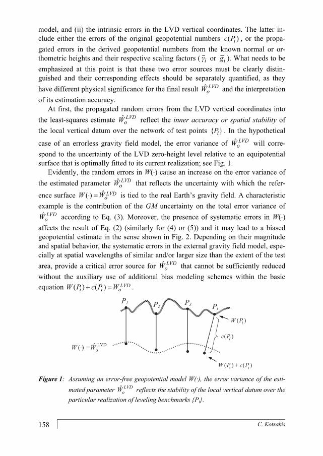
At first, the propagated random errors from the LVD vertical coordinates into
the least-squares estimate ˆLVD
oW reflect the inner accuracy or spatial stability of
the local vertical datum over the network of test points { }iP . In the hypothetical
case of an errorless gravity field model, the error variance of ˆLVD
oW will corre-
spond to the uncertainty of the LVD zero-height level relative to an equipotential
surface that is optimally fitted to its current realization; see Fig. 1.
Evidently, the random errors in W(⋅) cause an increase on the error variance of
the estimated parameter ˆLVD
oW that reflects the uncertainty with which the refer-
ence surface ˆ( ) LVDo
W W⋅ = is tied to the real Earth’s gravity field. A characteristic
example is the contribution of the GM uncertainty on the total error variance of
ˆLVD
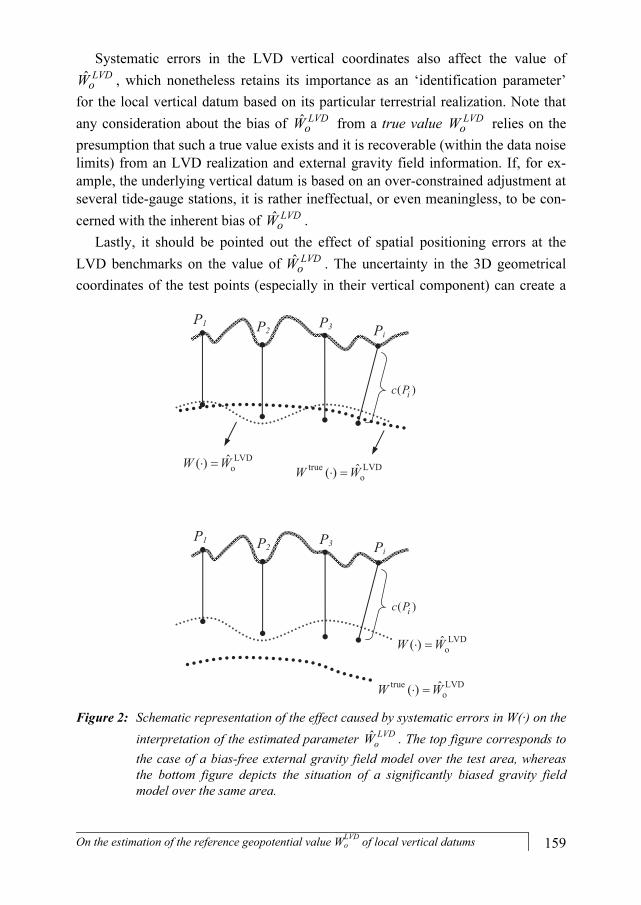
oW according to Eq. (3). Moreover, the presence of systematic errors in W(⋅)
affects the result of Eq. (2) (similarly for (4) or (5)) and it may lead to a biased
geopotential estimate in the sense shown in Fig. 2. Depending on their magnitude
and spatial behavior, the systematic errors in the external gravity field model, espe-
cially at spatial wavelengths of similar and/or larger size than the extent of the test
area, provide a critical error source for ˆLVD
oW that cannot be sufficiently reduced
without the auxiliary use of additional bias modeling schemes within the basic
equation ( ) ( ) LVDoi iW P c P W+ = .
P1 P2P3 Pi
ˆ( ) LVDoW W⋅ =
( )ic P
( )iW P
( ) ( )i iW P c P+
Figure 1: Assuming an error-free geopotential model W(·), the error variance of the esti-
mated parameter ˆ
LVD
oW reflects the stability of the local vertical datum over the
particular realization of leveling benchmarks {Pi}.
On the estimation of the reference geopotential value Wo
LVD of local vertical datums 159
Systematic errors in the LVD vertical coordinates also affect the value of
ˆLVD
oW , which nonetheless retains its importance as an ‘identification parameter’
for the local vertical datum based on its particular terrestrial realization. Note that
any consideration about the bias of ˆLVD
oW from a true value LVD
oW relies on the
presumption that such a true value exists and it is recoverable (within the data noise
limits) from an LVD realization and external gravity field information. If, for ex-
ample, the underlying vertical datum is based on an over-constrained adjustment at
several tide-gauge stations, it is rather ineffectual, or even meaningless, to be con-
cerned with the inherent bias of ˆLVD
oW .
Lastly, it should be pointed out the effect of spatial positioning errors at the
LVD benchmarks on the value of ˆLVD
oW . The uncertainty in the 3D geometrical
coordinates of the test points (especially in their vertical component) can create a
ˆ( ) LVDoW W⋅ = ˆ( )true LVD
oW W⋅ =
P1 P2P3 Pi
( )ic P
P1 P2P3 Pi
( )ic P
ˆ( ) LVDoW W⋅ =
ˆ( )true LVDoW W⋅ =
Figure 2: Schematic representation of the effect caused by systematic errors in W(·) on the
interpretation of the estimated parameter ˆ
LVD
oW . The top figure corresponds to
the case of a bias-free external gravity field model over the test area, whereas
the bottom figure depicts the situation of a significantly biased gravity field
model over the same area.

160 C. Kotsakis
notable error source for the geopotential values ( )iW P that may consecutively af-
fect the estimation accuracy of the fundamental LVD parameter. For example, a
geocentric radial error of 3 cm in the spatial location of each leveling benchmark
inflicts an error of about 0.3 m2/s2 on their computed gravity potential values. De-
pending on the nature (random or systematic) of this positioning error, its propa-
gated effect on ˆLVD
oW will be either statistically reduced by a factor of K (where
K is the number of test points) or it will add a constant bias of equal magnitude. In
most cases, however, such errors are practically masked under the uncertainty im-
posed by the noise level of Earth’s geopotential model itself.
4. Use of an external geoid model
In many LVD studies, instead of determining the gravity potential W(·) at a
number of leveling benchmarks with known 3D spatial positions, a geoid or quasi-
geoid model is alternatively used for the recovery of the unknown parameter LVDo
W . The estimation procedure relies on the well-known relationship between
geometric and physical heights over the Earth’s surface. Here, we confine our at-
tention to the case where LVD orthometric heights are employed along with a
(global or regional) geoid model and GPS geometric heights. The main aspects of
the following methodology are also applicable (with minor modifications) for simi-
lar studies based on Molodensky’s normal heights and quasi-geoid models; see also
Burša et al. (2004).
γi
Reference ellipsoid (U = Uo)
Pi
Geoid model (W = Wo)
LVD (W = WoLVD)
Earth’s topography
Hi
hi
i
Figure 3: The relationship among ellipsoidal, orthometric and geoid heights, and their
corresponding reference surfaces.

On the estimation of the reference geopotential value Wo
LVD of local vertical datums 161
In the absence of any random or systematic errors, the orthometric (Hi), ellip-
soidal (hi) and geoid (�i) heights at any terrestrial benchmark should fulfill the
theoretical constraint (expressed here in linearized form):
LVD
i i i
i
o oW W
h H �γ
-
- - = (6)
where LVDo
W and o
W denote the constant gravity potential on the LVD reference
surface and the equipotential surface that is realized by the geoid model, respec-
tively. The value γi corresponds to the normal gravity on the reference ellipsoid that
is computed through Somigliana’s formula at the known geodetic latitude of the
particular benchmark (see Fig. 3).
The following remarks should be stated regarding the validity of Eq. (6).
• The deflection of the vertical at the LVD benchmark is ignored, so that all
height types are treated as geometrically straight distances along the same spa-
tial direction. The corresponding approximation error caused in Eq. (6) is below
the mm-level, even for extreme cases of arcmin-level vertical deflections and
km-level topographic heights, which is considered negligible for most geodetic
applications.
• A more rigorous formulation of Eq. (6) should employ the actual gravity gi on
the geoidal equipotential surface, instead of the normal gravity γi on the refer-
ence ellipsoid. Assuming that the gravity anomaly Δgi
= gi
− γi does not exceed a
maximum of 500 mgals, the approximation error in Eq. (6) due to this simplifi-
cation is typically below the mm-level and thus also negligible for most geo-
detic applications.
• The geoid height �i in Eq. (6) contains the additive contribution of a zero-
degree term which accounts for the mass difference between the actual Earth
(GM) and its reference ellipsoid (GM'), and it further specifies the particular
equipotential surface that is realized by the geoid model (see Smith 1998). This
zero-degree term entails the a priori choice of a reference geopotential value Wo
which explicitly appears in Eq. (6).
• The chosen value of Wo should be numerically close to LVDo
W in order to mini-
mize the linearization error of Eq. (6). In practice, Wo is selected either as an
optimal approximation to the global mean sea level derived from satellite altim-
etry data (e.g. Burša et al. 2002) or as a postulated parameter of a global vertical
reference system (GVRS) that needs to be connected with the particular LVD
via an external geoid model. In any case, the linearization error associated with
Eq. (6) is practically negligible (< 1 mm) for any ‘reasonable’ choice of Wo.
• If the geoid model does not incorporate a zero-degree term, the theoretical con-
straint in Eq. (6) should take the following form (based on a spherical approxi-
mation):

162 C. Kotsakis
1 LVD
i i i
i
o o
o
GM GMh H � U W
γ R
- ¢Ê ˆ- - = + -Á ˜Ë ¯�
where i
�� is the geoid height without the contribution of a zero-degree term, Uo
is the normal gravity potential on the reference ellipsoid, and Ro denotes the
mean Earth radius. Note that the equipotential surface realized by the geoid
model will now correspond to the geopotential value:
o o
o
GM GMW U
R
- ¢= +
• The geometric height ih and the geoid height
i� (or
i�� ) should refer to a
common geodetic reference system with respect to a single Earth reference el-
lipsoid. Datum inconsistencies between these height types need to be accounted
for and either eliminated beforehand through a suitable transformation or in-
cluded as additional parameterized corrections within the general model of Eq.
(6). A compendium of height transformation formulae between different geo-
detic reference systems can be found in Kotsakis (2008).
• Effects due to the permanent tidal deformation of the Earth’s crust and its grav-
ity field, as well as other temporal height variations, need to be consistently
modeled beforehand in all data types shown in Eq. (6).
Using Eq. (6) as an ‘observation equation’ over a network of GPS/leveling
benchmarks and also assuming a constant noise level at all data points, the follow-
ing least-squares estimate can be obtained for the LVD datum parameter:
2
1 1
2 2
1 1
1 1( ) ( )
ˆ
1 1
K K
i i i i i i i
i iLVD i i
K K
i ii i
o o o
h H � γ h H �γ γ
W W W
γ γ
= =
= =
- - - -
= - = -
 Â
 Â
(7)
The error variance of the above estimate is given from the equation
2
2
ˆ
2
1
1LVD
oKW
ii
σσ
γ=
=
Â
(8)
where 2σ represents the total height data accuracy at each LVD benchmark, i.e.
2 2 2 2
h H �σ σ σ σ= + + .
In principle, the previous result corresponds to a weighted averaging of the
gravity potential residuals ( )i i i iγ h H �− − that are spawned by the perturbation

On the estimation of the reference geopotential value Wo
LVD of local vertical datums 163
term LVD
o o oW W Wδ = − . The associated weight factors are the inverse squared
normal gravity values 2
iγ−
whose role is to account for the non-parallelism of the
equipotential surfaces, ( ) LVD
oW W⋅ = and ( )
oW W⋅ = , which are realized by their
vertical offsets at the data points. Of course, as already mentioned in previous re-
marks, a more rigorous and physically meaningful implementation of this averag-
ing procedure requires the use of geoidal gravity values instead of normal gravity
values. Nevertheless, in practice, the last two equations can be safely reduced to the
simplified expressions:
1
( )
ˆ
K
i i i
LVD i
aveo o
h H �
W W γK
=
- -
= -
 (9)
and
2
2 2
ˆ LVDo
aveW
σσ γ
K= (10)
where ave
γ corresponds to the average normal gravity on the reference ellipsoid
over the test area, and K denotes the number of the available GPS/leveling bench-
marks. The difference between the gravity potential estimates that are computed by
Eqs. (7) and (9) is not larger than 10–3 m2/s2, even for test networks extending from
the equator up to the poles.
The statistical accuracy of ˆ LVDo
W from the above procedure depends on the
noise level and the amount of the heterogeneous height data. As an example, for a
total noise level of σ = 11 cm (which is roughly composed by σh
= 3 cm, σH
= 2 cm
and σ�
= 10 cm), the LVD datum parameter can be estimated with a formal accu-
racy of about ±0.5 m2/s2 using only four control points (K=4). This corresponds to
a relative error of 10-8, which conforms with the reported uncertainty of several ˆ LVDo
W estimates that have been determined for various LVDs around the world
(e.g. Burša 2001, 2004). Note that the previous formulae neglect the effect of geo-
graphically correlated errors in each height type and thus may lead to a non-
optimal result and a deceptive evaluation of its true estimation accuracy.
Remark 2. The noise level of the height data is often determined empirically
through the sample variance of the de-trended residuals {hi – Hi – �i}. In such
cases, the error variance from Eq. (8) or (10) should be perceived as a statistical
measure for the consistency of the heterogeneous height data in the gravity poten-
tial domain, and not necessarily as the true accuracy of ˆ LVDo
W .
It should be noted that the error variance from Eq. (8) or (10) reflects (also) the
estimation accuracy of the geopotential difference ˆ LVDo o
W W− on the basis of the

164 C. Kotsakis
given data. This difference is a key parameter for implementing the height trans-
formation between the underlying LVD and a unified vertical datum defined by
oW , as well as for obtaining LVD vertical positions solely from GPS measure-
ments and a geoid model representing a particular equipotential surface of Earth’s
gravity field (Jekeli 2000).
5. Summary – Conclusions
In most LVDs neither of their fundamental defining components, that is a geo-
potential model ( )W ⋅ and a conventional geopotential value LVD
oW , is used for
their primary realization. However, an auxiliary representation of an existing verti-
cal datum in the gravity potential domain is essential since it provides the required
framework for connecting and unifying different vertical reference frames without
the need to perform relative leveling measurements between them. Such a repre-
sentation relies on a given model of Earth’s gravity field and a reference (zero-
height) geopotential value that needs to be recovered from a traditional realization
of the underlying vertical datum with the aid of space geodetic positioning data.
The main aspects of the corresponding estimation procedure have been discussed
in the present paper, focusing on the optimal inversion of co-located GPS, or-
thometric and geoid heights for the a posteriori determination of the LVD datum
parameter.
Among other issues, a distinction between the ‘inner’ and ‘external’ component
of the total error variance associated with ˆ LVDo
W is crucial if we aim to properly
interpret its estimation accuracy level. Those components reflect various error
sources and they split up the uncertainty of the LVD datum parameter into separate
elements with different physical significance, namely (i) the spatial stability of the
local vertical datum over its available terrestrial realization (inner component
which is dictated by the propagated accuracy of the LVD orthometric heights), and
(ii) the accuracy with which the local vertical datum is tied to Earth’s actual gravity
field (external component which is dictated by the propagated accuracy of the GPS
and geoid height data).
It should be pointed out that the height reference frames associated with re-
gional LVDs are often affected by systematic distortions in their official vertical
coordinates. In the presence of such distortions, one may question the rationale of
the previous identification scheme in terms of a single estimate for their zero-
height geopotential level. For example, there is a notable difficulty in the interpre-
tation of ˆLVD
oW if the local vertical datum has been established by an over-
constrained leveling adjustment to more than one tide gauge stations. Indeed, in
such cases the fixed origin points realize a zero-height reference surface that is not
On the estimation of the reference geopotential value Wo
LVD of local vertical datums 165
theoretically matched to an equipotential surface due to the distorting effect of sea
surface topography. Nevertheless, the primary role of ˆLVD
oW is not necessarily to
approximate the true reference geopotential level of the original LVD definition
(which, actually, does not even exist in over-constrained vertical datums), but
rather to specify an equipotential surface that optimally fits the known vertical po-
sitions of terrestrial leveling benchmarks with the help of an external gravity field
model. The modeling and the removal of LVD systematic errors is thus an auxil-
iary step that should be implemented either before or concurrently with the optimal
estimation of ˆLVD
oW in order to improve the aforementioned fit and to fortify the
physical significance of the recovered zero-height geopotential level.
References
Amos, M.J. and Featherstone, W.E., 2009. Unification of �ew Zealand’s local vertical
datums: iterative gravimetric quasigeoid computations. J Geod, 83: 57-68.
Ardalan, A., Grafarend, E. and Kakkuri, J., 2002. �ational height datum, the Gauss-Listing
geoid level value wo and its time variation (Baltic Sea Level Project: epochs 1990.8,
1993.8, 1997.4). J Geod, 76: 1-28.
Ardalan, A. and Safari, A., 2005. Global height datum unification: a new approach in grav-
ity potential space. J Geod, 79: 512-523.
Burša, M., Kouba, J., Kumar, M., Müller, A., Radĕj, K., True, S.A., Vatrt, V. and Vojtišk-ová, M., 1999. Geoidal geopotential and world height system. Stud Geophys et Geod, 43: 327-337.
Burša, M., Kouba, J., Müller, A., Radĕj, K., True, S.A., Vatrt, V. and Vojtišková, M., 2001. Determination of geopotential differences between local vertical datums and realiza-
tion of a world height system. Stud Geophys et Geod, 45: 127-132.
Burša, M., Groten, E., Kenyon, S., Kouba, J., Radĕj, K., Vatrt, V. and Vojtišková, M., 2002. Earth’s dimension specified by geoidal geopotential. Stud Geophys et Geod, 46: 1-8.
Burša, M., Kenyon, S., Kouba, J., Šima, Z., Vatrt, V. and Vojtišková, M., 2004. A global
vertical reference frame based on four regional vertical datums. Stud Geophys et Geod, 48: 493-502.
Burša, M., Dušátko, D., Kenyon, S., Kouba, J., Šima, Z., Vatrt, V., Marša, J. and Vojtišk-ová, M., 2006. Determination of geopotential Wo, ALICA�TE and its connection to Wo,
�AVD88. Presented at the EUREF Annual Symposium, Riga, Latvia, June 14-17, 2006.
Burša, M., Kenyon, S., Kouba, J., Šima, Z., Vatrt, V., Vojtĕch, V. and Vojtišková, M., 2007. The geopotential value Wo for specifying the relativistic atomic time scale and a
global vertical reference system. J Geod, 81: 103-110.
Colombo, O.L., 1980. A world vertical network. Department of Geodetic Science, The Ohio State University, OSU Report No. 296, Columbus, Ohio.
Grafarend, E. and Ardalan, A., 1997. Wo: an estimate in the Finnish Height Datum �60,

166 C. Kotsakis
epoch 1993.4, from twenty-five GPS points of the Baltic Sea Level Project. J Geod, 71: 673-679.
Hajela, D.P., 1983. Accuracy estimates of gravity potential differences between Western
Europe and United States through LAGEOS satellite laser ranging network. Depart-ment of Geodetic Science, The Ohio State University, OSU Report No. 345, Colum-bus, Ohio.
Heck, B. and Rummel, R., 1990. Strategies for solving the vertical datum problem using
terrestrial and satellite geodetic data. IAG Symposia, vol 104, pp. 116-128, Springer, New York Berlin Heidelberg.
Heck, B., 2004. Problems in the definition of vertical reference frames. IAG Symposia, vol 127, pp. 164-173, Springer, New York Berlin Heidelberg.
Heiskanen, W. and Moritz, H., 1967. Physical geodesy. WH Freeman, San Francisco.
Hipkin, R., 2003. Defining the geoid by W = Wo ≡ Uo: Theory and practice of a modern
height system. Proceedings of the 3rd meeting of the International Gravity and Geoid Commission (Tziavos IN, ed), Thessaloniki, Ziti Editions, pp. 367-377.
Jekeli, C. and Dumrongchai, P., 2003. On monitoring a vertical datum with satellite altim-
etry and water-level gauge data on large lakes. J Geod, 77: 447-453.
Jekeli, C., 2000. Heights, the Geopotential and Vertical Datums. Department of Civil, En-vironmental Engineering and Geodetic Science, The Ohio State University, OSU Re-port No. 459, Columbus, Ohio.
Kasenda, A. and Kearsley, A.H.W., 2003. Offsets between some local height datums in the
South East Asia Region. Proceedings of the 3rd meeting of the International Gravity and Geoid Commission (Tziavos IN, ed), Thessaloniki, Ziti Editions, pp. 384-388.
Kotsakis, C., 2008. Transforming ellipsoidal heights and geoid undulations between differ-
ent geodetic reference frames. J Geod, 82: 249-260.
Lehmann, R., 2000. Altimetry-gravimetry problems with free vertical datums. J Geod, 74: 327-334.
McCarthy, D.D. and Petit, G. (eds.), 2004. IERS Conventions 2003. International Earth Rotation and Reference Systems Service, Technical Note No. 32, Verlag des Bundes-amts für Kartographie und Geodäsie, Frankfurt am Main.
Nahavandchi, H. and Sjöberg, L.E., 1998. Unification of vertical datums by GPS and gra-
vimetric geoid models using modified Stokes formula. Mar Geod, 21: 261-273.
Pan, M. and Sjöberg, L.E., 1998. Unification of vertical datums by GPS and gravimetric
geoid models with application to Fennoscandia. J Geod, 72: 64-70.
Rapp, R.H. and Balasubramania, N., 1992. A conceptual formulation of a world height
system. Department of Geodetic Science, The Ohio State University, OSU Report No. 421, Columbus, Ohio.
Rapp, R.H., 1994. Separation between reference surfaces of selected vertical datums. Bull Geod, 69: 26-31.
Rummel, R. and Teunissen, P., 1988. Height datum definition, height datum connection
and the role of the geodetic boundary value problem. Bull Geod, 62(4): 477-498.
Sacerdote, F. and Sansò, F., 2004. Geodetic boundary-value problems and the height datum

On the estimation of the reference geopotential value Wo
LVD of local vertical datums 167
problem. IAG Symposia, vol 127, pp. 174-178, Springer, New York Berlin Heidel-berg.
Sadiq, M., Tscherning, C.C. and Ahmad, Z., 2009. An estimation of the height system bias
parameter �o using least-squares collocation from observed gravity and GPS-leveling
data. Stud Geophys et Geod, 53: 375-388.
Sansò, F. and Usai, S., 1995. Height datum and local geodetic datum in the theory of geo-
detic boundary value problems. AVN, 8-9: 343-385.
Sansò, F. and Venuti, G., 2002. The height datum/geodetic datum problem. Geoph J Int, 149: 768-775.
Smith, D.A., 1998. There is no such thing as ‘the’ EGM96 geoid: subtle points on the use
of a global geopotential model. International Geoid Service Bullettin, 8: 17-27.
van Onselen, K., 1997. Quality investigation of vertical datum connection. Delft Institute for Earth-Oriented Space Research, DEOS Report No. 97.3, Delft, The Netherlands.
Xu, P. and Rummel, R., 1991. A quality investigation of global vertical datum connection. Netherlands Geodetic Commission, Publications on Geodesy (new series), Report no. 34, Delft, The Netherlands.
Xu, P., 1992. A quality investigation of global vertical datum connection. Geoph J Int, 110: 361-370.