ontomet: ontology metadata framework - semantic … · informal metadata crosswalks ... figure 8....
TRANSCRIPT
ONTOMET: Ontology Metadata Framework
A Thesis
Submitted to the Faculty
of
Drexel University
by
Luis E. Bermudez
in partial fulfillment of the
requirements for the degree
of
Doctor of Philosophy
December 2004

ii
DEDICATIONS
I dedicate this work to my wife Gaby, little Felipe,
my mom Elba, my sister Paty, and my father,
who told me to study
engineering and not music.

iii
ACKNOWLEDGEMENTS
I gratefully acknowledge the guidance and support from all the members of
my committee, Dr. Michael Piasecki, Dr. David Maidment, Dr. Hyoil Han, Dr.
Claire Welty and Dr. Richard Weggel. In particular, I would like to thank my
advisor Dr. Michael Piasecki, for encouraging me to pursue this stage in my life,
for trusting in my ideas and my work, and for providing me with the advice
whenever I needed. I would also like to acknowledge Rainer Lehfeldt, who was
the first one to introduce me to the metadata and the RDF concepts; Frank
Sellerohf and Christoph Lippert, for the brainstorm sessions and for the object
oriented explanations that helped me to code better JAVA programs.
I would also like to thank my friends from (DICE) Drexel Informatics for
Civil Engineering Research Group, Saiful, Bora, Volkan, Zafer, Yoori for their
friendship, constructive discussions, and suggestions. Special thanks to Bora
Beran for proofreading this thesis and Saiful Islam for walking with me inside the
computer science and information systems worlds. I would like to thank in general
to all the other students whom I shared moments with in the last 4 years. I would
also like to mention Dr. David Lanter for his valuable suggestions and dedicated
time.
I thank with my heart my lovely wife, Gaby, for encouraging me, giving me
the energy, and having the required patience to support me in difficult moments.
My first son Luis Felipe, was born when I was in chapter 10, almost finishing this
dissertation. I thank God for this new burst of energy in my life when I needed

iv
more than ever to complete this work. I also thank both my mother and sister in
law for their advice and support.

v
TABLE OF CONTENT
List of Tables ........................................................................................................... ix
List of Figures ...........................................................................................................x
Abstract................................................................................................................... xiii
Chapter 1: Introduction ............................................................................................. 1
1.1 Review of the Problem................................................................................... 1
1.1.1 .Specifications’ lack of domain-specific elements .....................................3
1.1.2 .Specifications have limited extensibility ...................................................4
1.1.3 .Semantic heterogeneity in metadata annotations ....................................8
1.1.4 . Informal metadata crosswalks................................................................10
1.2 Strategy, contributions and thesis organization ........................................... 11
Chapter 2: Background concepts............................................................................ 15
2.1 Ontologies .................................................................................................... 15
2.2 Web Ontology Language ............................................................................. 17
2.3 Open world and closed world assumptions.................................................. 19
2.4 Machine-readable format and markup languages........................................ 22
Chapter 3: ONTOMET overview............................................................................. 25
Chapter 4: Traditional approaches and comparison with ONTOMET..................... 29
4.1 Tightly and loosely coupled frameworks ...................................................... 29
4.2 Characteristics of federated system components ........................................ 31
Chapter 5: Metadata specifications and encodings ................................................ 35
5.1 Metadata definition....................................................................................... 35
5.2 Metadata specification ................................................................................. 36

vi
5.3 Related metadata specifications to hydrology.............................................. 37
5.3.1 . ISO 19115:2003 .....................................................................................37
5.3.2 .FGDC-STD-001-1998 ............................................................................38
5.3.3 .Dublin Core ............................................................................................39
5.3.4 .Directory Interchange Format ................................................................39
5.3.5 .Earth Science Markup Language...........................................................40
5.3.6 .Geography Markup Language ...............................................................40
5.3.7 .Ecological Metadata Language..............................................................41
5.3.8 .ADN Framework.....................................................................................42
5.3.9 .ANZLIC ..................................................................................................43
5.4 Metadata specifications formalizations ........................................................ 43
Chapter 6: Dynamic Community Profiles ................................................................ 48
6.1 Definition ...................................................................................................... 48
6.2 Abstract model for metadata specifications ................................................. 50
6.3 Methodology to create a dynamic metadata community profile: .................. 57
6.3.1 . Importing ontologies...............................................................................58
6.3.2 .Setting an element as core ....................................................................60
6.3.3 .Unsetting an element as core ................................................................62
6.3.4 .Setting as mandatory .............................................................................62
6.3.5 .Adding a new metadata section or metadata entity ...............................63
6.3.6 .Creating a new metadata code list .........................................................64
6.3.7 .Expanding a code list .............................................................................65
6.3.8 .Adding a new metadata element to an existing class ............................65
6.3.9 . Imposing a more stringent obligation on an element. ............................66

vii
6.3.10 Imposing a more restrictive domain on an element..........................68
6.3.11 Extension problems..........................................................................70
6.4 Related approaches to Dynamic Community Profiles.................................. 72
Chapter 7: Mapping metadata specifications.......................................................... 76
7.1 Motivation and background .......................................................................... 76
7.2 Process overview ......................................................................................... 79
7.3 Metadata-Tree-Path ..................................................................................... 80
Chapter 8: Conceptualization of metadata specifications in owl............................. 87
8.1 ISO in OWL.................................................................................................. 87
8.2 FGDC in OWL.............................................................................................. 89
8.2.1 .Case 1: Creation of arbitrary object properties ......................................90
8.2.2 .Case 2: Creation of arbitrary classes .....................................................91
Chapter 9: Conceptualizing controlled vocabularies............................................... 93
9.1 Controlled vocabularies................................................................................ 93
9.2 Classification of controlled vocabularies ...................................................... 95
9.3 Definitions .................................................................................................... 96
9.3.1 .Definition of conceptualized controlled vocabularies .............................96
9.3.2 .Definition of non conceptualized CV ......................................................97
9.3.3 .Non conceptualized categorized CV ......................................................97
9.3.4 .Non conceptualized - Non categorized CV ............................................98
9.3.5 .Non conceptualized - categorized with relations CV..............................98
9.4 Methodology............................................................................................... 100
9.4.1 .Hydrologic Units Ontology....................................................................102
9.4.2 .Global Change Master Directory Ontology...........................................104
viii
Chapter 10: Upper hydrologic ontology ................................................................ 108
10.1 Motivation and background ...................................................................... 108
10.2 Construction and definition of terms......................................................... 109
10.3 Testing of the top hydrologic ontology ..................................................... 115
10.3.1 Feature ...........................................................................................115
10.3.2 Phenomena....................................................................................116
10.3.3 Substance ......................................................................................116
10.4 Usage example: Hydroogle...................................................................... 117
Chapter 11: Pangloss ........................................................................................... 123
11.1 Overview .................................................................................................. 123
11.2 Other tools to annotate and extend metadata specifications ................... 128
Chapter 12: CUAHSI metadata profile.................................................................. 131
Chapter 13: Interoperability test............................................................................ 136
13.1 Creation of the ontologies ........................................................................ 137
13.2 Query definition ........................................................................................ 139
13.3 Performing the query:............................................................................... 141
Chapter 14: Summary........................................................................................... 146
Chapter 15: Further work...................................................................................... 149
List of References................................................................................................. 151
Vita........................................................................................................................ 163

ix
LIST OF TABLES
Table 1. Different representation of metadata specifications...................................10
Table 2. Metadata classification...............................................................................35
Table 3. Formalization of metadata specifications...................................................45
Table 4. Metadata descriptors sequence.................................................................52
Table 5. Identification of metadata descriptors by a tree structure ..........................53
Table 6. Terminology used in OWL, UML, and ISO.................................................58
Table 7. Possible Mappings.....................................................................................82
Table 8. ISO elements definitions mapped to OWL.................................................88
Table 9. ISO Types mapped to OWL.......................................................................88

x
LIST OF FIGURES
Figure 1. Discovery issues due to metadata incompatibilities ...................................2
Figure 2. Example of extension of metadata specifications.......................................6
Figure 3. Classes after profile changes .....................................................................7
Figure 4. Community profiles: duplication vs. extension............................................7
Figure 5. A small ontology example.........................................................................16
Figure 6. RDF Triple in XML ....................................................................................18
Figure 7. Reasoning over inherited properties.........................................................21
Figure 8. ONTOMET – Ontology Metadata Framework ..........................................26
Figure 9. Taxonomy of Heterogeneity and Interoperability ......................................33
Figure 10 RDF Graph ..............................................................................................37
Figure 11. Example of an ESML file ........................................................................41
Figure 12. Metadata specifications dimensions.......................................................46
Figure 13. Dynamic Community Profile ...................................................................49
Figure 14. Abstract Model for Metadata Specifications ...........................................51
Figure 15. Identification of metadata abstract model components in ISO ...............54
Figure 16. Identification of metadata abstract model components in FGDC ...........54
Figure 17. Identification of metadata abstract model components in DC ................55
Figure 18. Identification of metadata abstract model components in DIF................55
Figure 19. Metadata path in XML.............................................................................56
Figure 20. Multi-range-class ....................................................................................61
Figure 21. Creation of a class and a sub-class in OWL...........................................63
Figure 22. Neuse-Station ontology ..........................................................................64

xi
Figure 23. Usage of a Code-list as a range of a property in OWL...........................64
Figure 24. ISO Code-list ..........................................................................................65
Figure 25. Extending an ISO's code-list...................................................................65
Figure 26. Creation of an object property in OWL ...................................................66
Figure 27. Creation of a datatype property in OWL .................................................66
Figure 28. ISO element datasetURI.........................................................................67
Figure 29. Cardinality restriction in OWL .................................................................68
Figure 30. Restriction iso:keyword...........................................................................69
Figure 31. Extension of iso:keywords in XML..........................................................69
Figure 32. Value of a property as object Property and as datatype Property ..........71
Figure 33. Extending a property of a multi-range-class ...........................................72
Figure 34. Extracted Figure 3 and 4 from [4] ...........................................................74
Figure 35. Metadata Mapping Model .......................................................................80
Figure 36. A ONE_TO_ONE_AND ONE_WITH_VALUE mapping..........................83
Figure 37. Mapping example from FGDC to ISO.....................................................86
Figure 38. Classification of Hodge knowledge organization systems. .....................95
Figure 39. USGS Hydrologic Units Ontology .........................................................103
Figure 40 Excerpt Global Change Master Directory Keywords. ............................104
Figure 41. Extension of ISO MD_Keywords to accept all values of GCMD...........106
Figure 42. Protégé snapshot GCMD in OWL.........................................................107
Figure 43. Upper Hydrologic Ontology...................................................................110
Figure 44. Discovering Hydrologic knowledge with Hydroogle ..............................118
Figure 45. Google search for stage and Delaware. ...............................................119
Figure 46. Search refinement Hydroogle...............................................................120

xii
Figure 47. Refined search for stage an Delaware in Hydroogle ............................121
Figure 48. Hydroogle Architecture .........................................................................122
Figure 49. Pangloss MetaInstance ........................................................................124
Figure 50. Core Paths of ISO-19115:2003 in Pangloss.........................................125
Figure 51. Pangloss MetaMapper..........................................................................126
Figure 52. Datatype encoding of a URI..................................................................128
Figure 53. RDF/XML encoding of CUAHSI keywords creation..............................132
Figure 54. CUAHSI Metadata Profile .....................................................................133
Figure 55. Pangloss MetaExtender snapshot of CUAHSI core .............................134
Figure 56. MTF export from Pangloss ...................................................................134
Figure 57. Controlled vocabulary of a Dynamic Community Profile.......................135
Figure 58. Profiles inheritance ...............................................................................136
Figure 59. USGS vocabulary .................................................................................137
Figure 60. USGS Dynamic Community Profile ......................................................138
Figure 61. USGS instance creation .......................................................................139
Figure 62. Excerpt of USGS instance in XML........................................................139
Figure 63. Formatted results..................................................................................140
Figure 64. RDQL to find the metadata root element ..............................................141
Figure 65. Instance in XML shown the metadata root ...........................................142
Figure 66. RDQL to get iso:title knowing the root value.........................................143
Figure 67. Semantic interoperability with mappings ..............................................144

xiii
ABSTRACT ONTOMET: Ontology Metadata Framework
Luis Bermudez Michael Piasecki Supervisor, Ph.D.
Proper description of data, or metadata, is important to facilitate data
sharing among Geospatial Information Communities. To avoid the production of
arbitrary metadata annotations, communities agree that creating or adopting a
metadata specification is needed. The specification is a document, such as the
Geographic Metadata Standard (ISO 19115-2003), which provides a set of rules
for the proper use of metadata elements. When a community is adopting a
metadata specification it has two main concerns: 1) how can an existing
specification be adopted, so that elements can be restricted and domain
vocabularies be used? and 2) how can a metadata specification be mapped with
another one to achieve interoperability? The two aforementioned concerns are
raised due to the fact that: 1) specifications lack domain-specific elements, 2)
specifications have limited extensibility, 3) specifications do not always solve
semantic heterogeneities and 4) methodologies to create crosswalks among
specification have not been formalized.
The main goal of this thesis is to present a feasible solution for these
problems by providing a flexible environment to allow interoperations of formalized
metadata specifications, extensions, crosswalks and domain vocabularies. The
main contributions of this thesis are: 1) creation of an abstract model to represent
metadata specifications, 2) development of a methodology to extend metadata
specifications, called Dynamic Community Profile, and 3) formalization of
semantic mappings to perform complex and contextual metadata crosswalks.

xiv
These three main contributions are encapsulated in a framework called Ontology-
Metadata Framework or ONTOMET. ONTOMET has seven components:
metadata specification, a domain vocabulary, top-domain ontology, metadata
crosswalk, Dynamic Community Profile and vocabulary mapper. A Dynamic
Community Profile is a metadata specification, which extends other metadata
specifications and infer terms from controlled vocabularies. Vocabulary mappers
solve semantic heterogeneities that appear in domain vocabularies and a
metadata crosswalk expresses the semantic mappings of two specifications. Also
strategies to conceptualize metadata specifications and vocabularies, are
presented. Stand alone JAVA Tools and Web programs were created that
implemented the methodologies presented, to allow creation of metadata
instances and mappings, as well as views of hydrologic vocabularies to facilitate
discovery of knowledge and resources in the Web.

1
CHAPTER 1: INTRODUCTION
1.1 Review of the Problem
Proper description of data is an important activity to facilitate its sharing
among Geospatial Information Communities [18]. The information/data about data
is commonly referred to as metadata. A metadata entry is composed of a resource,
a property and a value. A resource can be any information medium such as a data
set, jpeg image, a numerical model, the latest measurement of a station or a
polyline representing a river. A property, sometimes called “metadata element” is a
characteristic of a resource, that helps to distinguish a particular resource from
others (e.g. author, date of creation, number of records etc). And a value is the
assigned information for a resource to a property. For example, this thesis is a
resource, that has a property, author, the value of which is Luis Bermudez.
Simply creating metadata is not enough due to the semantic heterogeneities
that are present in the properties and the values. Metadata annotators may select
different properties (e.g. keyword, topic, subject) or distinct values (e.g. stage, gage
height, water elevation) when identifying a resource. Also, a value can have
different meanings (e.g. stage, can refer to water elevation or a platform for
performing arts). These semantic differences in metadata annotations hinder
accurate discoveries of data and the exchange of meaningful information across
communities (See Figure 1).

2
Figure 1. Discovery issues due to metadata incompatibilities
To avoid the arbitrary use of properties and values when describing a
resource, rules of usage and encoding must be defined. A document that presents
a set of statements which helps domain experts to formally express the rules of
usage for metadata elements is called a metadata specification. The three major
metadata specifications related to geographic digital data are: Geographic
Metadata Standard ISO 19115:2003 [65], Dublin Core Metadata Initiative [21], and
the Content Standard for Digital Geospatial Metadata, published by the Federal
Geographic Data Committee [32], (These three will be referred in this thesis as
ISO, FGDC and DCMI, respectively). A metadata specification is a product of a
community agreement; however, it is impossible to achieve a world-wide
consensus about one and only one metadata specification. Developing or adopting
a metadata specification to help describe the format and the content of data to
achieve interoperability has become a major issue in different earth science

3
initiatives (e.g. CHRONOS [15], CLEANER [17], CUAHSI [20], IRIS [63], NOKIS
[88] , OASIS [91], OMG [98], MMI [82]). These initiatives have two main concerns:
1) How can a specification that already exists be easily adopted, restricting some
elements and incorporating domain vocabularies?, and 2) How can a metadata
specification be mapped with another one to achieve interoperability?
The two aforementioned concerns are raised due to the fact that: 1)
specifications lack of domain-specific elements, 2) specifications have limited
extensibility, 3) specifications do not always solve semantic heterogeneities and 4)
methodologies to create crosswalks among specifications have not been
formalized. In the remainder of this chapter, these problems will be discussed in
detail and a strategy to overcome these difficulties will be presented.
1.1.1 Specifications’ lack of domain-specific elements
When a Geospatial Information Community (hereafter GIC) plans to develop
or use an external metadata specification, it often finds that metadata specifications
are general [55] and lack of domain-specific vocabularies [26, 118]. For example, a
GIC, such as a hydrologic community, will find no explicit rules in ISO, FGDC or
DCMI that specify how to describe a watershed. GICs cannot determine whether
the outlet location must be specified, or if the feature described needs to be called
“drainage area”, “watershed” or “hydrologic unit”. As a consequence, communities
prefer either to create their own specification, sometimes using similar elements
from other specifications, such as Ecological Metadata Language EML [24]; or not
using elements from any other specification, therefore producing a completely new
specification, e.g. Hydrologic Markup Language HydroML [129].

4
The need to rewrite or create a new specification appears because of the
incompatible goals among specification producers and specification implementers
[53]. Producers design the specification using a top-down approach, trying to
produce a general set of descriptors, while implementers seek a more detailed
specification to satisfy their own needs. Normally, the producer of specifications is
a publisher of standards, such as International Organization for Standardization
(ISO) or the Federal Geographic Data Committee (FGDC), that sets forth a general
set of descriptors. Therefore, the specifications do not provide sufficient rules for a
detailed description, such as explicitly stating that the instrument number should be
given when describing a gauge height measurement in a river.
1.1.2 Specifications have limited extensibility
When a GIC uses a metadata specification to fulfill its particular needs, it
creates a metadata community profile [65]. In the creation process, a GIC can
accept, discard, redefine or add elements. However, the mechanisms to perform
these actions are restricted by the flexibility of the medium in which the
specification is formalized. Commonly, formalizations of metadata specifications
are expressed using the eXtensible Markup Language (XML) schemas [30] and the
Unified Modeling Language UML [96], which are not flexible enough to redefine
metadata elements.
In an XML schema, a metadata element takes the form of an XML element,
which is declared using markups. For example, the following script says that an
element title is an XML schema element and is of type string.
<xsd:element name=”title” type=”xsd:string”/>

5
The title element can be declared globally or locally and it can be a complex
or a simple element. A global, a complex and a local element can all have the same
name, which means that a resource can not be uniquely identified in an XML
schema [56].
In a UML model it is not possible to restrict properties as it affects the
membership of objects in a class and extending distributed resources in the Web
will break the principle of modularization [3]. In UML, a property is an attribute of a
class or an association of two classes. These are unique, and exist only if a class
exists. A subclass inherits the attributes and association of its parent, but it is not
possible to overwrite them. The principle of modularization states that a property
belongs to one class in a defined package, but it does not accept a property
belonging to two or more distributed classes.
As a consequence of the lack of flexibility of UML, specifications that are
used to create a community profile, are not really extended but replicated. For
example, Figure 2 depicts two metadata entities from ISO (CI_ResponsibleParty
and MD_Keywords) formalized in UML. It shows possible changes in the original
specification to conform to particular needs of an information community:
individualName is mandatory, role should not be used, and keyword is restricted to
a finite set of terms.

6
Figure 2. Example of extension of metadata specifications
Communities express these changes by rewriting the specification and not
by extending the classes, mostly to preserve modularization. Figure 3 shows the
classes after the changes. The implication is that the new specification will have a
different namespace for its classes and attributes, and the link to the original one is
lost. Also, the problem is aggravated if a GIC would like to combine elements from
more than one metadata specification. At the end, GICs will have unlinked
metadata specifications due to the duplication of metadata specifications, as shown
in the left side of Figure 4.

7
Figure 3. Classes after profile changes
Figure 4. Community profiles: duplication vs. extension
One the other hand, if metadata specifications are extended, duplication
can be avoided. They can be connected as shown in the right side of Figure 4, and,
the language for expressing the metadata specification must be capable of
canceling or overwriting the inherited statements. Also, elements must have a
unique namespace and new elements or refinements must be able to “talk” about
this uniquely identified resource.

8
1.1.3 Semantic heterogeneity in metadata annotations
Solely adopting a metadata specification does not solve the problem of the
discrepancies of the metadata descriptions [26]. Two GICs can agree on a
metadata specification, and find a way to connect their information systems to
exchange data. However, semantic conflicts in metadata annotations can still
appear. For example, stage, gage height and water elevation are different concepts
that are semantically equivalent. As a consequence, the two GICs will have to
resolve the semantic incompatibles to be able to exchange meaningful information.
This is commonly known as the need to achieve semantic interoperability among
heterogeneous systems [10, 43, 51, 52, 111]. The problem presents itself
especially in domain-specific metadata elements (e.g. land-cover, stage height,
runoff), which are metadata that capture meaningful information specific to a
domain [67].
Semantic heterogeneity occurs because of the differences in world
conceptualizations among individuals [36, 45, 99]. To understand the semantic
heterogeneity problem it is useful to envision independent universes that surround
humankind. These are the physical universe, the cognitive universe and the
representation universe. The physical universe is composed of world realities such
as objects and phenomena. The cognitive universe is where the perceptions or
conceptualizations from the physical universe are perceived and defined, or
mapped in the representation universe. The representation universe is the output of
the conceptualization, composed of symbols (e.g. pictures) and formalisms (e.g.
languages, conceptual models, logical models). The semantic heterogeneity
problem occurs due to the differences in the mappings between the physical and

9
the representation universe. Discrepancies among these two universes appear
because: 1) a unique world reality can have different representations (e.g. stage
and gage height are different representations of water level in a section of a river);
and 2) two different world realities can have a similar representation (e.g. stage
can be a water level measurement or a platform for performing events).
Semantic heterogeneities are classified as [43] 1) naming conflicts, 2)
scaling and unit conflicts, and 3) confounding conflicts. Naming conflicts occur
when different name representations exist for a reality or when two realities have
the same name representation. Different name representations that exist for a
reality can be further classified as [1] synonyms, lexical variants and quasi-
synonyms. Synonyms appear because of differences in linguistic origin. They exist
because a reality can have a popular and a scientific representation or because of
dialectic variants (e.g. stage / water elevation). Lexical variants occur because of
spelling or grammatical variations (e.g. ground water / ground-water / groundwater).
And, quasi-synonyms are terms that generally have different meanings, but are
treated as equivalent (e.g. smoothness / roughness).
Scaling and unit conflicts refer to two representations of one reality which
are different due to the datum selected or the scales or the units of measurement.
Confounding conflicts occur when the representation seems to be the same, but
differ in reality due to different contexts. For example, the latest reported
measurement data of two different information systems can refer to different times,
or a flooding stage warning may differ from river to river or agency/state policies.
In summary, semantic heterogeneities appear in metadata annotations due
to the differences in the mappings between the physical and the representation

10
universe. Naming, scaling/units conflict, and connotation conflicts that appear in
metadata annotations must be resolved to achieve semantic interoperability.
1.1.4 Informal metadata crosswalks
A crosswalk is an explicit mapping of one metadata specification to another.
A National Information Standards Organization (NISO) report [115] presents the
issues about creating crosswalks and states that there is not any formal
methodology of specifying a crosswalk among metadata specifications. It is difficult
to have a formal methodology because metadata specifications have different
language representations, elements can appear in more than one context, and
metadata mappings are not always a one-to-one mapping. Table 1, shows different
representations for ISO and FGDC, such as Text, Document Type Definition, DTD
[11], XML Schema (XSD), Unified Modeling Language (UML) or Web Ontology
Language (OWL). All these formats are further discussed in section 5.4.
Table 1. Different representation of metadata specifications
TEXT DTD XSD UML OWL
ISO [65] [65] [64]
FGDC [32] [108] [104] [8]
A direct mapping from one specification to another is not always possible
due to the repetition of elements in different contexts. A non-repeated element,
such as abstract in FGDC and ISO can be mapped simply by stating <FGDC:
abstract sameAs ISO:abstract>. However, not all the mappings are this obvious.
For example, the element title in FGDC can be mapped to the element title in ISO,
11
but, a closer look at ISO, shows that title is an element of an entity called
CI_Citation, which appears in various places or contexts in the ISO specification.
CI_Citation can be used to describe the author of a thesaurus, or the author of a
dataset. So just saying that ISO:title is the appropriate mapping for FGDC:title is
not correct.
Another issue is that the mapping is not always one-to-one. One mapping
example from FGDC to ISO discussed by the National States Geographic
Information Council [89] is:
<FGDC:originator sameAS ISO:Responsible Party and ISO:Role =
originator>
This mapping is a one-to-many mapping, in addition to one element having
a particular value.
In summary, metadata specifications are formalized in different formats, so
there is a need to represent them in a similar platform (i.e. harmonization). Also,
semantic crosswalks are not always simple one-to-one mappings. Problems that
occur due to contextual mappings and complex one-to-many or many-to-one
mappings must be solved.
1.2 Strategy, contributions and thesis organization
The previous sections examined the problems related to extending
metadata specifications and creating crosswalks. The main goal of this thesis is to
present a feasible solution for these problems by providing a flexible environment to
allow interoperations of formalized metadata specifications, extensions, crosswalks
and domain vocabularies. The main contributions of this thesis are:
1. creation of an abstract model to represent metadata specifications;

12
2. development of a methodology to extend metadata specifications by creating
Dynamic Community Profiles; and
3. formalization of semantic mappings to perform complex and contextual
metadata crosswalks.
An abstract model for metadata specification permits visualization of all the
specifications from a unique view, facilitating understanding and interoperations
among metadata specifications. This abstract model presents a metadata
specification as a simple tree with one root. Also a structure that allows classes and
properties branched together is presented, to allow representation of
conceptualized metadata specifications in a tree form.
This thesis uses the capabilities of ontologies (further explained in section
2.1) to provide a flexible environment to create metadata community profiles.
Ontologies are used as a knowledge representation mechanism, for both metadata
specifications and domain vocabularies. The Dynamic Community Profiles
methodology uses the special characteristics of properties in ontologies. (e.g.
properties can be restricted), to link a profile with its parent metadata specification,
and to redefine inherited properties. The profile, also allows inference of terms from
domain vocabularies expressed in ontologies. A community profile using this
methodology was proposed for the Hydrologic Information System of the
Consortium of Universities for the Advancement of Hydrologic Science Inc.
(CUAHSI). The Dynamic Community Profile was tested by presenting a metadata
editor named Pangloss. The tool is able to infer controlled vocabularies and present
them in drop-down boxes. This will allow creation of metadata instances that
13
conform to the community profile specification. An interoperability test was
performed with simple ontologies, that can serve also as an implementation guide.
To circumvent the problem of metadata crosswalks, a conceptual model
based on tree-paths is proposed. The model resolves issues regarding mappings
that are not one-to-one and problems related to contextual mappings. An example
of semantic mappings form FGDC to ISO is presented with a tool that allows to
create edit, save and load the mappings.
The previous discussed strategies are encapsulated in a framework called
ONTOMET or Ontology Metadata Framework. The background concepts of
ONTOMET are discussed in Chapter 2. In this chapter ontologies, open and closed
world assumptions, machine readability and OWL are defined. An overview of
ONTOMET is presented in Chapter 3. Chapter 4 presents traditional approaches
and a comparison with ONTOMET. Chapter 5 defines and presents a survey of
metadata specifications. Chapter 6 presents an abstract model for metadata
specifications and a methodology to extend metadata specifications to create
Dynamic Community Profiles. Chapter 7 presents the strategy to formalize and
create complex semantic crosswalks on metadata specifications.
Since this thesis is based on conceptualizations of metadata specifications
as well as hydrologic vocabularies, three chapters were also assigned to present
conceptualization strategies for metadata specifications and vocabularies. Chapter
8 discusses the strategies to encode ISO and FGDC metadata standard. Chapter 9
presents conceptualizations of controlled vocabularies. In particular, this chapter
presents a conversion into ontologies of USGS hydrologic units and Global Change
Master Directory keywords. Chapter 10 discusses the creation of a top hydrologic

14
ontology using a top-down approach. To test the upper hydrologic ontology an
inventory of terms was categorized with the proposed ontology and a Web site
Hydroogle was created. Hydroogle allows the refinement of hydrologic searches in
Google using ontological relations.
Chapter 11 presents the Pangloss tool, Chapter 12 discuses the creation of
the Dynamic Community Profile for CUAHSI and Chapter 13 presents the
interoperability test. And, Chapter 14 and 15 discusses the summary of this
research and future work respectively.

15
CHAPTER 2: BACKGROUND CONCEPTS
This chapter presents the “ontology” concept, an overview of the Web
Ontology Language (OWL), a discussion about open and closed worlds, and a
definition of what is conceived as machine-readable format.
2.1 Ontologies
In computer science an ontology is an explicit and formal specification of
mental abstractions, that conforms to a community agreement about a domain and
design for a specific purpose [47]. It is different from the term Ontology (first letter in
upper case) used in Philosophy to describe the existing things in the world [35].
Different abstractions, specifications and agreements exist among communities, so
different domain ontologies exist, while only a single Ontology is possible.
An ontology provides the structure of the controlled vocabulary similar to a
dictionary or a thesaurus. The vocabulary agreed to by a community is the
expression of concepts (i.e. mental abstractions) of their domain. Since a concept
can be expressed in different ways and differ in meaning from one person to
another, the controlled vocabulary helps to solve semantic incompatibilities [10, 51,
52, 111].
A formal specification of a vocabulary can be found as a plain list of words,
a dictionary, a taxonomy, an Entity-Relational (ER) diagram, an Object Model in
Unified Modeling Language (UML) diagram, an eXtensible Markup Language
(XML) schema and possibly many others. What makes a controlled vocabulary an
ontology is that in an ontology the concepts are defined explicitly by creating
classes. A class is created using a mental abstraction, which can be a
16
classification, an aggregation or a generalization [5]. For example, a list of terms
such as USA, Germany, and Colombia do not represent any explicit conceptual
relation until an explicit class Country is abstracted to classify them. In addition to
this requirement an ontology needs to conform to strict hierarchical subclass
relationships between the classes [79]. Also, classes have properties and relations
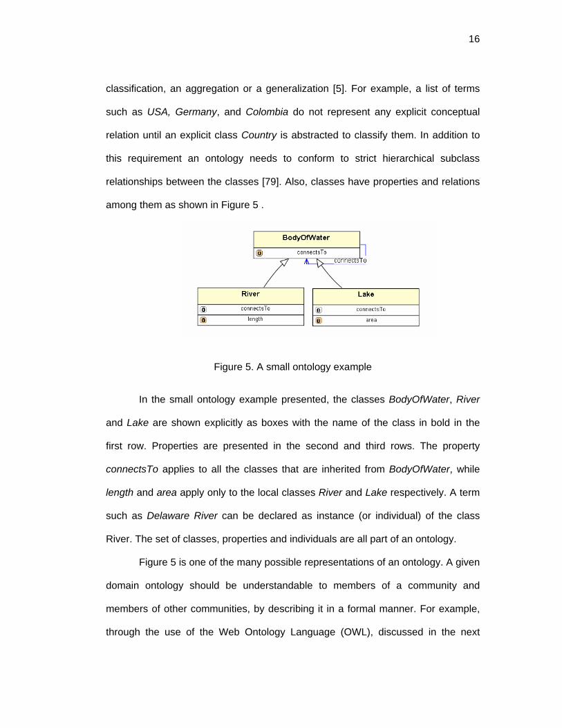
among them as shown in Figure 5 .
Figure 5. A small ontology example
In the small ontology example presented, the classes BodyOfWater, River
and Lake are shown explicitly as boxes with the name of the class in bold in the
first row. Properties are presented in the second and third rows. The property
connectsTo applies to all the classes that are inherited from BodyOfWater, while
length and area apply only to the local classes River and Lake respectively. A term
such as Delaware River can be declared as instance (or individual) of the class
River. The set of classes, properties and individuals are all part of an ontology.
Figure 5 is one of the many possible representations of an ontology. A given
domain ontology should be understandable to members of a community and
members of other communities, by describing it in a formal manner. For example,
through the use of the Web Ontology Language (OWL), discussed in the next

17
section. OWL provides the mechanism to create the necessary classes and
properties in a similar way as object models. Also OWL supports logical statements
like inverse, transitive, symmetric and functional relations, that allows richer
semantic declarations for creating control vocabulary used in metadata schemas.
2.2 Web Ontology Language
The Web Ontology Language (OWL) was selected as the vehicle to express
metadata specifications because: it is a language that it is supported by the World
Wide Web Consortium, W3C; it has object oriented features; it is based on a
flexible graph model composed of Resource Description Framework (RDF) triples;
it can be serialized in XML; and tools to interact with this language (e.g. Protégé
[116]) are freely available.
OWL has components of traditional knowledge representation languages,
which can be roughly classified into logical languages, frame-based languages and
graph-based languages [3]. The distinction among these three can be
characterized by differences in main “symbols” used to represent the knowledge.
Logical languages use logical statements, such as KIF [39]. Frame-based
languages use frames to represent concepts (classes), which contain slots or
properties [123], such as FRL [105] and they are closely related to object-oriented
languages [3, 68]. And graph-based languages use nodes and links, such as
Sowa’s Conceptual Graph [114] to represent knowledge. OWL can be formalized in
description logics, in an RDF graph, and in a frame-based system .
OWL is a core component of the Semantic Web [9], which is a universe of
metadata and ontologies expressed in machine-readable format along with
software tools that allow the understanding of semantic relations among

18
heterogeneous and distributed resources in the Web [25]. It is based on
technologies recommended by the World Wide Web Consortium, such as the
extensible Markup Language (XML), Resource Description Framework (RDF), and
Uniform Resource Identifier (URI). This last one allows a Web user to display a
page by clicking on a link, download a file, or to name distinctly every resource in
the Web. RDF and OWL uses the URI to link, talk about, complement, use, and
extend distributed resources.
RDF is based on statements that resemble simple language expressions.
Statements are composed of a resource (subject) with a property (predicate) and a
value (object). An example of a statement is:
“http://waterdata.usgs.gov/nwis/uv?dd_cd=01&site_no=0208758850 was created
by USGS”. While in the above statement only the subject is a URI, the other parts
of the statement can also be represented as a URI. Figure 6 shows an excerpt in
XML where the http://purl.org/dc/elements/1.1./#creator is also a URI. This
resource, abbreviated as dc:creator, is an element provided by the Dublin Core
Metadata Initiative [21] to describe resources in the Web.
Figure 6. RDF Triple in XML

19
In a similar fashion geospatial data can be described by using elements that
have an assigned URI and that are available as a Web resource. A community can
then refer to one or more metadata standards and reuse one or many vocabularies
to fit its needs. Unique identification of resources with URIs help to solve semantic
heterogeneities among information communities and facilitate Web information
systems to make inferences over the Semantic Web.
The framework presented in this thesis is fully interoperable with the
Semantic Web, due to the fact that OWL is used as the encoding language for
metadata specifications, domain vocabularies and mappings. URIs are not only
used to identify resources, but also to locate them dynamically (i.e., URL). In most
cases the components of the system are described using description logics, which
is automatically conceived when creating ontologies conforming to OWL-Light or
OWL-DL (e.i Description Logics). However, OWL-FULL, the third version of OWL is
used in some cases when datatypes need to be restricted to a control vocabulary.
2.3 Open world and closed world assumptions
ONTOMET is built on the assumption that it is possible to reason about
individuals using their own and inherited properties. The metadata specification can
be expressed in a description logic system, such as OWL, that allows: 1) creation
of subclasses, 2) restriction of inherited properties. Creation of subclasses
guarantees that a new metadata element inherits all the properties of the super
class. And, restricting a property can help to shape a metadata specification for a
particular community, using similar “overwriting rules” found in object oriented
systems.

20
OWL-Light and OWL-DL are close to description logics behavior which
assumes a closed world and monotonicity. If expressions are written in OWL-Full,
which is close to non-monotonic logic, some care must be taken in order to reason
properly and avoid computational problems. Differences between monotonic and
non-monotonic systems are explained below.
In Monotonic logic when new statements are added to the knowledge base,
the conclusions increase monotonically as the knowledge base increases. It
assumes a closed world where new statements will never cause previous facts to
be falsified [122]. This is the case for first-order predicate logic and knowledge
representation frameworks such as RDF, DAML+OIL, OWL-DL and OWL-Light [3,
58].
If an open world is assumed, new information added to the system may
cause the set of conclusions to increase or to be reduced [114]; therefore, the new
set of conclusions does not experience monotonic behavior. For example, if a
descriptor keyword originally can take any string, but then is restricted to having
only ten possible keywords, the new set of conclusions is reduced to ten, and the
knowledge base after the last added statement is reduced. This indicates non-
monotonic behavior.
Non-monotonic logic is also called defeasible inference, because earlier
proofs might no longer be feasible when new information is captured. It is close to
inference of everyday life, since inference can be undone by new information. Non-
monotonic logic is better suited to represent inheritance systems [123] and is close
to UML and Object Oriented Systems [3]. When properties are restricted, similar to
21
overwriting in a non-monotonic reasoning system, the more specific definitions take
precedence over more general ones.
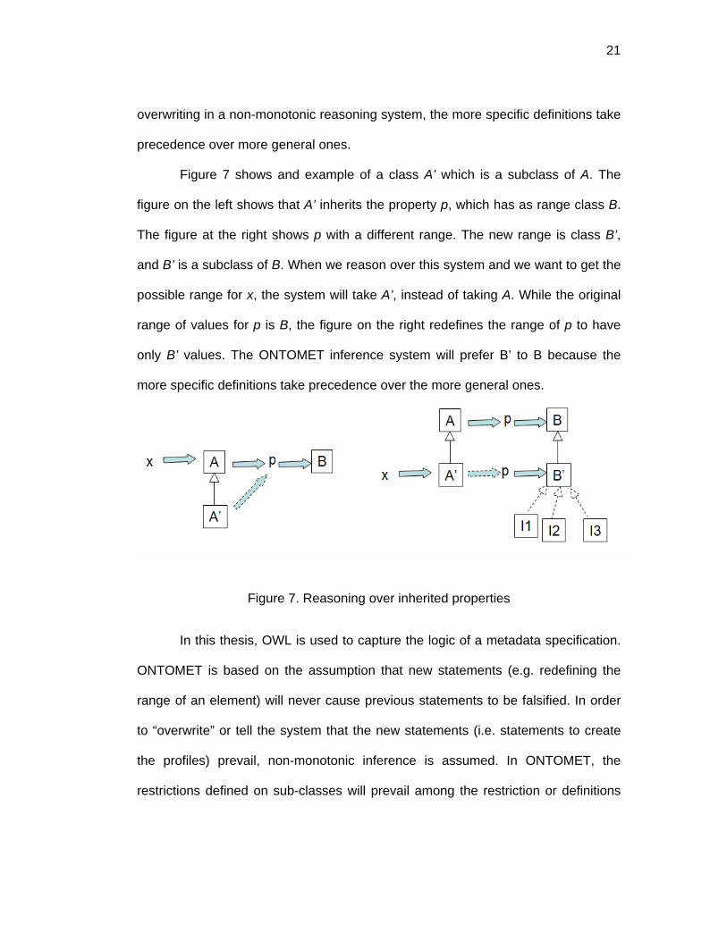
Figure 7 shows and example of a class A’ which is a subclass of A. The
figure on the left shows that A’ inherits the property p, which has as range class B.
The figure at the right shows p with a different range. The new range is class B’,
and B’ is a subclass of B. When we reason over this system and we want to get the
possible range for x, the system will take A’, instead of taking A. While the original
range of values for p is B, the figure on the right redefines the range of p to have
only B’ values. The ONTOMET inference system will prefer B’ to B because the
more specific definitions take precedence over the more general ones.
Figure 7. Reasoning over inherited properties
In this thesis, OWL is used to capture the logic of a metadata specification.
ONTOMET is based on the assumption that new statements (e.g. redefining the
range of an element) will never cause previous statements to be falsified. In order
to “overwrite” or tell the system that the new statements (i.e. statements to create
the profiles) prevail, non-monotonic inference is assumed. In ONTOMET, the
restrictions defined on sub-classes will prevail among the restriction or definitions

22
encountered in the parent class, where more specific definitions take precedence
over more general ones [123].
2.4 Machine-readable format and markup languages
A computer program can always be created to read/write information in any
predefined syntax. If the syntax gains acceptance, the same program can then be
used by several communities to read/write the information minimizing the time and
cost of developing a diversity of software. The best example is HTML, or Hypertext
Markup Language. HTML is a markup language that uses markups (“<>”) to
enclose information (e.g. <p> a paragraph </p>). Users all over the world use the
HTML syntax to publish information on the Web, and browsers like Internet
Explorer or Netscape are available to read this conventional syntax, to interpret the
tags and to take an action (e.g. present a link an image or a list).
Information encoded in markups is commonly refer as being in machine-
readable format, because markups are used by computer programs to understand
the format. In particular, machine-readable formats are associated with encoding
languages proposed by the World Wide Web Consortium (W3C). Markup
languages date from late 1960’s when the Generalized Markup Language (GML)
was developed. The evolution of markup languages since 1969 until today is
discussed in the remainder of this section.
In 1969 IBM researchers created the Generalized Markup Language (GML)
to facilitate sharing of documents. GML was used to describe the content of the
document and the formatting. In 1974, Charles Goldbar, lead researcher at IBM
and inspired by GML, created the Standard Generalized Markup Language (SGML)
that was eventually adopted in 1986 as a standard by the International Standards

23
Organization (ISO 8879:1986). SGML offered a sophisticated system to create
documents, which appear in the same way in any software application. However,
the acceptance of SGML at the time was poor, because it was too general,
overloaded with options, too complex for Web browsers to cope with and not
designed for easy implementation. Web publishing needed a simplified language,
easy to learn and use.
Tim Berners-Lee and Anders Berglund invented a tag-based language for
marking up technical documents that can be shared over the Internet among a
group of scientists in the European Organization for Nuclear Research (CERN).
This language was then defined using SGML and was called Hyper Text Mark-up
Language (HTML), which is the primary language for rendering Web documents
today. HTML is a simple SGML type of document, with a fixed set of tags and used
primarily for defining the appearance of documents in Web browsers. In the early
days of the Web, HTML was a well suited language; however, Web advancements
(e.g. tables, multimedia, special formats) created problems so new versions of
HTML appeared. Web browsers were not always able to comply with the new
versions of HTML and differences and incompatibilities started to appear in the
Web. This happened mainly because HTML is not extensible; in contrast its parent
SGML is fully extensible.
In 1996 the eXtensible Markup Language (XML) was proposed as an
extension of SGML, enabling Web authors to fully customize their documents and
enable consistent exchange of documents through the Web. XML allows
information to be self-describing to the computer and easily shared [60]. The three
main advantages of XML are: independence of content and presentation,

24
extensibility and validation. XML has been a recommendation of the World Wide
Web Consortium (W3C, 2002) since February 1998, and since then it has been
utilized to write existing metadata and other markup languages such as the Earth
Science Markup Language (ESML, 2002), Geography Markup Language (GML.
2002) and Ecological Metadata Language (EML). Also, XML is used for encoding
metadata, conceptual models and ontologies.
XML solved the syntax problem, and provided an extended platform to
create other languages. However, XML schemas by themselves are not capable of
expressing semantics [56]. The Resource Description Framework (RDF), then
emerged to express semantics, i.e. the creation of classes and properties.
Programs that rely on RDF are able to understand the tagged elements and their
relations. For example, knowing that an XML element is a type of a class and that it
can have properties. However, RDF does not allows restriction of inherited
properties and XML datatypes are not supported. The Web Ontology Language
(OWL), built on top of RDF and with XML serialization capabilities, tackles the flaws
in RDF. Hence, the decision in this thesis was to use OWL as an encoded
language that allows semantics restriction and XML types to be expressed in
machine-readable format.
This chapter discussed the concept of ontologies, OWL, open and closed
world assumptions, and machine readable format. Ontologies which are
specification of conceptualizations are formalized in the Ontology Web Language
(OWL). OWL provides machine readability to ontologies, and extension capabilities
that allow creation of metadata profiles, by “overriding” inherited properties.

25
CHAPTER 3: ONTOMET OVERVIEW
The Ontology-Metadata framework (hereafter ONTOMET) is presented in
Figure 8. The boxes are the different components of the system and the relations
are presented with arrows. It depicts six different components, all of which can be
formalized as an OWL ontology. A metadata specification, a domain vocabulary
and a top-domain ontology are independent components and can reside in different
information systems. A metadata specification can either be a metadata standard
(e.g. FGDC or ISO ) or a Dynamic Community Profile. A Dynamic Community
Profile is a metadata specification that extends one or more metadata
specifications and infers domain vocabularies that are used as controlled terms
when annotating metadata. An example of a Dynamic Community Profile for
CUAHSI is presented in Chapter 12. The CUAHSI profile is created by extending
ISO and inferring terms from two domain vocabularies: a measurement units
ontology and a science keywords ontology.
Metadata crosswalk, Dynamic Community Profile and Vocabulary Mapper,
are dependent components of the independent components. A metadata crosswalk
is a formalization of semantic mappings among two metadata specifications. In this
thesis two possible ways to formalize a mapping are presented. One using
equivalence of similar metadata tree-paths (see section 7.3) and simple mappings
using OWL semantics (see Chapter 13).

26
Figure 8. ONTOMET – Ontology Metadata Framework
Domain vocabularies can be merged in a top-domain ontology. This thesis
presents an example of an upper hydrologic ontology (Chapter 10), where general
concepts, such as measurements, observations and instruments are defined and
related to help categorize hydrologic terms. Domain vocabularies are integrated to
the top-domain ontology by stating that a term is a member of a concept defined in
the top-domain ontology. For example, river is a member (or individual) of water-
body, where waterbody is a class in the upper hydrologic ontology.
A main characteristic of ONTOMET is the independence of the components,
an important feature in modern software system architectures [34]. A Dynamic
Community Profile uses independent metadata specifications and independent
domain vocabularies.

27
The methodology to create Dynamic Community Profiles overcome the
difficulties of classical metadata profile approaches expressed in UML and XML
schemas, which are not flexible enough to accept, discard or redefine a metadata
element as well as allowing easy integration of domain vocabularies. The
advantage of the methodology is that it does not require duplication of
specifications. Each element in the metadata specification and each term from the
domain vocabularies, are uniquely identified using URIs.
Dynamic Community Profiles methodology make use of object-oriented
features such as inheritance to link community profiles with the metadata
specification being extended. It uses the idea of controlling inheritance in non-
monotonic reasoning systems, where the more specific definitions take precedence
over more general ones [123].
Dynamic Community Profiles methodology make use of inferences
calculated at run time dynamically. For example, keywords such as aquifers,
dispersion, water table, can be instances of a more generic concept called “Ground
Water Terms”. A logical statement can then be written saying that an element X
uses all values from “Ground Water Terms”. At run time, programs can infer all the
values for “Ground Water Terms”, and can then validate an instance or present a
dropdown box for a user to input a valid annotation for a particular element. These
inference capabilities are characteristics presented in logical knowledge based
systems, and are not directly available in UML and XML schemas.
To test the framework, a suite of tools called Pangloss and Web
applications were built to interoperate in the Semantic Web. Pangloss creates a run
time tree with inferred vocabularies that allow creation/edition of metadata

28
instances based on the Dynamic Community Profile Methodology. Also with
Pangloss explicit semantic mappings of two metadata specifications can be
created. An interoperability test was coded to show all the components of the
system and to present guidelines for a complete implementation.
This chapter presented an overview of ONTOMET, which is a framework
that facilitates creation of Dynamic Community Profiles. ONTOMET allows more
than one metadata specification to coexist and to be linked together via inheritance
and formalized metadata crosswalks. Also, domain vocabularies can be inferred to
provide control annotations of metadata elements and are inked together via
mappers.

29
CHAPTER 4: TRADITIONAL APPROACHES AND COMPARISON WITH ONTOMET
4.1 Tightly and loosely coupled frameworks
The problem of metadata extensibility and crosswalks is part of a bigger
problem called information brokering [67] whose goal is to seek interoperability
among distributed and ever-expanding number of resources. A database (e.g.
Oracle, MySQL), storing information about metadata instances, is considered a
resource. If another database stores information also about metadata but the
schema is based on a different metadata specification, then there is a need for
information brokering among these two heterogeneous resources. This section
provides an overview of traditional approaches and presents the differences with
the strategy proposed in this thesis.
Systems to integrate heterogeneous information systems date back to early
1980’s (e.g. Multibase [71]). The system was referred to as federated databases
[54, 74, 112], which are also known as heterogeneous databases [107] and multi-
database systems [13]. Federated databases are composed of autonomous,
distributed and heterogeneous databases operating together. The first systems
were tightly coupled, where a central systems administrator hardwired the
mappings from a general schema to other local schemas, resolving the conflicts
before they can occur (e.g. before a user queried the system).
The problem of integrating databases evolved to the need of interoperating
different information systems because of the proliferation of multimedia data (e.g.
images) and different database types (e.g. object-oriented vs. relational) [67]. This
created loosely coupled architectures, e.g. MRDSM [73], which are based on the

30
premise that it is infeasible to maintain mappings from general to local schemas
permanently, due to changes in locals schemas or the addition of new components
to the federation. The heterogeneities in loosely coupled systems are resolved by
independent modules whose messages pass through the systems via common
interfaces. Widerhold [133] defines special modules, called mediators, that create
information from encoded knowledge about sets or subsets of data that can be
understood by higher level applications. Mediators, also called wrappers, extract
data from data sets reformulating queries and can perform transformations such as
those required by dates and units. They are independent from the implementation
algorithm and from the different components in the federation.
Tightly coupled and loosely coupled strategies have provided integration
with non-intrusive strategies but fail in the ability to scale when a large number of
components are added to the system [67]. The complexity emerges due to the
need for maintaining the federation updates when changes occur and when new
components are added. Tightly coupled systems require a central administrator to
maintain a set of functions to perform transformations from one system to another,
while the loosely coupled systems, being less complex than the first one, delegates
the burden to local administrators. In both cases the semantic conflicts are never
resolved in an explicit fashion and are hard-coded in the conversion functions [43],
worsening the problem.
This thesis presents an approach using explicit resolution of some conflicts
before they can occur, similar to tightly coupled strategies. For this purpose,
description logics and ontologies are used, based on the Web Ontology Language
(OWL), instead of functions. Wrappers act on the ontologies to resolve implicit

31
conflicts due to the inference capabilities and the allowed logical expressions in
OWL. The Dynamic Community Profiles methodology make use of object-oriented
features, in particular inheritance and overwriting to merge metadata community
profiles with metadata standards and other specifications.
For the resolution of conflicts, this thesis is based on metadata specification
formalizations and not on the database schema, which can be different from the
original metadata specification. OWL, an RDF based language, is used to encode
metadata standards and ontologies. Tools like JENA [61], a JAVA API, presents
interfaces that allows automatic storage of RDF models into relational databases,
freeing the user of the burden to create database schemas that conform to the RDF
schema. Converting to and from XML and relational databases is discussed in [7],
and it is not the purpose of this study.
4.2 Characteristics of federated system components
Federated systems are composed of components (e.g. databases and
applications) which have three characteristics [112]: distribution, autonomy, and
heterogeneity. Distribution refers to the capability of a system to distribute data
within local or federated components. An essential characteristic of ONTOMET is
the use of Uniform Resource Identifiers (URIs) to identify and locate distributed
resources.
A system has a design, communication and execution autonomy [107].
Design autonomy refers to the ability of a component to chose its own data model,
information and implementation software. Communication autonomy refers to the
capability of a component system to decide about what other components to
communicate with, and when and what information to exchange with them. And,

32
execution autonomy refers to the ability of a component to execute requests
independently from other federated components.
The proposed framework accepts the design autonomy of each system,
meaning that any metadata specification can be used as long as it is expressed in
OWL. A Communication autonomy exists, since a component of the systems (i.e. a
Dynamic Community Profile) can explicitly state that it wants to use (extend)
another metadata specification. The declaration of such statement is formalized in
a document (XML) and not in a function of a software. The execution autonomy is
left to the wrappers that use the ontology specification to perform the different
actions (i.e. infer vocabularies, restrict a property, etc.).
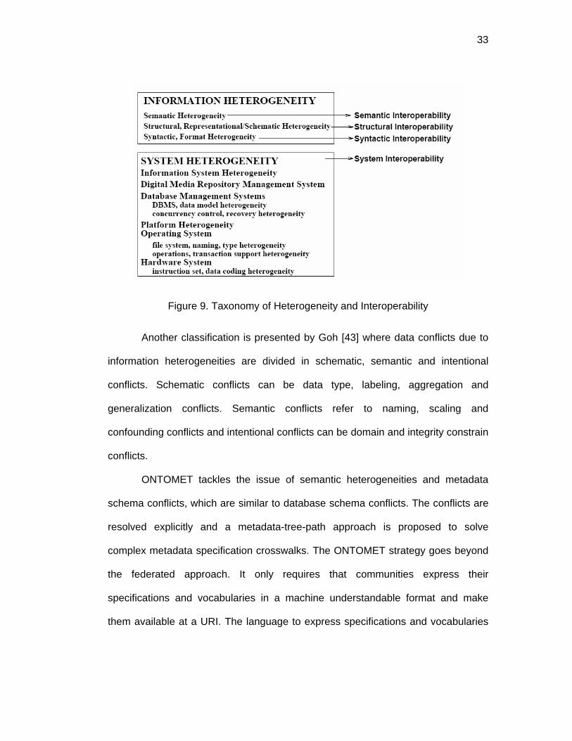
The last characteristic of federated databases is heterogeneity, which
occurs because of the design autonomy each component exhibits. Two types of
heterogeneities can be distinguished [67]: information and system heterogeneities
(See Figure 9). Information heterogeneities refer to the different ways data is
organized (structural, schema), is presented (syntax and format) and is interpreted
(semantic). And system heterogeneity refers to system components related to the
four interoperability levels [10]: Network protocols, hardware & operating systems,
spatial data files and database management systems.
33
Figure 9. Taxonomy of Heterogeneity and Interoperability
Another classification is presented by Goh [43] where data conflicts due to
information heterogeneities are divided in schematic, semantic and intentional
conflicts. Schematic conflicts can be data type, labeling, aggregation and
generalization conflicts. Semantic conflicts refer to naming, scaling and
confounding conflicts and intentional conflicts can be domain and integrity constrain
conflicts.
ONTOMET tackles the issue of semantic heterogeneities and metadata
schema conflicts, which are similar to database schema conflicts. The conflicts are
resolved explicitly and a metadata-tree-path approach is proposed to solve
complex metadata specification crosswalks. The ONTOMET strategy goes beyond
the federated approach. It only requires that communities express their
specifications and vocabularies in a machine understandable format and make
them available at a URI. The language to express specifications and vocabularies

34
should be one that is accepted world wide, such as OWL, proposed by the World
Wide Web Consortium (W3C), .
This chapter discussed the differences and similarities between ONTOMET
and traditional approaches related to information brokering. ONTOMET resolves
data conflicts before they can occur, similar to tightly coupled strategies, by
explicitly mapping vocabularies and crosswalking metadata specifications.
ONTOMET also has the three characteristics of federated data systems:
distribution, autonomy, and heterogeneity. ONTOMET can make use of distributed
data by uniquely identifying with URIs every metadata element and term in a
domain vocabulary. Each component in ONTOMET can exist by itself
autonomously and can reside in a different server. And, OWL syntax is used to
solve semantic heterogeneities among vocabularies and formalized crosswalks are
used to map metadata specifications.

35
CHAPTER 5: METADATA SPECIFICATIONS AND ENCODINGS
5.1 Metadata definition
Metadata is data about data, “information that makes data useful” [46] .
What makes data perceived as metadata is the purpose and the usage given to
such data, rather than its content and structure [60]. Metadata purposes vary from
organization to organization, and each one of them categorizes metadata in
different ways. Indeed, a metadata element can play one or many roles. For
example, the geographical coordinates of a dataset can be employed either to
discover or to use a dataset. Table 2 presents a comparison of metadata
categorization for three geoscience initiatives. The first column presents the
purpose of the metadata as seen from a user’s point of view, and the other three
columns present categorizations given by the Geochemical Earth Reference Model
[40], the National Virtual Ocean Data System [90] and the Earth Science Markup
Language [28]. Geographic Metadata such as ISO and FGDC are used mostly to
discover and evaluate geographical data so they can be categorized as cataloging,
semantic or content metadata.
Table 2. Metadata classification
User role / Initiative GERM NVODS ESML Discover Cataloging
Application Semantic Content
Evaluate Application Semantic Content Access Application Semantic Content Use Application Semantic
Syntactic Structural Semantic

36
5.2 Metadata specification
A metadata specification is a set of statements that help domain experts to
formally express the rules of usage for metadata elements. Based on St.Pierre &
LaPlant [115], in a metadata specification the following is declared and defined:
1. Declaration of an element by providing a unique identifier.
2. Declaration of a human readable label or labels in different languages.
3. Classification of an element by defining that it is a type of element category
(e.g. entities in ISO), or in the case of DCMI, stating that it is a refined
property (e.g. Has Format is sub property of relation.)
4. Definition of the range of an element or type of data allowed for the element.
For example: string, integer, codelists or type of resource.
5. Definition for the length of characters allowed in the annotation.
6. Definition of the obligation, stating whether is mandatory, optional or
conditional.
7. Definition of the occurrence: referring to the number of the times this element
can appear. This is sometime refer to as cardinality. Cardinalities can be
defined as minimum, maximum or with a given value.
8. Declaration of a definition.
9. Declaration of comments. This can include examples and best practices.
Using the RDF data model, a metadata specification statement can be
formalized as a Subject - Predicate - Object (also known as resource-property-
value triple). An example of a statement is: “abstract is a datatype property”. Figure
10 shows a formal graph, using OWL semantics.

37
Figure 10 RDF Graph
An XML script to encode the previous triple (assuming that owl and
namespaces are defined) is :
<owl:DatatypeProperty rdf:ID="abstract"/>
Using OWL it is possible to declare metadata elements as shown in Figure
10. Chapter 8 discusses the formalization of ISO and FGDC in OWL in more detail.
5.3 Related metadata specifications to hydrology
5.3.1 ISO 19115:2003
The International Organization for Standardization (ISO) is a non–
governmental organization composed of a network of national standards institutes
from 147 countries that coordinate and develop international standards. The
ISO/TC 211 is a technical committee within ISO that deals with geographic
information and is in charge of the ISO 19115:2003, the International Standard for
Digital Geospatial Metadata.

38
ISO 19115 is presented diagrammatically in the Unified Modeling Language
(UML), a graphical language promoted by the Object Management Group (OMG).
The ISO 19115 Metadata set is composed of (UML) packages, aggregating in each
package similar descriptors. A package is composed of entities or UML classes.
For example, one package is MD_Metadata which encompasses the metadata
entity set information.
ISO 19115 contains more than 400 elements or attributes, grouped in 95
classes, that constitute the discrete units of the metadata. Twenty two elements
composed the core set that includes 7 mandatory, 4 conditional and 11 optional
elements. These elements have a defined data type (integer, string, date, Class)
and a domain (enumeration, or specific name of a class). For example, the element
title has a data type of character String and the domain is free text while the
element date is a class whose datatype is a class and whose domain is CI_Date.
ISO 19139 is the implementation schema for ISO 19115 and as September 2004 is
in its draft version which is available at the DCIWG web site [22].
5.3.2 FGDC-STD-001-1998
In the US, The National Geospatial Data Clearinghouse was established in
1994 by Executive Order 12906. Section three of this order expressed the need for
developing a standardized documentation of data. This development is the FGDC-
STD-001-1998, which defines the Content Standard for Digital Geospatial Metadata
(CSDGM) and contains more than 200 elements.
FGDC-STD-001-1998 elements are organized into a hierarchy of compound
elements. Compound elements contain other compound elements or data
elements. A data element is the primitive unit and has a defined data type and

39
domain. The data type can be an integer, real, text, a date or time. The domain can
be a list of restricted and unrestricted values, or a free value depending on the type
(e.g. free data, free integer or free text).
Metadata is the top level compound element and is composed of the other 7
compound elements. The core set of FGDC-STD-001-1998 is composed of twelve
elements form the two top mandatory elements: Identification_Information and
Metadata_Reference_Information.
5.3.3 Dublin Core
The Dublin Core Metadata Initiative [21] publishes metadata elements for
the description of resources. In 2002 it had 15 standard optional elements and by
2003 it had added more than 30 additional elements and qualifiers. The elements
are presented in an XML Schema and in an RDF schema available at
http://dublincore.org/documents/2002/05/15/dcq-rdf-xml/#DCQS. DCMI defines
properties but does not define the ranges and elements of these properties, thus
provides great flexibility for its use. There are some defined classes to help identify
schemas that maybe used in the description. For example, the subject schemes
supported by DCMI are: LCSH, Mesh, DDC, LCC, UDC .
The success of Dublin Core is its simplicity of 15 non-mandatory elements
and its additional small set of qualified elements. Dublin Core properties and RDF
properties are linked by inheritance, using the rdf:subproperty relationship.
5.3.4 Directory Interchange Format
The Directory Interchange Format, DIF [84], is a collection of fields that
store information about data. It was a consequence of the Earth Science and
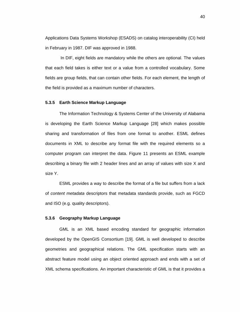
40
Applications Data Systems Workshop (ESADS) on catalog interoperability (CI) held
in February in 1987. DIF was approved in 1988.
In DIF, eight fields are mandatory while the others are optional. The values
that each field takes is either text or a value from a controlled vocabulary. Some
fields are group fields, that can contain other fields. For each element, the length of
the field is provided as a maximum number of characters.
5.3.5 Earth Science Markup Language
The Information Technology & Systems Center of the University of Alabama
is developing the Earth Science Markup Language [28] which makes possible
sharing and transformation of files from one format to another. ESML defines
documents in XML to describe any format file with the required elements so a
computer program can interpret the data. Figure 11 presents an ESML example
describing a binary file with 2 header lines and an array of values with size X and
size Y.
ESML provides a way to describe the format of a file but suffers from a lack
of content metadata descriptors that metadata standards provide, such as FGCD
and ISO (e.g. quality descriptors).
5.3.6 Geography Markup Language
GML is an XML based encoding standard for geographic information
developed by the OpenGIS Consortium [19]. GML is well developed to describe
geometries and geographical relations. The GML specification starts with an
abstract feature model using an object oriented approach and ends with a set of
XML schema specifications. An important characteristic of GML is that it provides a

41
set of XML schemas that may be used to construct an application schema. The
application schema declares the feature and property types of interest of a
particular domain. GML is also known as ISO 19136.
<a:ESML xmlns:a="ESML" xmlns:xsi="http://www.w3.org/2001/XMLSchema-instance" xsi:schemaLocation="ESMLR:\Schema\ESML.xsd"> <SyntacticMetaData> <Binary> <Structure instances="1"> <Header type="Int32" name="sizeX" symbol="true"/> <Header type="Int32" name="sizeY" symbol="true"/> <Array occurs="$sizeX"> <Array occurs="$sizeY"> <Field name="BrightnessTemp" type="Int32" order="LittleEndian"/> </Array> </Array> </Structure> </Binary> </SyntacticMetaData> </a:ESML>
Figure 11. Example of an ESML file
5.3.7 Ecological Metadata Language
EML [24] is an open source project that provides a metadata specification,
based on XML schemas, to guide the documentation and sharing of ecological
data. It uses similar metadata elements found in other standards, such as ISO,
FGDC, DCMI, the biological profile of the Content Standard for Digital Geospatial
Metadata, the OpenGIS Consortium's Geography Markup Language (GML), the
Scientific, Technical, and Medical Markup Language (STMML), and the Extensible
Scientific Interchange Language (XSIL).
EML differentiates four type of resources: dataset, literature, protocol and
software resources. EML resources provide the general descriptors of all the
resources (e.g. creator and title), and each resource has its own special descriptor
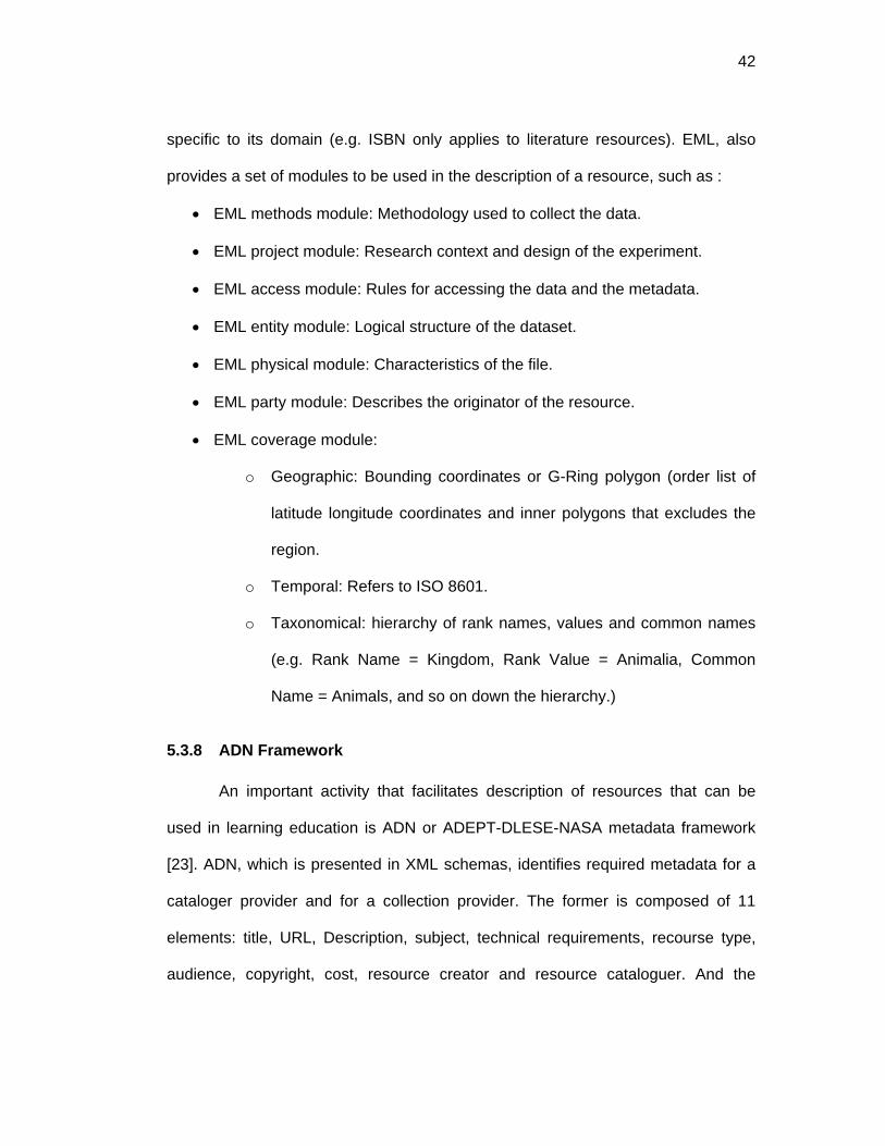
42
specific to its domain (e.g. ISBN only applies to literature resources). EML, also
provides a set of modules to be used in the description of a resource, such as :
• EML methods module: Methodology used to collect the data.
• EML project module: Research context and design of the experiment.
• EML access module: Rules for accessing the data and the metadata.
• EML entity module: Logical structure of the dataset.
• EML physical module: Characteristics of the file.
• EML party module: Describes the originator of the resource.
• EML coverage module:
o Geographic: Bounding coordinates or G-Ring polygon (order list of
latitude longitude coordinates and inner polygons that excludes the
region.
o Temporal: Refers to ISO 8601.
o Taxonomical: hierarchy of rank names, values and common names
(e.g. Rank Name = Kingdom, Rank Value = Animalia, Common
Name = Animals, and so on down the hierarchy.)
5.3.8 ADN Framework
An important activity that facilitates description of resources that can be
used in learning education is ADN or ADEPT-DLESE-NASA metadata framework
[23]. ADN, which is presented in XML schemas, identifies required metadata for a
cataloger provider and for a collection provider. The former is composed of 11
elements: title, URL, Description, subject, technical requirements, recourse type,
audience, copyright, cost, resource creator and resource cataloguer. And the

43
required metadata for a collection builder provider is: language of the resource,
language of the metadata, copyright of the metadata, terms of use, metadata
framework, creation date, accession date, catalog name and number and record
status. All the other metadata elements are define as robust metadata, which
includes coverage, science standards, geography standards, relationship between
resources, keywords, etc.
5.3.9 ANZLIC
The Australian Spatial Data Infrastructure (ASDI) is a framework that
supports the usage of spatial information linking users and data providers of spatial
information. One of its objectives is to provide spatial metadata and standards.
ANZLIC is the geographic metadata standard for New Zealand and Australia. It
presents an annex with mappings to ISO-19115 metadata.
5.4 Metadata specifications formalizations
This section presents the most common formalizations for the metadata
specifications previously described and discusses some differences among these
formalizations. The possible formalizations of metadata specifications, as well as
their strengths and weaknesses are as follows:
• ASCII text: Lacks machine readability.
• DTD Document Type Definition [11]: Defines legal building blocks of XML
documents. Lacks of support for both cardinality and datatypes.
• XSD (XML Schemas [30]): Has the function of a DTDs and provides support
for cardinality and datatypes. URI uniqueness is not guaranteed due to name
conflicts in global and local elements.

44
• UML Unified Modeling Language [96]: A language to create conceptual
models. Allows to create classes, attributes and associations among
classes. It is not directly expressed in machine-readable format; however
programs to edit UML, can export the model to XML Metadata Interchange
Format or XMI [97]. XMI is a special XML schema that allows expression of
UML models. UML has also limitations on the extensibility and using URIs, to
identify uniquely distributed resources is not supported.
• RDFS Resource Description Framework Schemas [12]: Allows expression of
semantics like class and properties, and can be serialized in XML.
Cardinalities and property restrictions are not supported. URI uniqueness is
guaranteed.
• OWL Web Ontology Language [6]: Built on top of RDF, supports restrictions,
cardinalities and XML datatypes.
Table 3 shows formalizations for different types of metadata specifications
related to digital libraries and geospatial data. It is important to notice that any
specification can be presented in different ways. For example, FGDC is presented
in text, DTD, XSD and OWL.
A metadata specification can be presented either in a informal or in a formal
manner. An informal approach is one that specifies a metadata specification in
plain ASCII text. A formal approach, on the other hand, is one that expresses a
metadata specification as a conceptual model in terms of classes and properties, or
as an application schema. The two most common conceptual model
representations are UML and XMI. A metadata specification can also be expressed
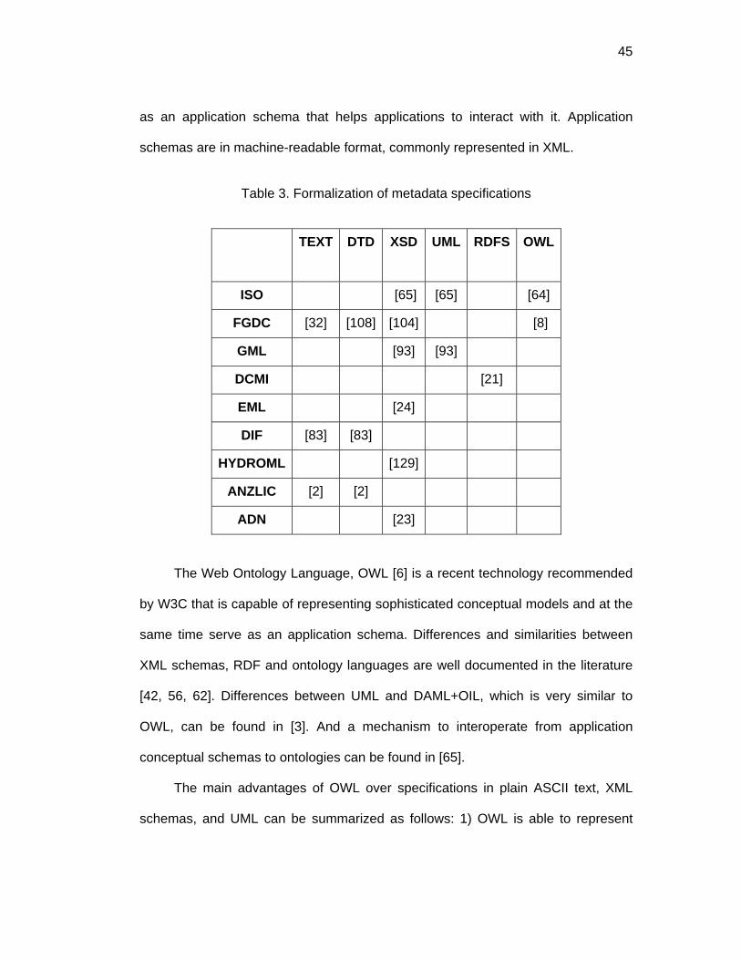
45
as an application schema that helps applications to interact with it. Application
schemas are in machine-readable format, commonly represented in XML.
Table 3. Formalization of metadata specifications
TEXT DTD XSD UML RDFS OWL
ISO [65] [65] [64]
FGDC [32] [108] [104] [8]
GML [93] [93]
DCMI [21]
EML [24]
DIF [83] [83]
HYDROML [129]
ANZLIC [2] [2]
ADN [23]
The Web Ontology Language, OWL [6] is a recent technology recommended
by W3C that is capable of representing sophisticated conceptual models and at the
same time serve as an application schema. Differences and similarities between
XML schemas, RDF and ontology languages are well documented in the literature
[42, 56, 62]. Differences between UML and DAML+OIL, which is very similar to
OWL, can be found in [3]. And a mechanism to interoperate from application
conceptual schemas to ontologies can be found in [65].
The main advantages of OWL over specifications in plain ASCII text, XML
schemas, and UML can be summarized as follows: 1) OWL is able to represent
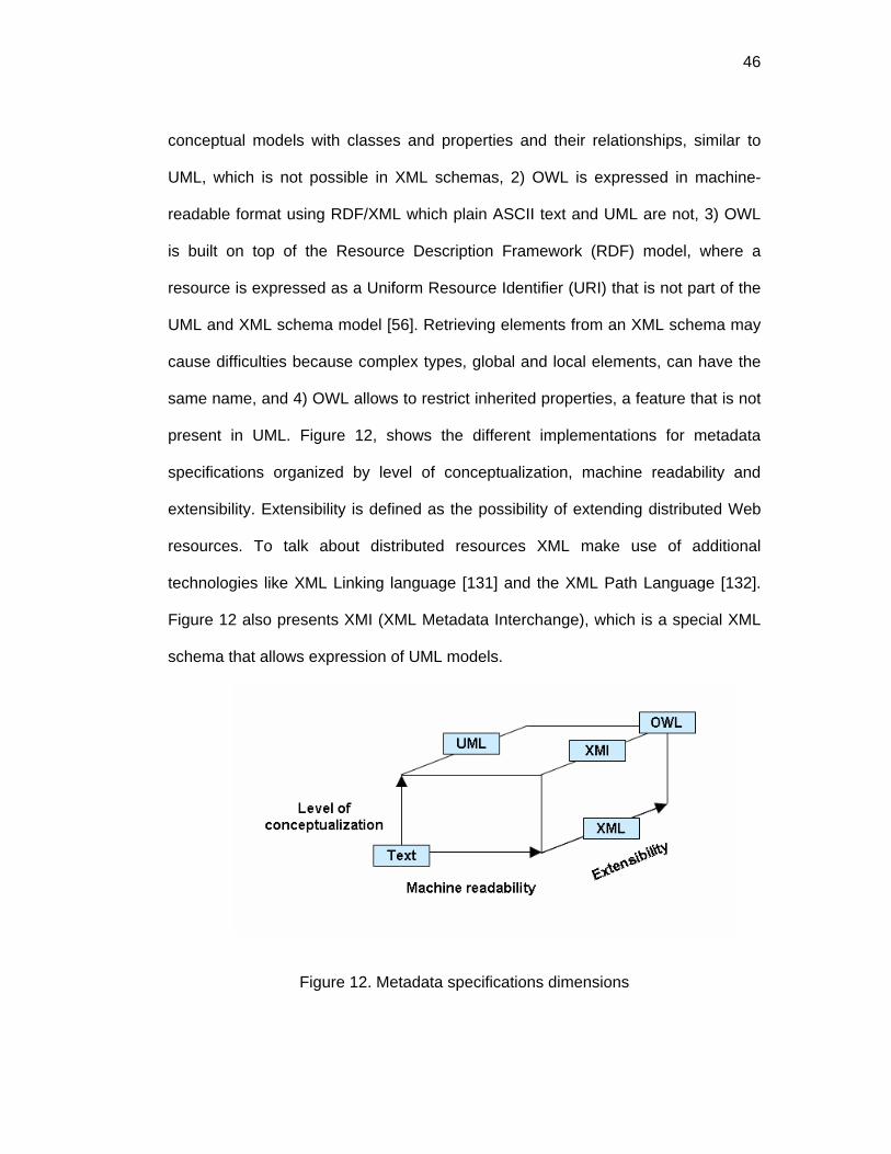
46
conceptual models with classes and properties and their relationships, similar to
UML, which is not possible in XML schemas, 2) OWL is expressed in machine-
readable format using RDF/XML which plain ASCII text and UML are not, 3) OWL
is built on top of the Resource Description Framework (RDF) model, where a
resource is expressed as a Uniform Resource Identifier (URI) that is not part of the
UML and XML schema model [56]. Retrieving elements from an XML schema may
cause difficulties because complex types, global and local elements, can have the
same name, and 4) OWL allows to restrict inherited properties, a feature that is not
present in UML. Figure 12, shows the different implementations for metadata
specifications organized by level of conceptualization, machine readability and
extensibility. Extensibility is defined as the possibility of extending distributed Web
resources. To talk about distributed resources XML make use of additional
technologies like XML Linking language [131] and the XML Path Language [132].
Figure 12 also presents XMI (XML Metadata Interchange), which is a special XML
schema that allows expression of UML models.
Figure 12. Metadata specifications dimensions

47
The advantage of UML over OWL is that UML is a mature language and has
become the standard tool to create conceptual models. However, very recently
applications have become available to create OWL ontologies like Protégé
(http://protege.stanford.edu/) and others listed in http://Web.daml.org/tools/. Also,
some research efforts are underway that focus on developing UML tools to create
ontologies [3]. To create the specifications and controlled vocabularies, Protégé in
combination with the plug-in tool ezOWL (http://iWeb.etri.re.kr/ezowl/index.html),
that allows the visualization of models is used. To create the community profiles
two tools were used. Protégé to create simple restrictions and Pangloss to create
more sophisticated statements, such as the core paths.
This chapter defines a metadata specification and presents a survey of
metadata specifications related to hydrology. It also, presents the strengths and
weaknesses of the different types of encodings for metadata specifications.

48
CHAPTER 6: DYNAMIC COMMUNITY PROFILES
6.1 Definition
A Dynamic Community Profile is a metadata specification, formalized in a
machine-readable format, in which configurable extension declarations are allowed
to meet the needs of a particular community. The following extension declarations
are allowed in a profile:
• Accept an element (set as core).
• Discard an element (set as not core).
• Set an element as mandatory.
• Set an element as optional.
• Set to allow multiple values.
• Set to not allow multiple values.
• Change the range of possible values .
• Add a new element.
• Change the name or label and the description.
• Set the length of the field.
A Dynamic Community Profile is a metadata specification that extends one
or more metadata specifications and infers domain vocabularies that are used as
controlled terms when annotating metadata. A conceptual view of a Dynamic
Community Profile is depicted in Figure 13. It is composed of an extended
metadata specification, a domain vocabulary and tree-paths, which is further
explain in chapter 6.2. This can be thought of a framework consisting of three
different ontologies, each of them residing in a different file. By using tree-paths it is
possible to uniquely identify repeated metadata elements in a metadata
specification. More about the tree-paths is discussed in chapter 6.2.

49
A metadata specification uses a domain vocabulary (e.g. code list in ISO),
but an extended metadata specification can make use of a domain vocabulary (i.e.
terms that specifically pertain to a community), by using the inference capabilities
built in ontologies in OWL. The profile is dynamic because some of the extended
declarations are realized at run time. All the terms in the vocabulary might not be
known when declaring a profile. The terms are known at run time, when the
inference algorithm provides the terms inferred.
Original Metadata Specification
Domain Vocabulary
Dynamic Metadata Community Profile
Metadata Specification
TreePaths
Extended Metadata Specification
uses
1..*1..*
extends
basedOn
Figure 13. Dynamic Community Profile
The extended metadata specification must be interoperable with the original
specification that has been extended. This implies that it should be possible to find
a metadata instance created from the extended metadata, while using queries from
the original metadata specification. It may be necessary to apply some type of
query language which accepts rules to inference the instances from the profile,
such as RDQL [109]. Chapter 13 presents a test where instances from Dynamic

50
Community Profiles are interoperable with the original specification. It also shows
examples of RDQL statements in the context of metadata specifications.
Before going into the detail explanation of the methodology to create
Dynamic Community Profiles, an abstract model for metadata specifications is
presented in the following section.
6.2 Abstract model for metadata specifications
To refer to metadata items used in any metadata specification, the term
metadata descriptor will be used in this chapter to avoid conflicts between the
terminology used by different specifications. A metadata descriptor is a metadata
element when we refer to FGDC, entity or element when we refer to ISO, class or
attribute (or association) when we refer to UML metadata models, a property when
we refer to DCMI and fields when we refer to DIF.
Based on similarities of metadata model specifications and the definition
discussed in 5.2 an abstract model is presented in Figure 14. A metadata
specification has a root which is a ComplexDescriptor, which is a type of
Descriptor. A Descriptor has the following properties: label, definition, isMandatory,
and isRepeatable. A descriptor can be a ComplexDescriptor or a SimpleDescriptor.
A ComplexDescriptor contains one or more Descriptors, that can either be
ComplexDescriptors or SimpleDescriptors. A SimpleDescriptor, is one that does not
contains other descriptors and has a range of values, specified by a datatype or a
controlled vocabulary.

51
SimpleType ListofValues
Datatype
SimpleDescriptor
range
Root
Metadata Specification
hasA
ComplexDescriptor
Descriptorlabel : Stringdefinition : StringisMandatory : BooleanisRepeatable : Boolean
1..*
contains
1..*
Figure 14. Abstract Model for Metadata Specifications
A metadata descriptor can be identified as a sequence of labels, starting
from the root label. Every metadata specification has a root descriptor. Root
descriptors for ISO, FGDC, DCMI and DIF are MD_Metadata, Metadata, DC and
DIF respectively. A root is a ComplexDescriptor, which can contain other
descriptors, until it reaches a SimpleDescriptor. Table 4 presents examples of how
the “publishing date” descriptor is depicted in different specifications.
The ISO 19115:2003 metadata specification uses the format presented in
Table 4, when referring to core elements (see table 3 of ISO specification). The
symbol “>” denotes relation to other classes, while the “.” denotes a class-attribute
relation. This wording format describes exactly a particular descriptor and its
position in the specification. In the case for ISO, this is very important because
some descriptors can be use in several parts of the specification. For example,
CI_Citation is used in MD_Keywords.thesaurusName. CI_Citation and in
MD_DataIdentification. citation.CI_Citation.

52
Table 4. Metadata descriptors sequence.
ISO (MD_Metadata > MD_DataIdentification.citation > CI_Citation.date)
DCMI DC.date
FGDC Identification-Information_Citation_Citation-Information_Publication-Date
(implicit root = Metadata)
DIF DIF
Data_Set_Citation
Dataset_Release_Date
The encoding of DCMI shown in Table 4 is used when annotating metadata
in HTML pages. FGDC elements are depicted in the hierarchical form shown in
Table 4 when encoded in Metadata Interchange Format [55] in:
http://cuahsi.sdsc.edu/html_source/ metadata_resources.html. And DIF can be
presented as in Table 4, by creating an implicit root name DIF.
The previous examples have a hierarchical tree-like data structure. A tree
has a root, or parent node. A root has children. A child can be a branch or a leaf.
Branches are ComplexDescriptors and the leaves are SimpleDescriptors. Following
the pattern: Root.ComplexDescriptor … ComplexDescriptor.SimpleDescriptor
it is possible to declare a tree-path identifying unambiguously each element in a
metadata specification.
Table 5 shows the examples of Table 4 with the new pattern. For ISO, the
association between classes (e.g. identificationInfo) is shown as a

53
ComplexDescriptor. For FGDC the Metadata root was made explicit. And in the
case of DIF the representation structure was collapsed in one line.
Table 5. Identification of metadata descriptors by a tree structure
ISO MD_Metadata>MD_DataIdentification.citation >CI_Citation.date MD_Metadata.identificationInfo.MD_DataIdentification. citation.CI_Citation.date
DCMI DC.date DC.date
FGDC Identification-Information_Citation_Citation-Information_Publication-Date Metadata.Identification_Information.Citation. Citation_Information.Publication_Date
DIF DIF Data_Set_Citation Dataset_Release_Date DIF.Data_Set_Citation.Dataset_Release_Date
An example of the tree components for ISO, FGDC, DC and DIF are
presented in the next 4 figures.

54
Figure 15. Identification of metadata abstract model components in ISO
Figure 16. Identification of metadata abstract model components in FGDC

55
Figure 17. Identification of metadata abstract model components in DC
Figure 18. Identification of metadata abstract model components in DIF

56
A core metadata path can be declared using the tree-path to mark a specific
element in a particular hierarchical context. A particular tree-path starts with the
root and traverses the tree using a top-bottom approach (parent-child relationship)
until it reaches the tail of that particular path. Sometimes it happens that a leaf of a
tree is a ComplexDescriptor, as it happens when ISO declares the core metadata.
It is suggested that the leaf of the tree-path should always be a SimpleDescriptor,
which in the case of ISO means that it should be an attribute (property).
A MetadataPath has a Path, which is a list of RDF resources which are the
URIs of the each descriptor in the TreePath. (See Figure 19).
Figure 19. Metadata path in XML
If metadata specifications are conceptualized in OWL, a more specific tree-
path pattern can be depicted. OWL contains Classes and properties. Properties are
either objectProperties (i.e. connects two classes) or datatypeProperties (i.e.
connects a class with a datatype value). The root of a metadata specification is
always a class, and has properties as children. Following the tree-path approach,
classes and objectProperties can then be seen as complexDescriptors, while

57
datatypeProperties can be depicted as simpleDescriptors. The TreePath pattern
can be presented in the following way:
Metadata_Root_Class.ObjectProperty.Class.Objectproperty …
Class.datatypeProperty.
A formal grammar definition of a tree is discussed in section 7.3. The next
section explains the methodology to create Dynamic Community Profiles using
OWL.
6.3 Methodology to create a dynamic metadata community profile:
This chapter presents the methodology to create a Dynamic Community
Profile. It will show all the possible extensions one by one, presenting examples
using ISO:19115-2003. For ISO the ontology used is the one created by the Drexel
Informatics for Civil Engineering (DICE) research group at Drexel University [64].
Typically, all metadata specifications provide guidelines for extending their
content and scope as is the case for the ISO-19115 (see Annex C, D and E of the
standard). ISO 19115 is presented diagrammatically using the Unified Modeling
Language (UML). The ISO 19115 Metadata set is composed of UML packages,
each of which is composed of entities (UML classes). An entity contains elements
(UML attributes), which identify the discrete units of the metadata. For example,
title, alternateTitle and date, are elements of the class CI_Citation. To clarify the
usage of terms, Table 1 presents the different terminology used by UML, ISO and
OWL. UML class is the same as ISO entity and same as an OWL class; and an
UML attribute or association, an ISO element and an OWL property refer all to the
same concept.

58
Table 6. Terminology used in OWL, UML, and ISO
UML Class Attribute or Association
ISO Entity Element
OWL Class Property
ISO declares that a community profile should consist of the core metadata
set, some optional elements, and newly defined elements. To create a community
profile the following extensions are allowed: 1) addition of a new metadata section;
2) creation of a new metadata code list to replace the domain of an existing
metadata element that has “free text” listed as its domain value; 3) creation or
expansion of a code list; 4) addition of a new metadata element to an already
existing entity 5) addition of a new metadata entity 6) imposition of a more stringent
obligation on an existing metadata element; 7) imposition of a more restrictive
domain on an existing metadata element. The methodology to create the above
extensions is discussed in detail in the following sections.
6.3.1 Importing ontologies
The first step for any extension is to import the ontologies that contain the
specifications and the vocabularies as shown in Figure 5. The owl:imports functions
as the extension mechanism and as the link to bridge specifications and
vocabularies.
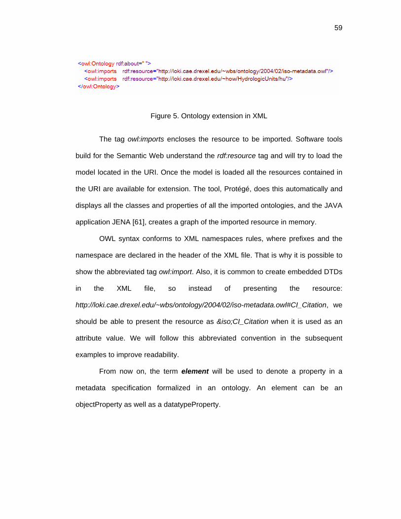
59
Figure 5. Ontology extension in XML
The tag owl:imports encloses the resource to be imported. Software tools
build for the Semantic Web understand the rdf:resource tag and will try to load the
model located in the URI. Once the model is loaded all the resources contained in
the URI are available for extension. The tool, Protégé, does this automatically and
displays all the classes and properties of all the imported ontologies, and the JAVA
application JENA [61], creates a graph of the imported resource in memory.
OWL syntax conforms to XML namespaces rules, where prefixes and the
namespace are declared in the header of the XML file. That is why it is possible to
show the abbreviated tag owl:import. Also, it is common to create embedded DTDs
in the XML file, so instead of presenting the resource:
http://loki.cae.drexel.edu/~wbs/ontology/2004/02/iso-metadata.owl#CI_Citation, we
should be able to present the resource as &iso;CI_Citation when it is used as an
attribute value. We will follow this abbreviated convention in the subsequent
examples to improve readability.
From now on, the term element will be used to denote a property in a
metadata specification formalized in an ontology. An element can be an
objectProperty as well as a datatypeProperty.

60
6.3.2 Setting an element as core
A community determines the elements that constitute its profile by marking
elements of another specification as core. A core element can be mandatory or
optional and it should always be available when a metadata instance is going to be
created or when there is a need of semantic validation or when a metadata
repository is going to be queried.
There are three possible ways to specify (or mark) core elements: 1) setting
all the other non-core elements with cardinality equal to zero, 2) creating a flag on
the elements that must be core, and 3) using a tree-path approach.
In the first case an algorithm is used to discard elements with a zero
cardinality. The process of creating a core profile using a conceptualization tool like
OWL, that allows to create subclasses and restrict inherited properties, is as
follows:
1. Create a subclass for all the classes in the original specification.
2. Create a restriction cardinality equal to zero for all the elements.
3. When an element is marked as core, the previously created restriction
cardinality is deleted.
4. When an element is marked as not core, the class of that element is sub
classed and a property restriction is created with cardinality equal to
zero.
In the second case, creating a flag to tell a system that an element is core
can be done by creating an annotation property named “isCore”. If its value is
“true”, then it is core, otherwise if its value is “false” then the property is not core.

61
The previous two approaches (restriction cardinalities and flags), to set up
core elements will work only if elements are not reused inside the metadata
specification. For example, classes that are range of more than one property
(hereafter called multi-range-class) are consider reused elements. Figure 20,
shows a multi-range-class in ISO-19115, MD_identifier, which is a range of two
properties EX_GeographicDescription.geographicIdentifier, and CI_Citation.
identifier.
To illustrate the problem let us assume that we want to set authority in
MD_Identifier as core, but only when it is used in the context of
EX_GeographicDescription.geographicIndetifier. Using the cardinality restriction or
flag, MD_Identifier.authority can be declared as a core element. However, both
EX_GeographicDescription.geographicIndetifier and CI_Citation.identifier are
affected by the declaration, and as a result MD_Identifier.authority is true in all the
context that it is used. All the ISO classes that were mapped from a UML class,
with a stereotype datatype, to an OWL class are exposed to this problem.
Figure 20. Multi-range-class

62
Because of the problem with multi-range-classes, a new methodology is
created based on the tree-path model previously explained. The proposed model
guarantees that the element being referred to is exactly an element in a particular
context, and not the element in all the contexts of the specification. The metadata-
tree-path for MD_Identifier.authority in the context of EX_GeographicDescription is
as follows:
MD_Metadata . identificationInfo . MD_DataIdentification . Extent .
EX_Extent. geographicElement . EX_GeographicDescription .
geographicIdentifier . MD_Identifier . authority
6.3.3 Unsetting an element as core
An element in the specification is not core by default. However if a previous
element was set as core, it should have a metadata-tree-path declared as core. To
unset a path previously set as core, the path can be declared un-core, or simply
deleted.
6.3.4 Setting as mandatory
Setting an element as mandatory means that when its parent is used, this
element should be annotated. When a specification is presented in a conceptual
way, properties have associated cardinalities related to a particular class. For
example, Citation is a class that has a property title. Title has cardinality one, which
means that Citation should have only one title.
Setting an element as mandatory in OWL is done by setting the cardinality
to one or more, or setting the minimum cardinality to one or more. In OWL
cardinalities can be created (or overwritten) using restrictions over properties. A
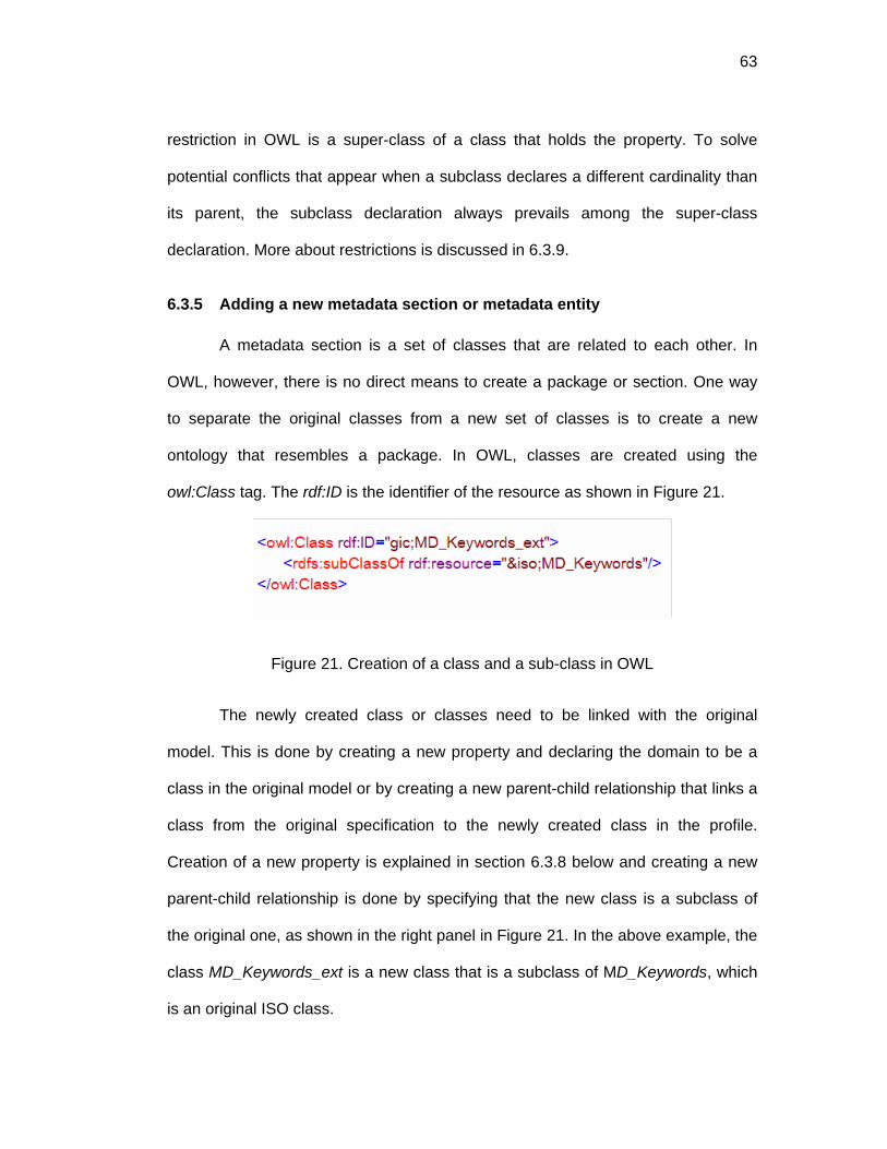
63
restriction in OWL is a super-class of a class that holds the property. To solve
potential conflicts that appear when a subclass declares a different cardinality than
its parent, the subclass declaration always prevails among the super-class
declaration. More about restrictions is discussed in 6.3.9.
6.3.5 Adding a new metadata section or metadata entity
A metadata section is a set of classes that are related to each other. In
OWL, however, there is no direct means to create a package or section. One way
to separate the original classes from a new set of classes is to create a new
ontology that resembles a package. In OWL, classes are created using the
owl:Class tag. The rdf:ID is the identifier of the resource as shown in Figure 21.
Figure 21. Creation of a class and a sub-class in OWL
The newly created class or classes need to be linked with the original
model. This is done by creating a new property and declaring the domain to be a
class in the original model or by creating a new parent-child relationship that links a
class from the original specification to the newly created class in the profile.
Creation of a new property is explained in section 6.3.8 below and creating a new
parent-child relationship is done by specifying that the new class is a subclass of
the original one, as shown in the right panel in Figure 21. In the above example, the
class MD_Keywords_ext is a new class that is a subclass of MD_Keywords, which
is an original ISO class.

64
6.3.6 Creating a new metadata code list
Code-lists and enumerations in ISO are defined as datatype classes whose
instances form a list of named literals that contain a set of values. In OWL this can
be represented as a class whose instances are the list of possible values. Figure
22 shows an excerpt of a list of gauge stations for the Neuse River Basin, encoded
in XML, where a new class Station and instances of those classes are created with
their respective ids and labels in English (=”en”).
Figure 22. Neuse-Station ontology
The station class in the previous ontology excerpt can be used as the range
of a property in another ontology. In Figure 23, the range of the property site refers
to all the stations located in the Neuse-station ontology in Figure 22 or simply the
instances of &neuse;Station.
Figure 23. Usage of a Code-list as a range of a property in OWL

65
6.3.7 Expanding a code list
Code-lists, as previously mentioned, are formalized in OWL as a class. To
add a new member of the class one needs to create a new instance of that class.
An ISO code-list will look similar to Figure 24.
Figure 24. ISO Code-list
After importing this ontology an instance can be created for one of the
imported classes. Figure 25 shows a new instance of the class TopicCatCd with ID
= “_020”.
Figure 25. Extending an ISO's code-list.
6.3.8 Adding a new metadata element to an existing class
A metadata element is equivalent to a property in OWL. In OWL there are
two types of properties: datatype properties (owl:datatypeProperty) and object
properties (owl:ObjectProperty). The datatype property has as its range an XML
datatype (e.g. string, integer, date and others given by the XML schema

66
specification), while an object property has as its range an owl:Class. Figure 26
shows the creation of a new property, named site, whose domain is the ISO
MD_DataIdentification class, and whose range are the instances of the class
Station as previously defined in the Neuse-Station ontology.
Figure 26. Creation of an object property in OWL
If we would like to create a property whose range is a simple data type, like
an integer, then a owl:datatypeProperty should be declared as shown in Figure 27:
Figure 27. Creation of a datatype property in OWL
6.3.9 Imposing a more stringent obligation on an element.
Restricting a metadata element can be interpreted as imposing restrictions on
a property in OWL. The restrictions that are available in OWL are: hasValue,
allValueFrom, someValuesFrom, minCardinality, maxCardinality, and cardinality.
All of these restrictions can be applied to extend properties, shaping the extended
ontology to fit specific needs of GICs.

67
A property has the following characteristics: cardinality, type, and range. In
order to change the characteristics of a property the following must be done: first,
create a subclass of the class that holds the property to be extended, and second,
create a local restriction to the extended property in the subclass.
Imposing a more stringent obligation on an existing metadata element
requires to “change” the cardinality of an element. In OWL this is done by creating
a local restriction on a property. Since it is a more stringent obligation, this means
that the cardinality before was zero and now must be one. This can be done by
stating that owl:minCardinality or owl:cardinality is equal to one. Figure 28 shows
the XML expression for the ISO element datasetURI.
Figure 28. ISO element datasetURI
If this property is to become mandatory, the following two steps must be
followed: first, create a new subclass of &iso;MD_Metadata:
&ext;MD_Metadata_ext, and second, a restriction; owl:minCardinality on the
property &iso;dataSetURI. An example is shown in Figure 29.
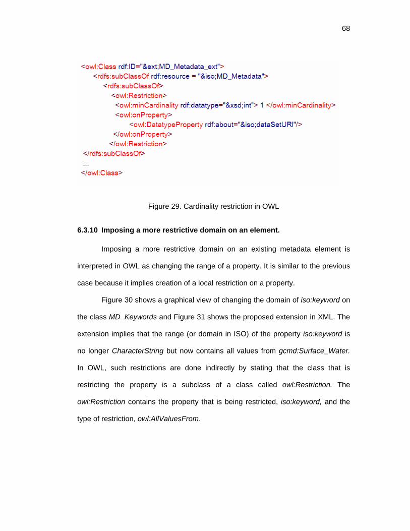
68
Figure 29. Cardinality restriction in OWL
6.3.10 Imposing a more restrictive domain on an element.
Imposing a more restrictive domain on an existing metadata element is
interpreted in OWL as changing the range of a property. It is similar to the previous
case because it implies creation of a local restriction on a property.
Figure 30 shows a graphical view of changing the domain of iso:keyword on
the class MD_Keywords and Figure 31 shows the proposed extension in XML. The
extension implies that the range (or domain in ISO) of the property iso:keyword is
no longer CharacterString but now contains all values from gcmd:Surface_Water.
In OWL, such restrictions are done indirectly by stating that the class that is
restricting the property is a subclass of a class called owl:Restriction. The
owl:Restriction contains the property that is being restricted, iso:keyword, and the
type of restriction, owl:AllValuesFrom.

69
Figure 30. Restriction iso:keyword
Figure 31. Extension of iso:keywords in XML
The owl:ValuesFrom tag is a built-in OWL property that links the restriction to
a class description or a data range. A class description is a defined class, whose
instances are all the values that the restrictions refer to. In Figure 31 this class is
gcmd:Surface_Water, which contains instances like: discharge and stage height. It
is important to note that the logical reading of the created statement is “all
individuals that have values for the property iso:keyword of type
gcmd:Surface_Water are of type gic:MD_Keywords_ext”.

70
6.3.11 Extension problems
6.3.11.1 Restricting datatype properties
OWL can be used in three different versions: OWL-Light, OWL-DL and
OWL-Full as mention before. While the OWL-Full version is the most expressive,
the other two guarantee computational completeness and decidability. The
metadata specification as well as the controlled vocabularies and the extensions
where created in OWL-DL only; however, there are some expressions where OWL-
Full is needed, as for the case presented previously in Figure 31. The figure shows
a restriction that uses allvaluesFrom. If the property to which the restriction is
applied is a datatype property and the restriction on that property is not a datatype
class, or rdfs:literal, or a oneOf, it becomes an OWL-Full expression. Since
gcmd:Surface_Water, in Figure 31 is an owl:Class and not a datatype class, or a
rdfs:literal or a oneOf, the statement is in OWL-Full.
There are two possible solutions to this problem: 1) Change the datatype
property to be an object property in the original metadata specification. This is not
feasible, since the metadata specification should be an independent Web-
accessible resource, published by an entity (e.g. ISO) that is different from the
community creating the extension. For obvious reasons the community can not be
permitted to change the original metadata specification directly, because this
specification will be used by other communities. 2) Treat the datatype property as
an object property in the extension. In this case the extension will be in OWL-Full.
Because of the concern with regard to the computational completeness and
decidability when using an ontology in OWL-Full, we tested our extension using
Pangloss, which is the suite of tools created to test the methodologies proposed in

71
this thesis. It was found that it was possible to create such expressions without
encountering any problems.
An instance can be presented in two ways as an objectProperty or as a
datatypeProperty as presented in Figure 17. Both have the same meaning in an
RDF graph; however, a computer application that reads these instances should be
able to accommodate instances in which some literal values might be a URI (e.g.
“http://foo#b1), as shown in the right panel of Figure 17.
Figure 32. Value of a property as object Property and as datatype Property
6.3.11.2 Restricting inherited properties on classes that are the range of more
than one property
On occasions the need arises to restrict a property in multi-range-class (See
Figure 20). If a multi-range-class is restricted, every time the class is being used
(e.g. range of a property) the restriction will apply. If the MD_Identifier of
geographicIdentifier is restricted to have only one possible value for its authority
property (e.g. the citation referring to GETTY, which provides a thesaurus for
geographic names), then identifier in CI_Citation will also be subject to the same
restriction. The workaround of this problem is to also create an extension on the
domain of the property that uses a multi-range class and apply the restriction to that
class. Figure 33 depicts the schematic where the class

72
ext:EX_GeographicDescription_ext, which is a subclass of
iso:EX_GeographicDescription, is subjected to a restriction with allValuesFrom
ext:MD_Identifier_ext. Using this procedure a computer program can be coded to
prefer the extended classes, from the original ones, and validate the instances,
display a user interface or query metadata instances that conform to a particular
GIC.
Figure 33. Extending a property of a multi-range-class
6.4 Related approaches to Dynamic Community Profiles
Dynamic Community Profiles are an extended notion of community profiles
[32, 65] and application profiles [4, 53]. Community profiles, provide an extension of
metadata standards to fit specific community needs, but they tend to be monolithic
(i.e. not allowing combination with other specifications).
Application profiles [53] rely on the Resource Description Framework to
reuse elements of several metadata specifications, which are identified with unique
namespaces. This approach allows to import other schemas and use elements
defined in the imported schemas. Extensions that can be performed under RDF

73
schemas include: defining of a new element and create a list of controlled
vocabulary to use as annotation of the description. A new element is defined by
creating a schema in a new namespace, and declaring RDF properties in that
schema. A controlled vocabulary for an element is defined by creating a new class
and creating instances of that class. To link the controlled vocabulary to a property,
the class is declared to be a range of that property.
Activities that use RDF schemas, normally use DCMI plus other domain
schemas that specify a set of properties and controlled vocabularies. The
Development of a European Service for Information on Research and Education
(DESIRE) allows registering and mapping of RDF schemas (and namespaces)
related to library and education information [126], and currently it has approximately
20 application profiles. Other approaches that use an extension of DCMI, but that
are not related to library and education are: HealthCybermap [66] and RDFPIC
[70]. The former is related to health metadata while the latter is related to
photographs.
RDF Schemas allow creation of classes and properties but are not
sufficiently flexible to allow expression of extensions given in geographic metadata
specifications such as ISO-19115:2003. Redefining the range of a previously
created property or changing the cardinality or obligation it is not possible when
using the vocabulary provided in the RDF schemas. One approach is to create
another schema defining new properties that are used to specify the profiles and
that allow overwriting properties. Baker et. al. [4] propose an extension mechanism
to redefine elements, defining a new property called “uses”. This property is used to
declare the profiles. Also, it is permitted to overwrite the domain, changing the label

74
and comments to attain a more comprehensive profile. Figure 34 shows a special
property sf:uses, which marks selected elements to be used in a profile. The figure
also shows a redefinition of the label and the comment of dcq:temporal element.
Figure 34. Extracted Figure 3 and 4 from [4]
The overwriting mechanism in this thesis is different from that of Baker et.
al., in that instead of declaring new semantics to overwrite characteristics of
elements, the restriction capabilities of OWL are used. Also, to specify core
elements, instead of the “uses” property of Baker, a metadata-tree-path is used, as
explained in Chapter 6.2. The metadata-tree-path model allows a more general
approach for refining metadata elements and provides a solution for the multi range
classes problem which is not possible with Baker’s strategy.
This chapter presented the methodology to create Dynamic Community
Profiles. First it discussed an abstract model, where metadata specifications can be
seen as tree-paths. Then it is explained the selection of elements from other
specifications by setting then them as core; addition of new elements; creation
and expansion of code lists; and imposition of more stringent obligations and more

75
restrictive domain on elements. It also explained extension problems and related
approaches using the Resource Description Framework.

76
CHAPTER 7: MAPPING METADATA SPECIFICATIONS
7.1 Motivation and background
Agreements in metadata specifications are necessary to achieve semantic
interoperability among communities. However, more than one metadata
specification exists and it is impossible to achieve a general consensus about the
use of one and only one specification. To minimize the time spend in maintaining
content metadata and to maximize the use among a broad range of users,
metadata in one specification must be available in other related specifications [87,
115]. Therefore, metadata crosswalks are necessary to facilitate interoperability
among communities which uses heterogeneous and related specifications.
A crosswalk is an explicit mapping of one metadata specification to another.
Creating a crosswalks is a difficult and error-prone task, which requires in-depth
knowledge and experience of the metadata specifications being mapped [115].
Developing a crosswalk between two metadata specifications requires the following
steps [87]:
1. Harmonization: The two metadata specifications are expressed in the same
format or model.
2. Semantic mapping: Elements from a metadata specification are explicitly
mapped to one or more elements of another metadata specification.
3. Additional rules: Necessary to solve complex mapping such as hierarchy
level or one-to-many mappings.
4. Mapping implementations: The process of mapping a metadata instance
from one format to another following the semantic mappings and the rules.

77
Semantic mappings are usually presented informally in HTML files (e.g.
GCMD), specifications annexes (e.g. ANZLIC) and in tables (e.g. DGIWG, [87]).
Informal mappings include mappings among labels or ids. For example, the Global
Change Master Directory (GCMD), presents conversions from the Directory
Interchange Format (DIF) in http://gcmd.gsfc.nasa.gov/Aboutus/standards/ to ISO,
FGDC, GeoConnections, Z39.50, Catalogue Interoperability Protocol (CIP),
National Biological Information Infrastructure (NBII), Dublin Core Metadata Initiative
(DCMI) and the Australia New Zealand Land Information Council (ANZLIC).
However, the trend is that geospatial metadata specifications should have
interfaces and crosswalks to ISO 19115:200, which can be discerned from
metadata and interoperability studies (e.g. [29]), and from public communications or
annexes of other publisher of standards (e.g. FGDC, ANZLIC) .
Some efforts to coordinate different metadata specifications are provided by
groups such as Digital Geographic Information Working Group [22], which offers a
crosswalk between the ISO and the FGDC standards. These crosswalks are
accepted and recommended by FGDC in their FGDC/ISO Standard Harmonization
Web site [33]. A compilation of crosswalks is presented by the Metadata
Architecture and Application Team (MAAT) in
http://www.sinica.edu.tw/~metadata/tool/mapping-foreign.html. MAAT is a group
affiliated with the National Digital Archives Program in Taiwan. Their purpose is to
support metadata implementation projects and by developing a Metadata
Framework Model. (For more references about the topic see [87]).
Formal crosswalks implementations, usually are hard coded in software
programs (e.g. [119]), or expressed in XSLT (e.g. [23, 87]). XSLT [16] is based on

78
the eXtensible Style language, which is used to create styles for XML documents
and allows formatting from one format to another. An XSLT crosswalk form DCMI
to ISO can be found in [87], and a transformation from the ADN to DCMI and vice
versa can be found in [23]. The later includes both, a transformation of the label of
the elements as well as transformations of the controlled vocabulary used. The
transformation is possible from an ADN instance in an XML document to an
instance in DC in an XML document For example:
<general><title>Hello World</title></general>
GOES TO
<dc.title>Hello World</dc.title>
AND
<educational>
<resourceType>
DLESE:Text:Reference
</resourceType>
</educational>
GOES TO
<dc.type>Text</dc.type>
The XSLT is the most sophisticated tool to transform one XML file format to
another; however, the mappings of the semantics is not clearly expressed, since
the semantics and the syntax transformation rules are both declared at the same
time. This is the reason why, semantic mappings are written in static tables (e.g.
79
[22, 87]) which only serve the purpose of guidance when an individual is creating
the XSLT.
This chapter discusses an approach to formally express semantic mappings
following a model for metadata crosswalks, based on tree-paths discussed earlier.
The model was integrated in a tool to provide a view of the semantic mappings
dynamically. Also a 1D transformation was performed from FGDC to ISO. The 1D
transformations are those where the intermediate nodes are not repeated.
7.2 Process overview
1. Harmonization: The source and target metadata specifications are both
expresses in a conceptual form in OWL. (See Chapter 8). And the model,
where the mappings take place, is a tree with special characteristics
expressed in the next section.
2. The semantic mappings are express as a MetadataMapping, where there is
a toPath and a fromPath. These to Paths are MultiMetadataPaths,
composed of one or more paths. Each path is composed of a value and a
list of resources. Mappings flags and code handler, can be used to perform
rules in complex mappings. For example, one-to-many mappings where the
syntax should be known and should have a special treatment. All the
mappings are stored in a MetadataMappingModel, as shown in Figure 35.
3. Rules: The rules should be specified in the model, to have them all
expressed in machine-readable format.
4. Transformation process algorithm is expressed in the next section.

80
The next section presents a formal definition of a tree, the components of
the metadata mapping model, and the transformation procedure.
Figure 35. Metadata Mapping Model
7.3 Metadata-Tree-Path
Metadata specification is a rooted tree. A rooted tree has the following
properties:
• It is composed of vertices (nodes) and graphs (arcs). A node can be either a
classes or a property. And an edge represents either the class-property or
property-class relationship.
• It contains only one root, which is a node and a class.
• Two vertices are connected by at most one path.

81
• It is undirected, meaning that no direction is specified.
• Has no simple cycles. Two nodes that apparently are the same, For
example, having the same URI, can be found in one branch. But they have
different node number, so they are different, not allowing cycles.
• If any edge is removed, it is not connected anymore.
• The number of edges is equal to number of nodes – 1.
A metadata tree can be seen as a set of paths. A path is defined as:
{ }mnnnp ...,, 21= , where rootn =1 and leafnm = , and m is the number of nodes
in the path. A path can have a value, which is the value of the leaf. A path with
value is defined as:
{ } valnnrootp m ,...,, 2= .
• A multipath ( *p ) is a set of one or more paths, { }npppp ,...,* 21= , where
n is the number of paths contained in the multipath.
• A metadata specification is defined as { }nSSS pppS *
2*
1* ...,,= , where n is
the number of multipaths contained in the metadata specification.
• A metadata instance is defined as { }nIII pppI *
2*
1* ...,,= , where n is the
number of multipaths contained in the metadata instance.
• I conforms to S if for all nIII ppp *
2*
1* ...,, , define in I there is a similar path
in given specification iS . This will be denoted as iSI .
• An instance path that conforms to one path in S is denoted as iSIP ⊂

82
• A mapping definition kji SSM )( → from any specification iS to any specification
jS is define as a pair of multipaths. The first one, *iSkp depicting the source
and the right one, *jSkp , denoting the target: **
)( , ji
kji
Sk
SkSS ppM =→ ,
where k is greater than zero and less than or equal to the total number of
mappings. The set of all define mappings is define as )( ji SSM → .
• A mapping function is defined as: *)(
* ),( SjIiSS
SIi
PMPMAPji
i ⊂→
⊂ = . The
mapping is performed using a specified set of mappings, )( ji SSM → , and takes
a multipath instance, *iSIi
P ⊂ , which conforms to iS and translates it to a
multipath instance *SjIi
P ⊂ which conforms of a target specification, jS . Table
7 shows different possible mappings.
Table 7. Possible Mappings
FROM \ TO ONE ONE AND ONE WITH VALUE
MANY MANY AND ONE WITH VALUE
ONE SYNTAX SYNTAX
ONE AND ONE WITH VALUE
SYNTAX SYNTAX
MANY SYNTAX SYNTAX
MANY AND ONE WITH VALUE
SYNTAX SYNTAX

83
• A ONE_TO_ONE mapping is when the source and target multipaths has one
path with no value defined. (e.g. fgdc:Metadata_date maps to iso;datestamp)
• A ONE_TO_ONE_AND ONE_WITH_VALUE, occurs when the source has
one path with no defined value and the target has one path without a value
and a path with a defined value. (See Figure 36)
Figure 36. A ONE_TO_ONE_AND ONE_WITH_VALUE mapping
The areas not shaded in Table 7 are not well-formed mappings, and can be
defined as two or more well formed mappings (shaded area). For example, many to
many mappings can be resolved with two or more ONE_TO_ONE mappings. A
mapping with the SYNTAX word, means that further knowledge of the source and

84
target syntax is necessary. For example, knowing if the values must be separated
with a comma or a tab character.
A transformation from one tree-path to another can be performed by an
algorithm that iterates over the mappings, gets the value from the source path and
copy this value in the target path. To explain the algorithm the following is
assumed:
• A source metadata specification : iS .
• A target metadata specification: jS .
• A metadata instance: iSI , which conforms to iS , the instance that contains
the source.
• A metadata instance jSI , which conforms to jS , the instance where the
values are going to be mapped to.
• Set of mappings: )( ji SSM → from Specification iS to jS . Which has a total of
mappings = totalMappings.
The main method to perform the mapping is as follows:
int k = 1; While ( k <= totalMappings ) { // get he kth mapping from mappings
kji SSM )( → = getMapping ( )( ji SSM → , k)
//Get the source multipaths *iS
kp = getSourcePaths (kji SSM )( → )
//get similar multipaths from an instance conforming to Si *iSI
kP ⊂ = getSimilarPaths ( iSI , *iSkp ),
totalPaths = getTotalPaths ( *iSIkP ⊂ )
int m = 1; while ( m <= totalPaths ) { // get path from source instance in position m

85
iSImP ⊂ = getSourcePath( mP iSI
k ,*⊂ ) // get the value in the source path
)( 11iSIpgetValuev ⊂=
If ( is_ONE_TO_ONE(kji SSM )( → )) {
// get the first path in the target )(arg *
1ij S
kS petthTgetFirstPap =
// assign value to a path x (eassignValup jSI
x =⊂ ), 11 vp jS } else
If ( is_A ONE_TO_ONE_AND ONE_WITH_VALUE(kji SSM )( → )){
// get the path target with no value )(arg *
1ij S
kS petNoValuegetPathTp =
// assign value to a path x (eassignValup jSI
x =⊂ ), 11 vp jS // add the path x to the target instance
=⊂ jSItempp add ( jSI , jSI
xp ⊂ ) // get the path with defined value and added
)(arg *2
ij Sk
S peetWithValugetPathTp =
=⊂ jSItempp add ( jSI , jSp2 )
}
} m++;
} k++
The semantic mapping can be stored in XML-RDF, following the model
presented in Figure 35. A result of a mapping from an instance in FGDC to ISO is
shown in Figure 37.

86
Figure 37. Mapping example from FGDC to ISO
The approach presented in this chapter works for 1D mappings. 1D
mappings are those where the intermediate nodes are not repeated. If they are
repeated, they need a further check in the algorithm. The processed source and
target paths need to be stored in a temporary map, and every time a repeated path
is going to be processed it will check the temporary map to find the exact node of
replication on the target instance.
This chapter presented the importance of metadata mappings, the process
of mapping metadata specifications and a formalization model based on tree-paths.
Also, it was discussed a categorization of all the possible mappings and algorithms
to perform the mappings based on the formalized model.

87
CHAPTER 8: CONCEPTUALIZATION OF METADATA SPECIFICATIONS IN OWL
At the time of writing this thesis there was no endorsement by ISO, or any
other publisher of standards, of a metadata specification formalized in OWL.
However, communications with members of the Technical Committee 211, TC211,
of ISO suggest that efforts are underway to consider an endorsement of the ISO
19115:2003 in OWL in the near future. While this may be in part due to the fact that
OWL is in its infancy (newly recommended by W3C, 10 February 2004) a mapping
of several metadata specifications created by Drexel University are available at:
http://loki.cae.drexel.edu/~wbs/ontology/list.htm. This chapter discusses some of
the strategies taken to conceptualize metadata specifications in OWL, starting from
two possible scenarios: 1) a specification conceptualized in UML and 2) a
specification not conceptualized. For the former a conversion from UML to OWL of
ISO 19115-2003 is presented and for the later a conversion from FGDC in DTD
format to OWL is discussed.
8.1 ISO in OWL
Conversion of ISO metadata specification from UML to OWL is discussed in [64]. A
summary of the mappings are presented Table 8 and
Table 9. The most important conversions are: A UML class is mapped to an
owl:class; a UML association is mapped to an owl:ObjectProperty; a UML attribute
is mapped to an owl:datatypeProperty; a Code lists in ISO is mapped to a class in
OWL; and the elements of the list are presented as instances of an owl class. In
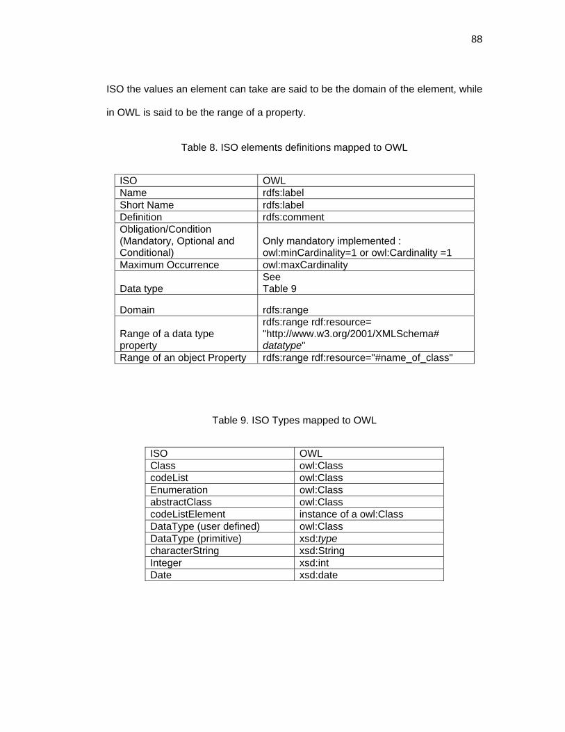
88
ISO the values an element can take are said to be the domain of the element, while
in OWL is said to be the range of a property.
Table 8. ISO elements definitions mapped to OWL
ISO OWL Name rdfs:label Short Name rdfs:label Definition rdfs:comment Obligation/Condition (Mandatory, Optional and Conditional)
Only mandatory implemented : owl:minCardinality=1 or owl:Cardinality =1
Maximum Occurrence owl:maxCardinality
Data type See Table 9
Domain rdfs:range
Range of a data type property
rdfs:range rdf:resource= "http://www.w3.org/2001/XMLSchema# datatype"
Range of an object Property rdfs:range rdf:resource="#name_of_class"
Table 9. ISO Types mapped to OWL
ISO OWL Class owl:Class codeList owl:Class Enumeration owl:Class abstractClass owl:Class codeListElement instance of a owl:Class DataType (user defined) owl:Class DataType (primitive) xsd:type characterString xsd:String Integer xsd:int Date xsd:date
89
8.2 FGDC in OWL
The FGDC-STD-001-1998 metadata model is expressed as a hierarchy of
compound elements. Compound elements contain other compound elements or
data elements. A data element is the primitive unit and has a defined data type and
a domain. The data type can be an integer, a real, a text, a date or a time. The
domain can be a list of restricted and unrestricted values, or a free value depending
on the type (e.g. free data, free integer or free text).
FGDC-STD-001-1998 does not conform to any conceptual formal
specification such as an Object Oriented Model (like UML) or an Entity Relational
(ER) model. This lack of conceptualization leads to different possible approaches to
formalize FGDC in OWL. The two possible non-exclusive ways are:
1. Creation of arbitrary object properties to link elements seen as classes.
2. Creation of arbitrary classes to categorize elements seen as properties.
An example of case 1 can be found in
http://loki.cae.drexel.edu/~wbs/ontology/list.htm and an example of the second
approach can be found in http://loki.cae.drexel.edu:8080/~how/pangloss/. The two
cases will be presented for the declaration in FGDC of the complex element
Keywords:
Keywords = 1{Theme}n + 0{Place}n + 0{Stratum}n + 0{Temporal}n
The previous statement means that Keywords is a complex element that
contains minimum one Theme and Theme can appear various times (maximum =

90
n), and Place, Stratum and Temporal elements are optional (minimum=0) and can
appear various times (maximum = n).
8.2.1 Case 1: Creation of arbitrary object properties
The first possible way to conceptualize the previous statements is to view all
the elements as classes and create arbitrary object properties. So the following is
created for the Keywords statement:
Keywords = class
hasTheme = ObjectProperty, whose range is Theme
hasPlace= ObjectProperty, whose range is Place
hasStratum= ObjectProperty, whose range is Stratum
hasTemporal= ObjectProperty, whose range is Temporal
hasTheme, hasPlace, hasStratum and hasTemporal are all arbitrary object
properties, whose ranges are Theme, Place Stratum and Temporal respectively.
These ranges are complex elements seen as classes. For example, for Theme, the
following is stated in the FGDC standard:
Theme = Theme_Keyword_Thesaurus + 1{Theme_Keyword}n
And to conceptualized the previous statement the following is done:
Theme = class
hasTheme_Keyword_Thesaurus = datatypeProperty ,
whose range is String
hasTheme_Keyword = datatypeProperty ,
whose range String

91
Theme is a class, and two arbitrary datatypeProperties are created:
hasTheme_Keyword_Thesaurus and hasTheme_Keyword. They are
datatypeProperties, because they correspond to simple elements in the FGDC
declaration. And the range of both properties are xsd:String.
A conclusion for case 1 is as follows: For each element create a
has_element object Property, if the range is a complex element, otherwise (i.e.
range is a simple element) create a datatypeProperty.
8.2.2 Case 2: Creation of arbitrary classes
Case 2 differs from case 1, because in case 2 arbitrary classes are created:
Theme_Type, Place_Type, Stratum_Type and Temporal_Type. The exception is
the root, Metadata, which is seen as a class, and not as a property. This approach
is similar to the serialization of FGDC in XML schema [104], where element types
are created (i.e. similar to classes) to related complex element to contained
elements. Classes and object properties are created as follows:
Keywords = class
Theme = ObjectProperty, whose range is Theme_Type
Place= ObjectProperty, whose range is Place_Type
Stratum= ObjectProperty, whose range is Stratum_Type
Temporal= ObjectProperty, whose range is Temporal_Type
Theme_Type = Class
Theme_Keyword_Thesaurus = datatypeProperty,
whose range is String

92
Theme_Keyword = datatypeProperty,
whose range is String
For case 1 and case 2, cardinalities and code lists are treated in the same
fashion as ISO [64]. The second approach is preferred over the first one because
creation of classes can be viewed as the process of categorizing properties, and
secondly because a related approach exists in XML schema facilitating the
conversion of one format to another.
This chapter presented strategies to conceptualize ISO and FGDC
metadata standards into OWL. ISO original formalization is in UML, which is use for
constructing object oriented models. UML to OWL conversion is preformed by
matching UML concepts with OWL concepts and converting datatypes from one
schema to the other. For the creation of the FGDC ontology it was required to
create arbitrary classes, which can be seen as a mechanism to categorize FGDC
properties.

93
CHAPTER 9: CONCEPTUALIZING CONTROLLED VOCABULARIES
One of the main problems with metadata specifications is the lack of
domain-specific elements. To facilitate the use of domain terms with metadata
specifications, this thesis proposes that both, metadata specifications and
controlled vocabularies need to be conceptualized. The conceptualization should
be expressed in a logic that allows to connect one with the other in a flexible and
simple fashion. The connectivity is possible in Semantic Web Languages such as
RDF and OWL.
The idea to present controlled vocabularies in an ontology form is not new.
A recent study [75] shows that RDF has being used in various systems to encode
dictionaries and vocabularies. And [79, 111], shows the use of ontologies to encode
domain vocabularies; however for Hydrology very little has been done so far.
This chapter presents a taxonomy of controlled vocabularies, a survey of
related vocabularies to the hydrologic domain and recommended methodologies to
formalize controlled vocabularies in ontologies in order to facilitate the bridging
between metadata specifications. First, a definition and classification of controlled
vocabularies are given, followed by examples for the hydrologic domain, a
methodology and finally some conversion examples.
9.1 Controlled vocabularies
A control vocabulary can be defined as a set of restricted words, used by an
information community when describing resources or discovering data. An
information community uses a controlled vocabulary to avoid misspellings and
avoid use of arbitrary words that cause inconsistencies when cataloging data.

94
A consensus about what exactly constitutes a controlled vocabulary and the
types that exist are both not clear. Ontologies can be viewed as controlled
vocabularies [67, 79], while a controlled vocabulary can also be presented as a
simple terminological tool [81]. Controlled vocabularies in digital libraries are seen
as a Knowledge Organization System. Hodge [57], categorized these systems
based on structure and complexity, relationships among terms, and historical
functions, as follows:
• Term Lists:
o Authority files: List of terms with limited hierarchical structures.
o Glossaries: List of terms usually with definitions, capturing specific
domain terms.
o Dictionaries: General glossaries, with no hierarchical structure,
which provide additional information about the term (e.g. origin,
synonym, or related term).
o Gazetteers: List of place names, usually classified or categorized.
• Classification and categories:
o Subject headings: Shallow hierarchical structure of general terms.
o Classification schemes, sometimes called taxonomies or
categorization schemes which provide a hierarchical structure based
on categories.
• Relationship Lists
o Thesauri: Relationship list with more expression power than
alphanumeric classification systems, because they can relate terms

95
by saying that one term is broader, narrower, related, synonym or
antonym.
o Semantic Networks: Relationship lists that include thesauri relations
plus other relations, such as whole-part, cause-effect, or parent-child
relationships.
o Ontologies: Tools to represent complex relationships among terms,
include rules and axioms not possible to express in semantic
networks.
9.2 Classification of controlled vocabularies
The different Knowledge Organization Systems presented by Hodge [57]
are classified in Figure 38 based on the level of conceptualization and
categorization.
Figure 38. Classification of Hodge knowledge organization systems.
96
Controlled vocabularies can be characterized by differences in the
conceptualization status. A controlled vocabulary can be conceptualized or non
conceptualized. Three distinctions are depicted among non-conceptualized
vocabularies: Categorized, non-categorized and categorized with relations. These
categories are explained in detail in this section. Also, in addition to Hodge
organization systems, conceptual models are added as conceptualized controlled
vocabularies.
9.3 Definitions
An abstraction is a process where real world objects, their relationships and
the properties of those objects are identified. The term class will be used to denote
a general reality abstraction, as it is used in Object Oriented Languages and
Knowledge Representation Languages. However, this term also refers to entities in
Entity Relational Diagrams or facets in frame-based logics. A formal conceptual
language (e.g. UML, RDF, OWL, ERD, FRL) is a system of written symbols and a
grammar rules used as mechanism of communication between people and
computer programs, that allows to express classes, their relations and their
properties. A symbol is a conventional sign like box in UML or a tag in RDF/XML
that explicitly communicates that the term associated with the symbol is a class. A
class acts like a flag to tell if the controlled vocabulary is conceptualized or not.
9.3.1 Definition of conceptualized controlled vocabularies
A Controlled Vocabulary(CV) is conceptualized if:
1. A symbol explicitly exists to represent abstraction (e.g. class or box, tag).

97
2. At least one term uses such symbol to represent a conceptualization
abstraction. (e.g. the term inside a box that denotes a class).
An example of a conceptualized controlled vocabularies for the hydrologic
domain is ArcHydro (Maidment, 2002), which is a successful data model for
hydrology and hydrography [77] another example is SWEET [103] which presents a
conceptualized view of the Global Change Master Directory [95].
9.3.2 Definition of non conceptualized CV
A CV is non conceptualized if a symbol that denotes a class does not exist.
Three types can be named: categorized, non-categorized and categorized with
relations.
9.3.3 Non conceptualized categorized CV
A controlled vocabulary is non-conceptualized and categorized if it meets
the following conditions:
1. It is non conceptualized.
2. At least one explicit category exists.
3. At least one term is classified.
An example of non conceptualized but categorized control vocabulary is a
gazetteer. Two well known gazetteers are Getty Geographical Thesaurus names
[41] and the Geographic Names Information System-GNIS [128]. GNIS contains
about 2 million geographic features in the United States with name, latitude and
longitude coordinates for each feature.

98
9.3.4 Non conceptualized - Non categorized CV
A controlled vocabulary is non conceptualized and non categorized if:
1. It is non conceptualized.
2. No explicit category exists.
Non categorized CVs include glossaries, dictionaries and authority files. An
example of the later is a list of gauge stations of a basin. Relevant glossaries and
dictionaries related to hydrology are the following: UNESCO International Glossary
of Hydrology [127], which presents a list of words and their definition and
translation in different languages, with “see also” links to similar terms. Water
Science Glossary of Terms [86] developed by Nevada Division of Water Planning,
which is a small internet version of a more complete dictionary, the Water Words
Dictionary published by Nevada Division of Water Resources [59]. This last one is
the more comprehensive glossary (about 386 pages). And a final example is a
limited glossary use for education purposes developed by Oklahoma Climatological
Survey [94].
9.3.5 Non conceptualized - categorized with relations CV
A controlled vocabulary is non conceptualized and categorized with relations if:
1. It is non conceptualized.
2. An explicit category exists.
3. Terms are related via means different than the categorization ( e.g., use for,
is related to).
This type of controlled vocabularies includes classification schemes and
thesaurus. The most important cataloging systems are the Dewey Decimal

99
Classification [92], the Universal Decimal Classification [125] and The Library of
Congress [120]. These are called also alphanumeric classifications because it uses
alphanumeric codes to organize the terms from more general to more specific [81].
For the three systems, the place in the classification where the word hydrology
appears is shown bellow:
Dewey Decimal Classification:
• 550 - Earth Sciences
• 551 - Geology, hydrology, meteorology
o 551.4 Geomorphology and hydrosphere, water
551.46 Oceanography
551.48 Hydrology
551.49 Ground Water Hydrology
o 551.5 Meteorology
o 551.6 Climatology and Weather
Universal Decimal Classification :
o 5 Natural science
o 55 Earth sciences. Geology, meteorology, etc.
551 General geology. Meteorology. Climatology. Historical geology. Stratigraphy.
Palaeogeography
• 551.1/.4 General geology
• 551.1 General structure of the Earth
• 551.2 Internal geodynamics (endogenous processes)
• 551.3 External geodynamics (exogenous processes)
• 551.4 Geomorphology. Study of the Earth's physical forms
• 551.5 Meteorology
556 Hydrosphere. Water in general. Hydrology

100
The Library of Congress :
GB651 – 2998 Hydrology. Water
GB980 - 2998 Ground and surface waters
GB980-992 Watersheds. Runoff. Drainage
GB1001-1199.8 Groundwater. Hydrogeology
GB1201-1598 Rivers. Stream measurements
GB1601-2398 Lakes. Limnology. Ponds. Lagoons
GB2401-2598 Ice. Glaciers. Ice Sheets. Sea Ice
GB2601-2798 Snow. Snow surveys
GB2801-2998 Hydrometeorology
GC1-1581 Oceanography
Well known thesauri related to hydrology are: NASA, Global Change Master
Directory [95], which provides a list of keywords where category is the broader
term, followed by topic, term and variable; the CIESIN Indexing Vocabulary [110]
which is divided in science topics with “Land and Freshwater resources” being the
one most related to Hydrology and also presents the words in a topic-term-variable
hierarchy; the Alexandria Digital Library Feature Type Thesaurus [121] which
contains a comprehensive list of feature types, and relations “used for”, “related
terms”, “narrower term” and broader “term”; and the Florida Environments Online
Thesaurus, developed by a cooperative initiative of the public universities of
Florida, Publication of Archival, Library & Museum Materials [101], which presents
broader and narrower, and use for relations.
9.4 Methodology
Based on the conceptualization taxonomy of controlled vocabularies a
methodology is presented to conceptualize controlled vocabularies, starting from
simple CVs to conceptualized CVs. A simple CV is one that has no

101
conceptualizations and no categories. The first step is to find a category that can
group all the terms. Sometimes an obvious category can be found, such as
“station” for a list of stations, or “science keywords” for a list of scientific terms. The
issue is to select a class that can take on the role of a classifier for all the terms.
This is a classical bottom-up approach, where common properties in real world
objects are identified and are used as classifiers (i.e. classification abstraction [5]).
For example, real world objects, USA, Colombia, and Germany have in common
that they are a territory of a recognized nation. The two properties, territory and
recognized nation promote a new class named Country. If a category exists in a
CV, it is automatically converted to a class and as in the previous case, all the other
classified terms are converted to instances of these class.
Conversion of a CV with categories and relations, such as thesauri and
alphanumeric schemes, presents a greater challenge. A method of conversion of a
thesaurus to RDF/OWL is explained in Assem et al., (2004). Basically the process
is broken into two parts: first a syntactic conversion to a plain RDF and then a
semantic conversion to OWL. Assem et al., (2004) present two conversion
examples: Medical Subject Headings [124] and Wordnet, [31]. Another example of
conversion of a thesaurus to an ontology is presented in [44], In this work the
National Cancer Institute Thesaurus was converted into classes and broader
classes were created to group the terms.
In general the following guidelines should apply:
1. Create classes, using preferred terms as RDF labels. Classes are created
from concepts or categories that exist explicitly or implicitly.

102
2. Relations are converted to properties. But some properties declared in RDF
schema and in OWL can be used (e.g. For example, comment).
3. Narrower-Broader relationships are mapped to object properties and are
transitive and inverse.
4. Noun, verb, adverb, and adjectives are all disjoint.
5. Hyponym (subclass) and hypernym (superclass) can be converted to a new
property or the subclass relation in OWL can be used. It is important to
notice that superclasses can not be declared in OWL.
6. Synonyms can be mapped using sameAs relationship in OWL.
Two conversion examples are shown. One for a classification scheme and
another one for a thesaurus.
9.4.1 Hydrologic Units Ontology
An example of a classification scheme in hydrologic vocabularies is the
USGS Hydrologic Units Code (HUC) System, which is a hierarchical classification
of nested large-to-smaller watersheds within a certain region. A HUC for the first
level is formed by two digits (e.g. Mid Atlantic Region is 02) , for the second level is
formed by four digits (e.g. Delaware Subregion is 0204), for the third level is formed
by six digits (e.g. Lower Delaware Accounting Unit is 020402) and for the fourth
level is formed by eight digits (e.g.Schuylkill Cataloging Unit is 020402).
Four categories can be found in the USGS classification: Region,
Subregion, Accounting Unit and Cataloging Unit. All of these are mapped to
classes (See Figure 39). Also a more general classification can be created:

103
Hydrologic Unit, which is also mapped to a class and becomes a super class of the
previous four classifications.
Hydrologic Units are related via whole-part relationships. The property “is
part of” is used for this purpose. OWL allows to express this property as a transitive
property. For this reason it is not necessary to express explicitly that Schuylkill is
part of the Delaware Subregion. Saying that the Schuylkill is part of the Lower
Delaware and that the Lower Delaware is part of Delaware Subregion is sufficient.
Figure 39. USGS Hydrologic Units Ontology

104
9.4.2 Global Change Master Directory Ontology
The Global Change Master Directory, GCMD, [95] provides a list of
comprehensive keywords related to science. (An excerpt is shown in Figure 40).
GCMD is organized in hierarchical way from broader to narrower terms (i.e.
categories, topics terms and variables).
Figure 40 Excerpt Global Change Master Directory Keywords.
Conversion from GCMD list to OWL is achieved by: 1) Presenting all
keywords as classes; 2) Presenting all keywords as instances, 3) A combination of
the previous two.
All GCMD keywords can be encoded as classes, assuming that the
keywords have a clear hierarchical structure. Rain, precipitation, atmosphere and
EARTH SCIENCE are classes. Rain is subclass of precipitation, precipitation is a
subclass of atmosphere and so on. This approach is similar to the classification for
105
geologic ages and rock types [72] and the OWL encoding of the National Cancer’s
Thesaurus [44]. The problem with this approach is that the relations that exist
among the classes and subclasses does not conform to common generalization
abstractions [5], where “isA” relation exist among the classes and subclasses. For
example, precipitation isA atmosphere is not true.
The second approach presents keywords as instances while Category,
Topic, Term and Variable are represented as classes. A Keyword class is created
as a parent of Category, Topic, Term and Variable classes. This translation
preserves the organization of GCMD keywords, and conforms to classification
abstractions [5]. For example, Rivers/Streams are GCMD variables, and
Hydrosphere is a GCMD topic. In order to link the keywords it is necessary to
define a property hasParentCategory in the Keyword class. For each subclass,
restrictions are created on the hasParentCategory property to maintain the exact
GCMD keyword structure. For example, Category does not have parent categories,
so it has a cardinality restriction that says that hasParentCategory = 0. The
Variable class, has only one parent category, Term, so it has a restriction for
hasParentCategory, which hasAllValuesFrom the class Term.
The third approach is a combination of the previous two, which purpose is to
facilitate the use of GCMD keywords in metadata specifications. For example, a
restriction can be created on iso:keyword (see
Figure 41), so that iso:keyword can take only values of selected GCMD
terms (e.g. Atmosphere, Climate indicators, Cryosphere, Land Surface and
Oceans).

106
Figure 41. Extension of ISO MD_Keywords to accept all values of GCMD
In order to create the previous restriction, two conditions are necessary: 1)
that the keywords are individuals of an existing class and 2) that Atmosphere,
Climate_indicators, Cryosphere, Land_Surface and Oceans are declared classes.
For these reasons, all the GCMD variables were encoded as instances and
classified under their parent term-topic-category. A Protégé snapshot of such
conceptualization is presented in Figure 42.

107
Figure 42. Protégé snapshot GCMD in OWL
This chapter presented a definition of controlled vocabularies and a
categorization of Hodge’s Knowledge Organization System. A strategy to
conceptualize control vocabularies depending of the level of conceptualization was
also discussed. Two complete examples were studied: a hydrologic units ontology
and the Global Change Master Directory ontology.

108
CHAPTER 10: UPPER HYDROLOGIC ONTOLOGY
10.1 Motivation and background
The previously discussed controlled vocabularies in Chapter 8 are not
always available in machine-readable format. If any of these are to be used in the
Semantic Web they must be converted into a conceptualized schema. Larger
collections of terms are found in general thesaurus such as Wordnet [31]; “the most
widely used ontology for natural language processing”[114]. However, Wordnet,
which can be found in RDF [80] and OWL [69] lacks of specialized hydrologic
concepts. The incompleteness of the controlled vocabularies previously mentioned
will be demonstrated in the following examples:
• Wordnet does not contain terms like “specific yield” or “NEXRAD”,
• International Glossary of Hydrology [127], does not define “atmosphere” or
“geological formation”.
• Global Change Master Directory (GCMD), does not contain hydrologic
terms like “well”, “transmissivity”, or “dikes”.
• Alexandria Digital Library Feature Type Thesaurus being the most complete
feature thesaurus, does not contain “gauge station” or “pollutant discharge
source” or related terms that can be used instead.
• The Water Words Dictionary published by the Nevada Division of Water
Resources does not contain terms to describe geologic formations.
For the hydrologic domain, there is a lack of top level ontology that can help
categorized new terms. This chapter presents such an ontology, where existing
terms from other ontologies as well as new terms can find a place in a hydrologic

109
conceptualization. The purpose is to create an ontology using a top-down
approach, creating a conceptual model to fit hydrology related data.
An upper hydrologic ontology is a controlled vocabulary that defines classes
to help categorize terms related to the hydrologic domain. The classes are related
to each other via properties. Some properties have logical characteristics, allowing
agents or computer programs to infer related terms and provide a better query
result to users or service requesters. The upper hydrologic ontology can be used
for:
• inference of hydrologic knowledge (further explained in section 10.4), and
• refinement of hydrologic related searches (further explained in section
10.4).
The upper hydrologic ontology can also served as:
a controlled vocabulary when creating or searching hydrologic metadata, similar to
what was created for GCMD (See
• Figure 41), and
• a central ontology to solve semantic heterogeneities occurring in other
ontologies, by mapping other terms to the hydrologic top concepts.
10.2 Construction and definition of terms
The upper hydrologic ontology has been built around the concept of
measurement. Measurement and the related concepts presented in Figure 43 are
explained in detail in this section.

110
Figure 43. Upper Hydrologic Ontology
A measurement can be defined as “a process of assigning numbers or
other symbols to an attribute of a thing, in such a way that the relationships of the
numbers or symbols reflect relationships of the attribute being measured.” [106].
Sometimes, observation is used as a more general term, to distinguish between
quantitative measurements from category observations [38, 100]. From a classical
point of view, measurements can be categorized as nominal, ordinal, interval and
ratio [117]. In a nominal measurement objects are classified by shared attributes,
which is the same as category observations [38, 100]. While the other three
categories are quantitative measurements. Since the purpose of this thesis is to

111
present the semantics to facilitate interoperability, the divisions of category
observations and quantitative measurement are not taken into account. The reason
is that it is not envisioned that a user will search by “category measurement”.
Instead he or she will rather search by an instrument (e,g, NEXRAD data) or test
data (e.g. pumping test). If data is recorded by an observable (i.e. instrument or
test) it is an observation, and if the measurement is a product of a mathematical or
logical method it is said to be a derived observation.
An Observation is a measurement originating from an instrument or a test
that can record a value or a symbol for a property of a phenomena. Observations
are discrete samples of continuously running natural processes for which only one
value exists in the spatial temporal domain for the measurement [85].
A derived observation is a measurement that is not observed but
computed. In Wordnet computation is defined as a procedure of determining
something by mathematical or logical methods. It is different from an observation
because observation is not determined by mathematical or logical methods, but by
an instrument. If discharge is calculated by a rating curve, it is a product of a
computed value and not an observed value. Also, computing a runoff curve number
by means of looking at a table of land use vs. hydrologic soil groups is a logical
computation (e.g. if land is ”dirty road” and hydrologic soil group is “B” then curve
number is 82). Another example is reflectivity which is a measured value while
rainfall rate is a computed value from reflectivity data. Also, permeability is another
example of derived observation.
Property is a basic or essential attribute shared by all members of a class
[31]. Rainfall intensity is a property of rainfall, so all rainfall events have to have

112
rainfall intensities. It behaves like an abstract object, having no location in time and
space [48]. Where and when questions have no meaning. For example, where is
the pH? Or when is the pH? A property can be observed or computed. (e.g.
evaporation rate measured in millimeters/day). For this reason a class name
“Measurable particular” is created, which is allowed to have “measurable
properties”.
Measurable particular is a hydrologic particular, which has a measurable
Property. It is divided in Phenomena and Physical Endurant. They have part-whole
relations as defined by Winston [134]. The component-object relation (e.g. channel-
stream), member-collection (e.g., stream-waterBody) and place-area (e.g., stream-
basin) are defined as the property is part of in the Physical endurant class. The
stuff-object relation (e.g., water-stream) is defined as the property has substance
component in the Substance class and the phase-process relation (e.g.
evaporation, hydrologic cycle) is defined as the property hasPhase in the
phenomena class. These relations are transitive and have corresponding inverse
properties (e,g., is part of and has part).
The is part of relation when the relation is applied to a feature is not strictly
a whole-part relation, since most of the time geospatial features have fiat
boundaries [113]. This means that the they do not posses a divisible bulk. For
example, it is difficult to discern where a mountain starts, or what the real
boundaries of a basin are. Also, a river can be part of a basin, but not completely
and for the case of geological formations, the differentiation is even harder. The is
part of relation is simplified as a relation where the containment part does not need

113
to be completely inside the whole. If at least one part is contained, then it is said to
be part of the containment feature.
Phenomena: The American Heritage® Dictionary defines phenomena in
the physical sense as “an observable event” (e.g. rainfall, infiltration and runoff ). It
is a subject of the observation to which values can be assigned [100]. In the context
of this thesis, a phenomena is an event that can be observed by instruments,
observed by tests, or derived from other observations. A measurement is not a
simulation, since it is not a product directly or indirectly of an observation.
A phenomena exist if anyone of its properties can be measured by an
instrument, be reproduced by a test or be computed from previous measurements.
It can be raining very lightly for a short period of time, but if the reflective measured
by the radar is not greater than 5 decibels (in rain mode), then it is not raining. In
other words, a phenomena is defined through its ability to be detected by an
instrument. Moreover, to record a natural phenomena precisely more than one
device is necessary, each of them performing different measures. For example,
radar and rain gauge measurements together, can be more accurate for estimating
rainfall than each measurement alone. Also, a phenomena can be estimated by a
computation, which includes mathematical models, lookup values in tables, or
simple equations.
The second part of the phenomena definition says that it is an event. An event,
is a particular (i.e. unrepeatable entity) that occurs or happens or takes place [50],
commonly known as occurrent [48]. Guarino [48], explains that an occurrent is
generated by a continuant (i.e. object ) and that it cannot exist without one. (e.g.

114
evaporation is a phenomena, that can only exist if water and the sun both exist).
Also events can be static or dynamic.
In order, to precisely define an event it is assumed that events cannot move,
are not properties and are not facts. Event though we perceive that a hydrologic
event (e.g. rainfall event) moves because different events are measured and
compared. Events are not properties. Casati and Varzi [14], present a discussion
about events that can be seen as properties and vice versa. They argue, for
example, that the redness of an apple is a property, but also an event with spatial
temporal locations. The redness of the apple is perceived in a coordinate x and an
interval time t. These properties are called phased sortals [49]. The hydrologic
events precipitation, infiltration and runoff, even though they are three distinct
events, can be seen as properties or phased sortals of the water flow. However if
we insist on the previous definition that a property cannot have a temporal and
spatial locust, then it can be concluded that if precipitation has a spatial and
temporal location it is not a property, and therefore must be phenomena.
Events are not facts [102, 130]. A rainfall event should not be confused with the
fact that it rained. For an event to be an event it needs the spatial and temporal
extent. A fact only refers to the event. For example, the fact that the Schuylkill River
flooded is distinguished from the event that Schuylkill River flooded at time t. To be
precise, if something seems like a fact but it has clearly a spatial-temporal location
it will always be an event.
A Physical endurant is define in DOLCE, Descriptive Ontology for
Linguistic and Cognitive [78] as a top level concept. It is a useful category to
separate measurable particulars from phenomena. A physical endurant, is a

115
particular that can endure in time and can be feature or a substance. The difference
between a feature and a substance is that feature has a spatial location, while
substance does not. A substance is sometimes called stuff, and it can be
composed of other substances (e.g. Hydrogen and Water) or can be composed of
other features (e.g. water is part of streams).
Instrument: Wordnet defines an instrument as a device that requires a skill
for proper use. An instrument in this thesis is a device that records observations. If
the instrument is located in the spatial location where the measurement is taking
place it is said to be in situ (i.e. confined to the site of origin), e.g. gauge station, if
not it is said to be remote, e.g. radar. These two distinctions are important because
in the first case, the location of the instrument can be used as the location for the
phenomena, which is different from the second case.
10.3 Testing of the top hydrologic ontology
To test the proposed upper hydrologic ontology, instances depicting
different type of data were created in Protégé [116].
10.3.1 Feature
The first instance created was basin. Basin is a feature, since it has a
spatial location and has a continuous existence (i.e. physical endurant). Since it is a
measurable particular it has measurable properties, such as curve number,
precipitation distribution and Digital Elevation Model (DEM). These are measurable
properties since they do not have a space and time location. Also, to be a property
they should have a measurement medium. Curve number can be measured by a
logical method, such as the SCS curve number method, using the soil type tables.

116
A basin can contain other features such as streams, lakes, waste water treatment
facilities, and geological formations, which do not need to be totally contained in the
basin. If any part of a geological formation is in the basin, it is said to be contained.
It should be clear that no distinction is made on how these features are represented
(e,g, point, line, polyline or volumes).
10.3.2 Phenomena
Precipitation is the first phenomenon created, which is an event. It occurs.
Precipitation has properties, such as precipitation rate (intensity) and precipitation
volume, which can be measured using various mechanisms: remote sensors like
NEXRAD, on-site instruments like rain gauges or buckets. Since NEXRAD does not
measure the precipitation rate directly, it is said to be a derived observation. A rain
gauge measures rain depth or volume, hence it is not a derived observation, while
the synthetic unit hydrograph is a method to reproduce a measurement in a
watershed.
10.3.3 Substance
The first obvious substance to be created is water, which is part of a water
body, aquifer or the atmosphere. Water does not have a physical location, because
it does not have a specified latitude or longitude. It is composed of other
substances (H and O), and it has measurable properties such as temperature and
pH.

117
10.4 Usage example: Hydroogle
A hydrologic ontology can serve a number of different purposes. One of
them is to provide the controlled vocabulary for a community, similar to what was
presented with the hydrologic units ontology and the GCMD ontology in earlier
chapters. Dynamic Community Profiles can use the terms define in the ontology as
controlled vocabulary for selected elements in extended metadata specifications. In
addition, hydrologic ontologies can help discover knowledge and refine queries to
improve search results by reducing the information overload. In order to test this
approach, an application called Hydroogle was developed, which follows the idea of
“Google”, which is the most popular search engine today.
Hydroogle helps to discover hydrologic knowledge by presenting related
terms, as shown in Figure 44. The term RAIN was searched and terms that
contained RAIN were displayed in HTML with properties that were linked to other
hydrologic concepts. For example, rainfall is a type of precipitation. And rain bucket
is a type of point measurement. If a user wants to search for other point
measurements, a click on point measurements will present some types of point
measurements (e.g. evaporation pan, rain bucket, rain gauge, piezometer, etc..)

118
Figure 44. Discovering Hydrologic knowledge with Hydroogle
Hydroogle will also help to refine searches. In the first attempt to search for
“Stage Delaware”, Google retrieved 642,000 results. Google matches all the index
Web pages that contain both stage and Delaware. The first results are related to
festivals and entertainment information. Google is unable to discern that the search
has a hydrologic context. The large amount of results found including non-relevant
searches is what is commonly known as information overload [67].

119
Figure 45. Google search for stage and Delaware.
To guide the user towards a more specific hydrologic search, Hydroogle
presents a list of possible hydrologic units containing that name and the concepts
related to any of the terms the user wants to search for. The user can select, for
example, Lower Delaware and stage and streamflow, clicking on the small box at
the right of the term. Then the Google Web Service is implemented to search for
the refinement search. See Figure 46 and Figure 47.

120
Figure 46. Search refinement Hydroogle
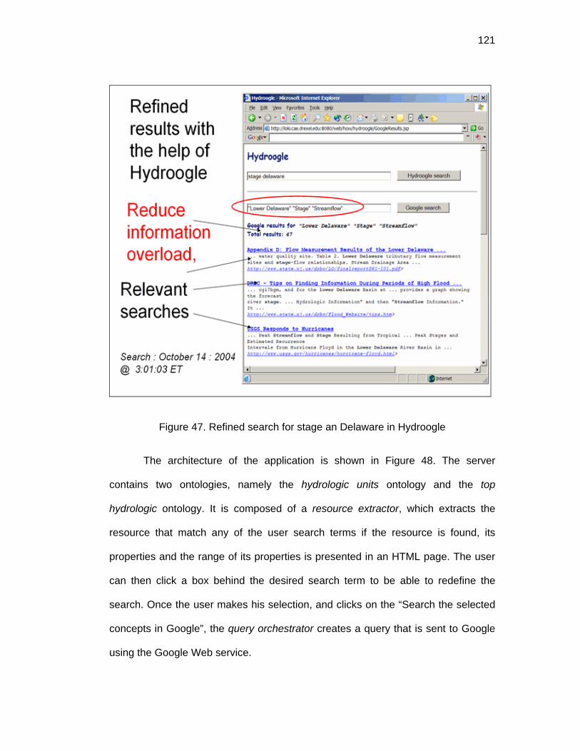
121
Figure 47. Refined search for stage an Delaware in Hydroogle
The architecture of the application is shown in Figure 48. The server
contains two ontologies, namely the hydrologic units ontology and the top
hydrologic ontology. It is composed of a resource extractor, which extracts the
resource that match any of the user search terms if the resource is found, its
properties and the range of its properties is presented in an HTML page. The user
can then click a box behind the desired search term to be able to redefine the
search. Once the user makes his selection, and clicks on the “Search the selected
concepts in Google”, the query orchestrator creates a query that is sent to Google
using the Google Web service.
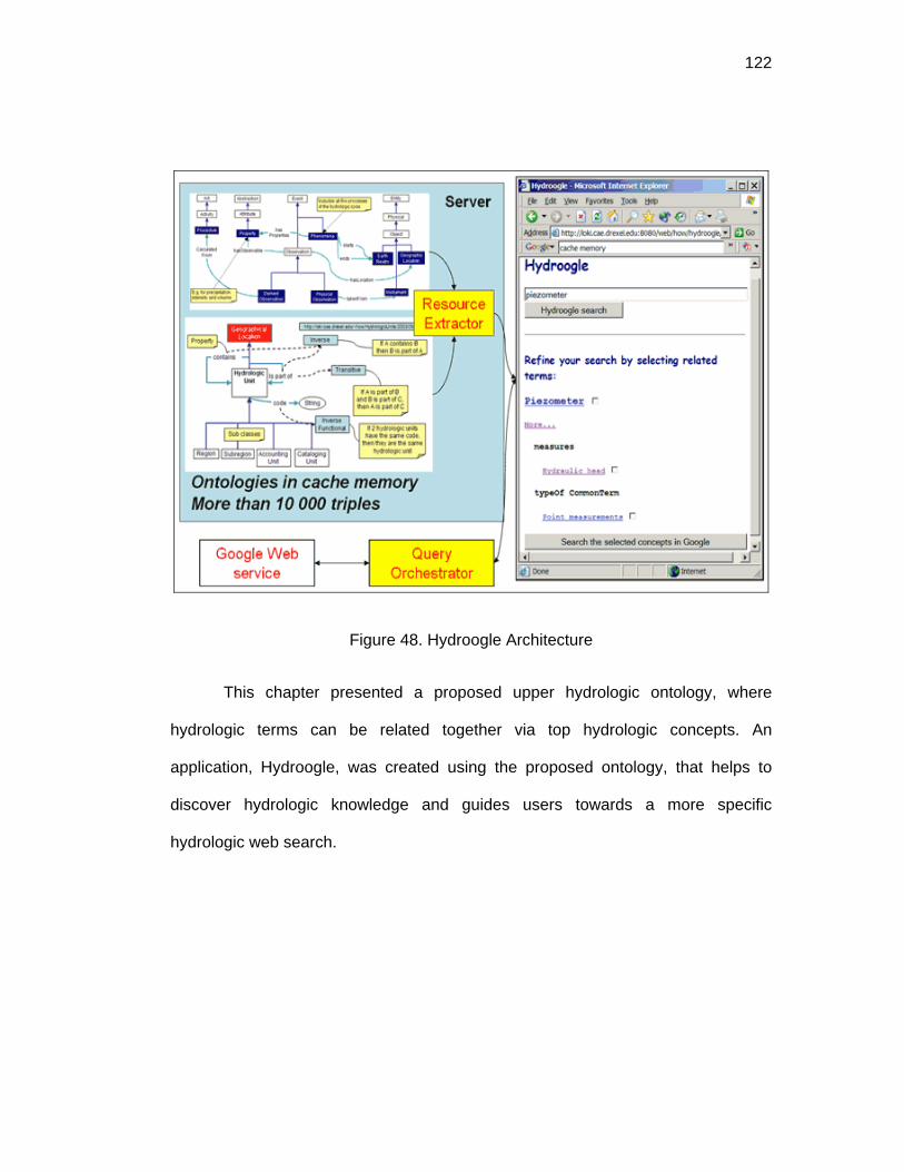
122
Figure 48. Hydroogle Architecture
This chapter presented a proposed upper hydrologic ontology, where
hydrologic terms can be related together via top hydrologic concepts. An
application, Hydroogle, was created using the proposed ontology, that helps to
discover hydrologic knowledge and guides users towards a more specific
hydrologic web search.

123
CHAPTER 11: PANGLOSS
11.1 Overview
To test ONTOMET, Pangloss, a suite of products that interact with
metadata specifications and vocabularies, was developed. The prototype takes
advantage of World-Wide-Web (WWW) recommended technologies, such as:
Hypertext Transfer Protocol (HTTP) protocol to provide communication; Internet
Protocol (IP) to provide connectivity across heterogeneous networks and hardware
platforms; Universal Resource Locators (URLs) as a universal identifier and locator
for distributed resource on the Web; Web Ontology language (OWL) and the
Resource Description Framework (RDF) to represent metadata specifications,
instances and vocabularies; eXtensible Markup language (XML) as the encoding
medium and HTML to present metadata specifications.
A variety of programming languages (C++, Visual Basic, JAVA, Pyhton,
etc.) exist to create a software program. However there are some advantages that
JAVA has over the others. JAVA is license-free; its compilation units can be
executed on any operating system, once the virtual machine has been installed in
the computer; it is fully object oriented, facilitating reusing of the code and
functional encapsulation; and lastly only JAVA APIs to interact with OWL were
available (i.e. JENA [61]) in 2001. The three programs created were:
1. Pangloss MetaInstance, facilitates creation of instances based on schemas
expressed in OWL ontologies and profiles created with the methodologies
presented in this thesis. The result is an RDF/XML document that conforms

124
to the rules of the metadata specification. The screenshot ( Figure 49 )
shows an example for ISO-19115:2003.
Figure 49. Pangloss MetaInstance
2. Pangloss MetaExtender permits the selection of core elements of a
metadata specification expressed as an OWL ontology. These paths can
then be used by an information community to set their profile. The
screenshot (Figure 50) shows the core paths for ISO-19115:2003.

125
Figure 50. Core Paths of ISO-19115:2003 in Pangloss
3. Pangloss MetaMapper allows the explicit creation of a mapping between
two metadata specifications, both of them expressed as an OWL ontology.
The screenshot shows the mapping of FGDC Place-Keyword to ISO
keyword + type=place. The model implemented follows the tree model
approach.

126
Figure 51. Pangloss MetaMapper
The main characteristics of Pangloss are :
• Flexibility: It can open any OWL schema (even those not related to
metadata specifications). However, the root must be specified in
order to create the class.property.class.property tree.
• Clarity:
o Root class: It is clear where to start, since the root will
display the first properties.
o Mandatory elements: Mandatory elements are shown
with a red M if the cardinality or the minimum cardinality
is one.
o Duplicable elements: If an element is duplicable a + sign
is shown to indicate that the whole branch can be
repeated

127
o Datatype properties which need a value are presented
with a blank blue square.
• Easy tree navigation. All the nodes in the tree can be navigated
following the Class.property.class.property.. pattern. If a property
has as range a class, the class and its subproperties are presented
to the user.
• Loop problems are resolved by manual navigation. The
class.property.class.property pattern can result in circular problems.
Pangloss shows the first class and the first properties. After that the
user is required to manually navigate along the tree, and to manually
create loops. This does not affect the program performance.
• Fast loading. Pangloss opens two times faster than the best
ontology editor (Protégé). This is due to the fact that, Protégé is
based on its own knowledge-based model which is mapped to a
JENA model, while Pangloss uses a JENA model directly. Also in
Pangloss not all the classes and properties are open when loading
the ontology, it only opens the root, and the first branch (properties),
reducing loading time.
• Accepts class restrictions on datatype Properties, which is an OWL-
Full expression. The encoding can be either of the two presented in
Figure 52. The right one is preferred, where the URI is being
encoded as a String. Pangloss checks for every string to see if it is a
URI or not, and acts accordingly.

128
Figure 52. Datatype encoding of a URI.
• Restriction rules of inherited properties take precedence over parent
properties as explained in section 2.3. This is useful to present the
specification created form Dynamic Community Profiles methodology.
The use of this product to create a hydrologic metadata profiles is discussed
in Chapter 12. A survey of other tools to annotate and extend metadata are
presented in the next section.
11.2 Other tools to annotate and extend metadata specifications
The USGS provides a variety of tools to support creation and validation of
metadata for CSDGM FGDC-STD-001-1998 in:
http://geology.usgs.gov/tools/metadata/, including compilers, parsers, editors,
online helpers to validate and create enumerated domains and source Information
from bibliographic records. A metadata validation service for FGDC metadata is
available at http://geo-nsdi.er.usgs.gov/validate.php. ESRI Arc Catalog facilitates
and automates creation of metadata, while it is FGDC compliant it is not fully ISO
compliant. The Environmental Information Management System [27],
http://www.epa.gov/eims/index.html supports FGDC. It is a Web system that
displays forms to populate metadata for EPA staff and other individuals by getting a

129
password, however it does not fully accommodate FGDC metadata standards and
their output is only in HTML format. The California Environmental Information
Catalog (CEIC), an online directory for reporting and discovery of information
resources for California. http://gis.ca.gov/catalog/index.epl, allows users to create
their own catalogs, but no standards are imposed. OMNIPORT formulates a way to
create dynamic forms to parse metadata for distributed and heterogeneous
environments [37]. The MORPHO tool available at
http://knb.ecoinformatics.org/software/eml/ helps to create Ecological metadata
based on EML, and MetaMaker helps to create FGDC compliant metadata. MOBE
is a metadata editor developed by San Diego Super Computer Center. A simplified
metadata schema, Metadata Transfer Format, MTF [55] is used as a template to
create metadata. It is flexible in the sense that it accepts any MTF, and the syntax
is simple; however, the following is not possible: expressing that a complex element
has cardinality “many”, specifying a range of controlled vocabularies and create
and edit RDF/XML or OWL documents.
Other tools which support FGDC, and ISO and support with relational
databases are: Multistandard Multilingual Metadata catalogingTool (M3Cat) created
by Intlec Geomatics, Enraemed Metadata Collector from the Ethiopian Natural
Resources Environmental Meta-Database, Spatial Metadata Management System
(SMMS) produced by Intergraph, and Metamanager created by Compusult Limited.
All of the previous tools, except MOBE and COBE have hard-coded the
metadata elements, which makes them inflexible tools. While this has the benefit
that it can sometimes be easier to create metadata, it has the disadvantage that

130
multiple profiles, if created following the methodology in this thesis, will need
additional coding. Also, they do not allow editions in RDF/XML nor OWL.
The Protégé ontology editor, can be used as an alternative to create
instances of metadata specifications expressed in OWL; however, treatment of
core elements and class restrictions of datatype properties need special attention.
Also, a tree view of a metadata specification as class.property.class.property is not
possible in Protégé, which displays classes in one panel, and properties in another.
Creating an instance for ISO:19115:2003 in OWL which has more than 100 classes
is cumbersome in Protégé. For this reason, Pangloss presents a metadata tree
view, similar to COBE, which is more user friendly when creating metadata
instances.
This chapter presented Pangloss, a suite of products that interact with
metadata specifications and vocabularies and that make use of the methodologies
in ONTOMET. Also it presented differences with other tools that facilitate creation
of metadata instances.

131
CHAPTER 12: CUAHSI METADATA PROFILE
The methodology to setup a Dynamic Community Profile was tested by
creating a metadata community profile for CUAHSI. The requirements for the
Drexel University Team, were to recommend a set of metadata elements to
describe hydrologic data. The project had the following constraints:
1. The elements should be published in Metadata Template Files (MTF) which
is a special format preferred by the San Diego Supercomputer Center.
2. The elements must comply with the ISO:19115:2003 and related standards.
3. The profile must use controlled vocabularies from a known thesaurus for
topic themes and terms from measurement units detailed in the Handbook
of Hydrology [76]
The procedure was as follows:
1. The ISO:19115:2003 and related metadata specifications were converted to
OWL, as outlined previously in section 8.1.
2. Controlled vocabularies for units and for topics were encoded in an ontology
as outline in Chapter 9.
CuahsiKeywords was created as a subclass of iso:MD_Keywords. And a restriction
was created on iso:keyword , so that iso:keyword can take only values of selected
GCMD terms (e.g. Atmosphere, Climate indicators, Cryosphere, Land Surface and
Oceans). See
3. Figure 41 for a graphical view and Figure 53 for the XML encoding.
4. CUAHSI Keywords were made mandatory.

132
Figure 53. RDF/XML encoding of CUAHSI keywords creation.
5. The CUAHSI Metadata profile was created by extending ISO MD_Metadata,
and importing the related ontologies, as shown in Figure 54.

133
Figure 54. CUAHSI Metadata Profile
6. The elements were set as CORE using the Pangloss MetaExtender as
shown in Figure 55. The core elements were saved in MTF (See Figure 56)
and in XML as shown previously in Figure 19.

134
Figure 55. Pangloss MetaExtender snapshot of CUAHSI core
Figure 56. MTF export from Pangloss
The Pangloss MetaInstance was used to read the CUAHSI extension declaration,
the controlled vocabularies and display a tree with a controlled vocabulary to allow

135
control over creation of metadata instances. An excerpt of the CUAHSI core
elements and the control list for the keyword elements is presented in Figure 57.
Figure 57. Controlled vocabulary of a Dynamic Community Profile.
Related ontologies for the project and more information can be found at :
http://loki.cae.drexel.edu:8080/Web/how/me/metadatacuahsi.html

136
CHAPTER 13: INTEROPERABILITY TEST
A test was assembled to show the semantic interoperability between the
Dynamic Community Profile and its parent specification. For example, if a profile A
is created from the ISO specification, it will be interoperable with ISO, as well as all
the other Dynamic Community Profiles directly or indirectly linked with the ISO
norm (See Figure 58). The semantic interoperability means that if a query is
performed using the semantics of only ISO, the query engine or algorithm should
also be able to retrieve instances of profiles A, B, C, D..
Figure 58. Profiles inheritance
The test is divided in three parts: 1) Creation of the ontologies: A controlled
vocabulary; a profile and an instance; 2) defining a query, and 3) performing the
query.

137
13.1 Creation of the ontologies
A simple controlled vocabulary was created for USGS with two terms:
Gage_height and Discharge. Both of them are individuals of Hydro_parameter.
(See Figure 59)
Figure 59. USGS vocabulary
A simple Dynamic Community Profile was created called ISO-USGS, where the
resource keyword in ISO is restricted to have the USGS vocabulary shown in
Figure 60.

138
Figure 60. USGS Dynamic Community Profile
An instance was created which is shown in Figure 61. The range of
descriptiveKeywords is shown as USGS-Keywords, which is a new class that is
part of the profile, and not part of the original ISO:19115. An excerpt of the instance
is shown in Figure 62. Note that the class that appears as the range of
iso19115:descriptiveKeywords is usgs:USGS-Keywords, but all the other resources
are from the original ISO specification (i.e. elements with the prefix iso19115:).

139
Figure 61. USGS instance creation
Figure 62. Excerpt of USGS instance in XML
13.2 Query definition
A query is composed of a pair Q = (Eq,Vq), where Eq is a metadata element
and Vq is a value to query. In this test, both are resources identified as :

140
Eq=http://loki.cae.drexel.edu/~wbs/ontology/2004/08/iso-19115:keyword ,
Vq = http://loki.cae.drexel.edu/~how/2004/11/usgs-voc#Gage_height
The result of a the query is a QueryResult, QR, that is composed of simple
results SR. A Simple result is as set of pairs { (E1,V1)1, (E2,V2)2,…(En,Vn)n }. In this
test n=3, for which the Es are:
E1 = http://loki.cae.drexel.edu/~wbs/ontology/2004/08/iso-19115:title
E2=http://loki.cae.drexel.edu/~wbs/ontology/2004/08/iso-19115:abstract
E3=http://loki.cae.drexel.edu/~wbs/ontology/2004/08/iso-19115:onLine
A formatted result can look like Figure 63, which shows the values found for
E1, E2 and E3.
Figure 63. Formatted results
A query is executed in two phases: 1) Get the metadata root resource for all the
instances whose property Eq matches Vq., and 2) starting from the metadata root
resource found, get the values for E1,E2 and E3.

141
13.3 Performing the query:
The query will be executed on the following metadata element and value:
Eq=http://loki.cae.drexel.edu/~wbs/ontology/2004/08/iso-19115:keyword ,
Vq = http://loki.cae.drexel.edu/~how/2004/11/usgs-voc#Gage_height
To perform the query the RDF Data Query Language or RDQL is used
[109]. The metadata root resource is found with the statement shown in Figure 64.
The statement starts with the variable that will be returned (i.e. MD_Metadata). It
has a “?” before it to denote that it is a named variable, as well as all the others that
are shown with the interrogation mark. After the WHERE clause, three triples
appear. The x in the first triple is the value that is going to be searched (e.i. Vq) like:
http://loki.cae.drexel.edu/~how/2004/11/usgs-voc#Gage_height. The query
engine will first find all the triples that match the first triple, getting all the values for
MD_Keywords, which is used in the second triple. The query engine will then find
all the triples that match the second triple finding all the possible values for
MD_DataIdentification. Then the engine will use the MD_DataIdentification values
to get the triples that match the third triple, and thus the values for MD_Metadata.
The USING statement, helps to write the ISO resources in abbreviated form.
Figure 64. RDQL to find the metadata root element

142
The query returns the following value for MD_Metadata:
http://loki.cae.drexel.edu/~how/2004/11/usgs-ins#A5099540, which is shown in
Figure 65.
Figure 65. Instance in XML shown the metadata root
Then for the three resources E1, E2, and E3 a query is performed to get the
values. A query for: http://loki.cae.drexel.edu/~wbs/ontology/2004/08/iso-
19115:title is presented in Figure 66. Note that the first triple uses the value of the
metadata root found. Following a similar procedure of triples pattern matching as
explained previously, a value for property title, denoted as ?x, is found, which
returns: “USGS 02091500 CONTENTNEA CREEK AT HOOKERTON, NC -
DISCHARGE AND GAGE HEIGHT COLLECTED BY USGS”. Similar queries can
be performed to get all other values for a metadata instance.

143
Figure 66. RDQL to get iso:title knowing the root value
From the previous test it can be concluded that queries are performed over
properties, which are inherited by the classes, created in the Dynamic Community
Profiles. The name of the classes in the profiles do not need to be known by an
engine that is querying instances from the profile. Communities can create their
profile, and it will be semantically interoperable with the parent metadata
specification.
A complete test demo, that also shows mapping examples between
metadata elements and vocabularies, can be found at
http://localhost:8080/Web/how/ontomet/ontomet.jsp. The demo shows how a user
searching for one term, finds metadata instances that are described with
heterogeneous elements and vocabularies, as shown in Figure 67.

144
Figure 67. Semantic interoperability with mappings
The ontologies used in this demo are the following:
Specifications (Standards)
• ISO-Schema: ISO 19115-2003 and related specifications in OWL
http://loki.cae.drexel.edu/~wbs/ontology/2004/08/iso-19115
• FGDC-Schema in OWL
http://loki.cae.drexel.edu/~how/cuahsi/2004/10/fgdc
Vocabularies
• USGS vocabulary
http://loki.cae.drexel.edu/~how/2004/11/usgs-voc
• COE (US Army Corps of Engineers) vocabulary
http://loki.cae.drexel.edu/~how/2004/11/coe-voc#Hydro_Terms

145
Profiles
• ISO-USGS , which is a Dynamic Community Profile for USGS, where the
element keywords in ISO is restricted to have USGS vocabulary
http://loki.cae.drexel.edu/~how/2004/11/usgs-iso
• COE-FGDC, which is a dynamic profile for COE, where the element
Theme_Keyword of FGDC is restricted to have values of COE vocabulary
http://loki.cae.drexel.edu/~how/2004/11/coe-fgdc
Instances
• An instance that conforms to the ISO-USGS profile
http://loki.cae.drexel.edu/~how/2004/11/usgs-ins
• An instance that conforms to the COE-FGDC profile
http://loki.cae.drexel.edu/~how/2004/11/coe-ins
Mappers
• A ontology that maps USGS and COE vocabularies
http://loki.cae.drexel.edu/~how/2004/11/coe-usgs-voc
• A mapping for the keywords element
http://loki.cae.drexel.edu/~how/2004/11/fgdc-iso
This chapter presented a test to show the semantic interoperability between
the Dynamic Community Profile and its parent specification. It was concluded that
because of the queries were performed over properties, which are inherited by the
classes, the Dynamic Community Profiles can be query only by knowing the
semantics of its parent.

146
CHAPTER 14: SUMMARY
Metadata specifications can be better used by information communities if
they are conceptualized, expressed in machine-readable, format and domain
vocabularies can be utilized in a dynamic way. The ONTOMET framework, based
on ontologies and technologies from the Semantic Web, can be used by diverse
communities to achieve semantic interoperability among distributed and
heterogeneous resources. The aim of this thesis was: to present an abstract model
for metadata specifications, to develop a methodology to extend metadata
specifications called Dynamic Community Profiles, to develop a top hydrologic
ontology, to formalize semantic mappings to perform metadata crosswalks, and to
provide guidelines to formalize vocabularies.
The abstract tree-path model presented in this thesis is an object model to
treat metadata specifications that provides a harmonization platform to either create
tools or support semantic mappings. The tool Pangloss was coded to successfully
test this model by presenting a conceptualized specification as a tree, and allow the
user to navigate along its branches. Also, representation of a metadata
specification as a rooted simple tree allows creation of core paths and creation of
contextual semantic mappings.
The Dynamic Community Profile methodology will allow facilitation of
adopting a metadata specification, refinement of metadata elements and use of
domain vocabularies in a simple declaration. Dynamic Community Profiles use the
capabilities of description logics build in OWL to infer vocabularies dynamically at
run time, so the latest vocabularies can be made available in the profile. Dynamic

147
Community Profiles will also speed up systems development times, thus avoiding
to hard code the semantics.
More than one metadata specification will always exist because it is
impossible to achieve a general consensus about the use of one and only one
specification. To minimize the time spend in maintaining content metadata and to
maximize the use among a broad range of users, metadata in one specification
must be available in other related specifications. To perform metadata crosswalks,
this thesis presented first, that harmonization can be achieved by expressing the
source and target metadata specification in OWL; and secondly, that semantic
mappings can be formalized using tree-paths. The strategy presented allowed
solution of complex mappings such as one-to-many mappings.
This thesis presented strategies to conceptualize metadata specification in
OWL as well as conceptualization of controlled vocabularies. ISO and FGDC
conceptualizations were presented to show to different scenarios: 1) a specification
conceptualized in UML, and 2) a specification not conceptualized. Controlled
vocabularies for hydrology were conceptualized using a bottom-up approach
starting from existing vocabularies (e.g. a list of stations of scientific term
thesaurus). Also a top-down approach of a hydrologic ontology was presented,
providing an upper level schema to categorize hydrologic related concepts such as
features, phenomena, properties and instruments. The top hydrologic ontology
presented can guide the construction of other upper domain ontologies of other
Earth Science disciplines, since they share similar concepts (e.g. instrument,
measurement, phenomena, etc.).

148
In order to support and to tie together the various ideas presented in this
thesis, several stand-alone tools and Web applications were developed. These
tools showed the versatility of having metadata specification, vocabularies and
mapping conceptualized in a standard languages like OWL. A Dynamic Community
Profile was created for CUAHSI using the previously discussed tools and
methodologies. An interoperability test was also developed to show the semantic
interoperability of original metadata specifications and extended ones.

149
CHAPTER 15: FURTHER WORK
The Semantic Web is a new technology, but there is no doubt that its
adoption will spread in similar fashion as other recommended technologies by W3C
have spread (e.g. HTML and XML). This thesis shows some ideas and
methodologies to facilitate the use of metadata specifications using the Semantic
Web; however, other strategies can be studied, where the methodologies
presented in this thesis can be used. Related topics include, for example, topic
maps, which is another way to express controlled vocabularies, that can be used
with XPath and XML schemas technology.
Metadata instances are stored mostly in Relational Database Systems
(RDBM). Conversion from triples to tuples in a relational database and vice versa is
part of ongoing research, as well as translation of one query language to another
(i.e. SQL and RDQL query languages). Also, automatic conversion from conceptual
models to database schemas is needed to facilitate integration of metadata
specification and traditional storage systems.
More ontologies for the hydrologic domain are needed. This thesis present
a base, using two approaches, a bottom-up and an top-down approach.
Refinement and discussion about ontology construction to promote the
understating and crosswalks of vocabularies from different hydrologic communities
are needed. Also development of ontologies for specific topics in hydrology, such
as those related to pollutants, chemistry and water quality is a future research topic.
The model for metadata crosswalks was tested for a 1D mapping, and
further development to perform a full mapping implementation is needed. The
metadata mapping model approach can be combined with XSLT technologies. The

150
first one can be used to express the semantic mapping independently from the final
format and the later to be use for the format transformations.

151
LIST OF REFERENCES
[1] ANSI/NISO, Guidelines for the construction, format, and management of monolingual thesauri ANSI/NISO, 2003.
[2] ANZLIC, ANZLIC Metadata Guidelines, 2001, http://www.anzlic.org.au/infrastructure_metadata.html.
[3] K. Baclawski, Kokar, M., Kogut, P., Hart, L., Smith, J., Letkowski, Jerzy, Emery, Pat, Extending the Unified Modeling Language for ontology development, Software System Model 1, 1-15, 2002.
[4] T. Baker, M. Dekkers, R. Heery, M. Patel and G. Salokhe, What Terms Does Your Metadata Use? Application Profiles as Machine-Understandable Narratives, in: International Conference on Dublin Core and Metadata Applications, K. Oyama and H. Gotoda, eds. National Institute of Informatics (NII), Tokyo, Japan, 2001.
[5] C. Batini, S. Ceri and S.B. Navathe, Conceptual Database Design, The Benjamin/Cummings publishing Company, Inc., Redwood City, California, 1992.
[6] S. Bechhofer, F.v. Harmelen, J. Hendler, I. Horrocks, D.L. McGuinness, P. Patel-Schneider and L.A. Stein, OWL Web Ontology Language Reference W3C Recommendation, 2004, http://www.w3.org/TR/2004/REC-owl-ref-20040210/.
[7] Z. Bellahsene, A.B. Chaudhri, E. Rahm, M. Rys and R. Unland, Database and XML Techonoloiges, First International XML Database Symposium, XSym 2003 Berlin, Germany, September 2003 Springer, Berlin, 2003.
[8] L.E. Bermudez, Pangloss, 2004, http://loki.cae.drexel.edu:8080/~how/pangloss/.
[9] T. Berners-Lee, J. Hendler and O. Lassila, The Semantic Web, Scientific American 184(5), 34-43, 2001.
[10] Y. Bishr, Overcoming the semantic and other barriers to GIS interoperability, Geographic Information Science 12(4), 299-314, 1998.

152
[11] T. Bray, J. Paoli, C.M. Sperberg-McQueen, E. Maler and F. Yergeau, Extensible Markup Language (XML) 1.0 (Third Edition) W3C, 2004, http://www.w3.org/TR/2004/REC-xml-20040204/.
[12] D. Brickley and R.V. Guha, RDF Vocabulary Description Language 1.0: RDF Schema W3C, 2004, http://www.w3.org/TR/2004/REC-rdf-schema-20040210/.
[13] M. Bright, A. Hurson and S. Pakzad, A taxonomy and current issues in multidatabase systems, IEEE Computer 25(3), 50-60, 1992.
[14] R. Casati and A.C. Varzi, Events, in: Stanford Encyclopedia of Philosophy (Fall 2002 Edition), E.N. Zalta, ed., 2002.
[15] CHRONOS, An Information System for Chronostratigraphy, 2004, http://www.chronos.org/index.html.
[16] J. Clark, XSL Transformations (XSLT) W3C, 1999, http://www.w3.org/TR/1999/REC-xslt-19991116.
[17] CLEANER, Collaborative Large-Scale Engineering Analysis Network for Environmental Research., 2004, http://cleaner.ce.berkeley.edu/intro.php.
[18] Commission on Geosciences Environment and Resource CGER, A Data Foundation for The National Spatial Data Infrastructure, National Academy Press, Washington, D.C., 1995.
[19] S. Cox, P. Daisey, R. Lake, C. Portele and A. Whiteside, Geography Markup Language (GML3.0) OGC 02-023r4 Open GIS Consortium, 2003, http://www.opengis.org/specs/?page=specs.
[20] CUAHSI, Consortium for the Advancement of the Hydrologic Sciences, Inc., 2004, http://www.cuahsi.org/.
[21] DCMI, Dublin Core Metadata Initiative, 2004, http://dublincore.org/.
[22] DGIWG, Digital Geographic Information Working Group, 2004, http://metadata.dgiwg.org/.

153
[23] DLESE, ADN framework, 2003, http://www.dlese.org/Metadata/adn-item/index.htm.
[24] Ecoinformatics, EML - Ecological Markup Language, 2003, http://www.ecoinformatics.org/tools.html.
[25] M.J. Egenhofer, Toward the Semantic Geospatial Web, in: Tenth ACM international symposium on advances in geographic information systems ACM Press, McLean, Virginia, USA, 2002.
[26] A. Elmargarmid and C. Pu, Guest Editors' Introduction to the Special Issue on Heterogeneous Databases, ACM Computing Surveys 22, 175-178, 1990.
[27] EPA, User Guide and Data Administration Guidelines for the USEPA'S Environmental Information Management System (EIMS) U.S. Environmental Protection Agency, Office of Research and Development, 2001, http://www.epa.gov/eims/EIMS_UserGuide.pdf.
[28] ESML, Earth Science Markup Language, 2004, http://esml.itsc.uah.edu/.
[29] European Territorial Management Information Infrastructure, ETeMII White Paper Chapter on Metadata, 2002.
[30] D. Fallside, C., XML Schema Part 0: Primer, W3C Recommendation W3C, 2001, http://www.w3.org/TR/2001/REC-xmlschema-0-20010502/.
[31] C. Fellbaum, Wordnet: An Electronic Lexical Database, Bradford Books, 1998.
[32] FGDC, Content Standard for Digital Geospatial Metadata, Washington, D.C., 1998.
[33] FGDC, FGDC/ISO Metadata Standard Harmonization, 2004, http://www.fgdc.gov/metadata/whatsnew/fgdciso.html.
[34] R.T. Fielding, Styles and the Design of Network-based Software Architectures, Doctoral dissertation, University of California, 2000.
154
[35] F.T. Fonseca, ONTOLOGY-DRIVEN GEOGRAPHIC INFORMATION SYSTEMS, Doctor of Philosophy, The University of Maine, 2001.
[36] F.T. Fonseca, M.J. Egenhofer, P. Agouris and G. Câmara, Using Ontologies for Integrated Geographic Information Systems, Transactions in GIS 6(3), 231 - 257, 2002.
[37] S.G. Ford and R.C. Stern, Omniport: Integrating Legacy Data into the WWW, in: Second International World Wide Web conference, Chicago, 1994, http://archive.ncsa.uiuc.edu/SDG/IT94/Proceedings/CorInfSys/stern/stern-ford.html.
[38] M. Fowler, Analysis Patterns: Reusable Object Models, Addison-Welsey, Reading, MA, 1997.
[39] M. Genesereth, Knowledge Interchange Format draft proposed American national Standard (dpANS) NCITS.T2/98-004, 1998, http://logic.stanford.edu/kif/dpans.html.
[40] GERM, 2004, http://earthref.org/GERM/main.htm.
[41] GETTY, Thesaurus of Geographic Names, 2004, http://www.getty.edu/research/conducting_research/vocabularies/tgn/.
[42] Y. Gil and V. Ratnakar, TRELLIS: An Interactive Tool for Capturing Information Analysis and Decision Making, in: Knowledge Engineering and Knowledge Management. Ontologies and the Semantic Web: 13th International Conference, EKAW 2002, A. Gómez-Pérez and V. Richard Benjamins, eds., Lecture in Computer Science Springer-Verlag Heidelberg, Siguenza, Spain, 2002, 2473, pp. 37 - 42.
[43] C.H. Goh, Representing and Reasoning about Semantic Conflicts in Heterogeneous Information Sources, Ph.D. Thesis, MIT Sloan School of Management, 1997.
[44] J. Golbeck, G. Fragoso, F. Hartel, J. Hendler, J. Oberthaler and B. Parsia, The National Cancer Institute's Thésaurus and Ontology, Journal of Web Semantics 1(1), 2003.

155
[45] J. Gomes and L. Velho, Abstraction Paradigms for Computer Graphics, The Visual Computer 11, 227-239, 1995.
[46] M. Grötschell and J. Lügger, Scientific Information Systems and Metadata Konrad-Zuse-Zentrum für Informationstechnik., Berlin, 1998, http://elib.zib.de/ftp/pub/UserHome/Luegger/Dresden/Metadata.htm.
[47] T. Gruber, A Translation Approach to Portable Ontology Specification., Knowledge Acquisition 5(2), 199-220, 1993.
[48] N. Guarino, Some Ontological Principles for Designing Upper Level Lexical Resources, in: First International Conference on Language Resources and Evaluation, Granada, Spain, 1998.
[49] N. Guarino and C. Welty, A Formal Ontology of Properties, in: Proceedings of the 12th European Workshop on Knowledge Acquisition, Modeling and Management, Lecture Notes In Computer Science, Springer-Verlag, London, UK, 2000, pp. 97-112.
[50] P. Hacker, Events, Ontology and Grammar, Philosophy(57), 477-486, 1982.
[51] T. Hadzilakos, G. Halaris, M. Kavouras, M. Kokla, G. Panopoulos, I. Paraschakis, T. Sellis, L. Tsoulos and M. Zervakis, Interoperability and Definition of a National Standard for Geospatial Data: The Case of the Hellenic Cadastre, International Journal of Applied Earth Observations and Geoinformation 2(2), 120-128, 2000.
[52] F. Harvey, W. Kuhn, H. Pundt and Y. Bishr, Semantic interoperability: A central issue for sharing geographic information, The Annals of Regional Science 33(2), 213-232, 1999.
[53] R. Heery and M. Patel, Application profiles: mixing and matching metadata schemas, Ariadne(25), 2000.
[54] D. Heimbigner and D. McLeod, A federated architecture for Information Managment, ACM Transactions on Office Information Systems 3(3), 1985.

156
[55] J. Helly, A.A.P. Koppers and H. Staudigel, Scalable models of data sharing in Earth sciences, Geochem. Geophys. Geosyst 4(1), 1010, doi:10.1029/2002GC000318, 2003.
[56] J. Hendler, XML and the Semantic Web, XML Journal October, 2002.
[57] G. Hodge, Systems of Knowledge Organization for Digital Libraries: Beyond Traditional Authority Files The Digital Library Federation, Council on Library and Information Resources, Washington, DC, 2000.
[58] I. Horrocks, P. Patel-Schneider and F.v. Harmelen, From SHIQ and RDF to OWL: The Making of a Web Ontology Language, Journal of Web Semantics 1(1), 7-26, 2003.
[59] G.A. Horton, Water Words Dictionary Nevada Division of Water Resources, 2000, http://water.nv.gov/Water%20planning/dict-1/ww-index.htm.
[60] S.W. Houlding, XML an opportunity for meaningful data standards in the geosciences, Computer & Geosicences 27(7), 839-849, 2001.
[61] HP Labs Semantic Web Research, 2004, http://www.hpl.hp.com/semweb/.
[62] J. Hunter and C. Lagoze, Combining RDF and XML Schemas to Enhance Interoperability Between Metadata Application Profiles, in: The Tenth International World Wide Web Conference ACM Press, Hong Kong, 2001, pp. 457-466.
[63] IRIS, Incorporated Research Institutions for Seismology, 2004, http://www.iris.washington.edu/.
[64] A.K.M.S. Islam, L.E. Bermudez and M. Piasecki, Ontology for Geographic Information - Metadata ( ISO 19115), 2004, http://loki.cae.drexel.edu/~wbs/ontology/.
[65] ISO, Geographic information - Metadata, 2003.

157
[66] M.N. Kamel Boulos, A.V. Roudsari and E.R. Carson, Towards a Semantic Medical Web: HelathCyberMap's Dublin Core Ontology in Protege-2000, in: Fifth International Protege Workshop, Sowerby Centre for Health Informatics at Newcastle (SCHIN). University of Newcastle upon Tyne, Newcastle, England, 2001.
[67] V. Kashyap and A. Sheth, Information Brokering Across Heterogeneous Digital Data, Kluwer Academic Publishers, Norwell, MA, 2000.
[68] M. Kifer, G. Wagner and J. Wu, Logical foundations of object-oriented and frame-based languages, Journal of the ACM 42(4), 741-843, 1995.
[69] Knowledge Information Data processing Group, Knowler:WordNet OWL-Ontology Dept. of Computer Science at the University of Neuchâtel, 2004, http://taurus.unine.ch/knowler/wordnet.html.
[70] Y. Lafon and B. Bos, Describing and retrieving photos using RDF and HTTP World Wide Web Consortium, 2002, http://www.w3.org/TR/2002/NOTE-photo-rdf-20020419/.
[71] T. Landers and R. Rosenberg, An overview of Multibase, in: 2nd International Symposium for Distributed Databases, 1982, pp. 153-183.
[72] K. Lin and B. Ludäscher, A System for Semantic Integration of Geologic Maps via Ontologies, in: Semantic Web Technologies for Searching and Retrieving Scientific Data (SCISW), Sanibel Island, Florida, 2003.
[73] W. Litwin, An overview of the multidatabase system MRDSM, in: 1985 ACM annual conference on The range of computing: mid-80's perspective: mid-80's perspective ACM Press, 1985, pp. 524-533.
[74] W. Litwin and A. Abdellatif, Multidatabase Interoperability, IEEE Computer 19(12), 1986.
[75] A. Magkanaraki, S. Alexaki, V. Christophides and D. Plexousakis, Benchmarking RDF Schemas for the Semantic Web, in: International Semantic Web Conference, Sardinia, Italy, 2002.
[76] D.R. Maidment, Handbook of Hydrology, McGraw-Hill, 1993.

158
[77] D.R. Maidment, Arc Hydro Gis for Water Resources, ESRI, California, 2002.
[78] C. Masolo, S. Borgo, A. Gangemi, N. Guarino, A. Oltramari and L. Schneider, The WonderWeb Library of Foundational Ontologies Preliminary Report WonderWeb, 2002, http://wonderweb.semanticweb.org/deliverables/documents/D17.pdf.
[79] D.L. McGuinness, Ontologies Come Age, in: Spinning the Semantic Web, D. Fensel, J. Hendler, H. Lieberman and W. Wahlster eds., The MIT Press, London, England, 2003.
[80] S. Melnik and S. Decker, A Resource Description Framework (RDF) representation of WordNet, 2004, http://www.cogsci.princeton.edu/~wn/links.shtml.
[81] P. Miller, I say what I mean, but do I mean what I say?, Adriadne(23), 2002.
[82] MMI, Marine Metadata Interoperability, 2004, http://mmi.shore.mbari.org/marinemetadata.
[83] NASA, Directory Interchange format DIF Version 9, 2004.
[84] NASA, Directory Interchange Format (DIF) Writer's Guide Global Change Master Directory. National Aeronautics and Space Administration, 2004, http://gcmd.gsfc.nasa.gov/User/difguide/difman.html.
[85] L. Neugebauer, Extending a databse to Support the Handling of Environmental Measuerement Data, in: Desing and Implementation of Large Spatial Databases, A. Buchman, G. O., J. Smith and Y.F. Wang, eds. Springer-Verlag, New York, New York, 1989, pp. 147-162.
[86] Nevada Division of Water Planning, Water Science Glossary of Terms, 2004, http://ga.water.usgs.gov/edu/dictionary.html.
[87] J. Nogueras-Iso, F.J. Zarazaga-Soria, J. Lacasta, R. Béjar and P.R. Muro-Medrano, Metadata standard interoperability: application in the geographic information domain, Computers, Environment and Urban Systems(28), 611–634, 2004.

159
[88] NOKIS, North and Baltic Sea Coastal Information System, 2004.
[89] NSGIC, FGDC to ISO metadata; How painful is this going to be?, in: 2003 Annual Meeting National States Geographic Information Council, Nashville, TN, 2003.
[90] NVODS, 2004, http://www.po.gso.uri.edu/tracking/vodhub/vodhubhome.html.
[91] OASIS, 2004, http://www.oasis-open.org.
[92] OCLC Online Computer Library Center, Dewey Decimal Classification (DDC), 2004, http://www.oclc.org/dewey/.
[93] OGC, Geography Markup Language (GML3.0), 2003, http://www.opengis.org/specs/?page=specs.
[94] Oklahoma Climatological Survey, Glossary, 2002, http://k12.ocs.ou.edu/teachers/glossary/g.html.
[95] L.M. Olsen, G. Major, S. Leicester, K. Shein, J. Scialdone, H. Weir, S. Ritz, C. Solomon, M. Holland, R. Bilodeau, T. Northcutt and T. Vogel, Global Change Master Directory (GCMD) Earth Science Keywords NASA, 2004, http://gcmd.gsfc.nasa.gov/Resources/valids/.
[96] OMG, Unified Modeling Language Specification, 2003, http://www.omg.org/technology/documents/formal/uml.htm.
[97] OMG, XML Metadata Interchange Specification Version 2.0, 2003, http://www.omg.org/cgi-bin/apps/doc?formal/03-05-02.pdf.
[98] OMG, Object Management Group, 2004, http://www.omg.org/.
[99] Open GIS Consortium, The OpenGIS Abstract Specification, 1999.
[100] Open GIS Consortium, Observations and Measurements, 2003.

160
[101] PALMM, Florida Environments Online Thesaurus, 2001, http://susdl.fcla.edu/lfnh/thesauri/feol2/index.htm.
[102] T. Ramsey, Facts and Propositions, Proceedings of the Aristotelian Society 7, 153-70, 1927.
[103] R. Raskin and M. Pan, Semantic Web for Earth and Environmental Terminology (SWEET), in: Semantic Web Technologies for Searching and Retrieving Scientific Data (SCISW), N. Ashish and C. Goble, eds., Sanibel Island, Florida, 2003.
[104] R.E. Rathmann, FGDC Metadata XML Schema 1.0.0 20030801, 2002, 2003, http://www.csc.noaa.gov/metadata/xml/tools.htm.
[105] R.B. Roberts and I.P. Goldstein, The FRL manual. AI Memo No. 409 MIT Articial Intelligence Laboratory, Cambridge, MA, 1977.
[106] W.S. Sarle, Measurement theory: Frequently asked questions, in: Disseminations of the International Statistical Applications Institute 1, ACG Press, Wichita, 1995, pp. 61-66.
[107] P. Scheuermann, C. Yu, A. Elmargarmid, H. Garcia-Molina, F. Manola, D. McLeod, A. Rosenthal and M. Templeton, Report on the workshop on heterogeneous database systems, ACM SIGMOD RECORD 19(4), 23-31, 1990.
[108] P.N. Schweitzer, Document Type Declaration (DTD) for FGDC-STD-001-1998, 2002, http://www.fgdc.gov/metadata/fgdc-std-001-1998.dtd.
[109] A. Seaborn, RDQL - A Query Language for RDF W3C, 2004, http://www.w3.org/Submission/RDQL/.
[110] SEDAC, CIESIN Indexing Vocabulary, 2004, http://sedac.ciesin.org/metadata/vocab/vocab_intro.html.
[111] A.P. Sheth, Changing focus on interoperability in information systems: from system, syntax, structures to semantics., in: Interoperating geographic information systems, M.F. Goodchild, M.J. Egenhofer, R. Fegeas and C. Cottman, eds., Kluwer Academic Publishers, Boston, 1999, pp. 5-29.

161
[112] A.P. Sheth and J. Larson, Federated Database Systems for managing Distributed, Heterogeneous and Autonomous Databases., ACM Computing Surveys 22(3), 1990.
[113] B. Smith and A.C. Varzi, Fiat and Bona Fide Boundaries', Philosophy and Phenomenological Research 60, 401-420, 2000.
[114] J.F. Sowa, Knowledge representation: logical, philosophical and computational foundations, Brooks/Cole Publishing Co, Pacific Grove, CA, 1999.
[115] M. St. Pierre and W.P. LaPlant, Issues in Crosswalking Content Metadata Standards National Information Standards Organization, 1998, http://www.niso.org/press/whitepapers/crsswalk.html.
[116] Standford University, Protege-2000, 2003, http://protege.stanford.edu/.
[117] S.S. Stevens, On the theory of scales of measurement., Science(103), 677-680, 1946.
[118] K. Stocks and J. Quinn, Data technologies: Geospatial data integration, in: Scalable Information Networks for the Environment (SINE). Report of an NSF-sponsored workshop, W. Michener and P. Tooby, eds., San Diego Supercomputer Center, 2002, pp. 23-29.
[119] Y. Teng, Use of XML for Web-Based Query Processing of Geospatial Data, Master Thesis, THE UNIVERSITY OF NEW BRUNSWICK, 2000.
[120] The Library of Congress, 2004, http://www.loc.gov/.
[121] The Regents of the University of California, Alexandria Digital Library Feature Type Thesaurus, 2002, http://www.alexandria.ucsb.edu/gazetteer/FeatureTypes/ver070302/index.htm.
[122] R. Thomason, Logic and Artificial Intelligence, in: The Stanford Encyclopedia of Philosophy, E.N. Zalta, ed., Fall 2003.
162
[123] D.S. Touretzky, The Mathematics of Inheritance Systems, Pitman Publishing Limited, London, 1986.
[124] U.S. National Library of Medicine, Introduction to MeSH in XML format,, 2001, http://www.nlm.nih.gov/mesh/xmlmesh.html.
[125] UDC Consortium, Universal Decimal Classification Consortium, 2004, http://www.udcc.org/.
[126] UKOLN, Desire Metadata Registry, 2003, http://desire.ukoln.ac.uk/registry/.
[127] UNESCO, International Glossary of Hydrology, 2002, http://webworld.unesco.org/water/ihp/db/glossary/glu/HYDR/HHYDRO.HTM.
[128] USGS, Geographic Names Information System (GNIS), 2004, http://geonames.usgs.gov/.
[129] USGS, Hydrologic Markup Language (HYDROML), 2004, http://water.usgs.gov/nwis_activities/XML/nwis_hml.htm.
[130] A.C. Varzi, Events, Truth, and Indeterminacy, The Dialogue 2, 241-264, 2002.
[131] W3C, XML Linking Language(XLink), 2004, http://www.w3.org/TR/xlink/.
[132] W3C, XML Path Language (XPath), 2004, 2004, http://www.w3.org/TR/xpath.
[133] G. Wiederhold, Mediators in the architecture of future information systems, IEEE Computer 25(3), 38-49, 1992.
[134] M. Winston, R. Chaffin and D. Herramann, A Taxonomy of Part-Whole Relations, Cognitive Science 11, 417-444, 1987.

163
VITA
Luis Bermudez Education Ph.D. Civil Engineering, Drexel University, Philadelphia, PA. Dec. 2004 M.S. Civil Engineering, Drexel University, Philadelphia, PA. Dec. 2001 B.S. Industrial Engineering, Andes University, Bogotá, Colombia Sep. 1995 Award Graduate Student Research Award, Drexel University, Philadelphia Feb. 2004 Pre-Reviewed Publications Bermudez, L. E. and M. Piasecki (2004). Metadata Community Profiles. Submitted to Geoinformatica. Saiful, A. S., L. Bermudez, S. Fellah, B. Beran and M. Piasecki (2004). Implementation of the Geographic Information - Metadata (ISO 19115:2003) Norm using the Web Ontology Language (OWL). Submitted to Transactions in GIS.
Conference Proceedings Bermudez, L. E. and M. Piasecki (2004). The role of ontologies in creating hydrologic metadata. In Proceedings of The sixth International Conference on Hydro-science and Engineering, Brisbane, Australia. (In Press). Bermudez, L. E. and M. Piasecki (2004). Achieving Semantic Interoperability with Hydrologic Ontologies for the Web. D. R. Maidment and K. Lanfear (eds.). In Proceedings of AWRA's 2004 Spring Specialty Conference Geographic Information Systems (GIS) and Water Resources III, Nashville, TN. Bermudez, L. E. and M. Piasecki (2003). HYDROML: Conceptual development of a hydrologic markup language. In Proceedings of 30th IAHR Congress, Thessalonkiki, Greece. Piasecki, M., L. E. Bermudez and A. S. Islam (2003). IM2: A Web-based Dissemination System for Now and Forecast Data Products. In Proceedings of 8th International Conference on Estuarine and Coastal Modeling, Monterrey, CA.