open space plan 2021 - 2026
TRANSCRIPT

Open Space Plan 2021 - 2026

© City of West Torrens Copyright
This document is based on research by staff of the City of West Torrens with assistance from URPS, WAX Design and other authors as cited. Apart from any permitted uses under the Copyright Act 1968, the work may be reproduced for study or training purposes, provided the source is acknowledged. Reproduction for commercial use requires prior written permission from the City of West Torrens and the various sources cited.
Access to document
This document has been prepared by the City of West Torrens. You may access copies of this document from Council’s website, westtorrens.sa.gov.au. You may download and print this document in unaltered form, only for your personal use or use by your organisation.
Disclaimer
While reasonable efforts have been made to ensure that the contents of this document are factually correct, the City of West Torrens does not accept responsibility for its accuracy or currency. As information is subject to change, the City of West Torrens shall not be liable for any loss or damage that may be occur through the use of, or reliance on, the contents of this document.
Kaurna Acknowledgement
The City of West Torrens acknowledges that the Kaurna people and their descendants are still and will always be the first peoples of the land. The City of West Torrens commits to valuing and supporting the Kaurna people’s inherent relationship to the land.
Revision Date Reviewed Details
1 1/10/2020 WK (wax) Draft for client review
2 28/05/2021 CoWT Updated draft following CoWT review
3 01/06/2021 CoWT Minor updates to V2
4 8/06/2021 CoWT Minor updates to v3
5 28/06/2021 URPS Draft approved by Council for community consultation
6 08/09/2021 CoWT Final delivery following community engagement on draft plan and amendments by CoWT
7 27/09/2021 CoWT Minor amendments to final report
Open Space Plan 2021-2026 i
Contents
1 Introduction..................................................................................................................................... 1
1.1 What is public open space? ..................................................................................................................... 2
1.2 Purpose of the Open Space Plan ............................................................................................................. 2
1.3 The benefits of open space...................................................................................................................... 2
2 Context ............................................................................................................................................ 3
2.1 Physical context ....................................................................................................................................... 3
2.2 Planning and policy context ................................................................................................................. 4
3 Emerging issues for open space ..................................................................................................... 6
3.1 Increasing infill development .................................................................................................................. 6
3.2 A changing community ............................................................................................................................ 7
3.3 Climate change ...................................................................................................................................... 9
3.4 Community aspirations ......................................................................................................................... 10
4 Open space planning framework ................................................................................................ 11
4.1 Open space hierarchy ............................................................................................................................ 11
4.2 Open space function .............................................................................................................................. 13
5 Supply of open space in West Torrens ........................................................................................ 15
5.1 Planning standards for open space ....................................................................................................... 15
5.2 Current provision of open space ........................................................................................................... 15
5.3 Hierarchy of Open Space ....................................................................................................................... 17
5.4 Function of open space ......................................................................................................................... 19
5.5 Access to open space ............................................................................................................................. 21
5.6 Open space gap analysis .................................................................................................................... 23
5.7 Connections and links ............................................................................................................................ 24
6 Open space vision, goals and strategies ..................................................................................... 26
6.1 Vision and goals ................................................................................................................................... 26
6.2 Implementation Plan ............................................................................................................................. 32
Appendix A – Planning and policy context .................................................................................................. 33
City of West Torrens - plans and strategies ........................................................................................................ 33
Other plans and strategies ................................................................................................................................. 37
Appendix B - Community profile ................................................................................................................. 39
Population and age structure ............................................................................................................................. 39
Population projections ....................................................................................................................................... 40
Appendix C – Open space by suburb .......................................................................................................... 45

Open Space Plan 2021-2026 ii

Open Space Plan 2021-2026 iii
Message from the Mayor Our Council's vision for our community is for West Torrens to be 'the best place to live, work and enjoy life'. As such, I am pleased to introduce our Open Space Plan 2021 - 2026, which outlines the importance our parks and streetscapes play in supporting the health and well-being of our communities and providing attractive neighbourhoods in which to live.
Infill housing and development is an issue that all Adelaide metropolitan councils face, as population numbers increase and the demand for inner-suburb living increases. As infill development increases, residential lot sizes become smaller and this puts added pressure on councils to provide spaces where our community can exercise, play, socialise and take part in sporting activities.
Open space is not just about liveability for our communities; it has an important role to play in supporting our environment by providing essential habitats for the continued existence of locally native plants and wildlife. Plants and green space also help cool temperatures in hot weather and purify air for us to breathe and it is a well-known fact that suburbs that have attractive green space often increase value in our community.
As West Torrens is only some 37 square kilometres in area and the Adelaide Airport is located on about 20 per cent of that, the provision of open space is a challenge for us. Our residential population of 61,000+ residents is steadily rising and the desire and need from our community for attractive, usable open space is increasing. As a result, providing open space that is fit for purpose in the future is very important in our thriving community.
The City of West Torrens Open Space Plan 2021 - 2026 addresses key issues and drivers that influence Council's management and provision of open space. In recent years we have made it our mission to improve the quality, and expand the usage, of many of our recreational areas in West Torrens and when you view our state-of-the-art facilities such as Apex Park, Weigall, Lockleys and Camden Ovals, it's clearly evident the importance that we place on providing functional and beautiful spaces for everyone to enjoy.
This Plan builds on where we have come from and what we have achieved and provides an important guide for us for what needs to happen in the future.
Michael S. Coxon
Mayor, City of West Torrens

Open Space Plan 2021-2026 1
1 Introduction Quality open space is integral to achieving the City of West Torrens’ vision of being the best place to live, work and enjoy life.
Our parks and streetscapes play an important role in supporting healthy communities and attractive neighbourhoods. It is critical that these spaces are planned, managed and maintained in a way that delivers benefits to the community, supports Council’s overarching objectives, and the community’s aspirations for the City for West Torrens.
Open space includes places for people to play sport, be active, relax and connect. Open space plays a key role in supporting a healthy population and opportunities to enhance health and wellbeing are key considerations for this Open Space Plan.
Open spaces provide space for trees and landscaping which enhance the amenity of streets, provide shading and cooling in hot weather, and improve biodiversity and water quality.
Open space can help us prepare for and mitigate the impacts of climate change. However, as we experience higher temperatures, drier conditions, and more extreme weather events, we will need to manage our open space differently.
This Open Space Plan addresses the key issues and drivers that influence the provision and management of open space. Land use planning policy changes allow for expanded areas of medium density development and identify areas where higher density development is envisaged. These policy changes facilitate the development of more dense residential areas which will accommodate additional population in West Torrens and consequently increase demand for open space. A number of substantial improvements have been made to the open space provision between 2017 and 2020. Approximately $30 million has been invested into parks and major sporting and recreation hubs across the city, including:
• Major upgrades to district open space including Camden Oval, Lockleys Oval, Kings Reserve, Weigall Oval and neighbourhood open space including Apex Park and Mellor Park Reserve
• Establishment of nature play opportunities to enhance conventional playgrounds
• Works to enhance the natural landscape value and biodiversity along the River Torrens Linear Park, Apex Park, Lockleys Oval and the Westside Bikeway.
• Preparation of a Recreation and Open Space Asset Management Plan to facilitate Council's sustainable service delivery and long-term financial planning and reporting.
This Plan builds on these improvements and responds to projected changes in population, urban development, environmental conditions and community needs, to guide open space management over the next 5 years.

Open Space Plan 2021-2026 2
1.1 What is public open space? Public open space in the City of West Torrens includes parks and reserves, sports fields, playgrounds, and linear pathways, such as the River Torrens Linear Park and bikeway corridors. It includes land with a drainage or utility purpose, some paved areas, and some landscaped road reserves. Most of the open space referred to in this plan is on land owned by Council and under its care and management, however some of the open space is on land owned by external parties with public access permitted.
1.2 Purpose of the Open Space Plan The Open Space Plan will guide the delivery of quality public open spaces and aspires to meet the needs of the community by Council over the next 5 years.
The objectives of the Plan are to:
• Protect existing areas of open space.
• Deliver a diversity of open space types and experiences to suit the needs of the community.
• Provide an equitable distribution of public open space across West Torrens by responding to:
o areas of population growth (rising demand)
o areas in short supply of open space (gap areas) and
o opportunities to enhance open space.
• Enhance the accessibility and safety of open spaces and strengthen linkages between open spaces and key activity nodes.
• Maximise the greening and cooling benefits of the open spaces and open space network.
• Enhance open spaces through coordinated planning, management and maintenance activities.
• Describe goals and strategies that will inform Council asset management planning and funding requirements for open space.
1.3 The benefits of open space There is a strong link between good quality, accessible open space and the livability of our suburbs. Open space underpins many social, environmental and economic benefits that are essential to a healthy community.
Open space can:
• Provide spaces and opportunities for people to connect with nature, to socialise, to exercise, and to rest and relax which in turn provides mental and physical health benefits.
• Contribute to civic pride and social cohesion, including improving the local amenity, enhancing economic activity and property values and supporting a more livable City.
• Provide important physical and social opportunities for childhood development.
• Facilitate stormwater management, including stormwater drainage and protection from flooding.
• Provide a resource for nature education.
• Support the community to adapt to climate change through the cooling effects from trees and lawns in open spaces, which can create aesthetically pleasing and comfortable places, reducing the use of air-conditioning of buildings, ameliorate noise, improve air quality and provide a habitat for plants and animals.

Open Space Plan 2021-2026 3
2 Context The City of West Torrens is located on the traditional country of the Kaurna Meyunna (Kaurna people). For thousands of years they lived sustainably in harmony with the land, managing the land, fishing, hunting and collecting food from the natural environment. The coast, river, wetlands and reedbeds provided food, fresh water and places to meet and rest. The colonisation of South Australia led to the displacement of traditional camping, food collection and hunting areas and many Kaurna people were relocated far away.
The region, its plants, animals, river and coastal environment including River Torrens (Karrawirra Pari) and Gulf St Vincent (Wongayerlo) have continuing cultural and spiritual significance to Kaurna people.
2.1 Physical context The City of West Torrens comprises 37 square kilometres of Adelaide’s western metropolitan area. It is bound by the Torrens River to the north; Adelaide city to the east; Gulf St Vincent to the west, with ANZAC Highway, South Road and the Glenelg tramway as its southern boundary. The council area includes approximately 1.5km of coastline.
The area played a key role in the establishment of the Colony of South Australia, originally for farming purposes and then in the 1930s and 40s for residential development, and a range of more intensive commercial and industrial land uses in the 1950s and 60s. Today the greatest percentage of land within West Torrens is dedicated to residential development, while the commercial areas comprise a range of industrial, logistic, distribution and retail establishments.
Adelaide Airport occupies a significant area of land in the centre of the City of West Torrens, taking up about 20% of the council area. Adelaide Airport is on Commonwealth land and is therefore not managed by Council, except for a few areas such as some bikeways and the West Beach Detention Basin.

Open Space Plan 2021-2026 4
2.2 Planning and policy context The Open Space Plan sits within a broader framework of Council plans, policies and strategies as well as State Government legislation and land use planning policies. Council's Community Plan is the lead document in Council's suite of strategic management plans. Its purpose is to communicate the community's aspirations and to help Council evaluate and address these through its strategic planning processes and day to day operations. The Open Space Plan delivers across three of the five focus areas of the Community Plan as shown below. These are Community Life, Built Environment, and Environment and
Sustainability.
Figure 1 Council planning framework

Open Space Plan 2021-2026 5
Council's Recreation and Open Space Asset Management Plan describes the investment required to manage open space assets to agreed service levels. It informs how Council resources are allocated to open space management.
Council's Community Land Management Plans describe the land owned by Council that is set aside for public use or conservation purposes, such as reserves and recreation and sporting facilities. It aims to balance site conditions with community needs for open space.
In addition to the plans above, the preparation of this Open Space Plan has been informed by and will contribute to progressing the following Council documents:
• Open Space for Higher Density Structure Plan
• AdaptWest Climate Change Adaptation Plan
• Disability Access and Inclusion Plan
• Tree Strategy
• Public Health Plan
• Transport Plan
• Water Management Action Plan; and
• Public Realm Design Manual.
A summary of each of these documents is provided in Appendix A.
There are a number of State government plans, policies and guides that influence open space and its management. The 30-Year Plan for Greater Adelaide (to be replaced by a Regional Plan in the future) includes targets relating to urban consolidation, greening and walkability that can be progressed through the Open Space Plan.
The State Government's plans for the North-South Corridor Project is likely to involve the purchase of land for infrastructure such as the tunnel and exit ramps. Should there be any land surplus to requirements, this may provide an opportunity for Council to incorporate this land in its open space network.
The State Government has released 'Creating Greener Places for Healthy and Sustainable Communities' as part of its focus on improving public access to green open spaces in recognition of the health and wellbeing benefits urban greening can provide. This contains a set of principles for creating quality green open spaces, and these can help inform the delivery of open space in West Torrens, as outlined below:
Principles for Quality Green Public Space
1. Promote community health and wellbeing
2. Connect with nature
3. Build stronger communities
4. Deliver connectivity and access for all
5. Contribute to neighbourhood character
6. Support resilient neighbourhoods.

Open Space Plan 2021-2026 6
3 Emerging issues for open space 3.1 Increasing infill development The 30 Year Plan for Greater Adelaide includes a target to increase urban densities through infill development in the inner metropolitan area of Adelaide. The Planning Reform process will see the 30 Year Plan replaced by a Regional Plan that is likely to see similar infill targets.
The Planning and Design Code Phase 3 introduced in 2021 has expanded the area in which more dense residential development is envisaged and introduced of new forms of higher density buildings such as residential flat buildings, terraces, row dwellings and group dwellings. The introduction of the Code also introduces new minimum site areas for all dwelling types within the General Neighbourhood Zone. The Urban Corridor Zones (Urban Corridor Boulevard, Business, Living and Main Street) and Housing Diversity Neighbourhood Zone have the potential to see increases in total population as well as potential to introduce a more diverse population.
These changes are anticipated to result in a growing population in West Torrens with people living at higher densities on smaller parcels of land. This is likely to result in the community being more reliant on public open space and thus will place greater demand on Council's open space network. In addition, the 12.5% open space contribution required by the Planning, Development and Infrastructure Act is unlikely to deliver new open space to infill development in the Housing Diversity Neighborhood Zones due to the smaller allotment sizes and number.
These changes highlight the important of protecting existing areas of open space. It will also be important to strengthen linkages to key activity nodes to enhance accessibility. In addition, opportunities for shared open space should be explored with schools, community groups and private land owners.
The Code introduces a clear intent to plant more trees on private land in conjunction with the development of new dwellings in urban residential areas. However in some zones, minimum site areas make it difficult to achieve the provision of tree planting sought by the Code. Where tree planting in conjunction with a new dwelling is not possible on the basis of being located in the Housing Diversity Neighbourhood Zone, Urban Renewal Neighbourhood Zone or an area with a 'Designated Soil Type', the developer may elect to either plant the tree or pay into the Urban Tree Canopy Off-set Scheme. The funds received are to be used to plant trees in parks, reserves and nature strips or to create new parks.
The uptake to contribute to the Urban Tree Canopy Off-set Scheme in lieu of planting a tree and subsequent funds provided to councils may increase community expectations of increased canopy cover. The Urban Tree Canopy Off-set Scheme will apply in areas that promote uplift and infill, which will also see increases in demand for limited public land, particularly street verges. Balancing demand for vehicle access, on-street car parking, bin collection and other infrastructure coupled with a need to plant trees in streetscapes to meet greening targets may lead to unmet expectations of both developers and the community.
The creation of higher density residential and mixed use areas will likely contribute more stormwater runoff and this presents challenges for the capacity of Council's stormwater infrastructure to manage future volumes. There may be a need for Council's open space network to provide space to allow for the detention of stormwater.

Open Space Plan 2021-2026 7
Urban infill may result in loss of greening, particularly on private properties as trees, landscape areas and lawns are removed to make way for more housing developments. The loss of greening and cooling benefits can exacerbate urban heat island effects. In addition, as greening is lost from private land, the community is likely to rely more on Council's open space network for their recreational, relaxation, and health needs.
The quality of the existing open space network may be affected due to higher number of visitors, increased usage and greater wear and tear. This in turn, will require increased levels of maintenance and management.
3.2 A changing community Understanding community characteristics can guide the City of West Torrens to develop strategies and actions that deliver high quality open space that meets the current and emerging needs of its community.
Population and demographics
The estimated population of the City of West Torrens in 2020 was 61,735 (profile.id, 2021).
Compared to the population of the Greater Adelaide area, there is a greater proportion of people aged between 20 and 39 in West Torrens. From 2011 to 2016 the population age cohort which saw the greatest growth in the City of West Torrens was 25- to 34-year-olds. An increase in the number of children aged under ten years old, along with the increase in 25- to 39-year-olds suggests there has been an increase in families living in the City of West Torrens. Continued growth in these demographic groups will increase demand for open space as well as an ongoing demand for sports hubs and playspaces as the demographic matures.
There is also a greater proportion of the population of people aged over 85 in West Torrens compared to Greater Adelaide, and this age group has been growing since 2011. There has also been growth in the 45-69 age groups. Consequently, a focus on active ageing should be reflected in the provision of open space in the City of West Torrens.
Population projections include ongoing population growth with the most significant percentage of population growth focussed in the Richmond and Plympton areas. Council has already planned for these areas with the upgrade to Weigall Oval completed in 2020 and proposed activation of Richmond Oval to be undertaken over the coming decade. Council will continue to explore opportunities to provide open space for the growing population.
Higher density areas have been shown to support a range of social, environmental and economic benefits. However to be successful, this shift in the urban form must be accompanied by associated increases in quality open space and public places. These spaces and places must support the higher concentration of residents and must also be considered in the context that there is no typical ‘higher density resident’ which means that open spaces need to be designed to accommodate multiple concurrent uses.
The community of West Torrens is culturally diverse, with nearly one-third of people being born overseas and the same proportion speaking a language other than English at home.
There is a similar proportion of the population living with disability in West Torrens compared to Greater Adelaide, as indicated by the proportion of people requiring assistance with core activities. Open space design should not be a barrier to people living with disability from joining opportunities for social

Open Space Plan 2021-2026 8
participation and interaction. Providing accessible open spaces where people with disabilities can easily move around, use facilities and enjoy the landscape is a priority of Council’s Disability Access and Inclusion Corporate Plan (DAICP).
This information suggests that an ‘inclusion’ approach should be applied to open space to ensure that design, planning and upgrades are multicultural, inclusive and highly accessible.
Population growth
In the next five to ten years, there is limited population growth projected across the City of West Torrens but from 2031 onwards, growth is projected to steadily increase. The largest growth is expected to occur in Richmond and Plympton areas (note not suburb). By 2036, it is expected that the Plympton area population would have increased by nearly 18%, whilst the Richmond area would have increased by nearly 16%. These growth projections offer timeframe for delivery of open space across the council. A focus of the open space strategy will be to capitalise on the timeframe in terms of the planning, delivery and management of open space.
Household and dwelling characteristics
In 2006, the average household size in the City of West Torrens was 2.2 people. Just over one third of households in the council area include children, and there are similar proportions of lone person households and multiple person no children households. There are a greater proportion of lone person households in the City of West Torrens than for Greater Adelaide however a smaller proportion of households with children. Almost two-thirds of households in the council area do not include children. The distribution of households with no children is relatively similar across the whole Council area while there are slightly more households with children in the Fulham and Lockleys areas than the other areas.
Across the council area the mixed aged groups have different demands for open space. For example, families with young children are more likely to want playgrounds near to their homes, young adults may want dedicated sports fields and events to be held in parks, while older people may want nearby spaces that are designed to be age-friendly with good public transport options or parks or playgrounds to take their grandchildren. This may require increasing open space provision close to aged care or supported residential care facilities. The increasingly active retiree cohort may also benefit from active recreation opportunities and walking and cycling trails that connect desirable destinations, sports hubs and other open space.
Opportunities for open space to host formal and informal events and celebrations are important to support community connection. Open spaces and public places provide opportunities for people of different cultural backgrounds to interact with each other in ways specific to their cultural customs/social practices.
A “successful” multicultural environment is one where various group's sense of comfort is combined with good physical design to create an atmosphere that can nurture many preferences; a place that fosters social interaction while simultaneously creating distinct " spaces" where individual cultures can be emphasised and celebrated (Knapp, 2009)1.
1 Knapp, C (2008) Making multicultural places, Project for Public Spaces, https://www.pps.org/article/multicultural-places

Open Space Plan 2021-2026 9
3.3 Climate change As the climate change continues to change, South Australia will continue to experience extreme weather events with warmer and drier conditions with longer, hotter and more frequent heatwaves. In addition to the direct impacts on human health and wellbeing, heatwaves can adversely affect plant health, impacting condition, and amenity and the longer term sustainability of trees and shrubs. The open space network can play an important role in mitigating weather events, providing shading and cooling for the community and environment which may alleviate the effects of heatwaves.
West Torrens has undertaken urban heat mapping which identified areas such as roads, streets without tree canopy and unshaded playground equipment as being hotter than their surrounds. This Open Space Plan highlights the importance of urban greening the urban environment and suburbs (i.e. trees, shrubs and turf) to in providing shading and cooling, especially if these spaces are irrigated.
Average annual rainfall is projected to decline, particularly in winter and spring. However, there may be an increase in heavy rainfall events which may place pressure on drainage infrastructure, resulting in flash flooding. West Torrens has invested significantly in oval drainage for sports hubs at Weigall, Lockleys and Camden Ovals in order to better manage potential flooding or increased rainfall. There may also be opportunities for other open spaces to provide a drainage function and alleviate flood risk.
The term 'climate smart' refers to opportunities to build resilience to climate risk and reducing greenhouse gas emissions. Climate resilience means being able to survive, adapt and thrive as the climate changes and extreme weather events become more frequent and more intense. Planning for and delivering climate smart open space will help Council design open spaces to address the future climate changes, and maximise water and energy efficiencies, while minimise greenhouse gas emissions associated with construction and operation activities. For example, it may be useful to investigate the use of hybrid grass species that can cope with higher usage from increased population, can tolerate water inundation and also have lower irrigation and maintenance requirements.
Adding and maintaining greenery in urban environments is critical to provide shading and cooling benefits as the climate warms. However as annual rainfall declines and temperatures and evapotranspiration rates rise, the volume of water required for irrigation to maintain the condition of green space will increase.
Water sensitive urban design features and green infrastructure such as rain gardens, permeable pavements, green roofs and green walls and irrigation management systems can assist in keeping water in the environment, maximising the efficiency of water use and making sure soil moisture is maintained.
Species selection needs to consider the future climate for the duration of the expected life of the species, irrigation demands and water availability. Irrigation across the city needs to be optimised to deliver maximum greening with available water resources.
Facilitating ongoing use of open space during hot weather may require increased provision of trees and other shade structures to shade playgrounds and picnic areas, drink fountains and choosing materials and equipment that are more resilient to heat and are less likely to become dangerously hot to touch.

Open Space Plan 2021-2026 10
3.4 Community aspirations The emerging issues summarised above were also highlighted as important issues by the community during recent consultation on Council's 'Community Needs Analysis' report (2020). Key community aspirations in relation to open space are listed below:
Trees, landscaping and open spaces
• Strong support for protecting existing trees and a desire for new green spaces, particularly to cater for the increased demand for open space arising from infill development
• Desire for parks, spaces and streets to be enhanced with additional planting and shading
Infill development
• Desire for supporting infrastructure associated with residential infill such as public transport, car parking and access to open spaces
Environment, sustainability and renewables
• Desire for energy efficient design, water capture and reuse, enhanced water quality, cleaner air and more tree planting so that West Torrens becomes more environmentally sustainable
Sport and recreation facilities
• A desire for children’s playspaces, and spaces for older children such as skate parks, sports courts, basketball facilities and a regional swimming pool, with associated shelters and toilets
• Recognition that sporting facilities and sporting groups are very important now and into the future

Open Space Plan 2021-2026 11
4 Open space planning framework Open spaces can be classified and managed under a hierarchy which is generally based on the intended use of the site, the area and population catchment that is caters for and the service level. The hierarchy can inform potential uses and level of investment for each site, such as its quality and the types of facilities provided.
The hierarchy approach recognises that not all open space can, or should be, developed or maintained to the same standard and the approach to development and management will vary according to the type, character, demand, budgetary resources, service levels and potential community value of the open space.
Open spaces can also be sub-defined by the 'function' that they perform, such as civic space, recreation park, sportsground, etc. The range of open space functions helps describe the diversity of spaces across the council area.
The hierarchy of open space and functions are described below.
4.1 Open space hierarchy The size of open space influences how many facilities can potentially be provided in that open space, how many people are likely to visit, and the type of activities that can be undertaken.
The hierarchy of open space used by the City of West Torrens is guided by the State Government's hierarchy definitions as well as definitions used by other metropolitan councils, and in doing so provides a level of consistency across other local government areas.
The open space hierarchy for the City of West Torrens is to be used as a guide for the planning and management of open spaces, and includes the following classifications:
• Regional - regional open spaces generally have the capacity to service or attract people from across and beyond the City of West Torrens due to its location, size, uniqueness, visitor appeal, quality, levels of service, play value or focus of the activity. They often have a greater complexity of facilities and activities, or may form a linear linkage across the council area. Typically regional open spaces are large, however smaller parcels of land may also be considered as having a regional status, particularly if they attract people from outside of the council area, such as for holding special events and ceremonies. Regional open spaces are often reached by car, public transport as well as walking and cycling.
• District - district open spaces vary in size and attract people from a wider catchment area across the Council. These spaces may provide dedicated areas for recreation, play, sports competitions and events and may cater for a more significant number of users and activities compared to the smaller open spaces. They are often reached by car, public transport as well as walking and cycling.
• Neighbourhood - neighbourhood open spaces would generally cater for people across a number of suburbs and be larger in size than local open spaces. These spaces may be a bit further away from homes than local parks and so it is anticipated that people may reach these spaces by walking, cycling as well as by car.

Open Space Plan 2021-2026 12
• Local - local open spaces are likely to be small in size and will generally cater for a local area (one or two suburbs). These spaces would be close to homes, schools and local shops, and people would generally walk or cycle to these spaces, rather than travel by vehicle. They are likely to be less developed than larger spaces, not over-complicated in design, yet still be appealing and safe. The types of activities at local open spaces would be play, walking, unstructured recreation and being connected to nature.
• Landscaped road reserves - landscaped road reserves generally include wide verges that have a streetscape appeal. They may also include pedestrian walkways which help provide linkages to open space, enable people to be close to nature, and also enhance amenity values. The landscaped road reserves are not anticipated to have recreational or other infrastructure provided.
• Shared open space - these are open spaces that are accessible to the public but are not owned by the City of West Torrens. They may be land owned by an educational facility or club sporting fields. They may also include school grounds which have an agreement in place with the Council to assist in maintenance in return for allowing the public to access after school hours. Currently the Council has an agreement in place with Cowandilla Primary School and will look to expand this in the future
The hierarchy of open space helps guide the potential range of facilities or level of service for each open space. In addition, the function of each open space, its surrounding community and Council's budgetary resources are also factors that help guide the provision, development and management of open spaces. A guide for facilities development and investment is provided below.

Open Space Plan 2021-2026 13
Table 1 Types of facilities for open spaces - a guide for investment
FACILITIES OPEN SPACE HIERARCHY
Landscaped Road Reserve
Local Neighbourhood District Regional
Trees and landscaping Park bench Paths Bin Playground BBQ Lighting Irrigation Drink fountain Bike rack Shelter Picnic setting Basketball hoop Court/ skate bowl Toilets Sportsground (eg club) Off street car parking
4.2 Open space function In addition to a 'hierarchy', open spaces are classified according to their principle 'function', based on the main function of each space. The function describes the predominant type of land use, experience or facilities in the open space, such as a sportsground, a recreation park, a community garden, etc.
Identifying the range of functions of open spaces helps to describe the diversity of open spaces and experiences across West Torrens.
Providing a diversity of open spaces will serve to ensure that the diverse population will continue to have a range of recreation experience now and in the future. By classifying open space by its function type a greater diversity of spaces can be created and the Council and developers can be clearer as to what open space is required to address any deficiencies or gaps in provision.

Open Space Plan 2021-2026 14
The range of functions is described below.
• Civic - open space dedicated for civic events, gatherings and heritage sites. An example is the West Torrens Memorial Gardens.
• Community Garden - community spaces for growing food and plants. An example is Clifford Street Reserve, Torrensville.
• Linear path - long connection of open space which provide linkage to places and supports recreation activities, natural systems, and often associated with waterways. An example is River Torrens Linear Park and Westside Bikeway.
• Recreation park - open space for casual forms of recreation such as exercise, relaxation and social interaction. These spaces can include facilities such as playgrounds, exercise equipment and picnic settings. Some of the parks also have memorials. An example of a recreation park is Mellor Park.
• Sportsgrounds - open space dedicated to structured active sports and facilities such as playing fields, ovals and courts. Can also be accessed by the community for recreation. An example is Richmond Oval and Kesmond Reserve.
• Streetscape - landscaped road reserves and walkways. These areas are often planted to enhance the local amenity and accessibility for pedestrians. These spaces are not anticipated to be sites of significant investment or have recreational facilities provided. Although they may not provide constructed facilities, they help enhance the open space network through providing linkages and places for people to connect with nature. An example is a portion of landscaped road reserve along James Congdon Drive, Mile End. Another example is a walkway linking Brecon Court Reserve to Sir Donald Bradman Drive, Lockleys.
• Utility - areas dedicated to essential services such as drainage and supply of services (eg power and water). An example is a portion of Keswick Creek drain, and the West Beach Detention Basin.
• Significant Tree - Land dedicated to retaining significant trees and/or purchased specifically with the intent to plant a type of tree that meets the significant tree legislation and size requirements upon maturity, and therefore cannot be used for another purpose- although may be used in conjunction with abutting land which is used for other compatible open space purposes (there are currently no open space areas in this classification).

Open Space Plan 2021-2026 15
5 Supply of open space in West Torrens 5.1 Planning standards for open space The provision of open space in a Council area can be defined utilising varying planning standards. The National standard of 3 ha (7 acres) per 1,000 people is widely accepted. Recently, and in response to increased urban densities as well as the social, physical and environmental benefits of open space, the demand for open space has grown. Similarly, accessibility to open space has become a crucial factor. The provision of open space within a 400m walking radius (buffer) of dwellings is the recognised standard.
Although, it is important to review the limitations of the local footpath networks, road crossings and barriers within 400m buffers.
The success of such targets depends on the existing built form of the Council area, the existing provision of open space and the opportunities to increase or upgrade open space. As housing densities increase, more people will live in a defined area and thus an increase in the provision of and access to open space is required. Having the opportunity to increase open space provision is most achievable in ‘greenfield’ development; however, the City of West Torrens will require innovative and responsive solutions to increase open space provision within their existing developed urban fabric.
Although planning standards such as those described above can be used as a tool to measure the supply of open space, they should not be the sole determinant of supply, and they should not be applied too strictly. Rather, it is important that the needs of the community are considered, and that the quality, useability and accessibility of open space are the critical factors in planning for open space.
For the above reasons, the guiding principles for planning and maintaining open spaces in this Plan will aim to provide reserves and parks within short walking distance to homes. Open spaces that provide quality open space provision, a variety of experiences through diverse settings, equity of access, greening, efficient resource management and preservation for future generations to enjoy.
5.2 Current provision of open space There is currently 173ha of open space in West Torrens, which equates to 5.7% of the Council area (excluding Adelaide Airport). In addition to the open space owned and managed by Council, there is an additional 107.7ha of privately owned open space which the community can utilise. This open space has not been taken into account in calculating the provision of open space as the Council does not currently have any agreements for shared use of these facilities.
The total open space in West Torrens represents 2.84ha per 1000 people, based on an existing population of 60,842. If shared open space agreements for land not owned and managed by the Council are established, the available open space in West Torrens represents 4.65ha per 1000 people. Based on the National standard of 3ha per 1000 people, the current supply of open space is meeting this particular planning standard. However, as urban infill and population numbers increase in the future, there will be greater pressure on the current open space network to meet the community demand for quality open space.
In addition, a large proportion of people across West Torrens live within a 400m walking radius of open space.

Open Space Plan 2021-2026 16
The open space network varies across West Torrens. It includes local parks and landscaped road reserves that enhance local amenity, enable people to be 'in touch with nature', and provide opportunities for play, exercise, and meeting people. The open space network also includes several larger parks and sports grounds which provide more complex settings with high quality facilities for events and organised sports. There are also important corridors throughout West Torrens, including the River Torrens Linear path and several bikeways. These not only provide spaces in a natural setting but also encourage exercise by walking and cycling, reducing dependency on private car usage and promoting healthy lifestyles. There are some sites in the open space network that are owned by Council but are used exclusively by clubs.
West Torrens has continued to raise the quality of the open space network, such as upgrades to Camden Oval, Lockleys Oval, Kings Reserve, Weigall Oval, Apex Park, and plans are in place to upgrade Mellor Park Reserve. This is further supported by the high quality bikeways in West Torrens that provide good access and linkages to open spaces and other destinations. Notwithstanding this, opportunities to provide more open space and enhance existing spaces will continue to be explored, particularly to meet the needs of the anticipated future population growth.
Future open space provision may require a combination of land acquisition and enhancement of existing open spaces, including streetscapes and walking and cycle connections, particularly in higher density areas and to provide parks within short walking distance (5-10 minutes) from homes.
The following sections describe in more detail the types of open spaces and their distribution across West Torrens. Analysis of this information can help identify opportunities for providing more open space and in enhancing current spaces.
Comparison to other councils The City of West Torrens currently provides 2.84ha of open space per 1000 people. Table 2 shows how this compares to neighbouring suburbs.
Table 2 Open space provision – other councils (sourced from council open space plans)
Council Area of open space
(ha) Population
2019
Provision of open space (ha/1000
pop) City of West Torrens 173 60,842 2.84
City of Charles Sturt 403 119,002 3.39
City of Holdfast Bay 70 37,007 1.89
City of Unley 30 39,244 0.76
City of Norwood, Payneham & St Peters 180 37,099 4.86

Open Space Plan 2021-2026 17
5.3 Hierarchy of Open Space Table 3 shows how open space in the City of West Torrens is split across the categories of hierarchy. The distribution of this open space is illustrated in Figure 2
Table 3 Area of open space by hierarchy
Hierarchy Area (ha) % of total
open space % of council area
(excluding airport)
Regional 121.2 70.2% 4.0%
District 2.0 1.2% 0.1%
Neighbourhood 17.6 10.2% 0.6%
Local 25.1 14.5% 0.8%
Landscaped Road Reserve 5.4 3.2% 0.2%
Shared Open Space 1.4 0.8% <0.1%

River To
rrens
River Torrens
Linear Park
Lockleys Oval
Camden Oval
Weigall Oval
Linear Park Breakout Creek
Richmond Oval
Kings Reserve
Apex Park
Reserve
Westside Bikeway
Reece Jennings
Bikeway
Mellor Park Reserve
Captain McKenna
Bikeway
Deacon Ave Reserve
Coast Park Bikeway
Anna Meares Bikeway
Mike Turtur Bikeway
Thebarton Oval
City of West Torrens
Civic Centre and
Memorial Gardens
Western YouthReserve
Dog Park Westside Bikeway
MA
RIO
N R
OA
D
SOUTH RO
AD
RICHMOND ROAD
POR
T RO
AD
SIR DONALD BRADMAN DRIVE RAILW
AY TER
RA
CE
TAP
LEY
S H
ILL RO
AD
ASHWIN PARADE
AIR
POR
T R
OAD
ANZAC HIG
HWAY
HENLEY BEACH ROAD
CROSS ROAD
JAM
ES C
ONG
DON
DRI
VE
SOU
TH R
OAD
Figure 2
OPEN SPACE
- HIERACHY
Z0 1,000500
m
Council boundary
Roads
Open space hierarchy
Regional
District
Neighbourhood
Local
Landscaped Road Reserve
Shared Open Space
Watercourse
City of West Torrens
Open Space Plan 2021-2026 19
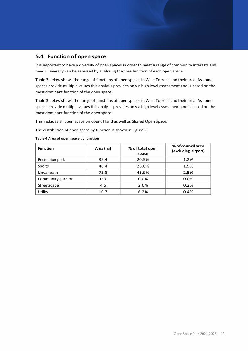
5.4 Function of open space It is important to have a diversity of open spaces in order to meet a range of community interests and needs. Diversity can be assessed by analysing the core function of each open space.
Table 3 below shows the range of functions of open spaces in West Torrens and their area. As some spaces provide multiple values this analysis provides only a high level assessment and is based on the most dominant function of the open space.
Table 3 below shows the range of functions of open spaces in West Torrens and their area. As some spaces provide multiple values this analysis provides only a high level assessment and is based on the most dominant function of the open space.
This includes all open space on Council land as well as Shared Open Space.
The distribution of open space by function is shown in Figure 2.
Table 4 Area of open space by function
Function Area (ha) % of total open space
% of council area (excluding airport)
Recreation park 35.4 20.5% 1.2% Sports 46.4 26.8% 1.5% Linear path 75.8 43.9% 2.5% Community garden 0.0 0.0% 0.0% Streetscape 4.6 2.6% 0.2% Utility 10.7 6.2% 0.4%

River T
orren
s
River Torrens
Linear Park
Lockleys Oval
Camden Oval
Weigall Oval
Linear Park Breakout Creek
Richmond Oval
Kings Reserve
Apex Park
Reserve
Westside Bikeway
Reece Jennings
Bikeway
Mellor Park Reserve
Captain McKenna
Bikeway
Deacon Ave Reserve
Coast Park Bikeway
Anna Meares Bikeway
Mike Turtur Bikeway
Thebarton Oval
City of West Torrens
Civic Centre and
Memorial Gardens
Western YouthReserve
Dog Park Westside Bikeway
MA
RIO
N R
OA
D
SOUTH RO
AD
RICHMOND ROAD
POR
T RO
AD
SIR DONALD BRADMAN DRIVE RAILW
AY TER
RA
CE
TAP
LEY
S H
ILL RO
AD
ASHWIN PARADE
AIR
POR
T R
OAD
ANZAC HIG
HWAY
HENLEY BEACH ROAD
CROSS ROAD
JAM
ES C
ONG
DON
DRI
VE
SOU
TH R
OAD
Figure 3
OPEN SPACE
- FUNCTION
Z0 1,000500
m
Open Space - Function
Linear path
Recreation park
Sports
Community garden
Streetscape
Utility
Council boundary
Roads
Watercourse
City of West Torrens

Open Space Plan 2021-2026 21
5.5 Access to open space There is growing evidence of the mental and physical health benefits enjoyed by people that have access to quality green open spaces. Parks and other forms of open space provide opportunities for people to be in touch with nature and gain those positive health benefits. There are also environmental and economic benefits of open space, especially when these are provided in close proximity to where people live.
As residential densities in the City of West Torrens increase, the amount of private open space and incidental green space is likely to diminish. The diversity of population in West Torrens, i.e. age cohorts, family and lone households, cultural backgrounds, and car ownership, will also influence the demand for open space.
The City of Weest Torrens strives to provide access to a range of open space types, including providing open spaces within walking distance of homes, i.e. within a radius of approximately 400m.
Open spaces that provide for social/family recreation and exercise close to homes not only provide a space for a range of activities, but they also provide restorative qualities that enhance wellbeing, and therefore accessibility to these spaces is important. Having strong connectivity across the council area such as providing a high quality shared path network is also important.
As it can be a challenge to provide parks close to every home in every suburb, alternative ways need to be explored to ensure people have access to quality open spaces. This may include enhancing the function, amenity and facilities of existing spaces or designing urban spaces in activity centres that are more people- centric and support community activities, such as plazas, and piazza style areas.
Figure 4 shows the location of open spaces within the City of West Torrens (dark green) and open spaces adjacent to the council area (dark brown), and their 400m catchment areas Residential areas are also shown to demonstrate how close they are to open spaces.

River T
orren
s
River Torrens
Linear Park
Lockleys Oval
Camden Oval
Weigall Oval
Linear Park Breakout Creek
Richmond Oval
Kings Reserve
Apex Park Reserve
Westside Bikeway
Reece JenningsBikeway
Mellor Park Reserve
Captain McKenna Bikeway
Deacon Ave Reserve
Coast Park Bikeway
Anna Meares Bikeway
Mike Turtur Bikeway
Thebarton Oval
City of West Torrens Civic Centre and
Memorial Gardens
Western YouthReserve
Dog Park Westside Bikeway
ADELAIDE AIRPORT
MA
RIO
N R
OA
D
SOU
TH R
OAD
RICHMOND ROAD
POR
T RO
AD
SIR DONALD BRADMAN DRIVE RAILW
AY TER
RA
CE
TAP
LEY
S H
ILL RO
AD
ASHWIN PARADE
AIR
POR
T R
OAD
HENLEY BEACH ROAD
CROSS ROAD
JAM
ES C
ONG
DON
DRI
VE
SOU
TH R
OAD
Figure 4
OPEN SPACE
- PROVISION
Z0 1,000500
m
City of West Torrens
Watercourse
Roads
Council boundary
Open Space outside CoWT
Open space 400m buffer
Adelaide Airport
Open space CoWT
Open space outside CoWT
400m buffer

Open Space Plan 2021-2026 23
5.6 Open space gap analysis Access to open space is an important element in providing open space for the community. As shown in Figure 4, there are many suburbs with access to a local park within a 400m radius. However, some residential areas may not be in a comfortable walking distance to open space. These areas are anticipated to receive increased levels of infill development and higher density living. Consequently, these areas should be a priority for Council to explore ways to enhance accessibility and opportunities to provide additional open space.
Given the already built up character of these areas, opportunities to provide additional open space will be challenging and so alternative opportunities will need to be explored in order to provide quality open space that meet the needs of the community. There may be opportunities to create new smaller high quality parks, road closures and open space 'shared use agreements' with schools and other private landowners to enable public access to open spaces and play facilities.
In addition to providing more open space in these priority areas, opportunities to improve accessibility and walkability may include modification to low use roads so they become more walking and cycling friendly, addition of more landscaping and trees, apply techniques to slow down traffic, and reduce the dominance of cars in such streets. This will not only enhance access to open space but also turns streets into attractive urban spaces which the community can enjoy, as well as providing environmental benefits.
Appendix C – Open space by suburb describes current and potential future open space provision for each suburb within the City of West Torrens. By 2030, and based on population prediction, several suburbs within the City of West Torrens will have a lack of open space with some areas achieving less than one hectare per 1000 people which sits well below the benchmark of three hectares per 1000 people.
In addition, the distribution of open space in some suburbs limits access for many residents with walking distances exceeding the acceptable 400m radius.
Due to projected population increase and current availability the following suburbs are identified as high priority 'gap'. Due to low provision and poor distribution of open space , greater provision should be made available in these areas:
• Underdale/Torrensville
• Richmond/Marleston
• Hilton/ western Mile End
The following nine suburbs are identified as medium priority gap areas as they currently contain open space provision below the national benchmark:
• Ashford
• Brooklyn Park
• Camden Park
• Glandore
• Kurralta Park
• Mile End
• Netley

Open Space Plan 2021-2026 24
• West Richmond
The remaining suburbs within the City of West Torrens are close to achieving the open space benchmark or are currently exceeding this and will be assessed on a case by case basis in regards to open space upgrades and creation.
5.7 Connections and links The City of West Torrens continues to improve linkages between destinations and facilities in line with policies and plans including the 30-Year Plan for Greater Adelaide and Council’s Community Plan, Transport Strategy, and the principles of Creating Greener Places for Healthy and Sustainable Communities.
Priority destinations and facilities to be linked with open space include community centres, schools, shops/cafes, retirement and aged care precincts. Figure 5 shows these locations in the City of West Torrens.
The community enjoys the excellent bikeways established through West Torrens. These provide important connections for the many people who walk and cycle along them. There may be opportunities to extend these bikeways to provide additional access and enjoyment for users. Figure 5 shows existing bike connect routes in the City of West Torrens. There may be opportunities to enhance bikeways by linking in with secondary roads.
Drainage corridors are places that can be redeveloped as linear paths which provide appealing, safe and convenient linkages for people as an alternative to travelling on busy roads, as well as being an attractive destination. There may be opportunities to develop drainage corridors to provide spaces for linear paths, such as along Keswick Creek drain.
There may also be opportunities to modify roads, particularly local roads that are wide, to create a more cycling and pedestrian friendly environment. This will enhance the role of streets in providing green open space as well as provide linkages to parks and other open spaces.

River To
rrens
River Torrens
Linear Park
Lockleys Oval
Camden Oval
Weigall Oval
Linear Park Breakout Creek
Richmond Oval
Kings Reserve
Apex Park Reserve
Westside Bikeway
Reece JenningsBikeway
Mellor Park Reserve
Captain McKenna Bikeway
Deacon Ave Reserve
Coast Park Bikeway
Anna Meares Bikeway
Mike Turtur Bikeway
Thebarton Oval
City of West Torrens Civic Centre and
Memorial Gardens
Western YouthReserve
Dog Park Westside Bikeway
ADELAIDE AIRPORT
MA
RIO
N R
OA
D
SOU
TH R
OAD
RICHMOND ROAD
POR
T RO
AD
SIR DONALD BRADMAN DRIVE RAILW
AY TER
RA
CE
TAP
LEY
S H
ILL RO
AD
ASHWIN PARADE
AIR
POR
T R
OAD
HENLEY BEACH ROAD
CROSS ROAD
JAM
ES C
ONG
DON
DRI
VE
SOU
TH R
OAD
Figure 5
DESTINATIONS
AND LINKS
Z0 1,000500
m
City of West Torrens
Open Space
Bike direct routes
Roads
Watercourse
WaterWays
Council boundary
Land Use
Residential
Retail and food
Education (public)
Education (private)
Adelaide Airport

Open Space Plan 2021-2026 26
6 Open space vision, goals and strategies 6.1 Vision and goals The City of West Torrens’ vision, goals and strategies in this Open Space Plan have been developed in response to emerging issues, community aspirations and the opportunities identified in this Open Space Plan. These are described in the figure below:
Figure 5 Open Space vision, goals and strategies
Goals and strategies have been grouped under three key themes. Under each goal are a number of strategies aimed at enhancing the provision, quality, function and ongoing management of the open space network. Whilst specific actions will be developed through a separate Implementation Plan, some key priorities are highlighted under each Strategy.
A diverse, connected, vibrant and healthy open space network
Proximity, provision, connection and access
People, wellbeing, vitality and
environment
Delivery, management and operations
1. Diverse open spaces close to people
2. Connected open spaces
3. Vibrant and healthy places for people and
nature
4. Enhance community participation
5. Responsive and well managed open space
Vision
Themes
Goals

Open Space Plan 2021-2026 27
Theme 1 – Proximity, provision, connection and access
GOAL 1: DIVERSE OPEN SPACES CLOSE TO PEOPLE There are social, environmental and economic benefits of open space, especially when these are provided in close proximity to homes. The analysis of open space distribution in this Open Space Plan shows there is a good spread of open spaces across West Torrens, however there are locations where more open space would be desirable in order to enhance the walkability to parks.
As West Torrens experiences urban infill development, population growth and a reduction in private open spaces, there will be an increasing demand on the public open space network. Council has been upgrading numerous parks to better meet the needs of the community, however it will also explore future opportunities when possible to provide more open space to serve the growing population.
Providing a diversity of open spaces will also serve to ensure that the community will have a range of open space experiences now and in the future. The diversity of open spaces was explored in this Open Space Plan by analysing the 'functions' of open spaces (i.e. the type and experience offered in each open space). This indicates that there is a mix of open spaces offered, such as sporting grounds, linear pathways, parks for exercise and relaxation, as well as community gardens. It is important to ensure that the open spaces reflect the needs of the community over time.
Across the City of West Torrens, infill development and population growth are putting pressure on the existing open space network. In some areas there are already deficiencies in provision of open space and increasing population will exacerbate these. More open space is required to serve the needs of the community now and into the future.
The City of West Torrens will need to strategically plan for the delivery of open space that increases the overall open space provision and focuses on meeting future demands in gap areas. Reviewing and managing the hierarchy of open spaces will help ensure there is the right provision in the right place.
Strategies
1.1 Deliver a diversity of quality open space that meets the needs of people of all ages and all abilities.
Priorities:
• Review current open space facilities, landscaping and infrastructure in open spaces to identify any changes that would better meet the needs of the community
• Ensure a spread of open space hierarchies and functions across West Torrens to ensure access and diversity of spaces is provided
• Protect existing Council owned open space
• Identify opportunities to promote active aging in response the changes in community demographics, as well as supporting disability access and inclusion.

Open Space Plan 2021-2026 28
Strategies
1.2 Provide open space within walking distance of homes.
Priorities:
• Seek opportunities to provide and/or enhance accessible open space within walking distance of all homes
• Enhance the quality and/or function of open space in areas where there is an undersupply of open space.
1.3 Increase the provision of open space where there is an undersupply in higher population growth and higher demand areas.
Priorities:
• Purchase land and/or repurpose council-owned land for open space purposes, when possible
• Explore opportunities for council to accumulate revenue to purchase land for open space
• Liaise with local schools and other institutions regarding shared usage of playing fields and other opportunities
• Explore opportunities for open spaces associated with North-South Corridor Project.
GOAL 2: CONNECTED OPEN SPACE
Good access to open spaces is just as important as the open spaces themselves. Walking or cycling to open space enhances the health, wellbeing and community connection opportunities.
Connecting parks and reserves to each other, to residential areas and to key destinations will maximise access to open space. Greenways can provide walking and cycling routes along linear open spaces or transport routes with streetscapes improved with landscaping and tree planting. Creating and enhancing linkages will encourage walking and cycling between open space destinations and facilities, enabling connection with district and regional open space.
Strategies
2.1 Enhance linkages between open space and destinations (such as community centres, schools, shops/cafes, retirement and aged care precinct). (MORE CONNECTIONS)
Priorities: • Seek opportunities to modify roads and verges to improve community access and lower the
priority of cars on roads, such as local roads that are wide
• Identify locations along drainage corridors where public pathways can be developed, such as the Keswick Creek corridor and Brownhill Creek corridor
• Enhance the function and amenity of linkages by greening streetscapes (trees and grassed verges), wayfinding, signage, lighting, or other methods
• Explore opportunities to enhance open space and accessibility for an aging population and for people with disabilities.

Open Space Plan 2021-2026 29
Strategies
2.2 Strengthen connections, pedestrian and cycle paths and greenways. (BETTER CONNECTIONS)
Priorities: • Enhance (existing) bicycle and walking paths so they provide an 'all accessible' open space
network, such as with signage, design, etc
• Integrate pathways with neighbouring council areas so to reduce barriers such as River Torrens, Port Road, the Tramline and Anzac Highway.
Theme 2 – People, wellbeing, vitality and environment
GOAL 3: VIBRANT AND HEALTHY PLACES FOR PEOPLE AND NATURE Open space plays an important role in facilitating opportunities for recreation, social interaction and cultural activities, which together underpin active lifestyles and improved physical and mental health and wellbeing. It provides opportunities for people from diverse cultural backgrounds, different ages and differing abilities to meet, be active, enjoy the landscape and spend time outdoors. Open space also provides opportunities for art and cultural expression that recognises and promotes Kaurna culture and values as well as the culture and history of the community.
Open spaces provide places for nature, for natural processes to occur and for people to connect with nature. Within the urban environment, space for nature is limited which means all opportunities to enhance biodiversity and natural processes are extremely important.
As the climate gets warmer and drier and heatwaves become increasingly longer, hotter and more frequent, having green urban environments is increasingly important to provide shading and cooling. Planning for and delivering climate smart open space means the City of West Torrens needs open space that is designed for the future climate, maximises water and energy efficiency and minimises greenhouse gas emissions associated with construction and operation.
Strategies
3.1 Create safe, accessible, well-designed, attractive, multi-function open spaces to encourage community activation and recreation.
Priorities: • Adopt the 'Principles for Quality Green Public Space' when designing spaces
• Identify improvements to open spaces so they meet the needs of people of all ages and abilities, and incorporate the CWT Disability Access and Inclusion Plan requirements
• Promote the role of sport and active recreation in enhancing diversity, social inclusion, positive health and wellbeing
• Create socially engaging spaces.

Open Space Plan 2021-2026 30
Strategies
3.2 Integrate into the open space network the culture, heritage and art of a diverse community and acknowledge Kaurna culture.
Priorities: • Seek opportunities for:
o Dual naming of open spaces
o Interpretative signage
o Public art.
3.3 Develop climate smart2 open spaces by integrating green infrastructure, water management, biodiversity, and climate resilient landscape design.
Priorities: • Seek opportunities in the open space network for:
o Water Sensitive Urban Design and stormwater management
o Irrigation management
o Tree planting in open spaces such as parks, streets and other movement corridors (through Tree Strategy)
o Cooling and shading (natural and structural)
o Enhancing and developing biodiversity spaces and corridors
• Raise community awareness and education on climate smart open spaces.
GOAL 4: ENHANCE COMMUNITY PARTICIPATION Optimising community use of open space is critical to achieving the health, wellbeing and community benefits. Community participation in the planning, design and ongoing use of open space is also important to develop a sense of ownership, encourage care and protection and make sure community needs are being met.
To enhance community participation the City of West Torrens can promote the availability of open spaces and the benefits of being active or connecting with nature, as well as opportunities to participate in planning and design processes, management and monitoring. Demand for open space to host events and activities is expected to continue to increase and it will be increasingly important for Council to promote venues with suitable supporting infrastructure.
2 Climate smart means taking opportunities to building resilience to climate risk and reducing greenhouse gas emissions. Climate resilience means being able to survive, adapt and thrive as the climate changes and extreme weather events become more frequent and more intense. Directions for a Climate Smart South Australia describes the State government’s policy directions to adapt and mitigate climate change

Open Space Plan 2021-2026 31
Strategies
4.1 Encourage community participation in the planning, design and management of open space.
Priorities: • Provide opportunities for local communities to participate in the design and/or maintenance of
open spaces
• Promote the range of open spaces available to the community.
4.2 Promote events and activities held at open spaces to encourage community participation and attendance.
Priorities: • Communicate effectively with a diverse population
• Seek input from our multi-cultural community
• Be creative to make it easy for people to participate.
4.3 Support and encourage community participation in sports and recreational activities.
Priorities:
• Facilitate the use of open space / sporting fields for the wider community through adaptive uses which cater to a wide variety of uses
• Overcome barriers and promote enablers to participation for underrepresented groups.
Theme 3 – Delivery, management and operations
GOAL 5: RESPONSIVE AND WELL MANAGED OPEN SPACE The ongoing management of open space needs to balance the needs and expectations of the community with Council resource availability. Asset management plans and the open space hierarchy provide guidance for management and resource allocation however there is currently no guidance to support land acquisition for open space. A strategic and consistent approach to maintain and improve open space as well as increase provision of open space is needed to support the City of West Torrens to achieve its vision for open space.
Strategies
5.1 Develop a consistent approach to setting maintenance service levels across the open space hierarchy.
Priority:
• Undertake regular review of the open space hierarchy classifications and service levels for each area of open space (coordinate with Strategy 1.1)

Open Space Plan 2021-2026 32
Strategies
5.2 Maintain and improve the quality and amenity of open space in line with the Open Space Hierarchy, council budgetary resources and annual work programs
Priority: • Seek input from the community on desired use of open spaces to help inform budgetary and
resourcing requirements
5.3 Acquire land for open space in suitable areas through a transparent and accountable process
In collaboration with Strategy No. 1.2, explore opportunities such as: • Developing a Policy and a set of procedures and criteria that will enable staff to negotiate the
purchase of land
6.2 Implementation Plan The Goals and Strategies in this Open Space Plan will be delivered through a number of key priorities as described in the table above, over the next 5 years. An internal Implementation Plan will be developed to outline the detailed actions, roles, responsibilities and timeframes of those actions. The progress of these will be reported to Council on an annual basis.

Open Space Plan 2021-2026 33
Appendix A – Planning and policy context The Open Space Plan is informed by and helps support objectives of a range of council and state government documents, as summarised below.
City of West Torrens plans and strategies:
• City of West Torrens Community Plan 2030 (2021)
• Open Space for Higher Density Structure Plan (2019)
• Underdale and Torrensville Urban Renewal DPA Open Space Study (2017)
• Public Realm Design Manual (2019)
• Tree Strategy 2018 – 2025
• Recreation and Open Space Asset Management Plan
• Open Space and Public Place Plan (2013)
• Adapt West Climate Change Adaptation Plan (2016)
• Disability Access and Inclusion Corporate Plan 2019 – 2021 (2019)
• Transport Strategy
• Water Management Action Plan
• Public Health Plan.
Other plans and strategies
• Creating Greener Places for Healthy and Sustainable Communities (2019)
• 30 Year Plan for Greater Adelaide (2017).
City of West Torrens - plans and strategies
City of West Torrens Community Plan 2030 (2021)
The Community Plan is the City of West Torren’s lead strategic document that identifies community aspirations and how Council will achieve the community’s vision of West Torrens – committed to being the best place to live, work and enjoy life.
The Community Plan contains five focus areas and these contain strategic objectives. The Open Space Plan is informed by, and supports, the key focus areas and strategic objectives of the Community Plan:
Community life - We support diversity, health and well-being, community cohesion and connections, and create opportunities to learn and enjoy the local area. Strategic objectives that are most relevant to the Open Space Plan include the following:
Built environment - We ensure housing, urban development and infrastructure contribute to attractive and safe neighbourhoods, and how we travel in and beyond our area.
Prosperity - We support jobs, businesses and industries to generate local economic growth and activity.

Open Space Plan 2021-2026 34
Environment and sustainability - We protect and conserve the natural environment, reuse and recycle resources, support biodiversity and respond to climate change.
Organisational strength - How Council ensures its services lead to quality outcomes and exceptional experiences for our community.
Open Space for Higher Density Structure Plan (2019)
The Open Space for Higher Density Structure Plan is focussed on the provision of open space within the context of medium to high density development within the Urban Corridor Zone and Residential Zone (medium density policy areas). Focussing on the changing densities occurring within the City of West Torrens and pressures on open space within the densifying suburbs, the report identifies strategic areas in which additional open space is required, including Torrensville, Brooklyn Park, Mile End, Marleston, North Plympton, Keswick and Glandore.
The report utilises four key ‘themes’ for open space planning which have defined opportunities. They are focussed on open space provision, design and maintenance, location and accessibility and funding and governance.
The higher density areas will be likely to see rising demand for open space compared to other residential areas where population is unlikely to increase to such an extent. This report identifies that many of the areas designated as medium density areas are already low in open space provision. It is also states there is no typical ‘higher density resident’ and therefore a diversity of open space types and experiences may be needed in order to cater for a range of needs and interests.
The report identifies that future open space plans need to have a focus on ‘other spaces’ such as greenways, drainage reserves and streetscapes, which can link or connect existing open spaces. Expanding the network of accessible open space within walking distance of homes is also an important element which should be investigated. Projections within the report found that a significant amount of the higher density areas will have a shortfall of open space within 400 metres of homes by 2027. Council will need to consider innovative ways to deliver of open space in these areas, such as by closing or narrowing low use roads, creating small pocket parks, and exploring open space 'shared use agreements' with schools and other private landowners to enable public access in their open spaces and play facilities.
This report recommends:
• Identify opportunities for open space and public realm provision and enhancement in those priority areas as identified by the Structure Plan
• Develop more detailed ‘precinct’ plans for open space and public realm provision and enhancement in the identified priority areas
• Review and amend planning policy to ensure it facilitates the achievement of open space and public realm outcomes proposed by this Structure Plan
• Explore opportunities for the provision of/sharing open space with schools.
• Concept of link and place- finding ways to enhance the journey to open space and/or links parcels of open space

Open Space Plan 2021-2026 35
Underdale and Torrensville Urban Renewal DPA Open Space Study (ekistics, 2017) recommends:
• A new Local level open space facility within the area to be rezoned in the vicinity of Ashley Street
• A new Local level open space in the vicinity of Carlton Parade
• Potential open space connection through the Symbion site to link the proposed new local level open space and the River Torrens Linear Park
• An upgrade to the cycling and walking facilities along Hardys Road to improve connections between the existing and future retail areas along Henley Beach Road and the River Torrens Linear Park.
Public Realm Design Manual (2019)
The Public Realm Design Manual provides the Council with direction regarding the development of high quality, recognisable and environmentally sustainable streetscapes and public open space. This document balances the needs of the community and presents objectives which will contribute to fostering the Council’s ‘sense of place’.
The manual sets out approaches to the public realm which can be implemented to meet a wide array of issues such as urban heat, active streets, climate change and flexible open spaces. Including increased tree planting to streets, reclaiming more public spaces along streets, planting targeted canopy cover and increasing quality and provision of open spaces.
The Open Space Plan will seek to identify opportunities for these design approaches as well as identify the areas where additional open space may be needed.
Tree Strategy 2018 – 2025
The City of West Torrens’ Tree Strategy recognises the importance of trees within the Council area and the need to improve delivery and management of existing and new trees. This strategy details the importance of trees and the impact they can have on the environment and quality of life for residents. It is noted that urban forests assist in filtering groundwater, reducing the flow of stormwater runoff and absorb air pollution.
Furthermore, increasing trees within Council streets and open spaces can improve the overall amenity of neighbourhoods by providing shade and colour as well as slowing traffic, reducing noise and screening views. Trees and open spaces have been shown to have beneficial impacts on psychological and social aspects of human life and can be related to a reduction in stress levels and increased physical activity.
The vision for the tree strategy is to create a city that recognises the contributions trees make to the character and amenity of neighbourhoods, to biodiversity, to public health and the wellbeing of the community. The strategy contains four objectives:
• Protect the existing urban forest • Expand the urban forest canopy cover comprising a diverse species mix • Improve the health and growing conditions of the urban forest • Inform and engage with the community and stakeholders to help develop Council’s urban forest
initiatives

Open Space Plan 2021-2026 36
Recreation and Open Space Asset Management Plan
Council's Asset Management Plan for Recreation and Open Space describes the investment required to manage open space assets to agreed service levels. It describes these service levels however there is no differentiation of service levels for different hierarchy open space. The Plan also describes future drivers of service delivery and utilisation of assets, including development and associated population change.
The Asset Management Plan only covers the renewal or upgrade of existing assets. The plan does refer to new works that create a new asset that did not previously exist (eg a new playground at a park that did not have one) but does not refer to the acquisition of new property.
Open Space and Public Place Plan (2013)
The 2013 Open Space Plan sets a vision for the equitable distribution of quality and useable public open space which is both accessible and of adequate size to accommodate the increasing population, recognising the correlation between an increase in density and increase in demand for public open space and public places.
Adapt West Climate Change Adaptation Plan (2016)
The Western Adelaide Region will face warmer and drier conditions, with increasing risks from heatwaves, flooding and sea level rise. To build the resilience of the Region, a climate change adaptation plan was developed to provide the foundation for a coordinated and collaborative.
A number of priorities in this plan have links with managing open space, including:
• Increase urban greening;
• Plan and design climate resilient buildings, places and spaces;
• Manage urban runoff to mitigate flood risk and improve water quality and reuse; and
• Embed climate considerations into asset management plans.
The Open Space Plan provides a key mechanism to identify and describe the on-ground actions required to deliver these desired outcomes that will increase the resilience of the City of West Torrens and the region more broadly.
Disability Access and Inclusion Corporate Plan 2019 – 2021 (2019)
The City of West Torrens Disability Access and Inclusion Corporate Plan identifies opportunities to address 6 key local issues where Council can have an impact. The accessibility of assets issue has the strongest links to open space, and the plan identifies key initiatives including improving the provision of universal design in public spaces including open space and adopting universal design principles when planning for procurement in the public realm.
Transport Strategy
The Transport Strategy guides how Council can best meet the City's traffic and movement needs over the next 20 years, as well as issues relating to promoting active forms of travel such as walking and cycling, and the linkages across the City.

Open Space Plan 2021-2026 37
Water Management Action Plan
The Water Management Action Plan aim to enhance the sustainability of our water resources and in doing so influences the way council, and the community, uses and manages its water. A key driver is to minimise the consumption of and dependence on potable (drinking) water for non-potable needs, such as open space irrigation and building service amenities, and to improve the health of watercourses and quality of stormwater discharges to Gulf St Vincent. This has included upgrades to more efficient forms of irrigation, water efficient devices, and the expansion of the pipe network for recycled wastewater irrigation from the Glenelg Wastewater Treatment Plant to Council open spaces (known as the GAP water).
Public Health Plan
The City of West Torrens has a vital role in supporting the health and wellbeing of the community, and the Public Health Plan sets the framework to assist health providers and partners in supporting a healthy and inclusive community.
Council facilitates a healthy community through providing community facilities and libraries; health promotion; safe roads, footpaths and cycle ways; open space and public places that support physical activity and social interaction.
Other plans and strategies
Creating Greener Places for Healthy and Sustainable Communities (2019)
As South Australia moves to a new planning system, the State Government has developed this plan to help recognise and support the role of quality green open spaces in changing neighbourhoods. The plan is not intended as a technical manual, rather a catalyst to promote the importance of open spaces in our neighbourhoods.
The principles set out within this plan are directly related to the Open Space Plan and provide direction on the importance of providing quality green open spaces in the City of West Torrens. The six principles are:
1. Promote community health and wellbeing 2. Connect with nature 3. Build stronger communities 4. Deliver connectivity and access for all 5. Contribute to neighbourhood character 6. Support resilient neighbourhoods
30 Year Plan for Greater Adelaide (2017)
In May 2017, the State Government released the 30-Year Plan for Greater Adelaide – 2017 Update which sets directions for how Adelaide should grow to become more liveable, competitive and sustainable. The update builds upon the original Plan released in 2010 and refocusses key principles, policies and actions for the region based on the knowledge acquired over the last seven years.

Open Space Plan 2021-2026 38
The update continues to emphasise the need for increased urban densities along key transit corridors and infill sites and additional housing mix and highlights the need for this to be supported by healthy walkable neighbourhoods which provide quality public open space and streets. These spaces need to connect people with nature, support social interaction and be walking and cycling friendly. The update supports the increasing role that accessible public open space plays in supporting recreation and social wellbeing as urban densities increase.
When considering the updates alignment with increased population and public open space goals of the City, the following targets are of particular importance:
• Target 4 - Walkable Neighbourhoods: Increase the percentage of residents living in walkable neighbourhoods in Inner, Middle and Outer Metropolitan Adelaide by 25% by 2045.
• Target 5 - A green liveable city: Urban green cover is increased by 20% in metropolitan Adelaide by 2045.
• Target 6 - Greater housing choice: Increase housing choice by 25% to meet changing household needs in Greater Adelaide by 2045.
The above targets are supported by a number of policy themes, policies and actions that provide the necessary pathways to achieve the targets.
As part of the planning reforms, planning regions were proclaimed in March 2020 and regions now have 3 years to prepare and adopt a Regional Plan. Until these plans are prepared, the existing South Australian Planning Strategies (ie the 30-Year Plan for Greater Adelaide) will apply.

Open Space Plan 2021-2026 39
Appendix B - Community profile Population and age structure
The estimated population of the City of West Torrens in 2019 was 60,842 (profile.id, 2020).
Figure 6 shows the age structure of West Torrens compared to the Greater Adelaide area and Figure 7 shows the change in age structure of the West Torrens community from 2011 to 2016. The graphs shows that there is a greater proportion of people aged between 20 and 39 in West Torrens compared to Greater Adelaide and that the greatest growth in population has been in the 25 to 34 year bracket.
The increase in children aged under ten along with the increases in 25 to 39 year olds suggests there has been an increase in families living in the City of West Torrens. Continued growth in these demographic groups will increase demand for open space as well as an ongoing demand for a sports hub as the demographic mature.
The figures also show the proportion of people aged 85 and over is greater in West Torrens and the number of people in this age group increased from 2011 to 2016. There has also been growth in the 45-69 age groups.
Figure 1 Age structure, 2016 (profile.id, 2020)
0.0
1.0
2.0
3.0
4.0
5.0
6.0
7.0
8.0
9.0
10.0
0 to 4 5 to 9 10 to14
15 to19
20 to24
25 to29
30 to34
35 to39
40 to44
45 to49
50 to54
55 to59
60 to64
65 to69
70 to74
75 to79
80 to84
85 andover
% o
f tot
al p
opul
atio
n
City of West Torrens Greater Adelaide

Open Space Plan 2021-2026 40
Figure 2 Change in age structure (City of West Torrens) 2011 to 2016 (profile.id, 2020)
Population projections
The Department of Planning, Transport and Infrastructure regularly updates population projections for South Australia. For the purposes of this report, these have been analysed at the SA2 level which is the smallest geographic area projections are prepared for, to understand the future growth within the City of West Torrens. The City of West Torrens is divided in 5 populated SA2 areas as illustrated in Figure 8.
Figure 3 SA2 boundaries
-200
-100
0
+100
+200
+300
+400
+500
+600
+700
0 to 4 5 to 9 10 to14
15 to19
20 to24
25 to29
30 to34
35 to39
40 to44
45 to49
50 to54
55 to59
60 to64
65 to69
70 to74
75 to79
80 to84
85 andover
Chan
ge in
num
ber o
f peo
ple

Open Space Plan 2021-2026 41
Tables 5 – 7 provides the population projections from 2016 to 2036. The table shows there is limited population growth expected across all five statistical areas within the next five to ten years. The population growth begins to steadily increase from 2031 onwards, with the largest percentage of population growth focussed in Richmond and Plympton (SA2). By 2036, it is expected that the Plympton SA population would have increased by nearly 18%, whilst Richmond SA2 would have increased by nearly 16%. These growth projections offer timeframe for delivery of open space across the council. A focus of the open space strategy will be to capitalise on the timeframe in terms of the planning, delivery and management of open space.
This projected population increase within Plympton and Richmond aligns with the areas designated as Medium Density Policy areas.
Table 1 Population projections 2016 – 2036 (DPTI, 2020)
SA2 Population projection for 30 June 2016
Population projection for 30 June 2021
Population projection for 30 June 2026
Population projection for 30 June 2031
Population projection for 30 June 2036
Fulham 2752 2785 2798 2828 2917 Lockleys 13016 13388 13754 14243 14771 Plympton 24828 25653 26736 28025 29517 Richmond 16975 17259 18171 19188 19820 West Beach – Adelaide Airport
5118 5222 5327 5457 5644
Table 2 Population change 5-year increments (total number) (DPTI, 2020)
SA2 Population Increase 2016-2021 (#)
Population Increase 2021-2026 (#)
Population Increase 2026-2031 (#)
Population Increase 2031-2036 (#)
Population Increase 2016-2036 (#)
Fulham 33 13 40 79 165 Lockleys 372 366 489 528 1755 Plympton 825 1083 1289 1492 4689 Richmond 284 912 1017 632 2845 West Beach – Adelaide Airport
104 105 130 187 526
Table 3 Population change 5-year increments (% change) (DPTI, 2020)
SA2 Percentage Increase 2016-2021 (%)
Percentage Increase 2021-2026 (%)
Percentage Increase 2026-2031 (%)
Percentage Increase 2031-2036 (%)
Percentage Increase 2016-2036 (%)
Fulham 1.19 0.42 1.42 2.78 6 Lockleys 2.86 2.73 3.56 3.70 12.8 Plympton 3.32 4.82 4.82 5.32 17.69 Richmond 1.67 5.28 5.60 3.29 15.84 West Beach – Adelaide Airport
2.0 2.0 2.44 3.42 10

Open Space Plan 2021-2026 42
6.2.1 Other demographic characteristics Other demographic characteristics are described in Table 8. The table shows that the West Torrens community is more culturally diverse than the Greater Adelaide population, with nearly one-third of people speaking a language other than English at home. This suggests that an ‘inclusion’ approach should be applied to all open space to ensure that the design, planning and upgrades are multicultural, inclusive and highly accessible.
There is a similar proportion of the population living with disability in West Torrens compared to Greater Adelaide, as indicated by the proportion of people requiring assistance with core activities.
Table 4 Demographic characteristics (ABS, 2017)
Characteristic City of West Torrens 2016 Percentage of total population
Greater Adelaide 2016 Percentage of total population
Born overseas 30.6% 26.3%
Speaks language other than English at home
30.8% 19.6%
Aboriginal or Torres Strait Islander 1.0% 1.4%
Year 12 completion 59.5% 53.5%
University of tertiary education 27.7% 16.2%
Requiring assistance with core activities
5.6% 5.9%
6.2.2 Household, dwelling and transport characteristics Table 9 shows a number of household characteristics. In 2006, the average household size in the City of West Torrens was 2.17 people. Just over one third of households in the council area include children, and there are similar proportions of lone person households and multiple person no child households. There are a greater proportion of lone person households in the City of West Torrens than for Greater Adelaide however a smaller proportion of households with children.
Table 5 Household characteristics (profile.id, 2020)
Characteristic City of West Torrens Percentage of total population
Greater Adelaide Percentage of total population
Lone person household 30.2% 26.2%
Multiple person no children household
29.7% 28.5%
Household with children 34.3% 39.7%
Average household size 2.29 persons per dwelling 2.42 persons per dwelling
Table 10 shows the distribution of selected household characteristics across the SA2 areas. This shows that there is a similar distribution of lone person households across Fulham, Lockleys and Richmond, with slightly more lone person households in Plympton and less in West Beach. The distribution of households with no children is relatively similar across all SA2 areas while there are slightly more households with children in Fulham and Lockleys than the other areas.

Open Space Plan 2021-2026 43
Table 6 Household characteristics for SA2 areas (ABS, 2017)
Characteristic Fulham Lockleys Plympton Richmond (SA) West Beach
Number (% of households) Lone person household
311 (26%) 1588 (27%) 3252 (29%) 2119 (27%) 537 (23%)
Multiple person no children household
296 (25%) 1471 (25%) 3142 (28%) 2045 (26%) 667 (28%)
Household with children
435 (37%) 2053 (35%) 3475 (31%) 2442 (32%) 739 (31%)
Table 11 shows the change in dwelling characteristics between 2006 and 2016. Of particular note is the larger increase in medium density dwellings, which increased by about 80% in 10 years. This indicates both an increase in density and an increase in built form footprints across the cities.
Table 7 Dwelling characteristics (ABS, 2017)
Characteristic City of West Torrens Number of dwellings
2006
City of West Torrens Number of dwellings
2016
Change 2006-2016
Separate house 14,690 14,909 +219
Semi-detached / townhouse (medium density)
2,804 5,049 +2245
Flat or apartment (high density)
4,842 3,192 -1650
Rented 7,543 (33.7%) 8,470 (36.4%) + 927
Owner occupied 13,680 (61.1%) 13,829 (59.4%) + 149
Table 12 shows the main method of travel to work of the working population in 2016. Of note is the greater proportion of residents that catch public transport or cycle to work compared to Greater Adelaide.
Table 8 Travel to work (profile.id, 2020)
Main method of travel to work City of West Torrens 2016 Percentage of employed people
Greater Adelaide 2016 Percentage of employed people
Car (as driver) 61.2% 66.0%
Car (as passenger) 5.0% 4.5%
Bus, train or tram 12.1% 8.5%
Bicycle 2.2% 1.1%
Walk 2.5% 2.2%

Open Space Plan 2021-2026 44
6.2.3 Implications for open space planning Across the council area the mixed aged groups have different demands for open space. For example, families with young children are more likely to want playgrounds near to their homes, young adults may want dedicated sports fields and events to be held in parks, while older people may want nearby spaces that are designed to be age-friendly with good public transport options or places to take their grandchildren. This may require increasing open space provision close to aged care or supported residential care facilities. The increasingly active retiree cohort may also benefit from active recreation opportunities and walking and cycling trails that connect desirable destinations. Walking and cycling paths that are connected and shaded are required.
Nearly two-thirds of households do not have children and are likely to want open space that provides opportunities to host gatherings with bbq or picnic facilities. Opportunities for open space to host formal and informal events and celebrations are important to support community connection, particularly for lone-person households.
Open spaces and public places provide opportunities for people of different cultural backgrounds to interact with each other in ways specific to their cultural customs/social practices and experience how people from other cultures celebrate special events.
A “successful” multicultural environment is one where various group's sense of comfort is combined with good physical design to create an atmosphere that can nurture many preferences; a place that fosters social interaction while simultaneously creating distinct "spaces" where individual cultures can be emphasized and celebrated (Knapp, 2009)3.
Open space design should not be a barrier to people living with disability from joining opportunities for social participation and interaction. Providing accessible open spaces where people with disabilities can easily move around, use facilities and enjoy the landscape is a priority of council’s DAIP.
Projected increases in population mean there is a need to start planning, managing and delivering open space in Plympton and Richmond over the next ten years. This will ensure that when the population comes, there is already the open space provision required to meet their needs. This needs to be undertaken in a strategic manner with progressive updates, development and delivery of open space. Council's Open Space Plan needs to set out opportunities to deliver new open space within these growing areas and establish key landscape and open space infrastructure.
Higher density areas have been shown to support a range of social, environmental and economic benefits, however to be successful, this shift in urban form must be accompanied by associated increases in quality open space and public places. These spaces and places must support the higher concentration of residents, and must also be considered in the context that there is no typical ‘higher density resident’ which in turn results in different open space and public place needs.
3 Knapp, C (2008) Making multicultural places, Project for Public Spaces, https://www.pps.org/article/multicultural-places

Open Space Plan 2021-2026 45
Appendix C – Open space by suburb

Open Space Plan 2021-2026 46
Table 9 Open space by suburb
Suburb 2016 population Suburb area (ha) (West
Torrens only)
Area open space in City of West
Torrens (ha)
Population estimate 2036 Key open space areas
Adelaide Airport 0 727.6 3.3 0 Anna Meares Bikeway, captain McKenna bikeway
Ashford (SA) 957 30.8 0.5 1126
Brooklyn Park 4786 154.9 1.7 5399 College Grove Park, Lyons St Reserve
Camden Park (SA) 3140 122.2 2.8 3696 Westside Bikeway, Cromer St reserve
Cowandilla 1435 52.6 3.2 1662 Western Youth Reserve, Cowandilla Primary School
Fulham (SA) 2702 132.6 20.8 2864 Torrens Linear Park, Coast Watchers Park, East Parkway Reserve
Glandore 1781 44.1 1.2 2096 St Georges Ave Reserve, Jubilee Park
Glenelg North 1251 82.4 2.8 1472 Golflands Reserve, Glenelg baseball club, Patawalonga frontage
Hilton (SA) 838 37.4 0.6 970 West Torrens Memorial Gardens, Civic Centre
Keswick 745 44.8 1.2 877 Kesmond Reserve
Keswick Terminal 0 58.7 0.0 0
Kurralta Park 2820 79.9 2.1 3319 Grassmere reserve, Westside Bikeway
Lockleys 5629 314.2 33.1 6350 Torrens Linear Park, Lockleys Oval, Mellor Park Reserve, Noble Ave Reserve
Marleston 1832 97.5 2.6 2156 Westside Bikeway, West Torrens Dog Park, Peake Gardens tennis club
Mile End 4432 182.1 2.7 5132 Mile End Common
Mile End South 26 66.8 0.0 26
Netley 1770 96.5 2.0 2083 Baroda Avenue reserve, Joe Wells Reserve, Beare Ave reserve
North Plympton 3226 152.3 4.0 3797 Westside Bikeway, Rex Jones Reserve, Sandringham Reserve
Novar Gardens 2505 176.4 16.4 2948 Camden Oval, Cummins House Reserve, Graham Crs reserve, Lindfield Reserve, St Andrews Reserve
Plympton 4752 177.4 12.3 5593 Weigall Oval, Westside Bikeway, Errington St Reserve
Richmond (SA) 3302 140.6 7.9 3824 Hisense Stadium (Richmond Oval), Westside Bikeway

Open Space Plan 2021-2026 47
Suburb 2016 population Suburb area (ha) (West
Torrens only)
Area open space in City of West
Torrens (ha)
Population estimate 2036 Key open space areas
Thebarton 1430 117.4 3.3 1656 Dove St reserve
Torrensville 4045 206.1 15.9 4684 Kings Reserve, Thebarton Oval, Torrens Linear Park, Frank Norton Reserve
Underdale 2302 102.8 6.6 2597 Torrens Linear Park, Underdale High School
West Beach (SA)* 2483 291 24.9 2731 Torrens Linear Park, Apex Park, University Playing Fields, Pacific Parade Reserve
West Richmond 965 38.1 0.5 1117 Britton St Reserve
* Only refers to part of suburb within the City of West Torrens

51 Open Space Plan 2021-2026