openstreetmap data in layered gis-format - geofabrik · openstreetmap data in layered gis format //...
TRANSCRIPT
OpenStreetMap Data in Layered GIS Format // Version 0.7.4
OpenStreetMap Datain
Layered GIS Format
Version 0.7.4 - 2017-10-05
Frederik Ramm <[email protected]>
Table of Contents
1 Preface...........................................................................................................................................................22 Introduction.................................................................................................................................................3
2.1 Versions................................................................................................................................................32.2 Map datum..........................................................................................................................................32.3 Character encoding...........................................................................................................................32.4 Attribute names.................................................................................................................................32.5 Common attributes...........................................................................................................................42.6 International Names.........................................................................................................................42.7 Layers...................................................................................................................................................42.8 Points and Areas................................................................................................................................52.9 Spillover Shape Files.........................................................................................................................5
3 Feature Catalogue - Overview................................................................................................................54 Point Features.............................................................................................................................................6
4.1 Places (“places”).................................................................................................................................64.2 Points of Interest................................................................................................................................74.3 Places of Worship (“pofw”)...........................................................................................................124.4 Natural Features (“natural”)..........................................................................................................134.5 Traffic Related (“traffic”)................................................................................................................134.6 Transport Infrastructure (“transport”).......................................................................................154.7 Power Generation and Distribution (“power”)........................................................................16
5 Line Features.............................................................................................................................................165.1 Boundaries (“boundaries”)............................................................................................................165.2 Roads and Paths (“roads”).............................................................................................................175.3 Railways, Subways, Trams, Lifts, and Cable Cars (“railways”)...........................................185.4 Waterways (“waterways”).............................................................................................................195.5 Coastline (“coastline”)....................................................................................................................195.6 Power lines (“powerlines”)............................................................................................................205.7 Runways and taxiways..................................................................................................................205.8 Infrastructure disused, planned, under construction (“nonop”)..........................................205.9 Barrier-type linear features ("barriers").....................................................................................22
6 Polygon Features......................................................................................................................................226.1 Administrative Areas (“adminareas”).........................................................................................226.2 Building outlines (“buildings”).....................................................................................................236.3 Land use and land cover (“landuse”)..........................................................................................236.4 Bodies of Water (“water”)..............................................................................................................246.5 Landmass and Oceans....................................................................................................................24
7 Routes..........................................................................................................................................................24
1

OpenStreetMap Data in Layered GIS Format // Version 0.7.4
7.1 Routes.................................................................................................................................................258 Migrating from Free Shape Files..........................................................................................................25
8.1 Associated Area Layer...................................................................................................................258.2 Additional Layers............................................................................................................................258.3 Additional Feature Classes............................................................................................................26
Version History and Copyright
Version Created At Changes0.5 2010-02-20 Add bridge and tunnel attributes to road shapes
Add layer, bridge, and tunnel attributes to railway line shapeAdd operator attribute to powerline shapeAdd note about splitting road layer for large extracts
0.6 2011-09-16 Add many new POI types, and section about area POIs. Add new traffic layer and new “non-operational” layer.Rename “railwaystations” layer to “traffic” and include information about air and sea traffic. Add many definitions.Added section on spillover shape files.
0.6.1 2012-02-04 Added "barriers" layer; added vineyards, orchards, military landuse and quarries to landuse layer; added rack railways to railway layer.
0.6.2 2012-07-30 Added section on “international names”; updated section on landmass and oceans.
0.6.3 2014-01-30 Added a few more aerialway values to the railways layer; added natural parks.0.6.4 2014-03-12 Added a column “type” in the buildings layer.0.6.5 2014-11-01 Added new “named_place” in places layer, fix a few missing codes0.6.6 2015-07-06 Fix openstreetmapdata.com reference0.6.7 2015-09-22 Add feature code 1005 in places layer0.6.8 2016-01-28 Add X=proposed in nonop layer0.7.0 2016-06-01 Add aeroways and routes layer, change codes of powerlines layer, redesign
nonop layer (new codes and feature classes), use Navteq's nomenclature for “oneway” column, add levels and height column to buildings layer.
0.7.1 2016-10-25 Add ferries, add ref field to traffic layer.0.7.2 2017-01-24 Use amenity=taxi instead of amenity=taxi_rank. See taginfo.osm.org for details.
Add waterway=dock.0.7.3 2017-03-02 Swap codes 5205 and 5208 (ford and speed camera). They were swapped in the
produced shape files. Add Buddhist, Taoist, Shintoist, Sikh and Hindu places of worship.
0.7.4 2017-10-06 Add feature classes basin, village_green, brownfield, greenfield, plant_nursery, construction and railway to the landuse layer. Split up feature class “farm” into “farmyard” and “farmland”.
Copyright in this document is held by Geofabrik GmbH. Some definitions have been extracted from the OpenStreetMap Wiki at http://wiki.openstreetmap.org/. Permission is granted to re-use this document whole or in part under the terms of the Creative Commons Attribution-Share Alike 2.0 license provided that proper attribution is given.
1 PrefaceThe OpenStreetMap (OSM) project (www.openstreetmap.org) has collected an enormous
2

OpenStreetMap Data in Layered GIS Format // Version 0.7.4
amount of free spatial data and the database is growing every day. Many people want to usethis data for their own GIS projects but have been hindered by the use of a non-standard data format in the OSM project. This document describes a mapping from OSM data formatsto the usual GIS formats to make the OSM data accessible to more people.
The mapping from OSM data to other formats is not an exact science. OSM rules on how to map certain features are often not well defined and there is no mandatory quality control. This openness allows a lot of flexibility and is part of the reason why OSM has been able to collect so much data in such a short time frame, but it makes using the data more difficult. When using or exporting the data, many decisions have to be made on how to extract the different features into something usable for the task at hand.
The mapping described in this document is in no way the only mapping possible, in fact there is an infinite number of possible mappings. In this document we have specified a general-use mapping of the basic features like roads, waterways, different land use types, and points of interest. Other uses might need specialized mappings, but they are out of the scope of this document.
The format described in this document is used by Geofabrik to create shapefiles and other formats for its clients.
2 Introduction
2.1 Versions
This is no static document. New versions of this document are likely to appear from time to time. If the definition of layers or features is changed significantly, the layers will get new version identifiers.
Layer names will use version numbers with leading 'v' and without the embedded '.': So version 0.1 of this document will use the suffix “v01”, version 2.7 will use “v27” (minor versions above 9 are not allowed).
2.2 Map datum
All coordinates are unprojected WGS84 (EPSG:4326).
2.3 Character encoding
All strings are encoded in UTF-8.
2.4 Attribute names
All attribute names are lower case and are less than 11 characters long so that they are not truncated in shapefiles.
3

OpenStreetMap Data in Layered GIS Format // Version 0.7.4
2.5 Common attributes
Most tables/shape files will have the following columns/attributes:Attribute PostGIS Type Descriptiosteps/gis-roads-v06.pln
id VARCHAR(4 Bytes)
Id of this feature. Unique in this layer.
osm_id VARCHAR(10)
OSM Id taken from the Id of this feature (node_id, way_id, or relation_id) in the OSM database. In case several features in the OSM database are joined into one feature, this is one of the Ids. This Id is not necessarily unique because one OSMobject can result in several geometry objects.Also note that when doing shape file exports, this will be exported as a VARCHAR type since shape files don't support long integers.
lastchange TIMESTAMPWITHOUTTIME ZONE
Last change of this feature. Comes from the OSM last_changed attribute. Reflects changes in the attributes of a feature; changes in the geometry will not necessarily change this.
code SMALLINT(2 Bytes)
4 digit code (between 1000 and 9999) defining the feature class. The first one or two digits define the layer, the last two or three digits the class inside a layer.
fclass VARCHAR(40) Class name of this feature. This does not add any information that is not alreadyin the “code” field but it is better readable.
name VARCHAR(100) Name of this feature, like a street or place name. If the name in OSM contains obviously wrong data such as “fixme” or “none”, it will be empty. See note on “international names” below!
The code and the combination of layer name and fclass always contains the same information.
2.6 International Names
In OpenStreetMap, every feature can have many names. The standard name is always the name used on the ground, locally, usually the name as it would be written on a sign. There may be any number of additional names in different languages, plus also a specific “international name”. In cases where the local script is not latin script, the international name will often contain a transcribed version of the standard name.
By default, Geofabrik shape files will always carry the standard name, the one that is given in OSM's “name” tag. At the client's request, or if we export shape files for the whole world, we will not use a “name” column, but instead have two columns called “loc_name” (which will contain the standard name) and “int_name” (which will contain the international name, or the English name, or if neither of them are given will be the same as the loc_name).
2.7 Layers
In OSM there are no layers in the traditional GIS sense. All features are in one big coherent database.
For the purpose of the mapping described in this document, the features stored in the OSM database are extracted into different layers depending on their type.
All layers defined in this document use the “osm_” prefix for their names.
4
OpenStreetMap Data in Layered GIS Format // Version 0.7.4
To allow for future changes of this document, the document version number is embedded inthe layer names. So the “roads” layer in version 1.0 is called “osm_roads_v10” in file names, WMS layers etc.
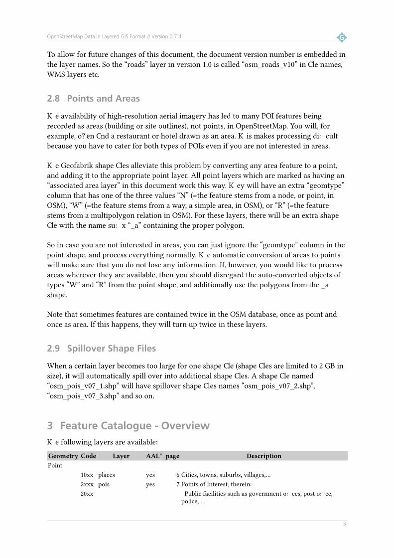
2.8 Points and Areas
The availability of high-resolution aerial imagery has led to many POI features being recorded as areas (building or site outlines), not points, in OpenStreetMap. You will, for example, often find a restaurant or hotel drawn as an area. This makes processing difficult because you have to cater for both types of POIs even if you are not interested in areas.
The Geofabrik shape files alleviate this problem by converting any area feature to a point, and adding it to the appropriate point layer. All point layers which are marked as having an “associated area layer” in this document work this way. They will have an extra “geomtype” column that has one of the three values “N” (=the feature stems from a node, or point, in OSM), “W” (=the feature stems from a way, a simple area, in OSM), or “R” (=the feature stems from a multipolygon relation in OSM). For these layers, there will be an extra shape file with the name suffix “_a” containing the proper polygon.
So in case you are not interested in areas, you can just ignore the “geomtype” column in the point shape, and process everything normally. The automatic conversion of areas to points will make sure that you do not lose any information. If, however, you would like to process areas wherever they are available, then you should disregard the auto-converted objects of types “W” and “R” from the point shape, and additionally use the polygons from the _a shape.
Note that sometimes features are contained twice in the OSM database, once as point and once as area. If this happens, they will turn up twice in these layers.
2.9 Spillover Shape Files
When a certain layer becomes too large for one shape file (shape files are limited to 2 GB in size), it will automatically spill over into additional shape files. A shape file named “osm_pois_v07_1.shp” will have spillover shape files names “osm_pois_v07_2.shp”, “osm_pois_v07_3.shp” and so on.
3 Feature Catalogue - OverviewThe following layers are available:Geometry Code Layer AAL* page DescriptionPoint
10xx places yes 6 Cities, towns, suburbs, villages,...2xxx pois yes 7 Points of Interest, therein:20xx Public facilities such as government offices, post office,
police, ...
5

OpenStreetMap Data in Layered GIS Format // Version 0.7.4
Geometry Code Layer AAL* page Description21xx Hospitals, pharmacies, ...22xx Culture, Leisure, ...23xx Restaurants, pubs, cafes, ...24xx Hotel, motels, and other places to stay the night25xx Supermarkets, bakeries, ...26xx Tourist information, sights, museums, ...29xx Miscellaneous points of interest3xxx pofw yes 12 Places of worship such as churches, mosques, graveyards, ...41xx natural yes 13 Natural features52xx traffic yes 13 Traffic related50xx transport yes 15 Parking lots, petrol (gas) stations, ...64xx power yes 16 Power generators, substations, ...
Line11xx boundaries 16 Borders between countries ...51xx roads 17 Roads, tracks, paths, ...61xx railway 18 Railway, subways, light rail, trams, ...66xx powerlines 20 Power lines67xx aeroway 20 Runways and taxiways at airports81xx waterways 19 Rivers, canals, streams, ...83xx coastline 19 Coastline53xx, 54xx, 55xx, 56xx, 62xx, 63xx, 64xx, 65xx
nonop 20 Roads and railways planned, under construction, or disused
Polygon12xx adminareas 22 Administrative areas (countries, states, counties, ...)15xx buildings 23 Building outlines72xx landuse 23 Forests, residential areas, industrial areas,...82xx water 24 Lakes, ...
* AAL = associated area layer.
4 Point Features
4.1 Places (“places”)
Location for cities, towns, etc. Typically somewhere in the centre of the town.
Additional attributes:Attribute PostGIS Type Description OSM Tags
population INTEGER Number of people living in this place population=*
Note that for many places the population is not available and will be set to 0. For islands the
6

OpenStreetMap Data in Layered GIS Format // Version 0.7.4
population is always 0.
The following feature classes exist in this layer:code fclass Description OSM Tags
1000 place1001 place city As defined by national/state/provincial
government. Often over 100,000 peopleplace=city (but see 1005)
1002 place town As defined by national/state/provincial government. Generally smaller than a city, between 10,000 and 100,000 people
place=town
1003 place village As defined by national/state/provincial government. Generally smaller than a town, below10,000 people
place=village
1004 place hamlet As defined by national/state/provincial government. Generally smaller than a village, just a few houses
place=hamlet
1005 place national_capital A national capital place=city with (a) is_capital=country or (b)admin_level=2 or (c) capital=yes and no admin_level set
1010 place suburb Named area of town or city place=suburb1020 place island Identifies an island place=island1030 place farm Named farm place=farm1031 place dwelling Isolated dwelling (1 or 2 houses, smaller than
hamlet)place=isolated_dwelling
1040 place region A region label (used in some areas only) place=region1041 place county A county label (used in some areas only) place=county1050 place locality Other kind of named place place=locality1099 place named_place see below. area=yes, name=*
The “associated area layer” for this layer uses code 1099 for objects tagged “area=yes” but not having any tags that would put them into any of the other layers. Objects in this layer have either not been categorized in OSM at all, or they have been categorized but not in a way that fits any of the Geofabrik layers.
4.2 Points of Interest
This layer has an associated area layer (see section 2.8).
The following feature classes exist in this layer:code layer fclass Description OSM Tags
20xx public2001 police A police post or station. amenity=police2002 fire_station A fire station. amenity=fire_station2004 post_box A post box (for letters). amenity=post_box2005 post_office A post office. amenity=post_office2006 telephone A public telephone booth. amenity=telephone2007 library A library. amenity=library
7
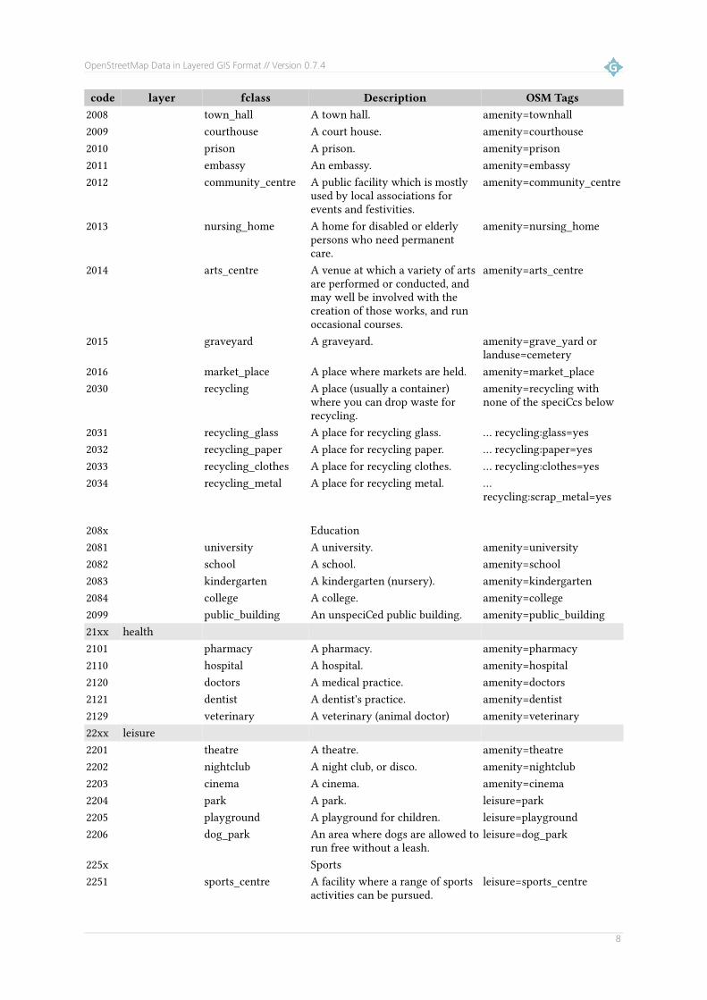
OpenStreetMap Data in Layered GIS Format // Version 0.7.4
code layer fclass Description OSM Tags2008 town_hall A town hall. amenity=townhall2009 courthouse A court house. amenity=courthouse2010 prison A prison. amenity=prison2011 embassy An embassy. amenity=embassy2012 community_centre A public facility which is mostly
used by local associations for events and festivities.
amenity=community_centre
2013 nursing_home A home for disabled or elderly persons who need permanent care.
amenity=nursing_home
2014 arts_centre A venue at which a variety of arts are performed or conducted, and may well be involved with the creation of those works, and run occasional courses.
amenity=arts_centre
2015 graveyard A graveyard. amenity=grave_yard or landuse=cemetery
2016 market_place A place where markets are held. amenity=market_place2030 recycling A place (usually a container)
where you can drop waste for recycling.
amenity=recycling with none of the specifics below
2031 recycling_glass A place for recycling glass. ... recycling:glass=yes2032 recycling_paper A place for recycling paper. ... recycling:paper=yes2033 recycling_clothes A place for recycling clothes. ... recycling:clothes=yes2034 recycling_metal A place for recycling metal. ...
recycling:scrap_metal=yes
208x Education2081 university A university. amenity=university2082 school A school. amenity=school2083 kindergarten A kindergarten (nursery). amenity=kindergarten2084 college A college. amenity=college2099 public_building An unspecified public building. amenity=public_building21xx health2101 pharmacy A pharmacy. amenity=pharmacy2110 hospital A hospital. amenity=hospital2120 doctors A medical practice. amenity=doctors2121 dentist A dentist's practice. amenity=dentist2129 veterinary A veterinary (animal doctor) amenity=veterinary22xx leisure2201 theatre A theatre. amenity=theatre2202 nightclub A night club, or disco. amenity=nightclub2203 cinema A cinema. amenity=cinema2204 park A park. leisure=park2205 playground A playground for children. leisure=playground2206 dog_park An area where dogs are allowed to
run free without a leash.leisure=dog_park
225x Sports2251 sports_centre A facility where a range of sports
activities can be pursued. leisure=sports_centre
8
OpenStreetMap Data in Layered GIS Format // Version 0.7.4
code layer fclass Description OSM Tags2252 pitch An area set aside for a specific
sport.leisure=pitch
2253 swimming_pool A swimming pool or water park. amenity=swimming_pool, leisure=swimming_pool, sport=swimming, leisure=water_park
2254 tennis_court A tennis court. sport=tennis2255 golf_course A golf course. leisure=golf_course2256 stadium A stadium. The area of the
stadium may contain one or several pitches.
leisure=stadium
2257 ice_rink An ice rink. leisure=ice_rink23xx catering Catering services2301 restaurant A normal restaurant. amenity=restaurant2302 fast_food A fast-food restaurant. amenity=fast_food2303 cafe A cafe. amenity=cafe2304 pub A pub. amenity=pub
2305
bar A bar. The difference between a pub and a bar is not clear but pubstend to offer food while bars do not.
amenity=bar
2306food_court A common seating area with
various fast-food vendors.amenity=food_court
2307biergarten An open-air area where food and
drinks are served.amenity=biergarten
24xx accommodation (indoor)2401 hotel A hotel. tourism=hotel2402 motel A motel. tourism=motel2403 bed_and_breakfast A facility offering bed and
breakfast.tourism=bed_and_breakfast
2404 guesthouse A guesthouse. The difference between hotel, bed and breakfast, and guest houses is not a strict one and OSM tends to use whatever the facility calls itself.
tourism=guest_house
2405 hostel A hostel (offering cheap accomodation, often bunk beds in dormitories).
tourism=hostel
2406 chalet A detached cottage, usually self-catering.
tourism=chalet
2420 (outdoor)2421 shelter All sorts of small shelters to
protect against bad weather conditions.
amenity=shelter
2422 camp_site A camp site or camping ground. tourism=camp_site2423 alpine_hut An alpine hut is a building
typically situated in mountains providing shelter and often food and beverages to visitors.
tourism=alpine_hut
2424 caravan_site A place where people with caravans or motorhomes can stay overnight or longer.
tourism=caravan_site
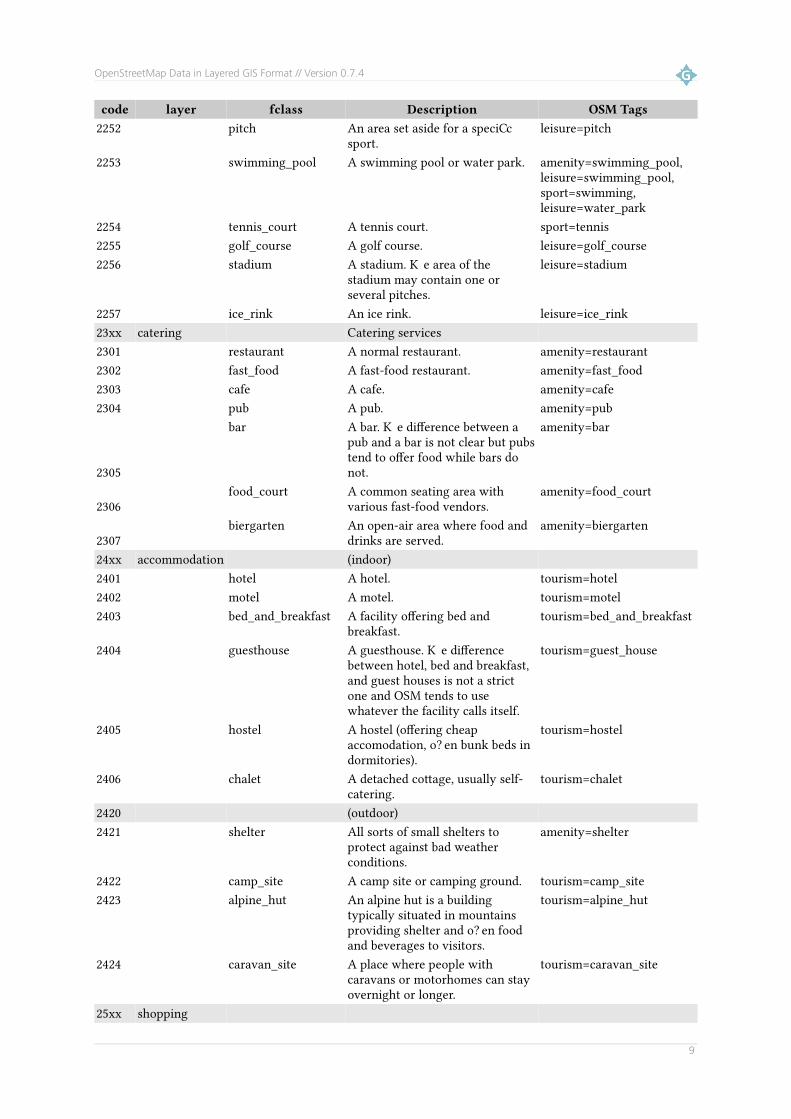
25xx shopping
9

OpenStreetMap Data in Layered GIS Format // Version 0.7.4
code layer fclass Description OSM Tags2501 supermarket A supermarket. shop=supermarket2502 bakery A bakery. shop=bakery2503 kiosk A very small shop usually selling
cigarettes, newspapers, sweets, snacks and beverages.
shop=kiosk
2504 mall A shopping mall. shop=mall2505 department_store A department store. shop=department_store2511 convenience A convenience store is a small
shop selling a subset of items you might find at a supermarket.
shop=convenience
2512 clothes A clothes or fashion store. shop=clothes2513 florist A store stelling flowers. shop=florist2514 chemist A shop selling articles of personal
hygiene, cosmetics, and householdcleaning products.
shop=chemist
2515 bookshop A book shop. shop=books2516 butcher A butcher. shop=butcher2517 shoe_shop A shoe shop. shop=shoes2518 beverages A place where you can buy
alcoholic and non-alcoholic beverages.
shop=alcohol, shop=beverages
2519 optician A place where you can buy glasses.
shop=optician
2520 jeweller A jewelry shop. shop=jewelry2521 gift_shop A gift shop. shop=gift2522 sports_shop A shop selling sports equipment. shop=sports2523 stationery A shop selling stationery for
private and office use.shop=stationery
2524 outdoor_shop A shop selling outdoor equiment. shop=outdoor2525 mobile_phone_shop A shop for mobile phones. shop=mobile_phone2526 toy_shop A toy store. shop=toys2527 newsagent A show selling mainly newspapers
and magazines.shop=newsagent
2528 greengrocer A shop selling fruit and vegetables.
shop=greengrocer
2529 beauty_shop A shop that provides personal beauty services like a nail salon ortanning salon.
shop=beauty
2530 video_shop A place where you can buy films. shop=video2541 car_dealership A car dealership. shop=car2542 bicycle_shop A bicycle shop. shop=bicycle2543 doityourself A do-it-yourself shop where you
can buy tools and building materials.
shop=doityourself and shop=hardware
2544 furniture_shop A furniture store. shop=furniture2546 computer_shop A computer shop. shop=computer2547 garden_centre A place selling plants and
gardening goods. shop=garden_centre
2561 hairdresser A hair salon. shop=hairdresser2562 car_repair A car garage. shop=car_repair2563 car_rental A place where you can rent a car. amenity=car_rental
10

OpenStreetMap Data in Layered GIS Format // Version 0.7.4
code layer fclass Description OSM Tags2564 car_wash A car wash. amenity=car_wash2565 car_sharing A car sharing station. amenity=car_sharing2566 bicycle_rental A place where you can rent
bicycles.amenity=bicycle_rental
2567 travel_agent A travel agency. shop=travel_agency2568 laundry A place where you can wash
clothes or have them cleaned.shop=laundry, shop=dry_cleaning
2590 vending_machine An unspecified vending machine. amenity=vending_machine with none of the specifics below
2591 vending_cigarette A cigarette vending machine. vending=cigarettes2592 vending_parking A vending machine for parking
tickets.vending=parking_tickets
2600 money2601 bank A bank. amenity=bank2602 atm A machine that lets you withdraw
cash from your bank account.amenity=atm
2700 tourism information2701 tourist_info Something that provides
information to tourists; may or many not be manned.
tourism=information with none of the specifics below
2704 tourist_map A map displayed to inform tourists.
tourism_information and information=map
2705 tourist_board A board with explanations aimed at tourists.
and information=board
2706 tourist_guidepost A guide post. and information=guidepostdestinations
2721 attraction A tourist attraction. tourism=attraction2722 museum A museum. tourism=museum2723 monument A monument. historic=monument2724 memorial A memorial. historic=memorial2725 art A permanent work of art. tourism=artwork2731 castle A castle. historic=castle2732 ruins Ruins of historic significance. historic=ruins2733 archaeological An excavation site. historic=archaeological_site2734 wayside_cross A wayside cross, not necessarily
old.historic=wayside_criss
2735 wayside_shrine A wayside shrine. historic=wayside_shrine2736 battlefield A historic battlefield. historic=battlefield2737 fort A fort. historic=fort2741 picnic_site A picnic site. tourism=picnic_site2742 viewpoint A viewpoint. tourism=viewpoint2743 zoo A zoo. tourism=zoo2744 theme_park A theme park. tourism=theme_park
2900 miscpoi2901 toilet Public toilets. amenity=toilets2902 bench A public bench. amenity=bench2903 drinking_water A tap or other source of drinking
water.amenity=drinking_water
11

OpenStreetMap Data in Layered GIS Format // Version 0.7.4
code layer fclass Description OSM Tags2904 fountain A fountain for cultural, decorative,
or recreational purposes. amenity=fountain
2905 hunting_stand A hunting stand. amenity=hunting_stand2906 waste_basket A waste basket. amenity=waste_basket2907 camera_surveillance A surveillance camera. man_made=surveillance2921 emergency_phone An emergency telephone. amenity=emergency_phone,
emergency=phone2922 fire_hydrant A firy hydrant. amenity=fire_hydrant,
emergency=fire_hydrant2923 emergency_access An emergency access point
(signposted place in e.g. woods thelocation of which is known to emergency services).
highway=emergency_access_point
2950 tower A tower of some kind. man_made=tower and noneof the specifics below
2951 tower_comms A communications tower. man_made=tower and tower:type=communication
2952 water_tower A water tower. man_made=water_tower2953 tower_observation An observation tower. man_made=tower and
tower:type=observation2954 windmill A windmill. man_made=windmill2955 lighthouse A lighthouse. man_made=lighthouse2961 wastewater_plant A wastewater treatment plant. man_made=wastewater_pla
nt2962 water_well A facility to access underground
aquifers.man_made=water_well
2963 water_mill A mill driven by water. Often historic.
man_made=watermill
2964 water_works A place where drinking water is processed.
man_made=water_works
4.3 Places of Worship (“pofw”)
This layer has an associated area layer (see section 2.8).
The following feature classes exist in this layer:code layer fclass Description OSM Tags
3000 pofw Places of worship3100 pofw christian A christian place of worship
(usually a church) without one of the denominations below.
religion=christian
3101 pofw christian_anglican A christian place of worship where the denomination is known. (Note to German users: “protestant” is “evangelisch” in German; “evangelical” is “evangelikal” in German.)
+ denomination=anglican3102 pofw christian_catholic + denomination=catholic3103 pofw christian_evangelical + denomination=evangelical3104 pofw christian_lutheran + denomination=lutheran3105 pofw christian_methodist + denomination=methodist3106 pofw christian_orthodox + denomination=orthodox3107 pofw christian_protestant + denomination=protestant3108 pofw christian_baptist + denomination=baptist3109 pofw christian_mormon + denomination=mormon
12

OpenStreetMap Data in Layered GIS Format // Version 0.7.4
code layer fclass Description OSM Tags3200 pofw jewish A jewish place of worship
(usually a synagogue).religion=jewish
3300 pofw muslim A muslim place of worhsip, (usually a mosque) without one ofthe denominations below.
religion=muslim
3301 pofw muslim_sunni A Sunni muslim place of worship. + denomination=sunni3302 pofw muslim_shia A Shia muslim place of worship. + denomination=shia3400 pofw buddhist A Buddhist place of worship. religion=buddhist3500 pofw hindu A Hindu place of worship. religion=hindu3600 pofw taoist A Taoist place of worship. religion=taoist3700 pofw shintoist A Shintoist place of worship. religion=shintoist3800 pofw sikh A Sikh place of worship. religion=sikh
4.4 Natural Features (“natural”)
Additional attributes:Attribute PostGIS Type Description OSM Tags
elevation INTEGER Height of the feature above mean sea level, in metres.
elevation=*
Note that for many features the elevation is not available and will be set to 0.
The following feature classes exist in this layer:code layer fclass Description OSM Tags
4101 natural spring A spring, possibly source of a stream.
natural=spring
4103 natural glacier A glacier. natural=glacier4111 natural peak A mountain peak. natural=peak4112 natural cliff A cliff. natural=cliff4113 natural volcano A volcano. natural=volcano4121 natural tree A tree. natural=tree4131 natural mine A mine. natural=mine4132 natural cave_entrance A cave entrance. natural=cave_entrance4141 natural beach A beach. (Note that beaches are
only rarely mapped as point features.)
natural=beach
4.5 Traffic Related (“traffic”)
Additional attributes:Attribute PostGIS Type Description OSM Tags
ref VARCHAR(8) Reference number (only common for motorway_junction (5206) but may also exist for other feature classes of this layer)
ref=*
13
OpenStreetMap Data in Layered GIS Format // Version 0.7.4
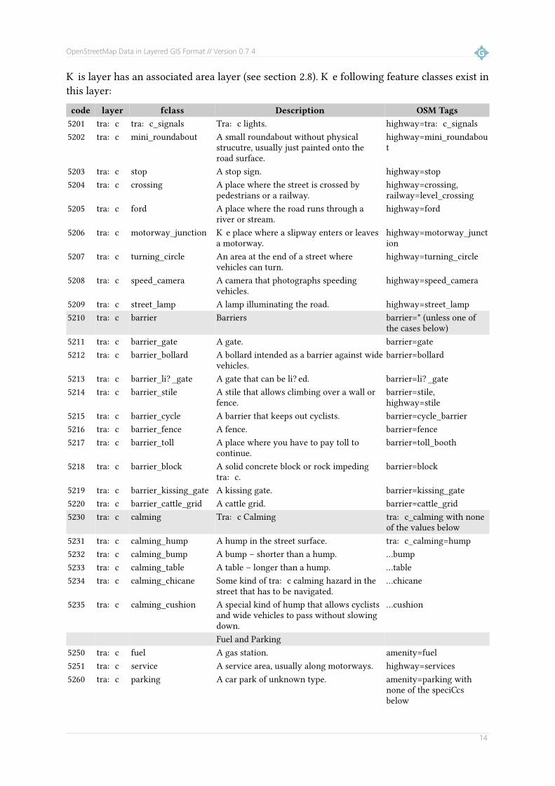
This layer has an associated area layer (see section 2.8). The following feature classes exist inthis layer:
code layer fclass Description OSM Tags5201 traffic traffic_signals Traffic lights. highway=traffic_signals5202 traffic mini_roundabout A small roundabout without physical
strucutre, usually just painted onto the road surface.
highway=mini_roundabout
5203 traffic stop A stop sign. highway=stop5204 traffic crossing A place where the street is crossed by
pedestrians or a railway.highway=crossing, railway=level_crossing
5205 traffic ford A place where the road runs through a river or stream.
highway=ford
5206 traffic motorway_junction The place where a slipway enters or leaves a motorway.
highway=motorway_junction
5207 traffic turning_circle An area at the end of a street where vehicles can turn.
highway=turning_circle
5208 traffic speed_camera A camera that photographs speeding vehicles.
highway=speed_camera
5209 traffic street_lamp A lamp illuminating the road. highway=street_lamp5210 traffic barrier Barriers barrier=* (unless one of
the cases below)5211 traffic barrier_gate A gate. barrier=gate5212 traffic barrier_bollard A bollard intended as a barrier against wide
vehicles.barrier=bollard
5213 traffic barrier_lift_gate A gate that can be lifted. barrier=lift_gate5214 traffic barrier_stile A stile that allows climbing over a wall or
fence.barrier=stile, highway=stile
5215 traffic barrier_cycle A barrier that keeps out cyclists. barrier=cycle_barrier5216 traffic barrier_fence A fence. barrier=fence5217 traffic barrier_toll A place where you have to pay toll to
continue.barrier=toll_booth
5218 traffic barrier_block A solid concrete block or rock impeding traffic.
barrier=block
5219 traffic barrier_kissing_gate A kissing gate. barrier=kissing_gate5220 traffic barrier_cattle_grid A cattle grid. barrier=cattle_grid5230 traffic calming Traffic Calming traffic_calming with none
of the values below5231 traffic calming_hump A hump in the street surface. traffic_calming=hump5232 traffic calming_bump A bump – shorter than a hump. ...bump5233 traffic calming_table A table – longer than a hump. ...table5234 traffic calming_chicane Some kind of traffic calming hazard in the
street that has to be navigated....chicane
5235 traffic calming_cushion A special kind of hump that allows cyclists and wide vehicles to pass without slowing down.
...cushion
Fuel and Parking5250 traffic fuel A gas station. amenity=fuel5251 traffic service A service area, usually along motorways. highway=services5260 traffic parking A car park of unknown type. amenity=parking with
none of the specifics below
14

OpenStreetMap Data in Layered GIS Format // Version 0.7.4
code layer fclass Description OSM Tags5261 traffic parking_site A surface car park. amenity=parking and...
... parking=site5262 traffic parking_multistorey A multi storey car park. ... parking=multi-storey5263 traffic parking_undergroun
dAn underground car park. ... parking=underground
5270 traffic parking_bicycle A place to park your bicycle. amenity=bicycle_parkingWater Traffic
5301 traffic slipway A slipway. leisure=slipway5302 traffic marina A marina. leisure=marina5303 traffic pier A pier. man_made=pier5311 traffic dam A dam. waterway=dam5321 traffic waterfall A waterfall. waterway=waterfall5331 traffic lock_gate A lock gate. waterway=lock_gate5332 traffic weir A barrier built across a river or stream. waterway=weir
Note: Most of the 53xx type objects do sometimes appear as linear features in OSM as well but those are not yet available in the shape files.
4.6 Transport Infrastructure (“transport”)
This layer has an associated area layer (see section 2.8).
The following feature classes exist in this layer:code layer fclass Description OSM Tags
5601 transport railway_station A larger railway station of mainline rail services.
railway=station
5602 transport railway_halt A smaller, local railway station, or subway station.
railway=halt, or public_transport=stop_position + train=yes
5603 transport tram_stop A tram stop. railway=tram_stop, or public_transport=stop_position + tram=yes
5621 transport bus_stop A bus stop. highway=bus_stop, or public_transport=stop_position + bus=yes
5622 transport bus_station A large bus station with multiple platforms.
amenity=bus_station
5641 transport taxi_rank A taxi rank. amenity=taxi565x Air Traffic5651 transport airport A large airport. amenity=airport or
aeroway=aerodrome unless type=airstrip
5652 transport airfield A small airport or airfield. aeroway=airfield, military=airfield, aeroway=aeroway with type=airstrip
5655 transport helipad A place for landing helicopters. aeroway=helipad5656 transport apron A apron (area where aircraft are
parked)aeroway=apron
566x Water Traffic
15

OpenStreetMap Data in Layered GIS Format // Version 0.7.4
code layer fclass Description OSM Tags5661 transport ferry_terminal A ferry terminal. amenity=ferry_terminal567x Other Traffic5671 transport aerialway_statio
nA station where cable cars or lifts alight.
aerialway=station
4.7 Power Generation and Distribution (“power”)
This layer has an associated area layer (see section 2.8).
The following feature classes exist in this layer:code layer fclass Description OSM Tags
6401 power tower A towers supporting power lines. power=tower6204 power pole A pole supporting power lines. power=pole6410 power station A power station where the power
source is not specified.power=generator with none of thespecifics below
6411 power station_nuclear A nuclear power station. power=generator with generator:source=nuclear
6412 power station_solar A solar power station. with generator:source=solar or power_source=photovoltaic
6413 power station_fossil A power station burning fossil fuels. with generator:source=gas or coal6414 power station_water A hydroelectric power station. with generator:source=hydro or
power_source=hydro6415 power station_wind A wind turbine, or park thereof. with generator:source=wind or
power_source=wind6422 power substation A power substations or relay station. power=station
power=sub_station6423 power transformer A power transformer within a station
or substation.power=transformer
5 Line Features
5.1 Boundaries (“boundaries”)
OSM currently uses up to 11 different levels for administrative boundaries. Boundaries currently don't have a name attribute.
The following feature classes exist in this layer:code layer fclass Description OSM Tags
1100 boundary boundary=administrative1101 boundary admin_level1 + admin_level=11102 boundary national National border + admin_level=21103 boundary admin_level3 + admin_level=31104 boundary admin_level4 Usually a border of the first level below
national; NUTS-2 (Germany: Land, France: région, UK: England/ Scotland/Wales...).
+ admin_level=4
1105 boundary admin_level5 + admin_level=51106 boundary admin_level6 Usually a border of the second level below
national; NUTS-3 (Germany: Kreis, France: + admin_level=6
16

OpenStreetMap Data in Layered GIS Format // Version 0.7.4
code layer fclass Description OSM Tagsdépartement, UK: county...).
1107 boundary admin_level7 + admin_level=71108 boundary admin_level8 Usually a city or borough boundary. + admin_level=81109 boundary admin_level9 + admin_level=91110 boundary admin_level10 + admin_level=101111 boundary admin_level11 + admin_level=11
The exact meaning of the admin_levels 1 to 11 varies between countries and is documented in detail on the OpenStreetMap Wiki: http://wiki.openstreetmap.org/wiki/Admin_level. Other levels depend on the country they are in.
See section 6.1 for polygonal administrative areas. It is recommended to use the line featuresif all you need is borders drawn, but use polygons if you need to test feature for lying insideor outside of an area.
5.2 Roads and Paths (“roads”)
All kinds of roads from motorways to gravel tracks as well as cycleways, footpaths, etc.
Additional attributes:Attribute PostGIS Type Description OSM Tags
ref VARCHAR(20) Reference number of this road ('A 5', 'L 605', ...) ref=*oneway VARCHAR(1) Is this a oneway road? (“F” means that only driving
in direction of the linestring is allowed. “T” means that only driving against the direction of the linestring is allowed. “B” (default value) means that traffic is permitted in both directions.
oneway=*
maxspeed SMALLINT Max allowed speed in km/h maxspeed=*layer SMALLINT Relative layering of roads (-5, ..., 0, ..., 5) layer=*bridge VARCHAR(1) Is this road on a bridge? (“T” = true, “F” = false) bridge=*tunnel VARCHAR(1) Is this road in a tunnel? (“T” = true, “F” = false) tunnel=*
Roads of type 5111 (motorway) and 5112 (trunk) are always oneway.
The following feature classes exist in this layer:code layer fclass Description OSM Tags
511x roads Major roads5111 roads motorway Motorway/freeway highway=motorway5112 roads trunk Important roads, typically divided highway=trunk5113 roads primary Primary roads, typically national. highway=primary5114 roads secondary Secondary roads, typically regional. highway=secondary5115 roads tertiary Tertiary roads, typically local. highway=tertiary512x roads Minor Roads5121 roads unclassified Smaller local roads highway=unclassified5122 roads residential Roads in residential areas highway=residential5123 roads living_street Streets where pedestrians have priority over
carshighway=living_street
17

OpenStreetMap Data in Layered GIS Format // Version 0.7.4
code layer fclass Description OSM Tags5124 roads pedestrian Pedestrian only streets highway=pedestrian513x roads Highway links (sliproads/ramps) 5131 roads motorway_link Roads that connect from one road to another
of the same of lower category.highway=motorway_link
5132 roads trunk_link highway=trunk_link5133 roads primary_link highway=primary_link5134 roads secondary_link highway=secondary_link 514x roads Very small roads5141 roads service Service roads for access to buildings, parking
lots, etc.highway=service
5142 roads track For agricultural use, in forests, etc. Often gravel roads.
highway=track without tracktype specification
5143 roads track_grade1 Tracks can be assigned a “tracktype” from 1 (asphalt or heavily compacted) to 5 (hardly visible). A detailed description is here: http://wiki.openstreetmap.org/wiki/Tracktype
... with tracktype=grade15144 roads track_grade2 ... with tracktype=grade25145 roads track_grade3 ... with tracktype=grade35146 roads track_grade4 ... with tracktype=grade45147 roads track_grade5 ... with tracktype=grade5
515x roads Paths unsuitable for cars5151 roads bridleway Paths for horse riding highway=bridleway or
highway=path with horse=designated
5152 roads cycleway Paths for cycling highway=cycleway or highway=path with cycle=designated
5153 roads footway Footpaths highway=footway or highway=path with foot=designated
5154 roads path Unspecified paths highway=path without cycle/foot/horse=designated
5155 roads steps Flights of steps on footpaths highway=steps516x roads Ferries5160 roads ferry Ferry routes route=ferry
Unknown5199 roads unknown Unknown type of road or path highway=road
5.3 Railways, Subways, Trams, Lifts, and Cable Cars (“railways”)
Railways do not have a name attribute. Instead, they have the following additional attributes:
Attribute PostGIS Type Description OSM Tagslayer SMALLINT Relative layering of railways/roads (-5, ..., 0, ..., 5) layer=*bridge VARCHAR(1) Is this road on a bridge? (“T” = true, “F” = false) bridge=*tunnel VARCHAR(1) Is this road in a tunnel? (“T” = true, “F” = false) tunnel=*
The following feature classes exist in this layer:code layer fclass Description OSM Tags
6101 railways rail Regular railway tracks. railway=rail (unless traction=* also set)
18

OpenStreetMap Data in Layered GIS Format // Version 0.7.4
code layer fclass Description OSM Tags6102 railways light_rail Light railway tracks, often commuter
railways.railway=light_rail
6103 railways subway Underground railway tracks. railway=subway6104 railways tram Tram tracks (may be incident with roads). railway=tram6105 railways monorail A monorail track. railway=monorail6106 railways narrow_gauge A narrow gauge railway track. railway=narrow_gauge6107 railways miniature A miniature railway track. railway=miniature6108 railways funicular A funicular, or cable railway usually on a
steep incline.railway=funicular, or railway=rail with traction=funicular
6109 railways rack A rack railway railway=rack, or railway=rail with traction=rack or railway=rail with rack=yes
6111 railways drag_lift An overhead tow-line for skiers. aerialway=drag_lift6112 railways chair_lift An open chairlift run. aerialway=chair_lift or
high_speed_chair_lift6113 railways cable_car A cabin cable car run. aerialway=cable_car6114 railways gondola An aerialway where the cabins go around in
a circle,aerialway=gondola
6115 railways goods An aerialway for the transport of goods. aerialway=goods6119 railways other_lift Another type of lift. aerialway=one of
platter, t-bar, j-bar, magic_carpet, zip_line, rope_tow, or mixed_lift
5.4 Waterways (“waterways”)
Additional attributes:Attribute PostGIS Type Description OSM Tags
width SMALLINT Width of the waterway in metres. width=*
The following feature classes exist in this layer:code layer fclass Description OSM Tags
8101 waterways river A large river. waterway=river8102 waterways stream A smaller river or stream. waterway=stream8103 waterways canal An artificial waterway. waterway=canal8104 waterways drain A small drainage ditch or similar structure. waterway=drain
Note that in OSM larger rivers are often available as polygon geometries and line geometries; the line geometry will then run through the middle of the river in the direction of the water flow.
5.5 Coastline (“coastline”)
Only the code 8300 is used. Coastlines don't have a name attribute.
19

OpenStreetMap Data in Layered GIS Format // Version 0.7.4
5.6 Power lines (“powerlines”)
Power lines don't have a name attribute.code layer fclass Description OSM Tags
6600 powerlines line A regular power line. power=line6601 powerlines minor_line A smaller power line usually
supported by poles, not masts.
power=minor_line
6611 powerlines cable An underground or submarine power cable.
power=cable
6612 powerlines minor_cable A smaller underground or submarine power cable.
power=minor_cable
Additional attributes:Attribute PostGIS Type Description OSM Tags
operator VARCHAR(30) Operator/owner of infrastructure operator=*
Note: Some power lines in OpenStreetMap are modelled as relations and are not yet included in this layer. Contact Geofabrik for details.
5.7 Runways and taxiways
This layer contains runways and taxiways. There is a layer with an “_a” suffix which contains those which are mapped as areas at OpenStreetMap and there is a layer without anthat suffix which contains those which are mapped as lines.
code layer fclass Description OSM Tags6701 aeroways runway Runway at an airport aeroway=runway6702 aeroways taxiway Taxiway at an airport aeroway=taxiway
5.8 Infrastructure disused, planned, under construction (“nonop”)
This layer contains roads and railways which are disused, planned, under construction or abandoned. These elements have been placed in a separate layer because they are not usablefor traffic; yet for some applications they may be relevant.
This layer uses the codes from the “roads” and “railways” layers incremented by integral multiples of 100. The names of the feature classes are appended by the suffixes “_proposed”, “_construction”, “_disused” and “_abandoned” depending on their operational status.
coderange
layer fclasses Description OSM Tags
53xx nonop motorway_proposed/trunk_proposed/...
Proposed roads. highway=proposed with proposed=motorway/trunk/...
54xx nonop motorway_construction/trunk_construction/...
Roads under construction. highway=construction with construction=motorway/trunk/...
55xx nonop motorway_disused/trunk_disus Disused roads. Road still highway=disused with
20

OpenStreetMap Data in Layered GIS Format // Version 0.7.4
coderange
layer fclasses Description OSM Tags
ed exists but is closed and not used any more. Paving may be covered by vegetation.
disused=motorway/trunk/...
56xx nonop motorway_abandoned/trunk_abandoned
Paving has been removed but it is still clearly visble that ther was a road.
highway=abandoned with abandoned=motorway/trunk/...
62xx nonop rail_proposed/light_rail_proposed/...
Proposed railway tracks. railway=proposed with proposed=rail/light_rail/... or railway=proposed with proposed:railway=rail/light_rail/...
6200 nonop other_rail_proposed Proposed railway tracks but exact railway type (railway, light rail, tram, subway ...) not given.
railway=proposed without both proposed=* a and proposed:railway=*
63xx nonop rail_construction/light_rail_construction/...
Railway tracks under construction.
railway=construction with construction=rail/light_rail/... or railway= construction with construction:railway=rail/light_rail/...
6300 nonop other_rail_construction Railway tracks under construction but exact railway type (railway, light rail, tram, subway ...) not given.
railway=construction without both construction=* a and construction:railway=*
64xx nonop rail_disused/light_rail_disused/...
Disused railway tracks. railway=disused with disused=rail/light_rail/... or railway=disused with disused:railway=rail/light_rail/...
6400 nonop other_rail_disused Proposed railway tracks but exact railway type (railway, light rail, tram, subway ...) not given.
railway=disused without both disused=* a and proposed:railway=*
65xx nonop rail_abandoned/light_rail_abandoned/...
Abandoned railway tracks, i.e. rails and sleepers have been removed but ballast is still in place.
railway=abandoned with abandoned=rail/light_rail/... or railway= abandoned with abandoned:railway=rail/light_rail/...
6500 nonop other_rail_abandoned Abandoned ailway tracks but exact railway type (railway, light rail, tram, subway ...) not given. Rails and sleepers have been removed but ballast is still in place.
railway=construction without both construction=* a and construction:railway=*
Additional attributes:
21

OpenStreetMap Data in Layered GIS Format // Version 0.7.4
Attribute PostGIS Type Description OSM Tagsref VARCHAR(20) Reference number of this road ('A 5', 'L 605', ...);
unset for railways.ref=*
layer SMALLINT Relative layering of roads (-5, ..., 0, ..., 5) layer=*bridge VARCHAR(1) Is this road/railway on a bridge? (“T” = true, “F” =
false)bridge=*
tunnel VARCHAR(1) Is this road/railway in a tunnel? (“T” = true, “F” = false)
tunnel=*
5.9 Barrier-type linear features ("barriers")
This layer contains natural or man-made barrier lines, like fences, hedges, or walls.code layer fclass Description OSM Tags
5501 barriers fence A fence. barrier=fence, wood_fence, wire_fence
5511 barriers hedge A hedge. barrier=hedge5512 barriers tree_row A row of trees. barrier=tree_row5521 barriers wall A wall. barrier=wall5531 barriers dyke A dyke. man_made=dyke
6 Polygon FeaturesPolygon features are extracted from simple polygons and from multipolygons in OSM.
6.1 Administrative Areas (“adminareas”)
This layer is similar the the “boundaries” layer but it contains polygons built from boundarylines. This layer does have a name attribute.
Additional attributes:Attribute PostGIS Type Description OSM Tags
postalcode VARCHAR(10) Postal code for this administrative area. Postal codesare only available for a few administrative areas, they are not necessarily unique.
postal_code=*
The following feature classes exist in this layer:code layer fclass Description OSM Tags
1200 adminareas boundary=administrative1201 adminareas admin_level1 + admin_level=11202 adminareas national National border + admin_level=21203 adminareas admin_level3 + admin_level=31204 adminareas admin_level4 Usually a border of the first level below
national; NUTS-2 (Germany: Land, France: région, UK: England/ Scotland/Wales...).
+ admin_level=4
1205 adminareas admin_level5 + admin_level=51206 adminareas admin_level6 Usually a border of the second level
below national; NUTS-3 (Germany: + admin_level=6
22

OpenStreetMap Data in Layered GIS Format // Version 0.7.4
code layer fclass Description OSM TagsKreis, France: département, UK: county...).
1207 adminareas admin_level7 + admin_level=71208 adminareas admin_level8 Usually a city or borough boundary. + admin_level=81209 adminareas admin_level9 + admin_level=91210 adminareas admin_level10 + admin_level=101211 adminareas admin_level11 + admin_level=11
Note that due to editing errors introduced by OpenStreetMap contributors and also due to lack of data in some areas, there is no guarantee that these areas are complete; there may always be missing bits. Contact Geofabrik if you are interested in a redacted data set.
The exact meaning of the admin_levels 1 to 11 varies between countries and is documented in detail on the OpenStreetMap Wiki: http://wiki.openstreetmap.org/wiki/Admin_level
6.2 Building outlines (“buildings”)
Buildings don't have a name attribute.
Additional attributes:Attribute PostGIS Type Description OSM Tags
type VARCHAR(20) The type of building, if specified in OSM; otherwise empty.
building=(anything other than yes)
height SMALLINT Height of the building. height=* (building:height=* if height=* is not set)
levels SMALLINT Number of floors building:levels=*
The following feature classes exist in this layer:code layer fclass Description
1500 buildings Building outlines building=*
6.3 Land use and land cover (“landuse”)
The following feature classes exist in this layer:code layer fclass Description OSM Tags
7201 landuse forest A forest or woodland. landuse=forest, natural=wood
7202 landuse park A park. leisure=park, leisure=common
7203 landuse residential A residential area. landuse=residential7204 landuse industrial An industrial area. landuse=industrial7206 landuse cemetery A cemetery or graveyard. landuse=cemetery7207 landuse allotments An area with small private gardens. landuse=allotments7208 landuse meadow A meadow, possibly used for grazing
cattle.landuse=meadow
7209 landuse commercial A commercial area. landuse=commercial
23

OpenStreetMap Data in Layered GIS Format // Version 0.7.4
code layer fclass Description OSM Tags7210 landuse nature_reserve A nature reserve. leisure=nature_reserve7211 landuse recreation_ground An open green space for general
recreation.leisure=recreation_ground orlanduse_recreation_ground
7212 landuse retail An area mainly used by shops. landuse=retail7213 landuse military Military landuse, usually no access for
civilians.landuse=military
7214 landuse quarry A quarry. landuse=quarry7215 landuse orchard An area used for growing fruit-bearing
trees.landuse=orchard
7216 landuse vineyard An area used for growing grapes. landuse=vineyard7217 landuse scrub An area where scrub grows. landuse=scrub7218 landuse grass An area where grass grows. landuse=grass7219 landuse heath Heath areas. natural=heath7220 landuse national_park A national park. boundary=national_park7221 landuse basin A basin. landuse=basin7222 landuse village_green A green area in the centre of a village. landuse=village_green7223 landuse plant_nursery Areas where plant nurseries exist. landuse=plant_nursery7224 landuse brownfield Land where old buildings have been
demolished and cleared.landuse=brownfield
7225 landuse greenfield Land scheduled for new development where there have been no buildings before.
landuse=greenfield
7226 landuse construction A construction site. landuse=construction7227 landuse railway Area used for railway operations. Not
all land used for railway is covered by this type.
landuse=railway
7228 landuse farmland Agricultural land (areas where crops are grown)
landuse=farmland
7229 landuse farmyard Area of land with farm buildings and the shrubbery/trees around them.
landuse=farmyard
6.4 Bodies of Water (“water”)
The following feature classes exist in this layer:code layer fclass Description
8200 water water Unspecified bodies of water. Typically lakes, but can also be larger rivers, harbours, etc.
natural=water
8201 water reservoir Artificial lakes, typically above a dam. landuse=reservoir8202 water river Polygons for larger rivers. waterway=riverbank8203 water dock Dock (to repair ships, don't confuse it with
the American term “dock”)waterway=dock
8211 water glacier Glaciers natural=glacier8221 water wetland Swamp, bog, or marsh land natural=wetland
Note that in OSM larger rivers are often available as polygon geometries and line geometries; the line geometry will then run through the middle of the river in the direction of the water flow.
24

OpenStreetMap Data in Layered GIS Format // Version 0.7.4
6.5 Landmass and Oceans
The Geofabrik shape files do not come with landmass or ocean polygons built from coastlinedata. However, there are free shapefile downloads provided here which are regularly extracted from OSM:
http://openstreetmapdata.com/
You'll find both ocean polygons and land mass polygons there, as well several generalized data sets.
7 RoutesRoutes are extracted from OpenStreetMap relation objects which have the tag type=route.
7.1 Routes
Additional attributes:Attribute PostGIS Type Description OSM Tags
ref VARCHAR(100) Reference number/code of this route. ref=*name VARCHAR(100) Name of the route. This might be sometimes more a
description than a real name.name=*
operator VARCHAR(100) Operator of this route. operator=*network VARCHAR(20) Network hiearchy. Common values:
• nwn: national hiking route• rwn: regional hiking route• lwn: local hiking route• ncn: national cylce route• rcn: regional cycle route• lcn: local cycle route
network=*
osmc_symb VARCHAR(100) machine-readable description of the hiking path symbol, full documentation see https://wiki.openstreetmap.org/wiki/Key:osmc:symbol
osmc:symbol=*
The following feature classes exist in this layer:code layer fclass Description
9001 routes bicycle cycle route route=bicycle9002 routes mtb route for moutain bikes route=mtb9003 routes hiking hiking route route=hiking9004 routes horse riding route route=horse9005 routes nordic_walking nordic walking route route=nordic_walking9006 routes running running route route=running
8 Migrating from Free Shape FilesThere are some differences between the free shape files provided by Geofabrik at
25

OpenStreetMap Data in Layered GIS Format // Version 0.7.4
download.geofabrik.de and the shapefiles described in this document.
8.1 Associated Area Layer
If a feature class exists both as area and as points in OpenStreetMap, point layers of paid shape files will contain a centroid point of the area. The geomtype field of this objects is set to “P” (polygon). Exclude all objects of a point layer with geomtype=P to prevent pois mapped as areas in OpenStreetMap being drawn twice.
8.2 Additional Layers
Following layers are not part of the free shape files:Geometry Code Layer Description
Point64xx power Power generators, substations, ...
Line11xx boundaries Borders between countries ...55xx barriers Natural or man-made barrier lines like fence, hedges or walls66xx powerlines Power lines67xx aeroways Runways and taxiways at airports83xx coastline Coastline53xx, 54xx,55xx, 56xx,62xx, 63xx,64xx, 65xx
nonop Roads and railways planned, under construction, or disused
Polygon12xx adminareas Administrative areas (countries, states, counties, ...)
MultiLineString90xx routes Routes for cycling, hiking, moutain bikes, nordic walking
and running
8.3 Additional Feature Classes
The following table shows all feature classes which are not part of the free shape files. Feature classes which are part of layers given at section 8.2 are not listed here.
code(s) layer fclass(es)1005 places national_capital565x transport airport, airfield, helipad5671 transport aerialway_station2524 pois outdoor_shop2525 pois mobile_phone_shop2529 pois beauty_shop2530 pois video_shop2541 pois car_dealership2544 pois furniture_shop2923 pois emergency_access_point
26
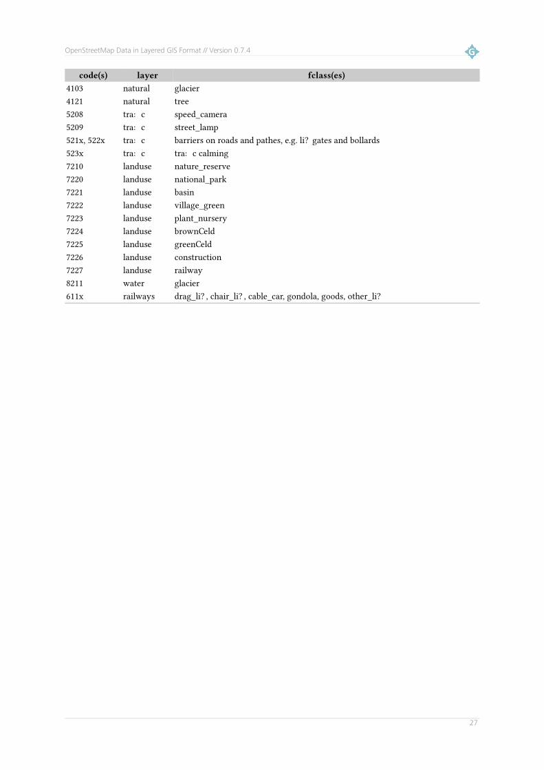
OpenStreetMap Data in Layered GIS Format // Version 0.7.4
code(s) layer fclass(es)4103 natural glacier4121 natural tree5208 traffic speed_camera5209 traffic street_lamp521x, 522x traffic barriers on roads and pathes, e.g. lift gates and bollards523x traffic traffic calming7210 landuse nature_reserve7220 landuse national_park7221 landuse basin7222 landuse village_green7223 landuse plant_nursery7224 landuse brownfield7225 landuse greenfield7226 landuse construction7227 landuse railway8211 water glacier611x railways drag_lift, chair_lift, cable_car, gondola, goods, other_lift
27