oracle database 11g geocoder
TRANSCRIPT
An Oracle White PaperJanuary 2009
Oracle Database 11g Geocoder
Oracle White Paper—Oracle Database 11g Geocoder
Introduction.........................................................................................1
Geocoder Schema..............................................................................2
Data Tables and Indexes ................................................................2
The Profile Tables.........................................................................15
Using the Oracle Geocoder...............................................................24
Using the Database Geocoder ......................................................24
Using the J2EE Geocoder.............................................................35
Oracle White Paper—Oracle Database 11g Geocoder
1
IntroductionGeocoding is a procedure that uses postal addresses to derive geographic (longitude,latitude) locations. The Oracle Geocoder provides geocoding and reverse-geocodingservices, and performs point-of-interest (POI) matching that returns complete addressesfor points of interest.
The Oracle Geocoder is a geocoding engine implemented as Java-stored proceduresinside an Oracle database server. In addition to geocoding PL/SQL APIs, client-side JavaAPIs are provided to facilitate the integration of the server-side geocoder with client-sideJava applications.
The Oracle Geocoder is supported in two forms: the database geocoder and the J2EEgeocoder. The database geocoder uses PL/SQL APIs to access address and coordinateinformation stored in database tables; the J2EE geocoder uses an XML API to provide aservice that accesses the address and coordinate information stored in database tables.The database and the J2EE geocoders both access the same underlying databasetables. These tables and their indexes constitute the geocoder schema. The geocoderschema is typically supplied by a data provider and is generally ready to use, out-of-the-box, however, the geocoder schema can also be built by a user.
This white paper describes the geocoder schema used by the Oracle Geocoder and howdata is accessed and interpreted for geocoding. It also describes how the OracleGeocoder is configured for use. The examples in this paper are based on the UnitedStates address-format conventions, unless stated otherwise.
Oracle White Paper—Oracle Database 11g Geocoder
2
Geocoder Schema
The geocoder schema is made up of six data tables and their indexes, and three profile tables.The data tables store address and coordinate information, and the profile tables store address-format information used by the geocoder to parse addresses entered by a user.
Data Tables and Indexes
The data tables, GC_ROAD_SEGMENT_<suffix>, GC_AREA_<suffix>,GC_ROAD_<suffix>, GC_INTERSECTION_<suffix>, GC_POSTAL_CODE_<suffix> andGC_POI_<suffix> store address and coordinate information for a single country or group ofcountries of interest. The mandatory suffix for these tables is data-provider- or user-specifiedand is typically used to identify the country or group of countries to which the data belongs,for example, “US” for the United States or “EU” for Europe. However, any 5-characters-or-less can be used for the table-name suffix and the same suffix must also be used in thecreation of indexes on these tables. The six tables and their indexes are described in thissection:
GC_ROAD_SEGMENT Table and Indexes
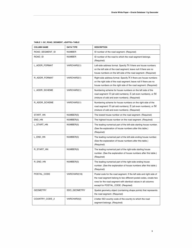
The GC_ROAD_SEGMENT_<suffix> table (for example, GC_ROAD_SEGMENT_US)stores road-segment information for the country or group of countries associated with thetable-name suffix. A road segment is the portion of a road between two continuousintersections along the road; an intersection occurs when roads meet or cross each other. Aroad segement can also be the portion of a road between the start (or end) of the road and itsclosest intersection along the road, or it can be the entire length of a road if there are nointersections along the road. The GC_ROAD_SEGMENT_<suffix> table contains one rowfor each road segment and has the columns shown in Table 1.
Oracle White Paper—Oracle Database 11g Geocoder
3
TABLE 1: GC_ROAD_SEGMENT_<SUFFIX> TABLE
COLUMN NAME DATA TYPE DESCRIPTION
ROAD_SEGMENT_ID NUMBER ID number of the road segment. (Required)
ROAD_ID NUMBER ID number of the road to which the road segment belongs.(Required)
L_ADDR_FORMAT VARCHAR2(1) Left-side address format. Specify N if there are house numberson the left side of the road segment; leave null if there are nohouse numbers on the left side of the road segment. (Required)
R_ADDR_FORMAT VARCHAR2(1) Right-side address format. Specify N if there are house numberson the right side of the road segment; leave null if there are nohouse numbers on the right side of the road segment. (Required)
L_ADDR_SCHEME VARCHAR2(1) Numbering scheme for house numbers on the left side of theroad segment: O (all odd numbers), E (all even numbers), or M(mixture of odd and even numbers). (Required)
R_ADDR_SCHEME VARCHAR2(1) Numbering scheme for house numbers on the right side of theroad segment: O (all odd numbers), E (all even numbers), or M(mixture of odd and even numbers). (Required)
START_HN NUMBER(5) The lowest house number on the road segment. (Required)
END_HN NUMBER(5) The highest house number on the road segment. (Required)
L_START_HN NUMBER(5) The leading numerical part of the left-side starting house number.(See the explanation of house numbers after this table.)(Required)
L_END_HN NUMBER(5) The leading numerical part of the left-side ending house number.(See the explanation of house numbers after this table.)(Required)
R_START_HN NUMBER(5) The leading numerical part of the right-side starting housenumber. (See the explanation of house numbers after this table.)(Required)
R_END_HN NUMBER(5) The leading numerical part of the right-side ending housenumber. (See the explanation of house numbers after this table.)(Required)
POSTAL_CODE VARCHAR2(16) Postal code for the road segment. If the left side and right side ofthe road segment belong to two different postal codes, create tworows for the road segment with identical values in all columnsexcept for POSTAL_CODE. (Required)
GEOMETRY SDO_GEOMETRY Spatial geometry object (containing shape points) that representsthe road segment. (Required)
COUNTRY_CODE_2 VARCHAR2(2) 2-letter ISO country code of the country to which the roadsegment belongs. (Required)
Oracle White Paper—Oracle Database 11g Geocoder
4
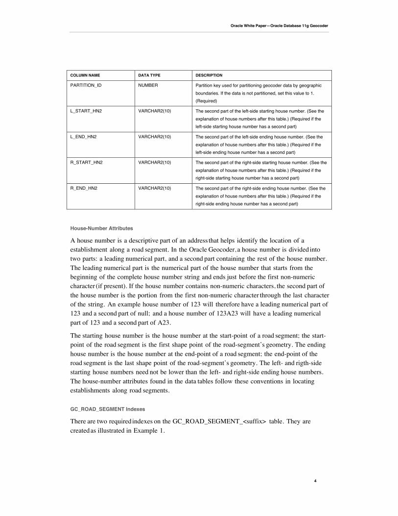
COLUMN NAME DATA TYPE DESCRIPTION
PARTITION_ID NUMBER Partition key used for partitioning geocoder data by geographicboundaries. If the data is not partitioned, set this value to 1.(Required)
L_START_HN2 VARCHAR2(10) The second part of the left-side starting house number. (See theexplanation of house numbers after this table.) (Required if theleft-side starting house number has a second part)
L_END_HN2 VARCHAR2(10) The second part of the left-side ending house number. (See theexplanation of house numbers after this table.) (Required if theleft-side ending house number has a second part)
R_START_HN2 VARCHAR2(10) The second part of the right-side starting house number. (See theexplanation of house numbers after this table.) (Required if theright-side starting house number has a second part)
R_END_HN2 VARCHAR2(10) The second part of the right-side ending house number. (See theexplanation of house numbers after this table.) (Required if theright-side ending house number has a second part)
House-Number Attributes
A house number is a descriptive part of an address that helps identify the location of aestablishment along a road segment. In the Oracle Geocoder, a house number is divided intotwo parts: a leading numerical part, and a second part containing the rest of the house number.The leading numerical part is the numerical part of the house number that starts from thebeginning of the complete house number string and ends just before the first non-numericcharacter (if present). If the house number contains non-numeric characters, the second part ofthe house number is the portion from the first non-numeric character through the last characterof the string. An example house number of 123 will therefore have a leading numerical part of123 and a second part of null; and a house number of 123A23 will have a leading numericalpart of 123 and a second part of A23.
The starting house number is the house number at the start-point of a road segment; the start-point of the road segment is the first shape point of the road-segment’s geometry. The endinghouse number is the house number at the end-point of a road segment; the end-point of theroad segment is the last shape point of the road-segment’s geometry. The left- and rigth-sidestarting house numbers need not be lower than the left- and right-side ending house numbers.The house-number attributes found in the data tables follow these conventions in locatingestablishments along road segments.
GC_ROAD_SEGMENT Indexes
There are two required indexes on the GC_ROAD_SEGMENT_<suffix> table. They arecreated as illustrated in Example 1.

Oracle White Paper—Oracle Database 11g Geocoder
5
Example 1: GC_ROAD_SEGMENT_<suffix> Indexes
CREATE INDEX idx_<suffix>_road_geom ON gc_road_segment_<suffix> (geometry) INDEXTYPE ISmdsys.spatial_index;
CREATE INDEX idx_<suffix>_road_seg_rid ON gc_road_segment_<suffix> (road_id, start_hn, end_hn);
GC_AREA Table and Indexes
The GC_AREA_<suffix> table (for example, CG_AREA_US) stores information on theadministrative areas for the country or group of countries associated with the table-namesuffix. Information may be stored for up to 7 different levels of administrative areas, though 4or 5 levels are common in most countries. In the US administrative hierarchy, a level-1 arearepresents a country, a level-2 area represents a state, a level-3 area represents a county, and alevel-4 area represents a city.
To populate the GC_AREA table, you must specify an area ID for each level in theadministrative hierarchy to which the area belongs. An area with ADMIN_LEVEL=1, i.e., acountry, will have a LEVEL1_AREA_ID associated with it, but no data (0) in its LEVEL2_through LEVEL7_AREA_ID columns. However, an area with ADMIN_LEVEL=3, i.e., acounty, will have a LEVEL3_AREA_ID for the county, a LEVEL2_AREA_ID for the state,and a LEVEL1_AREA_ID for the country to which it belongs. In this example, LEVEL4_through LEVEL7_AREA_ID columns will have no data (0). It is important to note, that theAREA_ID value for an area is the same as the area’s LEVEL(admin_level)_AREA_ID.Therefore, if an area has an ADMIN_LEVEL=2, its AREA_ID and its LEVEL2_AREA_IDare equivalent.
The GC_AREA_<suffix> table contains the columns shown in Table 2.
TABLE 2: GC_AREA_<SUFFIX> TABLE
COLUMN NAME DATA TYPE DESCRIPTION
AREA_ID NUMBER(10) ID number of the administrative area. (Required)
AREA_NAME VARCHAR2(64) Name of the administrative area. (Required)
LANG_CODE VARCHAR2(3) 3-letter ISO national language code for the language associated with theadministrative area. (Required)
ADMIN_LEVEL NUMBER(1) Administrative hierarchy level for the administrative area. 1 to 7 are validentries for this column. (Required)
LEVEL1_AREA_ID NUMBER(10) AREA_ID of the level-1 area to which the administrative area belongs. Inthe administrative hierarchy, the level-1 area is the country. (Required)
LEVEL2_AREA_ID NUMBER(10) AREA_ID of the level-2 area to which the administrative area belongs, ifapplicable.
LEVEL3_AREA_ID NUMBER(10) AREA_ID of the level-3 area to which the administrative area belongs, ifapplicable.
Oracle White Paper—Oracle Database 11g Geocoder
6
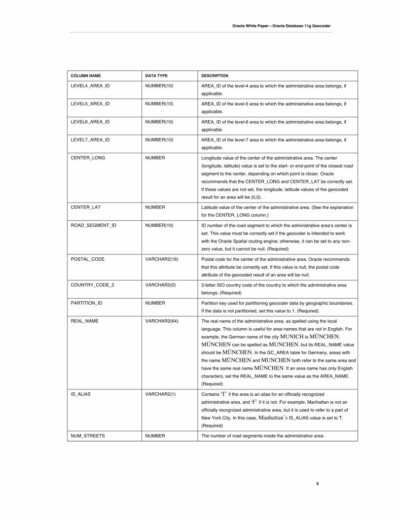
COLUMN NAME DATA TYPE DESCRIPTION
LEVEL4_AREA_ID NUMBER(10) AREA_ID of the level-4 area to which the administrative area belongs, ifapplicable.
LEVEL5_AREA_ID NUMBER(10) AREA_ID of the level-5 area to which the administrative area belongs, ifapplicable.
LEVEL6_AREA_ID NUMBER(10) AREA_ID of the level-6 area to which the administrative area belongs, ifapplicable.
LEVEL7_AREA_ID NUMBER(10) AREA_ID of the level-7 area to which the administrative area belongs, ifapplicable.
CENTER_LONG NUMBER Longitude value of the center of the administrative area. The center(longitude, latitude) value is set to the start- or end-point of the closest roadsegment to the center, depending on which point is closer. Oraclerecommends that the CENTER_LONG and CENTER_LAT be correctly set.If these values are not set, the longitude, latitude values of the geocodedresult for an area will be (0,0).
CENTER_LAT NUMBER Latitude value of the center of the administrative area. (See the explanationfor the CENTER_LONG column.)
ROAD_SEGMENT_ID NUMBER(10) ID number of the road segment to which the administrative areaʼs center isset. This value must be correctly set if the geocoder is intended to workwith the Oracle Spatial routing engine; otherwise, it can be set to any non-zero value, but it cannot be null. (Required)
POSTAL_CODE VARCHAR2(16) Postal code for the center of the administrative area. Oracle recommendsthat this attribute be correctly set. If this value is null, the postal codeattribute of the geocoded result of an area will be null.
COUNTRY_CODE_2 VARCHAR2(2) 2-letter ISO country code of the country to which the administrative areabelongs. (Required)
PARTITION_ID NUMBER Partition key used for partitioning geocoder data by geographic boundaries.If the data is not partitioned, set this value to 1. (Required)
REAL_NAME VARCHAR2(64) The real name of the administrative area, as spelled using the locallanguage. This column is useful for area names that are not in English. Forexample, the German name of the city MUNICH is MÜNCHEN.MÜNCHEN can be spelled as MUNCHEN, but its REAL_NAME valueshould be MÜNCHEN. In the GC_AREA table for Germany, areas withthe name MÜNCHEN and MUNCHEN both refer to the same area andhave the same real name MÜNCHEN. If an area name has only Englishcharacters, set the REAL_NAME to the same value as the AREA_NAME.(Required)
IS_ALIAS VARCHAR2(1) Contains ʻT’ if the area is an alias for an officially recognizedadministrative area, and ʻF’ if it is not. For example, Manhattan is not anofficially recognized administrative area, but it is used to refer to a part ofNew York City. In this case, Manhattan’s IS_ALIAS value is set to T.(Required)
NUM_STREETS NUMBER The number of road segments inside the administrative area.
Oracle White Paper—Oracle Database 11g Geocoder
7
GC_AREA Indexes
There are two required indexes on the GC_AREA_<suffix> table. They are created asillustrated in Example 2.
Example 2: GC_AREA_<suffix> Indexes
CREATE INDEX idx_<suffix>_area_name_id ON gc_area_<suffix> (country_code_2, area_name,admin_level);
CREATE INDEX idx_<suffix>_area_id_name ON gc_area_<suffix> (area_id, area_name,country_code_2);
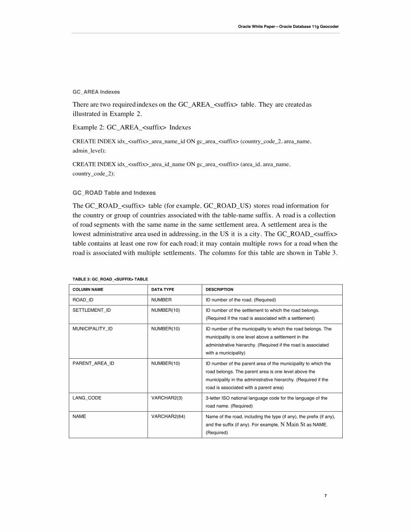
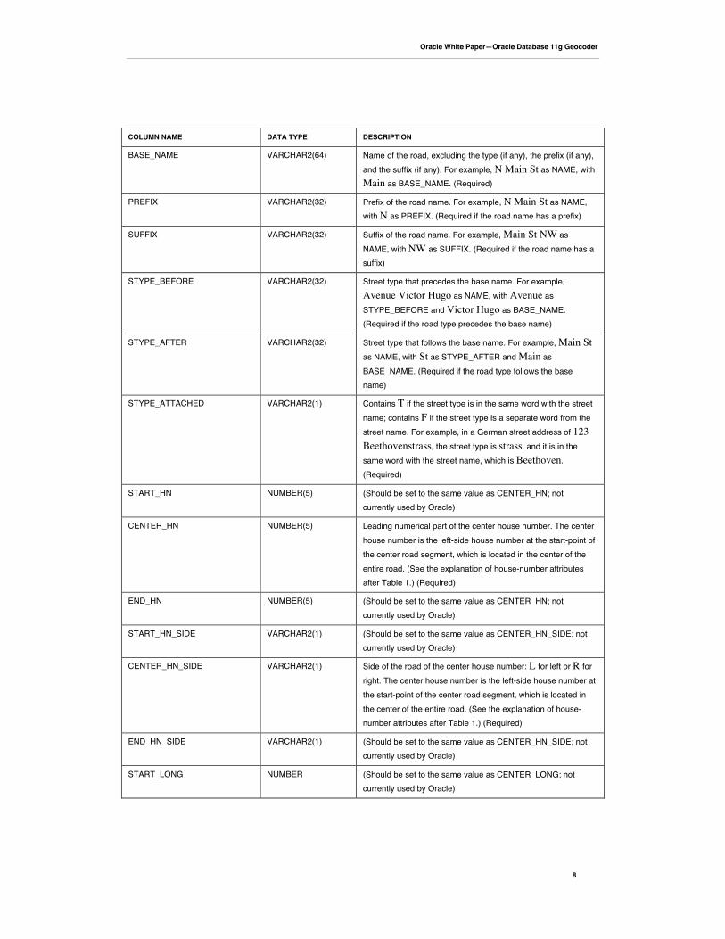
GC_ROAD Table and Indexes
The GC_ROAD_<suffix> table (for example, GC_ROAD_US) stores road information forthe country or group of countries associated with the table-name suffix. A road is a collectionof road segments with the same name in the same settlement area. A settlement area is thelowest administrative area used in addressing, in the US it is a city. The GC_ROAD_<suffix>table contains at least one row for each road; it may contain multiple rows for a road when theroad is associated with multiple settlements. The columns for this table are shown in Table 3.
TABLE 3: GC_ROAD_<SUFFIX> TABLE
COLUMN NAME DATA TYPE DESCRIPTION
ROAD_ID NUMBER ID number of the road. (Required)
SETTLEMENT_ID NUMBER(10) ID number of the settlement to which the road belongs.(Required if the road is associated with a settlement)
MUNICIPALITY_ID NUMBER(10) ID number of the municipality to which the road belongs. Themunicipality is one level above a settlement in theadministrative hierarchy. (Required if the road is associatedwith a municipality)
PARENT_AREA_ID NUMBER(10) ID number of the parent area of the municipality to which theroad belongs. The parent area is one level above themunicipality in the administrative hierarchy. (Required if theroad is associated with a parent area)
LANG_CODE VARCHAR2(3) 3-letter ISO national language code for the language of theroad name. (Required)
NAME VARCHAR2(64) Name of the road, including the type (if any), the prefix (if any),and the suffix (if any). For example, N Main St as NAME.(Required)
Oracle White Paper—Oracle Database 11g Geocoder
8
COLUMN NAME DATA TYPE DESCRIPTION
BASE_NAME VARCHAR2(64) Name of the road, excluding the type (if any), the prefix (if any),and the suffix (if any). For example, N Main St as NAME, withMain as BASE_NAME. (Required)
PREFIX VARCHAR2(32) Prefix of the road name. For example, N Main St as NAME,with N as PREFIX. (Required if the road name has a prefix)
SUFFIX VARCHAR2(32) Suffix of the road name. For example, Main St NW asNAME, with NW as SUFFIX. (Required if the road name has asuffix)
STYPE_BEFORE VARCHAR2(32) Street type that precedes the base name. For example,Avenue Victor Hugo as NAME, with Avenue asSTYPE_BEFORE and Victor Hugo as BASE_NAME.(Required if the road type precedes the base name)
STYPE_AFTER VARCHAR2(32) Street type that follows the base name. For example, Main Stas NAME, with St as STYPE_AFTER and Main asBASE_NAME. (Required if the road type follows the basename)
STYPE_ATTACHED VARCHAR2(1) Contains T if the street type is in the same word with the streetname; contains F if the street type is a separate word from thestreet name. For example, in a German street address of 123Beethovenstrass, the street type is strass, and it is in thesame word with the street name, which is Beethoven.(Required)
START_HN NUMBER(5) (Should be set to the same value as CENTER_HN; notcurrently used by Oracle)
CENTER_HN NUMBER(5) Leading numerical part of the center house number. The centerhouse number is the left-side house number at the start-point ofthe center road segment, which is located in the center of theentire road. (See the explanation of house-number attributesafter Table 1.) (Required)
END_HN NUMBER(5) (Should be set to the same value as CENTER_HN; notcurrently used by Oracle)
START_HN_SIDE VARCHAR2(1) (Should be set to the same value as CENTER_HN_SIDE; notcurrently used by Oracle)
CENTER_HN_SIDE VARCHAR2(1) Side of the road of the center house number: L for left or R forright. The center house number is the left-side house number atthe start-point of the center road segment, which is located inthe center of the entire road. (See the explanation of house-number attributes after Table 1.) (Required)
END_HN_SIDE VARCHAR2(1) (Should be set to the same value as CENTER_HN_SIDE; notcurrently used by Oracle)
START_LONG NUMBER (Should be set to the same value as CENTER_LONG; notcurrently used by Oracle)
Oracle White Paper—Oracle Database 11g Geocoder
9
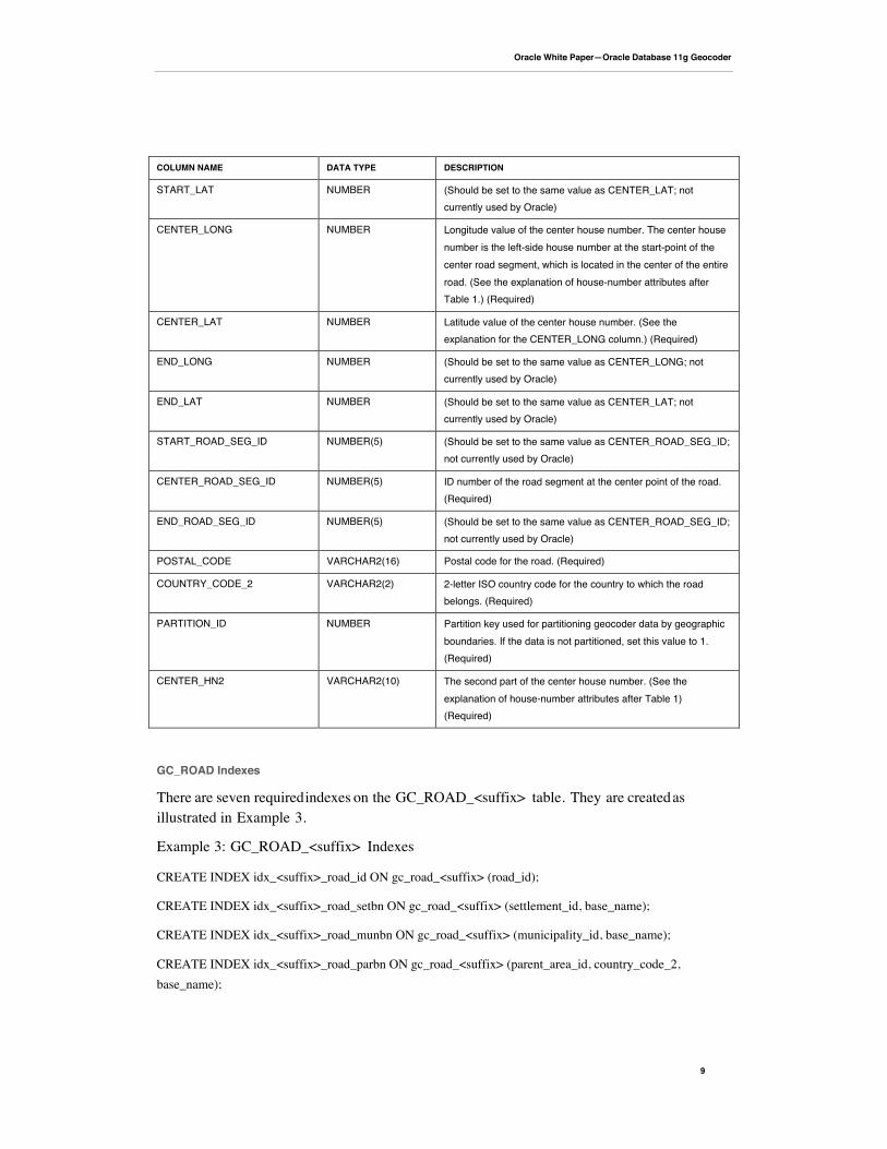
COLUMN NAME DATA TYPE DESCRIPTION
START_LAT NUMBER (Should be set to the same value as CENTER_LAT; notcurrently used by Oracle)
CENTER_LONG NUMBER Longitude value of the center house number. The center housenumber is the left-side house number at the start-point of thecenter road segment, which is located in the center of the entireroad. (See the explanation of house-number attributes afterTable 1.) (Required)
CENTER_LAT NUMBER Latitude value of the center house number. (See theexplanation for the CENTER_LONG column.) (Required)
END_LONG NUMBER (Should be set to the same value as CENTER_LONG; notcurrently used by Oracle)
END_LAT NUMBER (Should be set to the same value as CENTER_LAT; notcurrently used by Oracle)
START_ROAD_SEG_ID NUMBER(5) (Should be set to the same value as CENTER_ROAD_SEG_ID;not currently used by Oracle)
CENTER_ROAD_SEG_ID NUMBER(5) ID number of the road segment at the center point of the road.(Required)
END_ROAD_SEG_ID NUMBER(5) (Should be set to the same value as CENTER_ROAD_SEG_ID;not currently used by Oracle)
POSTAL_CODE VARCHAR2(16) Postal code for the road. (Required)
COUNTRY_CODE_2 VARCHAR2(2) 2-letter ISO country code for the country to which the roadbelongs. (Required)
PARTITION_ID NUMBER Partition key used for partitioning geocoder data by geographicboundaries. If the data is not partitioned, set this value to 1.(Required)
CENTER_HN2 VARCHAR2(10) The second part of the center house number. (See theexplanation of house-number attributes after Table 1)(Required)
GC_ROAD Indexes
There are seven required indexes on the GC_ROAD_<suffix> table. They are created asillustrated in Example 3.
Example 3: GC_ROAD_<suffix> Indexes
CREATE INDEX idx_<suffix>_road_id ON gc_road_<suffix> (road_id);
CREATE INDEX idx_<suffix>_road_setbn ON gc_road_<suffix> (settlement_id, base_name);
CREATE INDEX idx_<suffix>_road_munbn ON gc_road_<suffix> (municipality_id, base_name);
CREATE INDEX idx_<suffix>_road_parbn ON gc_road_<suffix> (parent_area_id, country_code_2,base_name);
Oracle White Paper—Oracle Database 11g Geocoder
10
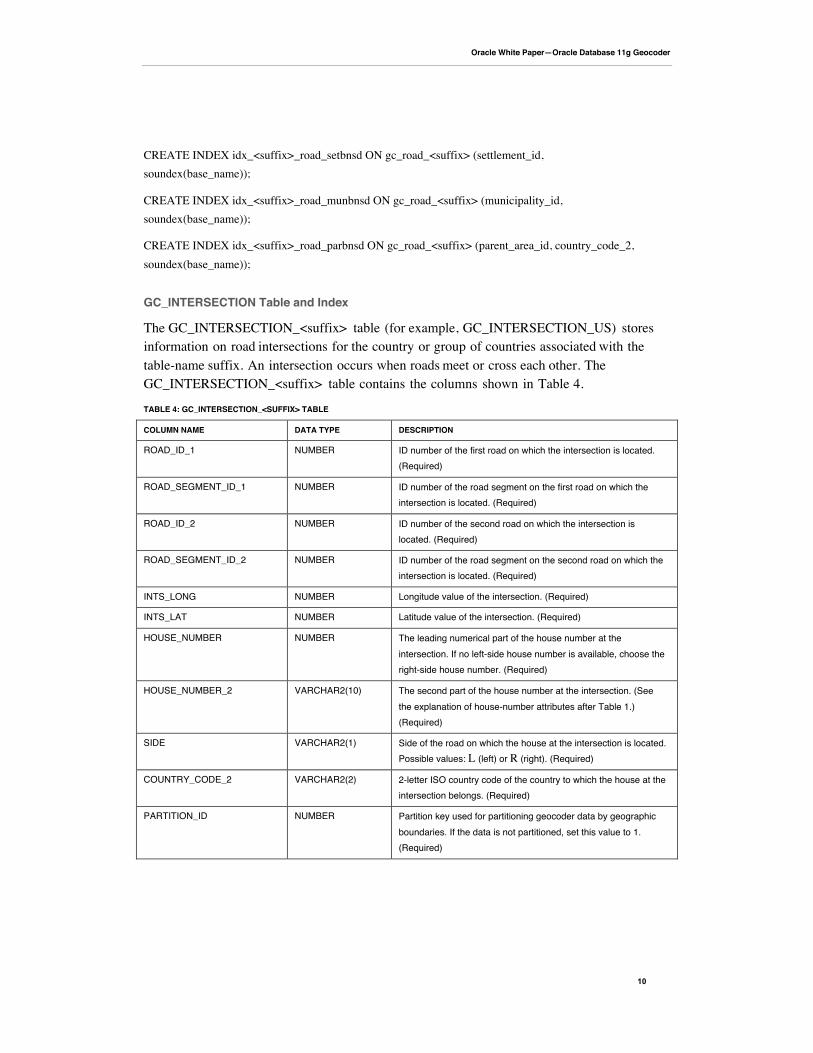
CREATE INDEX idx_<suffix>_road_setbnsd ON gc_road_<suffix> (settlement_id,soundex(base_name));
CREATE INDEX idx_<suffix>_road_munbnsd ON gc_road_<suffix> (municipality_id,soundex(base_name));
CREATE INDEX idx_<suffix>_road_parbnsd ON gc_road_<suffix> (parent_area_id, country_code_2,soundex(base_name));
GC_INTERSECTION Table and Index
The GC_INTERSECTION_<suffix> table (for example, GC_INTERSECTION_US) storesinformation on road intersections for the country or group of countries associated with thetable-name suffix. An intersection occurs when roads meet or cross each other. TheGC_INTERSECTION_<suffix> table contains the columns shown in Table 4.
TABLE 4: GC_INTERSECTION_<SUFFIX> TABLE
COLUMN NAME DATA TYPE DESCRIPTION
ROAD_ID_1 NUMBER ID number of the first road on which the intersection is located.(Required)
ROAD_SEGMENT_ID_1 NUMBER ID number of the road segment on the first road on which theintersection is located. (Required)
ROAD_ID_2 NUMBER ID number of the second road on which the intersection islocated. (Required)
ROAD_SEGMENT_ID_2 NUMBER ID number of the road segment on the second road on which theintersection is located. (Required)
INTS_LONG NUMBER Longitude value of the intersection. (Required)
INTS_LAT NUMBER Latitude value of the intersection. (Required)
HOUSE_NUMBER NUMBER The leading numerical part of the house number at theintersection. If no left-side house number is available, choose theright-side house number. (Required)
HOUSE_NUMBER_2 VARCHAR2(10) The second part of the house number at the intersection. (Seethe explanation of house-number attributes after Table 1.)(Required)
SIDE VARCHAR2(1) Side of the road on which the house at the intersection is located.Possible values: L (left) or R (right). (Required)
COUNTRY_CODE_2 VARCHAR2(2) 2-letter ISO country code of the country to which the house at theintersection belongs. (Required)
PARTITION_ID NUMBER Partition key used for partitioning geocoder data by geographicboundaries. If the data is not partitioned, set this value to 1.(Required)
Oracle White Paper—Oracle Database 11g Geocoder
11
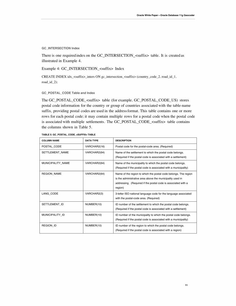
GC_INTERSECTION Index
There is one required index on the GC_INTERSECTION_<suffix> table. It is created asillustrated in Example 4.
Example 4: GC_INTERSECTION_<suffix> Index
CREATE INDEX idx_<suffix>_inters ON gc_intersection_<suffix> (country_code_2, road_id_1,road_id_2);
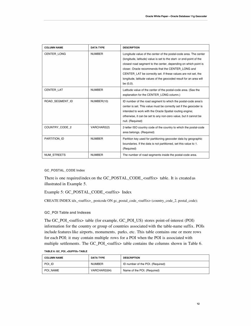
GC_POSTAL_CODE Table and Index
The GC_POSTAL_CODE_<suffix> table (for example, GC_POSTAL_CODE_US) storespostal code information for the country or group of countries associated with the table-namesuffix, providing postal codes are used in the address format. This table contains one or morerows for each postal code; it may contain multiple rows for a postal code when the postal codeis associated with multiple settlements. The GC_POSTAL_CODE_<suffix> table containsthe columns shown in Table 5.
TABLE 5: GC_POSTAL_CODE_<SUFFIX> TABLE
COLUMN NAME DATA TYPE DESCRIPTION
POSTAL_CODE VARCHAR2(16) Postal code for the postal-code area. (Required)
SETTLEMENT_NAME VARCHAR2(64) Name of the settlement to which the postal code belongs.(Required if the postal code is associated with a settlement)
MUNICIPALITY_NAME VARCHAR2(64) Name of the municipality to which the postal code belongs.(Required if the postal code is associated with a municipality)
REGION_NAME VARCHAR2(64) Name of the region to which the postal code belongs. The regionis the administrative area above the municipality used inaddressing. (Required if the postal code is associated with aregion)
LANG_CODE VARCHAR2(3) 3-letter ISO national language code for the language associatedwith the postal-code area. (Required)
SETTLEMENT_ID NUMBER(10) ID number of the settlement to which the postal code belongs.(Required if the postal code is associated with a settlement)
MUNICIPALITY_ID NUMBER(10) ID number of the municipality to which the postal code belongs.(Required if the postal code is associated with a municipality)
REGION_ID NUMBER(10) ID number of the region to which the postal code belongs.(Required if the postal code is associated with a region)
Oracle White Paper—Oracle Database 11g Geocoder
12
COLUMN NAME DATA TYPE DESCRIPTION
CENTER_LONG NUMBER Longitude value of the center of the postal-code area. The center(longitude, latitude) value is set to the start- or end-point of theclosest road segment to the center, depending on which point iscloser. Oracle recommends that the CENTER_LONG andCENTER_LAT be correctly set. If these values are not set, thelongitude, latitude values of the geocoded result for an area willbe (0,0).
CENTER_LAT NUMBER Latitude value of the center of the postal-code area. (See theexplanation for the CENTER_LONG column.)
ROAD_SEGMENT_ID NUMBER(10) ID number of the road segment to which the postal-code areaʼscenter is set. This value must be correctly set if the geocoder isintended to work with the Oracle Spatial routing engine;otherwise, it can be set to any non-zero value, but it cannot benull. (Required)
COUNTRY_CODE_2 VARCHAR2(2) 2-letter ISO country code of the country to which the postal-codearea belongs. (Required)
PARTITION_ID NUMBER Partition key used for partitioning geocoder data by geographicboundaries. If the data is not partitioned, set this value to 1.(Required)
NUM_STREETS NUMBER The number of road segments inside the postal-code area.
GC_POSTAL_CODE Index
There is one required index on the GC_POSTAL_CODE_<suffix> table. It is created asillustrated in Example 5.
Example 5: GC_POSTAL_CODE_<suffix> Index
CREATE INDEX idx_<suffix>_ postcode ON gc_postal_code_<suffix> (country_code_2, postal_code);
GC_POI Table and Indexes
The GC_POI_<suffix> table (for example, GC_POI_US) stores point-of-interest (POI)information for the country or group of countries associated with the table-name suffix. POIsinclude features like airports, monuments, parks, etc. This table contains one or more rowsfor each POI; it may contain multiple rows for a POI when the POI is associated withmultiple settlements. The GC_POI_<suffix> table contains the columns shown in Table 6.
TABLE 6: GC_POI_<SUFFIX> TABLE
COLUMN NAME DATA TYPE DESCRIPTION
POI_ID NUMBER ID number of the POI. (Required)
POI_NAME VARCHAR2(64) Name of the POI. (Required)

Oracle White Paper—Oracle Database 11g Geocoder
13
COLUMN NAME DATA TYPE DESCRIPTION
LANG_CODE VARCHAR2(3) 3-letter ISO national language code for the language of the POIname. (Required)
FEATURE_CODE NUMBER Feature code for the POI, if the data vendor classifies POIs bycategory.
HOUSE_NUMBER VARCHAR2(10) House number of the POI; may contain non-numeric characters.(Required)
STREET_NAME VARCHAR2(80) Road name of the POI. (Required)
SETTLEMENT_ID NUMBER(10) ID number of the settlement to which the POI belongs. (Requiredif the POI is associated with a settlement)
MUNICIPALITY_ID NUMBER(10) ID number of the municipality to which the POI belongs.(Required if the POI is associated with a municipality)
REGION_ID NUMBER(10) ID number of the region to which the POI belongs. (Required ifthe POI is associated with a region)
SETTLEMENT_NAME VARCHAR2(64) Name of the settlement to which the POI belongs. (Required if thePOI is associated with a settlement)
MUNICIPALITY_NAME VARCHAR2(64) Name of the municipality to which the POI belongs. (Required ifthe POI is associated with a municipality)
REGION_NAME VARCHAR2(64) Name of the region to which the POI belongs. (Required if thePOI is associated with a region)
POSTAL_CODE VARCHAR2(16) Postal code of the POI. (Required)
VANITY_CITY VARCHAR2(35) Name of the city popularly associated with the POI, if it is differentfrom the actual city containing the POI. For example, the LondonHeathrow Airport is actually located in a town named Hayes,which is part of greater London, but people tend to associate theairport only with London. In this case, the VANITY_CITY value isLondon.
ROAD_SEGMENT_ID NUMBER ID number of the road segment on which the POI is located.(Required)
SIDE VARCHAR2(1) Side of the road on which the POI is located. Possible values: L(left) or R (right). (Required)
PERCENT NUMBER Decimal fraction of the length of the road segment on which thePOI is located. It is computed as the distance from the roadsegment start-point to the POI, divided by the length of the roadsegment. (Required)
TELEPHONE_NUMBER VARCHAR2(20) Telephone number of the POI.
LOC_LONG NUMBER Longitude value of the POI. (Required)
LOC_LAT NUMBER Latitude value of the POI. (Required)
COUNTRY_CODE_2 VARCHAR2(2) 2-letter ISO country code for the country to which the POIbelongs. (Required)

Oracle White Paper—Oracle Database 11g Geocoder
14
COLUMN NAME DATA TYPE DESCRIPTION
PARTITION_ID NUMBER Partition key used for partitioning geocoder data by geographicboundaries. If the data is not partitioned, set this value to 1.(Required)
Oracle White Paper—Oracle Database 11g Geocoder
15
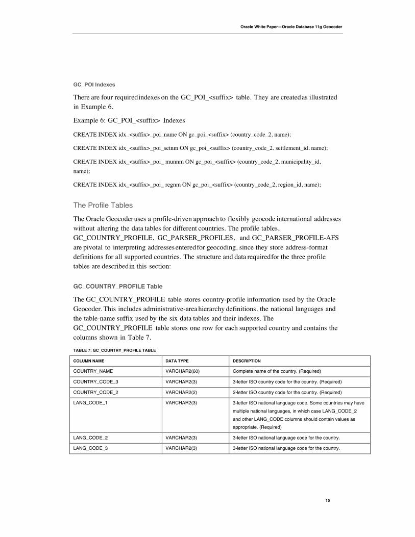
GC_POI Indexes
There are four required indexes on the GC_POI_<suffix> table. They are created as illustratedin Example 6.
Example 6: GC_POI_<suffix> Indexes
CREATE INDEX idx_<suffix>_poi_name ON gc_poi_<suffix> (country_code_2, name);
CREATE INDEX idx_<suffix>_poi_setnm ON gc_poi_<suffix> (country_code_2, settlement_id, name);
CREATE INDEX idx_<suffix>_poi_ munnm ON gc_poi_<suffix> (country_code_2, municipality_id,name);
CREATE INDEX idx_<suffix>_poi_ regnm ON gc_poi_<suffix> (country_code_2, region_id, name);
The Profile Tables
The Oracle Geocoder uses a profile-driven approach to flexibly geocode international addresseswithout altering the data tables for different countries. The profile tables,GC_COUNTRY_PROFILE, GC_PARSER_PROFILES, and GC_PARSER_PROFILE-AFSare pivotal to interpreting addresses entered for geocoding, since they store address-formatdefinitions for all supported countries. The structure and data required for the three profiletables are described in this section:
GC_COUNTRY_PROFILE Table
The GC_COUNTRY_PROFILE table stores country-profile information used by the OracleGeocoder. This includes administrative-area hierarchy definitions, the national languages andthe table-name suffix used by the six data tables and their indexes. TheGC_COUNTRY_PROFILE table stores one row for each supported country and contains thecolumns shown in Table 7.
TABLE 7: GC_COUNTRY_PROFILE TABLE
COLUMN NAME DATA TYPE DESCRIPTION
COUNTRY_NAME VARCHAR2(60) Complete name of the country. (Required)
COUNTRY_CODE_3 VARCHAR2(3) 3-letter ISO country code for the country. (Required)
COUNTRY_CODE_2 VARCHAR2(2) 2-letter ISO country code for the country. (Required)
LANG_CODE_1 VARCHAR2(3) 3-letter ISO national language code. Some countries may havemultiple national languages, in which case LANG_CODE_2and other LANG_CODE columns should contain values asappropriate. (Required)
LANG_CODE_2 VARCHAR2(3) 3-letter ISO national language code for the country.
LANG_CODE_3 VARCHAR2(3) 3-letter ISO national language code for the country.
Oracle White Paper—Oracle Database 11g Geocoder
16
COLUMN NAME DATA TYPE DESCRIPTION
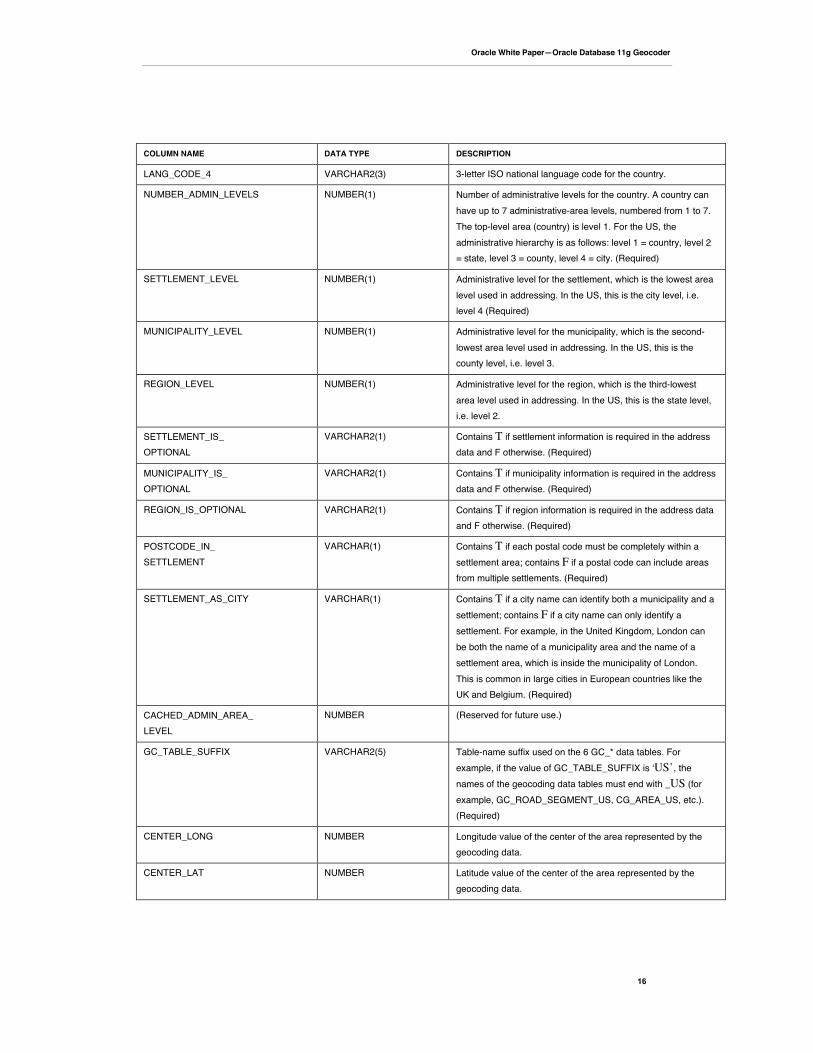
LANG_CODE_4 VARCHAR2(3) 3-letter ISO national language code for the country.
NUMBER_ADMIN_LEVELS NUMBER(1) Number of administrative levels for the country. A country canhave up to 7 administrative-area levels, numbered from 1 to 7.The top-level area (country) is level 1. For the US, theadministrative hierarchy is as follows: level 1 = country, level 2= state, level 3 = county, level 4 = city. (Required)
SETTLEMENT_LEVEL NUMBER(1) Administrative level for the settlement, which is the lowest arealevel used in addressing. In the US, this is the city level, i.e.level 4 (Required)
MUNICIPALITY_LEVEL NUMBER(1) Administrative level for the municipality, which is the second-lowest area level used in addressing. In the US, this is thecounty level, i.e. level 3.
REGION_LEVEL NUMBER(1) Administrative level for the region, which is the third-lowestarea level used in addressing. In the US, this is the state level,i.e. level 2.
SETTLEMENT_IS_OPTIONAL
VARCHAR2(1) Contains T if settlement information is required in the addressdata and F otherwise. (Required)
MUNICIPALITY_IS_OPTIONAL
VARCHAR2(1) Contains T if municipality information is required in the addressdata and F otherwise. (Required)
REGION_IS_OPTIONAL VARCHAR2(1) Contains T if region information is required in the address dataand F otherwise. (Required)
POSTCODE_IN_SETTLEMENT
VARCHAR(1) Contains T if each postal code must be completely within asettlement area; contains F if a postal code can include areasfrom multiple settlements. (Required)
SETTLEMENT_AS_CITY VARCHAR(1) Contains T if a city name can identify both a municipality and asettlement; contains F if a city name can only identify asettlement. For example, in the United Kingdom, London canbe both the name of a municipality area and the name of asettlement area, which is inside the municipality of London.This is common in large cities in European countries like theUK and Belgium. (Required)
CACHED_ADMIN_AREA_LEVEL
NUMBER (Reserved for future use.)
GC_TABLE_SUFFIX VARCHAR2(5) Table-name suffix used on the 6 GC_* data tables. Forexample, if the value of GC_TABLE_SUFFIX is ʻUS’, thenames of the geocoding data tables must end with _US (forexample, GC_ROAD_SEGMENT_US, CG_AREA_US, etc.).(Required)
CENTER_LONG NUMBER Longitude value of the center of the area represented by thegeocoding data.
CENTER_LAT NUMBER Latitude value of the center of the area represented by thegeocoding data.

Oracle White Paper—Oracle Database 11g Geocoder
17
COLUMN NAME DATA TYPE DESCRIPTION
SEPARATE_PREFIX VARCHAR2(1) Contains T if the street-name prefix is a separate word from thestreet name; contains F if the street name prefix is in the sameword with the street name. For example, in a US street addressof 123 N Main St, the prefix is N, and it is separate from thestreet name, which is Main. (Not currently used by Oracle)
SEPARATE_SUFFIX VARCHAR2(1) Contains T if the street-name suffix is a separate word from thestreet name; contains F if the street-name suffix is in the sameword with the street name. For example, in a US street addressof 123 Main St NW, the suffix is NW, and it is separatefrom the street name, which is Main, and from the street type,which is St. (Not currently used by Oracle)
SEPARATE_STYPE VARCHAR2(1) Contains T if the street type is a separate word from the streetname; contains F if the street type is in the same word with thestreet name. For example, in a German street address of 123Beethovenstrass, the type is strass, and it is in the sameword with the street name, which is Beethoven. (Notcurrently used by Oracle)
AREA_ID NUMBER Not currently used by Oracle.
VERSION VARCHAR2(10) Version of the data. The current version is 1.0. (Required)

Oracle White Paper—Oracle Database 11g Geocoder
18
GC_PARSER_PROFILES Table
The Oracle Geocoder uses keywords to identify address fields, such as, house number, roadname, city name, state name, and zip code. The GC_PARSER_PROFILES table storesinformation about keywords typically found in postal addresses. A keyword can be the type ofstreet, for example, road, street, drive, avenue, etc. or the prefix or suffix of a street, forexample, north, south, east, west, etc. The GC_PARSER_PROFILES table contains thecolumns shown in Table 8.
TABLE 8: GC_PARSER_PROFILES TABLE
COLUMN NAME DATA TYPE DESCRIPTION
COUNTRY_CODE VARCHAR2(2) 2-letter ISO country code for the keyword. (Required)
KEYWORDS VARCHAR2(4000) A single array of keywords that will be identified by the Oracle Geocoderfor a specific address field. The array may contain a single word, or agroup of words and abbreviations that can be used with the samemeaning, for example, United States of America, USA, and United Statesall refer to the US. The US uses over 400 keywords in parsing addresses.Here are some examples of keyword arrays and keywords from the USdataset. However, only a single SDO_KEYWORDARRAY is stored perrow:
SDO_KEYWORDARRAY('US', 'USA', 'UNITED STATES', 'UNITEDSTATES OF AMERICA', 'U.S.A.', 'U.S.')
SDO_KEYWORDARRAY('AV', 'AVENUE', 'AVE', 'AVEN', 'AVENU','AVN', 'AVNUE', 'AV.','AVE.')
SDO_KEYWORDARRAY('40TH', 'FORTIETH')
SDO_KEYWORDARRAY('NY', 'New York')
SDO_KEYWORDARRAY('LIBRARY')
OUTPUT_KEYWORD VARCHAR2(2000) A keyword used in the geocoder data to represent an address field. Itmust be the same as one of the keywords used in the keyword array. Theoutput keyword is used to match the addresses stored in the geocodingdata tables to the userʼs input, for example, if the output_keyword ʻAVʼ isused for street type AVENUE in the GC_ROAD_US table, wherever auser enters an address containing any of the keywords ('AV', 'AVENUE','AVE', 'AVEN', 'AVENU', 'AVN', 'AVNUE', 'AV.','AVE.'), the keyword will beinterpreted and matched to the output keyword AV to help find theaddress in the database. Here are the output keywords for the abovekeyword arrays. However, only a single OUTPUT_KEYWORD is storedper row:
USAV40THNYLIBRARY
Oracle White Paper—Oracle Database 11g Geocoder
19
COLUMN NAME DATA TYPE DESCRIPTION
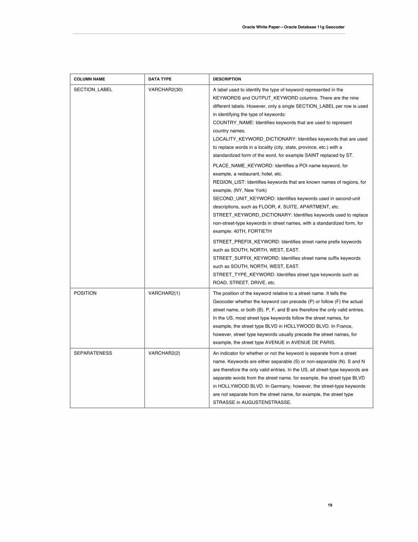
SECTION_LABEL VARCHAR2(30) A label used to identify the type of keyword represented in theKEYWORDS and OUTPUT_KEYWORD columns. There are the ninedifferent labels. However, only a single SECTION_LABEL per row is usedin identifying the type of keywords:COUNTRY_NAME: Identifies keywords that are used to representcountry names.LOCALITY_KEYWORD_DICTIONARY: Identifies keywords that are usedto replace words in a locality (city, state, province, etc.) with astandardized form of the word, for example SAINT replaced by ST.
PLACE_NAME_KEYWORD: Identifies a POI name keyword, forexample, a restaurant, hotel, etc.REGION_LIST: Identifies keywords that are known names of regions, forexample, (NY, New York)SECOND_UNIT_KEYWORD: Identifies keywords used in second-unitdescriptions, such as FLOOR, #, SUITE, APARTMENT, etc.STREET_KEYWORD_DICTIONARY: Identifies keywords used to replacenon-street-type keywords in street names, with a standardized form, forexample: 40TH, FORTIETH
STREET_PREFIX_KEYWORD: Identifies street name prefix keywordssuch as SOUTH, NORTH, WEST, EAST.STREET_SUFFIX_KEYWORD: Identifies street name suffix keywordssuch as SOUTH, NORTH, WEST, EAST.STREET_TYPE_KEYWORD: Identifies street type keywords such asROAD, STREET, DRIVE, etc.
POSITION VARCHAR2(1) The position of the keyword relative to a street name. It tells theGeocoder whether the keyword can precede (P) or follow (F) the actualstreet name, or both (B). P, F, and B are therefore the only valid entries.In the US, most street type keywords follow the street names, forexample, the street type BLVD in HOLLYWOOD BLVD. In France,however, street type keywords usually precede the street names, forexample, the street type AVENUE in AVENUE DE PARIS.
SEPARATENESS VARCHAR2(2) An indicator for whether or not the keyword is separate from a streetname. Keywords are either separable (S) or non-separable (N). S and Nare therefore the only valid entries. In the US, all street-type keywords areseparate words from the street name, for example, the street type BLVDin HOLLYWOOD BLVD. In Germany, however, the street-type keywordsare not separate from the street name, for example, the street typeSTRASSE in AUGUSTENSTRASSE.
Oracle White Paper—Oracle Database 11g Geocoder
20
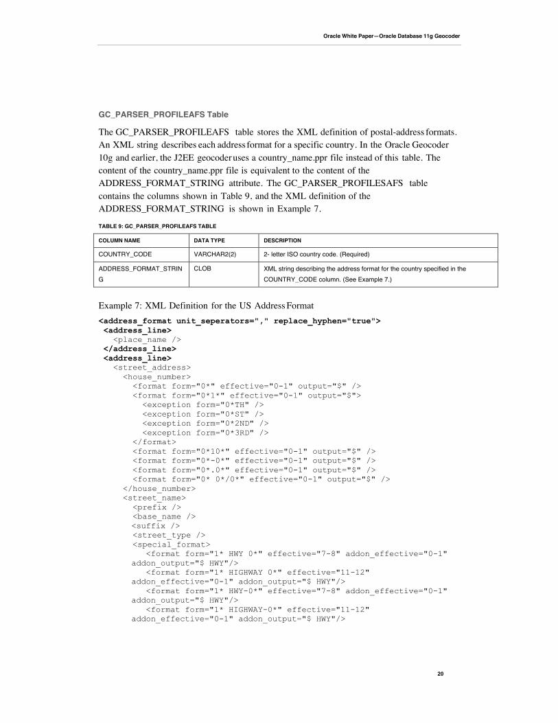
GC_PARSER_PROFILEAFS Table
The GC_PARSER_PROFILEAFS table stores the XML definition of postal-address formats.An XML string describes each address format for a specific country. In the Oracle Geocoder10g and earlier, the J2EE geocoder uses a country_name.ppr file instead of this table. Thecontent of the country_name.ppr file is equivalent to the content of theADDRESS_FORMAT_STRING attribute. The GC_PARSER_PROFILESAFS tablecontains the columns shown in Table 9, and the XML definition of theADDRESS_FORMAT_STRING is shown in Example 7.
TABLE 9: GC_PARSER_PROFILEAFS TABLE
COLUMN NAME DATA TYPE DESCRIPTION
COUNTRY_CODE VARCHAR2(2) 2- letter ISO country code. (Required)
ADDRESS_FORMAT_STRING
CLOB XML string describing the address format for the country specified in theCOUNTRY_CODE column. (See Example 7.)
Example 7: XML Definition for the US Address Format<address_format unit_seperators="," replace_hyphen="true"> <address_line> <place_name /> </address_line> <address_line> <street_address> <house_number> <format form="0*" effective="0-1" output="$" /> <format form="0*1*" effective="0-1" output="$"> <exception form="0*TH" /> <exception form="0*ST" /> <exception form="0*2ND" /> <exception form="0*3RD" /> </format> <format form="0*10*" effective="0-1" output="$" /> <format form="0*-0*" effective="0-1" output="$" /> <format form="0*.0*" effective="0-1" output="$" /> <format form="0* 0*/0*" effective="0-1" output="$" /> </house_number> <street_name> <prefix /> <base_name /> <suffix /> <street_type /> <special_format>
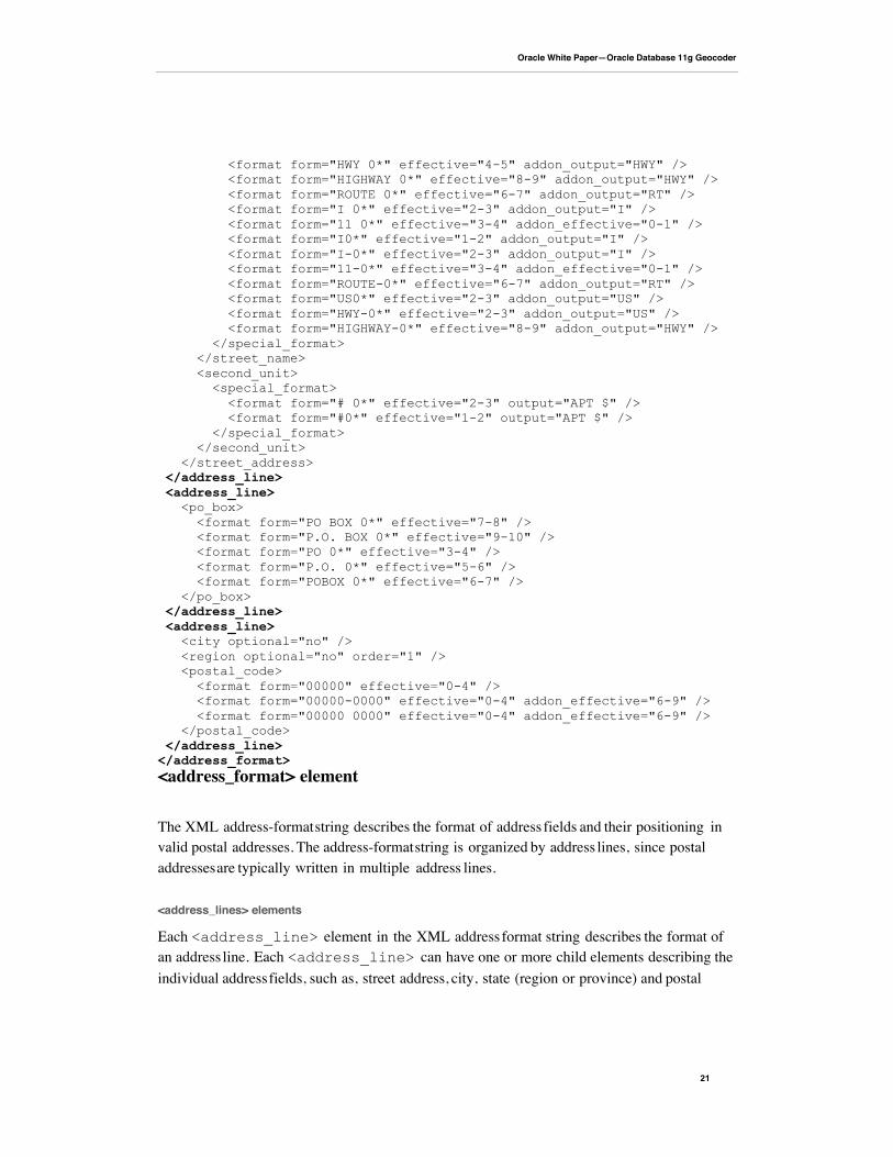
<format form="1* HWY 0*" effective="7-8" addon_effective="0-1"addon_output="$ HWY"/> <format form="1* HIGHWAY 0*" effective="11-12"addon_effective="0-1" addon_output="$ HWY"/> <format form="1* HWY-0*" effective="7-8" addon_effective="0-1"addon_output="$ HWY"/> <format form="1* HIGHWAY-0*" effective="11-12"addon_effective="0-1" addon_output="$ HWY"/>
Oracle White Paper—Oracle Database 11g Geocoder
21
<format form="HWY 0*" effective="4-5" addon_output="HWY" /> <format form="HIGHWAY 0*" effective="8-9" addon_output="HWY" /> <format form="ROUTE 0*" effective="6-7" addon_output="RT" /> <format form="I 0*" effective="2-3" addon_output="I" /> <format form="11 0*" effective="3-4" addon_effective="0-1" /> <format form="I0*" effective="1-2" addon_output="I" /> <format form="I-0*" effective="2-3" addon_output="I" /> <format form="11-0*" effective="3-4" addon_effective="0-1" /> <format form="ROUTE-0*" effective="6-7" addon_output="RT" /> <format form="US0*" effective="2-3" addon_output="US" /> <format form="HWY-0*" effective="2-3" addon_output="US" /> <format form="HIGHWAY-0*" effective="8-9" addon_output="HWY" /> </special_format> </street_name> <second_unit> <special_format> <format form="# 0*" effective="2-3" output="APT $" /> <format form="#0*" effective="1-2" output="APT $" /> </special_format> </second_unit> </street_address> </address_line> <address_line> <po_box> <format form="PO BOX 0*" effective="7-8" /> <format form="P.O. BOX 0*" effective="9-10" /> <format form="PO 0*" effective="3-4" /> <format form="P.O. 0*" effective="5-6" /> <format form="POBOX 0*" effective="6-7" /> </po_box> </address_line> <address_line> <city optional="no" /> <region optional="no" order="1" /> <postal_code> <format form="00000" effective="0-4" /> <format form="00000-0000" effective="0-4" addon_effective="6-9" /> <format form="00000 0000" effective="0-4" addon_effective="6-9" /> </postal_code> </address_line></address_format><address_format> element
The XML address-format string describes the format of address fields and their positioning invalid postal addresses. The address-format string is organized by address lines, since postaladdresses are typically written in multiple address lines.
<address_lines> elements
Each <address_line> element in the XML address format string describes the format ofan address line. Each <address_line> can have one or more child elements describing theindividual address fields, such as, street address, city, state (region or province) and postal
Oracle White Paper—Oracle Database 11g Geocoder
22
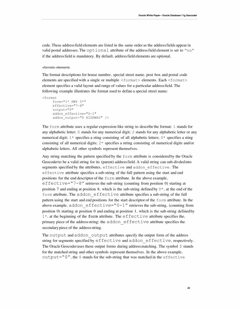
code. These address field elements are listed in the same order as the address fields appear invalid postal addresses. The optional attribute of the address field element is set to “no”if the address field is mandatory. By default, address field elements are optional.
<format> elements
The format descriptions for house number, special street name, post box and postal codeelements are specified with a single or multiple <format> elements. Each <format>element specifies a valid layout and range of values for a particular address field. Thefollowing example illustrates the format used to define a special street name:<format form="1* HWY 0*" effective="7-8" output="$" addon_effective="0-1" addon_output="$ HIGHWAY" />
The form attribute uses a regular expression-like string to describe the format: 1 stands forany alphabetic letter; 0 stands for any numerical digit; 2 stands for any alphabetic letter or anynumerical digit; 1* specifies a sting consisting of all alphabetic letters; 0* specifies a stingconsisting of all numerical digits; 2* specifies a string consisting of numerical digits and/oralphabetic letters. All other symbols represent themselves.
Any string matching the pattern specified by the form attribute is considered by the OracleGeocoder to be a valid string for its (parent) address field. A valid string can sub-divded intosegments specified by the attributes, effective and addon_effective. Theeffective attribute specifies a sub-string of the full pattern using the start and endpositions for the end descriptor of the form attribute. In the above example,effective=“7-8” retrieves the sub-string (counting from position 0) starting atposition 7 and ending at position 8, which is the sub-string defined by 0*, at the end of theform attribute. The addon_effective attribute specifies a sub-string of the fullpattern using the start and end positions for the start descriptor of the form attribute. In theabove example, addon_effective=“0-1” retrieves the sub-string, (counting fromposition 0) starting at position 0 and ending at position 1, which is the sub-string defined by1*, at the beginning of the form attribute. The effective attribute specifies the,primary piece of the address string; the addon_effective attribute specifies thesecondary piece of the address string.
The output and addon_output attributes specify the output form of the addressstring for segments specified by effective and addon_effective, respectively.The Oracle Geocoder uses these output forms during address matching. The symbol $ standsfor the matched string and other symbols represent themselves. In the above example,output=“$”, the $ stands for the sub-string that was matched in the effective
Oracle White Paper—Oracle Database 11g Geocoder
23
attribute; addon_output=“$ HIGHWAY” stands for the sub-string that was matched inthe addon_effective attribute, followed by a space, followed by the word “HIGHWAY”.
Using the <format> element in the above example, with form=“1* HWY 0*”, the inputstring ‘STATE HWY 580’ will have: effective=580; output=580;addon_effective=STATE; and addon_output=STATE HIGHWAY.
The <format> element may also contain an <exception> sub-element. The<exception> sub-element specifies a string that has a valid form, but must be excludedfrom the address field. In a <house_number> element with valid numbers 0*1*. Anynumeric digits followed by any alphabetic letters, <exception form=“0*TH” />specifies that any house number with (or without) numeric digits and ending with “TH” mustbe excluded.
The Oracle Geocoder address parser uses the format description defined in the XML addressformat, combined with the keyword definition for each address field defined in theGC_PARSER_PROFILES table to parse the input address and identify individual addressfields.
Installing the Parser-Profile Tables
The Oracle Geocoder profile tables are typically supplied by a data provider. Use the dataprovider’s profile tables for geocoding whenever they are available. For users building theirown geocoder schema, Oracle provides the GC_PARSER_PROFILES andGC_PARSER_PROFILEAFS tables. The installation of these Oracle-supplied profile tablesshould only be undertaken if profile tables are not supplied with the data tables.
The Oracle-supplied tables contain parser profiles for a limited number of countries. If profilesfor your country or group of countries of interest are not included, you will need to manuallyadd them using the information provided in Sections 2.2.2 and 2.2.3 as a guide. For a quickstart, you may copy the profiles of a country with a similar address format to your country ofinterest, and edit these profiles where necessary. If your profiles of interest are included in theOracle-supplied tables, you may use them directly or update them if necessary.
To install and query the Oracle-supplied profile tables, perform the following steps:
• Log on to your database as the geocoder user. The geocoder user is the user underwhose schema the geocoder schema will be loaded.
• Create the GC_PARSER_PROFILES and GC_PARSER_PROFILEAFS tables by callingthe SDO_GCDR.CREATE_PROFILE_TABLES() procedure:
> CALL SDO_GCDR.CREATE_PROFILE_TABLES();
• Populate the GC_PARSER_PROFILES and GC_PARSER_PROFILEAFS tables byrunning the sdogcprs.sql script found in your $ORACLE_HOME/md/admin subdirectory:
Oracle White Paper—Oracle Database 11g Geocoder
24
> @$ORACLE_HOME/md/admin/sdogcprs.sql
• Query the profile tables to determine if parser profiles for country of interest are supplied:
> SELECT DISTINCT(country_code) FROM gc_parser_profiles;
> SELECT DISTINCT(country_code) FROM gc_parser_profileafs;
Using the Oracle Geocoder
The Oracle Geocoder is supported in two forms: the database geocoder and the J2EE geocoder.The database geocoder uses PL/SQL APIs to access the geocoder schema and the J2EEgeocoder uses an XML API to provide a service that accesses the geocoder schema. Thegeocoder schema is typically supplied by a data provider and is generally ready to use, out-of-the-box. Refer to the data provider’s documentation for installation of the geocoder schema,which must be installed before the database and J2EE geocoders can be used. The choice ofwhich geocoder to use depends on your application. Web-based applications favor the J2EEgeocoder.
Using the Database Geocoder
The database geocoder is ready for use once the geocoder schema has been loaded into thedatabase. Addresses are then geocoded by calling subprograms of the SDO_GCDR PL/SQLpackage. The addresses are entered into these subprograms using specific geocoding datatypesand the geocoded results are also returned in these datatypes. There are three datatypes thatmust be understood in order to enter addresses and extract and interpret geocoding results.
The SDO_GEO_ADDR type, the SDO_KEYWORDARRAY type, and theSDO_ADDR_ARRAY type are the datatypes used in database geocoding. Addresses to begeocoded are represented either as formatted addresses or unformatted addresses. TheSDO_GEO_ADDR type is used to describe formatted addresses, while theSDO_KEYWORDARRAY is used to describe unformatted addresses. TheSDO_ADDR_ARRAY type stores multiple SDO_GEO_ADDR objects and is used whenmultiple addresses are returned. A description of these datatypes and the SDO_GCDR PL/SQLpackage follows:
SDO_KEYWORDARRAY Type
The SDO_KEYWORDARRAY datatype is used to store the address lines of an unformettedaddress. An unformatted address is specified using strings with address information in thepostal-address format of the country to which the address belongs. For example, anunformatted US address may consist of the following strings: ‘22 Monument Square’ and‘Concord, MA 01742’. For database geocoding, these strings are stored in the

Oracle White Paper—Oracle Database 11g Geocoder
25
SDO_KEYWORDARRAY type. The SDO_KEYWORDARRAY type is a VARRAY(variable length array) of VARCHAR2 strings and is defined as follows:
CREATE TYPE sdo_keywordarray AS VARRAY(10000) OF VARCHAR2(9000);
Oracle White Paper—Oracle Database 11g Geocoder
26
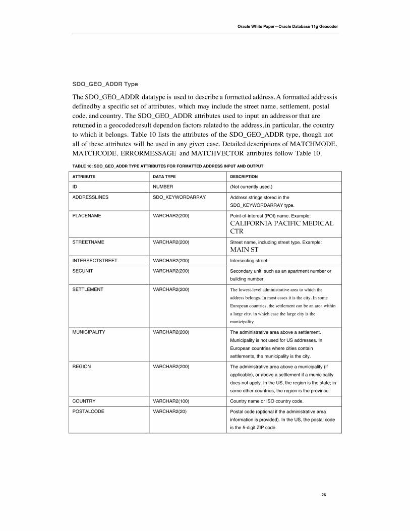
SDO_GEO_ADDR Type
The SDO_GEO_ADDR datatype is used to describe a formetted address. A formatted address isdefined by a specific set of attributes, which may include the street name, settlement, postalcode, and country. The SDO_GEO_ADDR attributes used to input an address or that arereturned in a geocoded result depend on factors related to the address, in particular, the countryto which it belongs. Table 10 lists the attributes of the SDO_GEO_ADDR type, though notall of these attributes will be used in any given case. Detailed descriptions of MATCHMODE,MATCHCODE, ERRORMESSAGE and MATCHVECTOR attributes follow Table 10.
TABLE 10: SDO_GEO_ADDR TYPE ATTRIBUTES FOR FORMATTED ADDRESS INPUT AND OUTPUT
ATTRIBUTE DATA TYPE DESCRIPTION
ID NUMBER (Not currently used.)
ADDRESSLINES SDO_KEYWORDARRAY Address strings stored in theSDO_KEYWORDARRAY type.
PLACENAME VARCHAR2(200) Point-of-interest (POI) name. Example:CALIFORNIA PACIFIC MEDICALCTR
STREETNAME VARCHAR2(200) Street name, including street type. Example:MAIN ST
INTERSECTSTREET VARCHAR2(200) Intersecting street.
SECUNIT VARCHAR2(200) Secondary unit, such as an apartment number orbuilding number.
SETTLEMENT VARCHAR2(200) The lowest-level administrative area to which the
address belongs. In most cases it is the city. In some
European countries, the settlement can be an area within
a large city, in which case the large city is the
municipality.
MUNICIPALITY VARCHAR2(200) The administrative area above a settlement.Municipality is not used for US addresses. InEuropean countries where cities containsettlements, the municipality is the city.
REGION VARCHAR2(200) The administrative area above a municipality (ifapplicable), or above a settlement if a municipalitydoes not apply. In the US, the region is the state; insome other countries, the region is the province.
COUNTRY VARCHAR2(100) Country name or ISO country code.
POSTALCODE VARCHAR2(20) Postal code (optional if the administrative areainformation is provided). In the US, the postal codeis the 5-digit ZIP code.
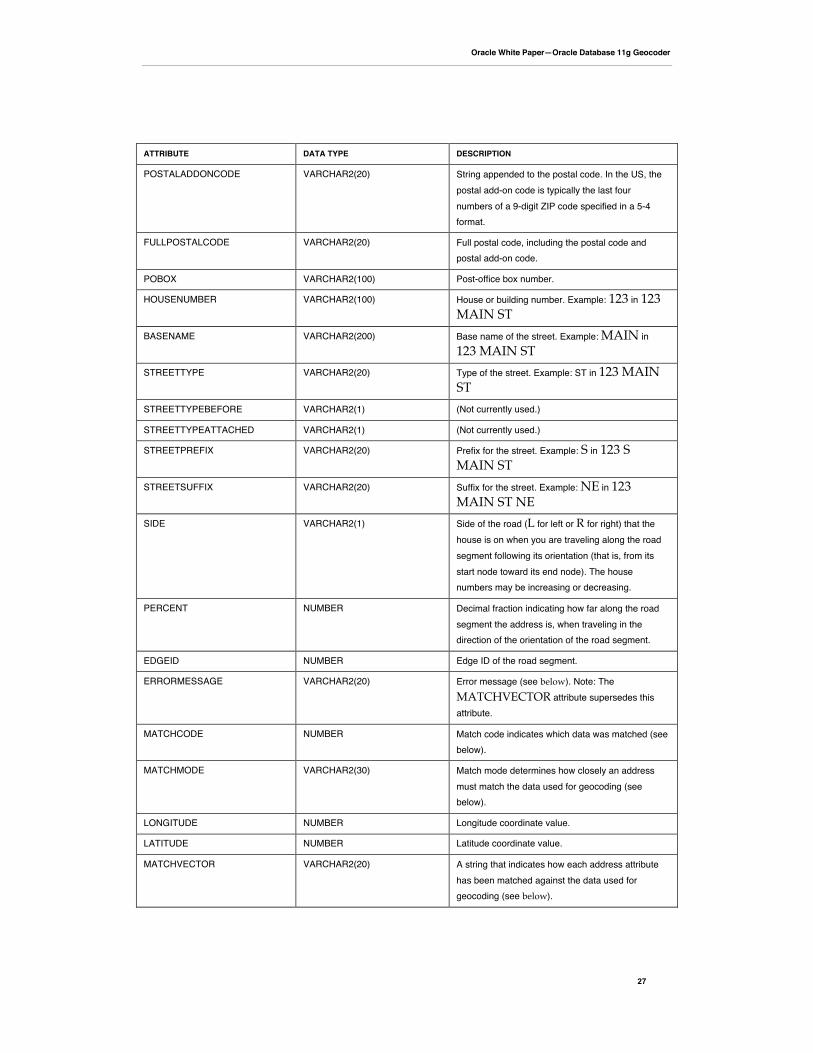
Oracle White Paper—Oracle Database 11g Geocoder
27
ATTRIBUTE DATA TYPE DESCRIPTION
POSTALADDONCODE VARCHAR2(20) String appended to the postal code. In the US, thepostal add-on code is typically the last fournumbers of a 9-digit ZIP code specified in a 5-4format.
FULLPOSTALCODE VARCHAR2(20) Full postal code, including the postal code andpostal add-on code.
POBOX VARCHAR2(100) Post-office box number.
HOUSENUMBER VARCHAR2(100) House or building number. Example: 123 in 123MAIN ST
BASENAME VARCHAR2(200) Base name of the street. Example: MAIN in123 MAIN ST
STREETTYPE VARCHAR2(20) Type of the street. Example: ST in 123 MAINST
STREETTYPEBEFORE VARCHAR2(1) (Not currently used.)
STREETTYPEATTACHED VARCHAR2(1) (Not currently used.)
STREETPREFIX VARCHAR2(20) Prefix for the street. Example: S in 123 SMAIN ST
STREETSUFFIX VARCHAR2(20) Suffix for the street. Example: NE in 123MAIN ST NE
SIDE VARCHAR2(1) Side of the road (L for left or R for right) that thehouse is on when you are traveling along the roadsegment following its orientation (that is, from itsstart node toward its end node). The housenumbers may be increasing or decreasing.
PERCENT NUMBER Decimal fraction indicating how far along the roadsegment the address is, when traveling in thedirection of the orientation of the road segment.
EDGEID NUMBER Edge ID of the road segment.
ERRORMESSAGE VARCHAR2(20) Error message (see below). Note: TheMATCHVECTOR attribute supersedes thisattribute.
MATCHCODE NUMBER Match code indicates which data was matched (seebelow).
MATCHMODE VARCHAR2(30) Match mode determines how closely an addressmust match the data used for geocoding (seebelow).
LONGITUDE NUMBER Longitude coordinate value.
LATITUDE NUMBER Latitude coordinate value.
MATCHVECTOR VARCHAR2(20) A string that indicates how each address attributehas been matched against the data used forgeocoding (see below).
Oracle White Paper—Oracle Database 11g Geocoder
28
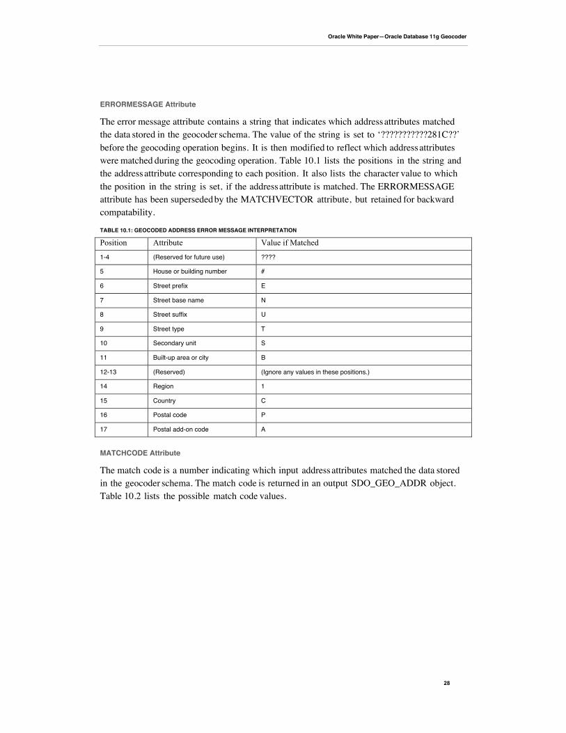
ERRORMESSAGE Attribute
The error message attribute contains a string that indicates which address attributes matchedthe data stored in the geocoder schema. The value of the string is set to ‘???????????281C??’before the geocoding operation begins. It is then modified to reflect which address attributeswere matched during the geocoding operation. Table 10.1 lists the positions in the string andthe address attribute corresponding to each position. It also lists the character value to whichthe position in the string is set, if the address attribute is matched. The ERRORMESSAGEattribute has been superseded by the MATCHVECTOR attribute, but retained for backwardcompatability.
TABLE 10.1: GEOCODED ADDRESS ERROR MESSAGE INTERPRETATION
Position Attribute Value if Matched
1-4 (Reserved for future use) ????
5 House or building number #
6 Street prefix E
7 Street base name N
8 Street suffix U
9 Street type T
10 Secondary unit S
11 Built-up area or city B
12-13 (Reserved) (Ignore any values in these positions.)
14 Region 1
15 Country C
16 Postal code P
17 Postal add-on code A
MATCHCODE Attribute
The match code is a number indicating which input address attributes matched the data storedin the geocoder schema. The match code is returned in an output SDO_GEO_ADDR object.Table 10.2 lists the possible match code values.
Oracle White Paper—Oracle Database 11g Geocoder
29
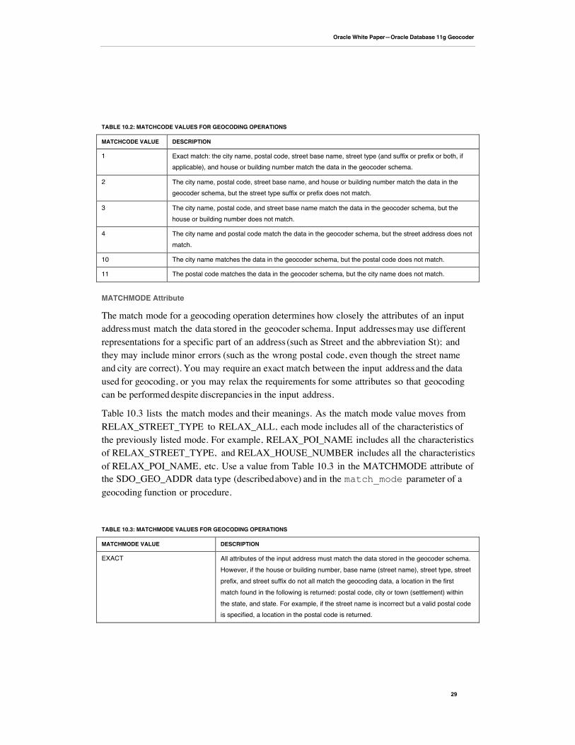
TABLE 10.2: MATCHCODE VALUES FOR GEOCODING OPERATIONS
MATCHCODE VALUE DESCRIPTION
1 Exact match: the city name, postal code, street base name, street type (and suffix or prefix or both, ifapplicable), and house or building number match the data in the geocoder schema.
2 The city name, postal code, street base name, and house or building number match the data in thegeocoder schema, but the street type suffix or prefix does not match.
3 The city name, postal code, and street base name match the data in the geocoder schema, but thehouse or building number does not match.
4 The city name and postal code match the data in the geocoder schema, but the street address does notmatch.
10 The city name matches the data in the geocoder schema, but the postal code does not match.
11 The postal code matches the data in the geocoder schema, but the city name does not match.
MATCHMODE Attribute
The match mode for a geocoding operation determines how closely the attributes of an inputaddress must match the data stored in the geocoder schema. Input addresses may use differentrepresentations for a specific part of an address (such as Street and the abbreviation St); andthey may include minor errors (such as the wrong postal code, even though the street nameand city are correct). You may require an exact match between the input address and the dataused for geocoding, or you may relax the requirements for some attributes so that geocodingcan be performed despite discrepancies in the input address.
Table 10.3 lists the match modes and their meanings. As the match mode value moves fromRELAX_STREET_TYPE to RELAX_ALL, each mode includes all of the characteristics ofthe previously listed mode. For example, RELAX_POI_NAME includes all the characteristicsof RELAX_STREET_TYPE, and RELAX_HOUSE_NUMBER includes all the characteristicsof RELAX_POI_NAME, etc. Use a value from Table 10.3 in the MATCHMODE attribute ofthe SDO_GEO_ADDR data type (described above) and in the match_mode parameter of ageocoding function or procedure.
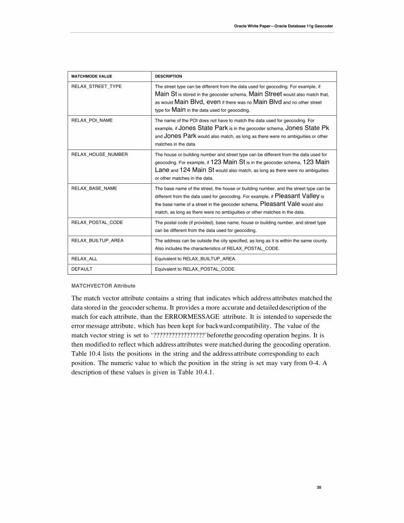
TABLE 10.3: MATCHMODE VALUES FOR GEOCODING OPERATIONS
MATCHMODE VALUE DESCRIPTION
EXACT All attributes of the input address must match the data stored in the geocoder schema.However, if the house or building number, base name (street name), street type, streetprefix, and street suffix do not all match the geocoding data, a location in the firstmatch found in the following is returned: postal code, city or town (settlement) withinthe state, and state. For example, if the street name is incorrect but a valid postal codeis specified, a location in the postal code is returned.
Oracle White Paper—Oracle Database 11g Geocoder
30
MATCHMODE VALUE DESCRIPTION
RELAX_STREET_TYPE The street type can be different from the data used for geocoding. For example, ifMain St is stored in the geocoder schema, Main Street would also match that,as would Main Blvd, even if there was no Main Blvd and no other streettype for Main in the data used for geocoding.
RELAX_POI_NAME The name of the POI does not have to match the data used for geocoding. Forexample, if Jones State Park is in the geocoder schema, Jones State Pkand Jones Park would also match, as long as there were no ambiguities or othermatches in the data.
RELAX_HOUSE_NUMBER The house or building number and street type can be different from the data used forgeocoding. For example, if 123 Main St is in the geocoder schema, 123 MainLane and 124 Main St would also match, as long as there were no ambiguitiesor other matches in the data.
RELAX_BASE_NAME The base name of the street, the house or building number, and the street type can bedifferent from the data used for geocoding. For example, if Pleasant Valley isthe base name of a street in the geocoder schema, Pleasant Vale would alsomatch, as long as there were no ambiguities or other matches in the data.
RELAX_POSTAL_CODE The postal code (if provided), base name, house or building number, and street typecan be different from the data used for geocoding.
RELAX_BUILTUP_AREA The address can be outside the city specified, as long as it is within the same county.Also includes the characteristics of RELAX_POSTAL_CODE.
RELAX_ALL Equivalent to RELAX_BUILTUP_AREA.
DEFAULT Equivalent to RELAX_POSTAL_CODE.
MATCHVECTOR Attribute
The match vector attribute contains a string that indicates which address attributes matched thedata stored in the geocoder schema. It provides a more accurate and detailed description of thematch for each attribute, than the ERRORMESSAGE attribute. It is intended to supersede theerror message attribute, which has been kept for backward compatibility. The value of thematch vector string is set to ‘?????????????????’ before the geocoding operation begins. It isthen modified to reflect which address attributes were matched during the geocoding operation.Table 10.4 lists the positions in the string and the address attribute corresponding to eachposition. The numeric value to which the position in the string is set may vary from 0-4. Adescription of these values is given in Table 10.4.1.
Oracle White Paper—Oracle Database 11g Geocoder
31
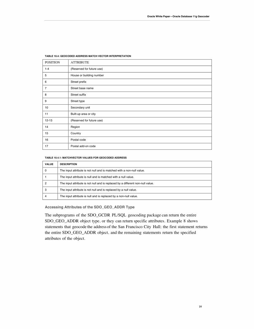
TABLE 10.4: GEOCODED ADDRESS MATCH VECTOR INTERPRETATION
POSITION ATTRIBUTE
1-4 (Reserved for future use)
5 House or building number
6 Street prefix
7 Street base name
8 Street suffix
9 Street type
10 Secondary unit
11 Built-up area or city
12-13 (Reserved for future use)
14 Region
15 Country
16 Postal code
17 Postal add-on code
TABLE 10.4.1: MATCHVECTOR VALUES FOR GEOCODED ADDRESS
VALUE DESCRIPTION
0 The input attribute is not null and is matched with a non-null value.
1 The input attribute is null and is matched with a null value.
2 The input attribute is not null and is replaced by a different non-null value.
3 The input attribute is not null and is replaced by a null value.
4 The input attribute is null and is replaced by a non-null value.
Accessing Attributes of the SDO_GEO_ADDR Type
The subprograms of the SDO_GCDR PL/SQL geocoding package can return the entireSDO_GEO_ADDR object type, or they can return specific attributes. Example 8 showsstatements that geocode the address of the San Francisco City Hall; the first statement returnsthe entire SDO_GEO_ADDR object, and the remaining statements return the specifiedattributes of the object.

Oracle White Paper—Oracle Database 11g Geocoder
32
Example 8: Database Geocoder Returning the SDO_GEO_ADDR Type and SpecifiedAttributes of the Type
SQL> SELECT SDO_GCDR.GEOCODE('GEOCODER_US', 2 SDO_KEYWORDARRAY('1 Carlton B Goodlett Pl', 'San Francisco, CA94102'), 3 'US', 'RELAX_BASE_NAME') 4 FROM DUAL;
SDO_GCDR.GEOCODE('GEOCODER_US',SDO_KEYWORDARRAY('1CARLTONBGOODLETTPL','SANFRANCISCO----------------------------------------------------------------------SDO_GEO_ADDR(0, SDO_KEYWORDARRAY(), NULL, 'CARLTON B GOODLETT PL', NULL,NULL, 'SAN FRANCISCO', NULL, 'CA', 'US', '94102', NULL, '94102', NULL,'1', 'CARLTON B GOODLETT', 'PL', 'F', 'F', NULL, NULL, 'L', .01,23614360, '????#ENUT?B281CP?', 1, 'RELAX_BASE_NAME', -122.41815,37.7784183, '????0101010??000?')
SQL> SELECT SDO_GCDR.GEOCODE('GEOCODER_US', 2 SDO_KEYWORDARRAY('1 Carlton B Goodlett Pl', 'San Francisco, CA94102'), 3 'US', 'RELAX_BASE_NAME').EDGEID 4 FROM DUAL;
SDO_GCDR.GEOCODE('GEOCODER_US',SDO_KEYWORDARRAY('1CARLTONBGOODLETTPL','SANFRANCISCO-------------------------------------------------------------------- 23614360
SQL> SELECT G.GC.STREETTYPE, G.GC.SIDE, G.GC.PERCENT, G.GC.EDGEID,G.GC.MATCHCODE, G.GC.MATCHVECTOR 2 FROM ( 3 SELECT SDO_GCDR.GEOCODE('GEOCODER_US', 4 SDO_KEYWORDARRAY('1 Carlton B Goodlett Pl', 'San Francisco, CA94102'), 5 'US','RELAX_BASE_NAME') GC 6 FROM DUAL) G;
GC.STREETTYPE G GC.PERCENT GC.EDGEID GC.MATCHCODE GC.MATCHVECTOR-------------------- - ---------- ---------- ------------ --------------------PL L 0 23614360 1????0101010??000?
SQL> SELECT ID, MATCHVECTOR, LONGITUDE, LATITUDE FROM TABLE ( 2 SDO_GCDR.GEOCODE_ALL('GEOCODER_US', 3 SDO_KEYWORDARRAY('1 Carlton B Goodlett Pl', 'San Francisco, CA94102'), 4 'US','RELAX_BASE_NAME') 5 );
ID MATCHVECTOR LONGITUDE LATITUDE---------- -------------------- ---------- ---------- 1 ????0101010??000? -122.41815 37.7784

Oracle White Paper—Oracle Database 11g Geocoder
33
SDO_ADDR_ARRAY Type
The SDO_ADDR_ARRAY type is a VARRAY (variable length array) of SDO_GEO_ADDRobjects used to store geocoded address results. Multiple address objects can be returned whenmultiple addresses are matched as a result of a geocoding operation. TheSDO_ADDR_ARRAY type is defined as follows:
CREATE TYPE sdo_addr_array AS VARRAY(1000) OF sdo_geo_addr;
SDO_GCDR: Geocoding Package
The MDSYS.SDO_GCDR package contains subprograms for database geocoding address data.The geocoding supprograms are listed in Table 11. Use the SQL command: DESCRIBESDO_GCDR to see the signature for these subprograms.
TABLE 11: SDO_GCDR SUBPROGRAMS
SUBPROGRAM DESCRIPTION
SDO_GCDR.GEOCODE Geocodes an unformatted address and returns anSDO_GEOR_ADDR object.
SDO_GCDR.GEOCODE_ADDR Geocodes an input address using attributes in anSDO_GEO_ADDR object, and returns the first matched address asan SDO_GEO_ADDR object.
SDO_GCDR.GEOCODE_ADDR_ALL Geocodes an input address using attributes in anSDO_GEO_ADDR object, and returns matching addresses as anSDO_ADDR_ARRAY object.
SDO_GCDR.GEOCODE_ALL Geocodes all addresses associated with an unformatted addressand returns the result as an SDO_ADDR_ARRAY object.
SDO_GCDR.GEOCODE_AS_GEOMETRY Geocodes an unformatted address and returns anSDO_GEOMETRY object.
SDO_GCDR.REVERSE_GEOCODE Reverse geocodes a location, specified by its spatial geometryobject and country, and returns an SDO_GEO_ADDR object.
Geocoding From a Place Name or Point-of-Interest (POI)
The name of a place or POI can be used in geocoding instead of a street address. In Example 9,a PL/SQL function create_addr_from_placename is created to construct anSDO_GEO_ADDR object from placename and country input parameters. Thecreate_addr_from_placename function is then used in a SELECT statement as inputto the SDO_GCDR.GEOCODE_ADDR fuction, which will retrun a geocoded result for theplace name and country specified.
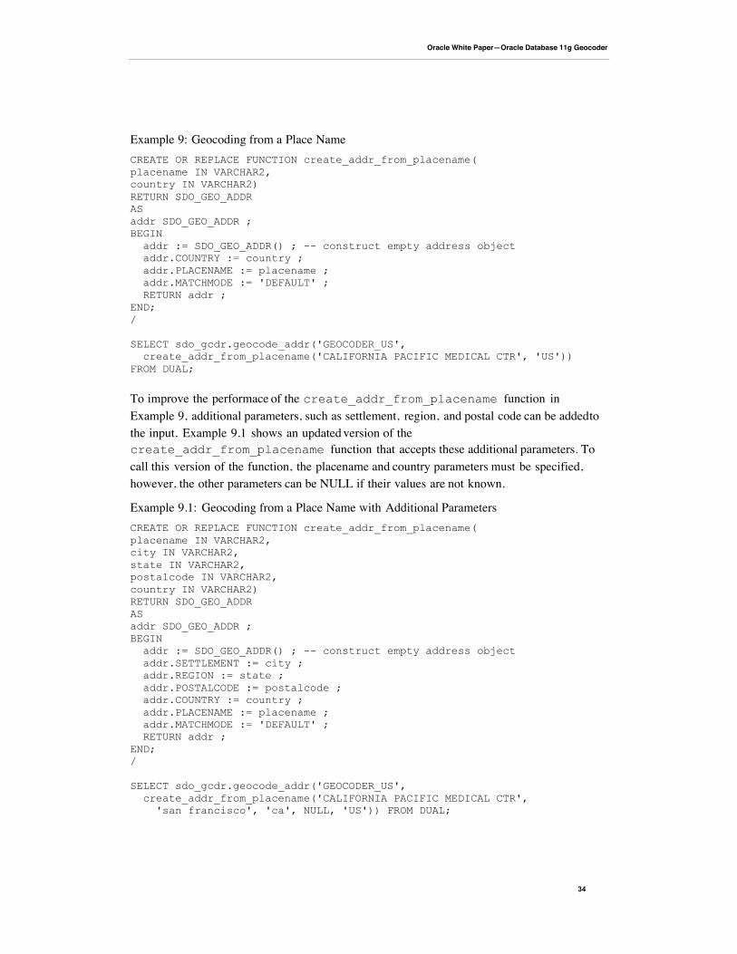
Oracle White Paper—Oracle Database 11g Geocoder
34
Example 9: Geocoding from a Place NameCREATE OR REPLACE FUNCTION create_addr_from_placename(placename IN VARCHAR2,country IN VARCHAR2)RETURN SDO_GEO_ADDRASaddr SDO_GEO_ADDR ;BEGIN addr := SDO_GEO_ADDR() ; -- construct empty address object addr.COUNTRY := country ; addr.PLACENAME := placename ; addr.MATCHMODE := 'DEFAULT' ; RETURN addr ;END;/
SELECT sdo_gcdr.geocode_addr('GEOCODER_US', create_addr_from_placename('CALIFORNIA PACIFIC MEDICAL CTR', 'US'))FROM DUAL;
To improve the performace of the create_addr_from_placename function inExample 9, additional parameters, such as settlement, region, and postal code can be added tothe input. Example 9.1 shows an updated version of thecreate_addr_from_placename function that accepts these additional parameters. Tocall this version of the function, the placename and country parameters must be specified,however, the other parameters can be NULL if their values are not known.
Example 9.1: Geocoding from a Place Name with Additional ParametersCREATE OR REPLACE FUNCTION create_addr_from_placename(placename IN VARCHAR2,city IN VARCHAR2,state IN VARCHAR2,postalcode IN VARCHAR2,country IN VARCHAR2)RETURN SDO_GEO_ADDRASaddr SDO_GEO_ADDR ;BEGIN addr := SDO_GEO_ADDR() ; -- construct empty address object addr.SETTLEMENT := city ; addr.REGION := state ; addr.POSTALCODE := postalcode ; addr.COUNTRY := country ; addr.PLACENAME := placename ; addr.MATCHMODE := 'DEFAULT' ; RETURN addr ;END;/
SELECT sdo_gcdr.geocode_addr('GEOCODER_US', create_addr_from_placename('CALIFORNIA PACIFIC MEDICAL CTR', 'san francisco', 'ca', NULL, 'US')) FROM DUAL;
Oracle White Paper—Oracle Database 11g Geocoder
35
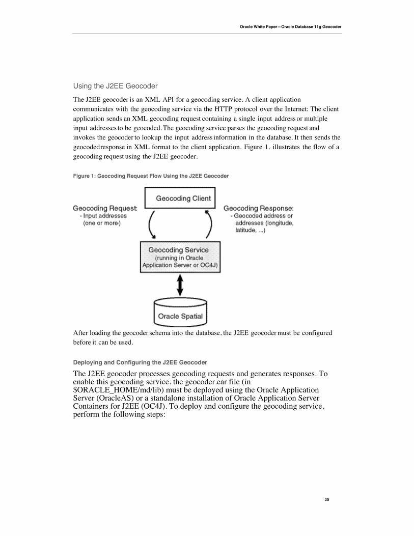
Using the J2EE Geocoder
The J2EE geocoder is an XML API for a geocoding service. A client applicationcommunicates with the geocoding service via the HTTP protocol over the Internet: The clientapplication sends an XML geocoding request containing a single input address or multipleinput addresses to be geocoded. The geocoding service parses the geocoding request andinvokes the geocoder to lookup the input address information in the database. It then sends thegeocoded response in XML format to the client application. Figure 1, illustrates the flow of ageocoding request using the J2EE geocoder.
Figure 1: Geocoding Request Flow Using the J2EE Geocoder
After loading the geocoder schema into the database, the J2EE geocoder must be configuredbefore it can be used.
Deploying and Configuring the J2EE Geocoder
The J2EE geocoder processes geocoding requests and generates responses. Toenable this geocoding service, the geocoder.ear file (in$ORACLE_HOME/md/lib) must be deployed using the Oracle ApplicationServer (OracleAS) or a standalone installation of Oracle Application ServerContainers for J2EE (OC4J). To deploy and configure the geocoding service,perform the following steps:
Oracle White Paper—Oracle Database 11g Geocoder
36
1. Edit the default-web-site.xml file found in the ../j2ee/home/configsubdirectory to add the following lines inside the <web-site> element, just abovethe </web-site> tag:
<!--Added for the Oracle J2EE Geocoder --><web-app application="geocoder" name="web" root="/geocoder" load-on-startup="true" />
Save the changes and exit the default-web-site.xml file.
2. Edit the server.xml file found in the ../j2ee/home/config subdirectory to add thefollowing lines inside the <application-server> element, just above the</application-server> tag:
<!--Added for the Oracle J2EE Geocoder --><max-http-connections value="10" />
Save the changes and exit the server.xml file.Note: the <max-http-connections> element limits the number of concurrentrequests that the geocoding service can process. It is important to limit the number ofconcurrent requests to prevent java.lang.OutOfMemoryError errors.
3. Deploy the geocoder.ear file found in your $ORACLE_HOME/md/libsubdirectory using the OracleAS or the standalone OC4J Application Server Control(for example, http://<hostname>:8888/em). You may choose to deploy thegeocoder.ear file in an existing OC4J instance, or you can create a new OC4Jinstance for the geocoder. In either case, enter geocoder for the Application Nameduring deployment.
Note: If you are not familir with application deployment using either OracleAS orstanalone OC4J, review the Oracle Fusion Middlware Server Administrator’s Guideor the Oracle Containers for J2EE Configuration and Administration Guide.
4. Launch the Oracle Geocoder welcome page in a Web browser using the URL:http://<hostname>:<port>/geocoder, for example,http://localhost:8888/geocoder. On the welcome page, select theAdministration link and enter the admin (oc4jadmin) username andpassword. Modify the Geocoder configuration file. Uncomment at least one<geocoder> element and alter the <database> element attributes of that<geocoder> element to reflect the configuration of your database.
Each <geocoder> element defines the geocoder for the database in which the geocoderschema resides. The <database> element defines the database connection for thegeocoder. In Oracle 11g or later, there are two ways to define a database connection:
Oracle White Paper—Oracle Database 11g Geocoder
37
1) by providing the JDBC database connection parameters and 2) by providing theJNDI name (container_ds) of a predefined container data source. The attributes of the<database> element are as follows:
name: a descriptive name for the database connection; it is not used to connect to thedatabasehost: the name or IP address of the database serverport: the port number of the Oracle listenersid: the Oracle system identifier or Oracle Service namemode: the type of JDBC driver to use for the connectionuser: the database user under whose schema the geocoder schema is storedpassword: the password for the userload_db_parser_profiles: a parameter that specifies whether to load the address parser-profiles from the specified database connection. If true, the address parser-profiles areloaded from the geocoder schema, otherwise the parser profiles are loaded from theapplication at ../applications/geocoder/web/WEB-INF/parser_profiles/country_name.ppr (e.g. usa.ppr). Prior to Oracle 11g, parser-profiles were loaded from the application onlycontainer_ds: The JNDI name for a predefined data source
Example 10, illustrates two different ways in which a <database> element can bedefined. The first definition is a JDBC connection example, the second definition usesthe JNDI name of a predefined container data source.
Example 10: <database> Element Definitions
<database name="gcdatabase" host="gisserver.us.oracle.com" port="1521" sid="orcl" mode="thin" user="geocoder_us" password="geocoder_us" load_db_parser_profiles="true" />
<database container_ds="jdbc/gc_europe" load_db_parser_profiles="true" />
Save changes after the configuration and then restart the geocoder using theRestart geocoder button.
Note: If the welcome page was not displayed at the beginning of this step, ensurethat the newly delpoyed geocoding service was successfully started. It is assumed thatyou are running Oracle AS or OC4J 10.1.3 or later with an Oracle 11g or latergeocoder.ear file.
Oracle White Paper—Oracle Database 11g Geocoder
38
To test the database connection, you may revisit the welcome page, Oracle SpatialInternational Geocoder at URL: http://<hostname>:<port>/geocoder and run theInternational postal address parsing/geocoding demo and the XML geocoding request page.These demos require geocoder data for the US.
XML Schema Definitions and Request and Response Examples
Geocoding Request Schema and Example
Request XSD:
<?xml version="1.0" encoding="UTF-8"?><!-- Schema for an XML geocoding request that takes one or moreinput_locations and supports reverse geocoding using the input_location'sattributes --><xsd:schema xmlns:xsd="http://www.w3.org/2001/XMLSchema"elementFormDefault="qualified"> <xsd:complexType name="address_lineType"> <xsd:attribute name="value" type="xsd:string" use="required"/> </xsd:complexType> <xsd:complexType name="address_listType"> <xsd:sequence> <xsd:element name="input_location" type="input_locationType" maxOccurs="unbounded"/> </xsd:sequence> </xsd:complexType> <xsd:complexType name="gdf_formType"> <xsd:attribute name="name" type="xsd:string"/> <xsd:attribute name="street" type="xsd:string"/> <xsd:attribute name="intersecting_street" type="xsd:string"/> <xsd:attribute name="builtup_area" type="xsd:string"/> <xsd:attribute name="order8_area" type="xsd:string"/> <xsd:attribute name="order2_area" type="xsd:string"/> <xsd:attribute name="order1_area" type="xsd:string"/> <xsd:attribute name="country" type="xsd:string"/> <xsd:attribute name="postal_code" type="xsd:string"/> <xsd:attribute name="postal_addon_code" type="xsd:string"/> </xsd:complexType> <xsd:complexType name="gen_formType"> <xsd:attribute name="name" type="xsd:string"/> <xsd:attribute name="street" type="xsd:string"/> <xsd:attribute name="intersecting_street" type="xsd:string"/> <xsd:attribute name="sub_area" type="xsd:string"/> <xsd:attribute name="city" type="xsd:string"/> <xsd:attribute name="region" type="xsd:string"/> <xsd:attribute name="country" type="xsd:string"/> <xsd:attribute name="postal_code" type="xsd:string"/> <xsd:attribute name="postal_addon_code" type="xsd:string"/> </xsd:complexType> <xsd:element name="geocode_request"> <xsd:complexType> <xsd:sequence> <xsd:element name="address_list" type="address_listType"/>
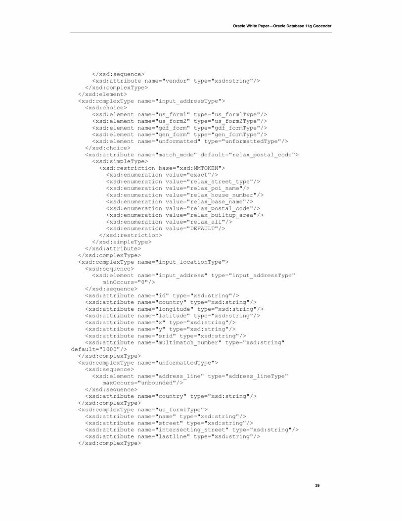
Oracle White Paper—Oracle Database 11g Geocoder
39
</xsd:sequence> <xsd:attribute name="vendor" type="xsd:string"/> </xsd:complexType> </xsd:element> <xsd:complexType name="input_addressType"> <xsd:choice> <xsd:element name="us_form1" type="us_form1Type"/> <xsd:element name="us_form2" type="us_form2Type"/> <xsd:element name="gdf_form" type="gdf_formType"/> <xsd:element name="gen_form" type="gen_formType"/> <xsd:element name="unformatted" type="unformattedType"/> </xsd:choice> <xsd:attribute name="match_mode" default="relax_postal_code"> <xsd:simpleType> <xsd:restriction base="xsd:NMTOKEN"> <xsd:enumeration value="exact"/> <xsd:enumeration value="relax_street_type"/> <xsd:enumeration value="relax_poi_name"/> <xsd:enumeration value="relax_house_number"/> <xsd:enumeration value="relax_base_name"/> <xsd:enumeration value="relax_postal_code"/> <xsd:enumeration value="relax_builtup_area"/> <xsd:enumeration value="relax_all"/> <xsd:enumeration value="DEFAULT"/> </xsd:restriction> </xsd:simpleType> </xsd:attribute> </xsd:complexType> <xsd:complexType name="input_locationType"> <xsd:sequence> <xsd:element name="input_address" type="input_addressType" minOccurs="0"/> </xsd:sequence> <xsd:attribute name="id" type="xsd:string"/> <xsd:attribute name="country" type="xsd:string"/> <xsd:attribute name="longitude" type="xsd:string"/> <xsd:attribute name="latitude" type="xsd:string"/> <xsd:attribute name="x" type="xsd:string"/> <xsd:attribute name="y" type="xsd:string"/> <xsd:attribute name="srid" type="xsd:string"/> <xsd:attribute name="multimatch_number" type="xsd:string"default="1000"/> </xsd:complexType> <xsd:complexType name="unformattedType"> <xsd:sequence> <xsd:element name="address_line" type="address_lineType" maxOccurs="unbounded"/> </xsd:sequence> <xsd:attribute name="country" type="xsd:string"/> </xsd:complexType> <xsd:complexType name="us_form1Type"> <xsd:attribute name="name" type="xsd:string"/> <xsd:attribute name="street" type="xsd:string"/> <xsd:attribute name="intersecting_street" type="xsd:string"/> <xsd:attribute name="lastline" type="xsd:string"/> </xsd:complexType>
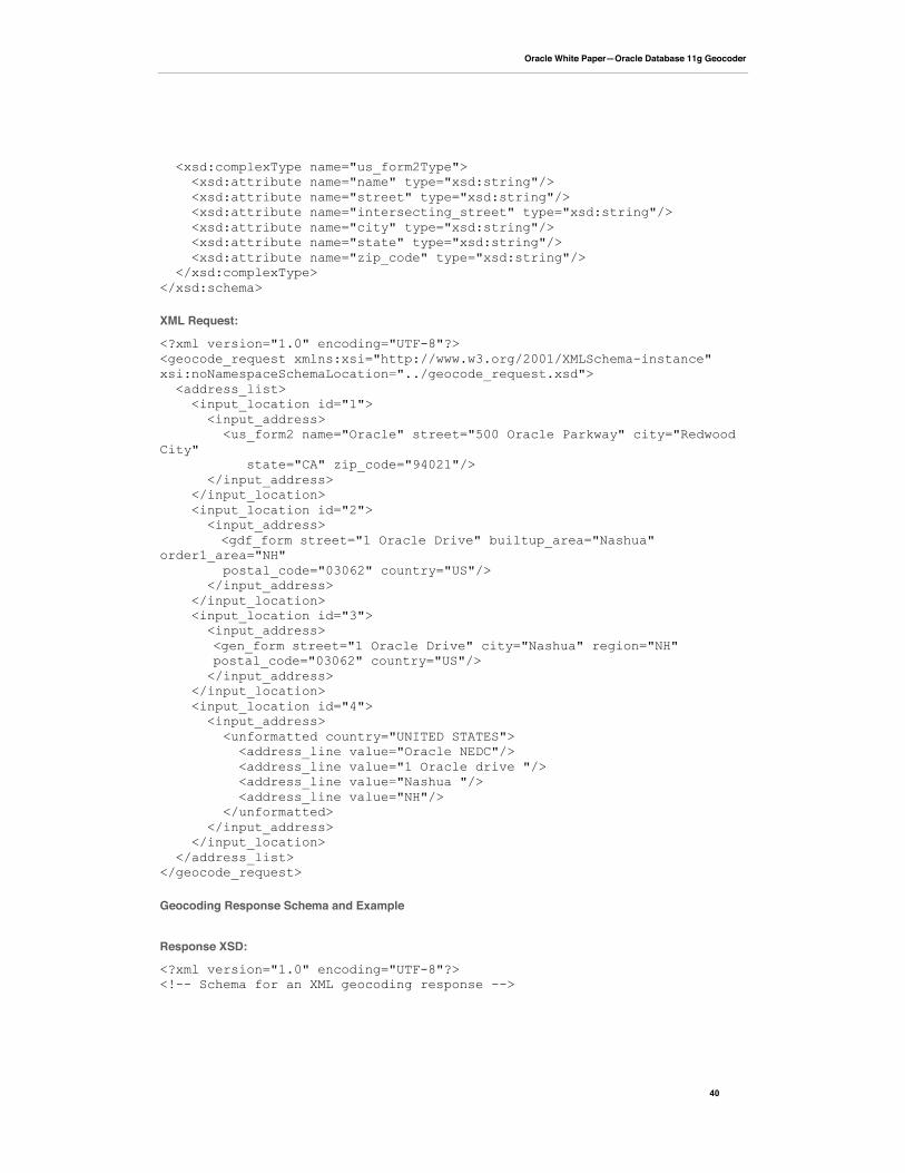
Oracle White Paper—Oracle Database 11g Geocoder
40
<xsd:complexType name="us_form2Type"> <xsd:attribute name="name" type="xsd:string"/> <xsd:attribute name="street" type="xsd:string"/> <xsd:attribute name="intersecting_street" type="xsd:string"/> <xsd:attribute name="city" type="xsd:string"/> <xsd:attribute name="state" type="xsd:string"/> <xsd:attribute name="zip_code" type="xsd:string"/> </xsd:complexType></xsd:schema>
XML Request:
<?xml version="1.0" encoding="UTF-8"?><geocode_request xmlns:xsi="http://www.w3.org/2001/XMLSchema-instance"xsi:noNamespaceSchemaLocation="../geocode_request.xsd"> <address_list> <input_location id="1"> <input_address> <us_form2 name="Oracle" street="500 Oracle Parkway" city="RedwoodCity" state="CA" zip_code="94021"/> </input_address> </input_location> <input_location id="2"> <input_address>
<gdf_form street="1 Oracle Drive" builtup_area="Nashua"order1_area="NH" postal_code="03062" country="US"/> </input_address> </input_location> <input_location id="3"> <input_address>
<gen_form street="1 Oracle Drive" city="Nashua" region="NH"postal_code="03062" country="US"/>
</input_address> </input_location> <input_location id="4"> <input_address> <unformatted country="UNITED STATES"> <address_line value="Oracle NEDC"/> <address_line value="1 Oracle drive "/> <address_line value="Nashua "/> <address_line value="NH"/> </unformatted> </input_address> </input_location> </address_list></geocode_request>
Geocoding Response Schema and Example
Response XSD:
<?xml version="1.0" encoding="UTF-8"?><!-- Schema for an XML geocoding response -->
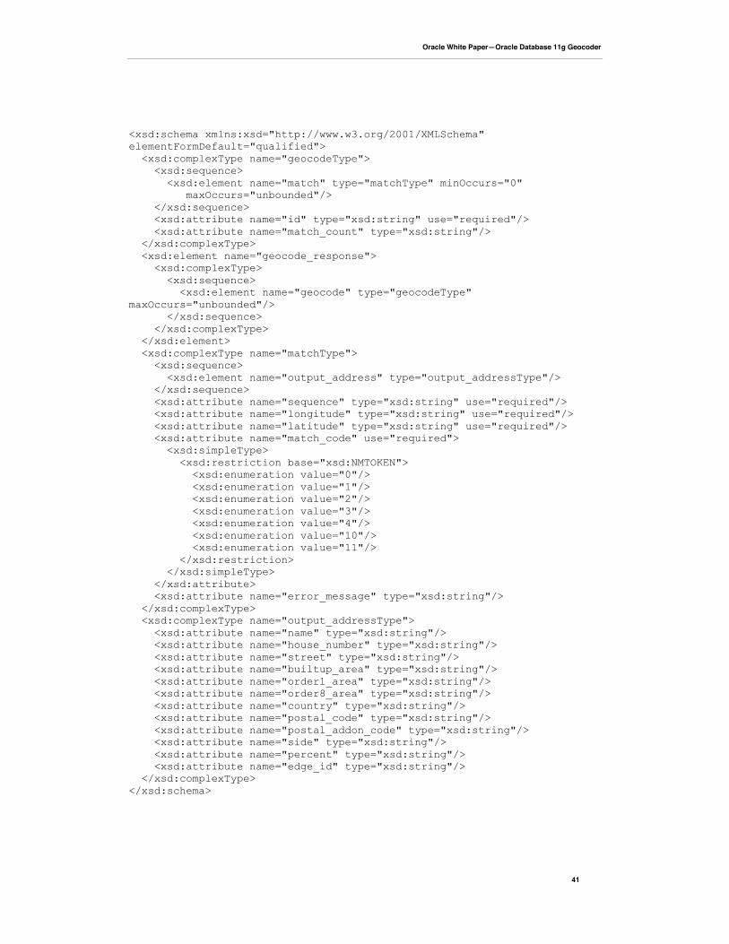
Oracle White Paper—Oracle Database 11g Geocoder
41
<xsd:schema xmlns:xsd="http://www.w3.org/2001/XMLSchema"elementFormDefault="qualified"> <xsd:complexType name="geocodeType"> <xsd:sequence> <xsd:element name="match" type="matchType" minOccurs="0" maxOccurs="unbounded"/> </xsd:sequence> <xsd:attribute name="id" type="xsd:string" use="required"/> <xsd:attribute name="match_count" type="xsd:string"/> </xsd:complexType> <xsd:element name="geocode_response"> <xsd:complexType> <xsd:sequence> <xsd:element name="geocode" type="geocodeType"maxOccurs="unbounded"/> </xsd:sequence> </xsd:complexType> </xsd:element> <xsd:complexType name="matchType"> <xsd:sequence> <xsd:element name="output_address" type="output_addressType"/> </xsd:sequence> <xsd:attribute name="sequence" type="xsd:string" use="required"/> <xsd:attribute name="longitude" type="xsd:string" use="required"/> <xsd:attribute name="latitude" type="xsd:string" use="required"/> <xsd:attribute name="match_code" use="required"> <xsd:simpleType> <xsd:restriction base="xsd:NMTOKEN"> <xsd:enumeration value="0"/> <xsd:enumeration value="1"/> <xsd:enumeration value="2"/> <xsd:enumeration value="3"/> <xsd:enumeration value="4"/> <xsd:enumeration value="10"/> <xsd:enumeration value="11"/> </xsd:restriction> </xsd:simpleType> </xsd:attribute> <xsd:attribute name="error_message" type="xsd:string"/> </xsd:complexType> <xsd:complexType name="output_addressType"> <xsd:attribute name="name" type="xsd:string"/> <xsd:attribute name="house_number" type="xsd:string"/> <xsd:attribute name="street" type="xsd:string"/> <xsd:attribute name="builtup_area" type="xsd:string"/> <xsd:attribute name="order1_area" type="xsd:string"/> <xsd:attribute name="order8_area" type="xsd:string"/> <xsd:attribute name="country" type="xsd:string"/> <xsd:attribute name="postal_code" type="xsd:string"/> <xsd:attribute name="postal_addon_code" type="xsd:string"/> <xsd:attribute name="side" type="xsd:string"/> <xsd:attribute name="percent" type="xsd:string"/> <xsd:attribute name="edge_id" type="xsd:string"/> </xsd:complexType></xsd:schema>
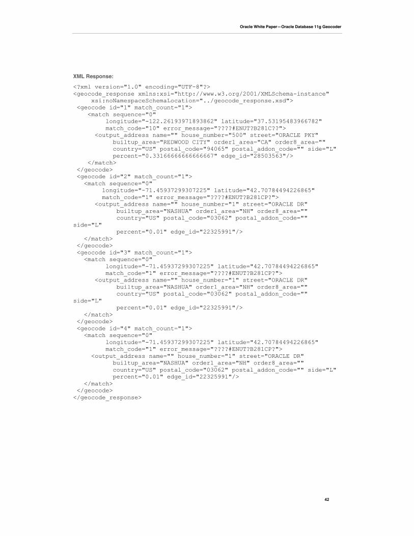
Oracle White Paper—Oracle Database 11g Geocoder
42
XML Response:
<?xml version="1.0" encoding="UTF-8"?><geocode_response xmlns:xsi="http://www.w3.org/2001/XMLSchema-instance" xsi:noNamespaceSchemaLocation="../geocode_response.xsd"> <geocode id="1" match_count="1"> <match sequence="0" longitude="-122.26193971893862" latitude="37.53195483966782" match_code="10" error_message="????#ENUT?B281C??"> <output_address name="" house_number="500" street="ORACLE PKY" builtup_area="REDWOOD CITY" order1_area="CA" order8_area="" country="US" postal_code="94065" postal_addon_code="" side="L" percent="0.33166666666666667" edge_id="28503563"/> </match> </geocode> <geocode id="2" match_count="1"> <match sequence="0" longitude="-71.45937299307225" latitude="42.70784494226865" match_code="1" error_message="????#ENUT?B281CP?"> <output_address name="" house_number="1" street="ORACLE DR" builtup_area="NASHUA" order1_area="NH" order8_area="" country="US" postal_code="03062" postal_addon_code=""side="L" percent="0.01" edge_id="22325991"/> </match> </geocode> <geocode id="3" match_count="1"> <match sequence="0" longitude="-71.45937299307225" latitude="42.70784494226865" match_code="1" error_message="????#ENUT?B281CP?"> <output_address name="" house_number="1" street="ORACLE DR" builtup_area="NASHUA" order1_area="NH" order8_area="" country="US" postal_code="03062" postal_addon_code=""side="L" percent="0.01" edge_id="22325991"/> </match> </geocode> <geocode id="4" match_count="1"> <match sequence="0" longitude="-71.45937299307225" latitude="42.70784494226865" match_code="1" error_message="????#ENUT?B281CP?"> <output_address name="" house_number="1" street="ORACLE DR" builtup_area="NASHUA" order1_area="NH" order8_area="" country="US" postal_code="03062" postal_addon_code="" side="L" percent="0.01" edge_id="22325991"/> </match> </geocode></geocode_response>

Oracle Database 11g GeocoderJanuary 2009Author: Nichole Alexander and Ji YangContributing Authors: Xavier Lopez
Oracle CorporationWorld Headquarters500 Oracle ParkwayRedwood Shores, CA 94065U.S.A.
Worldwide Inquiries:Phone: +1.650.506.7000Fax: +1.650.506.7200oracle.com
Copyright © 2009, Oracle and/or its affiliates. All rights reserved. This document is provided for information purposes only andthe contents hereof are subject to change without notice. This document is not warranted to be error-free, nor subject to any otherwarranties or conditions, whether expressed orally or implied in law, including implied warranties and conditions of merchantability orfitness for a particular purpose. We specifically disclaim any liability with respect to this document and no contractual obligations areformed either directly or indirectly by this document. This document may not be reproduced or transmitted in any form or by anymeans, electronic or mechanical, for any purpose, without our prior written permission.
Oracle is a registered trademark of Oracle Corporation and/or its affiliates. Other names may be trademarks of their respectiveowners.
0109