ordinary meeting of council - moorabool shire council · ordinary meeting of council notice is...
TRANSCRIPT

ORDINARY MEETING OF COUNCIL
Notice is hereby given of the Ordinary Meeting of Council to be held at
Council Chambers, 15 Stead Street, Ballan on Wednesday 18 September 2013,
commencing at 7:00 p.m.
Members: Cr. Pat Toohey (Mayor) Woodlands Ward Cr. Allan Comrie East Moorabool Ward Cr. David Edwards East Moorabool Ward Cr. John Spain East Moorabool Ward Cr. Tonia Dudzik East Moorabool Ward Cr. Paul Tatchell Central Ward Cr. Tom Sullivan West Moorabool Ward
Officers: Mr. Rob Croxford Chief Executive Officer Mr. Shane Marr General Manager Corporate Services Mr. Phil Jeffrey General Manager Infrastructure Mr. Satwinder Sandhu General Manager Growth and Development Mr. Danny Colgan General Manager Community Services
Rob Croxford Chief Executive Officer
1 of 252
Agenda - Moorabool Shire Ordinary Meeting of Council Wednesday 18 September, 2013
OMC - 18/09/2013 09/13
AGENDA
1. OPENING OF MEETING AND PRAYER ....................................................... 4
2. PRESENT ..................................................................................................... 4
3. APOLOGIES ................................................................................................. 4
4. CONFIRMATION OF MINUTES .................................................................... 4
4.1 Ordinary Meeting of Council – Wednesday 4 September 2013 ...................... 4
5. DISCLOSURE OF CONFLICT OF INTEREST .............................................. 5
6. MAYOR’S REPORT ...................................................................................... 7
7. COUNCILLORS' REPORTS ......................................................................... 8
8. PUBLIC QUESTION TIME ............................................................................ 9
9. PETITIONS ................................................................................................. 11
10. PRESENTATIONS / DEPUTATIONS .......................................................... 12
11. OFFICER'S REPORTS ............................................................................... 13
11.1 CHIEF EXECUTIVE OFFICER .................................................................... 13
11.1.1 CEO Annual Leave ...................................................................................... 13
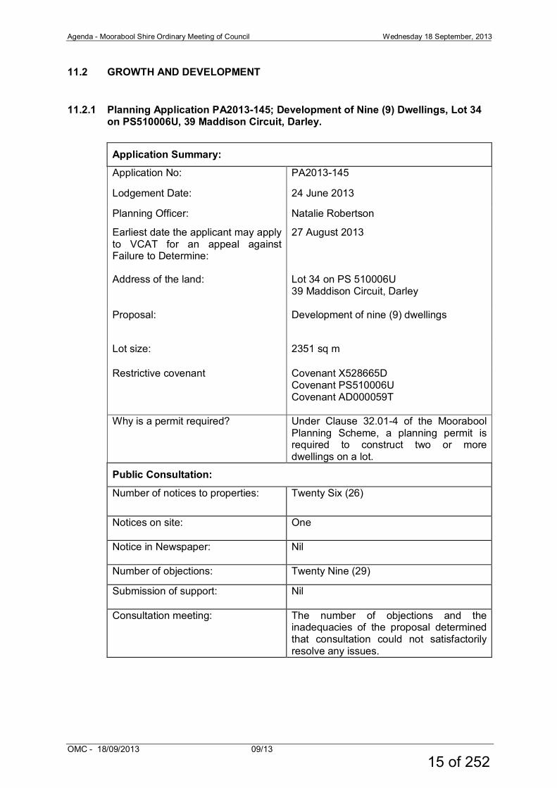
11.2 GROWTH AND DEVELOPMENT ................................................................ 15
11.2.1 Planning Application PA2013-145; Development of Nine (9) Dwellings, Lot 34 on PS510006U, 39 Maddison Circuit, Darley. ................................... 15
11.2.2 Planning Permit PA2013-042; Development and Use of a Dwelling in Association with a Vineyard at CA32A Section4 Parish of Gorong, 1 02 Gilletts Lane, Ingliston ............................................................................ 41
11.2.3 Planning Application PA2013-103; The Use of the land for a Place of Assembly (Music Festival) and a Business Identification sign; CA87B, Parish of Kerrit Bareet, Yendon Egerton Road, VIC Mount Egerton, 3352... 74
11.2.4 Amendment C53 – Gordon Structure Plan .................................................. 91
11.2.5 Amendment C51 – Bacchus Marsh Activity Centre Structure Plan ............ 131
11.3 COMMUNITY SERVICES ......................................................................... 173
11.3.1 Draft Moorabool Health and Wellbeing Plan 2013-2017 ............................ 173
11.4 INFRASTRUCTURE SERVICES ............................................................... 226
11.5 CORPORATE SERVICES ......................................................................... 227
11.5.1 Adoption “in principle” of the 2012/13 Financial Statements, Standard Statements and Performance Statement for submission to the Victorian Auditor-General for certification ................................................................. 227
2 of 252
Agenda - Moorabool Shire Ordinary Meeting of Council Wednesday 18 September, 2013
OMC - 18/09/2013 09/13
12. OTHER REPORTS .................................................................................... 235
12.1 Assembly of Councillors ............................................................................ 235
12.2 Section 86 - Delegated Committees of Council - Reports .......................... 237
12.3 Section 86 - Advisory Committees of Council - Reports ............................. 243
13. NOTICES OF MOTION .............................................................................. 249
14. URGENT BUSINESS ................................................................................ 250
15. CLOSED SESSION OF THE MEETING TO THE PUBLIC ......................... 251
16. MEETING CLOSURE ................................................................................ 252
3 of 252
Agenda - Moorabool Shire Ordinary Meeting of Council Wednesday 18 September, 2013
OMC - 18/09/2013 09/13
1. OPENING OF MEETING AND PRAYER Almighty God be with us as we work for the people of the Shire of Moorabool. Grant us wisdom that we may care for the Shire as true stewards of your creation. May we be aware of the great responsibilities placed upon us. Help us to be just in all our dealings and may our work prosper for the good of all. Amen
2. PRESENT
3. APOLOGIES
4. CONFIRMATION OF MINUTES
4.1 Ordinary Meeting of Council – Wednesday 4 September 2013
Recommendation: That Council confirms the Minutes of the Ordinary Meeting of Council held on Wednesday 4 September 2013.
4 of 252
Agenda - Moorabool Shire Ordinary Meeting of Council Wednesday 18 September, 2013
OMC - 18/09/2013 09/13
5. DISCLOSURE OF CONFLICT OF INTEREST Under the Local Government Act (1989), the classification of the type of interest giving rise to a conflict is; a direct interest; or an indirect interest (section 77A and 77B). The type of indirect interest specified under Section 78, 78A, 78B, 78C or 78D of the Local Government Act 1989 set out the requirements of a Councillor or member of a Special Committee to disclose any conflicts of interest that the Councillor or member of a Special Committee may have in a matter being or likely to be considered at a meeting of the Council or Committee. Definitions of the class of the interest are: • a direct interest
- (section 77A, 77B)
• an indirect interest (see below)
- indirect interest by close association (section 78)
- indirect financial interest (section 78A)
- indirect interest because of conflicting duty (section 78B)
- indirect interest because of receipt of gift(s) (section 78C)
- indirect interest through civil proceedings (section 78D)
Time for Disclosure of Conflicts of Interest In addition to the Council protocol relating to disclosure at the beginning of the meeting, section 79 of the Local Government Act 1989 (the Act) requires a Councillor to disclose the details, classification and the nature of the conflict of interest immediately at the beginning of the meeting and/or before consideration or discussion of the Item. Section 79(6) of the Act states:
While the matter is being considered or any vote is taken in relation to the matter, the Councillor or member of a special committee must: (a) leave the room and notify the Mayor or the Chairperson of the special
committee that he or she is doing so; and (b) remain outside the room and any gallery or other area in view of
hearing of the room. The Councillor is to be notified by the Mayor or Chairperson of the special committee that he or she may return to the room after consideration of the matter and all votes on the matter.
5 of 252

Agenda - Moorabool Shire Ordinary Meeting of Council Wednesday 18 September, 2013
OMC - 18/09/2013 09/13
There are important reasons for requiring this disclosure immediately before the relevant matter is considered. • Firstly, members of the public might only be in attendance for part of a
meeting and should be able to see that all matters are considered in an appropriately transparent manner.
• Secondly, if conflicts of interest are not disclosed immediately before an item
there is a risk that a Councillor who arrives late to a meeting may fail to disclose their conflict of interest and be in breach of the Act.
6 of 252
Agenda - Moorabool Shire Ordinary Meeting of Council Wednesday 18 September, 2013
OMC - 18/09/2013 09/13
6. MAYOR’S REPORT To be presented at the meeting by the Mayor. Recommendation: That the Mayor's report be received.
7 of 252
Agenda - Moorabool Shire Ordinary Meeting of Council Wednesday 18 September, 2013
OMC - 18/09/2013 09/13
7. COUNCILLORS' REPORTS To be presented at the meeting by Councillors. Recommendation: That the Councillors' reports be received.
8 of 252
Agenda - Moorabool Shire Ordinary Meeting of Council Wednesday 18 September, 2013
OMC - 18/09/2013 09/13
8. PUBLIC QUESTION TIME The Council has made provision in the business of the Ordinary Meetings of the Council for the holding of a Public Question Time.
Public Question Time is required to be conducted in accordance with the requirements contained within the Public Question Time Protocols and Procedural Guidelines. The person asking the question is to stand and identify themselves by name and residential address before asking the question. All questions are to be directed to the Mayor as Chairperson, who shall determine the appropriate person to respond to the question. The person asking the question must be present in the gallery when the question is considered and may be asked for clarification by the Mayor. At the discretion of the Mayor, a lengthy question may be required to be placed into writing by the person asking the question. The Mayor may accept a question on notice, in the event that research is required to provide a response. In the case of questions taken on notice, both the question and response shall be recorded in the Minutes of the Meeting. Procedural Guidelines – Public Question Time A maximum of two questions may be asked by any one person at any one time. If a person has submitted 2 questions to a meeting, the second question: may, at the discretion of the Mayor, be deferred until all other persons who have asked a question have had their questions asked and answered; or may not be asked if the time allotted for public question time has expired. A maximum of three minutes per question will be allocated. An extension of time may be granted at the discretion of the Mayor. The Mayor will nominate the appropriate person to respond to each question. In the event that the question is directed for response by a Council Officer, it shall be referred through the Chief Executive Officer. The Mayor may disallow any question, which is considered: To relate to a matter outside the duties, functions and powers of Council; To be defamatory, indecent, offensive, abusive, irrelevant, trivial or objectionable in language or substance; To be confidential in nature or of legal significance; To deal with a subject matter already answered; To be aimed to embarrass any person; To relate to personnel matters;
9 of 252
Agenda - Moorabool Shire Ordinary Meeting of Council Wednesday 18 September, 2013
OMC - 18/09/2013 09/13
To relate to the personal hardship of any resident or ratepayer; To relate to industrial matters; To relate to contractual matters; To relate to proposed developments; To relate to legal advice; To relate to matters affecting the security of Council property; or To relate to any other matter which Council considers would prejudice the Council or any person. The Mayor has the discretion to seek clarification of the question if deemed necessary but otherwise the person asking the question is not permitted to enter into debate with or directly question the Mayor or Chief Executive Officer. The Mayor may direct that a member of the gallery ceases speaking if the above procedure is not followed.
10 of 252
Agenda - Moorabool Shire Ordinary Meeting of Council Wednesday 18 September, 2013
OMC - 18/09/2013 09/13
9. PETITIONS No petitions have been made to Council for consideration as part of this Agenda.
11 of 252
Agenda - Moorabool Shire Ordinary Meeting of Council Wednesday 18 September, 2013
OMC - 18/09/2013 09/13
10. PRESENTATIONS / DEPUTATIONS The Council has made provision in the business of the Ordinary Meetings of the Council for the making of presentations or deputations to Council in relation to matters presented on the agenda for Council consideration. Presentations or deputations are required to be conducted in accordance with the requirements contained within the Presentation/Deputations Protocols and Procedural Guidelines. Persons wishing to make a presentation or deputation to Council on a matter included in the agenda shall inform Council prior to the meeting by contacting the Chief Executive Officer’s office and registering their name and agenda item being spoken to. At the meeting the Mayor will invite the persons wishing to make a presentation or delegation to address the Council on the agenda item.
The person making the presentation or deputation is to stand and address Council on the item. No debate on the item is permitted between the person making the presentation or delegation and the Council. A maximum of three minutes per presentation or delegation will be allocated. An extension of time may be granted at the discretion of the Mayor. Councillors, through the Mayor, may ask the person making the presentation or delegation for clarification of matters presented. The Mayor may direct that a member of the gallery ceases speaking if the above procedure is not followed. List of Persons making Presentations/Deputations other than in relation to a planning item listed on the agenda:
Item No Description
Name
Position
- - - -
List of Persons making Presentations/Deputations to a planning item listed on the agenda: Individuals seeking to make a presentation to the Council on a planning item listed on the agenda for consideration at the meeting will be heard by the Council immediately preceding consideration of the Council Officer’s report on the planning item. Item No Description
Name
Applicant/ Objector
- - - -
12 of 252
Agenda - Moorabool Shire Ordinary Meeting of Council Wednesday 18 September, 2013
OMC - 18/09/2013 09/13
11. OFFICER'S REPORTS
11.1 CHIEF EXECUTIVE OFFICER
11.1.1 CEO Annual Leave Introduction File No.: Personnel File Author: Rob Croxford Background This report requests approval of the Council for the CEO to take leave in October/November 2013 and January 2014. Proposal It is requested that the Council approve annual leave for the periods:
• 14 October to 18 October, 2013 inclusive – 5 days
• 4 November 2013 – 1 day • 25 December 2013 to 10 January 2014 inclusive – 13 days
The acting CEO for the period 14 October to 18 October 2013, inclusive will be Shane Marr, General Manager Corporate Services. The acting CEO for the period 4 November 2013 and 25 December 2013 to 10 January 2014 inclusive will be Satwinder Sandhu, General Manager Growth and Development Victorian Charter of Human Rights and Responsibilities Act 2006 In developing this report to Council, the officer considered whether the subject matter raised any human rights issues. In particular, whether the scope of any human right established by the Victorian Charter of Human Rights and Responsibilities is in any way limited, restricted or interfered with by the recommendations contained in the report. It is considered that the subject matter does not raise any human rights issues. Officer's Declaration of Conflict of Interests Under section 80C of the Local Government Act 1989 (as amended), officers providing advice to Council must disclose any interests, including the type of interest. Author – Rob Croxford In providing this advice to Council as the Author, I have no interests to disclose in this report.
13 of 252

Agenda - Moorabool Shire Ordinary Meeting of Council Wednesday 18 September, 2013
OMC - 18/09/2013 09/13
Conclusion That the CEO be granted annual leave and that Shane Marr be appointed Acting CEO for the period 14 October to 18 October, 2013 inclusive and Satwinder Sandhu for the period 4 November 2013 and 25 December 2013 to 10 January 2014 inclusive.
Recommendation: 1. That the CEO, Robert Croxford be granted annual leave for the following
periods:
• 14 October to 18 October, 2013 inclusive – 5 days • 25 December 2013 to 10 January 2014 inclusive – 13 days
2. That the acting CEO for the period 14 October to 18 October, 2013
inclusive will be Shane Marr, General Manager Corporate Services.
3. That the acting CEO for the period 4 November 2013 and 25 December 2013 to 10 January 2014 inclusive will be Satwinder Sandhu, General Manager Growth and Development.
Report Authorisation Authorised by: Name: Rob Croxford Title: Chief Executive Officer Date: Thursday 12 September 2013
14 of 252
Agenda - Moorabool Shire Ordinary Meeting of Council Wednesday 18 September, 2013
OMC - 18/09/2013 09/13
11.2 GROWTH AND DEVELOPMENT
11.2.1 Planning Application PA2013-145; Development of Nine (9) Dwellings, Lot 34 on PS510006U, 39 Maddison Circuit, Darley.
Application Summary:
Application No: PA2013-145
Lodgement Date: 24 June 2013
Planning Officer: Natalie Robertson
Earliest date the applicant may apply to VCAT for an appeal against Failure to Determine:
27 August 2013
Address of the land: Lot 34 on PS 510006U 39 Maddison Circuit, Darley
Proposal: Development of nine (9) dwellings
Lot size: 2351 sq m
Restrictive covenant Covenant X528665D Covenant PS510006U Covenant AD000059T
Why is a permit required? Under Clause 32.01-4 of the Moorabool Planning Scheme, a planning permit is required to construct two or more dwellings on a lot.
Public Consultation:
Number of notices to properties: Twenty Six (26)
Notices on site: One
Notice in Newspaper: Nil
Number of objections: Twenty Nine (29)
Submission of support: Nil
Consultation meeting: The number of objections and the inadequacies of the proposal determined that consultation could not satisfactorily resolve any issues.
15 of 252
Agenda - Moorabool Shire Ordinary Meeting of Council Wednesday 18 September, 2013
OMC - 18/09/2013 09/13
Policy Implications:
Key Result Area - Enhanced Infrastructure and Natural Built Environment.
Objective - Effective and efficient land use planning and building controls.
Strategy - Implement high quality, responsive, and efficient processing systems for planning and building applications
Ensure that development is sustainable, resilient to change and respects the existing character.
Victorian Charter of Human Rights and Responsibilities Act 2006
In developing this report to Council, the officer considered whether the subject matter raised any human rights issues. In particular, whether the scope of any human right established by the Victorian Charter of Human Rights and Responsibilities is in any way limited, restricted or interfered with by the recommendations contained in the report. It is considered that the subject matter does not raise any human rights issues.
Officer's Declaration of Conflict of Interests
Under section 80C of the Local Government Act 1989 (as amended), officers providing advice to Council must disclose any interests, including the type of interest. General Manager Growth and Development – Satwinder Sandhu In providing this advice to Council as the General Manager, I have no interests to disclose in this report. Author – Senior Statutory Planner, Natalie Robertson
In providing this advice to Council as the Author, I have no interests to disclose in this report.
16 of 252
Agenda - Moorabool Shire Ordinary Meeting of Council Wednesday 18 September, 2013
OMC - 18/09/2013 09/13
Executive Summary:
The application is for the construction of nine (9) double storey dwellings on Lot 34, 39 Maddison Circuit, Darley. This application is before Council due to the inadequacies of the proposal and due to the receipt of twenty eight objections from nearby neighbours.
The site has an area of 2351 sqm. While the proposed development provides housing choice for a range of households, which accords with State and Local Planning Policies, and the objectives of the zone, it is considered that the location, layout and design of the development is not in accordance with the character of the surrounding area.
The layout of the dwellings on the site does not meet all the requirements of Clause 55 (Rescode) of the Moorabool Planning Scheme.
Objections relate to dwelling density, traffic in the street, car parking, overdevelopment, waste collection, infrastructure provision and neighbourhood character. Details of the objector’s concerns and response to the key issues have been provided in the report.
It is considered that the proposal is inconsistent with the pattern of development and discernible character in this Estate and does not meet the requirements of Restrictive Covenant AD00059T.
Summary Recommendation:
The proposal has been assessed against the relevant components of the Planning and Environment Act 1987 , particularly with regard to Section 61 (4), the Moorabool Planning Scheme, particularly those set out in the State and Local Planning Policy Framework, Clause 32.01-4 - Residential 1 Zone – and Clause 55 of the Moorabool Planning Scheme (Rescode). It is considered that the proposed development fails to comply with Restrictive Covenant AD00059T and is generally inconsistent with requirements of the scheme which is outlined in detail in this report.
It is recommended that Council resolve to Refuse to Grant a Permit for this application pursuant to Section 61(1) and (4) of the Planning and Environment Act 1987 on grounds contained later in this report.
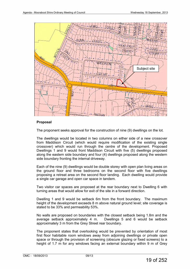
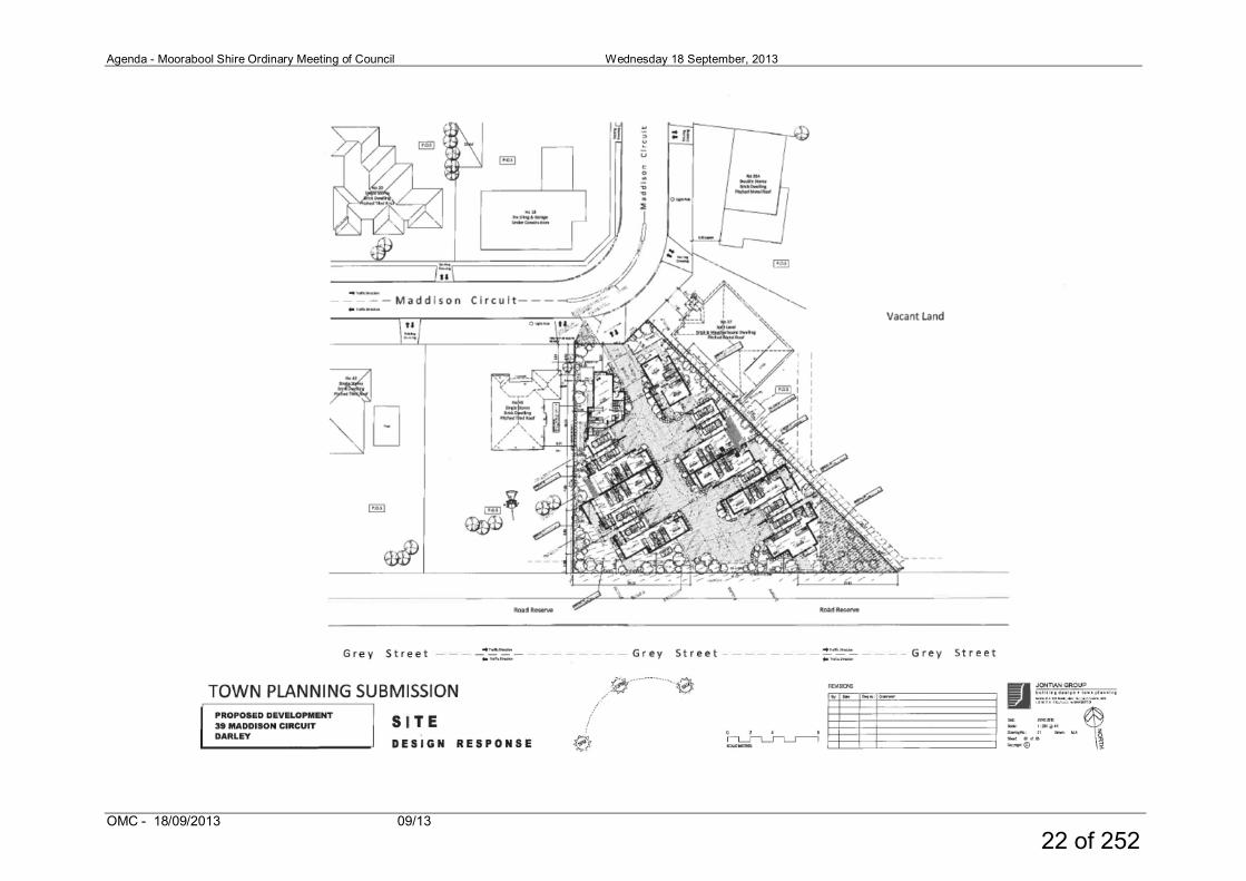
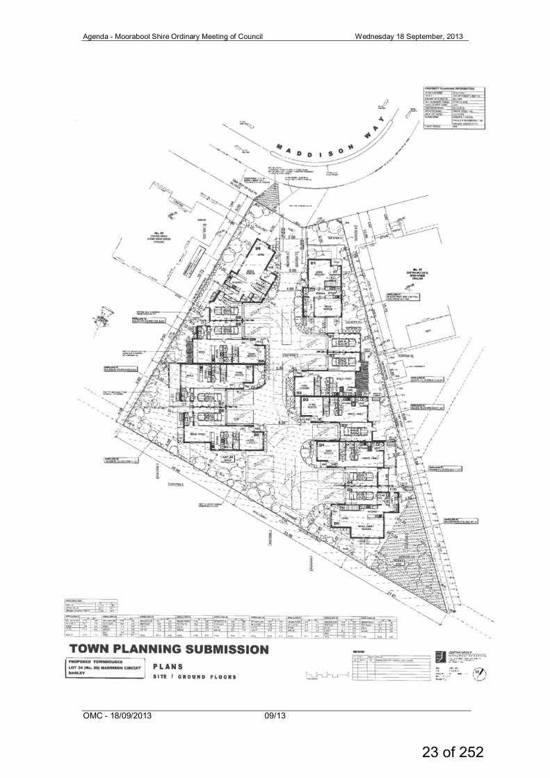
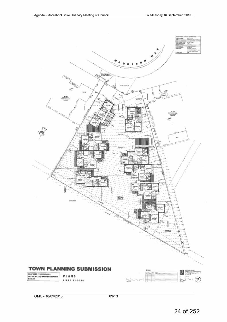
Site and Surrounds The subject site abuts the south side bend in Maddison Circuit and the north side of Grey Street, Darley. The subject site is within a newer subdivision area, less than 15 years old, approximately 1km west of the Darley Plaza Activity Centre and Western Freeway interchange. The subject site is also within 1km of the Pentland Hills Primary School and Civic and Community Hub. The subject site is best described as triangular in shape, within a combined frontage to Maddison Circuit of 18.27 m, a rear boundary abutting Grey Street of 71.43 m, an east and west boundary of 78.43 m and 50.00 m, respectively. The site is 2351 sq m, vacant with a significant fall from north to south.
17 of 252
Agenda - Moorabool Shire Ordinary Meeting of Council Wednesday 18 September, 2013
OMC - 18/09/2013 09/13
The site is encumbered by a 2m wide easement along the rear boundary and has a hatched portion of land, as the shown on the title plan, on the south east corner that must not contain any buildings except for fencing and has been identified as an area that cannot be sewered under a Section 173 Agreement. The subject site is located on the bend of the southeast corner of the Circuit which provides for a street frontage which affords some constraints with regard to on street parking. There are dwellings on each side of the subject site with 5m to 6m setbacks. These dwellings, as with most in the neighbourhood are single storey with double garages and generous side setbacks from side and rear boundaries. The dwelling on the northeast boundary has several habitable room windows which face the subject site. The subject site is located within a residential neighbourhood of Darley which was established approximately 2001 with a mix of newer dwellings and some vacant land. The area is elevated with significant views to the north east, east, south east and south. The subject site itself is described as having panoramic views from the site to the southeast. The site adjoins the land previously used as a landfill site by Council. Maddison Circuit provides for two way traffic, kerb and channel, footpaths and crossovers. There is a pedestrian path to Ball Street on the western side of Maddison Circuit which provides access to the Pentland Primary School. A public bus stop is located on the corner of Maddison Circuit and Grey Street. Whilst the southern properties on Maddison Circuit share a rear boundary with Grey Street, Maddison Circuit itself has a distinct character. The dwellings are large single dwellings on generous lots with substantial open space. Maddison Circuit may only be accessed via Grey Street and may consider a small neighbourhood within itself. There are no other multi dwelling developments within the Circuit. There is no significant vegetation on the subject site.
18 of 252
Agenda - Moorabool Shire Ordinary Meeting of Council Wednesday 18 September, 2013
OMC - 18/09/2013 09/13
Proposal The proponent seeks approval for the construction of nine (9) dwellings on the lot. The dwellings would be located in two columns on either side of a new crossover from Maddison Circuit (which would require modification of the existing single crossover) which would run through the centre of the development. Proposed Dwellings 1 and 9 would front Maddison Circuit with five (5) dwellings proposed along the eastern side boundary and four (4) dwellings proposed along the western side boundary fronting the internal driveway. Each of the nine (9) dwellings would be double storey with open plan living areas on the ground floor and three bedrooms on the second floor with five dwellings proposing a retreat area on the second floor landing. Each dwelling would provide a single car garage and open car space in tandem. Two visitor car spaces are proposed at the rear boundary next to Dwelling 6 with turning areas that would allow for exit of the site in a forward direction. Dwelling 1 and 9 would be setback 6m from the front boundary. The maximum height of the development exceeds 8 m above natural ground level; site coverage is stated to be 33% and permeability 53%. No walls are proposed on boundaries with the closest setback being 1.8m and the average setback approximately 4 m. Dwellings 5 and 6 would be setback approximately 3 m from the Grey Street rear boundary. The proponent states that overlooking would be prevented by orientation of most first floor habitable room windows away from adjoining dwellings or private open space or through the provision of screening (obscure glazing or fixed screens) to a height of 1.7 m for any windows facing an external boundary within 9 m of Grey
Subject site
19 of 252
Agenda - Moorabool Shire Ordinary Meeting of Council Wednesday 18 September, 2013
OMC - 18/09/2013 09/13
Street. It is proposed to screen the rear deck of Dwelling 8 and at ground level, overlooking would be prevented by internal and external boundary fencing. Internal overlooking is proposed to be prevented by the orientation of first floor windows away from secluded private open space of the dwellings. The dwellings would have a contemporary design described as appropriate to newer suburban areas at the edge of a country town. The dwellings would present with a mix of face brick, weatherboard or rendered walls at both floors and hipped, Colorbond® roofs with eaves. No front fence to Maddison Circuit is proposed. No provision has been made for domestic storage, refuse storage, mail boxes, however the proponents states that they can be provided.
20 of 252
Agenda - Moorabool Shire Ordinary Meeting of Council Wednesday 18 September, 2013
OMC - 18/09/2013 09/13
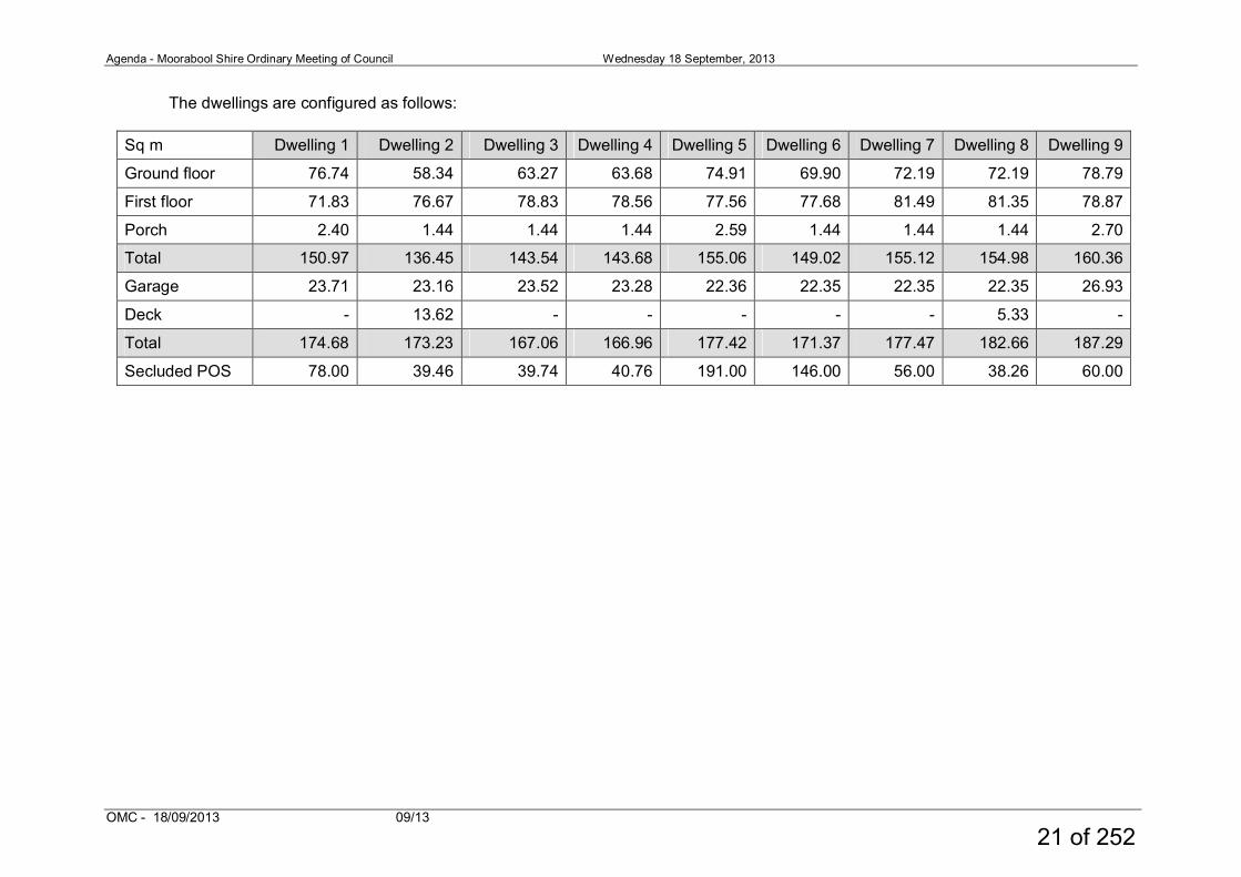
The dwellings are configured as follows:
Sq m Dwelling 1 Dwelling 2 Dwelling 3 Dwelling 4 Dwelling 5 Dwelling 6 Dwelling 7 Dwelling 8 Dwelling 9
Ground floor 76.74 58.34 63.27 63.68 74.91 69.90 72.19 72.19 78.79
First floor 71.83 76.67 78.83 78.56 77.56 77.68 81.49 81.35 78.87
Porch 2.40 1.44 1.44 1.44 2.59 1.44 1.44 1.44 2.70
Total 150.97 136.45 143.54 143.68 155.06 149.02 155.12 154.98 160.36
Garage 23.71 23.16 23.52 23.28 22.36 22.35 22.35 22.35 26.93
Deck - 13.62 - - - - - 5.33 -
Total 174.68 173.23 167.06 166.96 177.42 171.37 177.47 182.66 187.29
Secluded POS 78.00 39.46 39.74 40.76 191.00 146.00 56.00 38.26 60.00
21 of 252
Agenda - Moorabool Shire Ordinary Meeting of Council Wednesday 18 September, 2013
OMC - 18/09/2013 09/13
22 of 252
Agenda - Moorabool Shire Ordinary Meeting of Council Wednesday 18 September, 2013
OMC - 18/09/2013 09/13
23 of 252
Agenda - Moorabool Shire Ordinary Meeting of Council Wednesday 18 September, 2013
OMC - 18/09/2013 09/13
24 of 252
Agenda - Moorabool Shire Ordinary Meeting of Council Wednesday 18 September, 2013
OMC - 18/09/2013 09/13
25 of 252
Agenda - Moorabool Shire Ordinary Meeting of Council Wednesday 18 September, 2013
OMC - 18/09/2013 09/13
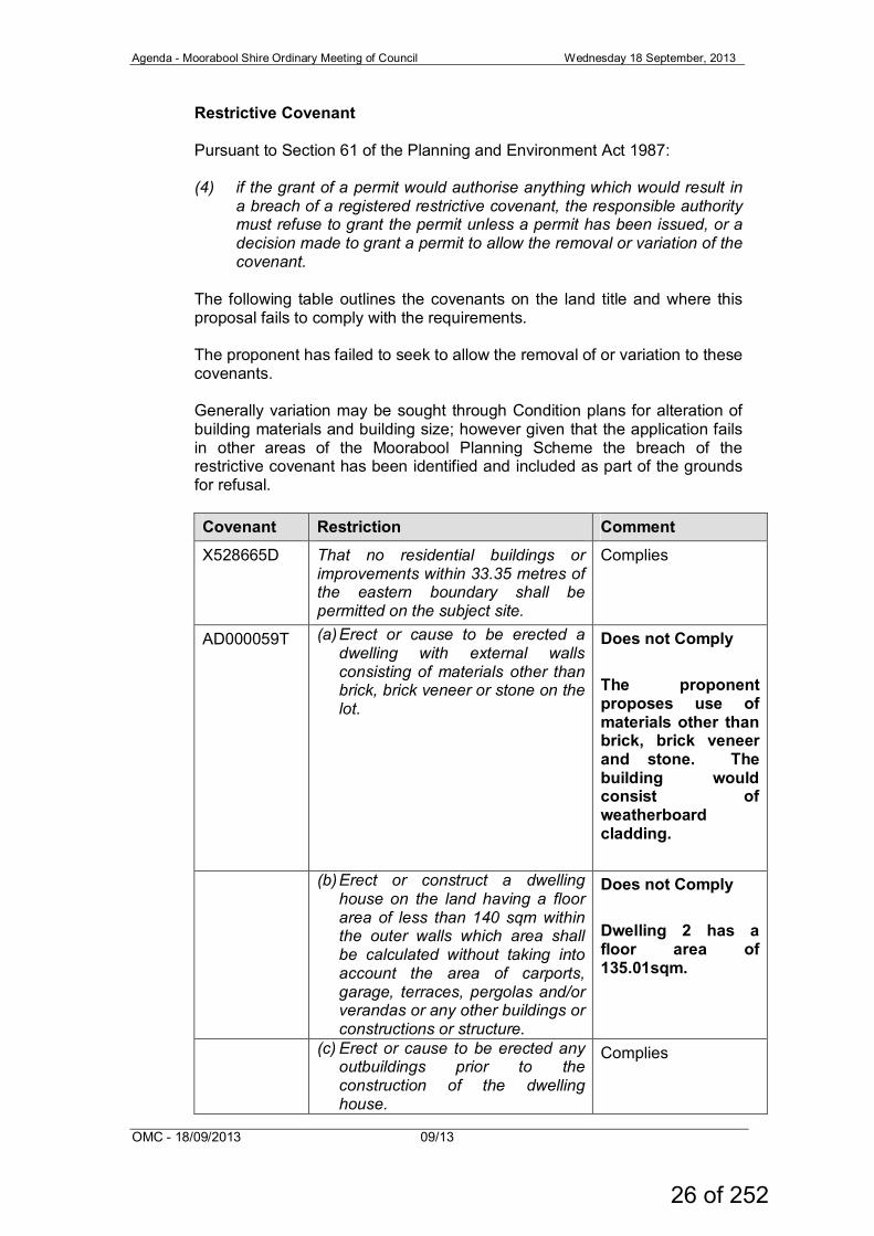
Restrictive Covenant Pursuant to Section 61 of the Planning and Environment Act 1987: (4) if the grant of a permit would authorise anything which would result in
a breach of a registered restrictive covenant, the responsible authority must refuse to grant the permit unless a permit has been issued, or a decision made to grant a permit to allow the removal or variation of the covenant.
The following table outlines the covenants on the land title and where this proposal fails to comply with the requirements. The proponent has failed to seek to allow the removal of or variation to these covenants. Generally variation may be sought through Condition plans for alteration of building materials and building size; however given that the application fails in other areas of the Moorabool Planning Scheme the breach of the restrictive covenant has been identified and included as part of the grounds for refusal. Covenant Restriction Comment X528665D That no residential buildings or
improvements within 33.35 metres of the eastern boundary shall be permitted on the subject site.
Complies
AD000059T (a) Erect or cause to be erected a dwelling with external walls consisting of materials other than brick, brick veneer or stone on the lot.
Does not Comply The proponent proposes use of materials other than brick, brick veneer and stone. The building would consist of weatherboard cladding.
(b) Erect or construct a dwelling house on the land having a floor area of less than 140 sqm within the outer walls which area shall be calculated without taking into account the area of carports, garage, terraces, pergolas and/or verandas or any other buildings or constructions or structure.
Does not Comply Dwelling 2 has a floor area of 135.01sqm.
(c) Erect or cause to be erected any outbuildings prior to the construction of the dwelling house.
Complies
26 of 252
Agenda - Moorabool Shire Ordinary Meeting of Council Wednesday 18 September, 2013
OMC - 18/09/2013 09/13
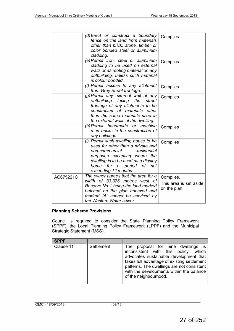
(d) Erect or construct a boundary
fence on the land from materials other than brick, stone, timber or color bonded steel or aluminium cladding.
Complies
(e) Permit iron, steel or aluminium cladding to be used on external walls or as roofing material on any outbuilding, unless such material is colour bonded.
Complies
(f) Permit access to any allotment from Grey Street frontage.
Complies
(g) Permit any external wall of any outbuilding facing the street frontage of any allotments to be constructed of materials other than the same materials used in the external walls of the dwelling.
Complies
(h) Permit handmade or machine mud bricks in the construction of any buildings
Complies
(i) Permit such dwelling house to be used for other than a private and non-commercial residential purposes excepting where the dwelling is to be used as a display home for a period of not exceeding 12 months.
Complies
AC675221C The owner agrees that the area for a width of 33.375 metres west of Reserve No 1 being the land marked hatched on the plan annexed and marked “A” cannot be serviced by the Western Water sewer.
Complies. This area is set aside on the plan.
Planning Scheme Provisions Council is required to consider the State Planning Policy Framework (SPPF), the Local Planning Policy Framework (LPPF) and the Municipal Strategic Statement (MSS).
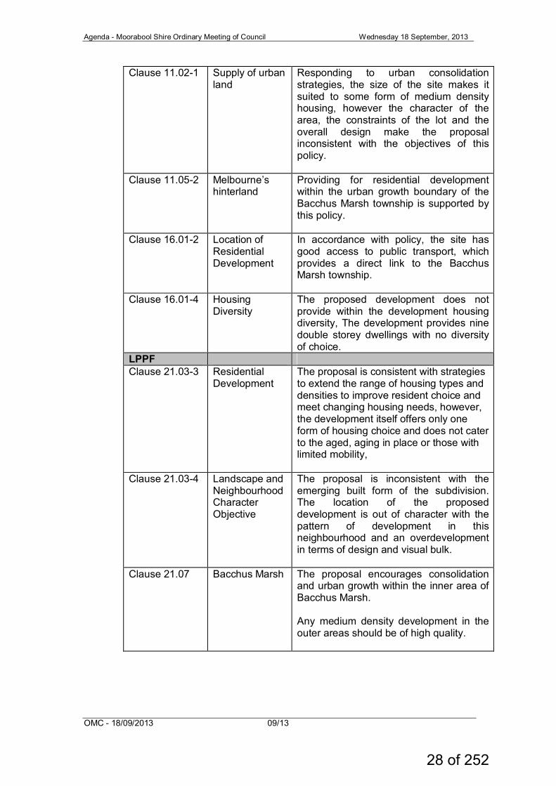
SPPF Clause 11 Settlement The proposal for nine dwellings is
inconsistent with this policy, which advocates sustainable development that takes full advantage of existing settlement patterns. The dwellings are not consistent with the developments within the balance of the neighbourhood.
27 of 252
Agenda - Moorabool Shire Ordinary Meeting of Council Wednesday 18 September, 2013
OMC - 18/09/2013 09/13
Clause 11.02-1 Supply of urban land
Responding to urban consolidation strategies, the size of the site makes it suited to some form of medium density housing, however the character of the area, the constraints of the lot and the overall design make the proposal inconsistent with the objectives of this policy.
Clause 11.05-2 Melbourne’s hinterland
Providing for residential development within the urban growth boundary of the Bacchus Marsh township is supported by this policy.
Clause 16.01-2
Location of Residential Development
In accordance with policy, the site has good access to public transport, which provides a direct link to the Bacchus Marsh township.
Clause 16.01-4
Housing Diversity
The proposed development does not provide within the development housing diversity, The development provides nine double storey dwellings with no diversity of choice.
LPPF Clause 21.03-3 Residential
Development The proposal is consistent with strategies to extend the range of housing types and densities to improve resident choice and meet changing housing needs, however, the development itself offers only one form of housing choice and does not cater to the aged, aging in place or those with limited mobility,
Clause 21.03-4 Landscape and Neighbourhood Character Objective
The proposal is inconsistent with the emerging built form of the subdivision. The location of the proposed development is out of character with the pattern of development in this neighbourhood and an overdevelopment in terms of design and visual bulk.
Clause 21.07 Bacchus Marsh The proposal encourages consolidation and urban growth within the inner area of Bacchus Marsh. Any medium density development in the outer areas should be of high quality.
28 of 252
Agenda - Moorabool Shire Ordinary Meeting of Council Wednesday 18 September, 2013
OMC - 18/09/2013 09/13
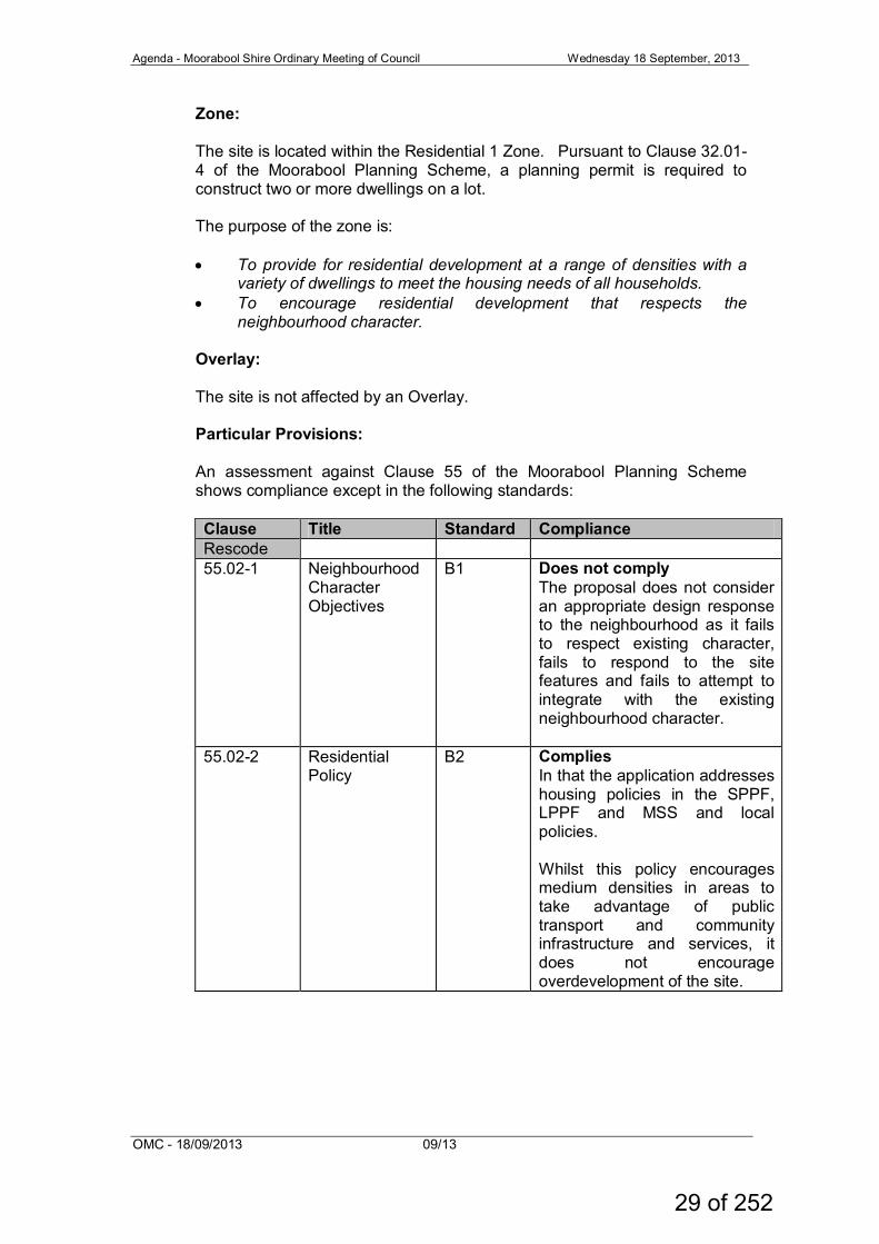
Zone: The site is located within the Residential 1 Zone. Pursuant to Clause 32.01-4 of the Moorabool Planning Scheme, a planning permit is required to construct two or more dwellings on a lot. The purpose of the zone is:
• To provide for residential development at a range of densities with a
variety of dwellings to meet the housing needs of all households. • To encourage residential development that respects the
neighbourhood character.
Overlay: The site is not affected by an Overlay. Particular Provisions: An assessment against Clause 55 of the Moorabool Planning Scheme shows compliance except in the following standards:
Clause Title Standard Compliance Rescode 55.02-1 Neighbourhood
Character Objectives
B1 Does not comply The proposal does not consider an appropriate design response to the neighbourhood as it fails to respect existing character, fails to respond to the site features and fails to attempt to integrate with the existing neighbourhood character.
55.02-2 Residential Policy
B2 Complies In that the application addresses housing policies in the SPPF, LPPF and MSS and local policies. Whilst this policy encourages medium densities in areas to take advantage of public transport and community infrastructure and services, it does not encourage overdevelopment of the site.
29 of 252

Agenda - Moorabool Shire Ordinary Meeting of Council Wednesday 18 September, 2013
OMC - 18/09/2013 09/13
55.02-3 Dwelling diversity
B3 N/A
55.02-4 Infrastructure B4 Complies The development is likely to have connection to all services. There is a restriction of the title that demonstration the corner portion of the allotment cannot connect to Western Water sewerage and if a permit were to issue compliance would have to be demonstrated.
55.02-5 Integration with Street
B5 Partially complies Whilst the front Dwellings 1 and 9 are orientated to the street the existing dwellings do not integrate with the street.
55.03-1 Street setback
B6 Complies The dwellings proposed meet the average setback of the adjoining existing buildings.
55.03-2 Building height
B7 Does not Comply The proposal fails to consider the height of proposed buildings against the height of existing buildings. The design response fails to consider visual impact of the buildings when viewed from the street and from adjoining properties.
55.03-3 Site coverage
B8 Complies The proposal states that the land parcel is 2616 sqm however the title and Council records indicate land size at 2351 sqm. Remove from this the undevelopable portion of land which reduces the land parcel by approximately 190 sqm therefore making the site area 2161 sqm which equates to 39.63 %. Whilst this complies with the standard it does not consider the impact of the second storey.
30 of 252
Agenda - Moorabool Shire Ordinary Meeting of Council Wednesday 18 September, 2013
OMC - 18/09/2013 09/13
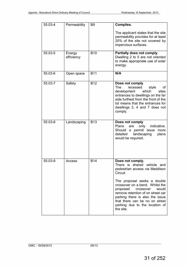
55.03-4 Permeability B9 Complies. The applicant states that the site permeability provides for at least 20% of the site not covered by impervious surfaces.
55.03-5 Energy efficiency
B10 Partially does not comply. Dwelling 2 to 5 are not oriented to make appropriate use of solar energy.
55.03-6 Open space B11 N/A
55.03-7 Safety B12 Does not comply The recessed style of development which sites entrances to dwellings on the far side furthest from the front of the lot means that the entrances for dwellings 3, 4 and 7 does not comply.
55.03-8 Landscaping B13 Does not comply Plans are only indicative. Should a permit issue more detailed landscaping plans would be required.
55.03-9 Access B14 Does not comply. There is shared vehicle and pedestrian access via Maddison Circuit. The proposal seeks a double crossover on a bend. Whilst the proposed crossover would remove retention of on street car parking there is also the issue that there can be no on street parking due to the location of the site.
31 of 252
Agenda - Moorabool Shire Ordinary Meeting of Council Wednesday 18 September, 2013
OMC - 18/09/2013 09/13
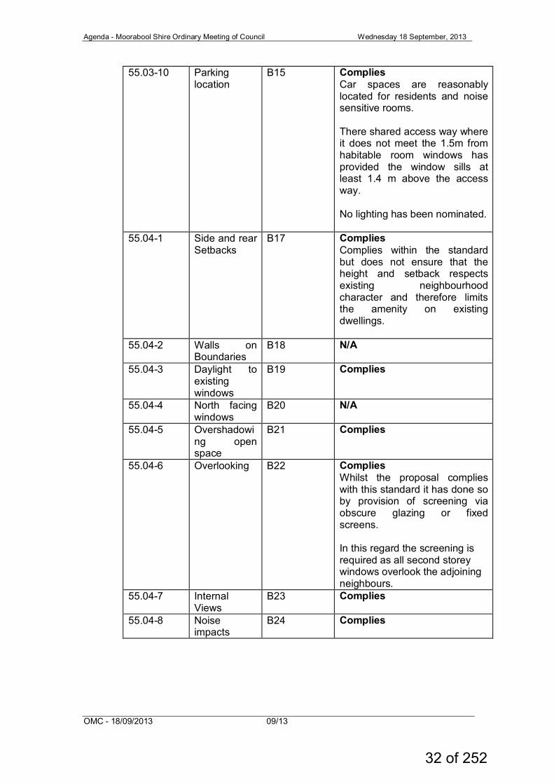
55.03-10 Parking location
B15 Complies Car spaces are reasonably located for residents and noise sensitive rooms. There shared access way where it does not meet the 1.5m from habitable room windows has provided the window sills at least 1.4 m above the access way. No lighting has been nominated.
55.04-1 Side and rear Setbacks
B17 Complies Complies within the standard but does not ensure that the height and setback respects existing neighbourhood character and therefore limits the amenity on existing dwellings.
55.04-2 Walls on Boundaries
B18 N/A
55.04-3 Daylight to existing windows
B19 Complies
55.04-4 North facing windows
B20 N/A
55.04-5 Overshadowing open space
B21 Complies
55.04-6 Overlooking B22 Complies Whilst the proposal complies with this standard it has done so by provision of screening via obscure glazing or fixed screens. In this regard the screening is required as all second storey windows overlook the adjoining neighbours.
55.04-7 Internal Views
B23 Complies
55.04-8 Noise impacts
B24 Complies
32 of 252
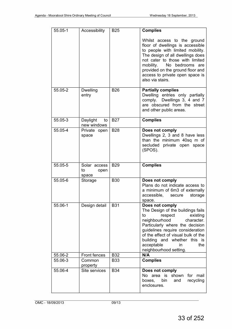
Agenda - Moorabool Shire Ordinary Meeting of Council Wednesday 18 September, 2013
OMC - 18/09/2013 09/13
55.05-1 Accessibility B25 Complies Whilst access to the ground floor of dwellings is accessible to people with limited mobility. The design of all dwellings does not cater to those with limited mobility. No bedrooms are provided on the ground floor and access to private open space is also via stairs.
55.05-2 Dwelling entry
B26 Partially complies Dwelling entries only partially comply. Dwellings 3, 4 and 7 are obscured from the street and other public areas.
55.05-3 Daylight to new windows
B27 Complies
55.05-4 Private open space
B28 Does not comply Dwellings 2, 3 and 8 have less than the minimum 40sq m of secluded private open space (SPOS).
55.05-5 Solar access to open space
B29 Complies
55.05-6 Storage B30 Does not comply Plans do not indicate access to a minimum of 6m3 of externally accessible, secure storage space.
55.06-1 Design detail B31 Does not comply The Design of the buildings fails to respect existing neighbourhood character. Particularly where the decision guidelines require consideration of the effect of visual bulk of the building and whether this is acceptable in the neighbourhood setting.
55.06-2 Front fences B32 N/A 55.06-3 Common
property B33 Complies
55.06-4 Site services B34 Does not comply No area is shown for mail boxes, bin and recycling enclosures.
33 of 252
Agenda - Moorabool Shire Ordinary Meeting of Council Wednesday 18 September, 2013
OMC - 18/09/2013 09/13
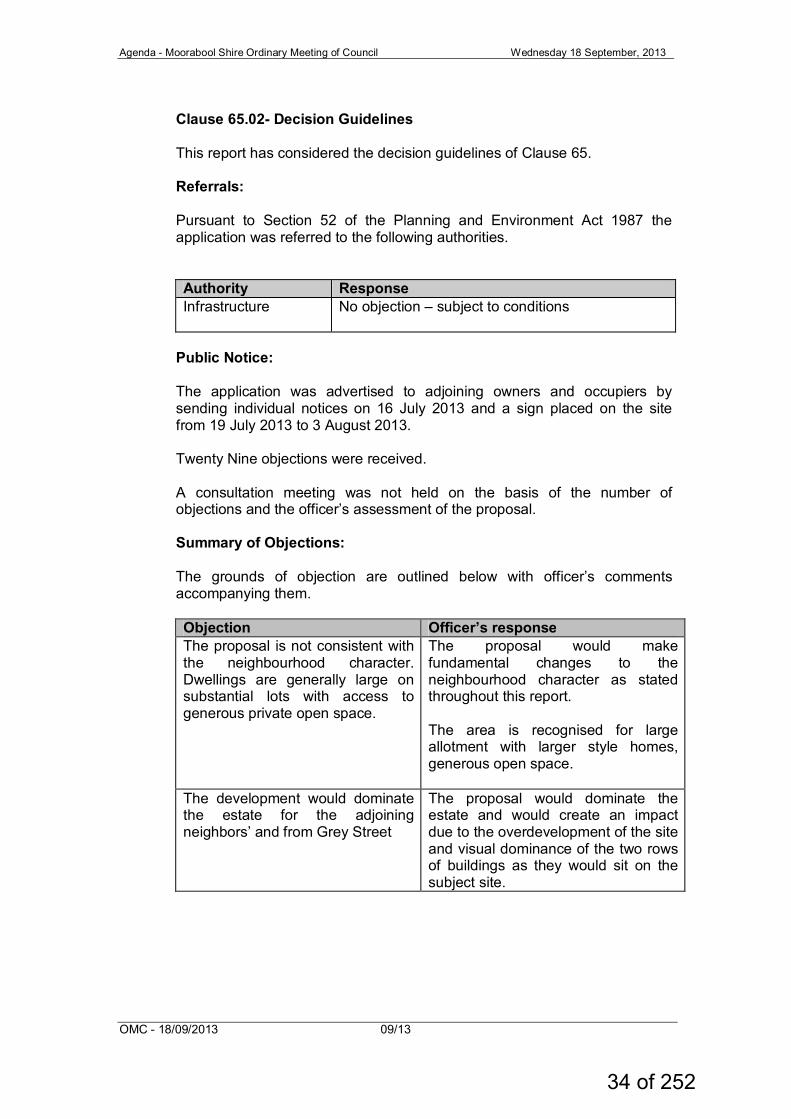
Clause 65.02- Decision Guidelines This report has considered the decision guidelines of Clause 65. Referrals: Pursuant to Section 52 of the Planning and Environment Act 1987 the application was referred to the following authorities.
Authority Response Infrastructure No objection – subject to conditions
Public Notice: The application was advertised to adjoining owners and occupiers by sending individual notices on 16 July 2013 and a sign placed on the site from 19 July 2013 to 3 August 2013. Twenty Nine objections were received. A consultation meeting was not held on the basis of the number of objections and the officer’s assessment of the proposal. Summary of Objections: The grounds of objection are outlined below with officer’s comments accompanying them.
Objection Officer’s response The proposal is not consistent with the neighbourhood character. Dwellings are generally large on substantial lots with access to generous private open space.
The proposal would make fundamental changes to the neighbourhood character as stated throughout this report. The area is recognised for large allotment with larger style homes, generous open space.
The development would dominate the estate for the adjoining neighbors’ and from Grey Street
The proposal would dominate the estate and would create an impact due to the overdevelopment of the site and visual dominance of the two rows of buildings as they would sit on the subject site.
34 of 252
Agenda - Moorabool Shire Ordinary Meeting of Council Wednesday 18 September, 2013
OMC - 18/09/2013 09/13
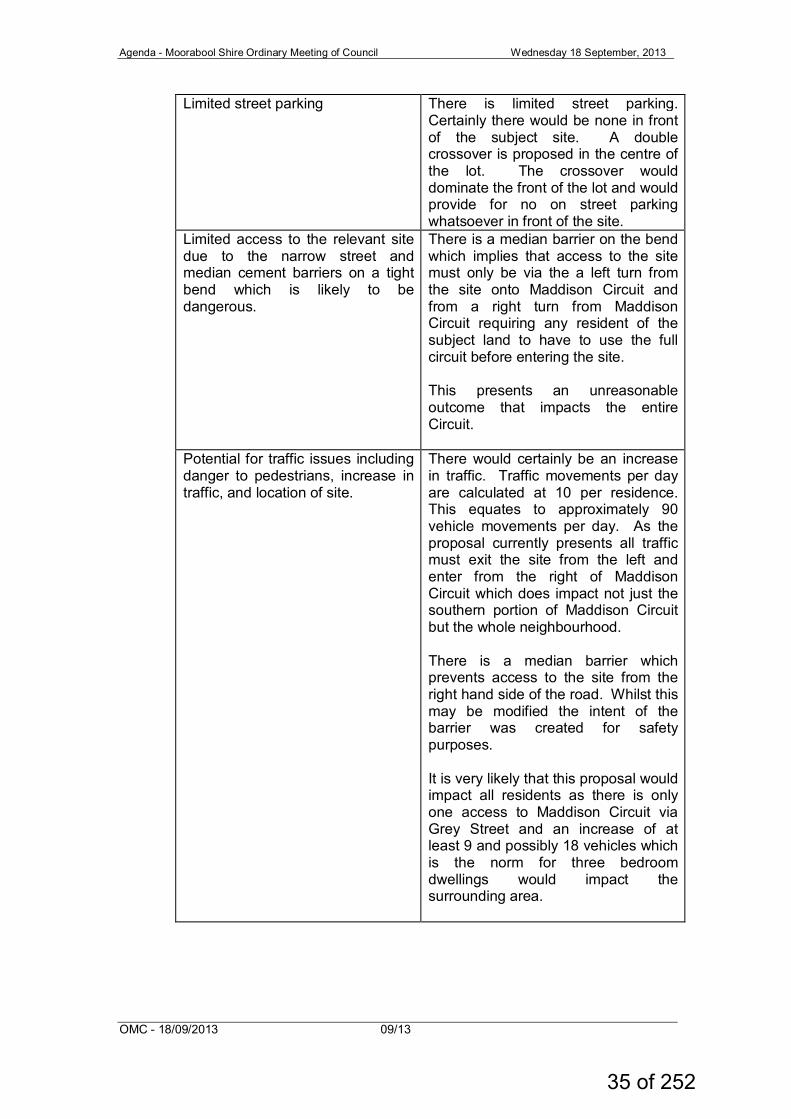
Limited street parking There is limited street parking. Certainly there would be none in front of the subject site. A double crossover is proposed in the centre of the lot. The crossover would dominate the front of the lot and would provide for no on street parking whatsoever in front of the site.
Limited access to the relevant site due to the narrow street and median cement barriers on a tight bend which is likely to be dangerous.
There is a median barrier on the bend which implies that access to the site must only be via the a left turn from the site onto Maddison Circuit and from a right turn from Maddison Circuit requiring any resident of the subject land to have to use the full circuit before entering the site. This presents an unreasonable outcome that impacts the entire Circuit.
Potential for traffic issues including danger to pedestrians, increase in traffic, and location of site.
There would certainly be an increase in traffic. Traffic movements per day are calculated at 10 per residence. This equates to approximately 90 vehicle movements per day. As the proposal currently presents all traffic must exit the site from the left and enter from the right of Maddison Circuit which does impact not just the southern portion of Maddison Circuit but the whole neighbourhood. There is a median barrier which prevents access to the site from the right hand side of the road. Whilst this may be modified the intent of the barrier was created for safety purposes. It is very likely that this proposal would impact all residents as there is only one access to Maddison Circuit via Grey Street and an increase of at least 9 and possibly 18 vehicles which is the norm for three bedroom dwellings would impact the surrounding area.
35 of 252
Agenda - Moorabool Shire Ordinary Meeting of Council Wednesday 18 September, 2013
OMC - 18/09/2013 09/13
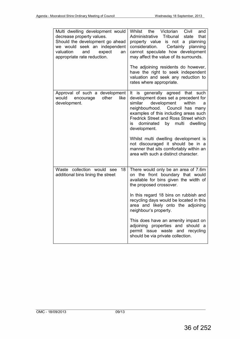
Multi dwelling development would decrease property values. Should the development go ahead we would seek an independent valuation and expect an appropriate rate reduction.
Whilst the Victorian Civil and Administrative Tribunal state that property value is not a planning consideration. Certainly planning cannot speculate how development may affect the value of its surrounds. The adjoining residents do however, have the right to seek independent valuation and seek any reduction to rates where appropriate.
Approval of such a development would encourage other like development.
It is generally agreed that such development does set a precedent for similar development within a neighbourhood. Council has many examples of this including areas such Fredrick Street and Ross Street which is dominated by multi dwelling development. Whilst multi dwelling development is not discouraged it should be in a manner that sits comfortably within an area with such a distinct character.
Waste collection would see 18 additional bins lining the street
There would only be an area of 7.6m on the front boundary that would available for bins given the width of the proposed crossover. In this regard 18 bins on rubbish and recycling days would be located in this area and likely onto the adjoining neighbour’s property. This does have an amenity impact on adjoining properties and should a permit issue waste and recycling should be via private collection.
36 of 252
Agenda - Moorabool Shire Ordinary Meeting of Council Wednesday 18 September, 2013
OMC - 18/09/2013 09/13
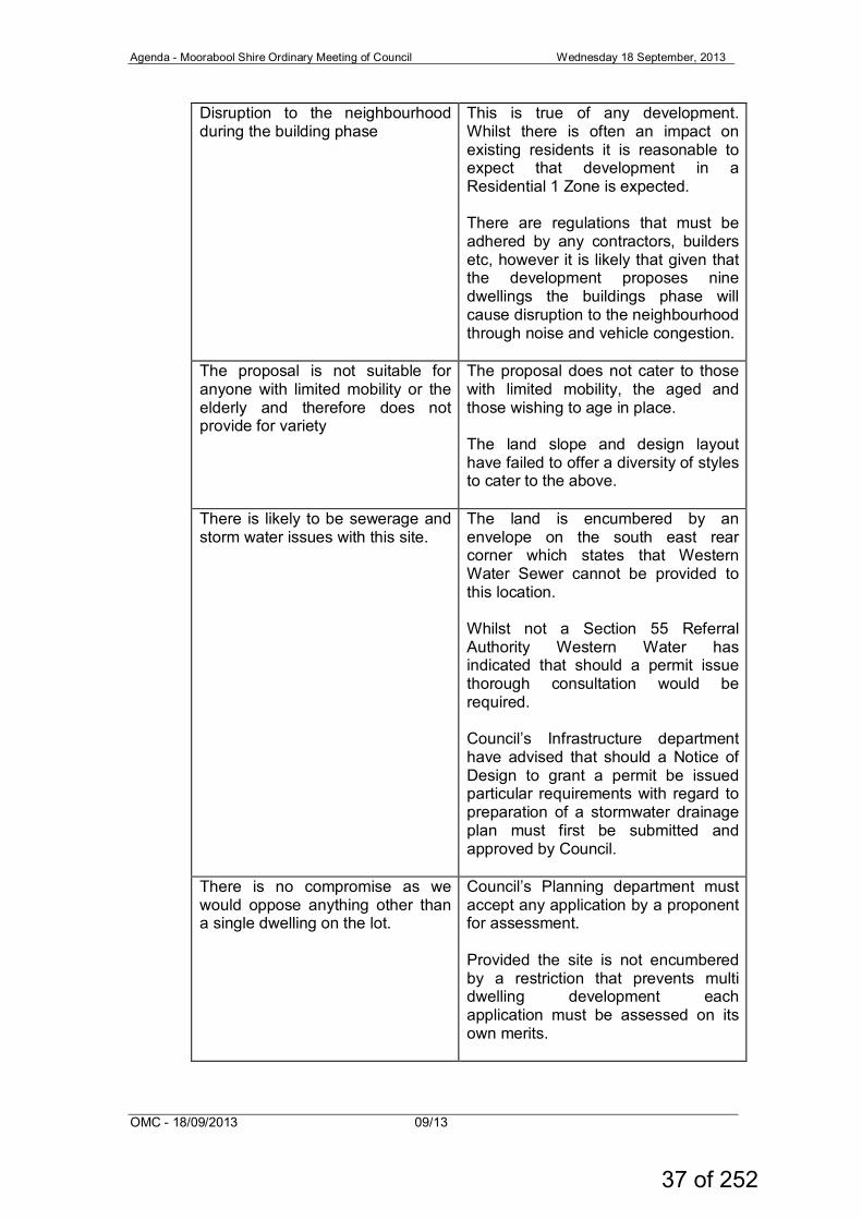
Disruption to the neighbourhood during the building phase
This is true of any development. Whilst there is often an impact on existing residents it is reasonable to expect that development in a Residential 1 Zone is expected. There are regulations that must be adhered by any contractors, builders etc, however it is likely that given that the development proposes nine dwellings the buildings phase will cause disruption to the neighbourhood through noise and vehicle congestion.
The proposal is not suitable for anyone with limited mobility or the elderly and therefore does not provide for variety
The proposal does not cater to those with limited mobility, the aged and those wishing to age in place. The land slope and design layout have failed to offer a diversity of styles to cater to the above.
There is likely to be sewerage and storm water issues with this site.
The land is encumbered by an envelope on the south east rear corner which states that Western Water Sewer cannot be provided to this location. Whilst not a Section 55 Referral Authority Western Water has indicated that should a permit issue thorough consultation would be required. Council’s Infrastructure department have advised that should a Notice of Design to grant a permit be issued particular requirements with regard to preparation of a stormwater drainage plan must first be submitted and approved by Council.
There is no compromise as we would oppose anything other than a single dwelling on the lot.
Council’s Planning department must accept any application by a proponent for assessment. Provided the site is not encumbered by a restriction that prevents multi dwelling development each application must be assessed on its own merits.
37 of 252
Agenda - Moorabool Shire Ordinary Meeting of Council Wednesday 18 September, 2013
OMC - 18/09/2013 09/13
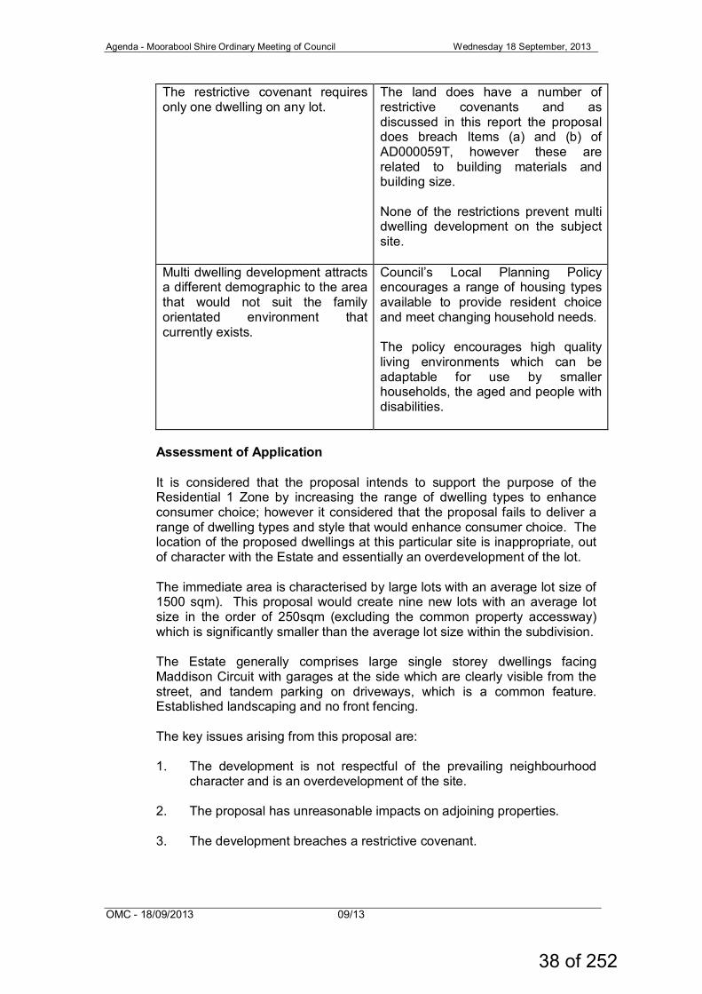
The restrictive covenant requires only one dwelling on any lot.
The land does have a number of restrictive covenants and as discussed in this report the proposal does breach Items (a) and (b) of AD000059T, however these are related to building materials and building size. None of the restrictions prevent multi dwelling development on the subject site.
Multi dwelling development attracts a different demographic to the area that would not suit the family orientated environment that currently exists.
Council’s Local Planning Policy encourages a range of housing types available to provide resident choice and meet changing household needs. The policy encourages high quality living environments which can be adaptable for use by smaller households, the aged and people with disabilities.
Assessment of Application It is considered that the proposal intends to support the purpose of the Residential 1 Zone by increasing the range of dwelling types to enhance consumer choice; however it considered that the proposal fails to deliver a range of dwelling types and style that would enhance consumer choice. The location of the proposed dwellings at this particular site is inappropriate, out of character with the Estate and essentially an overdevelopment of the lot. The immediate area is characterised by large lots with an average lot size of 1500 sqm). This proposal would create nine new lots with an average lot size in the order of 250sqm (excluding the common property accessway) which is significantly smaller than the average lot size within the subdivision. The Estate generally comprises large single storey dwellings facing Maddison Circuit with garages at the side which are clearly visible from the street, and tandem parking on driveways, which is a common feature. Established landscaping and no front fencing. The key issues arising from this proposal are:
1. The development is not respectful of the prevailing neighbourhood
character and is an overdevelopment of the site. 2. The proposal has unreasonable impacts on adjoining properties. 3. The development breaches a restrictive covenant.
38 of 252
Agenda - Moorabool Shire Ordinary Meeting of Council Wednesday 18 September, 2013
OMC - 18/09/2013 09/13
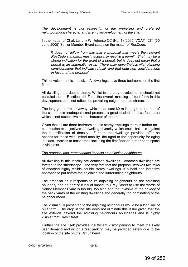
The development is not respectful of the prevailing and preferred neighbourhood character and is an overdevelopment of the site. In the matter of Chak Lai Li v Whitehorse CC (No. 1) [2005] VCAT 1274 (30 June 2005) Senior Member Byard states on the matter of ResCode:
It does not follow from this that a proposal that meets the relevant ResCode standards must necessarily receive a permit. That may be a strong indication for the grant of a permit, but is does not mean that a permit is an automatic result. There may nevertheless vital planning considerations that indicate refusal, and that outweigh considerations in favour of the proposal.
This development is intensive. All dwellings have three bedrooms on the first floor. All dwellings are double storey. Whilst two storey developments should not be ruled out in Resdientail1 Zone the overall massing of built form in this development does not reflect the prevailing neighbourhood character. The long gun barrel driveway which is at least 60 m in length to the rear of the site is also inadequate and presents a great deal of hard surface area which is not responsive to the character of the area. Given that all are three bedroom double storey dwellings there is further no contribution to objectives of dwelling diversity which could balance against the intensification of density. Further, the dwellings provided offer no options for those with limited mobility, the aged or the opportunity for aging in place. Access to most areas including the first floor or to rear open space is via stairs. The proposal has unreasonable impacts on adjoining neighbours All dwelling in this locality are detached dwellings. Attached dwellings are foreign to the streetscape. The very fact that the proposal involves two rows of attached highly visible double storey dwellings is a bold and intensive approach to put before the adjoining and surrounding neighbours. The proposal as it responds to its adjoining neighbours on the adjoining boundary and as part of it visual impact to Grey Street to use the words of Senior Member Byard is too big, too high and too invasive of the privacy of the back yards of the existing dwellings and generally too dominating of the neighbourhood. The visual bulk presented to the adjoining neighbours would be a long line of built form. The drop in the site does not eliminate this issue given that the site extends beyond the adjoining neighbours boundaries and is highly visible from Grey Street. Further the site itself provides insufficient visitor parking to meet the likely user demand and no on street parking may be provided safely due to the location of the site on the Circuit bend.
39 of 252
Agenda - Moorabool Shire Ordinary Meeting of Council Wednesday 18 September, 2013
OMC - 18/09/2013 09/13
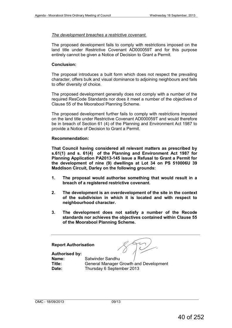
The development breaches a restrictive covenant. The proposed development fails to comply with restrictions imposed on the land title under Restrictive Covenant AD000059T and for this purpose entirely cannot be given a Notice of Decision to Grant a Permit. Conclusion:
The proposal introduces a built form which does not respect the prevailing character, offers bulk and visual dominance to adjoining neighbours and fails to offer diversity of choice. The proposed development generally does not comply with a number of the required ResCode Standards nor does it meet a number of the objectives of Clause 55 of the Moorabool Planning Scheme. The proposed development further fails to comply with restrictions imposed on the land title under Restrictive Covenant AD000059T and would therefore be in breach of Section 61 (4) of the Planning and Environment Act 1987 to provide a Notice of Decision to Grant a Permit. Recommendation: That Council having considered all relevant matters as prescribed by s.61(1) and s. 61(4) of the Planning and Environment Act 1987 for Planning Application PA2013-145 issue a Refusal to Grant a Permit for the development of nine (9) dwellings at Lot 34 on PS 510006U 39 Maddison Circuit, Darley on the following grounds:
1. The proposal would authorise something that would result in a
breach of a registered restrictive covenant. 2. The development is an overdevelopment of the site in the context
of the subdivision in which it is located and with respect to neighbourhood character.
3. The development does not satisfy a number of the Recode standards nor achieves the objectives contained within Clause 55 of the Moorabool Planning Scheme.
Report Authorisation Authorised by: Name: Satwinder Sandhu Title: General Manager Growth and Development Date: Thursday 6 September 2013
40 of 252
Agenda - Moorabool Shire Ordinary Meeting of Council Wednesday 18 September, 2013
OMC - 18/09/2013 09/13
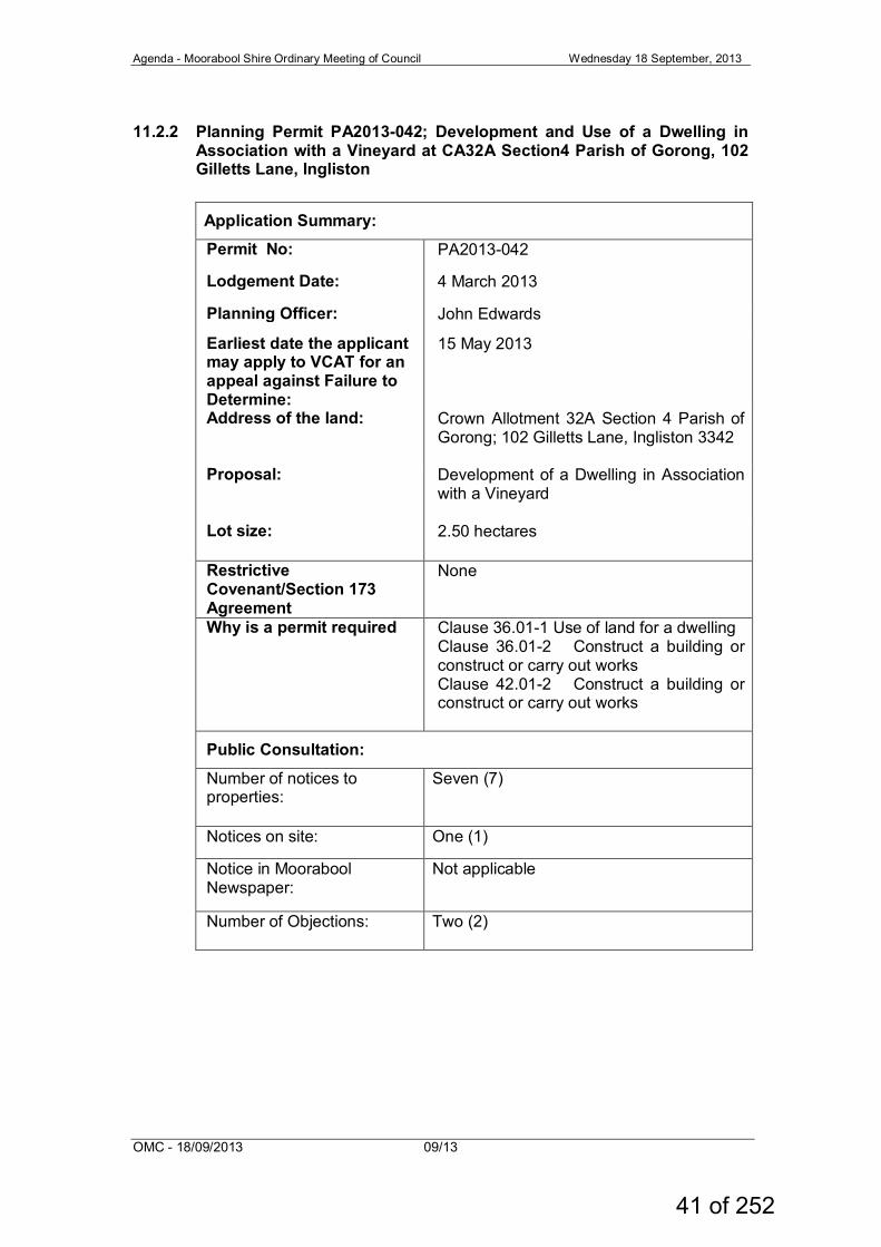
11.2.2 Planning Permit PA2013-042; Development and Use of a Dwelling in Association with a Vineyard at CA32A Section4 Parish of Gorong, 102 Gilletts Lane, Ingliston
Application Summary: Permit No: PA2013-042
Lodgement Date: 4 March 2013
Planning Officer: John Edwards
Earliest date the applicant may apply to VCAT for an appeal against Failure to Determine:
15 May 2013
Address of the land: Crown Allotment 32A Section 4 Parish of Gorong; 102 Gilletts Lane, Ingliston 3342
Proposal: Development of a Dwelling in Association with a Vineyard
Lot size: 2.50 hectares
Restrictive Covenant/Section 173 Agreement
None
Why is a permit required Clause 36.01-1 Use of land for a dwelling Clause 36.01-2 Construct a building or construct or carry out works Clause 42.01-2 Construct a building or construct or carry out works
Public Consultation:
Number of notices to properties:
Seven (7)
Notices on site: One (1)
Notice in Moorabool Newspaper:
Not applicable
Number of Objections:
Two (2)
41 of 252
Agenda - Moorabool Shire Ordinary Meeting of Council Wednesday 18 September, 2013
OMC - 18/09/2013 09/13
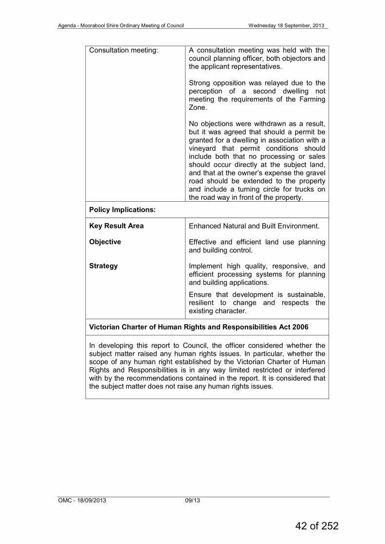
Consultation meeting: A consultation meeting was held with the council planning officer, both objectors and the applicant representatives. Strong opposition was relayed due to the perception of a second dwelling not meeting the requirements of the Farming Zone. No objections were withdrawn as a result, but it was agreed that should a permit be granted for a dwelling in association with a vineyard that permit conditions should include both that no processing or sales should occur directly at the subject land, and that at the owner’s expense the gravel road should be extended to the property and include a turning circle for trucks on the road way in front of the property.
Policy Implications:
Key Result Area Enhanced Natural and Built Environment.
Objective Effective and efficient land use planning and building control.
Strategy Implement high quality, responsive, and efficient processing systems for planning and building applications.
Ensure that development is sustainable, resilient to change and respects the existing character.
Victorian Charter of Human Rights and Responsibilities Act 2006 In developing this report to Council, the officer considered whether the subject matter raised any human rights issues. In particular, whether the scope of any human right established by the Victorian Charter of Human Rights and Responsibilities is in any way limited restricted or interfered with by the recommendations contained in the report. It is considered that the subject matter does not raise any human rights issues.
42 of 252
Agenda - Moorabool Shire Ordinary Meeting of Council Wednesday 18 September, 2013
OMC - 18/09/2013 09/13
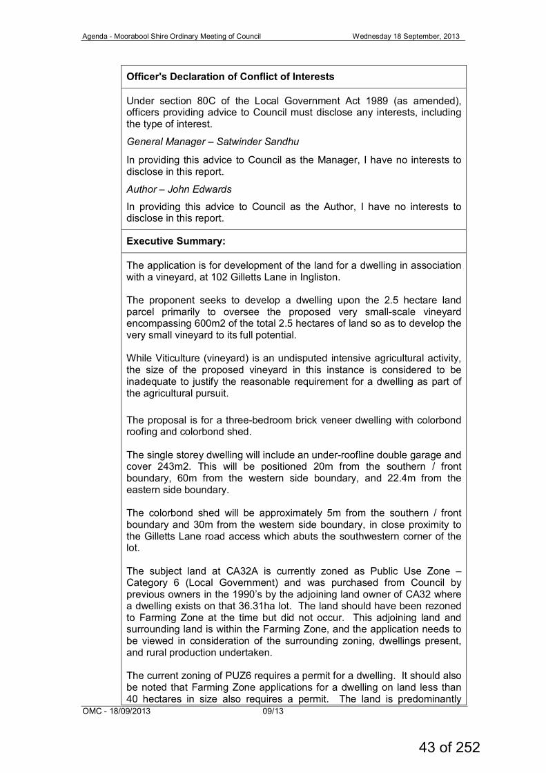
Officer's Declaration of Conflict of Interests
Under section 80C of the Local Government Act 1989 (as amended), officers providing advice to Council must disclose any interests, including the type of interest.
General Manager – Satwinder Sandhu
In providing this advice to Council as the Manager, I have no interests to disclose in this report.
Author – John Edwards
In providing this advice to Council as the Author, I have no interests to disclose in this report.
Executive Summary:
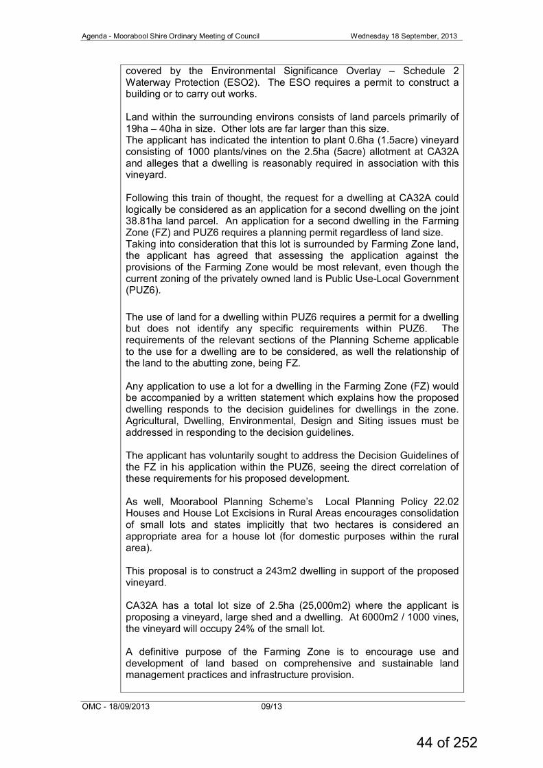
The application is for development of the land for a dwelling in association with a vineyard, at 102 Gilletts Lane in Ingliston. The proponent seeks to develop a dwelling upon the 2.5 hectare land parcel primarily to oversee the proposed very small-scale vineyard encompassing 600m2 of the total 2.5 hectares of land so as to develop the very small vineyard to its full potential. While Viticulture (vineyard) is an undisputed intensive agricultural activity, the size of the proposed vineyard in this instance is considered to be inadequate to justify the reasonable requirement for a dwelling as part of the agricultural pursuit. The proposal is for a three-bedroom brick veneer dwelling with colorbond roofing and colorbond shed. The single storey dwelling will include an under-roofline double garage and cover 243m2. This will be positioned 20m from the southern / front boundary, 60m from the western side boundary, and 22.4m from the eastern side boundary. The colorbond shed will be approximately 5m from the southern / front boundary and 30m from the western side boundary, in close proximity to the Gilletts Lane road access which abuts the southwestern corner of the lot. The subject land at CA32A is currently zoned as Public Use Zone –Category 6 (Local Government) and was purchased from Council by previous owners in the 1990’s by the adjoining land owner of CA32 where a dwelling exists on that 36.31ha lot. The land should have been rezoned to Farming Zone at the time but did not occur. This adjoining land and surrounding land is within the Farming Zone, and the application needs to be viewed in consideration of the surrounding zoning, dwellings present, and rural production undertaken. The current zoning of PUZ6 requires a permit for a dwelling. It should also be noted that Farming Zone applications for a dwelling on land less than 40 hectares in size also requires a permit. The land is predominantly
43 of 252
Agenda - Moorabool Shire Ordinary Meeting of Council Wednesday 18 September, 2013
OMC - 18/09/2013 09/13
covered by the Environmental Significance Overlay – Schedule 2 Waterway Protection (ESO2). The ESO requires a permit to construct a building or to carry out works. Land within the surrounding environs consists of land parcels primarily of 19ha – 40ha in size. Other lots are far larger than this size. The applicant has indicated the intention to plant 0.6ha (1.5acre) vineyard consisting of 1000 plants/vines on the 2.5ha (5acre) allotment at CA32A and alleges that a dwelling is reasonably required in association with this vineyard. Following this train of thought, the request for a dwelling at CA32A could logically be considered as an application for a second dwelling on the joint 38.81ha land parcel. An application for a second dwelling in the Farming Zone (FZ) and PUZ6 requires a planning permit regardless of land size. Taking into consideration that this lot is surrounded by Farming Zone land, the applicant has agreed that assessing the application against the provisions of the Farming Zone would be most relevant, even though the current zoning of the privately owned land is Public Use-Local Government (PUZ6). The use of land for a dwelling within PUZ6 requires a permit for a dwelling but does not identify any specific requirements within PUZ6. The requirements of the relevant sections of the Planning Scheme applicable to the use for a dwelling are to be considered, as well the relationship of the land to the abutting zone, being FZ. Any application to use a lot for a dwelling in the Farming Zone (FZ) would be accompanied by a written statement which explains how the proposed dwelling responds to the decision guidelines for dwellings in the zone. Agricultural, Dwelling, Environmental, Design and Siting issues must be addressed in responding to the decision guidelines. The applicant has voluntarily sought to address the Decision Guidelines of the FZ in his application within the PUZ6, seeing the direct correlation of these requirements for his proposed development. As well, Moorabool Planning Scheme’s Local Planning Policy 22.02 Houses and House Lot Excisions in Rural Areas encourages consolidation of small lots and states implicitly that two hectares is considered an appropriate area for a house lot (for domestic purposes within the rural area). This proposal is to construct a 243m2 dwelling in support of the proposed vineyard. CA32A has a total lot size of 2.5ha (25,000m2) where the applicant is proposing a vineyard, large shed and a dwelling. At 6000m2 / 1000 vines, the vineyard will occupy 24% of the small lot. A definitive purpose of the Farming Zone is to encourage use and development of land based on comprehensive and sustainable land management practices and infrastructure provision.
44 of 252
Agenda - Moorabool Shire Ordinary Meeting of Council Wednesday 18 September, 2013
OMC - 18/09/2013 09/13
The supplied Farm Management Plan indicates that once in full production this vineyard will result in the production of 500-600 bottles of wine (processed and bottled offsite) to create an annual income of $5,000 less expenses. The smaller scale of the operation allows the dwelling occupier to be able to undertake the day-to-day care of the vineyard as well as spend time offsite marketing and selling the Brefney Estate label wines. It is proposed that the applicant will live in the proposed dwelling and be responsible for the day-to-day management of this proposed vineyard as well as conducting the marketing and sales for the Brefney Estate wines. Viticulture (vineyard) is an acknowledged intensive agricultural activity. The size of the proposed vineyard in this instance is relatively small at only 0.6ha, though the request for a dwelling as a reasonable requirement for oversight of a vineyard of any size is to be considered. There are three dwellings fronting Gilletts Lane, with the most northerly dwelling at 102 Gilletts Lane (on CA32 portion) being in the same ownership as that of the owner/applicant. The proposal was advertised to surrounding and adjoining landowners and two objections were received from both other landowners with a dwelling fronting the eastern side of the same road. Notably the objections primarily related not to the agricultural use per se but to its impact on the low quality shared road access; upon general amenity to the adjoining neighbours; that the application should be considered an application for a second dwelling by the land owner; and their belief that the supplied Farm Management Plan fails to justify reasonable need for a dwelling associated with a vineyard. A consultation meeting was held with the council planning officer allowing the opportunity for the objectors and the applicant(s) to discuss the relevant issues and seek resolution. At the conclusion of the meeting no objections were withdrawn, but it was agreed that should any permit be issued that it would include conditions that will not allow for the processing into wine onsite nor should sales occur directly at the subject land, and that at the owner’s expense the formed gravel road should be extended to the property entrance and include a turning circle for trucks on the road way in front of the property. The application was forwarded to relevant referral authorities and internal Council departments for comment. No objections were offered from internal departments or referral authorities provided certain conditions were placed on any permit granted. The proposal has been assessed against the relevant components of the Moorabool Planning Scheme, particularly those set out in the State and Local Planning Policy Frameworks, the Clause 36.01-Public Use Zone, Clause 35.07-Farming Zone, and Clause 42.01 Environmental Significance Overlay – Schedule 2 Waterways Protection (ESO2).
45 of 252
Agenda - Moorabool Shire Ordinary Meeting of Council Wednesday 18 September, 2013
OMC - 18/09/2013 09/13
Summary Recommendation:
That Council resolve to issue a Notice of Decision to Grant a Permit for the Development of a Dwelling in association with a Vineyard, subject to conditions.
Proposal The proposal involves the development of a single storey brick veneer dwelling and shed upon 2.5 hectare land parcel at Crown Allotment 32A Section 4 Parish of Gorong (part of 102 Gilletts Lane) in support of a proposed vineyard. The land parcel at the end of Gilletts Lane in Ingliston is Public Use Zone—Local Government (PUZ6) and surrounded by the Farming Zone (FZ). The proposed dwelling comprises three (3) bedrooms, 2 bathrooms, laundry, kitchen, meals/family room, lunge room/study, entry foyer/powder room, and double garage. The under-roofline area covers 243 square metres, including the double garage (36.35m2). The proposed dwelling would be sited approximately 60m from the western side boundary, 22.4m from the eastern side boundary, 20m from the southern side boundary, and 160m from the rear northern boundary. The proposed four bay shed will be 7m x 15.2m occupying 106.4m2. The wall/eave height will be 3.6m and the gable roof peak height will be 4.2m achieved across 10degree roof pitch angle. The external surfaces will be of colorbond metal sheeting (stated colour evening haze) with a roller door positioned on the northern side at the western end. This end bay will form an enclosed area 3.8m x 7m, and the remaining three bays will have open fronts to the north and encompass an enclosed area of 11.4m x 7m. The proposed shed will be positioned approximately 5m from the southern boundary and 30m from the western side boundary, in close proximity to the Gilletts Lane access. The open bays will be accessed directly from the proposed driveway on the north side. Two (2) minimum volume 10,000 litre water tanks with CFA coupling outlets will be provided with one adjacent to the dwelling and the other adjacent to the shed. The subject land is accessed at the southwestern corner from the end of the 20.12m wide road reserve known as Gilletts Lane. The proposed buildings are to be situated approximately 1200m north of the intersection of Gilletts Lane with Ingliston Road, and 300m north of the existing dwelling under the same ownership and fronting the eastern side of Gillletts Lane upon Crown Allotment 32 Section 4 Parish of Gorong. Both CA32A being the subject of this application, and CA32 are known jointly as 102 Gilletts Lane, Ingliston.
46 of 252
Agenda - Moorabool Shire Ordinary Meeting of Council Wednesday 18 September, 2013
OMC - 18/09/2013 09/13
The dwelling and outbuilding are to be constructed and used in association with the proposed vineyard. The vines are to be planted in an area 60m x 100m (0.6ha), setback to the north of the road frontage and southern boundary by approximately 75m. A Land Capability Assessment Report (LCA) has been provided with the application which demonstrates that the site is suitable for a sustainable onsite wastewater management system to meet the needs of a new residence on the allotment. The land siting identified for the land application of wastewater will not impact on the dwelling, shed or trafficable areas nor the proposed vineyard location. A Farm Management Plan (FMP) is provided in support of the application for a dwelling in association with a vineyard identified as Farm Management Plan for Lot 32A Gilletts Lane, Ingliston – Intensive agriculture: Vineyard –Brefney Estate –Prepared by: Christopher and Justin Carroll, February 2013. The FMP indicates that the grapevines will rely on local rainfall for growth (non-irrigated), though they will require approximately 22,500 litres (5000 gallons) per year during the first three years through the initial establishment growth phase. It is stated that this will be provided as required from the two water tanks collecting water off the house and shedding. The FMP further states that approximately 0.6ha (1.5 acres) comprising 1000 vines will be planted for the purpose of growing cool climate quality vines. Vines will be hand-pruned, fruit will be hand-picked, and all vineyard operations conducted by hand to ensure optimum treatment of the vines, the soil and environment. The fruit is to be transported off-site to be made into premium bottled wine. A previous owner of the neighbouring Lot CA32 bought this vacant 2.5ha lot CA32A from the local council. Both lots were subsequently jointly sold to the current owner in 2011. Since purchasing the contiguous lots, the 2.5ha lot at CA32A and the abutting 36.31ha lot at CA32 which has an existing dwelling, the focus has been on improving soil quality with organic fertilizers, weed removal and pest-reduction. The subject site is considered by the owner to be ideal for viticulture considering the volcanic basalt soils and the north-facing aspect. The FMP includes economic outcomes for the intended enterprise Brefney Estate. This asserts that due to the four-year lead time before the growing vines can produce sufficient quality fruit, selected fruit from similar vineyards throughout Victoria will be purchased and made into wine to initiate marketing and branding purposes and to create income for 2014-2017. When in full production, the grapes from 1000 vines are expected to produce 500-600 bottles of wine annually. Potential sales are considered to be one quarter direct, and the remainder through wholesalers. Priced at RRP $24.00 and wholesale $16.00 and with production costs of $8.00, this would yield profit of approximately $16.00 or $8.00 per bottle respectively. This is expected to provide an estimated income of $5000 annually from the fourth year, resulting in a profit of $4000 per annum (labour costs excluded).
47 of 252
Agenda - Moorabool Shire Ordinary Meeting of Council Wednesday 18 September, 2013
OMC - 18/09/2013 09/13
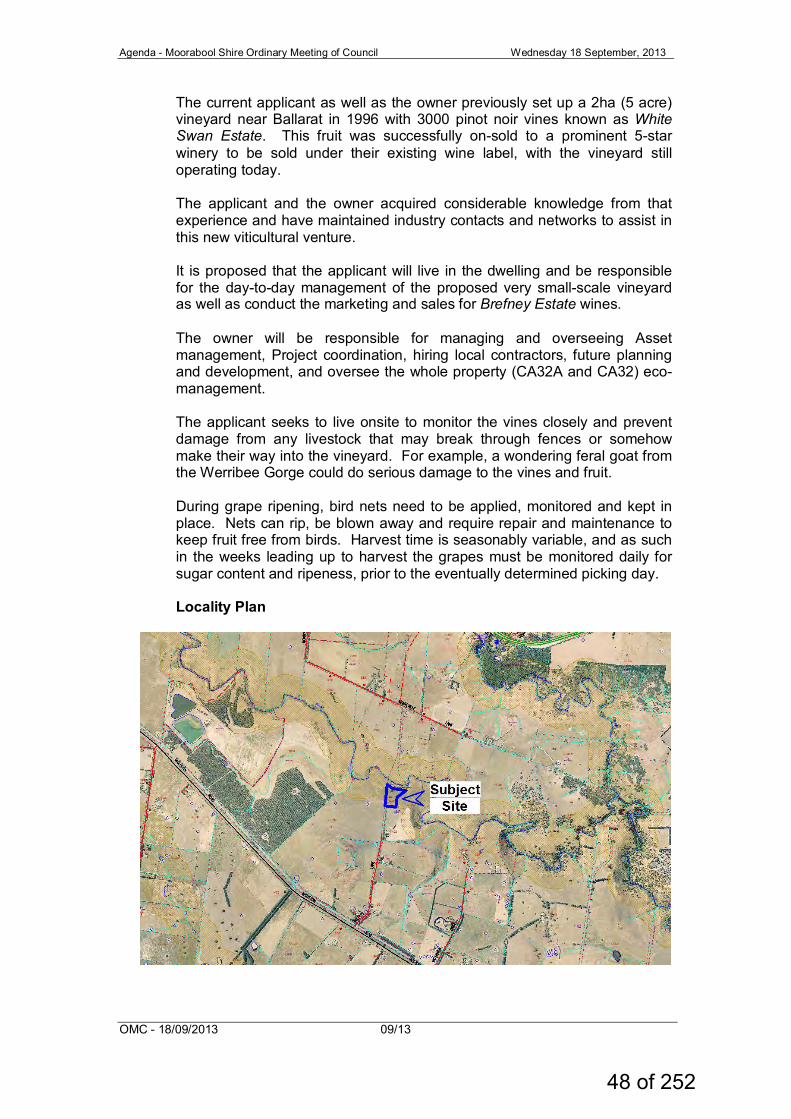
The current applicant as well as the owner previously set up a 2ha (5 acre) vineyard near Ballarat in 1996 with 3000 pinot noir vines known as White Swan Estate. This fruit was successfully on-sold to a prominent 5-star winery to be sold under their existing wine label, with the vineyard still operating today. The applicant and the owner acquired considerable knowledge from that experience and have maintained industry contacts and networks to assist in this new viticultural venture. It is proposed that the applicant will live in the dwelling and be responsible for the day-to-day management of the proposed very small-scale vineyard as well as conduct the marketing and sales for Brefney Estate wines. The owner will be responsible for managing and overseeing Asset management, Project coordination, hiring local contractors, future planning and development, and oversee the whole property (CA32A and CA32) eco-management. The applicant seeks to live onsite to monitor the vines closely and prevent damage from any livestock that may break through fences or somehow make their way into the vineyard. For example, a wondering feral goat from the Werribee Gorge could do serious damage to the vines and fruit. During grape ripening, bird nets need to be applied, monitored and kept in place. Nets can rip, be blown away and require repair and maintenance to keep fruit free from birds. Harvest time is seasonably variable, and as such in the weeks leading up to harvest the grapes must be monitored daily for sugar content and ripeness, prior to the eventually determined picking day. Locality Plan
48 of 252
Agenda - Moorabool Shire Ordinary Meeting of Council Wednesday 18 September, 2013
OMC - 18/09/2013 09/13
Proposed Site Plan (superimposed aerial view)
49 of 252
Agenda - Moorabool Shire Ordinary Meeting of Council Wednesday 18 September, 2013
OMC - 18/09/2013 09/13
Proposed Site Plan
50 of 252
Agenda - Moorabool Shire Ordinary Meeting of Council Wednesday 18 September, 2013
OMC - 18/09/2013 09/13
Proposed Dwelling and Shed Plans (3D superimposition example)
Proposed Shed Plans
51 of 252
Agenda - Moorabool Shire Ordinary Meeting of Council Wednesday 18 September, 2013
OMC - 18/09/2013 09/13
Proposed Dwelling Floor Plans
Proposed Dwelling Elevation Plans
52 of 252
Agenda - Moorabool Shire Ordinary Meeting of Council Wednesday 18 September, 2013
OMC - 18/09/2013 09/13
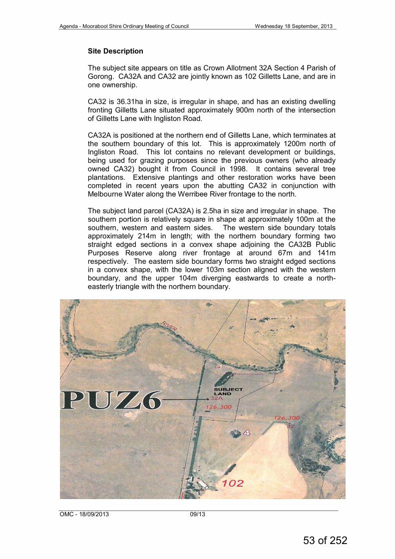
Site Description The subject site appears on title as Crown Allotment 32A Section 4 Parish of Gorong. CA32A and CA32 are jointly known as 102 Gilletts Lane, and are in one ownership. CA32 is 36.31ha in size, is irregular in shape, and has an existing dwelling fronting Gilletts Lane situated approximately 900m north of the intersection of Gilletts Lane with Ingliston Road. CA32A is positioned at the northern end of Gilletts Lane, which terminates at the southern boundary of this lot. This is approximately 1200m north of Ingliston Road. This lot contains no relevant development or buildings, being used for grazing purposes since the previous owners (who already owned CA32) bought it from Council in 1998. It contains several tree plantations. Extensive plantings and other restoration works have been completed in recent years upon the abutting CA32 in conjunction with Melbourne Water along the Werribee River frontage to the north. The subject land parcel (CA32A) is 2.5ha in size and irregular in shape. The southern portion is relatively square in shape at approximately 100m at the southern, western and eastern sides. The western side boundary totals approximately 214m in length; with the northern boundary forming two straight edged sections in a convex shape adjoining the CA32B Public Purposes Reserve along river frontage at around 67m and 141m respectively. The eastern side boundary forms two straight edged sections in a convex shape, with the lower 103m section aligned with the western boundary, and the upper 104m diverging eastwards to create a north-easterly triangle with the northern boundary.
53 of 252
Agenda - Moorabool Shire Ordinary Meeting of Council Wednesday 18 September, 2013
OMC - 18/09/2013 09/13
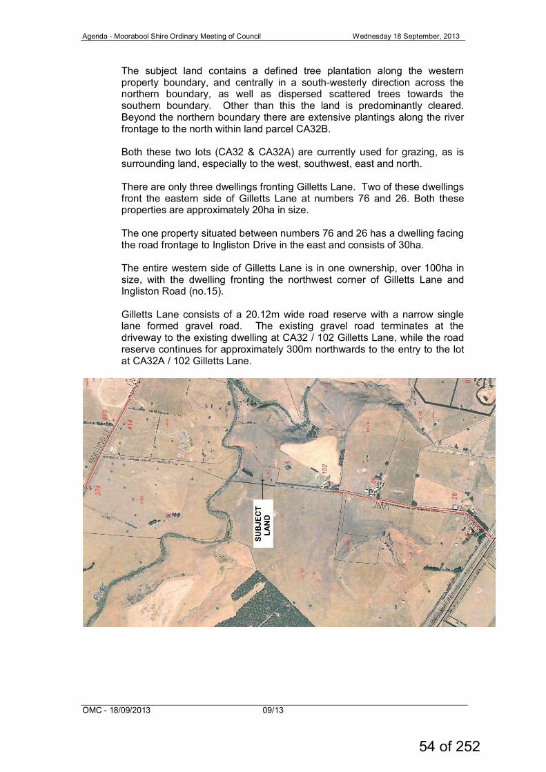
The subject land contains a defined tree plantation along the western property boundary, and centrally in a south-westerly direction across the northern boundary, as well as dispersed scattered trees towards the southern boundary. Other than this the land is predominantly cleared. Beyond the northern boundary there are extensive plantings along the river frontage to the north within land parcel CA32B. Both these two lots (CA32 & CA32A) are currently used for grazing, as is surrounding land, especially to the west, southwest, east and north. There are only three dwellings fronting Gilletts Lane. Two of these dwellings front the eastern side of Gilletts Lane at numbers 76 and 26. Both these properties are approximately 20ha in size. The one property situated between numbers 76 and 26 has a dwelling facing the road frontage to Ingliston Drive in the east and consists of 30ha. The entire western side of Gilletts Lane is in one ownership, over 100ha in size, with the dwelling fronting the northwest corner of Gilletts Lane and Ingliston Road (no.15). Gilletts Lane consists of a 20.12m wide road reserve with a narrow single lane formed gravel road. The existing gravel road terminates at the driveway to the existing dwelling at CA32 / 102 Gilletts Lane, while the road reserve continues for approximately 300m northwards to the entry to the lot at CA32A / 102 Gilletts Lane.
54 of 252
Agenda - Moorabool Shire Ordinary Meeting of Council Wednesday 18 September, 2013
OMC - 18/09/2013 09/13
Planning Scheme Provisions Council is required to consider the Victoria Planning Provisions and give particular attention to the State Planning Policy Framework (SPPF), the Local Planning Policy Framework (LPPF) and the Municipal Strategic Statement (MSS). State Planning Policy Framework Clause 11.05-2 Melbourne’s hinterland areas The objective of this policy is to manage growth in Melbourne’s hinterland, the area immediately beyond Metropolitan Melbourne and within 100 kilometres of the Melbourne’s Central Activities District and to: • Provide for development in selected discrete settlements within the
hinterland of Metropolitan Melbourne having regard to complex ecosystems, landscapes, agricultural and recreational activities in the area.
• Prevent dispersed settlement.
This dwelling is proposed in support of a proposed vineyard on the agricultural land. It would add another dwelling upon a small 2.5ha lot on land surrounded by the Farming Zone. It would add to and not prevent dispersed settlement/dwelling development. Clause 11.05-3 Rural Productivity The objective of this policy is to manage land use change and development in rural areas to promote agriculture and rural production aiming to: • Prevent inappropriately dispersed urban activities in rural areas. • Limit new housing development in rural areas, including: • Directing housing growth into existing settlements. • Discouraging development of isolated small lots in the rural zones
from use for single dwellings, rural living or other incompatible uses.
The proposal would create the development of a single dwelling in association with a vineyard on a small isolated lot in the rural zones. This clause seeks to discourage such development when created for rural living purposes or other non-agricultural purposes. Clause 14 Natural Resource Management Clause 14.01-1 Protection of agricultural land Objective To protect productive farmland which is of strategic significance in the local or regional context. Strategies (include but are not limited to) Ensure that the State’s agricultural base is protected from the unplanned loss of productive agricultural land due to permanent changes of land use.
55 of 252
Agenda - Moorabool Shire Ordinary Meeting of Council Wednesday 18 September, 2013
OMC - 18/09/2013 09/13
Take into consideration regional, state and local issues and characteristics in the assessment of agricultural quality and productivity. Permanent removal of productive agricultural land from the State's agricultural base must not be undertaken without consideration of its economic importance for the agricultural production and processing sectors. In considering a proposal to subdivide or develop agricultural land, the following factors must be considered: • The desirability and impacts of removing the land from primary
production, given its agricultural productivity. • The impacts of the proposed subdivision or development on the
continuation of primary production on adjacent land, with particular regard to land values and to the viability of infrastructure for such production.
• The compatibility between the proposed or likely development and the existing uses of the surrounding land.
• Assessment of the land capability.
This 2.5ha land at CA32A is now used for extensive agriculture/grazing as part of the agricultural activity of CA32 which consists of 36.31ha. This proposal seeking a dwelling under land in the same ownership for another agricultural use, albeit intensive agriculture (viticulture). It will not be removing the land from agriculture. While a small portion will be utilised for the dwelling, another portion will intensify agricultural activity through viticulture. Land Capability Assessment (LCA) provided with the application clearly identifies the capability of the land to support both the dwelling and the vineyard. Clause 14.01-2 Sustainable agricultural land use The objective of this policy is to encourage sustainable agricultural land use and to ensure agricultural and productive rural land use activities are managed to maintain the long-term sustainable use and management of existing natural resources The proposal is for a dwelling in association with viticulture (vineyard). The Farm Business Plan states that the owner who does not live at the site will continue to be responsible for long term sustainable use and management of the whole property (CA32 & CA32A), and the occupant for the proposed dwelling will be responsible for the day-to-day operations of the vineyard on CA32A. The FMP also identifies the owner’s current strong commitment to restoration works and replantings especially along the river frontage in association with Melbourne Water Authority.
Local Planning Policy Framework Clause 21.04-1 Key issues and influences, agriculture and horticulture The diversity in agricultural production and potential across the Shire is an economically valuable resource. Where irrigation water or higher rainfall combines with highly productive soil types, the Shire supports intensive horticultural pursuits.
56 of 252
Agenda - Moorabool Shire Ordinary Meeting of Council Wednesday 18 September, 2013
OMC - 18/09/2013 09/13
The protection of agricultural and horticultural production is an important planning outcome. The Shire’s agricultural base and attractive rural setting are important drivers in attracting people to live in Moorabool. Council supports rural living development where it does not compromise the long term productive use of rural land for agriculture and horticulture, maintains the Shire’s environmental qualities, and provides services and infrastructure to support such development. Farm businesses need to be able to retain the capacity to operate as agricultural enterprises. The Shire’s horticultural land resources are important economically in supporting tourism and the lifestyle appeal of the area. This proposal seeks approval for a dwelling in association with viticulture. The Scheme supports intensive horticultural pursuits such as viticulture where it does not compromise the long term productive use of the land. The establishment of a vineyard on this allotment is by persons who have previously established another successful vineyard. Clause 22.03 Houses and House Lot Excisions in Rural Areas Agriculture is still the major land use in the Shire and a significant component of the economy. The Shire is committed to facilitating sustainable agriculture and protecting the long term supply of productive agricultural and horticultural land. There is need to avoid fragmentation of land suitable for rural production by discouraging subdivision and houses that are unrelated to the rural use of the land. It is also important to ensure that farm production is not compromised or adversely affected by residents living in rural areas.
The objectives are:
• To ensure that subdivision and dwellings in rural areas are required to
increase agricultural productivity. • To minimise the potential for adverse impacts on farm production
through land use conflicts. It is policy to: • Discourage subdivision and dwellings unless they are directly related
to the agricultural use of land. • Discourage non agricultural use and development in areas of
productive agricultural land. • Encourage the consolidation of small lots. • Ensure that lots created under Clause 35.07-3 have a maximum area
of two hectares. • Maintain the right of existing farms to continue their operations without
being adversely affected or constrained by residential concerns. • Include the following requirements on a permit to excise a lot for a
dwelling where it is considered this would facilitate ongoing agricultural use of the remaining land:
57 of 252
Agenda - Moorabool Shire Ordinary Meeting of Council Wednesday 18 September, 2013
OMC - 18/09/2013 09/13
• Consolidate of the remaining land with the title of an existing farm; or • If the remainder land is less than 40ha, require the landowner to enter
into an agreement under S173 of the Planning and Environment Act that no further applications will be made to erect a dwelling on the balance allotment.
• This policy further supports the Scheme objectives in that dwellings should be directly related to agricultural use of the land, should be associated with an increase in agricultural production outputs, and should not adversely affect surrounding agricultural production. This matches well with the information provided by the application. The matters relating to subdivision hold no bearing upon this application.
Zoning The subject land is still covered by the Public Use Zone –Schedule 6 Local Government (PUZ6) at Clause 36.01. This was the applicable zoning when the land was owned by the council. It passed from local government into private ownership in 1998, but the zone was not changed to the applicable Rural Zone, or its successor the Farming Zone. Clause 36.01 Public Use Zone The applicable purpose of the PUZ is:
• To implement the State Planning Policy Framework and the Local
Planning Policy
Framework, including the Municipal Strategic Statement and local planning policies. Clause 36.01-2 states that a permit is required to Construct a building or construct or carry out works for any use in Section 2
In this case, the Section 2 –Permit Required— means a use that is not carried out by or on behalf of local government. In addition, both the responsible authority and the applicant agreed that the application should be viewed in light of the surrounding zone, the Farming Zone, being the most applicable zone to the application. As such, the provisions of the Farming Zone are taken into consideration as part of the assessment of this application. It should be noted however that State Government has made changes to the Farming Zone as at 5 September 2013 which impact directly on the development of dwellings within the Zone. The requirement for Farm Management Plans addressing the development of a dwelling in support of rural activities will no longer be required as part of the changes. This in effect significantly relaxes the justification of a dwelling in association with an agricultural activity.
58 of 252
Agenda - Moorabool Shire Ordinary Meeting of Council Wednesday 18 September, 2013
OMC - 18/09/2013 09/13
Clause 35.07 Farming Zone The purpose of the FZ is: • To provide for the use of land for agriculture • To encourage the retention of productive agricultural land • To ensure that non-agricultural uses, particularly dwellings, do not
adversely affect the use of land for agriculture • To encourage use and development of land based on comprehensive
and sustainable land management practices and infrastructure provisions.
Clause 35.07-2 states that a planning permit is required for the use of a dwelling on a lot size less than 40 hectares. Clause 35.07-5 requires an application to use a lot for dwelling be accompanied by a written statement which explains how the proposed dwelling responds to the decision guidelines for dwellings in the zone. The applicant provided written documentation supporting the application as well as the Farm Management Plan. Clause 35.07-6 Decision Guidelines:
General, Agricultural, Dwelling, Environmental, Design & Siting issues must be addressed in responding to the decision guidelines. The applicant submitted a written statement addressing the Decision Guidelines of the Farming Zone, stating the following: • The proposal does not fragment highly productive agricultural land.
The 2.58ha (6.5ac) property is to be used for a viable farming use (Vineyard) and is surrounded by other farming properties all sited on good quality productive farm land abutting the Werribee River.
• The Farm Management Plan for the Brefney Vineyard supports the application for a dwelling.
• Living on the site, Mr Carroll will be able to farm and manage the farm on a more regular productive basis – not wasting time travelling each time he comes to the property. He will also be on site to assist his parents run the abutting farm.
• The site is currently used for grazing of cattle and once Justin Carroll is living on site he will progressively develop a vineyard on the site. The site has a water supply from the Werribee Rive and related infrastructure already established, suitable to be further developed and for the construction of a dwelling. Additional fencing along the eastern and southern boundaries will be required immediately.
• The new dwelling will not affect farming activities on the abutting properties.
• Demonstrated need for the dwelling.
59 of 252
Agenda - Moorabool Shire Ordinary Meeting of Council Wednesday 18 September, 2013
OMC - 18/09/2013 09/13
• Justin Carroll needs to live on their evolving vineyard property to
manage and to develop it to its full potential as a vineyard. He must be on site daily to attend the various aspects of their property to achieve sustainable management. To implement and enhance the farm, Justin Carroll realises that he will have to live on the property so that he can maintain, develop and look after his vines and other farm activities that he wishes to pursue in line with “Best Practice”. It would not be possible to develop a productive and viable vineyard if he was not able to live on the property. Living on site will assist in the surveillance of the assets to protect the farm during grass fires, and act as a deterrent to vandalism.
Clause 35.07-6 Decision Guidelines - General Issues The capability of the land to accommodate the proposed use or development, including the disposal of effluent. How the use or development relates to sustainable land management. Whether the site is suitable for the use or development and whether the proposal is compatible with adjoining and nearby land uses. The dwelling, sheds and driveway (the domestic footprint) is proposed close to the southern boundary /access from Gilletts Lane. This utilises an area for domestic purposes which minimises impact on agricultural activity. The applicant has identified that the volcanic basalt soils and northerly aspect of the land are attributes which suit the growing of vines for high quality wine production, and the dwelling is proposed in support of this rural activity. The Land Capability Assessment provided by the applicant shows the land is capable of treating and disposing of domestic wastewater effluent associated with the dwelling. It identifies a suitable area for land wastewater application which will not impact on the vineyard proposal or be effected by vehicle movements or domestic outdoor activities. The land is a small title of 2.58ha, and the proposal for 6000m2 vineyard would cover 24% of the lot. While no such intensive agricultural activity currently occurs in the locale as surrounding farm land is used predominantly for grazing livestock, the encouragement of establishment of intensive horticultural pursuits is a recognised objective within the Local Planning Policy Framework (21.04-1 Key influences). The applicant further states that the dwelling occupant will manage the vineyard (CA32A), undertake marketing & sales for the wine label, and also help out on the rest of the farm (CA32). The Farm Management Plan also reiterates the land owner’s history of land restoration activity and continuing commitment to sustainable land management, especially in undertaking restoration works in conjunction with Melbourne Water along the northern boundary river frontage.
60 of 252
Agenda - Moorabool Shire Ordinary Meeting of Council Wednesday 18 September, 2013
OMC - 18/09/2013 09/13
The site is suitable for septic system wastewater management and thus development of a dwelling. The use of the dwelling will allow increased agricultural production, albeit viticulture. This is compatible with the surrounding predominantly extensive agriculture, including that of the land owner.
Clause 35.07-6 Decision Guidelines - Agricultural Issues Whether the use or development will permanently remove land from agricultural production. The potential for the use or development to limit the operation and expansion of adjoining and nearby agricultural issues. The proposed development of a dwelling on the land will remove a small portion of land from agricultural production currently used for grazing. It would probably be in the vicinity of 1000m2 of land. A further 6000m2 is proposed to be transformed to intensive agriculture (Vineyard) which will be an overall intensification of agricultural activity, albeit on a small scale. The addition of a dwelling and vineyard at the subject site would not limit the continued grazing activities on nearby land, and provides an additional dwelling for further supervision of agricultural activities on land under the same ownership. Clause 35.07-6 Decision Guidelines - Dwelling Issues Whether the dwelling will result in the loss or fragmentation of productive agricultural land. The proposed dwelling (and vineyard) has the potential to result in fragmentation and loss of agricultural land should the 2.58ha subject land be ultimately sold off separately after establishing the dwelling, and should the new owners allow the vineyard activity to cease. This CA32A land parcel of 2.58ha is currently farmed contiguously with the CA32 land parcel of 36.31ha, operating as one farming unit under one ownership, and viewed in this light it is an improved farm output through use of land for intensive agriculture. The permit will link the dwelling to the agricultural activity. Whether the dwelling will be adversely affected by agriculture activities on adjacent and nearby land due to dust, noise, odour, use of chemicals and farm machinery, traffic and hours of operation. There is little likelihood of the dwelling being impacted by neighbouring rural activity as livestock grazing is the current status quo. Whether the dwelling will adversely affect the operation and expansion of adjoining and nearby agricultural uses. The presence of another dwelling in the area will have little impact on existing agricultural operations that occur on adjoining land, and will enable more support for rural activity conducted on CA32A and CA32, both jointly known as 102 Gilletts Lane.
61 of 252
Agenda - Moorabool Shire Ordinary Meeting of Council Wednesday 18 September, 2013
OMC - 18/09/2013 09/13
The potential for the proposal to lead to a concentration or proliferation of dwellings in the area and the impact of this on the use of the land for agriculture. The proposed dwelling on such a small lot will lead to a higher concentration of dwellings in the area, but the proposal as presented offers a positive impact on agricultural use of the land.
Clause 35.07-6 Decision Guidelines - Environmental Issues The impact of the proposal on the natural physical features and resources of the area, in particular on soil and water quality. The land is relatively flat and heavily grazed in the past. The proposed vineyard and dwelling will have little impact on the physical features. There is however risk of impact on water quality in particular if the vineyard is mismanaged or the septic system not maintained as the Werribee River is not far away. Hence the land being covered by the Environmental Significance Overlay Schedule 2 Protection of Waterways (ESO2). The proposed dwelling and septic system are to be located beyond the southern edge of the ESO2. The impact of the use or development on the flora and fauna on the site and its surrounds. The land has been heavily grazed in the past so impacts in this area are negligible. The need to protect and enhance the biodiversity of the area, including the retention of vegetation and faunal habitat and the need to revegetate land including riparian buffers along waterways, gullies, ridgelines, property boundaries and saline discharge and recharge area. The property owner has already done extensive reparation works within the riparian sector along the Werribee River frontage in conjunction with Melbourne Water. The owner has indicated that this will continue. Weed control and soil revitalisation works have been progressively undertaken and will continue. The location of on-site effluent disposal areas to minimise the impact of nutrient loads on waterways and native vegetation. The placement of the dwelling maximises the distance from the boundary with riparian frontage to the north, and close proximity to the southern road frontage. This is beyond the boundary of the ESO2 as mentioned above. While the Water Authorities preferred maximum dwelling density ratios are 1:40ha, the dwelling density on land between Gilletts Lane and Ingliston Drive to the east is currently 1:27.5ha and would alter marginally to 1:22ha with the introduction of this new dwelling. This will have a negligible impact on the status quo.
62 of 252
Agenda - Moorabool Shire Ordinary Meeting of Council Wednesday 18 September, 2013
OMC - 18/09/2013 09/13
Clause 42.01 Environmental Significance Overlay The purpose of the Overlay is: • To identify areas where the development of land may be affected by
environmental constraints. • To ensure that development is compatible with identified
environmental values. Clause 42.01-2 requires a planning permit to construct a building or construct or carry out works. Schedule 2 Waterway Protection (ESO2) The subject land is partially affected by the Environmental Significance Overlay – Schedule 2 Waterway Protection (ESO2). This covers the Werribee River and environs at the northern end of the subject land. The proposed dwelling and septic system are to the south and beyond the edge of the ESO2 so that they do not impact on the ESO2 in this instance... Particular Provisions No particular provisions apply to this application. General Provisions Clause 65 – Decision Guidelines have been considered by officers in evaluating this application as appropriate as follows:
• The matters set out in Section 60 of the Act. • The State Planning Policy Framework and the Local Planning Policy
Framework, including the Municipal Strategic Statement and local planning policies.
• The purpose of the zone, overlay or other provision. • Any matter required to be considered in the zone, overlay or other
provision. • The orderly planning of the area. • The effect on the amenity of the area. • The proximity of the land to any public land. • Factors likely to cause or contribute to land degradation, salinity or
reduce water quality. • Whether the proposed development is designed to maintain or
improve the quality of stormwater within and exiting the site. • The extent and character of native vegetation and the likelihood of its
destruction. • The degree of flood, erosion or fire hazard associated with the location
of the land and the use, development or management of the land so as to minimise any such hazard.
Clause 66 stipulates all the relevant referral authorities to which the application must be referred.
63 of 252
Agenda - Moorabool Shire Ordinary Meeting of Council Wednesday 18 September, 2013
OMC - 18/09/2013 09/13
Referrals The following referrals were made pursuant to s.52 of the Planning and Environment Act 1987 and Council Departments were provided with an opportunity to make comment on the application. Authority Response Southern Rural Water
Consent, subject to conditions
Infrastructure Environmental Health
Consent, subject to conditions Consent, subject to conditions
All consented to the application for a dwelling subject to conditions being placed on any permit issued. Public Notice Notification of the proposal was undertaken by placing a sign on site in a prominent location, and by written notification to nearby adjoining owners and occupiers. A public Notice was also placed in the relevant locally circulating newspaper. Two objections were received and the issues presented are detailed and addressed below.
Objection Response Increase in dust and noise through increased vehicle use on Gilletts Lane
Increase in traffic flow will be from 3 dwellings in the lane to 4 dwellings in the lane, ie. A domestic/household increase of 33%. The small scale nature of the vineyard also means the vast majority of the work will be done by members of the household, rather than through contractors, etc.
Increased fire risk on roadside grass verge through increase occurrences of vehicles passing on single lane gravel road in Gilletts Lane
The increase is from members of one additional household (from 3 to 4). This should not be an unacceptable increase, considering the above lack of hired personnel travelling the road as mentioned above.
Loss of enjoyment of current privacy, isolation and serenity.
Provided that the bulk of the increase in traffic is associated with domestic purposes of the occupants of the new dwelling this should be tolerable. It is intended to restrict customer/public access by prohibiting farm gate sales.
64 of 252
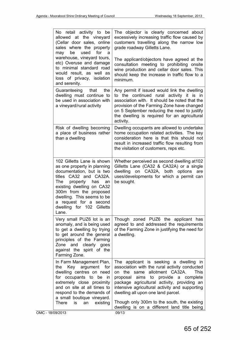
Agenda - Moorabool Shire Ordinary Meeting of Council Wednesday 18 September, 2013
OMC - 18/09/2013 09/13
No retail activity to be allowed at the vineyard (Cellar door sales, online sales where the property may be used for a warehouse, vineyard tours, etc) Overuse and damage to minimal standard road would result, as well as loss of privacy, isolation and serenity.
The objector is clearly concerned about excessively increasing traffic flow caused by customers travelling along the narrow low grade roadway Gilletts Lane. The applicant/objectors have agreed at the consultation meeting to prohibiting onsite wine production and cellar door sales. This should keep the increase in traffic flow to a minimum.
Guaranteeing that the dwelling must continue to be used in association with a vineyard/rural activity
Any permit if issued would link the dwelling to the continued rural activity it is in association with. It should be noted that the provision of the Farming Zone have changed on 5 September reducing the need to justify the dwelling is required for an agricultural activity.
Risk of dwelling becoming a place of business rather than a dwelling
Dwelling occupants are allowed to undertake home occupation related activities. The key consideration here is that this should not result in increased traffic flow resulting from the visitation of customers, reps etc.
102 Gilletts Lane is shown as one property in planning documentation, but is two titles CA32 and CA32A. The property has an existing dwelling on CA32 300m from the proposed dwelling. This seems to be a request for a second dwelling for 102 Gilletts Lane.
Whether perceived as second dwelling at102 Gilletts Lane (CA32 & CA32A) or a single dwelling on CA32A, both options are uses/developments for which a permit can be sought.
Very small PUZ6 lot is an anomaly, and is being used to get a dwelling by trying to get around the general principles of the Farming Zone and clearly goes against the spirit of the Farming Zone.
Though zoned PUZ6 the applicant has agreed to and addressed the requirements of the Farming Zone in justifying the need for a dwelling.
In Farm Management Plan, the Key argument for dwelling centres on need for occupants to be in extremely close proximity and on site at all times to respond to the demands of a small boutique vineyard. There is an existing
The applicant is seeking a dwelling in association with the rural activity conducted on the same allotment CA32A. This proposal aims to provide a complete package agricultural activity, providing an intensive agricultural activity and supporting dwelling all upon one land parcel.
Though only 300m to the south, the existing dwelling is on a different land title being
65 of 252
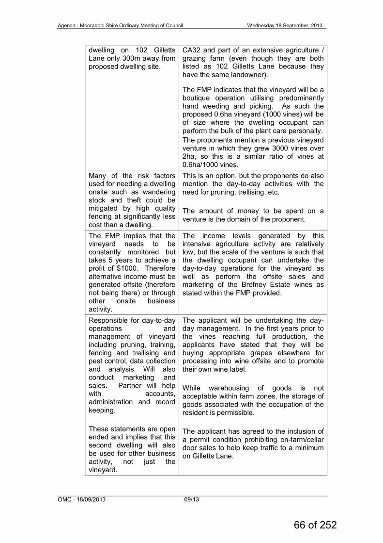
Agenda - Moorabool Shire Ordinary Meeting of Council Wednesday 18 September, 2013
OMC - 18/09/2013 09/13
dwelling on 102 Gilletts Lane only 300m away from proposed dwelling site.
CA32 and part of an extensive agriculture / grazing farm (even though they are both listed as 102 Gilletts Lane because they have the same landowner).
The FMP indicates that the vineyard will be a boutique operation utilising predominantly hand weeding and picking. As such the proposed 0.6ha vineyard (1000 vines) will be of size where the dwelling occupant can perform the bulk of the plant care personally. The proponents mention a previous vineyard venture in which they grew 3000 vines over 2ha, so this is a similar ratio of vines at 0.6ha/1000 vines.
Many of the risk factors used for needing a dwelling onsite such as wandering stock and theft could be mitigated by high quality fencing at significantly less cost than a dwelling.
This is an option, but the proponents do also mention the day-to-day activities with the need for pruning, trellising, etc. The amount of money to be spent on a venture is the domain of the proponent.
The FMP implies that the vineyard needs to be constantly monitored but takes 5 years to achieve a profit of $1000. Therefore alternative income must be generated offsite (therefore not being there) or through other onsite business activity.
The income levels generated by this intensive agriculture activity are relatively low, but the scale of the venture is such that the dwelling occupant can undertake the day-to-day operations for the vineyard as well as perform the offsite sales and marketing of the Brefney Estate wines as stated within the FMP provided.
Responsible for day-to-day operations and management of vineyard including pruning, training, fencing and trellising and pest control, data collection and analysis. Will also conduct marketing and sales. Partner will help with accounts, administration and record keeping. These statements are open ended and implies that this second dwelling will also be used for other business activity, not just the vineyard.
The applicant will be undertaking the day-day management. In the first years prior to the vines reaching full production, the applicants have stated that they will be buying appropriate grapes elsewhere for processing into wine offsite and to promote their own wine label. While warehousing of goods is not acceptable within farm zones, the storage of goods associated with the occupation of the resident is permissible. The applicant has agreed to the inclusion of a permit condition prohibiting on-farm/cellar door sales to help keep traffic to a minimum on Gilletts Lane.
66 of 252
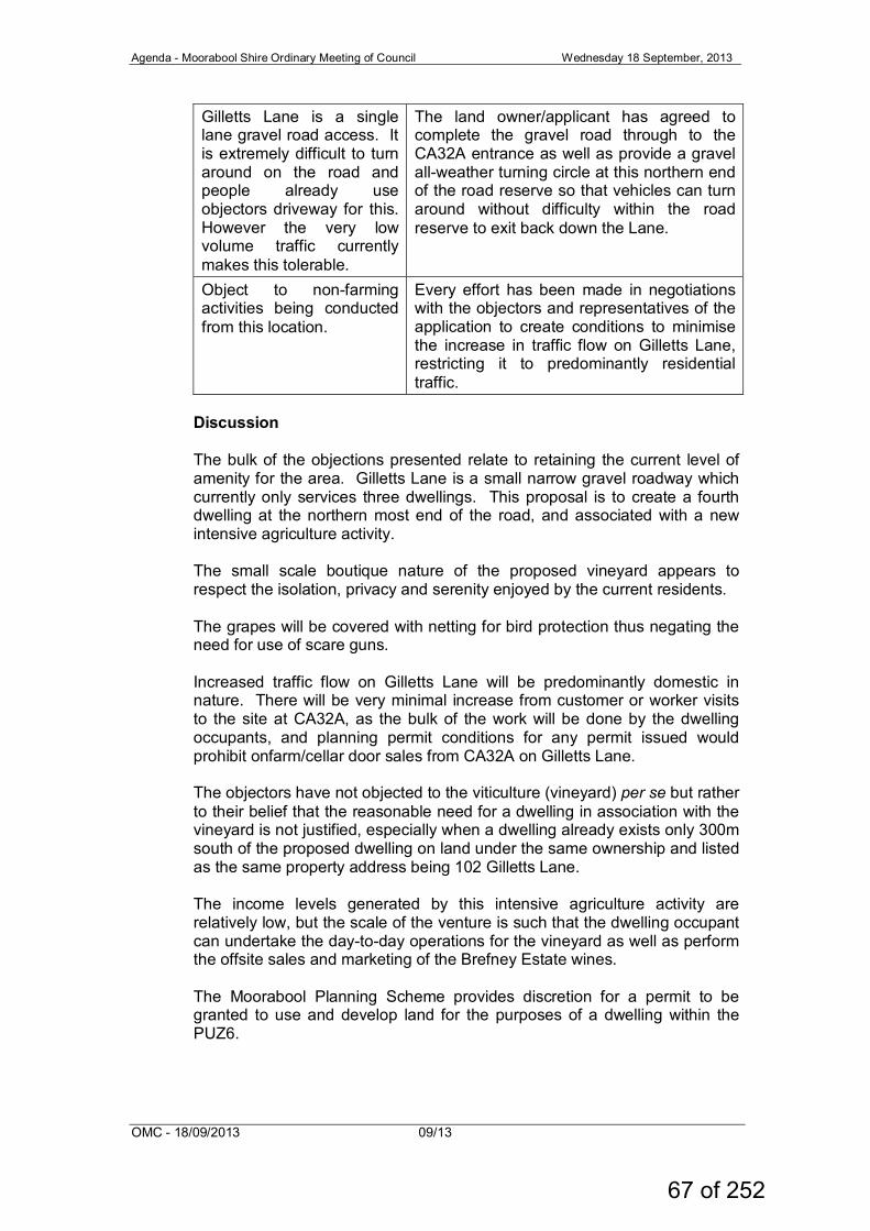
Agenda - Moorabool Shire Ordinary Meeting of Council Wednesday 18 September, 2013
OMC - 18/09/2013 09/13
Gilletts Lane is a single lane gravel road access. It is extremely difficult to turn around on the road and people already use objectors driveway for this. However the very low volume traffic currently makes this tolerable.
The land owner/applicant has agreed to complete the gravel road through to the CA32A entrance as well as provide a gravel all-weather turning circle at this northern end of the road reserve so that vehicles can turn around without difficulty within the road reserve to exit back down the Lane.
Object to non-farming activities being conducted from this location.
Every effort has been made in negotiations with the objectors and representatives of the application to create conditions to minimise the increase in traffic flow on Gilletts Lane, restricting it to predominantly residential traffic.
Discussion The bulk of the objections presented relate to retaining the current level of amenity for the area. Gilletts Lane is a small narrow gravel roadway which currently only services three dwellings. This proposal is to create a fourth dwelling at the northern most end of the road, and associated with a new intensive agriculture activity. The small scale boutique nature of the proposed vineyard appears to respect the isolation, privacy and serenity enjoyed by the current residents. The grapes will be covered with netting for bird protection thus negating the need for use of scare guns. Increased traffic flow on Gilletts Lane will be predominantly domestic in nature. There will be very minimal increase from customer or worker visits to the site at CA32A, as the bulk of the work will be done by the dwelling occupants, and planning permit conditions for any permit issued would prohibit onfarm/cellar door sales from CA32A on Gilletts Lane. The objectors have not objected to the viticulture (vineyard) per se but rather to their belief that the reasonable need for a dwelling in association with the vineyard is not justified, especially when a dwelling already exists only 300m south of the proposed dwelling on land under the same ownership and listed as the same property address being 102 Gilletts Lane. The income levels generated by this intensive agriculture activity are relatively low, but the scale of the venture is such that the dwelling occupant can undertake the day-to-day operations for the vineyard as well as perform the offsite sales and marketing of the Brefney Estate wines. The Moorabool Planning Scheme provides discretion for a permit to be granted to use and develop land for the purposes of a dwelling within the PUZ6.
67 of 252
Agenda - Moorabool Shire Ordinary Meeting of Council Wednesday 18 September, 2013
OMC - 18/09/2013 09/13
The applicant has voluntarily agreed that the correlation with the requirements of the neighbouring Farming Zone (FZ) would be most applicable to this location and this proposal. A dwelling in the FZ on a lot less than 40ha requires a permit. Where a permit is required the decision guidelines of the Farming zone require that consideration be given to a range of matters before deciding on an application. The purpose of the Farming Zone is to provide for the use of land for agriculture, encourage the retention of productive agricultural land and ensure that non-agricultural uses, particularly dwellings, do not adversely affect the use of land for agriculture. In relation to dwellings in the Farming Zone the decision guidelines require that the responsible authority consider whether a dwelling: • will result in the loss or fragmentation of productive agricultural land; • will be adversely affected by agricultural activities on adjacent and
nearby land due to dust, noise, odour, use of chemicals and farm machinery, traffic and hours of operation;
• will adversely affect the operation and expansion of adjoining and nearby agricultural uses;
• the potential for the proposal to lead to a concentration or proliferation of dwellings in the area and the impact of this on the use of the land for agriculture.
And also to consider: • whether the use or development will support and enhance agricultural
production; • whether the use or development will permanently remove land from
agricultural production; • the potential for the use or development to limit the operation and
expansion of adjoining and nearby agricultural uses. • the capacity of the site to sustain the agricultural use; • the agricultural qualities of the land, such as soil quality, access to
water and access to rural infrastructure. • any integrated land management plan prepared for the site.
The application is for a dwelling in association with a vineyard. While the process of viticulture per se achieves all the Farming Zone requirements, the key factors in this instance relate to the level of viticulture activity (0.6ha) and whether this is significant enough to justify a dwelling associated with the activity. The scale of the activity seems commensurate with the boutique operation providing the ability for the dwelling occupier to undertake the day-to-day operations of caring for the vineyard as well as undertaking the offsite marketing and sales of wines under the Brefney Estate label. State planning policies provide guidance to Council as to the objectives that are to be achieved in relation to the protection of prime agricultural land across Victoria.
68 of 252
Agenda - Moorabool Shire Ordinary Meeting of Council Wednesday 18 September, 2013
OMC - 18/09/2013 09/13
Specifically State Planning Policies, Clause 11.05-3 relating to rural productivity and Clause 14.01-1 relating to the protection of agricultural land, stress the need to protect productive farming land from encroachment by non-agricultural activities and potential future land use conflicts from dwellings, and that the permanent removal of productive agricultural land from the State's agricultural base must not be undertaken without consideration of its economic importance for the agricultural production and processing sectors. Further, Clause 11.05-3 Rural Productivity stresses the need to prevent dispersed settlement (dwellings on isolated lots); while Local Planning Policy, specifically Clause 21.04-1 Key issues and influences-agriculture and horticulture, stresses the importance of protecting long term productive use of rural land and the need to need to manage existing and potential land use conflicts between rural residential and agricultural or horticultural production. The applicant has provided justification for the development of a dwelling in support of a boutique vineyard where the scale of operation allows the dwelling occupier to undertake the day-to-day care of the vineyard as well as spend time offsite promoting the sales and marketing of the Brefney Estate wine label. Clause 22.03 Houses and House Lot Excisions in Rural Areas further supports the Scheme objectives in that dwellings should be directly related to agricultural use of the land, should be associated with an increase in agricultural production outputs, and should not adversely affect surrounding agricultural production. Within the PUZ6 zoning a permit is required for a dwelling. Within the Farming Zone a permit is required for a dwelling on land less than 40ha and for a second dwelling. The applicant has voluntarily addressed the more onerous requirements applicable to the Farming Zone even though the subject land is within the PUZ6, as the surrounding land including the contiguous land parcel are within the Farming Zone. In assessing an application for a dwelling upon this PUZ6 land, the responsible authority considers the objectives of the planning scheme and relevant planning policies as well as the zone. The existence of this PUZ6 land within an area surrounded by FZ land, all of which are used for farming purposes, means that serious consideration would be given to the expectations of development within the abutting zoning as they are clearly delineated. This is further strengthened when taking into consideration the relaxation of the need to justify a dwelling in association with an agricultural activity as a consequence of the changes to the Farming Zone introduced on 5 September 2013. This was undertaken by the Victorian government through changes to the Victoria Planning Provisions.
69 of 252
Agenda - Moorabool Shire Ordinary Meeting of Council Wednesday 18 September, 2013
OMC - 18/09/2013 09/13
Considerable objection also related to amenity and the condition of Gilletts Lane. The roadway is a narrow formed single lane gravel road with grass verges. It is currently in effect a low use residential laneway servicing the three (3) existing dwellings fronting Gilletts Lane. Concern was expressed that more extensive traffic – including heavy vehicles for farming purposes, customer sales by roadside/on-farm/cellar door sales, vineyard tour buses – would create increased dust, noise and deterioration of the road and existing driveways. It was mentioned that currently Gilletts Lane road users use the existing driveways to turn around on as the road is too narrow to turn in, and this has been causing damage to the edging and formation of the crossovers. These issues were predominantly resolved in the meeting between objectors, applicant(s) and council’s officer with the agreement of the applicants to the inclusion of permit conditions aimed at reducing amenity impact by requiring the applicant to: • Extend the gravel road formation from the existing end through to the
CA32A lot entry point in the north at the landowner’s expense. • Create a formed all-weather gravel surfaced turning circle at the end of
Gilletts Lane adjacent to the entry to CA32A at the landowner’s expense.
• Exclude roadside/on-farm/cellar door sales from CA32A • No wine production to occur upon the subject land
Every effort has been made during negotiations with the objectors and representatives of the applicant to create conditions to maintain current amenity through minimising the increase in traffic flow and improving the road conditions, restricting it to predominantly residential traffic. The application was assessed by relevant authorities and internal Council departments with no objections being offered subject to several conditions provided being included on any planning permit issued. Considering the provisions of the Moorabool Planning Scheme, the State and Local Planning Policy Frameworks, the Clause 42.01 Environmental Significance Overlay – Schedule 2 Water way Protection, the Clause 36.01-Public Use Zone, and the correlation with Clause 35.07-Farming Zone; as well as the resolutions achieved for some of the objectors’ concerns, it is considered appropriate to recommend approval of the proposed development. Other Policies/Procedures Council adopted the Rural Growth Policy Statement at the OMC of the 5th September 2012. Council can give weight to this document under the provisions of section 60(1A)(g) of the Planning and Environment Act 1987. This policy seeks “To articulate the Council’s support for resilient and integrated rural communities and agricultural enterprises”. This policy has been considered to the extent appropriate in the writing of this report.
70 of 252
Agenda - Moorabool Shire Ordinary Meeting of Council Wednesday 18 September, 2013
OMC - 18/09/2013 09/13
Financial Implications The recommendation of an approval of this development would not represent any financial implications to Council. Risk & Occupational Health & Safety Issues The recommendation of a refusal of this development does not create any risk or OH & S issues to Council. Communications Strategy Notice was undertaken for the application, in accordance with the Planning and Environment Act 1987, and two objections were received. A Consultation Meeting was undertaken by Council with the objectors and the representatives of the applicant to seek resolution of any issues if possible. The applicant and objectors were informed that this matter would be heard by Council and were further advised of their right to address Council. The parties will be advised of Council’s determination. Conclusion: The proposal has been assessed against the relevant components of the Moorabool Planning Scheme, the State and Local Planning Policy Frameworks, the Clause 42.01 Environmental Significance Overlay – Schedule 2 Water way Protection, the Clause 36.01-Public Use Zone, and the correlation with Clause 35.07-Farming Zone. It is recommended that having considered the requirements of the Moorabool Planning Scheme that council resolve to issue a Notice of Decision to Grant a Permit. Recommendation: That Council resolve to issue a Notice of Decision to Grant a Permit PA2013-042 pursuant to Section 60(1) of the Planning and Environment Act 1987, for the Development of a Dwelling in association with a Vineyard on Crown Allotment 32A Section 4 Parish of Gorong, part of 102 Gilletts Lane, Ingliston subject to the following conditions:
Conditions
1. Unless specifically required otherwise by any other condition of
this permit and except with the prior written consent of the responsible authority to any variation, the dwelling must be sited and constructed in accordance with the approved plans.
2. No roadside sales or direct on-farm sales or cellar door sales will
be permitted from the subject land. 3. No wine production will be permitted upon the subject land.
71 of 252
Agenda - Moorabool Shire Ordinary Meeting of Council Wednesday 18 September, 2013
OMC - 18/09/2013 09/13
Infrastructure Conditions 4. The proponent must at his own cost construct Gilletts Lane from
the end of the existing works to the northern end of the road reserve to the following standard: a. a 7.0 metre wide carriageway of which the central 4.0 metre
section shall have a pavement of approved granular material to a minimum compacted depth of 150 millimetres;
b. table drainage as required to minimum width 2.0 metres and depth 0.2 metres;
c. the pavement shall be formed to facilitate water runoff to the table drains;
d. culverts of minimum 375 millimetre diameter installed as required to facilitate drainage;
e. a turning area for service and emergency vehicles to be provided at the termination of the road works;
f. Traffic signage as required; g. all works to be completed to the satisfaction of the
Responsible Authority.
5. All road and drainage works must be maintained in good condition and repair for a minimum of 6 months after completion of the works, to the satisfaction of the Responsible Authority.
6. A security deposit of 5% of the total value of engineering works
as approved by the Responsible Authority must be lodged with the Responsible Authority, to cover the maintenance of all works. The deposit will be returned after the final inspection of works, 6 months after the completion of works, subject to the satisfactory completion of all required maintenance and rectification works.
7. A standard rural vehicle crossing with culvert must be provided
on Gilletts Lane to the satisfaction of the responsible authority. A vehicle crossing permit must be taken out for the construction of the vehicle crossing.
8. Storm water drainage from the proposed buildings and
impervious surfaces must be retained and disposed of within the boundaries of the subject land to the satisfaction of the Responsible Authority. Overflows from on-site storage systems must be directed away from any waste water disposal areas.
9. Sediment discharges must be restricted from any construction
activities within the property in accordance with relevant Guidelines including Construction Techniques for Sediment Control (EPA 1991).
10. Unless otherwise approved by the Responsible Authority there
must be no buildings, structures, or improvements located over proposed drainage pipes and easements on the property.
11. Any existing works affected by the development must be fully
reinstated at no cost to and to the satisfaction of the Responsible Authority.
72 of 252
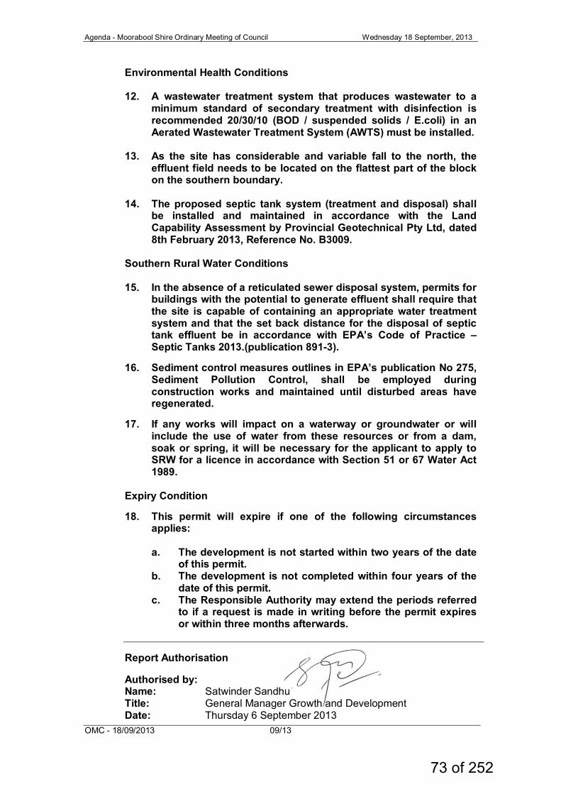
Agenda - Moorabool Shire Ordinary Meeting of Council Wednesday 18 September, 2013
OMC - 18/09/2013 09/13
Environmental Health Conditions
12. A wastewater treatment system that produces wastewater to a minimum standard of secondary treatment with disinfection is recommended 20/30/10 (BOD / suspended solids / E.coli) in an Aerated Wastewater Treatment System (AWTS) must be installed.
13. As the site has considerable and variable fall to the north, the
effluent field needs to be located on the flattest part of the block on the southern boundary.
14. The proposed septic tank system (treatment and disposal) shall
be installed and maintained in accordance with the Land Capability Assessment by Provincial Geotechnical Pty Ltd, dated 8th February 2013, Reference No. B3009.
Southern Rural Water Conditions
15. In the absence of a reticulated sewer disposal system, permits for buildings with the potential to generate effluent shall require that the site is capable of containing an appropriate water treatment system and that the set back distance for the disposal of septic tank effluent be in accordance with EPA’s Code of Practice – Septic Tanks 2013.(publication 891-3).
16. Sediment control measures outlines in EPA’s publication No 275,
Sediment Pollution Control, shall be employed during construction works and maintained until disturbed areas have regenerated.
17. If any works will impact on a waterway or groundwater or will
include the use of water from these resources or from a dam, soak or spring, it will be necessary for the applicant to apply to SRW for a licence in accordance with Section 51 or 67 Water Act 1989.
Expiry Condition
18. This permit will expire if one of the following circumstances applies:
a. The development is not started within two years of the date
of this permit. b. The development is not completed within four years of the
date of this permit. c. The Responsible Authority may extend the periods referred
to if a request is made in writing before the permit expires or within three months afterwards.
Report Authorisation Authorised by: Name: Satwinder Sandhu Title: General Manager Growth and Development Date: Thursday 6 September 2013
73 of 252
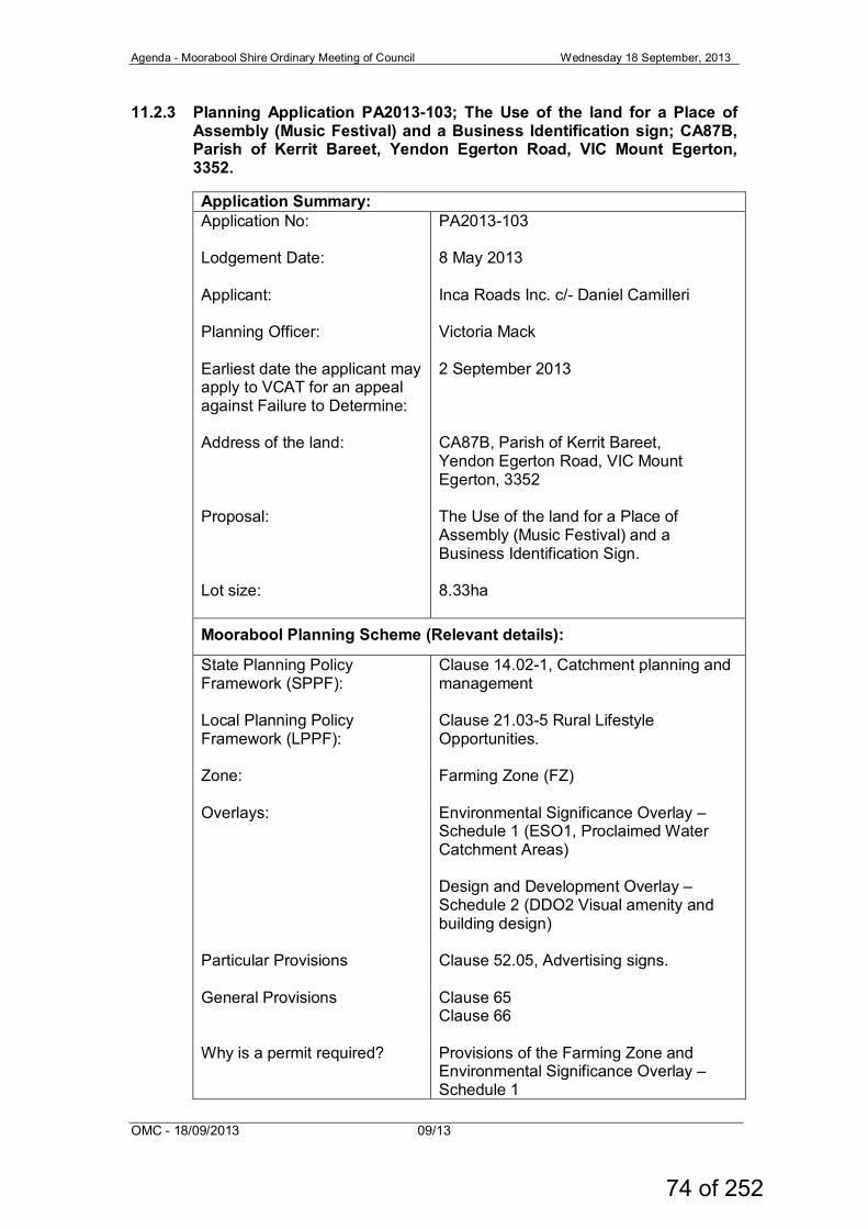
Agenda - Moorabool Shire Ordinary Meeting of Council Wednesday 18 September, 2013
OMC - 18/09/2013 09/13
11.2.3 Planning Application PA2013-103; The Use of the land for a Place of Assembly (Music Festival) and a Business Identification sign; CA87B, Parish of Kerrit Bareet, Yendon Egerton Road, VIC Mount Egerton, 3352.
Application Summary: Application No: Lodgement Date: Applicant: Planning Officer: Earliest date the applicant may apply to VCAT for an appeal against Failure to Determine: Address of the land: Proposal: Lot size:
PA2013-103 8 May 2013 Inca Roads Inc. c/- Daniel Camilleri Victoria Mack 2 September 2013 CA87B, Parish of Kerrit Bareet, Yendon Egerton Road, VIC Mount Egerton, 3352 The Use of the land for a Place of Assembly (Music Festival) and a Business Identification Sign. 8.33ha
Moorabool Planning Scheme (Relevant details):
State Planning Policy Framework (SPPF):
Clause 14.02-1, Catchment planning and management
Local Planning Policy Framework (LPPF):
Clause 21.03-5 Rural Lifestyle Opportunities.
Zone: Farming Zone (FZ)
Overlays: Environmental Significance Overlay – Schedule 1 (ESO1, Proclaimed Water Catchment Areas) Design and Development Overlay – Schedule 2 (DDO2 Visual amenity and building design)
Particular Provisions Clause 52.05, Advertising signs.
General Provisions Clause 65 Clause 66
Why is a permit required? Provisions of the Farming Zone and Environmental Significance Overlay – Schedule 1
74 of 252
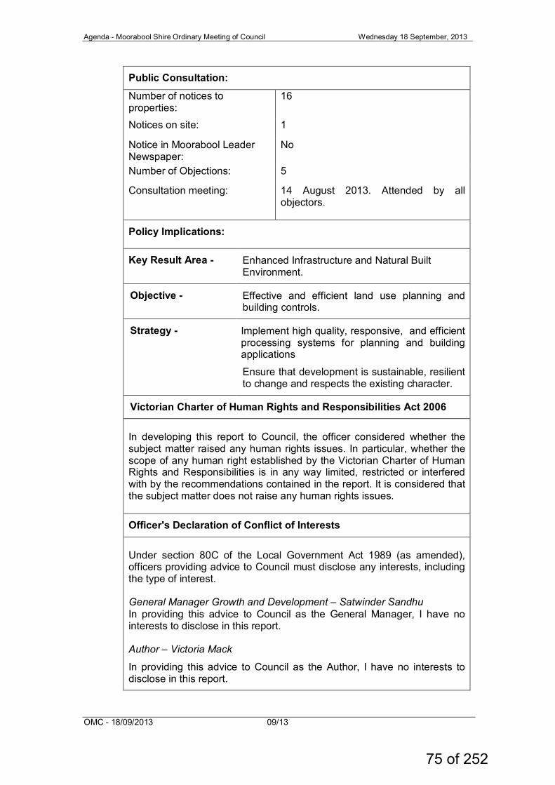
Agenda - Moorabool Shire Ordinary Meeting of Council Wednesday 18 September, 2013
OMC - 18/09/2013 09/13
Public Consultation:
Number of notices to properties:
16
Notices on site: 1
Notice in Moorabool Leader Newspaper:
No
Number of Objections: 5
Consultation meeting: 14 August 2013. Attended by all objectors.
Policy Implications:
Key Result Area - Enhanced Infrastructure and Natural Built Environment.
Objective - Effective and efficient land use planning and building controls.
Strategy - Implement high quality, responsive, and efficient processing systems for planning and building applications
Ensure that development is sustainable, resilient to change and respects the existing character.
Victorian Charter of Human Rights and Responsibilities Act 2006
In developing this report to Council, the officer considered whether the subject matter raised any human rights issues. In particular, whether the scope of any human right established by the Victorian Charter of Human Rights and Responsibilities is in any way limited, restricted or interfered with by the recommendations contained in the report. It is considered that the subject matter does not raise any human rights issues.
Officer's Declaration of Conflict of Interests
Under section 80C of the Local Government Act 1989 (as amended), officers providing advice to Council must disclose any interests, including the type of interest. General Manager Growth and Development – Satwinder Sandhu In providing this advice to Council as the General Manager, I have no interests to disclose in this report. Author – Victoria Mack
In providing this advice to Council as the Author, I have no interests to disclose in this report.
75 of 252
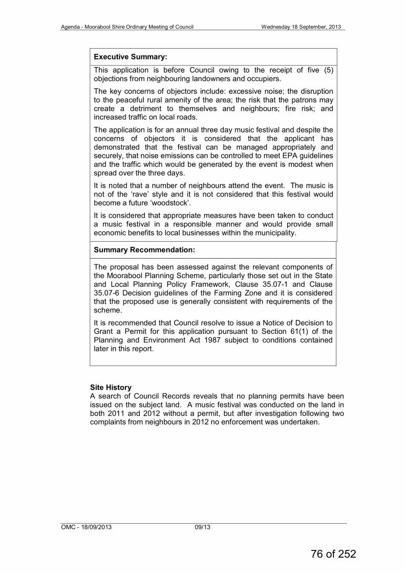
Agenda - Moorabool Shire Ordinary Meeting of Council Wednesday 18 September, 2013
OMC - 18/09/2013 09/13
Executive Summary:
This application is before Council owing to the receipt of five (5) objections from neighbouring landowners and occupiers.
The key concerns of objectors include: excessive noise; the disruption to the peaceful rural amenity of the area; the risk that the patrons may create a detriment to themselves and neighbours; fire risk; and increased traffic on local roads.
The application is for an annual three day music festival and despite the concerns of objectors it is considered that the applicant has demonstrated that the festival can be managed appropriately and securely, that noise emissions can be controlled to meet EPA guidelines and the traffic which would be generated by the event is modest when spread over the three days.
It is noted that a number of neighbours attend the event. The music is not of the ‘rave’ style and it is not considered that this festival would become a future ‘woodstock’.
It is considered that appropriate measures have been taken to conduct a music festival in a responsible manner and would provide small economic benefits to local businesses within the municipality.
Summary Recommendation:
The proposal has been assessed against the relevant components of the Moorabool Planning Scheme, particularly those set out in the State and Local Planning Policy Framework, Clause 35.07-1 and Clause 35.07-6 Decision guidelines of the Farming Zone and it is considered that the proposed use is generally consistent with requirements of the scheme.
It is recommended that Council resolve to issue a Notice of Decision to Grant a Permit for this application pursuant to Section 61(1) of the Planning and Environment Act 1987 subject to conditions contained later in this report.
Site History A search of Council Records reveals that no planning permits have been issued on the subject land. A music festival was conducted on the land in both 2011 and 2012 without a permit, but after investigation following two complaints from neighbours in 2012 no enforcement was undertaken.
76 of 252
Agenda - Moorabool Shire Ordinary Meeting of Council Wednesday 18 September, 2013
OMC - 18/09/2013 09/13
Proposal Inca Roads proposes to conduct a Music Festival on the land from Friday 29 November 2013 to Sunday 1 December 2013. The site would be set up the day prior and clean up would be occur the day following. The application can be summarised as follows: • The applicant: ‘Inca Roads’ is an incorporated not-for-profit charitable
music club and claims to ‘celebrate the best in young talent’ by encouraging new performers to perform at the event in a family friendly environment; and provide a professional platform for artists as young as 15 years of age.
• Music type: A mix of classic genre's such as soul, jazz & rhythm and blues; as well as modern day pop, rock and acoustic music.
• Attendees / patrons: All festival patrons would be required to be members of Inca Roads. No tickets are proposed to be sold at the gate on the event weekend. A membership database is kept.
• Age demographic: The documentation provided states that the demographic would be from 15 to 80 years of age, with the majority of attendees being between 25 and 35 years of age.
• Participants numbers: The three day music festival would capped at a maximum of 650 people including members (500), organisers and volunteer staff (50) and performing artists (100).
• Hours of festival: Live music would be played at the following times: - Friday 29th November: 1pm – 1am (Saturday) - Saturday 30th November: 11am – 1am (Sunday) - Sunday 1 December: 10am – 1.45pm.
• Performance breaks: There would be 30-45 minute performances followed by 30-45 minute breaks.
• Entrance and exit: Entrance and exit from the site would be from the Yendon Egerton Road, in the north-east corner of the site and an alternative emergency exit is also suggested to the west along the south side boundary of the site across neighbouring land to Lillis Road, but no easements are registered on title nor is there an unused government road.
• Traffic: The organisers estimate that the maximum number of cars that would be on the site over the three days would be 200, with some traffic movements on each day as performers and others arrive or depart the venue. It is estimated that approximately 150 cars would be on the site at any one time. An in-paddock parking area for 159 cars (including two (2) disabled spaces) is noted on the site plan as well as an additional 40 car spaces for artists, closer to the performing area. It is not anticipated by the applicant that there would be a peak time for arrivals or departures.
• Traffic Management: There would be no queuing on the Yendon Egerton Road and cars would enter the site where there would be a waiting area able to accommodate at least 30 cars. Traffic management volunteers would control and direct all cars from this assembly area.
• Signage: One (1) sign would be erected on the gate to the property which would be 1m long x 0.5 wide. No other signage would be erected on the property or any other roads.
77 of 252
Agenda - Moorabool Shire Ordinary Meeting of Council Wednesday 18 September, 2013
OMC - 18/09/2013 09/13
• Alcohol: No alcohol would be sold on the site but patrons would be able to bring their own alcohol to the event. A Liquor Licence would not be required as alcohol is not being sold at the event. A copy of an email response from the Victorian Commission for Gambling and Liquor Regulation was received which indicated that in this instance where there was no liquor being sold to the public and the premises was not a club and not a premises where meals or light refreshments are normally served to the public, that a Liquor Licence was not required.
• Accommodation: Patrons and organisers would bring their own tents for overnight accommodation. Three camping areas are noted on the site plan.
• Food: No cooking equipment would be allowed on the site, or any fires. Food during the event would be provided either by a general BBQ for members, supplied by participants themselves, or purchased from food vans to be available during the event. Perishable food would be stored in a refrigerator on the site. Insurance and registration for any vendors on site would be required.
• Waste management: Rubbish bags would be provided to members on arrival and waste bins would be available around the site. Bins would be emptied into a waste disposal area which is noted on the site plan, to be located behind an existing shed on the land and screened by trees. Collected waste would be disposed of in a Council waste handling facility after the event.
• Portable toilets: Twenty four (24) ‘portaloos’ and one (1) disabled toilet would be provided on the site by Palmer Hire for the duration of the event. This equates to one cubicle per 25 patrons, Washbasins and soap would be provided and volunteers would check the cubicles each 6 hours. The location of the ‘portaloos’ is marked on the site plan.
• Showers: Six (6) shower bays are noted on the site plan. • Stage and performing area: The stage area would contain a site
induction point, a drinking water point, a food vending and service area, a first aid tent and a disabled viewing area, all to be located south east of the main stage. The stage would be rented for the event and have a floor area of 20sqm (4m x 5m) with scaffolding and a tarpaulin. Some plywood would also be used on the roof and walls to be constructed by a licenced carpenter. Details of the stage area are marked on the site plan.
• Staff: All staff would be volunteers and would be inducted at least one hour prior to their shift about the site’s safety and operational procedures.
• Security: Would be provided by Regional Security Services, with one (1) security guard per 50 patrons.
• First Aid: There would be ‘at least one Chief First Aid and OH&S officer on shift’ and ‘at least two General First Aid officers on shift’.
• Land: The land is owned by a relative of the applicant. • Water: would be free to participants. • Power and lighting: A 15Kva generator would power the site with
smaller generators for night lighting. The camp areas will be lit between the hours of 8pm and 4am. Low level lighting would be used for the stage and surrounds - no laser lighting would be used.
• Risk: Public and Products Liability Insurance would be in place with Hohan Group as underwriters.
78 of 252
Agenda - Moorabool Shire Ordinary Meeting of Council Wednesday 18 September, 2013
OMC - 18/09/2013 09/13
• Fire risk: a 25,000L water supply would be available with appropriate CFA connections. The grass would be mown to approximately 5cm in height and cleared of debris prior to the event.
• Local suppliers: would be used to provide security, coffee, food and local farm products.
• Video: A video of the 2012 event is available at: http://vimeo.com/72242628
• Acoustic Report: An acoustic report has been provided prepared by Sound and Acoustic Engineer, Dom Watson, from ATC Productions.
The summary of the acoustic report findings (August 2013) stated as follows:
Measurements were taken at key points along the boundary of the property, within the festival site and at neighbouring properties. With a 112dB(A) weighted peak output one metre form the source location this was found to be well within the limits of EPA regulations at all properties in the local area. All properties were well within the 65dB (A) EPA limit. See also recommendations. All objectors are those most minimally impacted with recordings of less than 45dB (A). Interestingly readings of 4WD’s trucks and V6 cars driving down the road easily reached 75-85dB (A).
Based on these results, it is my strong belief that the operating of this festival will not have any adverse effects on the neighbouring properties or objectors and will cause minimal disruption to the surrounding area.
It was also noted by the acoustic consultant that the audio system to be used in 2013 is superior to that used in previous events and that ‘the greater amount of ‘headroom’ the less sonic distortion and shorter distance the sound travels’. Recommendations to dampen sound leakage (summarised): 1. Insulate three (3) walls of the stage with large square straw bales
(approx. 150kg each). 2. Add artificial barriers to reduce noise escaping from the site. 3. Consult with festival sound engineer to arrange speaker directions to
cancel out any reverberating frequencies during the event, such as using cardioid array to minimise effect of bass frequencies.
4. Provide a public complaint hotline operator in event of noise exceedance.
5. Procedure in place to monitor and act upon sound exceedance. The applicants have stated they will use a digital decibel meter to determine sound levels across all spectrums prior to the commencement of the event and will comply with the following: • The ‘Reasonable Noise’ and ‘ Reasonable duration of amplified sound’
of s48A of the EPA Production Act 1970; • EPA (Residential Noise) Regulations 2008 • s46 and s48B (Entertainment Venue / Concert restrictions ‘Duration of
Sound’).
79 of 252
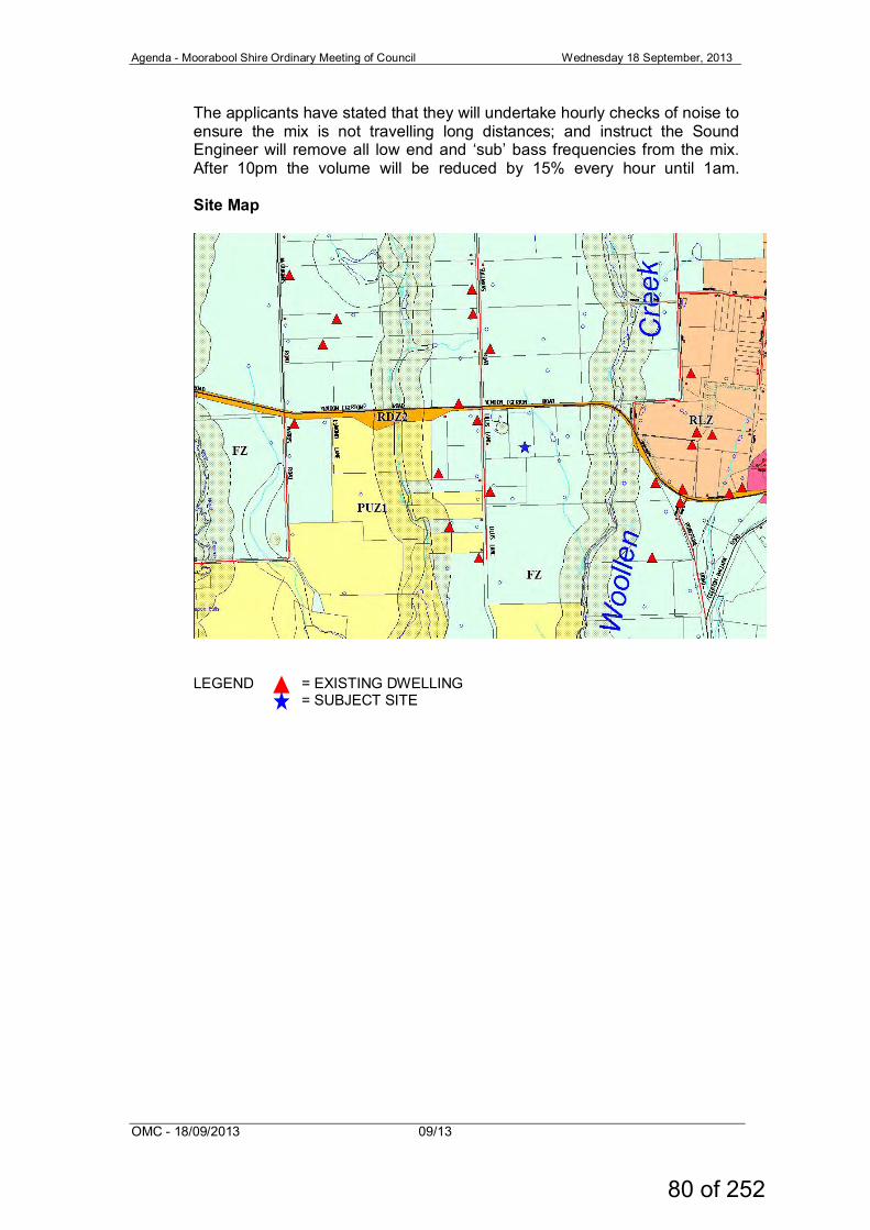
Agenda - Moorabool Shire Ordinary Meeting of Council Wednesday 18 September, 2013
OMC - 18/09/2013 09/13
The applicants have stated that they will undertake hourly checks of noise to ensure the mix is not travelling long distances; and instruct the Sound Engineer will remove all low end and ‘sub’ bass frequencies from the mix. After 10pm the volume will be reduced by 15% every hour until 1am. Site Map
LEGEND = EXISTING DWELLING = SUBJECT SITE
80 of 252
Agenda - Moorabool Shire Ordinary Meeting of Council Wednesday 18 September, 2013
OMC - 18/09/2013 09/13
SITE PLAN
81 of 252
Agenda - Moorabool Shire Ordinary Meeting of Council Wednesday 18 September, 2013
OMC - 18/09/2013 09/13
DETAILED STAGE AND CAR PARKING PLAN
82 of 252
Agenda - Moorabool Shire Ordinary Meeting of Council Wednesday 18 September, 2013
OMC - 18/09/2013 09/13
Site Description The site is vacant farming land with an area of 8.33ha. The entrance to the land is via a crossover and a farm gate from the Yendon Egerton Road located in the north east corner of the site. The property is accessed from this gateway via a gravel farm track. There is a small dam in this corner of the allotment setback approximately 28m south of the road. Two waterways are also located in the north east corner of the site - one running east west parallel with the road which also runs through the dam and which then connects with the other which clips the north east corner of the site and flows to the south east across neighbouring land. The pastured grazing land is undulating rising to the rear south side boundary of the allotment. There is native vegetation along the east side boundary and then scattered native vegetation across the southern half of the site. Neighbouring land is used for predominantly grazing and fodder conservation. To the east, south and west of the site the land is generally cleared with vegetation more generally limited to windbreaks and a few scattered trees. To the north of the site the land is also used for grazing but has medium density scattered native vegetation. Neighbouring allotments are generally of similar size or larger some with dwellings. It is estimated that there are approximately 13 dwellings within a 1km radius of the site. Planning Scheme Provisions State Planning Policy Framework Clause 14.02-1, Catchment planning and management • The objective of this policy is to assist the protection and, where
possible, restoration of catchments, waterways, water bodies, groundwater, and the marine environment.
Local Planning Policy Framework Clause 21.03-5 Rural Lifestyle Opportunities • The objective of this policy is to support development in small towns
and rural lifestyle opportunities as an additional residential choice.
83 of 252
Agenda - Moorabool Shire Ordinary Meeting of Council Wednesday 18 September, 2013
OMC - 18/09/2013 09/13
Zone Farming Zone Pursuant to Clause 35.07-1, Section 2 of the Moorabool Planning Scheme a planning permit is required to use land for a Place of Public Assembly (Music Festival). Overlays Environmental Significance Overlay – schedule 1 Pursuant to Clause 42.01-2 of the Moorabool Planning Scheme a planning permit is required to construct or carry out works. Design and Development Overlay – Schedule 2 A permit is not required to construct or to carry out works where all external walls and roof areas are clad with non-reflective materials. Particular Provisions Advertising Signage Pursuant to Clause 52.05-9, a permit is required to display a business identification sign. The objectives for advertising signs are: ` • To regulate the display of signs and associated structures. • To provide for signs that are compatible with the amenity and visual
appearance of an area, including the existing or desired future character.
• To ensure signs do not contribute to excessive visual clutter or visual disorder.
• To ensure that signs do not cause loss of amenity or adversely affect the natural or built environment or the safety, appearance or efficiency of a road.
In Category 4 – sensitive areas – the total advertisement area to each premises for a Business Identification must not exceed 3 sqm. Only one (1) sign is proposed which would be located on the front gateway to the property and which would have an area of 0.5 sqm. More particularly, the scale and form of the sign proposed would only be erected for the duration of the festival.
84 of 252
Agenda - Moorabool Shire Ordinary Meeting of Council Wednesday 18 September, 2013
OMC - 18/09/2013 09/13
General Provisions Clause 65 sets out a list of criteria that the responsible authority must consider as appropriate, including the following: • The matters set out in Section 60 of the Act. (This is the consideration
of objections); • The State Planning Policy Framework (SPPF) and the Local Planning
Policy (LPPF), including the Municipal Strategic Statement (MSS) and local policies.
• The purpose of the zone, overlay or other provisions; • Any matter required to be considered in the zone, overlay or other
provisions: • The orderly planning of the area; • The effect on the amenity of the area; • The proximity of the land to any public land • Factors likely to cause or contribute to land degradation, salinity or
reduce water quality • The extent and character of native vegetation and the likelihood of
destruction • Whether native vegetation is to be or can be protected, planted or
allowed to regenerate Referrals Pursuant to Section 55 of the Planning and Environment Act 1987 the application was referred to the following authorities. Authority Response Central Highlands Water No objection subject to one (1) condition The application was referred internally to Council’s Environmental Health Officer and Infrastructure departments, both of whom offer no objection to the proposed development subject to conditions. Public Notice The application was advertised to adjoining owners and occupiers within a one (1) kilometre radius of the site by sending individual notices on 2 July 2013 and a sign placed on the site from 3 July 2013 to 18 July 2013. Five (5) objections were received. A consultation meeting was helped on 14 August 2013 at Ballan Council Chambers between 5pm and 6.30pm and was attended by all objectors.
85 of 252
Agenda - Moorabool Shire Ordinary Meeting of Council Wednesday 18 September, 2013
OMC - 18/09/2013 09/13
Summary of Objections A summary of the objections are as follows: Objection Officer’s response Noise The objector’s overriding concern was the noise emanating from the festival and that the operating hours proposed are excessive for families with young children. More generally the concern was that the event would disturb the peaceful rural amenity of the area. There was also concern that the physical address of the venue could be easily found on the internet, and that this could easily attract gate crashers to the event.
At the consultation meeting objectors acknowledged that the noise from the event in 2012 was not as invasive as in 2011. It was also noted that some neighbours do attend the event. The applicant has provided an acoustic report which demonstrates that the noise leakage from the stage area can be contained within acceptable levels, with both an improved sound system, as is proposed in 2013, and also with specific sound engineering controls to minimise noise travelling long distances. Most objectors live more than 750m north and west of the proposed site. The applicant has endeavoured to have all references to the address removed from internet sites that he controls.
Alcohol and drugs Objectors were concerned about over consumption of alcohol and the possibility of prohibited drugs. They wanted to know how will the organisers would ensure that the patrons did not end up overdosed or ‘out of control’ over the three days.
The applicant has contracted Regional Security Services to be on site for the duration of the event. This firm was also present in 2012. It is not considered that this event would get out of control; however, a strong security presence should address all issues that arise, as well as qualified staff with appropriate first aid training and appropriate staff and patron induction procedures.
Traffic Increased traffic created by the event would create a detriment to local road users.
The traffic will arrive and depart throughout the event, and the organisers claim that there is no ‘peak period’ for arrival or departure. There would be no queuing in the Yendon Egerton Road. Council’s Infrastructure Department as a condition of permit requires that a traffic report is provided to them prior to the event.
86 of 252
Agenda - Moorabool Shire Ordinary Meeting of Council Wednesday 18 September, 2013
OMC - 18/09/2013 09/13
Fire risk Fire risk if the season dries off early. Objectors questioned how such a large crowd of people could be evacuated if there was a bushfire. Cigarettes cause a fire risk.
While there is some risk of fire at this time of year, often at the end of November grass is still green, and bushfires at the end of November are not common. The applicant has stated that there would be a static water supply is available on site in the event of fire and appropriate fire control measures in place if a fire was to start on the site. If the grass is cut early in November this usually encourages fresh grass growth.
Rubbish Clean-up of the site, including cigarette butts.
A satisfactory waste plan has been submitted and the requirement for a full clean-up of the site can be conditioned.
Why here? Why couldn’t the festival be held in an alternative venue better suited for the purpose.
The applicants have stated that they are a charitable organisation run by volunteers and do not have a big budget. The aim is to give young and emerging performers an opportunity to perform in front of an audience, and to run the event at relatively low cost.
Assessment of Application The application is for an annual three day music festival. The applicants have conducted this festival twice on the land, in 2011 and 2012, without a permit. Three complaints about noise were received by Council in early December 2012 about noise. Investigation of these events resulted in the operators being told that must obtain a Planning Permit if they proposed to run the event in 2013. The event is operated by Inca Roads Inc. which is a not-for-profit arts organisation that claims to have been created to provide a genuine platform where musicians and artists are provided a place to perform and collaborate, in a family friendly environment. The maximum number of people that would attend would be 650, made up of 500 members (patrons), 100 artists, and 50 organisers and support volunteers. Attendees would all be members of the Inca Roads organisation, and attendance would be pre-arranged and as part of the membership arrangements with no tickets being sold at the gate during the event, which should be made a condition of permit. The applicant has provided details of how the event would be conducted and managed to ensure safety and security, and minimise risk. Documentation includes: Member site entry notifications; Evacuation procedures; Volunteer site induction; Traffic management guidelines; Tasks and responsibilities; First aid; Standard Operating Procedures; and General Logistics.
87 of 252
Agenda - Moorabool Shire Ordinary Meeting of Council Wednesday 18 September, 2013
OMC - 18/09/2013 09/13
The application was advertised and five (5) objections were received. While all objectors were concerned about the impost of this event on their peaceful rural amenity two also stated at the consultation meeting that the noise from the festival in 2012 was not as invasive as it had been in 2011. The concern of the objectors was based on their previous negative experience of the festival’s noise and also internet research which revealed some social media style reports of the festival experience by patrons which ranged from complimentary to a bit wild. However, it is considered that the organisers have tried to accommodate these concerns and they have developed a management response for the 2013 event which should satisfactorily addresses noise emissions, security, risk and traffic management. It is considered that the event should be allowed to be conducted in 2013, with a review to be conducted by Council four (4) months after the event to assess whether future events should be permitted. It is also recommended that a condition of the permit should restrict the permit to Inca Roads Inc. only and in this instance that the permit does not run with the land. The application was referred to Council’s Infrastructure Department and Environmental Health who did not object to the application subject to conditions. The application was also referred to Central Highlands Water who did not object to the application subject to one condition. The applicant has submitted an application for a Temporary Occupancy Permit from Council’s Building Department – Form 5 (Place of Public Entertainment - POPE) with Council’s Building Department. This has been assessed by the Municipal Building Surveyor and that based on the information provided by the applicant that in accordance with the Building Amendment (Place of Public Entertainment) Regulations 2013, a POPE is not required. The POPE application accords with the information provided for this Planning Permit application. Recommendation: That Council having considered all relevant matters as prescribed by s.60 (1) of the Planning and Environment Act 1987 issue a Notice of Decision to Grant a Permit PA2013-103 for The Use of the land for a Place of Assembly (Music Festival) and a Business Identification sign at CA87B, Parish of Kerrit Bareet, also known as 87B Yendon Egerton Road, Mount Egerton, subject to the following conditions: 1. The development as shown on the endorsed plans must not be
altered without the written consent of the Responsible Authority.
2. This permit can only be operated by Inca Roads Inc. and is not
transferable to any other body without the consent of the Responsible Authority.
88 of 252
Agenda - Moorabool Shire Ordinary Meeting of Council Wednesday 18 September, 2013
OMC - 18/09/2013 09/13
3. At least three weeks prior to the event the site must be slashed to remove the grass burden to reduce risk of fire.
4. No more than 650 people are permitted to attend the Music
Festival which includes members, artists and paid or voluntary staff.
5. The entrance to the site must be kept clear of vehicles and be
securely staffed at all times. 6. All attendees must be members of Inca Roads and no entrance
fees are permitted to be collected at the gate. 7. Appropriately trained security personnel must be in attendance
for the duration of the event at a minimum ratio of one to fifty members.
8. Live music can only be played at the following times:
a. Friday: 1pm – 1am (Saturday) b. Saturday: 11am – 1am (Sunday) c. Sunday: 10am – 1.45pm.
9. Within four (4) months of the completion of the 2013 festival the
applicant must provide to Council a 2013 Music Festival report of the event including:
a. The number of persons who attended the event including
members, artists and volunteers; b. Security and incident report; c. Acoustic report; and d. Complaints report (as applicable).
The use of the land for future festivals will be conditional upon the 2013 festival being conducted in an appropriate manner to the satisfaction of the Responsible Authority. Council reserves the right to cancel the permit if compliance has not been achieved.
10. The location, dimensions and features of the approved sign
(including the design, colours, materials and sign type) shown on the endorsed plans must not be altered without the written consent of the Responsible Authority.
11. The sign must be only displayed immediately prior to and during
the event and must be removed within 3 days of the conclusion of the event to the satisfaction of the Responsible Authority.
12. Within seven (7) days of the completion of the event the site must
be cleaned of all waste and all structures are to be removed. 13. Areas set aside for the parking and movement of vehicles as
shown on the endorsed plan must be made available for such use and must not be used for any other purpose.
89 of 252
Agenda - Moorabool Shire Ordinary Meeting of Council Wednesday 18 September, 2013
OMC - 18/09/2013 09/13
Infrastructure condition 14. Not less than twenty eight days prior to the event, the proponent
must submit to the Responsible Authority a Traffic Management Plan, detailing the location and type of all advance warning signs and all signs at the entrance to the event.
Environmental Health conditions 15. All temporary and mobile food vendors must be registered under
the Food Act 1986 with the appropriate authority on Streatrader, online database for mobile and temporary food premises, and submit a Statement of Trade to Moorabool Shire Council at least 5 working days prior to the first day of the festival.
16. All drinking water provided at the festival must be potable water which meets the requirements of the Australian Drinking Guidelines 2011 and be contained on site in a secure, clean and sanitary container/tank.
17. All waste water generated on site from the toilets, showers and wastewater from food vending activities must be suitably contained on-site and removed off-site by an approved waste water management contractor/company.
Central Highlands Water condition 18. Wastewater generated onsite during the event must be collected
and disposed of through the use of portable sanitary facilities. Expiry condition 19. This permit will expire if:
a. The use is not started within one year of the date of this permit.
This permit expires on 30 April 2014. The Responsible Authority may extend the period referred to subject to a satisfactory report being received as per condition 9 of this permit and a request is made in writing before the permit expires or within three months afterwards. Permit Note: The applicant must apply for a Temporary Occupancy Permit from Council’s Building Department – Form 5 (Place of Public Entertainment).
Report Authorisation Authorised by: Name: Satwinder Sandhu Title: General Manager Growth and Development Date: Wednesday 5 September 2013
90 of 252
Agenda - Moorabool Shire Ordinary Meeting of Council Wednesday 18 September, 2013
OMC - 18/09/2013 09/13
11.2.4 Amendment C53 – Gordon Structure Plan Introduction File No.: 13/06/059 Author: Damien Drew General Manager: Satwinder Sandhu Background Amendment C53 is a Council-initiated amendment to give effect to the Gordon Structure Plan originally adopted by Council on 1 June, 2011. The Structure Plan has been based on an extensive community consultation process and sets out a plan to guide and manage the future development of the township and its surrounds. It addresses land use, zoning, urban design, visual amenity, facilities and infrastructure. The Structure Plan recommended that changes be made to the Planning Scheme, including the rezoning of some land, the addition of planning provisions to guide the form and type of uses and developments to be supported, and strategies and policies that Council will apply to the future planning and development of Gordon. In addition to the above, Council as part of the 2013-14 budget have also allocated funds for further infrastructure planning for the Gordon township. At its Ordinary Meeting held on 1 June, 2011, Council resolved to seek authorisation from the Minister for Planning to prepare and exhibit a planning scheme amendment (C53) for the purpose of implementing the recommendations of the Gordon Structure Plan 2011. On 26 July, 2011, Council wrote to the Minister for Planning requesting authorisation to prepare and exhibit an amendment to the Moorabool Planning Scheme. Further information was sought by the Department of Planning and Community Development on 16 September, 2011, which led to Council making changes to the proposed amendment, in particular, proposing to apply the Residential 1 Zone to the township rather than the Low Density Residential Zone. Subsequently, the Minister for Planning authorised the preparation and exhibition of Amendment C53 on 7 February, 2012. The authorisation required that consultation occur with the Regional Office of the Department of Planning and Community Development in the preparation of the amendment prior to exhibition, to discuss the Schedules to the Design and Development Overlay and Clause 21.09. Internal reviews occurred through the period from 7 February, 2012, and on 23 March, 2013, the Minister for Planning granted an extension of six months to the Authorisation A02038 to prepare the planning scheme amendment C53 to the Moorabool Planning Scheme. The Amendment has undergone public exhibition over a period of four weeks between 6 June, 2013 and 5 July, 2013.
91 of 252
Agenda - Moorabool Shire Ordinary Meeting of Council Wednesday 18 September, 2013
OMC - 18/09/2013 09/13
A total of 15 submissions, including five (5) late submissions, were received in response to Amendment C53, of which two (2) supported the amendment or offered no objection, two (2) supported the amendment but requesting alterations/changes, five or six (5) offering no objection but requesting alterations/changes, one (1) offering no position, and two (2) opposed the Amendment. Three (3) submissions offered comment but neither supported nor objected to the Amendment. Submissions in response to the amendment cover a range of issues. The key issues include: • Support for the proposed Gordon township boundary • Support for the Gordon Structure Plan vision for the town • Expansion of the extent of the township boundary, i.e., requests from
landowners for rezoning for residential development • Refinements are needed to the MSS policy and Overlay controls • Expansion of the extent of the Business 1 Zone and Significant
Landscape Overlay - Schedule 2 • Impacts of the application of the proposed Overlays • Bushfire risk • Gas Transmission Pipeline • Application of the new Residential Zones. In accordance with the Planning and Environment Act 1987, Council must now either change the Amendment in the manner requested by the submissions, refer submissions to an Independent Panel appointed by the Minister for Planning, or abandon the Amendment or part of the Amendment. This report considers submissions received in relation to the Amendment and recommends that all submissions be referred to an Independent Panel for consideration. Proposal The Amendment Amendment C53 seeks to implement the Gordon Structure Plan 2011, which was adopted by Council on 1 June, 2011, by making the following changes to the Moorabool Planning Scheme: Municipal Strategic Statement • Amending the existing Clause 21.09 “Small Towns” (Gordon) to reflect
the new land use directions and policies identified in the Gordon Structure Plan 2011.
• Amending the existing Clause 21.11 by adding the Gordon Structure Plan 2011 to the list of reference documents to the Moorabool Planning Scheme.
Zoning and Overlays • Rezoning the identified commercial area of Gordon from Township
Zone to Business 1 Zone;
92 of 252
Agenda - Moorabool Shire Ordinary Meeting of Council Wednesday 18 September, 2013
OMC - 18/09/2013 09/13
• Rezoning the remaining Gordon residential area from Township Zone to Residential 1 Zone;
• Rezoning an area of 1.26 hectares of land associated with the properties known as No.s 1, 5 and 7 Russell Street from Rural Living Zone to Residential 1 Zone, to remove the existence of two zones from these properties.
• Rezoning lot from Rural Living Zone to Public Use Zone (PUZ5) to reflect the use of land.
• Applying the Significant Landscape Overlay - Schedule 2 “Gordon Town Centre, Township and Surrounds” to the Gordon Town Centre and to the rural living surrounds.
• Applying a new Design and Development Overlay - Schedule 5 “Gordon Town Centre, Township and Surrounds” to the Gordon Town Centre and to the rural living surrounds.
The purpose of the Design and Development Overlay (DDO) Schedule 5 is to ensure that any development and subdivision responds to the ‘country town feel’ of Gordon, and it contains objectives and guidance for the siting and design of buildings in relation to character and amenity. In addition, the DDO seeks to protect the spacious character of the township by maintaining larger lot sizes and to ensure equitable development of land within the ‘spare capacity’ in the reticulated sewerage system. This overlay ensures a planning permit is not required to construct a building or undertake works, if the following requirements are met: • Buildings or extensions to existing buildings with a minimum side
setback of 2 metres from either boundary and a minimum rear setback of 5 metres.
• The site area covered by buildings does not exceed 40 per cent. • Total floor area of all buildings does not exceed 300 square metres in
floor area. • Buildings under 9 metres in height. • Earthworks under 1 metre in depth or height. • Where all external walls and roof areas are clad with non-reflective
materials. The Significant Landscape Overlay - Schedule 2 seeks to:
• To retain and protect significant trees, vegetation and windbreaks that are significant component of local identity and landscape of the township character of Gordon.
• To protect vegetation and trees of special significance, natural beauty, interest and importance.
• To retain trees where they have high amenity value, unless identified as an environmental weed.
• To support the retention and planting of further exotic and indigenous trees.
The SLO simply introduces a permit trigger for the removal of canopy trees and does not prohibit development or tree removal. Standard exemptions for lopping or removal for safety reasons will still apply.
93 of 252
Agenda - Moorabool Shire Ordinary Meeting of Council Wednesday 18 September, 2013
OMC - 18/09/2013 09/13
Public Exhibition Process Amendment C53 was exhibited in accordance with the provisions of the Planning and Environment Act 1987 between 6 June, 2013 and 5 July, 2013. Notice was provided to all relevant Government Departments, Statutory Authorities and affected landowners and occupiers. Notices were placed in the Moorabool News, Council’s web site, Government Gazette and the Moorabool Matters publications. Public information sessions were held in the Gordon Hall on Tuesday 11 June and Wednesday 13 June, 2013, with a Council officer in attendance. A total of 15 submissions, including five (5) late submissions, were received in response to Amendment C53, of which two (2) supported the amendment or offered no objection, two (2) supported the amendment but requesting alterations/changes, five or six (5) offering no objection but requesting alterations/changes, one (1) offering no position, and two (2) opposed the Amendment. Three (3) submissions offered comment but neither supported nor objected to the Amendment. Submission Review Under the Section 23 of the Act, the Council is required to consider all submissions made to an Amendment and must: (a) change the amendment in the manner requested; or (b) refer the submission to a panel appointed under Part 8; or (c) abandon the amendment or part of the amendment. Submissions in response to the amendment cover a range of issues. The key issues include:
The objections • Support for the proposed Gordon township boundary • Support for the Gordon Structure Plan vision for the town • Expansion of the extent of the township boundary, i.e., requests from
landowners for rezoning for residential development • Refinements are needed to the MSS policy and Overlay controls • Expansion of the extent of the Business 1 Zone and Significant
Landscape Overlay - Schedule 2 • Impacts of the application of the proposed Overlays • Bushfire risk • Gas Transmission Pipeline • Application of the new Residential Zones. The table at Attachment 1: Amendment C53 – Review of Submissions outlines the specific issues raised in the submissions and provides the officer response. In the event these submissions are referred to an Independent Planning Panel appointed by the Minister for Planning, as recommended, these responses will be the basis for Council’s presentation to the Panel.
94 of 252
Agenda - Moorabool Shire Ordinary Meeting of Council Wednesday 18 September, 2013
OMC - 18/09/2013 09/13
Key Issues Raised in Submissions
Expansion of the Extent of the Township Boundary A number of submissions make comment concerning the future growth of Gordon and, in particular, the areas to the west of Old Melbourne Road and north of Corbetts Road. Although Gordon is the third largest town in the Shire, the draft Central Highlands Regional Growth Plan does not envisage ‘major growth’ in the town during the life of the Structure Plan (15 year planning period). It is anticipated that infill development and consolidation land within the township boundary will accommodate the projected population growth in Gordon during the life of this Structure Plan. As per State and Local Planning Policy, consolidation of the existing township area is encouraged, having consideration to respecting neighbourhood character and environmental factors, such as, retention of remnant vegetation. In addition, Clause 16 of the SPPF, encourages compactness of settlements to provide for optimal use of local infrastructure. Compact development can result in healthy walkable settlements that support local businesses and community enterprises. Therefore, in accommodating future population growth in Gordon, it is important to consolidate areas within the township boundary. The adopted Structure Plan does not contemplate greenfields development to facilitate growth of the town. Given that the Structure Plan does not include an assessment of whether land requested for rezoning in the submissions is suitable for urban development, and the implications of significant development on sites, which are not within the existing township, it is difficult to recommend that there is adequate strategic justification to expand the township boundaries. Whilst these sites are on the fringes of the existing township and within proximity to the town centre, the Structure Plan seeks to avoid an oversupply of residential land in the short term. It is considered that these areas do not present the same short-term opportunities provided by infill areas and urban consolidation, and have additional environmental and servicing considerations. Given the significant implications of the rezoning of greenfield areas and the lack of reference to the land requested for rezoning as short-term development areas in the exhibited amendment, a Panel is unlikely to be able to support the proposition that these landholdings now be identified as short-term development areas. In addition, if the land subject to the submissions had been identified for short-term development in the exhibited amendment and the adopted Structure Plan, Council may have received submissions expressing differing views in relation to this matter.
95 of 252
Agenda - Moorabool Shire Ordinary Meeting of Council Wednesday 18 September, 2013
OMC - 18/09/2013 09/13
Therefore, changing Amendment C53 to identify greenfields land for short-term development could be considered to constitute a transformation of the amendment by a Planning Panel. Central Highlands Water has recently delivered the required infrastructure and servicing for reticulated sewerage in Gordon. It is anticipated that the provision of sewerage within the Township will add a significant positive attribute for living in Gordon. Provision of this infrastructure is likely to create a higher residential development rate within the existing township boundaries. However, the Gordon Sewerage system has a limited capacity. Central Highlands Water (CHW) identified 141 existing properties to be serviced by reticulated sewerage and has provided for an upper limit of 280 property connections in the declared sewerage district. While the capacity of 280 property connections provided by CHW does not create a fixed upper limit for the township, (although the ultimate capacity of the sewerage treatment works is not clear), any additional connections beyond the 280 limit would be required to meet the full cost of connections and any upgrade in infrastructure. These requirements could mean that further connections beyond that number will be severely constrained. Thus, there is only capacity for the creation of an additional 139 infill lots within the Gordon sewerage district and rezoning of land outside the existing township boundary cannot be supported on that basis. Overlay Controls The Amendment proposes to apply the Design and Development Overlay to all land proposed to be rezoned to the Residential 1 Zone, Business 1 Zone and a r e a s i n the ex ist ing Rural Living Zone, to implement the urban design guidelines outlined in the adopted Gordon Structure Plan. These guidelines were formed to help manage the design, siting and layout of buildings and works within the township and surrounds, and their translation into a Design and Development Overlay encourages specific design and development outcomes, which have been developed through the Gordon Structure Plan process. The Amendment implements a DDO, which seeks to preserve a number of the elements, considered to make strong contributions to the existing character of Gordon and which, through careful planning, can be enhanced as the town develops and grows. A Design and Development Overlay (DDO) Schedule 5 is proposed to apply to the Gordon Town Centre and to the rural living surrounds. The purpose of this overlay is to ensure that any development and subdivision responds to the characteristics of Gordon, and it contains objectives and guidance for the siting and design of buildings in relation to character and amenity.
96 of 252
Agenda - Moorabool Shire Ordinary Meeting of Council Wednesday 18 September, 2013
OMC - 18/09/2013 09/13
It seeks to reinforce and strengthen the distinctive character of Gordon, to ensure that buildings with visible roof form make a positive contribution to the character of the township, and to protect the spacious character of the township by maintaining larger lot sizes. In addition, the DDO aims to maintain the ‘country town feel’ of Gordon now that reticulated sewerage is available in the township. Development will be permissible, but at a larger lot size to encourage the maintenance of vegetation and to ensure a more equitable development of land within the ‘spare capacity’ in the sewerage system. Canopy vegetation, particularly indigenous vegetation, contributes positively to the neighbourhood character in Gordon and its presence in the Town should be maintained and enhanced. However, the current planning controls applying to Gordon do not include specific vegetation controls. It is proposed to apply Significant Landscape Overlay (SLO) - Schedule 2 “Gordon Town Centre, Township and Surrounds” to the Gordon Town Centre and to the rural living surrounds. This provision is intended to protect the character created by canopy trees and prevent lots from being ‘moon-scaped’ prior to development as is often the case during subdivision. Unlike the DDO controls, the SLO will allow consideration of the role of significant trees in the landscape character and it will inform design and siting of residential development with respect to landscape aesthetics. The SLO simply introduces a permit trigger and does not prohibit development or tree removal. Standard exemptions for lopping or removal for safety reasons will still apply. Assessment of development will be based on not only the objectives and decision guidelines of the schedule, but will be supported by the local planning policy at Clause 21.09-1 – Gordon. The Department of Environment & Primary Industries (DEPI) has suggested that in Schedule 2 to the Significant Landscape Overlay – Clause 3.0 definition should be based on trunk diameter measured at breast height, which is 1.3 metres above the ground (DBH). This is the accepted scientific method for tree trunk measurement and accordingly, the SLO Schedule should be amended to refer to trunk diameter measured at breast height. In addition, DEPI has requested that removal of standing dead native trees should not be exempt from requiring planning approval. It is recognised that dead native trees can have significant habitat value, and requiring a proper assessment (planning approval) prior to removal will ensure that the environmental features valued by the Gordon community will be appropriately protected. Another submitter has suggested that the SLO schedule should be amended to provide clarity regarding the level of documentation required for any planning permit application. It is agreed that application requirements would improve the clarity of the SLO. The application requirements of VPO1, SLO1 and Clause 52.17 of the Moorabool Planning Scheme could be used to form the basis of application requirements for this Overlay Schedule.
97 of 252
Agenda - Moorabool Shire Ordinary Meeting of Council Wednesday 18 September, 2013
OMC - 18/09/2013 09/13
The requested extension of the area to be covered by SLO2 is beyond the scope of this amendment, and where such an extension would affect private land, public consultation would be required by notice to affected landowners. It is usually only possible for a Panel to consider changes to an amendment or proposal, especially significant changes, if there is adherence to the rules of natural justice. The particular rule of natural justice, which must be satisfied, is the requirement that all matters upon which a decision will be based are revealed to all parties and they are given an opportunity to be heard. If a wider extent of SLO2 had been foreshadowed in the exhibited amendment, then Amendment C53 may have attracted further submissions on this issue. Therefore, the transformation of an amendment or proposal would normally require re-exhibition, which is not appropriate or practical as it could cause unnecessary delay or protraction of process in the case of this Amendment. There are a significant number of property owners affected by the proposed Overlays, all of whom were directly notified of this Amendment. The receipt of only two objecting submissions indicates strong community and landowner support for the application of the Overlay controls. Application of the Overlay controls is proposed to facilitate appropriate development, and enable the main elements of the character to be retained in the township and surrounds. These Overlays will not prevent development of land, but will require more detailed consideration of built form, density, landscape values, and a sensitive design response, as part of development proposals. The DDO and SLO are planning tools forming part of the Victorian Planning Provisions and their application is not considered to be overly prescriptive or seriously impose on property owners’ rights. Town Centre and Business 1 Zone The proposed Business 1 Zone will provide opportunities for commercial uses as part of the town centre, for limited expansion along Main Street, and recognises some existing non-residential uses in Main Street. The rezoning of a wider area to Business 1 would be premature and is not justified by current growth projections for Gordon. It would be likely to saturate the supply of land for retail development in the town. It is considered that the Amendment will rezone sufficient land for commercial purposes, in the town centre (Main Street), to cater for demand during the life of the Structure Plan. Rezoning of land for commercial purposes to the south of Main Street, in particular, No. 32 Russell Street, would fragment the ‘town centre’ and is not supported by the Structure Plan.
98 of 252
Agenda - Moorabool Shire Ordinary Meeting of Council Wednesday 18 September, 2013
OMC - 18/09/2013 09/13
The owners of No. 69 Main Street have advised that their property consists of two adjoining titles and the Amendment proposes to rezone one title to Business 1 Zone and the other to Residential 1 Zone. They believe that it would be more desirable and practical to rezone both titles to the Business 1 Zone. It is considered that the change requested by the owners of No. 69 Main Street has some merit and should be considered by a Planning Panel. The current Township Zone seeks to provide for a range of commercial uses in small towns, subject to planning approval. Thus, it possible that a Planning Panel could find that changing the Amendment to rezone the whole of No. 69 Main Street to the Business 1 Zone (now Commercial 1 Zone) may not be of such significance to constitute a transformation of the Amendment. Whilst some concerns have been raised regarding the quality of the Structure Plan document, in relation to the directions for the Town Centre, it is considered that DDO5 will appropriately translate those directions into the planning scheme. Bushfire Risk Some submitters, in particular, the CFA, has raised concerns in relation to the consideration of bushfire risk as part of the Amendment. The CFA stated that in preparing the Amendment, Council may not have adequately considered Clause 13.05 in general, and any potential changes to the Bushfire Management Overlay (BMO) specifically. Additional areas within proposed DDO5 and SLO2 may be subject to the revised extent of the BMO. Other issues raised by the CFA relate to the consistency between the exemptions (10/30 & 10/50 rules) allowed under Clause 52.48 and the controls in the proposed SLO2, and the need to recognise the bushfire risk in, and around, the township in Clause 21.09-1 – Gordon. The Bushfire Management Overlay applies to portions of land in the east and north-eastern areas of Gordon. It is applied to land where "bushfire hazard requires specified bushfire protection measures for subdivision and building and works to be implemented". Completion of the Gordon Sewerage Project now enables land in the current Township Zone to be subdivided into lots of 300 square metres or greater (and less if permitted by a development permit). In this context, it is considered that if further subdivision of land is fully realised under the existing Township Zone, the cumulative impacts of this pattern of development may lead to adverse bushfire planning outcomes and risk to future residents on these lots. Council is required to pursue the most appropriate planning scheme arrangements, beyond the Bushfire Management Overlay, which assist in the provision of a safe settlement pattern. Council has given consideration to Clause 13.05 by proposing to apply planning controls to limit subdivision and further development in Gordon. In particular, the application of DDO5 will specify a minimum lot size of 800 square metres in the township, thus limiting the density of residential development in the town.
99 of 252
Agenda - Moorabool Shire Ordinary Meeting of Council Wednesday 18 September, 2013
OMC - 18/09/2013 09/13
It should be noted that the proposed Significant Landscape Overlay 2 (SLO2) only regulates the removal of large trees and exempts the clearing of vegetation with higher fuel loads, such as, understorey vegetation, smaller shrubs, etc. In the area now covered by the BMO, the 10/50 metre rule applies via Clause 52.48. Landowners can clear vegetation within the prescriptions of Clause 52.48 without a planning permit, but they are not compelled to undertake clearing. In the BMO area, the 10/50 provisions of Clause 52.48 will override the vegetation protection provisions of the SLO2 where clearing is undertaken for bushfire protection, effectively rendering the SLO provisions null and void for removal of trees to 10 metres out from an existing dwelling. In relation to recognising the exemptions contained in Clause 52.48 in the SLO schedule, previous Panels have considered that cross-referencing and/or duplication of planning scheme clauses are neither necessary nor desirable. This practice should be avoided, as it will make the planning scheme even larger and more complex than it is already. It is incumbent on a landowner wishing to undertake an action (in this case vegetation clearing), to review the planning scheme themselves, and seek advice from Council or a planning specialist, as necessary, to determine the layers of the scheme which are relevant to their particular circumstances. It is appropriate to strengthen Clause 21.09-1 – Gordon, to recognise bushfire risk affecting the township and surrounds, and to ensure that development within Gordon responds to and mitigates any identified bushfire risks. Referral to a Planning Panel will assist in determining whether the Amendment meets the objective of Clause 13.05-1 (Bushfire) and gives effects to the strategies of the policy. The Panel will evaluate the CFA submission and determine whether any changes should be made to the Amendment. Gas Transmission Pipeline APA requests that development is restricted in its gas transmission pipeline easement; and that ‘Sensitive’ uses, such as, schools, hospitals, aged care facilities and prisons and ‘high density’ land uses, such as, multi-storey development predominates or where large numbers of people congregate in the normal use of the area preferably be separated approximately 316 metres from the edge of the easements for public safety and not within approximately 193 metres from the edge of the easements. Development will be restricted in proximity to the gas transmission pipeline easement located on the southern boundary of the current Township Zone (along the southern side of Nightingale Street).
100 of 252
Agenda - Moorabool Shire Ordinary Meeting of Council Wednesday 18 September, 2013
OMC - 18/09/2013 09/13
The Amendment does not make any significant changes to the land use zoning in proximity to the alignment of the gas transmission pipeline. It does include the application of a DDO, which seeks to place controls on development, particularly applying a minimum lot size. It is considered that the Amendment addresses issues raised by APA by limiting the density of development in the proposed Residential 1 Zone. New Zones On 1 July 2013, the Victorian State Government introduced a suite of new planning zones that would supersede and / or replace current zones within the planning scheme. The Minister for Planning amended the Victorian Planning Provisions on 15 July 2013 to replace the five business zones with two commercial zones. The rezoning of properties in the Town Centre was exhibited as Business 1 Zone and under the new zones will be Commercial 1 Zone. The purpose of the new zone is to create vibrant mixed-use commercial centres and for residential uses that complement to the commercial centre. The new zone increases the types of uses allowable without the need for a planning permit (permits are still required for buildings and works as normal in these zones). The new Commercial Zones (CZ1 and CZ2) were not operable at the time of preparation and exhibition of this Amendment and were, therefore, not able to be included as part of the exhibited amendment package. With the introduction of this suite of commercial zones, the Amendment will need to be altered to give effect to these new zones. In addition, the new suite of Residential Zones came into effect on 15 July, 2013 and aim to: • improve the range of residential zones to better manage growth and
protect and maintain liveability and neighbourhood character • simplify requirements with greater certainty and clearer rules • allow a broader range of activities to be considered • provide greater clarity about the type of use and development, which
can be expected in residential areas. A council will be able to use the residential zones to better specify strategic locations where increased densities should be provided, and limit residential change in areas where neighbourhood character, environmental and other characteristics should be protected. The new zones are intended to provide positive economic, environmental and social effects to residential areas throughout Victoria. The Central Highlands Water (CHW) submission notes the introduction of three new residential zones into the planning system, which will replace the application of the Residential 1 Zone by July 2014. Given that the sewerage system has limited additional capacity, CHW has recommended the application of the Neighbourhood Residential Zone to the Township, which is consistent with the outcomes sought by Council’s proposed DDO5.
101 of 252
Agenda - Moorabool Shire Ordinary Meeting of Council Wednesday 18 September, 2013
OMC - 18/09/2013 09/13
As Council is required to implement the new residential zones by July 2014, this Amendment should be altered to give effect to these zones. It is considered that the Neighbourhood Residential Zone is appropriate for Gordon, as suggested by CHW. The Gordon Structure Plan does not anticipate population growth of the level that would warrant the application of application of the General Residential Zone or Residential Growth Zone within the Township, and CHW has advised that significant upgrades to the sewerage system may be required to service future development under this scenario. Revised amendment documentation, which considers the application of the new Commercial 1 Zone and Neighbourhood Residential Zone will be prepared and provided to all submitters along with Planning Panels Victoria at the Directions Hearing. This documentation will form the basis for discussion of application of the new zones at the Panel Hearing. Changes to the Amendment As a result of the submissions and administration errors, the following changes are proposed for consideration by the Panel: • Update the former Business 1 Zone to the new Commercial 1 Zone as
per Ministerial changes. • Update the former Residential 1 Zone to the new Neighbourhood
Residential Zones as per Ministerial changes. • Change the proposed zoning of No. 69 Main Street, Gordon from part
Business 1 Zone and part Residential 1 Zone, to the new Commercial 1 Zone to address the owners’ submission.
• Make changes to the exhibited documents to address issues outlined in this report
• Make minor administrative corrections to the exhibited documents to address any identified clerical errors.
Planning Panel It is important to note that the basic role of a panel is to: • give submitters an opportunity to be heard in an independent forum
and in an informal, non-judicial manner. A panel is not a court of law. • give independent advice to the planning authority (Council) and the
Minister for Planning about an amendment and about submissions referred to it. A panel makes a recommendation to the planning authority. It does not formally decide whether the amendment is to be approved.
When considering an amendment a panel will address: • the merits of the amendment; • the issues raised in the submissions; • the strategic context and implications of the amendment;
102 of 252
Agenda - Moorabool Shire Ordinary Meeting of Council Wednesday 18 September, 2013
OMC - 18/09/2013 09/13
• the matters identified in the Planning Practice Note Strategic Assessment Guidelines for Planning Scheme Amendments; and any other relevant matters.
A Panel prepares a report to record its considerations and recommendations in relation to an amendment. The purpose of a Panel report is to: • Record the outcome of the public consultation process involving
exhibition, submissions and Hearing. • Provide an independent assessment of the issues arising from that
process. • Provide recommendations about the decisions, which should be made. Policy Implications The 2013 - 2017 Council Plan provides as follows: Key Result Area Enhanced Infrastructure and Natural and
Built Environment Objective Effective and efficient land use planning
and building controls
Strategy Ensure the Planning Scheme is reviewed and updated in order to facilitate land use and development to support the social, economic, environment and well-being of the Shire.
Ensure that development is sustainable,
resilient to change and respects the existing character.
The proposed Amendment C53 is consistent with the 2013-2017 Council Plan. The Structure Plan is consistent with all relevant State and Council planning policies, which have been described and discussed in detail in the Structure Plan. Planning and Environment Act Section 4 of the Planning & Environment Act 1987 sets out the objectives for planning in Victoria. Relevant objectives for consideration as part of this amendment include the need for Planning:
(a) to provide for the fair, orderly, economic and sustainable use, and development of land;
(c) to secure a pleasant, efficient and safe working, living and recreational environment for all Victorians and visitors to Victoria;
(g) to balance the present and future interests of all Victorians.
103 of 252
Agenda - Moorabool Shire Ordinary Meeting of Council Wednesday 18 September, 2013
OMC - 18/09/2013 09/13
The Gordon Structure Plan and its implementation via the Moorabool Planning Scheme are considered to be consistent with the objectives of planning in Victoria. Environmental Effects The development of the Structure Plan has regard to environmental issues and constraints. The Structure Plan identifies a township boundary, which will see population increases accommodated within the existing urban area, minimising urban sprawl and protecting the surrounding rural environment. The proposed amendment will result in positive environmental benefits by integrating any new development within the area affected by the Structure Plan and incorporating principles of environmentally sensitive urban design through the use of built form controls to be implemented through Schedules to the Design and Development Overlay. The Gordon Structure Plan and associated changes to the Moorabool Planning Scheme clearly outline the future development potential of the township and immediately surrounding areas. Protection and enhancement of areas of high environmental significance such as the existing trees, proclaimed water supply catchment, Paddock Creek and adjacent rural landscapes will be strengthened by the amendment. Economic Effects The proposed amendment will have positive economic effects and will assist in supporting business and potentially generate new employment opportunities. The Amendment has the potential to have positive economic impacts by creating a greater critical mass of activity within Gordon. In addition, the proposed amendment supports continued growth and development of existing commercial and retail type businesses in Gordon. The proposed Amendment will provide for land supply in the short to medium term for commercial uses, which were identified in the Structure Plan. Future retail and community development will provide increased opportunities for local employment and retail activity to the benefit of the wider community, in a manner and scale that will not detract from the retail roles of nearby towns and the regional centre of Ballarat. State Planning Policy Framework The State Planning Policy Framework informs planning authorities of the State policy to be taken into account when making decisions. The following clauses should be considered in the assessment of the recommendations made in the Gordon Structure Plan:
104 of 252

Agenda - Moorabool Shire Ordinary Meeting of Council Wednesday 18 September, 2013
OMC - 18/09/2013 09/13
Clause 11.02-1- Supply of Urban Land This clause seeks to ensure there is a sufficient supply of land available for residential, commercial, industrial, recreational, institutional, and other public uses. The clause states that planning authorities should plan to accommodate projected population growth over at least a I5 year period and provide clear direction on locations where growth should occur. Clause 11.02-3- Structure Planning This clause aims to facilitate the orderly development of urban areas and ensure effective planning and management of the land use and development of an area through the preparation of strategic plans, statutory plans, development and conservation plans, development contribution plans and other relevant plans. Clause 11.03-1 -Open space planning Clause 11.03-1 of the Scheme relates to the provision of open space and creation of a diverse and integrated network of public open space commensurate with the needs of the community. Open space networks should be linked through the provision of walking and cycle trails and should incorporate links between major parks and activity areas, along waterways and natural drainage corridors and connect places of natural and cultural interest. Clause 11.05-1 Regional Settlement Networks The state policy objective in relation to regional settlement networks seeks to promote the sustainable growth and development of regional Victoria through a network of settlements. The strategies for this policy objective include: Deliver networks of high-quality settlements by: • Building on strengths and capabilities of each region across Victoria to
respond sustainably to population growth and changing environments. • Developing networks of settlements that will support resilient
communities and the ability to adapt and change. • Balancing strategic objectives to achieve improved land-use and
development outcomes at a regional, catchment and local level. • Preserving and protecting features of rural land and natural resources
and features to enhance their contribution to settlements and landscapes.
• Encouraging an integrated planning response between settlements within regions and in adjoining regions and states.
• Providing for appropriately located supplies of residential, commercial, and industrial land across a region, sufficient to meet community needs.
105 of 252
Agenda - Moorabool Shire Ordinary Meeting of Council Wednesday 18 September, 2013
OMC - 18/09/2013 09/13
• Improving connections to regional and metropolitan transport services and urban connectivity.
Clause 11.05-2 Melbourne’s Hinterland Areas The State Planning Policy for Melbourne’s Hinterland area has the following objective: • To manage growth in Melbourne’s hinterland, the area immediately
beyond Metropolitan Melbourne and within 100 kilometres of the Melbourne Central Activities District.
Policy strategies to achieve this objective include maintaining the attractiveness and amenity of hinterland towns, improving connections to regional and metropolitan transport services and managing the growth of settlements to ensure that development is linked to the timely provision of infrastructure. Clause 11.05-4 Regional Planning Strategies and Principles This policy has as its objective, to “develop regions and settlements which have a strong identity, are prosperous and are environmentally sustainable”. Clause 12.01-1- Protection of habitat Clause 12.01-1 of the State Planning Policy Framework outlines the State policy in relation to the protection and conservation of biodiversity, including native vegetation retention and provision of habitats for native plants and animals and control of pest plants and animals. This clause states that responsible authorities should ensure that the siting of new buildings and works minimises the removal or fragmentation of native vegetation. Clause 14.02-1 Catchment Planning and Management The objective of this policy is to assist the protection and, where possible, restoration of catchments, waterways, water bodies, groundwater, and the marine environment. The Township of Gordon is physically divided within two proclaimed water supply catchments. Clause 15.01-2 Urban Design Principles The State Planning Policy Framework for Urban Design has the following objective: “To achieve architectural and urban design outcomes that contribute positively to local urban character and enhance the public realm while minimising detrimental impact on neighbouring properties.”
106 of 252
Agenda - Moorabool Shire Ordinary Meeting of Council Wednesday 18 September, 2013
OMC - 18/09/2013 09/13
To achieve the above objective, a strategy of eleven design principles have been identified, which the responsible authority must have regard to, including: • Context • The public realm • Safety • Landmarks, views and vistas. • Pedestrian spaces • Heritage • Consolidation of sites and empty sites • Light and shade • Energy resource efficiency • Architectural quality; and • Landscape architecture. Clause 19.03-2- Water supply sewerage and drainage Clause 19.03-2 states that planning and responsible authorities should ensure that water quality in water supply catchments is protected from possible contamination by urban, industrial and agricultural land uses. Local Planning Policy Framework
The Local Planning Policy Framework within the Moorabool Planning Scheme provides strong support for the finalisation and implementation of the Gordon Structure Plan. Clause 21.02 Natural Environment The local planning policy for the natural environment includes objectives, which relate to water and catchment management and non-urban landscapes. The Natural Environment policy seeks to protect the quality and quantity of water within the Moorabool Shire. The policy objective relating to non-urban landscapes seeks to maintain and enhance the natural environment and the Shires rural identify and character. Clause 21.03 Settlement and Housing The Local Planning Policy for settlement and housing seeks to support the further development of small towns and rural lifestyle opportunities to ensure appropriate residential choice throughout the Moorabool municipality. The preparation of structure plans for the township of Blackwood and Gordon are identified as further strategic work tasks for achieving the policy objective.
107 of 252
Agenda - Moorabool Shire Ordinary Meeting of Council Wednesday 18 September, 2013
OMC - 18/09/2013 09/13
Clause 21.09-1 Gordon
Clause 21.09 of the Local Planning Policy Framework states, “Gordon is the third largest town in the Shire located on the Western Freeway some 23 kilometres from central Ballarat. The town layout is characterised by two residential areas and a denser central core with larger lots on its outskirts that provide a distinctly rural character.” The objective identified for Gordon states “To identify and manage urban growth opportunities driven by the upcoming sewering of Gordon and other growth drivers.”
Clause 21.09-9 Further Strategic Work
The following is identified as a further strategic work task within the Local Planning Policy for Gordon: • Prepare and adopt a structure plan study for Gordon. Social Considerations The development of the Structure Plan has had due regard to social and community issues with recommendations to improve walkability/accessibility and increase goods and services provision through development and investment in Gordon. The Amendment will contribute to the social improvements by ensuring that land use and design outcomes that meet the needs of the local community and visitors to Gordon. Financial Implications The costs for the incorporation of the Structure Plan into the Moorabool Planning Scheme, including Panel costs, will be met within the 2013/2014 budget. Council will incur the costs associated with convening a planning panel. These charges are part of the normal amendment preparation process and include payment for the panel members time associated with conducting the hearing and preparing the report. The costs cover consumable times and services (as required), such as, photocopying, panel member’s accommodation, food and travel, and venue hire. These costs are difficult to predict, as they are dependent on the number of panel members appointed, the complexity of the issues being considered and, therefore, the time required for the panel hearing and the preparation of the subsequent report. However, the referral of the Amendment to an Independent Panel would provide a tangible outcome to the considerable resources already expended on the project.
108 of 252
Agenda - Moorabool Shire Ordinary Meeting of Council Wednesday 18 September, 2013
OMC - 18/09/2013 09/13
Risk & Occupational Health & Safety Issues Referring a planning scheme amendment to an Independent Panel is a normal part of the planning process and thus there are unlikely to be any risks if Council resolves to request the appointment of an Independent Panel. Furthermore, if the Design and Development, and Significant Landscape Overlays are not in place to protect the Town’s character assets, there is a risk of the potential loss of significant vegetation over time, ultimately eroding the character of Gordon, which is highly valued by the community. Major changes to the content of the amendment carry a risk that the Planning Panel will consider that the changes 'transform' the amendment. Any transformation of an amendment requires the amendment to be re-exhibited. Re- exhibition of the amendment will result in further delays as well as allow for further submissions to be made and issues to be raised. The amendment represents the culmination of hard work and effort on behalf of Council and the community, as part of the community consultation processes undertaken in developing the Gordon Structure Plan and the goals and aspirations of the residents. Abandonment of the amendment would prevent Council from being able to give effect to the recommendations within the Gordon Structure Plan. There are unlikely to be any occupational health and safety implications for Council in relation to this amendment.
Communications and Consultation Strategy From the inception of the project in 2008 to date, significant public consultation and engagement has been undertaken, including three stakeholder workshops and three community workshops were held at various stages of the Structure Plan preparation process. The draft Structure Plan itself was the subject of a further two stakeholder workshops and two community workshops. In addition, letters were sent to each landholder in the study area. Public exhibition of Amendment C53 has been undertaken in accordance with the provisions of the Planning and Environment Act 1987. The Gordon Structure Plan has previously been publicly exhibited through an informal consultation process. All affected landowners have been notified of the changes that are proposed to the planning scheme, thus offering an opportunity to further participate in the planning process. Formal notification by mail, newspaper advertisement, government gazette (as required by legislation), was undertaken as part of the exhibition of the amendment. Public information sessions were held in the Gordon Hall on Tuesday 11 June and Wednesday 13 June, 2013. These sessions enabled members of the community to discuss any issues in relation to Amendment C53 and the adopted Structure Plan with a Council officer.
109 of 252
Agenda - Moorabool Shire Ordinary Meeting of Council Wednesday 18 September, 2013
OMC - 18/09/2013 09/13
Content of the submissions received has previously been discussed throughout the report. Should Council resolve to request the appointment of an Independent Panel, the Panel would conduct a public hearing in the municipality. This hearing will provide an opportunity for those who made a submission during the exhibition period to make a presentation to the Panel based on their original submission. Victorian Charter of Human Rights and Responsibilities Act 2006 In developing this report to Council, the officer considered whether the subject matter raised any human rights issues. In particular, whether the scope of any human right established by the Victorian Charter of Human Rights and Responsibilities is in any way limited, restricted or interfered with by the recommendations contained in the report. It is considered that the subject matter does not raise any human rights issues. Officer's Declaration of Conflict of Interests Under section 80C of the Local Government Act 1989 (as amended), officers providing advice to Council must disclose any interests, including the type of interest. General Manager – Satwinder Sandhu In providing this advice to Council as the General Manager, I have no interests to disclose in this report. Author – Damien Drew In providing this advice to Council as the Author, I have no interests to disclose in this report. Conclusion The Gordon Structure Plan provides the framework for future planning of the township. The proposed amendment C53 to implement the Structure Plan is supported by the Planning and Environment Act 1987, Council’s Municipal Strategic Statement and the State Planning Policy Framework. It proposes to implement Design and Development, and Significant Landscape Overlays and rezone land to the Business 1 and Residential 1 Zones. The proposed DDO and SLO will provide statutory requirements for new development within the Gordon, which in turn will ensure that new development achieves the preferred character and is sympathetic to the and maintains the existing built form. In addition, the proposed amendment will reinforce the Main Street’s role in being the location for commercial and retail uses, with the wider area rezoned to Residential 1 with minimum lot sizes, to enable the sense of space, which is part of the country village character to be maintained and further enhanced.
110 of 252
Agenda - Moorabool Shire Ordinary Meeting of Council Wednesday 18 September, 2013
OMC - 18/09/2013 09/13
To provide direction to Council as to how best to proceed with the amendment, a Planning Panel should be established to consider the issues raised in the submissions. Therefore, to progress the planning process for Gordon, it is recommended that Council refers all submissions received in response to Moorabool Planning Scheme Amendment C53, including the late submissions, for consideration by a Planning Panel to be appointed by the Minister for Planning. Each submitter would then be advised in writing by Planning Panels Victoria of how they can be involved in the Panel process. Furthermore, in referring Amendment C53 to an Independent Panel will bring the Amendment closer to its conclusion.
Recommendation: That Council, having considered all submissions to Amendment C53, resolves to:
1. Request the Minister for Planning to appoint a Planning Panel
under Part 8 of the Planning and Environment Act 1987. 2. Refer Amendment C53 (including submissions) to the Planning
Panel for consideration. 3. Accept the late submissions and refer them to the Planning Panel
for consideration. 4. Submit to the Panel, a detailed response to the submissions
generally as outlined in this report and in Attachment 1. Report Authorisation Authorised by: Name: Satwinder Sandhu Title: General Manager Growth and Development Date: Wednesday 5 September 2013
111 of 252

Agenda – Moorabool Shire Ordinary Meeting of Council Wednesday 18 September, 2013
OMC – 18/9/2013 08/13
A
ttachment - Item
11.2.4
112 of 252
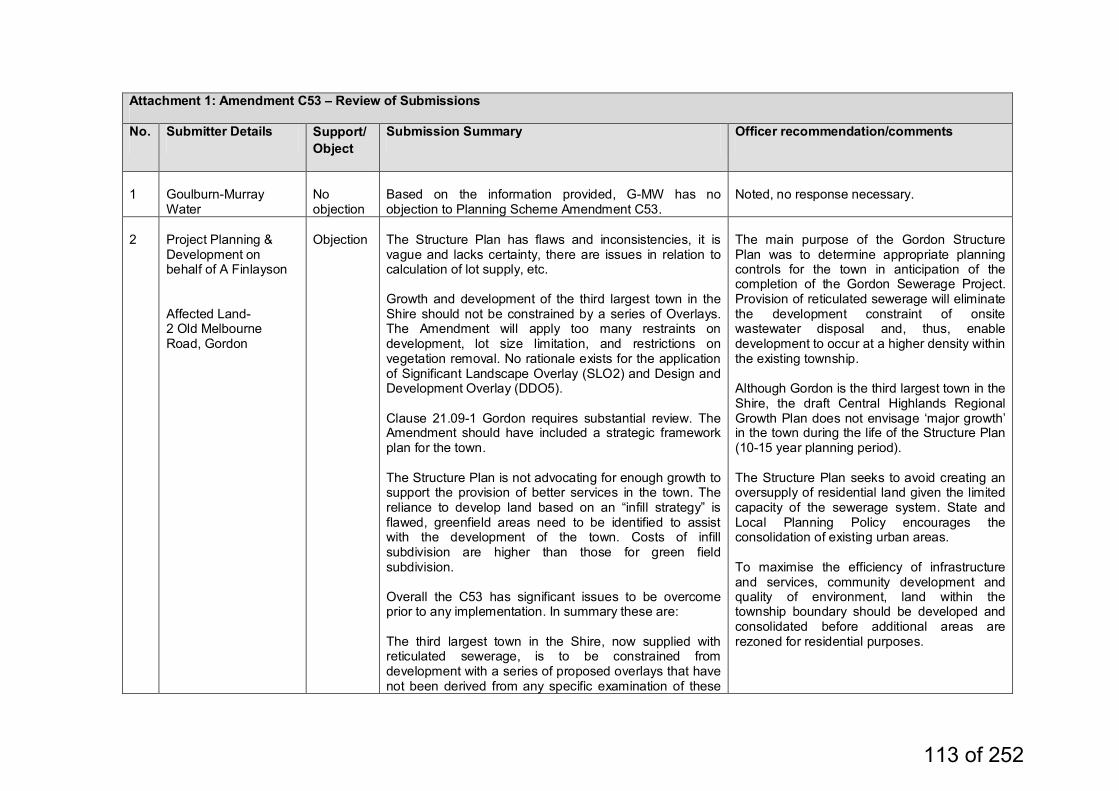
Attachment 1: Amendment C53 – Review of Submissions
No. Submitter Details Support/Object
Submission Summary Officer recommendation/comments
1
Goulburn-Murray Water
No objection
Based on the information provided, G-MW has no objection to Planning Scheme Amendment C53.
Noted, no response necessary.
2
Project Planning & Development on behalf of A Finlayson Affected Land- 2 Old Melbourne Road, Gordon
Objection
The Structure Plan has flaws and inconsistencies, it is vague and lacks certainty, there are issues in relation to calculation of lot supply, etc. Growth and development of the third largest town in the Shire should not be constrained by a series of Overlays. The Amendment will apply too many restraints on development, lot size limitation, and restrictions on vegetation removal. No rationale exists for the application of Significant Landscape Overlay (SLO2) and Design and Development Overlay (DDO5). Clause 21.09-1 Gordon requires substantial review. The Amendment should have included a strategic framework plan for the town. The Structure Plan is not advocating for enough growth to support the provision of better services in the town. The reliance to develop land based on an “infill strategy” is flawed, greenfield areas need to be identified to assist with the development of the town. Costs of infill subdivision are higher than those for green field subdivision. Overall the C53 has significant issues to be overcome prior to any implementation. In summary these are: The third largest town in the Shire, now supplied with reticulated sewerage, is to be constrained from development with a series of proposed overlays that have not been derived from any specific examination of these
The main purpose of the Gordon Structure Plan was to determine appropriate planning controls for the town in anticipation of the completion of the Gordon Sewerage Project. Provision of reticulated sewerage will eliminate the development constraint of onsite wastewater disposal and, thus, enable development to occur at a higher density within the existing township. Although Gordon is the third largest town in the Shire, the draft Central Highlands Regional Growth Plan does not envisage ‘major growth’ in the town during the life of the Structure Plan (10-15 year planning period). The Structure Plan seeks to avoid creating an oversupply of residential land given the limited capacity of the sewerage system. State and Local Planning Policy encourages the consolidation of existing urban areas. To maximise the efficiency of infrastructure and services, community development and quality of environment, land within the township boundary should be developed and consolidated before additional areas are rezoned for residential purposes.
113 of 252
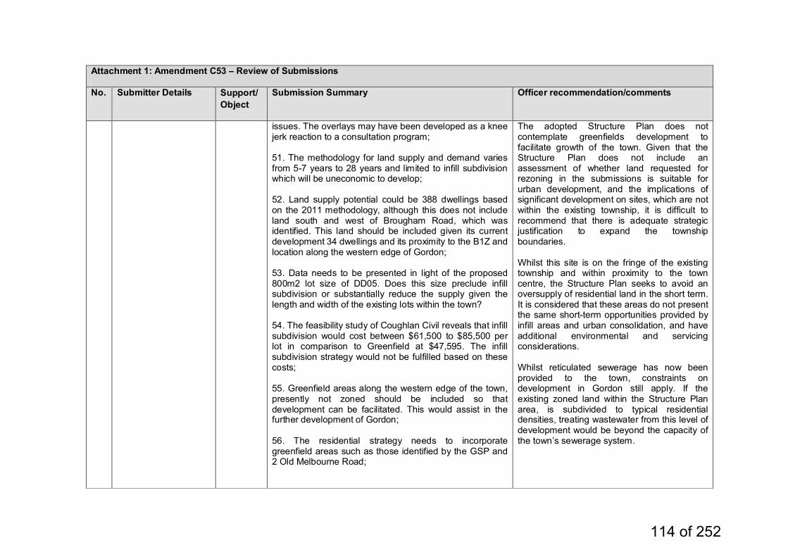
Attachment 1: Amendment C53 – Review of Submissions
No. Submitter Details Support/Object
Submission Summary Officer recommendation/comments
issues. The overlays may have been developed as a knee jerk reaction to a consultation program; 51. The methodology for land supply and demand varies from 5-7 years to 28 years and limited to infill subdivision which will be uneconomic to develop; 52. Land supply potential could be 388 dwellings based on the 2011 methodology, although this does not include land south and west of Brougham Road, which was identified. This land should be included given its current development 34 dwellings and its proximity to the B1Z and location along the western edge of Gordon; 53. Data needs to be presented in light of the proposed 800m2 lot size of DD05. Does this size preclude infill subdivision or substantially reduce the supply given the length and width of the existing lots within the town? 54. The feasibility study of Coughlan Civil reveals that infill subdivision would cost between $61,500 to $85,500 per lot in comparison to Greenfield at $47,595. The infill subdivision strategy would not be fulfilled based on these costs; 55. Greenfield areas along the western edge of the town, presently not zoned should be included so that development can be facilitated. This would assist in the further development of Gordon; 56. The residential strategy needs to incorporate greenfield areas such as those identified by the GSP and 2 Old Melbourne Road;
The adopted Structure Plan does not contemplate greenfields development to facilitate growth of the town. Given that the Structure Plan does not include an assessment of whether land requested for rezoning in the submissions is suitable for urban development, and the implications of significant development on sites, which are not within the existing township, it is difficult to recommend that there is adequate strategic justification to expand the township boundaries. Whilst this site is on the fringe of the existing township and within proximity to the town centre, the Structure Plan seeks to avoid an oversupply of residential land in the short term. It is considered that these areas do not present the same short-term opportunities provided by infill areas and urban consolidation, and have additional environmental and servicing considerations. Whilst reticulated sewerage has now been provided to the town, constraints on development in Gordon still apply. If the existing zoned land within the Structure Plan area, is subdivided to typical residential densities, treating wastewater from this level of development would be beyond the capacity of the town’s sewerage system.
114 of 252
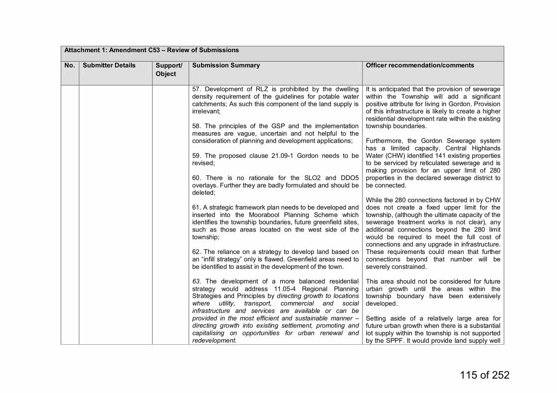
Attachment 1: Amendment C53 – Review of Submissions
No. Submitter Details Support/Object
Submission Summary Officer recommendation/comments
57. Development of RLZ is prohibited by the dwelling density requirement of the guidelines for potable water catchments; As such this component of the land supply is irrelevant; 58. The principles of the GSP and the implementation measures are vague, uncertain and not helpful to the consideration of planning and development applications; 59. The proposed clause 21.09-1 Gordon needs to be revised; 60. There is no rationale for the SLO2 and DDO5 overlays. Further they are badly formulated and should be deleted; 61. A strategic framework plan needs to be developed and inserted into the Moorabool Planning Scheme which identifies the township boundaries, future greenfield sites, such as those areas located on the west side of the township; 62. The reliance on a strategy to develop land based on an “infill strategy” only is flawed. Greenfield areas need to be identified to assist in the development of the town. 63. The development of a more balanced residential strategy would address 11.05-4 Regional Planning Strategies and Principles by directing growth to locations where utility, transport, commercial and social infrastructure and services are available or can be provided in the most efficient and sustainable manner – directing growth into existing settlement, promoting and capitalising on opportunities for urban renewal and redevelopment.
It is anticipated that the provision of sewerage within the Township will add a significant positive attribute for living in Gordon. Provision of this infrastructure is likely to create a higher residential development rate within the existing township boundaries. Furthermore, the Gordon Sewerage system has a limited capacity. Central Highlands Water (CHW) identified 141 existing properties to be serviced by reticulated sewerage and is making provision for an upper limit of 280 properties in the declared sewerage district to be connected. While the 280 connections factored in by CHW does not create a fixed upper limit for the township, (although the ultimate capacity of the sewerage treatment works is not clear), any additional connections beyond the 280 limit would be required to meet the full cost of connections and any upgrade in infrastructure. These requirements could mean that further connections beyond that number will be severely constrained. This area should not be considered for future urban growth until the areas within the township boundary have been extensively developed. Setting aside of a relatively large area for future urban growth when there is a substantial lot supply within the township is not supported by the SPPF. It would provide land supply well
115 of 252
Attachment 1: Amendment C53 – Review of Submissions
No. Submitter Details Support/Object
Submission Summary Officer recommendation/comments
beyond the horizon of the Structure Plan, and is not considered to be orderly and proper planning for the town. Rezoning of land outside the extent of the existing Township Zone at the current time would not allow for appropriate growth of the town from an infrastructure or community service point of view and would not foster township identity or community life. The release of further land for residential development, before existing areas are developed is not sustainable from a community service or infrastructure provision perspective. Any outward urban expansion would erode the generally peaceful village atmosphere by physically increasing the town’s size, increasing activity both pedestrian and vehicular, whilst at the same time seriously affecting the sensitive open landscaped setting of the town’s western edge. The benefits of greenfield development outlined do not outweigh the further substantial costs incurred by Council, in relation to infrastructure provision and servicing (garbage collection, etc.)
116 of 252
Attachment 1: Amendment C53 – Review of Submissions
No. Submitter Details Support/Object
Submission Summary Officer recommendation/comments
The Structure Plan does not preclude long-term growth of the town, if and when, servicing becomes available. However, this issue would need to be considered in a future Structure Plan, which is unlikely to be prepared until the areas within the existing township boundary have been extensively developed. Given the significant implications of the rezoning of greenfield areas and the lack of reference to the land requested for rezoning as short-term development areas in the exhibited amendment, a Panel is unlikely to be able to support the proposition that these landholdings now be identified as short-term development areas. In addition, if the land subject to the submissions had been identified for short-term development in the exhibited amendment and the adopted Structure Plan, Council may have received submissions expressing differing views in relation to this matter. Therefore, changing Amendment C53 to identify greenfields land for short-term development could be considered to constitute a transformation of the amendment by a Planning Panel. The submitter's request for Residential 1 Zone for this area is not supported.
117 of 252
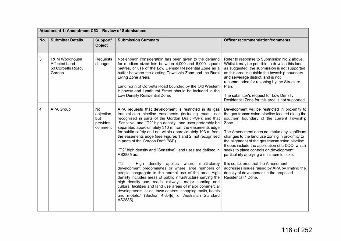
Attachment 1: Amendment C53 – Review of Submissions
No. Submitter Details Support/Object
Submission Summary Officer recommendation/comments
3
I & M Woodhouse Affected Land- 50 Corbetts Road, Gordon
Requests changes.
Not enough consideration has been given to the demand for medium sized lots between 4,000 and 6,000 square metres, or use of the Low Density Residential Zone as a buffer between the existing Township Zone and the Rural Living Zone areas. Land north of Corbetts Road bounded by the Old Western Highway and Lyndhurst Street should be included in the Low Density Residential Zone.
Refer to response to Submission No.2 above. Whilst it may be possible to develop this land as suggested, the submission is not supported as this area is outside the township boundary and sewerage district, and is not recommended for rezoning by the Structure Plan. The submitter's request for Low Density Residential Zone for this area is not supported.
4
APA Group
No objection, but provides comment
APA requests that development is restricted in its gas transmission pipeline easements (including roads; not recognised in parts of the Gordon Draft PSP); and that ‘Sensitive’ and ‘“T2” high density’ land uses preferably be separated approximately 316 m from the easements edge for public safety and not within approximately 193 m from the easements edge (see Figures 1 and 2; not recognised in parts of the Gordon Draft PSP). ‘”T2” high density and “Sensitive”’ land uses are defined in AS2885 as: “T2 – High density applies where multi-storey development predominates or where large numbers of people congregate in the normal use of the area. High density includes areas of public infrastructure serving the high density use; roads, railways, major sporting and cultural facilities and land use areas of major commercial developments; cities, town centres, shopping malls, hotels and motels.” (Section 4.3.4[d] of Australian Standard AS2885).
Development will be restricted in proximity to the gas transmission pipeline located along the southern boundary of the current Township Zone. The Amendment does not make any significant changes to the land use zoning in proximity to the alignment of the gas transmission pipeline. It does include the application of a DDO, which seeks to place controls on development, particularly applying a minimum lot size. It is considered that the Amendment addresses issues raised by APA by limiting the density of development in the proposed Residential 1 Zone.
118 of 252
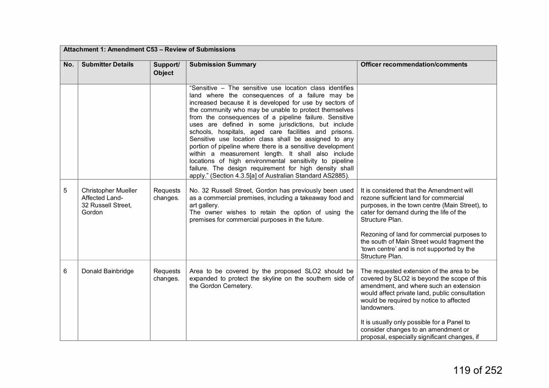
Attachment 1: Amendment C53 – Review of Submissions
No. Submitter Details Support/Object
Submission Summary Officer recommendation/comments
“Sensitive – The sensitive use location class identifies land where the consequences of a failure may be increased because it is developed for use by sectors of the community who may be unable to protect themselves from the consequences of a pipeline failure. Sensitive uses are defined in some jurisdictions, but include schools, hospitals, aged care facilities and prisons. Sensitive use location class shall be assigned to any portion of pipeline where there is a sensitive development within a measurement length. It shall also include locations of high environmental sensitivity to pipeline failure. The design requirement for high density shall apply.” (Section 4.3.5[a] of Australian Standard AS2885).
5
Christopher Mueller Affected Land- 32 Russell Street, Gordon
Requests changes.
No. 32 Russell Street, Gordon has previously been used as a commercial premises, including a takeaway food and art gallery. The owner wishes to retain the option of using the premises for commercial purposes in the future.
It is considered that the Amendment will rezone sufficient land for commercial purposes, in the town centre (Main Street), to cater for demand during the life of the Structure Plan. Rezoning of land for commercial purposes to the south of Main Street would fragment the ‘town centre’ and is not supported by the Structure Plan.
6
Donald Bainbridge
Requests changes.
Area to be covered by the proposed SLO2 should be expanded to protect the skyline on the southern side of the Gordon Cemetery.
The requested extension of the area to be covered by SLO2 is beyond the scope of this amendment, and where such an extension would affect private land, public consultation would be required by notice to affected landowners. It is usually only possible for a Panel to consider changes to an amendment or proposal, especially significant changes, if
119 of 252
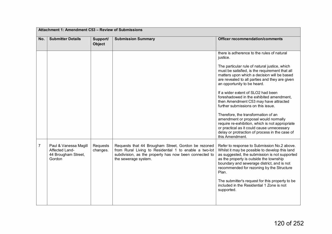
Attachment 1: Amendment C53 – Review of Submissions
No. Submitter Details Support/Object
Submission Summary Officer recommendation/comments
there is adherence to the rules of natural justice. The particular rule of natural justice, which must be satisfied, is the requirement that all matters upon which a decision will be based are revealed to all parties and they are given an opportunity to be heard. If a wider extent of SLO2 had been foreshadowed in the exhibited amendment, then Amendment C53 may have attracted further submissions on this issue. Therefore, the transformation of an amendment or proposal would normally require re-exhibition, which is not appropriate or practical as it could cause unnecessary delay or protraction of process in the case of this Amendment.
7
Paul & Vanessa Magill Affected Land- 44 Brougham Street, Gordon
Requests changes.
Requests that 44 Brougham Street, Gordon be rezoned from Rural Living to Residential 1 to enable a two-lot subdivision, as the property has now been connected to the sewerage system.
Refer to response to Submission No.2 above. Whilst it may be possible to develop this land as suggested, the submission is not supported as the property is outside the township boundary and sewerage district, and is not recommended for rezoning by the Structure Plan. The submitter's request for this property to be included in the Residential 1 Zone is not supported.
120 of 252
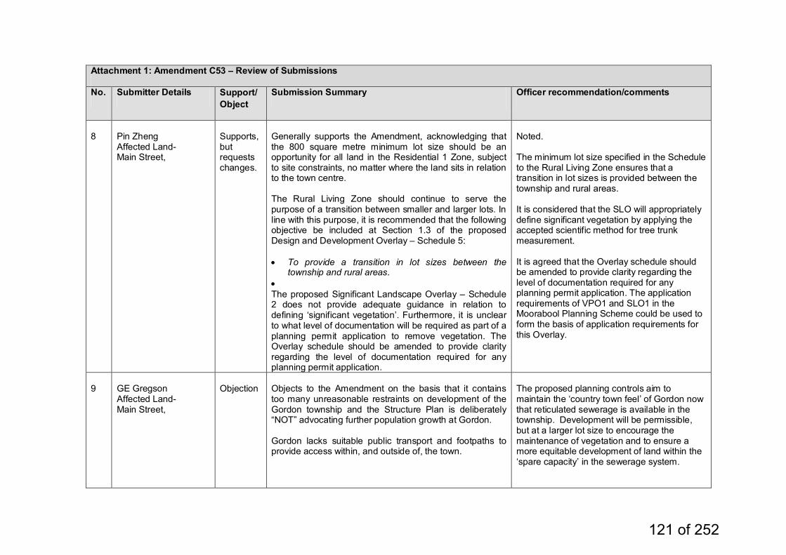
Attachment 1: Amendment C53 – Review of Submissions
No. Submitter Details Support/Object
Submission Summary Officer recommendation/comments
8
Pin Zheng Affected Land- Main Street,
Supports, but requests changes.
Generally supports the Amendment, acknowledging that the 800 square metre minimum lot size should be an opportunity for all land in the Residential 1 Zone, subject to site constraints, no matter where the land sits in relation to the town centre. The Rural Living Zone should continue to serve the purpose of a transition between smaller and larger lots. In line with this purpose, it is recommended that the following objective be included at Section 1.3 of the proposed Design and Development Overlay – Schedule 5: • To provide a transition in lot sizes between the
township and rural areas. • The proposed Significant Landscape Overlay – Schedule 2 does not provide adequate guidance in relation to defining ‘significant vegetation’. Furthermore, it is unclear to what level of documentation will be required as part of a planning permit application to remove vegetation. The Overlay schedule should be amended to provide clarity regarding the level of documentation required for any planning permit application.
Noted. The minimum lot size specified in the Schedule to the Rural Living Zone ensures that a transition in lot sizes is provided between the township and rural areas. It is considered that the SLO will appropriately define significant vegetation by applying the accepted scientific method for tree trunk measurement. It is agreed that the Overlay schedule should be amended to provide clarity regarding the level of documentation required for any planning permit application. The application requirements of VPO1 and SLO1 in the Moorabool Planning Scheme could be used to form the basis of application requirements for this Overlay.
9
GE Gregson Affected Land- Main Street,
Objection
Objects to the Amendment on the basis that it contains too many unreasonable restraints on development of the Gordon township and the Structure Plan is deliberately “NOT” advocating further population growth at Gordon. Gordon lacks suitable public transport and footpaths to provide access within, and outside of, the town.
The proposed planning controls aim to maintain the ‘country town feel’ of Gordon now that reticulated sewerage is available in the township. Development will be permissible, but at a larger lot size to encourage the maintenance of vegetation and to ensure a more equitable development of land within the ‘spare capacity’ in the sewerage system.
121 of 252
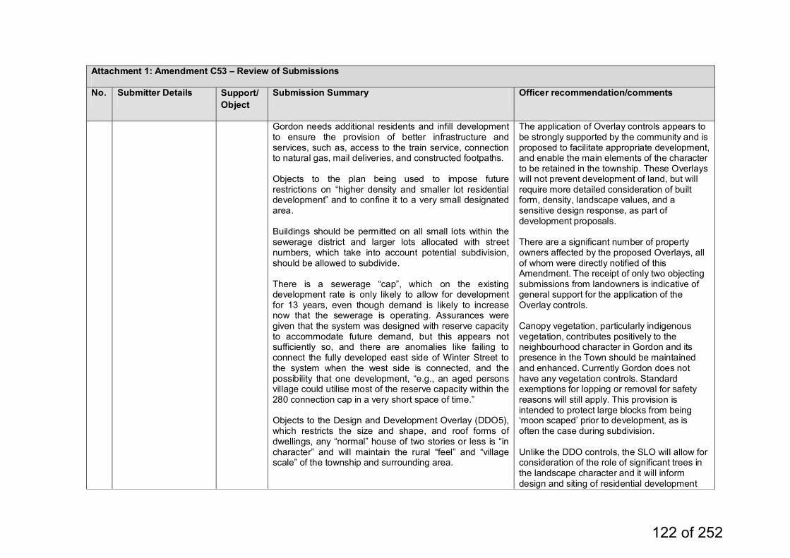
Attachment 1: Amendment C53 – Review of Submissions
No. Submitter Details Support/Object
Submission Summary Officer recommendation/comments
Gordon needs additional residents and infill development to ensure the provision of better infrastructure and services, such as, access to the train service, connection to natural gas, mail deliveries, and constructed footpaths. Objects to the plan being used to impose future restrictions on “higher density and smaller lot residential development” and to confine it to a very small designated area. Buildings should be permitted on all small lots within the sewerage district and larger lots allocated with street numbers, which take into account potential subdivision, should be allowed to subdivide. There is a sewerage “cap”, which on the existing development rate is only likely to allow for development for 13 years, even though demand is likely to increase now that the sewerage is operating. Assurances were given that the system was designed with reserve capacity to accommodate future demand, but this appears not sufficiently so, and there are anomalies like failing to connect the fully developed east side of Winter Street to the system when the west side is connected, and the possibility that one development, “e.g., an aged persons village could utilise most of the reserve capacity within the 280 connection cap in a very short space of time.” Objects to the Design and Development Overlay (DDO5), which restricts the size and shape, and roof forms of dwellings, any “normal” house of two stories or less is “in character” and will maintain the rural “feel” and “village scale” of the township and surrounding area.
The application of Overlay controls appears to be strongly supported by the community and is proposed to facilitate appropriate development, and enable the main elements of the character to be retained in the township. These Overlays will not prevent development of land, but will require more detailed consideration of built form, density, landscape values, and a sensitive design response, as part of development proposals. There are a significant number of property owners affected by the proposed Overlays, all of whom were directly notified of this Amendment. The receipt of only two objecting submissions from landowners is indicative of general support for the application of the Overlay controls. Canopy vegetation, particularly indigenous vegetation, contributes positively to the neighbourhood character in Gordon and its presence in the Town should be maintained and enhanced. Currently Gordon does not have any vegetation controls. Standard exemptions for lopping or removal for safety reasons will still apply. This provision is intended to protect large blocks from being ‘moon scaped’ prior to development, as is often the case during subdivision. Unlike the DDO controls, the SLO will allow for consideration of the role of significant trees in the landscape character and it will inform design and siting of residential development
122 of 252
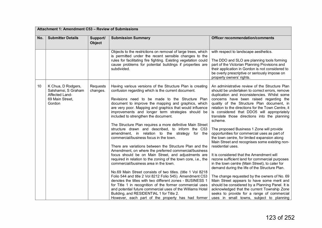
Attachment 1: Amendment C53 – Review of Submissions
No. Submitter Details Support/Object
Submission Summary Officer recommendation/comments
Objects to the restrictions on removal of large trees, which is permitted under the recent sensible changes to the rules for facilitating fire fighting. Existing vegetation could cause problems for potential buildings if properties are subdivided.
with respect to landscape aesthetics. The DDO and SLO are planning tools forming part of the Victorian Planning Provisions and their application in Gordon is not considered to be overly prescriptive or seriously impose on property owners’ rights.
10
K Chua, D Rodgers, Salshamsi, S Graham Affected Land- 69 Main Street, Gordon
Requests changes.
Having various versions of the Structure Plan is creating confusion regarding which is the current document. Revisions need to be made to the Structure Plan document to improve the mapping and graphics, which are very poor. Mapping and graphics that would influence improvements and longer term strategies should be included to strengthen the document. The Structure Plan requires a more definitive Main Street structure drawn and described, to inform the C53 amendment, in relation to the strategy for the commercial/business focus in the town. There are variations between the Structure Plan and the Amendment, on where the preferred commercial/business focus should be on Main Street, and adjustments are required in relation to the zoning of the town core, i.e., the commercial/business area in the town. No.69 Main Street consists of two titles. (title 1 Vol 8218 Folio 544 and title 2 Vol 8212 Folio 545). Amendment C53 denotes the titles with two different zones - BUSINESS 1 for Title 1 in recognition of the former commercial uses and potential future commercial uses of the Williams Hotel Building, and RESIDENTIAL 1 for Title 2. However, each part of the property has had former
An administrative review of the Structure Plan should be undertaken to correct errors, remove duplication and inconsistencies. Whilst some concerns have been raised regarding the quality of the Structure Plan document, in relation to the directions for the Town Centre, it is considered that DDO5 will appropriately translate those directions into the planning scheme. The proposed Business 1 Zone will provide opportunities for commercial uses as part of the town centre, for limited expansion along Main Street and recognises some existing non-residential uses. It is considered that the Amendment will rezone sufficient land for commercial purposes in the town centre (Main Street), to cater for demand during the life of the Structure Plan. The change requested by the owners of No. 69 Main Street appears to have some merit and should be considered by a Planning Panel. It is acknowledged that the current Township Zone seeks to provide for a range of commercial uses in small towns, subject to planning
123 of 252
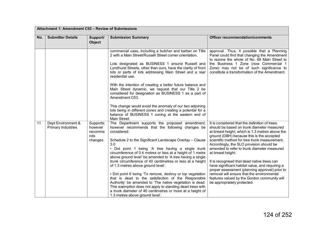
Attachment 1: Amendment C53 – Review of Submissions
No. Submitter Details Support/Object
Submission Summary Officer recommendation/comments
commercial uses, including a butcher and barber on Title 2 with a Main Street/Russell Street corner orientation. Lots designated as BUSINESS 1 around Russell and Lyndhurst Streets, other than ours, have the clarity of front lots or parts of lots addressing Main Street and a rear residential use. With the intention of creating a better future balance and Main Street dynamic, we request that our Title 2 be considered for designation as BUSINESS 1 as a part of Amendment C53. This change would avoid the anomaly of our two adjoining lots being in different zones and creating a potential for a balance of BUSINESS 1 zoning at the eastern end of Main Street.
approval. Thus, it possible that a Planning Panel could find that changing the Amendment to rezone the whole of No. 69 Main Street to the Business 1 Zone (now Commercial 1 Zone) may not be of such significance to constitute a transformation of the Amendment.
11 Dept Environment & Primary Industries
Supports; however recommends changes
The Department supports the proposed amendment; however recommends that the following changes be considered: Schedule 2 to the Significant Landscape Overlay – Clause 3.0 • Dot point 1 being ‘A tree having a single trunk circumference of 0.4 metres or less at a height of 1 metre above ground level’ be amended to ‘A tree having a single trunk circumference of 40 centimetres or less at a height of 1.3 metres above ground level’. • Dot point 6 being ‘To remove, destroy or lop vegetation that is dead to the satisfaction of the Responsible Authority’ be amended to ‘The native vegetation is dead. This exemption does not apply to standing dead trees with a trunk diameter of 40 centimetres or more at a height of 1.3 metres above ground level’.
It is considered that the definition of trees should be based on trunk diameter measured at breast height, which is 1.3 metres above the ground (DBH) because this is the accepted scientific method for tree trunk measurement. Accordingly, the SLO provision should be amended to refer to trunk diameter measured at breast height. It is recognised that dead native trees can have significant habitat value, and requiring a proper assessment (planning approval) prior to removal will ensure that the environmental features valued by the Gordon community will be appropriately protected.
124 of 252
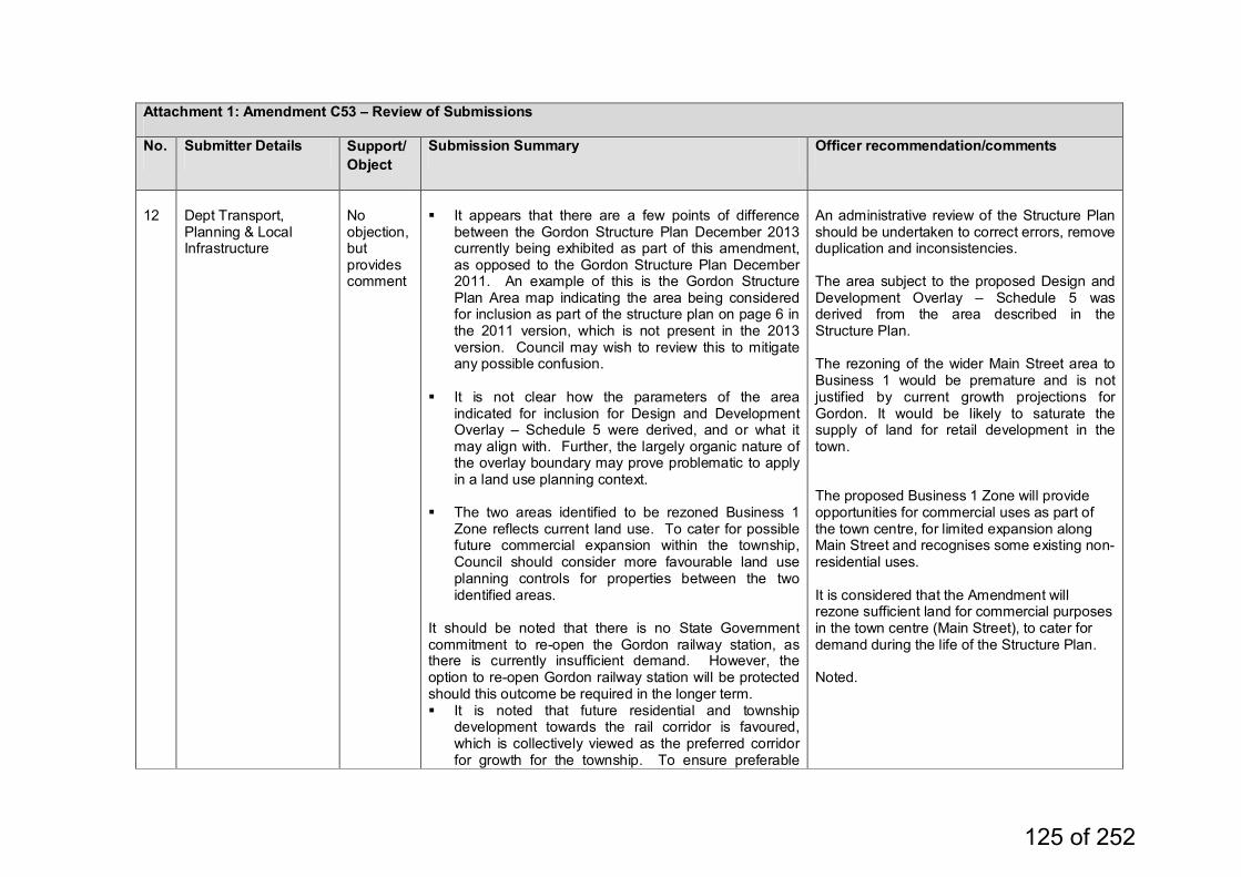
Attachment 1: Amendment C53 – Review of Submissions
No. Submitter Details Support/Object
Submission Summary Officer recommendation/comments
12
Dept Transport, Planning & Local Infrastructure
No objection, but provides comment
It appears that there are a few points of difference
between the Gordon Structure Plan December 2013 currently being exhibited as part of this amendment, as opposed to the Gordon Structure Plan December 2011. An example of this is the Gordon Structure Plan Area map indicating the area being considered for inclusion as part of the structure plan on page 6 in the 2011 version, which is not present in the 2013 version. Council may wish to review this to mitigate any possible confusion.
It is not clear how the parameters of the area indicated for inclusion for Design and Development Overlay – Schedule 5 were derived, and or what it may align with. Further, the largely organic nature of the overlay boundary may prove problematic to apply in a land use planning context.
The two areas identified to be rezoned Business 1 Zone reflects current land use. To cater for possible future commercial expansion within the township, Council should consider more favourable land use planning controls for properties between the two identified areas.
It should be noted that there is no State Government commitment to re-open the Gordon railway station, as there is currently insufficient demand. However, the option to re-open Gordon railway station will be protected should this outcome be required in the longer term. It is noted that future residential and township
development towards the rail corridor is favoured, which is collectively viewed as the preferred corridor for growth for the township. To ensure preferable
An administrative review of the Structure Plan should be undertaken to correct errors, remove duplication and inconsistencies. The area subject to the proposed Design and Development Overlay – Schedule 5 was derived from the area described in the Structure Plan. The rezoning of the wider Main Street area to Business 1 would be premature and is not justified by current growth projections for Gordon. It would be likely to saturate the supply of land for retail development in the town. The proposed Business 1 Zone will provide opportunities for commercial uses as part of the town centre, for limited expansion along Main Street and recognises some existing non-residential uses. It is considered that the Amendment will rezone sufficient land for commercial purposes in the town centre (Main Street), to cater for demand during the life of the Structure Plan. Noted.
125 of 252
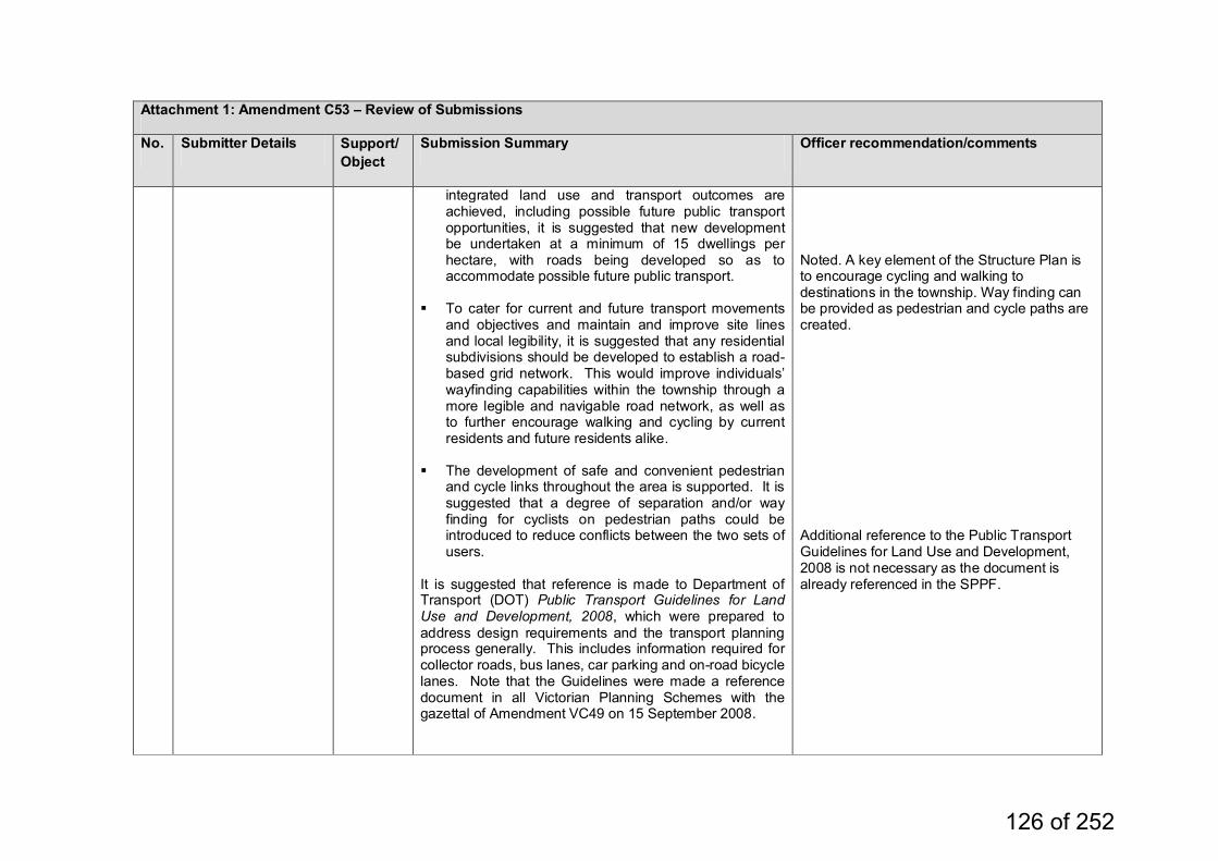
Attachment 1: Amendment C53 – Review of Submissions
No. Submitter Details Support/Object
Submission Summary Officer recommendation/comments
integrated land use and transport outcomes are achieved, including possible future public transport opportunities, it is suggested that new development be undertaken at a minimum of 15 dwellings per hectare, with roads being developed so as to accommodate possible future public transport.
To cater for current and future transport movements and objectives and maintain and improve site lines and local legibility, it is suggested that any residential subdivisions should be developed to establish a road-based grid network. This would improve individuals’ wayfinding capabilities within the township through a more legible and navigable road network, as well as to further encourage walking and cycling by current residents and future residents alike.
The development of safe and convenient pedestrian
and cycle links throughout the area is supported. It is suggested that a degree of separation and/or way finding for cyclists on pedestrian paths could be introduced to reduce conflicts between the two sets of users.
It is suggested that reference is made to Department of Transport (DOT) Public Transport Guidelines for Land Use and Development, 2008, which were prepared to address design requirements and the transport planning process generally. This includes information required for collector roads, bus lanes, car parking and on-road bicycle lanes. Note that the Guidelines were made a reference document in all Victorian Planning Schemes with the gazettal of Amendment VC49 on 15 September 2008.
Noted. A key element of the Structure Plan is to encourage cycling and walking to destinations in the township. Way finding can be provided as pedestrian and cycle paths are created. Additional reference to the Public Transport Guidelines for Land Use and Development, 2008 is not necessary as the document is already referenced in the SPPF.
126 of 252
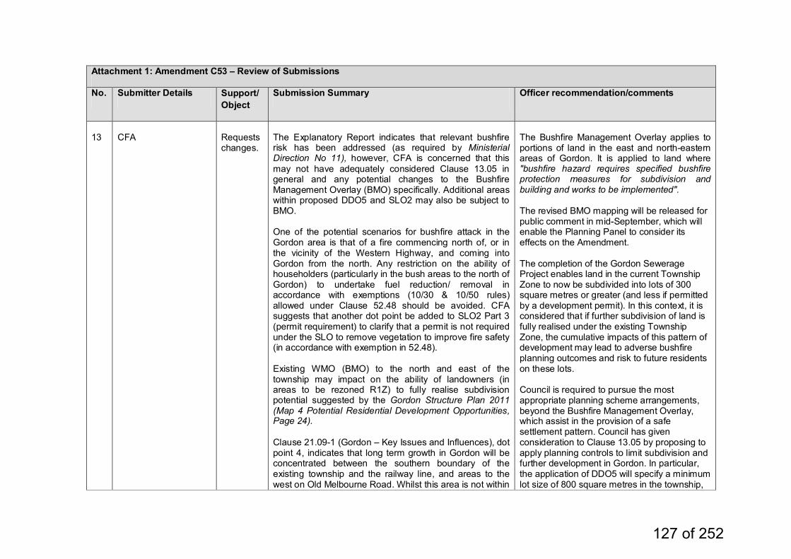
Attachment 1: Amendment C53 – Review of Submissions
No. Submitter Details Support/Object
Submission Summary Officer recommendation/comments
13
CFA
Requests changes.
The Explanatory Report indicates that relevant bushfire risk has been addressed (as required by Ministerial Direction No 11), however, CFA is concerned that this may not have adequately considered Clause 13.05 in general and any potential changes to the Bushfire Management Overlay (BMO) specifically. Additional areas within proposed DDO5 and SLO2 may also be subject to BMO. One of the potential scenarios for bushfire attack in the Gordon area is that of a fire commencing north of, or in the vicinity of the Western Highway, and coming into Gordon from the north. Any restriction on the ability of householders (particularly in the bush areas to the north of Gordon) to undertake fuel reduction/ removal in accordance with exemptions (10/30 & 10/50 rules) allowed under Clause 52.48 should be avoided. CFA suggests that another dot point be added to SLO2 Part 3 (permit requirement) to clarify that a permit is not required under the SLO to remove vegetation to improve fire safety (in accordance with exemption in 52.48). Existing WMO (BMO) to the north and east of the township may impact on the ability of landowners (in areas to be rezoned R1Z) to fully realise subdivision potential suggested by the Gordon Structure Plan 2011 (Map 4 Potential Residential Development Opportunities, Page 24). Clause 21.09-1 (Gordon – Key Issues and Influences), dot point 4, indicates that long term growth in Gordon will be concentrated between the southern boundary of the existing township and the railway line, and areas to the west on Old Melbourne Road. Whilst this area is not within
The Bushfire Management Overlay applies to portions of land in the east and north-eastern areas of Gordon. It is applied to land where "bushfire hazard requires specified bushfire protection measures for subdivision and building and works to be implemented". The revised BMO mapping will be released for public comment in mid-September, which will enable the Planning Panel to consider its effects on the Amendment. The completion of the Gordon Sewerage Project enables land in the current Township Zone to now be subdivided into lots of 300 square metres or greater (and less if permitted by a development permit). In this context, it is considered that if further subdivision of land is fully realised under the existing Township Zone, the cumulative impacts of this pattern of development may lead to adverse bushfire planning outcomes and risk to future residents on these lots. Council is required to pursue the most appropriate planning scheme arrangements, beyond the Bushfire Management Overlay, which assist in the provision of a safe settlement pattern. Council has given consideration to Clause 13.05 by proposing to apply planning controls to limit subdivision and further development in Gordon. In particular, the application of DDO5 will specify a minimum lot size of 800 square metres in the township,
127 of 252

Attachment 1: Amendment C53 – Review of Submissions
No. Submitter Details Support/Object
Submission Summary Officer recommendation/comments
the current BMO (WMO), parts of this area could be included in future amendments to the BMO. CFA suggests that another dot point relating to the potential bushfire risk around the township (north, east and south) be added to the Key Issues and Influences.
thus limiting the density of residential development. Amendment VC83 has relaxed the vegetation clearing controls around accommodation buildings within areas affected by the BMO, to assist in achieving State objectives for the protection of life and property from bushfires. It should be noted that the proposed Significant Landscape Overlay 2 (SLO2) only regulates the removal of large trees and exempts the clearing of vegetation with higher fuel loads, such as, understorey vegetation, smaller shrubs, etc. In relation to the SLO and the need to obtain a permit to remove vegetation, it is considered that the requirement should remain to enable the impact of the potential loss of substantial trees on the landscape character of the Town to be assessed. In the area now covered by the BMO, the 10/50 metre rule applies via Clause 52.48. Landowners can clear vegetation within the prescriptions of Clause 52.48 without a planning permit, but they are not compelled to undertake clearing. In the BMO area, the 10/50 provisions of Clause 52.48 will override the vegetation protection provisions of the SLO2 where clearing is undertaken for bushfire protection, effectively rendering the SLO provisions null
128 of 252
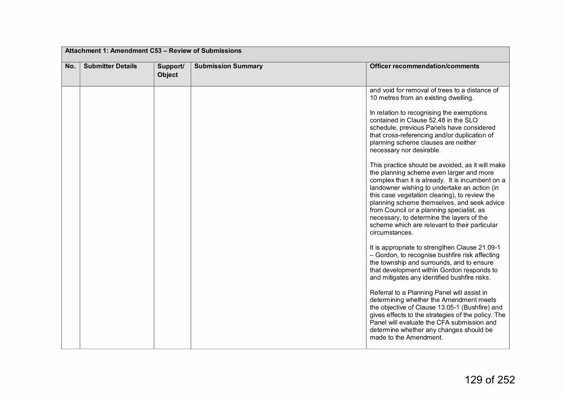
Attachment 1: Amendment C53 – Review of Submissions
No. Submitter Details Support/Object
Submission Summary Officer recommendation/comments
and void for removal of trees to a distance of 10 metres from an existing dwelling. In relation to recognising the exemptions contained in Clause 52.48 in the SLO schedule, previous Panels have considered that cross-referencing and/or duplication of planning scheme clauses are neither necessary nor desirable. This practice should be avoided, as it will make the planning scheme even larger and more complex than it is already. It is incumbent on a landowner wishing to undertake an action (in this case vegetation clearing), to review the planning scheme themselves, and seek advice from Council or a planning specialist, as necessary, to determine the layers of the scheme which are relevant to their particular circumstances. It is appropriate to strengthen Clause 21.09-1 – Gordon, to recognise bushfire risk affecting the township and surrounds, and to ensure that development within Gordon responds to and mitigates any identified bushfire risks. Referral to a Planning Panel will assist in determining whether the Amendment meets the objective of Clause 13.05-1 (Bushfire) and gives effects to the strategies of the policy. The Panel will evaluate the CFA submission and determine whether any changes should be made to the Amendment.
129 of 252
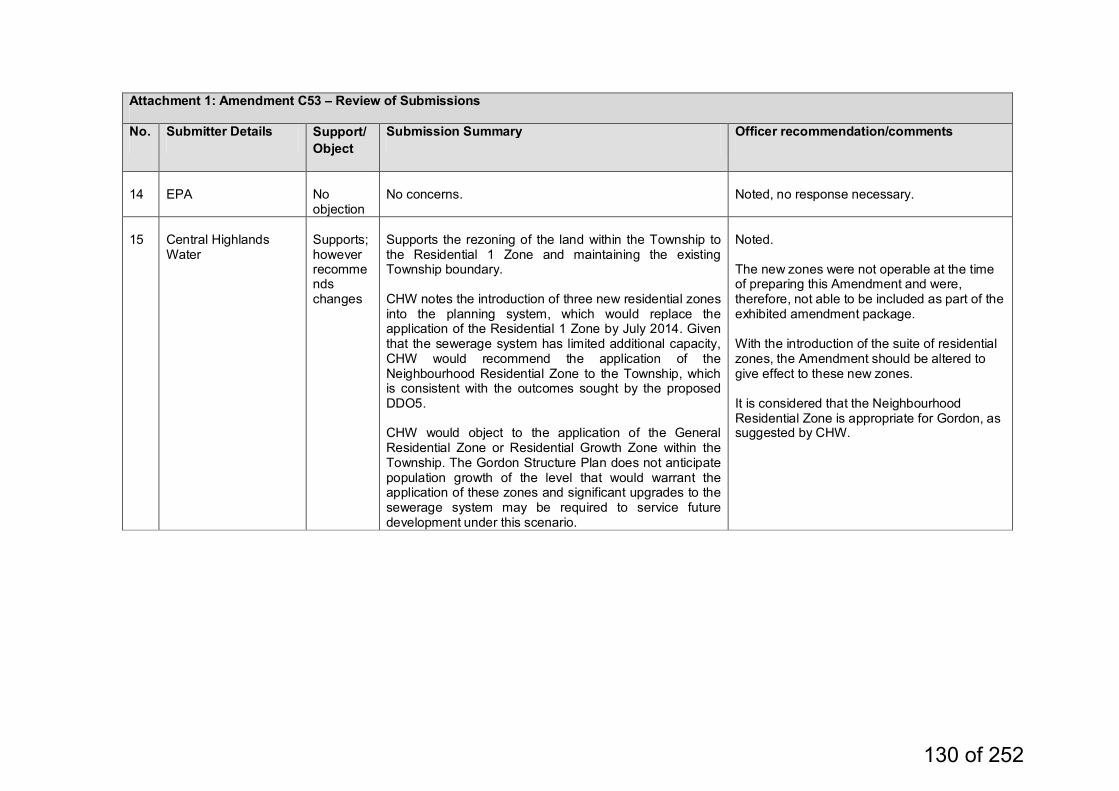
Attachment 1: Amendment C53 – Review of Submissions
No. Submitter Details Support/Object
Submission Summary Officer recommendation/comments
14
EPA
No objection
No concerns.
Noted, no response necessary.
15
Central Highlands Water
Supports; however recommends changes
Supports the rezoning of the land within the Township to the Residential 1 Zone and maintaining the existing Township boundary. CHW notes the introduction of three new residential zones into the planning system, which would replace the application of the Residential 1 Zone by July 2014. Given that the sewerage system has limited additional capacity, CHW would recommend the application of the Neighbourhood Residential Zone to the Township, which is consistent with the outcomes sought by the proposed DDO5. CHW would object to the application of the General Residential Zone or Residential Growth Zone within the Township. The Gordon Structure Plan does not anticipate population growth of the level that would warrant the application of these zones and significant upgrades to the sewerage system may be required to service future development under this scenario.
Noted. The new zones were not operable at the time of preparing this Amendment and were, therefore, not able to be included as part of the exhibited amendment package. With the introduction of the suite of residential zones, the Amendment should be altered to give effect to these new zones. It is considered that the Neighbourhood Residential Zone is appropriate for Gordon, as suggested by CHW.
130 of 252
Agenda - Moorabool Shire Ordinary Meeting of Council Wednesday 18 September, 2013
OMC - 18/09/2013 09/13
11.2.5 Amendment C51 – Bacchus Marsh Activity Centre Structure Plan Introduction File No.: 13/06/058 Author: Damien Drew General Manager: Satwinder Sandhu Background Amendment C51 is a Council-initiated amendment to give effect to the provisions of the Bacchus Marsh Activity Centre Structure Plan 2011. The purpose of the Structure Plan is to: “reflect the needs and aspirations of the community and reinforce Bacchus Marsh as a preferred location for activity with a suitable mix of commercial, retail, community and recreational activities to meet needs locally, reduce the town’s escape expenditure and increase local employment opportunities.” At its Ordinary Meeting held on 7 December 2011, Council resolved to adopt the Structure Plan and to seek authorisation from the Minister for Planning to prepare and exhibit a planning scheme amendment (C51) for the purpose of implementing the recommendations of the Bacchus Marsh Activity Centre Structure Plan 2011. On 31 January, 2012, Council wrote to the Minister for Planning requesting authorisation to prepare and exhibit an amendment to the Moorabool Planning Scheme. Consequently, the Minister for Planning authorised the preparation and exhibition of Amendment C51 on 16 February, 2012. The authorisation required that consultation occur with the regional office of the Department of Planning and Community Development in the preparation of the amendment, including the proposed planning provisions, prior to exhibition. Internal reviews and consultation occurred through the period from 7 February, 2012, and on 19 February 2013, the Minister for Planning extended the Authorisation A02186 granted to Council to prepare the planning scheme amendment C51 to the Moorabool Planning Scheme. Amendment C53 seeks to: The amendment proposes three actions, namely: to introduce eight (8) Design and Development Overlays to the
Moorabool Planning Scheme to rezone one area of land in Taverner Street which is currently
zoned Farming to Residential 1 to apply a Development Plan Overlay to the above land.
All permit applications would be required to be assessed against the character definition, and how the development responds to maintaining and enhancing the country town character, as this is included in all overlays derived from the structure plan.
131 of 252
Agenda - Moorabool Shire Ordinary Meeting of Council Wednesday 18 September, 2013
OMC - 18/09/2013 09/13
Amendment C51 was placed on public exhibition between 30 May and 28 June 2013, including notices in local papers and individual letters to all affected property owners. On 3 July, Council resolved to accept late submissions for Amendment C51 Bacchus Marsh Activity Centre Structure Plan up to 24 July 2013, a period of three (3) weeks to enable ratepayers and residents to complete submissions to the plan. A total of 17 submissions were received in response to the amendment, six (6) during the formal public exhibition period, and eleven (11) late submissions. The submissions included, nine (9) of opposition, three (3) offering no objection but making comment, one (1) offering support in principle but requesting alterations/changes, and four (4) indicating support for, or no objection to, the Amendment. The submissions cover a wide range of issues. The key issues include: • Role of the Structure Plan • Main Street Precinct, including the Civic Precinct • Proposed Greenway • The area identified as the ‘Taverner Development Area’ • New Zones In accordance with the Planning and Environment Act 1987, Council must now either change the Amendment in the manner requested by the submissions, refer submissions to an Independent Panel appointed by the Minister for Planning, or abandon the Amendment or part of the Amendment. This report considers submissions received in relation to the Amendment and recommends that all submissions be referred to an Independent Panel for consideration. Proposal The Growing Moorabool, Economic Development Strategy and Action Plan recommends that Council prepare a Structure Plan for a concentrated centre of activity in the core of Bacchus Marsh which includes extra retail, offices, service industries, medical and professional suites and a range of residential offerings. Council's Municipal Strategic Statement (MSS) identifies the opportunities for consolidated activity in the town centre as follows: "Central Bacchus Marsh has potential to establish a best practice example of transport- oriented Activity Centre planning. Significantly-sized parcels of land between the railway station and Main Street and between Fisken and Grant Streets provide opportunity for planned residential and mixed-use urban development".
132 of 252
Agenda - Moorabool Shire Ordinary Meeting of Council Wednesday 18 September, 2013
OMC - 18/09/2013 09/13
Moorabool Shire Council’s Municipal Strategic Statement (MSS) identifies further strategic work relating specifically to Bacchus Marsh. This further strategic work includes:
Prepare and adopt a Local Area Structure Plan for the land between the railway station and Main Street and between Fisken and Grant Streets as shown in the Growing Moorabool Economic Development Strategy.
The finalisation of the Bacchus Marsh Activity Centre Structure Plan completes this further work identified in the MSS. The aim of the project was to prepare a structure plan, which reflects the needs and aspirations of the community and provides a clear framework for the detailed development planning at precinct level. This structure plan seeks to reinforce the Bacchus Marsh town centre as the preferred location for consolidated development with a suitable mix of commercial, retail, community and recreational activities to reduce the town's escape expenditure, create a critical mass of activity, and increase local employment opportunities. The plan is concerned with the core of Bacchus Marsh – focussing on the land between Parwan Road (the Geelong – Bacchus Marsh Road) to the south, Bennett Street to the north, and the western extent of the study area generally follows Grant Street, but incorporates the hospital environs. Fisken Street forms the eastern boundary of the study area. In formulating the Plan, fifteen (15) objectives were identified: 1. To consolidate a mix of land use activities within the Bacchus Marsh
Central Activity Centre. 2. To provide a variety of housing in and around the Activity Centre to
accommodate some of the future population growth in a managed and sustainable manner.
3. To accommodate the existing and future needs of the Bacchus Marsh community through the provision of appropriate and accessible community and civic services.
4. To ensure that new development is of an appropriate scale and form that has regard to the prevailing built form character and structure of Bacchus Marsh and creates highly active and vibrant streets.
5. Where appropriate, conserve the sites of identified architectural and cultural significance.
6. To improve access and mobility for all through enhancing and integrating new development with the existing grid-based street network.
7. To create a more sustainable Bacchus Marsh. 8. To reinforce the commercial hub role of Main Street through
intensification of a mix of retail, commercial and leisure related uses within a walkable environment.
9. Continue to encourage the Activity Centre as the focus for employment and commercial development.
10. To strengthen Grant Street as the secondary activity core of the Activity Centre and the secondary location for complementary commercial/and uses.
133 of 252
Agenda - Moorabool Shire Ordinary Meeting of Council Wednesday 18 September, 2013
OMC - 18/09/2013 09/13
11. To promote safe walking and cycling access to and through the Activity Centre.
12. To promote efficient traffic movement and minimise potential conflicts. 13. To facilitate better connections to public transport within the Activity
Centre. 14. To maximise the efficiency of existing vehicular access and car
parking facilities to supplement sustainable transport to and through the centre; and
15. To create a network of safe, interesting and pleasant spaces throughout the Activity Centre and the surrounding neighbourhood.
Several new Design and Development Overlays have been proposed to be applied to the Activity Centre and surrounds. These Overlays seek to guide design and built form of new development to achieve the objectives identified within the Structure Plan. The proposed overlays contain design objectives, which seek to maintain and enhance the ‘country town’ character of Bacchus Marsh. Within the structure plan, this character is described as follows: “The 'country town character' of Bacchus Marsh is highly valued by the local community, in particular the features that distinguish Bacchus Marsh from the more suburban character of other peri urban settlements. Landscape character and built form are key contributors to this character. Main Street and environs are a focus for a wide range of community activities and have a disproportionate effect on the townships character by virtue of their high profile for locals and visitors. The significant features of Main Street's character include buildings predominantly one to two storeys in height with verandahs along shop frontages. Civic buildings are setback from the edge of the public building and/or are distinctive by virtue of scale or design, whereas commercial buildings are built to the front boundary. Newer buildings are interspersed with heritage buildings and framed by established trees. Signage is mixed in style and size. Residential development makes up a large proportion of land use within and surrounding the Activity Centre. In relation to character, the trees and vegetation found within reserves, streets and gardens and the resulting predominantly green skyline make a significant contribution to the town's identity. In terms of built form, key features of the BM country town character are: • A prevailing pattern of low front fences; • Verandahs fronting primary frontage; • Relatively narrow crossovers; • Significant, landscaped front and side setbacks within the established
built up area; and • Garages [which are] recessive (i.e., do not dominate house
frontages).”
134 of 252
Agenda - Moorabool Shire Ordinary Meeting of Council Wednesday 18 September, 2013
OMC - 18/09/2013 09/13
Other characteristics that contribute to this country town character in existing buildings include comparatively narrow frontages to buildings, predominantly vertical emphasis of windows, use of eaves and use of render, brick or weatherboard as building materials. The proposed Structure Plan should have the overall effect of: • Reinforcing the centre as the ‘heart’ of the town focused around a
focal point ‘Town square’ and creating a vibrant centre; • Reducing car speeds; • Encouraging active transport i.e. walking, riding bikes etc.; • Reducing car dependence for local short journeys; • Making the town centre safer through an increase in activity, social
interaction and passive surveillance, and providing a more pedestrian friendly environment;
• Making the main street more attractive through landscaping, widening footpaths and other treatments, such as, shelter, shade, art and seating options;
• Providing additional spaces for people to rest, play, meet, spend time and hold special events.
The Amendment
Amendment C51 was subsequently prepared and included the implementation of the recommendations of the Bacchus Marsh Activity Centre Structure Plan 2011 by: - amending the Municipal Strategic Statement (clause 21.07 Bacchus
Marsh) to align the objectives and strategies with the recommendations of the Structure Plan.
- inserting a local policy that provides direction relating to the objectives and policies relating to the Activity Centre.
- inserting the Bacchus Marsh Activity Centre Structure Plan into clause 21.11 as a reference document.
- incorporating eight (8) new Design and Development Overlays in the Moorabool Planning Scheme, which introduce specific built form and urban design requirements to ensure that new development respects the prevailing character of the town.
- rezoning the area of land known as the ‘Taverner Street Development Area’, which is currently zoned Farming to Residential 1.
- applying a Development Plan Overlay (DPO4) and Environmental Audit Overlay (EAO) to the Taverner Street Development Area.
- applying a Development Plan Overlay (DPO5) over the land described as ‘The Greenway’ within the Bacchus Marsh Activity Centre Structure Plan.
Public Exhibition Process
Amendment C53 was exhibited in accordance with the provisions of the Planning and Environment Act 1987 between 6 June, 2013 and 5 July, 2013. Notice was provided to all relevant Government Departments, Statutory Authorities and affected landowners and occupiers. Notices were placed in the Moorabool News, Council’s web site, Government Gazette and the Moorabool Matters publications.
135 of 252
Agenda - Moorabool Shire Ordinary Meeting of Council Wednesday 18 September, 2013
OMC - 18/09/2013 09/13
During the public exhibition period, Council officers met with a number of affected landowners. A total of 17 submissions, including eleven (11) late submissions, were received in response to Amendment C51, of which nine (9) are objections, three (3) offer no objection but make comment, one (1) offers support in principle but requests alterations/changes, and four (4) indicate support for, or no objection to, the Amendment. The relatively low number of submissions is indicative of a degree of community acceptance of Council’s strategic directions for the activity centre and surrounds. Submission Review Under the Section 23 of the Act, the Council is required to consider all submissions made to an Amendment and must: (a) change the amendment in the manner requested; or (b) refer the submission to a panel appointed under Part 8; or (c) abandon the amendment or part of the amendment. Submissions not supporting the amendment primarily related to: • Role of the Structure Plan • Main Street Precinct, including the Civic Precinct • Proposed Greenway • The area identified as the ‘Taverner Development Area • New Zones The table at Attachment 1: Amendment C53 – Review of Submissions outlines the property specific issues raised in the submissions and provides the officer response. In the event these submissions are referred to an Independent Planning Panel appointed by the Minister for Planning, as recommended, these responses will be the basis for Council’s presentation to the Panel. Role of the Activity Centre Structure Plan The Structure Plan has been prepared to address State and Local planning policies, which are directed towards concentration of retail and commercial premises into activity centres accessible to the community to meet the community's retail needs. The thrust of the State policy is to consolidate existing centres and to enhance the retail role of those centres. Significant weight of both State and Local planning policy provide support for the preparation of Structure Plans generally, and specifically the Bacchus Marsh Activity Centre. Structure planning processes for activity centres, more of which are existing rather than new or proposed centres, are often undertaken with the zoning regime in place. The Structure Plan gives consideration to future demand for retail and related services, however, it is not rigid or prescriptive in relation to land use within the Activity Centre and it does not change land use zoning in the Activity Centre.
136 of 252
Agenda - Moorabool Shire Ordinary Meeting of Council Wednesday 18 September, 2013
OMC - 18/09/2013 09/13
One of the objectives of the Structure Plan is: “To ensure that new development is of an appropriate scale and form that has regard to the prevailing built form character and structure of Bacchus Marsh and creates highly active and vibrant streets.” It is considered that the Amendment makes proper use of the Victoria Planning Provisions (VPP) and reflects a contemporary approach to the form and structure of local planning provisions by expressing building design requirements through Design and Development Overlay controls, rather than local planning policies. It includes changes to the LPPF to address matters which cannot be appropriately dealt with through zone or overlay controls. The Design and Development Overlay is the appropriate VPP tool to manage built form, siting, landscaping and other site-specific development considerations to ensure that new development contributes positively to local urban character. However, the DDO can only specify requirements in relation to development, not use, and cannot change the intent of the zone, which applies, to the land concerned. Therefore, it is beyond the scope of the Amendment to incorporate controls over land use, i.e., change land use zoning in the Activity Centre. Main Street Precinct, including the Civic Precinct DDO11 seeks to encourage a superior built form, which reflects the role of the Main Street as the commercial hub of Bacchus Marsh. Development should provide for an inviting and pedestrian friendly public realm with street activity and provide for a high quality contemporary architectural design, which responds to the uniqueness of Main Street. To achieve this, the overlay seeks to implement design objectives, which aim to: • Encourage contemporary design, which respects the prevailing
country town character. • Create a visual consistency in the precinct with standard wall height. • Ensure that new development respects and sensitively designed to
respond to surrounding development which is architectural/cultural significant.
• Improve pedestrian access within the precinct and provide bicycle parking.
• Encourage landscaping opportunities within the public realm. • Minimise the visual intrusion of car parking facilities through locating
facilities at the rear of shops or in a basement, and ensure that vehicle traffic does not compromise a good walking and cycling environment.
In addition, the overlay specifies building and work requirements, and seeks to limit building height to 7.5 metres and ensure that buildings have an attractive street frontage, which has a positive impact on the public realm. Additional storeys may be possible where they are entirely below the line of visibility of somebody standing within Main Street. The Overlay seeks to incorporate a framework of verandahs, which would define the precinct.
137 of 252
Agenda - Moorabool Shire Ordinary Meeting of Council Wednesday 18 September, 2013
OMC - 18/09/2013 09/13
The Civic Precinct redevelopment is likely to incorporate a range of community, civic, retail and commercial uses. Whilst submitters are concerned about a major retail development in the Civic Precinct, there is a larger undeveloped landholding within Commercial 1 Zone south of Main Street, which is likely to be more suitable for a large retail development. Amendment C51 does not propose to back zone the land south of Main Street. It would be anti-competitive practice to exclude major retail facilities from being developed on land already within the Commercial 1 Zone. It is not the purpose of the Amendment to regulate ownership of land in the activity centre or to apply separate DDOs to the activity centre based upon land ownership. The Civic Precinct is part of the activity centre, thus it is not necessary to introduce a separate Schedule for this area. Single DDOs have been applied to other activity centres, such as, Drouin and Warragul, so it is not mandatory that separate Schedules are required for parts of the Bacchus Marsh Activity Centre. As a reference document, the Structure Plan will have a limited role in the decision‐making process, as it will not be part of the planning scheme (Incorporated and Reference documents Practice Note). It will however, support the DDO11 by providing useful background information to assist in the detailed planning of individual sites, including the Civic Precinct site, and areas at the fringe of the Town Centre that have been earmarked for change in the Structure Plan. Proposed Greenway Land to the south of Main Street presents one of the most significant opportunities for the future development of the town centre. Given the critical location of the holdings and the location relative to the balance of the town centre, it is imperative that the development of this land is undertaken based on an overall master plan for the site, which seeks to complement and integrate with the balance of the town centre. It is crucial that the site not be developed as a stand‐alone entity, which ‘turns its back’ on the balance of the town centre, as its location between the existing activity centre and the railway station presents a significant opportunity. The Structure Plan document provides the strategic direction necessary to progress the more detailed planning of sites within the Bacchus Marsh Activity Centre and Station Precinct. In recognising the opportunities presented by the Provenzano site for retailing, including large format retailing, these opportunities should be achieved in a manner, which integrates the site into the existing Town Centre. The Greenway is an integral component of the Structure Plan. It is intended to be a new high quality, high amenity pedestrian and cycle link connecting Main Street and the railway station, the two major nodes of activity within the Bacchus Marsh Activity Centre.
138 of 252
Agenda - Moorabool Shire Ordinary Meeting of Council Wednesday 18 September, 2013
OMC - 18/09/2013 09/13
The vision seeks to build upon the country town character and environment with very high pedestrian and cyclist amenity, and provision of safety is an important element. A wide road reserve with new vegetation is a further component of the Greenway concept. It is anticipated that the Greenway will be created as part of the development process for vacant land south of Main Street. Development of this land will require the creation of internal access roads connecting to existing roads, in particular, Waddell Street and Pilmer Street, and possibly Main Street. Thus, the Greenway will have multiple roles not only to create an attractive corridor through which people may cycle and walk, in addition to providing local vehicle access. The Greenway will provide a higher level of amenity than usually found in similar developments and therefore, could add value to developments within the Activity Centre. If the Greenway has a greater width than a collector road as specified in the Infrastructure Design Manual, it may be argued that Council should compensate landowners/developers for the additional land required for creation of the Greenway. Council has planned the cross section of the Greenway to minimise road pavement and verge widths, and to maximise the width of the central “pedestrian / cycle path”. Verge widths can be reduced, as above and below ground services usually contained in those parts of the road reserve, can be located in the central space. The development envisaged along the Greenway is at a higher density which will help equalise a per hectare development yield. At present the alignment of the Greenway is indicative, the final alignment is proposed to be determined via the process of approving a development plan for the land south of Main Street. There are potential alternative locations for the Greenway to link to Main Street, such as, Eddie Toole Place, which could obviate the need for the Greenway route to traverse the land at 191 Main Street. However, the principle contained in the Structure Plan to require a north - south linkage through the Provenzano site, is an important feature, which should be retained in the Structure Plan. Existing routes between Main Street and the Railway Station do not provide the same level of safety or convenient access, as the route identified in the Structure Plan. It is considered that the land at 191 Main Street is a strategic site in the Activity Centre as it is well located to be a potential access route into the major vacant commercial site south of Main Street. Therefore, it would be premature to remove sites from the proposed DPO prior to a Planning Panel providing advice and recommendations in relation to the Greenway. The proposed DPO is intended to ensure that the Greenway corridor is protected from unplanned development and the precise location of the Greenway is identified before the commencement of development on the affected land.
139 of 252
Agenda - Moorabool Shire Ordinary Meeting of Council Wednesday 18 September, 2013
OMC - 18/09/2013 09/13
The area identified as the ‘Taverner Development Area’ Council has received a number of submissions in response to the rezoning of the area identified as the ‘Taverner Development Area’. Three submissions were received from landowners, with one landowner supporting the proposed rezoning, another raising concern about the duplication of planning controls and the third, which raised concerns about the heritage listing of the Osage Orange Avenue at Taverner Street. Three referral authorities raised issues in relation to the ‘Taverner Development Area’. Western Water advised that according to the last Sewerage Master Plan for Bacchus Marsh, the main parcel of land, which does not appear to be allowed for, previously in terms of servicing, is the land affected by DDO5, which is currently Farming Zone and proposed to be Mixed Density Residential. It noted, however, that DPO4, which covers this same land, requires developers to demonstrate how infrastructure, including water supply and sewerage, will be cost effectively provided. Southern Rural Water (SRW) expressed some concerns in relation to the rezoning of this land, as the viability of the irrigation district primarily hinges on maintaining the current level of water entitlements and agricultural development. The potential loss of revenue for the BMID, which reduces the on-going financial viability of the BMID, as the fixed costs of the district are shared over a smaller customer base. SRW’s preference is to continue to use the land for agricultural purposes and therefore maintain the land as a Farming Zone. However, if it is determined that rezoning of the land is appropriate, SRW would require infrastructure works to be funded by the developer, creation of an easement in favour of SRW containing land near and over the main irrigation supply line along the Werribee River. Concerns have been raised in a submission from the EPA regarding the rezoning of the Taverner Street land to Residential 1 Zone and required buffer distances from Industrial zoned land to the south. It commented that the land is situated approximately 100 metres north of an existing area of land zoned Industrial 2 containing uses, which include a concrete batching plant. The EPA recommends that Council, as proponent of the rezoning, investigate further whether the siting of residential zoned land 100 metres from the existing concrete batching plant is appropriate. It has advised that the proponent (Council) should demonstrate that the concrete batching plant is operating in compliance with relevant statutory rules and policy, and will not have an adverse impact on the proposed residential land.
140 of 252
Agenda - Moorabool Shire Ordinary Meeting of Council Wednesday 18 September, 2013
OMC - 18/09/2013 09/13
Environmental risks associated with 'industry’, include potential amenity issues, such as, noise, dust and lighting. These risks have to be considered in the selection of appropriate planning tools from the Victorian Planning Provisions. It is State Planning Policy to protect industry from residential encroachment. In addition, the EPA has recommended that a noise assessment should be undertaken to ensure that the concrete batching plant complies with the recommended levels as set out in the EPA publication, Noise from Industry in Regional Victoria. Further, the EPA has recommended that Council give further consideration to the potential for residential development in the location proposed to have an adverse impact on the viability of existing and future uses within the Industrial 2 Zone. If Council wishes to continue with the Taverner Street Development Area rezoning and development, the EPA's requirements will need to be addressed as part of this Amendment. Addressing these issues will require undertaking additional detailed studies at additional cost.
In light of the submissions from EPA and SRW it would be recommended that Council still refer this issue to the Panel, but identify that the rezoning may be premature given the impact assessment and environmental audit issues. Future support for the re-zoning would then be dependent on landowner capacity to prepare a proposal supported by the above studies and others, such as, cultural heritage, environmental, flooding, infrastructure, traffic, and urban design assessments. The Structure Plan provides the high level strategic support for the future use of the Taverner area as residential uses. Given this, a ‘proponent led’ rezoning request might be considered in the future, with documentation required from the landowners to include a certificate of environmental audit, an acoustic report and an assessment against State Policy regarding the protection of industry from residential encroachment.
All costs associated with the preparation of an amendment would then be borne by the proponent. New Zones On 1 July, 2013, the Victorian State Government introduced a suite of new planning zones, which will supersede and / or replace current zones within all Victorian planning schemes. A Ministerial Amendment, Amendment VC100 was gazetted on 15 July 2013, replaced the previous five business zones with two new Commercial Zones (CZ1 and CZ2) in all Victorian planning schemes. The new commercial zones are intended to provide greater flexibility and growth opportunities for Victoria’s commercial and business centres, responding to changing retail, commercial and housing markets by allowing for a wider range of uses to support mixed-use employment.
141 of 252
Agenda - Moorabool Shire Ordinary Meeting of Council Wednesday 18 September, 2013
OMC - 18/09/2013 09/13
These changes affected the zoning of the Bacchus Marsh Activity Centre. The majority of the Activity Centre was previously within the Business 1 and 2 Zones and, under the new zones, is now within the Commercial 1 Zone. Under the new zone there are minimal changes to the uses allowed, existing floor space caps for shop and office in rural and regional Victorian planning schemes have been retained via a neutral translation to the new Commercial 1 Zone, and planning approval is still required for buildings and works in this zone. Whilst the zone reforms allow floor space caps to be specified in the schedule to the Commercial 1 Zone in rural and regional Victoria, it is likely that a retail strategy would be required to justify any further floor space caps in the Bacchus Marsh Activity Centre. In addition, the new suite of Residential Zones came into effect on 15 July, 2013 and aim to: • improve the range of residential zones to better manage growth and
protect and maintain liveability and neighbourhood character • simplify requirements with greater certainty and clearer rules • allow a broader range of activities to be considered • provide greater clarity about the type of use and development, which
can be expected in residential areas. A council will be able to use the residential zones to better specify strategic locations where increased densities should be provided, and limit residential change in areas where neighbourhood character, environmental and other characteristics should be protected. The new zones are intended to provide positive economic, environmental and social effects to residential areas throughout Victoria. Planning Panel It is important to note that the basic role of a panel is to: • give submitters an opportunity to be heard in an independent forum
and in an informal, non-judicial manner. A panel is not a court of law. • give independent advice to the planning authority (Council) and the
Minister for Planning about an amendment and about submissions referred to it. A panel makes a recommendation to the planning authority. It does not formally decide whether the amendment is to be approved.
When considering an amendment a panel will address: • the merits of the amendment; • the issues raised in the submissions; • the strategic context and implications of the amendment; • the matters identified in the Planning Practice Note Strategic
Assessment Guidelines for Planning Scheme Amendments; and any other relevant matters.
142 of 252
Agenda - Moorabool Shire Ordinary Meeting of Council Wednesday 18 September, 2013
OMC - 18/09/2013 09/13
A Panel prepares a report to record its considerations and recommendations in relation to an amendment. The purpose of a Panel report is to: • Record the outcome of the public consultation process involving
exhibition, submissions and Hearing. • Provide an independent assessment of the issues arising from that
process. • Provide recommendations about the decisions, which should be made. Policy Implications The 2013 - 2017 Council Plan provides as follows: Key Result Area Enhanced Infrastructure and Natural and
Built Environment Objective Effective and efficient land use planning
and building controls
Strategy Ensure the Planning Scheme is reviewed and updated in order to facilitate land use and development to support the social, economic, environment and well-being of the Shire.
Ensure that development is sustainable,
resilient to change and respects the existing character.
2013/14 Projects- Finalisation of Structure Plans – C51 Bacchus Marsh Activity Centre
Structure Plan The proposed Amendment is consistent with the 2013-2017 Council Plan. Planning and Environment Act 1987 Council has prepared the Amendment to meet its responsibilities and duties as a Planning Authority under the provisions of the Planning and Environment Act 1987. Section 4(d) of the Act includes and objective to “to conserve and enhance those buildings, areas or other places which are of scientific, aesthetic, architectural or historical interest, or otherwise of special cultural value.” Section 12 of the Act outlines the duties and power of planning authority (council) under the Act: 12(1) A planning authority must— (a) implement the objectives of planning in Victoria; (d) prepare amendments to a planning scheme for which it is a planning
authority;
143 of 252

Agenda - Moorabool Shire Ordinary Meeting of Council Wednesday 18 September, 2013
OMC - 18/09/2013 09/13
State Planning Policy Framework This planning scheme amendment strongly supports the delivery of the SPPF, specifically it is supported by Clause 11.01-1, 11.01-2 and 15.01-2 of the Moorabool Planning Scheme. Clause 11.01-1 Activity centre network The State Planning Policy Framework for active centre networks has the following objective: To build up activity centres as a focus for high-quality development, activity and living for the whole community by developing a network of activity centres. To achieve the above objective, the following strategies are in place: Develop a network of activity centres that: • Comprises a range of centres that differ in size and function. • Is a focus for business, shopping, working, leisure and community
facilities. • Provides different types of housing, including forms of higher density
housing. • Is connected by public transport and cycling networks. • Maximises choices in services, employment and social interaction. • Support the role and function of the centre given its classification, the
policies for housing intensification, and development of the public transport network.
Clause 11.01-2 Activity centre planning The State Planning Policy Framework for activity centre planning has the following objective: To encourage the concentration of major retail, residential, commercial, administrative, entertainment and cultural developments into activity centres which provide a variety of land uses and are highly accessible to the community. The implementation of strategies to achieve the above objective includes: Undertake strategic planning for the use and development of land in and around the activity centres. Policy guidelines for achieving the objective and strategies include • Activity Centre Design Guidelines (Department of Sustainability and
Environment, 2005). • Safer Design Guidelines for Victoria (Crime Prevention Victoria and
the Department of Sustainability and Environment, 2005). • Guidelines for Higher Density Residential Development (Department
of Sustainability and Environment, 2005). • Precinct Structure Planning Guidelines (Growth Areas Authority,
2009).
144 of 252
Agenda - Moorabool Shire Ordinary Meeting of Council Wednesday 18 September, 2013
OMC - 18/09/2013 09/13
Clause 15.01-2 Urban Design Principles The State Planning Policy Framework for Urban Design has the following objective: To achieve architectural and urban design outcomes that contribute positively to local urban character and enhance the public realm while minimising detrimental impact on neighbouring properties. To achieve the above objective, eleven design principles have been identified which a responsible authority must have regard to, including: • Context • The public realm • Safety • Landmarks, views and vistas. • Pedestrian spaces • Heritage • Consolidation of sites and empty sites • Light and shade • Energy resource efficiency • Architectural quality; and • Landscape architecture. Local Planning Policy Framework The Local Planning Policy Framework within the Moorabool Planning Scheme provides strong support for the finalisation and implementation of the Bacchus Marsh Activity Centre Structure Plan. Some wording changes to Clause 21.07 and 21.07-7 are proposed to reflect the new plan. Clause 21.07 Bacchus Marsh Clause 21.07 of the Local Planning Policy Framework states, “Central Bacchus Marsh has potential to establish a best practice example of transport-orientated Activity Centre planning. Significantly sized parcels of land between the railway station and Main Street and between Fisken and Grant Streets provide opportunity for planned residential and mixed use urban development.” Clause 21.07-7 Further Strategic Work The following item is identified as a further strategic work task within the Local Planning Policy for Bacchus Marsh: Prepare and adopt a Local Area Structure Plan for the land between the railway station and Main Street and between Fisken and Grant Streets as shown in the Growing Moorabool, Economic Development Strategy, 2006.
145 of 252

Agenda - Moorabool Shire Ordinary Meeting of Council Wednesday 18 September, 2013
OMC - 18/09/2013 09/13
Economic Effects Bacchus Marsh is the Moorabool Shire’s largest and most vibrant activity centre. It will continue to be the focus for economic development, as well, as residential growth in the municipality. The Bacchus Marsh Activity Centre Structure Plan was founded upon a study, which identified the need and scope for development within Bacchus Marsh, the Growing Moorabool: Economic Development Strategy 2006 and Action Plan. The proposed Amendment will have positive economic effects and will assist in supporting business and potentially generate new employment opportunities. It has the potential to have positive economic impacts by creating a greater critical mass of activity within Bacchus Marsh. In addition, the proposed amendment supports continued growth and development of existing commercial and retail type businesses in Bacchus Marsh. Thus, the economic viability of the Centre is expected to be improved by the amendment by maintaining and enhancing its function as the Shire’s main commercial and community hub. Environmental Effects The Structure Plan has been prepared having due regard to environmental issues and constraints. It proposes making maximum use of the existing commercial centre and its infrastructure. In addition, the Structure Plan encourages active transport methods through the provision of the Greenway linking Main Street and the Railway Station, landscaping treatments, and supporting footpath construction in the town. The proposed amendment will result in positive environmental benefits by integrating any new development within the area affected by the Structure Plan and incorporating principles of environmentally sensitive urban design through the use of built form controls to be implemented through Schedules to the Design and Development Overlay. The amendment is expected to have positive environmental impacts resulting from: • the inclusion of a separate and distinct objective to create a more
sustainable Bacchus Marsh, with seven strategies included to achieve that objective.
• the encouragement of environmental improvements to public realm areas, particularly the Werribee River environs.
• the inclusion of the Environmental Audit Overlay to protect future residential growth from potential contamination issues
Social Considerations The development of the Structure Plan has had due regard to social and community issues with recommendations to improve walkability/accessibility and increase goods and services provision through development and investment in the town centre.
146 of 252
Agenda - Moorabool Shire Ordinary Meeting of Council Wednesday 18 September, 2013
OMC - 18/09/2013 09/13
The Amendment will contribute to the social improvements by ensuring that land use and design outcomes that meet the needs of the local community and visitors to the Activity Centre. Financial Implications The development of the Bacchus Marsh Central Activity Structure Plan was funded primarily from the previous State Government's Creating Better Places grant scheme. The costs for the incorporation of the Structure Plan into the Moorabool Planning Scheme, including Panel costs, will be met within the 2013/2014 budget. Council will incur the costs associated with convening a planning panel. These charges are part of the normal amendment preparation process and include payment for the panel members time associated with conducting the hearing and preparing the report. The costs cover consumable times and services (as required), such as, photocopying, panel members’ accommodation, food and travel, and venue hire. These costs are difficult to predict, as they are dependent on the number of panel members appointed, the complexity of the issues being considered and, therefore, the time required for the panel hearing and the preparation of the subsequent report. In addition, Council has to bear the cost of any expert assistance it requires during the course of the hearing. However, the referral of the Amendment to an Independent Panel would provide a tangible outcome to the considerable resources already expended on the project. The Planning and Environment (Fees) Regulations 2011 sets the statutory fees for the preparation, exhibition, consideration and referral of submissions to a Planning Panel and approval of a planning scheme amendment. The primary role of the Structure Plan is to identify planning controls and concepts for the development of the town centre. In most instances, development works will be part of the development costs and therefore not expected to be a Council liability. Works related to urban restoration will be costed and submitted as part of the normal budget process. Risk & Occupational Health & Safety Issues Council can only consider strategic directions for land use in Bacchus Marsh that align with broader State Government planning policies. This proposal has been developed to meet this objective and to provide the best opportunity of being successfully implemented in the Planning Scheme. It is considered that there are no major risks to Council in referring this planning scheme amendment to an Independent Panel for further review.
147 of 252
Agenda - Moorabool Shire Ordinary Meeting of Council Wednesday 18 September, 2013
OMC - 18/09/2013 09/13
Referring a planning scheme amendment to an Independent Panel is a normal part of the planning process and thus there are unlikely to be any risks if Council resolves to request the appointment of an Independent Panel. Considerable financial support has been provided by the State Government to enable Council to prepare the Structure Plan. The grant was provided on the basis that the implementation of the Structure Plan would occur via its incorporation into the planning scheme. There are unlikely to be any occupational health and safety implications for Council in relation to this amendment.
Communications and Consultation Strategy From the inception of the project in 2008 to date, significant public consultation and engagement has been undertaken, including three stakeholder workshops and three community workshops were held at various stages of the Structure Plan preparation process. The draft Structure Plan itself was the subject of a further two stakeholder workshops and two community workshops. In addition, letters were sent to each landholder in the study area, as part of the draft Structure Plan consultation process. The planning scheme amendment process has afforded a further opportunity for parties to be involved in the shaping of the Structure Plan and its supporting Policy. Public exhibition of Amendment C51 has been undertaken in accordance with the provisions of the Planning and Environment Act 1987. The exhibition process is outlined in the Discussion Section of this report. All submitters will be notified of the outcome regarding the consideration of this report. Should Council resolve to request the appointment of a Planning Panel, the Panel would conduct a public hearing at a convenient venue in the municipality. Once a planning panel is appointed all submitters to Amendment C51, will be notified of the hearing proceedings and be given the opportunity to present to the Panel. Victorian Charter of Human Rights and Responsibilities Act 2006 In developing this report to Council, the officer considered whether the subject matter raised any human rights issues. In particular, whether the scope of any human right established by the Victorian Charter of Human Rights and Responsibilities is in any way limited, restricted or interfered with by the recommendations contained in the report. It is considered that the subject matter does not raise any human rights issues. Officer's Declaration of Conflict of Interests Under section 80C of the Local Government Act 1989 (as amended), officers providing advice to Council must disclose any interests, including the type of interest.
148 of 252
Agenda - Moorabool Shire Ordinary Meeting of Council Wednesday 18 September, 2013
OMC - 18/09/2013 09/13
General Manager – Satwinder Sandhu In providing this advice to Council as the General Manager, I have no interests to disclose in this report. Author – Damien Drew In providing this advice to Council as the Author, I have no interests to disclose in this report. Conclusion The Planning and Environment Act 1987, the State Planning Policy Framework and Council’s Municipal Strategic Statement support the proposed amendment C51. The amendment proposes to implement Design and Development Overlays, and the rezoning of, and application of the Development Plan Overlay and Environmental Audit Overlay to, the land known as the Taverner Development Area. The proposed DDO’s will provide statutory requirements for new development within the Bacchus Marsh Activity Centre Structure Plan area in relation to design and built form. Application of the DDO’s will ensure that new development achieves the preferred character identified within each schedule and respects and enhances the ‘country town’ character of Bacchus Marsh. In addition, the proposed amendment will reinforce the Main Street Precinct as the primary activity centre for Bacchus Marsh and guide appropriate new uses to the town centre. To provide direction to Council as to how best to proceed with the amendment, a Planning Panel should be established to consider the issues raised in the submissions. Therefore, it is recommended that Council seek the appointment by the Minister for Planning of a Planning Panel to consider submissions received in response to Moorabool Planning Scheme Amendment C51. Each submitter would then be advised in writing by Planning Panels Victoria of how they can be involved in the Panel process. Furthermore, in referring Amendment C51 to an Independent Panel will bring the Amendment closer to its conclusion.
Recommendation: That Council, having considered all submissions to Amendment C51, resolves to:
1. Request the Minister for Planning to appoint an Independent
Panel under Part 8 of the Planning and Environment Act 1987. 2. Refer Amendment C51 (including submissions) to the
Independent Panel for consideration.
149 of 252

Agenda - Moorabool Shire Ordinary Meeting of Council Wednesday 18 September, 2013
OMC - 18/09/2013 09/13
3. Accept the late submissions and refer them to the Independent Panel for consideration.
4. Submit to the Panel, a detailed response to the submissions
generally as outlined in this report and in Attachment 1. Report Authorisation Authorised by: Name: Satwinder Sandhu Title: General Manager Growth and Development Date: Thursday 6 September 2013
150 of 252
Agenda – Moorabool Shire Ordinary Meeting of Council Wednesday 18 September, 2013
OMC – 18/9/2013 08/13
A
ttachment - Item
11.2.5
151 of 252
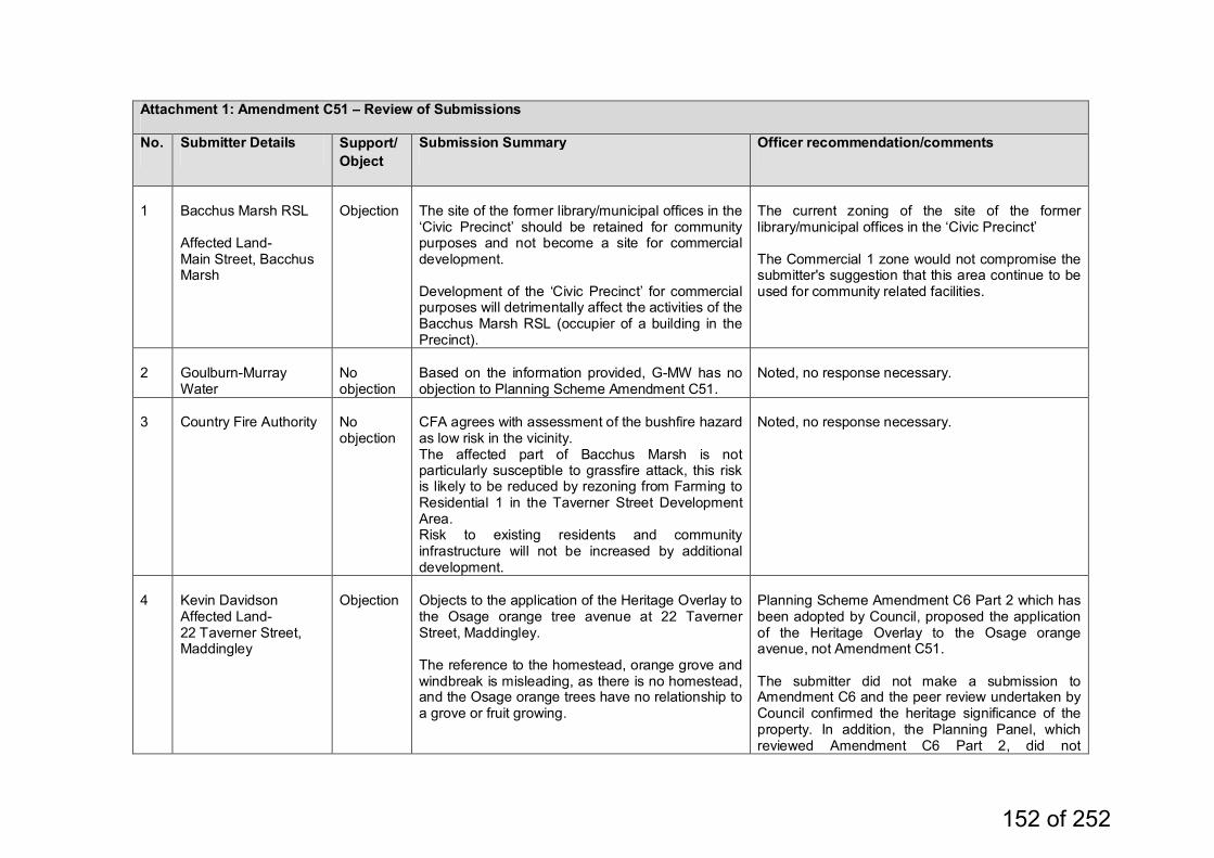
Attachment 1: Amendment C51 – Review of Submissions
No. Submitter Details Support/Object
Submission Summary Officer recommendation/comments
1
Bacchus Marsh RSL Affected Land- Main Street, Bacchus Marsh
Objection
The site of the former library/municipal offices in the ‘Civic Precinct’ should be retained for community purposes and not become a site for commercial development. Development of the ‘Civic Precinct’ for commercial purposes will detrimentally affect the activities of the Bacchus Marsh RSL (occupier of a building in the Precinct).
The current zoning of the site of the former library/municipal offices in the ‘Civic Precinct’ The Commercial 1 zone would not compromise the submitter's suggestion that this area continue to be used for community related facilities.
2
Goulburn-Murray Water
No objection
Based on the information provided, G-MW has no objection to Planning Scheme Amendment C51.
Noted, no response necessary.
3
Country Fire Authority
No objection
CFA agrees with assessment of the bushfire hazard as low risk in the vicinity. The affected part of Bacchus Marsh is not particularly susceptible to grassfire attack, this risk is likely to be reduced by rezoning from Farming to Residential 1 in the Taverner Street Development Area. Risk to existing residents and community infrastructure will not be increased by additional development.
Noted, no response necessary.
4
Kevin Davidson Affected Land- 22 Taverner Street, Maddingley
Objection
Objects to the application of the Heritage Overlay to the Osage orange tree avenue at 22 Taverner Street, Maddingley. The reference to the homestead, orange grove and windbreak is misleading, as there is no homestead, and the Osage orange trees have no relationship to a grove or fruit growing.
Planning Scheme Amendment C6 Part 2 which has been adopted by Council, proposed the application of the Heritage Overlay to the Osage orange avenue, not Amendment C51. The submitter did not make a submission to Amendment C6 and the peer review undertaken by Council confirmed the heritage significance of the property. In addition, the Planning Panel, which reviewed Amendment C6 Part 2, did not
152 of 252
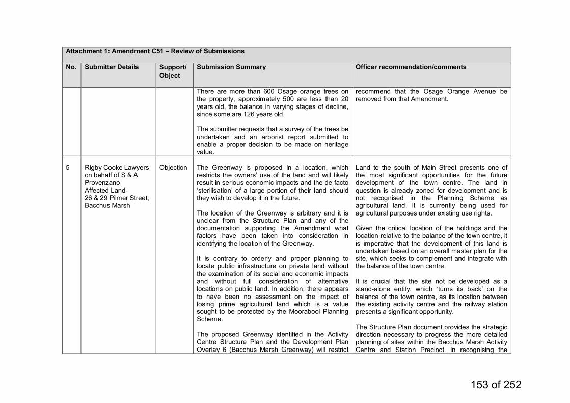
Attachment 1: Amendment C51 – Review of Submissions
No. Submitter Details Support/Object
Submission Summary Officer recommendation/comments
There are more than 600 Osage orange trees on the property, approximately 500 are less than 20 years old, the balance in varying stages of decline, since some are 126 years old. The submitter requests that a survey of the trees be undertaken and an arborist report submitted to enable a proper decision to be made on heritage value.
recommend that the Osage Orange Avenue be removed from that Amendment.
5
Rigby Cooke Lawyers on behalf of S & A Provenzano Affected Land- 26 & 29 Pilmer Street, Bacchus Marsh
Objection
The Greenway is proposed in a location, which restricts the owners’ use of the land and will likely result in serious economic impacts and the de facto ‘sterilisation’ of a large portion of their land should they wish to develop it in the future. The location of the Greenway is arbitrary and it is unclear from the Structure Plan and any of the documentation supporting the Amendment what factors have been taken into consideration in identifying the location of the Greenway. It is contrary to orderly and proper planning to locate public infrastructure on private land without the examination of its social and economic impacts and without full consideration of alternative locations on public land. In addition, there appears to have been no assessment on the impact of losing prime agricultural land which is a value sought to be protected by the Moorabool Planning Scheme. The proposed Greenway identified in the Activity Centre Structure Plan and the Development Plan Overlay 6 (Bacchus Marsh Greenway) will restrict
Land to the south of Main Street presents one of the most significant opportunities for the future development of the town centre. The land in question is already zoned for development and is not recognised in the Planning Scheme as agricultural land. It is currently being used for agricultural purposes under existing use rights. Given the critical location of the holdings and the location relative to the balance of the town centre, it is imperative that the development of this land is undertaken based on an overall master plan for the site, which seeks to complement and integrate with the balance of the town centre. It is crucial that the site not be developed as a stand‐alone entity, which ‘turns its back’ on the balance of the town centre, as its location between the existing activity centre and the railway station presents a significant opportunity. The Structure Plan document provides the strategic direction necessary to progress the more detailed planning of sites within the Bacchus Marsh Activity Centre and Station Precinct. In recognising the
153 of 252
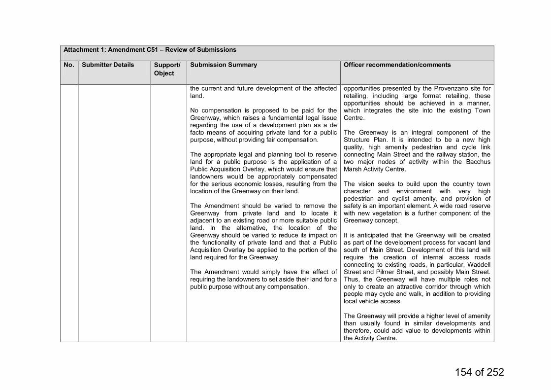
Attachment 1: Amendment C51 – Review of Submissions
No. Submitter Details Support/Object
Submission Summary Officer recommendation/comments
the current and future development of the affected land. No compensation is proposed to be paid for the Greenway, which raises a fundamental legal issue regarding the use of a development plan as a de facto means of acquiring private land for a public purpose, without providing fair compensation. The appropriate legal and planning tool to reserve land for a public purpose is the application of a Public Acquisition Overlay, which would ensure that landowners would be appropriately compensated for the serious economic losses, resulting from the location of the Greenway on their land. The Amendment should be varied to remove the Greenway from private land and to locate it adjacent to an existing road or more suitable public land. In the alternative, the location of the Greenway should be varied to reduce its impact on the functionality of private land and that a Public Acquisition Overlay be applied to the portion of the land required for the Greenway. The Amendment would simply have the effect of requiring the landowners to set aside their land for a public purpose without any compensation.
opportunities presented by the Provenzano site for retailing, including large format retailing, these opportunities should be achieved in a manner, which integrates the site into the existing Town Centre. The Greenway is an integral component of the Structure Plan. It is intended to be a new high quality, high amenity pedestrian and cycle link connecting Main Street and the railway station, the two major nodes of activity within the Bacchus Marsh Activity Centre. The vision seeks to build upon the country town character and environment with very high pedestrian and cyclist amenity, and provision of safety is an important element. A wide road reserve with new vegetation is a further component of the Greenway concept. It is anticipated that the Greenway will be created as part of the development process for vacant land south of Main Street. Development of this land will require the creation of internal access roads connecting to existing roads, in particular, Waddell Street and Pilmer Street, and possibly Main Street. Thus, the Greenway will have multiple roles not only to create an attractive corridor through which people may cycle and walk, in addition to providing local vehicle access. The Greenway will provide a higher level of amenity than usually found in similar developments and therefore, could add value to developments within the Activity Centre.
154 of 252
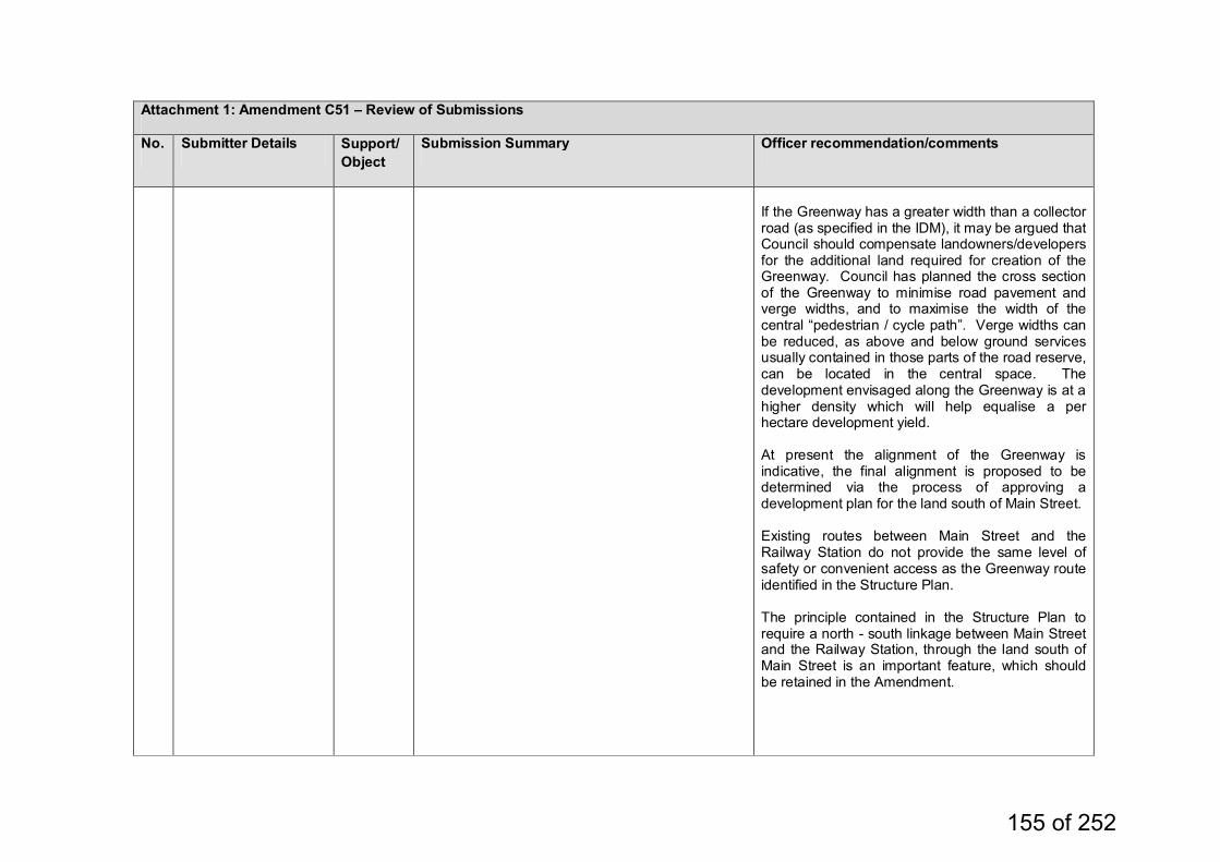
Attachment 1: Amendment C51 – Review of Submissions
No. Submitter Details Support/Object
Submission Summary Officer recommendation/comments
If the Greenway has a greater width than a collector road (as specified in the IDM), it may be argued that Council should compensate landowners/developers for the additional land required for creation of the Greenway. Council has planned the cross section of the Greenway to minimise road pavement and verge widths, and to maximise the width of the central “pedestrian / cycle path”. Verge widths can be reduced, as above and below ground services usually contained in those parts of the road reserve, can be located in the central space. The development envisaged along the Greenway is at a higher density which will help equalise a per hectare development yield. At present the alignment of the Greenway is indicative, the final alignment is proposed to be determined via the process of approving a development plan for the land south of Main Street. Existing routes between Main Street and the Railway Station do not provide the same level of safety or convenient access as the Greenway route identified in the Structure Plan. The principle contained in the Structure Plan to require a north - south linkage between Main Street and the Railway Station, through the land south of Main Street is an important feature, which should be retained in the Amendment.
155 of 252
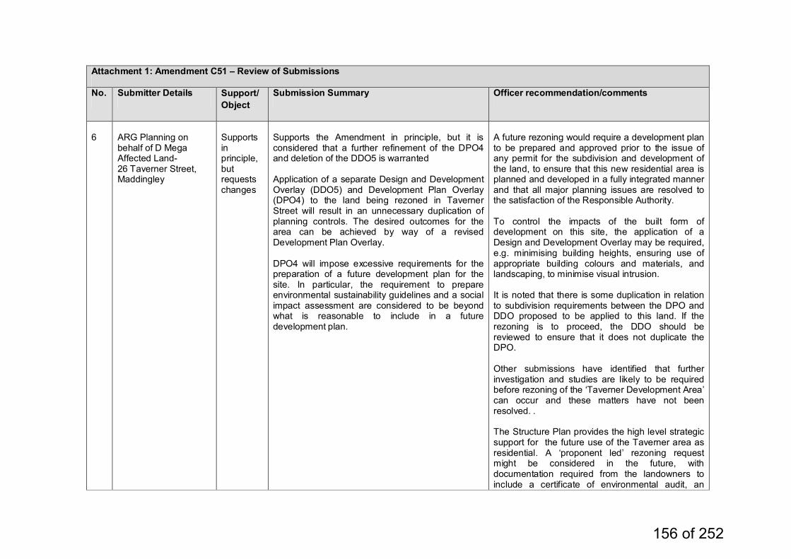
Attachment 1: Amendment C51 – Review of Submissions
No. Submitter Details Support/Object
Submission Summary Officer recommendation/comments
6
ARG Planning on behalf of D Mega Affected Land- 26 Taverner Street, Maddingley
Supports in principle, but requests changes
Supports the Amendment in principle, but it is considered that a further refinement of the DPO4 and deletion of the DDO5 is warranted Application of a separate Design and Development Overlay (DDO5) and Development Plan Overlay (DPO4) to the land being rezoned in Taverner Street will result in an unnecessary duplication of planning controls. The desired outcomes for the area can be achieved by way of a revised Development Plan Overlay. DPO4 will impose excessive requirements for the preparation of a future development plan for the site. In particular, the requirement to prepare environmental sustainability guidelines and a social impact assessment are considered to be beyond what is reasonable to include in a future development plan.
A future rezoning would require a development plan to be prepared and approved prior to the issue of any permit for the subdivision and development of the land, to ensure that this new residential area is planned and developed in a fully integrated manner and that all major planning issues are resolved to the satisfaction of the Responsible Authority. To control the impacts of the built form of development on this site, the application of a Design and Development Overlay may be required, e.g. minimising building heights, ensuring use of appropriate building colours and materials, and landscaping, to minimise visual intrusion. It is noted that there is some duplication in relation to subdivision requirements between the DPO and DDO proposed to be applied to this land. If the rezoning is to proceed, the DDO should be reviewed to ensure that it does not duplicate the DPO. Other submissions have identified that further investigation and studies are likely to be required before rezoning of the ‘Taverner Development Area’ can occur and these matters have not been resolved. . The Structure Plan provides the high level strategic support for the future use of the Taverner area as residential. A ‘proponent led’ rezoning request might be considered in the future, with documentation required from the landowners to include a certificate of environmental audit, an
156 of 252
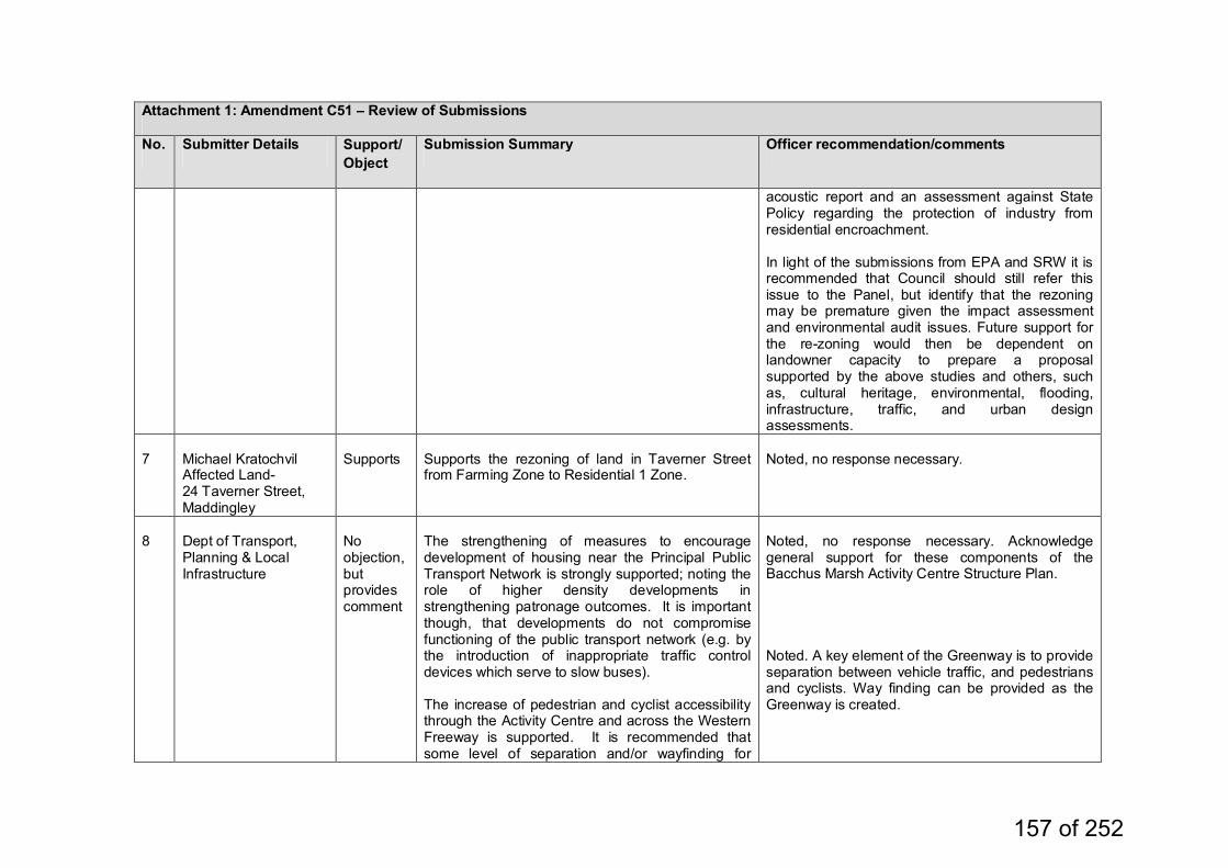
Attachment 1: Amendment C51 – Review of Submissions
No. Submitter Details Support/Object
Submission Summary Officer recommendation/comments
acoustic report and an assessment against State Policy regarding the protection of industry from residential encroachment. In light of the submissions from EPA and SRW it is recommended that Council should still refer this issue to the Panel, but identify that the rezoning may be premature given the impact assessment and environmental audit issues. Future support for the re-zoning would then be dependent on landowner capacity to prepare a proposal supported by the above studies and others, such as, cultural heritage, environmental, flooding, infrastructure, traffic, and urban design assessments.
7
Michael Kratochvil Affected Land- 24 Taverner Street, Maddingley
Supports
Supports the rezoning of land in Taverner Street from Farming Zone to Residential 1 Zone.
Noted, no response necessary.
8
Dept of Transport, Planning & Local Infrastructure
No objection, but provides comment
The strengthening of measures to encourage development of housing near the Principal Public Transport Network is strongly supported; noting the role of higher density developments in strengthening patronage outcomes. It is important though, that developments do not compromise functioning of the public transport network (e.g. by the introduction of inappropriate traffic control devices which serve to slow buses). The increase of pedestrian and cyclist accessibility through the Activity Centre and across the Western Freeway is supported. It is recommended that some level of separation and/or wayfinding for
Noted, no response necessary. Acknowledge general support for these components of the Bacchus Marsh Activity Centre Structure Plan. Noted. A key element of the Greenway is to provide separation between vehicle traffic, and pedestrians and cyclists. Way finding can be provided as the Greenway is created.
157 of 252
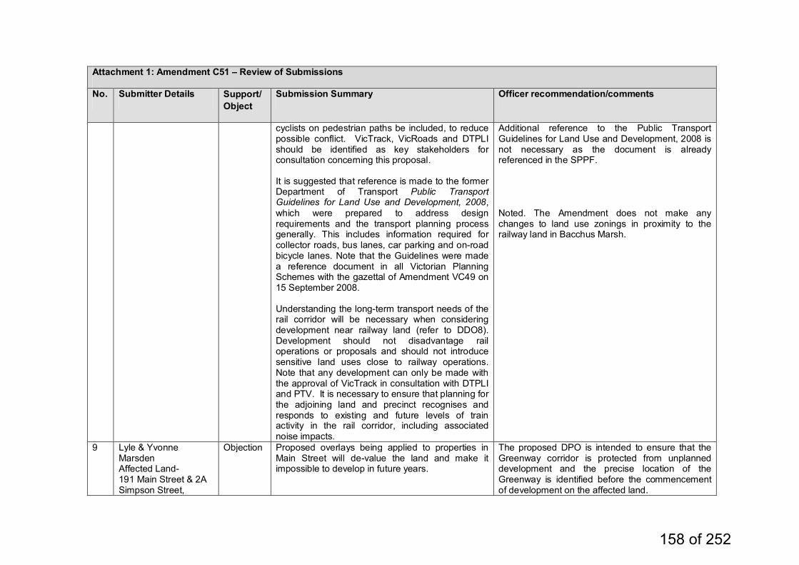
Attachment 1: Amendment C51 – Review of Submissions
No. Submitter Details Support/Object
Submission Summary Officer recommendation/comments
cyclists on pedestrian paths be included, to reduce possible conflict. VicTrack, VicRoads and DTPLI should be identified as key stakeholders for consultation concerning this proposal. It is suggested that reference is made to the former Department of Transport Public Transport Guidelines for Land Use and Development, 2008, which were prepared to address design requirements and the transport planning process generally. This includes information required for collector roads, bus lanes, car parking and on-road bicycle lanes. Note that the Guidelines were made a reference document in all Victorian Planning Schemes with the gazettal of Amendment VC49 on 15 September 2008. Understanding the long-term transport needs of the rail corridor will be necessary when considering development near railway land (refer to DDO8). Development should not disadvantage rail operations or proposals and should not introduce sensitive land uses close to railway operations. Note that any development can only be made with the approval of VicTrack in consultation with DTPLI and PTV. It is necessary to ensure that planning for the adjoining land and precinct recognises and responds to existing and future levels of train activity in the rail corridor, including associated noise impacts.
Additional reference to the Public Transport Guidelines for Land Use and Development, 2008 is not necessary as the document is already referenced in the SPPF. Noted. The Amendment does not make any changes to land use zonings in proximity to the railway land in Bacchus Marsh.
9 Lyle & Yvonne Marsden Affected Land- 191 Main Street & 2A Simpson Street,
Objection Proposed overlays being applied to properties in Main Street will de-value the land and make it impossible to develop in future years.
The proposed DPO is intended to ensure that the Greenway corridor is protected from unplanned development and the precise location of the Greenway is identified before the commencement of development on the affected land.
158 of 252
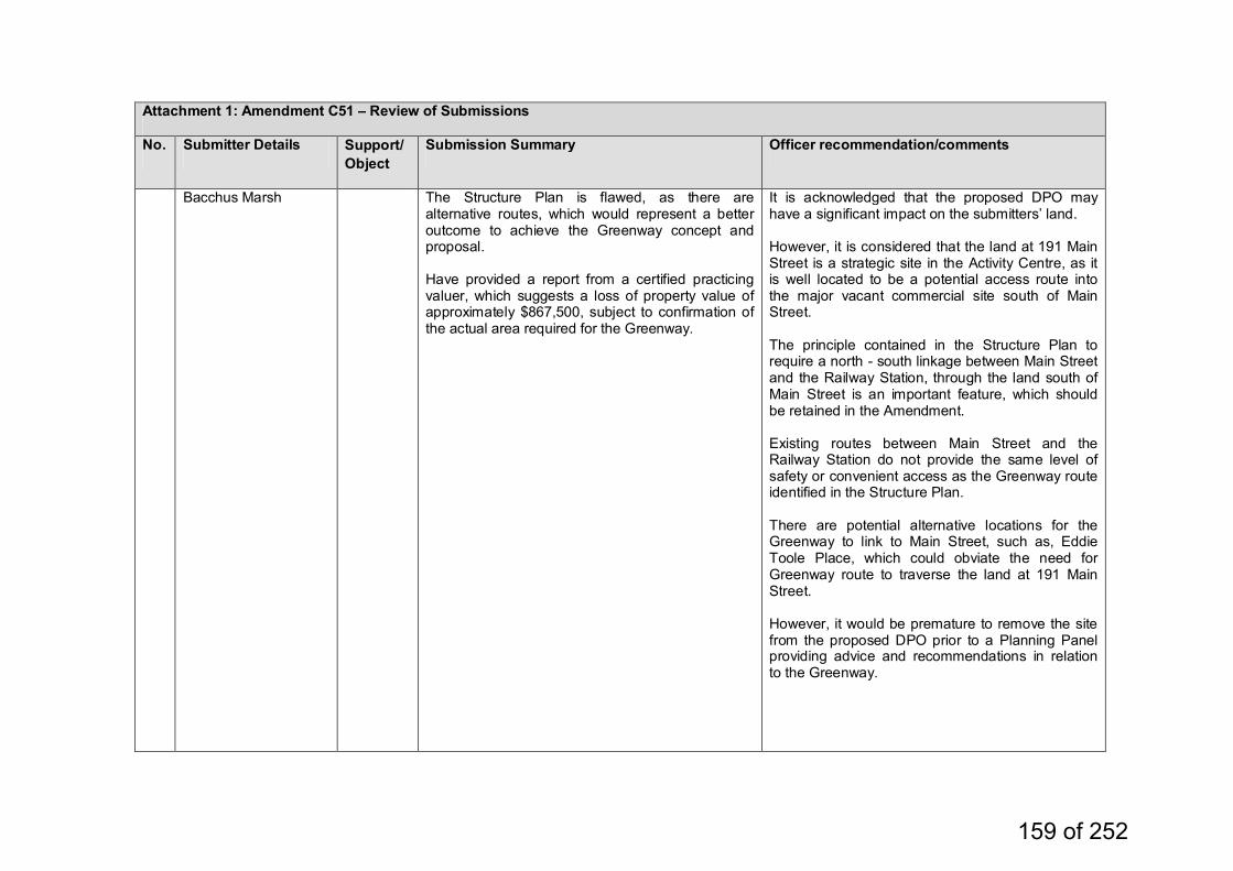
Attachment 1: Amendment C51 – Review of Submissions
No. Submitter Details Support/Object
Submission Summary Officer recommendation/comments
Bacchus Marsh The Structure Plan is flawed, as there are alternative routes, which would represent a better outcome to achieve the Greenway concept and proposal. Have provided a report from a certified practicing valuer, which suggests a loss of property value of approximately $867,500, subject to confirmation of the actual area required for the Greenway.
It is acknowledged that the proposed DPO may have a significant impact on the submitters’ land. However, it is considered that the land at 191 Main Street is a strategic site in the Activity Centre, as it is well located to be a potential access route into the major vacant commercial site south of Main Street. The principle contained in the Structure Plan to require a north - south linkage between Main Street and the Railway Station, through the land south of Main Street is an important feature, which should be retained in the Amendment. Existing routes between Main Street and the Railway Station do not provide the same level of safety or convenient access as the Greenway route identified in the Structure Plan. There are potential alternative locations for the Greenway to link to Main Street, such as, Eddie Toole Place, which could obviate the need for Greenway route to traverse the land at 191 Main Street. However, it would be premature to remove the site from the proposed DPO prior to a Planning Panel providing advice and recommendations in relation to the Greenway.
159 of 252
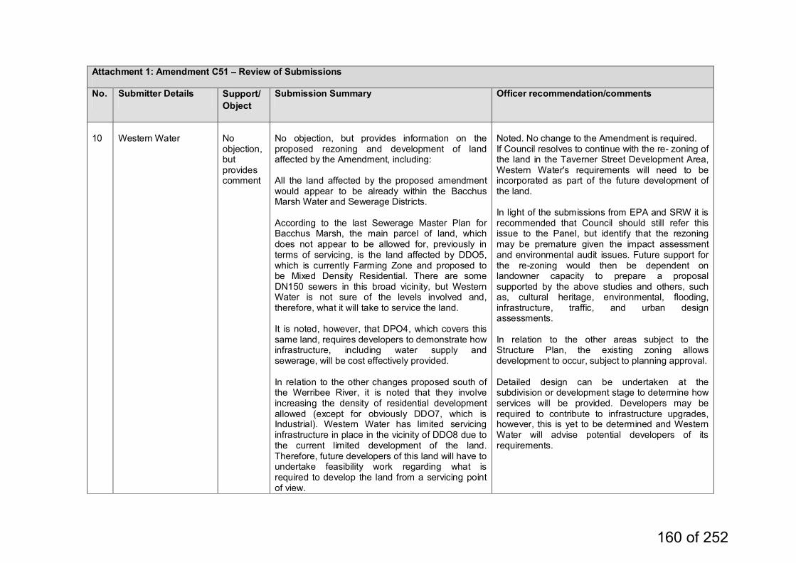
Attachment 1: Amendment C51 – Review of Submissions
No. Submitter Details Support/Object
Submission Summary Officer recommendation/comments
10
Western Water
No objection, but provides comment
No objection, but provides information on the proposed rezoning and development of land affected by the Amendment, including: All the land affected by the proposed amendment would appear to be already within the Bacchus Marsh Water and Sewerage Districts. According to the last Sewerage Master Plan for Bacchus Marsh, the main parcel of land, which does not appear to be allowed for, previously in terms of servicing, is the land affected by DDO5, which is currently Farming Zone and proposed to be Mixed Density Residential. There are some DN150 sewers in this broad vicinity, but Western Water is not sure of the levels involved and, therefore, what it will take to service the land. It is noted, however, that DPO4, which covers this same land, requires developers to demonstrate how infrastructure, including water supply and sewerage, will be cost effectively provided. In relation to the other changes proposed south of the Werribee River, it is noted that they involve increasing the density of residential development allowed (except for obviously DDO7, which is Industrial). Western Water has limited servicing infrastructure in place in the vicinity of DDO8 due to the current limited development of the land. Therefore, future developers of this land will have to undertake feasibility work regarding what is required to develop the land from a servicing point of view.
Noted. No change to the Amendment is required. If Council resolves to continue with the re- zoning of the land in the Taverner Street Development Area, Western Water's requirements will need to be incorporated as part of the future development of the land. In light of the submissions from EPA and SRW it is recommended that Council should still refer this issue to the Panel, but identify that the rezoning may be premature given the impact assessment and environmental audit issues. Future support for the re-zoning would then be dependent on landowner capacity to prepare a proposal supported by the above studies and others, such as, cultural heritage, environmental, flooding, infrastructure, traffic, and urban design assessments. In relation to the other areas subject to the Structure Plan, the existing zoning allows development to occur, subject to planning approval. Detailed design can be undertaken at the subdivision or development stage to determine how services will be provided. Developers may be required to contribute to infrastructure upgrades, however, this is yet to be determined and Western Water will advise potential developers of its requirements.
160 of 252
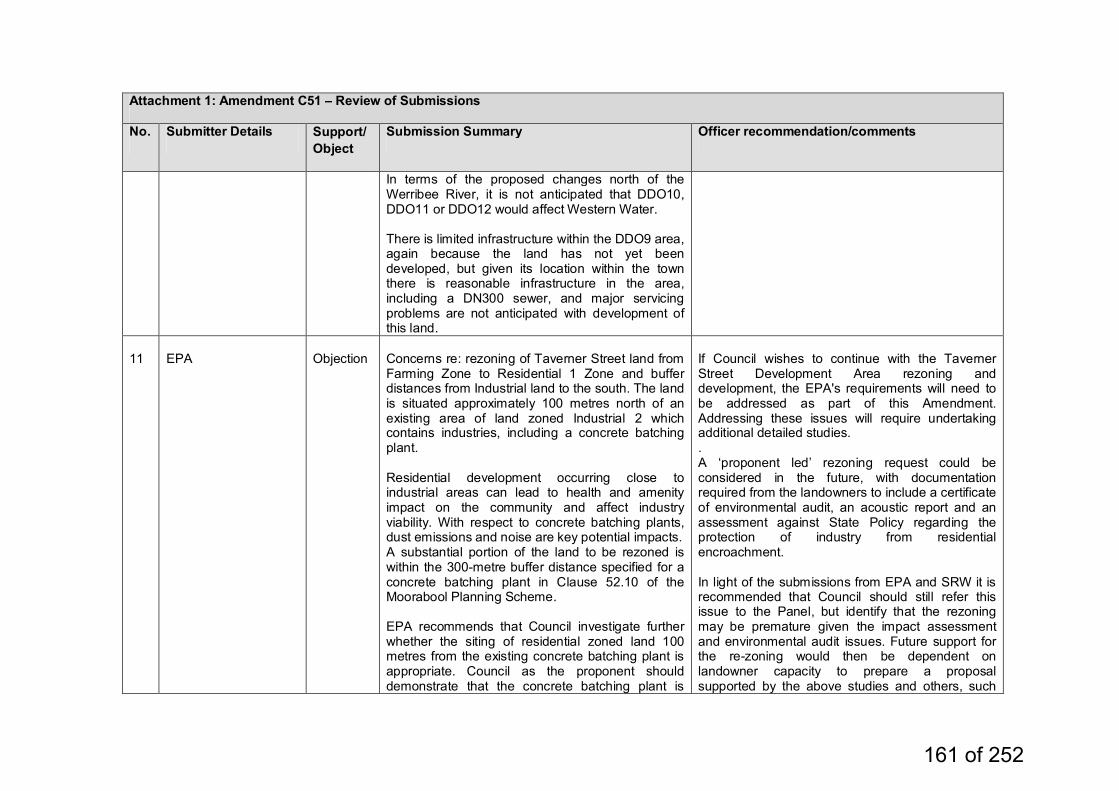
Attachment 1: Amendment C51 – Review of Submissions
No. Submitter Details Support/Object
Submission Summary Officer recommendation/comments
In terms of the proposed changes north of the Werribee River, it is not anticipated that DDO10, DDO11 or DDO12 would affect Western Water. There is limited infrastructure within the DDO9 area, again because the land has not yet been developed, but given its location within the town there is reasonable infrastructure in the area, including a DN300 sewer, and major servicing problems are not anticipated with development of this land.
11
EPA
Objection
Concerns re: rezoning of Taverner Street land from Farming Zone to Residential 1 Zone and buffer distances from Industrial land to the south. The land is situated approximately 100 metres north of an existing area of land zoned Industrial 2 which contains industries, including a concrete batching plant. Residential development occurring close to industrial areas can lead to health and amenity impact on the community and affect industry viability. With respect to concrete batching plants, dust emissions and noise are key potential impacts. A substantial portion of the land to be rezoned is within the 300-metre buffer distance specified for a concrete batching plant in Clause 52.10 of the Moorabool Planning Scheme. EPA recommends that Council investigate further whether the siting of residential zoned land 100 metres from the existing concrete batching plant is appropriate. Council as the proponent should demonstrate that the concrete batching plant is
If Council wishes to continue with the Taverner Street Development Area rezoning and development, the EPA's requirements will need to be addressed as part of this Amendment. Addressing these issues will require undertaking additional detailed studies. . A ‘proponent led’ rezoning request could be considered in the future, with documentation required from the landowners to include a certificate of environmental audit, an acoustic report and an assessment against State Policy regarding the protection of industry from residential encroachment. In light of the submissions from EPA and SRW it is recommended that Council should still refer this issue to the Panel, but identify that the rezoning may be premature given the impact assessment and environmental audit issues. Future support for the re-zoning would then be dependent on landowner capacity to prepare a proposal supported by the above studies and others, such
161 of 252
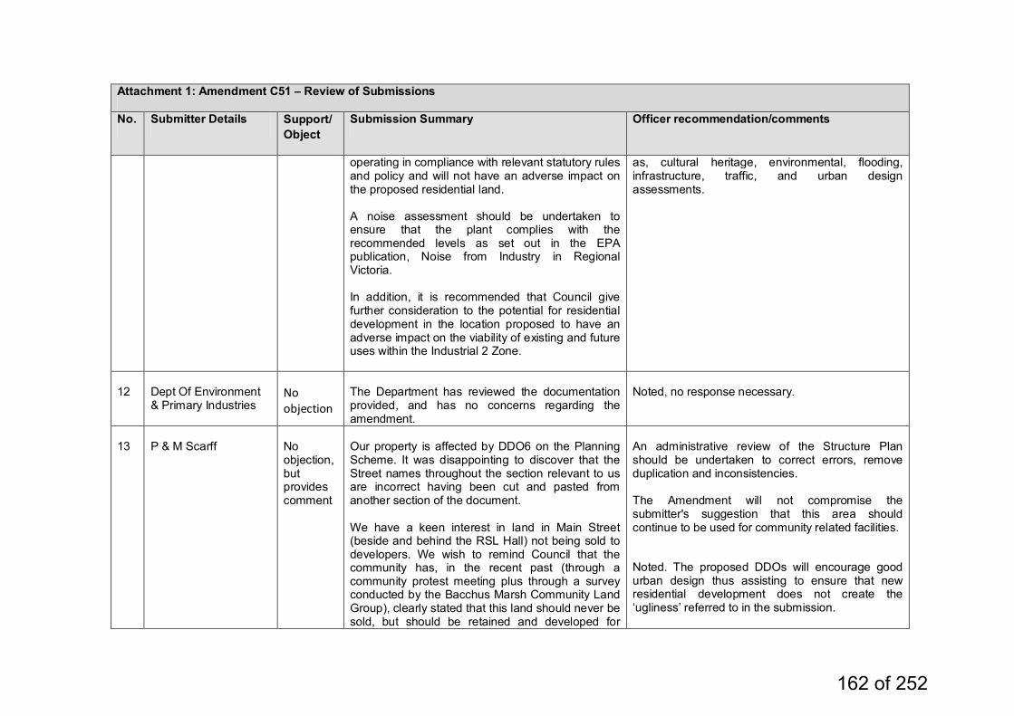
Attachment 1: Amendment C51 – Review of Submissions
No. Submitter Details Support/Object
Submission Summary Officer recommendation/comments
operating in compliance with relevant statutory rules and policy and will not have an adverse impact on the proposed residential land. A noise assessment should be undertaken to ensure that the plant complies with the recommended levels as set out in the EPA publication, Noise from Industry in Regional Victoria. In addition, it is recommended that Council give further consideration to the potential for residential development in the location proposed to have an adverse impact on the viability of existing and future uses within the Industrial 2 Zone.
as, cultural heritage, environmental, flooding, infrastructure, traffic, and urban design assessments.
12
Dept Of Environment & Primary Industries
No objection
The Department has reviewed the documentation provided, and has no concerns regarding the amendment.
Noted, no response necessary.
13
P & M Scarff
No objection, but provides comment
Our property is affected by DDO6 on the Planning Scheme. It was disappointing to discover that the Street names throughout the section relevant to us are incorrect having been cut and pasted from another section of the document. We have a keen interest in land in Main Street (beside and behind the RSL Hall) not being sold to developers. We wish to remind Council that the community has, in the recent past (through a community protest meeting plus through a survey conducted by the Bacchus Marsh Community Land Group), clearly stated that this land should never be sold, but should be retained and developed for
An administrative review of the Structure Plan should be undertaken to correct errors, remove duplication and inconsistencies. The Amendment will not compromise the submitter's suggestion that this area should continue to be used for community related facilities. Noted. The proposed DDOs will encourage good urban design thus assisting to ensure that new residential development does not create the ‘ugliness’ referred to in the submission.
162 of 252
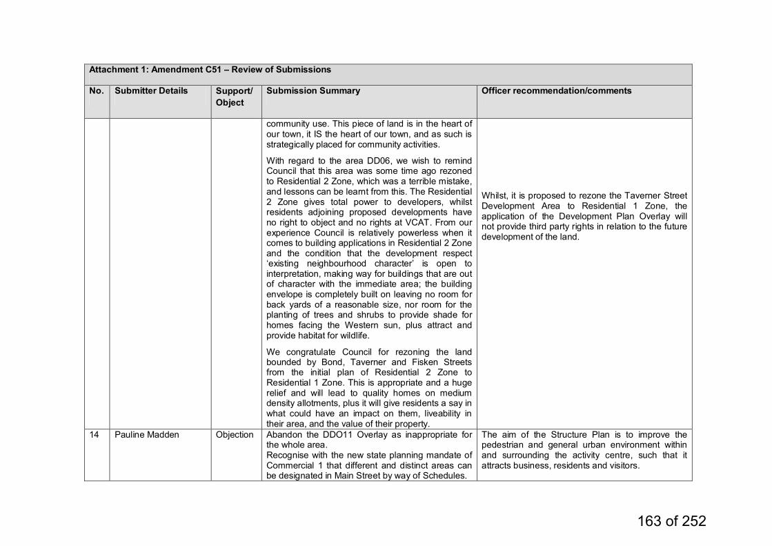
Attachment 1: Amendment C51 – Review of Submissions
No. Submitter Details Support/Object
Submission Summary Officer recommendation/comments
community use. This piece of land is in the heart of our town, it IS the heart of our town, and as such is strategically placed for community activities.
With regard to the area DD06, we wish to remind Council that this area was some time ago rezoned to Residential 2 Zone, which was a terrible mistake, and lessons can be learnt from this. The Residential 2 Zone gives total power to developers, whilst residents adjoining proposed developments have no right to object and no rights at VCAT. From our experience Council is relatively powerless when it comes to building applications in Residential 2 Zone and the condition that the development respect ‘existing neighbourhood character’ is open to interpretation, making way for buildings that are out of character with the immediate area; the building envelope is completely built on leaving no room for back yards of a reasonable size, nor room for the planting of trees and shrubs to provide shade for homes facing the Western sun, plus attract and provide habitat for wildlife.
We congratulate Council for rezoning the land bounded by Bond, Taverner and Fisken Streets from the initial plan of Residential 2 Zone to Residential 1 Zone. This is appropriate and a huge relief and will lead to quality homes on medium density allotments, plus it will give residents a say in what could have an impact on them, liveability in their area, and the value of their property.
Whilst, it is proposed to rezone the Taverner Street Development Area to Residential 1 Zone, the application of the Development Plan Overlay will not provide third party rights in relation to the future development of the land.
14 Pauline Madden Objection Abandon the DDO11 Overlay as inappropriate for the whole area. Recognise with the new state planning mandate of Commercial 1 that different and distinct areas can be designated in Main Street by way of Schedules.
The aim of the Structure Plan is to improve the pedestrian and general urban environment within and surrounding the activity centre, such that it attracts business, residents and visitors.
163 of 252
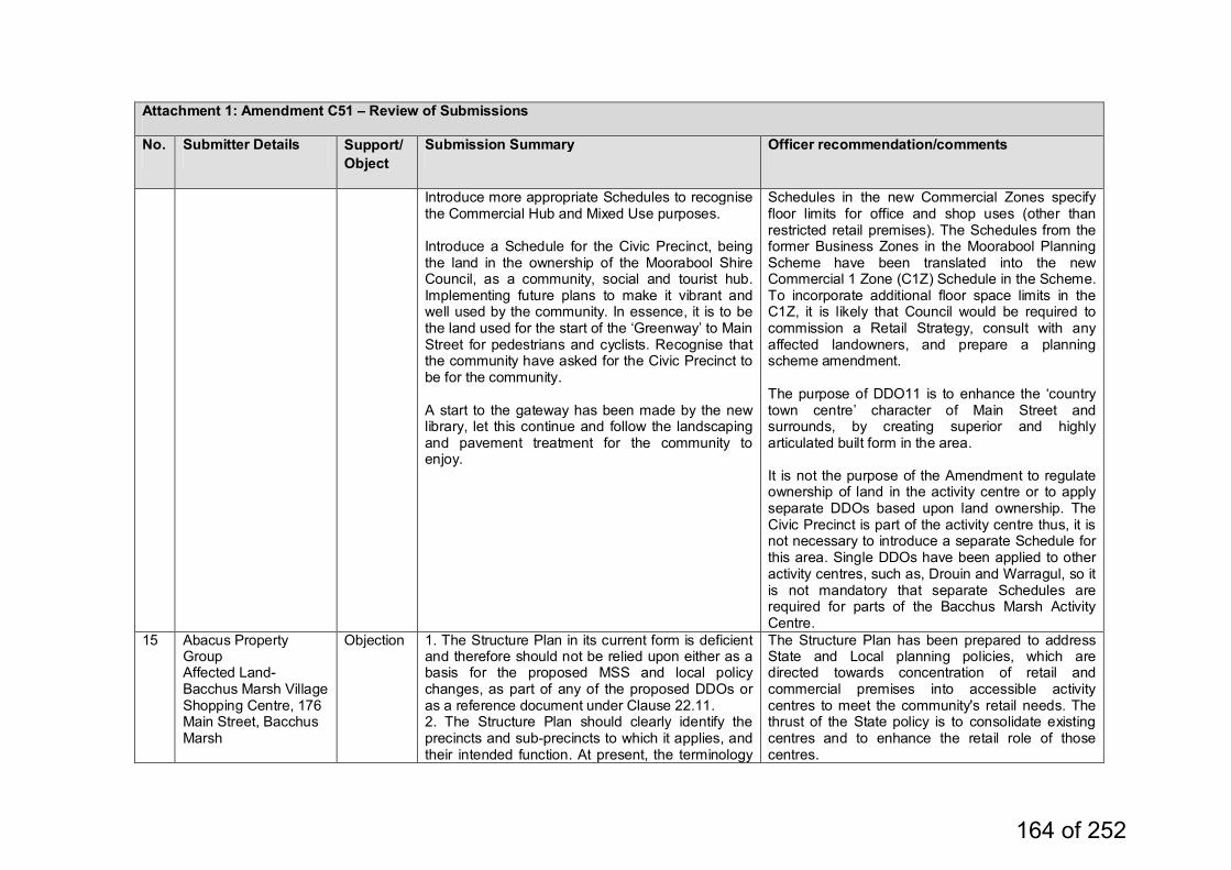
Attachment 1: Amendment C51 – Review of Submissions
No. Submitter Details Support/Object
Submission Summary Officer recommendation/comments
Introduce more appropriate Schedules to recognise the Commercial Hub and Mixed Use purposes. Introduce a Schedule for the Civic Precinct, being the land in the ownership of the Moorabool Shire Council, as a community, social and tourist hub. Implementing future plans to make it vibrant and well used by the community. In essence, it is to be the land used for the start of the ‘Greenway’ to Main Street for pedestrians and cyclists. Recognise that the community have asked for the Civic Precinct to be for the community. A start to the gateway has been made by the new library, let this continue and follow the landscaping and pavement treatment for the community to enjoy.
Schedules in the new Commercial Zones specify floor limits for office and shop uses (other than restricted retail premises). The Schedules from the former Business Zones in the Moorabool Planning Scheme have been translated into the new Commercial 1 Zone (C1Z) Schedule in the Scheme. To incorporate additional floor space limits in the C1Z, it is likely that Council would be required to commission a Retail Strategy, consult with any affected landowners, and prepare a planning scheme amendment. The purpose of DDO11 is to enhance the ‘country town centre’ character of Main Street and surrounds, by creating superior and highly articulated built form in the area. It is not the purpose of the Amendment to regulate ownership of land in the activity centre or to apply separate DDOs based upon land ownership. The Civic Precinct is part of the activity centre thus, it is not necessary to introduce a separate Schedule for this area. Single DDOs have been applied to other activity centres, such as, Drouin and Warragul, so it is not mandatory that separate Schedules are required for parts of the Bacchus Marsh Activity Centre.
15 Abacus Property Group Affected Land- Bacchus Marsh Village Shopping Centre, 176 Main Street, Bacchus Marsh
Objection 1. The Structure Plan in its current form is deficient and therefore should not be relied upon either as a basis for the proposed MSS and local policy changes, as part of any of the proposed DDOs or as a reference document under Clause 22.11. 2. The Structure Plan should clearly identify the precincts and sub-precincts to which it applies, and their intended function. At present, the terminology
The Structure Plan has been prepared to address State and Local planning policies, which are directed towards concentration of retail and commercial premises into accessible activity centres to meet the community's retail needs. The thrust of the State policy is to consolidate existing centres and to enhance the retail role of those centres.
164 of 252
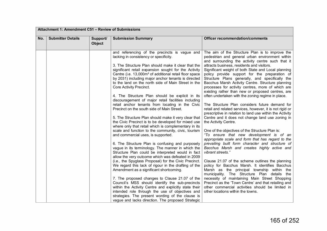
Attachment 1: Amendment C51 – Review of Submissions
No. Submitter Details Support/Object
Submission Summary Officer recommendation/comments
and referencing of the precincts is vague and lacking in consistency or specificity. 3. The Structure Plan should make it clear that the significant retail expansion sought for the Activity Centre (i.e. 13,000m² of additional retail floor space by 2031) including major anchor tenants is directed to the land on the north side of Main Street in the Core Activity Precinct. 4. The Structure Plan should be explicit in its discouragement of major retail facilities including retail anchor tenants from locating in the Civic Precinct on the south side of Main Street. 5. The Structure Plan should make it very clear that the Civic Precinct is to be developed for mixed use where only that retail which is complementary in its scale and function to the community, civic, tourism and commercial uses, is supported. 6. The Structure Plan is confusing and purposely vague in its terminology. The manner in which the Structure Plan could be interpreted would in fact allow the very outcome which was defeated in 2009 (i.e., the Spyglass Proposal) for the Civic Precinct. We regard this lack of rigour in the drafting of the Amendment as a significant shortcoming. 7. The proposed changes to Clause 21.07 of the Council’s MSS should identify the sub-precincts within the Activity Centre and explicitly state their intended role through the use of objectives and strategies. The present wording of the clause is vague and lacks direction. The proposed Strategic
The aim of the Structure Plan is to improve the pedestrian and general urban environment within and surrounding the activity centre such that it attracts business, residents and visitors. Significant weight of both State and Local planning policy provide support for the preparation of Structure Plans generally, and specifically the Bacchus Marsh Activity Centre. Structure planning processes for activity centres, more of which are existing rather than new or proposed centres, are often undertaken with the zoning regime in place. The Structure Plan considers future demand for retail and related services, however, it is not rigid or prescriptive in relation to land use within the Activity Centre and it does not change land use zoning in the Activity Centre. One of the objectives of the Structure Plan is: “To ensure that new development is of an appropriate scale and form that has regard to the prevailing built form character and structure of Bacchus Marsh and creates highly active and vibrant streets.” Clause 21.07 of the scheme outlines the planning policy for Bacchus Marsh. It identifies Bacchus Marsh as the principal township within the municipality. The Structure Plan details the necessity of maintaining Main Street Shopping Precinct as the ‘Town Centre’ and that retailing and other commercial activities should be limited in other locations within the towns.
165 of 252
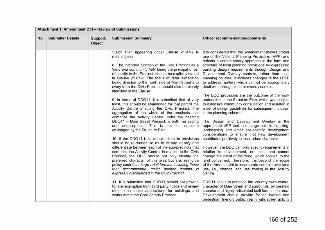
Attachment 1: Amendment C51 – Review of Submissions
No. Submitter Details Support/Object
Submission Summary Officer recommendation/comments
Vision Plan appearing under Clause 21.07-2 is meaningless. 8. The intended function of the Civic Precinct as a ‘civic and community hub’ being the principal driver of activity in the Precinct, should be explicitly stated in Clause 21.07-2. The focus of retail expansion being directed to the north side of Main Street and away from the Civic Precinct should also be clearly identified in the Clause. 9. In terms of DDO11, it is submitted that at very least, this should be abandoned for that part of the Activity Centre affecting the Civic Precinct. The aggregation of the whole of the precincts that comprise the Activity Centre under the heading DDO11 – Main Street Precinct, is both misleading and unacceptable. This is not the outcome envisaged by the Structure Plan. 10. If the DDO11 is to remain, then its provisions should be re-drafted so as to clearly identify and differentiate between each of the sub-precincts that comprise the Activity Centre. In relation to the Civic Precinct, the DDO should not only identify the preferred character of this area but also reinforce policy such that ‘large retail formats including those that accommodate major anchor tenants is expressly discouraged in the Civic Precinct.’ 11. It is submitted that DDO11 should not provide for any exemption from third party notice and review other than those applications for buildings and works within the Core Activity Precinct.
It is considered that the Amendment makes proper use of the Victoria Planning Provisions (VPP) and reflects a contemporary approach to the form and structure of local planning provisions by expressing building design requirements through Design and Development Overlay controls, rather than local planning policies. It includes changes to the LPPF to address matters which cannot be appropriately dealt with through zone or overlay controls. The DDO provisions are the outcome of the work undertaken in the Structure Plan, which was subject to extensive community consultation and resulted in a set of design guidelines for subsequent inclusion in the planning scheme. The Design and Development Overlay is the appropriate VPP tool to manage built form, siting, landscaping and other site-specific development considerations to ensure that new development contributes positively to local urban character. However, the DDO can only specify requirements in relation to development, not use, and cannot change the intent of the zone, which applies, to the land concerned. Therefore, it is beyond the scope of the Amendment to incorporate controls over land use, i.e., change land use zoning in the Activity Centre. DDO11 seeks to enhance the ‘country town centre’ character of Main Street and surrounds, by creating superior and highly articulated built form in the area. Development should provide for an inviting and pedestrian friendly public realm with street activity
166 of 252
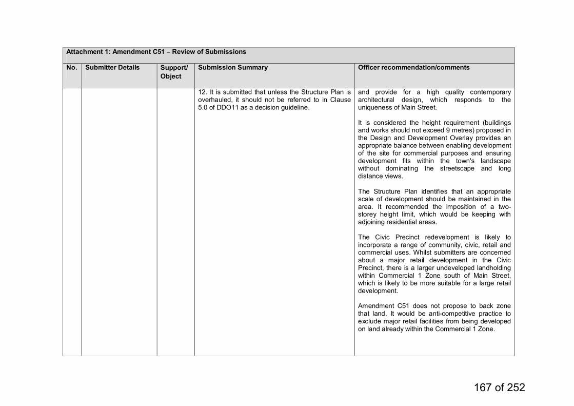
Attachment 1: Amendment C51 – Review of Submissions
No. Submitter Details Support/Object
Submission Summary Officer recommendation/comments
12. It is submitted that unless the Structure Plan is overhauled, it should not be referred to in Clause 5.0 of DDO11 as a decision guideline.
and provide for a high quality contemporary architectural design, which responds to the uniqueness of Main Street. It is considered the height requirement (buildings and works should not exceed 9 metres) proposed in the Design and Development Overlay provides an appropriate balance between enabling development of the site for commercial purposes and ensuring development fits within the town's landscape without dominating the streetscape and long distance views. The Structure Plan identifies that an appropriate scale of development should be maintained in the area. It recommended the imposition of a two-storey height limit, which would be keeping with adjoining residential areas. The Civic Precinct redevelopment is likely to incorporate a range of community, civic, retail and commercial uses. Whilst submitters are concerned about a major retail development in the Civic Precinct, there is a larger undeveloped landholding within Commercial 1 Zone south of Main Street, which is likely to be more suitable for a large retail development. Amendment C51 does not propose to back zone that land. It would be anti-competitive practice to exclude major retail facilities from being developed on land already within the Commercial 1 Zone.
167 of 252
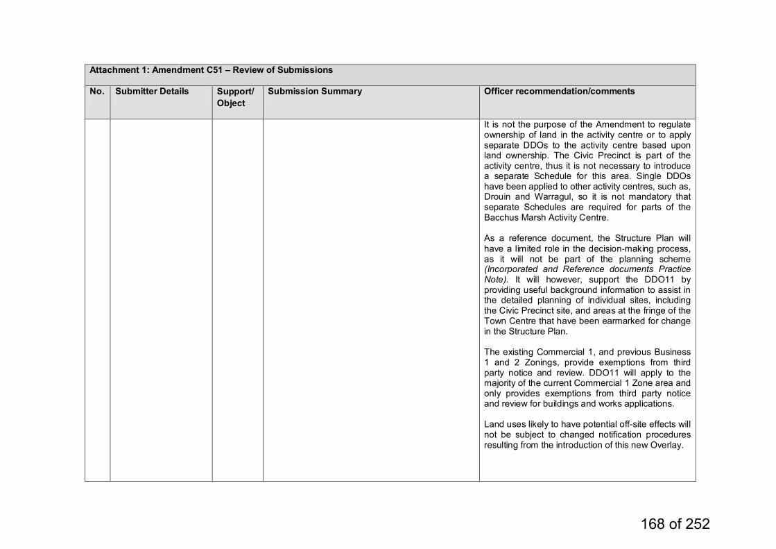
Attachment 1: Amendment C51 – Review of Submissions
No. Submitter Details Support/Object
Submission Summary Officer recommendation/comments
It is not the purpose of the Amendment to regulate ownership of land in the activity centre or to apply separate DDOs to the activity centre based upon land ownership. The Civic Precinct is part of the activity centre, thus it is not necessary to introduce a separate Schedule for this area. Single DDOs have been applied to other activity centres, such as, Drouin and Warragul, so it is not mandatory that separate Schedules are required for parts of the Bacchus Marsh Activity Centre. As a reference document, the Structure Plan will have a limited role in the decision‐making process, as it will not be part of the planning scheme (Incorporated and Reference documents Practice Note). It will however, support the DDO11 by providing useful background information to assist in the detailed planning of individual sites, including the Civic Precinct site, and areas at the fringe of the Town Centre that have been earmarked for change in the Structure Plan. The existing Commercial 1, and previous Business 1 and 2 Zonings, provide exemptions from third party notice and review. DDO11 will apply to the majority of the current Commercial 1 Zone area and only provides exemptions from third party notice and review for buildings and works applications. Land uses likely to have potential off-site effects will not be subject to changed notification procedures resulting from the introduction of this new Overlay.
168 of 252
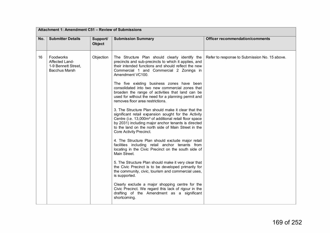
Attachment 1: Amendment C51 – Review of Submissions
No. Submitter Details Support/Object
Submission Summary Officer recommendation/comments
16
Foodworks Affected Land- 1-9 Bennett Street, Bacchus Marsh
Objection
The Structure Plan should clearly identify the precincts and sub-precincts to which it applies, and their intended functions and should reflect the new Commercial 1 and Commercial 2 Zonings in Amendment VC100. The five existing business zones have been consolidated into two new commercial zones that broaden the range of activities that land can be used for without the need for a planning permit and removes floor area restrictions. 3. The Structure Plan should make it clear that the significant retail expansion sought for the Activity Centre (i.e. 13,000m² of additional retail floor space by 2031) including major anchor tenants is directed to the land on the north side of Main Street in the Core Activity Precinct. 4. The Structure Plan should exclude major retail facilities including retail anchor tenants from locating in the Civic Precinct on the south side of Main Street. 5. The Structure Plan should make it very clear that the Civic Precinct is to be developed primarily for the community, civic, tourism and commercial uses, is supported. Clearly exclude a major shopping centre for the Civic Precinct. We regard this lack of rigour in the drafting of the Amendment as a significant shortcoming.
Refer to response to Submission No. 15 above.
169 of 252
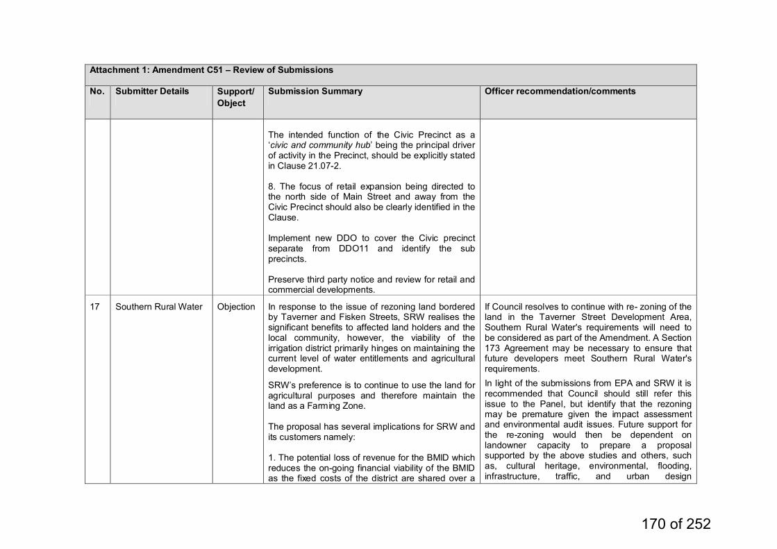
Attachment 1: Amendment C51 – Review of Submissions
No. Submitter Details Support/Object
Submission Summary Officer recommendation/comments
The intended function of the Civic Precinct as a ‘civic and community hub’ being the principal driver of activity in the Precinct, should be explicitly stated in Clause 21.07-2. 8. The focus of retail expansion being directed to the north side of Main Street and away from the Civic Precinct should also be clearly identified in the Clause. Implement new DDO to cover the Civic precinct separate from DDO11 and identify the sub precincts. Preserve third party notice and review for retail and commercial developments.
17
Southern Rural Water
Objection
In response to the issue of rezoning land bordered by Taverner and Fisken Streets, SRW realises the significant benefits to affected land holders and the local community, however, the viability of the irrigation district primarily hinges on maintaining the current level of water entitlements and agricultural development.
SRW’s preference is to continue to use the land for agricultural purposes and therefore maintain the land as a Farming Zone. The proposal has several implications for SRW and its customers namely: 1. The potential loss of revenue for the BMID which reduces the on-going financial viability of the BMID as the fixed costs of the district are shared over a
If Council resolves to continue with re- zoning of the land in the Taverner Street Development Area, Southern Rural Water's requirements will need to be considered as part of the Amendment. A Section 173 Agreement may be necessary to ensure that future developers meet Southern Rural Water's requirements.
In light of the submissions from EPA and SRW it is recommended that Council should still refer this issue to the Panel, but identify that the rezoning may be premature given the impact assessment and environmental audit issues. Future support for the re-zoning would then be dependent on landowner capacity to prepare a proposal supported by the above studies and others, such as, cultural heritage, environmental, flooding, infrastructure, traffic, and urban design
170 of 252
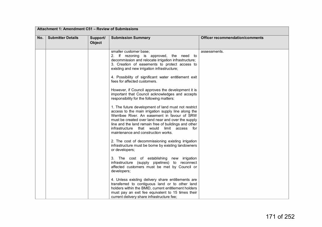
Attachment 1: Amendment C51 – Review of Submissions
No. Submitter Details Support/Object
Submission Summary Officer recommendation/comments
smaller customer base; 2. If rezoning is approved, the need to decommission and relocate irrigation infrastructure; 3. Creation of easements to protect access to existing and new irrigation infrastructure; 4. Possibility of significant water entitlement exit fees for affected customers. However, if Council approves the development it is important that Council acknowledges and accepts responsibility for the following matters: 1. The future development of land must not restrict access to the main irrigation supply line along the Werribee River. An easement in favour of SRW must be created over land near and over the supply line and the land remain free of buildings and other infrastructure that would limit access for maintenance and construction works. 2. The cost of decommissioning existing irrigation infrastructure must be borne by existing landowners or developers; 3. The cost of establishing new irrigation infrastructure (supply pipelines) to reconnect affected customers must be met by Council or developers; 4. Unless existing delivery share entitlements are transferred to contiguous land or to other land holders within the BMID, current entitlement holders must pay an exit fee equivalent to 15 times their current delivery share infrastructure fee;
assessments.
171 of 252
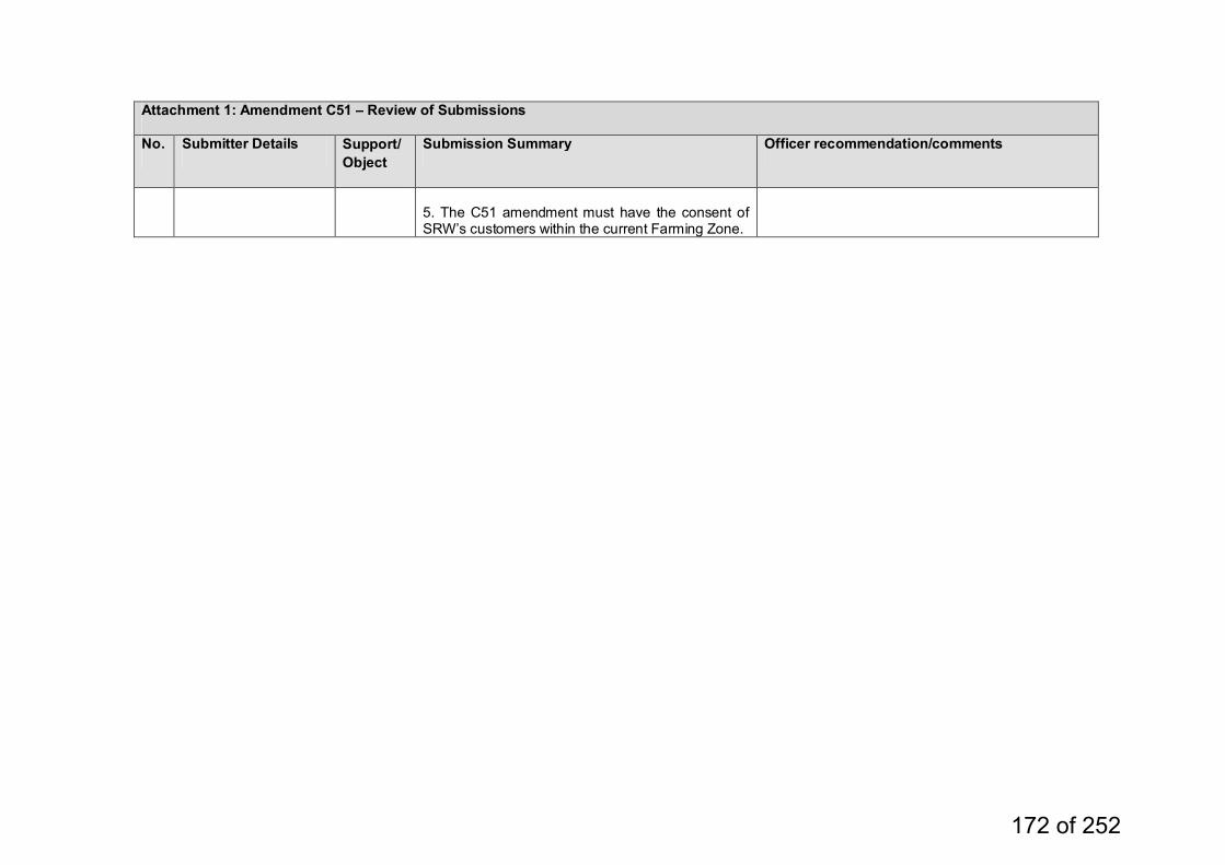
Attachment 1: Amendment C51 – Review of Submissions
No. Submitter Details Support/Object
Submission Summary Officer recommendation/comments
5. The C51 amendment must have the consent of SRW’s customers within the current Farming Zone.
172 of 252
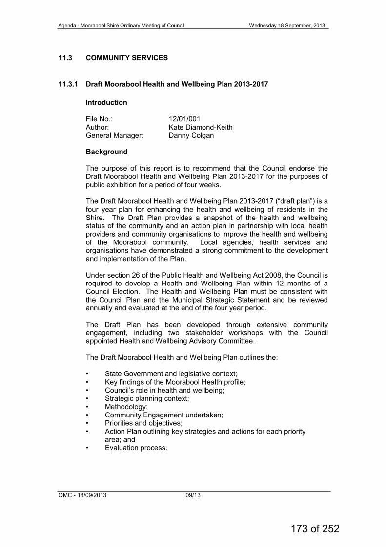
Agenda - Moorabool Shire Ordinary Meeting of Council Wednesday 18 September, 2013
OMC - 18/09/2013 09/13
11.3 COMMUNITY SERVICES
11.3.1 Draft Moorabool Health and Wellbeing Plan 2013-2017 Introduction File No.: 12/01/001 Author: Kate Diamond-Keith General Manager: Danny Colgan Background The purpose of this report is to recommend that the Council endorse the Draft Moorabool Health and Wellbeing Plan 2013-2017 for the purposes of public exhibition for a period of four weeks. The Draft Moorabool Health and Wellbeing Plan 2013-2017 (“draft plan”) is a four year plan for enhancing the health and wellbeing of residents in the Shire. The Draft Plan provides a snapshot of the health and wellbeing status of the community and an action plan in partnership with local health providers and community organisations to improve the health and wellbeing of the Moorabool community. Local agencies, health services and organisations have demonstrated a strong commitment to the development and implementation of the Plan. Under section 26 of the Public Health and Wellbeing Act 2008, the Council is required to develop a Health and Wellbeing Plan within 12 months of a Council Election. The Health and Wellbeing Plan must be consistent with the Council Plan and the Municipal Strategic Statement and be reviewed annually and evaluated at the end of the four year period. The Draft Plan has been developed through extensive community engagement, including two stakeholder workshops with the Council appointed Health and Wellbeing Advisory Committee. The Draft Moorabool Health and Wellbeing Plan outlines the: • State Government and legislative context; • Key findings of the Moorabool Health profile; • Council’s role in health and wellbeing; • Strategic planning context; • Methodology; • Community Engagement undertaken; • Priorities and objectives; • Action Plan outlining key strategies and actions for each priority
area; and • Evaluation process.
173 of 252
Agenda - Moorabool Shire Ordinary Meeting of Council Wednesday 18 September, 2013
OMC - 18/09/2013 09/13
The Council’s Health and Wellbeing Advisory Committee will oversee the implementation of the Plan over the next four years. The Draft Plan includes an action and evaluation plan to ensure the Draft Plan is progressed and reviewed annually. The Draft Plan highlights the many positive health and wellbeing aspects of the Shire and further opportunities to build on these strengths including the following: • There are many opportunities for residents and visitors to embrace a
healthy lifestyle including a variety of community and sporting facilities that offer health and wellbeing outcomes.
• The Shire has the highest percentage per capita of people actively involved in sport and recreation participation across the Grampians Region (Department Planning Community Development, 2011, LGA Participation Central Highlands Wimmera).
• The Council’s Healthy Communities Project is providing many new opportunities for residents to be involved in walking groups, physical activity and healthy eating programs.
• Moorabool has a high level of volunteerism. According to the 2011 Census, voluntary work performed by the population in Moorabool Shire compared to Victoria showed that there were a higher proportion of persons who volunteered for an organisation or group. Overall, 20.3 per cent of the population or over 5,700 people reported performing voluntary work, compared with 17.7 per cent for Victoria.
• The Shire’s growing population provides tremendous opportunities for business growth and investment.
• The community infrastructure, sporting and social networks and character of the communities, make Moorabool an attractive place to live.
• Households in Moorabool Shire bring in an average household income 17 per cent higher than the non-metropolitan Victoria average.
• Moorabool historically has a low unemployment rate compared to the Victorian average. The latest figures show the unemployment rate in Moorabool Shire is 4.6 per cent, below the State average of 4.8 per cent.
Proposal The Health and Wellbeing of our community is determined by not only physical and psychological factors, but also by the way we live and work, our social networks, friends and family, how we access leisure facilities, availability of services in our area, laws and regulations governing our community. The Moorabool Health and Wellbeing Plan aims to capture the health and wellbeing status of our community and present a plan in partnership with local health providers and community organisations to improve the health of the Moorabool community. The draft plan focuses on addressing five key health issues: mental health; obesity; drug and alcohol abuse; family violence; and access to family support services.
174 of 252
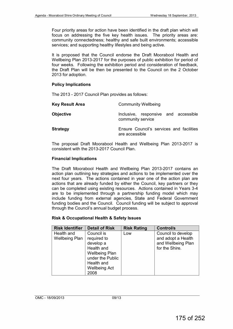
Agenda - Moorabool Shire Ordinary Meeting of Council Wednesday 18 September, 2013
OMC - 18/09/2013 09/13
Four priority areas for action have been identified in the draft plan which will focus on addressing the five key health issues. The priority areas are: community connectedness; healthy and safe built environments; accessible services; and supporting healthy lifestyles and being active. It is proposed that the Council endorse the Draft Moorabool Health and Wellbeing Plan 2013-2017 for the purposes of public exhibition for period of four weeks. Following the exhibition period and consideration of feedback, the Draft Plan will be then be presented to the Council on the 2 October 2013 for adoption. Policy Implications The 2013 - 2017 Council Plan provides as follows: Key Result Area Community Wellbeing Objective Inclusive, responsive and accessible
community service
Strategy Ensure Council’s services and facilities are accessible
The proposal Draft Moorabool Health and Wellbeing Plan 2013-2017 is consistent with the 2013-2017 Council Plan. Financial Implications The Draft Moorabool Health and Wellbeing Plan 2013-2017 contains an action plan outlining key strategies and actions to be implemented over the next four years. The actions contained in year one of the action plan are actions that are already funded by either the Council, key partners or they can be completed using existing resources. Actions contained in Years 3-4 are to be implemented through a partnership funding model which may include funding from external agencies, State and Federal Government funding bodies and the Council. Council funding will be subject to approval through the Council’s annual budget process. Risk & Occupational Health & Safety Issues
Risk Identifier Detail of Risk Risk Rating Control/s Health and Wellbeing Plan
Council is required to develop a Health and Wellbeing Plan under the Public Health and Wellbeing Act 2008
Low Council to develop and adopt a Health and Wellbeing Plan for the Shire.
175 of 252
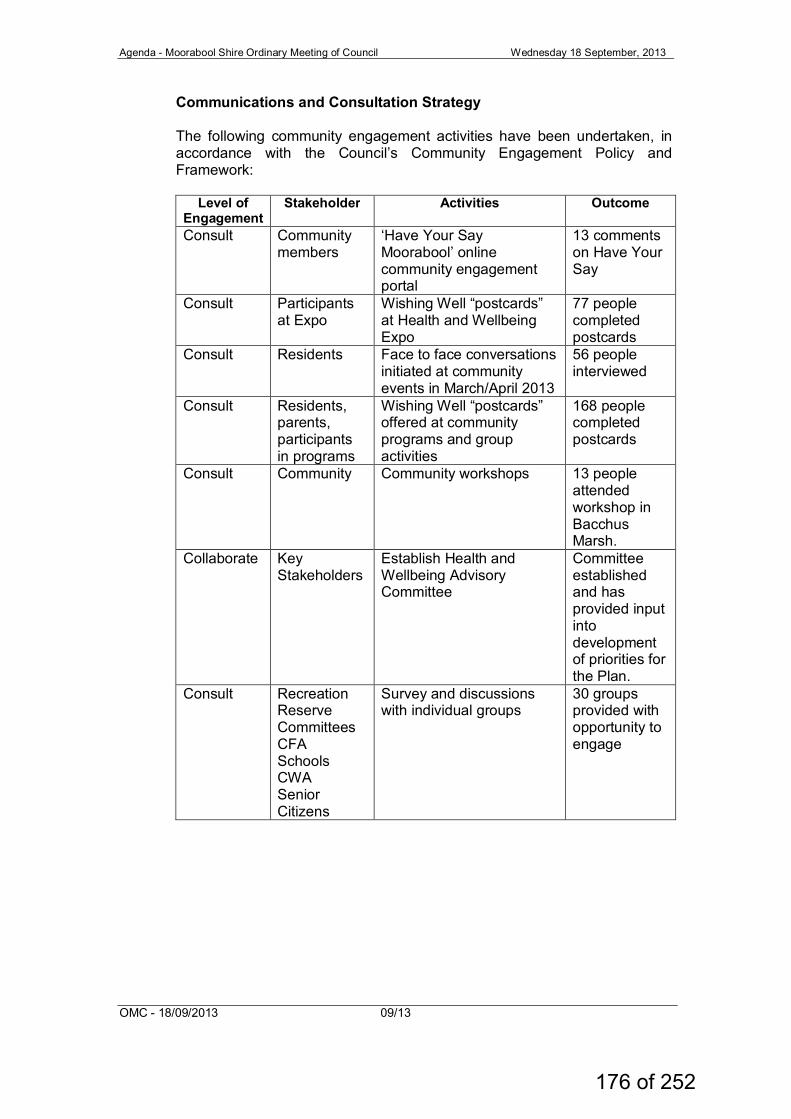
Agenda - Moorabool Shire Ordinary Meeting of Council Wednesday 18 September, 2013
OMC - 18/09/2013 09/13
Communications and Consultation Strategy The following community engagement activities have been undertaken, in accordance with the Council’s Community Engagement Policy and Framework:
Level of Engagement
Stakeholder Activities Outcome
Consult Community members
‘Have Your Say Moorabool’ online community engagement portal
13 comments on Have Your Say
Consult Participants at Expo
Wishing Well “postcards” at Health and Wellbeing Expo
77 people completed postcards
Consult Residents Face to face conversations initiated at community events in March/April 2013
56 people interviewed
Consult Residents, parents, participants in programs
Wishing Well “postcards” offered at community programs and group activities
168 people completed postcards
Consult Community Community workshops 13 people attended workshop in Bacchus Marsh.
Collaborate Key Stakeholders
Establish Health and Wellbeing Advisory Committee
Committee established and has provided input into development of priorities for the Plan.
Consult Recreation Reserve Committees CFA Schools CWA Senior Citizens
Survey and discussions with individual groups
30 groups provided with opportunity to engage
176 of 252
Agenda - Moorabool Shire Ordinary Meeting of Council Wednesday 18 September, 2013
OMC - 18/09/2013 09/13
The Draft Plan will be placed on public exhibition for four weeks. The exhibition of the draft plan will involve: • The Have Your Say website, Council’s on-line engagement portal; • Making copies of the draft plan available at Council’s Customer
Service locations, Lerderderg Library, Ballan Library and all rural library sites;
• Providing a copy of the draft plan to members of the Council’s Health and Wellbeing Committee, other community groups and organisations, State and Federal Government and adjoining municipalities; and
• Providing a copy of the draft plan to all Council delegated committees of management.
The process for submissions will be advertised through local newspapers and other communication processes i.e. email groups and Council’s website. Victorian Charter of Human Rights and Responsibilities Act 2006 In developing this report to Council, the officer considered whether the subject matter raised any human rights issues. In particular, whether the scope of any human right established by the Victorian Charter of Human Rights and Responsibilities is in any way limited, restricted or interfered with by the recommendations contained in the report. It is considered that the subject matter does not raise any human rights issues. Officer's Declaration of Conflict of Interests Under section 80C of the Local Government Act 1989 (as amended), officers providing advice to Council must disclose any interests, including the type of interest. General Manager – Danny Colgan In providing this advice to Council as the General Manager, I have no interests to disclose in this report. Author – Kate Diamond-Keith In providing this advice to Council as the Author, I have no interests to disclose in this report. Conclusion The Draft Moorabool Health and Wellbeing Plan 2013-2017 is a Plan to guide future investment and direction in improving the health and wellbeing of the community for both Council and key community partners. The Draft Plan will be implemented and evaluated by the Health and Wellbeing Committee and the Committee members will be directly involved in implementing the actions in the Plan.
177 of 252
Agenda - Moorabool Shire Ordinary Meeting of Council Wednesday 18 September, 2013
OMC - 18/09/2013 09/13
Recommendation: That Council: 1. endorse in principle the Draft Moorabool Health and Wellbeing
Plan 2013-2017 for the purposes of public exhibition for a period of four weeks
2. receive a further report at the conclusion of the exhibition period seeking adoption of the Moorabool Health and Wellbeing Plan 2013-2017.
Report Authorisation Authorised by: Name: Danny Colgan Title: General Manager Community Services Date: Thursday 5 September, 2013
178 of 252
Agenda – Moorabool Shire Ordinary Meeting of Council Wednesday 18 September, 2013
OMC – 18/9/2013 08/13
A
ttachment - Item
11.3.1
179 of 252
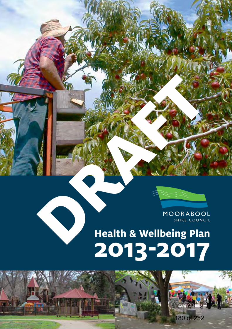
Health & Wellbeing Plan
2013-2017DRAFT
180 of 252
2 moorabool health & wellbeing plan 2012-2017 >>
table of contents » ExEcutivE Summary 2
» moorabool – a HEaltHy community 4
» introduction 6
» council Planning contExt 11
» Public HEaltH and WEllbEing in contExt 15
» mEtHodology 19
» Engaging tHE community about HEaltH and WEllbEing 20
» HEaltH ProfilE 22
» Policy contExt 27
» moorabool HEaltH and WEllbEing Plan action Plan 30
» Evaluation and rEPorting 42
moorabool health & wellbeing plan 2012-2017 >> 181 of 252

1moorabool health & wellbeing plan 2012-2017 >>182 of 252
2 moorabool health & wellbeing plan 2012-2017 >>
executive summarytHE draft moorabool HEaltH and WEllbEing Plan 2013-2017 (“draft Plan”) iS a four yEar Plan for EnHancing tHE HEaltH and WEllbEing of our rESidEntS. tHE draft Plan aimS to caPturE tHE HEaltH and WEllbEing StatuS of our community and PrESEnt a Plan in PartnErSHiP WitH local HEaltH ProvidErS and community organiSationS, to imProvE tHE HEaltH of tHE moorabool community.
Under section 26 of the Public Health and Wellbeing Act 2008, the Council is required to develop a Health and Wellbeing Plan within 12 months of a Council Election. The Health and Wellbeing Plan must be consistent with the Council Plan and the other plans including the Municipal Strategic Statement and be reviewed annually and evaluated at the end of the four year period.
The Health and Wellbeing of our community is determined not only by physical and psychological
factors, but also by the way we live and work, our social networks, friends and family, how we access leisure facilities, availability of services in our area, laws and regulations governing our community. A Moorabool Health Profile has been developed to examine the health and wellbeing indicators for the Shire. This profile has identified five key health issues, which include mental health, obesity, drug and alcohol abuse, family violence and access to family support services.
To facilitate the development of this Plan, a Health and Wellbeing Committee was appointed by the Moorabool Shire Council, with Cr. Tonia Dudzik as the Chairperson. This committee comprises representatives from local health services, agencies and organisations. The committee has determined the key priority areas for the Health and Wellbeing Plan by considering the following information:
» Health profile data
» Outcomes of community engagement activities - what the community told us about their health and wellbeing
183 of 252
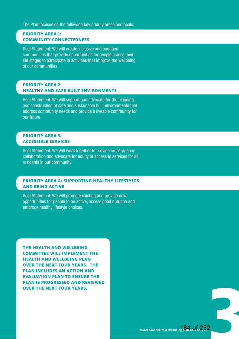
The Plan focuses on the following key priority areas and goals:
Priority arEa 1: community connEctEdnESS
Goal Statement: We will create inclusive and engaged communities that provide opportunities for people across their life stages to participate in activities that improve the wellbeing of our communities.
Priority arEa 2: HEaltHy and SafE built EnvironmEntS
Goal Statement: We will support and advocate for the planning and construction of safe and sustainable built environments that address community needs and provide a liveable community for our future.
Priority arEa 3: accESSiblE SErvicES
Goal Statement: We will work together to provide cross-agency collaboration and advocate for equity of access to services for all residents in our community.
Priority arEa 4: SuPPorting HEaltHy lifEStylES and bEing activE
Goal Statement: We will promote existing and provide new opportunities for people to be active, access good nutrition and embrace healthy lifestyle choices.
3moorabool health & wellbeing plan 2012-2017 >>
tHE HEaltH and WEllbEing committEE Will imPlEmEnt tHE HEaltH and WEllbEing Plan ovEr tHE nExt four yEarS. tHE Plan includES an action and Evaluation Plan to EnSurE tHE Plan iS ProgrESSEd and rEviEWEd ovEr tHE nExt four yEarS.
184 of 252
4 moorabool health & wellbeing plan 2012-2017 >>
moorabool – a healthy communitymoorabool SHirE iS faSt-groWing SEmi-rural municiPality nEStlEd bEtWEEn mElbournE, gEElong and ballarat. it offErS rESidEntS PicturESquE and friEndly SurroundS WitH tHE vibrancy of an activE, groWing community.
The Moorabool Shire provides many opportunities for residents and visitors to embrace a healthy lifestyle including a variety community facilities that offer health and wellbeing outcomes. From our many sporting and recreation centres, to the vast network of walking trails, there is ample opportunity for people to engage in physical activities. In fact Moorabool Shire has the highest percentage per capita of people actively involved in sport and recreation participation across the Grampians Region (Department Planning Community Development, 2011, LGA Participation Central Highlands Wimmera).
The Moorabool Shire is currently implementing a Federal Government Healthy Communities Project aimed at increasing physical activity and healthy eating throughout the Shire. This new program has had high participation rates, with multiple walking groups and healthy eating programs operating across the Shire.
Moorabool is a community known for its high level of volunteerism with many people in the community connected through volunteering, for example at the local football club, CFA, kindergarten. Volunteerism leads to great communities and we are fortunate to have a web of strong and resilient communities. According to the 2011 Census, voluntary work performed by the population in Moorabool Shire compared to Victoria showed that there was a higher proportion of persons who volunteered for an organisation or group. Overall, 20.3% of the population or over 5,700 people reported performing voluntary work, compared with 17.7% for Victoria.
Housing affordability is a major drawcard for young families and couples relocating to the Shire. Bacchus Marsh, Ballan, Gordon and the many smaller towns in the Shire offer a vital array of community infrastructure, established social and sporting networks and the charm and character experienced only in rural areas.
The Shire’s growing population provides tremendous opportunities for business growth and investment. The excellent services we provide, and those planned for the future, will see Moorabool become an even more attractive prospect.
Moorabool is well connected to Melbourne, Geelong and Ballarat, with easy access to major highways. The regular train link between Ballarat and Melbourne services Moorabool with stops at Ballan and Bacchus Marsh. Furthermore, Bacchus Marsh is included as part of the metropolitan public transport ticketing system.
Households in Moorabool Shire bring in an average household income 17% higher than the non-metropolitan Victoria average. Moorabool historically has a low unemployment rate compared to the Victorian average. The latest figures show the unemployment rate in Moorabool Shire is 4.6%, below the State average of 4.8%.
The Shire’s primary tourist attractions are the massive gorges with volcanic rock floors more than 250 million years old, and the national and state parks. Ancient landscapes comprising Permian glacial rock deposits, rare and distinctive vegetation more than 600 kilometres out of its natural zone, and dramatic land forms with massive views are integral to the sense of place experienced in Moorabool Shire.
185 of 252

5moorabool health & wellbeing plan 2012-2017 >>186 of 252

6 moorabool health & wellbeing plan 2012-2017 >>6 moorabool health & wellbeing plan 2012-2017 >>
introductiontHE HEaltH and WEllbEing of our community iS dEtErminEd by not only PHySical and PSycHological factorS, but alSo by tHE Way WE livE and Work, our Social nEtWorkS, friEndS and family, HoW WE accESS lEiSurE facilitiES, availability of SErvicES in our arEa and laWS and rEgulationS govErning our community.
The Victorian Public Health and Wellbeing Plan 2011-2015 defines Public Health:
‘Is what we, as a society, do collectively to assure the conditions in which people can be healthy.’ Public health focuses on prevention, promotion, and protection rather than on treatment, on populations rather than individuals, and on the factors and behaviours that cause illness and injury.’’ (Source: Victorian Public Health and Wellbeing Plan 2011-2015)
The draft plan aims to capture the health and wellbeing status of our community and present a plan in partnership with local health providers and community organisations to improve the health of the Moorabool community.
The Council already supports and delivers a range of activities and facilities that support the health and wellbeing of the community including parks and leisure facilities, walking tracks, bike paths, playgrounds, health programs, immunisation programs, environmental health and public health awareness. However, like every community, there are areas for improvement and areas where the Council can advocate for change.
The draft plan is a four year plan for enhancing the health and wellbeing of our residents. The development of priorities for the plan has been undertaken in close partnership with the following key agencies:
» Central Highlands Primary Care Partnership
» Ballan and District Health and Care
» Child and Family Services (CAFS) Moorabool
» Ballan and District Health and Care
» Women’s Health Grampians
» Vic Roads
» Darley Neighbourhood House and Early Learning Centre
» Bacchus Marsh Community College
» Ballan and District Community House and Adult Education Centre
» Bacchus Marsh & Melton Regional Hospital
» Bacchus Marsh Police
» Pinarc Disability Support
» Merrimu Services Inc
» Djerriwarrh Health Services
» Medicare Grampians Region
» Highlands Local Learning and Employment Network
» Ballarat Community Health – Mental Health Service
» Indigenous Group for Bacchus Marsh and Surrounds
187 of 252

The Plan focuses on four key priority areas:
Priority arEa 1: community connEctEdnESS
Goal Statement: We will create inclusive and engaged communities that provide opportunities for people across their life stages to participate in activities that enhance the wellbeing of our communities.
What do we want to achieve?: » Inclusive communities that embrace diversity and gender
equality
» Moorabool as a community for young people, children and families, aged and those with disabilities to participate in activities that improve health and wellbeing
» The development of new and expanded services that address issues such as family violence, drug and alcohol abuse, mental health issues and support disadvantaged people in our community.
» An inclusive community that enables people to connect with one another
Priority arEa 2: HEaltHy and SafE built EnvironmEntS
Goal Statement: We will support and advocate for the planning and construction of safe and sustainable built environments that address community needs and provide a liveable community for our future.
What do we want to achieve?: » Improved access for families, children and young people to
physical activity programs and facilities
» Advocacy for innovative and alternative transport options
» Interventions that promote community safety including – lighting, maintenance, passive surveillance
» A reduction in the level of road congestion in our community
» Inclusive and user friendly open spaces
» The development of multi-use integrated community facilities within a place based approach in partnership with service providers and community organisations
» Ensure as the population grows, the employment and retail opportunity also grows to reduce the need to commute to Melbourne and Ballarat for work or personal services
» Increased numbers of students completing post compulsory secondary and further education 7moorabool health & wellbeing plan 2012-2017 >>188 of 252
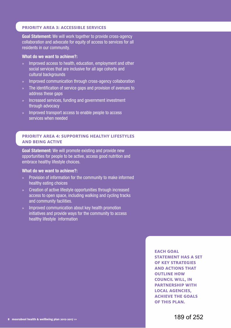
8 moorabool health & wellbeing plan 2012-2017 >>
Priority arEa 3: accESSiblE SErvicES
Goal Statement: We will work together to provide cross-agency collaboration and advocate for equity of access to services for all residents in our community.
What do we want to achieve?: » Improved access to health, education, employment and other
social services that are inclusive for all age cohorts and cultural backgrounds
» Improved communication through cross-agency collaboration
» The identification of service gaps and provision of avenues to address these gaps
» Increased services, funding and government investment through advocacy
» Improved transport access to enable people to access services when needed
Priority arEa 4: SuPPorting HEaltHy lifEStylES and bEing activE
Goal Statement: We will promote existing and provide new opportunities for people to be active, access good nutrition and embrace healthy lifestyle choices.
What do we want to achieve?: » Provision of information for the community to make informed
healthy eating choices
» Creation of active lifestyle opportunities through increased access to open space, including walking and cycling tracks and community facilities.
» Improved communication about key health promotion initiatives and provide ways for the community to access healthy lifestyle information
EacH goal StatEmEnt HaS a SEt of kEy StratEgiES and actionS tHat outlinE HoW council Will, in PartnErSHiP WitH local agEnciES, acHiEvE tHE goalS of tHiS Plan.
8 moorabool health & wellbeing plan 2012-2017 >> 189 of 252

9moorabool health & wellbeing plan 2012-2017 >>190 of 252
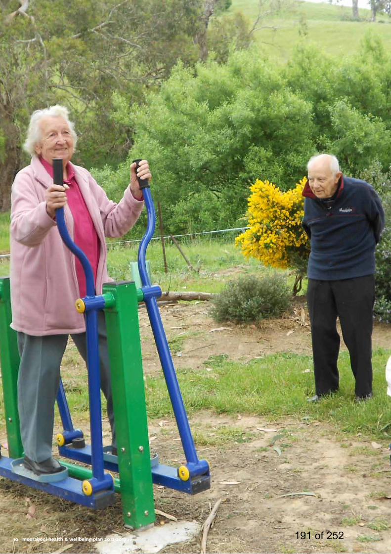
10 moorabool health & wellbeing plan 2012-2017 >>10 moorabool health & wellbeing plan 2012-2017 >> 191 of 252
11moorabool health & wellbeing plan 2012-2017 >>
council planning context tHE moorabool HEaltH and WEllbEing Plan iS a kEy Part of council’S Planning framEWork. tHE HEaltH and WEllbEing Plan informS tHE council Plan and otHEr StratEgic PlanS.
The Municipal Strategic Statement (MSS) provides the vision for land use planning and development within the Shire of Moorabool. The MSS provides a snapshot of existing and projected conditions regarding Moorabool’s people, built form and natural resources as well as regional strengths and key influences. The Statement identifies major issues, directions and strategies within zones, overlays and policies providing the means for achieving Council’s long-term objectives.
linkS to moorabool 2041
The Council has commenced a journey of ‘Moorabool 2041’ which is a process/framework aimed at documenting the opportunities, pressures and challenges facing Moorabool. The process will lead to a long term vision to guide the development of Moorabool to retain its character and the places we love and to ensure change provides new services and opportunities for our residents.
Moorabool 2041 will be a key document to:
» Guide our planning scheme content to deliver sustainable development and the protection of our agricultural, environmental and cultural resources.
» Plan for the augmentation of social and physical infrastructure and identify the role for state and federal governments in closing the infrastructure gap.
» Ensure that as the population grows, the employment and retail available also grows to reduce the need to commute to Melbourne and Ballarat for work or personal services.
The Health and Wellbeing Plan is being informed by and will inform the Moorabool 2041 process.
The Health and Wellbeing Plan will inform the development of other strategies and policies to ensure that they relate to the health and wellbeing priorities of the Shire. This ensures that the health needs of residents are promoted and represented across Council’s planning framework.
192 of 252
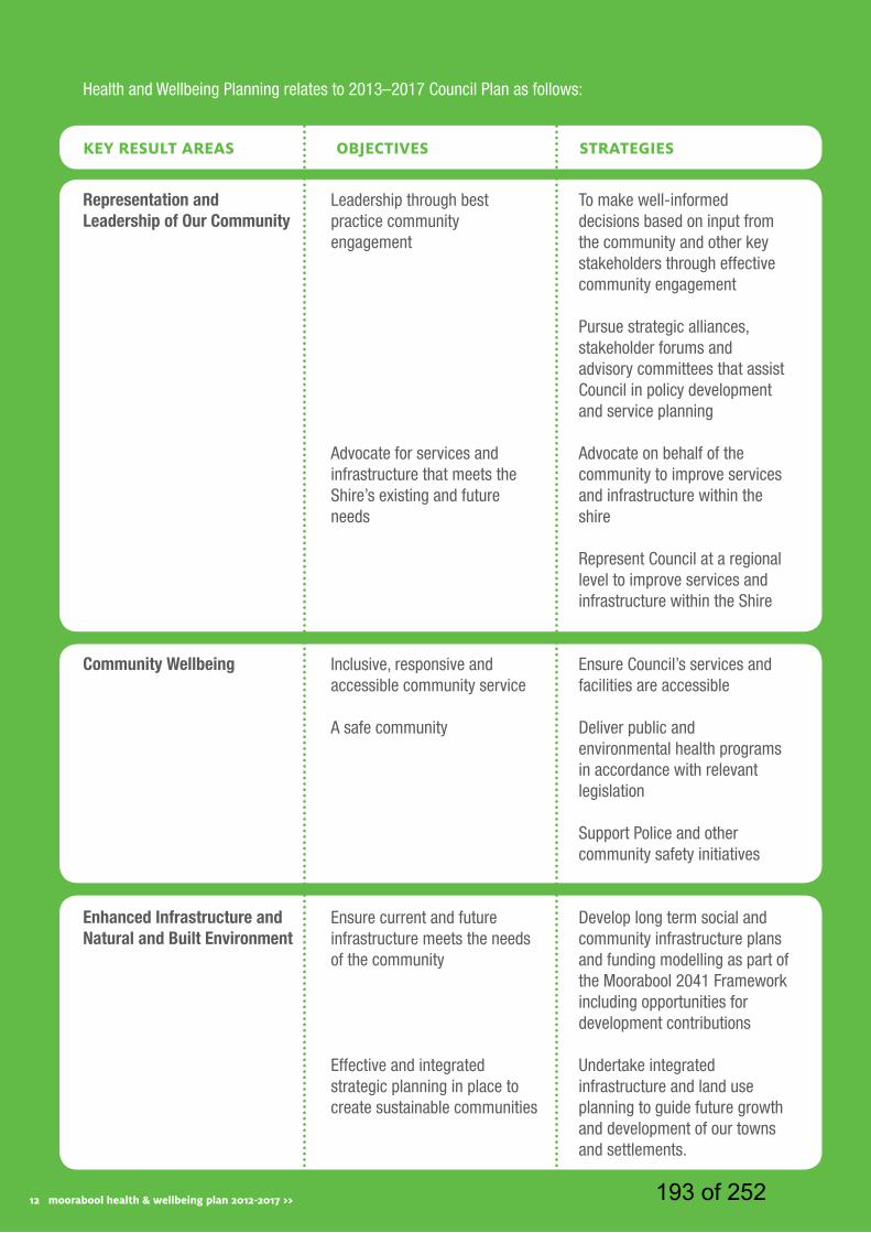
12 moorabool health & wellbeing plan 2012-2017 >>
Health and Wellbeing Planning relates to 2013–2017 Council Plan as follows:
kEy rESult arEaS obJEctivES StratEgiES
Representation and Leadership of Our Community
Community Wellbeing
Enhanced Infrastructure and Natural and Built Environment
Leadership through best practice community engagement
Advocate for services and infrastructure that meets the Shire’s existing and future needs
Inclusive, responsive and accessible community service
A safe community
Ensure current and future infrastructure meets the needs of the community
Effective and integrated strategic planning in place to create sustainable communities
To make well-informed decisions based on input from the community and other key stakeholders through effective community engagement
Pursue strategic alliances, stakeholder forums and advisory committees that assist Council in policy development and service planning
Advocate on behalf of the community to improve services and infrastructure within the shire
Represent Council at a regional level to improve services and infrastructure within the Shire
Ensure Council’s services and facilities are accessible
Deliver public and environmental health programs in accordance with relevant legislation
Support Police and other community safety initiatives
Develop long term social and community infrastructure plans and funding modelling as part of the Moorabool 2041 Framework including opportunities for development contributions
Undertake integrated infrastructure and land use planning to guide future growth and development of our towns and settlements.
12 moorabool health & wellbeing plan 2012-2017 >> 193 of 252
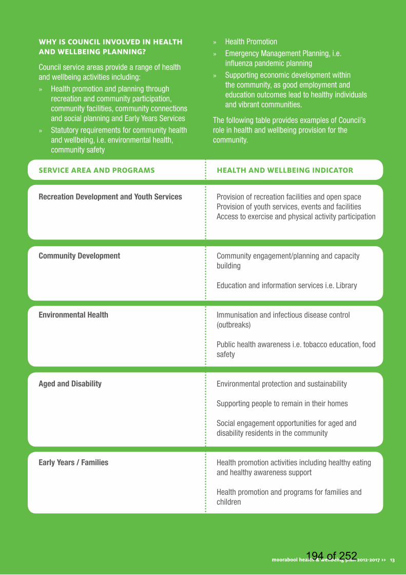
SErvicE arEa and ProgramS HEaltH and WEllbEing indicator
Recreation Development and Youth Services
Community Development
Environmental Health
Aged and Disability
Early Years / Families
WHy iS council involvEd in HEaltH and WEllbEing Planning?
Council service areas provide a range of health and wellbeing activities including:
» Health promotion and planning through recreation and community participation, community facilities, community connections and social planning and Early Years Services
» Statutory requirements for community health and wellbeing, i.e. environmental health, community safety
» Health Promotion
» Emergency Management Planning, i.e. influenza pandemic planning
» Supporting economic development within the community, as good employment and education outcomes lead to healthy individuals and vibrant communities.
The following table provides examples of Council’s role in health and wellbeing provision for the community.
Provision of recreation facilities and open spaceProvision of youth services, events and facilitiesAccess to exercise and physical activity participation
Community engagement/planning and capacity building
Education and information services i.e. Library
Immunisation and infectious disease control (outbreaks)
Public health awareness i.e. tobacco education, food safety
Environmental protection and sustainability
Supporting people to remain in their homes
Social engagement opportunities for aged and disability residents in the community
Health promotion activities including healthy eating and healthy awareness support
Health promotion and programs for families and children
moorabool health & wellbeing plan 2012-2017 >> 13194 of 252

14 moorabool health & wellbeing plan 2012-2017 >>
SErvicE arEa and ProgramS HEaltH and WEllbEing indicator
Key age and stage health checks for childrenManagement of Council’s land that contains natural assets
Planning healthy and sustainable communities
Lobbying to ensure land use development policy frameworks provide safer by design/ healthy by design/ urban design outcomes
Community infrastructure provision i.e. parks, trails, cycling and walking tracks
Waste services and management
Traffic and transport management and planning
Public safety via animal control
Traffic safety and school crossings, through parking patrols
Advocating for local employment opportunities to reduce the need to commute to Melbourne and Ballarat
Promotion of the education and employment opportunities available in the Shire
Strategic and Sustainable Development
Infrastructure Services
Community Safety
Economic Development
Council also has a leadership and advocacy role in health and wellbeing including:
» Advocating for improved health service provision in partnership with local providers
» Accessing State and Federal Government Funding to improve existing and provide new community facilities
» Engaging the community in determining their current and future health needs and representing the community in advocating for these needs
» Leading the way with planning for new communities, public spaces and opportunities for residents to connect with and support their local community
» Through a holistic approach to health planning support Moorabool residents are able to access appropriate, accessible, timely services that meet their needs.
14 moorabool health & wellbeing plan 2012-2017 >> 195 of 252
15moorabool health & wellbeing plan 2012-2017 >>
public health & wellbeing planning in contexttHE Public HEaltH and WEllbEing act 2008 (SEction26), StatES tHat tHE council iS rEquirEd to dEvEloP a HEaltH and WEllbEing Plan WitHin 12 montHS of a council ElEction.
The Health and Wellbeing Plan must be consistent with the Council Plan and the Municipal Strategic Statement and be reviewed annually and evaluated at the end of the four year period. The Council must involve the community in the development of the Plan and identify how it intends to work in partnership with the Department of Health and other agencies undertaking public health initiatives, projects and programs to accomplish the goals and strategies identified in the plan.
WHy iS HEaltH and WEllbEing imPortant for tHE moorabool community?
The Victorian Government’s Environments for health municipal public health planning framework (Department of Human Services 2001) was developed to assist Local Governments in developing their Public Health Plans.
It outlines the four environments for health as:
» Built
» Social
» Economic
» Natural
196 of 252
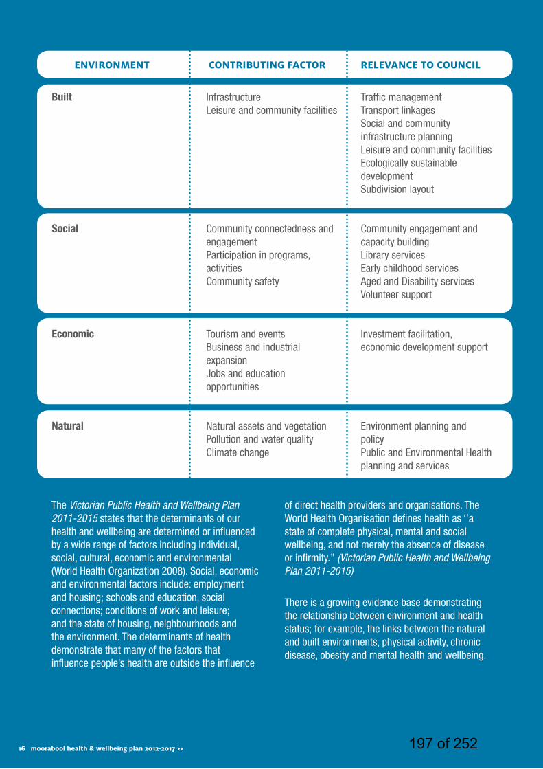
16 moorabool health & wellbeing plan 2012-2017 >>
EnvironmEnt contributing factor rElEvancE to council
Built
Social
Economic
Natural
Infrastructure Leisure and community facilities
Community connectedness and engagementParticipation in programs, activitiesCommunity safety
Tourism and eventsBusiness and industrial expansionJobs and education opportunities
Natural assets and vegetationPollution and water qualityClimate change
Traffic management Transport linkagesSocial and community infrastructure planningLeisure and community facilitiesEcologically sustainable developmentSubdivision layout
Community engagement and capacity buildingLibrary servicesEarly childhood servicesAged and Disability servicesVolunteer support
Investment facilitation, economic development support
Environment planning and policyPublic and Environmental Health planning and services
The Victorian Public Health and Wellbeing Plan 2011-2015 states that the determinants of our health and wellbeing are determined or influenced by a wide range of factors including individual, social, cultural, economic and environmental (World Health Organization 2008). Social, economic and environmental factors include: employment and housing; schools and education, social connections; conditions of work and leisure; and the state of housing, neighbourhoods and the environment. The determinants of health demonstrate that many of the factors that influence people’s health are outside the influence
of direct health providers and organisations. The World Health Organisation defines health as ‘’a state of complete physical, mental and social wellbeing, and not merely the absence of disease or infirmity.’’ (Victorian Public Health and Wellbeing Plan 2011-2015)
There is a growing evidence base demonstrating the relationship between environment and health status; for example, the links between the natural and built environments, physical activity, chronic disease, obesity and mental health and wellbeing.
16 moorabool health & wellbeing plan 2012-2017 >> 197 of 252
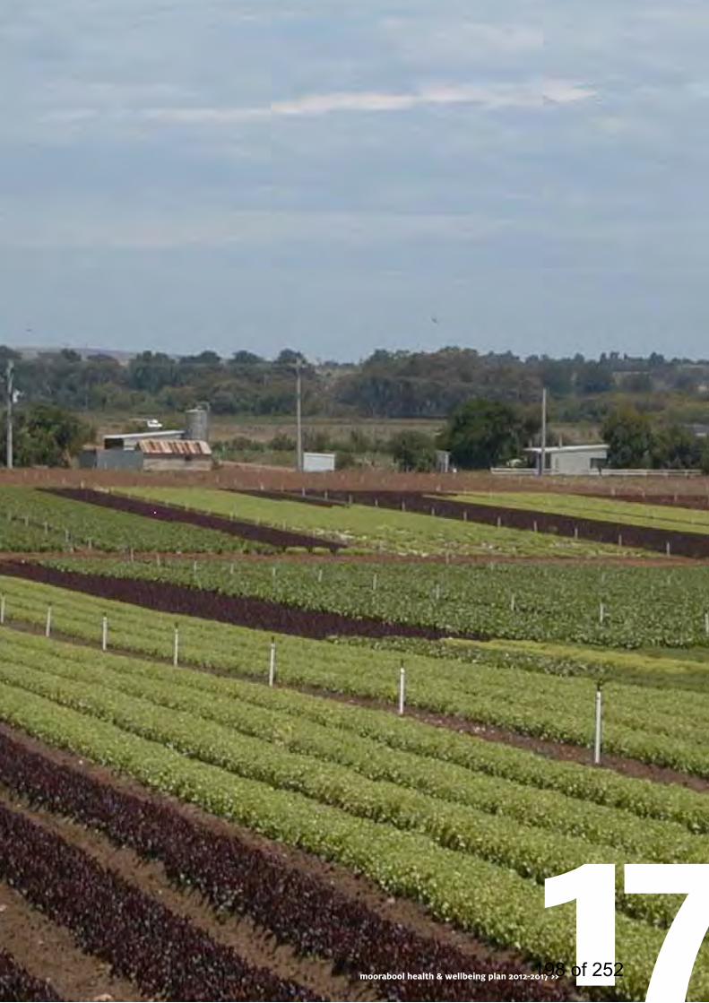
17moorabool health & wellbeing plan 2012-2017 >>198 of 252

18 moorabool health & wellbeing plan 2012-2017 >>18 moorabool health & wellbeing plan 2012-2017 >> 199 of 252
methodologytHE dEvEloPmEnt of tHE moorabool HEaltH and WEllbEing Plan HaS involvEd ExtEnSivE community EngagEmEnt, analySiS of dEmograPHic and HEaltH data and rESEarcH including:
» The collation and analysis of current health and wellbeing data to develop a Moorabool Health Profile
» Establishment of the Health and Wellbeing Advisory Committee with representatives comprising of internal and external stakeholders identified as having high interest/high influence in the development and implementation of the Plan. It is intended for this group to continue once the Health and Wellbeing Plan has been developed to support, drive and monitor the implementation of the four year plan.
» Analysis of State Government Policies, including the Victorian Public Health and Wellbeing Plan 2011-2015
» Review of related Council plans, strategies and policies
» Implementation of the Community Engagement Plan as detailed in the table below
19moorabool health & wellbeing plan 2012-2017 >>200 of 252

20 moorabool health & wellbeing plan 2012-2017 >>
engaging the community about health & wellbeing WHy EngagE WitH tHE community?
Moorabool Shire Council is committed to undertaking best practice community engagement in the development and implementation of the Moorabool Health and Wellbeing Plan.
Consistent with the Moorabool Shire Council Community Engagement Policy, effective community engagement ensures that key stakeholders and the broader community are appropriately engaged in decision making processes. This means providing genuine opportunities for all sectors of the community to share their ideas, knowledge and experiences through the use of multiple engagement tools and techniques (workshops, committees, fact sheets, and social media). It also means the provision of balanced and objective information and involves actively asking, listening and giving feedback around how key stakeholder and broader community input influenced the decision making process.
Undertaking a ‘best practice’ community engagement process in the development of the Moorabool Health and Wellbeing Plan has reinforced Councils commitment to establishing a partnership approach to improving health and wellbeing outcomes in Moorabool. The process has been crucial for not only understanding health and wellbeing issues and concerns, but also in identifying a set of shared priorities, strategies and actions to improve the health and wellbeing of the community moving forward.
WHat did tHE community tEll uS about HEaltH and WEllbEing in moorabool?
The issues and ideas raised through the community engagement process were grouped
into seven broad themes. These are as follows:
Recreational and Social » Reference was made to specific infrastructure
ranging from sporting facilities to arts and culture facilities as well as facilities targeted to specific demographic groups (for example, a youth space).
» New and improved parks, gardens and outdoor facilities
» Programming including exercise programs, literacy programs, and activities for different demographic cohorts.
Services and Supports » The importance of health services, in
particular, the need for accessibility to basic and specialist services.
» Increased availability of a broad range of health and wellbeing programs across a range of demographic groups.
» The need for other support services such as transport. The availability of highly specialised services was also raised as an issue of importance.
Education and Attitude » Availability of educational opportunities from
kindergarten through to secondary school and beyond.
Roads and Traffic » Improved road infrastructure
» Traffic congestion was raised as an ongoing issue.
Tracks and Trails » The maintenance of tracks and trails
throughout the Shire as vital to ensuring the safe passage of users.
201 of 252
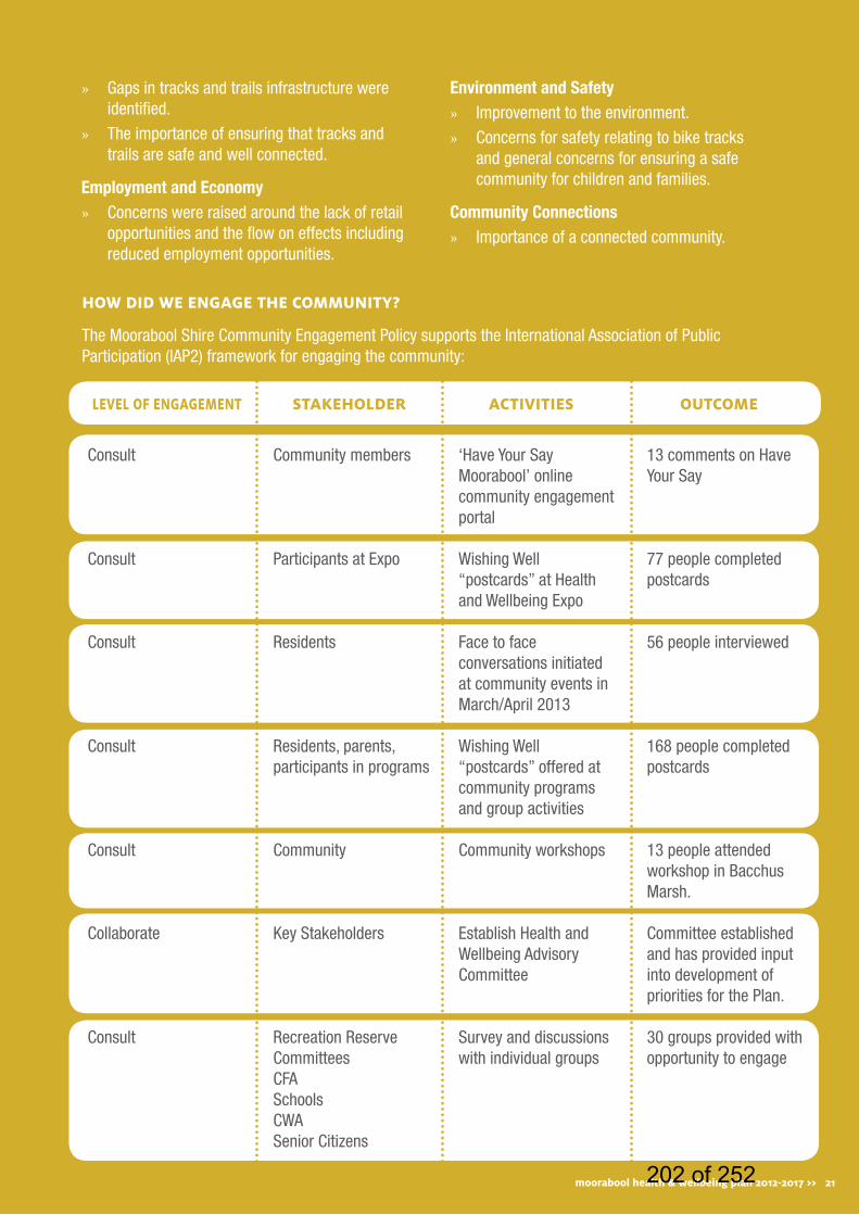
» Gaps in tracks and trails infrastructure were identified.
» The importance of ensuring that tracks and trails are safe and well connected.
Employment and Economy » Concerns were raised around the lack of retail
opportunities and the flow on effects including reduced employment opportunities.
Environment and Safety » Improvement to the environment.
» Concerns for safety relating to bike tracks and general concerns for ensuring a safe community for children and families.
Community Connections » Importance of a connected community.
HoW did WE EngagE tHE community?
The Moorabool Shire Community Engagement Policy supports the International Association of Public Participation (IAP2) framework for engaging the community:
lEvEl of EngagEmEnt StakEHoldEr activitiES outcomE
Consult
Consult
Consult
Consult
Consult
Collaborate
Consult
Community members
Participants at Expo
Residents
Residents, parents, participants in programs
Community
Key Stakeholders
Recreation Reserve CommitteesCFASchoolsCWASenior Citizens
‘Have Your Say Moorabool’ online community engagement portal
Wishing Well “postcards” at Health and Wellbeing Expo
Face to face conversations initiated at community events in March/April 2013
Wishing Well “postcards” offered at community programs and group activities
Community workshops
Establish Health and Wellbeing Advisory Committee
Survey and discussions with individual groups
13 comments on Have Your Say
77 people completed postcards
56 people interviewed
168 people completed postcards
13 people attended workshop in Bacchus Marsh.
Committee established and has provided input into development of priorities for the Plan.
30 groups provided with opportunity to engage
moorabool health & wellbeing plan 2012-2017 >> 21202 of 252
22 moorabool health & wellbeing plan 2012-2017 >>
health profiletHE moorabool HEaltH ProfilE ProvidES a dEtailEd analySiS of tHE StatuS of HEaltH and WEllbEing in tHE moorabool SHirE. tHE HEaltH ProfilE idEntifiEd tHE fivE kEy HEaltH iSSuES for moorabool aS; mEntal HEaltH, obESity, family violEncE, drug and alcoHol abuSE and accESS to family SuPPort SErvicES.
The following provides a brief overview of the health issues in the Moorabool Shire and what they mean for the community. A copy of the Moorabool Health Profile is located on the Council website, or by contacting the Council’s Community Development Unit.
PoPulation ovErviEW
Moorabool Shire is located in the Central Highlands region of Victoria, strategically positioned between Melbourne and Ballarat. The Shire is predominantly rural, with large areas of state forest. The major population centre of the Shire is the Bacchus Marsh area. In recent decades this area has experienced significant residential growth, a result of its proximity to employment in Melbourne, its topography and rural atmosphere. Ballan has also experienced some growth, although at a significantly slower rate, due to its location outside of the Melbourne ‘commuter belt’.
In 2012 the estimated population of Moorabool Shire was 29,263 people. By 2031, the population of Moorabool Shire is forecast to be 41,662; this represents an average annual growth rate of 1.83%. The most populous age group in Moorabool Shire is 10-14 year olds. By 2021, the number of people aged under 15 is forecast to increase by 27 per cent, while the number of people aged over 65 is expected to increase by 110.8 per cent and the age group which is forecast to have the largest
proportional increase (relative to its population size) is 85 and over year olds, who are forecast to increase by 127.9 per cent.
The population of Moorabool is predominantly of Anglo-Saxon Celtic background (81.2%) with 12.18 per cent of the population born overseas. Indigenous residents make up 0.9 per cent of the total population of Moorabool Shire. However, the ABS acknowledges that the Census figures under-represent the true Indigenous population in many areas.
family and community
Moorabool Shire has a high level of community connection, residents were asked to rate their satisfaction with feeling part of their community and answers are presented according to a 0-100 range. The average community connection score for Australians is approximately 70, in comparison the average score for persons living in Moorabool Shire was 75.2.
Volunteering helps strengthen our community and there are enormous benefits for the volunteer including improved physical and mental health. 20.3 per cent of Moorabool residents report they help out as a volunteer.
Almost three-quarters of Moorabool residents (73.8%) shared a meal with their families at least five days a week. This was higher than the Victorian average (66.3%). When families eat meals together, the evidence suggests that they consume more nutritious food than when each family member eats alone. Shared meal times should be seen as a special time for families to connect and share the day’s or week’s events, the benefits of shared meals are not isolated to evening meals, but can include family breakfasts and weekend lunches.
203 of 252
HouSing
The primary housing market role that Moorabool Shire has played since the 1970s is providing alternative housing options for older families generally originating in Melbourne’s western suburbs. There is continued demand for residential expansion within the eastern areas of the Shire from both existing residents and from external migrants, most notably from Melbourne’s western suburbs. It is assumed that this pattern will continue into the future, as long as sufficient supplies of land are available for development.
Moorabool Shire has a higher proportion of affordable lettings than the Victorian average; however there are a lower proportion of rented dwellings owned by the government or a community/church group compared to the regional Victorian average. In 2006, compared to the Victoria average, a higher proportion of Moorabool residents (not visitors) were living in a caravan, cabin or houseboat or living in an improvised home, a tent, or were sleeping out.
HEaltH
Child Health Assessments are routinely undertaken by the Maternal and Child Health Service to monitor child health and development. Ten visits are anticipated according to key ages and stages until a child reaches 3.5 years of age. The rate of participation for children eligible for an assessment at 3.5 years was 72.4 per cent in Moorabool, compared to the Victorian State average of 62.2 per cent.
In Moorabool Shire the percentage of persons overweight or obese (53.1%) is significantly higher than the Victorian average (48.6%). This finding is consistent with the percentage of persons who did not meet fruit and vegetable dietary guidelines (50.6%). Moorabool Shire also reports a higher rate of smoking in females aged over 18 years (21.3%) compared to the Victorian average (16.9%) however the rate of smoking in males aged over 18 years (15.3%) is well below the State average of (21.4%).
Compared to Victoria, Moorabool had a higher rate of males with mental health issues.
Drug and alcohol use is an issue throughout the community with 7% at risk of short term harm of alcohol.
The number and proportion of residents with diabetes increased between 2001 and 2011. Compared to Victoria, Moorabool had a higher proportion of population aged 18 years and over that reported having doctor-diagnosed type 2 diabetes.
Between 2006 and 2010 Moorabool males were significantly more likely to have been diagnosed with cancer than females. Prostate cancer was the most commonly diagnosed cancer, followed by bowel and breast cancer.
Education &training
Educational qualifications are an important resource enabling individuals and their communities an opportunity to engage in the knowledge economy. The percentage of people living in Moorabool who had Tertiary or TAFE qualifications has been calculated from the 2006 Australian Bureau of Statistics. Of those living in Moorabool, 46.1 per cent of persons aged 25 years and over had tertiary or TAFE qualifications, compared to the Victorian State average of 50.7 per cent.
Between 2006 and 2011, the proportion of population aged 20 to 64 years that had completed Year 12 or equivalent increased but generally only by a very small percentage, compared to regional Victoria and Victoria figures. This increase was far greater for females than males.
A skilled workforce in a community is an essential component of a strong local economy with 53.8 per cent of employed persons working in Moorabool worked in highly skilled occupations compared to the Victorian State average of 56.3 per cent.
23moorabool health & wellbeing plan 2012-2017 >> 204 of 252
24 moorabool health & wellbeing plan 2012-2017 >>
crimE and SafEty
In Moorabool, there were 619 recorded crimes against the person per 100,000 population in 2011-12 compared to the Victorian State average of 984. In Moorabool, there were 3,486 recorded crimes against property per 100,000 population in 2011-12, compared to the Victorian State average of 4,797.
When walking alone in their local area during the day 98.3 per cent of persons in Moorabool felt safe or very safe, and when walking alone at night 79.6 per cent of persons in Moorabool felt safe or very safe, these figures exceed the Victorian average. Safe neighbourhoods help encourage physical activity, foster community connectedness and add to the overall health and wellbeing of residents.
A report by Women’s Health Grampians has indicated that the number of family violence incidents had consistantly increased between 2006/7 and 2011/12. The average number of family violence incidents a year in Moorabool for the six year period was 176.8.
lEiSurE and culturE
Opportunities to participate in leisure and cultural pursuits are intrinsic to individual and community wellbeing. As one of the most environmentally rich and naturally scenic municipalities in the state, Moorabool is a picturesque landscape abundant in breathtakingly diverse parks and gardens. Moorabool residents were as likely as other Victorians to visit green space, almost half (48.8%) reported visiting green space at least weekly in the previous three months, consistent with the Victorian average (50.7%).
Participation in Arts and Culture was measured in the 2011 VicHealth Indicators Survey. Respondents were asked if they had participated in a range of activities in the previous month, including painting, drawing, art and craft, playing musical instruments, singing, writing and performing. 62.6 per cent of persons in Moorabool had participated in at least one of the selected artistic and cultural activities in the previous month, compared the Victorian State average of 63.6 per cent.
Work and Economic dEvEloPmEnt
Moorabool Shire has a slightly lower unemployment rate (4.6%) than the Victorian average of (4.8%).
Compared to regional Victoria, Moorabool had a higher proportion of residents earning less than $200 per week and higher proportions earning over $800 per week. Moorabool residents aged 65 years and over were more likely to be earning between $300 and $399 per week than the Victoria average. However Moorabool had a slightly higher proportion of population that reported they could raise $2000 in two days in an emergency.
Finding a suitable balance between work and daily living is a challenge that all workers face, 37.6 per cent of employed persons living in Moorabool felt that they had a good work-life balance; this is compared to the Victorian State average of 53.1 per cent. Work-life balance is beneficial for individuals, their families, organisations, and society.
205 of 252
25moorabool health & wellbeing plan 2012-2017 >> 206 of 252

26 moorabool health & wellbeing plan 2012-2017 >>26 moorabool health & wellbeing plan 2012-2017 >> 207 of 252
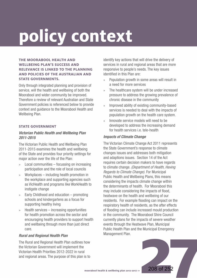
policy contexttHE moorabool HEaltH and WEllbEing Plan’S SuccESS and rElEvancE iS linkEd to tHE Planning and PoliciES of tHE auStralian and StatE govErnmEntS.
Only through integrated planning and provision of service, will the health and wellbeing of both the Moorabool and wider community be improved. Therefore a review of relevant Australian and State Government policies is referenced below to provide context and guidance to the Moorabool Health and Wellbeing Plan.
StatE govErnmEnt
Victorian Public Health and Wellbeing Plan 2011-2015
The Victorian Public Health and Wellbeing Plan 2011-2015 examines the health and wellbeing of the State and provides four priority settings for major action over the life of the Plan:
» Local communities – focussing on increasing participation and the role of local councils
» Workplaces – including health promotion in the workplace and supporting agencies such as VicHealth and programs like WorkHealth to instigate change
» Early Childhood and education – promoting schools and kindergartens as a focus for supporting healthy living
» Health services – increasing opportunities for health promotion across the sector and encouraging health providers to support health and wellbeing through more than just direct care.
Rural and Regional Health Plan
The Rural and Regional Health Plan outlines how the Victorian Government will implement the Victorian Health Priorities 2012-2022 in rural and regional areas. The purpose of this plan is to
identify key actions that will drive the delivery of services in rural and regional areas that are more responsive to people’s needs. The key issues identified in this Plan are:
» Population growth in some areas will result in a need for more services
» The healthcare system will be under increased pressure to address the growing prevalence of chronic disease in the community
» Improved ability of existing community-based services is needed to deal with the impacts of population growth on the health care system.
» Innovate service models will need to be developed to address the increasing demand for health services i.e. tele-health
Impacts of Climate Change
The Victorian Climate Change Act 2011 represents the State Government’s response to climate changes issues and addresses both mitigation and adaptions issues. Section 14 of the Act requires certain decision makers to have regards to climate change. (Department of Health, Having Regards to Climate Change). For Municipal Public Health and Wellbeing Plans, this means considering the impacts climate change within the determinants of health. For Moorabool this may include considering the impacts of flood, heatwave on the health and wellbeing of our residents. For example flooding can impact on the respiratory health of residents, as the after effects of flooding can include increased mould production in the community. The Moorabool Shire Council currently plans for the impacts of severe weather events through the Heatwave Plan, Municipal Public Health Plan and the Municipal Emergency Management Plan.
27moorabool health & wellbeing plan 2012-2017 >> 208 of 252

28 moorabool health & wellbeing plan 2012-2017 >>
Draft Central Highlands Regional Growth Plan
The draft Central Highlands Regional Growth Plan provides a regional approach to land use planning in the Central Highlands. It covers the municipalities of Ararat, Ballarat, Golden Plains, Hepburn, Moorabool and Pyrenees and identifies opportunities to encourage and accommodate growth and manage change over the next 30 years.
The plan identifies:
» where future development will be supported and assessed at a regional scale,
» environmental, economic, community and cultural assets and resources of regional significance that should be preserved, maintained or developed, and
» key regional priorities for future infrastructure planning and investment to support growth.
Overall Key Directions of the draft plan include:
» Support growth through the development of employment opportunities in towns identified for population growth.
» Encourage services, facilities and housing which meet the diverse needs of the community.
» Build on local opportunities to support sustainable growth and change in small towns.
» Develop communities that provide local jobs and services.
209 of 252

29moorabool health & wellbeing plan 2012-2017 >> 210 of 252
30 moorabool health & wellbeing plan 2012-2017 >>
moorabool health and wellbeing plan action planThe Action Plan identifies the key strategies and actions to address the key priority areas and improve the health and wellbeing of the Moorabool community. The strategies and actions identified are to be implemented over the short, medium and long term and address a multitude of issues across the Shire. The Moorabool Health and Wellbeing Committee will implement and monitor the Plan.
The action plan has been developed in conjunction with key partner agencies and organisations with the following key principles:
Strategies and actions must:
» be achievable and realistic for the timeframe
» have support from key partners in their implementation
» address the key health issues for the Shire
» be measurable against the key performance indicators
Priority arEa 1: community connEctEdnESS
goal StatEmEnt: We will create inclusive and engaged communities that provide opportunities for people across their life stages to participate in activities that improve the wellbeing of our communities.
30 moorabool health & wellbeing plan 2012-2017 >>
What we will do:
imProvE tHE HEaltH and WEllbEing outcomES for tHE moorabool community
actionS yEar kEy PartnErS HEaltH ProfilE arEa
Adopt a leadership statement on the issue of Violence Against Women to increase community awareness and demonstrate Council’s commitment to the issue
Advocate for improved careers advice services and apprenticeship opportunities for young people
Year 2
Year 1
Women’s Health Grampians
Highlands Local Learning and Employment Network
Family Violence
Education and training, work and economical development
211 of 252
actionS yEar kEy PartnErS HEaltH ProfilE arEa
In partnership with external agencies and Council staff prepare a report for Council consideration, to identify the key components of a new and dedicated youth space including the size and type of space required, governance and management arrangements, capital costs, operating costs, location and potential funding sources.
Develop a Social Outings Guide for Moorabool Shire.
Identify and promote alternative education programs for secondary school students
Implement a Community Leadership Program that focusses on health and wellbeing issues and outcomes
Produce a ‘Strengthening Diversity Plan’ that is shared with the local Health Services
Continue to promote the positive health benefits of increased education and employment opportunities in the community
Continue to promote the Council as employer of young people through apprenticeships
Year 1
Year 1
Year 4
Year 1
Year 3
Year 1-4
Year 1-4
Highlands Local Learning and Employment Network &Victoria Police
Central Highlands Primary Care Partnership
Highlands Local Learning and Employment Network
Community/ Neighbourhood HousesPrimary Care Partnership
Djerriwarrh Health Services and Ballan District Health and Care
31moorabool health & wellbeing plan 2012-2017 >>
Family and community
Family and community Leisure and culture
Education and training
Family and community
Health
Work and economic development
Work and economic development
212 of 252
32 moorabool health & wellbeing plan 2012-2017 >>32
crEatE SPacES and activitiES tHat SuPPort crEativity, cultural divErSity and artS dEvEloPmEnt in tHE community
addrESS Social incluSion iSSuES tHrougH imProvEd communication and information
actionS yEar kEy PartnErS HEaltH ProfilE arEa
actionS yEar kEy PartnErS HEaltH ProfilE arEa
Develop a dedicated space for youth/family arts activities including use of existing buildings/spaces for potential use.
Advocate for increased resources to support the arts and culture community
Create links between disparate arts and community cultural initiatives and events by promoting the Arts Alive Arts Atlas
Identify and promote grant opportunities for cultural festivals and events
Actively pursue strong youth engagement practice, particularly on-line. This will include engaging young people in the design, development and maintenance of an on-line communication strategy as well as having young people directly involved in the design and maintenance of an on-line framework to gain educational outcomes for their involvement.
Implement the Lerdi Listeners program, which is a program for isolated older people and people with disabilities to utilise the Lerderderg Library
Promote the positive health benefits of volunteerism and continue to provide opportunities for community members to participate in volunteer activities.
Year 4
Year 2
Year 1-2
Year 2
Year 1
Year 1
Year 1-4
Highlands Local Learning and Employment Network, Victoria Police, local arts groups
Local arts groups
Community/Neighbourhood Houses
Local Arts Groups
All
Leisure and culture
Leisure and culture
Leisure and culture
Leisure and culture
Family and community
Health, leisure and culture
Family and community
213 of 252

Continue to promote the positive health benefits of the community use of community facilities and participation in sport and recreation activities currently provided.
Provide opportunities through youth service program and events to recognise the achievements of young people and help enhance community understanding of the contribution young people make to the community.
Develop a Council Policy about problem gambling and the impacts on the community
Further promote walking, cycling and running groups operating in the Shire
Promote the prevention of violence against women message through local print, radio and television media
Support organisational changes by providing leadership and training on prevention of violence against women and gender equality
Year 1-4
Year 3
Year 4
Year 1
Year 1-4
Year 2
Central Highlands Primary Care Partnership
Djerriwarrh Health Services, Ballan District Health and Care
Women’s Health Grampians
Women’s Health Grampians
Leisure and culture
Family and community
Family and community
Health
Crime and safety
Crime and safety
key Performance indicators over 4 years
What will tell us that we have achieved our goal?
Increase in participation of physical activity groups i.e. walking groups
Increased community programs
How will we know we have achieved it?
Number of new people joining physical activity groups i.e. walking groups, sporting clubs
Bookings of community facilities increasedIncrease in advertising of programs
Where will the information come from?
Health Service data, community group participation data
Facility managersNewspapersWebsites
relevant Policies and Strategies:
» Youth Strategy
» Home and Community Care Assessment Service Action Plan
moorabool health & wellbeing plan 2012-2017 >> 33214 of 252
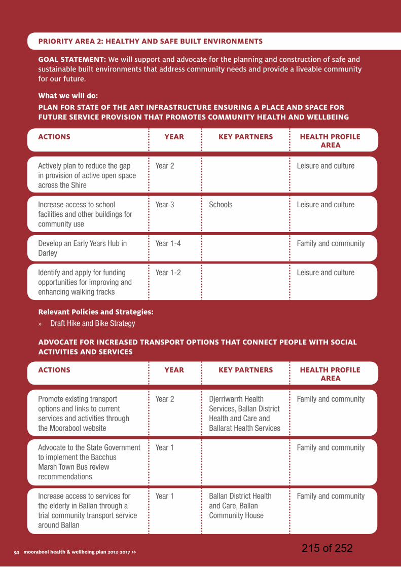
34 moorabool health & wellbeing plan 2012-2017 >>
goal StatEmEnt: We will support and advocate for the planning and construction of safe and sustainable built environments that address community needs and provide a liveable community for our future.
actionS yEar kEy PartnErS HEaltH ProfilE arEa
actionS yEar kEy PartnErS HEaltH ProfilE arEa
Actively plan to reduce the gap in provision of active open space across the Shire
Increase access to school facilities and other buildings for community use
Develop an Early Years Hub in Darley
Identify and apply for funding opportunities for improving and enhancing walking tracks
Promote existing transport options and links to current services and activities through the Moorabool website
Advocate to the State Government to implement the Bacchus Marsh Town Bus review recommendations
Increase access to services for the elderly in Ballan through a trial community transport service around Ballan
Year 2
Year 3
Year 1-4
Year 1-2
Year 2
Year 1
Year 1
Schools
Djerriwarrh Health Services, Ballan District Health and Care and Ballarat Health Services
Ballan District Health and Care, Ballan Community House
Leisure and culture
Leisure and culture
Family and community
Leisure and culture
Family and community
Family and community
Family and community
Priority arEa 2: HEaltHy and SafE built EnvironmEntS
What we will do:
Plan for StatE of tHE art infraStructurE EnSuring a PlacE and SPacE for futurE SErvicE ProviSion tHat PromotES community HEaltH and WEllbEing
advocatE for incrEaSEd tranSPort oPtionS tHat connEct PEoPlE WitH Social activitiES and SErvicES
relevant Policies and Strategies:
» Draft Hike and Bike Strategy
34 moorabool health & wellbeing plan 2012-2017 >> 215 of 252
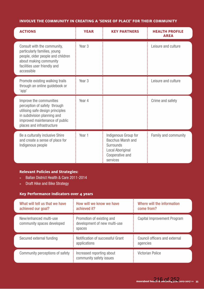
actionS yEar kEy PartnErS HEaltH ProfilE arEa
Consult with the community, particularly families, young people, older people and children about making community facilities user friendly and accessible
Promote existing walking trails through an online guidebook or ‘app’
Improve the communities perception of safety through utilising safe design principles in subdivision planning and improved maintenance of public places and infrastructure
Be a culturally inclusive Shire and create a sense of place for Indigenous people
Year 3
Year 3
Year 4
Year 1 Indigenous Group for Bacchus Marsh and SurroundsLocal Aboriginal Cooperative and services
Leisure and culture
Leisure and culture
Crime and safety
Family and community
involvE tHE community in crEating a ‘SEnSE of PlacE’ for tHEir community
relevant Policies and Strategies:
» Ballan District Health & Care 2011-2014
» Draft Hike and Bike Strategy
key Performance indicators over 4 years
What will tell us that we have achieved our goal?
New/enhanced multi-use community spaces developed
Secured external funding
Community perceptions of safety
How will we know we have achieved it?
Promotion of existing and development of new multi-use spaces
Notification of successful Grant applications
Increased reporting about community safety issues
Where will the information come from?
Capital Improvement Program
Council officers and external agencies
Victorian Police
moorabool health & wellbeing plan 2012-2017 >> 35216 of 252

36 moorabool health & wellbeing plan 2012-2017 >>
goal StatEmEnt: We will work together to provide cross-agency collaboration and advocate for equity of access to services for all residents in our community.
actionS yEar kEy PartnErS HEaltH ProfilE arEa
Establish a cross-agency working group to undertake an audit of services across all age cohorts and map the potential for integration of services
Utilise the Moorabool Shire Council Website to provide information about local services
Develop an online database of all services in the Moorabool Shire, that links to availability, wait times, transport information etc. ‘’a one-stop-shop (online) of information’’
Increase engagement with local and regional Committees that focus on integrated service provision - for example, Grampians Integrated Family Violence Committee, Grampians Indigenous Family Violence Regional Action Group, Moorabool Family Violence Prevention Network
Year 2
Year 1
Year 2
Year 4
All
All
Health, Family and community
Family and community
Health, Family and community
Health
Priority arEa 3: accESSiblE SErvicES
What we will do:
imProvE accESS to information about SErvicES and Waiting timES tHrougH tHE dEvEloPmEnt of an intEgratEd ‘onE StoP SHoP’ aPProacH
36 moorabool health & wellbeing plan 2012-2017 >> 217 of 252
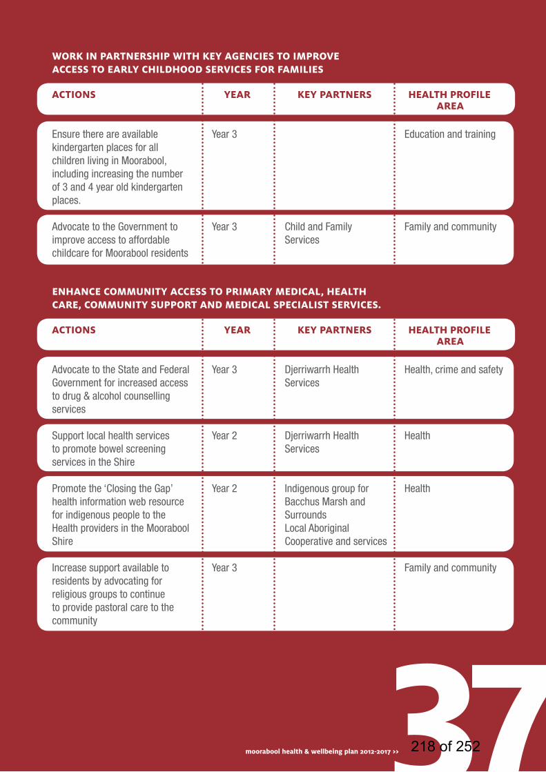
actionS yEar kEy PartnErS HEaltH ProfilE arEa
actionS yEar kEy PartnErS HEaltH ProfilE arEa
Ensure there are available kindergarten places for all children living in Moorabool, including increasing the number of 3 and 4 year old kindergarten places.
Advocate to the Government to improve access to affordable childcare for Moorabool residents
Advocate to the State and Federal Government for increased access to drug & alcohol counselling services
Support local health services to promote bowel screening services in the Shire
Promote the ‘Closing the Gap’ health information web resource for indigenous people to the Health providers in the Moorabool Shire
Increase support available to residents by advocating for religious groups to continue to provide pastoral care to the community
Year 3
Year 3
Year 3
Year 2
Year 2
Year 3
Child and Family Services
Djerriwarrh Health Services
Djerriwarrh Health Services
Indigenous group for Bacchus Marsh and SurroundsLocal Aboriginal Cooperative and services
Education and training
Family and community
Health, crime and safety
Health
Health
Family and community
Work in PartnErSHiP WitH kEy agEnciES to imProvE accESS to Early cHildHood SErvicES for familiES
EnHancE community accESS to Primary mEdical, HEaltH carE, community SuPPort and mEdical SPEcialiSt SErvicES.
37moorabool health & wellbeing plan 2012-2017 >> 218 of 252

38 moorabool health & wellbeing plan 2012-2017 >>
actionS yEar kEy PartnErS HEaltH ProfilE arEa
Reduce barriers associated with accessing services, facilities, goods and services
Reduce barriers associated with obtaining and maintaining employment for people with disabilities
Provide opportunities for inclusion and participation in the community for people with disabilities
Advocate for significant changes to attitudes and practices which discriminate against people with a disability
Implement cultural training programs for staff and community groups
Year 2
Year 2
Year 3
Year 2
Year 4
Pinarc Disability Support
Pinarc Disability Support
Pinarc Disability Support
Pinarc Disability Support
Indigenous Group for Bacchus Marsh and SurroundsLocal Aboriginal Cooperative and services
Family and community health
Work and economic development
Family and community
Family and community
Leisure and culture
addrESS accESS and incluSion acroSS all agES, gEndEr, cultural divErSity and ability
relevant Policies and Strategies:
» Municipal Early Years Plan
» Ballan District Health & Care 2011-2014
» Access and Inclusion Action Plan
key Performance indicators over 4 years
What will tell us that we have achieved our goal?
Waiting times for services
Usage of existing services
Gaps in services identified
How will we know we have achieved it?
Reduction in waiting times for services
Increased number of people accessing services
Gap analysis completed
Where will the information come from?
Health Services
Health Services
Cross-agency working group
38 moorabool health & wellbeing plan 2012-2017 >> 219 of 252
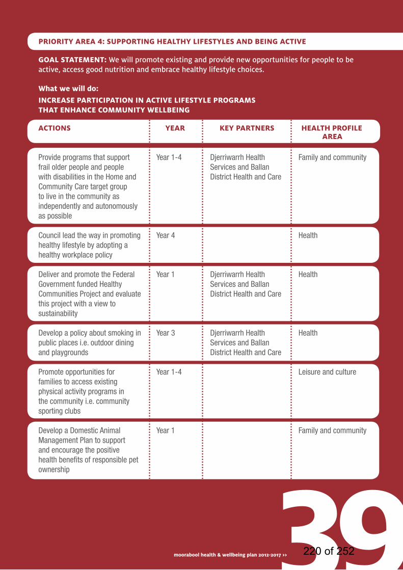
goal StatEmEnt: We will promote existing and provide new opportunities for people to be active, access good nutrition and embrace healthy lifestyle choices.
actionS yEar kEy PartnErS HEaltH ProfilE arEa
Provide programs that support frail older people and people with disabilities in the Home and Community Care target group to live in the community as independently and autonomously as possible
Council lead the way in promoting healthy lifestyle by adopting a healthy workplace policy
Deliver and promote the Federal Government funded Healthy Communities Project and evaluate this project with a view to sustainability
Develop a policy about smoking in public places i.e. outdoor dining and playgrounds
Promote opportunities for families to access existing physical activity programs in the community i.e. community sporting clubs
Develop a Domestic Animal Management Plan to support and encourage the positive health benefits of responsible pet ownership
Year 1-4
Year 4
Year 1
Year 3
Year 1-4
Year 1
Djerriwarrh Health Services and Ballan District Health and Care
Djerriwarrh Health Services and Ballan District Health and Care
Djerriwarrh Health Services and Ballan District Health and Care
Family and community
Health
Health
Health
Leisure and culture
Family and community
Priority arEa 4: SuPPorting HEaltHy lifEStylES and bEing activE
What we will do:
incrEaSE ParticiPation in activE lifEStylE ProgramS tHat EnHancE community WEllbEing
39moorabool health & wellbeing plan 2012-2017 >> 220 of 252
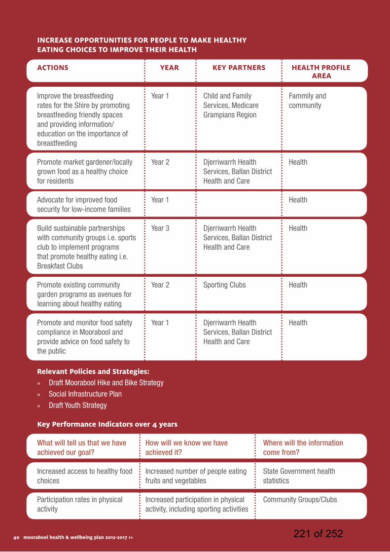
40 moorabool health & wellbeing plan 2012-2017 >>
actionS yEar kEy PartnErS HEaltH ProfilE arEa
Improve the breastfeeding rates for the Shire by promoting breastfeeding friendly spaces and providing information/education on the importance of breastfeeding
Promote market gardener/locally grown food as a healthy choice for residents
Advocate for improved food security for low-income families
Build sustainable partnerships with community groups i.e. sports club to implement programs that promote healthy eating i.e. Breakfast Clubs
Promote existing community garden programs as avenues for learning about healthy eating
Promote and monitor food safety compliance in Moorabool and provide advice on food safety to the public
Year 1
Year 2
Year 1
Year 3
Year 2
Year 1
Child and Family Services, Medicare Grampians Region
Djerriwarrh Health Services, Ballan District Health and Care
Djerriwarrh Health Services, Ballan District Health and Care
Sporting Clubs
Djerriwarrh Health Services, Ballan District Health and Care
Fammily and community
Health
Health
Health
Health
Health
incrEaSE oPPortunitiES for PEoPlE to makE HEaltHy Eating cHoicES to imProvE tHEir HEaltH
relevant Policies and Strategies:
» Draft Moorabool Hike and Bike Strategy
» Social Infrastructure Plan
» Draft Youth Strategy
key Performance indicators over 4 years
What will tell us that we have achieved our goal?
Increased access to healthy food choices
Participation rates in physical activity
How will we know we have achieved it?
Increased number of people eating fruits and vegetables
Increased participation in physical activity, including sporting activities
Where will the information come from?
State Government health statistics
Community Groups/Clubs
40 moorabool health & wellbeing plan 2012-2017 >> 221 of 252

41moorabool health & wellbeing plan 2012-2017 >> 222 of 252
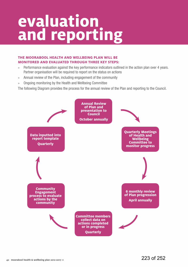
42 moorabool health & wellbeing plan 2012-2017 >>
evaluation and reportingtHE moorabool HEaltH and WEllbEing Plan Will bE monitorEd and EvaluatEd tHrougH tHrEE kEy StEPS:
» Performance evaluation against the key performance indicators outlined in the action plan over 4 years. Partner organisation will be required to report on the status on actions
» Annual review of the Plan, including engagement of the community
» Ongoing monitoring by the Health and Wellbeing Committee
The following Diagram provides the process for the annual review of the Plan and reporting to the Council.
annual review of Plan and
presentation to council
october annually
data inputted into report template
quarterly
community Engagement
process to evaluate actions by the
community
quarterly meetings of Health and
Wellbeing committee to
monitor progress
6 monthly review of Plan progression
april annually
committee members collect data on
actions completed or in progress
quarterly
223 of 252

Process to collect key performance indicator and evaluation information:
annual review report to council
data used for annual review of the Plan
committee review data report
data input into template from responsible
organisation / service unit
report template provided to Health and Wellbeing
committee
43moorabool health & wellbeing plan 2012-2017 >> 224 of 252

44 moorabool health & wellbeing plan 2012-2017 >> 225 of 252
Agenda - Moorabool Shire Ordinary Meeting of Council Wednesday 18 September, 2013
OMC - 18/09/2013 09/13
11.4 INFRASTRUCTURE SERVICES No reports for this meeting.
226 of 252
Agenda - Moorabool Shire Ordinary Meeting of Council Wednesday 18 September, 2013
OMC - 18/09/2013 09/13
11.5 CORPORATE SERVICES
11.5.1 Adoption “in principle” of the 2012/13 Financial Statements, Standard Statements and Performance Statement for submission to the Victorian Auditor-General for certification Introduction File No.: 02/02/002 Author: Steven Ivelja General Manager: Shane Marr
Background The following report presents the 2012/13 Financial Statements, Standard Statements and Performance Statement for adoption “in principle” by Council for submission to the Auditor-General for certification. The Local Government Act 1989 requires that Council complete the following at the end of each financial year with respect to producing an Annual Report and Performance Statement: S. 131 Annual report
(1) A Council must, in respect of each financial year, prepare an annual report containing -
(b) audited standard statements for the financial year;
(c) audited financial statements for the financial year;
(d) a copy of the performance statement prepared under section 132; and
(e) a copy of the report on the performance statement prepared under section 133.
(3) The standard statements in the annual report and the
financial statements must - (a) be prepared in the manner and form prescribed
by the regulations; (b) be submitted in their finalised form to the auditor
for auditing as soon as possible after the end of the financial year; and
(c) be certified in the manner prescribed.
(7) The Council must not submit the standard statements or the financial statements to its auditor or the Minister unless it has passed a resolution giving its approval “in principle” to the standard statements and the financial statements.
227 of 252
Agenda - Moorabool Shire Ordinary Meeting of Council Wednesday 18 September, 2013
OMC - 18/09/2013 09/13
(8) The Council must authorise two Councillors to certify the standard statements and the financial statements in their final form after any changes recommended, or agreed to, by the auditor have been made.
S. 132 Performance statement
(1) As soon as is reasonably practicable after the end of each financial year, a Council must prepare a performance statement.
(2) The performance statement must include -
(a) the Key Strategic Activities and performance targets and measures specified in the budget under section 127 for that financial year; and
(b) the actual results achieved for that financial year having regard to those performance targets and measures.
(4) The statement must –
(a) be in the form; and (b) contain the details - required by the regulations.
(5) The Council must submit the statement to its auditor as
soon as possible after the statement has been prepared.
(6) The Council must not submit the statement to its auditor
or the Minister unless the Council has passed a resolution giving its approval “in principle” to the statement.
(7) The Council must authorise two Councillors to approve
the statement in its final form after any changes recommended, or agreed to, by the auditor have been made.
S. 133 Audit report on the performance statement
The auditor must -
(a) prepare a report on the performance statement prepared by a Council under section 132 in the form and containing the details required by the Minister, and
(b) submit a copy of that report to the Minister and the Council as soon as is reasonably practicable after the report has been prepared.
228 of 252
Agenda - Moorabool Shire Ordinary Meeting of Council Wednesday 18 September, 2013
OMC - 18/09/2013 09/13
Proposal The 2012/13 Financial Statements, 2012/13 Standard Statements and 2012/13 Performance Statement have been prepared in accordance with the requirements of the Local Government Act, various Australian Accounting Standards and regulations. In accordance with Council’s Governance protocols, the reports will be presented to Council’s Audit Committee for review and recommendation to Council for adoption “in principle” and authorisation of two Councillors, being the Councillor members of the Audit Committee, to sign the audited statements. In summary, the statements indicate the following results for 2012/13: 1. Financial Statements: reflect the comparative performance to the
previous financial year.
• Comprehensive Income Statement – The result reflects a total comprehensive result of $172.352 million. Included within this result are the following significant items:
• $164.606 million in net asset revaluation increments as a
result of the revaluation of major infrastructure asset classes namely Roads and Bridges.
• $3.713 million reduction in Operating grants relating to reduced levels of Natural Disaster Relief funding received for asset restoration works to repair damage incurred during the flood events. Also contributing to the reduction in Operating grants are timing issues related to the early receipt of VGC funding in 2011/12 resulting in higher revenue levels in 2011/12.
• Materials and services $2.071 million increase which relates to the completion of flood recovery projects for which grants were received in the prior year. Also contributing to the increase are expenditures undertaken as part of the Capital Works program which have been deemed as Operating in nature, and as such have been expensed in accordance with accounting standards.
• $1.151 million reduction in depreciation expense as a result of the asset revaluation. Contributing to the favourable reduction is the impact of condition assessments which have indicated that Council assets are in a better condition to that which was previously assessed. Additionally, changes to depreciation rates for roads and kerb and channel assets categories have resulted in lower depreciation charges.
229 of 252
Agenda - Moorabool Shire Ordinary Meeting of Council Wednesday 18 September, 2013
OMC - 18/09/2013 09/13
• Net gain (loss) on disposal of property, infrastructure, plant
and equipment and investment properties compares favourably to 2011/12. The main reason relates to the timing of the asset revaluation which was performed on July 1 2012 resulting in the written down value of roads reconstructed in 2012/13 closely reflecting its fair value at the date of reconstruction.
• Balance Sheet – The movement in net assets reflects the total
surplus of $172.352 million. Included within this result are the following significant items:
• An increase in Property, Infrastructure, Plant and
Equipment mainly due to revaluation increments in Roads and Bridges $164.606 million.
• $2.395 million reduction in defined benefits liability related to the early payout of Moorabools share of the 2011/12 defined benefits shortfall. The liability was paid out in full in 2012/13 using Council cash reserves. It is anticipated that the early payout will be eventually covered by a loan which will be taken out in the 2013/14 year.
• Cash Flow Statement – The movement in cash held at the end of the year reflects a decrease in cash of $2.568 million. Included within this result are the following significant items:
• Net cash flows from operations decreased by $5.408
million from last year to $11.301 million. This mainly reflects the payout of the defined benefits liability in 2012/13 in addition to reduced levels of flood recovery grants and timing issues related to VGC payments.
• Net cash used in investing activities has decreased by $3.073 million to $11.480 million. This mainly reflects the decrease in capital expenditure as compared to 2011/12.
• Net cash used in finance activities was $2.389 million. In 2011/12 the net cash provided for finance activities was $1.497 million reflecting loans taken up in 2011/12. As at balance date, the defined benefits shortfall payout of $2.395 million was not taken up as a loan and was settled in cash. Due to the comparatively high level of cash holdings at balance date, the loan will be taken up at a later stage in 2013/14 when required.
230 of 252
Agenda - Moorabool Shire Ordinary Meeting of Council Wednesday 18 September, 2013
OMC - 18/09/2013 09/13
2. Standard Statements – reflect comparative performance to the
2012/13 Annual Budget adopted by Council.
• Total operating revenue of $37.950 million was $0.986 million (2.67%) above budget reflecting increased: − Other revenue of $0.442 million which was mainly driven
by a $104K in receipts related to the new recycling contract, $140K in additional cost recoveries as part of the debt collection contract (offset by an equivalent increase in debt collection costs) in addition to a number of other minor or miscellaneous payments and reimbursements received.
− Interest received of $0.259 million, Operating grants $0.149M.
• Total operating expenses of $43.650 million was $3.373 million
(8.38%) above budget reflecting increased:
− Contract Payments, Materials and Services of $4.050 million, due to a large amount of Capital Works being expensed as they relate to Non-Council Assets and significant expenses not deemed to be capital in nature (2.668 million). There was also expenditure of $1.29 million relating to the completion of One Off Projects and Flood Recovery projects for which funding was received in prior financial years.
• Depreciation expense was $1.207 million lower than budget due
to the impact of the revaluation of infrastructure assets in 2012/13. The condition assessments have indicated that Council infrastructure assets are in generally better condition that previously indicated thus resulting in a reduction in depreciation charges. Additionally, changes to depreciation rates for roads and kerb and channel asset categories have resulted in lower depreciation charges.
• The net gain (loss) on disposal of property was favourable to Budget due to the budget containing the written down value of Council owned land in Graham Street, Bacchus Marsh. This parcel of land was expected to be sold in 2012/13, however at 30 June it was yet to be sold.
• Cash position was $11.272 million, $7.126 million better than
budget. This has occurred mainly due to receiving grants in advance in relation to asset restoration works and half of the 2013/14 grants commission allocation in June 2013. Additionally, $5.408 million in net expenditure has been identified as requiring to be carried forward into the 2013/14 year as a result of 12/13 projects not being completed as at the 30th June.
231 of 252
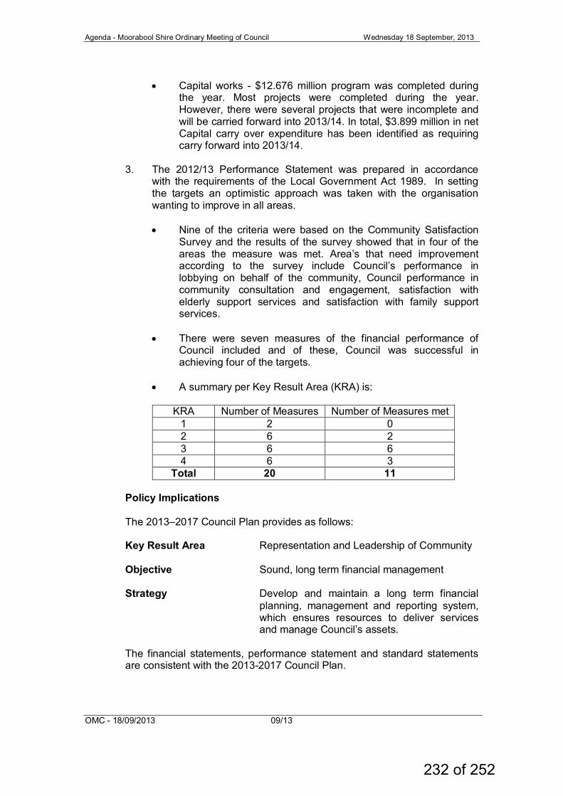
Agenda - Moorabool Shire Ordinary Meeting of Council Wednesday 18 September, 2013
OMC - 18/09/2013 09/13
• Capital works - $12.676 million program was completed during
the year. Most projects were completed during the year. However, there were several projects that were incomplete and will be carried forward into 2013/14. In total, $3.899 million in net Capital carry over expenditure has been identified as requiring carry forward into 2013/14.
3. The 2012/13 Performance Statement was prepared in accordance
with the requirements of the Local Government Act 1989. In setting the targets an optimistic approach was taken with the organisation wanting to improve in all areas.
• Nine of the criteria were based on the Community Satisfaction
Survey and the results of the survey showed that in four of the areas the measure was met. Area’s that need improvement according to the survey include Council’s performance in lobbying on behalf of the community, Council performance in community consultation and engagement, satisfaction with elderly support services and satisfaction with family support services.
• There were seven measures of the financial performance of
Council included and of these, Council was successful in achieving four of the targets.
• A summary per Key Result Area (KRA) is:
KRA Number of Measures Number of Measures met
1 2 0 2 6 2 3 6 6 4 6 3
Total 20 11
Policy Implications The 2013–2017 Council Plan provides as follows: Key Result Area Representation and Leadership of Community Objective Sound, long term financial management Strategy Develop and maintain a long term financial
planning, management and reporting system, which ensures resources to deliver services and manage Council’s assets.
The financial statements, performance statement and standard statements are consistent with the 2013-2017 Council Plan.
232 of 252
Agenda - Moorabool Shire Ordinary Meeting of Council Wednesday 18 September, 2013
OMC - 18/09/2013 09/13
Financial Implications The financial statements detail Council’s financial performance and position for 2012/13. They demonstrate that over time Council has steadily improved its cash position, but indicates that there are still numerous financial challenges that lay ahead which will require responsible fiscal stewardship. Communications Strategy The Annual Financial, Standard and Performance Statements are reported to Council to adopt “in principle” for submission to the Auditor-General for certification. Audited Statements are then incorporated into Council’s Annual Report, which is completed by Council by 30 September each year.
Victorian Charter of Human Rights and Responsibilities Act 2006 In developing this report to Council the briefing officer considered whether the subject matter raised any human rights issues. In particular, whether the scope of any human right established by the Victorian Charter of Human Rights and Responsibilities is in any way limited, restricted or interfered with by the recommendations contained in the report. It is considered that the subject matter does not raise any human rights issues. Officer's Declaration of Conflict of Interests Under section 80C of the Local Government Act 1989 (as amended), officers providing advice to Council must disclose any interests, including the type of interest. General Manager – Shane Marr In providing this advice to Council as the Manager, I have no interests to disclose in this report. Author – Steven Ivelja In providing this advice to Council as the Author, I have no interests to disclose in this report. Conclusion The attached Financial, Standard and Performance Statements for 2012/13 have been prepared in accordance with the requirements of the Local Government Act. Council’s Audit Committee have reviewed the statements and recommended that Council adopt the statements “in principle”. The Statements will then be submitted to the Auditor-General for certification. Council is also required to authorise two Councillors to sign the statements on behalf of Council, as required under the Local Government Act. It is practice for the Councillor members of the Audit Committee to sign the certified statements on behalf of Council.
233 of 252
Agenda - Moorabool Shire Ordinary Meeting of Council Wednesday 18 September, 2013
OMC - 18/09/2013 09/13
Recommendation: That Council:
1. In accordance with S. 131 of the Local Government Act (1989):
a. adopt in principle and submit the 2012/13 Standard
Statements and Financial Statements to the Auditor-General for certification; and
b. authorise the Council’s Audit Committee Representatives, Cr. Spain and Cr. Dudzik, to certify the 2012/13 Standard Statements and Financial Statements in their final form, after any changes recommended, or agreed to by the Auditor, have been made.
2. In accordance with S. 132 of the Local Government Act (1989):
a. submit the 2012/13 Performance Statement to the Auditor-
General for certification; and b. authorise the Council’s Audit Committee Representatives,
Cr. Spain and Cr. Dudzik, to certify the 2012/13 Performance Statement in its final form, after any changes recommended, or agreed to by the Auditor, have been made.
Report Authorisation Authorised by: Name: Shane Marr Title: General Manager Corporate Services Date: Wednesday 11 September 2013
234 of 252
Agenda - Moorabool Shire Ordinary Meeting of Council Wednesday 18 September, 2013
OMC - 18/09/2013 09/13
12. OTHER REPORTS
12.1 Assembly of Councillors File No.: 02/01/002 Section 76(AA) of the Local Government Act 1989 defines the following to be Assemblies of Councillors; an advisory committee of the Council that includes at least one Councillor; a planned or scheduled meeting of at least half the Councillors and one member of council staff which considers matters that are intended or likely to be:
• the subject of a decision of the Council; or • subject to the exercise of a Council function, power or duty by a
person or committee acting under Council delegation.
It should be noted, an assembly of Councillors does not include an Ordinary Council meeting, a special committee of the Council, meetings of the Council’s audit committee, a club, association, peak body or political party. Council must ensure that the written record of an assembly of Councillors is, as soon as practicable – a) reported to the next ordinary meeting of the Council; and b) incorporated in the minutes of that council meeting. (s. 80A(2)) Council also records each Assembly of Councillors on its website at www.moorabool.vic.gov.au A record of Assemblies of Councillors since the last Ordinary Meeting of Council is provided below for consideration: • Assembly of Councillors – Wednesday 4 September 2013 – Youth
Strategy • Assembly of Councillors – Wednesday 4 September 2013 – Domestic
Animal Management Plan • Assembly of Councillors – Wednesday 4 September 2013 – Update on
Rabbit and Weed Control Works • Assembly of Councillors – Wednesday 4 September 2013 – Audit and
Risk Committee • Assembly of Councillors – Wednesday 11 September 2013 – Update
on Gordon and Bacchus Marsh Activity Structure Plans • Assembly of Councillors – Wednesday 11 September 2013 – Regional
Growth Plan Update • Assembly of Councillors – Wednesday 11 September 2013 – VLGA
Councillor Code of Conduct
235 of 252
Agenda - Moorabool Shire Ordinary Meeting of Council Wednesday 18 September, 2013
OMC - 18/09/2013 09/13
Recommendation: That Council receives the record of Assemblies of Councillors as follows: • Assembly of Councillors – Wednesday 4 September 2013 – Youth
Strategy • Assembly of Councillors – Wednesday 4 September 2013 –
Domestic Animal Management Plan • Assembly of Councillors – Wednesday 4 September 2013 –
Update on Rabbit and Weed Control Works • Assembly of Councillors – Wednesday 4 September 2013 – Audit
and Risk Committee • Assembly of Councillors – Wednesday 11 September 2013 –
Update on Gordon and Bacchus Marsh Activity Structure Plans • Assembly of Councillors – Wednesday 11 September 2013 –
Regional Growth Plan Update • Assembly of Councillors – Wednesday 11 September 2013 –
VLGA Councillor Code of Conduct
236 of 252
Agenda - Moorabool Shire Ordinary Meeting of Council Wednesday 18 September, 2013
OMC - 18/09/2013 09/13
12.2 Section 86 - Delegated Committees of Council - Reports Section 86 Delegated Committees are established to assist Council with executing specific functions or duties. By instrument of delegation, Council may delegate to the committees such functions and powers of the Council that it deems appropriate, utilising provisions of the Local Government Act 1989. The Council cannot delegate certain powers as specifically indicated in Section 86(4) of the Act. Section 86 Delegated Committees are required to report to Council at intervals determined by the Council. Councillors as representatives of the following Section 86 – Delegated Committees of Council present the reports of the Committee Meetings for Council consideration. Committee Meeting Date Council
Representative
Navigators Community Centre 20 June 2013 Community Members
Elaine Recreation Reserve Committee of Management
8 August 2013 Cr. Sullivan
Recommendation: That Council receives the reports of the following Section 86 - Delegated Committees of Council: • Navigators Community Centre meeting of Thursday 20 June 2013. • Elaine Recreation Reserve Committee of Management meeting of
Thursday 8 August 2013.
237 of 252
Agenda – Moorabool Shire Ordinary Meeting of Council Wednesday 18 September, 2013
OMC – 18/9/2013 08/13
A
ttachment - Item
12.2a
238 of 252
Incorporated A0022451E Minutes of Committee of Management General Meeting held in the Navigators Hall on
20th June, 2013. Meeting commenced at 7.35pm. Present: Debbie Barnet (Vice-President), Marita Austin (Secretary), Alan Rogers (Treasurer), Michael Clark, Tarsha Gore, David Rayne and Wayne Austin Apologies: Ken Turner (President), Pat Dobbyn and David Tatman Motion: Apologies be accepted. Proposed: Alan Seconded: Michael……carried. Minutes of last meeting: Have been circulated. Motion: Minutes be accepted. Proposed: David Seconded: Wayne……carried. Business Arising from Minutes.
1. User agreement – Marita will contact Talia-MSC and arrange a meeting. Treasurer’s Report: Copy on file. Proposed Alan seconded: David .........all accepted. Correspondence – In. 1. MSC – email-Regional Arts Funding 2. MSC – email-Reminder of minutes recording and sending through to MSC. 3. Quote – Smart options 5kw solar system. 4. Navigators History Group requesting a loan. 5. CAV registration for NCC. Correspondence – Out.
1. MSC –Community database form completed. 2. MSC – letter to Simon Blanchfield regarding condition of court 1.
Motion: Correspondence In & Out to be accepted. Proposed: David. Seconded: Tarsha.....carried. Reports.
1. Rotunda –This has been partly erected. The builder has started with posts and the roof construction. The concrete base has been extended to make a path on the outside. The bench seating inside and outside will be 400mm wide. A water pipe and tap has been installed with a drain on the east side entrance. Power conduit has been laid underground from the tennis clubroom to the rotunda. MSC has approved solar panels to be fed direct into the grid. Alan has enquired about reducing light usage by replacing globes with LED lights. Work to be done; painting of boards for seating, lining boards to be painted. BBQ has been ordered; table is being designed and quoted on. Table size 3m x 1m.
239 of 252
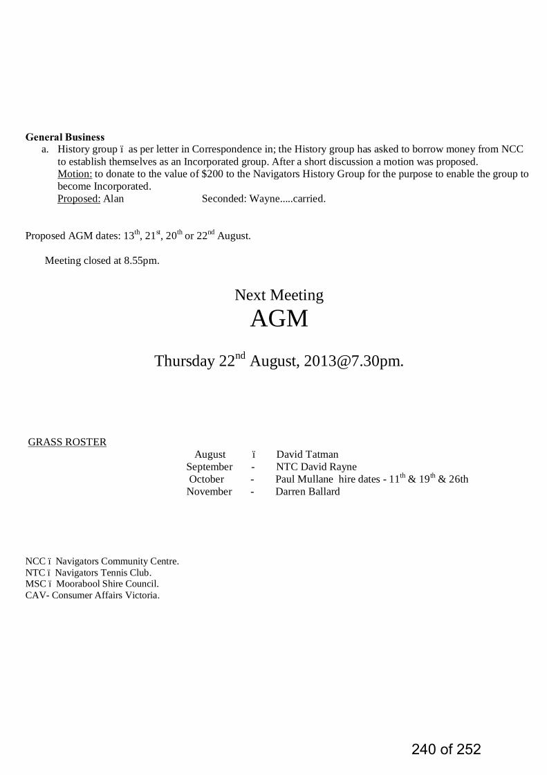
General Business
a. History group – as per letter in Correspondence in; the History group has asked to borrow money from NCC to establish themselves as an Incorporated group. After a short discussion a motion was proposed. Motion: to donate to the value of $200 to the Navigators History Group for the purpose to enable the group to become Incorporated.
Proposed: Alan Seconded: Wayne.....carried. Proposed AGM dates: 13th, 21st, 20th or 22nd August.
Meeting closed at 8.55pm.
Next Meeting AGM
Thursday 22nd August, [email protected].
GRASS ROSTER August – David Tatman September - NTC David Rayne October - Paul Mullane hire dates - 11th & 19th & 26th November - Darren Ballard NCC – Navigators Community Centre. NTC – Navigators Tennis Club. MSC – Moorabool Shire Council. CAV- Consumer Affairs Victoria.
240 of 252

Agenda – Moorabool Shire Ordinary Meeting of Council Wednesday 18 September, 2013
OMC – 18/9/2013 08/13
A
ttachment - Item
12.2b
241 of 252
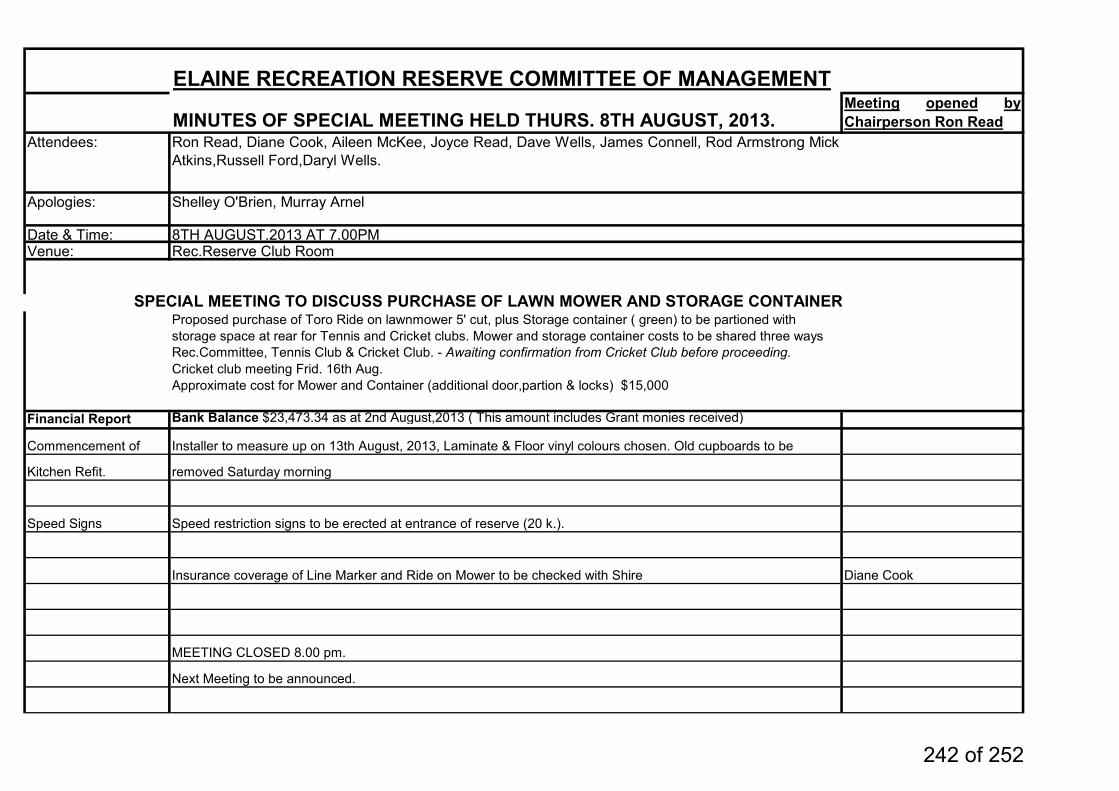
ELAINE RECREATION RESERVE COMMITTEE OF MANAGEMENT
MINUTES OF SPECIAL MEETING HELD THURS. 8TH AUGUST, 2013.Meeting opened byChairperson Ron Read
Attendees: Ron Read, Diane Cook, Aileen McKee, Joyce Read, Dave Wells, James Connell, Rod Armstrong MickAtkins,Russell Ford,Daryl Wells.
Date & Time: 8TH AUGUST.2013 AT 7.00PMVenue: Rec.Reserve Club Room
SPECIAL MEETING TO DISCUSS PURCHASE OF LAWN MOWER AND STORAGE CONTAINERProposed purchase of Toro Ride on lawnmower 5' cut, plus Storage container ( green) to be partioned with storage space at rear for Tennis and Cricket clubs. Mower and storage container costs to be shared three waysRec.Committee, Tennis Club & Cricket Club. - Awaiting confirmation from Cricket Club before proceeding.Cricket club meeting Frid. 16th Aug.Approximate cost for Mower and Container (additional door,partion & locks) $15,000
Financial Report Bank Balance $23,473.34 as at 2nd August,2013 ( This amount includes Grant monies received)
Commencement of Installer to measure up on 13th August, 2013, Laminate & Floor vinyl colours chosen. Old cupboards to be
Kitchen Refit. removed Saturday morning
Speed Signs Speed restriction signs to be erected at entrance of reserve (20 k.).
Insurance coverage of Line Marker and Ride on Mower to be checked with Shire Diane Cook
MEETING CLOSED 8.00 pm.
Next Meeting to be announced.
Apologies: Shelley O'Brien, Murray Arnel
242 of 252
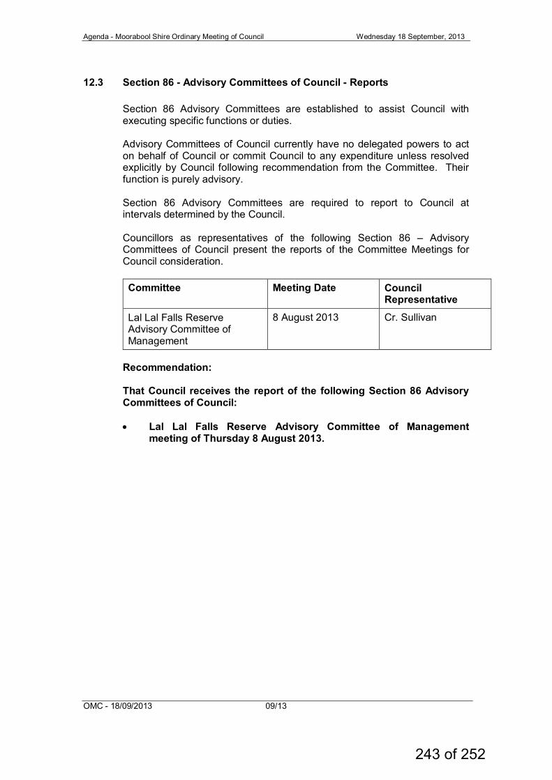
Agenda - Moorabool Shire Ordinary Meeting of Council Wednesday 18 September, 2013
OMC - 18/09/2013 09/13
12.3 Section 86 - Advisory Committees of Council - Reports Section 86 Advisory Committees are established to assist Council with executing specific functions or duties. Advisory Committees of Council currently have no delegated powers to act on behalf of Council or commit Council to any expenditure unless resolved explicitly by Council following recommendation from the Committee. Their function is purely advisory. Section 86 Advisory Committees are required to report to Council at intervals determined by the Council. Councillors as representatives of the following Section 86 – Advisory Committees of Council present the reports of the Committee Meetings for Council consideration. Committee Meeting Date Council
Representative
Lal Lal Falls Reserve Advisory Committee of Management
8 August 2013 Cr. Sullivan
Recommendation: That Council receives the report of the following Section 86 Advisory Committees of Council: • Lal Lal Falls Reserve Advisory Committee of Management
meeting of Thursday 8 August 2013.
243 of 252
Agenda – Moorabool Shire Ordinary Meeting of Council Wednesday 18 September, 2013
OMC – 18/9/2013 08/13
A
ttachment - Item
12.3
244 of 252
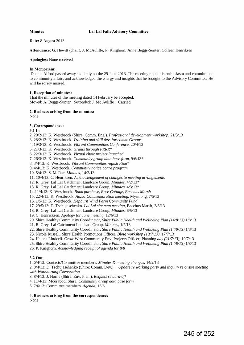
Minutes Lal Lal Falls Advisory Committee Date: 8 August 2013 Attendance: G. Hewitt (chair), J. McAuliffe, P. Kinghorn, Anne Beggs-Sunter, Colleen Henriksen Apologies: None received In Memoriam: Dennis Alford passed away suddenly on the 29 June 2013. The meeting noted his enthusiasm and commitment to community affairs and acknowledged the energy and insights that he brought to the Advisory Committee. He will be sorely missed. 1. Reception of minutes: That the minutes of the meeting dated 14 February be accepted. Moved: A. Beggs-Sunter Seconded: J. Mc Auliffe Carried 2. Business arising from the minutes: None 3. Correspondence: 3.1 In 2. 20/2/13: K. Westbrook (Shire: Comm. Eng.). Professional development workshop, 21/3/13 3. 28/2/13: K. Westbrook. Training and skill dev. for comm. Groups 4. 19/3/13: K. Westbrook. Vibrant Communities Conference, 20/4/13 5. 21/3/13: K. Westbrook. Grants through FRRR* 6. 22/3/13: K. Westbrook. Virtual choir project launched 7. 26/3/12: K. Westbrook. Community group data base form, 9/6/13* 8. 3/4/13: K. Westbrook. Vibrant Communities registration* 9. 4/4/13: K. Westbrook. Community notice board program 10. 5/4/13: S. McRae. Minutes, 14/2/13 11. 10/4/13: C. Henriksen. Acknowledgement of changes to meeting arrangements 12. R. Grey. Lal Lal Catchment Landcare Group, Minutes, 4/2/13* 13. R. Grey. Lal Lal Catchment Landcare Group, Minutes, 4/3/13* 14.11/4/13: K. Westbrook. Book purchase, Rose Cottage, Bacchus Marsh 15. 22/4/13: K. Westbrook. Anzac Commemoration meeting, Myrniong, 7/5/13 16. 1/5/13: K. Westbrook. Hepburn Wind Farm Community Fund 17. 29/5/13: D. Tschujasehenko. Lal Lal site map meeting, Bacchus Marsh, 3/6/13 18. R. Grey. Lal Lal Catchment Landcare Group, Minutes, 6/5/13 19. C. Henricksen. Apology for June meeting, 12/6/13 20. Shire Healthy Community Coordinator, Shire Public Health and Wellbeing Plan (14/8/13),1/8/13 21. R. Grey. Lal Catchment Landcare Group, Minutes, 1/7/13 22. Shire Healthy Community Coordinator, Shire Public Health and Wellbeing Plan (14/8/13),1/8/13 23. Nicole Russell. Shire Health Promotions Officer, Bloig workshop (19/7/13), 17/7/13 24. Helena Lindorff. Grow West Community Env. Projects Officer, Planning day (21/7/13), 19/7/13 25. Shire Healthy Community Coordinator, Shire Public Health and Wellbeing Plan (14/8/13),1/8/13 26. P. Kinghorn. Acknowledging receipt of agenda for 8/8 3.2 Out 1. 6/4/13: Contacts/Committee members. Minutes & meeting changes, 14/2/13 2. 8/4/13: D. Tschujasehenko (Shire: Comm. Dev.). Update re working party and inquiry re onsite meeting with Wathaurung Corporation 3. 8/4/13: J. Horne (Shire: Env. Plan.). Request re burn-off 4. 11/4/13: Moorabool Shire. Community group data base form 5. 7/6/13: Committee members. Agenda, 13/6 4. Business arising from the correspondence: None
245 of 252
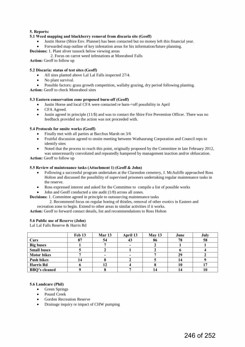
5. Reports: 5.1 Weed mapping and blackberry removal from discaria site (Geoff)
• Justin Horne (Shire Env. Planner) has been contacted but no money left this financial year. • Forwarded map outline of key infestation areas for his information/future planning.
Decisions: 1. Plant sliver tussock below viewing areas 2. Focus on carrot weed infestations at Moorabool Falls
Action: Geoff to follow up
5.2 Discaria: status of test sites (Geoff) • All sites planted above Lal Lal Falls inspected 27/4. • No plant survival. • Possible factors: grass growth competition, wallaby grazing, dry period following planting.
Action: Geoff to check Moorabool sites 5.3 Eastern conservation zone proposed burn-off (Geoff)
• Justin Horne and local CFA were contacted re burn-=off possibility in April • CFA Agreed. • Justin agreed in principle (11/$) and was to contact the Shire Fire Prevention Officer. There was no
feedback provided so the action was not proceeded with. 5.4 Protocols for onsite works (Geoff)
• Finally met with all parties at Bacchus Marsh on 3/6 • Fruitful discussion agreed to onsite meeting between Wathaurung Corporation and Council reps to
identify sites • Noted that the process to reach this point, originally proposed by the Committee in late February 2012,
was unnecessarily convoluted and repeatedly hampered by management inaction and/or obfuscation. Action: Geoff to follow up
5.5 Review of maintenance tasks (Attachment 1) (Geoff & John)
• Following a successful program undertaken at the Clarendon cemetery, J. McAuliffe approached Ross Holton and discussed the possibility of supervised prisoners undertaking regular maintenance tasks in the reserve.
• Ross expressed interest and asked for the Committee to compile a list of possible works • John and Geoff conducted a site audit (1/8) across all zones.
Decisions: 1. Committee agreed in principle to outsourcing maintenance tasks 2. Recommend focus on regular hoeing of thistles, removal of other exotics in Eastern and recreation zone to begin. Extend to other areas in similar activities if it works.
Action: Geoff to forward contact details, list and recommendations to Ross Holton 5.6 Public use of Reserve (John) Lal Lal Falls Reserve & Harris Rd Feb 13 Mar 13 April 13 May 13 June July Cars 87 54 43 86 78 58 Big buses 1 7 - 2 1 1 Small buses 5 2 1 2 6 4 Motor bikes 7 - - 7 29 2 Push bikes 14 8 2 5 14 9 Harris Rd 6 12 4 8 10 17 BBQ’s cleaned 9 8 7 14 14 10 5.6 Landcare (Phil)
• Green Springs • Pound Creek • Gordon Recreation Reserve • Drainage inquiry re impact of CHW pumping
246 of 252
5.7 Ballarat Tree Growers (Phil) • Imlal project progress: species success, bird surveys, comparison of seeding strategies
5.8 Lal Lal (Geoff) 1. Hall Committee A. Local Growers/Producers market Annual markets
Funding possibilities Projects outline 2. Friends of the railway station
Need for ongoing contact with VicTrack Need for group review of funding potential 5.9 Working parties
• Recreation Reserve/Eastern Conservation zone, above Lal Lal Creek, 6/3 • Eastern zone track 27/4 (in lieu of monthly meeting)
6. Business arising from reports None 7. General business: 7.1 Landscape plan (Sue) Defer 7.2 Action Plan
• Updates and restructure (2013) endorsed 7.3 Working parties
• To be decided at next meeting 7.3 Inter group contacts
• Agreed to send minutes to Imlal group and Moorabool Land Care groups Action: Phil to forward contact names and details to Geoff 8. Next meeting: Date: 12 September Venue: 394 Lal Lal Fals Rd, Lal Lal Time: 8.00 pm
247 of 252
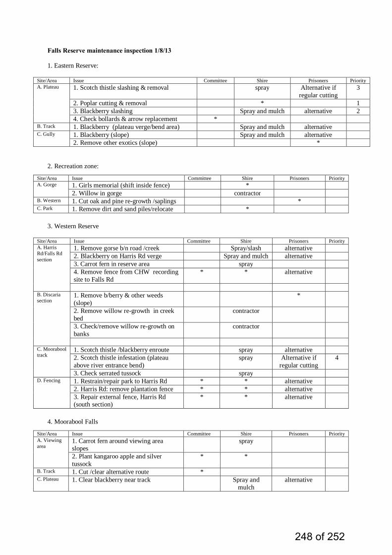
Falls Reserve maintenance inspection 1/8/13 1. Eastern Reserve:
Site/Area Issue Committee Shire Prisoners Priority A. Plateau 1. Scotch thistle slashing & removal spray Alternative if
regular cutting 3
2. Poplar cutting & removal * 1 3. Blackberry slashing Spray and mulch alternative 2 4. Check bollards & arrow replacement *
B. Track 1. Blackberry (plateau verge/bend area) Spray and mulch alternative C. Gully 1. Blackberry (slope) Spray and mulch alternative
2. Remove other exotics (slope) *
2. Recreation zone:
Site/Area Issue Committee Shire Prisoners Priority A. Gorge 1. Girls memorial (shift inside fence) *
2. Willow in gorge contractor B. Western 1. Cut oak and pine re-growth /saplings * C. Park 1. Remove dirt and sand piles/relocate *
3. Western Reserve
Site/Area Issue Committee Shire Prisoners Priority A. Harris Rd/Falls Rd section
1. Remove gorse b/n road /creek Spray/slash alternative 2. Blackberry on Harris Rd verge Spray and mulch alternative 3. Carrot fern in reserve area spray 4. Remove fence from CHW recording site to Falls Rd
* * alternative
B. Discaria section
1. Remove b/berry & other weeds (slope)
*
2. Remove willow re-growth in creek bed
contractor
3. Check/remove willow re-growth on banks
contractor
C. Moorabool track
1. Scotch thistle /blackberry enroute spray alternative 2. Scotch thistle infestation (plateau above river entrance bend)
spray Alternative if regular cutting
4
3. Check serrated tussock spray D. Fencing 1. Restrain/repair park to Harris Rd * * alternative
2. Harris Rd: remove plantation fence * * alternative 3. Repair external fence, Harris Rd (south section)
* * alternative
4. Moorabool Falls
Site/Area Issue Committee Shire Prisoners Priority A. Viewing area
1. Carrot fern around viewing area slopes
spray
2. Plant kangaroo apple and silver tussock
* *
B. Track 1. Cut /clear alternative route * C. Plateau 1. Clear blackberry near track Spray and
mulch alternative
248 of 252
Agenda - Moorabool Shire Ordinary Meeting of Council Wednesday 18 September, 2013
OMC - 18/09/2013 09/13
13. NOTICES OF MOTION
No notices of motion have been received for consideration as part of this Agenda.
249 of 252

Agenda - Moorabool Shire Ordinary Meeting of Council Wednesday 18 September, 2013
OMC - 18/09/2013 09/13
14. URGENT BUSINESS
250 of 252
Agenda - Moorabool Shire Ordinary Meeting of Council Wednesday 18 September, 2013
OMC - 18/09/2013 09/13
15. CLOSED SESSION OF THE MEETING TO THE PUBLIC Recommendation: That pursuant to the provisions of the Local Government Act 1989, the meeting now be closed to members of the public to enable the meeting to discuss matters, which the Council may, pursuant to the provisions of Section 89(2) of the Local Government Act 1989 (the Act) resolve to be considered in Closed Session, being a matter contemplated by Section 89(2) of the Act, as follows: (a) personnel matters; (b) the personal hardship of any resident or ratepayer; (c) industrial matters; (d) contractual matters; (e) proposed developments; (f) legal advice; (g) matters affecting the security of Council property; (h) any other matter which the Council or special committee
considers would prejudice the Council or any person; (i) a resolution to close the meeting to members of the public
251 of 252
Agenda - Moorabool Shire Ordinary Meeting of Council Wednesday 18 September, 2013
OMC - 18/09/2013 09/13
16. MEETING CLOSURE
252 of 252