oregon and washington departments of fish and …wdfw.wa.gov/fishing/crc/2011/crc28jul11fact.pdf ·...
TRANSCRIPT
1
OREGON AND WASHINGTON DEPARTMENTS OF FISH AND WILDLIFE JOINT STAFF REPORT - FALL FACT SHEET NO. 1a
Columbia River Compact
July 28, 2011
Fisheries Under Consideration: Non-Indian Commercial Mainstem
Non-Indian Commercial Select Areas
STOCK STATUS
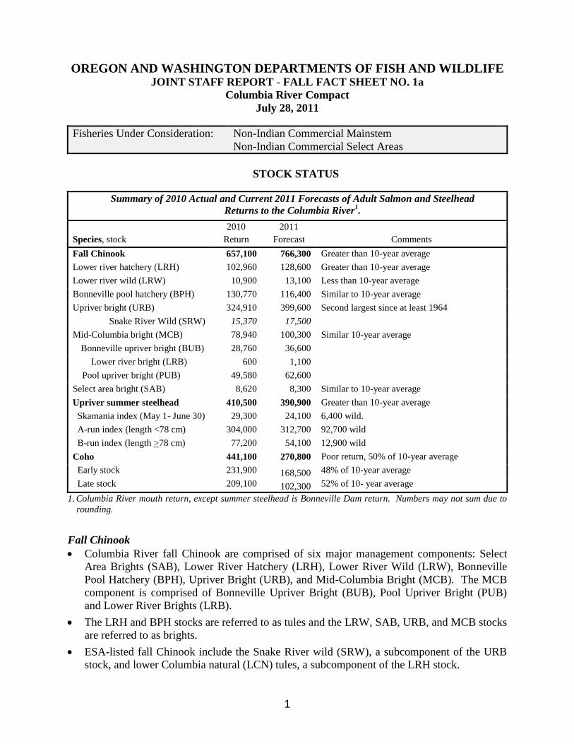
Summary of 2010 Actual and Current 2011 Forecasts of Adult Salmon and Steelhead
Returns to the Columbia River1.
2010 2011
Species, stock Return Forecast Comments
Fall Chinook 657,100 766,300 Greater than 10-year average
Lower river hatchery (LRH) 102,960 128,600 Greater than 10-year average
Lower river wild (LRW) 10,900 13,100 Less than 10-year average
Bonneville pool hatchery (BPH) 130,770 116,400 Similar to 10-year average
Upriver bright (URB) 324,910 399,600 Second largest since at least 1964
Snake River Wild (SRW) 15,370 17,500
Mid-Columbia bright (MCB) 78,940 100,300 Similar 10-year average
Bonneville upriver bright (BUB) 28,760 36,600 Lower river bright (LRB) 600 1,100
Pool upriver bright (PUB) 49,580 62,600 Select area bright (SAB) 8,620 8,300 Similar to 10-year average
Upriver summer steelhead 410,500 390,900 Greater than 10-year average
Skamania index (May 1- June 30) 29,300 24,100 6,400 wild.
A-run index (length <78 cm) 304,000 312,700 92,700 wild
B-run index (length >78 cm) 77,200 54,100 12,900 wild
Coho 441,100 270,800 Poor return, 50% of 10-year average
Early stock 231,900 168,500 48% of 10-year average
Late stock 209,100 102,300 52% of 10- year average
1. Columbia River mouth return, except summer steelhead is Bonneville Dam return. Numbers may not sum due to
rounding.
Fall Chinook
Columbia River fall Chinook are comprised of six major management components: Select
Area Brights (SAB), Lower River Hatchery (LRH), Lower River Wild (LRW), Bonneville
Pool Hatchery (BPH), Upriver Bright (URB), and Mid-Columbia Bright (MCB). The MCB
component is comprised of Bonneville Upriver Bright (BUB), Pool Upriver Bright (PUB)
and Lower River Brights (LRB).
The LRH and BPH stocks are referred to as tules and the LRW, SAB, URB, and MCB stocks
are referred to as brights.
ESA-listed fall Chinook include the Snake River wild (SRW), a subcomponent of the URB
stock, and lower Columbia natural (LCN) tules, a subcomponent of the LRH stock.

2
The URB, BPH, and PUB Chinook are destined for areas upstream of Bonneville Dam, and
in aggregate comprise the upriver run. Lower river components include SAB, LRH, LRW,
LRB and BUB Chinook stocks.
The 2011 forecast for fall Chinook returns to the Columbia River mouth of 766,300 adults, is
greater than both the 2010 return and the recent 10-year average, and would be the largest
return since 2004.
The URB forecast of 399,600 represents 52% of the total river mouth return of Chinook and
would be the largest URB return since 1987.
Bonneville Dam passage is expected to total 504,100 fall Chinook adults. Passage is
typically 50% complete by September 7.
Upriver Summer Steelhead
Upriver summer steelhead are fish that pass Bonneville Dam during April through October of
each year. Fish passing during July through October are categorized as Group A or Group B
based on fork length (Group A <78 cm, Group B ≥78 cm). Group B steelhead primarily
return to tributaries in the Salmon and Clearwater rivers in Idaho, while Group A steelhead
return to tributaries throughout the Columbia and Snake basins.
The forecast for the combined Group A/B steelhead returns to Bonneville Dam totals
366,800 fish, including 105,600 wild fish (29%). The Group A forecast is similar the recent
10-year average, while the Group B forecast is 80% of the 10-year average.
Passage during July is mainly Group A fish; Group B passage primarily begins around the
end of August. Counts of steelhead at Bonneville Dam during July 1-24 total 48,600 fish.
Passage at Bonneville Dam (July-October) is typically 50% complete by August 15.
Lower Columbia River Coho
The 2011 river mouth return of Columbia River coho (following expected ocean fisheries) is
predicted to be 270,800 adults, which includes 168,500 early stock and 102,300 late stock.
The forecast is only 50% of the 2001-2010 average and 61% of the 2010 return. The forecast
for early stock coho is 48% of the 10-year average, and the late stock forecast is 52% of the
10-year average.
Bonneville Dam passage is predicted to be 81,500 adult coho, which represents 79% of the
total ocean abundance of 101,400 Columbia River coho destined for areas above Bonneville
Dam.
MANAGEMENT GUIDELINES
Salmon/Steelhead
The "2008-2017 U.S. v Oregon Management Agreement" (MA) provides specific fishery
management guidelines for fall Chinook, steelhead and coho.
The allowable impact rate in combined treaty Indian and non-Indian fisheries is 45% of
the URB run based on preseason forecasts (URB stock is the surrogate for SRW
Chinook). This impact limit is allocated 30% for treaty Indian fisheries and 15% for non-
Indian fisheries.
The escapement goal at Spring Creek Hatchery is 7,000 fall Chinook (BPH stock).

3
The escapement goal for Chinook at McNary Dam is 60,000 fish.
Non-Indian impacts to wild summer steelhead (Group A and B index) are limited to 2%
during the fall season. Treaty Indian impacts are limited to 20% of the total Group B run.
The goal for upriver coho passage at Bonneville Dam is 50% of the ocean abundance.
Fall season non-Indian fisheries will be managed in accordance with the "2011 Non-Indian
Columbia River Fall Fishery Chinook Allocation Agreement". This agreement was
completed through the public North of Falcon (NOF) process, which includes input from
recreational and commercial fishing constituents.
Included in the allocation agreement are season structures and catch expectations for sport
and commercial fisheries. Based on this agreement, LRH impact allocations are shared 62%
sport and 38% commercial and URB impacts allocations are shared 36% sport and 64%
commercial. The most constraining stocks for 2011 fall Columbia River fisheries are LCN
tule Chinook and LCN coho.
The allowable exploitation rate (ER) for LCN tules is 37% for combined ocean and
Columbia River fisheries. The 2011 ER is expected to be 8.1% in Columbia River fisheries.
The LRH component is used as a surrogate for LCN tules.
The allowable ER for wild/natural LCN coho is 15% for combined ocean and Columbia
River fisheries. The 2011 ER is expected to be 4.3% in Columbia River fisheries.
The escapement goal for LRWs in the North Fork Lewis River is 5,700 fish.
Impacts to Columbia River chum salmon are limited to 5% of the run.
White Sturgeon
The Washington and Oregon Fish and Wildlife commissions and the two state directors have
provided management guidelines for 2011 white sturgeon fisheries. The total white sturgeon
harvest guideline (recreational and commercial) in 2011 is 17,000 fish, a reduction of 30%
from the 2010 guideline. The 2011 commercial allocation of white sturgeon is 3,400 fish.
Protocol for white sturgeon harvest in 2011 commercial fisheries was developed with input
from the Columbia River Commercial Advisory Group (CRCAG). The protocol includes
sub-allocation of harvest by fishery.
2011 NON-INDIAN FALL FISHERIES EXPECTATIONS
Recreational Fall Salmon Fisheries
The Buoy 10 fishery will begin August 1 with a daily bag limit of two fish/one Chinook.
The fishery is scheduled to be open for Chinook retention August 1-28, and October 1
through December 31. A two Chinook bag limit will be allowed when Chinook reopens on
October 1. Catch expectations include 10,950 Chinook (3,600 LRH and 2,400 URB) and
7,000 hatchery coho.
The lower Columbia River (LCR) fishery will begin August 1 with a two fish/one Chinook
daily limit from the Rocky Point/Tongue Point line upstream to Bonneville Dam. From
September 10-30, Chinook retention will only be allowed upstream of the Lewis River. The
daily bag limit may include up to two adult Chinook effective September 10, and continue

4
through December. The total catch expectation for this fishery is 20,700 Chinook (2,910
LRH and 12,400 URB) and 1,000 hatchery coho.
The mainstem fishery from Bonneville Dam upstream to Highway 395 Bridge (in Pasco,
Washington) will begin on August 1 with a two fish/two Chinook daily limit and a catch
expectation of 3,900 Chinook (2,600 URB).
To maximize opportunity, sport fisheries are expected to remain open for hatchery coho and
steelhead throughout normal seasons and areas, including times and areas closed for Chinook
retention.
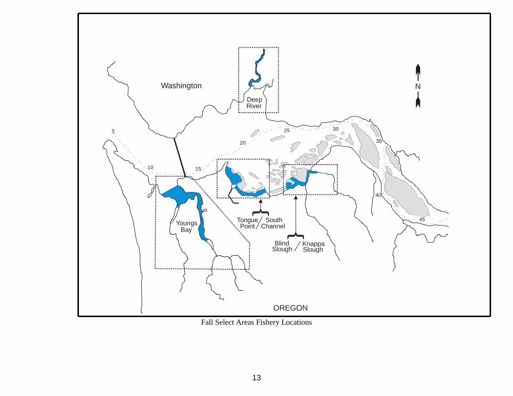
Select Area Fall Fisheries
2011 fall Select Area fisheries were discussed at a public meeting held June 8 in Astoria,
Oregon. Regulations and season structure proposed for 2011 are generally similar to those
adopted since 2001.
Expected returns of SAFE stocks to Select Area fishing sites include 39,800 coho and 7,100
SAB fall Chinook.
Coho returns to Select Area sites include 10,000 fish to Deep River 3,300 fish to Blind
Slough, 5,700 fish to Tongue Point and 20,800 to Youngs Bay. All expected returns are less
than (63%-81%) the average return observed over the past five years, except for the Deep
River site, which is 115% of average (due to increased smolt releases in recent years).
The predicted return of 18,000 Big Creek tule fall Chinook to the mouth of Big Creek is far
more than necessary for hatchery broodstock purposes (and expected in-stream losses) and
allows for additional harvest opportunity in the Knappa Slough Select Area fishing site.
For the second year, returns of tule fall Chinook released from Deep River net pens will
afford the opportunity to conduct Chinook-directed fisheries in Deep River during August.
Mainstem Commercial Fall Salmon Fisheries
Goals/expectations for mainstem commercial fisheries include:
August fishing periods to occur on Tuesdays, Thursdays and Sundays. 9-inch minimum
mesh and fishing hours expected to be 9 PM – 6 AM.
Early August to consist of a single opener on Thursday August 4 in Zones 1-5. Catch
expectation is 3,000 Chinook (1,330 LRH and 660 URB).
The late August fishery will begin on Tuesday August 16 in Zones 4-5 and continue through
August for an expected total of seven openers (August 16, 18, 21, 23, 25, 28, and 30). Total
catch expectation is 39,600 Chinook (2,210 LRH and 17,900 URB).
The late fall season is expected to begin September 18 in Zones 4-5. The fishery will
continue in Zones 4-5 through September and possibly extend into October. No Zone 1-5
target Chinook season is expected due to LCN tule limitations. The catch expectation for the
late fall Zones 4-5 fishery is 21,600 Chinook (340 LRH and 11,900 URB). Mesh size is
expected to be 8-inch minimum. Fishing hours will likely be 8 PM to 6 AM.
Coho fishing in 2011 will be limited. Target coho periods would occur the week of October
3 or 10 in Zones 1-3 during daylight hours with unslackened 6-inch maximum mesh. The
preseason catch expectation is 8,700 coho for all non-Indian commercial fisheries.
Additional coho would be available if harvest in the ocean or Buoy 10 fisheries is less than
expected.

5
The 2011 annual commercial allocation of white sturgeon is 3,400 fish. A total of 2,546 fish
are expected to remain on the commercial allocation upon conclusion of the summer season,
which includes 546 fish remaining from previous fisheries. Sturgeon landing limits are
expected to be in place throughout the fall season.
FISHERY RECOMMENDATIONS
Non-Indian Mainstem Commercial
2011 Non-Indian Mainstem Commercial Early Fall Fishery
Early August: 9 PM Thursday August 4 to 6 AM Friday August 5 (9 hours)
Area: Zones 1-5
Late August: 9 PM Tuesday August 16 to 6 AM Wednesday August 17 (9 hours)
9 PM Thursday August 18 to 6 AM Friday August 19 (9 hours)
9 PM Sunday August 21 to 6AM Monday August 22 (9 hours)
9 PM Tuesday August 23 to 6 AM Wednesday August 24 (9 hours)
9 PM Thursday August 25 to 6 AM Friday August 26 (9 hours)
Area: Zones 4-5. The deadline at the lower end of Zone 4 is defined
as a line projected from the Warrior Rock Lighthouse on the
Oregon shore easterly through the single red-capped piling and
continuing to the lower end of Bachelor Island (Washington).
Applies to all seasons:
Sanctuaries: Grays River, Elokomin-A, Cowlitz River, Kalama-A, Lewis-A, Washougal,
and Sandy Rivers as applicable.
Gear: Drift gillnets only. 9" minimum mesh size restriction.
For the August 4-5 fishery only: Multiple net rule in effect, which means nets
not specifically authorized for use in this fishery may be onboard the vessel if
properly stored. A properly stored net is defined as a net on a drum that is
fully covered by a tarp (canvas or plastic) and bound with a minimum of ten
revolutions of rope with a diameter of 3/8 (0.375) inches or greater.
August 16-26: Multiple net rule does not apply, which means nets not
authorized for this fishery may not be onboard.
Nets fished any time between official sunset and official sunrise must have
lighted buoys on both ends of the net. If the net is attached to the boat, then
one lighted buoy on the end of the net opposite the boat is required.
Allowable
Sales:
Salmon and white sturgeon. A maximum of 10 white sturgeon may be
possessed or sold by each participating vessel during the August 4-5 fishery,
and a maximum of 3 white sturgeon may be possessed or sold by each
participating vessel during each calendar week (Sunday through Saturday) in
the remaining openers. The white sturgeon possession and sales limit
includes mainstem fisheries only. Sales of white sturgeon from fall Select
Area fisheries is prohibited.
Additional
Rules:
24-hour Quick Reporting Rule will be in effect for Washington buyers.

6
The recommended boundary line at the lower end of Zone 4 is modified from previous years
to improve clarity and facilitate enforcement. The proposed boundary (Warrior Rock to red-
capped piling near lower end of Bachelor Island) is a straight line that roughly incorporates
the Lewis A sanctuary in one definition rather than two separate boundaries (Zone 3-4 and
Lewis sanctuary) used in the past.
Restricting the fishing time to nine hours per period (3 hours less than past years) is intended
to restrict the fishery to night hours to minimize conflicts between user groups.
Restricting the fishing area to Zones 4-5 only after the August 4 period will reduce catches of
LCN tule Chinook.
Restricting the fishery to 9-inch gear will reduce handle of steelhead and sub-legal sturgeon.
The proposed fishery is consistent with the 2011 Fall Allocation Agreement. Generally early
August fisheries catch an average of 3,000 Chinook per period based on the predicted run
sizes. Catch for the August 4th
period could be less, but is expected to include a high
proportion of LCN tules. Due to the risk of catching too many LCN tule Chinook, staff
suggests limiting the early August fishery to this one period regardless of the actual catch.
Staff recommends a sturgeon guideline of 1,800 fish for August fisheries leaving 746 for
September/October fisheries.
The proposed sturgeon landing limits should allow for sturgeon retention throughout August,
and provide for additional sturgeon harvest in September.
Catch expectations are:
20,000 – 25,000 Chinook and 1,700 sturgeon

7
Select Area Commercial
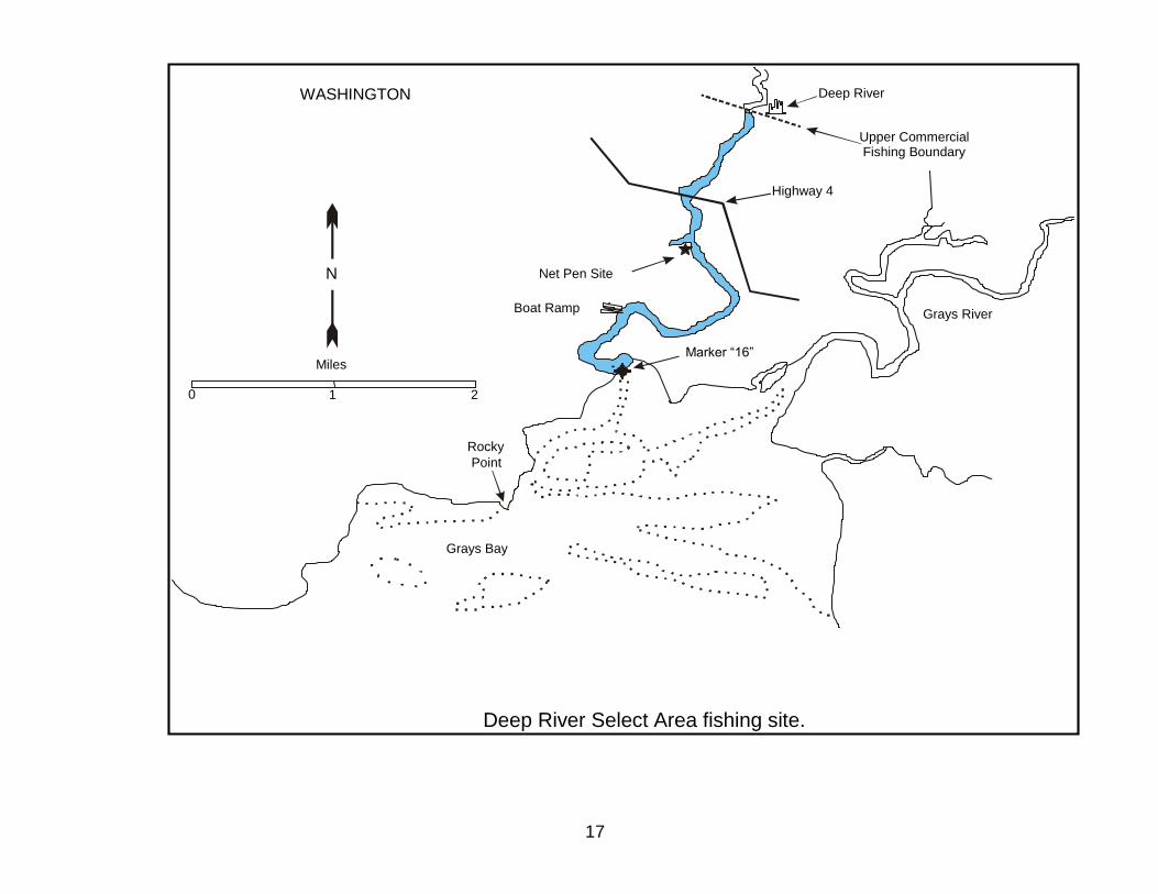
Deep River Fishery
Concurrent jurisdiction waters extend downstream from the Highway #4 Bridge and requires
Compact action. Washington state waters extend upstream from the Highway #4 Bridge and
requires Washington state action.
A Washington license is required in Washington state waters and either a Washington or
Oregon license is required in concurrent jurisdiction waters.
2011 Select Area Fall Season - Deep River Fishery
Season: Monday and Thursday nights from August 15 through August 26 (4 nights).
Open 7 PM – 9 AM (14 hours).
Monday, Tuesday, Wednesday, and Thursday nights from August 29 through October 28 (36 nights)
Open 7 PM – 9 AM (14 hours) from August 29 through September 16
and 4 PM – 9 AM (17 hours) thereafter.
Area: The Deep River fishing area includes all waters downstream of the town of Deep River to the mouth
defined by a line from USCG navigation marker #16 southwest to a marker on the Washington shore.
Gear: 9 3/4-inch maximum mesh size restriction August 15 through September 16 and 6-inch maximum
mesh size thereafter. Maximum net length of 100 fathoms and no weight restriction on leadline. Use
of additional weights or anchors attached directly to the leadline is allowed. No nets can be tied off to
stationary structures. Nets may not fully cross the navigation channel. It is unlawful to operate in any
river, stream or channel any gill net gear longer than three-fourths the width of the river, stream, or
channel. “River, stream, or channel width” is defined as bank-to-bank, where the water meets the
banks, regardless of the time of tide or the water level. This emergency provision shall supersede the
permanent regulation and all other regulations in conflict with it. All other provisions of the permanent
regulation remain in effect (WAC 220-20-015 (1))
Nets not specifically authorized for use in this fishery may be onboard the vessel if properly stored. A
properly stored net is defined as a net on a drum that is fully covered by a tarp (canvas or plastic) and
bound with a minimum of ten revolutions of rope with a diameter of 3/8 (0.375) inches or greater.
Nets fished any time between official sunset and official sunrise must have lighted buoys on both ends
of the net. If the net is attached to the boat, then one lighted buoy on the end of the net opposite the
boat is required.
Allowable
Sales: Salmon. Sales of white sturgeon from fall Select Area fisheries is prohibited.
Additional
Rules: 24-hour Quick Reporting Rule will be in effect for Washington buyers.
An earlier start and extended hours throughout the season (implemented in 2009) increases
harvest opportunity.
Fishing periods in the 3rd
and 4th
weeks of August provide earlier harvest opportunity for
coho and Chinook (tules and SABs), and important harvest rate and stock composition data
on tule fall Chinook released from Deep River pens beginning in 2009 (jack and Age-3
returns this year).
Larger maximum mesh size permitted through mid-September is intended to increase
opportunity to harvest Chinook during their peak availability. Six-inch maximum mesh size
thereafter reduces chum harvest and maximizes coho harvest during their peak availability.

8
Tongue Point/South Channel Fishery
All waters in this fishing area are concurrent jurisdiction waters and require Compact action.
A license from either Oregon or Washington is required to participate in this fishery.
2011 Select Area Fall Season - Tongue Point/South Channel Fishery
Season: Monday, Tuesday, Wednesday, and Thursday nights from August 29 through October 28 (36
nights)
Open 7 PM – 7 AM (12 hours) from August 29 through September 16 and 4 PM – 8 AM (16 hours)
thereafter.
Areas: Tongue Point and South Channel areas open entire season.
The Tongue Point fishing area includes all waters bounded by a line from a marker midway between
the red USCG navigation light #2 at the tip of Tongue Point and the downstream (northern most)
pier (#8) at the Tongue Point Job Corps facility, to the flashing green USCG navigation light #3 on
the rock jetty at the west end of Mott Island, a line from a marker at the southeast end of Mott Island
northeasterly to a marker on the northwest tip of Lois Island, and a line from a marker on the
southwest end of Lois Island westerly to a marker on the Oregon shore.
The South Channel area includes all waters bounded by a line from a marker on John Day Point
through the green USCG buoy #7 to a marker on the southwest end of Lois Island upstream to an
upper boundary line from a marker on Settler Point northwesterly to the flashing red USCG marker
#10, northwesterly to a marker on Burnside Island defining the upstream terminus of South
Channel.
Gear: In the Tongue Point fishing area, restrict gear to 6-inch maximum mesh size, maximum net length
of 250 fathoms, and weight not to exceed two pounds in any one fathom.
In the South Channel fishing area, restrict gear to 6-inch maximum mesh size, maximum net length
of 100 fathoms, and no weight restriction on leadline. Use of additional weights or anchors attached
directly to the leadline is allowed.
Nets not specifically authorized for use in this fishery may be onboard the vessel if properly stored.
A properly stored net is defined as a net on a drum that is fully covered by a tarp (canvas or plastic)
and bound with a minimum of ten revolutions of rope with a diameter of 3/8 (0.375) inches or
greater.
Nets fished any time between official sunset and official sunrise must have lighted buoys on both
ends of the net. If the net is attached to the boat, then one lighted buoy on the end of the net
opposite the boat is required.
Allowable
Sales: Salmon. Sales of white sturgeon from fall Select Area fisheries are prohibited.
Additional
Rules:
24-hour Quick Reporting Rule will be in effect for Washington buyers.
An earlier start and extended hours beginning in mid-September provide additional fishing
opportunities as previously requested by industry.

9
Blind Slough/Knappa Slough Fishery
Concurrent jurisdiction waters extend downstream from the Railroad Bridge in Blind Slough
and encompass all of Knappa Slough and require Compact action.
Oregon State waters extend upstream from the Railroad Bridge in Blind Slough and require
Oregon State action.
An Oregon license is required in Oregon State waters and either an Oregon or Washington
license is required in concurrent jurisdiction waters.
2011 Select Area Fall Season - Blind Slough/Knappa Slough Fishery
Season: Monday, Tuesday, Wednesday, and Thursday nights from August 29 through October 28
(36 nights)
Open hours are 7 PM – 7 AM (12 hours) from August 29 through September 16 and
6 PM - 8 AM (14 hours) thereafter.
Areas: The Blind Slough fishing area includes all waters from markers at the mouth of Gnat Creek located
approximately ½-mile upstream of the county road bridge, downstream to markers at the mouth of
Blind Slough.
The Knappa Slough fishing area includes all waters bounded by a line from the north marker at the
mouth of Blind Slough, westerly to a marker on Karlson Island, downstream to boundary lines
defined by markers on the west end of Minaker Island to markers on Karlson Island and the Oregon
shore. Markers define an area closure of about a 100’ radius at the mouth of Big Creek.
Gear: In both fishing areas, a maximum mesh size of 9 3/4-inch in effect for the entire season, maximum
net length of 100 fathoms, and no weight restriction on leadline. Use of additional weights or
anchors attached directly to the leadline is allowed.
Nets not specifically authorized for use in this fishery may be onboard the vessel if properly stored.
A properly stored net is defined as a net on a drum that is fully covered by a tarp (canvas or plastic)
and bound with a minimum of ten revolutions of rope with a diameter of 3/8 (0.375) inches or
greater.
Nets fished any time between official sunset and official sunrise must have lighted buoys on both
ends of the net. If the net is attached to the boat, then one lighted buoy on the end of the net
opposite the boat is required.
Allowable
Sales: Salmon. Sales of white sturgeon from fall Select Area fisheries are prohibited.
Additional
Rules:
24-hour Quick Reporting Rule will be in effect for Washington buyers.
Similar to the Tongue Point/South Channel fishery, fishing hours increase in late September
to maximize harvest opportunity.
The increased maximum mesh size should provide adequate opportunity to harvest surplus
fall Chinook predicted to return to Big Creek Hatchery.

10
Youngs Bay Fishery
All waters in this fishing area are Oregon State waters and require Oregon State action, but
all waters are open to Washington licensed fishers.
2011 Select Area Fall Season - Youngs Bay Fishery
Season: August 3 through August 25: 7 AM Wednesday to 7 PM Thursday (36 hours) weekly (4 periods)
August 29 through September 2: 7 PM Monday to 7 AM Friday (3.5 day period)
and
7 PM Monday September 5 through noon Sunday October 31 (57 days)
Area: The Youngs Bay fishing area includes all waters from the new Highway 101 Bridge upstream to
the upper boundary markers at Battle Creek Slough; except for closed waters southerly of the
alternate Highway 101 Bridge (Lewis and Clark River).
Gear: 9 3/4-inch maximum mesh size restriction through August 25 and 6-inch maximum mesh size
restriction thereafter.
Restrict net to maximum length of 250 fathoms and weight on leadline not to exceed two pounds in
any one fathom. Use of additional weights or anchors attached directly to the leadline is allowed
between markers located immediately upstream of the mouth of the Walluski River and the upper
deadline at Battle Creek Slough.
Red corks are required at 25-fathom intervals and red corks must be in contrast to corks used in the
remainder of the net.
Nets not specifically authorized for use in this fishery may be onboard the vessel if properly stored.
A properly stored net is defined as a net on a drum that is fully covered by a tarp (canvas or plastic)
and bound with a minimum of ten revolutions of rope with a diameter of 3/8 (0.375) inches or
greater.
Nets fished any time between official sunset and official sunrise must have lighted buoys on both
ends of the net. If the net is attached to the boat, then one lighted buoy on the end of the net
opposite the boat is required.
Allowable
Sales: Salmon. Sales of white sturgeon from fall Select Area fisheries are prohibited.
August fishing periods are designed to provide commercial harvest opportunity on SAB fall
Chinook while allowing for adequate escapement to both Klaskanine hatcheries and
tidewater recreational fisheries.
The standard fall season upper fishing boundary at Battle Creek Slough is intended to limit
harvest of SAB fall Chinook that congregate in the upper tidewater area.
Continuous fishing opportunity throughout the majority of September and October is
intended to maximize harvest of coho.
The 9 ¾-inch maximum mesh size restriction allows the fishery to target Chinook during
most of August and the 6-inch maximum mesh size restriction beginning in late-August will
focus the fishery on coho as their abundance begins to peak.

11
Issues Requiring Compact/State Consideration
Non-Indian mainstem commercial early fall fishery – Compact Action (page 5)
Deep River Select Area commercial fishery – Compact and Washington State Action (page 7)
Tongue Point/South Channel Select Area commercial fisheries – Compact Action (page 8)
Blind Slough/Knappa Slough commercial fisheries – Compact and Oregon State Action (page 9)
Youngs Bay Select Area fishery – Oregon State Action (page 10)
FUTURE MEETINGS
The Joint Staff is recommending a hearing for 1:00 PM Thursday August 25 to consider late-
August non-Indian and possibly treaty Indian commercial fisheries.

12
13
OREGON
Washington
YoungsBay
Tongue Point
SouthChannel
BlindSlough
KnappaSlough
N
10 15
20
25 30
35
40
45
DeepRiver
Fall Select Areas Fishery Locations

14
HWY 101
Bridge
Astoria CEDC Net Pen Sites
Old 101 Bridge
Alternate HWY 101
Bridge
N
Lewis & Clark River
Walluski River
Youngs River
North Fork
South Fork Klaskanine Hatchery
CEDC Hatchery
Battle Creek Slough
0 1 2
Miles
Klaskanine River
Upper Fishing Boundaries
Youngs Bay Select Area fishing site.
Tucker Creek Slough

15
S v e n s e n I s l a n d
P r a i r i e
C h a n n e l
C a l e n d a r S l o u g h
B i g C r e e k S l o u g h
P r a i r i e C h a n n e l
N
0 1
Miles
Oregon
Aldrich Point
Net Pen Site
Big
Creek
Gnat Creek
Road Bridge
Blind Slough
Karlson Island
Minaker
Island
Upper Commercial Fishing Boundary
Upper Recreational
Fishing Boundary
Blind Slough/Knappa Slough Select Area fishing sites.

16
John DayPoint
TonguePoint
John DayRiver
N
0 1/2 1
Oregon
Net Pen
Site
MottIsland
South Channel
SvensenIsland
LoisIsland
Tongue Point/ South Channel Select Area Fishing Sites
17
Deep River Select Area fishing site.
Boat Ramp
Highway 4
Net Pen Site
Deep River
Grays River
Grays Bay
Rocky Point
WASHINGTON
Miles
0 1 2
N
Marker “16”
Upper Commercial Fishing Boundary