origin of the palaeic landforms and glacial impact on the ... · origin of the palaeic landforms...
TRANSCRIPT

223
Origin of the palaeic landforms and glacial impact on the Varanger Peninsula, northern Norway
Jakob Fjellanger & Leif Sørbel
Fjellanger, J. & Sørbel, L. Origin of the palaeic landforms and glacial impact on the Varanger Peninsula, northern Norway. Norwegian Journal of Geology, Vol. 87, pp. 223-238,.Trondheim 2007. ISSN 029-196X.
The palaeic surface of the Varanger Peninsula has been studied to evaluate formational processes and glacial remoulding. The peninsula largely con-sists of a plateau (the palaeic surface) where quartzite heights resembling lithostructurally controlled inselbergs, protrude above a broadly undula-ting surface largely developed on sandstones. The lowest parts of the palaeic landscape are mainly developed on less resistant rocks like shales, and are often in the form of broad valleys. Along lithostructurally controlled escarpments depressions often occur and pediment-like forms are seldom found. An abundance of weathered zones, probably of pre-Quaternary age, occur in the quartzites, and autochthonous blockfields up to more than 3 meters thick are extensive on quartzites and sandstones. Weathering mantles are extensive also outside the blockfields. It is suggested that differen-tial etching and etchplanation has played an important role for the formation of the palaeic surface, but surface levels also indicate cyclic processes related to former sea levels. Large parts of the plateau show no or only limited signs of glacial erosion. The incision of V-shaped valleys reflects the changing climatic-geomorphic conditions in the late Cenozoic, the increased relief created by selective glacial erosion, and uplift. The late Cenozoic uplift is estimated to be at the most 200 meters for the Varanger Peninsula, but may be significantly less.
Jakob Fjellanger, Seljeveien 14, 1450 Nesoddtangen, Norway. E-mail [email protected]. Leif Sørbel, Department of Geosciences, University of Oslo, P.O. Box 1047 Blindern, 0316 Oslo, Norway
IntroductionPalaeosurfaces play an important role in historic genetic geomorphology as they may yield information on denu-dational processes, palaeoclimate and uplift events far back in time. However, detailed studies of palaeosurfaces in Norway have been rather few. Traditional geomor-phic methods coupled with the increasing use of mod-ern computers and software (GIS), and supplemented by new methods for surface dating, offer new possibilities for geomorphic analysis.
At the beginning of the 20th century Reusch (1901) introduced the term Palæic surface (here called “palaeic surface”) for the gentle landscape on the high plateaux in southern Norway, in contrast to the sharply incised fluvial and glacial valleys and fjords. Being inspired by Davis (1899) and his concept of the peneplain as the end product of the cycle of erosion, Reusch concluded that the palaeic surface was formed in preglacial times and graded to sea level before a late Tertiary uplift.
Many geoscientists have observed the stepped appear-ance of the plateau surfaces, in southern Norway (Reusch 1901; Strøm 1948; Schipull 1974; Peulvast 1985; Lidmar-Bergström et al. 2000), and in northern Norway (Wråk 1908; Peulvast 1986). Bonow et al. (2003) carried out a detailed mapping of flats and slopes in the Kjølen moun-tain area based on digital elevation data. They found a pattern of regularly spaced flats at three major levels, assumed to have developed by fluvial incision and back-
wearing of valley sides in response to major changes in the general base level. Peulvast (1986) noted a pattern of stepped surfaces in the Lofoten-Vesterålen area, at least partially of cyclic origin, but he also noted structural control of escarpments between the main levels reducing the importance of backwearing for the development of slopes that has been generally suggested. Thomas (1995) assumed that (re)activation of deep weathering sys-tems during Cenozoic uplift events, driven by increased hydraulic gradients supplying water to the saprolite-rock interface, had been important for the development of pre-glacial relief in Fennoscandia. Gjessing (1967) argued that depressions in the palaeic surface had been created by deep weathering, with subsequent widening by back-wearing thus creating pediments. Although he did not deny the existence of palaeosurface levels separated by steps, he rejected the idea that the summits of the Palaeic rounded hills represented a different and older palaeo-surface level than the depressions.
Elevated surfaces and incised valleys have lately been used for evaluating uplift in different settings (Schoenbohm et al. 2004; Clark et al. 2005; Kuhlemann et al. 2005; Bonow et al. 2006a; Bonow et al. 2006b). However, skeptics still question interpretations often incorporated in surface chronology studies (Thomas 1994; Summerfield 2000), for example that slope retreat is the main process respon-sible for surface formation.
In the present work the meso-scaled bedrock geomor-phology, and its relation to the lithostructures, is ana-
NORWEGIAN JOURNAL OF GEOLOGY Origin of the palaeic landforms and glacial impact
224
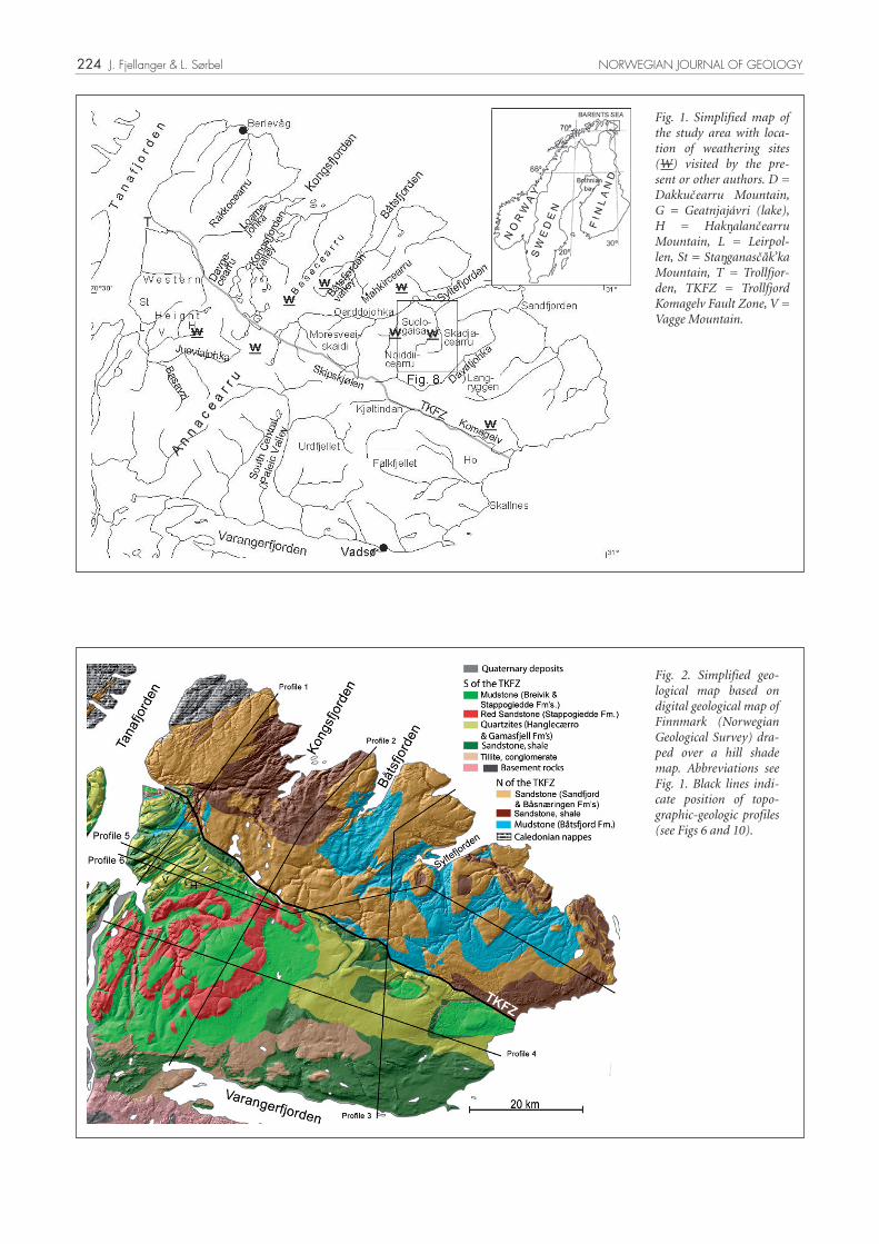
Fig. 1. Simplified map of the study area with loca-tion of weathering sites (W) visited by the pre-sent or other authors. D = Dakkucearru Mountain, G = Geatnjajávri (lake), H = Hak alancearru Mountain, L = Leirpol-len, St = Sta ganascåk’ka Mountain, T = Trollfjor-den, TKFZ = Trollfjord Komagelv Fault Zone, V = Vagge Mountain.
Fig. 2. Simplified geo-logical map based on digital geological map of Finnmark (Norwegian Geological Survey) dra-ped over a hill shade map. Abbreviations see Fig. 1. Black lines indi-cate position of topo-graphic-geologic profiles (see Figs 6 and 10).
J. Fjellanger & L. Sørbel NORWEGIAN JOURNAL OF GEOLOGY

225
lyzed to find out if slope retreat and pediment formation (backwearing) were the main components in the for-mation of the palaeic landscape or if it was due to deep weathering processes like differential etching and etch-planation (downwearing). A landscape chronology and uplift are briefly discussed and the geomorphic effect of Pleistocene ice-sheets evaluated.
Study areaThe Varanger Peninsula is situated at 28-31º E and 70-71º N, and has an area of about 6.200 km2. It is delimited by the Barents Sea in the N and E, Tanafjorden in the W and Varangerfjorden in the S (Fig. 1). Apart from a small area belonging to the Caledonian Kalak nappe in the far NW, the bedrock consists of Riphean to Vendian shales, mudstones, sandstones and conglomerates (Fig. 2). The Trollfjord-Komagelv Fault Zone (TKFZ), divides the peninsula into two parts and has been activated several times from the Proterozoic up to the Mesozoic or Ter-tiary (Siedlecka 1975, 1985; Karpuz et al. 1993; Karpuz et al. 1995). The geological succession in the Barents Sea region north of the TKFZ has not been correlated with the succession in Tanafjorden-Varangerfjorden region (Fig. 3), and it is possible that the Barents Sea region has been moved from an earlier position much further west (Siedlecki 1975).
The rock formations have often broadly undulating structures (Fig. 2) (Siedlecki 1980), and show a limited degree of metamorphism (Siedlecka & Roberts 1992). A strongly folded and faulted area between Trollf-jorden, Leirpollen and Geatnjajávri (here called “the Hak alancearru-Dakkucearru Heights”, see Fig. 1) has NE-SW trending structures due to compression from the northwest during the Caledonian orogeny. South of Varangerfjorden the bedrock is of late Archaean to early Proterozoic age and mainly consists of gneisses and plu-tonic rocks (Siedlecki 1980, Geological surveys of Fin-land 1987).
The peninsula can be characterized as an undulating plateau with altitudes generally between 200 and 600 m a.s.l. (Fig. 4). It is largely bordered by steep coastal or near coastal escarp-ments. The highest altitudes are in the Hak alancearru-Dakkucearru Heights where Sta ganascok’ka reaches 725 m a.s.l. and the Skipskjølen area 633 m a.s.l (Figs. 1 and 4).
Syltefjorden is 125-130 meters deep while Kongsfjorden and Båtsfjorden are seldom more than 80-90 meters. Thus, from their water depths these fjords seem to be only slightly over-deepened. Tanafjorden is mostly 200-300 meters deep and only slightly shallower in its outer part. Seismic profiles show that the sediment cover in the fjord is thin. In contrast, thicknesses of about 200 meters occur in the deltaic deposit at the mouth of the river Tana, and possibly up to 375 meter at Masjok 20 km up
river (pers. com. Geoffrey Corner, University of Tromsø, Oct. 2004). Varangerfjorden is less than 200 meters deep in its inner parts but reaches 400 meters east of the pen-insula. Off the eastern and northern coast of the Varanger Peninsula, the sea-depth is less than 100 meters 10 – 15 km from land, but increases to 350-400 meters 15 - 25 km from land in a coast-parallel trench (Kristoffersen et al. 1988).
Topographic heights on the Varanger plateau are often covered by block fields (Malmström & Palmér 1984; Olsen et al. 1996b; Fjellanger et al. 2006) and have occa-sional tors (Malmström & Palmér 1984). Systems of nar-row fluvial valleys penetrate up to 45 km inland from the northeastern and western coast. Only a few lakes exist on the Varanger Peninsula, and most of them occur in Kongsfjorddalen and southwards (Fig. 4). Erratics from the crystalline bedrock south of Varangerfjorden occur on the highest summits (Markgren 1964), indicating that the Varanger Peninsula has been overrun from south to north by thick Fennoscandian ice-sheets, the last dur-ing the Late Weichselian (Sollid et al. 1973; Marthinus-sen 1974; Andersen 1979; Svendsen et al. 1999; Siegert & Dowdeswell 2004). However, large parts of the Varanger Peninsula plateau lack signs of glacial sculpturing, which is mainly resricted to areas where topography facilitated
AgeFormation Formation
Breivika 600 m Skidnefjell 800 m
Mortensnes 10-60 m Skjærgårdsneset 210 mNyborg 200-400 m Styret 1500-1600 mSmalfjord 2-50 m Sandfjord 2000 mGrasdalen 280 m
Hanglecearru 200 mVagge 80 m
Gamasfjell 300 m
StangnesGrønnes
Ekkerøya
Tanafj.-Varangerfj. region Barents sea region
LØK
VIK
FJE
LL G
R.
5710
-581
0 m
Lithostratigraphic units
CA
MB
RIA
N-O
RD
OV
.
DIG
ER
MU
LEN
GR
. 15
10-1
550
m
Båsnæringen 2500-3500 m
Kongsfjord 3500 m
BA
RE
NTS
SE
A G
R.
890
0-10
000
m
Lithostratigraphic units
Stordalselva 1200 m
Tyvjofjellet 1500 m
Båtsfjord 1400-1600 m
Older Precambrian rocks
TAN
AFJ
OR
DE
N G
R.
1450
-166
0 m
Dakkovarre270-350 m
VA
DS
Ø G
R.
59
0-96
0 m
RIP
HE
AN
Other formations
TE
RM
INA
L R
IPH
EA
N
(OR
EA
RLY
VE
ND
IAN
)
Other formations
VE
STE
RTA
NA
GR
. 13
00-1
650
m Stappogiedde500-550 m
VE
ND
IAN
Fig. 3. Succession of rock formations with thicknesses in the Barents Sea region north of the TKFZ and in the Tanafjord-Varangerfjord region after Siedlecka & Roberts (1992). Double lines indicate major erosional disconformities that often truncate several of the older rock formations.
NORWEGIAN JOURNAL OF GEOLOGY Origin of the palaeic landforms and glacial impact

226
Fig. 4. A height layer map where transparent height layers are draped over a hill shade map, both created from a digital elevation model with 25 m pixel size. See Fig. 1 for abbreviations.
Fig. 5. Map showing relative relief calculated within a 2 km diameter circular window around each pixel. It is draped over a hill shade map. Large relative relief often coincide with lit-hostructural boundaries (see Fig. 2). See Fig. 1 for abbreviations.
J. Fjellanger & L. Sørbel NORWEGIAN JOURNAL OF GEOLOGY

227
enhanced ice-flow. It is also clear that the autochthonous blockfields must have survived the coverage by at least one, probably several ice-sheets (Ebert & Kleman 2004; Fjellanger et al. 2006).
MethodsAnalyses of topography, analyses of the relation between landforms and geology, and inventories of weathering residues, were the main methods used. An overview of geomorphology, superficial materials and glacial erosion was obtained from aerial photos. Relative chronology and published exposure dating (Fjellanger et al. 2006) were used to get some idea of the time scale.
Profile curves have been derived from a digital elevation model (DEM) with 25 x 25 m resolution (resampled to 50 x 50 m resolution) within a Geographical Information System (GIS) framework. Profile curves were constructed along lines trending north-south and west-east with 5 km spacing, and along some other selected lines. Maximum, minimum and mean elevations within a circular calcula-tion window of 2 km diameter were used to calculate the relief parameters along the profile lines (Brown et al. 1999; Fjellanger & Etzelmuller 2003; Bonow et al. 2006b). Maps showing altitude layers (Fig. 4) and relative relief (Fig. 5) calculated from the DEM aided the interpretation.
The topography along the profiles has been analyzed in relation to geological maps at a scale of 1:250 000 and some at a scale of 1:50 000. Some profiles have been cou-pled with digital geological maps.
During field surveying in the summers 2002, 2003 and 2004, some shallow pits were dug for brief evaluation of the types of superficial material present. Rock samples from blockfields and glacial features were collected for exposure dating purposes (Fjellanger et al. 2006) and rock samples from weathered zones in quartzites were col-lected for analysis of the weathering process (Fjellanger & Nystuen In press). Additionally, all available information regarding weathering mantles on the Varanger Peninsula was obtained from the literature.
ResultsTopography
Gently undulating surfaces dominate the landscape over large parts of the Varanger Peninsula down to about 200 m a.s.l., and even lower in the southeastern areas (Fig. 4). It is evident that areas with low relative relief are most extensive in the central and southeastern parts of the peninsula (Fig. 5).
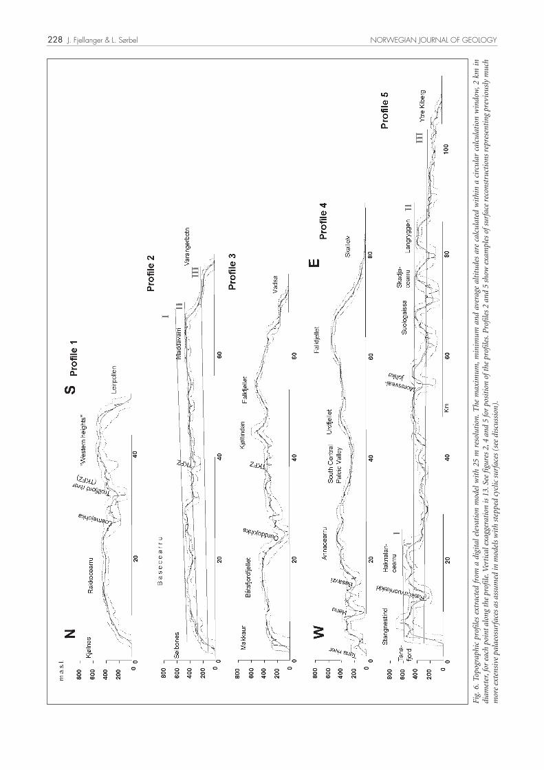
In the summit areas between the northern fjords a gen-tly undulating surface can be followed southwards (Fig.
6 profile 2 and northern parts of profiles 1 and 3). The altitude is 350-450 m a.s.l., here and there as low as 300 or up to 500 m a.s.l. (Fig. 4). This surface will be called the main level as it is the most extensive and forms the summit surface over large parts of the peninsula. South of the TKFZ the main level is extensive on both sides of the broad informally called South Central Valley (Fig. 1). The relative relief is for the most part less than 100 meters within a 2 km calculation window (Figs 5 and 6, also see Fig. 7). Between the northern fjords the main level starts to descend 5-10 km from the main coast line (Fig. 6 pro-files 1, 2 and 3). It largely ends in coastal escarpments up to 300 m high. The transition from the main level to lower and higher parts of the Palaeic surface partly con-sists of escarpments up to 250 meters high (Fig. 5 and 6).
The lowermost parts of the Palaeic surface at 150-300 m a.s.l. are found in the South Central Valley (Figs. 1 and 4), in a network of wide, high level valleys south of Syltefjor-den (Fig. 4 dark grey colour, and Fig. 8), in the northwest, and in the very easternmost part of the peninsula, where the surface descends down to about 150 m a.s.l (Fig. 6 profile 5). The South Central Valley is slightly less than 200 m a.s.l. in the south, gradually increasing to 250 m a.s.l. in the north, and has low relative relief (Fig. 6 pro-file 4). The network of broad, high level valleys south of Syltefjorden has an altitude mainly of 250-300 m a.s.l., and is developed between heights reaching 400-450 m a.s.l. (Figs. 4 and 6: profile 5). The bottoms of the valleys are partly rugged, specifically those close to Syltefjorden, but are smooth at the water divide towards Dávatjohka to the south (Fig. 8 southern part).
The lower Palaeic landscape usually ends in escarpments up to 200 m high at or close to the coast. Thus, along parts of the eastern and southern coasts the descent down to sea level is characterized by surfaces with step-wise arrangements (Fig. 6 profiles 2, 3 and 5). Along the southeastern coast the 150-300 meters level is more frag-mentary, and is replaced by plains below 100 m a.s.l. gen-tly sloping down towards the coast. This is the case inside Ekkerøy, between Skallnes and Holmfjellet, and along the lower part of Komagelv (Fig. 1). Between Skallnes and Holmfjellet the slope gradually steepens up to the rounded summit of Falkfjellet (Fig. 6 profile 4).
Three areas have summits or summit areas that rise sig-nificantly above the main level. The Hak alancearru-Dakkucearru Heights have gentle summit areas mainly at 500-600 m a.s.l. (Figs 4 and 9 and 10 profile 6). The Hak alancearru-Dakkucearru Heights are delimited by more or less distinct escarpments towards the main level. The highest escarpment is the south-facing wall of the Hak alancearru ridge reaching 250 meters above the main level. Skipskjølen further east has the form of a ridge with summits up to 633 m a.s.l. Abrupt escarpments face north, whereas towards the south and southwest, the moun-tain side slopes more gently. Falkfjellet to the south reaches up to 545 m a.s.l. but is not delimited by steep escarpments.
NORWEGIAN JOURNAL OF GEOLOGY Origin of the palaeic landforms and glacial impact
228
Fig.
6. T
opog
raph
ic p
rofi
les
extr
acte
d fr
om a
dig
ital
ele
vati
on m
odel
wit
h 25
m r
esol
utio
n. T
he m
axim
um, m
inim
um a
nd a
vera
ge a
ltit
udes
are
cal
cula
ted
wit
hin
a ci
rcul
ar c
alcu
lati
on w
indo
w, 2
km
in
diam
eter
, for
eac
h po
int a
long
the
prof
ile. V
erti
cal e
xagg
erat
ion
is 1
3. S
ee fi
gure
s 2,
4 a
nd 5
for
posi
tion
of t
he p
rofi
les.
Pro
file
s 2
and
5 sh
ow e
xam
ples
of s
urfa
ce r
econ
stru
ctio
ns r
epre
sent
ing
prev
ious
ly m
uch
mor
e ex
tens
ive
pala
eosu
rfac
es a
s as
sum
ed in
mod
els
wit
h st
eppe
d cy
clic
sur
face
s (s
ee d
iscu
ssio
n).
J. Fjellanger & L. Sørbel NORWEGIAN JOURNAL OF GEOLOGY

229
Narrow V-shaped valleys have been incised into the floor of the more gentle high level valleys south of Syltefjorden (Figs 4 and 8). Several of them drain into Syltefjorden, while the longer Dávatjohka ends in Sandfjorden. Dávat-johka extends for about 45 km inland and ascends rather steadily reaching 150 m a.s.l. about 30 km from the coast. The V-shaped cross profile is evident in large parts of this valley system and the valley width is rather constant (Fig. 4). The broad valleys leading down to Båtsfjorden and Kongsfjorden reach 150 m a.s.l. 10-15 km from the sea, and have a rugged topography (Fig. 4).
Lithostructures and landforms
Lithology and structure of the bedrock play an impor-tant role for the main geomorphic features of the plateau of the Varanger Peninsula. First, the highest areas con-sist of the most resistant rocks, while the lowest areas are underlain by less resistant rocks. Second, where resistant structures are near horizontal, the land surfaces are gen-tle, but where resistant structures dip more steeply, ridges or scarps have often developed.
The Hak alancearru-Dakkucearru Heights and the Skip-
Fig. 7. Photo shows land east of Kongsfjorden (profile 2 in Fig. 6). Notice the gentle summit level and the slight inclination towards the Barents Sea in the north in the left part of the photo.
Fig. 8. Aerial stereo photos from south of Syltefjorden showing Suologaissa mountain (upper left) and Noidiidčearru height (lower left). Notice bedrock structures in the Båtsfjord Formation clearly visible on the ground surface.
NORWEGIAN JOURNAL OF GEOLOGY Origin of the palaeic landforms and glacial impact

230
skjølen and the Falkfjellet mountains consist of quartz-ites of the Gamasfjellet and/or Hanglecærro Formations (Fig. 2). Whether these heights are delimited by abrupt escarpments or not is determined by the structural dip-angle of the quartzite. Profile 6 (Fig. 10), crossing the Hak alancearru-Dakkucearru Heights, shows that the summit surface at about 500-600 m a.s.l. truncates folds in the quartzites of the Hanglecærro and Gamasfjellet Formations and the intervening Vagge Formation shale. This has resulted in a repetitive sequence of plateaux sep-arated by valleys along synclines. Strike parallel shallow depressions have been formed in the outcropping Vagge Formation shale (Fig. 11).
The Hak alancearru ridge (up to 604 m a.s.l.) consists of a 40º-50º dipping outcrop of the Hanglecærro Formation quartzite. The ridge has several gaps where water from small ponds or melting snow has drained. The sedimen-tary bedding plane is clearly visible in the rock wall and exerts a strong control on its form (Fig. 12). Although zones of strongly weathered quartzite occur (Fjellanger & Nystuen, In press), in some cases crossing the whole ridge, the gaps do not seem to be associated with such zones.
The 200 m thick massive quartzite of the Hangelcærro formation was studied by Siedlecka & Siedlecki (1971) and Fjellanger & Nystuen (2007). The rock forma-tion consists of tightly packed quartz grains cemented together by quartz overgrowths. Microscope studies indi-cate similar properties for the 300 m thick Gamasfjell Formation quartzite. It is assumed that these two forma-tions, which cover large areas south of the TKFZ (Fig. 2), are relatively resistant to weathering processes, although long-term chemical weathering by meteoric water along cracks and faults has significantly altered the mechanical properties of the rock (Fjellanger & Nystuen 2007).
At the bottom of the south-facing rock wall, the Han-glecærro Formation continues underneath the strati-graphically overlying mudstones and sandstones of the Stappogiedde Formation (Siedlecka & Siedlecki 1971), which underlie the gently undulating surface (main level) to the south (Fig. 9). The knick at the scarp foot follows the lithological boundary (Figs 9 and 10 profile 1). No gently sloping foot slope or pediment is identi-fied. Small lakes occur rather frequently in a 2-3 km wide zone below the rock wall (Fig. 4), and several elongated lakes are situated along the nick, below the steepest parts of the wall.
In the southwestern part of the peninsula the red, quartz-itic Stappogiedde Formation sandstone forms a series of saucer-shaped synclines (Siedlecki 1980). The formation crops out in circular patterns (Fig. 2) embracing broadly undulating summit areas developed in mudstone inter-spersed with quartzite (Breivik Formation). Where escarpments occur around this area they are always con-nected to outcrops of the red quartzitic sandstone (Fig. 2, 4 and 10 profile 2).
The Stappogiedde Formation rocks are, together with older tillites, part of a Vendian succession of rocks. They have been deposited on an unconformity truncat-ing different terminal Riphean (or early Vendian) rocks, including the Gamasfjell Formation quartzite (Fig. 2 and Siedlecki 1980). Rocks deposited on the unconformity are also preserved as two isolated relicts further east in gentle synclines. The quartzitic mountains Urdfjellet and Falkfjellet (Gamasfjell Formation) occur between what remains of Vendian rocks (Fig. 2).
North of the TKFZ massive sandstone formations belonging to the Sandfjord and the Båsnæringen For-mations, dominate in the higher lying areas, while phyl-
Fig. 9. Photo shows the blockfield covered quartzite mountain Hak alancearru with the eastern part of its southern ridge (604 m a.s.l.). Its south-facing escarpment rises above the lower plain in Stappogiedde formation rocks to the left. View towards the west.
J. Fjellanger & L. Sørbel NORWEGIAN JOURNAL OF GEOLOGY

231
Fig.
10.
Sel
ecte
d to
pogr
aphi
c pr
ofile
s cou
pled
wit
h ge
olog
y sh
owin
g th
e re
lati
onsh
ip b
etw
een
litho
stru
ctur
es a
nd g
eom
orph
olog
y. S
ee fi
gure
s 2, 4
and
5 fo
r po
siti
on o
f the
pro
file
s. M
ax.,
min
. and
ave
rage
topo
-gr
aphi
c cu
rves
are
add
ed in
pro
file
s 5
and
6. V
erti
cal e
xagg
erat
ion
is 1
3x in
pro
file
s 2
and
4, a
nd 5
in p
rofi
les
5 an
d 6.
NORWEGIAN JOURNAL OF GEOLOGY Origin of the palaeic landforms and glacial impact

232
lites and mudstones, in some instances interspersed with sandstones or calcereous rocks, dominate lower areas. Thus, Kongsfjorden, Båtsfjorden and Syltefjorden, with associated broad valleys, are linked to the less resis-tant rocks of the Båtsfjord and Kongsfjord Formations (Fig. 2). South of Syltefjorden the topographic heights Suologáisá and Skadjacearru (Ekkovidda) consist of domed anticlines of the quartzitic Båsnæringen Forma-tion sandstone (Fig. 10 profile 5). These anticlines have been truncated, exposing stratigraphically underlying mudstone which is often associated with depressions (Fig. 10 profile 5). Juovkkaidcearru (Langryggen) further southeast and Noiddiicearru (Kjøpmannskjølen) further southwest consist of sandstones of the Tyvjofjell Forma-tion. The broad interconnected depressions between the heights are developed in the less resistant Båtsfjord For-
mation (Siedlecki 1980). The lithological borders mainly coincide with the scarp foot around the heights.
The systems of narrow V-shaped valleys south of Syltef-jorden mainly follow the Båtsfjord Formation rocks (Figs 2 and 8), but in the upper reaches of Syltefjorddalen with tributaries, the valleys have been cut in massive sand-stones. Valleys and depressions are developed along parts of the TKFZ exploiting this structural weakness. The valleys draining to Leirpollen in the west mostly follow mudstones of the Stappogiedde Formation, but have also been developed along synclines in the Stappogiedde For-mation sandstone (Fig. 10 profile 4).
Regolith and weathering
Blockfields cover about 25% of the Varanger Peninsula, are mostly confined to higher areas, and are for the most part autochthonous (Malmström & Palmér 1984; Olsen et al. 1996b; Sørbel & Tolgensbakk 2004; Fjellanger et al. 2006). They cover the inselberg-like quartzitic massifs and much of the undulating surface below (main level). However, in the southwestern part of the main level blockfields are confined to the very highest areas (Olsen et al. 1996b). The maximum thickness of the autochtho-nous blockfields is not known, but investigations in the Basecearru area (Fig. 1) indicate thicknesses of signifi-cantly more than 3 meters (Malmström & Palmér 1984; Meier 2001). Here the block mantle is more weathered at depth and the interstitial spaces are filled with a fine-grained, rust red well compacted matrix (Malmström & Palmér 1984).
In the Hanglecærro and Gamasfjell formation quartzites in the Hak alancearru-Dakkucearru Heights weathered zones frequently occur along previous cracks and faults. In the weathered zones the mechanical strength of the quartzites is significantly reduced, probably due to slight chemical dissolution of quartz along grain contacts (Fjel-langer & Nystuen 2007). The weathering was facilitated by the opening of intergranular routes for water, first by slight distortions of the packing geometry by differential movements along grain contacts during episodes of shear-ing, and second by pressure release during erosion of the above-lying rock resulting in a more open system where meteoric water could percolate into the rock (Fjellanger & Nystuen 2007). In the depression created in the Vagge shale between the ridge and the rest of the mountain Hak alancearru (Fig. 10), the surface generally consists of a rather fine-grained regolith. Large amounts of quartz sand up to more than one meter in thickness cover parts of the slope from the contact to the Hanglecærro For-mation (Fig. 11). Gravity-driven processes most prob-ably have transported the sand, but small dunes indi-cate that aeolian processes have also contributed. The quartz sand comes from chemically weathered zones in the Hanglecærro Formation quartzite where the result-ing increase in permeability and significant reduction in mechanical strength have greatly facilitated disintegra-
Fig. 11. Photo shows depression in outcropping Vagge Formation shale north of the Hak alancearru ridge covered by quartz sand and quartzite blocks derived from the neighbouring Hanglecærro Forma-tion (see Fig. 9). The lithological boundary may be seen along the upper part of the slope.
Fig. 12. The south-facing wall of the Hak alancearru ridge is lar-gely controlled by the bedding planes of the Hanglecærro Formation quartzite.
J. Fjellanger & L. Sørbel NORWEGIAN JOURNAL OF GEOLOGY

233
tion by frost wedging.
The south-facing rock wall of the Hak alancearru ridge is, in the lower half, covered by a talus, which is thin as observed along scars exposing the underlying bedrock. The talus has a slightly undulating appearance down slope, probably caused by undulations in the underly-ing bedrock surface. In some areas talus blocks have been deposited on the ground surface (main level) up to about 300 m from the scarp-foot, and partly forming a blanket covering the ground.
Inspection of shallow pits, e.g. in the northeastern part of Annacearru and northwest and south of Syltefjor-den, indicates that in situ developed weathering mantles may be widespread also outside the blockfields. The red quartzitic sandstone in the Stappogiedde Forma-tion is covered by a weathering mantle at least 1 meter thick. Northwest and south of Syltefjorden, the geo-logical structures of the Båtsfjord Formation are often expressed as parallel stripes on the ground surface (Fig. 8). This formation mostly outcrops below 300 m a.s.l. Field surveying and pits up to 1.2 meters deep around Suologáisá showed that the shale is weathered to fine-grained material and is usually covered by vegetation, while the interspersed sandstone layers weather to form blocks and stones exposed at the surface. Thus, the bed-rock structures are visible through the weathered mantle (saprolite).
Along the eastern border of Suologáisá red quartzitic sandstone boulders (Båsnæringen Formation) derived from Suologáisá itself form a blanket on the ground sur-face up to about 300 meters from the scarp foot, much like what was observed below the south-facing escarp-ment of Hak alancearru ridge. Sandstone clasts have also been deposited on top of a ridge underlain by the Båtsfjord Formation shale separated from the scarp foot by a 30-40 m deep depression.
River bluffs along the rivers Komagelva and Leirelva have been studied in the eastern part of the Varanger Penin-sula (Olsen et al. 1996a). Along Leirelva, about 120 m a.s.l. which is 35 m above the postglacial marine limit, 14 meters of glacigenic sediments are underlain by sand-stone bedrock. The uppermost 1 meter of the bedrock is strongly weathered, and consists of a fine-grained mate-rial showing gradational colour changes and colours resembling rubification known from soils in warmer cli-mates. The colours are clearly different from the fresher, but densely fractured, bedrock exposed below. Horizons and lenses of kaolinitic material were taken as evidence of formation during pre-Quaternary climates (Olsen et al. 1996a). Along Komagelva, at about 55 m a.s.l., a suc-cession of sediments containing kaolinitic horizons, and thus correlated with the succession along Leirelva, was interpreted as saprolites eroded and deposited by glacial processes. The underlying bedrock, however, was not exposed.
DiscussionPreservation of the pre-Quaternary surface
Signs of glacial sculpturing on the Varanger Peninsula plateau mainly occur in areas where topography has facilitated channelled ice-flow, e.g. along pre-existing val-leys parallel to the ice movement (Fjellanger et al. 2006). Significant glacial erosion has occurred in Kongsfjorden, Båtsfjorden and Syltefjorden where the lowest palaeic level, assumed to have existed there (see below), has been obliterated (Fig.4). In other areas the bedrock geomor-phology and superficial material show no or only very limited signs of glacial erosion, despite previous cover-age by several ice sheets (see below). Here, several meters thick autochthonous blockfields (Malmström & Palmér 1984; Meier 2001; Fjellanger et al. 2006) have incised meltwater channels and superimposed circular ablation moraines (Sørbel & Tolgensbakk 2003; Ebert & Kleman 2004). Large systems of parallel lateral meltwater chan-nels slope gently along the sides of valleys and mountains, and crossing systems of meltwater channels frequently occur (Sørbel & Tolgensbakk 2004). The ice sheets have mainly been cold-based and thus non-erosive on the pla-teau (Ebert & Kleman 2004; Fjellanger et al. 2006; Sørbel & Tolgensbakk 2004). During interglacial periods like the Holocene the weathering seems to have been limited as indicated by the exposed bedrock surfaces in the bottom of meltwater channels (Fjellanger et al. 2006).
Weathering profiles indicative of warmer climates (Olsen et al. 1996a), support the view that much of the plateau-surface has been preserved during the Quaternary. Its gentle form and position above the glacially eroded fjords, and the fact that it is under destruction by V-shaped val-leys, justifies the label “palaeic surface” (Reusch 1901).
Development of the palaeic surfaceStructurally controlled relief
Even though the highest areas of the main level are less than 100 meters below most of the summits of the Hak alancearru-Dakkucearru Heights, the height dif-ference is generally significant (Fig. 6 profiles 1 and 5). Therefore the Hak alancearru-Dakkucearru Heights, and also the quartzitic Skipskjølen ridge reaching 633 m a.s.l., resemble lithostructurally controlled inselbergs ris-ing above the main level (Figs. 4 and 9).
The lowest palaeic level mainly follows less resistant rocks like the Båtsfjord Formation between more resistant heights. Based on the distribution of these lithologies (Fig. 2) and surfaces remaining inside the fiords (Fig. 4) it is assumed that the lowest palaeic level has also existed in the Syltefjorden, Båtsfjorden and Kongsfjorden areas.The highest level developed on quartzites, the main level developed mainly on sandstones and the lowest level mainly developed on shales and mudstones indicate a
NORWEGIAN JOURNAL OF GEOLOGY Origin of the palaeic landforms and glacial impact

234
more or less systematic relation of rock types to the dif-ferent surface levels. In addition, the escarpments, which in many cases separate the surface levels, are located at the borders between different rock formations. Together, these facts show that lithological differences and struc-tures have a clear impact on the Palaeic relief. On the other hand, all three surface levels truncate different rock formations, indicating a more complex role played by the lithostructures in connection with the formational pro-cesses (see below).
The Vendian succession of rocks in the southern part of the Varanger Peninsula (Fig. 2 and Siedlecki 1980) is deposited on a regional unconformity representing a major erosional event (Holtedahl 1918; Føyn & Siedlecki 1980; Siedlecka & Roberts 1992) dated to sub-Vendian time (Gorokhov et al. 2001). The quartzite mountains Urdfjellet and Falkfjellet (Riphean Gamasfjell Forma-tion) have gentle slopes (Fig. 6 profiles 3 and 4), and are located between the remnants of Vendian cover rocks with modest dip angles (Siedlecki 1980). This indicates that the slopes of these mountains are re-exposed and tilted parts of the sub-Vendian surface.
Deep weathering
Residues of chemical deep-weathering have been found in different parts of the northern Fennoscandian plains. From different sites on Finnmarksvidda sediments from several glacial-interglacial cycles have been reported, and luminescence-dated (TL and OSL) up to more than 300 ka (Olsen et al. 1996a; Olsen 1998). Underneath these deposits deeply weathered bedrock amounting to at least 35 meters in thickness was identified (Olsen et al. 1996a; Olsen 1998). These saprolites were assumed to be of pre-Quaternary age (Olsen et al. 1996a).
In northern Finland kaolin deposits, interpreted to be the product of in situ chemical weathering, have been found below clays in which early Tertiary microfossils occur (Fenner 1988). Traces of pre-Quaternary deep-weath-ering have also been described from lowland plains in northern Sweden (Magnusson 1953), from the western part of Finnmarksvidda (Gjelsvik 1956), and on islands in the Lofoten-Vesterålen archipelago (Peulvast 1985; Paasche et al. 2006). More comprehensive summaries of weathering residues in Fennoscandia may be found in Lidmar-Bergström et al. (1999) and Migoñ & Lidmar-Bergström (2001).
The numerous weathered zones occurring on the surface of the quartzitic Hak alancearru-Dakkucearru Heights are interpreted as the product of pre-Quaternary deep weathering (Fjellanger & Nystuen 2007). Fresh bed-rock exposed in the bottom of lateral meltwater chan-nels shows that very limited weathering has occurred on bare rock surfaces since the late Weichselian deglacia-tion. Together with abundant signs of coverage by sev-eral non-erosive ice sheets this indicates that the weath-
ering residues, like the extensive and up to more that 3 meters thick autochthonous blockfields (Malmström & Palmér 1984; Olsen et al. 1996b; Meier 2001; Fjellanger et al. 2006), are much older than the Holocene, and a pre-Quaternary age is not unlikely. The saprolites identi-fied by Olsen et al (1996a) along Komagelva support the preservation of saprolites through the Quaternary. How-ever, more information about the blockfield material and other weathering residues is needed in order to reach firmer conclusions regarding the type of weathering pro-cesses responsible for these residues.
Formation of scarps
Pediments seldom occur along the lithostructurally con-trolled escarpments, and instead depressions may be found. Several of the depressions are presently filled with water, and are best developed where the escarpments are high, e.g. at the foot of the Hak alancearru rock wall. These depressions may have resulted from enhanced deep weathering due to increased water supply from the rock wall, during surface formation. However, it cannot be excluded that glacial erosion has played a role in the for-mation of these depressions, although more signs of such strong erosional events were to be expected in the area.
In most cases where escarpments separate surfaces at different levels on the Varanger Peninsula, the escarp-ments follow steeply dipping rock formations, e.g. the Hak alancearru rock wall, and along the sides of the palaeic valleys south of Syltefjorden (Figs 8, 9 and 10 Profile 5 and 6). This indicates downwearing as it seems less likely that slope retreat, after levelling large areas, would stop more or less abruptly at the border to rocks of higher resistance.
However, Römer (in press) pointed to the coexistence of inselbergs developed by backwearing and others devel-oped by differential weathering, and concluded that lith-ological and structural properties were the primary rea-sons for the different modes of formation. Thus, it seems possible that backwearing, in some cases, may stop at the border to more resistant rocks. But it is uncertain what other conditions must be fulfilled for this to be possible, like the angle of the retreating slope, types of weathering, types of lithologies etc.
Strong lithostructural control of escarpments in tropical regions has been ascribed to differential etching (Thomas 1989, 1994). A steeply dipping rock surface without a saprolite cover may be relatively stable in climates suit-able for deep-weathering (Bremer 1993).
In the southwestern part of the Varanger Peninsula (Figs. 2 and 10 profile 2), scarp retreat by undermining of the red Stappogiedde Formation quartzite may have played an important denudational role. However, differential etching may still have played a decisive role elsewhere within the study area.
J. Fjellanger & L. Sørbel NORWEGIAN JOURNAL OF GEOLOGY

235
Formation of the palaeic surface
It may be argued that the partly stepped appearance of the Palaeic surface on the Varanger Peninsula where each surface level truncates different rock formations, calls for a model with stepped cyclic surfaces. In such a model each surface has been initiated by an uplift event and developed in relation to relative sea level (Baulig 1935, King 1967). Denudation is usually assumed to have occurred by fluvial incision and subsequent retreat of valley sides (Ahnert 1998; Bonow et al. 2003) by the pro-cess of pedimentation (King 1967).
The tentatively reconstructed surfaces shown in Fig. 6 profiles 2 and 5 fit such a model. This implies that the highest surfaces previously had a much larger extent than at present and that each surface has been consumed by the development of the lower surface. In profile 5 (Fig. 6) the lowest reconstructed surface slopes gently towards the east, where it broadens out (Fig. 4), while in its inner parts it continues in valleys cutting into the main level (Fig. 6 profile 5). Profile 2 (Fig. 6) also indicates that the lowest surface previously existed in the Kongsfjorden and Båtsfjorden areas. Remaining parts of the reconstructed main level are preserved in the summits of the resistant heights between these valleys and fiords. The summit surfaces of the Hak alancearru Heights could likewise represent parts of the highest surface preserved on the most resistant lithologies.
However, if the surface on top of the quartzitic Hak alancearru inselbergs has been developed by slope retreat (backwearing), it may be asked why slope retreat stopped at the border to the same quartzites during development of the main level. The same question arises for the lithostructurally controlled borders of the low-est level (Figs. 2, 4, 10). This indicates that backwearing alone cannot explain the development of all surface lev-els, unless vastly different time periods are invoked.
Furthermore, the undulating surfaces, with up to several meters of thick weathering residues (maximum thickness is unknown) also resemble partly stripped etchplains as described by Thomas (1995). According to Büdel (1982) and Thomas (1994) etchplains may truncate different lithostructures if the resistance towards the etch process is not too different. Therefore, an alternative explana-tion to the backwearing concept is that differential etch-ing created the lithostructurally controlled escarpments, and that the surfaces have developed by etchplanation, or alternating periods of etching and stripping, but with a greater lowering rate in the less resistant rocks.
Thus, the gently undulating form of the surfaces may reflect the process of formation, (e.g. etchplanation), rather than closeness to sea level. On the other hand, closeness to sea level does not dismiss etch processes from being decisive for surface development. Differential etching may have lowered a surface to a position close to sea level, while more resistant lithologies (Thomas 1989) remain as higher ground.
Many of the inselbergs in northern Finland occur in areas where deep weathering residues are preserved. This caused Kaitanen (1985) to assume that differential weath-ering in preglacial times had played an important role during their development. On Finnmarksvidda Olsen et al. (1996a) identified thick pre-Quaternary saprolites. Thus, the correlation of plains in northern Finland and on Finnmarksvidda with the main level on the Varanger Peninsula (Riis 1996) supports the view that deep weath-ering has played an important part there also.
That deep weathering has played an important role for the formation of palaeosurfaces in Fennoscandia, or at least had a very important preparatory role, has also been suggested by several other authors (Gjessing 1967; Schi-pull 1974; Peulvast 1985; Söderman 1985; Gjessing 1987; Lidmar-Bergström 1988; 1995, Thomas 1995).
From a study of inselbergs in granitic terrains in Zimba-bwe, Römer (In press) concluded that inselbergs devel-oped by backwearing exist side by side with lithostruc-turally controlled inselbergs showing no sign of back-wearing. This points to the possibility that both slope retreat and differential etching may work simultaneously, and that rather than being totally different concepts, they should be viewed as end members of a continuum of process types (Peulvast & Sales 2004).
It is also possible that the intensity of different processes, like differential etching, etchplanation, pedimentation and fluvial abrasion, has changed between the periods of formation of different surface levels on the Varanger Peninsula. For example the processes being responsible for the upper surface truncating the Hanglecærro and Gamasfjell Formation quartzites may be different from the processes forming the “main” level which do not truncate these formations.
It is possible that former base levels have been of impor-tance for the formation of surfaces at three distinct lev-els and we note that rock resistance has been decisive for their present distribution. We conclude that differential weathering has played an important role for slope devel-opment and etchplanation for surface formation while pedimentation and parallel scarp retreat have played a minor role. Nevertheless both processes seem to have been involved.
Landscape chronology, uplift and climatic change
A Mesozoic age and an early Tertiary age have been sug-gested by Riis (1996) for the summit surface of the resis-tant heights and for the main level, respectively. This was based on extrapolation of the erosional boundaries (hiatuses) between the outcropping depositional forma-tions beneath the Barents Sea. Riis also correlated the main level on the Varanger Peninsula with the surface in northern Finland, where Eocene microfossils (Fenner 1988) were assumed to give a minimum age for the land
NORWEGIAN JOURNAL OF GEOLOGY Origin of the palaeic landforms and glacial impact

236
surface. These age suggestions indicate that further sur-face lowering has been limited.
Based on estimates of glacial erosion (Vorren et al. 1991; Vågnes et al. 1992) leading to denudational unloading, and the counter effect of the water load after transgres-sion, the crustal uplift of the Barents Sea area has been calculated to lie between 350 and 600 meters since mid-Pliocene (Dimakis et al. 1998). Riis (1996) used the pres-ent elevation of the main level and suggested 400 meters of uplift during the Pliocene - Pleistocene period.
However, it is clear that the lowest palaeic surface level, which extends at least down to 200 m a.s.l., could not have developed beneath the contemporaneous sea level. Thus, even if the eustatic sea level during formation of this surface level was as much as 50 meters lower than at present, which might have been the case for shorter peri-ods at about 2.5 and 10 Ma. (Haq et al. 1987), a maxi-mum uplift of about 200-250 meters may be inferred for the Varanger Peninsula since the middle Pliocene. But this estimate also seems too high, as the pre-glacial coast line may have been located as much as 400 km fur-ther west in the Barents Sea (Vorren et al. 1991). Thus, the altitude reached by the palaeo-rivers running 400 km inland from the coast line (Vorren et al. 1991), should be subtracted from the 200-250 meters. In addition Olsen et al. (1996a) detected saprolites assumed to be of pre-Qua-ternary origin at 120 m a.s.l., possibly also at 55 m a.s.l., in the eastern part of the Varanger Peninsula, indicating a further reduction of the Quaternary uplift in this area.
Several of the V-shaped valleys, e.g. the Davatjohka river (Fig. 1), maintain about the same width along much of their lengths, indicating that headward erosion has occurred relatively fast. They have regularly sloping lon-gitudinal profiles indicating development by sub-aerial fluvial processes. Thus, their formation is restricted to periods without ice sheet cover. River captures (Svensson 1971; Malmström & Palmér 1984) and frequently occur-ring steep valley heads indicate that the valleys are pres-ently working their way into the land block. These valley systems often follow less resistant rocks like the Båtsf-jord Formation (Fig. 2), but are also incised into more resistant rocks, e.g. the massive sandstones along parts of the Oarddojohka and Basávžžejohka valleys. They have survived at least one ice sheet, as is shown by melt-water channels from the bordering high-level surface which continue down into some of these valleys, sloping obliquely along their sides (Sørbel & Tolgensbakk 2004).
The river incision may have been facilitated by surface uplift as a response to the denudational unloading of the Barents Sea (Vorren et al. 1991;, Vågnes et al. 1992; Dimakis et al. 1998). However, their development may also reflect the change to a colder and wetter climate with increased runoff and production of coarser sediments assumed to have taken place in the late Cenozoic. It should also be mentioned that glacial erosion e.g. along
fjords obviously accounts for much of the increase in local relief. Thus, surface uplift may have been of limited importance for the development of the V-shaped valleys.
The points mentioned above give the impression that the palaeic surface was developed in a climate-geomorphic regime with much less vigorous fluvial abrasion than during the formation of the V-shaped valleys.
Assuming that the lowest palaeic level has also existed in Kongsfjorden, Båtsfjorden and Syltefjorden (see above) then the late Cenozoic erosion by rivers creating V-shaped valleys and ice sheets amounts to 200-300 meters of rock in these fjords.
ConclusionsThe palaeic surface seems to be well preserved on the Varanger Peninsula, despite having been covered by several Quaternary ice sheets. Three undulating levels may be distinguished in the palaeic surface, at 150-300, 300-500 and 500-700 m a.s.l. Their distribution is to a large extent related to the lithology of the bedrock, with quartzites in inselberg-like heights, sandstones dominat-ing the middle (main) level, and shales and mudstones dominating the lowest level. All levels truncate different rock formations. Many escarpments separating the sur-face levels are lithostructurally controlled. In the south-eastern part of the peninsula the slopes of the quartzite mountains represent sub-Vendian surfaces. Differential etching and etchplanation is thought to have formed the palaeic surface, but cyclic processes related to for-mer baselevels is also thought to have played a role. Late Cenozoic climate deterioration, increased local relief by selective glacial erosion, and surface uplift, facilitated the formation of V-shaped valleys. Surface uplift of the Varanger Peninsula is not thought to exceed 200 meters since the middle Pliocene, and may be significantly less. In Kongsfjorden, Båtsfjorden and Syltefjorden 200-300 meters of rock have been removed by rivers and ice sheets during the Late Cenozoic.
Acknowledgements: The manuscript has greatly benefited from com-ments by Karna Lidmar-Bergström, Jean-Pierre Peulvast and an anony-mous referee. Peter Padget is thanked for correcting the English. Labo-ratory and GIS work were carried out at the Institute for Geosciences, University of Oslo.
J. Fjellanger & L. Sørbel NORWEGIAN JOURNAL OF GEOLOGY

237
ReferencesAhnert, F. 1998: Introduction to geomorphology. London, Arnold, mem-
ber of the Hodder Headline Group, 352 pp.Andersen, B. G. 1979: The deglaciation of Norway 15,000 - 10,000 B.P.
Boreas 8, 79-87.Baulig, H. 1935: The changing Sea Level. Four lectures given at the
University of London in November, 1933, Institute of British Geo-graphers. 3, pp. 46.
Bonow, J., Japsen, P., Lidmar-Bergström, K., Chalmers, J. A. & Peder-sen, A. K. 2006a: Cenozoic uplift of Nuussuaq and Disko, West Greenland - elevated erosion surfaces as uplift markers of a passive margin. Geomorphology 80, 325-337.
Bonow, J., Lidmar-Bergström, K. & Japsen, P. 2006b: Palaeosurfaces in central West Greenland as reference for identification of tecto-nic movements and estimation of erosion. Global and Planetary Change 50, 161-183.
Bonow, J., Lidmar-Bergström, K. & Näslund, J.-O. 2003: Palaeosurfaces and major valleys in the area of Kjølen Mountains, southern Nor-way - consequences for uplift and climate change. Norwegian Jour-nal of Geography 57, 83-101.
Bremer, H. 1993: Etchplanation, review and comments of Büdel’s model. Zeitschrift für Geomorphologie, N. F. Suppl Band 92, 189-200.
Brown, R. W., Gallagher, K., Geadow, A. J. W. & Summerfield, M. A. 1999: Morphotectonic evolution og the South Atlantic margins of Africa and South America. In Summerfield, M. A. (Ed.): Geomorp-hology and global tectonics. Wiley & Son, 255-281.
Büdel, J. 1982: Climatic Geomorphology. Princeton, Princeton Univer-sity Press, 443 pp.
Clark, M. K., House, M. A., Royden, L. H., Whipple, K. X., Burchfiel, B. C., Zhang, X. & Tang, W. 2005: Late Cenozoic uplift of southeastern Tibet. Geology 33, 525-528.
Davis, W. M. 1899: The Geographical cycle. Geographical Journal 14, 481-504.
Dimakis, P., Braathen, B. I., Faleide, J. I., Elverhøi, A. & Gudlaugsson, S. T. 1998: Cenozoic erosion and preglacial uplift of the Svalbard-Barents Sea region. Tectonophysics 300, 311-327.
Ebert, K. & Kleman, J. 2004: Circular morain features on the Varan-ger Peninsula, northern Norway, and their possible relation to polythermal ice sheet coverage. Geomorphology 62, 159-168.
Fenner, J. 1988: Occurrences of pre-Quaternary diatoms in Scandina-via reconsidered. Meyniana 40, 133-141.
Fjellanger, J. & Etzelmuller, B. 2003: Stepped palaeosurfaces in southern Norway: Interpretation from DEM-derived topographic profiles. Norwegian Journal of Geography 57, 102-110.
Fjellanger, J. & Nystuen, J. P. 2007: Diagenesis and weathering of quart-zite at the Palaeic surface on the Varanger Peninsula, northern Nor-way. Norwegian Journal of Geology 87, 239-251.
Fjellanger, J., Sørbel, L., Linge, H., Brook, E. J., Raisbeck, G. & Yiou, F. 2006: Glacial survival of blockfields at the Varanger Peninsula, nor-thern Norway. Geomorphology 82, 255-272.
Føyn, S. & Siedlecki, S. 1980: Glacial stadial and interstadials of the Late precambrian Smalfjord tillite on Laksefjordvidda, Finnmark, North Norway. Norges geologiske undersøkelse 358, 31-45.
Geological surveys of Finland, N. a. S. 1987: Geological map, Northern Fennoscandia, 1:1 mill. Helsinki.
Gjelsvik, T. 1956: Pre-glaciale forvitringsfenomener i kopperforekom-ster i den syd-vestlige del av Finnmarksvidda. Geologiska förenin-gens i Stockholm förhandlingar 78, 659-665.
Gjessing, J. 1967: Norway’s paleic surface. Norsk Geografisk Tidsskrift 15, 69-132.
Gjessing, J. 1987: Geomorphology of Norway. In Varjo, U. & Tietze, W. (Eds.): Norden - Man and Environment. Gebrüder Borntraeger, 90-103.
Gorokhov, I. M., Siedlecka, A., Roberts, D., Melnikov, N. N. & Tur-chenko, T. I. 2001: Rb-Sr dating of diagenetic illite in Neopro-terozoik shales, Varanger Peninsula, northern Norway. Geological Magazine 138, 541-562.
Haq, B. U., Hardenbol, J. & Vail, P. R. 1987: Chronology of fluctuating sea levels since the Triassic. Science 235, 1156-1166.
Holtedahl, O. 1918: Bidrag til Finmarkens geologi. 84, 314 pp.Kaitanen, V. 1985: Problems concerning the origin of inselbergs in Fin-
nish Lapland. Fennia 162, 359-364.Karpuz, R. M., Olesen, O., Roberts, D., Gabrielsen, R. & Herrevold,
T. 1993: Application of multiple data sets to structural studies on Varanger Peninsula, northern Norway. International Journal of Remote Sensing 14, 979-1003.
Karpuz, R. M., Roberts, D., Herrevold, T., Gabrielsen, R. & Olesen, O. 1995: Structural and geophysical characteristics of the Trollfjorden-Komagelv Fault Zone, Varanger Peninsula, northern Norway. Nor-ges geologiske undersøkelser, Special Publication 7, 151-152.
King, L. C. 1967: The Morphology of the Earth. Edinburgh, Oliver and Boyd, 730 pp.
Kristoffersen, Y., Sand, M., Beskow, B. & Ohta, Y. 1988: Western Barents Sea. Bathymetry., Norwegian Polar Institute.
Kuhlemann, J., Székely, B., Frisch, W., Danišk, M., Dunkl, I., Molnár, G. & Timár, G. 2005: DEM analysis of mountainous relief in a crystalline basement block: Cenozoic relief generations in Corsica (France). Zeitschrift für Geomorphologie 49.
Lidmar-Bergström, K. 1988: Preglacial weathering and landform evo-lution in Fennoscandia. Geografiska Annaler, Serie A. 70, 273-276.
Lidmar-Bergström, K. 1995: Relief and saprolites through time on the Baltic Shield. Geomorphology 12, 45-61.
Lidmar-Bergström, K., Ollier, C. D. & Sulebak, J. R. 2000: Landforms and uplift history of southern Norway. Global and Planetary Change 24, 211-231.
Lidmar-Bergström, K., Olsson, S. & Roaldset, E. 1999: Relief features and palaeoweathering remnants in formerly glaciated Scandina-vian basement areas. In Thiry, M. & Simon-Coinçon, R. (Eds.): Palaeoweathering, palaeosurfaces and related continental deposits. International Association of Sedimentologists, Special Publication 27, 275-301.
Magnusson, N. H. 1953: Malmgeologi. Stockholm, 439 pp.Malmström, B. & Palmér, O. 1984: Glacial and periglacial geomorpho-
logy on the Varanger Peninsula, Northern Norway. Geomorphological mapping with analysis of glacial forms and block fields. Lund, The Royal University of Lund, Sweden, 351 pp.
Markgren, M. 1964: Geomorphological studies in Fennoscandia. Chute slopes in northern Fennoscandia. Lund studies in geography. Series A. Physical Geography 27, 136.
Marthinussen, M. 1974: Contributions to the Quaternary geology of north-easternmost Norway, and the closely adjoining foreign ter-ritories. Geological Survey of Norway 315, 157 pp.
Meier, K.-D. 2001: Vergleichende geomorphologische-quartärgeolo-gische Studien im Küstennahen Plateau- und Alpinrelief von Finn-mark (Kongsfjord, Båtsfjord) und Troms (Storfjord-Lyngen), Nor-wegisch-Lappland, unter besonderer Berücksichtigung der Block-feld-Entwicklung. Norden 14, 159-191.
Migoñ, P. & Lidmar-Bergström, K. 2001: Weathering mantles and their significance for geomorphological evolution of central and northern Europe since the Mesozoic. Earth-Science Reviews 56, 285-324.
Olsen, L. 1998: Pleistocene paleosols in Norway: implications for past climate and glacial erosion. Catena 34, 75-103.
Olsen, L., Mejdahl, V. & Selvik, S. F. 1996a: Middle and Late Pleistocene stratigraphy, chronology and glacial history in Finnmark, North Norway. Geological Survey of Norway, Bulletin 429, 111.
Olsen, L., Reite, A., Riiber, K. & Sørensen, E. 1996b: FINNMARK county, map of quaternary geology, 1 : 500.000. Trondheim, Geolo-gical Survey of Norway.
Paasche, Ø., Strømsøe, J. R., Dahl, S. O. & Linge, H. 2006: Weathering characteristics of arctic islands in northern Norway. Geomorpho-logy 82, 430-452.
Peulvast, J.-P. 1985: Post-orogenic morphotectonic evolution of the Scandinavian Caledonides during the Mesozoic and Cenozoic. In Gee, D. G. & Sturt, B. A. (Eds.): Caledonian Orogen - Scandinavia and Related Areas. Wiley, 213-232.
NORWEGIAN JOURNAL OF GEOLOGY Origin of the palaeic landforms and glacial impact

238
Peulvast, J.-P. 1986: Structural geomorphological development in the Lofoten-Vesterålen area, Norway. Norsk Geografisk Tidsskrift 40, 135-161.
Peulvast, J.-P. & Sales, V. d. C. 2004: Stepped surfaces and palaeoland-forms in the northern Brazilian "Nordeste": constraints on models of morphotectonic evolution. Geomorphology 62, 89-122.
Reusch, H. 1901: Nogle bidrag til forstaaelsen af hvorledes Norges dale og fjelde er blevne til. Norges geologiske undersøkelse 32, (Aarbog 1900), 124-263.
Riis, F. 1996: Quantification of Cenozoic vertical movements of Scan-dinavia by correlation of morphological surfaces with offshore data. Global and Planetary Change 12, 331-357.
Römer, W. in press: Differential weathering and erosion in an insel-berg landscape in southern Zimbabwe: A morphometric study and some notes on factors influencing the long-term development of inselbergs. Geomorphology.
Schipull, K. 1974: Geomorphologische Studien im zentrale Südnor-wegen mit Beträgen über Regelungs- und Steuerungssysteme in der Geomorphologie. 31, Verlag Ferdinand Hirt and University of Ham-burg, 91 pp.
Schoenbohm, L. M., Whipple, K. X. & Burchfiel, B. C. 2004: Geomorp-hic constraints on surface uplift, exhumation, and plateau growth in the Red River region, Yunnan Province, China. Geological Society of America Bulletin 116, 895-909.
Siedlecka, A. 1975: Late Precambrian stratigraphy and structures of the northeastern margin of the Fennoscandian Shield (East Finnmark-Timean Region). Geological Survey of Norway 316, 313-348.
Siedlecka, A. 1985: Development of the Upper Proterozoic sedimen-tary basins on the Varanger Peninsula, East Finnmark, northern Norway. Geological Survey of Finland 331, 175-185.
Siedlecka, A. & Roberts, D. 1992: The bedrock geology of Varanger Peninsula, Finnmark, Northern Norway: an excursion guide. Geo-logical Survey of Norway, Special publication 5, pp. 45.
Siedlecka, A. & Siedlecki, S. 1971: Late Precambrian sedimentary rocks of the Tanafjord-Varangerfjord region of Varanger Peninsula, nor-thern Norway. Norges geologiske undersøkelse 269, 246-294.
Siedlecki, S. 1975: The geology of Varanger Peninsula and stratigraphic correlation with Spitsbergen and north-east Greenland. Norges geo-logiske undersøkelse 316, 349-350.
Siedlecki, S. 1980: Geologisk kart over Norge, berggrunnskart VADSØ - M. 1 : 250.000. Translated title: Geological map of Norway, sheet VADSØ - scale 1:250,000. Trondheim, Norges geologiske undersøkelse.
Siegert, M. J. & Dowdeswell, J. A. 2004: Numerical reconstructions of the Eurasian Ice Sheet and climate during the Late Weichselian. Quaternary Science Reviews 23, 1273-1283.
Sollid, J. L., Andersen, S., Hamre, N., Kjeldsen, O., Salvigsen, O., Sturød, S., Tveitå, T. & Wilhelmsen, A. 1973: Deglaciation of Finnmark, North Norway. Norsk geografisk tidsskrift 27, 233-325.
Strøm, K. 1948: The Geomorphology of Norway. Geographical Journal CXII, 19-27.
Summerfield, M. A. 2000: Geomorphology and global tectonics; intro-duction. In Summerfield, M. A. (Ed.): Geomorphology and global tectonics. Wiley, 3-12.
Svendsen, J.-I., Astakhov, V. I., Bolshiyanov, D. Y., Demidov, I., Dow-deswell, J. A., Gataullin, V., Hjort, C., Hubberten, H. W., Larsen, E., Mangerud, J., Melles, M., Möller, P., Saarnisto, M. & Siegert, M. J. 1999: Maximum extent of the Eurasian ice sheets in the Barents and Kara Sea during the Weichselian. Boreas 28, 234-242.
Svensson, H. 1971: Some geomorphic features of the Varanger Peninsula based on new aerial photographs. Svensk Geografisk Årsbok 47, 7-28.
Söderman, G. 1985: Planation and weathering in eastern Fennoscan-dia. Fennia 63, 347-352.
Sørbel, L. & Tolgensbakk, J. 2003: Varangerhalvøyas glasialgeomorfo-logi - moreneformer og spylerenner fra flere istider. 18th Norwegian geological winter meeting, Oslo, 6.-8. January, Geological society of Norway (NGF).
Sørbel, L. & Tolgensbakk, J. 2004: Landformer og løsmateriale på Varan-gerhalvøya - en beskrivelse til arbeidet med Varangerhalvøya nasjo-nalpark. Rapport nr. 2. Vadsø, Fylkesmannen i Finnmark, 22 pp.
Thomas, M. F. 1989: The role of etch processes in landform develop-ment II. Etching and the formation of relief. Zeitschrift für Geo-morphologie NF. 33, 257-274.
Thomas, M. F. 1994: Geomorphology in the tropics. Chichester, John Wiley and Sons, pp.
Thomas, M. F. 1995: Models for landform development on passive margins. Some implications for relief development in glaciated areas. Geomorphology 12, 3-15.
Vorren, T. O., Richardsen, G., Knutsen, S. M. & Henriksen, E. 1991: Cenozoic erosion and sedimentation in the western Barents Sea. Marine Petroleum Geology 8, 317-340.
Vågnes, E., Faleide, J. I. & Gudlaugsson, S. T. 1992: Glacial erosion and tec-tonic uplift in the Barents Sea. Norsk Geologisk Tidsskrift 72, 333-338.
Wråk, W. 1908: Bidrag till Skandinaviens relieffkronologi. Ymer 28, 141-191.
J. Fjellanger & L. Sørbel NORWEGIAN JOURNAL OF GEOLOGY