original report stage 1 background study and … · 505 woodward avenue, unit 1 hamilton, ontario...
TRANSCRIPT

Distribution: The Region of Peel – 1 Copy & 1 Electronic Copy Ontario Ministry of Tourism, Culture and Sport – 1 Electronic Copy Amec Foster Wheeler Environment & Infrastructure - 1 Copy
ORIGINAL REPORT STAGE 1 BACKGROUND STUDY AND PROPERTY INSPECTION
FOR THE PROPOSED WIDENING OF MISSISSAUGA ROAD (REGIONAL ROAD 1) FROM 300 METRES NORTH OF
FINANCIAL DRIVE TO 300 METRES NORTH OF QUEEN STREET WEST (REGIONAL ROAD 6), CITY OF BRAMPTON, REGIONAL
MUNICIPALITY OF PEEL, ONTARIO
Submitted to:
Mr. Neal Smith, C.E.T.
Project Manager, Transportation, Infrastructure Programming
& Studies, Public Works Region of Peel
10 Peel Centre Drive, Suite B, 4th Floor Brampton, Ontario L6T 4B9 Tel: (905) 791-7800 ext 7866 [email protected]
AND
THE ONTARIO MINISTRY OF TOURISM, CULTURE AND SPORT
Submitted by:
Amec Foster Wheeler Environment & Infrastructure, a
Division of Amec Foster Wheeler Americas Limited 505 Woodward Avenue, Unit 1
Hamilton, Ontario L8H 6N6 Ph: (905) 312-0700 Fax: (905) 312-0771
Archaeological Consulting License # P141 (Austin)
P.I.F. # P141-0234-2015 Amec Foster Wheeler Project # TP115085.3
26 July 2016

Stage 1 Background Study and Property Inspection Proposed Widening of Mississauga Road from 300 m North of Financial Dr. to 300 m North of Queen St. W., City of Brampton, Regional Municipality of Peel, Ontario
Project Number TP115085.3 Page i
EXECUTIVE SUMMARY
Amec Foster Wheeler Environment & Infrastructure, a Division of Amec Foster Wheeler
Americas Limited (“Amec Foster Wheeler Environment & Infrastructure”) was retained by
the Region of Peel (the “CLIENT”) to conduct a Stage 1 background study and property
inspection for the proposed widening of Mississauga Road (Regional Road 1) from 300 m
north of Financial Drive to 300 m north of Queen Street West (Regional Road 6) in the
City of Brampton, Ontario (Appendix A: Figures 1, 2 and 3). The Stage 1 archaeological
assessment was triggered by a Schedule “C” Municipal Class Environmental Assessment.
The approximate size of the study corridor corresponds to 8.44 hectares (20.85 acres).
The assessment included a 45 m total Right-of-Way (ROW) from the centre lane,
corresponding to approximately 22.5 m on either side of the road.
The Stage 1 background study was conducted under Ontario Professional Licence to
Conduct Archaeological Fieldwork (P141) held by Dr. Shaun Austin, Associate
Archaeologist at Amec Foster Wheeler Environment & Infrastructure. The project
information was acknowledged by the Ministry of Tourism, Culture and Sport (MTCS) on
18 August, 2015 with the approval of PIF number P141-0234-2015. The background
research was conducted by Mr. Jason Seguin (P354). The background research included
a property inspection directed by Ms. Cara Howell (R180) and assisted by Mr. Jason
Seguin (P354). The property inspection was conducted from within the current ROW as
permission to access lands outside of the ROW was not granted at the time of the
assessment. The ROW afforded a clear vantage of the entire study area. The property
inspection took place on 19 August, 2015. The temperature that day was approximately
18 degrees Celsius with partly overcast skies. Weather conditions did not impede the
property inspection in any way.
Background research indicated that undisturbed and previously unassessed portions of
the study corridor have archaeological potential for three principal reasons: 1) the close
proximity of a natural watercourse, The Credit River, as illustrated on Figures 1-5
(Appendix A) (as well as number of smaller Credit River tributaries); 2) a clear pattern of
pre-contact Aboriginal and historic Euro-Canadian land use in the vicinity as demonstrated
by the presence of 13 registered archaeological sites within 1 km; and, 3) the close
proximity of early transportation routes (Mississauga Road, an early settlement road), as
shown on historic mapping (Figures 4 and 5, Appendix A).
Areas of low archaeological potential, or where potential has been removed, comprise
approximately 80.09% / 6.73 ha of the study area (including 5.05 ha of paved or
compacted gravel roads, driveways and shoulders, 0.05 ha of wet or low and wet areas;
and 1.66 ha of excessive and artificial slope). Additionally, 18.47% / 1.57 ha was
previously assessed by ASI (2005) and does not warrant further assessment. The

Stage 1 Background Study and Property Inspection Proposed Widening of Mississauga Road from 300 m North of Financial Dr. to 300 m North of Queen St. W., City of Brampton, Regional Municipality of Peel, Ontario
Project Number TP115085.3 Page ii
remainder of the study area (1.44% / 0.11 ha) exhibits archaeological potential and
warrants Stage 2 archaeological assessment (Appendix A: Figure 6 a-e).
In light of these results, the following recommendations are made:
1. A Stage 2 archaeological assessment in accordance with Section 2.1 of the MTCS
Standards and Guidelines for Consultant Archaeologist (2011) is required prior to
any form of land alteration within the areas of archaeological potential that are
noted in Figures 6 a-e, Appendix A.
2. The remainder of the study area (paved or compacted gravel roads, driveways and
shoulders; low and wet areas; areas of excessive and artificial slope; areas already
assessed) does not require further archaeological assessment (see Figures 6 a-e,
Appendix A) .
The above recommendations are subject to MTCS approval, and it is an offence to alter
any of the study area without MTCS concurrence. No grading or other activities that may
result in the destruction or disturbance to the study area is permitted until notice of MTCS
approval has been received.

Stage 1 Background Study and Property Inspection Proposed Widening of Mississauga Road from 300 m North of Financial Dr. to 300 m North of Queen St. W., City of Brampton, Regional Municipality of Peel, Ontario
Project Number TP115085.3 Page iii
PROJECT PERSONNEL
Project Manager: Cara Howell, B.A. (R180) Project Director: Shaun Austin, Ph.D. (P141) Field Director: Cara Howell, B.A. Field Archaeologist: Jason Seguin, M.A. Report Preparation: Jason Seguin, M.A. (P354) Graphics: Cara Howell, B.A. Report Reviewer: Shaun Austin, Ph.D.

Stage 1 Background Study and Property Inspection Proposed Widening of Mississauga Road from 300 m North of Financial Dr. to 300 m North of Queen St. W., City of Brampton, Regional Municipality of Peel, Ontario
Project Number TP115085.3 Page iv
TABLE OF CONTENTS
EXECUTIVE SUMMARY ................................................................................................. I
PROJECT PERSONNEL ............................................................................................... III
1.0 PROJECT CONTEXT .......................................................................................... 6 1.1 Development Context ............................................................................ 6
1.1.1 Scope of Work ............................................................................ 6 1.1.2 Physical Setting .......................................................................... 7
1.2 Historical Context .................................................................................. 8 1.2.1 Review of Historical Records ........................................................ 9
1.3 Archaeological Context ....................................................................... 12 1.3.1 Review of Previously Documented Work .................................... 13 1.3.2 Summary of Archaeological Potential ......................................... 14
2.0 STAGE 1 FIELD METHODS ............................................................................. 15
3.0 RECORD OF FINDS ......................................................................................... 16
4.0 STAGE 1 RESULTS AND CONCLUSIONS ...................................................... 17
5.0 RECOMMENDATIONS ..................................................................................... 18
6.0 ADVICE ON COMPLIANCE WITH LEGISLATION ........................................... 19
7.0 ASSESSOR QUALIFICATIONS ........................................................................ 20
8.0 CLOSURE ......................................................................................................... 21
9.0 BIBLIOGRAPHY AND SOURCES .................................................................... 23 TABLES Table 1: Property Owner(s) and Historic Feature(s) Illustrated Within or Adjacent to the Study Corridor in 1859 .................................................................................................... 9 Table 2: Property Owner(s) and Historic Feature(s) Illustrated Within or Adjacent to the Study Corridor in 1877 .................................................................................................. 10 Table 3: Registered Archaeological Sites within a One-Kilometre Radius ..................... 12 Table 4: Inventory of Documentary Record ................................................................... 16 APPENDICES APPENDIX A: FIGURES
Figure 1 Location of the Study Area Figure 2 Aerial Photograph Showing the Location of the Study Area Figure 3 Topographic Map Showing the Location of the Study Area Figure 4 1859 Tremaines’ Map of the County of Peel, Canada West

Stage 1 Background Study and Property Inspection Proposed Widening of Mississauga Road from 300 m North of Financial Dr. to 300 m North of Queen St. W., City of Brampton, Regional Municipality of Peel, Ontario
Project Number TP115085.3 Page v
Figure 5 1877 Illustrated Historical Atlas of the County of Peel Showing the Location of the Study Area
Figure 6a-e Stage 1 Results with Photograph Locations, Numbers and Directions
APPENDIX B: PHOTOGRAPHS APPENDIX C: ASSESSOR QUALIFICATIONS APPENDIX D: LIMITATIONS

Stage 1 Background Study and Property Inspection Proposed Widening of Mississauga Road from 300m North of Financial Dr. to 300 m North of Queen St. W., City of Brampton, Regional Municipality of Peel, Ontario
Project Number TP115085.3 Page 6
1.0 PROJECT CONTEXT
1.1 Development Context
Amec Foster Wheeler Environment & Infrastructure, a Division of Amec Foster Wheeler
Americas Limited (“Amec Foster Wheeler Environment & Infrastructure”) was retained by
the Region of Peel (the “CLIENT”) to conduct a Stage 1 background study and property
inspection for the proposed widening of Mississauga Road (Regional Road 1) from 300 m
north of Financial Drive to 300 m north of Queen Street West (Regional Road 6) in the
City of Brampton, Ontario (Appendix A: Figures 1, 2 and 3). The Stage 1 archaeological
assessment was triggered by a Schedule “C” Municipal Class Environmental Assessment.
The approximate size of the study corridor corresponds to 8.44 hectares (20.85 acres).
The assessment included a 45 m total Right-of-Way (ROW) from the centre lane,
corresponding to approximately 22.5 m on either side of the road.
The Stage 1 background study was conducted under Ontario Professional Licence to
Conduct Archaeological Fieldwork (P141) held by Dr. Shaun Austin, Associate
Archaeologist at Amec Foster Wheeler Environment & Infrastructure. The project
information was acknowledged by the Ministry of Tourism, Culture and Sport (MTCS) on
18 August, 2015 with the approval of PIF number P141-0234-2015. The background
research was conducted by Mr. Jason Seguin (P354). The background research included
a property inspection directed by Ms. Cara Howell (R180) and assisted by Mr. Jason
Seguin (P354). The property inspection was conducted from within the current ROW as
permission to access lands outside of the ROW was not granted at the time of the
assessment. The ROW afforded a clear vantage of the entire study area. The property
inspection took place on 19 August, 2015. The temperature that day was approximately
18 degrees Celsius with partly overcast skies. Weather conditions did not impede the
property inspection in any way.
All aspects of the Stage 1 background study were conducted in accordance with the
MTCS’s Standards and Guidelines for Consultant Archaeologists (2011). This report
presents the results of the Stage 1 background study and makes pertinent
recommendations.
1.1.1 Scope of Work
A Stage 1 archaeological assessment is a systematic qualitative process executed in
order to assess the archaeological potential of a property based on its historical use and
its potential for early Euro-Canadian (early settler) and pre-contact Aboriginal occupation.
The objectives of a Stage 1 background study are: 1) to provide information about the
property’s geography, history, previous archaeological fieldwork and current land
condition; 2) to evaluate in detail the property’s archaeological potential which will support
recommendations for Stage 2 property assessment for all or parts of the property if

Stage 1 Background Study and Property Inspection Proposed Widening of Mississauga Road from 300m North of Financial Dr. to 300 m North of Queen St. W., City of Brampton, Regional Municipality of Peel, Ontario
Project Number TP115085.3 Page 7
warranted; and, 3) to recommend appropriate strategies for Stage 2 property assessment
if warranted.
The scope of work consisted of the following tasks:
Contact the MTCS to determine if recorded archaeological sites exist in the vicinity
(1-km radius) of the property, through a search of the Ontario Archaeological Sites
Database maintained by that Ministry;
Contact the MTCS to determine if previous archaeological assessments have
been conducted within a radius of 50 m around the study area;
Review all relevant previous research;
A desktop review of the study area’s physical setting to determine its potential for
both historic and pre-contact human occupation, including its topography,
hydrology, soils, vegetation, and proximity to important resources and historic
transportation routes;
A visual assessment of the study area on order to gather first-hand and current
evidence of the property’s physical setting, and to aid in delineating areas where
archaeological potential may have been impacted or removed by previous land-
use practices;
Mapping, photographing and other relevant graphics;
Review the potential for historic occupation as documented in historical atlases
and other archival sources; and
Prepare a report of findings with recommendations regarding the need for further
archaeological work if deemed necessary.
1.1.2 Physical Setting
The study corridor is situated the Peel Plain physiographic region of southern Ontario near
the interface with the South Slope region (Chapman and Putnam 1984).
The Peel Plain covers a large area across the central portions of the Regional
Municipalities of Peel, York and Halton. The plain has level to gently rolling surface
topography, with a gradual slope downward toward Lake Ontario. The plain is made up of
deep deposits of dense limestone and shale till, often covered by a layer of clay sediment.
Several major rivers and a number of smaller streams cut across the plain, draining
southward into Lake Ontario.
The South Slope physiographic region (Ibid 1984: 172-174) is the southern slope of the
Oak Ridges Moraine. The South Slope meets the Oak Ridges Moraine at approximately
300 m above sea level, then descends southward toward Lake Ontario. In some areas it
Stage 1 Background Study and Property Inspection Proposed Widening of Mississauga Road from 300m North of Financial Dr. to 300 m North of Queen St. W., City of Brampton, Regional Municipality of Peel, Ontario
Project Number TP115085.3 Page 8
ends at elevations below 150 m above sea level. There are numerous streams that
descend the South Slope, having cut deep valleys in the till.
It is crucial to consider the proximity of modern and relict water sources in any evaluation
of archaeological potential because the availability of water is arguably the single most
important determinant of human land use, past and present. The Standards and
Guidelines for Consultant Archaeologists (MTCS 2011) lists proximity to water as one of
the prime indicators of potential for the presence of archaeological sites. Distance from
potable water has been one of the most commonly used variables for predictive modeling
of site location. Water, both potable and non-potable, also facilitated the transportation of
people and goods and served to focus animal and vegetable resources. A portion of the
Credit River and a number of Credit River tributaries are present within the study area.
Photographic documentation of the current conditions of the study area can be found in
Appendix B.
1.2 Historical Context
The study area was historically within the Township of Chinguacousy, Peel County. The
historic community of Huttonville is located within the study area.
The Township of Chinguacousy was the largest in the county (Walker & Miles 1877: 90),
containing 130 square miles. On the north it was bounded by Caledon, on the east by
Albion and Toronto Gore, on the south by Toronto Township, and on the west by the
County of Halton (Ibid 1877: 90). Settlement took place approximately the same time as
the new survey of the Township of Toronto, circa, 1818 (Ibid 1877: 90). A number of the
first settlers, drew their land while in New York City, and immigrated to the County of Peel.
Some of them settled in Chinguacousy. The majority of the first settlers in Chinguacousy
were from New Brunswick, United States and parts of Upper Canada. Many were the
children of the U.E. Loyalists who came to Canada at the close of the American Revolution
and first settled in Niagara (Ibid 1877: 90).
In 1821 the Township of Chinguacousy had a population of 412, with 230 acres of
cultivated land. The total assessed acreage of the Township at that time was 80,271 acres.
By 1876 the population had grown to 6,129 (Ibid 1877:90). Chinguacousy is divided by
Hurontario Street which runs through its centre with the concessions numbering east and
west from it. Chinguacousy was considered a first-class agricultural township and the
farmers, in general, were very successful (Ibid 1877: 90). The Township was noted for its
beautiful and substantial farm residences and commodious barns (Ibid 1877: 90). The
Credit River, almost immediately after entering the township from Caledon, makes an
eccentric curve, and runs away into Halton, returning to Chinguacousy in the lower part of
the township. In addition, Etobicoke Creek runs through the centre of the township, and
there are also several small streams and branches of the Humber River and Mimico Creek
(Ibid 1877: 90).

Stage 1 Background Study and Property Inspection Proposed Widening of Mississauga Road from 300m North of Financial Dr. to 300 m North of Queen St. W., City of Brampton, Regional Municipality of Peel, Ontario
Project Number TP115085.3 Page 9
The village of Huttonville is situated on the Credit River (on the 4th line west,
Chinguacousy), and is within the study area. By 1876 Huttonville had a population of
approximately 150. The principal business there was the celebrated mills of J.P. Hutton,
Esq. The village first commenced with the building of the mills by a Mr. Brown in 1848. At
that time the mill site was densely forested and contained only an old gate saw and very
few buildings. Brown, kept the mill going until 1855, when Mr. J.P. Hutton purchased it.
Among other improvements, Hutton put in a circular saw, a lathe and a shingle mill (Ibid
1877: 90-91). After the improvements, the mill was able to cut from ten to twenty thousand
feet of lumber per-day, giving employment to a number of men (Ibid 1877: 91). Hutton also
created a connection to a planing mill for matching and planing. The shingle mill produced
approximately two million singles, and the lathe mill cut approximately 400,000 feet of
lumber (Ibid 1877: 91). The only store in the village at that time was owned by a Mr.
Shawcross, who was also the deputy postmaster. There was also a wagon shop, a
blacksmith shop, and a temperance hotel (Ibid 1877: 91).
1.2.1 Review of Historical Records
Historical records and mapping, including the 1859 Tremaines’ Map of the County of Peel,
(G.R. & G.M. Tremaine. 1859) and the 1877 Illustrated Historical Atlas of Peel County
(Miles & Co. 1877), were examined for evidence of early Euro-Canadian use of Part of Lot
4, Lot 5 and Part Lot 6, Concession 4 (WHS), and Part of Lot 4 Lot 5 and Part Lot 6,
Concession 5 (WHS), formerly in the Township of Chinguacousy, County of Peel, now in
the City of Brampton, Regional Municipality of Peel, Ontario.
The 1859 Tremaines’ Map of the County of Peel (G.R. & G.M. Tremaine. 1859: Appendix
A: Figure 4) was examined first. Table 1 lists the property owner(s) and historic feature(s)
illustrated within or adjacent to the study corridor.
Table 1: Property Owner(s) and Historic Feature(s) Illustrated Within or Adjacent to the Study Corridor in 1859
Concession Lot Owner(s) Illustrated Feature(s) Present
4 WHS 4 Mrs. Mary Aun Forrest
A portion of the Credit River is within this lot but not directly within the study area. No other features are illustrated.
4 WHS 5 Jacob Snure A portion of the Credit River is illustrated within the study area. No other features are illustrated.
4 WHS 6 Jos. Pearen A tributary of the Credit River is within this lot but not directly within the study area. No other features are illustrated.
5 WHS 4 Jas. Ostrander No features are illustrated.

Stage 1 Background Study and Property Inspection Proposed Widening of Mississauga Road from 300m North of Financial Dr. to 300 m North of Queen St. W., City of Brampton, Regional Municipality of Peel, Ontario
Project Number TP115085.3 Page 10
Table 1: Property Owner(s) and Historic Feature(s) Illustrated Within or Adjacent to the Study Corridor in 1859
Concession Lot Owner(s) Illustrated Feature(s) Present
5 WHS 5 Jas. P. Hutton A portion of the Credit River is illustrated within the study area. There is one mill (“Hutton’s Mill”) within the study area and a pond associated with the Credit river (not within the current study area). A road is also illustrated (a portion of the northeast section is within the study area).
5 WHS 6 Jas. Ostrander A portion of the Credit River is illustrated to run through the centre of this lot (not within the current study area). No other features are illustrated.
Next, the 1877 Illustrated Historical Atlas of the County of Peel, Ontario was reviewed to
determine the potential for the presence of historic Euro-Canadian archaeological remains
within the study corridor during the 19th Century. Figure 5, Appendix A shows the
approximate placement of the study corridor on the 1877 Historical Map while Table 2 lists
the property owner(s) and historic feature(s) illustrated within or adjacent to the study
corridor.
Table 2: Property Owner(s) and Historic Feature(s) Illustrated Within or Adjacent to the Study Corridor in 1877
Concession Lot Owner(s) Illustrated Feature(s) Present
4 WHS 4 K. Chisholm & Co.
A portion of the Credit River is within this lot but not directly within the study area. There is one residence and one orchard in the upper eastern section, not within the current study area.
4 WHS 5 No name is Illustrated
A portion of the Credit River is illustrated within the study area, one residence and two orchards are illustrated to be present, not directly within the current study area.
4 WHS 6 Ralph Brown One barn, one residence and an orchard are illustrated, not within the current study area.
5 WHS 4 Nelson Conover One residence and one orchard are illustrated to be present, not within the current study area.

Stage 1 Background Study and Property Inspection Proposed Widening of Mississauga Road from 300m North of Financial Dr. to 300 m North of Queen St. W., City of Brampton, Regional Municipality of Peel, Ontario
Project Number TP115085.3 Page 11
Table 2: Property Owner(s) and Historic Feature(s) Illustrated Within or Adjacent to the Study Corridor in 1877
Concession Lot Owner(s) Illustrated Feature(s) Present
5 WHS 5 Huttonville A portion of the Credit River is illustrated within the study area. There are two mills (one within the study area) and two additional structures (one within the study area) associated with the mills, one barn, one residence and two orchards (not within the current study area), a pond associated with the Credit river (not within the current study area) and a road (a portion of the northeast section is within the study area).
5 WHS 6 Jas P. Hutton A portion of the Credit River is illustrated to run through the centre of this lot (not within the current study area). There is a church, a barn and a residence illustrated on the south side of the river (not within the current study area)
A review of the Surname Index in the 1877 Illustrated Historical Atlas of the County of
Peel, Ontario was also completed. There are five entries for K Chisholm & Co. Three of
them are in the Township of Caledon indicating that K. Chisholm & Co. had land on Lots
9, 10 and 11, Concession 4 (WHS). Two of the entries are for the Township of
Chinguacousy South on Lots 3 and 4, Concession 4 (WHS). As noted, Lot 4, Concession
4 (WHS) is within the study area. There is one entry for Jas. P. Hutton on Lot 6,
Concession 5 (WHS) in the Township of Chinguacousy South as noted in Table 1. There
is one entry recorded for Ralph Brown on Lot 6, Concession 4 (WHS) in the Township of
Chinguacousy South as noted in Table 1. Nelson Conover is also recorded on Lot 4,
Concession 5 (WHS) in the Township of Chinguacousy as noted in Table 1.
A biographical note regarding J.P. Hutton Esq, (Walker & Miles: 1877: 94) indicates that
his father was born in Perthshire, Scotland. J.P. Hutton came to Canada in 1819. He first
lived in Quebec, resided there for a few years, and then moved to Niagara where he was
married. He lived there for 10 years, and in 1831 moved to the Township of Chinguacousy
where he settled and lived until his death at the age of 82 (in 1875) (Ibid 1877: 94). He
had nine children: eight boys and one girl, and approximately 34 grandchildren (ibid 1877:
94).
His son, J.P. Hutton, Jr. was born in 1821 in Niagara. He settled in Chinguacousy in 1831.
In 1855 he married Miss Jemima Worts of Chinguacousy. He was politically active and

Stage 1 Background Study and Property Inspection Proposed Widening of Mississauga Road from 300m North of Financial Dr. to 300 m North of Queen St. W., City of Brampton, Regional Municipality of Peel, Ontario
Project Number TP115085.3 Page 12
engaged in farming and lumbering most of his life (Ibid 1877: 94). He owned 300 acres of
land in a block, approximately 100 of which he cleared (Ibid 1877: 94). He was President
and Director of the Peel Agricultural Society, was appointed Magistrate in 1857, was
captain of the militia, and was a member of the Chinguacousy Council for 10 years while
holding the position of Deputy Reeve the entire time (Ibid 1877: 94).
1.3 Archaeological Context
In Ontario, information concerning archaeological sites is stored in the Ontario
Archaeological Sites Database (OASD) maintained by the MTCS. This database contains
archaeological registered sites within the Borden system. Under the Borden system,
Canada has been divided into grid blocks based on longitude and latitude. A Borden block
is approximately 13 km east to west, and approximately 18.5 km north to south. Each
Borden block is referred to by a four letter designation and sites located within the block
are numbered sequentially as they are found. The study area is within the AjGw Borden
Blocks. According to the OASD there are 13 archaeological sites registered within a 1-km
radius (MTCS correspondence 4 September, 2015).
Table 3: Registered Archaeological Sites within a One-Kilometre Radius
Borden Number
Site Name Cultural
Affiliation Site Type
Researcher (Year
Researched)
AjGw-9 Burton Undetermined Pre-contact
Lithic Scatter P. Ramsden (1967, 1971)
AjGw-11 Hutton Woodland Campsite J. Godja (1966)
AjGw-15 Ostranger Undetermined Pre-contact
Campsite R. Hazard (1971)
AjGw-18 Fraser Archaic Campsite D. Spittal (1976)
AjGw-361 - Pre-Contact Findspot B. Welsh (2004)
AjGw-362 - Middle Archaic Findspot B. Welsh (2004)
AjGw-363 - Pre-Contact Findspot B. Welsh (2004)
AjGw-364 - Pre-Contact Scatter B. Welsh (2004)
AjGw-365 - Post-Contact Homestead B. Welsh (2004)
AjGw-366 - Post-Contact Homestead B. Welsh (2004)
AjGw-457 P1 Pre-Contact Scatter Not recorded (2008)
AjGw-459 P3 Late Woodland Village Not recorded (2008)
AjGw-525 Clearview Post-Contact Homestead W. Finlayson (2010)
Of the 13 registered sites noted above, three are recorded as post-contact homesteads
(AjGw-365, AjGw-366, and AjGw-525). There is one undetermined pre-contact campsite
(AjGw-15), and one undetermined pre-contact lithic scatter (AjGw-9). There are two pre-

Stage 1 Background Study and Property Inspection Proposed Widening of Mississauga Road from 300m North of Financial Dr. to 300 m North of Queen St. W., City of Brampton, Regional Municipality of Peel, Ontario
Project Number TP115085.3 Page 13
contact findspots (AjGw-361 and AjGw-363), and two pre-contact scatters (AjGw-364 and
AjGw-457). Also noted are: one Archaic campsite (AjGw-18), one Middle Archaic findspot
(AjGw-362), one Woodland campsite (AjGw-11), and one Late Woodland village (AjGw-
459).
AjGw-9 is noted on the 2015 database search has having a Stage 3 assessment
completed in 2008, with ongoing Stage 4 assessment. AjGw-459 is also undergoing Stage
4 assessment, while Stage 4 assessment was recommended for AjGw-525, Stage 3
assessment was recommended for AjGw-366, and Stage 2 recommendations were made
for AjGw-11 and AjGw-15.
A request for relevant archaeological reports within 50 m of the study area was also placed
with the Data Coordinator at MTCS. Two reports came back from the request:
Stage 1 Archaeological Assessment Class Environmental Assessment Study, Mississauga Road Improvements From Queen Street to Bovaird Drive (Formerly Highway 7) Regional Municipality of Peel, Ontario. ASI File 05EA-07, (MCL PIF P057-135 [Robert Pihl, M.A.] 2005a).
Stage 2 Archaeological Assessment Class Environmental Assessment Study, Mississauga Road Improvements From Queen Street to Bovaird Drive (Formerly Highway 7) Regional Municipality of Peel, Ontario. ASI File 05EA-122, (MCL PIF P057-188 [Robert Pihl, M.A.] 2005b).
1.3.1 Review of Previously Documented Work
The two assessment reports cited above were carefully reviewed during the preparation
of this report. Both assessments were conducted by Archaeological Services Inc. (ASI). A
summary of relevant information as it pertains to the current assessment area is provided
below.
The 2005(a) Stage 1 assessment was conducted for a Class Environmental Assessment
Study for Mississauga Road Improvements between Queen Street and Bovaird Drive in
the Regional Municipality Peel (ASI 2005a, Robert Pihl [P057]). The area noted on Figure
6e in Appendix A, outlines the 2005 assessment area as it pertains to current study
corridor. This report indicated that undisturbed lands within 100 m of Mississauga Road
exhibit potential for historic Euro-Canadian sites. The Stage 1 report recommendations
included the following:
Prior to any land-disturbing activities along the study corridor, Stage 2
archaeological assessment should be conducted in accordance with
Ministry of Culture Stage 1-3 Archaeological Assessment Guidelines, in
order to identify any archaeological remains that may be present within the
Stage 1 Background Study and Property Inspection Proposed Widening of Mississauga Road from 300m North of Financial Dr. to 300 m North of Queen St. W., City of Brampton, Regional Municipality of Peel, Ontario
Project Number TP115085.3 Page 14
study corridor limits. Such assessment must include investigation of any
and all lands beyond the limits of the existing disturbed right-of-way
(consisting of the traveled lanes and shoulders, and extending to the toe of
the fill slope, the top of the cut slope, or the outside edge of the drainage
ditch, whichever is furthest from the centerline), that will be impacted,
whether temporarily or permanently, by the project (ASI 2005a:8, Section
4.0, Recommendation 1).
The Stage 2 assessment (ASI 2005b) was reviewed next. This report concluded that the
entire ROW has been thoroughly disturbed in the past, and does not retain any
archeological potential (ASI 2005b: 5). However, “future road widening will, however,
extend outside the current ROW, and these lands will…require field assessment at some
later date. They were not investigated during the present study” (ASI 2005b: 5). Again,
Figure 6e, Appendix A indicates the area assessed during the ASI (2005b) Stage 2
assessment, which found that the lands within the ROW as indicated on Figure 6e were
disturbed and did not warrant further assessment.
1.3.2 Summary of Archaeological Potential
In summary, undisturbed and previously unassessed portions of the study corridor have
archaeological potential for three principal reasons: 1) the close proximity of a natural
watercourse, The Credit River, as illustrated on Figures 1-5 (Appendix A) (as well as
number of smaller Credit River tributaries); 2) a clear pattern of pre-contact Aboriginal
and historic Euro-Canadian land use in the vicinity as demonstrated by the presence of
13 registered archaeological sites within 1 km; and, 3) the close proximity of early
transportation routes (Mississauga Road, an early settlement road), as shown on historic
mapping (Figures 4 and 5, Appendix A).

Stage 1 Background Study and Property Inspection Proposed Widening of Mississauga Road from 300m North of Financial Dr. to 300 m North of Queen St. W., City of Brampton, Regional Municipality of Peel, Ontario
Project Number TP115085.3 Page 15
2.0 STAGE 1 FIELD METHODS
Amec Foster Wheeler conducted a visual inspection of the property under the field
direction of Cara Howell (R180) with the assistance of Jason Seguin (P354) on 19 August,
2015 in order to: 1) identify the presence or absence of features of archaeological
potential; 2) to confirm that previously identified features of archaeological potential are
present where they were previously identified; and 3) to determine if modern development
and/or landscaping alterations have removed archeological potential.
The property inspection was conducted from within the current ROW as permission to
access lands outside of the ROW was not granted at the time of the visual assessment.
All portions of the study area were clearly visible from the ROW. The temperature on the
day of the visual assessment was approximately 18 degrees Celsius with partly overcast
skies. Weather conditions did not impede the property inspection in any way.
Appendix A: Figures 6a-6e graphically presents the Stage 1 assessment results.
Photographs of the property inspection are located in Appendix B: Photographs. The
photograph locations and directions are included on Figures 6a-6e, Appendix A.

Stage 1 Background Study and Property Inspection Proposed Widening of Mississauga Road from 300m North of Financial Dr. to 300 m North of Queen St. W., City of Brampton, Regional Municipality of Peel, Ontario
Project Number TP115085.3 Page 16
3.0 RECORD OF FINDS
The following table provides the inventory of documentary records accumulated as part of
this assessment.
Table 4: Inventory of Documentary Record
Study Area Map and Photographs Field Notes
Part of Lot 4, Lot 5 and Part Lot 6, Concession 4 (WHS) and Part of Lot 4, Lot 5, and Part Lot 6 (WHS), formerly in the Township of Chinguacousy, County of Peel, now in the City of Brampton, Regional Municipality of Peel, Ontario
5 Field Maps, 46 Stage 1 Photographs
Stage 1 Forms, Photo Logs and Field Notes
Documentation related to the archaeological assessment of this project will be curated by
Amec Foster Wheeler until such time that arrangements for their ultimate transfer to Her
Majesty the Queen in right of Ontario, or other public institution, can be made to the
satisfaction of the project owner, the MTCS and any other legitimate interest groups.

Stage 1 Background Study and Property Inspection Proposed Widening of Mississauga Road from 300m North of Financial Dr. to 300 m North of Queen St. W., City of Brampton, Regional Municipality of Peel, Ontario
Project Number TP115085.3 Page 17
4.0 STAGE 1 RESULTS AND CONCLUSIONS
The Stage 1 background study and property inspection indicated that undisturbed and
previously unassessed portions of the study corridor have archaeological potential for
three principal reasons: 1) the close proximity of a natural watercourse, The Credit River,
as illustrated on Figures 1-5 (Appendix A) (as well as a number of smaller Credit River
tributaries); 2) a clear pattern of pre-contact Aboriginal and historic Euro-Canadian land
use in the vicinity as demonstrated by the presence of 13 registered archaeological sites
within 1 km; and, 3) the close proximity of early transportation routes (Mississauga Road,
an early settlement road), as shown on historic mapping (Figures 4 and 5, Appendix A).
Areas of low archaeological potential, or where potential has been removed, comprise
approximately 80.09% / 6.73 ha of the study area (including 5.05 ha of paved or
compacted gravel roads, driveways and shoulders, 0.05 ha of wet or low and wet areas;
and 1.66 ha of excessive and artificial slope). Additionally, 18.47% / 1.57 ha was
previously assessed by ASI (2005) and does not warrant further assessment. The
remainder of the study area (1.44%/0.11 ha) exhibits archaeological potential and
warrants Stage 2 archaeological assessment (Appendix A: Figure 6 a-e).

Stage 1 Background Study and Property Inspection Proposed Widening of Mississauga Road from 300m North of Financial Dr. to 300 m North of Queen St. W., City of Brampton, Regional Municipality of Peel, Ontario
Project Number TP115085.3 Page 18
5.0 RECOMMENDATIONS
In light of these results, the following recommendations are made:
1. A Stage 2 archaeological assessment in accordance with Section 2.1 of the MTCS
Standards and Guidelines for Consultant Archaeologist (2011) is required prior to
any form of land alteration within the areas of archaeological potential that are
noted in Figures 6 a-e, Appendix A.
2. The remainder of the study area (paved or compacted gravel roads, driveways and
shoulders; low and wet areas; areas of excessive and artificial slope; areas already
assessed) does not require further archaeological assessment (see Figures 6 a-e,
Appendix A) .
The above recommendations are subject to MTCS approval, and it is an offence to alter
any of the study area without MTCS concurrence. No grading or other activities that may
result in the destruction or disturbance to the study area is permitted until notice of MTCS
approval has been received.

Stage 1 Background Study and Property Inspection Proposed Widening of Mississauga Road from 300m North of Financial Dr. to 300 m North of Queen St. W., City of Brampton, Regional Municipality of Peel, Ontario
Project Number TP115085.3 Page 19
6.0 ADVICE ON COMPLIANCE WITH LEGISLATION
This report is submitted to the Minister of Tourism, Culture and Sport as a condition of
licensing in accordance with Part IV of the Ontario Heritage Act, R.S.O. 1990, c 0.18. The
report is reviewed to ensure that it complies with the standards and guidelines that are
issued by the Minister, and that the archaeological fieldwork and report recommendations
ensure the conservation, protection and preservation of the cultural heritage of Ontario.
When all matters relating to archaeological sites within the project area of a development
proposal have been addressed to the satisfaction of the Ministry of Tourism and Culture,
a letter will be issued by the ministry stating that there are no further concerns with regard
to alterations to archaeological sites by the proposed development.
It is an offence under Sections 48 and 69 of the Ontario Heritage Act for any party other
than a licensed archaeologist to make any alteration to a known archaeological site or to
remove any artifact or other physical evidence of past human use or activity from the site,
until such a time as a licensed archaeologist has completed archaeological fieldwork on
the site, submitted a report to the Minister stating that the site has no further cultural
heritage value or interest, and the report has been filed in the Ontario Public Register of
Archaeological Reports referred to in Section 65.1 of the Ontario Heritage Act.
Should previously undocumented archaeological resources be discovered, they may be a
new archaeological site and therefore subject to Section 48 (1) of the Ontario Heritage
Act. The proponent or person discovering the archaeological resources must cease
alteration of the site immediately and engage a licensed consultant archaeologist to carry
out archaeological fieldwork, in compliance with Section 48 (1) of the Ontario Heritage Act.
The Funeral, Burial and Cremation Services Act, 2002, S.O. 2002, c.33 requires that any
person discovering human remains must notify the police or coroner and the Registrar of
Cemeteries at the Ministry of Consumer Services.
Archaeological sites recommended for further archaeological fieldwork or protection
remain subject to Section 48 (1) of the Ontario Heritage Act and may not be altered, or
have artifacts removed from them, except by a person holding an archaeological license.

Stage 1 Background Study and Property Inspection Proposed Widening of Mississauga Road from 300m North of Financial Dr. to 300 m North of Queen St. W., City of Brampton, Regional Municipality of Peel, Ontario
Project Number TP115085.3 Page 20
7.0 ASSESSOR QUALIFICATIONS
This report was prepared and reviewed by the undersigned, employees of Amec Foster
Wheeler Environment & Infrastructure, a division of Amec Foster Wheeler Americas
Limited. Amec Foster Wheeler Environment & Infrastructure is one of North America’s
leading engineering firms, with more than 50 years of experience in the earth and
environmental consulting industry. The qualifications of the assessors involved in the
preparation of this report are provided in Appendix C.

Stage 1 Background Study and Property Inspection Proposed Widening of Mississauga Road from 300m North of Financial Dr. to 300 m North of Queen St. W., City of Brampton, Regional Municipality of Peel, Ontario
Project Number TP115085.3 Page 21
8.0 CLOSURE
This report was prepared for the exclusive use of The Region of Peel and is intended to
provide a Stage 1 background study and property inspection of the lands associated with
the proposed widening of Mississauga Road (Regional Road 1) from 300 m north of
Financial Drive to 300 m north of Queen Street West (Regional Road 6) in the City of
Brampton, Ontario. The study corridor is located on Part of Lot 4, Lot 5 and Part Lot 6,
Concession 4 (WHS) and Part of Lot 4, Lot 5 and Part Lot 6 (WHS), formerly in the
Township of Chinguacousy, County of Peel, now in the City of Brampton, Regional
Municipality of Peel, Ontario.
Any use which a third party makes of this report, or any reliance on or decisions to be
made based on it, are the responsibility of the third party. Should additional parties require
reliance on this report, written authorization from Amec Foster Wheeler Environment &
Infrastructure will be required. With respect to third parties, Amec Foster Wheeler has no
liability or responsibility for losses of any kind whatsoever, including direct or
consequential financial effects on transactions or property values, or requirements for
follow-up actions and costs.
The report is based on data and information collected during the Stage 1 background
study and property inspection by Amec Foster Wheeler. Except as otherwise maybe
specified, Amec Foster Wheeler disclaims any obligation to update this report for events
taking place, or with respect to information that becomes available to Amec Foster
Wheeler after the time during which Amec Foster Wheeler conducted the background
study.
In evaluating the study area, Amec Foster Wheeler has relied in good faith on information
provided by other individuals noted in this report. Amec Foster Wheeler has assumed that
the information provided is factual and accurate. In addition, the findings in this report are
based, to a large degree, upon information provided by the Client. Amec Foster Wheeler
accepts no responsibility for any deficiency, misstatement or inaccuracy contained in this
report as a result of omissions, misinterpretations or fraudulent acts of persons interviewed
or contacted.
Amec Foster Wheeler makes no other representations whatsoever, including those
concerning the legal significance of its findings, or as to other legal matters touched on in
this report, including, but not limited to, ownership of any property, or the application of
any law to the facts set forth herein. With respect to regulatory compliance issues,
regulatory statutes are subject to interpretation and change. Such interpretations and
regulatory changes should be reviewed with legal counsel.

Stage 1 Background Study and Property Inspection Proposed Widening of Mississauga Road from 300m North of Financial Dr. to 300 m North of Queen St. W., City of Brampton, Regional Municipality of Peel, Ontario
Project Number TP115085.3 Page 22
This report is also subject to the further Standard Limitations contained in Appendix D.
We trust that the information presented in this report meets your current requirements.
Should you have any questions, or concerns, please do not hesitate to contact the
undersigned.
Respectfully Submitted,
Amec Foster Wheeler Environment & Infrastructure, a Division of Amec Foster Wheeler Americas Limited
Prepared by: Reviewed by:
Jason Seguin, M.A.
Senior Archaeologist (P354)
Shaun Austin, Ph.D.
Associate Archaeologist (P141)

Stage 1 Background Study and Property Inspection Proposed Widening of Mississauga Road from 300m North of Financial Dr. to 300 m North of Queen St. W., City of Brampton, Regional Municipality of Peel, Ontario
Project Number TP115085.3 Page 23
9.0 BIBLIOGRAPHY AND SOURCES
Archaeological Services Inc. 2005a Stage 1 Archaeological Assessment Class Environmental Assessment Study,
Mississauga Road Improvements from Queen Street to Bovaird Drive (Formerly Highway 7) Regional Municipality of Peel, Ontario. ASI File 05EA-07, (MCL PIF P057-135 [Robert Pihl, M.A] DRAFT).
2005b Stage 2 Archaeological Assessment Class Environmental Assessment Study, Mississauga Road Improvements from Queen Street to Bovaird Drive (Formerly Highway 7) Regional Municipality of Peel, Ontario. ASI File 05EA-122, (MCL PIF P057-188 [Robert Pihl, M.A.]).
Chapman, L. and D.F. Putnam 1984 The Physiography of Southern Ontario. Second Edition. Ontario Geological
Survey, Special Volume 2. Ontario Ministry of Natural Resources, Toronto University Press, Toronto.
Government of Ontario 1990 Heritage Act RSO 1990. Queen’s Printer, Toronto. Ministry of Tourism, Culture and Sport 2011 Standards and Guidelines for Consultant Archaeologists, Ontario Ministry of
Tourism, Culture and Sport, Toronto. 2015 Archaeological Site Records. On file with the Ministry of Tourism, Culture and
Sport, Data Coordination (17 September, 2015). G.R. and G.M. Tremaine 1859 Tremaine Map of the County of Peel, Canada West. Accessed from: http://maps.library.utoronto.ca/cgi-bin/files.pl?idnum=1031 Walker & Miles 1877 Illustrated Historical Atlas of the County of Peel. Miles & Co., Toronto, Ontario.

Stage 1 Background Study and Property Inspection Proposed Widening of Mississauga Road from 300 m North of Financial Dr. to 300 m North of Queen St. W. City of Brampton, Regional Municipality of Peel, Ontario
Project Number TP115085.3 Appendix A
APPENDIX A
FIGURES

M
i
s
s
i
s
s
a
u
g
a
R
o
a
d
Q
u
e
e
n
S
t
r
e
e
t
W
e
s
t
S
t
e
e
l
e
s
A
v
e
.
W
e
s
t
25 Apr 2016
Location of the Study Area
PROJECT N °:
DATE:
TP155085
FIGURE:
1
Drawn By:
Checked By:
Revision N °:
Scale:
CH
SA
01
1: 5,000
N
E
S
W
NOTES:
THIS DRAWING SHOULD BE READ
IN CONJUNCTION WITH THE
AMEC FOSTER WHEELER
ENVIRONMENT &
INFRASTRUCTURE
REPORT No. TB155085.
Conditions encountered in the field
may be different from the interpreted
information presented on this figure.
SOURCE: ESRI
LEGEND
CLIENT:
\\H
MT
-F
S1
\P
ro
je
ctF
$\0
1-P
RO
JE
CT
S\T
P - B
urlin
gto
n\2
01
5\T
P1
15
08
5.3
00
0 - A
A1
a
nd
2
a
nd
C
HE
R, M
ississa
ug
a R
oa
d W
id
e\A
A1
a
nd
2
\G
ra
ph
ics\0
Pla
n m
ap
.d
wg
(F
ig
ure
1
)*ca
ra
.h
ow
ell*
Study Area
0 500m200 300 400100
Amec Foster Wheeler
Environment and Infrastructure
505 Woodward Ave., Hamilton, ON L8H6N6
tel: 905-312-0700 www.amecfw.com
CITY OF BRAMPTON
REGION OF PEEL
STAGE 1 ARCHAEOLOGICAL ASSESSMENT
Mississauga Road Widening, (300 m North of Financial Drive
to 300 m North of Queen St. West), City of Brampton

08 Feb 2016
Aerial Photograph Showing Location of the Study Area
PROJECT N °:
DATE:
2
Drawn By:
Checked By:
Revision N °:
Scale:
CH
SA
01
1: 10,000
N
E
S
W
NOTES:
Conditions encountered in the field
may be different from the interpreted
information presented on this figure.
SOURCE: ESRI
LEGEND
CLIENT:
\\H
MT
-F
S1
\P
ro
je
ctF
$\0
1-P
RO
JE
CT
S\T
P - B
urlin
gto
n\2
01
5\T
P1
15
08
5.3
00
0 - A
A1
a
nd
2
a
nd
C
HE
R, M
ississa
ug
a R
oa
d W
id
e\A
A1
a
nd
2
\G
ra
ph
ics\0
Pla
n m
ap
.d
wg
(F
ig
ure
2
)*ca
ra
.h
ow
ell*
Study Area
0 1000m400 600 800200
Amec Foster Wheeler
Environment and Infrastructure
505 Woodward Ave., Hamilton, ON L8H6N6
tel: 905-312-0700 www.amecfw.com
STAGE 1 ARCHAEOLOGICAL ASSESSMENT
Mississauga Road Widening, (300 m North of Financial Drive
to 300 m North of Queen St. West), City of Brampton
CITY OF BRAMPTON
REGION OF PEEL
THIS DRAWING SHOULD BE READ
IN CONJUNCTION WITH THE
AMEC FOSTER WHEELER
ENVIRONMENT &
INFRASTRUCTURE
REPORT No. TB115085.
TP115085
FIGURE:

08 Feb 2016
Topographic Map Showing the Location of the
Study Area
PROJECT N °:
DATE:
FIGURE:
3
Drawn By:
Checked By:
Revision N °:
Scale:
CH
SA
01
1: 5,000
N
E
S
W
SOURCE: Geomatics Canada
Canadian Topographic Map
1:50,000
LEGEND
CLIENT:
\\H
MT
-F
S1
\P
ro
je
ctF
$\0
1-P
RO
JE
CT
S\T
P - B
urlin
gto
n\2
01
5\T
P1
15
08
5.3
00
0 - A
A1
a
nd
2
a
nd
C
HE
R, M
ississa
ug
a R
oa
d W
id
e\A
A1
a
nd
2
\G
ra
ph
ics\0
Pla
n m
ap
.d
wg
(F
ig
ure
3
)*ca
ra
.h
ow
ell*
Study Area
0 250m100 150 20050
Amec Foster Wheeler
Environment and Infrastructure
505 Woodward Ave., Hamilton, ON L8H6N6
tel: 905-312-0700 www.amecfw.com
NOTES:
Conditions encountered in the field
may be different from the interpreted
information presented on this figure.
CITY OF BRAMPTON
REGION OF PEEL
STAGE 1 ARCHAEOLOGICAL ASSESSMENT
Mississauga Road Widening, (300 m North of Financial Drive
to 300 m North of Queen St. West), City of Brampton
THIS DRAWING SHOULD BE READ
IN CONJUNCTION WITH THE
AMEC FOSTER WHEELER
ENVIRONMENT &
INFRASTRUCTURE
REPORT No. TB115085.
TP115085

09 Feb 2016
1859 Tremaine Map of the County of Peel Showing the
Location of the Study Area
PROJECT N °:
DATE:
4
Drawn By:
Checked By:
Revision N °:
Scale:
CH
SA
01
1: 100,000
N
E
S
W
NOTES:
Conditions encountered in the field
may be different from the interpreted
information presented on this figure.
SOURCE:
LEGEND
CLIENT:
\\H
MT
-F
S1
\P
ro
je
ctF
$\0
1-P
RO
JE
CT
S\T
P - B
urlin
gto
n\2
01
5\T
P1
15
08
5.3
00
0 - A
A1
a
nd
2
a
nd
C
HE
R, M
ississa
ug
a R
oa
d W
id
e\A
A1
a
nd
2
\G
ra
ph
ics\0
Pla
n m
ap
.d
wg
(F
ig
ure
4
)*ca
ra
.h
ow
ell*
Study Area
Amec Foster Wheeler
Environment and Infrastructure
505 Woodward Ave., Hamilton, ON L8H6N6
tel: 905-312-0700 www.amecfw.com
STAGE 1 ARCHAEOLOGICAL ASSESSMENT
Mississauga Road Widening, (300 m North of Financial Drive
to 300 m North of Queen St. West), City of Brampton
CITY OF BRAMPTON
REGION OF PEEL
1859 Tremaine Map of the
County of Peel Showing the
Location of the Study Area
0 5000m2000 3000 40001000
THIS DRAWING SHOULD BE READ
IN CONJUNCTION WITH THE
AMEC FOSTER WHEELER
ENVIRONMENT &
INFRASTRUCTURE
REPORT No. TB115085.
TP115085
FIGURE:

08 Feb 2016
1877 Illustrated Historic Atlas of the County of Peel
Map Showing the Location of the Study Area
PROJECT N °:
DATE:
5
Drawn By:
Checked By:
Revision N °:
Scale:
CH
SA
01
1: 25,000
N
E
S
W
NOTES:
Conditions encountered in the field
may be different from the interpreted
information presented on this figure.
SOURCE:
LEGEND
CLIENT:
\\H
MT
-F
S1
\P
ro
je
ctF
$\0
1-P
RO
JE
CT
S\T
P - B
urlin
gto
n\2
01
5\T
P1
15
08
5.3
00
0 - A
A1
a
nd
2
a
nd
C
HE
R, M
ississa
ug
a R
oa
d W
id
e\A
A1
a
nd
2
\G
ra
ph
ics\0
Pla
n m
ap
.d
wg
(F
ig
ure
5
)*ca
ra
.h
ow
ell*
Study Area
Amec Foster Wheeler
Environment and Infrastructure
505 Woodward Ave., Hamilton, ON L8H6N6
tel: 905-312-0700 www.amecfw.com
STAGE 1 ARCHAEOLOGICAL ASSESSMENT
Mississauga Road Widening, (300 m North of Financial Drive
to 300 m North of Queen St. West), City of Brampton
CITY OF BRAMPTON
REGION OF PEEL
1877 Illustrated Historic Atlas
of the County of Peel Map
Showing the Location of the
Study Area
0 500m200 300 400100
THIS DRAWING SHOULD BE READ
IN CONJUNCTION WITH THE
AMEC FOSTER WHEELER
ENVIRONMENT &
INFRASTRUCTURE
REPORT No. TB115085.
TP115085
FIGURE:

1
2
3
4
5
39
40
41
42
43
44
45
46
08 Feb 2016
Stage 1 Results with Photograph
Locations, Numbers and Directions
PROJECT N °:
DATE:
FIGURE:
6a
Drawn By:
Checked By:
Revision N °:
Scale:
CH
SA
01
1: 2,000
N
E
S
W
SOURCE:ESRI
LEGEND
CLIENT:
CITY OF BRAMPTON
REGION OF PEEL
\\H
MT
-F
S1
\P
ro
je
ctF
$\0
1-P
RO
JE
CT
S\T
P - B
urlin
gto
n\2
01
5\T
P1
15
08
5.3
00
0 - A
A1
a
nd
2
a
nd
C
HE
R, M
ississa
ug
a R
oa
d W
id
e\A
A1
a
nd
2
\G
ra
ph
ics\0
Pla
n m
ap
.d
wg
(F
ig
ure
-1
-6
a)*ca
ra
.h
ow
ell*
Study Area
Amec Foster Wheeler
Environment and Infrastructure
505 Woodward Ave., Hamilton, ON L8H6N6
tel: 905-312-0700 www.amecfw.com
0 50m20 30 4010
Archaeological potential removed due to
roads, driveways and gravel shoulder
1
Photograph location and direction
TP115085
Archaeological potential removed due to
artificial slope
Area of archaeological potential intensive
testing required
NOTES:
THIS DRAWING SHOULD BE READ
IN CONJUNCTION WITH THE
AMEC FOSTER WHEELER
ENVIRONMENT &
INFRASTRUCTURE
REPORT No. TB115085.
Conditions encountered in the field
may be different from the interpreted
information presented on this figure.
STAGE 1 ARCHAEOLOGICAL ASSESSMENT
Mississauga Road Widening, (300 m North of Financial Drive
to 300 m North of Queen St. West), City of Brampton

6
7
8
36
37
38
08 Feb 2016
Stage 1 Results with Photograph
Locations, Numbers and Directions
PROJECT N °:
DATE:
FIGURE:
6b
Drawn By:
Checked By:
Revision N °:
Scale:
CH
SA
01
1: 2,000
N
E
S
W
SOURCE:ESRI
LEGEND
CLIENT:
CITY OF BRAMPTON
REGION OF PEEL
\\H
MT
-F
S1
\P
ro
je
ctF
$\0
1-P
RO
JE
CT
S\T
P - B
urlin
gto
n\2
01
5\T
P1
15
08
5.3
00
0 - A
A1
a
nd
2
a
nd
C
HE
R, M
ississa
ug
a R
oa
d W
id
e\A
A1
a
nd
2
\G
ra
ph
ics\0
Pla
n m
ap
.d
wg
(F
ig
ure
1
- 6
b)*ca
ra
.h
ow
ell*
Study Area
Amec Foster Wheeler
Environment and Infrastructure
505 Woodward Ave., Hamilton, ON L8H6N6
tel: 905-312-0700 www.amecfw.com
0 50m20 30 4010
Archaeological potential removed due to
roads, driveways and gravel shoulder
1
Photograph location and direction
TP115085
Area of archaeological potential intensive
testing required
NOTES:
THIS DRAWING SHOULD BE READ
IN CONJUNCTION WITH THE
AMEC FOSTER WHEELER
ENVIRONMENT &
INFRASTRUCTURE
REPORT No. TB115085.
Conditions encountered in the field
may be different from the interpreted
information presented on this figure.
STAGE 1 ARCHAEOLOGICAL ASSESSMENT
Mississauga Road Widening, (300 m North of Financial Drive
to 300 m North of Queen St. West), City of Brampton
Archaeological potential removed due to
artificial slope

9
11
10
12
13
30
31
32
33
34
35
08 Feb 2016
Stage 1 Results with Photograph
Locations, Numbers and Directions
PROJECT N °:
DATE:
FIGURE:
6c
Drawn By:
Checked By:
Revision N °:
Scale:
CH
SA
01
1: 2,000
N
E
S
W
SOURCE:ESRI
LEGEND
CLIENT:
CITY OF BRAMPTON
REGION OF PEEL
\\H
MT
-F
S1
\P
ro
je
ctF
$\0
1-P
RO
JE
CT
S\T
P - B
urlin
gto
n\2
01
5\T
P1
15
08
5.3
00
0 - A
A1
a
nd
2
a
nd
C
HE
R, M
ississa
ug
a R
oa
d W
id
e\A
A1
a
nd
2
\G
ra
ph
ics\0
Pla
n m
ap
.d
wg
(F
ig
ure
1
-6
c)*ca
ra
.h
ow
ell*
Study Area
Amec Foster Wheeler
Environment and Infrastructure
505 Woodward Ave., Hamilton, ON L8H6N6
tel: 905-312-0700 www.amecfw.com
0 50m20 30 4010
Archaeological potential removed due to
roads, driveways and gravel shoulder
1
Photograph location and direction
TP115085
Area of archaeological potential intensive
testing required
NOTES:
THIS DRAWING SHOULD BE READ
IN CONJUNCTION WITH THE
AMEC FOSTER WHEELER
ENVIRONMENT &
INFRASTRUCTURE
REPORT No. TB115085.
Conditions encountered in the field
may be different from the interpreted
information presented on this figure.
STAGE 1 ARCHAEOLOGICAL ASSESSMENT
Mississauga Road Widening, (300 m North of Financial Drive
to 300 m North of Queen St. West), City of Brampton
Archaeological potential removed due to
artificial slope

12
13
14
15
16
17
18
19
20
25
26
27
28
29
30
31
32
33
08 Feb 2016
Stage 1 Results with Photograph
Locations, Numbers and Directions
PROJECT N °:
DATE:
FIGURE:
6d
Drawn By:
Checked By:
Revision N °:
Scale:
CH
SA
01
1: 2,000
N
E
S
W
SOURCE: ESRI
LEGEND
CLIENT:
CITY OF BRAMPTON
REGION OF PEEL
\\H
MT
-F
S1
\P
ro
je
ctF
$\0
1-P
RO
JE
CT
S\T
P - B
urlin
gto
n\2
01
5\T
P1
15
08
5.3
00
0 - A
A1
a
nd
2
a
nd
C
HE
R, M
ississa
ug
a R
oa
d W
id
e\A
A1
a
nd
2
\G
ra
ph
ics\0
Pla
n m
ap
.d
wg
(F
ig
ure
1
-6
d)*ca
ra
.h
ow
ell*
Study Area
Amec Foster Wheeler
Environment and Infrastructure
505 Woodward Ave., Hamilton, ON L8H6N6
tel: 905-312-0700 www.amecfw.com
0 50m20 30 4010
Archaeological potential removed due to
roads, driveways and gravel shoulder
1
Photograph location and direction
TP115085
Area of archaeological potential intensive
testing required
NOTES:
THIS DRAWING SHOULD BE READ
IN CONJUNCTION WITH THE
AMEC FOSTER WHEELER
ENVIRONMENT &
INFRASTRUCTURE
REPORT No. TB115085.
Conditions encountered in the field
may be different from the interpreted
information presented on this figure.
STAGE 1 ARCHAEOLOGICAL ASSESSMENT
Mississauga Road Widening, (300 m North of Financial Drive
to 300 m North of Queen St. West), City of Brampton
Low and wet
Archaeological potential removed due to
artificial slope

21
22
23
24
09 Feb 2016
Stage 1 Results with Photograph
Locations, Numbers and Directions
PROJECT N °:
DATE:
FIGURE:
6e
Drawn By:
Checked By:
Revision N °:
Scale:
CH
SA
01
1: 2,000
N
E
S
W
SOURCE: ESRI
LEGEND
CLIENT:
CITY OF BRAMPTON
REGION OF PEEL
\\H
MT
-F
S1
\P
ro
je
ctF
$\0
1-P
RO
JE
CT
S\T
P - B
urlin
gto
n\2
01
5\T
P1
15
08
5.3
00
0 - A
A1
a
nd
2
a
nd
C
HE
R, M
ississa
ug
a R
oa
d W
id
e\A
A1
a
nd
2
\G
ra
ph
ics\0
Pla
n m
ap
.d
wg
(F
ig
ure
6
e)*ca
ra
.h
ow
ell*
Study Area
Amec Foster Wheeler
Environment and Infrastructure
505 Woodward Ave., Hamilton, ON L8H6N6
tel: 905-312-0700 www.amecfw.com
0 50m20 30 4010
Archaeological potential removed due to
roads, driveways and gravel shoulder
1
Photograph location
and direction
STAGE 1 ARCHAEOLOGICAL ASSESSMENT
Mississauga Road Widening, (300 m North of Financial Drive
to 300 m North of Queen St. West), City of Brampton
TP115085
Area of archaeological potential intensive
testing required
NOTES:
THIS DRAWING SHOULD BE READ
IN CONJUNCTION WITH THE
AMEC FOSTER WHEELER
ENVIRONMENT &
INFRASTRUCTURE
REPORT No. TB115085.
Conditions encountered in the field
may be different from the interpreted
information presented on this figure.
Previously assessed (ASI 2005).No further assessment required
Archaeological potential removed due to
artificial slope

Stage 1 Background Study and Property Inspection Proposed Widening of Mississauga Road from 300 m North of Financial Dr. to 300 m North of Queen St. W. City of Brampton, Regional Municipality of Peel, Ontario
Project Number TP115085.3 Appendix B
APPENDIX B
PHOTOGRAPHS

PROJECT NO. TP115085.3
PROJECT Stage 1 Background Study and Property Inspection
LOCATION Mississauga Rd.(300 m N of Financial Dr. to 300 m N of Queen St. W.) City of Brampton
Description
Facing southeast, potential
removed due to roads, disturbed
shoulder and paved sidewalk and
utility locates.
Facing northwest, potential
removed due to slope and ditch.
APPENDIX B - PHOTOGRAPHIC RECORD
PHOTOGRAPH 1
Description
PHOTOGRAPH 2

PROJECT NO. TP115085.3
PROJECT Stage 1 Background Study and Property Inspection
LOCATION Mississauga Rd.(300 m N of Financial Dr. to 300 m N of Queen St. W.) City of Brampton
PHOTOGRAPH 4
Description
Facing southeast, potential
removed due to slope and ditch.
APPENDIX B - PHOTOGRAPHIC RECORD
PHOTOGRAPH 3
Description
Facing north and down, potential
removed due to slope and ditch.

PROJECT NO. TP115085.3
PROJECT Stage 1 Background Study and Property Inspection
LOCATION Mississauga Rd.(300 m N of Financial Dr. to 300 m N of Queen St. W.) City of Brampton
PHOTOGRAPH 6
Description
Facing northeast, potential
removed due to slope and ditch.
APPENDIX B - PHOTOGRAPHIC RECORD
PHOTOGRAPH 5
Description
Facing northwest, potential
removed due to slope, ditch and
utility locates.
PROJECT NO. TP115085.3
PROJECT Stage 1 Background Study and Property Inspection
LOCATION Mississauga Rd.(300 m N of Financial Dr. to 300 m N of Queen St. W.) City of Brampton
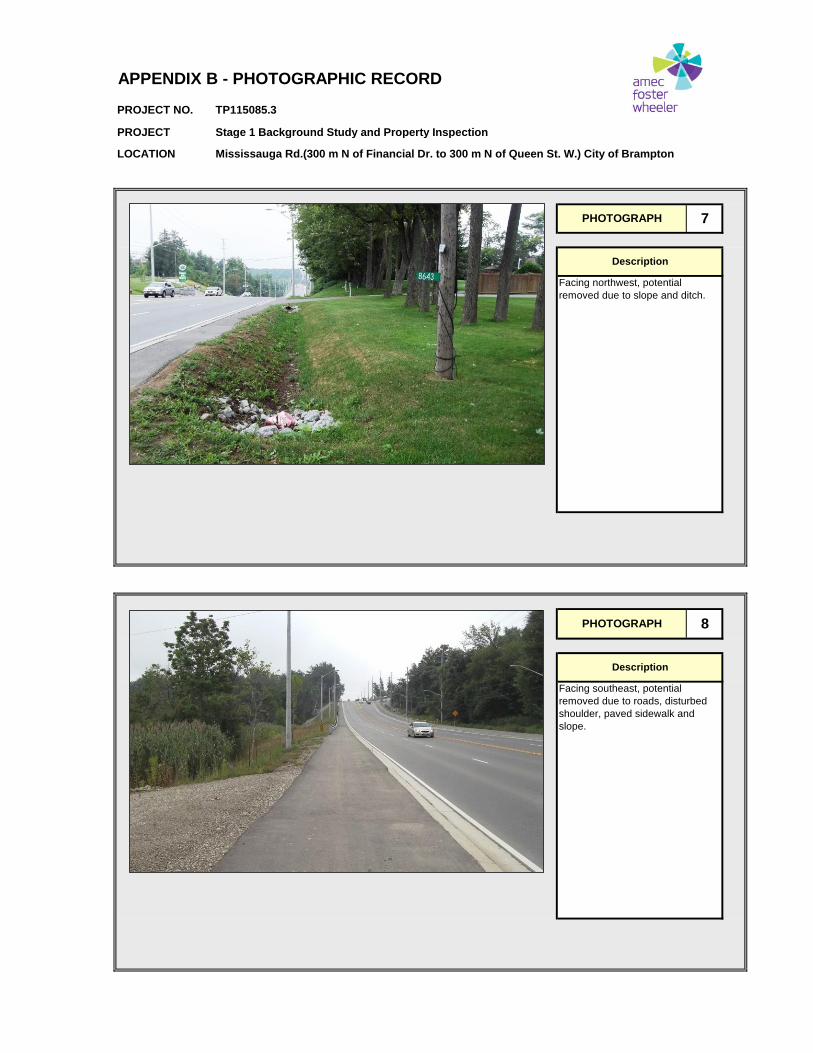
PHOTOGRAPH 8
Description
Facing southeast, potential
removed due to roads, disturbed
shoulder, paved sidewalk and
slope.
APPENDIX B - PHOTOGRAPHIC RECORD
PHOTOGRAPH 7
Description
Facing northwest, potential
removed due to slope and ditch.

PROJECT NO. TP115085.3
PROJECT Stage 1 Background Study and Property Inspection
LOCATION Mississauga Rd.(300 m N of Financial Dr. to 300 m N of Queen St. W.) City of Brampton
PHOTOGRAPH 10
Description
Facing southeast at area of
archaeological potential.
APPENDIX B - PHOTOGRAPHIC RECORD
PHOTOGRAPH 9
Description
Facing northwest, potential
removed due to slope and ditch.

PROJECT NO. TP115085.3
PROJECT Stage 1 Background Study and Property Inspection
LOCATION Mississauga Rd.(300 m N of Financial Dr. to 300 m N of Queen St. W.) City of Brampton
PHOTOGRAPH 12
Description
Facing southeast, potential
removed due to slope.
APPENDIX B - PHOTOGRAPHIC RECORD
PHOTOGRAPH 11
Description
Facing northwest, potential
removed due to slope.

PROJECT NO. TP115085.3
PROJECT Stage 1 Background Study and Property Inspection
LOCATION Mississauga Rd.(300 m N of Financial Dr. to 300 m N of Queen St. W.) City of Brampton
PHOTOGRAPH 14
Description
Facing east, potential removed due
to slope from bridge down to river.
APPENDIX B - PHOTOGRAPHIC RECORD
PHOTOGRAPH 13
Description
Facing northwest, potential
removed due to roads, paved
shoulder and slope.

PROJECT NO. TP115085.3
PROJECT Stage 1 Background Study and Property Inspection
LOCATION Mississauga Rd.(300 m N of Financial Dr. to 300 m N of Queen St. W.) City of Brampton
PHOTOGRAPH 16
Description
Facing northwest, potential
removed due to slope from bridge
down to river.
APPENDIX B - PHOTOGRAPHIC RECORD
PHOTOGRAPH 15
Description
Facing southeast, low potential due
to low and wet conditions.

PROJECT NO. TP115085.3
PROJECT Stage 1 Background Study and Property Inspection
LOCATION Mississauga Rd.(300 m N of Financial Dr. to 300 m N of Queen St. W.) City of Brampton
PHOTOGRAPH 18
Description
Facing south, potential removed
due to slope.
APPENDIX B - PHOTOGRAPHIC RECORD
PHOTOGRAPH 17
Description
Facing northwest, potential
removed due to slope.

PROJECT NO. TP115085.3
PROJECT Stage 1 Background Study and Property Inspection
LOCATION Mississauga Rd.(300 m N of Financial Dr. to 300 m N of Queen St. W.) City of Brampton
PHOTOGRAPH 20
Description
Facing north, potential removed
due to slope.
APPENDIX B - PHOTOGRAPHIC RECORD
PHOTOGRAPH 19
Description
Facing north, potential removed
due to slope.

PROJECT NO. TP115085.3
PROJECT Stage 1 Background Study and Property Inspection
LOCATION Mississauga Rd.(300 m N of Financial Dr. to 300 m N of Queen St. W.) City of Brampton
PHOTOGRAPH 22
Description
Facing north at area of
archaeological potential.
APPENDIX B - PHOTOGRAPHIC RECORD
PHOTOGRAPH 21
Description
Facing south at area of limited
archaeological potential.

PROJECT NO. TP115085.3
PROJECT Stage 1 Background Study and Property Inspection
LOCATION Mississauga Rd.(300 m N of Financial Dr. to 300 m N of Queen St. W.) City of Brampton
PHOTOGRAPH 24
Description
Facing southeast, potential
removed due to slope caused by
raised median.
APPENDIX B - PHOTOGRAPHIC RECORD
PHOTOGRAPH 23
Description
Facing northwest potential
removed due to roads, disturbed
shoulder and paved sidewalk.

PROJECT NO. TP115085.3
PROJECT Stage 1 Background Study and Property Inspection
LOCATION Mississauga Rd.(300 m N of Financial Dr. to 300 m N of Queen St. W.) City of Brampton
PHOTOGRAPH 26
Description
Facing northwest potential
removed due to slope caused by
raised median and bridge.
APPENDIX B - PHOTOGRAPHIC RECORD
PHOTOGRAPH 25
Description
Facing southeast, potential
removed due to slope caused by
raised median.

PROJECT NO. TP115085.3
PROJECT Stage 1 Background Study and Property Inspection
LOCATION Mississauga Rd.(300 m N of Financial Dr. to 300 m N of Queen St. W.) City of Brampton
PHOTOGRAPH 28
Description
Facing northwest; area of low
potential, slope from bridge down
to river. River bank is not within the
current assessment area.
APPENDIX B - PHOTOGRAPHIC RECORD
PHOTOGRAPH 27
Description
Facing southeast, potential
removed due to slope, ditch and
disturbed shoulder.

PROJECT NO. TP115085.3
PROJECT Stage 1 Background Study and Property Inspection
LOCATION Mississauga Rd.(300 m N of Financial Dr. to 300 m N of Queen St. W.) City of Brampton
PHOTOGRAPH 30
Description
Facing northwest, potential
removed due to slope, ditch and
paved shoulder.
APPENDIX B - PHOTOGRAPHIC RECORD
PHOTOGRAPH 29
Description
Facing southwest; area of low
potential, slope from bridge to river.
River bank is not within the current
assessment area.

PROJECT NO. TP115085.3
PROJECT Stage 1 Background Study and Property Inspection
LOCATION Mississauga Rd.(300 m N of Financial Dr. to 300 m N of Queen St. W.) City of Brampton
PHOTOGRAPH 32
Description
Facing southeast, potential
removed due to roads, paved
shoulder and sidewalk.
APPENDIX B - PHOTOGRAPHIC RECORD
PHOTOGRAPH 31
Description
Facing northwest at area of
archaeological potential minus the
compacted gravel driveway.

PROJECT NO. TP115085.3
PROJECT Stage 1 Background Study and Property Inspection
LOCATION Mississauga Rd.(300 m N of Financial Dr. to 300 m N of Queen St. W.) City of Brampton
PHOTOGRAPH 34
Description
Facing southeast, potential
removed due to slope and ditch.
APPENDIX B - PHOTOGRAPHIC RECORD
PHOTOGRAPH 33
Description
Facing northwest, potential
removed due to slope and ditch.

PROJECT NO. TP115085.3
PROJECT Stage 1 Background Study and Property Inspection
LOCATION Mississauga Rd.(300 m N of Financial Dr. to 300 m N of Queen St. W.) City of Brampton
PHOTOGRAPH 36
Description
Facing northwest, potential
removed due to roads, paved
shoulder and sidewalk.
APPENDIX B - PHOTOGRAPHIC RECORD
PHOTOGRAPH 35
Description
Facing southeast, potential
removed due to slope and ditch.

PROJECT NO. TP115085.3
PROJECT Stage 1 Background Study and Property Inspection
LOCATION Mississauga Rd.(300 m N of Financial Dr. to 300 m N of Queen St. W.) City of Brampton
PHOTOGRAPH 38
Description
Facing northwest at area of
archaeological potential.
APPENDIX B - PHOTOGRAPHIC RECORD
PHOTOGRAPH 37
Description
Facing southeast, potential
removed due to roads, paved
shoulder and sidewalk.

PROJECT NO. TP115085.3
PROJECT Stage 1 Background Study and Property Inspection
LOCATION Mississauga Rd.(300 m N of Financial Dr. to 300 m N of Queen St. W.) City of Brampton
PHOTOGRAPH 40
Description
Facing northwest, potential
removed due to roads, paved
shoulder, compacted gravel and
previous soil disturbance.
APPENDIX B - PHOTOGRAPHIC RECORD
PHOTOGRAPH 39
Description
Facing southeast, potential
removed due to roads, paved
shoulder, compacted gravel and
previous soil disturbance.

PROJECT NO. TP115085.3
PROJECT Stage 1 Background Study and Property Inspection
LOCATION Mississauga Rd.(300 m N of Financial Dr. to 300 m N of Queen St. W.) City of Brampton
PHOTOGRAPH 42
Description
Facing northwest at area of
archaeological potential minus the
paved shoulder.
APPENDIX B - PHOTOGRAPHIC RECORD
PHOTOGRAPH 41
Description
Facing southeast at area of
archaeological potential minus the
paved driveway.

PROJECT NO. TP115085.3
PROJECT Stage 1 Background Study and Property Inspection
LOCATION Mississauga Rd.(300 m N of Financial Dr. to 300 m N of Queen St. W.) City of Brampton
PHOTOGRAPH 44
Description
Facing west at area of recent land
development, potential removed.
APPENDIX B - PHOTOGRAPHIC RECORD
PHOTOGRAPH 43
Description
Facing southeast, potential
removed due to roads, paved
shoulder and ditch.

PROJECT NO. TP115085.3
PROJECT Stage 1 Background Study and Property Inspection
LOCATION Mississauga Rd.(300 m N of Financial Dr. to 300 m N of Queen St. W.) City of Brampton
PHOTOGRAPH 46
Description
Facing northwest, potential
removed due paved shoulder,
sidewalk and utility locates.
APPENDIX B - PHOTOGRAPHIC RECORD
PHOTOGRAPH 45
Description
Facing northwest at area of recent
land development, potential
removed.

Stage 1 Background Study and Property Inspection Proposed Widening of Mississauga Road from 300 m North of Financial Dr. to 300 m North of Queen St. W. City of Brampton, Regional Municipality of Peel, Ontario
Project Number TP115085.3 Appendix C
APPENDIX C
ASSESSOR QUALIFICATIONS

Stage 1 Background Study and Property Inspection Proposed Widening of Mississauga Road from 300 m North of Financial Dr. to 300 m North of Queen St. W. City of Brampton, Regional Municipality of Peel, Ontario
Project Number TP115085.3 Appendix C
ASSESSOR QUALIFICATIONS
Shaun Austin, Ph.D., Associate Archaeologist – Dr. Austin is the leader of Amec Foster
Wheeler’s cultural heritage resources group and is based in ‘the Company’s’ Hamilton
Office. He has been working in Canadian archaeology and heritage since 1976 and as an
archaeological and heritage consultant in Ontario since 1987. He is a dedicated cultural
heritage consultant with repeated success guiding projects through to completion to the
satisfaction of the development proponent, the cultural heritage community and all other
stakeholder groups. His areas of interest and expertise include pre-contact Aboriginal
lithics and ceramics. Dr. Austin holds a Professional Archaeology License (P141)
issued by the Ontario Ministry of Tourism, Culture and Sport, is MTO RAQs certified in
Archaeology/Heritage and is a member of the Ontario Association of Professional
Archaeologists.
Jason Seguin, M.A., Senior Archaeologist – Mr. Seguin has been engaged in
archaeology since 2004. Mr. Seguin has conducted stage 1 to 4 archaeological
assessments including background searches, field surveys, and excavations, analysis of
cultural artifacts, laboratory work and reporting. Mr. Seguin is involved in project
management and supervision as well as being an archaeological laboratory director. Mr.
Seguin’s education and work experience have provided him with an extensive knowledge
base, consisting of theoretical and practical experience in cultural resource management
in Canada and Central America, as well as curatorial, archival and museum management
experience. Mr. Seguin holds a Master’s Degree in Anthropology from Trent University,
and a Post-Graduate Certificate in Museum Management and Curatorship from Sir
Sandford Fleming College. Mr. Seguin holds a Professional Archaeology License
(License P354) issued by the Ontario Ministry of Tourism and Culture.
Cara Howell B.A., Staff Archaeologist – Ms. Howell has been working in consulting
archaeology since 1999. During this time she has acquired a full range of archaeological
skills, from background research to Stage 4 excavation. She has developed a
comprehensive understanding of all aspects of material culture and has a specialized
interest in historic Euro-Canadian artifacts. As Laboratory Director for Amec Foster
Wheeler’s Archaeology Group, she was instrumental in creating and implementing
cataloguing systems for all types of recovered artifacts. Mr. Howell also serves as lead
liaison with First Nations communities. She holds a B.A. in Physical Anthropology and a
B.A. in Classical Archaeology from McMaster University, and an Applied Research
License (R180) issued by the Ontario Ministry of Tourism, Culture and Sport.

Stage 1 Background Study and Property Inspection Proposed Widening of Mississauga Road from 300 m North of Financial Dr. to 300 m North of Queen St. W. City of Brampton, Regional Municipality of Peel, Ontario
Project Number TP115085.3 Appendix D
APPENDIX D
LIMITATIONS

Stage 1 Background Study and Property Inspection Proposed Widening of Mississauga Road from 300 m North of Financial Dr. to 300 m North of Queen St. W. City of Brampton, Regional Municipality of Peel, Ontario.
Project Number TP115085.3 Appendix D
LIMITATIONS 1. The work performed in the preparation of this report and the conclusions presented are
subject to the following:
(a) The Standard Terms and Conditions which form a part of our Professional Services Contract;
(b) The Scope of Services;
(c) Time and Budgetary limitations as described in our Contract; and,
(d) The Limitations stated herein.
2. No other warranties or representations, either expressed or implied, are made as to the professional services provided under the terms of our Contract, or the conclusions presented.
3. The conclusions presented in this report were based, in part, on visual observations of the Study Area. Our conclusions cannot and are not extended to include those portions of the Study Area which were not reasonably available, in Amec Foster Wheeler’s opinion, for direct observation.
4. The potential for archaeological resources, and any actual archaeological resources encountered, at the Study Area were assessed, within the limitations set out above, having due regard for applicable heritage regulations as of the date of the inspection.
5. Services including a background study and property inspection were performed. Amec Foster Wheeler’s work, including archival research and property inspection were conducted in a professional manner and in accordance with the Ministry of Tourism and Culture’s guidelines. It is possible that unforeseen and undiscovered archaeological resources may be present at the Study Area.
6. The utilization of Amec Foster Wheeler’s services during the implementation of any further archaeological work recommended will allow Amec Foster Wheeler to observe compliance with the conclusions and recommendations contained in the report. Amec Foster Wheeler’s involvement will also allow for changes to be made as necessary to suit field conditions as they are encountered.
7. This report is for the sole use of the parties to whom it is addressed unless expressly stated otherwise in the report or contract. Any use which any third party makes of the report, in whole or in part, or any reliance thereon, or decisions made based on any information of conclusions in the report, is the sole responsibility of such third party. Amec Foster Wheeler accepts no responsibility whatsoever for damages or loss of any nature or kind suffered by any such third party as a result of actions taken or not taken or decisions made in reliance on the report or anything set out therein.
8. This report is not to be given over to any third-party other than a governmental entity, for any purpose whatsoever without the written permission of Amec Foster Wheeler, which shall not be unreasonably withheld.