orographic storms in the southern europe heavy precipitating storms resulting from proximity to...
TRANSCRIPT

Orographic Storms in the Southern Europe
Heavy precipitating storms resulting from proximity to Mediterranean Sea
Fall season particularly dangerous because of warm water
Many ranges of mountains act to channel low-level flow into jets that focus lifting and lead to sustained precipitation that can result in flooding
Two types of storms: Simple orographic storms Convective orographic storms

Flash Floods in Europe
Fall season when first cold troughs move in and: Mediterranean is still warm Sahara is still hot and boundary layer is deep Sawyer-Elliasen Circulation strong
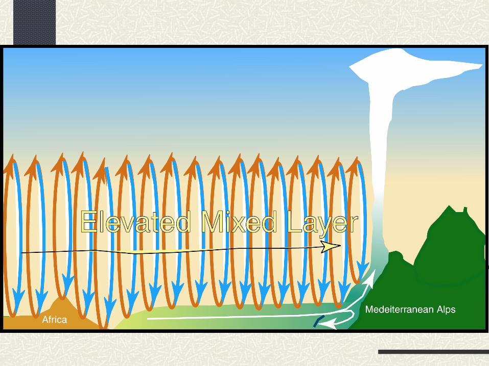
Elevated Mixed Layer off Sahara
Channeling by topography


Ingredients for Southern Europe Flash Flood
Approaching long wave trough from west produces strong southerly flow surge
Deep desert boundary layer drawn from Sahara northward over the Mediterranean marine boundary layer forming strong cap
Air-sea interaction increasing moisture and theta_e below the cap
Channeling by topography to focus flow into a jet against the continent
Mountains breaking inversion to “pull the trigger”
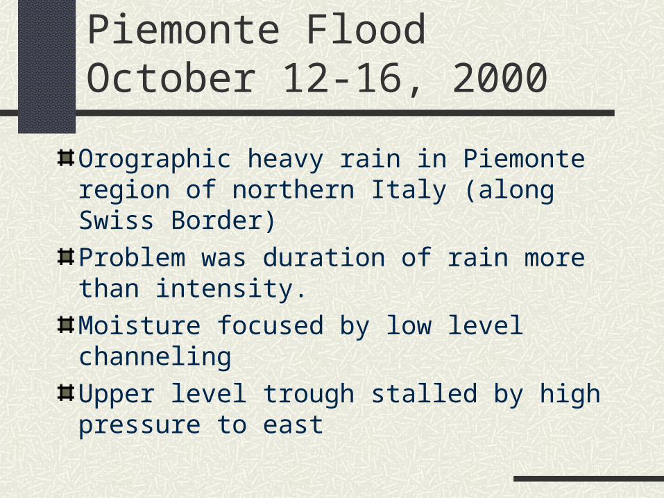
Piemonte FloodOctober 12-16, 2000
Orographic heavy rain in Piemonte region of northern Italy (along Swiss Border)
Problem was duration of rain more than intensity.
Moisture focused by low level channeling
Upper level trough stalled by high pressure to east
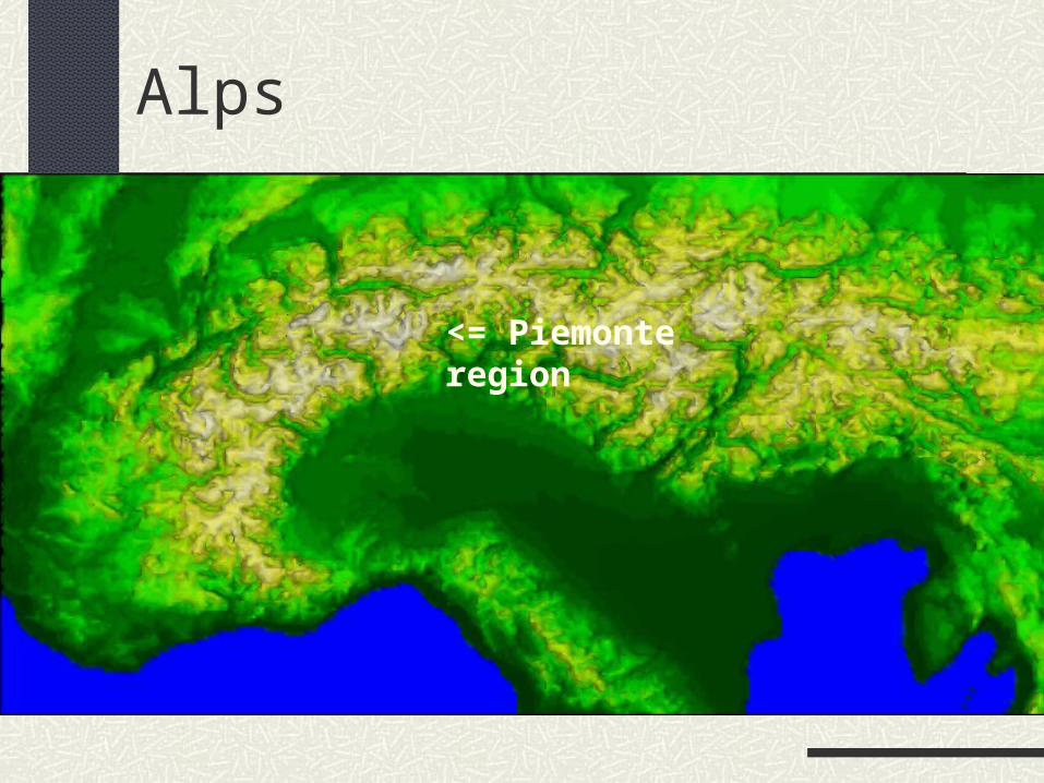
Alps
<= Piemonte region
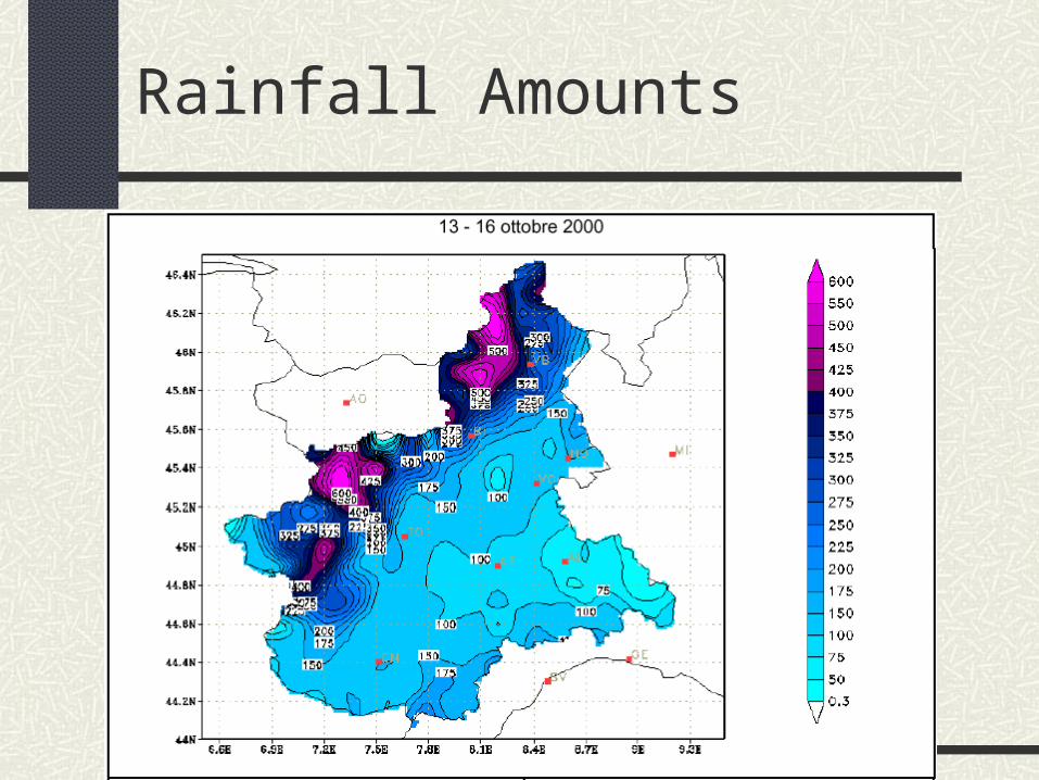
Rainfall Amounts


Convective Orographic Storms
Conditionally unstable flow approaching a barrier leads to the formation of deep convection along slopes of mountains
Orographic lifting itself can destabilize the flow
Mountains may act as a trigger to release instability built up elsewhere

Flash Flooding
Convective orographic rains are especially likely to lead to flash flooding Topography focuses runoff Topography can break a strong cap Topography focuses convective release Topography increases conditional instability
Flash Flooding
When large amounts of rain fall in a short time
Most likely when Cap is strong, focusing convection along slopes Moisture is high leading to high energy release
through latent heating and also high rainfall Air is warm, and can hold a lot of moisture
Flash Flooding in the Rockies
Normally, there is not enough moisture In the west, the ocean is relatively cool in the summer
and so the on shore flow is not conditionally unstable In the east, Gulf moisture rarely reaches the severe
topography from the east When it does, storms typically move away from their genesis
region because of the upper level Westerlies
Normally, the upper level flow moves from the west, moving storms in the east off the slopes

Two major Flash Floods: Both are listed as “Storms of the Century”
The 1972 Rapid City South Dakota Flood
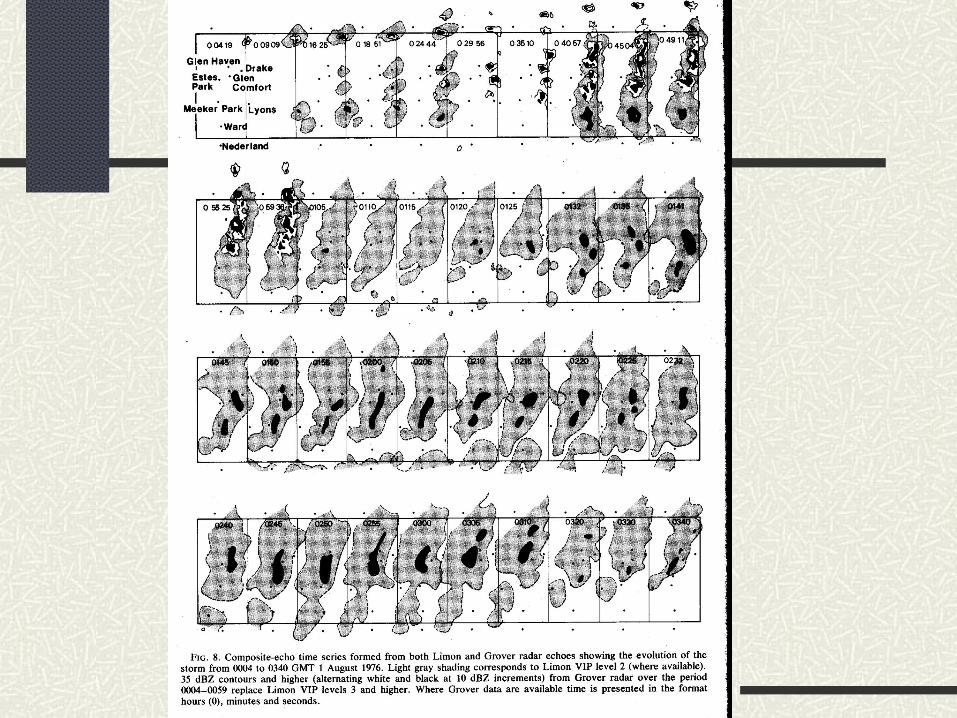
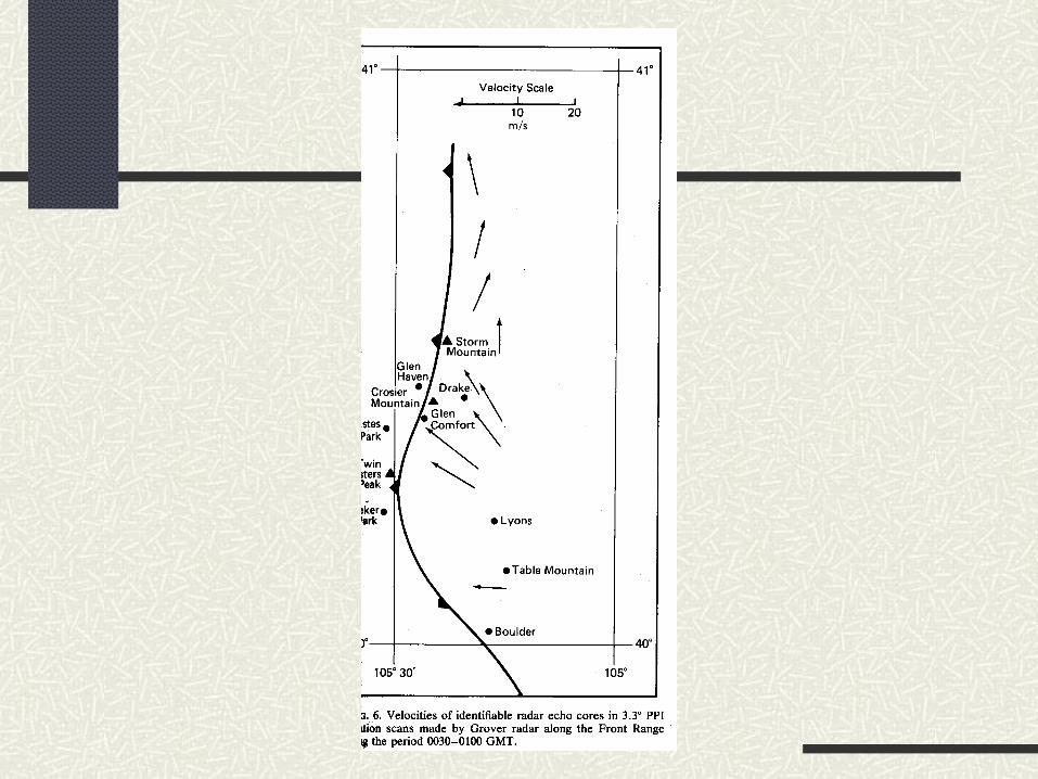
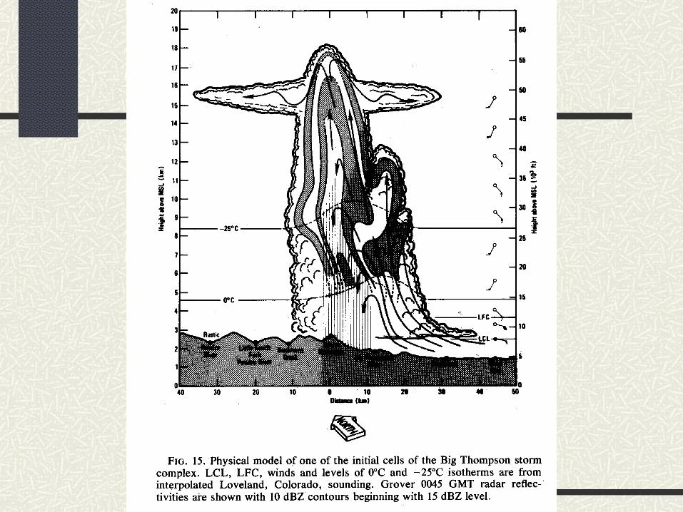
The 1976 Big Thompson Canyon, Colorado Flash Flood


Big Thompson Situation

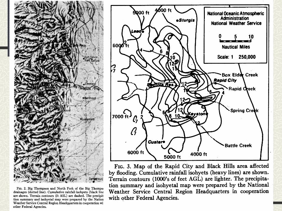

Rapid City Situation

Common Large-Scale Features to Big Thompson and Rapid City
Negatively tilted ridge just east of threat area, producing low inertial stability and low winds at storm outflow level
A weak 500 mb short-wave trough rotates northward in long wave trough as it approaches threat area, I.e. PVA
Light southeast to south-southeast (5-20 kt) winds in upper troposphere over threat area
Slow moving stationary polar front just to south of threat area
High moisture content present through large depth of troposphere

Common Mesoscale Features to Big Thompson and Rapid City
Afternoon heating to west of threat area and cold air advection to east combine to increase thickness and pressure gradients
Narrow band of conditionally unstable and unusually moist air moves westward behind polar front
Orographic lift provides mechanism to break cap and release instability
Cells drift slowly north-northwestward and new cells regenerated on southern flank where cold front intersects mountains resulting in quasi-stationary system

Summary of Orographic Flash floods
Occur when orography acts to break a strong inversion and resulting storms remain focused along the slopes
Ingredients include: High conditional instability of air approaching mountains Strong cap so that convection does not “jump the gun” and
go off before the flow reaches the mountains Upper level winds that will not allow convection to move
back toward moisture and instability source region Focusing of the flow along a particular mountain site:
Topography channeling Local fronts