overview of logging in clayoquot sound: 2000...
TRANSCRIPT
OVERVIEW OF LOGGING IN CLAYOQUOT SOUND: 2000-2009
for Terrestrial Committee, Clayoquot Biosphere Trust
by Maryjka Mychajlowycz, Friends of Clayoquot Sound
November 2009 (an April 2010 update inserted)
The views expressed in this report are those of the author and do not necessarily reflect the position or policy of the Clayoquot Biosphere Trust, its Directors or its staff.

Overview of Logging in Clayoquot Sound: 2000 to 2009
Table of Contents
Executive Summary ………………………………………………………………………………. 3 About this Report …………………………………………………………………………………. 3 Acknowledgements ……………………………………………………………………………….. 4 Clayoquot Sound Introduction ………………………………………………………………………………... ….. 4 Forested Landbase ……………………………………………………………………………... 4 Landbase in Logging Tenures ……………………………………………………………... ….. 5 Volumes of Wood Logged 1988-2008 …………………………………………………….. ….. 5 Vancouver Island Context ……………………………………………………………………... 6 Clayoquot Sound Intact Watersheds …………………………………………………………... 6 Historical/Political Background Clayoquot Land Use Decision 1993 …………………………………………………………... 7 Clayoquot Sound Scientific Panel 1995 …………………………………………………....….. 7 Scientific Panel Watershed Reserves …………………………………………………………... 8 Clayoquot Sound UNESCO Biosphere Reserve 2000 ………………………………………… 10 Logging Operators in Clayoquot Sound Iisaak Forest Resources …………………………...…………………………………………… 10 Ma-Mook Natural Resources/Coulson Forest Products ………………………………….. …… 14 International Forest Products (Interfor) …………………………………………………........... 17 Island Timberlands ………………………………………………………………………. …….. 18 BC Timber Sales ……………………………………………………………………………….. 19 Ahousaht Woodlot ……………………………………………………………………………... 21 Other Factors Influencing Forestry in Clayoquot Sound Meares Island Court Injunction ………………………………………………………………… 22 Forest and Range Agreements with First Nations ……………………………………………… 22 Ha’uukmin (Kennedy) Tribal Park …………………………………………………………….. 23 Selected Bibliography …………………………………………………………………………….. 24 Appendix 1: Tables 1. Iisaak Cutblock Tracking 2000-2008 …………………………………………………………... 3 pages 2. Ma-Mook Coulson Cutblocks Logged/to be Logged 2007-2010 ……………………………... 3 pages Appendix 2: Photos Iisaak Cutblocks…………………………………………………………………………………… 2 pages Ma-Mook Coulson Cutblocks ……………………………………………………………………. 2 pages Interfor/BC Timber Sales Cutblock ……………………………………………………………… 1 page Appendix 3: Maps 1. Clayoquot Sound Forest Cover 2004 2. Clayoquot Sound Land Tenures 3. Vancouver Island Forest Cover 1860 4. Vancouver Island Forest Cover 2004 5. Pristine (Intact) Watersheds in Clayoquot Sound 6. Clayoquot Sound Scientific Panel Watershed Reserves and Harvestable Areas 7. Clayoquot Sound Biosphere Reserve: Core, Buffer and Transition Zones 8. Iisaak Harvest History 2000-2008 9. Ma-Mook Coulson Operations: Hesquiat Area (Northern Clayoquot) 2007-2009 10. Ma-Mook Coulson Operations: Southern Clayoquot 2007-2009
2
Executive Summary Clayoquot Sound is an area of land and ocean on the west coast of central Vancouver Island, British Columbia, Canada. It encompasses 272,000 hectares of terrestrial area (263,000 land / 9,000 lakes), and 78,000 hectares of Pacific Ocean. Globally rare temperate rainforest covers 90% (244,000 hectares) of Clayoquot’s terrestrial area and includes 181,000 hectares of old growth forest. Currently 173,800 hectares of terrestrial area are in various logging tenures. Over the last 21 years (1988-2008) approximately 6,260,000 cubic metres of wood were logged in Clayoquot Sound, virtually all old growth. Overall, Vancouver Island has lost ¾ of its productive old growth forest to clearcut logging. Although Clayoquot comprises only 8% of Vancouver Island, it contains the largest area of old growth forest on the island and the island’s only cluster of intact (pristine) valleys, undisturbed by logging or other development. Currently, 60% of Clayoquot’s terrestrial base is off limits to logging: 91,400 hectares in parks, and 67,800 hectares in Scientific Panel watershed reserves within logging tenures. The report gives historical context and describes the logging activities, future plans and economic profile of Clayoquot Sound’s current logging operators: Iisaak Forest Resources, Ma-Mook Natural Resources/Coulson Forest Products, International Forest Products (Interfor), Island Timberlands, BC Timber Sales and Ahousaht First Nation woodlot. The most contentious issue coming up is logging of Clayoquot Sound’s remaining intact valleys, as companies have run out of forest to cut in the developed (partly logged) areas of Clayoquot Sound. About This Report The purpose of this report is to provide a one-stop overview of logging in Clayoquot Sound for the residents of the Clayoquot Sound Biosphere Reserve region as well as for the wider public, since no such document currently exists. The report focuses on the period from 2000 when Clayoquot Sound became a UNESCO Biosphere Reserve, and also gives background context. The forestry situation in Clayoquot has become more complex than in the well-publicized 1990s when MacMillan Bloedel and Interfor were the two logging companies operating here. At the same time, concise understandable information is not readily available, as it is dispersed among BC government agencies and logging companies, often in technical format, and not all of it is public. As well, since 2006 publicly advertised 5-year logging plans no longer show proposed cutblocks and roads, depriving locals and the public of this previously available information about logging companies’ current and future operations. This report is based mostly on original research and brings together information from various sources: -Friends of Clayoquot Sound Forest Watch files, 1994 to present -BC Ministry of Forests and Range (hereafter referred to just as Ministry of Forests) -Clayoquot Sound Technical Planning Committee, Integrated Land Management Bureau, BC Ministry of Forests -the logging operators in Clayoquot Sound: Iisaak, Ma-Mook Coulson, Interfor, Island Timberlands, BC Timber Sales -Sierra Club of BC, Western Canada Wilderness Committee, Ecotrust Canada The author can be contacted at Friends of Clayoquot Sound, maryjka at focs.ca.
3
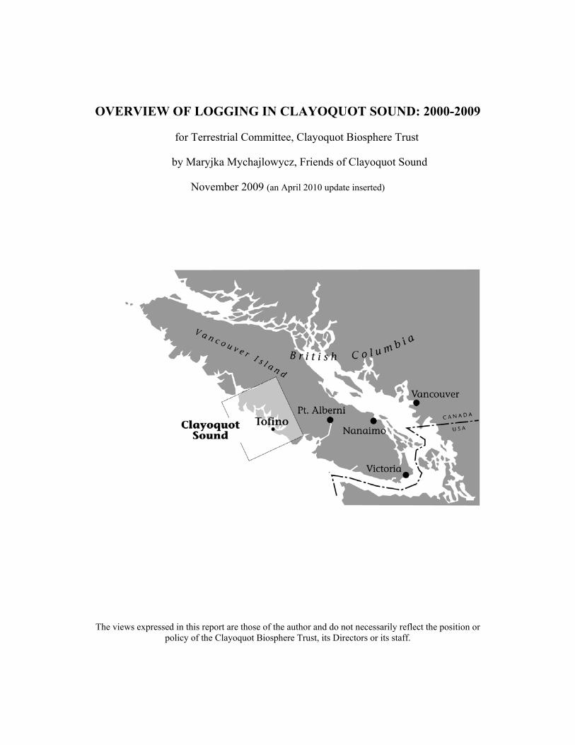
Acknowledgements Thanks to the government and logging company employees who provided verbal and written information specifically for this report: Laurie McCulligh, Hal MacLean and Emma Neill, BC Ministry of Forests; Brian Retzer, Clayoquot Sound Technical Planning Committee; Derek Drake, Iisaak Forest Resources; Ken Matthews, Ma-Mook Coulson; Bill Rosenburg, Interfor; Bill Waugh, Island Timberlands; Brenda Kuecks, Satnam Manhas, Eric Tamm and Mike Vitt, Ecotrust; also to Saya Masso, Tla-o-qui-aht First Nation. Thanks to the Terrestrial Committee of the Clayoquot Biosphere Trust for partially funding this report. CLAYOQUOT SOUND Introduction Clayoquot Sound is an area of land and ocean on the west coast of central Vancouver Island, British Columbia, Canada (see map on front cover). It consists of 272,000 hectares of terrestrial area (2,720 sq. km. / 1,050 sq. miles), of which 263,000 hectares are land and 9,000 hectares are lakes. Clayoquot Sound also encompasses 78,000 hectares of Pacific Ocean, for a total of 350,000 hectares of terrestrial and ocean area. (For reference, one hectare is 2.5 acres.) Clayoquot Sound’s landbase is covered with temperate rainforest, one of the world’s rarest forest types that occurs on only a fraction of 1% of the earth’s land surface. Just over half of the world’s original temperate rainforest has been logged, which, combined with its natural rarity, makes it one of the most endangered forest types globally. Of BC’s temperate rainforest, just over half has been cut. BC, Alaska and Chile contain most of the world’s remaining temperate rainforest. Clayoquot Sound is part of North America’s coastal temperate rainforest belt that stretches from northern California to southern Alaska. Clayoquot’s coniferous (softwood) forest is composed mostly of western hemlock and western redcedar, with admixtures of amabilis fir (also known as balsam, silver or Pacific fir) and Sitka spruce, as well as Douglas fir, yellow cedar and mountain hemlock at higher elevations. The temperate rainforest ecosystem of Clayoquot Sound has been evolving for more than 10,000 years, since retreat of the last glaciers. Individual trees in the old growth forest range from seedlings to 1,500-2,000 year old veterans. A typical giant red or yellow cedar is over 1,000 years old, while giant Sitka spruce and hemlocks are typically over 500 years old. Productive old growth temperate rainforest is the richest forest on earth in terms of biomass and timber volume. In Clayoquot Sound, average timber volume is 600-750 cubic metres per hectare, and the most productive sites can attain a timber volume of almost 2,000 cubic metres per hectare. Forested Landbase: 244,000 hectares, including 181,000 hectares of old growth About 90% (244,000 hectares) of Clayoquot Sound’s terrestrial base is forested (see Map 1: Clayoquot Sound Forest Cover 2004). The remaining 10% is made up of lakes, rivers and alpine rock and ice. Approximately three quarters (181,000 hectares) of the forested landbase is covered in old growth forest (defined as leading tree species over 140 years old, with crown closure greater than 30%).
4
The remaining quarter (or about 63,000 hectares) of the forested landbase consists of unproductive original forest (boggy, rocky knolls, sub-alpine), and logged areas that have been replanted or have naturally regenerated into second growth forest. From 1950 to 1993, approximately 27,000 hectares were logged (source: Clayoquot Land Use Decision, 1993), accounting for the majority of the logged area in Clayoquot Sound. According to the Sierra Club of BC, about 22% of Clayoquot’s productive old growth forest was logged as of 1993. The source for the above figures (except for the logged area) is the BC government’s Clayoquot Sound Technical Planning Committee, which analyzed the data produced in the late 1990s by the Clayoquot Sound Scientific Panel inventories. Landbase in Logging Tenures: approx. 173,800 hectares About 173,800 hectares (including lakes and rivers) of Clayoquot Sound’s terrestrial base are in various logging tenures (see list below and Map 2: Clayoquot Sound Land Tenures). Logging Tenure Areas in Hectares: 87, 393 Iisaak Tree Farm License (TFL) 57 3,807 Iisaak Timber Licenses (6 TLs outside TFL) 45,600 Ma-Mook TFL 54 (= the 92.5% in Clayoquot, out of total 49,298 in TFL) 24,368 Arrowsmith Timber Supply Area (TSA) (includes approx. 4,000 hectares in Interfor’s Forest License A19235; rest apportioned to BC Timber Sales) 11,000 approx. Western Forest Products TFL 44 (now apportioned to BC Timber Sales) 1,350 approx. Island Timberlands private forest land 267 Ahousaht Woodlot 0019 173,785 hectares TOTAL Volumes of Wood Cut in Clayoquot Sound 1988-2008 (in cubic metres) The volumes of wood logged in Clayoquot Sound over the last 20 years are shown below (source: BC Ministry of Forests, Tenures Branch, harvest billing records and cut control letters). Almost 100% of the cut was in old growth forest because the second growth in previously logged areas is still too young to harvest. (The oldest second growth is in Kennedy Lake Flats at 60 years old, while second growth elsewhere is mostly 20 to 40 years old.) (1 cubic metre = 1 telephone pole) 1988 959,000 (29,000 truck loads, at 33 cubic metres per truck) 1989 958,000 1990 763,000 1991 777,000 1992 467,000 1993 456,000 1994 406,000 1995 323,000 1996 106,000 (under Scientific Panel guidelines, from 1996 onwards) 1997 84,000 1998 17,000 1999 32,000 2000 25,000 2001 81,000 2002 145,000 2003 70,000 estimated
5
2004 153,000 estimated 2005 94,000 2006 66,000 2007 120,000 2008 158,000 (4,800 truck loads) 6,260,000 cubic metres TOTAL 1988-2008 For most of the last 20 years, the volumes logged have fallen short of the Allowable Annual Cut (AAC) set by BC Ministry of Forests for Clayoquot Sound. Despite its name, the Allowable Annual Cut is a required or target cut, not a maximum allowed cut. The AAC in 1988 was 900,000 cubic metres of wood, reduced to 600,000 by the 1993 Clayoquot Land Use Decision, then reduced again to 240,000 by 2000 to reflect implementation of the Clayoquot Sound Scientific Panel’s logging recommendations. In late 2008, the AAC for Ma-Mook Coulson’s Tree Farm License was increased, bringing the current Allowable Annual Cut in Clayoquot to roughly 290,000 cubic metres per year. (The AACs for Iisaak’s and Ma-Mook’s Tree Farm Licenses are now expressed on a trial basis as gross area to be cut, but the result is still volume of trees cut.) Vancouver Island Context Clayoquot Sound’s terrestrial area of 272,000 hectares comprises 8% of Vancouver Island’s 3,175,000 hectares. Although Clayoquot Sound occupies only a small fraction of Vancouver Island, it contains the largest area of ancient or old growth forest left on the Island, because Vancouver Island has lost three quarters of its productive original forest to clearcut logging. (See Maps 3 and 4: Vancouver Island 1860 and 2004.) Landsat satellite photos from 2004, as analyzed by Sierra Club of BC and Western Canada Wilderness Committee, with figures updated to 2008, show the following about Vancouver Island: • overall, 75% of the island’s original productive old growth forests have been logged • 90% of the productive old growth forests on low flat terrain (less than 300 metres above sea level, with slopes less than 17%), such as valley bottoms where the largest trees typically grow, have been logged • 89% of the productive old growth forests on the south island (south of Barkley Sound/Horne Lake) have been logged. (Source: Western Canada Wilderness Committee. Spring 2007. Vancouver Island: Protecting Paradise. Educational Report, vol. 26, no. 1.) 13% of Vancouver Island’s area is protected in parks, but only 6% of its productive forest is protected, because two thirds of the land in parks consists of alpine rock, ice and tundra, and unproductive forest (bogs, scrub forest and sub-alpine snow forest). Clayoquot Sound Intact Watersheds Clayoquot Sound encompasses the largest area of old growth forest remaining on Vancouver Island. It contains the island’s only cluster of intact or pristine valleys, completely undisturbed or less than 2% disturbed by logging, roads or other development (see Map 5: Pristine (Intact) Watersheds in Clayoquot Sound). These intact wilderness valleys form the unfragmented core of
6
Clayoquot Sound’s and Vancouver Island’s ancient forest. The rest of Clayoquot’s old growth forest exists in a fragmented state, interspersed with clearcuts and logging roads. Of Clayoquot Sound’s intact watersheds, only 3 are fully protected in parks: Megin, Moyeha and Watta in Strathcona Provincial Park. Other intact areas are partially protected in provincial parks: a third of Clayoquot River Valley, a quarter of Flores Island, and about half of Vargas Island. Intact Meares Island is still under a 1985 court injunction prohibiting logging and other development. The dark green on Map 5 shows the intact (pristine) areas of Clayoquot Sound that are not protected in parks and are in logging tenures, subject to Scientific Panel watershed reserves and logging practices. HISTORICAL/POLITICAL BACKGROUND Clayoquot Land Use Decision Before 1993, 15% of Clayoquot Sound’s landbase was protected in parks – mostly in Strathcona Provincial Park and Pacific Rim National Park. Almost all the rest of the landbase (81%) was provincial crown land allocated for logging as part of the Arrowsmith Timber Supply Area. In April 1993 the BC government, trying to resolve the controversy over logging of ancient forest in Clayoquot Sound, made the Clayoquot Land Use Decision, which increased park protection to 33% (87,600 hectares) of Clayoquot’s landbase. (Including lakes, the area in parks is 91,400 hectares.) The intact Megin and Watta Valleys were added to Strathcona Park and 13 new small provincial parks were created. 62% of the landbase remained allocated to logging, and 4% was not included in the decision: District of Tofino, First Nations Reserves, and Meares Island (under court injunction prohibiting logging). The 1993 Land Use Decision reduced the required timber harvest (Allowable Annual Cut) in Clayoquot Sound from 900,000 cubic metres of wood to 600,000 per year. This land use decision remains in force, and has had the Clayoquot Sound Scientific Panel logging recommendations, legislated in 2008, layered on top of it. Clayoquot Sound Scientific Panel The BC government’s 1993 Clayoquot Land Use Decision did not achieve its aim of satisfactorily balancing forest protection versus logging. Instead, the decision triggered the largest peaceful civil disobedience in Canadian history – 12,000 citizens attended a logging road blockade in Clayoquot Sound in the summer of 1993 and 870 were arrested. In late 1993, in a further attempt to resolve the controversy, the BC government appointed a “Scientific Panel for Sustainable Forest Practices in Clayoquot Sound” to answer the question “how to log Clayoquot Sound sustainably” within the parameters of the Clayoquot Sound Land Use Decision. The Scientific Panel’s mandate did not extend to considering Clayoquot Sound in the context of Vancouver Island. Therein lies the Panel’s fundamental flaw – it was not allowed to scientifically analyze the conservation needs of Vancouver Island. Principles of conservation biology and the precautionary principle indicate that all of Clayoquot's intact forest needs protection because
7
intact forests are extremely scarce on Vancouver Island, where three-quarters of the productive ancient forest has been clearcut logged, with Clayoquot Sound containing the largest intact forest left on the island. In 1995, the Panel came up with about 125 recommendations, which the BC government accepted in July of 1995, after which the Panel disbanded. The following is a summary of the main recommendations of the Scientific Panel: • Use an "ecosystem-based" approach to logging in Clayoquot Sound, meaning design logging so that it does not damage ecosystem health. • In each watershed (valley) establish "reserves" that are off-limits to logging in order to preserve ecosystem integrity and social values. Then plan logging in the areas outside of reserves. • Restrict the rate of logging in each valley to an average of 1% of the valley area per year. • In each watershed planning unit, retain at least 40% of the old growth forest. (Clayoquot Sound was divided into 15 planning units, each composed of one large watershed or several smaller adjacent watersheds.) • At the site level, retain at least 15% of the trees standing in each cutblock (opening) that is logged. (Source: Scientific Panel for Sustainable Forest Practices in Clayoquot Sound. 1995. Sustainable Ecosystem Management in Clayoquot Sound: Planning and Practices. Report 5.) By 2000, BC’s Ministry of Forests had reduced the required timber harvest (Allowable Annual Cut) in Clayoquot Sound from 600,000 to 240,000 cubic metres per year to reflect the impact of the Panel’s recommendations. From 1996 to 2006, a Clayoquot Sound Technical Planning Committee, composed mainly of government staff, commissioned ecological and cultural inventories and mapping of the area and produced a plan for each watershed planning unit. In addition to parks, the watershed plans show what areas within logging tenures are to be reserved from logging. The areas not in parks or watershed reserves are harvestable areas open for logging. Portions of the harvestable areas are in “special management zones” because of First Nations cultural values or scenic values, where logging is supposed to be designed so it does not compromise these values. (See Map 6: Clayoquot Sound Watershed Reserves and Harvestable Areas.) By 2006, watershed plans were completed, which opened the door for companies to propose logging in Clayoquot Sound’s intact valleys, since the plans designate part of every intact valley for harvesting. Since 1995, the large intact valleys had been under a logging deferral, pending completion of watershed plans, while logging under Scientific Panel guidelines continued in the developed (partly logged) watersheds. Scientific Panel Watershed Reserves and Harvestable Areas: 145,500 hectares (61%) of forested landbase off-limits to logging; 90,000 hectares (39%) of forested landbase open for logging (not including Meares Island) Once the Scientific Panel’s 67,800 hectares of no-logging watershed reserves are added to the 91,400 hectares in Clayoquot’s national and provincial parks, 60% (159,200 hectares) of Clayoquot Sound’s terrestrial base is off-limits to logging. This translates to 61% (145,500 hectares) of forested landbase and 62% (107,000 hectares) of old growth forest being off-limits to logging. These figures do not include 8,300 hectare Meares Island, which is under court
8
injunction prohibiting logging, and was not included in the calculations. (Source: Clayoquot Sound Technical Planning Committee, Progress Report, July 2006.) Critique of Science Panel Watershed Reserves: At first glance, 61% of forest reserved from logging appears to offer reasonably sufficient protection for ecological integrity and biodiversity. According to recent conservation biology science for the temperate rainforest of central and northern coastal BC (known as the Great Bear Rainforest), 70% protection of natural levels of old growth forest in each ecosystem type results in low risk of damaging ecological integrity (source: Coast Information Team, Scientific Basis of Ecosystem Based Management, 2004). However, a closer look reveals the inadequacy of the Clayoquot Sound reserve network. It does not take into account that overall on Vancouver Island, only 25% of productive old growth forest remains, most of it unprotected. Exactly how much of each ecosystem type is represented in the reserves is not known, as ecosystem mapping is missing for Megin, Watta, Moyeha and Upper Bedwell Valleys in Strathcona Park, and for Meares Island. The reserve network does not include large intact areas. Instead, it consists of small fragmented reserves. No intact watershed (except Megin, Watta and Moyeha in Strathcona Park) is reserved in its entirety. Almost a fifth of the reserves are narrow hydro-riparian (waterside) fringes, 20-50 metres wide along each side of streams and around lakes, and 100-150 metres wide along ocean shores. Most of the remaining reserves consist of steep unstable terrain (Class V) and sensitive soils (bedrock, poor growing sites, etc) that are not suitable for logging. Whenever possible, reserves to protect other values (old growth forest, ecosystem representation, marbled murrelet species) are overlapped into the unstable terrain/sensitive soils reserves. Reserves for marbled murrelets protect only about 60% of the excellent and good old-growth forest habitat of this threatened and declining bird species. Reserves are not specifically designed for any other wildlife species. Only half of blue-listed threatened plant communities are reserved instead of all. Logging roads can be built across reserves. Reserves to create connectivity between watersheds have yet to be established. A very major flaw in the Science Panel watershed reserves is that they apply only to logging, but not to other industrial activities such as mining, hydro or resort development, which can take place in the reserves. Effective June 26, 2008, the Clayoquot Sound watershed plans and Science Panel recommendations were legislated under the BC Land Act as an “Order Establishing Land Use Objectives for Clayoquot Sound”. However, land use objectives can be subject to change more readily than parks legislation. The order also contains a notwithstanding clause that allows the use of “adaptive management” to implement “alternative approaches” other than those outlined in the Science Panel. Since no monitoring exists to evaluate the effectiveness of the Panel’s logging practices or the reserve network in maintaining ecosystem integrity, it’s hard to see how logging companies can credibly apply adaptive management. In sum, the Scientific Panel no-logging watershed reserves in Clayoquot Sound are judged to be ecologically inadequate, their permanence is uncertain, they can be crossed by logging roads, and they are open to other industrial activities such as mining, hydro, resort development, etc. The 67,800 hectares of watershed reserves in Clayoquot are not equivalent to the 91,400 hectares in parks in terms of level or permanence of protection.
9
Clayoquot Sound UNESCO Biosphere Reserve In 1999 the regional, First Nations, BC and Canadian governments submitted a joint application to the Man and Biosphere Program of the United Nations Educational, Scientific and Cultural Organization (UNESCO) to have Clayoquot Sound declared a Biosphere Reserve. The designation was granted in January 2000. The designation is symbolic only and did not bring any additional protected areas, environmental regulations, or land use governance. There are currently about 550 Biosphere Reserves world-wide whose functions are three-fold: conservation of ecosystems and biological diversity; fostering sustainable economic and human development; and providing logistical support for education, research and training with respect to conservation and sustainability. Reasons why Clayoquot qualified as a Biosphere Reserve include global rarity of its temperate rainforest, presence of intact forested valleys, and existence of “ecosystem based” Scientific Panel logging practices. Generally, Biosphere Reserves consist of a “core” legally protected area, with a surrounding “buffer zone” where only activities compatible with conservation can occur, and an outer “transition zone” where sustainable resource management practices are promoted and developed. Existing parks (land, freshwater and marine components – 110,300 hectares in total) form the legally protected conservation core of the Clayoquot Sound Biosphere Reserve. The buffer zones consist of all unprotected intact major valleys, totaling approximately 58,300 hectares, plus the Tofino Mudflats Wildlife Management Area (338 hectares of land and 1,770 hectares of intertidal mudflats). The remainder of Clayoquot Sound is in the transition zone. (See Map 7: Clayoquot Sound Biosphere Reserve.) In Clayoquot Sound, no special regulations apply to buffer zones, except for the Tofino Mudflats (important bird habitat), which are a management area under the BC Wildlife Act and are administered by the BC Ministry of Environment. With regards to logging, the Clayoquot Sound Scientific Panel applies equally to transition and buffer zones. The Clayoquot Sound Biosphere Reserve came with a $12 million trust fund from the federal government. The Clayoquot Biosphere Trust, a registered charity, administers the fund and yearly disburses money from the fund’s interest to applicants for education, research and training projects. The Clayoquot Biosphere Trust is not a resource or land use governance body and has no authority to regulate logging in Clayoquot Sound. LOGGING OPERATORS IN CLAYOQUOT SOUND IISAAK FOREST RESOURCES Iisaak Forest Resources is a company that logs only in Clayoquot Sound and is owned by local First Nations via Ma-Mook Natural Resources. The genesis of Iisaak lies in the 1996 Interim Measures Extension Agreement, a pre-treaty agreement between the province of BC and the five Central Region tribes of the Nuu-chah-nulth Tribal Council: Ahousaht, Tla-o-qui-aht, Hesquiaht, Ucluelet and Toquaht. One of the clauses in
10
the agreement called for creating a joint venture between the Central Region tribes and MacMillan Bloedel, a logging company that held Tree Farm Licence 44 on Vancouver Island, including in Clayoquot Sound. The new joint company was created in 1998 – 51% owned by First Nations and 49% owned by MacMillan Bloedel – and was named Iisaak Forest Resources. It began logging in Clayoquot Sound in 2000. In 1999, MacMillan Bloedel sold to Weyerhaeuser, which assumed 49% ownership of Iisaak. In 2005, Central Region First Nations became 100% owners of Iisaak when Weyerhaeuser sold its coastal BC holdings. In a Memorandum of Understanding, signed in 1999 by Iisaak and 5 environmental groups (Greenpeace Canada, Greenpeace International, Sierra Club of BC, Natural Resources Defense Council and Western Canada Wilderness Committee), Iisaak committed to not logging the intact valleys in its tenure in Clayoquot Sound. Iisaak’s forestry operations are certified as “well managed” by the Forest Stewardship Council (FSC) via audits carried out by FSC certifier SmartWood. From late 2006 to mid-2008, Iisaak hired Ecotrust Canada and Triumph Timber as management partners to help the company become profitable. Logging Tenure Area: 91,200 hectares (87,400 in TFL 57 and 3,800 in Timber Licenses) Iisaak holds most of MacMillan Bloedel’s previous Tree Farm License (TFL) 44 in Clayoquot Sound. In 1999, TFL 44 was subdivided and the Clayoquot portion (minus Upper Kennedy River and Marion Creek tributary) became TFL 57 and was transferred to Iisaak. A Tree Farm License is a 25-year lease on provincial crown land that gives a company the exclusive right to cut timber on a particular land base. The licenses are renewed every 10 years indefinitely. The original license was granted to MacMillan Bloedel in 1955. Iisaak’s TFL 57 covers 87,400 hectares dispersed throughout Clayoquot Sound. Iisaak also holds six Timber Licenses on crown land outside the TFL, which cover an additional 3,800 hectares. (See Map 2: Clayoquot Land Tenures.) Allowable Annual Cut (AAC): Every five years or so, the BC Ministry of Forests sets a required volume of wood to be cut, known as Allowable Annual Cut or AAC, for each of the 33 Tree Farm Licenses in British Columbia. From 2000 to 2004, the AAC for TFL 57 was 123,800 cubic metres of wood – 110, 390 allotted to Iisaak and 13,410 allotted to small business. In 2005, the AAC was expressed as gross area to be cut of 381 hectares – 340 hectares allotted to Iisaak and 41 hectares to small business via BC Timber Sales. The new area-based AAC converts approximately to the previous AAC volumes. The Timber Licenses do not have a specified cut.
11
Actual Volumes of Wood Cut (in cubic metres): Iisaak has not been able to reach its required cut. The actual volumes of wood Iisaak has logged are shown below. For reference: 1 cubic metre (cu.m.) = 1 telephone pole 33 cu. m. = 1 logging truck load Year Volume (cu.m.) Location Old or 2nd Growth 2000 15,600 Catface Mt/Cypress Bay old growth 2001 16,500 Catface Mt/Cypress Bay salvage of waste 2002 45,000 Shark Creek; Millar Channel old growth 2003 35,800 Herbert Inlet (Gibson Cove); Atleo
River old growth
2004 16,500 Kennedy Lake Flats approx 90% old growth, 10% 2nd
2005 89,900 Millar Channel; Cypre R; SW Bedwell Sound; Tofino Creek; Kennedy Lake
92% old growth, 8% 2nd growth
2006 66,000 Catface Mt; Kennedy Flats; Kennedy R 70% old, 30% 2nd 2007 90,000 Warn Bay; Fortune Channel; Kennedy
Lake approx 85% old growth, 15% 2nd
2008 67,000 Warn Bay; Fortune Channel; Kennedy Lake; Tranquil Ck; Bedingfield Bay
old growth
2009 - to end Oct
39,500 Tranquil Ck; Bedingfield Bay old growth
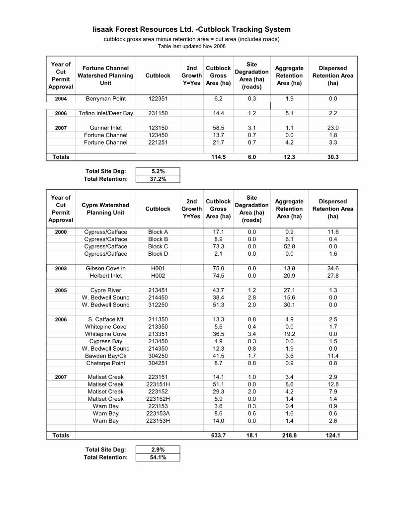
TOTAL 481,800 cu.m. Summary Description of Cutblocks: A “cutblock” is the industry term for an individual logging site. Gross area refers to the total size of a cutblock – harvested area, plus retention area(s) in which trees are left standing, plus any roads in the cutblock. One hectare is 2.5 acres. From 2000 to fall 2009, Iisaak logged 66 cutblocks that together cover a gross area of 1,453 hectares, of which 681 hectares (47%) are retention area. The remaining 772 hectares (53%) are the cut area, including 44 hectares of roads. Cutblock gross sizes and retention levels range from 89 hectares (with 76% of trees retained) to 1 hectare (with no retention). In one case, 2 contiguous cutblocks cover 150 hectares, with 65% tree retention. Average cutblock gross size is 22 hectares. 43 cutblocks (65%) involved road building for access, and 23 (35%) were helicopter accessed. 57 cutblocks (84%) were in old growth forest, and 9 (14%) were in second growth Douglas fir in Kennedy Lake Flats. For more information about individual cutblocks, see Table 1: Iisaak Cutblock Tracking System, photographs, and Map 8 in Appendices 1 to 3. Future Logging Plans: Iisaak has not disclosed its logging plans beyond 2009/early 2010. It appears the company is still developing its plans for 2010 and beyond in consultation with the local First Nations who own it.
12

The most contentious environmental issue is the question of logging intact old growth valleys. Both Iisaak and Ma-Mook Coulson have stated that by 2010 they will run out of wood to cut in the partly logged watersheds and will need to begin logging in the remaining intact watersheds in order to maintain their required cut levels. APRIL 2010 UPDATE: Effective March 1st, 2010 Iisaak’s parent company, Ma-Mook Natural Resources, has terminated its partnership with Coulson Forest Products and has assumed sole management of its Tree Farm License 54. First Nations are in now the process of deciding how to restructure their TFLs 54 and 57, as well as Ma-Mook and Iisaak. Economic Profile: Products: Iisaak produces logs for lumber and pulp. It does not own processing facilities, so it sells its logs to others – to Weyerhaeuser (from 2000 to 2005, while Weyerhaeuser was half owner), log brokers, other mills or directly to final customers. To increase the price it gets for its logs, Iisaak focuses on selling to Forest Stewardship Council (FSC) chain-of-custody certified mills. In 2007-2008, Iisaak marketed its logs through Triumph Timber to the following FSC sawmills: Terminal Forest Products in Vancouver, Coulson and Nagaard (both in Port Alberni), International Forest Products Corporation in Vancouver (not to be confused with Interfor), and Oregon-Canadian via McKenzie Sawmill (logs squared into cants in Vancouver, cants further processed in Portland, Oregon). (Source: Clayoquot Value-Added Forestry: Opportunities for Iisaak Forest Resources and Beyond, Ecotrust Canada, Sept 2008.) Recently, Iisaak has also sold its lumber-grade logs to a sawmill in Ucluelet, and to mills on the east side of Vancouver Island, for example, Longhouse Trading in Coombs. Iisaak sells its pulp-grade logs to pulp and paper mills, mostly on Vancouver Island. Depending on market conditions, logs are sold for export to the US or overseas, although Iisaak prefers not to export. In 2007, the species mix Iisaak cut consisted of about 74% Western redcedar, 22% hemlock/balsam, 3% Douglas fir and 1% cypress (yellow cedar). (Source: Clayoquot Value-Added Forestry: Opportunities for Iisaak Forest Resources and Beyond, Ecotrust Canada, Sept 2008.) Western redcedar is processed mostly into boards, siding, decking, fencing, shakes and shingles. Hemlock and balsam are made mostly into dimensional lumber for house framing and into pulp and paper. Employment: Iisaak’s annual volumes of cut have fluctuated, and so have the jobs it provides. Currently, Iisaak has 3 full-time staff, 1 full-time contract employee, and hires contractors to carry out various aspects of its operations (forestry engineering, road building, felling, yarding, hauling, scaling, water and air transport, etc). In 2007, when Iisaak cut the most (90,000 cubic metres), it generated about 43 jobs in total – managers, employees, contractors – of which 20 went to First Nations and 29 to locals (First Nations, and Tofino and Ucluelet residents). (Source: Iisaak: Wood with Respect, 2007 Report.)
13
Iisaak’s goal is to average at least 50% First Nations and local employment and to use as many local suppliers as possible. Financial Performance: In its first 7 years of operation (2000 to 2006), Iisaak mostly lost money, making a profit in only 2 years. In 2007, when it logged the most (90,000 cubic metres), Iisaak turned a profit of $2.1 million on sales of $20 million. One of the challenges Iisaak faces is lack of capital to build its own processing facilities to capture value-added benefit. MA-MOOK NATURAL RESOURCES / COULSON FOREST PRODUCTS Ma-Mook Coulson is a company that logs only in Clayoquot Sound and is jointly owned by local First Nations and Coulson Forest Products. In March 2007, Ma-Mook Natural Resources Ltd., a company owned by local First Nations, bought Tree Farm License 54 in Clayoquot Sound from International Forest Products (Interfor). To finance the $3.3 million purchase of the license, Ma-Mook entered into a joint venture with Coulson Forest Products, a logging company from Port Alberni. The joint venture company was to be 51% owned by Ma-Mook and 49% by Coulson. The partnership also gave Ma-Mook access to Coulson’s logging expertise and its sawmill in Port Alberni, a town 50 km south of Clayoquot Sound. The joint venture agreement was to be for five years, after which First Nations were to buy out Coulson’s share and assume full ownership of the company. For every cubic metre of wood logged during the five years, First Nations were to receive a credit of $5 towards their buyout of Coulson. Logging Tenure Area: 49,300 hectares in TFL 54 (approx. 45,600 in Clayoquot) Ma-Mook holds all of Tree Farm License 54 that formerly belonged to Interfor. A Tree Farm License (TFL) is a 25-year lease on provincial crown land that gives a company the exclusive right to cut timber on a particular landbase, and is renewed every 10 years indefinitely. The original license was granted to BC Forest Products in 1955. Ma-Mook’s TFL 54 covers 49,300 hectares of land. About 45,600 hectares (92.5% of the TFL) are located within Clayoquot Sound. The remaining 3,700 hectares are mostly in the Escalante Valley of Nootka Sound just north of Clayoquot Sound, and also in Lost Shoe Creek immediately south of the official Clayoquot Sound boundary (see Map 2: Clayoquot Land Tenures). Allowable Annual Cut (AAC): Every five years or so, the BC Ministry of Forests sets a required volume of wood to be cut, known as Allowable Annual Cut or AAC, for each of the 33 Tree Farm Licenses in British Columbia. When Ma-Mook purchased TFL 54 in March 2007, the required cut (AAC) was 75,750 cubic metres of wood – 66,750 allotted to Ma-Mook and 9,000 to small business via BC Timber Sales. On September 4th, 2008, the Ministry of Forests set a new AAC expressed as gross area to be cut of 320 hectares – 300 hectares for Ma-Mook and 20 hectares for small business via BC Timber
14
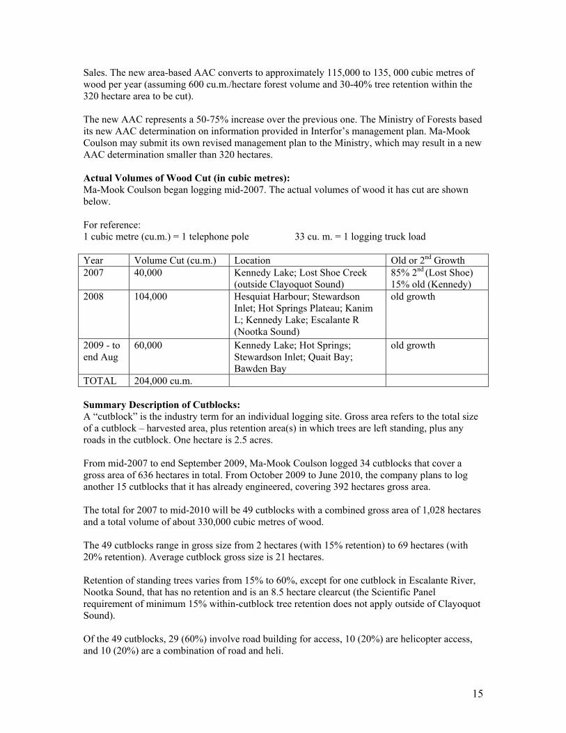
Sales. The new area-based AAC converts to approximately 115,000 to 135, 000 cubic metres of wood per year (assuming 600 cu.m./hectare forest volume and 30-40% tree retention within the 320 hectare area to be cut). The new AAC represents a 50-75% increase over the previous one. The Ministry of Forests based its new AAC determination on information provided in Interfor’s management plan. Ma-Mook Coulson may submit its own revised management plan to the Ministry, which may result in a new AAC determination smaller than 320 hectares. Actual Volumes of Wood Cut (in cubic metres): Ma-Mook Coulson began logging mid-2007. The actual volumes of wood it has cut are shown below. For reference: 1 cubic metre (cu.m.) = 1 telephone pole 33 cu. m. = 1 logging truck load Year Volume Cut (cu.m.) Location Old or 2nd Growth 2007 40,000 Kennedy Lake; Lost Shoe Creek
(outside Clayoquot Sound) 85% 2nd (Lost Shoe) 15% old (Kennedy)
2008 104,000 Hesquiat Harbour; Stewardson Inlet; Hot Springs Plateau; Kanim L; Kennedy Lake; Escalante R (Nootka Sound)
old growth
2009 - to end Aug
60,000 Kennedy Lake; Hot Springs; Stewardson Inlet; Quait Bay; Bawden Bay
old growth
TOTAL 204,000 cu.m. Summary Description of Cutblocks: A “cutblock” is the industry term for an individual logging site. Gross area refers to the total size of a cutblock – harvested area, plus retention area(s) in which trees are left standing, plus any roads in the cutblock. One hectare is 2.5 acres. From mid-2007 to end September 2009, Ma-Mook Coulson logged 34 cutblocks that cover a gross area of 636 hectares in total. From October 2009 to June 2010, the company plans to log another 15 cutblocks that it has already engineered, covering 392 hectares gross area. The total for 2007 to mid-2010 will be 49 cutblocks with a combined gross area of 1,028 hectares and a total volume of about 330,000 cubic metres of wood. The 49 cutblocks range in gross size from 2 hectares (with 15% retention) to 69 hectares (with 20% retention). Average cutblock gross size is 21 hectares. Retention of standing trees varies from 15% to 60%, except for one cutblock in Escalante River, Nootka Sound, that has no retention and is an 8.5 hectare clearcut (the Scientific Panel requirement of minimum 15% within-cutblock tree retention does not apply outside of Clayoquot Sound). Of the 49 cutblocks, 29 (60%) involve road building for access, 10 (20%) are helicopter access, and 10 (20%) are a combination of road and heli.
15
46 cutblocks (94%) are in old growth forest, and 3 blocks (6%) are in second growth Douglas fir in Lost Shoe Creek in Kennedy Lake Flats. For more information about individual cutblocks, see Table 2: Cutblocks Logged by Ma-Mook Coulson, photographs, and Maps 9 and 10 in Appendices 1 to 3. Future Logging Plans: In the fall of 2009 and into 2010, Ma-Mook Coulson plans to log 15 more old growth cutblocks that it has already engineered: at Indian Bay, Gunner Inlet, Rolling Stone and Virge Creeks (Fortune Channel), Matlset Narrows and Cypre/Catface (see “Future Blocks” at end of Table 2). APRIL 2010 UPDATE: Effective March 1st, 2010 Ma-Mook Natural Resources has terminated its partnership with Coulson, repaying Coulson’s loan and assuming sole management of its Tree Farm Licence 54. Coulson gets to log the cutblocks it has already engineered (see “Future Blocks” at end of Table 2). Coulson expects to harvest a scaled-down version of these blocks by October 2010. All of Coulson’s operations on the blocks it has already engineered, including road deactivation, are to be completed by April 1, 2012. Meanwhile, First Nations are in the process of deciding how to restructure their TFLs 54 and 57, as well as Ma-Mook and Iisaak. Economic Profile: Products: Ma-Mook Coulson produces saw logs and pulp logs for sale to other mills, as it does not own processing facilities. Lumber-grade logs are sold to the Coulson sawmill in Port Alberni, and to Interfor sawmills. According to the log supply agreement that formed one of the conditions of sale of Interfor’s Tree Farm License, Interfor has the right of first refusal on 50% of Ma-Mook Coulson’s logs. Interfor may be exporting some of the logs to its sawmills in Washington and Oregon. Pulp-grade logs are sold to the Catalyst pulp and paper mill in Port Alberni, and also to other pulp mills as part of the commitment to Interfor. About 65% of Ma-Mook Coulson’s logs are made into lumber products, and 35% are made into pulp and paper. The species mix that Ma-Mook Coulson cuts is similar to Iisaak’s – mostly Western redcedar, followed by hemlock and balsam (Amabilis) fir, plus some Douglas fir and cypress (yellow cedar). Employment: Currently, Ma-Mook Coulson has 3 contract employees in forestry engineering at its Port Alberni office, and hires contractors to carry out its various operations. The company would not disclose total employment figures. The information that is available pertains to First Nations jobs created in 2007: 4 new First Nations jobs at the Coulson mill in Port Alberni, and 8 First Nations contract jobs in forestry engineering locally in Clayoquot Sound. Also in 2007, Ma-Mook Coulson used 3 local First Nations contractors for catering, boat charters and cultural surveys; 2 contractors from Ucluelet
16

for forestry engineering, and road building and logging; and a contractor from Nanaimo for road building. (Source: report presented at Central Chiefs AGM, Dec. 10, 2007.) Ma-Mook Coulson tries to use First Nations and other local contractors and suppliers whenever possible. Financial Performance: As a private company, Ma-Mook Coulson is not required to and would not disclose financial information. From the very approximate examples published in the “Ma-Mook Coulson Gazette, October 2008”, it seems that in 2008, the first full year of operation, on a cut of 104,000 cubic metres, Ma-Mook Coulson should have made a profit of about $700,000. Of that, $520,000 ($5 per cubic metre) would have been a credit to First Nations towards their buyout of Coulson’s share of the company. INTERNATIONAL FOREST PRODUCTS (INTERFOR) Vancouver-based International Forest Products (Interfor) is one of BC’s largest logging corporations. Although it sold its Clayoquot Tree Farm License 54 to First Nations owned Ma-Mook Natural Resources in March 2007, Interfor still holds a Forest License in northern Clayoquot Sound. Interfor has operations all along the coast of BC; in interior BC at Adams Lake, Grand Forks and Castlegar; and also in Oregon and Washington. It has the capacity to log and produce 1.6 billion board feet of lumber each year that it sells around the world (hence the “International” in its name). Interfor began logging in Clayoquot Sound in 1992, after it purchased the Clayoquot Sound portion of Fletcher Challenge’s Tree Farm License 46 in December 1991. The subdivided Clayoquot portion was renamed TFL 54. At the same time, Interfor also bought Fletcher Challenge’s Forest License on Vancouver Island, including in Clayoquot Sound. Since February 2005, Interfor has not been active in Clayoquot Sound. At that time, pressure from markets, media and the public stopped the company from building a logging road into the intact valley of Hesquiat Lake Creek. Logging Chart Area: approx. 4,000 hectares in FL A19235 in Clayoquot Sound (part of Arrowsmith Timber Supply Area) Interfor holds Forest License (FL) A19235 on provincial crown land dispersed throughout west-central Vancouver Island, from Alberni Inlet to Nootka Sound. The Forest License is a “volume-based” license for 15 years, renewable every 5 years indefinitely, that gives Interfor the right to log a certain yearly volume. Interfor’s “chart area” in Clayoquot Sound spans roughly 4,000 hectares in northern-most Clayoquot. It consists of half of the intact (unlogged) Sydney Valley, half of intact Hesquiat Lake Creek, the west side of Hesquiat Lake, and 2 areas north and northwest of Hesquiat Harbour (see Map 2: Clayoquot Sound Land Tenures). Unlike a Tree Farm License, a Forest License chart area does not give exclusive right to one company to log that landbase. Other Forest License holders in the Arrowsmith Timber Supply
17
Area (which spans the south half of Vancouver Island) and BC Timber Sales can have access to Interfor’s chart areas. However, in practice, chart areas are generally respected and other operators do not try to move in. Allowable Annual Cut (AAC): The AAC for Interfor’s Clayoquot Forest License is part of the 13,700 cubic metres per year set for the whole Arrowsmith Timber Supply Area in Clayoquot Sound. Actual Volumes of Wood Cut: Since February 2005, when it stopped road building into intact Hesquiat Lake Creek, Interfor has not cut in the Clayoquot portion of its Forest License while it continues to log in other parts of the License. Future Plans: The two existing Cut Permits for two cutblocks in intact Hesquiat Lake Creek – blocks that were never cut – have been allowed to expire. According to Interfor, it has no plans to log in Clayoquot Sound. Its current operational plan (Forest Stewardship Plan approved in 2006) for the Forest License does not cover the Clayoquot portion. A new Forest Stewardship Plan, or an amendment to the current one, would be required before Interfor could propose roads or cutblocks in Clayoquot Sound. A new plan or an amendment would have to be advertised for public input. ISLAND TIMBERLANDS Nanaimo-based Island Timberlands Limited Partnership is a company that owns 258,000 hectares of private forest land in coastal BC, mostly on Vancouver Island, including about 1,350 hectares in Clayoquot Sound. After Weyerhaeuser sold its coastal BC forestry holdings to Brascan in 2005, a new company called Island Timberlands was formed to own and log the private forest land that was part of the sale. Island Timberlands is a private equity investment owned by Brookfield Asset Management and two Canadian institutional investors (pension funds). About 200,000 hectares of Island Timberlands’ private land is on Vancouver Island. It includes large tracts of second growth forest, mostly Douglas fir, on the east side of the island from Duncan to Campbell River, including Port Alberni. These are long-time private lands previously owned by MacMillan Bloedel. Island Timberlands also owns parcels of land that were privatized in 2004: these parcels used to be private land managed as part of Weyerhaeuser’s Tree Farm License 44, but were removed from the TFL as part of a deal between the provincial government and Weyerhaeuser. The 1,350 hectares in Clayoquot Sound that Island Timberlands now owns were part of the 2004 privatization. Private forest land is not subject to the same provincial regulations (Forest and Range Practices Act) as Tree Farm Licenses. Rather, it is subject to a lower standard of logging known as the “Private Managed Forest Land Act”. In Clayoquot Sound, private land is not subject to the Scientific Panel standards for logging, which apply to crown land only.
18
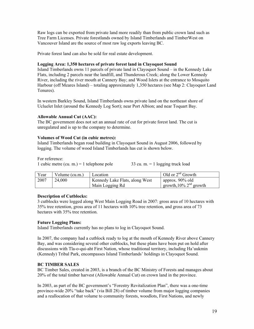
Raw logs can be exported from private land more readily than from public crown land such as Tree Farm Licenses. Private forestlands owned by Island Timberlands and TimberWest on Vancouver Island are the source of most raw log exports leaving BC. Private forest land can also be sold for real estate development. Logging Area: 1,350 hectares of private forest land in Clayoquot Sound Island Timberlands owns 11 parcels of private land in Clayoquot Sound – in the Kennedy Lake Flats, including 2 parcels near the landfill, and Thunderous Creek; along the Lower Kennedy River, including the river mouth at Cannery Bay; and Wood Islets at the entrance to Mosquito Harbour (off Meares Island) – totaling approximately 1,350 hectares (see Map 2: Clayoquot Land Tenures). In western Barkley Sound, Island Timberlands owns private land on the northeast shore of Ucluelet Inlet (around the Kennedy Log Sort); near Port Albion; and near Toquart Bay. Allowable Annual Cut (AAC): The BC government does not set an annual rate of cut for private forest land. The cut is unregulated and is up to the company to determine. Volumes of Wood Cut (in cubic metres): Island Timberlands began road building in Clayoquot Sound in August 2006, followed by logging. The volume of wood Island Timberlands has cut is shown below. For reference: 1 cubic metre (cu. m.) = 1 telephone pole 33 cu. m. = 1 logging truck load Year Volume (cu.m.) Location Old or 2nd Growth 2007 24,000 Kennedy Lake Flats, along West
Main Logging Rd approx. 90% old growth,10% 2nd growth
Description of Cutblocks: 3 cutblocks were logged along West Main Logging Road in 2007: gross area of 10 hectares with 35% tree retention, gross area of 11 hectares with 10% tree retention, and gross area of 73 hectares with 35% tree retention. Future Logging Plans: Island Timberlands currently has no plans to log in Clayoquot Sound. In 2007, the company had a cutblock ready to log at the mouth of Kennedy River above Cannery Bay, and was considering several other cutblocks, but these plans have been put on hold after discussions with Tla-o-qui-aht First Nation, whose traditional territory, including Ha’uukmin (Kennedy) Tribal Park, encompasses Island Timberlands’ holdings in Clayoquot Sound. BC TIMBER SALES BC Timber Sales, created in 2003, is a branch of the BC Ministry of Forests and manages about 20% of the total timber harvest (Allowable Annual Cut) on crown land in the province. In 2003, as part of the BC government’s “Forestry Revitalization Plan”, there was a one-time province-wide 20% “take back” (via Bill 28) of timber volume from major logging companies and a reallocation of that volume to community forests, woodlots, First Nations, and newly
19
created BC Timber Sales. BC Timber Sales also replaced the Ministry’s Small Business Forest Enterprise Program and took over that program’s annual cut (volume from BC’s 33 Tree Farm Licenses and 37 Timber Supply Areas not otherwise allocated to logging companies). BC Timber Sales was formed to plan, develop, and sell through auction at market prices the above volume. It awards Timber Sale Licenses to individuals and companies registered with the agency who have successfully bid to harvest the standing timber put up for auction. BC Timber Sales is also responsible for replanting the cutblocks it auctions. Logging Area and Allowable Annual Cut (AAC): In Clayoquot Sound, BC Timber Sales manages: • the small business volume (about 13,400 cubic metres of wood per year from 41 hectares in Iisaak’s TFL 57 and about 9,000 cubic metres per year from 20 hectares in Ma-Mook’s TFL 54), accumulated from 5% take backs each time a TFL was sold • approximately 20,000 hectares in the Arrowsmith Timber Supply Area, outside of Interfor’s Forest License chart area. The total AAC for the Arrowsmith TSA in Clayoquot Sound is 13,700 cubic metres per year, which BC Timber Sales and Interfor share in consultation with each other. • Western Forest Products’ TFL 44 in Clayoquot Sound that consists of the Upper Kennedy River and Marion Creek tributary and covers approximately 11,000 hectares, with an AAC of about 28,000 cubic metres per year (part of the 20% take back of volume from Western Forest Products). (See Map 2: Clayoquot Land Tenures.) Actual Volumes of Wood Cut: In the last 15 years or so, small business logging in Clayoquot Sound has not met its Allowable Annual Cut. From 1992 to 1996, a total of 77,000 cubic metres of wood was logged under the Small Business Forest Enterprise Program, the predecessor to BC Timber Sales. The next small business logging was in 2004, when 5 cutblocks from Interfor’s TFL 54 were tendered and awarded by BC Timber Sales. Three cutblocks in Kennedy Lake Flats, totaling 11,500 cubic metres of wood, were logged by Barkley Forest Products from Ucluelet. Two cutblocks east of Hesquiat Harbour, totaling 22,750 cubic metres of old growth wood, were logged by Homiss Enterprises, a company owned by Hesquiat First Nation Band Council (see Interfor/BC Timber Sales photograph in Appendix 2). Future Logging Plans: A Forest Stewardship Plan for the 20 hectares/9,000 cubic metres of small business volume in Ma-Mook Coulson’s TFL 54 was submitted in June 2009, but is not yet approved. Once approved, the next step is for BC Timber Sales and Ma-Mook to work out where in the TFL that volume will come from, before BC Timber Sales can engineer the cutblocks and put them up for bidding. There is currently no BC Timber Sales’ Forest Stewardship Plan for Iisaak’s TFL 57 or for the Arrowsmith Timber Supply Area in Clayoquot Sound, and no timelines for submitting such plans. Regarding Upper Kennedy River/Marion Creek, allocated to BC Timber Sales, the Ministry of Forests wants to remove this area from Western Forest Products’ TFL 44 in order to add it to a new BC coast-wide Pacific Timber Supply Area that is being created from take back areas/volumes. However, consultations with Tla-o-qui-aht First Nation have stalled the process
20
because this area is in Tla-o-qui-aht’s proposed Ha’uukmin Tribal Park that the tribe intends to manage. AHOUSAHT FIRST NATION WOODLOT Woodlot License 0019 was awarded to the Ahousaht First Nation Band Council in 1989 by the BC Ministry of Forests. Woodlot licenses are issued to individuals, First Nations bands and small corporations. Licenses are for 20 years or less, renewable every 10 years indefinitely. The license gives exclusive right to manage and cut timber on a particular land base. Woodlot licenses are awarded on provincial crown land, or on a combination of crown and private land. In coastal BC, the crown land portion cannot exceed 800 hectares and in interior BC 1,200 hectares. There is no cap on the size of the private land component. Logging Tenure Area: 267 hectares (20 ha private land and 247 ha crown land) The woodlot consists of 6 blocks of land, totaling 267 hectares, adjacent to the village/reserve of Ahousaht on SE Flores Island. Five blocks are on crown land and one is on private land in the reserve. One of the crown land blocks is adjacent to Gibson Marine Park, and the Ahousaht Wildside Trail crosses through this block. (See Map 2: Clayoquot Land Tenures.) Allowable Annual Cut (AAC): 500 cubic metres Actual Volumes Cut: There has been no logging since the woodlot license was issued in 1989, although management plans were written in 1989 and 1999. Prior to issuance of the woodlot license, about eight hectares of the private land portion in the reserve were logged (in 1970), and also a small area on the east side of Matilda Inlet north of the reserve. Future Logging Plans: Another effort is currently underway to activate the woodlot. With the help of Ecotrust Canada, Ahousaht is preparing a Woodlot License Plan for Ministry of Forests, to be advertised for public input this year, and also applying for Forest Stewardship Council (FSC) voluntary certification. Ahousaht Band Council is buying a small electric-powered sawmill capable of processing about 2,000 cubic metres of wood per year. The mill is to start by milling ocean-salvaged wood that Ahousaht people already have, and then wood from a Free Use Permit to be obtained from Ministry of Forests. Wood from these sources will be for Ahousaht subsistence use, to build and upgrade houses and community buildings. Once/if the woodlot begins operating, it will produce mainly cedar, FSC certified, to be milled in Ahousat into a range of high-value products (beams, showpieces, possibly doors, siding, edging, etc) and to be marketed locally in Tofino and Ucluelet.
21
OTHER FACTORS INFLUENCING FORESTRY IN CLAYOQUOT SOUND Meares Island Court Injunction About 99% (8,225 hectares) of Meares Island’s approximately 8,300 hectares are in logging tenures – 3,813 hectares in Ma-Mook’s Tree Farm License, 3,555 in Iisaak’s, and 857 in the Arrowsmith Timber Supply Area (see Map 2: Clayoquot Sound Land Tenures). However, the island remains virtually intact and unlogged (see Map 1: Clayoquot Sound Forest Cover). Meares is currently not considered part of the “timber harvesting land base” because of a 1985 court injunction obtained by Tla-o-qui-aht and Ahousaht First Nations that prohibits logging and other development. In 1984, these First Nations declared Meares Island a Tribal Park. Their injunction was filed during a 1984-1985 blockade of Meares by Friends of Clayoquot Sound, First Nations and other local citizens. The blockade and subsequent injunction prevented MacMillan Bloedel from logging the island’s ancient forest. In 1994, the Meares court case was adjourned indefinitely, with the injunction in force, and Meares Island became part of treaty negotiations. Because of the injunction, Meares Island was not included in the 1993 Clayoquot Land Use Decision that showed protected and timber harvesting areas in Clayoquot Sound. The island is not part of the Clayoquot Sound UNESCO Biosphere Reserve established in 2000. Science Panel watershed plans for Clayoquot Sound, completed in 2006, do not include Meares Island. It is not considered as contributing to timber supply when the BC Ministry of Forests sets Allowable Annual Cuts for the Tree Farm Licenses and Timber Supply Area. The injunction will expire once treaty is signed. Tla-o-qui-aht First Nation continues to regard Meares Island as a Tribal Park, a designation that will likely become official in their future treaty settlement. Hence Meares Island appears safe from industrial logging into the future. Forest And Range Agreements With First Nations A portion of the 2003 province-wide 20% “take back” of timber volume from major logging companies, as well as unlogged timber from various forest licenses is being made available to First Nations in BC via “Forest and Range Opportunity” agreements. The agreements are part of BC’s pre-treaty accommodation of First Nations interests regarding forest resource development in their traditional territories. About 125 agreements have been signed as of fall 2008. They generally consist of revenue sharing (cash payments) and timber volume available for First Nations logging and are for a 5-year period. In Clayoquot Sound, the province has negotiated Forest and Range agreements with Ahousaht, Hesquiaht and Tla-o-qui-aht First Nations. The agreements consist of cash payments only, without any timber volume, since none of the volume taken back from Interfor was sourced from Clayoquot Sound. Ahousaht agreement, April 2008: a total of $4,340,000 spread out over 5 years Hesquiaht agreement, July 2007: a total of $1,700,000 spread out over 5 years Tla-o-qui-aht agreement, December 2006: a total of $1,990,000 spread out over 5 years The intent is to renew the above forestry agreements once they expire, or to conclude new ones, until treaties are signed.
22
Tla-o-qui-aht First Nation’s Ha’uukmin (Kennedy) Tribal Park In mid 2009, Tla-o-qui-aht First Nation (TFN) completed the first “establishment” phase of the Ha’uukmin Tribal Park in the Kennedy watershed of their traditional territory. The Kennedy watershed, composed of the Kennedy and Clayoquot Rivers and Kennedy Lake, is the largest watershed in Clayoquot Sound, encompassing 55,000 hectares (550 sq. km.). The purpose of the Tribal Park is to implement the stewardship vision of TFN chiefs and elders and to generate sustainable livelihoods for TFN people. A management plan is being created that establishes two zones in the Tribal Park, and a non-profit Tribal Parks Society is being established to manage the park. The two zones are “recovery” and “protection”. A recovery zone, called in Nuu-chah-nulth “uuya tuknis” (we take care of), takes in most of Kennedy Lake and surrounding land, as well as the Highway 4 corridor. Here TFN would allow single-tree selection logging, run-of-river hydro, and tourism development such as fishing, boating, mountain biking, a zip line and a lodge. Restoration of forests and streams damaged by past logging is a priority in this zone to try to bring salmon back to former abundance. A protection zone, known as “qwa siin hap” (leave it as it is for now), takes in the intact Upper Kennedy and Clayoquot River valleys, and part of the Clayoquot Arm of Kennedy Lake. Preservation of ancient forest is a priority in this zone, with no logging or industrial activities allowed. Light-touch tourism such as hiking, backpacking and camping, as well as scientific research are encouraged. (Source: “Ha’uukmin Tribal Park” newspaper, co-published by TFN and Western Canada Wilderness Committee, summer 2009.) Ha’uukmin Tribal Park encompasses several logging tenures – those of Iisaak, Ma-Mook, BC Timber Sales, Island Timberlands, and Western Forest Products – as well as provincial parks, part of Pacific Rim National Park, Highway 4, and other jurisdictions. It is unclear how the Tribal Park, which relies on the strength of TFN’s aboriginal title but has no legal standing at present, would achieve authority to manage resource uses and users. Since the Tribal Park is part of TFN’s incremental treaty negotiations, legal standing may come via treaty. Regarding logging, TFN have been in discussion with the various operators and have achieved logging deferrals (from BC Timber Sales for inact Upper Kennedy River, and from Island Timberlands for private land logging), while some logging by Iisaak and Ma-Mook Coulson has gone ahead, after discussions with TFN. Ultimately, TFN want to acquire all the logging tenures in Ha’uukmin Tribal Park and in the rest of their traditional territory and to form their own logging company whose practices would exceed the logging standards of the Clayoquot Sound Scientific Panel.
23
24
Selected Bibliography
Clayoquot Sound Technical Planning Committee. 2003 and 2006. Watershed Planning in Clayoquot Sound, Volume 1: Principles and Process. Plus 11 Watershed Plans. Clayoquot Sound Technical Planning Committee. July 2006. Progress Report. Coast Information Team. 2004. Scientific Basis of Ecosystem-based Management. Ecotrust Canada. Sept 2008. Clayoquot Value-Added Forestry: Opportunities for Iisaak Forest Resources and Beyond. Iisaak Forest Resources, Ecotrust Canada and Triumph Timber. 2007. Iisaak – Wood with Respect: 2007 Report. Province of British Columbia. April 1993. Clayoquot Land Use Decision: Background Report. Scientific Panel for Sustainable Forest Practices in Clayoquot Sound. 1995. Sustainable Ecosystem Management in Clayoquot Sound: Planning and Practices. Report 5. Tla-o-qui-aht Tribal Parks and Western Canada Wilderness Committee. Summer 2009. Ha’uukmin Tribal Park. Educational Report, vol. 28, no. 3. Western Canada Wilderness Committee. Spring 2007. Vancouver Island: Protecting Paradise. Educational Report, vol. 26, no. 1.
Appendix 1: Tables Table 1. Iisaak Forest Resources – Cutblock Tracking System 2000-2008
adapted from cutblock table provided by Iisaak; 3 pages Table 2. Cutblocks Logged/to be Logged by Ma-Mook Coulson, Tree Farm License 54, 2007 to mid-2010 adapted from cutblock table provided by Ma-Mook Coulson; 3 pages
0 8 6
Iisaak Forest Resources Ltd. -Cutblock Tracking Systemcutblock gross area minus retention area = cut area (includes roads)
Table last updated Nov 2008
Year of Cut
Permit Approval
Fortune Channel Watershed Planning
UnitCutblock
2nd Growth Y=Yes
Cutblock Gross
Area (ha)
Site Degradation
Area (ha) (roads)
Aggregate Retention Area (ha)
Dispersed Retention Area
(ha)
2004 Berryman Point 122351 6.2 0.3 1.9 0.0
2006 Tofino Inlet/Deer Bay 231150 14.4 1.2 5.1 2.2
2007 Gunner Inlet 123150 58.5 3.1 1.1 23.0Fortune Channel 123450 13.7 0.7 0.0 1.8Fortune Channel 221251 21.7 0.7 4.2 3.3
Totals 114.5 6.0 12.3 30.3
Total Site Deg: 5.2%Total Retention: 37.2%
Year of Cut
Permit Approval
Cypre Watershed Planning Unit Cutblock
2nd Growth Y=Yes
Cutblock Gross
Area (ha)
Site Degradation
Area (ha) (roads)
Aggregate Retention Area (ha)
Dispersed Retention Area
(ha)
2000 Cypress/Catface Block A 17.1 0.0 0.9 11.6Cypress/Catface Block B 8.9 0.0 6.1 0.4Cypress/Catface Block C 73.3 0.0 52.8 0.0Cypress/Catface Block D 2.1 0.0 0.0 1.6
20032003 Gibson Cove inGibson Cove in H001H001 75 075. 0 00.0 13 813. 34 634.Herbert Inlet H002 74.5 0.0 20.9 27.8
2005 Cypre River 213451 43.7 1.2 27.1 1.3W. Bedwell Sound 214450 38.4 2.8 15.6 0.0W. Bedwell Sound 312250 51.3 2.0 30.1 0.0
2006 S. Catface Mt 211350 13.3 0.8 4.9 2.5Whitepine Cove 213350 5.6 0.4 0.0 1.7Whitepine Cove 213351 36.5 3.4 19.2 0.0
Cypress Bay 213450 4.9 0.3 0.0 1.5W. Bedwell Sound 214350 12.3 0.8 1.9 0.0Bawden Bay/Ck 304250 41.5 1.7 3.6 11.4Chetarpe Point 304251 8.7 0.8 0.9 0.8
2007 Matlset Creek 223151 14.1 1.0 3.4 2.9Matlset Creek 223151H 51.1 0.0 8.6 12.8Matlset Creek 223152 29.3 2.0 4.2 7.9Matlset Creek 223152H 5.9 0.0 1.4 1.4
Warn Bay 223153 3.6 0.3 0.4 0.9Warn Bay 223153A 8.6 0.6 1.6 0.6Warn Bay 223153H 14.0 0.0 1.4 2.6
Totals 633.7 18.1 218.8 124.1
Total Site Deg: 2.9%Total Retention: 54.1%
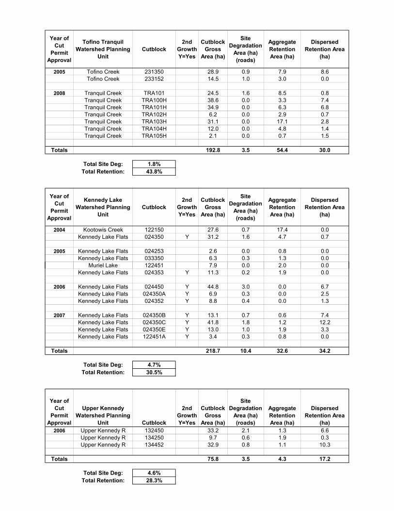
Year of Cut
Permit Approval
Tofino Tranquil Watershed Planning
UnitCutblock
2nd Growth Y=Yes
Cutblock Gross
Area (ha)
Site Degradation
Area (ha) (roads)
Aggregate Retention Area (ha)
Dispersed Retention Area
(ha)
2005 Tofino Creek 231350 28.9 0.9 7.9 8.6Tofino Creek 233152 14.5 1.0 3.0 0.0
2008 Tranquil Creek TRA101 24.5 1.6 8.5 0.8Tranquil Creek TRA100H 38.6 0.0 3.3 7.4Tranquil Creek TRA101H 34.9 0.0 6.3 6.8Tranquil Creek TRA102H 6.2 0.0 2.9 0.7Tranquil Creek TRA103H 31.1 0.0 17.1 2.8Tranquil Creek TRA104H 12.0 0.0 4.8 1.4Tranquil Creek TRA105H 2.1 0.0 0.7 1.5
Totals 192.8 3.5 54.4 30.0
Total Site Deg: 1.8%Total Retention: 43.8%
Year of Cut
Permit Approval
Kennedy Lake Watershed Planning
UnitCutblock
2nd Growth Y=Yes
Cutblock Gross
Area (ha)
Site Degradation
Area (ha) (roads)
Aggregate Retention Area (ha)
Dispersed Retention Area
(ha)
2004 Kootowis Creek 122150 27.6 0.7 17.4 0.0Kennedy Lake Flats 024350 Y 31.2 1.6 4.7 0.7
2005 Kennedy Lake Flats 024253 2.6 0.0 0.8 0.0Kennedy Lake Flats 033350 6.3 0.3 1.3 0.0
Muriel Lake 122451 7.9 0.0 2.0 0.0Kennedy Lake Flats 024353 Y 11.3 0.2 1.9 0.0
2006 Kennedy Lake Flats 024450 Y 44.8 3.0 0.0 6.7Kennedy Lake Flats 024350A Y 6.9 0.3 0.0 2.5Kennedy Lake Flats 024352 Y 8.8 0.4 0.0 1.3
2007 Kennedy Lake Flats 024350B Y 13.1 0.7 0.6 7.4Kennedy Lake Flats 024350C Y 41.8 1.8 1.2 12.2Kennedy Lake Flats 024350E Y 13.0 1.0 1.9 3.3Kennedy Lake Flats 122451A Y 3.4 0.3 0.8 0.0
Totals 218.7 10.4 32.6 34.2
Total Site Deg: 4.7%Total Retention: 30.5%
Year of Cut
Permit Approval
Upper Kennedy Watershed Planning
Unit Cutblock
2nd Growth Y=Yes
Cutblock Gross
Area (ha)
Site Degradation
Area (ha) (roads)
Aggregate Retention Area (ha)
Dispersed Retention Area
(ha)2006 Upper Kennedy R 132450 33.2 2.1 1.3 6.6
Upper Kennedy R 134250 9.7 0.6 1.9 0.3Upper Kennedy R 134452 32.9 0.8 1.1 10.3
Totals 75.8 3.5 4.3 17.2
Total Site Deg: 4.6%Total Retention: 28.3%
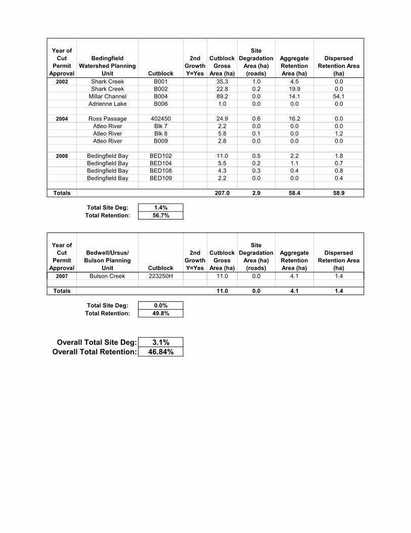
Year of Cut
Permit Approval
Bedingfield Watershed Planning
Unit Cutblock
2nd Growth Y=Yes
Cutblock Gross
Area (ha)
Site Degradation
Area (ha) (roads)
Aggregate Retention Area (ha)
Dispersed Retention Area
(ha)2002 Shark Creek B001 35.3 1.0 4.5 0.0
Shark Creek B002 22.8 0.2 19.9 0.0Millar Channel B004 89.2 0.0 14.1 54.1Adrienne Lake B006 1.0 0.0 0.0 0.0
2004 Ross Passage 402450 24.9 0.6 16.2 0.0Atleo River Blk 7 2.2 0.0 0.0 0.0Atleo River Blk 8 5.8 0.1 0.0 1.2Atleo River B009 2.8 0.0 0.0 0.0
2008 Bedingfield Bay BED102 11.0 0.5 2.2 1.8Bedingfield Bay BED104 5.5 0.2 1.1 0.7Bedingfield Bay BED108 4.3 0.3 0.4 0.8Bedingfield Bay BED109 2.2 0.0 0.0 0.4
Totals 207.0 2.9 58.4 58.9
Total Site Deg: 1.4%Total Retention: 56.7%
Year of Cut
Permit Approval
Bedwell/Ursus/ Bulson Planning
Unit Cutblock
2nd Growth Y=Yes
Cutblock Gross
Area (ha)
Site Degradation
Area (ha) (roads)
Aggregate Retention Area (ha)
Dispersed Retention Area
(ha)2002007 B l C kBulson Creek 223250H223250H 11 011.0 0 00.0 4 14.1 1 41.4
Totals 11.0 0.0 4.1 1.4
Total Site Deg: 0.0%Total Retention: 49.8%
Overall Total Site Deg: 3.1%Overall Total Retention: 46.84%
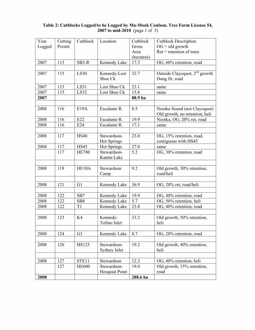
Table 2: Cutblocks Logged/to be Logged by Ma-Mook Coulson, Tree Farm License 54, 2007 to mid-2010 (page 1 of 3)
Year Logged
Cutting Permit
Cutblock Location Cutblock Gross Area (hectares)
Cutblock Description OG = old growth Ret = retention of trees
2007 113 SB3-R Kennedy Lake 17.3 OG, 60% retention, road 2007 115 LS30 Kennedy-Lost
Shoe Ck 32.7 Outside Clayoquot, 2nd growth
Doug fir, road
2007 115 LS31 Lost Shoe Ck 23.1 same 2007 115 LS32 Lost Shoe Ck 15.8 same 2007 88.9 ha 2008 116 E19A Escalante R. 8.5 Nootka Sound (not Clayoquot)
Old growth, no retention, heli 2008 116 E22 Escalante R. 19.9 Nootka, OG, 20% ret, road 2008 116 E24 Escalante R. 17.1 same 2008 117 HS40 Stewardson-
Hot Springs 23.0 OG, 15% retention, road,
contiguous with HS45 2008 117 HS45 Hot Springs 27.0 same 117 HE780 Stewardson-
Kanim Lake 5.2 OG, 30% retention, road
2008 119 HE10A Stewardson
Camp 9.2 Old growth, 30% retention,
road/heli 2008 121 G1 Kennedy Lake 36.9 OG, 20% ret, road/heli 2008 122 SB7 Kennedy Lake 19.9 OG, 40% retention, road 2008 122 SB8 Kennedy Lake 5.7 OG, 50% retention, heli 2008 122 T1 Kennedy Lake 23.8 OG, 40% retention, road 2008 123 K4 Kennedy-
Tofino Inlet 33.2 Old growth, 50% retention,
heli 2008 124 G3 Kennedy Lake 8.7 OG, 20% retention, road 2008 126 HS125 Stewardson-
Sydney Inlet 19.2 Old growth, 40% retention,
heli 2008 127 STE11 Stewardson 12.3 OG, 40% retention, heli 127 HE600 Stewardson-
Hesquiat Point 19.0 Old growth, 15% retention,
road 2008 288.6 ha
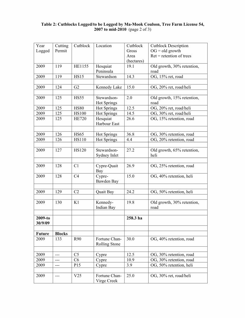
Table 2: Cutblocks Logged/to be Logged by Ma-Mook Coulson, Tree Farm License 54, 2007 to mid-2010 (page 2 of 3)
Year Logged
Cutting Permit
Cutblock Location Cutblock Gross Area (hectares)
Cutblock Description OG = old growth Ret = retention of trees
2009 119 HE1155 Hesquiat Peninsula
19.1 Old growth, 30% retention, road
2009 119 HS15 Stewardson 14.3 OG, 15% ret, road 2009 124 G2 Kennedy Lake 15.0 OG, 20% ret, road/heli 2009 125 HS55 Stewardson-
Hot Springs 2.0 Old growth, 15% retention,
road 2009 125 HS80 Hot Springs 12.5 OG, 20% ret, road/heli 2009 125 HS100 Hot Springs 14.5 OG, 30% ret, road/heli 2009 125 HE720 Hesquiat
Harbour East 26.6 OG, 15% retention, road
2009 126 HS65 Hot Springs 36.8 OG, 30% retention, road 2009 126 HS110 Hot Springs 4.4 OG, 20% retention, road 2009 127 HS120 Stewardson-
Sydney Inlet 27.2 Old growth, 65% retention,
heli 2009 128 C1 Cypre-Quait
Bay 26.9 OG, 25% retention, road
2009 128 C4 Cypre-Bawden Bay
15.0 OG, 40% retention, heli
2009 129 C2 Quait Bay 24.2 OG, 50% retention, heli 2009 130 K1 Kennedy-
Indian Bay 19.8 Old growth, 30% retention,
road 2009-to 30/9/09
258.3 ha
Future Blocks 2009 133 R90 Fortune Chan-
Rolling Stone 30.0 OG, 40% retention, road
2009 --- C5 Cypre 12.5 OG, 30% retention, road 2009 --- C6 Cypre 10.9 OG, 30% retention, road 2009 --- P15 Cypre 3.9 OG, 50% retention, heli 2009 --- V25 Fortune Chan-
Virge Creek 25.0 OG, 30% ret, road/heli
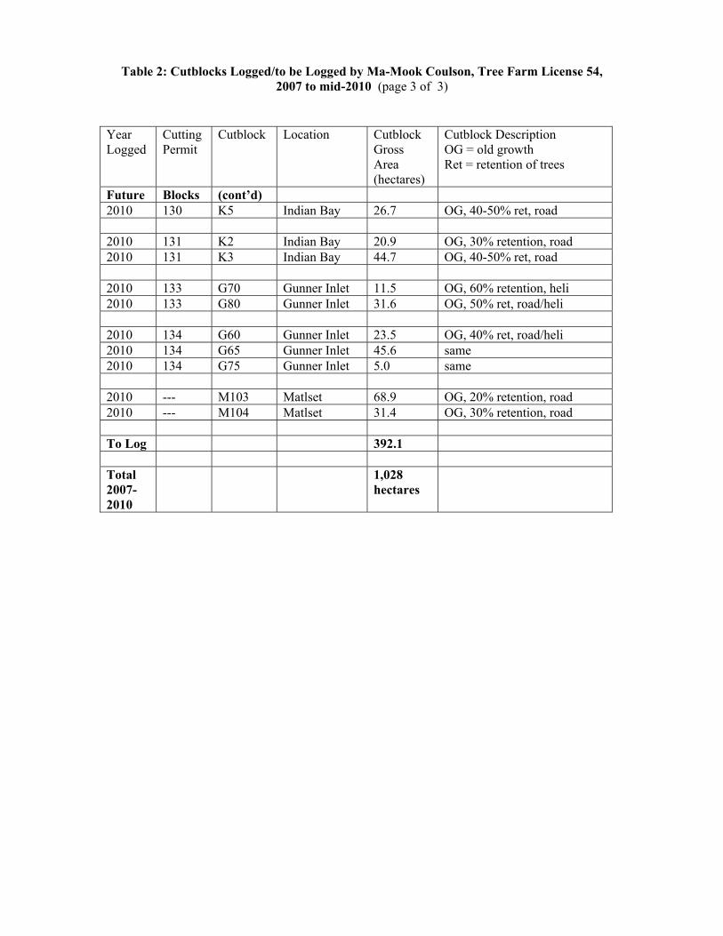
Table 2: Cutblocks Logged/to be Logged by Ma-Mook Coulson, Tree Farm License 54, 2007 to mid-2010 (page 3 of 3)
Year Logged
Cutting Permit
Cutblock Location Cutblock Gross Area (hectares)
Cutblock Description OG = old growth Ret = retention of trees
Future Blocks (cont’d) 2010 130 K5 Indian Bay 26.7 OG, 40-50% ret, road 2010 131 K2 Indian Bay 20.9 OG, 30% retention, road 2010 131 K3 Indian Bay 44.7 OG, 40-50% ret, road 2010 133 G70 Gunner Inlet 11.5 OG, 60% retention, heli 2010 133 G80 Gunner Inlet 31.6 OG, 50% ret, road/heli 2010 134 G60 Gunner Inlet 23.5 OG, 40% ret, road/heli 2010 134 G65 Gunner Inlet 45.6 same 2010 134 G75 Gunner Inlet 5.0 same 2010 --- M103 Matlset 68.9 OG, 20% retention, road 2010 --- M104 Matlset 31.4 OG, 30% retention, road To Log 392.1 Total 2007-2010
1,028 hectares
IISAAK FOREST RESOURCES
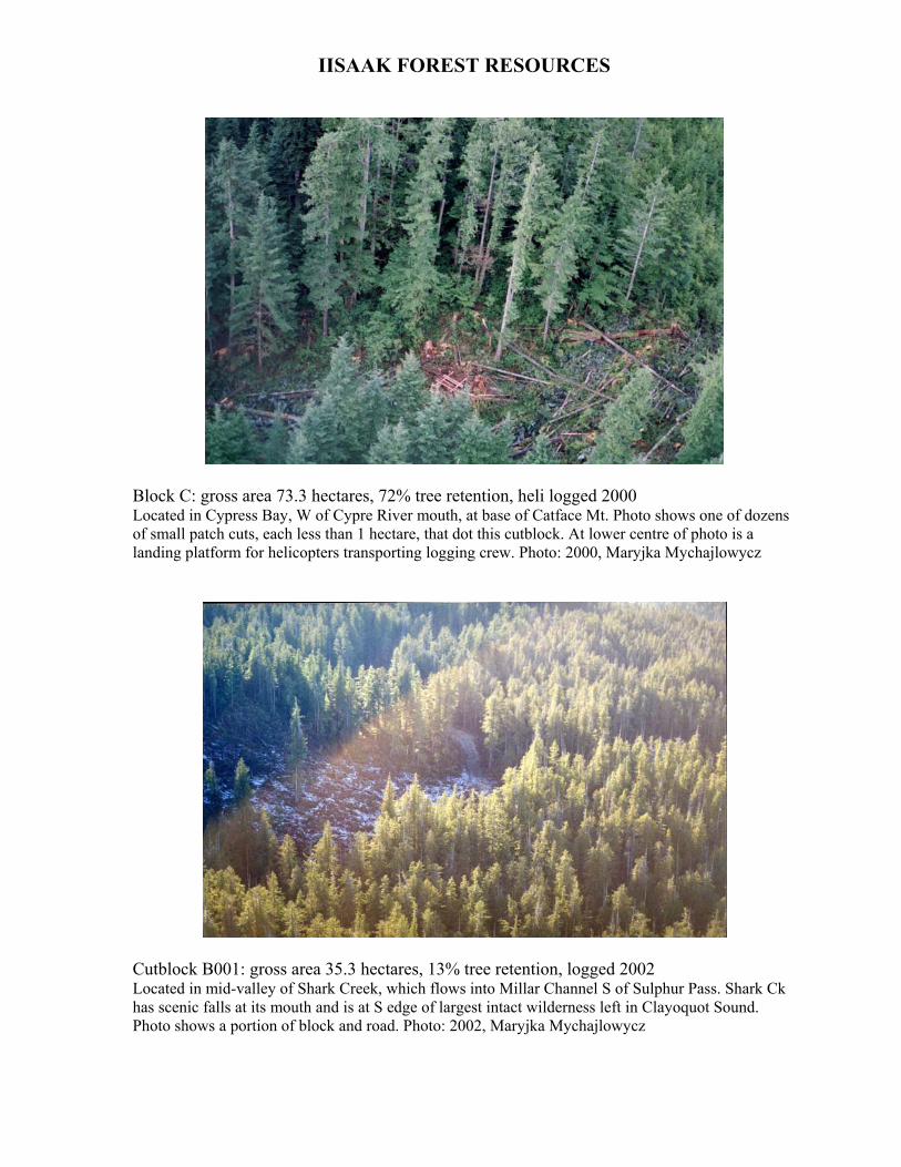
Block C: gross area 73.3 hectares, 72% tree retention, heli logged 2000 Located in Cypress Bay, W of Cypre River mouth, at base of Catface Mt. Photo shows one of dozens of small patch cuts, each less than 1 hectare, that dot this cutblock. At lower centre of photo is a landing platform for helicopters transporting logging crew. Photo: 2000, Maryjka Mychajlowycz
Cutblock B001: gross area 35.3 hectares, 13% tree retention, logged 2002 Located in mid-valley of Shark Creek, which flows into Millar Channel S of Sulphur Pass. Shark Ck has scenic falls at its mouth and is at S edge of largest intact wilderness left in Clayoquot Sound. Photo shows a portion of block and road. Photo: 2002, Maryjka Mychajlowycz
IISAAK FOREST RESOURCES
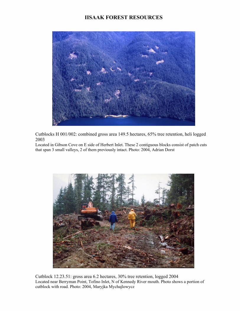
Cutblocks H 001/002: combined gross area 149.5 hectares, 65% tree retention, heli logged 2003 Located in Gibson Cove on E side of Herbert Inlet. These 2 contiguous blocks consist of patch cuts that span 3 small valleys, 2 of them previously intact. Photo: 2004, Adrian Dorst
Cutblock 12.23.51: gross area 6.2 hectares, 30% tree retention, logged 2004 Located near Berryman Point, Tofino Inlet, N of Kennedy River mouth. Photo shows a portion of cutblock with road. Photo: 2004, Maryjka Mychajlowycz

MA-MOOK COULSON
Cutblock HE 10A: gross area 9.2 hectares, 30% tree retention, logged 2008 Cutblock (brown patches) is located above Stewardson logging camp. Lowest slope of block was accessed by road building; higher slope by helicopter. Dark green is old growth, lighter green is 2nd growth in old clearcuts. Looking SW from Stewardson Inlet (with log boom) towards Kanim Lake and Pacific Ocean. Photo: 2008, Jeremy Sean Williams
Cutblocks HS 40/45: combined gross area 50 hectares, 15% tree retention, logged 2008 (Note: not all of cutblock is visible in this photo.) Located N of Hot Springs Cove. These 2 contiguous blocks straddle the ridge top between Hot Springs Cove and Stewardson Inlet (visible at lower left). Red grapple-yarder machine is visible on logging road. Photo: Oct 2008, Jacqueline Windh

MA-MOOK COULSON
Cutblock HS 80: gross area 12.5 hectares, 20% tree retention, logged 2009 (Note: only a portion of cutblock is visible in this close up.) Located NW of Hot Springs Cove, on Hot Springs Mainline logging road. This road runs adjacent to Maquinna Provincial Park, through prime old growth habitat of marbled murrelets (threatened bird species). Road is lined with cutblocks logged about 5 years ago by Interfor, and now by several Ma-Mook Coulson cutblocks. Photo: June 2009, courtesy of Ma-Mook Coulson
INTERFOR / BC TIMBER SALES
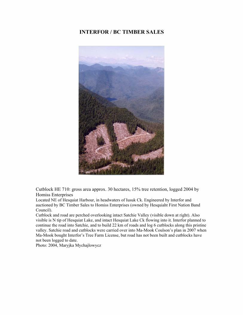
Cutblock HE 710: gross area approx. 30 hectares, 15% tree retention, logged 2004 by Homiss Enterprises Located NE of Hesquiat Harbour, in headwaters of Iusuk Ck. Engineered by Interfor and auctioned by BC Timber Sales to Homiss Enterprises (owned by Hesquiaht First Nation Band Council). Cutblock and road are perched overlooking intact Satchie Valley (visible down at right). Also visible is N tip of Hesquiat Lake, and intact Hesquiat Lake Ck flowing into it. Interfor planned to continue the road into Satchie, and to build 22 km of roads and log 6 cutblocks along this pristine valley. Satchie road and cutblocks were carried over into Ma-Mook Coulson’s plan in 2007 when Ma-Mook bought Interfor’s Tree Farm License, but road has not been built and cutblocks have not been logged to date. Photo: 2004, Maryjka Mychajlowycz
Appendix 3: Maps 1. Clayoquot Sound Forest Cover 2004 – by Western Canada Wilderness Committee, based on BC Ministry of Forests data as of November 2004 2. Clayoquot Sound Land Tenures – by BC Timber Sales, Ministry of Forests, November 2009 Note: TSA (brown, not outlined) = Arrowsmith Timber Supply Area TL eliminations = former Timber Licences, now part of TFL or Arrowsmith TSA 3. Vancouver Island Forest Cover 1860 – by Sierra Club of BC 4. Vancouver Island Forest Cover 2004 – by Sierra Club of BC, with additions by Western Canada Wilderness Committee 5. Pristine (Intact) Watersheds in Clayoquot Sound – by Western Canada Wilderness Committee, 1998 6. Clayoquot Sound Scientific Panel Watershed Reserves and Harvestable Areas – by Integrated Land Management Bureau, 2006 7. Clayoquot Sound UNESCO Biosphere Reserve: Core, Buffer and Transition Zones – by Clayoquot Biosphere Trust 8. Iisaak Harvest History 2000-2008 – by Iisaak Forest Resources (cutblocks are shown in pink) 9. Ma-Mook Coulson Operations: Hesquiat Area (Northern Clayoquot), 2007-2009 – by Ma-Mook Coulson (cutblocks are outlined in red) Note: Road shown in intact Satchie Valley has not been built. The 2 cutblocks shown in intact Hesquiat Point Creek have not been logged. 10. Ma-Mook Coulson Operations: Southern Clayoquot, 2007-2009 – by Ma-Mook Coulson (cutblocks are outlined in red)