overview of the usgs earth mapping resources initiative
TRANSCRIPT

U.S. Department of the InteriorU.S. Geological Survey
Overview of the USGS Earth Mapping Resources InitiativeGeoscience Data for the Upstream Critical Minerals Supply Chain
National Academy of Sciences Electric Vehicle WorkshopOctober 25-28, 2021
Warren Day, USGS Earth MRI Science Coordinator, Mineral Resources Program, Golden, CO
1

Defense and national security75
ReRhenium
Photo credit: Master Sgt. John R. Nimmo, Sr.
U.S. Air Force F-35A Lightning II Joint Strike
Fighter
32Ge
Germanium
Gen. III Ground Panoramic Night Vision Goggles
31GaGallium
33AsArsenic
Photo credit: L3 Technologies, Inc.
Healthcare64Gd
Gadolinium
Photo credit: GE HealthcarePET/CT diagnostic
imaging
63Eu
Europium
71LuLutetium
65TbTerbium
39Y
Yttrium
58CeCerium
Offshore direct drive wind turbine
Photo credit: US DOE
Energy generation
60
NdNeodymium
66
DyDysprosium
Thin-film solar PV
Photo credit: Testbourne, Ltd.
49
InIndium
31
GaGallium
34
SeSelenium
Transportation
27CoCobalt
28NiNickel
6
CCarbon
3Li
Lithium
Photo credit: Telsa, Inc.Electric and hybrid vehicles
Critical minerals support the global economyFuture technologies require increased supply

58
46
21
0 20 40 60 80
2019
1984
1954
Number of mineral commodities
25 to 50
>50 to <100
100
Like many developed countries, the United States is highly import reliant for a large and growing number of mineral commodities
Growing U.S. net import reliance
Net import reliance(as % of apparent consumption)
2019 U.S. net import reliance
3Slide courtesy of Nedal Nassar, USGS National Minerals Information Center
>90% import reliant for 23 critical minerals

4
USGS Earth Mapping Resources Initiative (Earth MRI)
• Established in 2019 under Executive Order 13817 and Secretarial Order 3359 to address the shortfall in the critical minerals supply needed for National defense and economic security.
• Goal: Improve our knowledge of the geologic framework of the United States in areas permissive for hosting undiscovered critical mineral resources.
• Partnership between the USGS, State Geological Surveys, and the private sector to generate state-of-the-art surface geologic maps, geophysical surveys, and elevation (lidar) data in areas with critical mineral potential.
• Multiple stakeholders and applications that include energy, groundwater, natural hazards, and other vital geoscience issues.
5
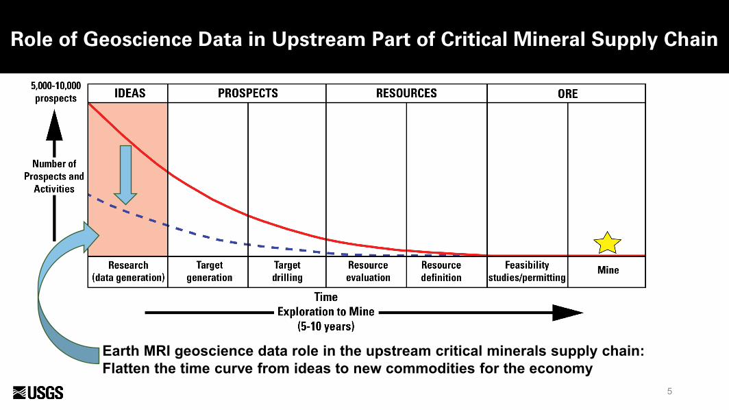
Role of Geoscience Data in Upstream Part of Critical Mineral Supply Chain
Earth MRI geoscience data role in the upstream critical minerals supply chain:Flatten the time curve from ideas to new commodities for the economy

6
Project Phase by Critical MineralList of 35 Critical Minerals Currently Drives the Process
Phase 3AntimonyBariteBerylliumChromiumFluorsparHafniumHeliumMagnesiumManganesePotashUraniumVanadiumZirconium
Phase 1Rare earth element group
Phase 2AluminumCobaltGraphite (natural)LithiumNiobiumPlatinum group elementsRare earth element group
TantalumTinTitaniumTungsten
Phase 4ArsenicBismuthCesium GalliumGermaniumIndiumRheniumRubidiumScandiumStrontiumTellurium
• Phase 1: Rare earth elements.
• Phase 2: Primary and co-product critical mineral commodities for which new geologic information will impact discovery and production.
• Phase 3: Co-products and by-product commodities for which new geologic information will impact discovery and production.
• Remaining mineral commodities are primarily by-products from mining of other commodities. Their recovery is largely dependent on the economics of recovery and market forces.
Need national-scale maps showing where critical minerals may occur to drive funding decisions.

Mineral Systems Framework
Mineral system: family of ore deposit types genetically linked in time, space, and shared tectonic processes

8
Mineral Systems ApproachExample: Porphyry Copper-Molybdenum-Gold System
System Name Deposit type Principal
commoditiesCritical
commodities
Porphyry Cu-Mo-Au
Greisen Mo, W, Sn W, SnS-R-V tungsten W W, Bi, Mn, ScPorphyry/skarn molybdenum Mo, W, Sn W, Re, Bi
Porphyry/skarn copperCu, Au, Ag, Mo PGE, Te, Re, U, Sc, Co, Bi
Skarn iron Fe, Cu GeSkarn magnesite Mg MgR-V manganese Mn Mn, CoPolymetallic sulfide S-R-V-IS
Cu, Zn, Cd, Pb, Ag, Au
Mn, Ge, Ga, In, Bi, Sb, As, W, Te
Distal disseminated silver-gold Ag, Au Sb, As
High sulfidation gold-silver Cu, Ag, Au As, Sb, Te, Bi, Sn,
GaIntermediate sulfidation antimony Sb, Hg Sb, As
Lithocap alunite Al, K2SO4 (potash) Al, K2SO4, GaLithocap kaolinite Kaolin Ga
Mineral system: family of ore deposit types genetically linked in time, space, and shared tectonic processes

9
Example: Significant Lithium Deposits in the Conterminous US
Important Mineral Systems for Lithium
• Basin brine pathway
• Lacustrine evaporite
• Porphyry Tin (granite-related): includes lithium-bearing pegmatite deposits
Source: Dicken and Hammarstrom, 2020, USGS data release, https://doi.org/10.5066/P95CO8LR

10
Deposit Model for Lacustrine Evaporite Lithium Deposits
Modified from Bradley and others, 2017: U.S. Geological Survey Professional Paper 1802, p. K1–K21, https://doi.org/10.3133/pp1802K

11
Background• Region is known to host gold, copper, and many critical mineral
resources. Lithium mining is ongoing in project area. • DOE Geothermal Technologies Office play-fairways-analysis
identified region as having potential for geothermal energy resources
Goal• Collect high resolution airborne magnetic, radiometric, and lidar
data to inform understanding of regional geology, natural resources, and geologic hazards
Details• Multi-agency partnership includes: USGS, DOE GTO, BLM, NRCS,
FEMA, and Nevada Bureau of Mines and Geology• Lidar data collection complete. Target October 2022 release• Flying of geophysical survey to beginning Fall 2021
Example: Geoscience Data Acquisition for Western Nevada (GeoDAWN)

12
Example: Geoscience Data Acquisition for Western Nevada (GeoDAWN)
Background• Region is known to host gold, copper, and many critical mineral
resources. Lithium mining is ongoing in project area. • DOE Geothermal Technologies Office play-fairways-analysis
identified region as having potential for geothermal energy resources
Goal• Collect high resolution airborne magnetic, radiometric, and lidar
data to inform understanding of regional geology, natural resources, and geologic hazards
Details• Multi-agency partnership includes: USGS, DOE GTO, BLM, NRCS,
FEMA, and Nevada Bureau of Mines and Geology• Lidar data collection complete. Target October 2022 release• Flying of geophysical survey to beginning Fall 2021

Reclaiming mine sites offers co-benefits for remediation and critical mineral recovery.
USGS and partners are planning a national mine waste inventory
13
Unconventional Mineral Resources: Mine Wastes
New USMIN geospatial database of current and historical mining locations. Yellow dots are mine features captured from historical USGS topographic maps. (A collaboration with BLM and State geological surveys)
Horton, J.D., and San Juan, C.A., 2021, Prospect- and Mine-Related Features from U.S. Geological Survey 7.5- and 15-Minute Topographic Quadrangle Maps of the United States (ver. 6.0, April 2021): U.S. Geological Survey data release, https://doi.org/10.5066/F78W3CHG.
Share of element’s primary production obtained as a
byproduct
Nassar et al., 2015, By-product metals are technologically essential but have problematic supply, Science Advances 1 (3), e1400180


Questions?15